36
Nature at the Edge of the City... Reconnecting Ecology & Community Through Adaptive Reuse of Folcroft and Clearview Landfills.
| Date post: | 28-Mar-2016 |
| Category: |
Documents |
| Upload: | emily-mccoy |
| View: | 213 times |
| Download: | 1 times |
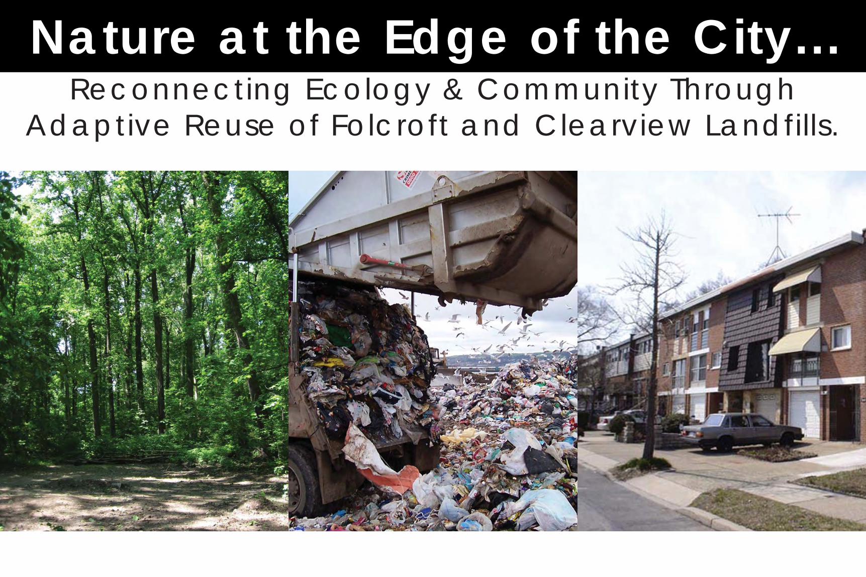
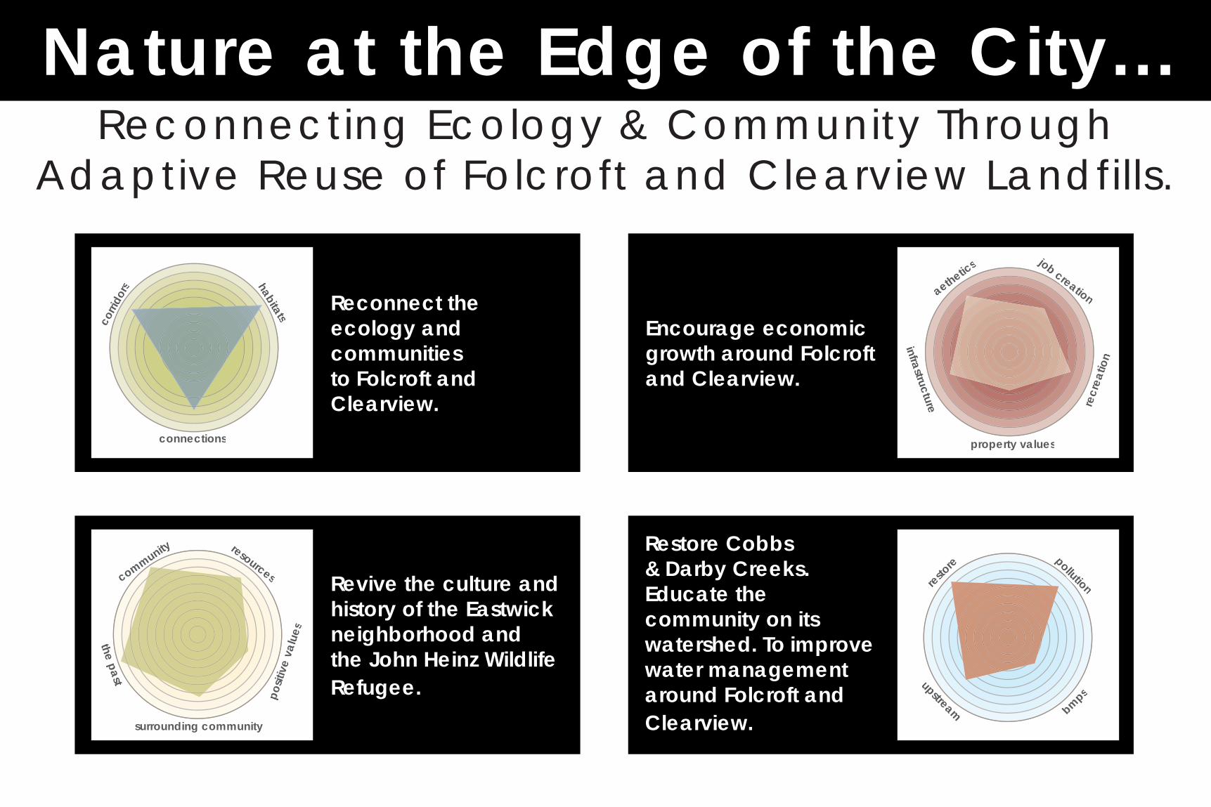
Nature at the Edge of the City...Reconnecting Ecology & Community Through
Adaptive Reuse of Folcroft and Clearview Landfills.
Nature at the Edge of the City...Reconnecting Ecology & Community Through
Adaptive Reuse of Folcroft and Clearview Landfills.
Reconnect the ecology and communities to Folcroft and Clearview.
corri
dors habitats
connections
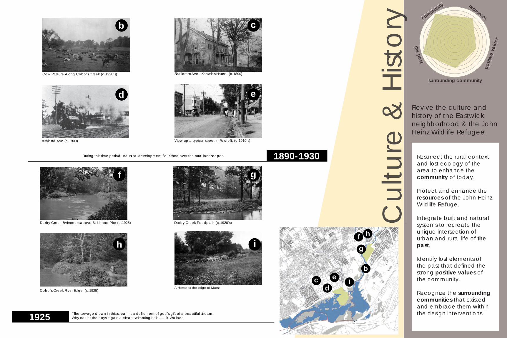
Revive the culture and history of the Eastwick neighborhood and the John Heinz Wildlife Refugee.
community
surrounding community
the past
posit
ive
valu
es
resources
Encourage economic growth around Folcroft and Clearview.
property values
infrastructure recr
eatio
n
job creationre
aethetics
Restore Cobbs & Darby Creeks. Educate the community on its watershed. To improve water management around Folcroft and Clearview.
restore pollution
upstream bmps
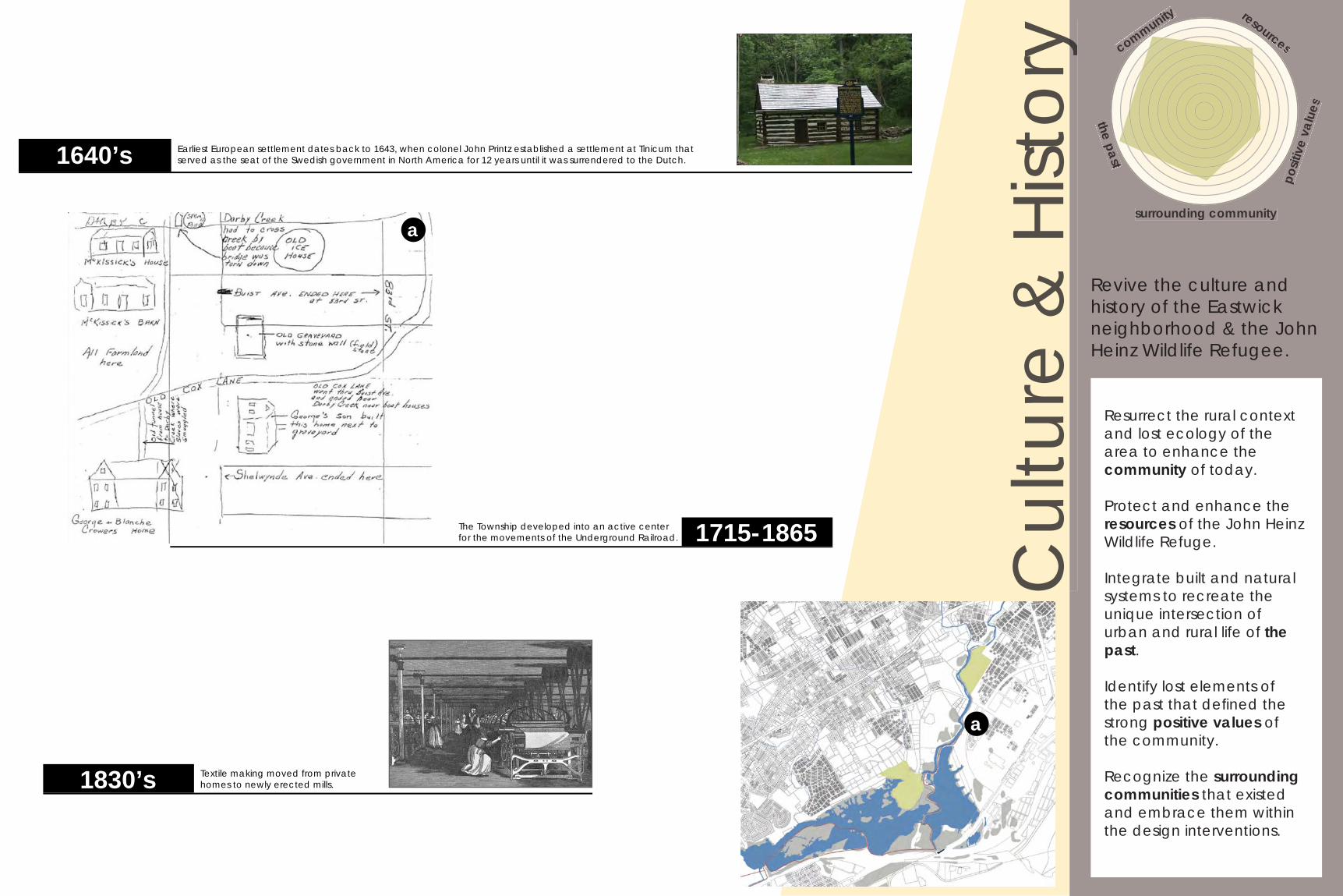
Resurrect the rural context and lost ecology of the area to enhance the community of today.
Protect and enhance the resources of the John Heinz Wildlife Refuge.
Integrate built and natural systems to recreate the unique intersection of urban and rural life of the past.
Identify lost elements of the past that defi ned the strong positive values of the community.
Recognize the surrounding communities that existed and embrace them within the design interventions.
Revive the culture and history of the Eastwick neighborhood & the John Heinz Wildlife Refugee.
The Township developed into an active center for the movements of the Underground Railroad. 1715-1865
Textile making moved from private homes to newly erected mills.1830’s
Earliest European settlement dates back to 1643, when colonel John Printz established a settlement at Tinicum that served as the seat of the Swedish government in North America for 12 years until it was surrendered to the Dutch.1640’s
community
surrounding community
the past
posit
ive
valu
es
resourcesyC
ultu
re &
Hist
oryy
a
a
Resurrect the rural context and lost ecology of the area to enhance the community of today.
Protect and enhance the resources of the John Heinz Wildlife Refuge.
Integrate built and natural systems to recreate the unique intersection of urban and rural life of the past.
Identify lost elements of the past that defi ned the strong positive values of the community.
Recognize the surrounding communities that existed and embrace them within the design interventions.
Revive the culture and history of the Eastwick neighborhood & the John Heinz Wildlife Refugee.
Darby Creek Floodplain (c.1920’s)
A Home at the edge of Marsh
Darby Creek Swimmers above Baltimore Pike (c.1925)
Cobb’s Creek River Edge (c.1925)
“The sewage shown in this stream is a defi lement of god’s gift of a beautiful stream. Why not let the boys regain a clean swimming hole..... B. Wallace1925
View up a typical street in Folcroft. (c.1910’s)
Cow Pasture Along Cobb’s Creek (c.1920’s)
Ashland Ave (c.1909)
Shallcross Ave - Knowles House (c.1890)
During this time period, industrial development fl ourished over the rural landscapes. 1890-1930
b c
d e
f g
h i
bc
de
fg
h
i
community
surrounding community
the past
posit
ive
valu
es
resourcesyC
ultu
re &
Hist
oryy
Resurrect the rural context and lost ecology of the area to enhance the community of today.
Protect and enhance the resources of the John Heinz Wildlife Refuge.
Integrate built and natural systems to recreate the unique intersection of urban and rural life of the past.
Identify lost elements of the past that defi ned the strong positive values of the community.
Recognize the surrounding communities that existed and embrace them within the design interventions.
Revive the culture and history of the Eastwick neighborhood & the John Heinz Wildlife Refugee.
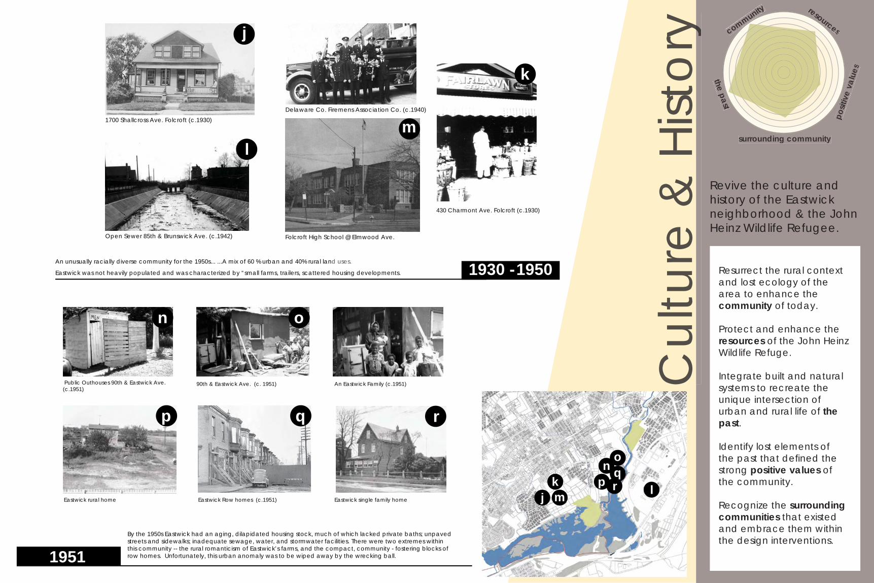
430 Charmont Ave. Folcroft (c.1930)
Delaware Co. Firemens Association Co. (c.1940)1700 Shallcross Ave. Folcroft (c.1930)
Open Sewer 85th & Brunswick Ave. (c.1942)
1930 -1950An unusually racially diverse community for the 1950s... ...A mix of 60 % urban and 40% rural land uses.
Eastwick was not heavily populated and was characterized by “small farms, trailers, scattered housing developments.
Folcroft High School @ Elmwood Ave.
1951
Eastwick Row homes (c.1951)
Public Outhouses 90th & Eastwick Ave. (c.1951)
90th & Eastwick Ave. (c. 1951) An Eastwick Family (c.1951)
k
j
p
Eastwick single family homeEastwick rural home
By the 1950s Eastwick had an aging, dilapidated housing stock, much of which lacked private baths; unpaved streets and sidewalks; inadequate sewage, water, and stormwater facilities. There were two extremes within this community -- the rural romanticism of Eastwick’s farms, and the compact, community - fostering blocks of row homes. Unfortunately, this urban anomaly was to be wiped away by the wrecking ball.
lm
on
q r
no
pmk lj
qr
community
surrounding community
the past
posit
ive
valu
es
resourcesyC
ultu
re &
Hist
oryy
Resurrect the rural context and lost ecology of the area to enhance the community of today.
Protect and enhance the resources of the John Heinz Wildlife Refuge.
Integrate built and natural systems to recreate the unique intersection of urban and rural life of the past.
Identify lost elements of the past that defi ned the strong positive values of the community.
Recognize the surrounding communities that existed and embrace them within the design interventions.
Revive the culture and history of the Eastwick neighborhood & the John Heinz Wildlife Refugee.
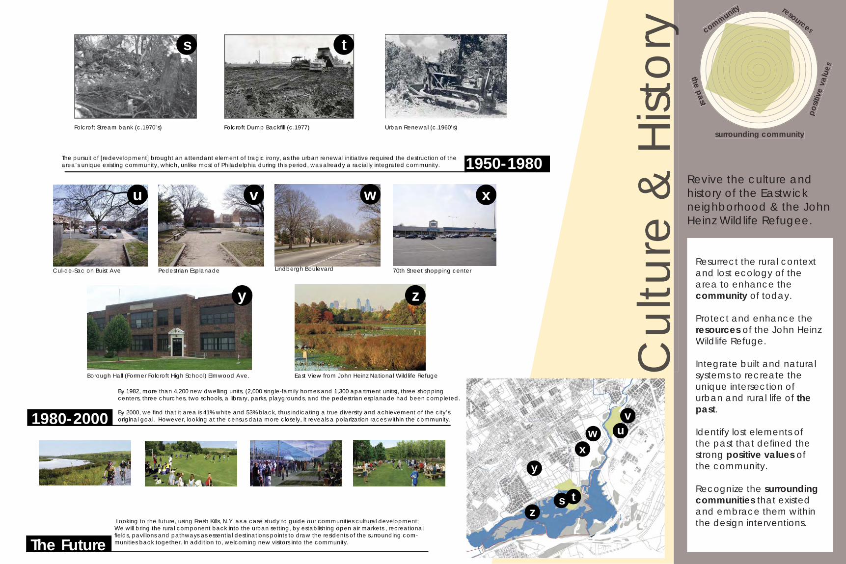
The pursuit of [redevelopment] brought an attendant element of tragic irony, as the urban renewal initiative required the destruction of the area’s unique existing community, which, unlike most of Philadelphia during this period, was already a racially integrated community. 1950-1980
Folcroft Dump Backfi ll (c.1977) Urban Renewal (c.1960’s)Folcroft Stream bank (c.1970’s)
By 1982, more than 4,200 new dwelling units, (2,000 single-family homes and 1,300 apartment units), three shopping centers, three churches, two schools, a library, parks, playgrounds, and the pedestrian esplanade had been completed.
By 2000, we fi nd that it area is 41% white and 53% black, thus indicating a true diversity and achievement of the city’s original goal. However, looking at the census data more closely, it reveals a polarization races within the community.1980-2000
t
u
70th Street shopping centerLindbergh BoulevardPedestrian EsplanadeCul-de-Sac on Buist Ave
z
xw
s
y
v
vu
s tz
y
wx
Borough Hall (Former Folcroft High School) Elmwood Ave. East View from John Heinz National Wildlife Refuge
The Future Looking to the future, using Fresh Kills, N.Y. as a case study to guide our communities cultural development; We will bring the rural component back into the urban setting, by establishing open air markets , recreational fi elds, pavilions and pathways as essential destinations points to draw the residents of the surrounding com-munities back together. In addition to, welcoming new visitors into the community.
community
surrounding community
the past
posit
ive
valu
es
resourcesyC
ultu
re &
Hist
oryy
Wat
er M
anag
emen
t
Restore Cobbs and Darby Creeks while educate the community on the watershed to improve water management around Folcroft and Clearview.
Pinpoint pollution sources to clean up around Folcroft and Clearview.
Educate the community on what the watershed means to them, that water quality is affected by water management upstream.
Outline BMPs that would improve the fl ooding and general water management around Folcroft and Clearview.
Restore Cobbs and Darby Creeks and educate the community on the watershed to improve water management around Folcroft and Clearview.
restore pollution
upstream bmpsdeveloped
undevelopeduuuuuuuuuuuuuuuuuuuuuuuuuuuuuuuuuuuuuuuuuuuuuuuuuuuuuuuuuuuuuuuuuuuuuuuuuuuuuuuuuuuuuuuuuuuuuuuuuuuuuuuuuuuuuuuuuuuuuuuuuuuuuuuuuuuuuuuuuuuuuuuuuuuuuuuuuuuuuuuuuuuuuuuuuuuuuuuuuuuuuuuuuuuuuuuuuuuuuuuuuuuuuuuuuuuuuuuuuuuuuuuuuuuuuuuuuuuuuuuuuuuuuuuuuuuuuuuuuuuuuunnnnnnnnnnnnnnnnnnnnnnnnnnnnnnnnnnnnnnnnnnnnnnnnnnnnnnnnnnnnnnnnnnnnnnnnnnnnnnnnnnnnnnnnnnnnnnnnnnnnnnnnnnnnnnnnnnnnnnnnnnnnnnnnnnnnnnnnnnnnnnnnnnnnnnnnnnnnnnnnnnnnnnnnnnnnnnnnnnnnnnnnnnnnnnnnnnnnnnnnnnnnnnnnnnnnnnnnnnnnnnnnnnnnnnnnnnnnnnnnnnnnnnnnnnnnnnnnnnnnnnnnnnndddddddddddddddddddddddddddddddddddddddddddddddddddddddddddddddddddddddddddddddddddddddddddddddddddddddddddddddddddddddddddddddddddddddddddddddddddddddddddddddddddddddddddddddddddddddddddddddddddddddddddddddddddddddddddddddddddddddddddddddddddddddddddddddddddddddddddddddddddddddddddddddddddddddddddddddddddddddddddddddddddddddddddddddddddddddddeeeeeeeeeeeeeeeeeeeeeeeeeeeeeeeeeeeeeeeeeeeeeeeeeeeeeeeeeeeeeeeeeeeeeeeeeeeeeeeeeeeeeeeeeeeeeeeeeeeeeeeeeeeeeeeeeeeeeeeeeeeeeeeeeeeeeeeeeeeeeeeeeeeeeeeeeeeeeeeeeeeeeeeeeeeeeeeeeeeeeeeeeeeeeeeeeeeeeeeeeeeeeeeeeeeeeeeeeeeeeeeeeeeeeeeeeeeeeeeeeeeeeeeeeeeeeeeeeeeeeeeeeeeeevvvvvvvvvvvvvvvvvvvvvvvvvvvvvvvvvvvvvvvvvvvvvvvvvvvvvvvvvvvvvvvvvvvvvvvvvvvvvvvvvvvvvvvvvvvvvvvvvvvvvvvvvvvvvvvvvvvvvvvvvvvvvvvvvvvvvvvvvvvvvvvvvvvvvvvvvvvvvvvvvvvvvvvvvvvvvvvvvvvvvvvvvvvvvvvvvvvvvvvvvvvvvvvvvvvvvvvvvvvvvvvvvvvvvvvvvvvvvvvvvvvvvvvvvvvvvvvvvvvvvvveeeeeeeeeeeeeeeeeeeeeeeeeeeeeeeeeeeeeeeeeeeeeeeeeeeeeeeeeeeeeeeeeeeeeeeeeeeeeeeeeeeeeeeeeeeeeeeeeeeeeeeeeeeeeeeeeeeeeeeeeeeeeeeeeeeeeeeeeeeeeeeeeeeeeeeeeeeeeeeeeeeeeeeeeeeeeeeeeeeeeeeeeeeeeeeeeeeeeeeeeeeeeeeeeeeeeeeeeeeeeeeeeeeeeeeeeeeeeeeeeeeeeeeeeelllllllllllllllllllllllllllllllllllllllllllllllllllllllllllllllllllllllllllllllllllllllllllllllllllllllllllllllllllllllllllllllllllllllllllllllllllllllllllllllllllllllllllllllllllllllllllllllllllllllllllllllloooooooooooooooooooooooooooooooooooooooooooooooooooooooooooooooooooooooooooooooooooooooooooooooooooooooooooooooooooooooooooooooooooooooooooooooooooooooooooooooooooooooooooooooooooooooooooooooooooooooooooooooppppppppppppppppppppppppppppppppppppppppppppppppppppppppppppppppppppppppppppppppppppppppppppppppppppppppppppppppppppppppppppppppppppppppppppppppppppppppppppppppppppppppppppppppppppppppppppppppppppppppppppppppppppppppppppppppppppppppppppppppppeeeeeeeeeeeeeeeeeeeeeeeeeeeeeeeeeeeeeeeeeeeeeeeeeeeeeeeeeeeeeeeeeeeeeeeeeeeeeeeeeeeeeeeeeeeeeeeeeeeeeeeeeeeeeeeeeeeeeeeeeeeeeeeeeeeeeeeeeeeeeeeeeeeeeeeeeeeeeeeeeeeeeeeeeeeeeeeeeeeeeeeeeeeeeeeeeeeeeeeeeeeeeeeeeeeeeeeeeeeeeeeeeeeeeeeeeeeeeeeeeeeeeeeeeeeeeeeeeeeeeeeeeeeeeeeeeeeedddddddddddddddddddddddddddddddddddddddddddddddddddddddddddddddddddddddddddddddddddddddddddddddddddddddddddddddddddddddddddddddddddddddddddddddddddddddddddddddddddddddddddddddddddddddddddddddddddddddddddddddddddddddddddddddddddddddddddddddddddddddddddddddddddddddddddddddddd
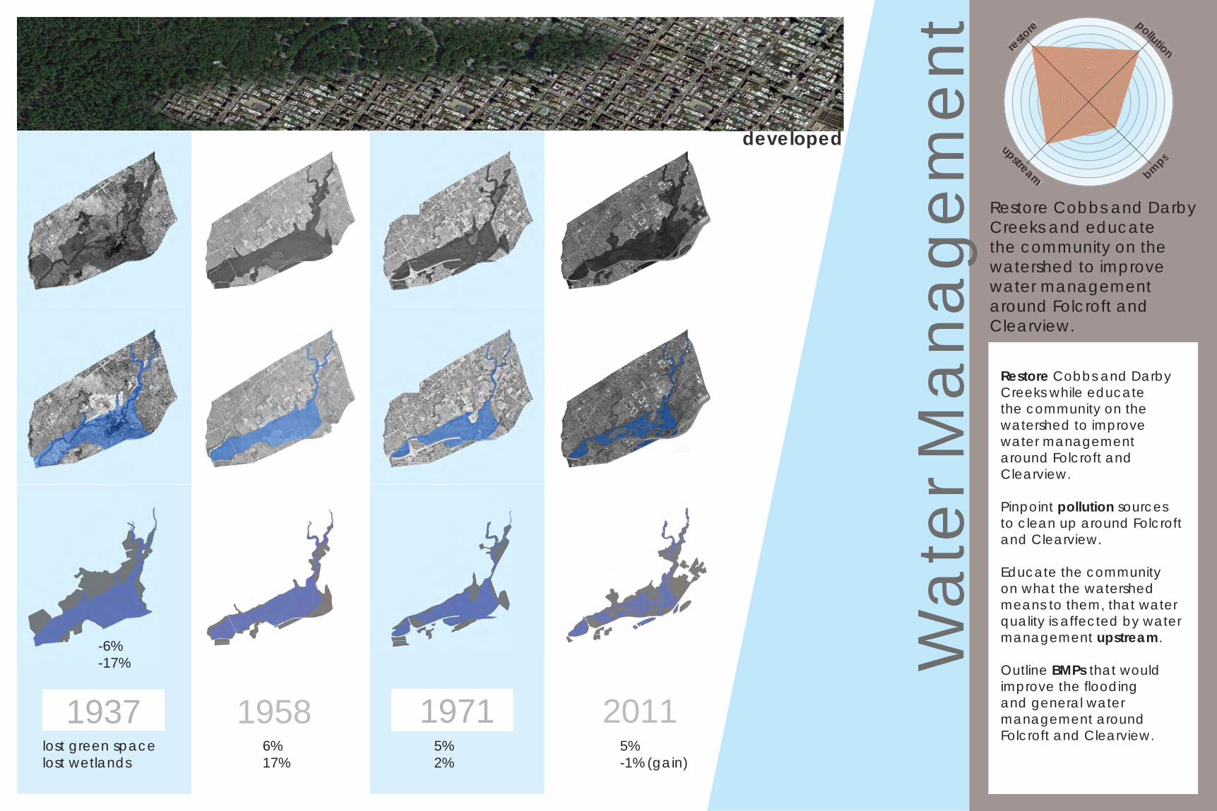
1937 1958 1971 2011lost green space lost wetlands
6%17%
-6%-17%
5%-1% (gain)
5%2%
Wat
er M
anag
emen
t
Restore Cobbs and Darby Creeks while educate the community on the watershed to improve water management around Folcroft and Clearview.
Pinpoint pollution sources to clean up around Folcroft and Clearview.
Educate the community on what the watershed means to them, that water quality is affected by water management upstream.
Outline BMPs that would improve the fl ooding and general water management around Folcroft and Clearview.
Restore Cobbs and Darby Creeks and educate the community on the watershed to improve water management around Folcroft and Clearview.
restore pollution
upstream bmps
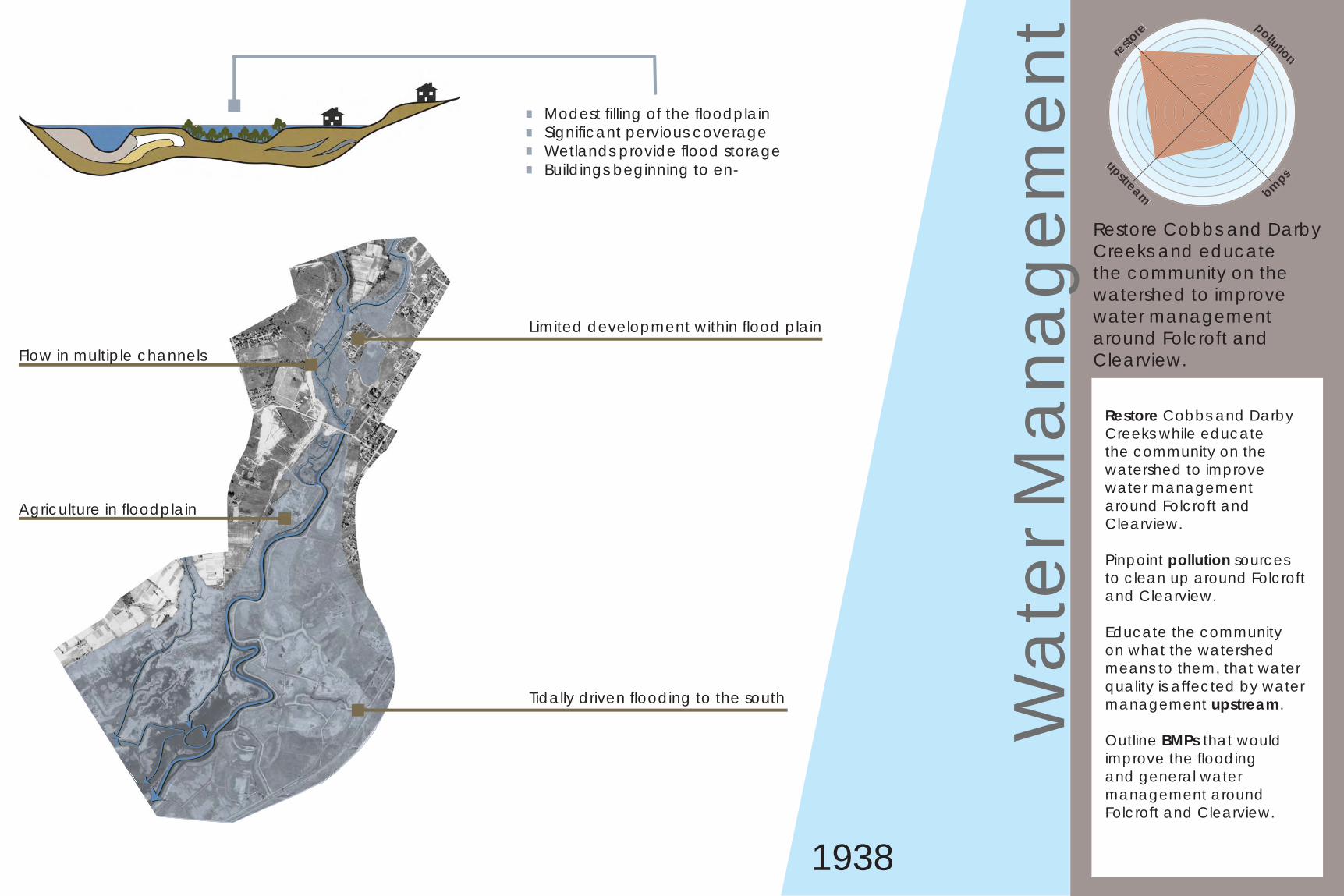
1938
Modest fi lling of the fl oodplainSignifi cant pervious coverageWetlands provide fl ood storageBuildings beginning to en-
Limited development within fl ood plain
Flow in multiple channels
Tidally driven fl ooding to the south
Agriculture in fl oodplain
Wat
er M
anag
emen
t
Restore Cobbs and Darby Creeks while educate the community on the watershed to improve water management around Folcroft and Clearview.
Pinpoint pollution sources to clean up around Folcroft and Clearview.
Educate the community on what the watershed means to them, that water quality is affected by water management upstream.
Outline BMPs that would improve the fl ooding and general water management around Folcroft and Clearview.
Restore Cobbs and Darby Creeks and educate the community on the watershed to improve water management around Folcroft and Clearview.
restore pollution
upstream bmps
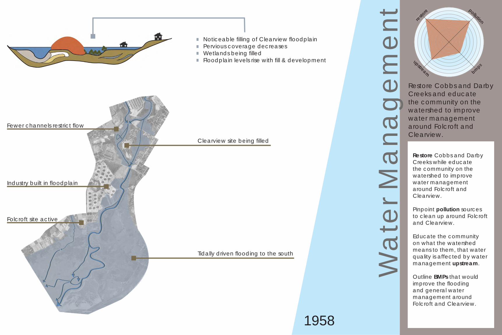
1958
Noticeable fi lling of Clearview fl oodplainPervious coverage decreasesWetlands being fi lledFloodplain levels rise with fi ll & development
Clearview site being fi lled
Fewer channels restrict fl ow
Tidally driven fl ooding to the south
Industry built in fl oodplain
Folcroft site active
Wat
er M
anag
emen
t
Restore Cobbs and Darby Creeks while educate the community on the watershed to improve water management around Folcroft and Clearview.
Pinpoint pollution sources to clean up around Folcroft and Clearview.
Educate the community on what the watershed means to them, that water quality is affected by water management upstream.
Outline BMPs that would improve the fl ooding and general water management around Folcroft and Clearview.
Restore Cobbs and Darby Creeks and educate the community on the watershed to improve water management around Folcroft and Clearview.
restore pollution
upstream bmps
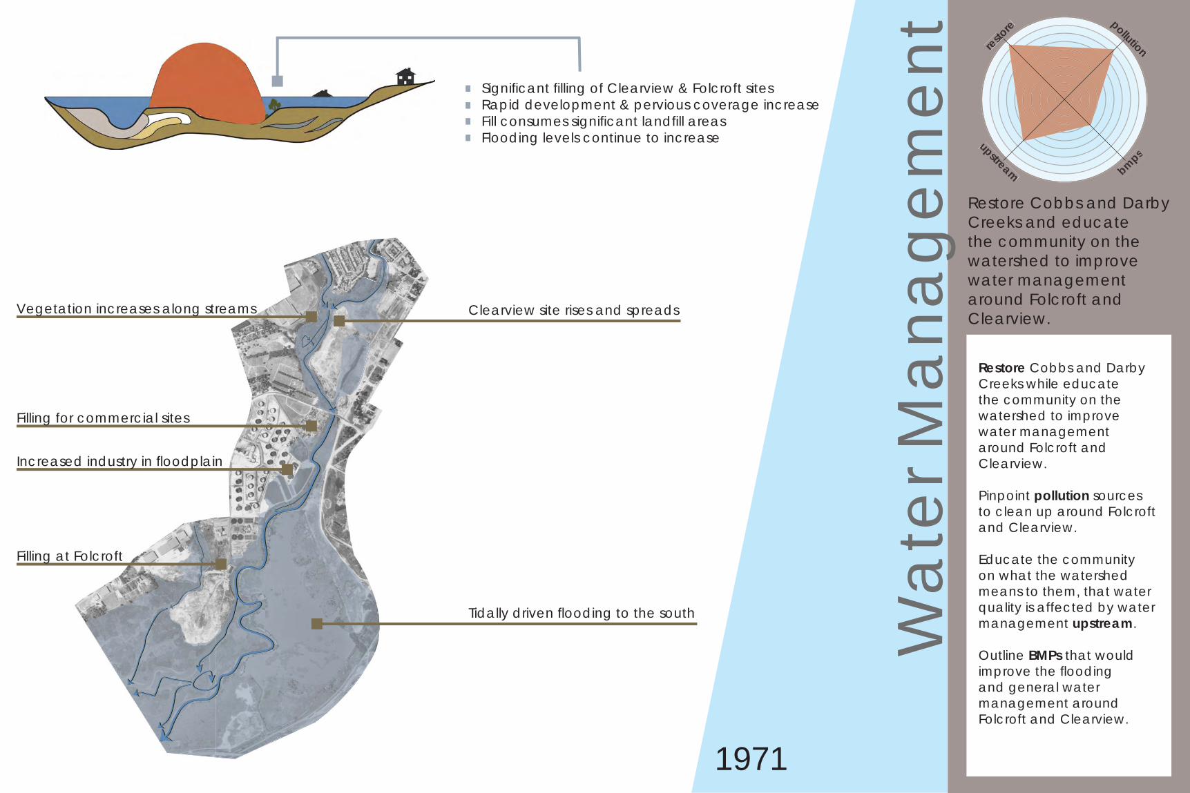
1971
Signifi cant fi lling of Clearview & Folcroft sitesRapid development & pervious coverage increaseFill consumes signifi cant landfi ll areasFlooding levels continue to increase
Clearview site rises and spreadsVegetation increases along streams
Tidally driven fl ooding to the south
Increased industry in fl oodplain
Filling for commercial sites
Filling at Folcroft
Wat
er M
anag
emen
t
Restore Cobbs and Darby Creeks while educate the community on the watershed to improve water management around Folcroft and Clearview.
Pinpoint pollution sources to clean up around Folcroft and Clearview.
Educate the community on what the watershed means to them, that water quality is affected by water management upstream.
Outline BMPs that would improve the fl ooding and general water management around Folcroft and Clearview.
Restore Cobbs and Darby Creeks and educate the community on the watershed to improve water management around Folcroft and Clearview.
restore pollution
upstream bmps
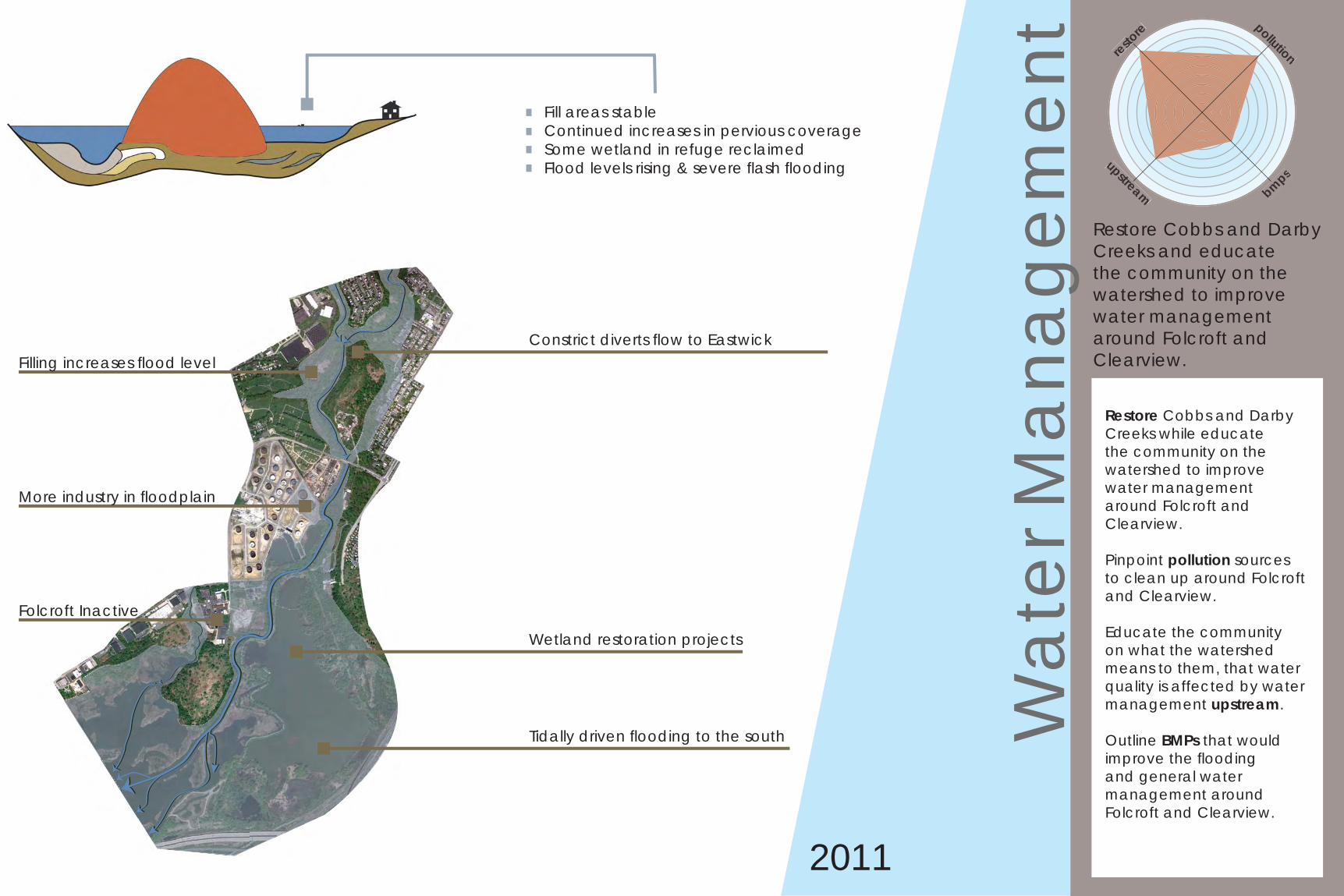
2011
Fill areas stableContinued increases in pervious coverageSome wetland in refuge reclaimedFlood levels rising & severe fl ash fl ooding
Constrict diverts fl ow to EastwickFilling increases fl ood level
Tidally driven fl ooding to the south
More industry in fl oodplain
Wetland restoration projects
Folcroft Inactive
Wat
er M
anag
emen
t
Restore Cobbs and Darby Creeks while educate the community on the watershed to improve water management around Folcroft and Clearview.
Pinpoint pollution sources to clean up around Folcroft and Clearview.
Educate the community on what the watershed means to them, that water quality is affected by water management upstream.
Outline BMPs that would improve the fl ooding and general water management around Folcroft and Clearview.
Restore Cobbs and Darby Creeks and educate the community on the watershed to improve water management around Folcroft and Clearview.
restore pollution
upstream bmps
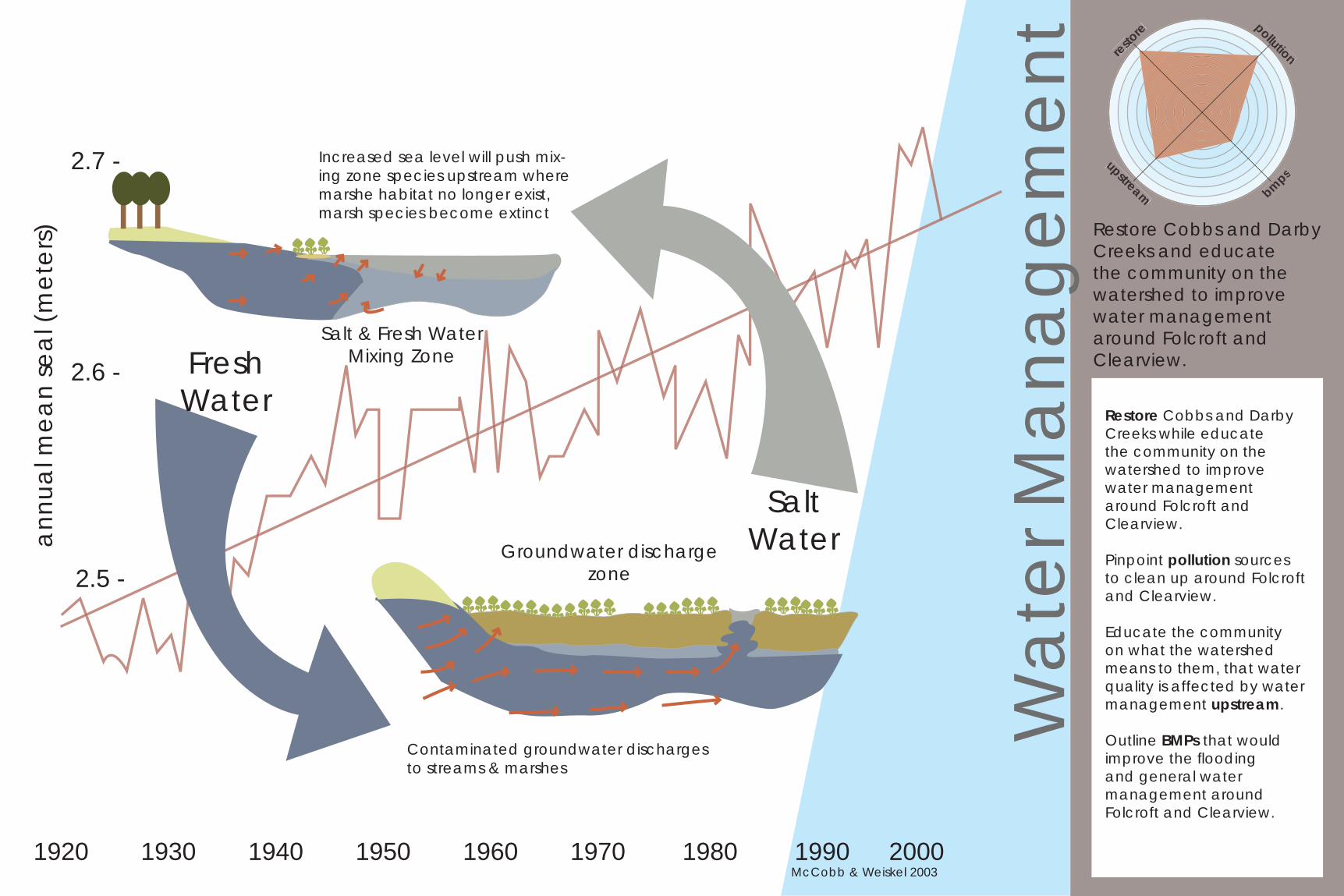
2.5 -
2.6 -
2.7 -
annu
al m
ean
seal
(met
ers)
1920 1930 1940 1950 1960 1970 1980 1990 2000McCobb & Weiskel 2003
Fresh Water
SaltWater
Increased sea level will push mix-ing zone species upstream where marshe habitat no longer exist, marsh species become extinct
Salt & Fresh WaterMixing Zone
Groundwater discharge zone
Contaminated groundwater discharges to streams & marshes
Wat
er M
anag
emen
t
Restore Cobbs and Darby Creeks while educate the community on the watershed to improve water management around Folcroft and Clearview.
Pinpoint pollution sources to clean up around Folcroft and Clearview.
Educate the community on what the watershed means to them, that water quality is affected by water management upstream.
Outline BMPs that would improve the fl ooding and general water management around Folcroft and Clearview.
Restore Cobbs and Darby Creeks and educate the community on the watershed to improve water management around Folcroft and Clearview.
restore pollution
upstream bmps
Pollu
tant
Sou
rces
and
Mec
hani
sms
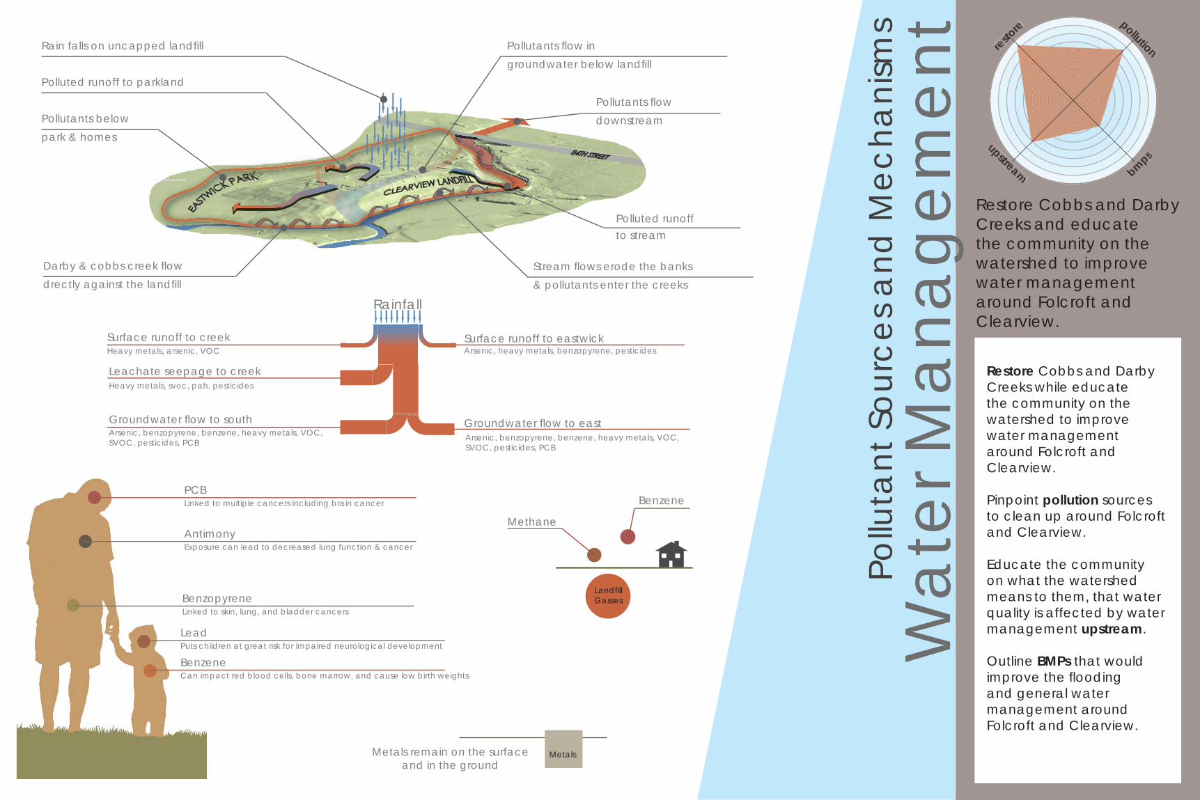
Rain falls on uncapped landfi ll
Polluted runoff to parkland
Darby & cobbs creek fl owdrectly against the landfi ll
Pollutants fl owdownstream
Pollutants fl ow ingroundwater below landfi ll
Polluted runoffto stream
Stream fl ows erode the banks& pollutants enter the creeks
Pollutants belowpark & homes
Surface runoff to eastwickHeavy metals, arsenic, VOCSurface runoff to creek
Rainfall
Leachate seepage to creek
Groundwater fl ow to south
Heavy metals, svoc, pah, pesticides
Arsenic, heavy metals, benzopyrene, pesticides
Groundwater fl ow to eastArsenic, benzopyrene, benzene, heavy metals, VOC, SVOC, pesticides, PCB
Arsenic, benzopyrene, benzene, heavy metals, VOC, SVOC, pesticides, PCB
PCBLinked to multiple cancers including brain cancer
AntimonyExposure can lead to decreased lung function & cancer
LeadPuts children at great risk for Impaired neurological development
BenzeneCan impact red blood cells, bone marrow, and cause low birth weights
BenzopyreneLinked to skin, lung, and bladder cancers
Landfi llGasses
Methane
Benzene
Metals remain on the surface and in the ground
Metals
Wat
er M
anag
emen
t
Restore Cobbs and Darby Creeks while educate the community on the watershed to improve water management around Folcroft and Clearview.
Pinpoint pollution sources to clean up around Folcroft and Clearview.
Educate the community on what the watershed means to them, that water quality is affected by water management upstream.
Outline BMPs that would improve the fl ooding and general water management around Folcroft and Clearview.
Restore Cobbs and Darby Creeks and educate the community on the watershed to improve water management around Folcroft and Clearview.
restore pollution
upstream bmps
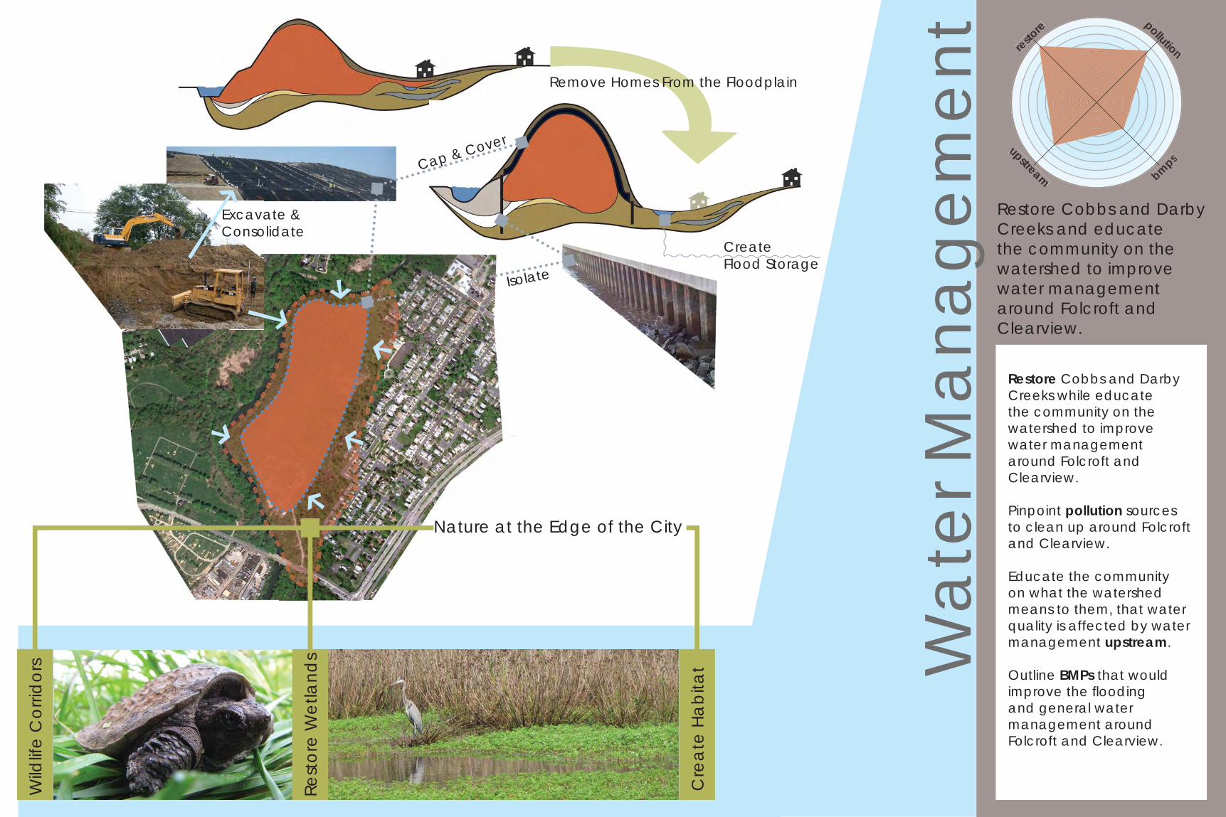
Rest
ore
Wet
land
s
Wild
life
Cor
ridor
s
Cre
ate
Habi
tat
Isolate
Remove Homes From the Floodplain
Cap & Cover
Excavate & Consolidate
Nature at the Edge of the City
Create Flood Storage
Con
nect
ivity
Create green corridors for terrestrial animals to safely navigate through urban infrastructure.
Restore habitats to encourage protected and / or endangered species in the watershed region.
Identify access points, landmarks, gateway areas, and transit locations to improve connections to Folcroft and Clearview.
corri
dors habitats
connections
Reconnect the ecology and communities to Folcroft and Clearview.
Identify access points,landmarks, gateway areas,and transit locations toimprove connections to Folcroft and Clearview.
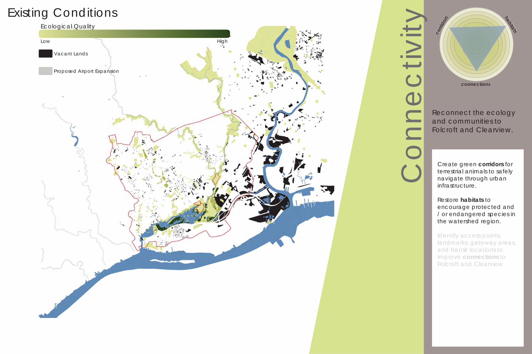
Existing Conditions
High
Proposed Airport Expansion
Ecological Quality
Low
Vacant Lands
Con
nect
ivity
Create green corridors for terrestrial animals to safely navigate through urban infrastructure.
Restore habitats to encourage protected and / or endangered species in the watershed region.
Identify access points, landmarks, gateway areas, and transit locations to improve connections to Folcroft and Clearview.
corri
dors habitats
connections
Reconnect the ecology and communities to Folcroft and Clearview.
Identify access points,landmarks, gateway areas,and transit locations toimprove connections to Folcroft and Clearview.
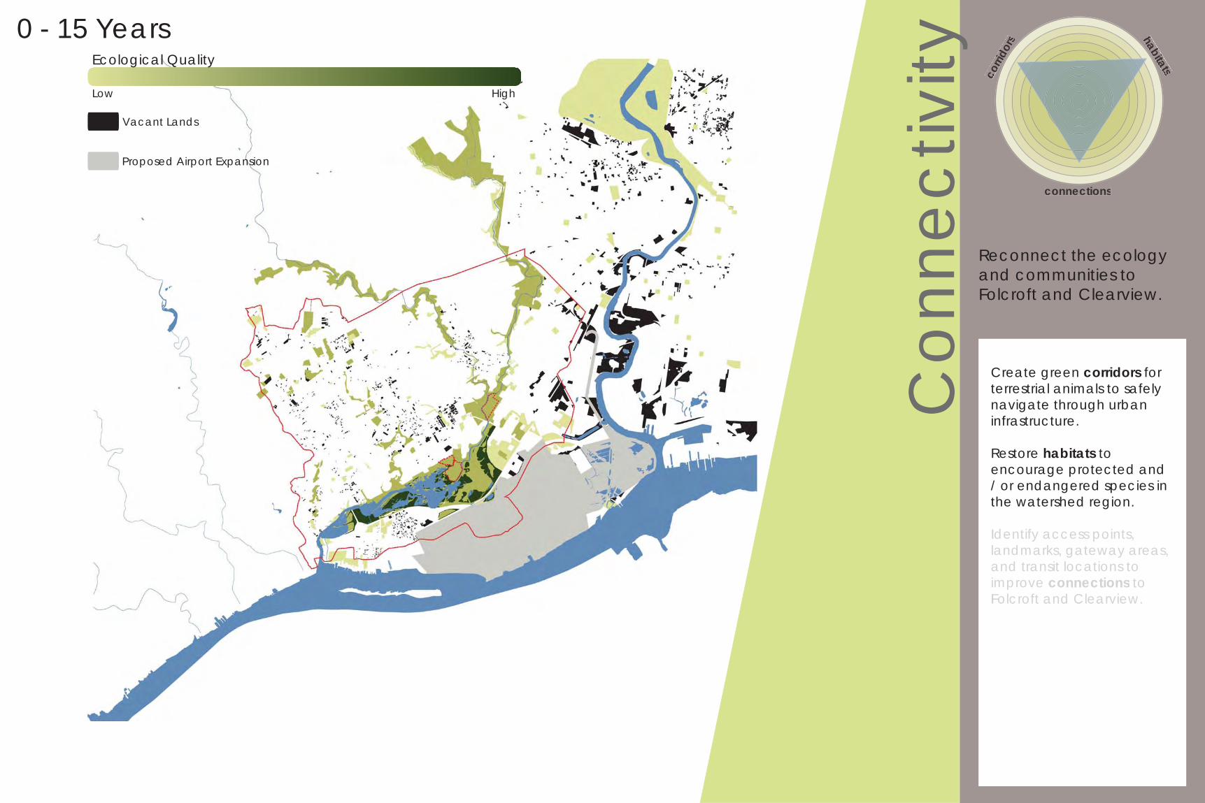
0 - 15 Years
Proposed Airport Expansion
Ecological Quality
Low
Vacant Lands
High
Con
nect
ivity
Create green corridors for terrestrial animals to safely navigate through urban infrastructure.
Restore habitats to encourage protected and / or endangered species in the watershed region.
Identify access points, landmarks, gateway areas, and transit locations to improve connections to Folcroft and Clearview.
corri
dors habitats
connections
Reconnect the ecology and communities to Folcroft and Clearview.
Identify access points,landmarks, gateway areas,and transit locations toimprove connections to Folcroft and Clearview.
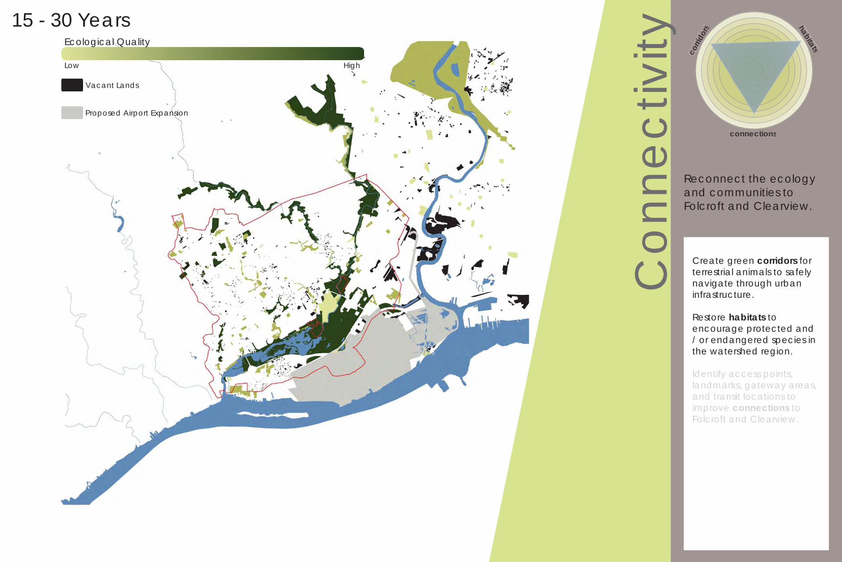
15 - 30 Years
Proposed Airport Expansion
Ecological Quality
Low
Vacant Lands
High
Proposed Airport Expansion
Ecological Quality
Low
Vacant Lands
Con
nect
ivity
Create green corridors for terrestrial animals to safely navigate through urban infrastructure.
Restore habitats to encourage protected and / or endangered species in the watershed region.
Identify access points, landmarks, gateway areas, and transit locations to improve connections to Folcroft and Clearview.
corri
dors habitats
connections
Reconnect the ecology and communities to Folcroft and Clearview.
Identify access points,landmarks, gateway areas,and transit locations toimprove connections to Folcroft and Clearview.
30 - 45 Years
High
Con
nect
ivity
Create green corridors for terrestrial animals to safely navigate through urban infrastructure.
Restore habitats to encourage protected and / or endangered species in the watershed region.
Identify access points, landmarks, gateway areas, and transit locations to improve connections to Folcroft and Clearview.
corri
dors habitats
connections
Reconnect the ecology and communities to Folcroft and Clearview.
Identify access points,landmarks, gateway areas,and transit locations toimprove connections to Folcroft and Clearview.
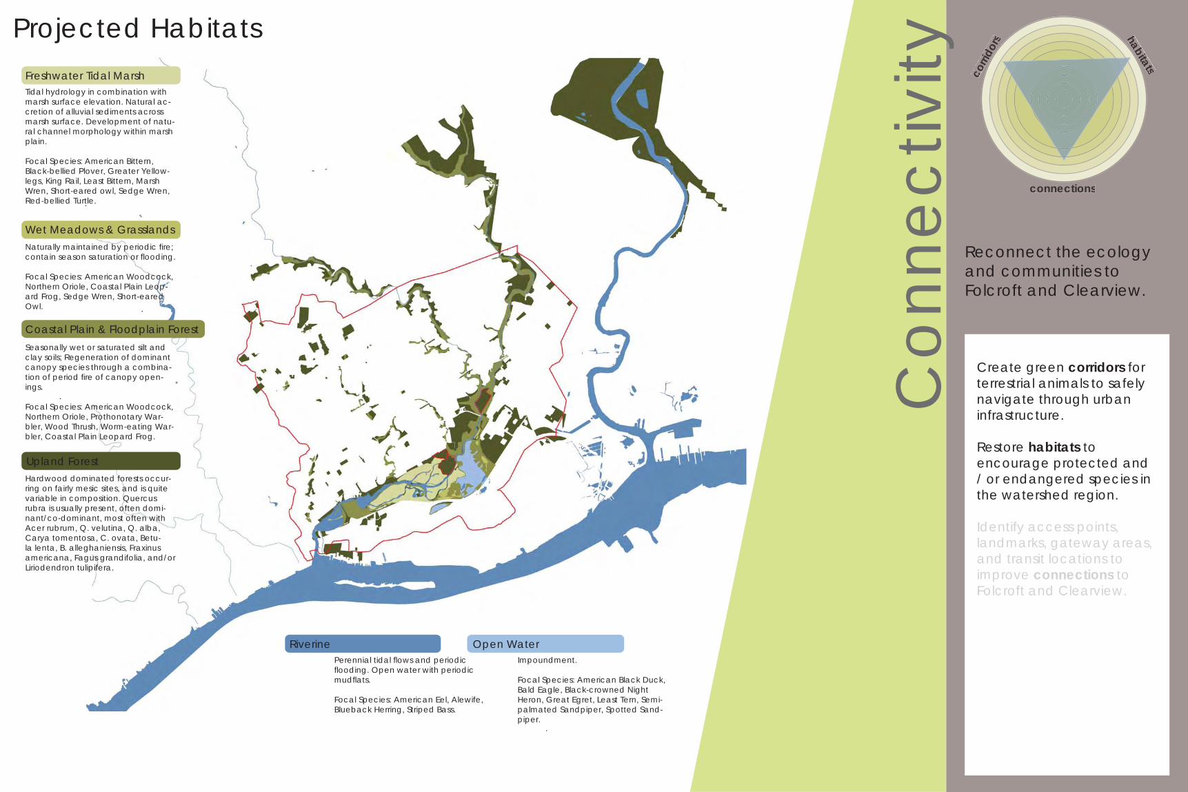
Projected Habitats
.
.
.
.
.
Riverine Open Water
Freshwater Tidal MarshTidal hydrology in combination with marsh surface elevation. Natural ac-cretion of alluvial sediments across marsh surface. Development of natu-ral channel morphology within marsh plain.
Focal Species: American Bittern, Black-bellied Plover, Greater Yellow-legs, King Rail, Least Bittern, Marsh Wren, Short-eared owl, Sedge Wren, Red-bellied Turtle.
Coastal Plain & Floodplain ForestSeasonally wet or saturated silt and clay soils; Regeneration of dominant canopy species through a combina-tion of period fi re of canopy open-ings.
Focal Species: American Woodcock, Northern Oriole, Prothonotary War-bler, Wood Thrush, Worm-eating War-bler, Coastal Plain Leopard Frog.
Upland ForestHardwood dominated forests occur-ring on fairly mesic sites, and is quite variable in composition. Quercus rubra is usually present, often domi-nant/co-dominant, most often with Acer rubrum, Q. velutina, Q. alba, Carya tomentosa, C. ovata, Betu-la lenta, B. alleghaniensis, Fraxinus americana, Fagus grandifolia, and/or Liriodendron tulipifera.
Perennial tidal fl ows and periodic fl ooding. Open water with periodic mudfl ats.
Focal Species: American Eel, Alewife, Blueback Herring, Striped Bass.
Impoundment.
Focal Species: American Black Duck, Bald Eagle, Black-crowned Night Heron, Great Egret, Least Tern, Semi-palmated Sandpiper, Spotted Sand-piper.
Wet Meadows & GrasslandsNaturally maintained by periodic fi re; contain season saturation or fl ooding.
Focal Species: American Woodcock, Northern Oriole, Coastal Plain Leop-ard Frog, Sedge Wren, Short-eared Owl.
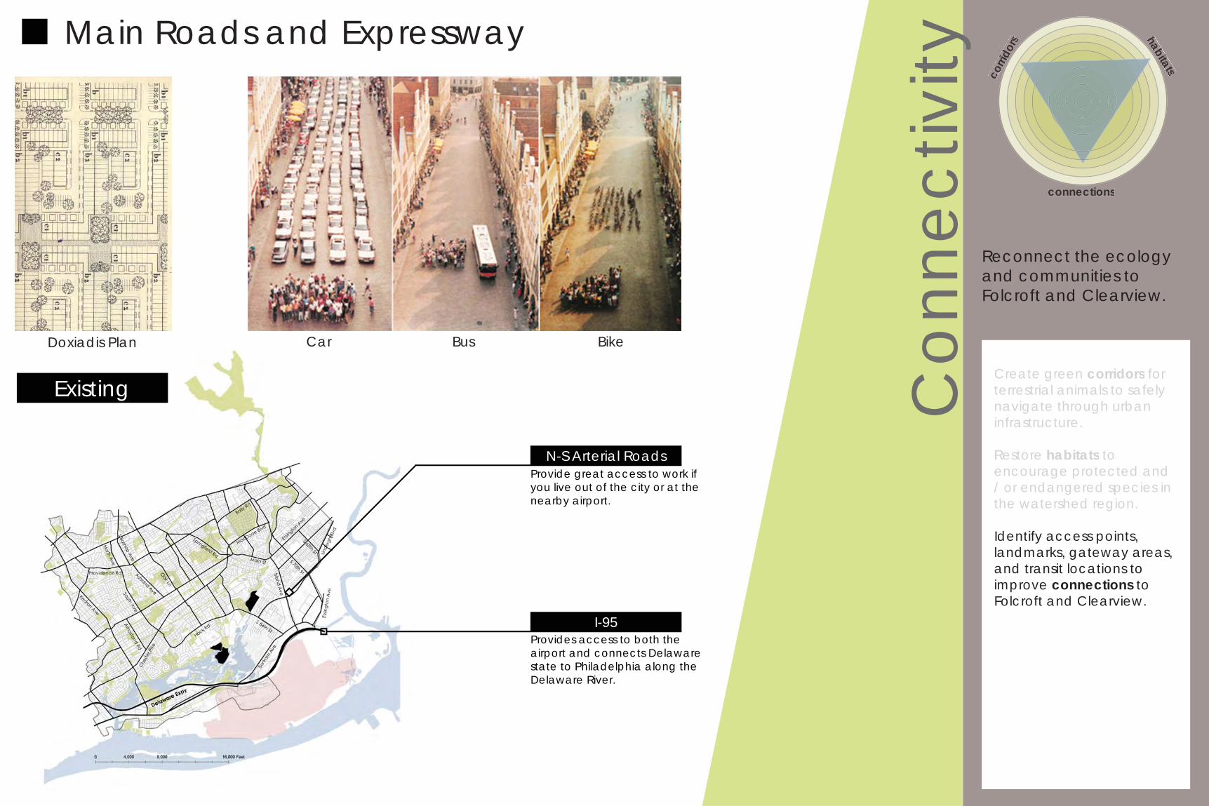
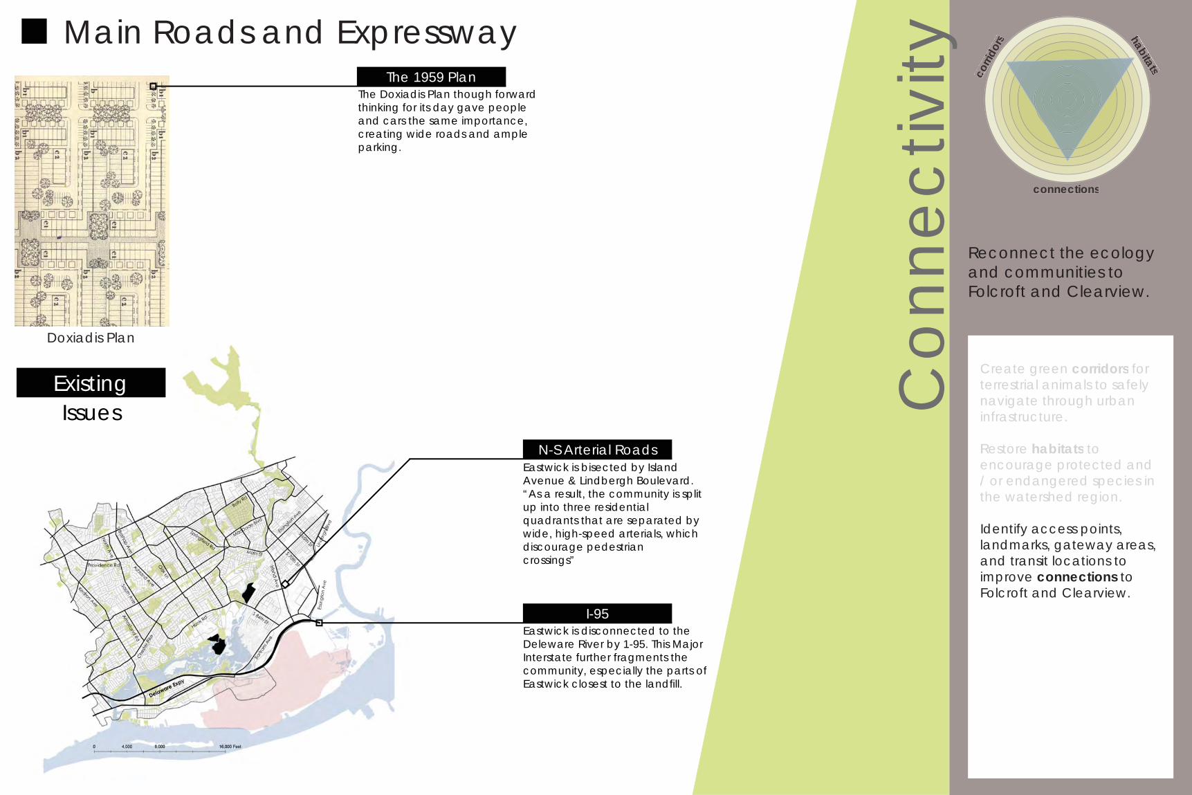
Doxiadis Plan
Con
nect
ivity
Create green corridors for terrestrial animals to safely navigate through urban infrastructure.
Restore habitats to encourage protected and / or endangered species in the watershed region.
Identify access points, landmarks, gateway areas, and transit locations to improve connections to Folcroft and Clearview.
corri
dors habitats
connections
Reconnect the ecology and communities to Folcroft and Clearview.
Create green corridors for terrestrial animals to safely navigate through urbaninfrastructure.
Restore habitats toencourage protected and / or endangered species inthe watershed region.
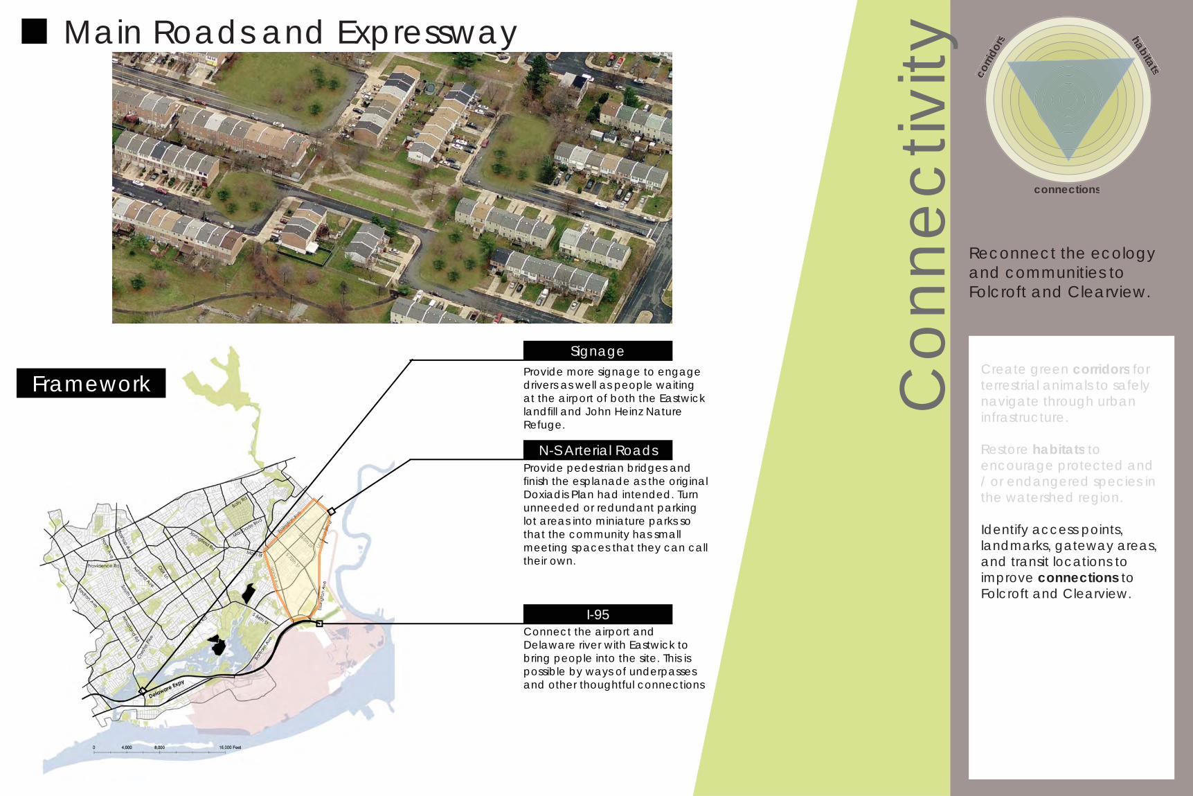
Main Roads and Expressway
Existing
Car Bus Bike
I-95
N-S Arterial RoadsProvide great access to work if you live out of the city or at the nearby airport.
Provides access to both the airport and connects Delaware state to Philadelphia along the Delaware River.
Doxiadis Plan
Con
nect
ivity
Create green corridors for terrestrial animals to safely navigate through urban infrastructure.
Restore habitats to encourage protected and / or endangered species in the watershed region.
Identify access points, landmarks, gateway areas, and transit locations to improve connections to Folcroft and Clearview.
corri
dors habitats
connections
Reconnect the ecology and communities to Folcroft and Clearview.
Create green corridors for terrestrial animals to safely navigate through urbaninfrastructure.
Restore habitats toencourage protected and / or endangered species inthe watershed region.
Main Roads and Expressway
ExistingIssues
I-95
N-S Arterial RoadsEastwick is bisected by Island Avenue & Lindbergh Boulevard. “As a result, the community is split up into three residentialquadrants that are separated by wide, high-speed arterials, which discourage pedestriancrossings”
Eastwick is disconnected to the Deleware River by 1-95. This Major Interstate further fragments the community, especially the parts of Eastwick closest to the landfi ll.
The 1959 PlanThe Doxiadis Plan though forward thinking for its day gave people and cars the same importance, creating wide roads and ample parking.
Con
nect
ivity
Create green corridors for terrestrial animals to safely navigate through urban infrastructure.
Restore habitats to encourage protected and / or endangered species in the watershed region.
Identify access points, landmarks, gateway areas, and transit locations to improve connections to Folcroft and Clearview.
corri
dors habitats
connections
Reconnect the ecology and communities to Folcroft and Clearview.
Create green corridors for terrestrial animals to safely navigate through urbaninfrastructure.
Restore habitats toencourage protected and / or endangered species inthe watershed region.
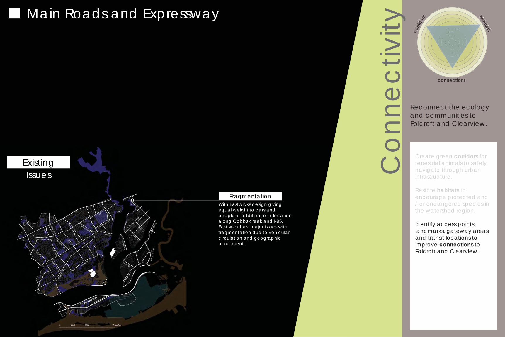
Main Roads and Expressway
ExistingIssues
FragmentationWith Eastwicks design giving equal weight to cars and people in addition to its location along Cobbs creek and I-95. Eastiwick has major issues with fragmentation due to vehicular circulation and geographic placement.
Con
nect
ivity
Create green corridors for terrestrial animals to safely navigate through urban infrastructure.
Restore habitats to encourage protected and / or endangered species in the watershed region.
Identify access points, landmarks, gateway areas, and transit locations to improve connections to Folcroft and Clearview.
corri
dors habitats
connections
Reconnect the ecology and communities to Folcroft and Clearview.
Create green corridors for terrestrial animals to safely navigate through urbaninfrastructure.
Restore habitats toencourage protected and / or endangered species inthe watershed region.
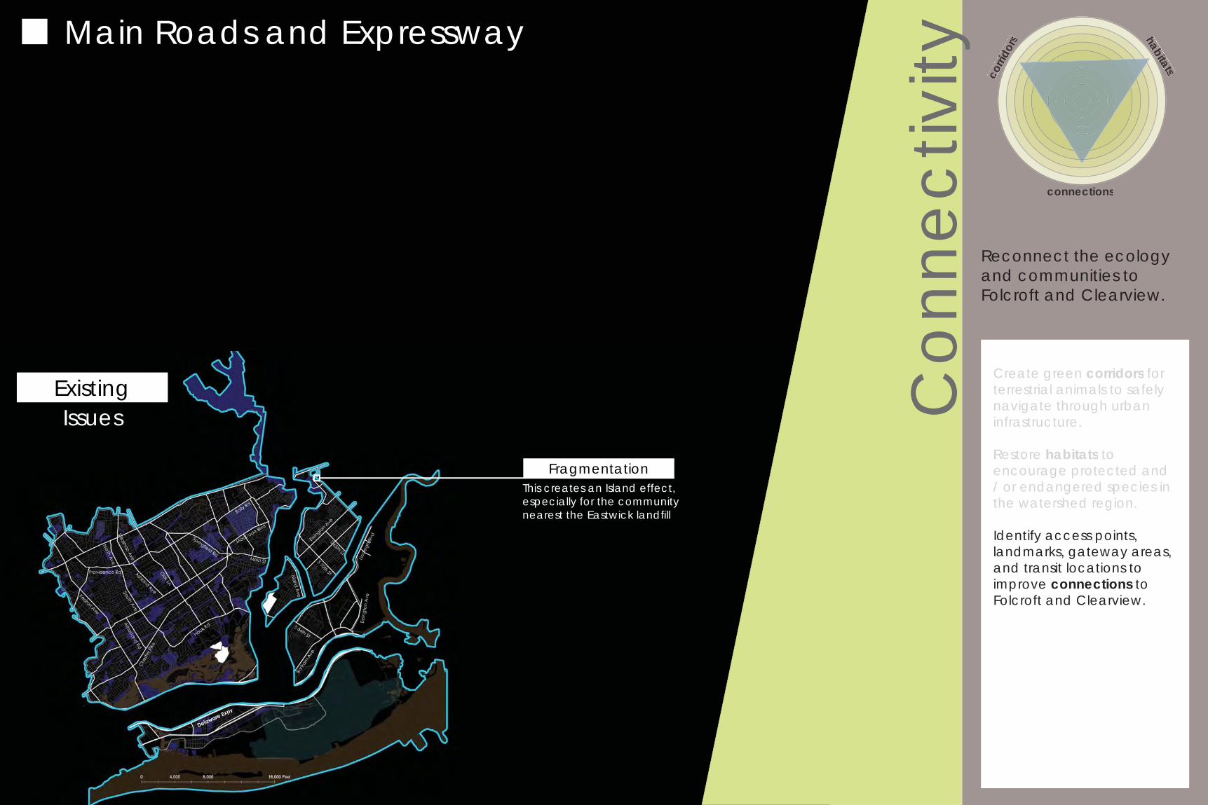
Main Roads and Expressway
ExistingIssues
FragmentationThis creates an Island effect, especially for the community nearest the Eastwick landfi ll
Con
nect
ivity
Create green corridors for terrestrial animals to safely navigate through urban infrastructure.
Restore habitats to encourage protected and / or endangered species in the watershed region.
Identify access points, landmarks, gateway areas, and transit locations to improve connections to Folcroft and Clearview.
corri
dors habitats
connections
Reconnect the ecology and communities to Folcroft and Clearview.
Create green corridors for terrestrial animals to safely navigate through urbaninfrastructure.
Restore habitats toencourage protected and / or endangered species inthe watershed region.
Main Roads and Expressway
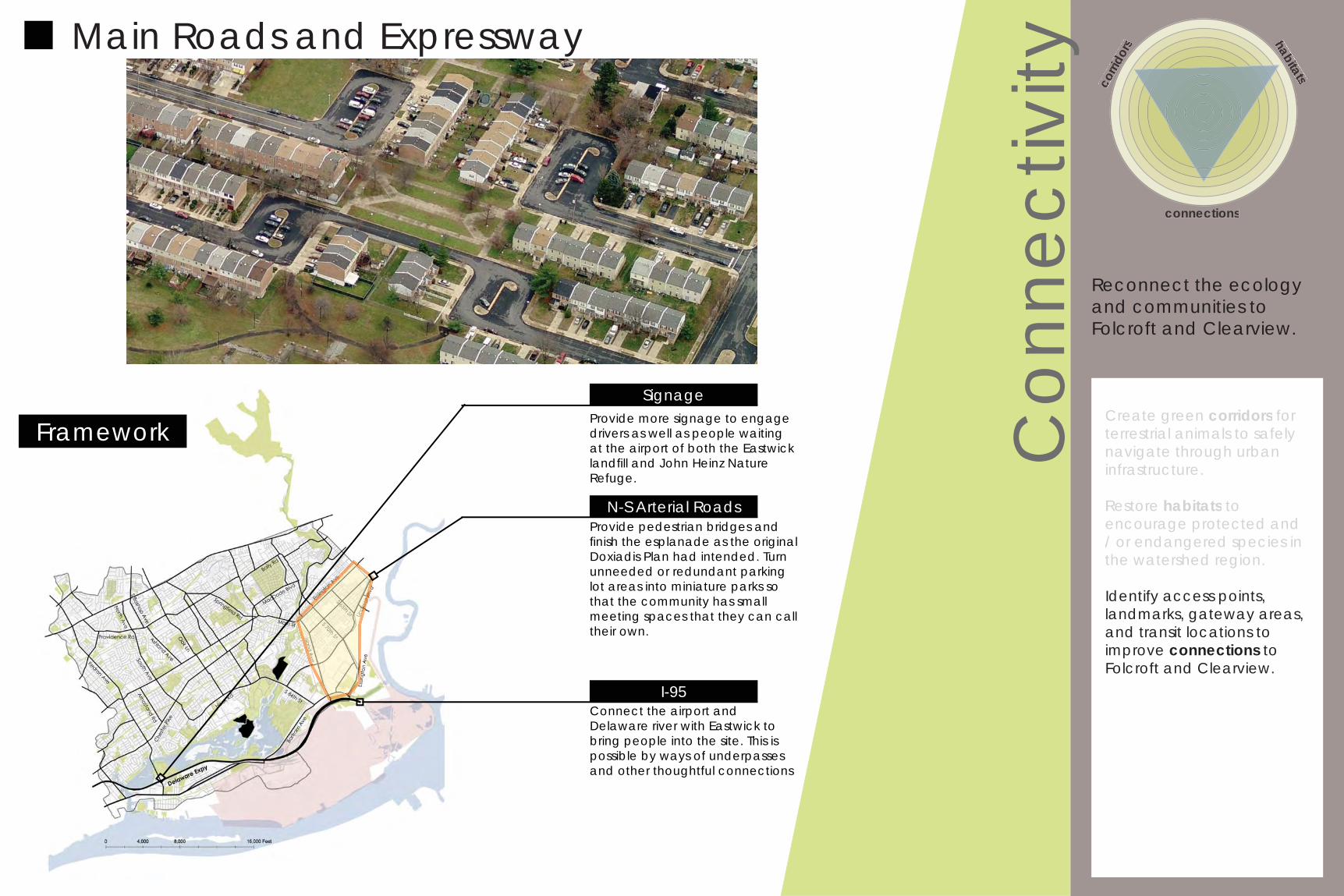
Framework
I-95
N-S Arterial RoadsProvide pedestrian bridges and fi nish the esplanade as the original Doxiadis Plan had intended. Turn unneeded or redundant parking lot areas into miniature parks so that the community has small meeting spaces that they can call their own.
Connect the airport and Delaware river with Eastwick to bring people into the site. This is possible by ways of underpasses and other thoughtful connections
Provide more signage to engage drivers as well as people waiting at the airport of both the Eastwick landfi ll and John Heinz Nature Refuge.
Signage
Con
nect
ivity
Create green corridors for terrestrial animals to safely navigate through urban infrastructure.
Restore habitats to encourage protected and / or endangered species in the watershed region.
Identify access points, landmarks, gateway areas, and transit locations to improve connections to Folcroft and Clearview.
corri
dors habitats
connections
Reconnect the ecology and communities to Folcroft and Clearview.
Create green corridors for terrestrial animals to safely navigate through urbaninfrastructure.
Restore habitats toencourage protected and / or endangered species inthe watershed region.
Main Roads and Expressway
Framework
I-95
N-S Arterial RoadsProvide pedestrian bridges and fi nish the esplanade as the original Doxiadis Plan had intended. Turn unneeded or redundant parking lot areas into miniature parks so that the community has small meeting spaces that they can call their own.
Connect the airport and Delaware river with Eastwick to bring people into the site. This is possible by ways of underpasses and other thoughtful connections
Provide more signage to engage drivers as well as people waiting at the airport of both the Eastwick landfi ll and John Heinz Nature Refuge.
Signage
Bike Path at John Heinz
Con
nect
ivity
Create green corridors for terrestrial animals to safely navigate through urban infrastructure.
Restore habitats to encourage protected and / or endangered species in the watershed region.
Identify access points, landmarks, gateway areas, and transit locations to improve connections to Folcroft and Clearview.
corri
dors habitats
connections
Reconnect the ecology and communities to Folcroft and Clearview.
Create green corridors for terrestrial animals to safely navigate through urbaninfrastructure.
Restore habitats toencourage protected and / or endangered species inthe watershed region.
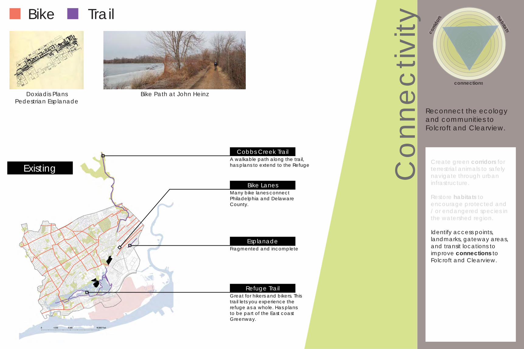
Existing
Bike Trail
Doxiadis PlansPedestrian Esplanade
Refuge TrailGreat for hikers and bikers. This trail lets you experience the refuge as a whole. Has plans to be part of the East coast Greenway.
Cobbs Creek TrailA walkable path along the trail, has plans to extend to the Refuge
EsplanadeFragmented and incomplete
Bike LanesMany bike lanes connect Philadelphia and Delaware County.
Con
nect
ivity
Create green corridors for terrestrial animals to safely navigate through urban infrastructure.
Restore habitats to encourage protected and / or endangered species in the watershed region.
Identify access points, landmarks, gateway areas, and transit locations to improve connections to Folcroft and Clearview.
corri
dors habitats
connections
Reconnect the ecology and communities to Folcroft and Clearview.
Create green corridors for terrestrial animals to safely navigate through urbaninfrastructure.
Restore habitats toencourage protected and / or endangered species inthe watershed region.
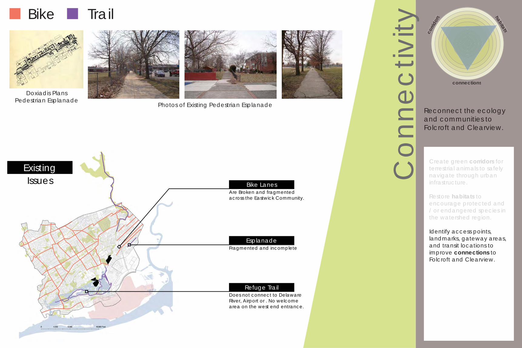
ExistingIssues
Refuge TrailDoes not connect to Delaware River, Airport or . No welcome area on the west end entrance.
Bike LanesAre Broken and fragmented across the Eastwick Community.
EsplanadeFragmented and incomplete
Bike Trail
Doxiadis PlansPedestrian Esplanade
Photos of Existing Pedestrian Esplanade
Con
nect
ivity
Create green corridors for terrestrial animals to safely navigate through urban infrastructure.
Restore habitats to encourage protected and / or endangered species in the watershed region.
Identify access points, landmarks, gateway areas, and transit locations to improve connections to Folcroft and Clearview.
corri
dors habitats
connections
Reconnect the ecology and communities to Folcroft and Clearview.
Create green corridors for terrestrial animals to safely navigate through urbaninfrastructure.
Restore habitats toencourage protected and / or endangered species inthe watershed region.
Framework
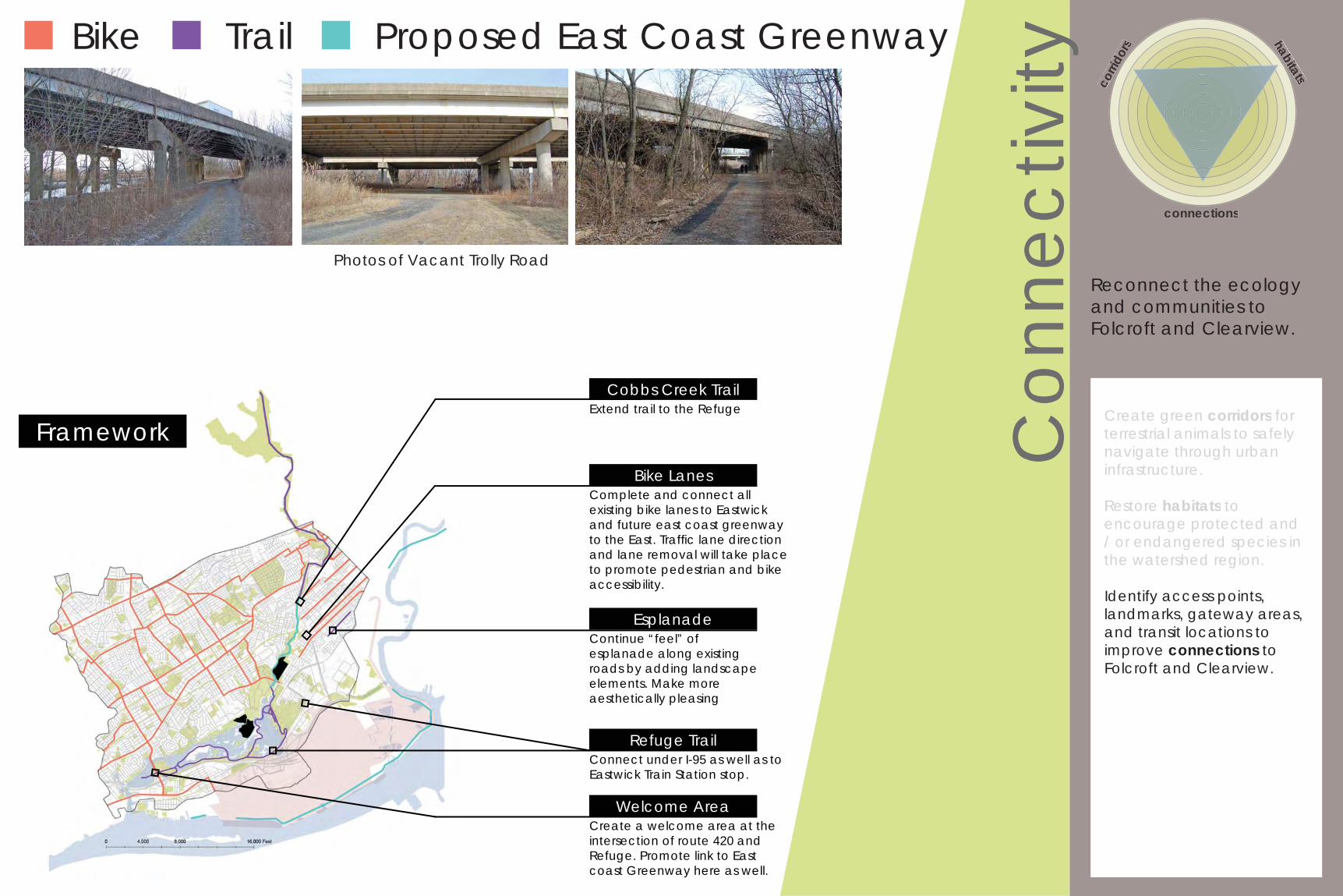
Refuge TrailConnect under I-95 as well as to Eastwick Train Station stop.
EsplanadeContinue “feel” of esplanade along existing roads by adding landscape elements. Make more aesthetically pleasing
Complete and connect all existing bike lanes to Eastwick and future east coast greenway to the East. Traffi c lane direction and lane removal will take place to promote pedestrian and bike accessibility.
Bike Lanes
Bike Trail
Photos of Vacant Trolly Road
Welcome AreaCreate a welcome area at the intersection of route 420 and Refuge. Promote link to East coast Greenway here as well.
Extend trail to the RefugeCobbs Creek Trail
Proposed East Coast Greenway
Con
nect
ivity
Create green corridors for terrestrial animals to safely navigate through urban infrastructure.
Restore habitats to encourage protected and / or endangered species in the watershed region.
Identify access points, landmarks, gateway areas, and transit locations to improve connections to Folcroft and Clearview.
corri
dors habitats
connections
Reconnect the ecology and communities to Folcroft and Clearview.
Create green corridors for terrestrial animals to safely navigate through urbaninfrastructure.
Restore habitats toencourage protected and / or endangered species inthe watershed region.
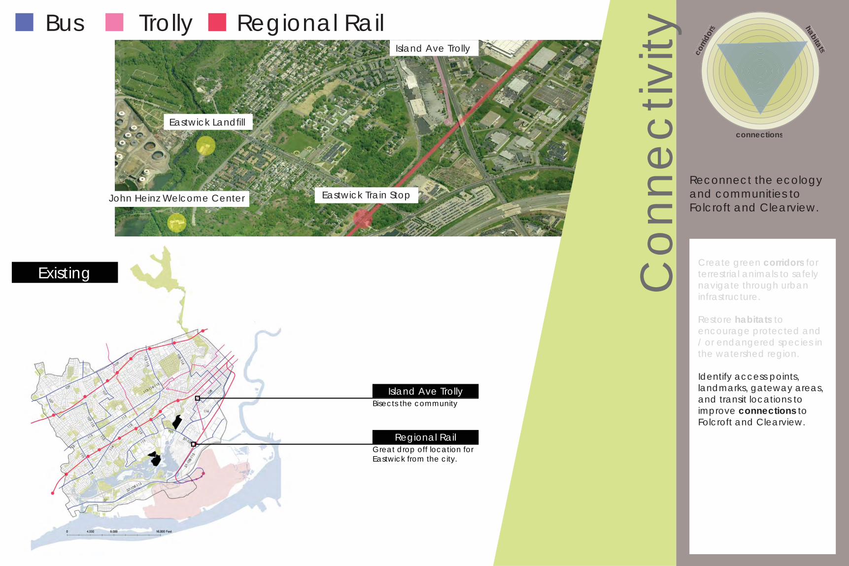
Existing
Eastwick Train Stop
Eastwick Landfi ll
John Heinz Welcome Center
Island Ave Trolly
Bus Trolly Regional Rail
Bisects the community
Great drop off location for Eastwick from the city.
Island Ave Trolly
Regional Rail
Con
nect
ivity
Create green corridors for terrestrial animals to safely navigate through urban infrastructure.
Restore habitats to encourage protected and / or endangered species in the watershed region.
Identify access points, landmarks, gateway areas, and transit locations to improve connections to Folcroft and Clearview.
corri
dors habitats
connections
Reconnect the ecology and communities to Folcroft and Clearview.
Create green corridors for terrestrial animals to safely navigate through urbaninfrastructure.
Restore habitats toencourage protected and / or endangered species inthe watershed region.
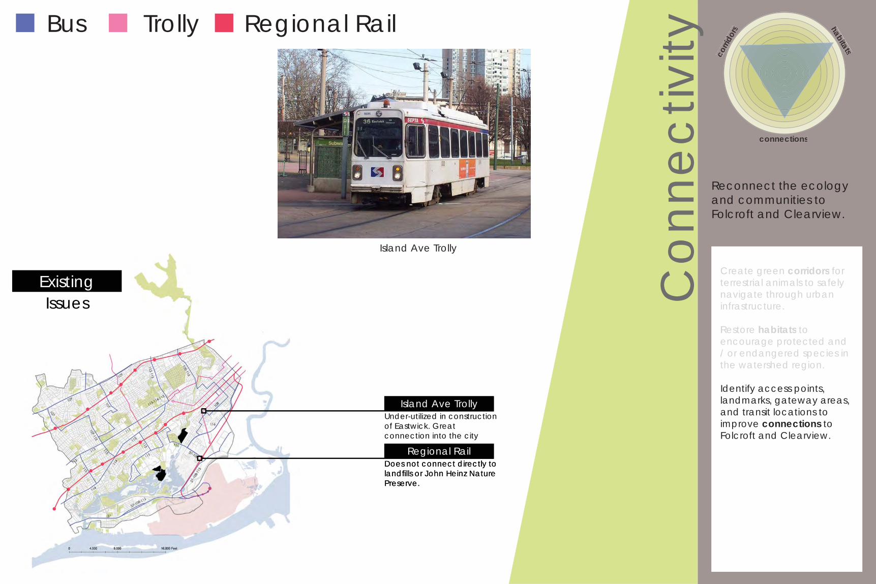
ExistingIssues
Island Ave TrollyUnder-utilized in construction of Eastwick. Great connection into the city
Regional RailDoes not connect directly to landfi lls or John Heinz Nature Preserve.
Bus Trolly Regional Rail
Island Ave Trolly
Island Ave Trolly
Regional RailDoes not connect directly to landfi lls or John Heinz Nature Preserve.
Con
nect
ivity
Create green corridors for terrestrial animals to safely navigate through urban infrastructure.
Restore habitats to encourage protected and / or endangered species in the watershed region.
Identify access points, landmarks, gateway areas, and transit locations to improve connections to Folcroft and Clearview.
corri
dors habitats
connections
Reconnect the ecology and communities to Folcroft and Clearview.
Create green corridors for terrestrial animals to safely navigate through urbaninfrastructure.
Restore habitats toencourage protected and / or endangered species inthe watershed region.
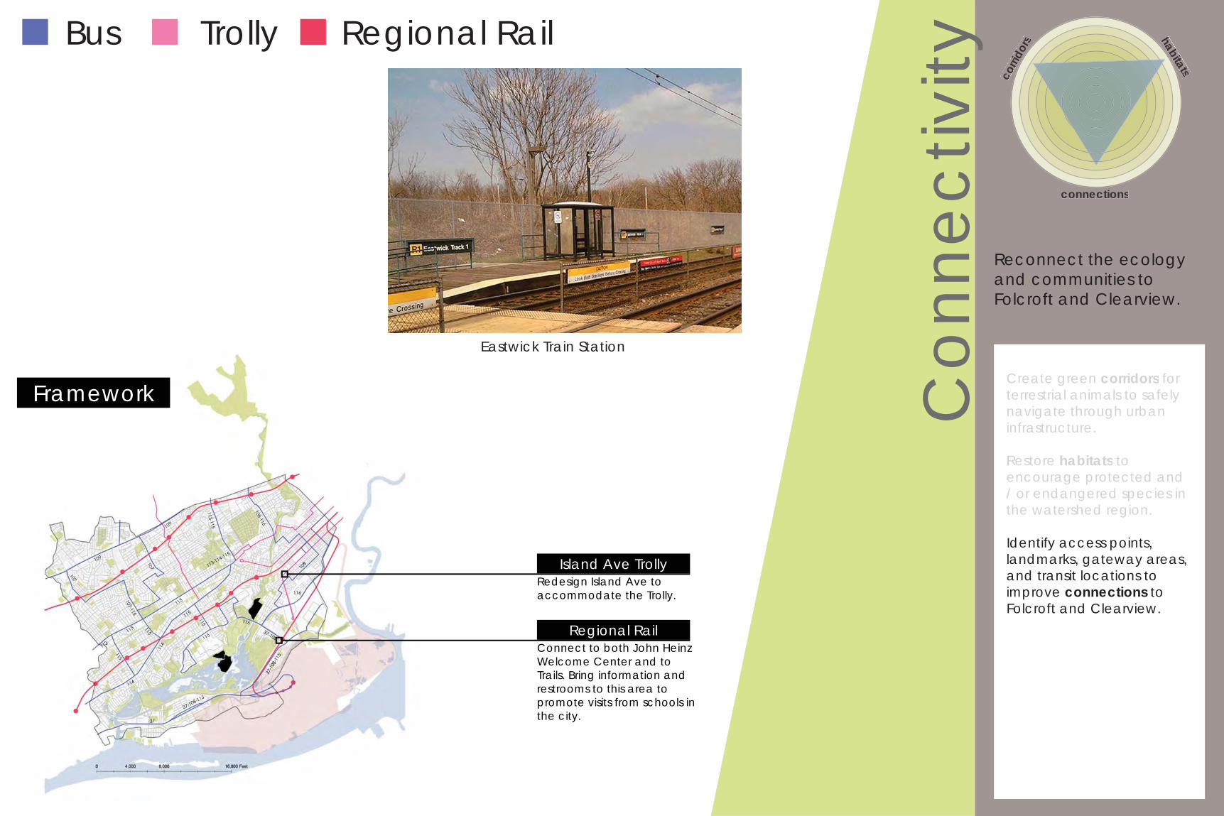
Framework
Bus Trolly Regional Rail
Island Ave TrollyRedesign Island Ave to accommodate the Trolly.
Regional RailConnect to both John Heinz Welcome Center and to Trails. Bring information and restrooms to this area to promote visits from schools in the city.
Eastwick Train Station
Trail Head
Con
nect
ivity
Create green corridors for terrestrial animals to safely navigate through urban infrastructure.
Restore habitats to encourage protected and / or endangered species in the watershed region.
Identify access points, landmarks, gateway areas, and transit locations to improve connections to Folcroft and Clearview.
corri
dors habitats
connections
Reconnect the ecology and communities to Folcroft and Clearview.
Create green corridors for terrestrial animals to safely navigate through urbaninfrastructure.
Restore habitats toencourage protected and / or endangered species inthe watershed region.
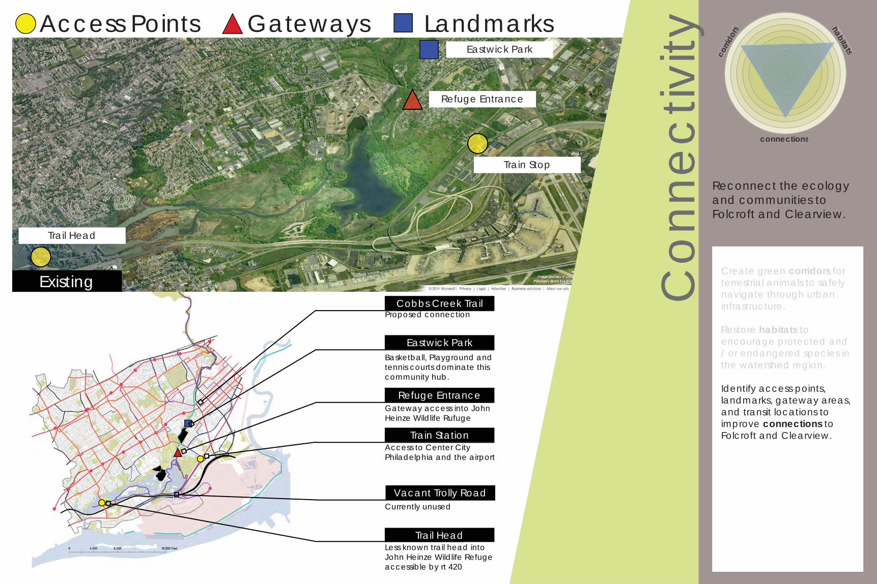
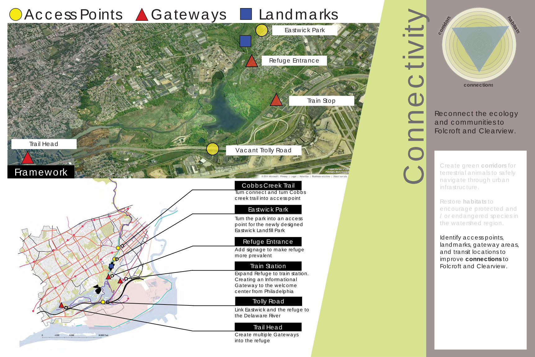
Access Points Gateways Landmarks
Existing
Eastwick Park
Refuge Entrance
Train Stop
Basketball, Playground and tennis courts dominate this community hub.
Gateway access into John Heinze Wildlife Rufuge
Less known trail head into John Heinze Wildlife Refugeaccessible by rt 420
Eastwick Park
Refuge Entrance
Trail Head
Cobbs Creek TrailProposed connection
Access to Center City Philadelphia and the airport
Train Station
Vacant Trolly RoadCurrently unused
Con
nect
ivity
Create green corridors for terrestrial animals to safely navigate through urban infrastructure.
Restore habitats to encourage protected and / or endangered species in the watershed region.
Identify access points, landmarks, gateway areas, and transit locations to improve connections to Folcroft and Clearview.
corri
dors habitats
connections
Reconnect the ecology and communities to Folcroft and Clearview.
Create green corridors for terrestrial animals to safely navigate through urbaninfrastructure.
Restore habitats toencourage protected and / or endangered species inthe watershed region.
Trail Head
Access Points Gateways Landmarks
Framework
Turn the park into an access point for the newly designed Eastwick Landfi ll Park
Add signage to make refuge more prevalent
Create multiple Gateways into the refuge
Eastwick Park
Refuge Entrance
Train Stop
Eastwick Park
Refuge Entrance
Trail Head
Cobbs Creek TrailTurn connect and turn Cobbs creek trail into access point
Expand Refuge to train station. Creating an Informational Gateway to the welcome center from Philadelphia
Train Station
Vacant Trolly Road
Trolly RoadLink Eastwick and the refuge to the Delaware River
Econ
omic
Gro
wth
Encourage economic growth around Folcroft and Clearview
property values
infrastructure recr
eatio
n
job creationre
aethetics
1900
2000
1990
1980
1970
1960
1950
1940
1930
1920
1910
2,500,000
2,000,000
1,500,000
1,000,000population of philadelphia
year
http://theboardwalkempire.blogspot.com/2010/09/atlantic-city-becoming-haven-for-vices.html
declining population decreases development and increases vacant land
“Due to a declining population, the landscape of Southwest Philadelphia is dotted with vacant lots and abandoned buildings and contains a disproportionate amount of transportation infrastructure serving the airport and local industry” (interface studio). These abandoned spaces are most often seen by communities as liabilities, places for drug dealing, violent crime, prostitution, trash, and unsightly vegetation.
These physical liabilities can be seen as assets. The vacant land and infrastructure can be re-purposed to improve the local business economy. Commercial infrastructure will increase local commerce and additional open space will add to the aesthetics and improve property values.
http://interface-studio.com. Philadelphia PA. Accessed on 10.24.11
OPPORTUN
ITIES
OPPO
RTUNITIES
ECONOMIC POTENTIAL
COMMERCIALINFRASTRUCTURE
VACANT LAND
RECREATIONAL OPEN SPACE
Econ
omic
Gro
wth
Encourage economic growth around Folcroft and Clearview
property values
infrastructure recr
eatio
n
job creationre
aethetics
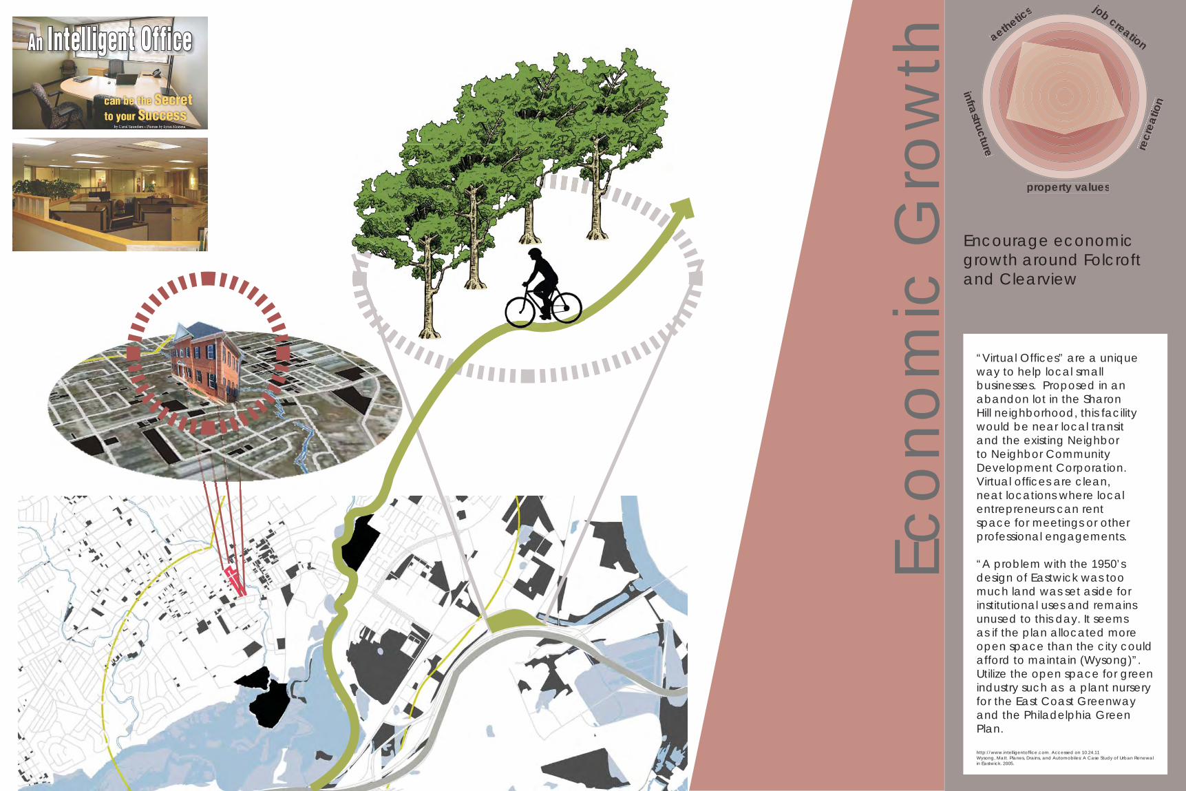
“Virtual Offi ces” are a unique way to help local small businesses. Proposed in an abandon lot in the Sharon Hill neighborhood, this facility would be near local transit and the existing Neighbor to Neighbor Community Development Corporation. Virtual offi ces are clean, neat locations where local entrepreneurs can rent space for meetings or other professional engagements.
“A problem with the 1950’s design of Eastwick was too much land was set aside for institutional uses and remains unused to this day. It seems as if the plan allocated more open space than the city could afford to maintain (Wysong)”. Utilize the open space for green industry such as a plant nursery for the East Coast Greenway and the Philadelphia Green Plan.
http://www.intelligentoffi ce.com. Accessed on 10.24.11Wysong, Matt. Planes, Drains, and Automobiles: A Case Study of Urban Renewal in Eastwick. 2005.

Nature at the Edge of the City...Reconnecting Ecology & Community Through
Adaptive Reuse of Folcroft and Clearview Landfills.


