1 NAVIGABILITY ALONG THE NATURAL CHANNEL OF THE SANTA CRUZ RIVER (From the Mexican border to the mouth at the Gila River near Buckeye, Arizona) An assessment based on history, hydrology, hydraulics and morphology by Hjalmar W. Hjalmarson, PE March 20, 2014
Transcript
1
NAVIGABILITY ALONG THE NATURAL CHANNEL
OF THE SANTA CRUZ RIVER
(From the Mexican border to the mouth at the Gila River
near Buckeye, Arizona)
An assessment based on history, hydrology, hydraulics and morphology
General approach ........................................................................................................ 7 Purpose and scope ...................................................................................................... 9
Estimate of natural flow in the Santa Cruz River ....................................................... 14 Discussion and summary of the natural hydrology .................................................... 17
HYDRAULIC GEOMETRY AND HYDRAULICS ........................................................... 19
Discussion and summary of the shape and size of the natural channel .................... 24
Bureau of Outdoor Recreation Method ...................................................................... 25 Fish and Wildlife Service Method............................................................................... 26
SUMMARY AND CONCLUSION .................................................................................. 29
APPENDIX A. ORIGINAL LAND SURVEYS WITH A FEW PHOTOGRAPHS AND
MAPS APPENDIX B. MICCELLANEOUS SUPPLEMENTAL INFORMATION APPENDIX C. RIVER ENGINEERING METHODS APPENDIX D. A FEW FACTS AND OBSERVATIONS BY A PROFESSIONAL RIVER ENGINEER
3
EXECUTIVE SUMMARY This Report is an assessment of the navigability of the natural channel of the Santa Cruz River that uses hydraulic geometry methods that project hydrologic information into the past. The assessment is for the 180 mile reach of the Santa Cruz River from the international border to the mouth at the Gila River. The purpose is to determine if this reach of the Santa Cruz River was susceptible to navigation at the time of Arizona statehood (February 14, 1912) in its ordinary and natural condition. This report is being prepared for proceedings before the Arizona Navigable Stream Adjudication Commission (ANSAC). For purposes of this assessment, I have used the following test for determining navigability
We hold that, to prove navigability of an Arizona watercourse under the federal standard for title purposes, one must merely demonstrate the following: On February 14,1912, the watercourse, in its natural and ordinary condition, either was used or was susceptible to being used for travel or trade in any customary mode used on water. See The Daniel Ball, 77 U.S. (10 Wall.) at 563, 19 L.Ed. 999.
Defenders of Wildlife v. Hull, 199 Ariz. 411,426, 18 P.3d 722 (App. 2001). :Additional legal analysis is provided in a memorandum submitted by the Arizona Center for Law in the Public Interest to ANSAC on Sept. 12, 2013 regarding the navigability of the Santa Cruz River (Case No. 03-002-NAV). This assessment used a systematic three-step procedure to first determine the natural condition of the Santa Cruz River, and then evaluate its susceptibility to navigation in that condition. This approach is necessary because the long history of human activities that greatly altered the flow and channel morphology greatly challenged this evaluation of the navigability. First, the natural hydrology was defined and expressed in a typical flow-duration curves of daily discharge for the study reach. Channel geometry was then calculated by applying empirical relations that utilize both the flow characteristics from step 1 and sediment characteristics of the Santa Cruz River. Finally, navigability was estimated using two independent methods of federal agencies that use information from steps 1 and 2. Published information and standard engineering hydraulic, hydraulic geometry and hydrologic methods were used to accomplish the three steps. Important hydrologic characteristics are: • The Santa Cruz River drained about 533 square miles at the upper end of the study
reach and about 8,581 square miles at the lower end. The watershed was hydrologically diverse because of the diversity of climate, geology and topography. The mountainous areas of the south and central parts of the watershed typically received more than 20 inches of precipitation per year. The hot-dry northern areas typically received less than 8 inches of precipitation per year. Precipitation fell during
4
two distinct periods--late summer and midwinter. Some snow accumulated in the higher mountains and typically melted and ran off in the spring.
• When rain fell onto the land in the Santa Cruz River watershed it started moving according to basic principles of hydrology. A portion of the precipitation seeped into the ground to replenish ground water. Some of the water flowed downhill on the land surface as direct runoff and appeared in surface streams that were unaffected by artificial diversions, storage, or other works of man in or on the stream channels. In the Santa Cruz River watershed, most of the runoff from storms reached the river channel directly on the land surface via overland flow, flow in rills, creeks and streams. Direct runoff was seasonal because the storms were seasonal and provided runoff for navigation for part of each year.
• The portion of the water that replenished the ground water was very important for
the susceptibility of the Santa Cruz River to navigation. Under natural conditions the water that replenished the ground water was temporarily stored, and later discharged to the rivers at springs and seeps in the watershed. This base runoff was released from storage during dry periods. Because precipitation, and therefore direct runoff, was seasonal and there are a few months each year with little precipitation, the base runoff provided perennial flow for navigation to the Santa Cruz River.
Important hydraulic characteristics under natural conditions at statehood were: • The Santa Cruz River constructed its own geometry between river mile 78 in the
Picacho area to river mile 180 at the Mexican border and this geometry is computed using established runoff and sediment characteristics of rivers and the runoff and sediment characteristics of the Santa Cruz River.
• The natural flow in the Santa Cruz River was both perennial and intermittent with a
mean annual flow at the Mexican border, Rillito Creek and the Picacho area of 29, 60 and 54 cubic feet per second, respectively. The corresponding widths and depths of flow were 24, 35 and 33 ft and 2.3, 2.9 and 2.8 ft, respectively. Average velocity of flow was less than about 3 ft/sec.
Important navigability characteristics were: • The depth and current (velocity) of the Santa Cruz River flow were important: too
little depth and too much velocity limited navigability. Most of the time flow depth was sufficiently great and flow velocity was sufficiently small for navigability of small watercraft along the Santa Cruz River.
• Navigability was independent of undesirable conditions such as temporary braiding
of the river channel following floods, low flow from severe droughts and flow variability because these characteristics are related to how the river might have been used for navigation rather than the navigability.
5
Conclusion: Based on all the hydrologic and hydraulic information, data and analysis contained in this report, it is the author's opinion that the natural channel of the Santa Cruz River, from the Mexican border (river mile 180) to the Picacho-Redrock area (river mile 78), was susceptible to navigation 75 % of the time during a typical year at the time of Arizona statehood in its ordinary and in its natural condition.
6
INTRODUCTION This report and analysis were undertaken to assess the navigability of the Santa Cruz River in its natural condition, at the time of Arizona statehood for presentation to ANSAC. This analysis is based on (1) my knowledge and expertise concerning hydrology, hydraulics and fluvial processes, in general, and the application of this knowledge to the Santa Cruz River in central and southern Arizona, in particular, (2) the documents of prior ANSAC studies, (3) published reports by the U. S. Geological Survey and other Federal agencies, and (4) federal definitions of navigable and natural flow. The 180 mile reach of the Santa Cruz River from the international border to the mouth at the Gila River is shown in Figure 1.
Figure 1.-- Watershed.
7
The test for determining navigability used in this analysis is from Defenders of Wildlife v. Hull, 199 Ariz. 411,426, 18 P.3d 722 (App. 2001):
We hold that, to prove navigability of an Arizona watercourse under the federal standard for title purposes, one must merely demonstrate the following: On February 14,1912, the watercourse, in its natural and ordinary condition, either was used or was susceptible to being used for travel or trade in any customary mode used on water. See The Daniel Ball, 77 U.S. (10 Wall.) at 563, 19 L.Ed. 999.
Additional legal analysis is set forth in a memorandum submitted by ACLPI to ANSAC on Sept. 12, 2013 regarding the navigability of the Santa Cruz River (Case No. 03-002-NAV). This river engineering report evaluates the ability of the natural channel of the Santa Cruz River to accommodate navigation. The necessary studies are channel widths, velocities, stability and depths at various seasons and locations. The question “was the natural river channel susceptible to travel?” is answered.
General approach The ability to navigate on a river encompasses many factors such as the amount of flow in the river channel, the width and depth of flow in the channel, the type of vessel and the purpose of the travel. Obviously, there must be a minimum depth of water in the channel because even the draft of a canoe will be a few inches. There are other factors of an economic and commercial nature that may be less obvious. These non-hydraulic factors, while important to the actual performance of navigation, are not included in this assessment of navigability. To make a reliable evaluation of navigability under the federal test, the anthropogenic impacts, such as the many diversions along the Santa Cruz River and its tributaries for irrigation by settlers, should be adjusted for because the diversion of flow may have affected the navigability. Two reports describe the hydrological and geomorphological characteristics of the Santa Cruz River before and at the time of Statehood and compare those characteristics to those of the present day. These two reports document important information regarding the history of the Santa Cruz River, especially the long history of human impacts and associated changes of channel morphology and hydrology of the watershed:
Fuller, J. E., 2004, Arizona Stream Navigability Study for the Santa Cruz River, Gila River Confluence to Headwaters. Original prepared by SFC Engineering Company in November 1996; revised by Fuller in January 2004. Wood, M. L, House, P. K., and Peatthree, P. A., 1999, Historical Geomorphology and Hydrology of the Santa Cruz River, Open-File Report 99-13, AZ. Geological
8
Survey; supported by the Arizona State Land Department as part of their efforts to gather technical information for a stream navigability assessment, 96p.
My analysis in this Report is based on my knowledge of the watershed, Federal Land Surveys (Appendix A), miscellaneous information in Appendices B to D and information in the two aforementioned reports. I only analyzed the segment of river located north of the Mexican border. Along the upper Santa Cruz River, south of Picacho-Redrock area, the channel generally lies within an inner valley created within broad, dissected pediments and alluvial basin deposits and flanked by mountains. The reach below the present site of Valencia Road was described in 1871 as having a channel with vertical banks 60 feet apart and up to 10 feet high. By the time of statehood in 1912, there was a deep channel, perhaps more than 20 feet deep, well into what is now the San Xavier Indian Reservation. In 1915 the Federal Land Survey (Appendix A pages 19-20) showed the channel of the Santa Cruz River was incised 12-20 ft and the “trench” was from 154 ft to 317 ft wide. All the base flow seeped into sediments about 3 miles north of the San Xavier Del Bac mission. The same survey showed the river as meandered. According to page 56 of the survey instruction in affect at that time (General Land Office, June 30, 1904, Manual of Surveying Instructions for the Survey of Public Lands of the United States and Private Land Claims; Commissioner of the General Land Office, Washington, 1894.) meandering is as follows:
In my analysis, the effects of climate change, if any, are considered insignificant because according to Thomsen and Eychaner (1991), “Tree-ring data do not indicate a significant change in precipitation from 1602 to 1970.”
9
Many diversions of the Santa Cruz began long before statehood. In the late 1880s, the river was diverted to create two lakes, Warner Lake and Silver Lake, near downtown Tucson (Appendix A page 9). Notably, Warner received legal notice that he was interfering with the water in the Santa Cruz and obstructing the "free and continuous passage of the same." (Fuller, 2004). In the early 1900s a third lake called the Santa Cruz Reservoir was created (Appendix B, pages 4 and 5) in the southern part of Santa Cruz Flats (Figure 1). Groundwater pumping also depleted much of the river. Pump technology first became available in 1891 and initiated the extensive groundwater pumping that excluded any reasonable chance of recovery of the entrenchment around Tucson by any natural processes. Groundwater pumping also affected the river's tributaries like the Rillito River. In this evaluation of the navigability of the Santa Cruz River, the greatest challenge is the fact that by 1912, the river had been so altered by human activities (Appendix D, Item 1 for example and Appendix A pages 26-28) that it is difficult to assess its condition in its "natural and ordinary" state. The evidence shows that the natural river had a substantial natural base flow. The reason that the natural flow did not find its way into the river channel is human interference through diversions, storage, and groundwater pumping. Yet, as the Arizona Court of Appeals made clear, the commission must evaluate the river as though those activities did not occur. When such adjustments are made, it is apparent that several reaches of the Santa Cruz River were sufficiently perennial or intermittent to support a finding that they were susceptible to navigation by small watercraft and, therefore, were capable of being used as a highway for commerce.
Purpose and scope The purpose of this report is to assess the navigability along the natural Santa Cruz River at the International border with Mexico to the mouth and the Gila River on February 14, 1912 when Arizona became a state. At statehood, Indians and settlers were diverting large quantities of water from the river. The natural condition of flow that existed before settlers arrived and diverted and stored water for irrigation, livestock and mining was used for this analysis of navigability. This assessment is based on the natural hydrologic, hydraulic and morphologic conditions related to navigability because under the Defenders of Wildlife test, navigability is based on natural and ordinary conditions. The study was performed as outlined in the following diagram. Background information that included historic accounts of water use in the watershed (US and Mexico) and hydrology of the watershed was first examined. Upon learning of the long history (several centuries) of water use in the watershed and the massive changes of the natural channel of the Santa Cruz River before statehood, the river engineering analysis was performed in three basic steps.
10
Step. 1: Estimate the amount and temporal distribution of natural flow for the Santa Cruz River from the Mexican border to the mouth of the river near Buckeye, Arizona. The natural hydrology for the Santa Cruz River is based largely on published reports by the U. S. Bureau of Reclamation and by the U. S. Geological Survey. Step 2: Estimate the natural hydraulic characteristics of the river channel that are related to navigation. The natural size and shape of the Santa Cruz River channel are based on published hydraulic geometry relations for deformable alluvial channels. Diversion and regulation for several centuries and especially since the 1800s have altered discharge and sediment characteristics in the Santa Cruz River. Observations and measurements of channel size and shape over the past approximately 300 years may be unreliable because the base flow and the morphology of the river changed as a result of this diversion of base flow and sediment from the river. Therefore, it is necessary estimate the size and shape of the river channel when the flow was natural. Sediment-hydraulic geometry (morphology) relations for alluvial channels were used to calculate natural channel size and shape of the Santa Cruz River. Step 3: Determine whether in its natural condition the Santa Cruz River was susceptible to navigation from the Mexican border to the mouth at the Gila River. Navigability along the Santa Cruz River is evaluated after the natural hydrology, hydraulics and morphology of the channel determined in steps 1 and 2, are used to estimate the size and shape of the river. Two relatively simple methods developed by the U.S. Department of the Interior were used.
This report presents the results of a quantitative estimate of the navigability of the Santa Cruz River based largely on USGS reports and stream gage records and also a USBR report. Several USGS reports on the flow characteristics of the Santa Cruz River, the use of hydraulic geometry to estimate channel geometry and the assessment of the navigability of rivers formed the basis of the reported analysis. Information in other reports by federal agencies, mostly the USBR report on the natural flow of the Colorado River and tributaries, also was used.
11
HYDROLOGY Natural and ordinary perennial/intermittent streamflow is comprised of surface runoff and base runoff. Surface runoff is derived from precipitation, more than 20 inches/yr in the southern/central mountains and less than 8 inches/yr in the northern valley, and some snowmelt. Base runoff is maintained by ground-water discharge to the Santa Cruz River and tributary streams such as Sonota Creek. Base flow is comprised of ground-water discharge from mountain front springs and seeps (Base Qmf on Figure 2) and Quaternary aquifers (Base Qqa) and basin fill and deeper aquifers (Base Qbfa). Figure 2. Sketch showing ground water under natural conditions. Under natural conditions the water that replenished the groundwater (recharge) along the mountain fronts all along the upper river valley and in Mexico was temporarily stored, and later discharged (Base Qmf, Qqa and Qbfa) to the river at springs and seeps including cienegas. This base runoff was slowly and steadily released from storage during dry periods. Because precipitation, and therefore direct runoff, was seasonal and there are a few months each year with little precipitation, the base runoff provided perennial and intermittent flow along the upper reaches of the Santa Cruz River. Mountain front springs typically are springs in bedrock areas at elevations commonly greater than 4,800 ft above sea level. These springs (Base Qmf on Figure 2) are not part of a large aquifer system and generally discharge small volumes relative to springs at lower levels (Base Qqa and Qbfa). Ground water supplying mountain front (higher-altitude) springs is stored in small-volume secondary openings, such as fractures, catchments of colluvium, or pockets of stream alluvium.
12
Mountain front and Quaternary aquifer springs tend to respond more quickly to temporal changes in precipitation than the lower-altitude springs. For example, summer storm runoff is stored as alluvial groundwater along tributary streams. Despite their relative small volume, the numerous Quaternary aquifers sustain intermittent and/or perennial stream segments of tributary streams and the Santa Cruz River. The evidence suggests that before development, ground-water discharge was mainly by evapotranspiration, with lesser discharge to streams as base flow. The principal water-bearing sediments consisted of stream-alluvium deposits, where saturated, and upper basin fill. Ground water generally occurred under unconfined conditions, although head differences with depth may have occurred because of the presence of clay lenses in the heterogeneous basin fill. Before development, water levels ranged from at land surface near perennial streams to as much as a few hundred feet below land surface in places near mountain fronts. Ground water flowed from the perimeter of a basin and from the up gradient end toward the basin center and then down valley to the mouth at the Santa Cruz River. Some ground water probably flowed through the entire length of the basins. Under natural conditions groundwater flowed toward the Santa Cruz River and encountered geologic constrictions and at these places rose above the river bed and became base runoff. In the Marana area (below Rillito Creek and Canada Del Oro) the groundwater basin became large and any groundwater recharge was offset by evapotranspiration along the river. Below Picacho Peak area the groundwater basin became very large and the relatively little amount of recharge was offset by large amounts of evapotranspiration. The depth to water below Picacho Peak area was shallow and there were large area of mesquite that transpired great quantities of water. Mowry (1864, p. 186) describes the human affected upper river as a sinuous channel with a width that “varies from 20 to 100 feet, and during very dry seasons portions of it disappear.” Near the mouth of the Santa Cruz groundwater was constricted by bedrock as base runoff was present for a few miles. Runoff from storms (direct runoff) entered the Santa Cruz River through tributary stream channels all along the watershed. Direct runoff was confined to the Santa Cruz channel and floodplain to the Marana area where high flows would spill onto the floodplain and become separated from the river. Further downstream floodwater entered distributary channels a couple of miles to the south and east of Picacho Peak and spread over a wide area (Santa Cruz Flats) (Figure 1). Thus, direct runoff was not confined to a single channel between the Picacho Peak area and the mouth at the Santa Cruz River (See Appendix B, T8S R7E Santa Cruz Flats and Appendix A). Based on this river morphology, historic accounts of hydrology and basin fill with constriction of groundwater flow at the boundary between alluvial basins 48 and 49, the reach north of river mile 78 in the Red Rock-Picacho Peak area was initially considered non-navigable for this analysis. Subsequent analysis indicates there may have been a
13
defined channel to the Gila River with intermittent flow but it is more likely neither sufficient flow or a defined channel existed when Spanish explorers were in the area. Human diversions, both groundwater and surface water, have resulted in lowering of groundwater water levels along the river to far below the river bed. This has induced large amounts of infiltration from the river to the underlying groundwater that is typically far below. Two examples of this “water loss” from the river are shown in Figure 3. The streambeds of the Santa Cruz River are extremely permeable, and water is lost to the subsurface as the flow moves downstream. In the previous example, flood volumes diminished 86% along the main stem of the Santa Cruz River. Part of the water lost through infiltration reaches the water table, and water levels in wells near the river fluctuate in response to the stream flow. (Condes de la Torre, Alberto, 1970, Streamflow in the Upper Santa Cruz River Basin, USGS WSP 1939-a, 32p).
A.—Typical flow event for incised channel (human induced) showing transmission losses and
attenuation of peaks. B.—Flow duration for tributary inflow and infiltration duration along reach of river above
Tucson.
Figure 3. Example of the water loss to infiltration (transmission loses) along the Santa Cruz River
14
Thus, this base runoff was derived from rather constant (steady) groundwater discharge all along the upper river upstream of Marana (Approximate boundary between T11S R11E and T12 S R11E) from the regional aquifer. This perennial and intermittent flow was sufficient for navigability as discussed later. The regional aquifer is defined as having recharge zones away from the river, primarily at mountain fronts and along ephemeral channels. The aquifer along the river was also recharged from storm flow (direct runoff) as shown by the channel losses to groundwater in Figure 3. In the absence mostly of evapotranspiration (ET), and to a lesser degree infiltration into the porous stream sediments, along the riparian area of the upper reach the base runoff would have steadily increased along the river throughout an ordinary year. However, the base runoff varied considerably because ET varied seasonally. Large amounts of the rather steady inflowing groundwater to the riparian area were consumed (converted to water vapor) during the summer months. Summer base runoff (roughly represented by Q90, the amount of base runoff equaled or exceeded 90% of the time during a typical year) decreased along the river. Base runoff (Base Qmf, Qqa and Qbfa, Figure 2) also varied considerably throughout the year. The USGS estimate of predevelopment base runoff (Freethey, G. W. and Anderson, T. W., 1986) that is used for this analysis of navigability focused on groundwater discharge from the basin fill (Qbfa). The USGS method generally ignored ground-water discharge from mountain front springs and seeps (Base Qmf on Figure 2) and Quaternary aquifers (Base Qqa). Thus, because the first human impacts were (1) diversion and storage of springflow and tributary streamflow for mining and livestock, (2) surface diversion made along the river using low earth/rock dams and eventually (3) shallow wells using centrifugal pumps, these rather small but numerous diversions initially had little impact on Qbfa but significantly reduced, or completely consumed, Qmf and Qqa. With the advent of deep wells in the basin fill aquifers, all of the base runoff eventually was partially or totally consumed by human activity.
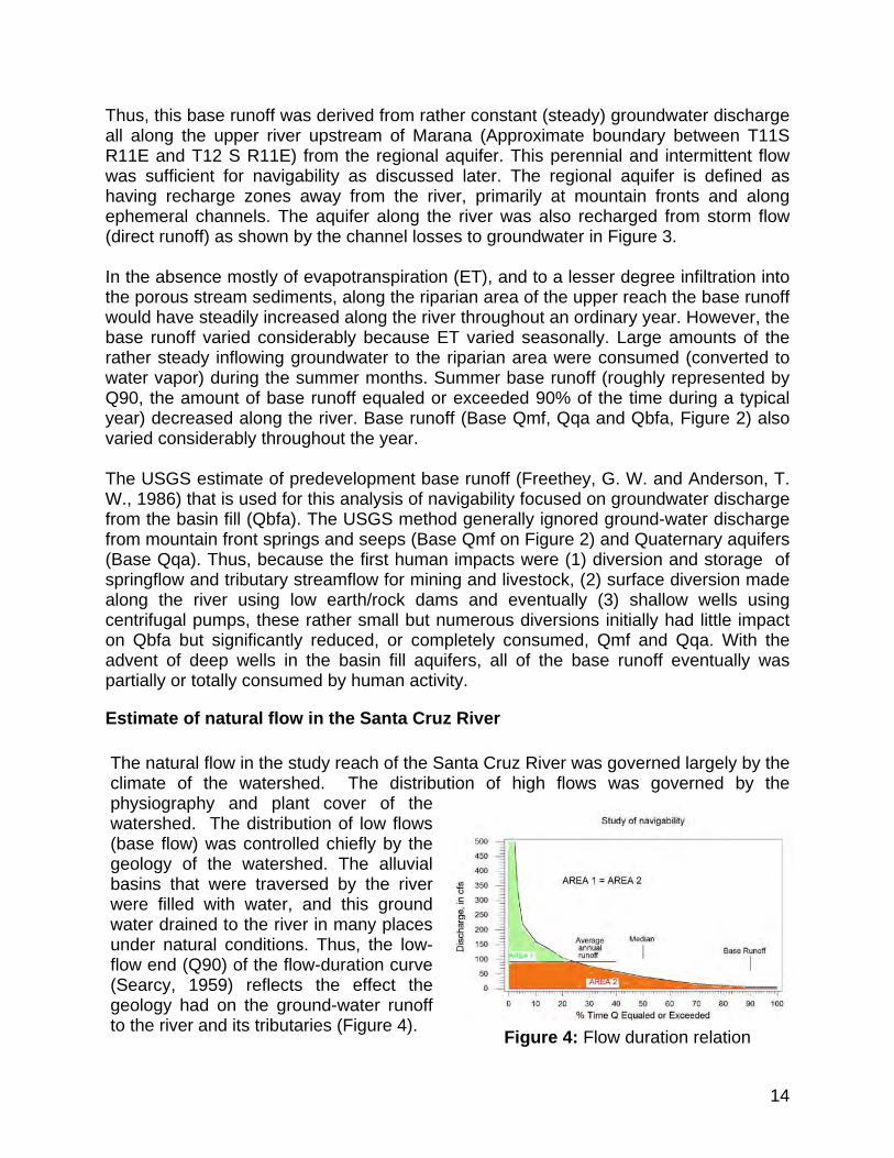
Estimate of natural flow in the Santa Cruz River The natural flow in the study reach of the Santa Cruz River was governed largely by the climate of the watershed. The distribution of high flows was governed by the physiography and plant cover of the watershed. The distribution of low flows (base flow) was controlled chiefly by the geology of the watershed. The alluvial basins that were traversed by the river were filled with water, and this ground water drained to the river in many places under natural conditions. Thus, the low-flow end (Q90) of the flow-duration curve (Searcy, 1959) reflects the effect the geology had on the ground-water runoff to the river and its tributaries (Figure 4). Figure 4: Flow duration relation
15
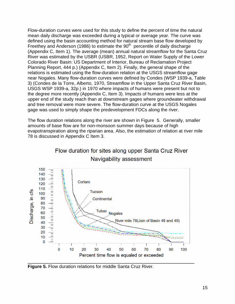
Flow-duration curves were used for this study to define the percent of time the natural mean daily discharge was exceeded during a typical or average year. The curve was defined using the basin accounting method for natural stream base flow developed by Freethey and Anderson (1986) to estimate the 90th percentile of daily discharge (Appendix C, Item 1). The average (mean) annual natural streamflow for the Santa Cruz River was estimated by the USBR (USBR, 1952, Report on Water Supply of the Lower Colorado River Basin: US Department of Interior, Bureau of Reclamation Project Planning Report, 444 p.) (Appendix C, Item 2). Finally, the general shape of the relations is estimated using the flow-duration relation at the USGS streamflow gage near Nogales. Many flow-duration curves were defined by Condes (WSP 1939-a, Table 3) (Condes de la Torre, Alberto, 1970, Streamflow in the Upper Santa Cruz River Basin, USGS WSP 1939-a, 32p.) in 1970 where impacts of humans were present but not to the degree more recently (Appendix C, Item 3). Impacts of humans were less at the upper end of the study reach than at downstream gages where groundwater withdrawal and tree removal were more severe. The flow-duration curve at the USGS Nogales gage was used to simply shape the predevelopment FDCs along the river. The flow duration relations along the river are shown in Figure 5. Generally, smaller amounts of base flow are for non-monsoon summer days because of high evapotranspiration along the riparian area. Also, the estimation of relation at river mile 78 is discussed in Appendix C Item 3.
Figure 5. Flow duration relations for middle Santa Cruz River.
16
Downstream from Basin 48 (Appendix C Item 1 and Figure 6) the flow in the Santa Cruz River became unconfined (See for example Appendix B Item 5 and Appendix C Item 1) and large amounts of streamflow entered the ground. Conversely, the evidence of the Federal Land Surveys, USGS reports, the USBR report and other reports (for example Item 4, Appendix C) shows a defined river channel with perennial/intermittent flow between river mile 78 and 180. Thus, for this analysis, navigability ceased at the north end of Basin 48 and the flow in the single channel of the Santa Cruz River is defined by the flow duration curve at river mile 78 (Figure 5). Therefore, there was no navigability north of river mile 78 (the join of Basin 48 and 49 of Figure 6) of the river there was insignificant base flow and flow was unconfined resulting in nonnavigability (Figure 7).
Figure 6. Profile of Santa Cruz River showing alluvial basin boundaries and perennial and intermittent reaches for natural conditions.
17
Figure 7. Flow duration relation for mouth of the Santa Cruz River. The flow-duration relations (Figure 5) for the Santa Cruz River are cumulative frequency curves that show the percent of time specified discharges were equaled or exceeded during a given period. The flow-duration curve does not show the chronological sequence of flows. Rather, it combines in one curve the flow characteristics of the Santa Cruz River throughout the range of discharge, without regard to the sequence of occurrence. It represents the distribution of average natural flow of the Santa Cruz River for the year and is useful for the assessment of navigability. The duration graph represents mean daily rates of discharge that are arranged in order of magnitude. This display simplifies general assessment of navigability because it represents long-term average flow conditions.
Discussion and summary of the natural hydrology The hydrology for natural (pre-settler) conditions of the Santa Cruz River below the Mexican border was defined using published USGS information (Freethey and Anderson, 1986) and (Condes de la Torre, Alberto, 1970) and USBR information (USBR, 1952). The information in the USBR report is well suited for this analysis of navigability as evidenced in the purpose and scope of the USBR report as follows:
This report has been prepared to fill an urgent need for a comprehensive analysis of the water supply of the Lower Colorado River Basin. There has been a definite need for a determination, in more detail than presented in the Department of Interior report "The Colorado River" (March 1946), of the average natural or virgin flows of streams and the rates of use of water to serve as the basis for planning future developments for the maximum utilization of water supplies presently and ultimately available.
18
The report presents detailed analyses and estimates of historic stream flow at selected gaging stations and other key points; an estimate of average natural or virgin flow at the same stations and points; rates of consumptive use of crops, natural vegetation, and other water consuming items; estimates of channel and evaporation losses and considerable other information on water supply and use in the Lower Colorado River Basin. A similar report covering the Upper Colorado Biver Basin was prepared in November 1948 by the Engineering Advisory Committee to the Upper Colorado River Basin Compact Commission. Together, these reports provide a basis for a comprehensive analysis of the water supply of the entire Colorado River Basin.
(USBR 1952). Flow-duration relations for natural flow were computed using the published information. The flow-duration relations are used to assess the amount of time a particular amount of mean daily discharge can be expected in the study reach of the Santa Cruz River. The Santa Cruz River was a single natural channel with continuous flow 75% of the time during normal years. Even with many diversions of base flow for the past few hundred years crops were raised in 1905 at a cienega at the end of the study reach (Appendix A page 4). The study reach is from the Mexican border (river mile 180) to river mile 78 at the join of sections 9 and 10, T10S R9E. It is my opinion, based on this analysis, the natural flow of the Santa Cruz River was as defined by the flow duration curves in Figure 5. The evidence shows that the river had a substantial natural base flow. The average annual runoff along the Santa Cruz River typically was from 29 cfs to 60 cfs. Flow between river mile 78 and river mile 180 typically was at least 17 cfs for 50% of each year.
19
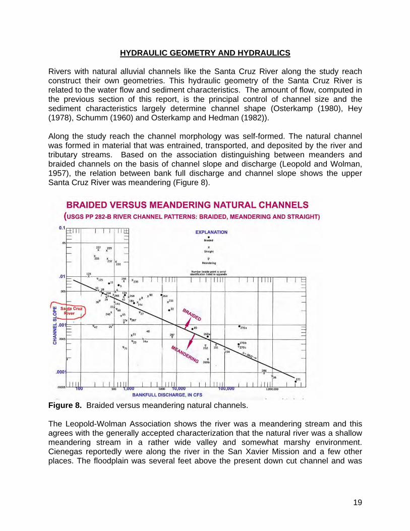
HYDRAULIC GEOMETRY AND HYDRAULICS Rivers with natural alluvial channels like the Santa Cruz River along the study reach construct their own geometries. This hydraulic geometry of the Santa Cruz River is related to the water flow and sediment characteristics. The amount of flow, computed in the previous section of this report, is the principal control of channel size and the sediment characteristics largely determine channel shape (Osterkamp (1980), Hey (1978), Schumm (1960) and Osterkamp and Hedman (1982)). Along the study reach the channel morphology was self-formed. The natural channel was formed in material that was entrained, transported, and deposited by the river and tributary streams. Based on the association distinguishing between meanders and braided channels on the basis of channel slope and discharge (Leopold and Wolman, 1957), the relation between bank full discharge and channel slope shows the upper Santa Cruz River was meandering (Figure 8).
Figure 8. Braided versus meandering natural channels. The Leopold-Wolman Association shows the river was a meandering stream and this agrees with the generally accepted characterization that the natural river was a shallow meandering stream in a rather wide valley and somewhat marshy environment. Cienegas reportedly were along the river in the San Xavier Mission and a few other places. The floodplain was several feet above the present down cut channel and was
20
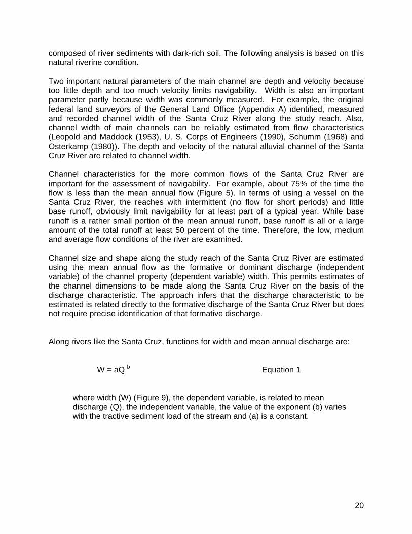
composed of river sediments with dark-rich soil. The following analysis is based on this natural riverine condition. Two important natural parameters of the main channel are depth and velocity because too little depth and too much velocity limits navigability. Width is also an important parameter partly because width was commonly measured. For example, the original federal land surveyors of the General Land Office (Appendix A) identified, measured and recorded channel width of the Santa Cruz River along the study reach. Also, channel width of main channels can be reliably estimated from flow characteristics (Leopold and Maddock (1953), U. S. Corps of Engineers (1990), Schumm (1968) and Osterkamp (1980)). The depth and velocity of the natural alluvial channel of the Santa Cruz River are related to channel width. Channel characteristics for the more common flows of the Santa Cruz River are important for the assessment of navigability. For example, about 75% of the time the flow is less than the mean annual flow (Figure 5). In terms of using a vessel on the Santa Cruz River, the reaches with intermittent (no flow for short periods) and little base runoff, obviously limit navigability for at least part of a typical year. While base runoff is a rather small portion of the mean annual runoff, base runoff is all or a large amount of the total runoff at least 50 percent of the time. Therefore, the low, medium and average flow conditions of the river are examined. Channel size and shape along the study reach of the Santa Cruz River are estimated using the mean annual flow as the formative or dominant discharge (independent variable) of the channel property (dependent variable) width. This permits estimates of the channel dimensions to be made along the Santa Cruz River on the basis of the discharge characteristic. The approach infers that the discharge characteristic to be estimated is related directly to the formative discharge of the Santa Cruz River but does not require precise identification of that formative discharge. Along rivers like the Santa Cruz, functions for width and mean annual discharge are:
W = aQ b Equation 1
where width (W) (Figure 9), the dependent variable, is related to mean discharge (Q), the independent variable, the value of the exponent (b) varies with the tractive sediment load of the stream and (a) is a constant.
21
Figure 9: Sketches showing general characteristics of river channel
A. Main channel showing width of average annual flow(C-C’), width of median daily flow(B-B’), and width of base flow(A-A’).
B. Cross section of channel showing width of flow(W), depth of flow(d) and mean depth of flow(D). B. Cross section of channel showing width of flow (W), depth of flow(d) and mean depth of flow(D).
Note the relationship of the flow levels and the flow discharges in Figure 5.
W
D d
Area (A) = WD
22
The study reach typically is coarse sand with some silt, clay and gravel. Thus, for practical considerations, a typical channel mostly of sand, gravel and some silt and clay was used. The corresponding coefficient ‘a’ = (3.70) and the exponent ‘b’= 0.55. The equation (Osterkamp, 1979b and 1980) for the natural Santa Cruz channel is:
W = 3.70 Q 0.55 Equation 2
There are no known documented observations of the predevelopment (natural) river morphology (width, depth, sinuosity, etc.). All of the original Federal land survey maps and most of the survey notes were examined for this study. There were several diversions and the upper river channel was dry in places. Where there was flow the widths generally agreed with computed widths for this study. No precise measurements of flow depth were found. Small arroyos were noted by the early surveyors in a few places. (See Appendix B). Depths of water for the main channel along the Santa Cruz River are related to flow characteristics and channel roughness, slope and width. The corresponding depth of flow for natural conditions is estimated using channel conveyance-slope characteristics and rating curve characteristics (Rantz and others, 1982). Manning's discharge equation is widely used for conditions of channel control to compute flow ratings (Rantz and others, 1982). The typical natural channel, like the natural channel of the Santa Cruz River, is approximately parabolic in shape. Using techniques of Burkham (1977) the following equation results: Q = (1.49/n) (0.67d)5/3 W So ½ Equation 3 Where d = depth of water above channel invert, So = energy gradient, and n = roughness coefficient. Channel size and shape along the study reach of the Santa Cruz River are estimated using the average annual flow of 29 cfs to 60 cfs of the study reach respectively as the formative or dominant discharge (independent variable) of the channel property (dependent variable) width. This permits estimates of the channel dimensions to be made along the river on the basis of the discharge characteristic. The approach infers that the discharge characteristic to be estimated is related directly to the formative discharge of the Santa Cruz River but does not require precise identification of that formative discharge It’s important to realize that the hydraulic geometry method yields representative cross section characteristics of width, depth and velocity. Cross section shape for meandering rivers like the predevelopment Santa Cruz appears to have been varies along the river. A sketch of how shape typically varies is shown in Figure 10. A common misconception
23
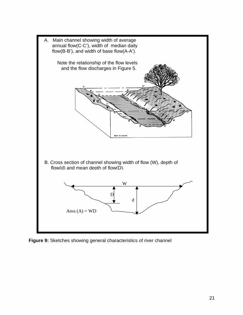
about rivers like the Santa Cruz is presence of large riffles that would impede navigability. The fact is there are riffles but the riffles are small partly because of energy processes associated with meandering. The beds of meandering segments of rivers have a more uniform gradient (smoother appearance and fewer and/or smaller riffles) than the beds of straight segments (Langbein, W. B., and Leopold, Luna, 1966, River Meanders-theory of minimum variance; USGS Professional Paper 422-H, 15p.). Figure 10. Sketch of typical meandering channel showing how channel shape changes. Cross section A-A represents the regime section computed in this analysis. Channels of alluvial rivers scour on the outside of bends and fill on the inside of bends. Computed estimates of predevelopment width-duration and depth-duration curves, are shown in figures 11 and 12. Computed velocities typically were between about 0.5 and 2.5 ft/sec except for flood flows. Figure 11. Width duration relations along the study reach.
24
Figure 12. Depth duration relations along the study reach.
The significance of this analysis at this point, in regard to navigability, is that the natural channel was meandering. Such a channel is relatively stable.
Discussion and summary of the shape and size of the natural channel Along the study reach the channel morphology of the Santa Cruz River was self-formed. In other words, the natural channel was formed in material that was entrained, transported, and deposited by the river and tributary streams. For such a river channel, simple power functions of width, sediment partical size and mean annual discharge can be used to estimate single channel geometry for the perennial and intermittent flow. Discharge, channel depth and channel width were estimated using established methods for rivers like the Santa Cruz River. Because the natural hydrology and natural channel morphology were significantly altered by human activities many (hundreds) years before Statehood in 1912, the science-based method used here is considered the best way to assess the river condition in its "natural and ordinary" state. The depth of water above the channel invert (maximum depth of Equation 3) closely approximates the depth for optimum navigability for channel widths of several feet using channel shape of the regime equations. Average channel depth, computed using total discharge and overall channel width was not used because it represents the minimum depth for navigability as explained in Item 3 of Appendix D.
25
NAVIGABILITY Navigability along the Santa Cruz River is evaluated using the natural hydrology and hydraulic geometry of the natural channel in the study reach. The river is evaluated as a single segment from the Mexican border south to river mile 78. Two convenient methods of assessing instream flows are used. The two relatively simple methods were developed by the U.S. Department of the Interior mostly for modern recreational boating (Figure 13).
Figure 13. Boating along the river. The following assessment of navigability is unaffected by channel sinuosity that is mild such that curvature at meander bends does not adversely affect channel width and alignment along potential navigable lanes. The channel widths of 24-35 ft at the average annual flow along the river easily accommodate navigable lanes where depths are at or near maximum.
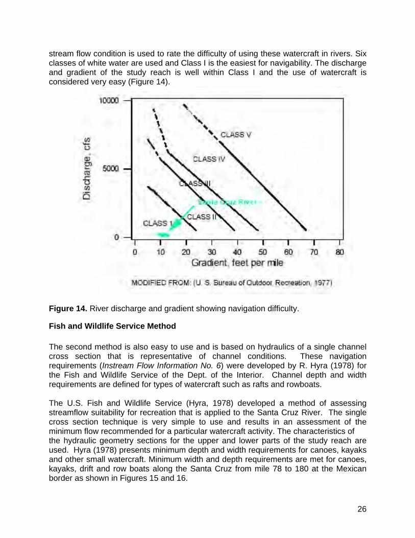
Bureau of Outdoor Recreation Method The first method is a rule of thumb rating of navigation difficulty by Jason M. Cortell and Associates Inc. of Waltham Mass (U. S. Bureau of Outdoor Recreation, 1977). This method is easy to use and was developed for the Bureau of Outdoor Recreation of the U. S. Dept. of the Interior in July 1977. The use of small watercraft, that includes canoes, kayaks drift boats and rafts, is rated in terms of flow criteria based on an International River Classification scale. A minimum
26
stream flow condition is used to rate the difficulty of using these watercraft in rivers. Six classes of white water are used and Class I is the easiest for navigability. The discharge and gradient of the study reach is well within Class I and the use of watercraft is considered very easy (Figure 14).
Figure 14. River discharge and gradient showing navigation difficulty.
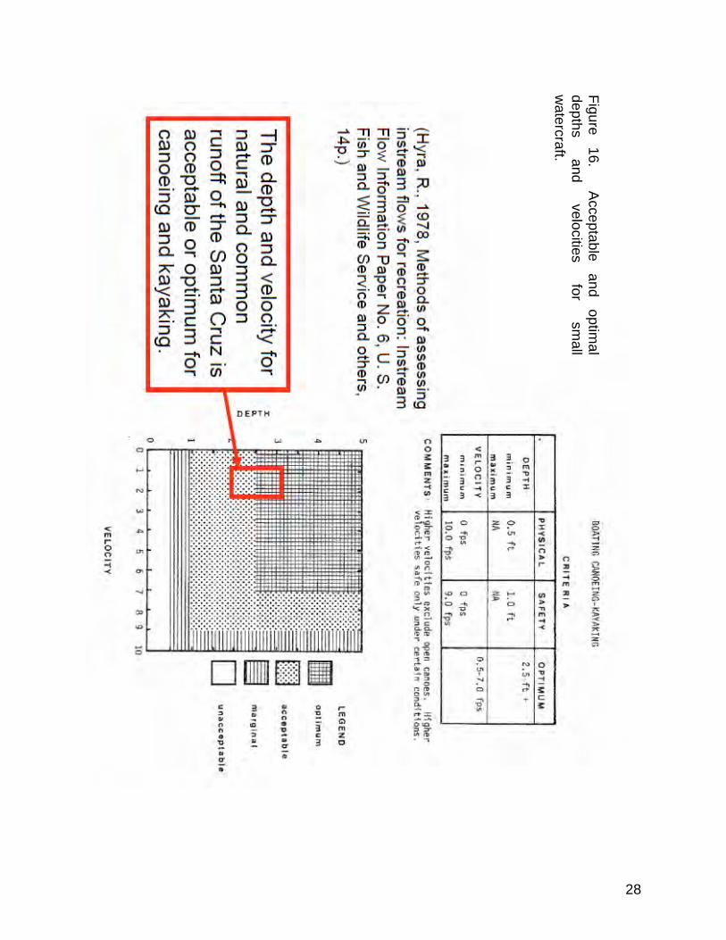
Fish and Wildlife Service Method The second method is also easy to use and is based on hydraulics of a single channel cross section that is representative of channel conditions. These navigation requirements (Instream Flow Information No. 6) were developed by R. Hyra (1978) for the Fish and Wildlife Service of the Dept. of the Interior. Channel depth and width requirements are defined for types of watercraft such as rafts and rowboats. The U.S. Fish and Wildlife Service (Hyra, 1978) developed a method of assessing streamflow suitability for recreation that is applied to the Santa Cruz River. The single cross section technique is very simple to use and results in an assessment of the minimum flow recommended for a particular watercraft activity. The characteristics of the hydraulic geometry sections for the upper and lower parts of the study reach are used. Hyra (1978) presents minimum depth and width requirements for canoes, kayaks and other small watercraft. Minimum width and depth requirements are met for canoes, kayaks, drift and row boats along the Santa Cruz from mile 78 to 180 at the Mexican border as shown in Figures 15 and 16.
27
Figure 15. Acceptable depths and width
for small w
atercraft.
28
Figure 16.
Acceptable
and optim
al depths
and velocities
for sm
all w
atercraft.
29
SUMMARY AND CONCLUSION
The two Federal methods show the Santa Cruz River along the study reach was navigable (Figure 17).
Figure 17. Profile of Santa Cruz River showing the navigable and non-navigable reaches. Assessment of whether the natural channel of the Santa Cruz River was navigable involves taking known hydrologic and geomorphic information and relationships from the present and projecting this information into the past. The three-step method is based of the fact that rivers construct their own geometry and this geometry can be estimated using hydrologic and hydraulic principles. The assessment used published information and data and was performed in three steps using standard engineering/hydrologic methods. The first step was the definition of the runoff for the Santa Cruz River using hydrologic techniques. A flow-duration relation for the river was estimated using the base, general shape and the mean annual runoff. The second step utilized hydraulic geometry techniques to estimate the width, depth and velocity for the natural flow in the study reach. There is a predictable relation between the channel geometry, type of sediment and the mean annual amount of natural flow. Finally, navigability was assessed using the physical characteristics of the natural channel of the Santa Cruz River such as discharge, gradient, depth, sediment and
30
velocity. The two methods of Federal agencies showed the Santa Cruz River was navigable from river mile 78 to the Mexican border (mile 180). At the time of statehood the runoff in the study reach was impacted by many upstream diversions and storage for irrigation, livestock and mining. Diversions for irrigation, livestock and irrigation along the Santa Cruz River and tributary streams reduced the amount of downstream water and sediment flow and thus influenced many downstream river functions in the study reach at and long before Statehood in 1912. This method takes into account the anthropogenic impacts. There is reasonably good agreement between the surveyed channel widths by the federal surveyors and the estimated widths of this assessment. It is my opinion the Santa Cruz River, from river mile 78 (boundary of sections 9 and 10, T10S R9E in the Red Rock-Picacho Peak area at boundary of alluvial basins 48 and 49) to the Mexican border (mile 180), was susceptible to navigation at the time of statehood (February 14, 1912) in its natural condition. During ordinary years the river was susceptible to navigation 75% of the time. Evidence relied upon to form this opinion is in this report and in the references for this report.
31
SELECTED REFERENCES Acting Secretary of the Interior, 1975, MORMON BATIALION TRAIL, House Document No. 94-258.
Anderson, T.W., Freethey, G.W., and Tucci, P., 1992, Geohydrology and water resources of alluvial basins in south-central Arizona and parts of adjacent states: U.S. Geological Survey Professional Paper 1406−B, 67 p. Barnes, H. H., 1967, Roughness coefficients of natural channels: U. S. Geological Survey Water-Supply Paper 1849, 213 p. Blake, W. P., 1910, Sketch of Pima County, Tucson Chamber of Commerce, Bolton, H. E., 1921, The Spanish Borderlands, Yale University Press., Buchman, E. W., 1911, Old Tucson, State Consolidated Publishing Co., Bull (Bull, W D., 1997, Discontinuous ephemeral streams: Geomorphology, Volume 19, Issues 3-4, p227-276 Burkham, D. E., 1977, A technique for determining depths for T-year discharges in rigid-boundary channels: U. S. Geological Water- Resources Investigations 77-83, 38 p. Burkham, D. E., 1979, Depletion of streamflow by infiltration in the main channels of the Tucson Basin, Southeastern Az, USGS WSP 1939-B, Burtell, R., 2013, DECLARATION OF RICH BURTELL ON THE NON-NAVIGABILITY OF THE SANTA CRUZ RIVER AT AND PRIOR TO STATEHOOD, In re Determination of Navigability of the Santa Cruz River (Case No. 03-002-NAV), October 2013, Prepared for: Freeport-McMoRan Corporation, 333 North Central Avenue, Phoenix, AZ 85004, 17 p. and tables, etc. Bryan, Kirk, 1923, Erosion and sedimentation in the Papago country, Ariz., with a sketch of the geology: U. S. Geol. Survey Bull. 730-B, 90p. Condes de la Torre, Alberto, 1970, Streamflow in the Upper Santa Cruz River Basin, USGS WSP 1939-a, 32p. Darton, N. H., 1933, guidebook of the Western United States: Part F, the southern Pacific Lines of New Orleans to Los Angeles; USGS Bulletin 845, 304p. Davis, A. P., 1897, IIRRIGATION NEAR PHCENIX, ARIZONA , USGS Water Supply Paper 2, 98p.
32
Duell, Prent, 1919, Mission Architecture, as examplified in San Xavier Del Bac, PUBLISHED BY THE ARIZONA ARCHAEOLOGICAL AND HISTORICAL SOCIETY, TUCSON, ARIZONA, 135p.
Farish, Thomas Edwin, 1915, History of Arizona, Vol. 1, Phoenix Arizona, Chapter 13, Troubles with the Indians; In Books of the Southwest, University of Arizona Library.
Frazer, R. F., 1983, Forts and Supplies, University of New Mexico Press., Freethey, G. W. and Anderson, T. W., 1986, Predevelopment hydrologic conditions in the alluvial basins of Arizona and adjacent parts of California and New Mexico, U. S. Geological Survey Hydrologic Investigations Atlas HA-664, 3 sheets. Fuller, J. E., 2004, Arizona Stream Navigability Study for the Santa Cruz River, Gila River Confluence to Headwaters. Original prepared by SFC Engineering Company in November 1996; revised by Fuller in January 2004. General Land Office, June 30, 1904, Manual of Surveying Instructions for the Survey of Public Lands of the United States and Private Land Claims; Commissioner of the General Land Office, Washington, 1894. Also Instructions for 1871, 1890, 1919 and 1973. Halpenney. L. C. and others, 1952, Ground water in the Santa Cruz River basin and adjacent areas, Arizona—A summary: U. S. Geological Survey Open-File Report, 224p. Hey, R. D., 1978, Determinate hydraulic geometry of river channels: American Society of Civil Engineers Journal of the Hydraulics Division, vol. 104, no. HY6, p. 869-885. Hjalmarson, H. W., 1988, Flood-hazard zonation in arid lands, in Arid Lands-Hydrology, scour, and water quality: Washington, D.C., National Research Council, Transportation Research Board, Record 1201, p.1-8. Judson, K. B., 1912, Myths and Legends of California and the Old Southwest: A. C. McClurg and Co., Chicago, 193p. King, H. W., 1954, Handbook of hydraulics: McGraw-Hill Book Co., New York, 10 chapters. Krug, J. A., 1946, The Colorado River, Bureau of Reclamation, U. S. Dept. of the Interior, 300p. Krug, W. R., Warren A. Gebert, and David 1. Graczyk, 1987, PREPARATION OF AVERAGE ANNUAL RUNOFF MAP OF THE UNITED STATES, USGS Open File Report 87-535. Langbein, W. B. and Iseri, K. T., 1960, General Introduction and Hydrologic Definitions: U. S. Geological Survey Water-Supply Paper 1541-A, 29 p.
33
Langbein, W. B., 1962, Hydraulics of River Channels as Related to Navigability:U. S. Geological Survey Water-Supply Paper 1539-W, 30 p. Lee, W. T., 1904, The underground waters of the Gila Valley, USGS WSP and Irr. 104. Leopold, L.B., Wolman, M.G., and Miller, J.P, 1964, Fluvial processes in geomorphology: New York, Dover Books on Earth Sciences, 503 p. Logan, M. F., 2002, The Lessening Stream, University of Arizona Press; 311 p. McNamee, Gregory, 1998, Gila, Life and Death of an American River; University of New Mexico Press, 232p. Meyer, M. C., 1996, Water in the Hispanic Southwest, a social and legal history, 1550-1850; University of Arizona Press, 209p Mowry, S., 1864, Arizona and Sonora, Geography, History and Resources, Silver Region of North America; Harpee Brothers Pub., Newspapers with historic accounts related to water. The Weekly Arizonian-Tubac, Weekly Arizonian-Tucson, Arizona Citizen-Tucson, Arizona Weekly Citizen-Tucson, Tombstone Epitaph- Tombstone, The Arizona Sentinal- Yuma, Arizona Republican- Phoenix Osterkamp, W. R., 1979b, Variation of alluvial-channel width with discharge and character of sediment: U.S. Geological Survey Water-Resources Investigations 79-15, 11 p. Osterkamp, W. R., 1980, Sediment-morphology relations of alluvial channels: Proceedings of the symposium on watershed management, American Society of Civil Engineers, Boise Idaho, p. 188-199. Osterkamp, W. R., and Hedman, E. R., 1977, Variation of width and discharge for natural high-gradient stream channels: Water Resources Research, v. 13, no. 2, p. 256-258. Osterkamp, W. R., and Headman, E. R., 1982, Perennial-streamflow characteristics related to channel geometry and sediment in the Missouri River basin: U.S Geological Survey Professional Paper 1242, 37 p. Parker, John. T.C, 1995, Channel change on the Santa Cruz River, Pima County, Arizona, 1936-86; U.S. Geological Survey water-supply paper; 2429, 58p. Phillips, J. V. and Ingersoll, T. L., 1998, Verification of roughness coefficients for selected natural and constructed stream channels in Arizona: U. S. GeologicSurvey Professional Paper 1584, 77 p.
34
Railroad record supplement, Feb. 11, 1856 CINCINNATI, M. E. Mansfield Editor. Rantz, S, E, and others, 1982, Measurement and Computation of Streamflow: Volume 2. Computation of Discharge, USGS Water-Supply Paper 2175, 388p. Ross, C. P., 1923, The lower Gila Region, Arizona: Geographic, geologic, and hydrologic reconnaissance with guide to desert watering places; USGS Water Supply Paper 498, 237p Searcy, J. K., 1959, Flow-duration curves: U. S. Geological Survey Water-Supply Paper 1542-A, 33 p. Schumm, S. A., 1960, the shape of alluvial channels in relation to sediment type: U.S. Geological Survey Professional Paper 352B, 30 p. Schumm, S. A., 1968, River adjustment to altered hydrologic regimen—Murrumbidgee River and paleochannels, Australia: U.S. Geological Survey Professional Paper 598, 65 p. Simons, D. B., and Richardson, E. V., 1966, Resistance to flow in alluvial channels: U.S. Geological Survey Professional Paper 422-J, 61 p. Tellman, B., Yarde, R. and Wallace, M.G., 1997. Arizona’s Changing Rivers: How People Have Affected the Rivers. Water Resources Research Center, College of Agriculture, University of Arizona, Tucson. 198 pp. Thomsen, B.W., and Eychaner, J.H., 1991, Predevelopment hydrology of the Gila River Indian Reservation, south-central Arizona: U.S. Geological Survey Water-Resources Investigations Report 89-4174, 44 p., 2 sheets. Thomsen, B.W., and Hjalmarson, H.W., 1991, Estimated Manning's roughness coefficient for stream channels, and flood plains in Maricopa County, Arizona: Phoenix, Flood Control District of Maricopa County report, 126p. U. S. Bureau of Land Management General Land Office Records. https://www.blm.gov/az/mtps/mtps_search.cfm USBR, 1952, Report on Water Supply of the Lower Colorado River Basin: US Department of Interior, Bureau of Reclamation Project Planning Report, (p. 152), 444 p. U. S. Corps of Engineers, 1980, Layout and design of shallow draft waterways: Engineer Manual 1110-2-1611, 15 chapters and 2 appendixes. U. S. Corps of Engineers, 1985, Hydraulic design of small boat navigation projects: Engineer Manual 1110-2-1457, 9 p and 2 appendixes.
35
U.S. Fish and Wildlife Service Arizona Game and Fish Department Chapter 10 Santa Cruz River Watershed, January 2011, 86 p. U. S. Bureau of Outdoor Recreation, 1977, Flow requirements, analysis of benefits, legal and institutional constraints: Recreation and Instream Flow, Vol. 1, 20p. USDA, 2007, Part 654 Stream Restoration Design National Engineering Handbook, Chapter 9 Alluvial Channel Design, 48p. Wahl, K. L., 1984, Evolution of the use of channel cross-section properties for Estimating streamflow characteristics: USGS Water-Supply Paper 2262, p. 53-66. Webb, Robert H.and Betancourt, J. L., Climatic variability and flood frequency of the Santa Cruz River, Pima County, USGS Water-supply paper; 2379, 40p. Wood, M. L, House, P. K., and Peatthree, P. A., 1999, Historical Geomorphology and Hydrology of the Santa Cruz River, Open-File Report 99-13, Arizona Geological Survey; supported by the Arizona State Land Department as part of their efforts to gather technical information for a stream navigability assessment, 96p.
36
GLOSSARY (Mostly from Langbein and Iseri, HTML Version 1995)
HYDROLOGIC DEFINITIONS FOR THIS STUDY OF NAVIGABILITY Acre-foot. A unit for measuring the volume of water, is equal to the quantity of water required to cover 1 acre to a depth of 1 foot and is equal to 43,560 cubic feet or 325,851 gallons. The term is commonly used in measuring volumes of water used or stored. Average discharge. In the annual series of the Geological Survey’s reports on surface-water supply—the arithmetic average of all complete water years of record whether or not they are consecutive. Average discharge is not published for less than 5 years of record. The term “average” is generally reserved for average of record and “mean” is used for averages of shorter periods, namely, daily mean discharge. Bank. The margins of a channel. Banks are called right or left as viewed facing in the direction of flow. Base flow. See Base runoff. Base runoff. Sustained or fair weather runoff. In most streams, base runoff is composed largely of groundwater effluent. (Langbein and others, 1947, p. 6.) The term base flow is often used in the same sense as base runoff. However, the distinction is the same as that between streamflow and runoff. When the concept in the terms base flow and base runoff is that of the natural flow in a stream, base runoff is the logical term. (See also Ground-water runoff and Direct runoff.) Braiding of river channels. Successive division and rejoining (of river flow ) with accompanying islands is the important characteristic denoted by the synonymous terms, braided or anatomizing stream. A braided stream is composed of anabranches. Channel (watercourse). An open conduit either naturally or artificially created which periodically or continuously contains moving water, or which forms a connecting link between two bodies of water. River, creek, run, branch, anabranch, and tributary are some of the terms used to describe natural channels. Natural channels may be single or braided (see Braiding of river channels) Canal and floodway are some of the terms used to describe artificial channels. Direct runoff. The runoff entering stream channels promptly after rainfall or snowmelt. Superposed on base runoff, it forms the bulk of the hydrograph of a flood. Discharge. In its simplest concept discharge means outflow; therefore, the use of this term is not restricted as to course or location, and it can be applied to describe the flow of water from a pipe or from a drainage basin. If the discharge occurs in some course or channel, it is correct to speak of the discharge of a canal or of a river. It is also correct to speak of the discharge of a canal or stream into a lake, a stream, or an ocean. (See also Streamflow and Runoff.) Drainage basin. A part of the surface of the earth that is occupied by a drainage system, which consists of a surface stream or a body of impounded surface water together with all tributary surface streams and bodies of impounded surface water. Drainage divide. The rim of a drainage basin. (See Watershed.) Evaporation. The process by which water is changed from the liquid or the solid state into the vapor state. In hydrology, evaporation is vaporization that takes place at a temperature below the boiling point. Evapotranspiration. Water withdrawn from a land area by evaporation from water surfaces and moist soil and plant transpiration.
37
Flow-duration curve. A cumulative frequency curve that shows the percentage of time that specified discharges are equaled or exceeded. (See Searcy, 1959.) Gaging station. A particular site on a stream, canal, lake, or reservoir where systematic observations of gage height or discharge are obtained. (See also Stream-gaging station.) Ground water. Water in the ground that is in the zone of saturation, from which wells, springs, and ground-water runoff are supplied. (After Meinzer, 1949, p. 385.) Groundwater runoff. That part of the runoff which has passed into the ground, has become ground water, and has been discharged into a stream channel as spring or seepage water. See also Base runoff and Direct runoff. Hydrologic budget. An accounting of the inflow to, outflow from, and storage in, a hydrologic unit, such as a drainage basin, aquifer, soil zone, lake, reservoir, or irrigation project. Hydrologic cycle. A convenient term to denote the circulation of water from the sea, through the atmosphere, to the land; and thence, with many delays, back to the sea by overland and subterranean routes, and in part by way of the atmosphere; also the many short circuits of the water that is returned to the atmosphere without reaching the sea. Hydrology. The science encompassing the behavior of water as it occurs in the atmosphere, on the surface of the ground, and underground. The science that relates to the water of the earth. Infiltration. The flow of a fluid into a substance through pores or small openings. It connotes flow into a substance in contradistinction to the word percolation, which connotes flow through a porous substance. Irrigation. The controlled application of water to arable lands to supply water requirements. Meander. The winding of a stream channel. Overland flow. The flow of rainwater or snowmelt over the land surface toward stream channels. After it enters a stream, it becomes runoff.
Percolation. The movement, under hydrostatic pressure, of water through the interstices of a rock or soil, except the movement through large openings such as caves Precipitation. As used in hydrology, precipitation is the discharge of water, in liquid or solid state, out of the atmosphere, generally upon a land or water surface. Reservoir. A pond, lake, or basin, either natural or artificial, for the storage, regulation, and control of water. Return flow. That part of irrigation water that is not consumed by evapotranspiration and that returns to its source or another body of water. The term is also applied to the water that is discharged from industrial plants. Also called return water. Riparian. Pertaining to the banks of a stream. Runoff. That part of the precipitation that appears in surface streams. It is the same as streamflow unaffected by artificial diversions, storage, or other works of man in or on the stream channels.
38
Stream. A general term for a body of flowing water. In hydrology the term is generally applied to the water flowing in a natural channel as distinct from a canal. More generally as in the term stream gaging, it is applied to the water flowing in any channel, natural or artificial. Streams in natural channels may be classified as follows: Relation to time. Perennial. One which flows continuously. Intermittent or seasonal. One which flows only at certain times of the year when it
receives water from springs or from some surface source such as melting snow in mountainous areas.
Ephemeral. One that flows only in direct response to precipitation, and whose channel is at all times above the water table. Relation to space. Continuous. One that does not have interruptions in space. Interrupted. One which contains alternating reaches, that are either perennial, intermittent, or ephemeral. Relation to ground water. Gaining. A stream or reach of a stream that receives water from the zone of saturation. Losing. A stream or reach of a stream that contributes water to the zone of saturation. Insulated. A stream or reach of a stream that neither contributes water to the zone of
saturation nor receives water from it. It is separated from the zones of saturation an impermeable bed.
Perched. A perched stream is either a losing stream or an insulated stream that is separated from the underlying ground water by a zone of aeration.
Streamflow. The discharge that occurs in a natural channel. Although the term discharge can be applied to the flow of a canal, the word streamflow uniquely describes the discharge in a surface stream course. The term “streamflow” is more general than runoff, as streamflow may be applied to discharge whether or not it is affected by diversion or regulation. Transpiration. The quantity of water absorbed and transpired and used directly in the building of plant tissue, in a specified time. It does not include soil evaporation. Underflow. The downstream flow of water through the permeable deposits that underlie a stream and that are more or less limited by rocks of low permeability. Watershed. The divide separating one drainage basin from another and in the past has been generally used to convey this meaning. Drainage divide, or just divide, is used to denote the boundary between one drainage area and another. Used alone, the term “watershed” is ambiguous and should not be used unless the intended meaning is made clear. As used in this report, watershed refers to the entire drainage of the Santa Cruz River and basins refers to internal areas of the “watershed”. Water table. The upper surface of a zone of saturation. No water table exists where that surface is formed by an impermeable body.
1
Appendix A. Original and early land surveys with a few photographs and maps. This appendix presents the original Federal Land Survey maps (plats) with information, such as channel widths, from selected associated survey field notes for the reach of Santa Cruz River near Picacho to the Mexican border. The maps and survey notes, when used together, provide valuable morphology, hydrology and hydraulic information for the assessment of navigability for ANSAC. These maps and field notes were obtained from the Bureau of Land Management (BLM) in 2013. The Department of the Interior, that included the General Land Office (GLO), was created in March 3, 1849. In 1946, the GLO was merged with U.S. Grazing Service to form the Bureau of Land Management (BLM) in the Department of the Interior. In the process, BLM became the custodian of the official land records of the United States. Its important to keep in mind that this group of maps is very useful for assessing natural morphology/hydrology of the Santa Cruz River but significant diversions and other affects of humans were present when these surveys were made. T9S R8E
2
T9S R9E The arroyos suggest some channel incision but this eastern channel of the Santa Cruz River is very small.
Photo taken from near section 2 of T9S R9E. (About 1930).
3
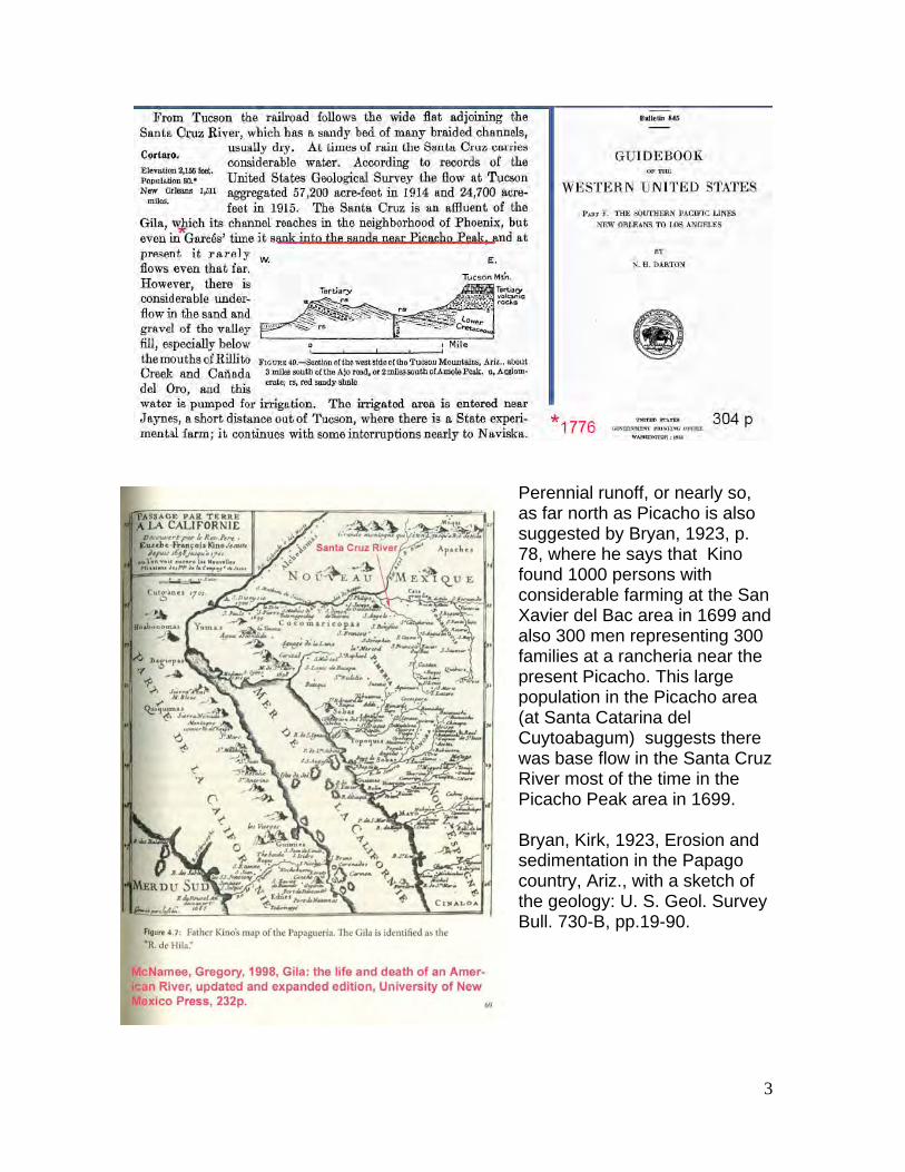
Perennial runoff, or nearly so, as far north as Picacho is also suggested by Bryan, 1923, p. 78, where he says that Kino found 1000 persons with considerable farming at the San Xavier del Bac area in 1699 and also 300 men representing 300 families at a rancheria near the present Picacho. This large population in the Picacho area (at Santa Catarina del Cuytoabagum) suggests there was base flow in the Santa Cruz River most of the time in the Picacho Peak area in 1699. Bryan, Kirk, 1923, Erosion and sedimentation in the Papago country, Ariz., with a sketch of the geology: U. S. Geol. Survey Bull. 730-B, pp.19-90.
4
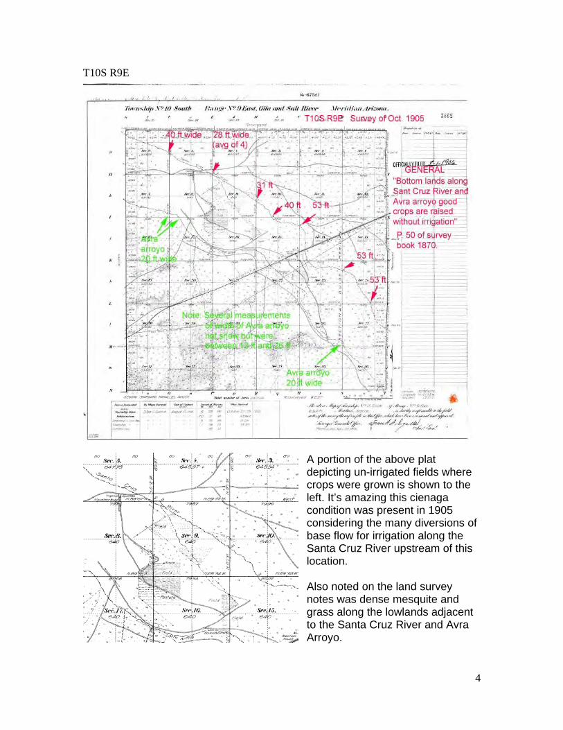
T10S R9E
A portion of the above plat depicting un-irrigated fields where crops were grown is shown to the left. It’s amazing this cienaga condition was present in 1905 considering the many diversions of base flow for irrigation along the Santa Cruz River upstream of this location. Also noted on the land survey notes was dense mesquite and grass along the lowlands adjacent to the Santa Cruz River and Avra Arroyo.
5
T10S R10E
Wide-flat Santa Cruz valley.. Covered with dense growth of mesquite, grass and scattered trees
6
T11S R10E
7
A different perspective to help orient the reader. Darton, N. H., 1933, Guidebook of the Western United States: Part F, the southern Pacific Lines New Orleans to Los Angeles; USGS Bulletin 845, 304 p.
8
T11S R11E
T12S R11E
9
T12S R12E
Historic (1880) landmarks shown on map to left. Logan, M. F., 2002, The Lessening Stream, University of Arizona Press; 311 p.
10
T13S R12E
11
T13S R13E
1871 Plenty of water in the Santa Cruz River. “.. the lands along stream are mostly settled upon.” Considerable mesquite. (See lightly shaded areas of above map)
12
T14S R13E
Surveyor indicated that Santa Cruz channel became 2 water ditches Most of land under cultivation
13
T14S R13E
14
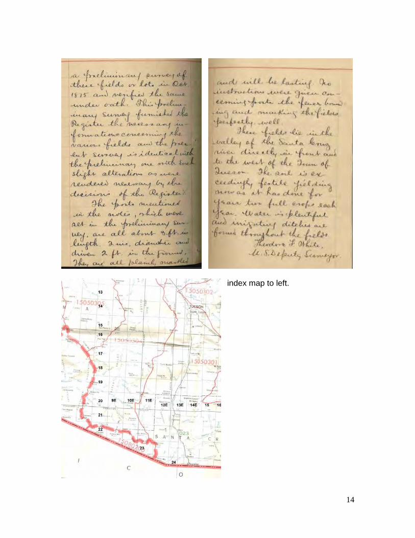
index map to left.
15
T15S R13E
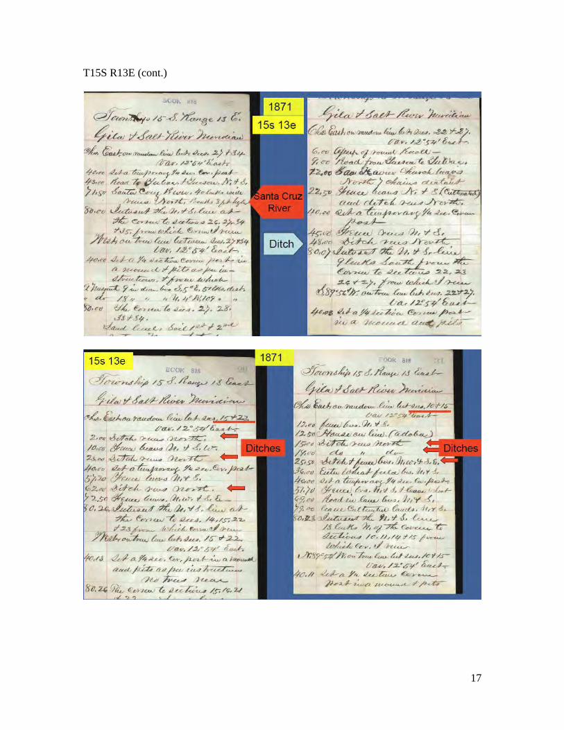
16
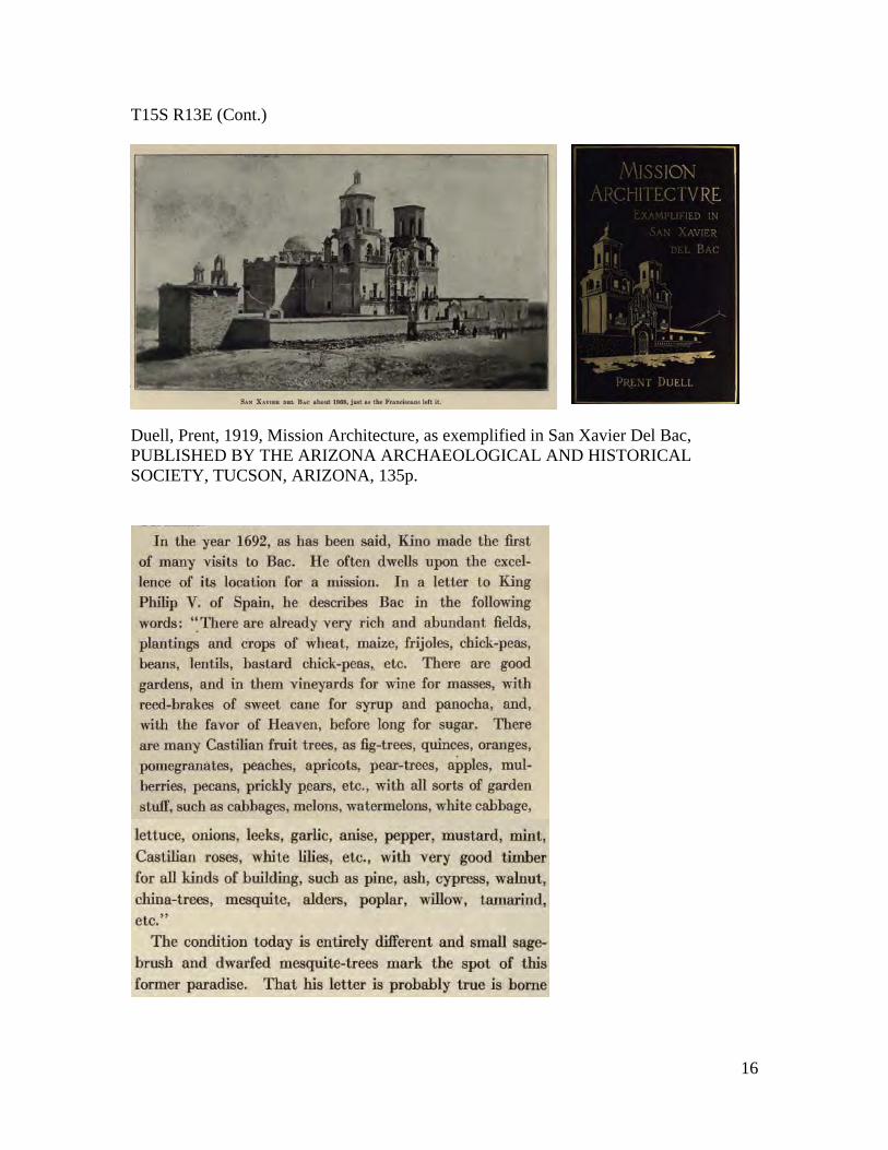
T15S R13E (Cont.)
Duell, Prent, 1919, Mission Architecture, as exemplified in San Xavier Del Bac, PUBLISHED BY THE ARIZONA ARCHAEOLOGICAL AND HISTORICAL SOCIETY, TUCSON, ARIZONA, 135p.
17
T15S R13E (cont.)
18
19
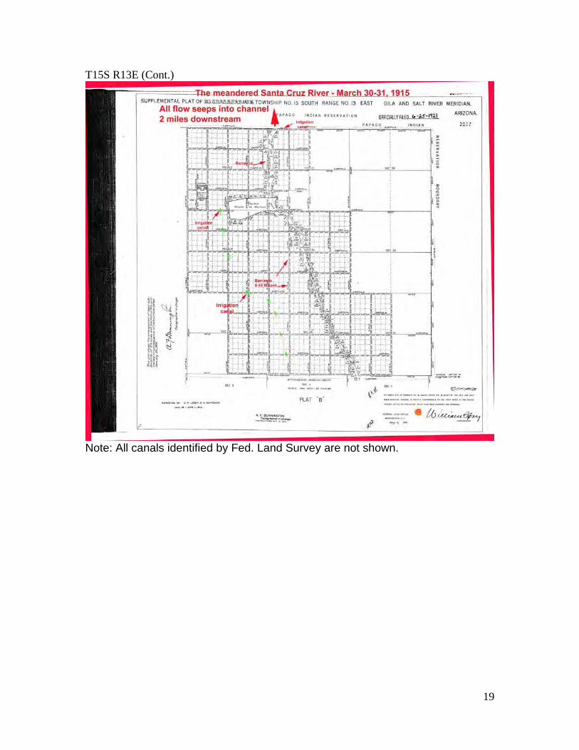
T15S R13E (Cont.)
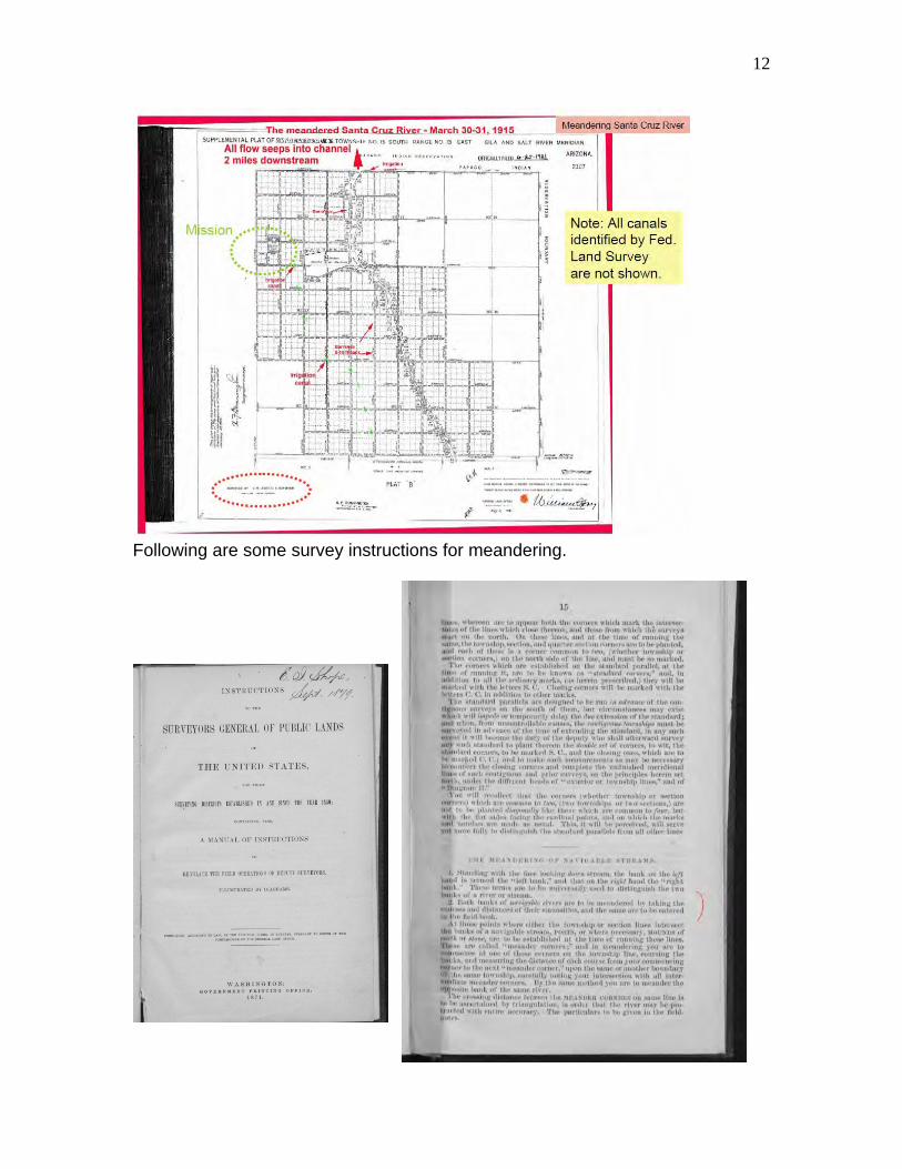
Note: All canals identified by Fed. Land Survey are not shown.
20
T15S R13E (Cont.) By March 30-31, 1915 the channel of the Santa Cruz River was incised 12-20 ft and the “trench” was from 154 ft to 317 ft wide. All of the base flow seeped into sediments about 3 miles north of the San Xavier Del Bac mission.
21
T16S R13E
T17S R13E
22
T18S R13E
At the southern boundary of this township the Santa Cruz “is a large, ever running stream of water, but sinks in the sand in a short distance. Water can be obtained by digging anywhere along the bottom.”
23
R19S R13E
24
T20S R13E
25
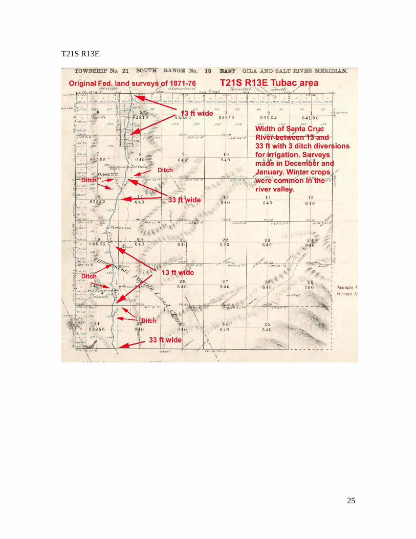
T21S R13E
26
T21S R13E (Cont.)
27
Photo of 1919.
28
T22S R13E
29
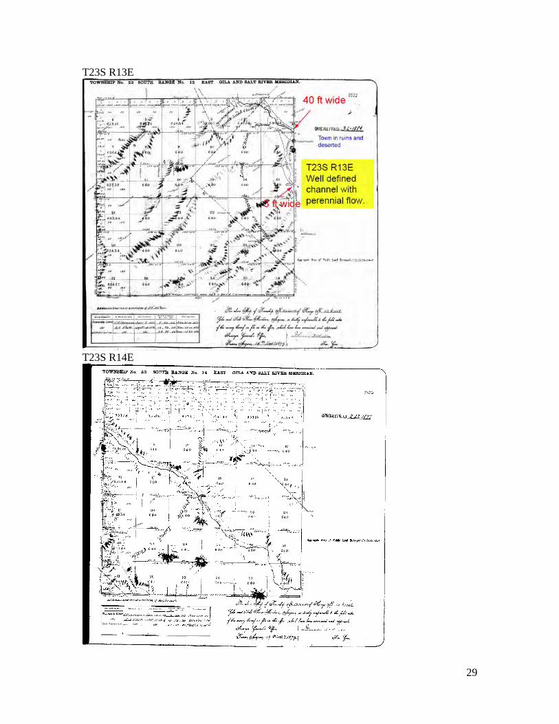
T23S R13E
T23S R14E
30
T24S R15E USGS Kino Springs map
1
Appendix B.-- Miscellaneous Supplemental information Item 1. The following account of the “immense artificial lake” for Warner’s grist mill near Tucson captures the effects of human diversions along the Santa Cruz River. Upstream diversions depleted the quantity of flow and the natural uniformity of flow needed for the mill to be successful, particularly in the summer time. The past success of the mill implies a good-steady base runoff in the Santa Cruz River at nearly all times. However, because of upstream diversions, mostly for irrigation, the building of a large lake was needed for an adequate supply of water for the grist mill as described below.
2
Item 2. This newspaper account is an example of the many accounts of upstream diversions depleting the base flow of the Santa Cruz.
Item 3. The Santa Cruz and Tucson ditch were built south of Tucson where diversion will be about 2 miles north of Tubac. Land at this location had been farmed for about a century where flow was perennial. The river was about 60 ft wide with a stony bottom and firm banks where head gate was located.
3
Item 4. An engineering report by P. E. Fuller on June 11, 1913 is a great example of the use of water along the Santa Cruz River. Fuller’s report shows 10 cfs of Santa Cruz River base flow was diverted into the Manning and Farmer ditches above Tucson in the early 1900s.
4
Item 5. P. E. Fuller’s report of June 11, 1913 also shows interesting photographs of the Santa Cruz Reservoir Project, that had failed by 1915, and the influence of Greene's Canal where flow (mostly floodwater) was diverted from the Santa Cruz River for irriation use. This is a great example of early human impact on the natural hydrology of the river.
5
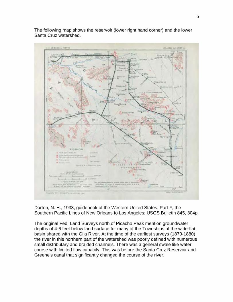
The following map shows the reservoir (lower right hand corner) and the lower Santa Cruz watershed.
Darton, N. H., 1933, guidebook of the Western United States: Part F, the Southern Pacific Lines of New Orleans to Los Angeles; USGS Bulletin 845, 304p. The original Fed. Land Surveys north of Picacho Peak mention groundwater depths of 4-6 feet below land surface for many of the Townships of the wide-flat basin shared with the Gila River. At the time of the earliest surveys (1870-1880) the river in this northern part of the watershed was poorly defined with numerous small distributary and braided channels. There was a general swale like water course with limited flow capacity. This was before the Santa Cruz Reservoir and Greene's canal that significantly changed the course of the river.
6
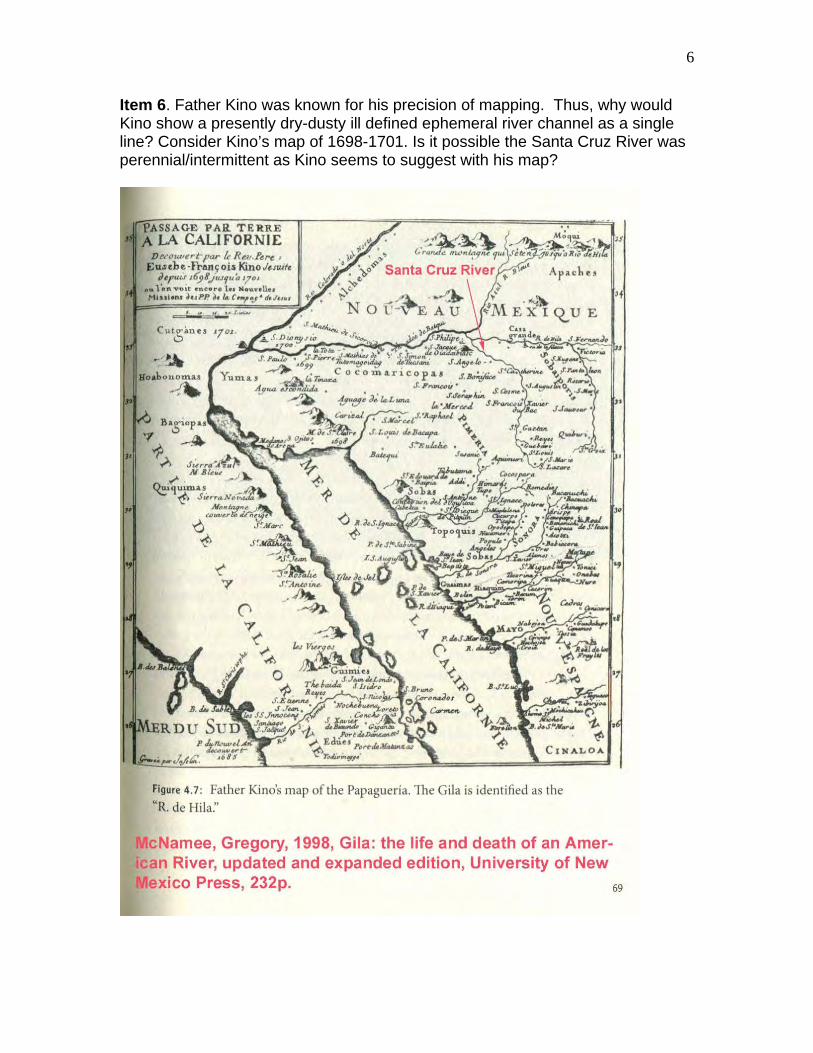
Item 6. Father Kino was known for his precision of mapping. Thus, why would Kino show a presently dry-dusty ill defined ephemeral river channel as a single line? Consider Kino’s map of 1698-1701. Is it possible the Santa Cruz River was perennial/intermittent as Kino seems to suggest with his map?
7
This account of an irrigation diversion from the Santa Cruz River supports Kino’s account of a single channel.
700 pages.
8
Item 7. Another example of a single channel along the lower Santa Cruz River in a sketch from the Office of the Mexican Boundary Survey, 1853
The Treaty of Guadalupe Hidalgo mandated that a boundary commission survey and mark the border between the U.S. and Mexico. The Army Corps of Topographical Engineers, under the direction of William H. Emory, conducted the actual surveying from 1848 – 1855. This sketch is from that survey. It shows the area south of the Gila River—part of present-day Arizona. RG 233, Records of the U.S. House of Representatives
9
Item 8. An example of the channels of the lower Santa Cruz River near the Gila River is shown below.
10
Item 9. Meandering of the Santa Cruz River
11
12
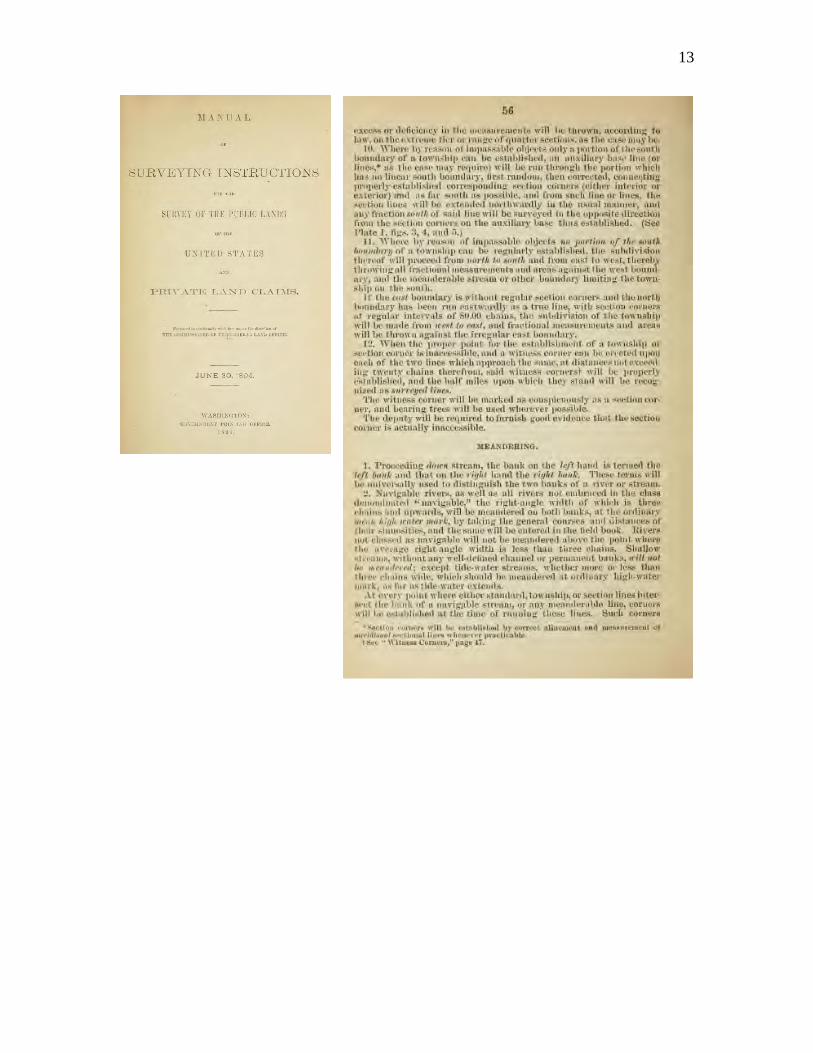
Following are some survey instructions for meandering.
13
14
15
Item 10. Many diversions in watershed.
16
Item 11. Channel profiles of Arizona streams
Item 12. Santa Cruz River in Nogales area in 1911
1
Appendix C. River engineering methods Item 1. Predevelopment base runoff (Q90) for hydrologic units The generalized U-shaped contours of head distribution of the following map (Freethey, G. W. and Anderson, T. W., 1986) indicate various combinations of groundwater recharge and discharge. The water-level contours for the Tucson basin area illustrate a composite flow condition in which multiple sources of inflow and outflow exist. The shape of the water-level contours indicates that mountain-front recharge occurs along the basin perimeter and underflow occurs at the upstream end. Surface-water infiltration represents an additional inflow source.
In contrast, the generalized head distribution in the lower Santa Cruz watershed is a series of rather parallel contour lines normal to the axis of the basin. Water enters the basin mainly at the upstream end, and any mountain-front recharge is relatively minimal.
2
Under natural conditions the Santa Cruz River watershed was a few multiple source-sink basins, where surface water may have been fully appropriated or consumed in places, and other sources of water, such as capture of natural discharges from evapotranspiration or ground-water underflow, was available. Historically, as the pumping rate from wells has increased, a proportionally greater part of the pumpage has been supplied by decreases in evapo-transpiration (ET) and reductions in aquifer storage. As a result the predevelopment ET has been estimated to be less than post development ET (USBR 1952). Before the use of wells there was minimal depletion of aquifer storage and demands for water were almost completely met by down valley flow. In other words, the surface diversions for irrigation depleted the base flow all along the river. In the lower Santa Cruz watershed where groundwater contours are straight indicating little mountain-front recharge there was no inflowing base runoff from mountain-front recharge. Under these conditions, the basin is classified as a multiple source-sink basin. Generally speaking, upper basin fill consists of less than 1,000 ft of sediments and includes basin-center deposits of more than 60-percent fine-grained material (Anderson, T.W., Freethey, G.W., and Tucci, P., 1992). The fine-grained material of the upper basin fill grades laterally to coarse-grained material near mountain fronts. The sediments also grade vertically from fine grained at depth to coarse grained at land surface. Stream-alluvium deposits consist of as much as 300 ft of coarse material along major streams. Before development, ground-water discharge was mainly by evapotranspiration, with minor discharge to streams as base flow (Anderson, T.W., Freethey, G.W., and Tucci, P., 1992). The principal water-bearing sediments consist of stream-alluvium deposits, where saturated, and upper basin fill. Ground water generally occurs under unconfined conditions, although head differences with depth may occur because of the presence of clay lenses in the heterogeneous basin fill. Before development, water levels ranged from at land surface near perennial streams to as much as a few hundred feet below land surface in places near mountain fronts. Ground water flows from the perimeter of a basin and from the up-gradient end toward the basin center and then down-valley to the mouth at the Gila River. Some ground water probably flowed through the entire length of the basins. As development increased, the main source of ground water to meet the increasing demand was from aquifer storage. This is especially true in the lower basin. Therefore, the lower basin is classified as a storage-depletion basin.
3
Because 1) the depletion of base flow in the upper basins has removed base flow from the lower basins and 2) the depletion of aquifer storage in the lower basins, there is no base flow in the lower Santa Cruz River. In summary, basins that were initially a multiple source-sink type have at least partially evolved toward a storage-depletion type as human development increased. Pumping has captured evapotranspiration and stream base flow. Surface water infiltration has increased locally because a larger volume of sediments is available for storage. Mountain-front recharge has been affected to some degree by development such as stock tanks and lakes. Most ground water is derived from storage within the aquifer, and water levels have declined below the river bed. Base flow is discharge from groundwater. Because groundwater levels have dropped below stream channels along valley floors, there is no base flow in many places. The following is the estimate of natural annual base flow (Q90) along the Santa Cruz River using USGS data for HA664 (Freethey, G. W. and Anderson, T. W., 1986). The 8 cfs at the Mexican border is the difference between the average annual streamflow of 21 cfs from Table 2 (p A10) of USGS WSP 1939-A by Condes de la Torre (1970) and the Virgin flow of 29 cfs determined by the USBR (Krug, 1946). The Virgin flow determined by the USBR is shown in the following section of this Appendix (Item 2).
4
Item 2. Computation of Average Annual Runoff of Santa Cruz River To understand why I used average annual runoff for my analysis, it is important to first understand what runoff is. Runoff is that part of the precipitation that naturally appears in surface streams. Therefore, it is the same thing as “stream flow” unaffected by artificial diversions, storage, or other works of man in or on the stream channels. In other words, runoff is the same as predevelopment stream flow or Virgin flow. Runoff includes both direct flow and base flow. For the average annual runoff data, I started by using the USBR report shown below, which shows runoff (Virgin flow) for two USGS stream gages on the upper Santa Cruz River.
USBR, 1952, Report on Water Supply of the Lower Colorado River Basin: US Department of Interior, Bureau of Reclamation Project Planning Report, (p. 152), 444 p.
Because the report by the USBR did not include the runoff at the mouth of the Santa Cruz River, I had to independently compute the average annual runoff using runoff data for other river sites given in the USBR report. I also used transpiration and evaporation published in the same USBR report. The published data I used are shown in the following table:
5
To determine the average annual runoff at the mouth of the Santa Cruz River it was necessary to calculate the portion of the “my computed runoff” shown in the previous water budget for the reach of Gila River that includes the Santa Cruz River and other streams (Centennial Wash, Hassayampa River, Caver Creek, etc..).
A simple ratio of drainage areas was used to estimate runoff as shown on the right. The resulting amounts of runoff at three locations along the 180 mile reach from the Mexican border to the mouth of the Santa Cruz River are shown to the right.
6
These amounts of runoff (predevelopment streamflow) were used for this assessment of navigability. Runoff for five reaches in the upper Santa Cruz River watershed that have either perennial or ephemeral flow are shown below (Minitab output). These reaches are defined on Sheet 3 of 3 of USGS HA 664. Runoff for the Tubac, Continental and Tucson was estimated using data for historic mean annual runoff in USBR (1952) report and ratios of drainage areas for the gage sites.
7
Item 3. Flow duration relations: The general shape of the flow duration relations along the river is estimated using the flow-duration relation at the USGS streamflow gage near Nogales. Sample flow-duration relations, that were defined by Condes (WSP 1939-a, Table 3 shown below) in 1970 where significant impacts of humans were present but not to degree more recently, are shown below. Impacts of humans were less at the upper end of the study reach than at downstream gages where groundwater withdrawal and tree removal was more severe. Post development flow duration curves, especially at the USGS Nogales gage, were used to simply shape the predevelopment FDCs along the river while keeping in mind the perennial/intermittent flow along the river as defined by the USGS (HA664).
Condes de la Torre, Alberto, 1970, Streamflow in the Upper Santa Cruz River Basin, USGS WSP 1939-a, 32p The flow duration relation at river mile 78 (downstream end of Basin 48) was estimated by subtracting the runoff (R rech = 5000 ac-ft/yr in table on p. 3 of Appendix C Item 1) for basin 48 from the flow at Cortaro. The resulting difference between average annual runoff for Cortaro and at river mile 78 is about 7 cfs as shown on the relations to the right.
8
Item 4. Early settlement along the Santa Cruz River and associated water is discussed by the USGS (Bryan, Kirk, 1923, Erosion and sedimentation in the Papago country, Ariz., with a sketch of the geology: U. S. Geol. Survey Bulletin 730-B, pp.19-90.). Father Kino's account of the valley near Tucson is of course colored by his enthusiasm and missionary zeal, but his statements imply conditions very unlike those of the present. In 1692 he found 800 persons at San Xavier del Bac, 12 miles south of Tucson. In January, 1697, there were at the same place " beginnings of good sowings and harvests of wheat," and in November of the same year he counted in the rancheria and environs 6,000 persons and " found even bread, fresh and very good." In October, 1699, he counted 1,000 persons in the rancheria of San Xavier del Bac and states:" The fields and lands for sowing were so extensive and supplied with so many irrigation ditches running along the ground that the father visitor [Antonio Leal] said they were sufficient for another city like Mexico." “Of San Cosme del Tucson, probably located just west of the present city of Tucson, he says that it had "splendid fields.“ Similarly he states that he counted 200 men representing 200 families at San Agustin del Oyaut (Oiaur), probably between Jaynes and Rillito. At Santa Catarina del Cuytoabagum he found 300 men representing 300 families. (See map below) This rancheria was probably near the present Picacho. In April, 1700, after erecting the foundation of a church and beginning a mission at San Xavier del Bac, Kino states that the mission " will be able to have throughout the year all the water it may need, running to any place or workroom one may please, and one of the greatest and best fields in all Nueva Biscaya." “ Bryan continues: The purport of these statements is that at the beginning of the eighteenth century….the flood plain of Santa Cruz River was without a deep channel and had a permanent stream, else the Indians with their primitive wooden tools would not have been able to divert the water into ditches, nor would the water have lasted all the year. It should be remembered also that the cutting of the channel trench has facilitated the flow of ground water at the present time. There must, then, have been much more water available in 1700 to cause the river to flow the year round. The extensive settlements down the river from Tucson are also significant, for, unless the floods were stronger and more frequent than now, 200 families could not live by primitive agriculture between Jaynes and Rillito, nor could 300 families live near Picacho.
9
Bryans argument clearly is supported by the original Federal Land surveys (See Appendix A). Cienaga-like conditions north of Tucson were present as late as 1905 as shown on the original Federal Land Survey for T10S R9E (Cienegas are wetlands characterized by permanent, scarcely fluctuating water sources and semi-arid surroundings.). Based largely on the original land surveys there was a single channel from the Mexican border through this Township. Also, the boundary between alluvial basins 48 and 49 (Appendix C Item 1), where groundwater flow is constricted, is near the center of this Township. Several small farms are shown on the survey plat of 1905 and the field notes identify corn, grain and sunflowers were in cultivated fields. Its most interesting that on pages 50-51 of the survey notes (book 1870) the surveyor says there was a good growth of grass on the bottom lands along the Santa Cruz River and Avra arroya where good crops are raised without irrigation.
10
Item 5. A description of the Santa Cruz River by Mowry (1864) is especially informative. Mowry, S., 1864, Arizona and Sonora, The Geography, History and Resources, Silver Region of North America; Harpee Brothers Pub., 251p.
11
1
Appendix D. A Few Additional Facts and Observations by a Professional River Engineer Item 1. Bull (Bull, W D., 1997, Discontinuous ephemeral streams: Geomorphology, Volume 19, Issues 3-4, p227-276) discusses arroyo development in the Santa Cruz River in the Tucson area where he points out The Santa Cruz River already had discontinuous channels before the 1890 floods. Humans concentrated streamflow and caused arroyo cutting by construction of infiltration galleries in streambeds with intermittent and perennial flow. These consisted of open ditches excavated below the shallow ground-water table that were well situated to become sites of initial stream-channel entrenchment. Downstream from Tucson, Arizona certain old settlers undertook to ‘develop water’ at a point about 2 miles down the river where there were springs, and in order to accomplish this most easily, cut a channel for a little distance, expecting the river to do the rest. Their expectations were fully realized, for the river scoured out the cut and carried on its work. In the next year the infamous floods of 1890 created an arroyo at Tucson 6-20 ft deep and ½ mile long, largely along an irrigation ditch dug by Sam Hughes. Headcuts were an early phase of the arroyo cutting; now the Santa Cruz River arroyo has alternating narrow and wide reaches that may be a function of bank materials and the transport and deposition of gravel (Parker, John. T.C, 1995, Channel change on the Santa Cruz River, Pima County, Arizona, 1936-86; U.S. Geological Survey water-supply paper; 2429, 58p.). According to Bull (1997) the Desert Land Act encouraged settlers to divert water from the streams of semiarid regions in order to claim homestead rights to farmland. Diversion dams were constructed that diverted streamflow into rather straight ditches. Such reductions in channel sinuosity served to increase unit stream power by increasing gradient, thereby causing a reach close to equilibrium to become strongly degradational with resulting arroyo formation.
2
Item 2. Diversion dam along Gila River in basin shared by the Gila and Santa Cruz Rivers. This is presented to show ANSAC one type of diversion used to divert river flow before the channel of the Santa Cruz River became deeply incised.
This diversion was in Hydrologic Unit basin 49 that is shown in Item 1 of Appendix C. This is presented to give the reader an idea of early diversions used by settlers and Indians. Judson, K. B., 1912, Myths and Legends of California and the Old Southwest: A. C. McClurg and Co., Chicago, 193p. In regard to ditches in the Middle Gila Valley, according to Davis (Davis, A. P., 1897, IIRRIGATION NEAR PHCENIX, ARIZONA , USGS Water Supply Paper 2, 98p.), “Water is diverted by means of a " burro" dam, which consists of a forked stick driven into the river bed, inclined slightly up stream, supporting in its forks another stick with its end driven diagonally into the sand 6 or 8 feet above. A series of these so-called '' burros" are constructed across the stream and support a mass of sticks and brush, which is finally weighted down with rocks and sand. This character of dam is quite common for small ditches in the West, and of course usually requires renewal after the season of high water.
3
Item 3. Burtell Analysis and rating curves and mean depths See: Burtell, R., 2013, DECLARATION OF RICH BURTELL ON THE NON-NAVIGABILITY OF THE SANTA CRUZ RIVER AT AND PRIOR TO STATEHOOD, In re Determination of Navigability of the Santa Cruz River (Case No. 03-002-NAV), October 2013, Prepared for: Freeport-McMoRan Corporation, 333 North Central Avenue, Phoenix, AZ 85004, 17 p. and tables, etc., Pages 6-7 including Table 4 and Figure 4. (Burtell Declaration) Having carefully reviewed the Burtell Declaration, I provide the following observations and critique. It appears from the Declaration, that Mr. Burtell downloaded from the internet about 253 measurements of discharge for the USGS gage near Nogales, Az (09480500). The downloaded measurement information included the discharge and channel width for each of the measurement sites. Mr. Burtell then estimated the mean depth of these measurements (and estimates) by dividing the discharge measured by the corresponding width across the river at the site. Mr. Burtell then generated a plot of mean depth versus discharge and a regression line through the data. This plot and line are shown on the next page. Mr. Burtell made the following statements on pages 6 and 7 of his report.
4
Based upon my 53 years of professional experience with river engineering, I concluded that Mr. Burtell’s assessment is flawed and misleading for the following reasons: A. Setting aside for the moment, Mr. Burtell’s comments in paragraph 32
regarding median and monthly depths from 1913 to 1920 and 1930 to 1939, it is important to first note that the 200+ stream measurements that were used to compute stream depths shown in Figure 4 above were different measurements. As paragraph 33 of the Burtell Declaration explains, Mr. Burtell computed the average stream depth shown in Figure 4 from the measured discharges and widths of flow on the USGS web site that were measured between 1975 and 2011.
B. Because the computed stream depths in Figure 4 are based on
measurements made between 1975 and 2011, the streamflow of the river and the corresponding measured discharge and computed mean depth reflect a river that has been significantly affected by human activity. Based on the USBR (1952) the natural flow in the river was considerably more than the flow during 1975-2011. Therefore, any conclusions drawn by Mr. Burtell about the flow depths shown in Figure 4 refer to human-altered flow that is only a fraction of the river’s natural base flow.
C. It is also important to recognize that the USGS measurements were made
over a period (1975-2011) of changing channel geometry that is typical for a sand channel stream like the Santa Cruz River. The USGS used 5 rating
5
curves (Nos. 9-13) in order to define the stage-discharge relation that was used for the computation of streamflow. Each rating was applied to a relatively stable period as shown on the next figure. Thus, the average depths computed by Mr. Burtell are for a channel experiencing changing geometry and slope.
Note: The channel of the Santa Cruz River is not what is known as a fixed channel (Rantz, 1982, p. 376) where well-defined stage-discharge relations can usually be developed that show only minor shifting at low flow. Because of the coarse sand channel, the stage-discharge relation is continually changing with time because of scour and fill and also because of changes in the configuration of the channel bed, possibly associated with upper and lower regime flow, during large floods. These changes cause the shape and position of the stage-discharge relation to vary from time to time especially from flood to flood. Plots of depth and discharge like Mr. Burtell’s Figure 4 have an apparent haphazard scatter when these channel changes are not properly considered. Familiarity with sand bed channels and even bedforms, that Mr. Burtell fails to account for, is useful when examining data at gages like the USGS gage 09480500.
D. The USGS measurements were also made at various locations upstream
and downstream of the gage depending on where a satisfactory site was found for the making of a measurement. Some measurements were made a few hundred feet from the gage. Thus, the average depths computed by Mr. Burtell are actually for different locations along the channel.
6
E. Mean depth has limited value for assessment of navigability as the following comparison of channel cross-sections demonstrates:
: .
See also:
7
F. Mr. Burtell’s regression (Figure 4) where discharge (y) is the “dependent variable” and average channel depth (x) is the “independent variable” is also grossly illogical. Although a relation depicted by a regression relation does not necessarily imply causation, the average channel depth is the result of the discharge and the channel hydraulics (shape, roughness, gradient, etc.). Obviously the discharge is not the result of average channel depth. Thus, Mr. Burtell apparently failed to grasp the fundamental logic of why when using a simple regression, discharge is necessarialy the “independent variable” and average channel depth is the “dependent variable”. Also, the basic concept of regression, in the simplest form, mathematically describes an unchanging relationship between two phenomena. However, as the five ratings used by the USGS demonstrate, the relationship between mean channel depth and discharge was obviously changing. Thus, a “regression” analysis under these circumstances, is both inappropriate and meaningless.
G. The rating curve in figure 4 (Burtell Declaration, paragraph 34) is
inaccurate for the following reasons. It is a crude uneducated fit of a line through data for changing channel geometry.
For channel controls, the flowing parabolic relation is applicable (Rantz, S, E, and others, 1982, Measurement and Computation of Streamflow: Volume 2. Computation of Discharge, USGS Water-Supply Paper 2175, 388p. (following equation on p. 330):
where Q is discharge (cfs), G is gage height (ft), e is effective point of zero flow (ft), C is a constant and N is an exponent or slope of rating.
This USGS equation is like Mr. Burtell’s rating where his average depth (X) = (G-e) and Y = Q. Mr. Burtell’s equation from his Figure 4 is:
Mr. Burtell’s slope (N = 3.1877) is considerably greater that the limiting value of 2 (USGS WSP 2175) and is, therefore, impossible. I realize that this level of mathematics (differential equations) is extraordinarily complex and may be beyond the expertise of ANSAC, but
8
the limiting slope for all natural channel controls is 3. A slope greater than 3 (Mr. Burtell used 3.1877) implies the incremental amount of increasing discharge (Y) for an incremental increase of depth (X) is increasing. In other words the exponent for the second derivative of X with respect to Y is greater than 1 (1.1877 to be exact) and this is an impossible hydraulic condition for a natural channel like the Santa Cruz River near Nogales.
In sum, Mr. Burtell’s analysis is both grossly erroneous and outside his area of expertise. Even without evaluating the erroneous calculations, his analysis should be rejected because he failed to account for human affects that greatly reduced streamflow and the natural depth of flow in the channel of the Santa Cruz River. In other words, Mr. Burtell neglected to consider a US Bureau of Reclamation report (USBR, 1952) that defined the natural flow at the Nogales gage. Also, the idea that average depth along a channel represents the navigation lane (or corridor) is contrary to navigation practices along rivers throughout the world. At best average depth simply represents the minimum depth and is computed using the total width of the channel that typically includes wide areas of shallow flow or secondary channels. Mr. Burtell’s analysis demonstrates an acute lack of knowledge of fundamental hydraulic methods and navigation principles and a lack of understanding and ability to apply those methods and principles to data.