Neanderthals in their landscape Jürgen RICHTER Inst. für Ur- und Frühgeschichte, University of Cologne. [email protected]Environment versus landscape Definitions of the term "landscape" include both the natural background (environment) and the human aspect of the part of the earth surface which is inhabited and used by men. At any given time, and all over the world, groups of humans developed specific manners of adaptive systems designed to address specific types of environments. Adaptive processes involve various options, decisions based on knowledge and experience, and opinions regarding particular environments. The geographic and cognitive nature of landscape is mirrored by definitions such as: "A particular part of the earth surface specifically conditioned by co-action of prevailing geofactors, including human action and, as attested by its specific appearance ("Erscheinungsbild"), differing from adjoining regions" (translated from Encarta 2002, German edition). Landscape does not only mean the natural environment which prevails around humans, but it includes the individual and cultural perception of the environment by the humans themselves. Thus, a conceptual model of landscape has to include the environment (animals, plants, climate, surface, watershed) and, at the same time, human perception functioning as a filter between environment and human adaptive systems (fig. 1). Consequently, the present paper focuses on the environment of Neanderthals, the human perception of the environment, and some examples of adaptive systems. The environment of Neanderthals 130.000-30.000 B.P. During the long time of their existence, from 130.000 to 30.000 years ago, Neanderthals underwent several fundamental climatic alterations. Not only did they live in - 17 - interglacial forests, they also inhabited interstadial steppe environments. Moreover, Neanderthals lived in a vast area throughout western Eurasia, stretching from the Near East to the British Isles, and from the Iberian Peninsula to Central Asia. At certain times, they were able to survive in the lowlands of the northern European plain, as well as in the high mountain regions of the Alps. Neanderthal populations survived several climatic cycles, such as the Eemian Interglacial (MIS 5e), the beginning of early Weichselian glacial cooling, interrupted by two long ameliorations (5c and 5a), the first glacial maximum (MIS 4) with an early, a moderate, and a late extreme phase, and Abstract: The physical and cultural remnants of Neanderthals have been found within a large variety of environmental contexts, and, obviously, there was no Neanderthal standard environment. Despite the fact that Neanderthals are widely regarded as having anatomically adapted to survive under cold climatic conditions, we must probably accept them as potentially ubiquist hominids. Through 100.000 years of Neanderthal (in strict sense) existence, between 130.000 and 30.000 years B.P., their environment changed several times under the influence of major climatic oscillations. A variety of different landscapes all over Europe and the Near East was inhabited and used by Neanderthals. Figure 1. Cultural repertoire model. B (excavated area) can be understood as time window within an annual cycle of hunter- gatherer mobility. The cultural repertoire (optional assemblage of all artefacts which can possibly be made by a given human group) is dispersed over an annual territory. The excavated assemblage (B) represents a part of the cultural repertoire. Site A (workshop site) had been occupied prior to B. Some artefacts found at B had been imported from A. Some artefacts were later exported from B (hunting and butchering site) to C (short term camp site; - from Uthmeier 2004b:77).
Transcript
Neanderthals in their landscape
Jürgen RICHTERInst. für Ur- und Frühgeschichte, University of Cologne. [email protected]
Environment versus landscape
Defi nitions of the term "landscape" include both the natural background (environment) and the human aspect of the part of the earth surface which is inhabited and used by men. At any given time, and all over the world, groups of humans developed specifi c manners of adaptive systems designed to address specifi c types of environments. Adaptive processes involve various options, decisions based on knowledge and experience, and opinions regarding particular environments. The geographic and cognitive nature of landscape is mirrored by defi nitions such as: "A particular part of the earth surface specifi cally conditioned by co-action of prevailing geofactors, including human action and, as attested by its specifi c appearance ("Erscheinungsbild"), differing from adjoining regions" (translated from Encarta 2002, German edition). Landscape does not only mean the natural environment which prevails around humans, but it includes the individual and cultural perception of the environment by the humans themselves. Thus, a conceptual model of landscape has to include the environment (animals, plants, climate, surface, watershed) and, at the same time, human perception functioning as a fi lter between environment and human adaptive systems (fi g. 1).
Consequently, the present paper focuses on the environment of Neanderthals, the human perception of the environment, and some examples of adaptive systems.
The environment of Neanderthals 130.000-30.000 B.P.
During the long time of their existence, from 130.000 to 30.000 years ago, Neanderthals underwent several fundamental climatic alterations. Not only did they live in
- 17 -
interglacial forests, they also inhabited interstadial steppe environments. Moreover, Neanderthals lived in a vast area throughout western Eurasia, stretching from the Near East to the British Isles, and from the Iberian Peninsula to Central Asia. At certain times, they were able to survive in the lowlands of the northern European plain, as well as in the high mountain regions of the Alps.
Neanderthal populations survived several climatic cycles, such as the Eemian Interglacial (MIS 5e), the beginning of early Weichselian glacial cooling, interrupted by two long ameliorations (5c and 5a), the fi rst glacial maximum (MIS 4) with an early, a moderate, and a late extreme phase, and
Abstract: The physical and cultural remnants of Neanderthals have been found within a large variety of environmental contexts, and, obviously, there was no Neanderthal standard environment. Despite the fact that Neanderthals are widely regarded as having anatomically adapted to survive under cold climatic conditions, we must probably accept them as potentially ubiquist hominids. Through 100.000 years of Neanderthal (in strict sense) existence, between 130.000 and 30.000 years B.P., their environment changed several times under the infl uence of major climatic oscillations. A variety of different landscapes all over Europe and the Near East was inhabited and used by Neanderthals.
Figure 1. Cultural repertoire model. B (excavated area) can be understood as time window within an annual cycle of hunter-gatherer mobility. The cultural repertoire (optional assemblage of all artefacts which can possibly be made by a given human group) is dispersed over an annual territory. The excavated assemblage (B) represents a part of the cultural repertoire. Site A (workshop site) had been occupied prior to B. Some artefacts found at B had been imported from A. Some artefacts were later exported from B (hunting and butchering site) to C (short term camp site; - from Uthmeier 2004b:77).
- 18 -
Jürgen RICHTER
which depopulated most of what is now central Europe, and the following long, unstable but still moderate, early Interpleniglacial (early MIS 3) with at least three interstadials (Oerel, Glinde, Moershoofd). During the second part of the MIS 3 interpleniglacial, the climate became considerably harsher. The climatic deterioration might have played a role in Neanderthal extinction. The Hengelo interstadial saw the beginning of the Aurignacian, and after some authors, the occurrence of modern humans in Europe. The oldest physical remnants of modern man, from Oase Cave in Romania, are dated to the following cold phase, between the Hengelo and the Denekamp interstadial. If dating of the last Neanderthals from Andalusia and Croatia at around 30.000 B.P. is correct, the Denekamp interstadial was the time of Neanderthal extinction. From 26.000 to 18.000 B.P. Central Europe was almost completely depopulated and the Weichselian glaciers reached their maximum extension. After the second maximum of the Weichselian glaciation (early MIS 2) Homo sapiens sapiens became the only hominid to settle on Earth. During periods of climatic deterioration, particularly under the harsh conditions of both glacial maxima of the last glaciation (MIS 4 and MIS 2), human habitat must have been restricted to the southern and southwestern parts of Europe. The rhythms of expansion and retreat of Neanderthal populations are not yet fully understood. Changing modes of adaptation, migration and repeated regional extinction must have played a major role within large-scale Neanderthal population cycles. In order to understand these mechanisms, a micro-scale approach proves advantageous, for it can provide case studies of Neanderthal land-use patterns and seasonal mobility within particular territories and landscapes.
Neanderthal land use patterns display a great variety of modes, which is particularly obvious when interglacial (MIS 5e) and glacial (f.e. MIS 3) case studies are compared:
- During the last interglacial or Eemian Interglacial, the climate was periodically warmer and more humid than today. Deciduous forests covered most of Central Europe. Elephant and rhino, red deer, forest bison and wild pig were among the human prey. Hippo lived as far north as England. While the climate was comfortable to humans, their population size was probably smaller in forests than in open landscapes. As Neanderthal nutrition was mainly based on meat, they were particularly dependent on the availability of larger mammals that could be hunted. In forest environments, however, the ungulate biomass tended to be smaller than in steppe environments, because the proportion of grass vegetation was lower. Animals were not concentrated in large herds but rather dispersed over large areas (Standwild).
- During the interpleniglacial (MIS 3), the climate was drier and amplitudes of temperature increased, with long, cool winters and shorter, hot summers. Open landscapes of the mammoth steppe zone covered most of Europe. Human nutrition was mainly based on the exploitation of ungulates such as horse, reindeer and bison, which occurred in large herds migrating between summer and winter habitats.
Europe during the last interglacial
The last interglacial or Eemian Interglacial, from 126.000 to 115.000 B.P., saw warm and humid climatic conditions in Europe similar to those of the present time, or even a little more favourable (overview: Van Kolfschoten & Gibbard 2000). Thus, archaeological sites from the last interglacial allow us to observe the behaviour of middle Palaeolithic humans under similar climatic conditions and in, potentially, comparable environments as currently prevailing.
Eemian archaeological sites are rare in Europe (fi g. 2), and a recent comprehensive study lists only 30 sites for central Europe (Wenzel 1998:3). For western Europe (cf. Monnier et al. 2002) the situation is even worse, and the British Isles are even completely void of any human traces dated to the last interglacial. Very few sites in eastern Europe are tentatively attributed to the Eemian, most of the claimed Eemian ages still being highly questionable (Chabai et al. 2004:425). On the other hand, Eemian human occupation might have stretched as far north as Finland and as Far East as Siberia, as new fi nds from the Yenisei area indicate (Chlachula et al. 2003). Several Neanderthal remains have been uncovered from Eemian contexts in central Europe. Eemian early Neanderthals have been found at Krapina (670 Fragments), Saccopastore (adult female and adult male), Ganovce (brain cast) and Taubach (12-14 years old child).
Given the short duration of the Eemian, of only 11.000 years or 0.5% of the Quaternary, there are still more sites than one might expect, especially in Central Germany and in Slovakia, where many travertine sites are concentrated with excellent preservation of organic matter. Eemian archaeological sites are mostly preserved in travertine and caves, and more rarely in Lake Basins, river and beach deposits and volcanic deposits (Wenzel 1998:3).
125.000 years ago, climatic amelioration came very rapidly. The Greenland GRIP ice core seemed to indicate some short, cold interruptions of the interglacial climate, but to the contrary, terrestrial pollen records from more than 100
Figure 2. Last Interglacial (MIS 5e and 5d) sites in Europe.
- 19 -
Neanderthals in their landscape
localities in northern central Europe argues for relatively stable climatic conditions during the last interglacial (Kühl & Litt 2003).
A simultaneous drop in steppe landscapes and a rise in forested landscapes in central Europe characterised the vegetation at the beginning of the Eemian interglacial. When the Eemian period began at about 125.000 B.P., the polar ice caps had already reached their minimum extension, such contrasting the early Holocene (Shackleton et al. 2003). Birches dominated (pollen stage E1), followed by pine-birch (pollen stage E2), pine-oak-mixed forest (pollen stage E3), oak-mixed forest-hazel (pollen stage E4a) and hazel-yew-linden tree (pollen stage E4b), stage E4 representing the climatic optimum in central Europe, when the Helicigona banatica mollusc fauna appeared north of the Alps. The second part of the interglacial displays a dominance of hornbeam (pollen stage E5), hornbeam-spruce (pollen stage E6a), pine-fi r-spruce (pollen stage 6b) and fi nally pine forest (pollen stage E7).
The terrestrial chronology of the Eemian has recently been compared with data from deep sea foraminifers, and it is now clear that the Eemian began about 5 ka later than MIS 5e and stretched about 5 ka into the cooler stage MIS 5d (Arslanov et al. 2002). The new chronology can now be used to integrate vegetation, radiometric and stratigraphic data from Eemian archaeological sites in Europe (fi g. 3). Two chronological stages are now visible:
Early and Middle Eemian: travertine and lakeside locales with birch forests, birch-and-coniferous forests and deciduous forests. Humans preferably exploited Megafauna like rhino and elephant. Homogeneous, Mousterian lithic assemblages with scrapers and denticulated pieces were common. Lithic production was mostly based on Levallois concepts. Generally, denticulate artefact assemblages tend to occur under mild and temperate climatic conditions (in France during MIS 5 and 3; see Rolland 2001:558) and are connected with processing of wood and plants, and possibly bone. Rolland also suggests profl igate raw material exploitation with opportunistic, less selective procurement, mostly from local sources.
Late Eemian and early post-Eemian: cave and riverside locales, and one volcano locale with more open environments. Bovines (Kulna, Wallertheim), horse and red deer (Tönchesberg, Sesselfelsgrotte and Southern France) were hunted. Lithic artefacts were very heterogeneous and indicate probably different regional traditions: “Taubachian” (microlithic) assemblages (Sesselfelsgrotte U-A08 and U-A07 and Kulna 11) were roughly contemporary to assemblages with different kinds of blades and backed pieces, extraordinary for this time (Tönchesberg, Wallertheim). Bifacial technology was very rare in western and central Europe but very important in the Crimea (Kabazi II, unit V-VI). At this time, the use of bifaces obviously coincided with the extension of open landscapes and of the Mammoth steppe. By contrast, inhabitants of forested landscapes preferred unifacial tools.
Taubach does not belong to the Taubachian (Weissmüller 1995:225).
Early and mid-Eemian hunting, trapping, scavenging at lake-sides and springs
The carrying capacity for ungulate biomass is lower in densely forested landscapes than in open landscapes, and the large herds of steppe animals like mammoth, woolly rhino, reindeer and horse disappeared. As ungulate-hunting prey decreased during the Eemian, a parallel decrease of human population was often assumed. Population density of Palaeolithic humans, however, might have been so low in relation to ungulate biomass, that a possible decrease in available prey might not have had any effect on human nutrition.
Aurochs and red deer were well adapted to woodlands and required hunting strategies focused on multi-species exploitation of single animals of relatively moderate mobility. Moreover, forest elephant and forest rhino kept large areas free of dense forests and facilitated grazing by other species such as horse and giant deer.
Most surprisingly, humans often exploited elephant and rhino, as many archaeological sites show (fi g. 4). It is not clear weather elephants were hunted, trapped or just scavenged.
At the famous site of Lehringen in Germany, an elephant skeleton was buried at a lake-side together with a 2,4 m long wooden spear and 27 stone artefacts of Levallois character (Wenzel 1998:194). Whether humans actually hunted the animal or just killed it when already trapped in the swamp, remains open to discussion. It was certainly butchered, as is equally attested for an elephant skeleton found at Gröbern, again at a lake-side, and again along with 27 artefacts of Levallois production (Mania 2000; Wenzel 1998:202). The nearby Neumark-Nord site, formerly dated to MIS 7 and recently redated to the fi rst half of the Eemian interglacial (Böttger et al. 2005), yielded several in-situ butchery zones. Elephant (Palaeoloxodon antiquus), forest rhino
Figure 3. Last Interglacial and early Weichselian Glacial sites compared to the Eemian vegetation record. Early and middle Eemian (MIS 5e) sites are strongly related to springs, lakes and watercourses and display broad spectrum hunting prey.
- 20 -
Jürgen RICHTER
(Dicerorhinus kirchbergensis) and aurochs (Bos primigenius) were exploited by humans, and abundant stone artefacts from discoid and Levallois concepts were found along with their bones (Mania 2000:27). Lehringen, Gröbern and Neumark-Nord have all a similar ecological setting in common, with butchery of Megafauna near small lakes.
Another important group of interglacial sites occurs near springs, and travertine deposits usually conserved the embedded archaeological remnants very well. Several sites in northern Germany (Veltheim-Steinmühle), central Germany (Taubach, Burgtonna), southwest Germany (Stuttgart), and Slovakia (Ganovce, Horka-Ondrej etc.) can be assigned to this group. All of these, together with the lake-side group, belong to the fi rst half of the Eemian, except Ganovce, layer 3, a possibly later occurrence, which is famous due to a travertine cast of an early Neanderthal brain found in this layer. At Taubach, the age profi le of forest rhino and bear connected with abundant cut-marks argue for hunting or trapping of these dangerous animals. The minimum count of individuals at Taubach was 76 rhinos and 52 bears (Wenzel 1998:231). Large numbers of rhinos have also been found in El Castillo Cave, layer 24 (steppe rhinos) and, along with aurochs and beaver, at Krapina Cave (Wenzel 1998:232). At Ganovce, forest elephant was again found along with forest rhino, but taphonomic analysis is yet lacking.
Late Eemian and early post-Eemian herd hunting
Less spectacular, but probably more important as a daily source of meat, were cervidae, such as red deer, and bovines such as aurochs. Red deer served as primary prey in Eemian southern France (Boyle 1998) and was possibly exploited at Rabutz (along with rhino and aurochs), and certainly at Stuttgart-Untertürkheim and Tönchesberg 2B (Wenzel 1998:232).
Tönchesberg 2B, on top of a middle Rhine volcano, belongs to a later phase with steppe elements, dating to the beginning
of MIS 5d (Conard 1992), which explains the exploitation of two horses along with the mentioned three red deer. At the same time (MIS 5d), a minimum number of 59 Bison priscus were hunted at Wallertheim (Rheinhessen; Gaudzinski 1992), thus attesting specialised, mono-specifi c hunting which is so far absent from the MIS 5e sites, and obviously occurred only from MIS 5d onwards when the climate changed towards glacial conditions.
The comparably late occurrence, at the end of the Eemian, of mono-specifi c hunting, coincides well with the evidence from Kabazi II, where Equus hydruntinus was repeatedly and exclusively hunted, and some cervidae, bovids and rhinos were possibly scavenged (Richter 2005).
Fish, shells and vegetables
As a general opinion, the beginning of the present interglacial or Holocene, with its supposed decrease in ungulate biomass, led to "broad spectrum adaptation" of subsistence. Meat from hunted animals was now increasingly accomplished by other kinds of diet. Among recent hunter-gatherers, particularly in the Southern Hemisphere, plant diets supply often more than half of the daily caloric demand of humans. If vegetables play a major role in nutrition, humans must obtain additional protein from animals. Molluscs and shells, rich in proteins, can cover such nutritional gaps, given that mainly proteins are needed, because molluscs add very little to the caloric budget. Reciprocally, the exploitation of molluscs makes much sense if the remaining part of the diet relies on plants. Exclusive subsistence on molluscs is impossible for humans, except for short periods when other sources of nutrition are scarce.
For the last decade of research, such reasoning about a possible broad spectrum adaptation of Neanderthals seemed meaningless, because isotope analysis of Neanderthal bones had repeatedly showed them as pure carnivores, comparable to wolf and hyena (Bocherens & Billiou 1998:324). This holds not only for Neanderthals in cold and dry climates, as attested for the 40/45.000 years old Neanderthal remains from Marillac/Charente (France), but also for Neanderthals in moderate climates. Such evidence comes from an individual from Sclayn (Belgium), layer 4, which is attributed to MIS 5c, a moderate interstadial (Brörup) of the Early Weichselian about 100.000 years ago (Bocherens & Billiou 1998:316). Nevertheless, isotope data from MIS 5e/5d Eemian Neanderthals are still lacking, thus encouraging speculation about interglacial Neanderthal diet.
Possible evidence of plant diets (Wenzel 1998:230) are burnt nuts (Corylus avellana) from Rabutz, and from the second-last interglacial at Ehringsdorf, burnt fruits from the linden (Tilia) as well as Kornel cherry (Cornus mas).
Use of molluscs is highly probable at Eemian seashore sites such as Balzi Rossi and Elaea. The large site of Saint-Germain-des-Vaux is best explained as a campsite especially devoted to the exploitation of marine resources. It is, by the way, the only Eemian settlement site in central and western Europe which has yielded zones of activity such as hearths,
Figure 4. Principal hunting prey for selected last Interglacial sites in Europe (Richter 2005). Megafauna comes mostly from MIS 5e sites (for site numbers compare fi g. 2).
- 21 -
Neanderthals in their landscape
pits, areas of lithic production etc. (Cliquet 1994; Monnier et al. 2002). Of course, some of the travertine (f.e. Taubach) lake-side sites (f.e. Lehringen) have delivered fi sh remnants, but there is no proof for human exploitation.
The Erscheinungsbild of Eemian landscapes
Compared to early Holocene subsistence patterns in Europe, the Eemian evidence is essentially different. "Broad spectrum" subsistence played only a minor role, and animal exploitation concentrated, during the earlier Eemian period, on a few species of Megafauna. At the beginning of the Holocene, elephants and rhinos were already extinct, medium-sized ungulates such as red deer or small mammals such as hare were hunted. Fishing and the collecting of vegetables played an important role. By contrast, Eemian Europeans were obviously an "affl uent society" which survived comfortably on selected large animals. An exploitation of animals prevailed which was essentially prime-dominated (Gaudzinski 2002). Whereas rhino and elephant dominated the earlier Eemian period, medium-sized ungulates like red deer and horse seem to have gained more importance during the second part of the Eemian.
The supposed reduction of ungulate biomass under forest conditions had obviously no impact on human survival rates. Possibly, Eemian human population density was so low that it never reached critical hunter-prey-relations.
Eemian life concentrated around small lakes and springs (fi g. 5) where people waited for incoming animals. Ambush hunting was probably common. Scavenging might have been easy, especially for rhino. More than one third of male Sumatra rhinos, close relatives of the Eemian rhinos, dies as a consequence of rivalry fi ghts. As campsites have never been found, their archaeological visibility must be very low. In terms of artefact spectra, they were probably not very different from the abundant hunting and butchering sites of which we know so many. Moreover, raw material procurement, artefact classes and transformational processes indicate more circulating than radiating mobility patterns (Chabai, Richter & Uthmeier 2005). Quite possibly, campsites were small and not very distant from the lakes and springs which form the centres of Eemian land-use (fi g. 6).
Lakes, springs and pathways between them must have been the constitutional elements of what appeared as the Erscheinungsbild of Eemian landscapes to prehistoric humans.
Europe during the Weichselian Interpleniglacial
Case studies of the late Middle Paleolithic cover such different landscapes as central Italy (Kuhn 1995), southern Germany (Uthmeier 2004), the Negev desert (Marks 1976) and the Crimean peninsula (Marks & Chabai 1998) and support models of differential territories, differential land-use, different types of camps, combined multi- and mono-species hunting, and combined universal and differential technological concepts, perhaps due to an increased population size. For Central Europe, the Sesselfelsgrotte Shelter near Kelheim in Bavaria has yielded a number of clues to Neanderthal land-use patterns (Richter 2000).
The Sesselfelsgrotte case
The Paleolithic cave site of Sesselfelsgrotte is situated in the valley of the lower Altmühl river (Bavaria), a tributary to the Danube (fi g. 7). Only a few kilometres to the southeast of the site, the narrow Altmühl valley opens to the large valley of the Danube (fi g. 8). The site is important because of its unique sequence of 22 Middle Paleolithic occupations and 6 Upper Paleolithic occupations (fi g. 9). Field campaigns at the site were carried out from 1964 to 1977, and again in 1981, directed by G. Freund and collaborators (University of Erlangen; Freund 1998).
About 7 m of sedimentary deposit was excavated. The layers consisted mainly of limestone debris from the roof of the shelter and from the slope above the cave. Eight occupation units were uncovered from the lower part of the sequence (Weißmüller 1995). Analysis by W. Weißmüller suggests
Figure 5. Model for MIS 5e scavenging (or ambush hunting) on megafauna near a small lake. The model illustrates the time window refl ected by many MIS 5e archaeological sites.
Figure 6. Model of Eemian perception of landscape. Land use was centered around waterplaces (black dots). Pathways served to traverse the space between waterplaces within circulating mobility patterns.
- 22 -
Jürgen RICHTER
Figure 7. Sesselfelsgrotte and other Palaeolithic and Mesolithic sites in the Altmuehl valley (Bavaria, South Germany). Emmertal and Baiersdorf are important raw material sources.
Figure 8. View of Essing village at the foot of "Sesselfels" rock face. The Gravettian site "Abri im Dorf" is under the large shelter behind the church steeple. The Sesselfelsgrotte is the small shelter (partially hidden by trees) to the left of the large one (from Freeden & Schnurbein 2002:74).
Figure 9. Sesselfelsgrotte yielded 22 Middle Palaeolithic and 6 Upper/Late Palaeolithic occupations from the beginning of the last Glacial to its end. The late Middle Palaeolithic "G-Complex" (Micoquian or "Mousterian with Micoquian Option" M.M.O.) is dated to the fi rst half of MIS 3. The "G-Complex" contains 13 assemblages with oscillating bifacial/non-bifacial tool ratios. Some of these would conventionally be classifi ed as "Central European Micoquian", and some as "Mousterian". All are now interpreted as different parts of one and the same land use system under the "M.M.O." frame.
- 23 -
Neanderthals in their landscape
an early Weichselian date for these assemblages, which are typologically and technologically similar to contemporaneous western European Mousterian industries. These occupations took place under interstadial conditions (MIS 5c and 5a) with forest and open landscape. Hunting of horses was an important subsistence activity. Only in the uppermost part of the lower layers (layers 3-West to M1), and quite close to the interface to the fi rst glacial maximum (oxygen-isotope stade 4) of the Weichselian glaciation, does glacial fauna such as Mammoth occur for the fi rst time.
A series of layers follows upward, containing no archaeological material, but abundant rodent remains (layers L, K, I). They are dated to the fi rst glacial maximum of the Weichselian glaciation (MIS 4). The rodent bones (remnants of owl pellets) suggest several subsequent stages of environmental change from a steppe landscape towards an arctic tundra landscape.
The overlying "G-Komplex" (layers H, G5, G4a, G3, G2, G1) yielded 13 Mousterian and Micoquian assemblages (Richter 1997). Some of them were recovered from virtual living fl oors (in particular the layers G4 and G2 with several fi replaces). 85.000 stone artefacts from the "G-Komplex" accompany abundant remains of prey, mainly from mammoth, reindeer and horse. Man was living in a steppe landscape with some arctic elements, increasing towards the top of the stratigraphic series. The "G-Komplex" is presumed to be part of an evolved stage within the Oerel-Glinde interstadial complex. Human presence is dated to between 55.000 and 45.000 cal. B.P.
Separated by an archaeological sterile layer (layer F), the "G-Komplex" is overlain by another late Middle Paleolithic horizon (layer E3). On top are loessy deposits of the second glacial maximum of the Weichselian and another two archaeological horizons with several late Upper Paleolithic and Late Paleolithic assemblages.
Differential land use among the "Micoquians"
Surprisingly, the "G-Komplex" assemblages display a particular pattern of raw material procurement that is repeated four times (fi g. 10). Raw material procurement was obviously embedded in a differential mobility pattern. At the beginning of each of the four cycles, heterogeneous raw materials from a large number of sources dominate, and towards the end of each cycle, homogenous raw materials from only a few different sources dominate. Thus, initial inventories, within each cycle, refl ect higher group mobility than consecutive inventories. Initial inventories indicate short-term occupations, consecutive inventories indicate long-term occupations. Comparison of diversity graph versus denticulate abundance within the "G-Komplex" confi rms this hypothesis (fi g. 11). N. Rolland argued that denticulates form the integral part of Mousterian inventories. Denticulates were basic tools for regular, daily use (Dibble & Rolland 1992:13). Their absolute number refl ects, in a linear mode, increasing occupation time. This is highly probable for the "G-Komplex" inventories as well.
Among the assemblages with Levallois fl ake production, it turns out that small assemblages with few denticulates tend
Figure 10. Oscillations in raw material diversity (maximum 1.0, vertical axis) observed among stone artefacts from the Sesselfelsgrotte G-Complex (see fi g. 9 for archaeological units as indicated on the horizontal axis). Cretaceous (rectangles) and Jurassic (crosses) cherts display the same cyclic pattern which repeats four times. Raised raw material diversity is interpreted as a summer feature, decreased raw material diversity as an autumn/winter feature (longer stays in base camps and/or logistic expeditions allow for repeated exploitation of a smaller number of raw material sources; from Richter 2000:215).
to have broad-spectrum raw material procurement, and large assemblages with many denticulates tend to have specialized raw material procurement (compare fi g. 10 and 11).
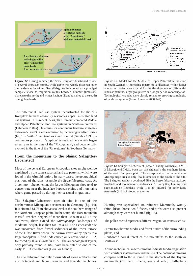
Thus, initial mobility covered longer distances than consecutive mobility. As this can be observed four times in the "G-Komplex", a regular change of the underlying land use pattern may be concluded. A regular change between circulating land use at the beginning, and radiating land use at the end of an occupation cycle can explain the data. Therefore, the Sesselfelsgrotte data indicates changing land use within the same cultural system (fi g. 12).
During the initial stage of land use (spring and summer), humans migrated between ephemeral campsites. At this stage, the Sesselfelsgrotte served as one such ephemeral campsite. Either small task groups collected raw material at a short distance from the ephemeral campsites, or raw material procurement was fully embedded in residential mobility and was conducted on the way between ephemeral camps. The initial stages might represent the summer season when big game like Reindeer and horse where dispersed over the mountainous region around the Altmühl river valley.
During the consecutive stage of land use (autumn), the Sesselfelsgrotte became a principal camp. The humans stayed here for longer periods. Task groups were sent out for hunting, collecting, and raw material procurement. Special task sites where established around the camp. A number of such sites are attested for the region (cf. Weißmüller 1995:54, fi g. 15). The consecutive stage of land use occurred probably during autumn when large herds of game gathered to come down from the mountains. They passed the Altmühl river valley on their way to their winter habitat near the Danube River plain.
- 24 -
Jürgen RICHTER
Figure 11. Four tool groups of the Central European Micoquian/M.M.O. The standard Mousterian tool group is a "fond commun" for all assemblages. During summer (residential, circulating mobility - short stays) the "fond commun" dominates small assemblages. During autumn/winter (logistic, radiating mobility – long and short stays, functional sites) functional demands were more diverse, thus adding more of the other three tool groups to the assemblages. Within the M.M.O. cultural repertoire, summer assemblages look more "Mousterian", and autumn/winter assemblages look more "Micoquian".
- 25 -
Neanderthals in their landscape
The differential land use system reconstructed for the "G-Komplex" humans obviously resembles upper Paleolithic land use systems. In his recent thesis, Th. Uthmeier compared Middle and Upper Paleolithic land use systems in Southern Germany (Uthmeier 2004a). He argues for continuous land use strategies between 50 and 30 ka characterised by increasing band territories (fi g. 13). With Clive Gambles ideas in mind (Gamble 1993), a continuous process of "exaption" is realized here which began as early as in the time of the "Micoquians", and became fully evolved in the time of the "Gravettians" in Southern Germany.
From the mountains to the plains: Salzgitter-Lebenstedt
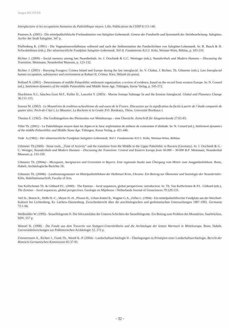
Most of the central European Micoquian sites might well be explained by the same seasonal land use patterns, which were found in the Altmühl region. In many cases, the geographical positions of the sites resemble the Sesselfelsgrotte case. As a common phenomenon, the larger Micoquian sites tend to concentrate near the interface between plains and mountains where game passed by during their seasonal migrations.
The Salzgitter-Lebenstedt open-air site is one of the northernmost Micoquian occurrences in Germany (fi g. 14). It is situated 81,78 m above sea level at the southern fringe of the Northern European plain. To the south, the Harz mountain massif reaches heights of more than 1000 m a.s.l. To the southwest, there extend the Mittelgebirge landscapes of moderate height, less than 600 m a.s.l. The Lebenstedt site was uncovered from fl uvial sediments of the lower terrace of the Fuhse River where the narrow river valley opens to a large fl oodplain. Alfred Tode carried out excavations in 1952, followed by Klaus Grote in 1977. The archaeological layers, only partially found in situ, have been dated to one of the early MIS 3 interstadials (Oerel or Glinde).
The site delivered not only thousands of stone artefacts, but also botanical and faunal remains and Neanderthal bones.
Hunting was specialized on reindeer. Mammoth, woolly rhino, bison, horse, wolf, fi shes, and birds were also present although they were not hunted (fi g. 15).
The pollen record represents different vegetation zones such as:
- arctic to subarctic tundra and forest tundra of the surrounding plains, and- subarctic boreal forest of the mountains to the south or southwest.
Abundant botanical macro-remains indicate tundra vegetation with conifers scattered around the site. The botanical remains compare well to those found in the stomach of the Taymir mammoth (Northern Siberia, early Alleröd; Pfaffenberg
Figure 12. During summer, the Sesselfelsgrotte functioned as one of several short stay camps, while game was widely dispersed over the landscape. In winter, Sesselfelsgrotte functioned as a principal campsite close to migration routes between summer (limestone plateau to the north) and winter habitats (Danube valley to the south) of ungulate herds.
Figure 13. Model for the Middle to Upper Palaeolithic tansition in South Germany. Increasing macro-move distances within larger annual territories were crucial for the development of differential land use patterns, larger group sizes and longer periods of occupation. Technological changes were closely related to growing complexity of land-use systems (from Uthmeier 2000:147).
Figure 14. Salzgitter-Lebenstedt (Lower Saxony, Germany), a MIS 3 Micoqiuen/M.M.O. open air site situated a the southern fringe of the north European plain. The escarpment of the mountainous Mittelgebirge area is only few kilometres to the south of the site. The Salzgitter territory combined, like the Sesselfelsgrotte territory, lowlands and mountainous landscapes. At Salzgitter, hunting was specialised on Reindeer, while it is not attested for other large mammals (in black) found at the site.
- 26 -
Jürgen RICHTER
Figure 15. Salzgitter Lebenstedt was situated at the steppe/forest (mountains) and tundra (plain) interface. Mammals found at the site are indicated (red circles) on a scheme of related ecotopes (modifi ed after Thenius 1962).
1991:209), thus underlining the extreme situation of the site at the northern fringes of the inhabited world (fi g. 16).
Recent re-analysis of the faunal remains from Lebenstedt (Gaudzinski & Roebroeks 2000) has proved the exploitation of more than 80 reindeer during the autumn season. Most of the animals died during September. Whereas hunting was not selective, sub-adult and juvenile animals were afterwards selected for marrow extraction. Many of the hunted animals were not fully exploited. Exploitation tended to be prime-dominated and compares well to Upper Paleolithic examples such as Stellmoor A (Gaudzinski & Roebroeks 2000:268).
Local raw material occurrences of Baltic fl int were also intensively exploited at the site. All stages of "chaines opératoires" of Levallois fl ake production are present, as well as abundant bifacial production of the Micoquian mode (fi g. 17). Imported artefacts could not be identifi ed and it was concluded that most of the lithic inventory was produced on the site (Pastoors 2001:245-247), thus indicating an extended length of occupation.
Salzgitter-Lebenstedt was an autumn hunting camp, which was designed to exploit large herds of reindeer during their seasonal migrations from the boreal forests of the mountainous belt southwest of Lebenstedt to the steppe-tundra of the northern plains. According to the Sesselfelsgrotte model, it can be interpreted as belonging to the consecutive stage of seasonal land-use. This would imply larger groups of humans and an extended length of occupation. Like reindeer, their principal prey, people spent the consecutive stage of land-use in the north European plain. The Micoquian site of Lichtenberg, about 90 km north of Lebenstedt and roughly contemporaneous, might belong to the same territory (Veil et al. 1994).
Figure 16. Botanical macro-remains found in the Salzgitter peat compare well to those found in the stomach of the Alleröd Taimyr mammouth. Salzgitter (probably together with the Lichtenberg Micoquian/M.M.O. site) attests to the presence of Neanderthals in extreme arctic environment, comparable to the present 75° north latitude (drawings from Pfaffenberg 1991).
Figure 17. Bifacial scrapers from Salzgitter-Lebenstedt (after Tode 1991).
Corresponding spring and summer camps (initial stage of seasonal land-use) were probably situated in the Mittelgebirge Mountains to the southwest of the site. This would imply a north to south extension of the annual territory of 150 km over two essentially different kinds of landscapes.
Close to the sky: Neanderthals in the Alps
It has been known for a long time that Neanderthals visited the Alps. In the Salzofen Cave (Totes Gebirge/Austria), they reached 2005 m a.s.l. (fi g. 18). Many middle Paleolithic sites are now known from the high mountain areas of the
- 27 -
Neanderthals in their landscape
Alps (Jequier 1975; Tillet 2001; Le Tensorer 1998), most of them dated to MIS 3. It is clear that these sites can only be interpreted as summer occupations, as access during winter is impossible.
When I recently tried to visit Wildkirchli Cave (Ebenalp, St. Gallen/Switzerland) at 1477 m, under interglacial conditions during May 2005 (fi g. 19), access to the cave was impossible due to a snow cover in excess of 1 m. Wildkirchli shelter was excavated by Emil Bächler from 1904 to 1908 and yielded a series of stone artefacts of the middle Paleolithic discoid concept of fl ake production. The raw material of the artefacts ("Ölquarzit") came from the Schwende river gravel 600 m below the cave. Whereas Bächler was correct in recognizing the stone artefacts as evidence Neanderthal activities (fi g.
20), he failed in his interpretation of abundant faunal remains from cave bear as the remnants of their hunting prey or even as artefacts.
Bächler was even convinced that two neighboring caves, Drachenloch (fi g. 21) and Wildenmannlisloch, which had delivered abundant cave bear remains, were holy places of the so-called "Höhlenbärenkult" (cave bear worship). For several decades of the last century, the three sites served to defi ne a "Wildkirchlikultur", a "protolithische Knochenkultur" (protolithic bone culture), and a "Höhlenbärenjägerkultur". After a re-analysis by J.-M. Jequier and others it became clear that the cave bears were neither hunted nor worshiped, and that their skeletal remains were naturally altered and not modifi ed by humans. Carnivores played an important role in
Figure 18. Late Middle Palaeolithic summer huntings stands in the Northern Alps. White circles indicate possible annual territories of 100 km.
Figure 19. Ebenalp with Wildkirchli (St.Gallen, Switzerland; from Bächler 1940:177).
Figure 20. Wildkirchli. Denticulated and notched stone tools made of "Ölquarzit" from the Schwende valley (assembled from Bächler 1940:149).
Figure 21. Collection of cave bear remnants from the nearby Drachenloch (“Dragon´s hole”) cave site on exhibit at the St. Gallen local museum during the 1930s. Baechler authored the hypothesis of a Middle Palaeolithic “Höhlenbärenkult” (cave bear worship). Abundant cave bear remains from Wildkirchli, Drachenloch and Wildenmannlisloch are nowadays explained as natural, long term accumulations without any anthropogenic traces (from Bächler 1940:124).
- 28 -
Jürgen RICHTER
the transformation processes of the faunal remains. Cave lion, cave panther, alpine wolf (Cuon alpinus), and wolf are among the faunal remains from Wildkirchli (Bächler 1940:211).
At Wildkirchli, Ibex, Cervus elaphus and Rupicapra rupicapra, which are all present among the faunal remains, are the most probable candidates for hunting. Wildkirchli was obviously the southernmost place within a large area of Neanderthal land use. Jequier detected imported raw materials from 120 km away (Jequier 1975). The Wildkirchli lithic assemblage contains many scrapers and denticulate pieces which compares well to the summer inventories of the contemporaneous Sesselfelsgrotte land use system.
The Erscheinungsbild of Weichselian landscapes among late Neanderthals
MIS 3 Neanderthal land use concepts rely on the dichotomy between mountainous areas (summer) and plains (autumn/winter) as migrating animals were preferably exploited at pass situations (fi g. 22). Adaptation to different seasonal habitats caused different mobility patterns, raw material procurement and toolkits for summer and autumn/winter situations (fi g. 23) which were previously mistaken as distinct cultural units (“Micoquian” and “Mousterian”) by archaeologists. It appears that the Sesselfelsgrotte model of land use can easily integrate and explain MIS 3-Mousterian assemblages such as Wildkirchli, as well as MIS 3-Micoquian assemblages such as Salzgitter-Lebenstedt. The MIS 3 evidence underlines that
Figure 22. Model of MIS 3 Micoquian (M.M.O.) perception of landscape. Annual territories are situated at interfaces between mountainous summer game areas and autumn/winter lowland areas where migrating animals change between their seasonal habitats.
Figure 23. Model of MIS 3 Micoqian (M.M.O.) annual land use cycles. Different assemblage types are explained as functions of different stages within the annual cycles. Circulating (summer) and radiating (autumn/winter) mobility modes are indicated by raw material spectra.
hunter-gatherer systems of adaptation must be understood in terms of fi ve different scales, expressed as levels A, B, C, D and E (fi g. 24).
The hierarchy of levels defi nes a layout for Neanderthal perception of environment and landscapes. Among hunter-gatherers, consciousness of about Level A, as a whole, has usually been founded on mythology. This must also apply to Neanderthals, though humans must have realized the extreme position of sites like Salgitter at the northern edge of the oikumene. Level B was also experienced rather locally and close to the edges (for example at the regional interface between Micoquian/M.M.O. and MtA) than as a whole (compare fi g. 25). Overall recognition of landscape began at Level C, the spatial maximum of annual mobility of one group. Particular land use strategies and mobility patterns
Figure 24. Model of fi ve different scales of hunter-gatherer perception of the earth´s surface. More or less hazardeous segments of level E constitute the principle windows of access for the archaeologist. Archaeologists need level B to evaluate the functional place of a given site within a particular land-use system, and level C to recognize the complete cultural repertoire of a social group (modifi ed after Richter in Zimmermann et al. 2005).
- 29 -
Neanderthals in their landscape
apply to level D. Occasionally, if human habitat remained the same all the year, Level C and D were also the same. Functional demands (camping, production and maintenance activities, raw material procurement, hunting, butchering, storage, funeral, worship) evoked topographic selection, spatial organization and equipment of single sites at level E. For archaeological reconstruction of hunter-gatherer cultures, level C delivers the key data sets. The proper knowledge is needed of the whole cultural repertoire dipersed over the surface of an annual mobility cycle in order to evaluate assemblages from single palaeolithic sites.
The size of annual territories can be assumed if maximum distances of raw material importation are compared. For the MtA, a maximum distance of 80 km is repeatedly attested and for the Micoquian/M.M.O. distances between 80 km in the West and 200 km in eastern central Europe have been observed. (Feblot-Augustins 1997; Floss 1994). If these distances are taken as diameters of circles representing the size of an annual territory, we can compare these to the sizes of level B contextual areas (fi g. 26). This allows for a rough estimation of some
Figure 25. M.M.O. principal sites. Archaeological sites of the Central European Micoquian defi ne a contextual area from southern Poland to Burgundy, with outliers in Southwestern Fance. An earlier stage (M.M.O.-A) combines non-Levallois with plan-covex bifacial technology, and a later stage (M.M.O.-B) Levallois (recurrent) with plan-convex bifacial technology.
Figure 26. Europe between 60.000 and 40.000 B.P. Red circles indicate annual territories (from west to east: Wildkirchli, Salzgitter, Sesselfelsgrotte, Pradnik region and Crimean sites) with diameters from 80 (atlantic climate) to 200 km (continental climate) diameter. Territory diameters are estimated from maximum distances of raw material importation. White outlines display contextual areas as indicated by different technological modes.
demographic variables (tabl. 1). The estimations depend on the preposition that each contextual area was fi lled with adjoining circular territories which is certainly highly hypothetical. On one hand, territories might have interlaced, on the other hand, not all-possible territories might have been occupied. Based on site distributions the contextual area of the central European Micoquien/M.M.O. comprised 391.000 km² (fi g. 25) and that of the MtA about 150.000 km² (see Soressi 2002:7; the minimum area is 84.000 km²: see Mellars 1996:261).
It occurs that territory diameters of 200 km would fail to support a population density required for long-term survival of a population. Consequently, the given distances of importation slightly exaggerate possible territory sizes, and thus should be regarded as over-average rather than as average values. More realistic estimations (tabl. 1, in yellow) derive from diameters between 80-100 km (for both MtA and M.M.O.) and may indicate that Middle Paleolithic contextual areas comprised as few as only 20-80 territories with a total population of less than 2000 persons each. The population density was certainly less than 0,02 persons per km², most probably around 0,005 persons per km².
Consequently, the land surface which was personally known by single humans did not exceed 8000 km². Compared to
Minimumterritorydiameter
MTA or M.M.O.size of territory
MTAsocial groups
(bands*)
MTApopulation
M.M.O.social groups
(bands*)
M.M.O.population
MTA or M.M.O.population
density
(km) (km²) (n) (n) (n) (n) (n/km²)
40 1256 119,4 2985,6 311,3 7782,6 0,0199
80 5024 29,8 746,4 77,8 1945,6 0,00498
100 7850 19,1 477,7 49,8 1245,2 0,00318
200 31400 4,7 119,4 12,4 311,3 0,0008
Table 1. Demographic estimations for MIS 3 Nanderthal land use. (*) 25 persons per band, one band per territory
- 30 -
Jürgen RICHTER
Eemian perception of landscape which was concentric and centripetal (focused on water-places) but infi nite in terms of its monotonous, repeated character of site functions and assemblages, MIS 3 land-use was tied to interfaces between complementary landscapes and restricted by the capacity to maintain knowledge about particular environmental features in order to support a wide spectrum of appropriate adaptation strategies. Neanderthal MIS 3 perception of landscape had the shape of a linear structure bridging dichotomous (seasonal differentiation) parts of annual land-use cycles.
Concluding remarks: Evolution or Continuity?
Several authors have noted that land use patterns essentially differed between earlier and later middle Paleolithic humans, and the question arises weather Neanderthal perceptions of landscape should be better understood in terms of evolution than in terms of continuity (tabl. 2).
For the earlier part of the middle Paleolithic, it was suggested that humans were extremely mobile and land use was rather organized in terms of pathways than in terms of territories (Kolen 1993). In my own opinion, explanation of the mentioned differences may base on two theoretical alternatives: an evolutionary one and a functional one.
1. Evolutionary explanation
Mental capacity and social behavior were less complex during MIS 10 to 5e than during MIS 5d to 3. Innovations were rare and did not survive due to low population density. During the late middle Paleolithic, the situation changes dramatically. Populations increased, regional traditions (Micoquian, MtA etc.), central places, dwelling structures and burials occurred. The overall increase of complexity indicates evolutionary progress from early to classic Neanderthals (Gamble 1993). Clive Gamble underlined this progress by his ranking of early humans as "Ancients" (Homo erectus to early Neanderthal), "Pioneers" (Archaic Homo sapiens and late Neanderthals) and "Moderns" (Homo sapiens sapiens).
2. Functional explanation
Eemian land use patterns resemble very much those of the earlier middle Paleolithic connected with early Neanderthals. Anthropologically, Eemian Neanderthals, however, are grouped together with their Weichselian successors and thus are accepted as standard Neanderthals. On the other hand, most of our earlier middle Paleolithic datasets comes from interglacial environments. Biache, Maastricht-Belvedere, and much of the Rheindahlen sequence are connected with open forests and non-migratory game. The differences between early and late Neanderthal behavior might well mirror the different conditions of interglacial versus interstadial landscapes. The large number of moderate phases within a glacial stage is obviously unique to the Wuermian glaciation. The earlier glaciations, MIS 6 and MIS 8 were not interrupted by interstadials, as far as we are presently aware.
Whereas the evolutionary explanation principally identifi es behavioral variability on a time scale, the functional explanation would presuppose that such variability can occur as a consequence of differential adaptation systems or even of cultural choice at a given time. For the moment, this perspective seems more promising, as the comparison of the Eemian and Weichselian evidence from Central Europe show:
- Eemian land-use is homogenous, no seasonal differentiation is visible as yet;- Early and middle Eemian artefact inventories are monotonous;- Eemian variability increases when open landscapes extend;- Weichselian (MIS 3) territories included different elevations and landscapes;- Weichselian seasonal habitats were preferably at geographical interfaces;- Weichselian land use patterns changed according to seasons;- Weichselian land use comprised different types of sites, camps and assemblages.
Neanderthal land-use patterns have yielded a principal explanation for the variability of middle Paleolithic artefact inventories, which, as it turns out, were strongly dependent on seasonal and functional parameters.
Early Middle Paleolithic Late Midddle Palaeolithic
Late Heidelbergensis / Early Neanderthal Standard Neanderthal
- small, short-term camps - different types of camps
- multi-species hunting - multi- and mono-species hunting
- universal technological concepts - universal and differential concepts
- very low population density - increased population?
Table 2.
- 31 -
Neanderthals in their landscape
References
Arslanov K.A., Tertychny N.I., Kuznetsov V.Yu., Chernov S.B., Lokshin N.V., Gerasimova S.A., Maksimov F.E., Dodonov A.E. (2002) – 230TH/U and 14C dating of mollusc shells from the coast of the Caspian, Barents, White and Black Seas. Geochronometria 21:49-56.
Bächler E. (1940) - Das alpine Paläolithikum der Schweiz im Wildkirchli, Drachenloch und Wildenmannlisloch. Basel, Monographien zur Ur- und Frühgeschichte der Schweiz 2.
Bocherens H. &Billiou D. (1998) - Implications paléoenvironnementales et paléoalimentaires de l´étude isotopique du Néandertalien de la couche 4. In: M. Otte, M. Pathou-Mathis, D. Bonjean (eds.), Recherches aux Grottes de Sclayn, Vol. 2. Liège, ERAUL 79:311-328.
Böttger T., Junge F.W., Kntsch S., Novenko E.Y., Velichko A.A. (2004) - Klimavariabilität an Warmzeit-Kaltzeit-Übergängen, abgeleitet aus limnischen Sedimentfolgen in Zentral- und Osteuropa (unpubl. Manuscript, www-available). Leipzig – Sächsische Akademie der Wissenschaften, 6 p.
Boyle K. (1998) - The Middle Palaeolithic geography of southern France. Resources and site location. Oxford, BAR Int. Ser. 723, 148 p.
Chabai V., Marks A.E. & Monigal K. (2004) - Crimea in the context of Eastern European Middle Paleolithic and Early Upper Paleolithic. In: V. Chabai, A.E. Marks & K. Monigal (eds.), Crimea in the context of Eastern European Middle Paleolithic and Early Upper Paleolithic. Liège, ERAUL 104:419-460.
Chlachula J., Drozdov N.I., Ovodov N.D. () - Last interglacial peopling of Siberia: the Middle Palaeolithic site of Ust´-Izhul´, the upper Yenisei area. Boreas 32:506-520.
Cliquet D. (1994) - Le gisement Paléolithique moyen de Saint-Germain-des-Vaux/Port Racine (Manche) dans son cadre régional. Essai palethnographique. Liège, ERAUL 63, 2 vol., 644 p.
Conard N.J. (2001) - River terraces, volcanic craters and middle Palaeolithic settlement in the Rhineland. In: N. Conard (ed.), Settlement dynamics of the middle Palaeolithic and Middle Stone Age. Tübingen, Kerns Verlag, p. 221-250.
Dibble H. & Rolland N. (1992) - On assemblage variability in the middle Paleolithic of Western Europe: History, perspective and a new synthesis. In: H. Dibble & P. Mellars (eds.), The Middle Paleolithic: Adaptation, behaviour and variability. Pennsylvania, Umiversity Museum Monographs 78:1-28.
Féblot-Augustins J. (1997) - La circulation des matières premières au Paléolithique. Liège, ERAUL 75, 2 vol.
Floss H. (1994) - Rohmaterialversorgung im Paläolithikum des Mittelrheingebietes. Bonn, Habelt, Monographien des RGZM 21.
Freund G. (1998) - Sesselfelsgrotte I. Grabungsverlauf und Stratigraphie. Saarbrücken, SDV, Quartär-Bibliothek 8.
Freeden U.v. & S.v. Schnurbein (eds.) (2002) - Spuren der Jahrtausende. Archäologie und Geschichte in Deutschland. Stuttgart, Theiss.
Gamble C. (1993) - Timewalkers: the prehistory of global colonization. Harmondsworth, Penguin.
Gaudzinski S. (1992) - Wisentjäger in Wallertheim. Zur Taphonomie einer mittelpaläolithischen Fundstelle in Rheinhessen. Jahrbuch RGZM 39:245-423.
Gaudzinski S. (2002) - The Eemian Interglacial (MIS 5e) in Northern Europe: Remarks on hominid subsistence. In: A. Tuffreau & W. Roebroeks (dir.), Le dernier Interglaciaire et les occupations humaines du Paléolithique moyen. Lille, Publications du CERP 8:41-51.
Gaudzinski S. & Roebroeks W. (2000) - Zur systematischen Verwertung der Jagdbeute im Mittelpaläolithikum. Ein Beitrag aus Salzgitter-Lebenstedt. Germania 78:247-271.
Jequier J.P. (1975) - Le Moustérien Alpin. Révision critique. Yverdon, Eborudunum II.
Kolen J. (1999) - Hominids without Homes: On the nature of Middle Palaeolithic settlement of Europe. In: W. Roebroeks & C. Gamble (eds.), The middle Palaeolithic occupation of Europe. Leiden, p. 139-175.
Kühl N. & Litt Th. (2003) - Quantitative time series reconstruction of Eemian temperature at three European soites using pollen data. Vegetation history and archaeobotany 12:205-214.
Kuhn S.L. (1995) - Mousterian Lithic Technology. An Ecological Perspective. Princeton, Princeton University Press, 209 p.
Le Tensorer J.-M. (1998) - Le Paléolithique en Suisse. Genoble, Jérome Millon.
Mania D. (2000) - Stratigraphy and palaeolithic of the middle and upper pleistocene in the Saale-Elbe-Region. In: A. Ronen & M. Weinstein-Evron, Toward modern humans. The Yabroudian and Micoquian, 400-50 k-years ago. Oxford, BAR Int. Ser. 850:25-49.
Marks A.E. (ed.) (1976) - Prehistory and paleoenvironments in the Central Negev, Israel, Vol. 1. Dallas, Southern Methodist University Press.
Marks A.E. & Chabai V. (eds.) (1998) - The Middle Paleolithic of Western Crimea, Vol. 1. Liège, ERAUL 84, 382 p.
Mellars P. (1996) - The Neanderthal Legacy. An archaeological perspective from Western Europe. Princeton, Princeton University Press, 471 p.
Monnier J.-L., Cliquet D., Hallégouet B., Vliet-Lanoe B.V., Molines N. (2002) - Stratigraphie, paléoenvironnement et occupations humaines durant le dernier interglaciaire dans lóuest de la France (Massif Armoricain). Comparaison avec l´interglaciare précédent. In: A. Tuffreau & W. Roebroeks (dir.), Le dernier
- 32 -
Jürgen RICHTER
Interglaciaire et les occupations humaines du Paléolithique moyen. Lille, Publications du CERP 8:115-140.
Pastoors A. (2001) - Die mittelpaläolithische Freilandstation von Salzgitter-Lebenstedt. Genese der Fundstelle und Systematik der Steinbearbeitung. Salzgitter, Archiv der Stadt Salzgitter, 347 p.
Pfaffenberg K. (1991) - Die Vegetationsverhältnisse während und nach der Sedimentation der Fundschichten von Salzgitter-Lebenstedt. In: R. Busch & H. Schwabedissen (eds.), Der altsteinzeitliche Fundplatz Salzgitter-Lebenstedt, Teil II. Fundamenta A11/2. Köln, Weimar-Wien, Böhlau, p. 183-210.
Richter J. (2000) - Social memory among late Neanderthals. In: J. Orschiedt & G.C. Weninger (eds.), Neanderthals and Modern Humans – Discussing the Transition. Mettmann, Neanderthal Museum, p. 123-132.
Richter J. (2005) - Hurrying Foragers: Crimea Island and Europe during the last interglacial. In: V. Chabai, J. Richter, Th. Uthmeier (eds.), Last Interglacial human occupation, subsiszence and environment at Kabazi II, Crimea. Kiev, Shliash (in press).
Rolland N. (2001) - Determinants of middle Palaeolithic settlement organization: a review of evidence, based on the record from western Europe. In: N. Conard (ed.), Settlement dynamics of the middle Palaeolithic and Middle Stone Age. Tübingen, Kerns Verlag, p. 545-572.
Shackleton N.J., Sánchez-Goni M.F., Pailler D., Lancelot Y. (2003) - Marine Isotope Substage 5e and the Eemian Interglacial. Global and Planetary Change 36:151-155.
Soressi M. (2002) - Le Moustérien de tradition acheuléenne du sud-ouest de la France. Discussion sur la signifi cation du faciès à partir de l´étude comparée de quatre sites: Pech-de-l´Azé I, Le Moustier, La Rochette et la Grotte XVI. Bordeaux, Thèse, Université Bordeaux I.
Thenius E. (1962) - Die Großsäugetiere des Pleistozäns von Mitteleuropa – eine Übersicht. Zeitschrift für Säugetierkunde 27:65-83.
Tillet Th. (2001) - Le Paléolithique moyen dans les Alpes et le Jura: exploitation de milieux de contraintes d´altidude. In: N. Conard (ed.), Settlement dynamics of the middle Palaeolithic and Middle Stone Age. Tübingen, Kerns Verlag, p. 421-446.
Tode A.(1982) - Der altsteinzeitliche Fundplatz Salzgitter-Lebenstedt, Teil I. Fundamenta A11/1. Köln, Weimar-Wien, Böhlau.
Uthmeier Th.(2000) - Stone tools, „Time of Activity“ and the transition from the Middle to the Upper Paleolithic in Bavaria (Germany). In: J. Orschiedt & G.-C. Weniger, Neanderthals and Modern Humans – Discussing the Transition: Central and Eastern Europe from 50.000 – 30.000 B.P. Mettmann, Neanderthal Museum, p. 133-150.
Uthmeier Th. (2004a) - Micoquien, Aurignacien und Gravettien in Bayern. Eine regionale Studie zum Übergang vom Mittel- zum Jungpaläolithikum. Bonn, Habelt, Archäologische Berichte 18.
Uthmeier Th. (2004b) - Landnutzungsmuster im Mittelpaläolithikum der Halbinsel Krim, Ukraine. Ein Beitrag zur Ökonomie und Soziologie der Neandertaler. Köln, Habilitationsschrift, Faculty of Arts.
Van Kolfschoten Th. & Gibbard P.L. (2000) - The Eemian – local sequences, global perspectives: introduction. In: Th. Van Kolfschoten & P.L. Gibbard (eds.), The Eemian – local sequences, global perspectives. Geologie en Mijnbouw / Netherlands Journal of Geosciences 79:129-133.
Veil St., Breest K., Höfl e H.-C., Meyer H.-H., Plisson H., Urban-Küttel B., Wagner G.A., Zöller L. (1994) - Ein mittelpaläolithischer Fundplatz aus der Weichsel-Kaltzeit bei Lichtenberg, Kr. Lüchow-Dannenberg. Zwischenbericht über die arechöologischen und geobotanischen Untersuchungen 1987-1992. Germania 72:1-66.
Weißmüller W. (1995) - Sesselfelsgrotte II. Die Silexartefakte der Unteren Schichten der Sesselfelsgrotte. Ein Beitrag zum Problem des Moustérien. Saarbrücken, SDV, 557 p.
Wenzel St. (1998) - Die Funde aus dem Travertin von Stuttgart-Untertürkheim und die Archäologie der letzten Warmzeit in Mitteleuropa. Bonn, Habelt, Universitätsforschungen zur Prähistorischen Archäologie 52, 272 p.
Zimmermann A., Richter J., Frank Th., Wendt K.-P. (2004) - Landschaftsarchäologie II – Überlegungen zu Prinzipien einer Landschaftsarchäologie. Bericht der Römisch-Germanischen Kommission 85:37-95.