80
Neighbourhood Plan for Yaxham “NP4Yaxham” 2016-2036 Pre-Submission Consultation Draft Plan Dated 18 th April 2016 Consultation Responses by 5pm 31 st May 2016

Neighbourhood Plan
for Yaxham
“NP4Yaxham”
2016-2036
Pre-Submission Consultation Draft Plan
Dated 18th April 2016
Consultation Responses by 5pm 31st May 2016

Pre-Submission Consultation Draft “NP4Yaxham” Neighbourhood Plan 18th April 2016
www.NP4Yaxham.com [email protected]
Lively discussions at consultation events…

Pre-Submission Consultation Draft “NP4Yaxham” Neighbourhood Plan 18th April 2016
www.NP4Yaxham.com Page i [email protected]
PREFACE
Dear Resident/Consultee
Here is our draft Neighbourhood Plan which has been produced by Yaxham people for
Yaxham people and aims to be incorporated into Breckland Council’s Local Plan. This
follows the consultations over the winter of 2015/16 and your many responses. These have
been incorporated into this Plan to express the views of the majority of local residents- as
planning policies that will form part of the formal planning process and community action
points that we together can seek to make progress on.
It is a large document, but please don’t be put off. It has to be presented in a certain format
because, if agreed at a referendum of the parish, it will become a formal planning
document. So a lot of detail and evidence is necessary. However, it does give our parish a
sense of place within Breckland, some history about the village over the centuries, and how
Yaxham and Clint Green have developed more recently. It also details how many people live
here and work here now.
The Plan reflects what residents have told us they like about living here and what they don’t
like and have given us their views about how they see the parish developing over the next
20 years. People attach great importance to Yaxham retaining its small and predominantly
rural village character, set in mid Norfolk protected within an open agricultural landscape.
The NP4Yaxham Working Group of 12 residents has worked very hard to put all this
together and we hope you will dip into the Plan and maybe learn things of interest about
our parish that you didn’t know.
Your comments on the Neighbourhood Plan for Yaxham and its policies will be very
welcome and we are very grateful to everyone who has participated by filling in the
questionnaires and surveys. There has been a very high level of support throughout the
village which has kept the Working Group focussed on getting to this point where a Plan is
actually on the table for discussion and comment.
Yours sincerely,
……………………… …………………….
Maggie Oechsle Ian Martin
Chairman Vice Chairman

Pre-Submission Consultation Draft “NP4Yaxham” Neighbourhood Plan 18th April 2016
www.NP4Yaxham.com Page ii [email protected]
The NP4Yaxham Team:
The members of the NP4Yaxham Working Group:
Maggie Oechsle Chairman, Frogs Hall Farm, Cutthroat Lane, Yaxham NR19 1RG
Ian Martin Vice-Chairman, Yaxham House, Norwich Road, Yaxham, NR19 1RH
Susan Martin Treasurer, Yaxham House, Norwich Road, Yaxham, NR19 1RH
Peter Lowings (Chairman, Parish Council), Pinebanks, Station Road, Yaxham NR19 1RB
David Brown (to Feb 2016), Blackberry Farm, Norwich Road, Clint Green NR19 1RT
Gary Davison Conker Cottage, Spring Lane, Clint Green, Yaxham NR19 1SA
Annie Green-Armytage (to Mar 2016) Quince Farm, Spring Lane, Clint Green, Yaxham NR19 1SA
Richard Hughes Carrington Wood, Norwich Road, Yaxham NR19 1QZ
Ben Mitchell 5 Norwich Road, Yaxham NR19 1RP
Stephen Robinson Lane End, Cutthroat Lane, Yaxham NR19 1RG
Jo Robinson (to Dec 2015), Lane End, Cutthroat Lane, Yaxham NR19 1RG
Jennie Smith Tregon, Norwich Road, Clint Green, Yaxham NR19 1AB
Mike Tibbetts Wickham House, Station Road, Yaxham NR19 1RD
Additional supporters/helpers: - Sharon Davison - Sarah Brown - Jackie Crisp - George Crummett - Ann Futter - Bill & Shelagh Gillons - Steve & Carlie Goldsmith - Anne Meredith
- Cynthia Nisbett - Lizzie Oechsle - Paul Philips - Amy Robinson - Simon & Michelle Salter - Libby Smith - Joan Thurgill
And many more…
“Fresh eyes” Reviewers - Peter Smith - Rev Sally Thurgill - Graham Tuttle - Clarke Willis - Karen Willis - Johanne Wright
And a huge thank you to:
Yaxham Village Amenities Association (YVAA) for use of the Village Hall and Meeting Room,
and Yaxham Primary School for use of Hall, for meetings and consultation events.
YVAA, Yaxham Primary School, St Peter’s Church, Yaxham Waters’ café and shop for hosting
“NP4Yaxham” survey “Post” boxes and copies of the Plan.
St Peter’s Church for the Christmas 2015 Coffee Morning
Mattishall Neighbourhood Plan Steering Group for guidance and encouragement
Consultant Support
- Small Fish Strategy Consultants – Mark Thomson – www.smallfish.co.uk
- Dick Wingate Associates – Dick Wingate – www.dwa-planning.co.uk
Printing by:
Eastern Office Equipment (Newsletters & Plans) – www.easternofficeequipment.co.uk

Pre-Submission Consultation Draft “NP4Yaxham” Neighbourhood Plan 18th April 2016
www.NP4Yaxham.com Page iii [email protected]
Neighbourhood Plan
for Yaxham
“NP4Yaxham”
2016-2036
Pre-Submission Consultation Draft Plan Dated 18th April 2016
Prepared by NP4Yaxham Working Group
under the auspices of Yaxham Parish Council
Pre-submission Consultation
Concludes at 5pm 31st May 2016
Please return completed Consultation Forms (Attachment 3) to the address below or
place in the NP4Yaxham “Post” boxes at Yaxham Primary School, St Peter’s Church,
Yaxham Village Hall or at Yaxham Waters shop or café or
Bring them to the Village Consultation events on:
Thursday 12th May, from 5pm to 7pm at the Meeting Room, Yaxham Village Hall,
prior to the Yaxham Parish Annual Meeting & the Parish Council Annual Meeting, and
Monday 16th May from 4pm-7pm in the Hall at Yaxham CofE (VA) Primary School
For more information please see:
www.np4yaxham.com, www.yaxham.com, www.yaxhamvillagehall.co.uk
email: [email protected] , or write to the address below.
Printed & Published by NP4Yaxham Working Group
C/O Frogs Hall Farm, Cutthroat Lane, Yaxham Norfolk NR19 1RG

Pre-Submission Consultation Draft “NP4Yaxham” Neighbourhood Plan 18th April 2016
www.NP4Yaxham.com Page iv [email protected]
The first meeting in the
village hall –
September 2015: (After having to relocate from
the Small Meeting Room as so
many villagers attended)
What’s it all about?
Do we want to proceed?
Yes we do!
Demonstrating
Housing Density –
Consultation Event,
November 2015
Emerging Policies -
Consultation Event,
January 2016

Pre-Submission Consultation Draft “NP4Yaxham” Neighbourhood Plan 18th April 2016
www.NP4Yaxham.com Page v [email protected]
Neighbourhood Plan for Yaxham
2016-2036
Structure & Content
Page
Index: Maps & Aerial Photos vi
Index: Planning Policies & Parish Action Points vii
Foreword 1
1. Introduction 3
2. A Portrait of Yaxham Parish 9
3. Parish Consultation Response 25
4. Vision, Principles & Objectives 27
4.1. Vision 27
4.2. Principles 28
4.3. Objectives 30
5. Specific Policy & Community Action Areas 32
5.1. Strategic Planning Context 32
5.2. Strategic Green Gaps 34
5.3. Housing 38
5.4. Environmental 43
5.5. Economic Development 53
5.6. Transport 55
5.7. Community Benefit 58
6. Implementation/Monitoring: Future Directions Plan 61
Attachment 1 Bibliography 63
Attachment 2 Glossary 65
Attachment 3 Consultation Response Form 69
NB Supporting Documents will be provided with the finalised Plan, but are not provided
with this pre-submission Draft Plan. These will include: Statement of Basic Conditions
(including Sustainability Statement); Consultation Statement (including Narrative,
Bibliography, Compendium of Surveys); Evidence Base (including Narrative, Source List, File);
SEA Screening Report – see www.NP4Yaxham.com for latest drafts.

Pre-Submission Consultation Draft “NP4Yaxham” Neighbourhood Plan 18th April 2016
www.NP4Yaxham.com Page vi [email protected]
Maps Page
1. Yaxham civil parish – the Neighbourhood Plan Designated Area 2
2. The District of Breckland in the County of Norfolk 10
3. Yaxham Civil Parish in Mattishall Ward of Breckland District Council 10
4. Tud River Valley 12
5. Yaxham LDF Settlement Boundary & Conservation Area Boundary 15
6. Clint Green LDF Settlement Boundary 17
7i & 7ii Pinns Corner Location & Detail 21
8. Yaxham Limited Footpath Network 23
9i & 9ii. Yaxham Site Options January 2016 & Spring 2016 24
10. Yaxham Parish Strategic Gaps 35
11. Conservation Area & Heritage Assets 45
12. Local Green Space Designation 48
13. Surface Water Flood Map 49
14. Fluvial Water Flood Map 50
15. Circular Footpath Walk in Yaxham 51
Aerial Photos Page
1. View of the civil parish of Yaxham 11
2. The Settlement of Yaxham 16
3. Settlement of Clint Green 17
Please Note: For all maps and aerial photos, unless stated otherwise, the source is
Online GIS for web-mapping, data-sharing, planning and business intelligence provided via
“Parish Online” to Yaxham Parish Council, including: ©Arial imagery-www.getmapping.com
©Contains Ordnance Survey Data: Crown Copyright and Database Right 2016

Pre-Submission Consultation Draft “NP4Yaxham” Neighbourhood Plan 18th April 2016
www.NP4Yaxham.com Page vii [email protected]
Index of Planning Policies
If NP4Yaxham is agreed at a referendum of the Parish, these will supplement
and become part of Breckland Local Plan.
The Policies set out what will need to be taken into account by developers in making their
planning applications, the Parish Council in commenting on those planning applications, and
by Breckland Council when determining those planning applications and deciding whether
or not to grant planning permission. Only the policies have any weight when determining
planning applications; the supporting text is for explanation; and it is only these policies that
are assessed against the Basic Conditions.
Policy Name Page
Strategic Planning Policy STR 1 – Strategic Gaps 36
Housing Policy HOU 1 – Location of New Residential
Development 38
Housing Policy HOU 2 – Housing Density 39
Housing Policy HOU 3 – Scale of Residential Development 40
Housing Policy HOU 4 – Existing Land Use 40
Housing Policy HOU 5 – Housing Mix 40
Housing Policy HOU 6 – Design 41
Housing Policy HOU 7 – Affordable Housing 42
Environmental Policy ENV 1 – The Rural Village Nature of Yaxham 43
Environmental Policy ENV 2 – Dark Skies 44
Environmental Policy ENV 3 – Conservation Area & Heritage Assets 46
Environmental Policy ENV 4 – The Local Environment 47
Environmental Policy ENV 5 – Local Green Space Designation 48
Environmental Policy ENV 6 – Prevention of Flooding 50
Environmental Policy ENV 7 – Sewerage Provision 51
Environmental Policy ENV 8 – Sustainable Design 51
Environmental Policy ENV 9 – Rights of Way/Footpaths 52
Economic Development Policy ECN 1 – New Economic Development 54
Economic Development Policy ECN 2 – New Developments 54
Transport Policy TRA 1 – Traffic and sustainable transport 56
Transport Policy TRA 2 – Parking Provision 57
Community Benefit Policy COM 1 – Existing Parish-Based Community
Services 58
Community Benefit Policy COM 2 – Developer Funding Priorities 60

Pre-Submission Consultation Draft “NP4Yaxham” Neighbourhood Plan 18th April 2016
www.NP4Yaxham.com Page viii [email protected]
Index of Parish Action Points
If NP4Yaxham is agreed at a Referendum of the Parish, these will be for
consideration by
Yaxham Parish Council, NP4Yaxham Action Group & Village Organisations
Parish Action Points cover issues about which the village feels strongly and wishes to see
action. These are wider than requirements relating to future housing development. They
may also not be considered as strictly planning matters by Breckland. However, many
residents have strongly indicated the need to have services and infrastructure in place to
meet current demands as well as the cumulative issues arising from the myriad of likely
development in the Mattishall-Yaxham-South Dereham corridor. Key to most of these
issues is that they are matters that the Parish Council, or other groups within the parish can
work or lobby for without waiting for or requiring new planning proposals.
Parish Action Points are therefore not Planning Policies and are not required to be assessed
against the Basic Conditions.
Action Points Name Page
Parish Action Point PAP 1 – Critical Infrastructure 33
Parish Action Point PAP 2 – Possible Similar Strategic Gaps
Beyond Parish Boundary 37
Parish Action Point PAP 3 – Affordable Housing 42
Parish Action Point PAP 4 – Street Lighting 44
Parish Action Point PAP 5 – Heritage Assets 46
Parish Action Point PAP 6 – Car Reduction Strategy 56
Parish Action Point PAP 7 – Community Services Outside
the Parish 59
Parish Action Point PAP 8 – Priority for Community Funding 60
Parish Action Point PAP 9 – NP4Yaxham Action Group 61

Pre-Submission Consultation Draft “NP4Yaxham” Neighbourhood Plan 18th April 2016
www.NP4Yaxham.com Page 1 [email protected]
FOREWORD
The Yaxham Neighbourhood Plan (“NP4Yaxham”) has developed during 2015 and 2016. The
Working Group was set up in September 2015 under the auspices of Yaxham Parish Council –
following public meetings in April and September 2015 and debate at Parish Council meetings.
The Working Group includes the Chairman of the Parish Council, residents from throughout the
parish and includes members who worked previously on the very successful “Your Yaxham”
Community Led Plan (CLP) in 2013. NP4Yaxham is the direct successor to the CLP in taking
forward the planning development of Yaxham. It sets out the planning polices (“Policies”)
relevant to the parish as well as the community aspirations for issues that cannot be controlled
through the planning process, “Parish Action Points” (PAP). The PAP will form the basis of the
“Future Directions Plan” (FDP), which will enable to Parish Council to take on the task of fulfilling
the wishes expressed by Parishioners.
The Neighbourhood Plan for Yaxham will form part of the Breckland Local Plan and will help
make a real difference to the future of the Parish and help shape future proposals for
development. It conforms to the broad principles of the National Planning Policy Framework
2012 (NPPF), the Breckland Core Strategies Document 2009 and the Emerging Breckland Local
Plan January 2016. The development of NP4Yaxham has been supported by Yaxham Parish
Council, Breckland District Council (as the Local Planning Authority – LPA), and Norfolk County
Council as well as many other organisations. NP4Yaxham has been funded solely by grants
from: the “Your Yaxham” CLP, Yaxham Parish Charity, Locality (for the Department for the
Communities and Local Government), and Breckland Council.
The Neighbourhood Plan Process requires a Neighbourhood Plan to pass through a number of
specified stages in order to progress to becoming incorporated into Breckland District Council’s
statutory development plan. Before formally submitting the NP4Yaxham to Breckland the draft
Plan has to be consulted on for six weeks – involving residents, local businesses, voluntary
organisations and specified statutory consultees. This stage of the process is called “Pre-
submission Consultation” over six weeks, concluding at 5pm on 31st May 2016. When this stage
is completed, we will consider all the consultation responses and where appropriate amend the
draft NP4Yaxham to reflect these. Once that is completed then the Plan will be formally
submitted to Breckland Council and eventually to a referendum of the whole parish.
The Working Group very much appreciates the help, support and involvement of so many within
the parish and commends this Pre-submission Draft Plan to the community and the consultees
for your consideration and response. Please complete the “Pre-submission” Draft Plan
Consultation Response Form in Attachment 3 and return as indicated. If you would like any
further information then please see www.NP4Yaxham.com, www.breckland.gov.uk, or email
[email protected] or write to the Working Group at the address on the front page. We
very much look forward to hearing from you.
…………………………………………………….. ………………………………………………………………..
Peter Lowings Maggie Oechsle
Chairman, Yaxham Parish Council Chairman, NP4Yaxham Working Group

Pre-Submission Consultation Draft “NP4Yaxham” Neighbourhood Plan 18th April 2016
www.NP4Yaxham.com Page 2 [email protected]
Map 1 Yaxham civil parish is outlined in blue – the Neighbourhood Plan Designated Area
Source: Parish Online 2015
No
rth

Pre-Submission Consultation Draft “NP4Yaxham” Neighbourhood Plan 18th April 2016
www.NP4Yaxham.com Page 3 [email protected]
1 Introduction
1.1 Legislative Status
The Yaxham Neighbourhood Plan has been developed under the Localism Act (2011) and
the subsequent Neighbourhood Planning (General) Regulations (2012) introduced to
regulate the formation and approval of Neighbourhood Plans (DCLG, 2012).
A Neighbourhood Plan must be in general conformity with the National Planning Policy
Framework (NPPF) and with the strategic policies of the current Breckland Local
Development Plan (2009), and have regard to the emerging Breckland Local Plan (see
www.Breckland.gov.uk) (Breckland Council, 2015). How the NP4Yaxham achieves this is set
out in the Statement of Basic Conditions that will accompany the Plan when it is formally
submitted to Breckland District Council.
The NP4Yaxham takes advantage of the knowledge and views of local residents and other
stakeholders to deliver sustainable development in the most advantageous way. When
approved by the residents in a referendum its policies become part of the statutory
development plan and will be taken account of in decisions on planning applications for
development within the designated area.
1.2 Geographic area covered by the Yaxham Neighbourhood Plan
The Yaxham Neighbourhood Plan covers the whole of the civil parish of Yaxham as can be
seen in Map 1.
Yaxham is the name of the civil parish and of the larger of the two settlements within it.
Residents of the parish refer to the village of Yaxham as the whole parish, as does this
Neighbourhood Plan. When the specific settlements of Yaxham and Clint Green are referred
to then the word “settlement” is used to distinguish from the parish or village.
1.3 The Local Planning Authority for Yaxham
The whole of Yaxham parish lies within Breckland District in the county of Norfolk.
Breckland District Council is the designated Local Planning Authority (LPA) and formally
approved the development of the Yaxham Neighbourhood Plan on 17th November 2015.
1.4 The data for the Neighbourhood Plan
Data has been collected from various sources, each of which is referenced as to source. This
is set out in the Evidence Base Narrative and Bibliography – see www.NP4Yaxham.com .

Pre-Submission Consultation Draft “NP4Yaxham” Neighbourhood Plan 18th April 2016
www.NP4Yaxham.com Page 4 [email protected]
It’s for their future too…
1.5 Development of the Yaxham Neighbourhood Plan
The NP4Yaxham has been developed by the Neighbourhood Plan Working Group of 12
residents, under the auspices of the Parish Council, supported, where necessary, by
professional consultants. Progress on the NP4Yaxham has been reported regularly to the
Parish Council at their monthly meetings and to residents via reports in periodic
Newsletters, the free thrice yearly Yaxham Village Amenities Newsletter delivered to every
home, posters in the Parish Council Notice Boards, on the parish website
(www.yaxham.com), the Village Hall website (www.yaxhamvillagehall.co.uk), and on the
NP4Yaxham Website www.np4yaxham.com, Facebook page, Streetlife
(www.streetlife.com), Twitter and via information e-mails sent out to a large number of
residents. The work has also involved developing an Evidence Base, building on the
comprehensive “Your Yaxham” Community Led Plan (CLP) completed on 2013, reviewing
national and local planning policies, and carrying out extensive public consultation in
September, November and December 2015, and in January, February and March 2016. The
Evidence Base is available as a separate document. Further detail on consultations can be
found in the separate report “Consultation”. The latest drafts of which can be found at
www.np4yaxham.com.
St Peter’s Church Christmas Coffee Morning, December 2015

Pre-Submission Consultation Draft “NP4Yaxham” Neighbourhood Plan 18th April 2016
www.NP4Yaxham.com Page 5 [email protected]
All age groups consulted…
1.6 The Plan and Supporting Documents
In accordance with legislation, the finalised Neighbourhood Plan will be supported by:
a Statement of Community Involvement (including a list of data sources)
a Statement of Basic Conditions
an Evidence Base Description (including a list of data sources)
the LPA Opinion as to whether NP4Yaxham Requires a Strategic Environmental
Assessment (SEA).
These documents and other information will be available on the www.np4yaxham.com.
1.7 Presumption in favour of sustainable development
When considering development proposals, local planning authorities will take a positive
approach that reflects the presumption in favour of sustainable development contained in
the National Planning Policy Framework (NPPF). They will work with applicants and the
local community to find solutions which mean that proposals can be approved wherever
possible, and to secure development that improves the economic, social and environmental
conditions in the area (DCLG, 2012). Paragraph 8 of the NPPF stresses that these roles
should not be undertaken in isolation because they are mutually dependent; therefore a
balanced assessment against these three dimensions is required.
Planning applications proposing sustainable development within Yaxham Parish that accord
with the policies in the Local Plan and, where relevant, with policies in this Neighbourhood
Plan, will be recommended for approval by the Parish Council, unless material
considerations indicate otherwise.

Pre-Submission Consultation Draft “NP4Yaxham” Neighbourhood Plan 18th April 2016
www.NP4Yaxham.com Page 6 [email protected]
Government regulations require the Local Planning Authority to undertake a Sustainability
Assessment for the development of its Local Plan to ensure that its policies support
Sustainable Growth. Breckland Council is doing this as part of its emerging Local Plan. In
turn the regulations do not formally require this of a Neighbourhood Plan – see below:
“Supplementary planning documents [including Neighbourhood Plans] do not require a sustainability appraisal but may in exceptional circumstances require a strategic environmental assessment if they are likely to have significant environmental effects that have not already have been assessed during the preparation of the Local Plan. http://planningguidance.communities.gov.uk/ Para: 008 Reference ID: 11-008-20140306
“There is no legal requirement for a neighbourhood plan to have a sustainability appraisal as set out in section 19 of the Planning and Compulsory Purchase Act 2004. However, a qualifying body must demonstrate how its plan or order will contribute to achieving sustainable development. A sustainability appraisal may be a useful approach for doing this and the guidance on sustainability appraisal of Local Plans should be referred to.”
http://planningguidance.communities.gov.uk/ Para: 026 Reference ID: 11-026-20140306
Breckland District Council has offered the following guidance:
“On the matter of Sustainability Appraisal, we agree that the issue needs to be in the
context of proportionality, and clearly we don’t want this to become burdensome
when it doesn’t need to be. We have discussed that you will need to demonstrate
how your neighbourhood plan contributes to sustainable development and you and
your consultants should be satisfied that your preferred approach meets the basic
condition.” Email 6th April 2016 from Jo Wright, Neighbourhood Planning Officer.
In order to demonstrate that the NP4Yaxham contributes to achieving sustainable
development, the NP4Yaxham Working Group has commissioned a sustainability review of
its policies. This gives consideration to the sustainability questions which form part of the
framework for the emerging Breckland Local Plan Sustainability Appraisal. It should be used
for information purposes only in order to better understand how the Draft Yaxham
Neighbourhood Plan represents sustainable plan-making. The full Sustainability Statement
is included in the NP4Yaxham Statement of Basic Conditions.
The methodology used for the Sustainability Statement is based on the Sustainability
Appraisal framework for the emerging Breckland Local Plan to guide assessment against the
objectives as set out. Against each of the sustainability objectives, consideration has been
given as to whether each of the NP4Yaxham draft policies will have a positive effect i.e. will
help to meet the objective, no effect or an adverse effect.
Most of the policies have either no effect on the sustainability objectives, or a positive
effect. The area where there are the most marked positive effects is within the topic area of

Pre-Submission Consultation Draft “NP4Yaxham” Neighbourhood Plan 18th April 2016
www.NP4Yaxham.com Page 7 [email protected]
cultural heritage and landscape, and this is likely due to the fact that the majority of the
Neighbourhood Plan’s policies focus on maintaining the character and landscape setting of
the parish as protecting these assets is the predominant focus of the plan.
The conclusion of this review is that the NP4Yaxham does demonstrate that it contributes to
sustainable development. The detail of this review is set out in the Sustainability Statement
in the Statement of Basic Conditions that will accompany the final Plan – the latest draft of
which can be found at www.np4yaxham.com.
1.8 Strategic Environmental Assessment A strategic environmental assessment is unlikely to be required where a supplementary planning document deals only with a small area at a local level (regulation 5(6) of the Environmental Assessment of Plans & Programmes Regulations 2004), unless it is considered that there are likely to be significant environmental effects.” http://planningguidance.communities.gov.uk/ Para: 008 Reference ID: 11-008-20140306 Breckland District Council has consulted on NP4Yaxham Draft Policies and provided a “Neighbourhood Planning Strategic Environmental Assessment Screening Report” as to whether the NP4Yaxham requires a Strategic Environmental Assessment (SEA). The full Report will be included in the Statement of Basic Conditions and on www.np4yaxham.com. It concludes as follows:
“6.4. Having reviewed the criteria, the [Breckland] Council has concluded that the emerging Neighbourhood Plan for Yaxham is not likely to have any significant environmental effect and accordingly will not require a Strategic Environmental Assessment. The main reasons for this conclusion are:
The Neighbourhood Plan for Yaxham does not allocate any sites for development.
The Neighbourhood Plan for Yaxham seeks to avoid or minimise environmental effects when determining development proposals.
The Neighbourhood Plan for Yaxham is unlikely to affect any designated sites in the vicinity or lead to other environmental effects.”
1.9 Five Year Land Supply
The NP4Yaxham Working Group is aware that the Government expects councils, such as
Breckland District Council, to have a continuing five years supply of housing land with
planning permission, and that Breckland does not have that level of supply. In order to
assist in making decisions on housing proposals, Breckland District Council has adopted the
following approach:-
“.....Paragraphs 47 and 49 of the National Planning Policy Framework (NPPF) state that where an authority does not have an up to date five year housing land supply (at present the District figure is 3.3 years), the relevant local policies for the supply of housing as referred to above should not be considered up-to-date and that housing

Pre-Submission Consultation Draft “NP4Yaxham” Neighbourhood Plan 18th April 2016
www.NP4Yaxham.com Page 8 [email protected]
applications should be considered in the context of the presumption in favour of sustainable development. The Government defines sustainable development as having three dimensions. These dimensions give rise to the need for the planning system to perform a number of roles: - economic, in terms of building a strong economy and in particular by ensuring that sufficient land of the right type is available in the right places; - social, by supporting, strong vibrant and healthy communities by providing the supply of housing required to meet future need in a high quality environment with accessible local services, and; - environmental, through the protection and enhancement of the natural, built and historic environment. Paragraph 8 of the NPPF stresses that these roles should not be undertaken in isolation because they are mutually dependent; therefore a balanced assessment against these three dimensions is required..................” (www.breckland.gov.uk)
Until such time as Breckland District Council has an adopted Local Plan demonstrating a five year supply of housing with planning permission, various elements of the NP4Yaxham will be in abeyance. The new Local Plan is anticipated to be adopted in the next 12 months.
1.10 Planning Policies and Parish Action Points
The Core of a Neighbourhood Plan is the planning policies. These set out what will need to
be taken into account by developers in making their planning applications, the Parish
Council in commenting on those applications, and by Breckland Council when determining
those planning applications and deciding whether or not to grant planning permission.
Only the policies have any weight when determining planning applications; the supporting
text is for explanation; and it is only these policies that are assessed against the Basic
Conditions.
In addition to the Planning Policies it became clear during the consultations with the parish
that issues connected with planning matters should be raised. The NP4Yaxham therefore
includes what we have termed “Parish Action Points” (PAP). These cover issues about which
the village feels strongly and wishes to see action. These are wider than requirements
relating to future housing development. They may also not be considered as strictly
planning matters by Breckland. However, many residents have strongly indicated the need
to have services and infrastructure in place to meet current demands as well as the
cumulative issues arising from the myriad of likely development in the Mattishall-Yaxham-
South Dereham corridor.
Key to most of these issues is that they are matters that the Parish Council, or other groups
within the parish can work or lobby for without waiting for or requiring new planning
proposals. These are for the consideration of Yaxham Parish Council and other village
organisations to take forward. The final section of NP4Yaxham proposes the creation of the
NP4Yaxham Action Group to help facilitate this process. Parish Action Points are therefore
not Planning Policies and are not required to be assessed against the Basic Conditions.

Pre-Submission Consultation Draft “NP4Yaxham” Neighbourhood Plan 18th April 2016
www.NP4Yaxham.com Page 9 [email protected]
2 A Portrait of the Parish of Yaxham
2.1 Setting the Context
Yaxham is a small rural village is situated in the district of Breckland in mid Norfolk. Map 1
shows the boundaries of the civil parish which also represent the Neighbourhood Plan
designated area. Map 2 sets the civil parish in relation to its immediate neighbours within
Breckland District and Map 3 shows Breckland at the centre of the county of Norfolk. The
centrality of Yaxham within Norfolk helps to explain part of the parish’s attraction to
residents and popularity as a centre for tourists to explore the wider county.
It is situated in the open agricultural countryside, on the northern end of the Brecks, which
is highly valued and extensively used by residents. The small rural agricultural nature of the
parish is clearly shown in Aerial Photo 1 below. The population recorded in the Census of
2011 was of some 760 individuals, within 330 households (Norfolk Insight, 2011).
Subsequent small scale in-fill development has increased the number of households to
around 360 (based on YVAA newsletter deliveries), and the population is therefore
estimated now to be around 800. A mile to the north is the market town of Dereham
(parish and town boundaries abut). The parish is bisected north/south by the B1135
Whinburgh/Wymondham Road and east/west
by the Norwich Road. Norwich is
approximately 15 miles to the east, with the
market town of Wymondham 9 miles to the
south and the large village of Mattishall 3
miles to the east (Norfolk County Council,
2011). The privately run Mid-Norfolk Rail
(MNR) way runs trains from Dereham to
Wymondham Abbey through Yaxham Station,
on the old Norfolk Railways line first opened in
1857 (Mid Norfolk Railway, 2015)
(www.mnr.org.uk) .
The Civil Parish of Yaxham comprises two main settlements (see Maps 5 and 6, and Aerial
Photos 3 and 4). Its population in the Census of 2011 of some 760 individuals. The
settlement of Yaxham lies to the west with some 220 dwellings and the settlement of Clint
Green in the east of the Parish, a mile apart, with some 110 dwellings. The balance of the
dwellings is to be found in smaller communities or are (or were) individual farmsteads.
Aerial Photo 1 illustrates the small focused settlements surrounded by sparsely populated
countryside.
MNR Yaxham Railway Station

Pre-Submission Consultation Draft “NP4Yaxham” Neighbourhood Plan 18th April 2016
www.NP4Yaxham.com Page 10 [email protected]
Map 2 Yaxham Civil Parish in Mattishall Ward of Breckland District Council
Source: www.Breckland.gov.uk
Yaxham is clearly distinct from Dereham and villages such as Mattishall to the east,
Westfield to the west and Whinburgh to the south. Yaxham has a range of services and
access to many more in the neighbouring Dereham and Mattishall.
Map 3 The District of Breckland in the County of Norfolk
Source: Ordnance Survey, 2009
Yaxham
BRECKLAND
Yaxham

Pre-Submission Consultation Draft “NP4Yaxham” Neighbourhood Plan 18th April 2016
www.NP4Yaxham.com Page 11 [email protected]
Aerial Photo 1. View of the civil parish of Yaxham (Boundary Marked in Blue)
A small rural village comprising two small settlements and set in sparsely
populated open countryside

Pre-Submission Consultation Draft “NP4Yaxham” Neighbourhood Plan 18th April 2016
www.NP4Yaxham.com Page 12 [email protected]
In 2013 the village undertook the “Your Yaxham” Community Led Plan (CLP) which has
provided much of the foundation for the Neighbourhood Plan. The Neighbourhood Plan for
Yaxham (NP4Yaxham) has built on this structure to reflect the nature of this small rural
parish. The Working Group has consulted widely and this provides the basis of the Plan.
First it sets the vision of how Yaxham sees itself and how it wishes to develop during the
Plan period – 2016-2036. From this flows the objectives and principles that govern the
approach to the planning policies, significant statements and community action points. The
portrait of the pillage gives a factual snap-shot of the make-up of the community at the time
of drafting this Plan. What the community wants to see, derived from the consultation
process, is then summarised which, along with the strategic planning context of the effects
of cumulative development in Yaxham and adjoining settlements, leads into the detailed
Planning Policies, Significant Statements and Community Action Points. Lastly, the future
implementation and monitoring of the Plan is set out.
The Tud Valley to the north of Yaxham (see Map 4) is an important green gap of open
farmland preserving the highly prized clear identity of Yaxham as a small but vibrant rural
community in its own right and not a suburb of nearby Dereham (NP4Yaxham, 2015). The
river valley is seen as particularly important to the parish as it represents a clear visual green
gap between Yaxham and its much larger neighbour. The Tud River Valley is ecologically
important, it includes a Site of Special Scientific Interest (SSSI) at Badley Moor, part of the
Norfolk Valley Fen Network Special Area of Conservation (SAC). In addition there are a
number of County Wildlife Sites (CWS) within the valley including: the Tud Valley Fen,
Yaxham Fen and Yaxham Orchard. CWS are areas of land recognised as being, at least, of
county importance for their nature conservation value; this is defined by the presence of
important, distinctive and threatened habitats and species.
Map 4 – Indication of The Tud River Valley north of Yaxham

Pre-Submission Consultation Draft “NP4Yaxham” Neighbourhood Plan 18th April 2016
www.NP4Yaxham.com Page 13 [email protected]
Defining the River Tud Valley in Map 4 is based on contour lines. The river descends from 45m in the
west to 35m in the east on the map. The indicative boundaries of the Tud River Valley shown here
broadly follow declining contour lines. Whilst the true fluvial watersheds are further apart these
contours give outline where the inclines become more pronounced. The northern and southern
river valley boundaries are indicated on the Map in green and are defined as follows:
RB1 – is the northern indicative boundary starts in the west at the 55m contour, skirts existing
settlement of Dereham and then follows the 50m contour line and descends to the 45m
contour line past Dumpling Green.
RB2 – is the southern indicative boundary line starts at the 50m contour line and skirts the
existing settlement of Yaxham round to the Norwich Road and on to the 45m contour
line past Clint Green and then to the 40m contour line past Mattishall.
To the south of Yaxham there is the ancient woodland of Yaxham Wood which is another
CWS, various trees within the Parish are covered by Tree Preservation Orders (TPO)
(Breckland District Council, 2014). To the East, between the settlements of Clint Green and
Mattishall there are the SSSI’s at Mattishall Moor and Rosie Curston’s Meadow. These areas
are of national importance are designated based on their nature conservation/ geological
value (Joint Nature Conservation Committee, 2015).
To preserve the rural ‘feel’ the area is uncluttered by street furniture and signs, and there
are no street lights. This has helped to
conserve its essentially rural
character, and to preserve the dark
skies of Norfolk (Campaign to Protect
Rural England, 2010). There has been
little development outside the two
main settlements in order to preserve
the impressive open rural and
agricultural nature, whilst allowing
views out over the surrounding
countryside. Likewise the similar open
countryside to the east represents a
clear geographical and visual break with the much larger village of Mattishall. In turn the
clear break between the two main settlements of Yaxham and Clint Green is prized for the
open rural nature of the area and the feeling of space within the civil parish.
The landscape around the area is gently rolling and, due to its relatively elevated position
and predominantly arable land cover, is open with good long range views. The general area
is characterised by well contained dispersed settlements and the presence of a distinctive
field and water drainage pattern delineated by hedgerows. The area, including Yaxham, is
vulnerable to losing some character as a result of sprawl from Dereham and insensitive
development not respecting the historic built character, and there is the risk that future loss
of vegetation such as hedgerows would open up the landscape further.
Yaxham field (and deer) looking north to Dereham

Pre-Submission Consultation Draft “NP4Yaxham” Neighbourhood Plan 18th April 2016
www.NP4Yaxham.com Page 14 [email protected]
Up to the mid-1960’s Yaxham was a small largely agricultural community. The predominant
reason for living in Yaxham was that you were employed in farming in Yaxham or in nearby
Dereham which had a significant manufacturing base with Hobbies, Crane Fruehauf and
Metamec which employed hundreds of local people. Since then planned changes have
doubled the size or Yaxham itself, with two estate developments in the 1960’s (St Peter’s
Close and Elm Close) and extensive infill and conversion of farm and other buildings since.
Now employment is more wide-ranging from one-person home-based activities, to a couple
of small local businesses, farming and commuting (as far afield as Cambridge) (NP4Yaxham,
2015).
The 2013 “Your Yaxham” Community Led Plan (CLP) identified the major changes that the
parish had gone through in recent decades. Perhaps the most striking fact was that almost
half the residents had lived in Yaxham for less than 10 years, whilst more than a third, had
lived here for more than 25 years with a number born-and-bred within the parish and its
immediate vicinity. This in itself goes a long way to explain many of the stresses and strains
within the community as long-term residents have seen huge changes in the make-up of
both Yaxham and Clint Green and may be more reticent about further change, whilst most
recent residents may come with new ideas and ways of doing things. In addition, there is a
significant range in housing tenure, types of housing and economic standing (Community
Led Plan, 2013).
2.2 The Built environment -
Development over time
Yaxham is home to 5 listed buildings
and a listed table tomb , most of which
are contained within the Conservation
Area which centres on St Peter’s
Church (Grade I listed), dating in part
to Saxon times (British Listed Buildings,
2016). Its fine round tower marks it
out as one of Norfolk’s 100 round
tower churches (Norfolk Round Tower
Churches, 2015). Within the Church
yard to the south-west corner of the porch is the “Table Tomb” (18th Century – Grade II
Listed) with fielded stone panels and Baroque corner pallisters. Close by is Willow Farm
House (Late medieval with 16th and 17th Century additions – Grade II listed), Baronia
Cottage (1611 – Grade II listed). Yaxham House (1820 – Grade II listed) is the Rectory built
by the Rev “Johnny” Johnson, cousin of William Cowper, who published a number of
collections of Cowper’s works.
St Peter's Church

Pre-Submission Consultation Draft “NP4Yaxham” Neighbourhood Plan 18th April 2016
www.NP4Yaxham.com Page 15 [email protected]
Map 5 Yaxham LDF Settlement Boundary (red) & Conservation Area Boundary (purple)
Source: www.breckland.gov.uk
Between the two main settlements is Yaxham Mill.
Historically this was the centre of the milling of cereals
for the parish. Yaxham tower mill was built by William
Critoph in 1860. The 48 foot, six storey tarred tower
had a ground diameter of 20 feet that narrowed by 2
feet per floor culminating with an ogee cap and a ball
finial that was still a garden ornament in the 1980s.
The four double shuttered sails drove 3 pairs of under-
driven stones. In its heyday the mill was providing
flour to the adjacent bakery, which produced bread
for sale at the shop on the same site. The site
included workers' cottages, the bakery and the miller's
house (Norfolk Windmills, 2015). The mill and its
buildings are now split between holiday cottages, a
pub/restaurant (currently closed, for sale and with an
uncertain future, but registered as a Community
Asset) and bed and breakfast – the latter being
centred on the mill itself (Breckland District Council,
2015). This is one of the iconic buildings on Yaxham’s
skyline.
Yaxham Mill c 1900
Source:
http://www.norfolkmills.co.uk/
Windmills/yaxham-towermill.html

Pre-Submission Consultation Draft “NP4Yaxham” Neighbourhood Plan 18th April 2016
www.NP4Yaxham.com Page 16 [email protected]
The settlement of Yaxham was centred on the area around the Church adjoining the north
south Dereham-Wymondham Road, and east-west Norwich Road between Westfield and
Mattishall. The coming of the railway in 1845 saw Yaxham Station open on 15th February
1847 at the height of “Railway Mania”. This line, running north-south between Dereham
and Wymondham led to the development of housing along Station Road and around the
Railway Station (Mid Norfolk Railway, 2015).
Aerial Photo 2: The Settlement of Yaxham
In general, less than 10% of the homes are outside the two main settlements. This is based
on the information collected during the “Your Yaxham” Community Led Plan (Community
Led Plan, 2013). Yaxham has a high proportion of brick-built residences, with newer
properties being constructed using more modern methods. Limited estate development has
occurred in the Parish. The first was the Council built St Peter’s Close, 1966, and the second
privately built Elm Close adjacent to The Elms around 1969.
In Clint Green (see Map 6 and Aerial Photo3) there is the clear linear development of
cottages and individual properties fronting the east-west Norwich Road running east to
Mattishall. The exceptions to this are Well Hill running to the south and Paper Street to the
north. The majority of building in Clint Green has taken place since the 1960s (Land Use
Consultants, 2007). Within the whole of the Parish smaller developments have taken place
on a more piecemeal basis such as at Stranton Avenue, Peters Way and Andrews Close.
Outside these areas most other properties are centred on local farms, or are as a result of
infill (Breckland Council, 2015).

Pre-Submission Consultation Draft “NP4Yaxham” Neighbourhood Plan 18th April 2016
www.NP4Yaxham.com Page 17 [email protected]
Aerial photo 3: Settlement of Clint Green
Map 6 Clint Green LDF Settlement Boundary
Source: www.breckland .gov.uk

Pre-Submission Consultation Draft “NP4Yaxham” Neighbourhood Plan 18th April 2016
www.NP4Yaxham.com Page 18 [email protected]
The housing stock shows a wide range of styles and sizes, with 60% detached houses, and
followed by semi-detached houses 26% with remainder of households living in bungalows
and a few living in flats in a converted granary. The majority of dwellings are privately
owned, 79% and private ownership is above the national average. There are few privately
rented properties, 1% versus 17% nationally, with social housing managed primarily by
Peddars Way Housing Association, part of the Flagship Housing Group, accounting for 12%
of the housing stock (although all bar 2 of the 46 units are in the settlement of Yaxham i.e.
22% of the dwellings in Yaxham settlement are social housing). Although the most common
type of dwelling is 3 bedroomed (40.8%), Yaxham has a high proportion of 4 bedroomed
houses (24.5%), while the proportion of one and two bedroomed dwellings (24.1%) is lower
than the national average of 40% (Breckland Council, 2015) (Norfolk Insight, 2011).
There is some risk of surface water flooding in and around the parish road and lanes
network, with run off from fields and un-cleared ditches being a contributory factor.
However, in addition, there is significant risk as to sewerage capacity and the high number
of private sewerage systems – cesspits, septic tanks and bio-disk systems serving many
private houses. The risk is that such systems need regular emptying and maintenance, and
run the risk of inundation at times of high levels of surface and groundwater, potentially
leading to the contamination of drainage ditches and water courses. In the past the
requirement for such sustainable systems have not been enforced before occupation,
leading to frequent emptying with the associated noise, unpleasant aromas and traffic
congestion in parts of the Parish not on mains sewerage. Without such frequent emptying
there is the real risk of overflow into drainage ditches and potentially contaminating the Tud
River Valley. This significant issue is considered a serious concern over future development,
and unless addressed could prove a constraint to development within the village (NP4Y
Environmental Maps, 2015).
The Parish experiences little crime, and most residents, 99.2% (Community Led Plan, 2013)
feel safe living in the Parish.
2.3 People
Yaxham has some 360 households, split approximately between around 220 in Yaxham, 110
in Clint Green and 30 outside the two main settlements. Compared to elsewhere in
Breckland and nationally there is a high proportion of retired people those over 65, of 25%
compared with a national average of 16.4%. Conversely, the parish has a lower proportion
of children: 0- 4 years of age 5% versus 6.3% nationally, 5-15 years of age 13% versus 17.7%
nationally. The largest disparity versus national figures is in 15-29 year olds with a figure of
12% versus 20% nationally. This may be partly explained by the higher than average retired
population who, by implication, do not have young children (Norfolk Insight, 2011).

Pre-Submission Consultation Draft “NP4Yaxham” Neighbourhood Plan 18th April 2016
www.NP4Yaxham.com Page 19 [email protected]
The ethnic mix of the Parish shows
99% of the Parish are classified as
British, with 99% having English as
their first language and 97% were born
in the UK. The predominant religion is
Christianity with 73% professing to be
Christian, the Parish is served by St
Peter’s Church and the Congregational
Chapel in Clint Green (Church of
England, 2012).
2.4 Facilities and Economic life
The Village Hall and Recreation Field are on land on a long lease (999 years) from the
Diocese of Norwich) and managed by
the Trustees of the Yaxham Village
Amenities Association (YVAA), of
which all residents are members.
Many of the parish’s active clubs and
societies hold their meetings and
events in the Village Hall, including:
the WI (Women’s Institute), Good
Companions, lace making. It is also
hired on a regular basis by outside
organisations Farm Machinery Club
and The Poultry Club all meet regularly. The Hall is often used for parties, wedding and
funeral receptions, fund raising events and coffee mornings. It is also used as a polling
station. There is short mat bowls, table tennis, keep-fit and pilates classes all meeting on a
regular basis for the more actively inclined.
The Village Hall is at the edge of the Recreation Field – a much valued green resource within
the parish. During the season football is played most weeks and during the summer many
All the findings are based on village views
Yaxham Village Hall
The Recreation Field The Big Lunch Picnic 2015

Pre-Submission Consultation Draft “NP4Yaxham” Neighbourhood Plan 18th April 2016
www.NP4Yaxham.com Page 20 [email protected]
community events take place including vintage engines, car-boot sales, the Big Lunch picnic
and many more besides.
By the Village Hall is the children’s play-area which provides a safe external play area for
children. This is popular and much used, but is showing its age and is in need of
modernising and bringing up to modern standards.
The Trustees of the Village Hall have plans for:
A new improved play area, replacing
the current play space, planned to
include: Flexi Swing, Multi-Play
System, Switchback Run, Bigfoot
Crossing and Junior Comet
Roundabout. The cost for this project
is estimated to be £30,000 to £40,000.
A new Multi Use Games Area (MUGA)
The new “MUGA” would provide an
area for a number of sports such as tennis, mini-tennis and netball (see
http://www.sportengland.org/media/125397/multi-use-games-areas-part-one.pdf).
The cost for this project is estimated at around £100,000.
It is intended that funds will be raised from grants and donations, and from developers such
as for the land behind Elm Close. In the future plans maybe considered to provide
additional changing room facilities at the Village Hall for sports activities.
The Church Room, which is held on a long lease (99 years) from the Diocese of Norwich, is
currently being renovated by the
YVAA Trustees to provide a much
needed more intimate smaller
community meeting place
(Community Led Plan, 2013). The
anticipated cost of the renovation
work alone is in excess of
£200,000, with additional funding
required for fixtures, fittings and
equipment. The Trustees are
working to achieve Grant funding
and will be launching a fund
raising campaign. Once completed it is hoped it will be used to host drop-in sessions for
local residents, computer classes and smaller family events.
The Church Room
The Children's Play Area

Pre-Submission Consultation Draft “NP4Yaxham” Neighbourhood Plan 18th April 2016
www.NP4Yaxham.com Page 21 [email protected]
Map 7i Pinns Corner - Location
Between Yaxham and Clint Green there is a small area of open land at Pinn’s Corner –Maps
7i & 7ii below and in detail on the next page. In the last eight years the Yaxham Woodland
Group has managed this land to encourage wild native flora and fauna. It has become a
much valued community resource with activities at the site taking place every month
Map 7ii Pinns Corner – Detail
including hedge-laying, wood-working, tree planting etc. for all age-groups from the school
to more senior citizens as can be seen above (NP4Yaxham Evidence Base).
The village primary school is the Yaxham
Church of England (VA) Primary School. It
is the first choice for parents resident in
Yaxham (NP4Yaxham, 2015). As a Church
School, with a reputation for SEN (Special
Educational Needs), it draws its pupils from
a significantly wider area than the parishes
of Yaxham and Whinburgh set out in its The Primary School

Pre-Submission Consultation Draft “NP4Yaxham” Neighbourhood Plan 18th April 2016
www.NP4Yaxham.com Page 22 [email protected]
The New Log Cabin
founding document. The Primary School is
currently close to its nominal capacity of 105
and will reach this in September 2016 when 8
leave and 16 join in Reception (Yaxham Primary
School Consultation Response, November
2015), with 48% of children attending the
school coming from within the Parish.
Norfolk County Council has not currently
designated the Primary School for expansion.
The NP4Yaxham Working Group has asked the County Council to indicate the maximum
number of new dwellings that the school could absorb without expansion. In addition, the
provision of Pre-School facilities has long been an aspiration of the parish.
As the Governors have stated, their education policy is:
“To support children in fully reaching their potential by providing educational facilities that
support the needs of a growing population. Yaxham has a Voluntary Aided Primary School
that currently meets the needs of the village’s it serves. The school supports a plan of
sustainable growth appropriate to serve the village and the children from the catchment
areas. Housing and other development will be expected to contribute towards any
improvements to the current education provision.” NP4Yaxham Consultation Statement.
Compared to the rest of Norfolk, the region and indeed England as a whole, a high
proportion of Yaxham’s residents are economically active, such as in full or part time work,
with an unemployment rate of below 4%. A number work in agriculture in local farms, in
Dereham and locally, with few commuting as far as other market towns or to Norwich.
There is a significant number of businesses based in Yaxham – some 40 identified – around 1
house in 10 is the base for a business. Of these 10 are farmers farming land in the parish.
Of the non-farming businesses only 1 employs more than two full-time staff (Yaxham
Waters), whilst 26 are sole traders providing services ranging from local to national. This
high level of economic activity is a key element of understanding the vitality and economical
sustainability (NP4Yaxham, 2015) (NP4Yaxham, 2015) (Breckland Council, 2015).
The main constraint for such businesses is the availability of high-speed broadband.
Properties close to the BT Openreach junction box at the junction of Station Road (Box
Number 30) and Dereham Road can access broadband download speeds of up to 38 Mbps,
and some up to 72 Mbps. However, much of the parish experiences much slower speeds
and many below 10 Mbps, considered to be the minimum level required, or even less than 2
Mbps. This is seen by the residents as a major constraint on social and educational life and
a key constraint on the economic development and prosperity (NP4Yaxham, 2015). The
advent of the EE mast in Toftwood has provided for EE customers 4G in part of the parish
and superfast (c. 40Mbps) in some areas, depending on coverage (NP4Yaxham, 2016).

Pre-Submission Consultation Draft “NP4Yaxham” Neighbourhood Plan 18th April 2016
www.NP4Yaxham.com Page 23 [email protected]
There is a poor environment for walking, with a limited network of footpaths and bridleways
(See Map 8 below), limited pavements and no facility for cyclists (Ordnance Survey, 2015).
Although walking is relatively popular, few people walk between the two settlements or to
work. This is principally because of the level and speed of traffic cutting through the parish
in order to bypass congestion on the A47. Whilst, the speed limit in the two settlements is
30mph (and 20mph as an advisory limit at the school), the speed limit entering/exiting and
between the two settlements is 60mph. The back lanes around the parish, no matter how
narrow, also have their speed limits set at 60mph. This is a major concern of residents and
explains much of the residents’ reluctance to walk or cycle on these roads, as well as the
desire to see (Breckland District Council, 2016) (Breckland Council, 2015) pavements and
potentially cycle-paths to adjoining settlements. A proportion of parents with children at
the Primary School have indicated their willingness to park at the Village Hall or at Pinn’s
Corner and then walk to the school, if the pavements were cleared and speed limits reduced
(NP4Yaxham Survey of Parents, December 2015). Any reduction in car use could also assist
the car parking and traffic congestion at the primary school at the start and close of the
school day (NP4Yaxham, 2015).
Map 8 Limited Footpath Network (Footpaths shown in pink)
There is a regular bus service to Norwich which collects passengers from three stops along
the road from the parish boundary with Dereham, through to the boundary with Mattishall,
although relatively few residents use the bus to get to work, principally in Norwich. This is
not helped by the final bus from Norwich departing at 6.30pm in the evening to the
frustration of many. By far the preferred method of getting to work is by car, 92% of
residents have access to at least one car, or van (Census 2011).
2.5 Future Development of the Parish
Breckland District Council is developing its Local Plan (the “Local Plan”). It is anticipated that
this will be finalised late in 2016 or in 2017. The Breckland Local Plan Part 1 - Preferred

Pre-Submission Consultation Draft “NP4Yaxham” Neighbourhood Plan 18th April 2016
www.NP4Yaxham.com Page 24 [email protected]
Directions, dated December 2015, was published for public consultation between 11th
January and 22nd February 2016. The emerging Policy PD03 locational Strategy in its
preferred option designates Yaxham as a Local Service Centre (LSC). This is the third tier in
the settlement hierarchy. Tier 1 is for Key Settlements (Attleborough, Thetford). Tier 2 is
for Market Towns e.g. Dereham (Breckland Council, 2015). Map 9i shows the consultation
Map with a number of possible development sites. Those highlighted green are deemed
“acceptable” by Breckland District Council, and those highlighted pink are “unacceptable”.
Map 9ii shows the additional sites proposed during the consultation, but have yet to be
reviewed by Breckland, and will be consulted on in the summer of 2016.
Map 9i Yaxham Emerging Site Options January 2016
Map 9ii Yaxham Additional Sites Spring 2016
Under the emerging Breckland Local Plan preferred directions the sustainable development
growth allocated to Yaxham is 52 new dwellings.
Please Note: NP4Yaxham will be updated as the emerging Local Plan develops

Pre-Submission Consultation Draft “NP4Yaxham” Neighbourhood Plan 18th April 2016
www.NP4Yaxham.com Page 25 [email protected]
3 Parish Consultation Response
The NP4Y Working Group has from the outset been very keen to reflect the views of
residents. The Community Led Plan questionnaire was delivered to every household and
achieved a response rate of 76% (Community Led Plan, 2013). This provided a strong
indicator of many of the issues concerning the residents – and many of these fall within the
development of Yaxham. These have been updated and issues were tested at village
consultation events in November
and December 2015, in January
2016 and in numerous surveys
with some around 30% of the
village regularly participating and
commenting (NP4Yaxham, 2015).
The NP4Y Working Group
analysed the responses from the
various rounds of consultation
and found the following
highlights that reflect the
preferences of the Yaxham
residents:
a) Protecting and enhancing the small rural nature of the village was seen as the biggest aim
of residents (98%), .Paragraphs 47 and 49 of the National Planning Policy Framework
(NPPF) state that where an authority does not have an up to date five year housing land
supply here was strong opposition to moves to urbanise our rural village, with opposition
to street-lighting (89%), traffic refuges (97%) and additional signage (98%).
b) Ensuring that Yaxham maintains its distinct character and independence from the much
larger urban market town of Dereham was viewed as important. Support for the
maintenance of the open visual geographical vista of the Tud River Valley between
Yaxham and Dereham (92%), and discouraging the coalescence between Yaxham from
Dereham (93%).
c) Homes for young families and the retired were seen as the most important housing type
needed. A majority, (91%) felt these should be within a mixed environment of family
homes, including the provision of affordable homes (46%), there was little appetite for
apartments or flats (5%). There was a general preference for small scale development
(98%), up to 10 homes, rather than larger scale developments, and that density should
reflect the immediate area and generally be no greater than 17.5 per ha (7/acre) (95%).
d) The provision of adequate new local facilities to cope with a growing population were
expressed as concerns. The need for the sustainable development of the Primary School,
Pre-School provision, access to GP surgeries and dentists, sewerage, potable water,
superfast speed broadband mobile phone coverage.
Consulting on emerging policies...

Pre-Submission Consultation Draft “NP4Yaxham” Neighbourhood Plan 18th April 2016
www.NP4Yaxham.com Page 26 [email protected]
e) In terms of infrastructure for supporting housing growth, the most vital were to medical
facilities (87%), mobile phone signal (70%) and broadband (50%).
f) For the economic future of the village, as well as the community, the provision of
superfast broadband to the whole village and comprehensive mobile phone coverage for
the whole parish were seen as very important.
g) With regard to new employment smaller businesses were preferred over larger ones,
with strong support especially for home-based businesses (87%).
h) The need to address the traffic volume and speed of traffic within the village was
considered vital, with residents hoping to see a reduction in level and speeds of traffic
through the village (100%). It was hoped to minimise traffic from new developments by
encouraging greater use of public transport and walking (74%). An improved road layout
at the “Tesco Roundabout”, where access to Dereham was seen as already dire, was
hoped for ahead of the advent of the proposal for 1,000-2,000 more homes and another
supermarket on the old Cemex site.
i) The main way of travelling within the village is driving (61%). There is a strong demand to
address traffic speed and levels to make it safer for walking and cycling (68%). This could
also help address chronic parking problems particularly around the primary school at the
start and end of the day (92%). If more parents felt safe to walk or cycle with their
children then this would reduce the pressure on parking around the school (89%).
j) Better footways or routes could increase walking and cycling activity in and around the
village and the implementation of a Green Lanes Policy, with reduced speed limits, would
encourage this.
k) For journeys elsewhere outside the village, especially journeys to places other than
Norwich, driving is the preferred method, (61% car ownership), followed by the bus
(15%). Many use the bus service to Norwich at least occasionally (22%).
l) There was very strong agreement concerning the importance of green spaces (93%), and
the need to avoid adverse impacts on these, as well as protecting the landscape,
protecting hedgerows and footpaths (93%).
m) There was strong support for the built heritage and particularly the renovation of the
Church Rooms being undertaken by YVAA (topped the village “priorities” poll).
n) There was also strong support for enhancing the existing play area on the Recreation
Field (YVAA survey) and for the long-held desire for a new play area in Clint Green.
A detailed description of all the consultation under way is set out in the Consultation
Statement which will accompany the NP4Yaxham when it is formally submitted. From this
consultation process, the Working Group identified the areas of concern, the objectives,
principles and vision (planning and non-planning). These then set the basis for the
formulation of planning policies and non-planning aspirational parish action points. This
whole approach has been the subject of further consultation with positive response rates of
up to 96% from up to 30% of households responding. The planning policies and parish
action points in this Plan are important as they seek to set out either through planning or
community action to address as many of the village’s views as practical.

Pre-Submission Consultation Draft “NP4Yaxham” Neighbourhood Plan 18th April 2016
www.NP4Yaxham.com Page 27 [email protected]
4 The Vision, Principles & Objectives
4.1 The Vision
a) The Neighbourhood Plan for Yaxham supports small-scale development, as it is to be
welcomed for the long-term economic and social sustainability of the parish. The Plan is
designed to ensure that development is undertaken in a way that protects and enhances the
small rural nature of the village, within its surrounding agricultural and open countryside. Its
individual identity is valued by residents who appreciate being close to, but not part of, the
market town of Dereham or village of Mattishall. Residents value highly the friendly,
welcoming community spirit given to both resident new and old and wish to build on that to
ensure future residents can be a part of the community.
b) Yaxham residents wish to retain the essential ‘small village feel’ of a sustainable rural
community through the Plan period and beyond. This can be achieved through small-scale
organic development that meets local housing and community needs and supports the rural
economy. Development should be: of the highest design and build standards, closely taking
account of their surroundings, sympathetically looking to enhance their location in relation
to the locality within the parish. The close co-operation between relevant authorities and
developers to provide the necessary infrastructure ahead of development will be actively
encouraged. Specifically in relation to health, education, sustainable transport, drainage:
co-operation will be essential, as these services are already under pressure.
c) Small-scale economic and employment opportunities in the parish, including working
from home, are and will continue to be an integral element of the sustainability of a vibrant
community. The encouragement and growth of such opportunities will support and foster
local services, to aid this greater access to high quality and high speed mobile phone,
broadband and other emerging technologies is required. Suitable opportunities, such as a
new shop, cafe or pub (particularly in Clint Green), will be supported. Such facilities would
enhance the community by providing more opportunities for social interaction, employment
and recreation locally
d) Travel by private car will continue to be the predominant way of travelling to, from, and
around this part of the District. Adequate parking for proposed new homes, new
employment sites, new services and recreational facilities will be encouraged. The aim is to
reduce the need for on street parking, and its associated impingent on cyclist and
pedestrians. The reduction of car use for travelling to and from neighbouring settlements
can be achieved through making walking and cycling safer – through lower speed limits,
wider pavements, the installation of new pavements/footpaths and, where possible, cycle-
paths. This improved infrastructure would also contribute to a reduction in the parking and
traffic congestion at the school at the start and end of the school day. The present network
of rural lanes and footpaths used for informal recreation needs to be preserved and

Pre-Submission Consultation Draft “NP4Yaxham” Neighbourhood Plan 18th April 2016
www.NP4Yaxham.com Page 28 [email protected]
enhanced, with the introduction of reduced speed limits under a “Quiet Lanes” Scheme to
be encouraged. The current public transport bus services enabling residents to travel to
Norwich, Dereham and the Norfolk & Norwich University Hospital (NNUH), should extend to
include an additional evening service to further reduce car use.
e) The built and natural heritage of Yaxham is of vital importance and value to the Parish
and should be protected, enhanced and retained – throughout the Plan period. The most
highly valued countryside areas in Yaxham Parish need to be nurtured, recognised and
conserved. Thus, it will retain its character as a small rural: independent, inclusive, vibrant
economically and socially sustainable community.
4.2 Three Key Principles
Sustainable development underpins the National Planning Policy Framework and is about
positive growth within the community. The three key principles of such development are
also drawn from the Community Led Plan (CLP), and the NP4Yaxham consultation processes
Principle 1 – Environmental
Yaxham maintains, and its residents value highly, its “village” feel as a small rural parish set
in open agricultural countryside, close to, but separate from Dereham and nearby villages –
sustaining its own primary school, village hall, small shop, cafe, chapel and church. This
“rural village” view underpins the whole approach of this Neighbourhood Plan.
Consultations have shown that Yaxham is a much valued place to live and residents
appreciate the special qualities within the settlements. At the same time, local residents
accept that growth will continue in the village but they wish to minimise the impact of
development and have a say how that development takes place.
Each of the sites put forward for development potential in 2016 border existing settlements
and there is great concern that large new developments of 30 plus homes could erode the
very qualities that make this community special, if such developments are not carefully
managed in terms of scale and design. Residential or rural business development should
seek to minimise the irreversible loss of undeveloped land and productive agricultural land.
All new development should contribute to protecting and enhancing our natural, built and
historic environment for future generations. Measures to improve biodiversity, use natural
resources prudently, minimise waste and pollution and adapt to climate change will be
required as well as avoiding allocating inappropriate development in flood-risk areas.
Elm Close is a site with outline planning permission for housing development and lies
adjacent to the Conservation Area and the Grade II listed Baronia Cottage (1611) which is
sited within the curtilage of The Elms. The new dwellings would be expected to enhance the
historic environment and avoid eroding the quality and distinctiveness of the setting.

Pre-Submission Consultation Draft “NP4Yaxham” Neighbourhood Plan 18th April 2016
www.NP4Yaxham.com Page 29 [email protected]
Principle 2 – Economic
Our aim is to enable the provision of new homes to meet the needs of all sections of the
community in a manner that respects the character of a small rural village surrounded by
open farmland. The Plan also seeks to enhance the provision of, and protect, the existing
small businesses and farming activities in and around our parish while at the same time
protecting the countryside and supporting nature conservation.
Connectivity within the parish through linking up existing footways and a cycleway into
Dereham may increase the viability of small local businesses and encourage more start-ups.
Evidence from the consultations showed over 40 small businesses within the parish but also
a large number of people commuting to work further afield.
The Yaxham Neighbourhood Plan is not anti-development and accepts that housing growth
is needed and new people and new businesses will come with it. However it must be more
than an exercise in meeting housing supply numbers by the addition of characterless estates
on the rural fringes of our village and open countryside.
Principle 3 – Social
This Neighbourhood Plan seeks to build, extend and add to initiatives arising from the CLP to
ensure that Yaxham continues to be a balanced, healthy and inclusive community and
ensure Yaxham remains a special place that people choose to live, work and visit. Housing
should meet the needs of the present and future generations and by creating a high quality
built environment where appropriate, there should also be accessible local services that
reflect the community’s needs.
The Neighbourhood Plan would seek to develop and improve local community facilities such
as medical, educational, leisure and recreational to enable the good health and wellbeing of
residents.
The provision of a footway to link up to Footpath No 5 from a new development in Elm
Close would enable safe walking to Station Road and the bus stop and also would provide
easy access to community facilities such as Village Hall, Social Club, Church Room and St
Peter’s Church thus reducing the need to get in the car.
Pre-school provision is seen as a much needed facility that is currently lacking as well as the
re-opening of the closure of the last pub in the village in 2015. A play area in Clint Green
and the upgrading of the children’s play area on the Recreation Field in Yaxham are seen as
priorities and solutions can be found in Community Benefit Policy COM 2 – Developer
Contributions.

Pre-Submission Consultation Draft “NP4Yaxham” Neighbourhood Plan 18th April 2016
www.NP4Yaxham.com Page 30 [email protected]
4.3 Objectives (cross-referenced with policies & parish action points)
4.3.1 Key Aims
Objective 1: In the context of cumulative proposed developments in the Mattishall-Yaxham-
Dereham area to ensure sufficient infrastructure and facilities to meet the ongoing and
future needs of the local community, including: sufficient primary school places, pre-school
provision, primary health care provision, and that sufficient potable water and sewerage
capacity are available to meet the needs of the expanding parish population. See Policy
PAP1, PAP7 & PAP8
Objective 2: to maintain the independent and separate character and identity of the parish
of Yaxham as a small rural and independent, close to, but separate from the neighbouring
settlements of Dereham and Mattishall. See Policy HOU3, HOU4, ENV1
Objective 3: to establish clear Non-Coalescence Gaps between Yaxham and Dereham,
Yaxham and Mattishall, and within the parish of Yaxham between the two main settlements
of Yaxham and Clint Green. See Policy STR1
4.3.2 Housing
Objective 4: to resist those developments which do not meet the key principles, and to
support small-scale, sustainable developments in keeping with the character and the parish
within the settlement boundaries. See Policies – HOU1, HOU2, HOU3, HOU4
Objective 5: to support good design, a diversity of housing types appropriate to local need
and the use of sustainable materials and methods. See Policies – HOU5, HOU6, ENV8, PAP3
4.3.3 Environment
Objective 6: to seek to champion and
enhance the “Dark skies” initiative in
order to minimise light pollution and
protect the small rural character of the
parish.
See Policies – ENV2, PAP4
Objective 7: to conserve and enhance
the historic built and environmental
heritage within the parish. See Policies
– ENV3, PAP5
Objective 8: to maintain and protect
the green spaces within the parish.
See Policy ENV5
Objective 9: to protect and enhance the countryside, including wildlife habitats and sites of
special interest. See Policy – ENV4
Objective 10: to minimise the level of surface water/groundwater run-off in order to
minimise the risk of local flooding and contamination of the drainage ditches and water
courses including the River Tud. See Policies – ENV6, EN7
Objective 11: to utilise where possible sustainable energy
Surface water flooding, Clint Green

Pre-Submission Consultation Draft “NP4Yaxham” Neighbourhood Plan 18th April 2016
www.NP4Yaxham.com Page 31 [email protected]
4.3.4 Economy
Objective 12: to maintain and enhance the vibrancy of the parish by supporting existing
local businesses, and encouraging small-scale new businesses, including home-working,
consistent with a rural environment.
See Policy – ECN1
Objective 13: to work towards achieving the latest communications technology is in place
including superfast broadband and 4G mobile phone network infrastructure for all parts of
the parish to support local people, families, businesses and services. See Policies – ECN2
4.3.5 Transport
Objective 14: within the parish to minimise the need for private car use by encouraging the
use of alternative forms of transport. See Policies – TRA1, PAP6.
Objective 15: to promote and enable alternative forms of transport within the parish by
making cycling and walking safer; specifically
by creating and/or enhancing pedestrian
walkways, cycle paths and “Green Lanes” and
“Quiet Lanes” within the parish, and walkways
and cycle paths between the two main
settlements of Yaxham and Clint Green and
with the neighbouring settlements of Dereham
and Mattishall.
See Policies – TRA1, ENV8, PAP6.
Objective 16: to achieve the extension of the local bus service (Dereham - Norwich, running
through the parish) into the evening. See Policy – PAP7
4.3.6 Community
Objective 17: to encourage opportunities for cultural, leisure, community, sport and other
activities, fostering social interaction and community spirit between all sections of the
community. See Policy – COM1
Objective 18: to protect and enhance the existing local play space in the settlement of
Yaxham and to seek a new play space in Clint Green. See Policy – COM2, PAP8
Objective 19: to maximise the developer contributions to the community infrastructure
within the Parish of Yaxham. See Policy COM2, PAP8

Pre-Submission Consultation Draft “NP4Yaxham” Neighbourhood Plan 18th April 2016
www.NP4Yaxham.com Page 32 [email protected]
5 Specific Policy & Community Action Areas
It is clear from the consultation and from the CLP that the village has many concerns and
priorities that can be covered by planning policies. But most people do not see the
distinction between planning matters and those they see as part of the same picture, but
cannot be part of the planning process. To only focus in this Plan on matters that are purely
planning matters would therefore only present part of the picture. NP4Yaxham therefore
includes two distinct sets of outcomes: Policies that relate to planning matters; and Parish
Action Points that the community can seek to take forward itself.
The following definitions need to be kept in mind in considering the following pages:
THE PLANNING POLICIES (Denoted in Yellow) These set out what will need to be taken into account by developers in making their planning applications, the Parish Council in commenting on those planning applications, and by Breckland Council when determining those planning applications and deciding whether or not to grant planning permission. Only the policies have any weight when determining planning applications; the supporting text is for explanation. It is only these planning policies that are assessed against the Basic Conditions.
PARISH ACTION POINTS (Denoted in Blue)
These cover issues about which the village feels strongly and wishes to see action. These
are wider than requirements relating to future housing development. They may also not be
considered as strictly planning matters by Breckland. However, many residents have
strongly indicated the need to have services and infrastructure in place to meet current
demands as well as the cumulative issues arising from the myriad of likely development in
the Mattishall-Yaxham-South Dereham corridor. Key to most of these issues is that they are
matters that NP4Yaxham Working Group or its successor will work with Yaxham Parish
Council and other groups within the parish can work or lobby for without waiting for or
requiring new planning proposals. Parish Action Points are therefore not Planning Policies
and are not required to be assessed against the Basic Conditions.
5.1 Strategic Planning Context - Infrastructure & Cumulative Development
The village is not an island. As is described in “A Portrait of Yaxham Parish”, and will be in
the Evidence Base to be provided with the Plan, Yaxham is a small parish drawing on many
services and employment opportunities in nearby larger villages or towns and as far afield as
Norwich. Potential development in the wider area therefore has a direct effect on Yaxham.
In the emerging Local Plan, the local market town of Dereham shows allocated sites on the
south side of the town towards Yaxham for up to 1,500 new homes (see “Breckland Local
Plan Part 2 Emerging Site Options, December 2015”, at www.breckland.gov.uk ) (Breckland
District Council, 2015).
To the east of Yaxham, the larger village of Mattishall has been allocated sites for up to 216
new homes. In Yaxham the allocated land provides for up to 100 new homes. In all, these

Pre-Submission Consultation Draft “NP4Yaxham” Neighbourhood Plan 18th April 2016
www.NP4Yaxham.com Page 33 [email protected]
allocated sites provide for cumulative development of up to 1,800 new homes, primarily on
green-field sites. This is a significant increase in an area where there are: existing major
infrastructure/service constraints already; and where the bulk of these developments are on
agricultural land, particularly located in the environmentally sensitive green gap of the Tud
Valley between Yaxham and Dereham – see Strategic Green Gaps Policy in Section 5.2).
Infrastructure and service constraints
The main current issues include:
- Road access to and from Yaxham and Dereham via the “Tesco” roundabout
- Traffic “rat-runs” along the Norwich Road through Yaxham & Mattishall
- GP Surgeries with closed lists in Dereham, and Mattishall Surgery under strain
- Lack of sewerage capacity for the area
- Primary school provision, local primary school at capacity (NP4Yaxham, 2015)
- Patchy provision of superfast broadband (>20Mbps) (NP4Yaxham, 2015)
- Poor to non-existent mobile-phone coverage in many parts of the village, although at
the other extreme a few dwellings can achieve 4G coverage following the turning on
of the Toftwood EE 4G transmitter (NP4Yaxham, 2015).
Whilst the NP4Yaxham cannot provide planning policies for development outside its
designated area (the civil parish of Yaxham), it would be failing in its responsibility if it did
not represent the views of residents as expressed through the community consultation
process (see the accompanying statement on Community Involvement). For the identified
infrastructure and constraints this Plan sets out Parish Action Point PAP1 for NP4Yaxham
Working Group or its successor to work with Yaxham Parish Council, Breckland DC, and,
where appropriate the neighbouring Town Council of Dereham, Whinburgh and Westfield,
and Mattishall Parish Council.
PARISH ACTION POINT PAP 1 – CRITICAL INFRASTRUCTURE
In order to promote economic development and basic quality of life in the Mattishall-
Yaxham-South Dereham area, Breckland District Council should recognise the important
need to put in place in support of the proposed development the critical elements of
infrastructure to enable the proposed development to be sustainable.
NP4Yaxham Working Group or its successor will work with Yaxham Parish Council and
other groups within the parish to work with other Parish and Town Councils to lobby/work
with Breckland District Council, and any other relevant Authorities and Providers, to
develop significant plans to address:
- Road Traffic access to/from Yaxham and Dereham
- Enhanced sewerage facilities at Mattishall
- Sufficient GP Surgeries, dentists etc
- Sufficient Primary School capacity in Yaxham
- The extension of superfast broadband and mobile-phone coverage

Pre-Submission Consultation Draft “NP4Yaxham” Neighbourhood Plan 18th April 2016
www.NP4Yaxham.com Page 34 [email protected]
5.2 Strategic Planning Policy – Strategic Gaps
The rural nature of the village of Yaxham is of critical importance to village residents, with
91% of respondents ‘strongly agreeing’ with the statement ‘I value Yaxham as a small rural
village’ (NP4Yaxham Statement of Community Involvement). A key issue for the village
therefore is respecting the separate and distinct identity of the settlements of Yaxham and
its immediate neighbours (see Map 1 and Aerial Photo 1). The coalescence of Yaxham with
one or more of these could seriously undermine the sustainability of Yaxham other than as a
suburb of a larger entity. The open nature of surrounding countryside in which Yaxham is
situated represents a clear visual break – with neighbouring settlements invisible from
Yaxham, despite their proximity. NP4Yaxham supports sustainable development and
growth and therefore seeks to guide development so as to respect these important
geographical gaps. These gaps are shown within the neighbourhood plan area in Map 10.
The Yaxham-Dereham, Strategic Gap 1. By contrast with the small rural village of Yaxham,
Dereham is a large market town. The contrast between urban and rural is striking. The gap
between the two is largely defined by the Tud River and its valley (see Map 4). It is of
strategic importance to Yaxham in maintaining its rural village nature, as set out in Principle
1. It is also environmentally sensitive (NP4Yaxham Evidence Base). The two parishes
directly abut to the north of Yaxham. The parish boundary in that direction is only 0.5km
from Yaxham’s current settlement boundary. At its narrowest the gap is only 1km between
the respective settlement boundaries, and only 0.75km of road with the National Speed
Limit. There is continual concern that Dereham’s urban boundary will extend south to the
parish boundary and thereby halve the gap. The village has seen the effective absorption of
another village, Scarning to the west of Dereham and does not wish to go the same way as it
would seriously undermine the independent and distinct character of the village.
The Yaxham (Clint Green)-Mattishall, Strategic Gap 2. This is similarly highly valued as
maintaining the separate and distinct identities of both the hamlet of Clint Green, at the
eastern end of the parish of Yaxham, and the village of Mattishall. There is a distance of
1.3k at its narrowest between Clint Green and Mattishall to the east, and the parish
boundary is only 0.17km east of Clint Green.
The Strategic Gap 3 is within the parish between the two main settlements of Yaxham and
Clint Green. Whilst thinking of themselves as a single village, the residents of both
settlements see Clint Green as having a very separate and distinct identity from that of the
settlement of Yaxham. The gap between existing settlement boundaries is only 1km.
NP4Yaxham sets policies that apply to the area within the Neighbourhood Plan designated
area i.e. the Civil Parish of Yaxham - see Map 10, parish boundary shown in blue, and
Strategic Gaps boundaries shown in purple.

Pre-Submission Consultation Draft “NP4Yaxham” Neighbourhood Plan 18th April 2016
www.NP4Yaxham.com Page 35 [email protected]
Map 10 Yaxham Parish Strategic Gaps within the Civil Parish Boundaries of Yaxham

Pre-Submission Consultation Draft “NP4Yaxham” Neighbourhood Plan 18th April 2016
www.NP4Yaxham.com Page 36 [email protected]
Rationale for the Strategic Gaps Policy
This Neighbourhood Plan does not seek to prevent development, but requires any such
development to recognise the importance of the Gaps to the civil parish of Yaxham. The
designation of these Strategic Gaps is to protect these areas which are especially sensitive to
STRATEGIC PLANNING POLICY STR1 – THE STRATEGIC GAPS (the “Gaps”)
1. The objective of this policy, within the Neighbourhood Plan Area, is to direct
development in such a way as to respect the definition and separate characters of the
settlements of Yaxham and the neighbouring settlements of Dereham and Mattishall:
Yaxham-Dereham – Strategic Gap 1, and
Yaxham-Mattishall – Strategic Gap 2, and
between
The two Yaxham settlements of Yaxham and Clint Green – Strategic Gap 3.
See Map 10
In order to:
Respect the separate character and identity of settlements including their setting;
Support and enhance the predominantly open and undeveloped character of the
landscape within Gaps; and
To protect and enhance the environmental importance of the Tud River chalk
valley, its flora, fauna, landscape character and important river and groundwater
flood management rolls.
2. Within the Gaps approval will be given for the construction of new buildings or the
change of use of existing buildings or land that do not:
Result in erosion of the physical gaps between built up areas; or
Adversely affect the visual character of the landscape, or
3. Development will be permitted if it individually, or cumulatively does not result in the
actual or perceived coalescence of settlements, including through:
visual intrusion which reduces the openness and ‘break’ between the
settlements; and,
a significant increase of activity which has an urbanising effect on the area.
4. In addition, within the Gaps or immediately abutting their boundaries, development
will be permitted if it:
makes a positive contribution to protecting, conserving or enhancing the
landscape and amenity of the Gaps; or
provide opportunities for quiet informal recreation.
5. Exceptions to this policy will only be considered where it can be demonstrated that no
suitable alternative location is available.

Pre-Submission Consultation Draft “NP4Yaxham” Neighbourhood Plan 18th April 2016
www.NP4Yaxham.com Page 37 [email protected]
development requires that development in such areas should make a positive contribution
to the amenity of the Gaps. In specific circumstances the gaps between such boundaries are
critical to the definition and separate identity of such settlements, as is the case for the gap
between:
- Yaxham and Dereham encompassing the river valley that is the source of the Tud
River that flows east eventually becoming the River Wensum and flowing into the
River Yare; and
- Yaxham and Mattishall with open countryside including SSSI’s (Sites of Special
Scientific Interest) at Mattishall Moor and Rosie Curston’s Meadow, to the south of
the River Tud; and
- Yaxham’s two main settlements of Yaxham and Clint Green which wish to remain
independent of each other whilst seeing themselves as one village.
For Strategic Gaps 1 and 2 it will be helpful if similar arrangements were put in place as part
of the Dereham and Mattishall Neighbourhood Plans. NP4Yaxham will therefore provide
the basis of working with the Town Council of Dereham and Parish Council of Mattishall
respectively – see Parish Action Point PAP 2. Any Strategic Gap or similar that is beyond the
NP4Yaxham Area is therefore aspirational and not a formal part of the Strategic Planning
Policy STR1.
Consulting on the on the Strategic Green Gaps Policy
PARISH ACTION POINT PAP 2 – POSSIBLE SIMILAR STRATEGIC GAPS
BEYOND THE PARISH BOUNDARY
NP4Yaxham Working Group or its successor will work with Yaxham Parish Council, with
Breckland Council on its emerging Local Plan and with neighbouring Parish Councils in
Dereham, Mattishall and Whinburgh & Westfield and with related Neighbourhood Plan
Groups to seek to create Strategic Gaps within their parishes that mirror and abut
where appropriate the Strategic Gaps within Yaxham.

Pre-Submission Consultation Draft “NP4Yaxham” Neighbourhood Plan 18th April 2016
www.NP4Yaxham.com Page 38 [email protected]
5.3 Housing
Scale and location of new residential development
The NP4Yaxham sets out that small scale housing developments are the most suitable and
appropriate scale of housing development for a village such as Yaxham. The NP4Yaxham
recognises that there is a national and local housing need that requires villages such as
Yaxham to accommodate additional housing. Indeed, this has been the case for many years
as Yaxham has absorbed small-scale, often in-fill, development which is in keeping with a
developing rural village. The NP4Yaxham recognises that the village will need to provide for
a level of housing growth that is proportionate and sustainable in view of its size, its
function, but that the level of services and facilities it has will need to be maintained and
enhanced.
The Consultation carried out in November 2015 found that residents have a general
preference for small scale development, including in-fill and brownfield development, which
is reflected in this plan. During the same consultation a number of considerations emerged
that should influence the location of new development, especially larger scale development
should it happen (NP4Yaxham, 2015).
Housing Density
The Breckland Local Plan (currently in consultation phase) preferred option for Policy PD03
designates Yaxham parish as a “Local Service Centre”, because of the facilities available in
the community (shop, licensed premises, employment, bus services to major towns) and as
such has allocated a proportion of the anticipated new homes requirement to be built in
Yaxham in the next 20 years of the emerging Local Plan i.e. to 2036. This nominated
number is 52. Also, as a Local Service Centre under the Local Plan land-owners were invited
to submit possible sites that could be considered for development over the 20 years. Six
HOUSING POLICY HOU1 – LOCATION OF NEW RESIDENTIAL DEVELOPMENT
New residential development will be permitted in principle on suitable sites within the
development boundary. Proposals for new residential development outside the
development boundary will generally not be permitted unless:
They are specifically allowed by other policies in either this Neighbourhood Plan;
It is a rural exception site for affordable homes; or
Material considerations strongly indicate otherwise; or
It can be clearly demonstrated that the benefits outweigh the adverse impacts,
especially those impacts on the strategic gaps, the rural landscape and the open
countryside.

Pre-Submission Consultation Draft “NP4Yaxham” Neighbourhood Plan 18th April 2016
www.NP4Yaxham.com Page 39 [email protected]
were nominated in the parish of Yaxham. Of these, on an initial screening by Breckland, two
sites are under consideration for allocation.
What does housing density mean?
The two sites Breckland has highlighted as “reasonable alternatives” total 5ha (10 acres) of
additional development land. Breckland has estimated a nominal combined capacity for up
to 100 new dwellings, using its nominal density assumption of 25 dwellings per ha (10 per
acre). With the exception of those areas where houses were built for council/social
housing, the housing density within the village is generally at or below 17.5 dwellings per ha
(7 dwellings per acre) i.e. significantly lower than the Breckland nominal figure. Local
consultation has established a strongly felt need to keep future development consistent
with current design and spatial allocation, in order to maintain the scale and character of
the village (Breckland District Council, 2015).
HOUSING POLICY HOU2 – HOUSING DENSITY
New residential development should have a density that is consistent and compatible with
the existing prevailing density in the immediate area in order to reflect the local character
and appearance. In keeping with the generally low density of housing within the village, all
future residential developments within or abutting the development boundary may have a
density up to 17.5 dwellings per ha, unless over-riding considerations necessitate a higher
density, such as viability. The need for an appropriate density is particularly important for
proposals which are within or abutting the conservation area.
Scale of Residential Development With the exception of the two estate developments in the 1960’s, Yaxham’s two main
settlements have evolved from collections of farms and cottages (and at one time a high
number of ale-houses). Throughout recent decades there has been a steady rate of new
development of typically single properties with the occasional development of more, but
always less than 10 to a development. This has meant that the village has achieved a
balance of incremental growth and acceptance within the community – and explains largely
why the residents value the village (Norfolk Insight, 2011).

Pre-Submission Consultation Draft “NP4Yaxham” Neighbourhood Plan 18th April 2016
www.NP4Yaxham.com Page 40 [email protected]
HOUSING POLICY HOU3 – SCALE OF RESIDENTIAL DEVELOPMENT
Residential development that is of an appropriate scale commensurate with the existing
development pattern and rural nature of the parish and the village will be encouraged.
Development of more than 10 homes on a single site will only be permitted if it is
necessary to provide affordable homes, is clearly the most advantageous way of providing
for local housing need, or it can be demonstrated in some other way that the benefits
significantly outweigh any adverse impacts.
The village has seen steady small-scale development over the last few decades through in-
fill and brownfield land development, including the conversion of barns and other buildings.
This has enabled the village to grow and absorb new developments. A high priority for the
community is that new development continues in this organic manner.
HOUSING POLICY HOU4 – EXISTING LAND USE
When deciding between potential development sites, those sites that make use of
brownfield land or which can be considered as in-fill should in general be preferred over
sites that are on agricultural land or on land where new development would lead to an
encroachment into the open countryside.
HOUSING POLICY HOU5 – HOUSING MIX
New residential development should aim to provide a mix of housing types to meet local
housing need. The provision of smaller dwellings with one or two bedrooms will be
particularly encouraged, however such dwellings should not have the appearance or flats or
apartments, but should appear outwardly as cottages or houses. One or two bedroom
bungalows will also encouraged.
Housing Design
NP4Yaxham requires those making planning new development to demonstrate the highest
standards of design in the context of the immediate locality within a small rural village. In
so doing developers should take full account of “Building for Life 12”
(www.builtforlifehomes.org) the government backed industry standard for well designed
homes. In doing so all developers will be required to achieve “Building for Life
Accreditation” before first occupation of any new dwelling (Birbeck & Kruczkowski, 2015).

Pre-Submission Consultation Draft “NP4Yaxham” Neighbourhood Plan 18th April 2016
www.NP4Yaxham.com Page 41 [email protected]
HOUSING POLICY HOU6 - DESIGN
The design of residential development should deliver high quality design and not adversely
impact on the essentially rural character and appearance of the parish.
Any new dwelling, redevelopment or extension to a dwelling should be carefully designed to
avoid conflicting with adjacent properties or landscape and should overall help to maintain
the rural character of the village and parish. To achieve this:
Development proposals should have regard to the height, layout, building line,
massing and scale of existing development in the immediate area;
• Houses of more than two storeys will be considered as inappropriate;
• Rear gardens should be at least equal to the ground floor footprint of the dwelling;
• Residents should be able to access the rear garden without going through the house;
• Sufficient external space should be provided to enable refuse, recycling and compost
to be stored out-of-sight. There should also be sufficient storage space for items
commonly stored in garages;
• The use of traditional materials common in the parish, especially those sourced
locally and of low ecological/ environmental impact, is to be encouraged;
• Existing natural features such as trees or hedgerows should be retained where
possible, unless their removal results in an ecological gain or an improvement to
green open space or important views.
A degree of design variety within a development is essential but it must take into account
the design and detailing of adjacent buildings and the spatial, visual and historical context in
which it resides. This is particularly important within or adjacent to the conservation area.
Affordable Homes
A need for ongoing affordable housing also became apparent during consultation and with
reference to the demographic make-up of Yaxham, and from housing needs data provided
by Breckland. In the Breckland emerging Local Plan affordable housing is defined as follows
(Breckland Council, 2015):
“Affordable housing is housing provided to those that are unable to meet their housing
needs in the private sector. Government policy as set out in the NPPF defines affordable
housing as ‘social rented, affordable rented and intermediate housing, provided to
eligible households whose needs are not met by the market'. Intermediate housing
provides the opportunity for local people, who are unable to afford open market prices,
to access the housing market.”

Pre-Submission Consultation Draft “NP4Yaxham” Neighbourhood Plan 18th April 2016
www.NP4Yaxham.com Page 42 [email protected]
Continuity of affordable housing is also seen as crucial to the community’s ability to provide
affordable opportunities in the future. This is in line with local and national policy;
Breckland District Council’s emerging Local Plan states:
“Eligibility for affordable housing will be in line with the Council's allocation policies and
Housing Strategy. Intermediate products such as housing for sale and rent at a cost
above social rent, but below market levels, can include shared equity schemes and
shared ownership and other low cost homes for sale and intermediate rent.”
Yaxham has a significant proportion of what has previously known as social housing i.e. that
which has been built with a public subsidy. Within this the model is primarily for general
rent and there is little/no shared-ownership. As a result of this tenure structure the number
of properties that become available for re-letting is low. Breckland has a housing allocation
policy based on defining local need as having a connection with the district – it does not
allow for more local community priority (Breckland Housing Allocation Policy 2015). There
is concern locally that there are not enough “affordable” homes available. Breckland
emerging Local Plan Policy preferred option provides for 36% of any new development of
over 5 dwellings shall be “affordable” homes as defined above. In addition the Local Plan
provides for
“In line with the requirements of the NPPF (National Planning Policy Framework)
affordable housing should include provisions to remain at an affordable price for
future eligible households or for any subsidy to be recycled for alternative affordable
housing provision.”
Public consultation as part of NP4Yaxam has reinforced this point and has led to the
development of the following policy and community action point.
HOUSING POLICY HOU7 – AFFORDABLE HOUSING
Provision of affordable housing/shared ownership is encouraged where this is
commensurate with the scale and nature of need for such housing locally.
PARISH ACTION POINT PAP 3 – AFFORDABLE HOUSING
The community strongly believes that affordable housing within Yaxham should first be
offered to local people i.e. those who have a connection with the parish through family,
residence, education, employment etc.
NP4Yaxham Working Group or its successor will work with Yaxham Parish Council and other
elected representatives to promote this objective as appropriate, and to report back to the
community on progress made.

Pre-Submission Consultation Draft “NP4Yaxham” Neighbourhood Plan 18th April 2016
www.NP4Yaxham.com Page 43 [email protected]
5.4 Environmental
Small Rural Village Nature of Yaxham
In village consultations statements valuing Yaxham as a small rural village or should remain
as a small rural village were agreed or strongly agreed by 98% by respondents (“Vision 2”
Questionnaire, 14th November 2915). This was typified by comments such as (“Vision 1”
Questionnaire):
“A small village and close enough to town but still rural”
“The size and character of the village”
“being a small rural village, surrounded by countryside”
By way of example respondents reject street lighting by 77%, traffic refuges by 72%, lit
junctions by 76% (Transport Questionnaire, 14th November 2015). The following policy
seeks to maintain the small rural village nature of Yaxham
ENVIRONMENTAL POLICY ENV1 – THE RURAL VILLAGE NATURE OF YAXHAM
Future Developments should respect the rural nature of the village and where possible
urban-style elements should be discouraged. In particular, developers should ensure that
housing proposals respect the rural nature with regard for the following:
Ridge heights of proposed buildings should be in keeping with the existing heights of
nearby buildings;
Density should reflect that of neighbouring housing within the vicinity of the
proposal, and should not be greater than 17.5 (see Policy HOU2);
Use of native species soft landscaping to provide new habitats for local wildlife,
particularly along frontages; and
Use of materials that reflect and respect the local vernacular.
Light pollution
This is recognised as an increasing problem in the countryside, and dark night-time skies
contribute to the tranquillity which is valued by the village. 73% of those surveyed wanted
the village to retain its low levels of light pollution1 including a prohibition on street lighting
for example. The parish of Yaxham currently only has one street-light, and that is how the
community would like it to remain. This sets the context for the following Key Statement
and Environmental Policy in terms of any new development within the parish boundary (see
below and Map 11).
1 Environment Q. Data Nov 2015 2

Pre-Submission Consultation Draft “NP4Yaxham” Neighbourhood Plan 18th April 2016
www.NP4Yaxham.com Page 44 [email protected]
ENVIRONMENTAL POLICY ENV2 - DARK SKIES
Artificial light is to be kept to a minimum, consistent with a small rural village. New
development should therefore help to maintain and enhance local tranquillity and dark skies
and in doing so should seek to avoid light pollution wherever possible.
Where significant external lighting is proposed, such as street lighting and/or floodlighting, a
Lighting Assessment will be expected to accompany any application submitted. Lighting
Assessments should include details of the type and design of the lights proposed, the hours
when they will operate, and proposed illumination levels. The report should also explain
how the proposed lighting scheme has been designed to minimise light pollution and any
mitigation measures that will be put in place.
Any permitted lighting is likely to be limited to specific operating hours only and this and any
other proposed mitigation measures from within the Lighting Assessment are likely to be
secured via a planning condition.
PARISH ACTION POINT PAP 4 – STREET LIGHTING
It will be essential for NP4Yaxham Working Group or its successor to work with Yaxham
Parish Council and other elected representatives of Yaxham to work to maintain and
enhance the “dark skies” and the strong rural feel in Yaxham by avoiding the introduction of
street lighting. New street lighting will therefore not be encouraged.
Conservation Area & Heritage Assets
As shown on Map 5, Yaxham is home to a Conservation Area, six Listed Buildings three Tree
Preservation Orders (one covering 34 trees). Conservation Areas and Listed Buildings are
already subject to special planning controls through the Planning (Listed Buildings and
Conservation Areas) Act 1990. Conservation Area protection extends to all buildings and
trees within a Conservation Area. By law, Historic England (the Government's statutory
adviser on the historic environment) must be notified by a local planning authority when a
planning application affects the setting of a Grade I or II* listed building and/or the
character or appearance of a Conservation Area (developments over a certain size or
height).
In addition to the formally designated heritage assets (Listed buildings Tree Preservation
Orders), there are heritage assets within the parish that are of importance to the local
community may have a wider significance, but that have not been formally designated as
such. The primary source for such non-formally designated heritage assets is the Yaxham
Heritage Register (see Evidence Base, based on the Common Ground charity’s “parish maps”
project, see www.commonground.org.uk ). This is a comprehensive list of other heritage
assets in the village, both within and without the Conservation Area and includes:

Pre-Submission Consultation Draft “NP4Yaxham” Neighbourhood Plan 18th April 2016
www.NP4Yaxham.com Page 45 [email protected]
- 12 identified archaeological sites
- 8 distinctive buildings, although sadly only 6 now survive (including the
railway station and buildings, workshop at end of Cutthroat Lane (now Rowan
Lodge), Corner cottages in Church Lane, The Elms and The Church Room)
- 7 landscape features
- It should be noted that the Yaxham Mill and its buildings was included in the
list as an archaeological site rather than a “distinctive building”.
The “Local Heritage Initiative” added the Chapel in Clint Green as a distinctive building, and
also paid for restoration work of the Church Wall edging the church yard at St Peter’s (see
evidence base – “Yaxham Heritage Trail”).
The non-formally designated heritage assets set out in the Yaxham Heritage Register, as
updated from time to time, are included as heritage assets for the purposes of the following
policy.
Map 11 Conservation Area & Heritage Assets
Source: Yaxham Heritage Register – Full Document included in Evidence Base

Pre-Submission Consultation Draft “NP4Yaxham” Neighbourhood Plan 18th April 2016
www.NP4Yaxham.com Page 46 [email protected]
ENVIRONMENTAL POLICY ENV3 – CONSERVATION AREA & HERITAGE ASSETS
New development in the parish near or close to the following assets (as shown on the
Proposals Map:
- In or adjacent to the Conservation Area; or
- Near or close to
o the six Listed Buildings,
o the three Tree Preservation Orders, or
o other heritage assets in the parish, as listed in the current Yaxham
Heritage Register,
should take account of the historic fabric of the area and preserve or enhance the
character or appearance of the Conservation Area, the Listed Buildings, protected trees
and/or other heritage assets.
In doing so a “Heritage Statement” shall be provided in support of all development
proposals within or adjacent to the Conservation Area, Listed Buildings or other heritage
assets. Such Heritage Statements should outline the significance of any heritage assets
affected and any adverse impacts that the development may have on heritage assets. It
shall also include any proposed mitigation measures, as well as how the proposed
development will contribute to the character and setting of the relevant Conservation
Area, Listed Buildings and other heritage assets(s).
PARISH ACTION POINT PAP 5 – HERITAGE ASSETS
The community places high value on the heritage assets within the parish. It is noted that
since the Yaxham Heritage Register was compiled a number of the assets identified then
have been replaced or ceased to exist (such as the old school, and the threshing barn at
Yaxham Mill). In addition there are notable buildings and other assets within the parish
that should be added to the Register.
NP4Yaxham Working Group or its successor to work with Yaxham Parish Council to
consider undertaking or arranging for a group of residents to undertake on its behalf to
produce and maintain an updated Yaxham Heritage Register to enable the community be
aware of and cherish its heritage assets and for the purposes of informing Policy ENV3.

Pre-Submission Consultation Draft “NP4Yaxham” Neighbourhood Plan 18th April 2016
www.NP4Yaxham.com Page 47 [email protected]
Local Environment – Hedgerows & County Wildlife Sites In recent years the Parish Council has pursued a policy of protecting and augmenting
hedgerows. As a minimum, all hedgerows in Yaxham should therefore be retained in situ
within development proposals wherever possible. In certain circumstances, it is understood
that some hedgerow realignment may be necessary in order to ensure safe and suitable
access. However, in such cases there will be an expectation that any hedgerow lost is
replanted with a native species mix to promote local biodiversity and also that new or
realigned hedgerows are reintegrated into any existing adjacent hedgerows.
Where applicable, applications should therefore be accompanied by a landscaping scheme
outlining existing and proposed replacement species and planting details. The protection
and suitable replacement or enhancement of road fronting hedgerows may also be secured
via a planning condition on any grant of planning permission.
Development proposals near to the County Wildlife Sites must demonstrate that local
biodiversity will not be adversely impacted, nor any habitats fragmented. Habitat corridors
to and from the County Wildlife Site should be enhanced and integrated into proposals
wherever possible.
ENVIRONMENTAL POLICY ENV4 – THE LOCAL ENVIRONMENT
In order to minimise further opening up of the landscape, all road fronting hedgerows in
Yaxham affected by development requiring consent should be protected and, wherever
possible, enhanced.
Any hedgerow lost as a result of such development will be expected to be compensated
elsewhere within the site, if possible, or elsewhere in the vicinity.
Proposals that would lead to the enhancement of ecological network will be encouraged,
particularly where they would further support the management of the County Wildlife
Sites and improve habitat connectivity.
Supplementary planting which strengthens the existing network of hedgerows will also be
encouraged.

Pre-Submission Consultation Draft “NP4Yaxham” Neighbourhood Plan 18th April 2016
www.NP4Yaxham.com Page 48 [email protected]
Green Heritage in the Settlements of Yaxham and Clint Green The village has a limited number of open green spaces. These are precious to the community and include: The Recreation Field in Yaxham and the area known as Pinns Corner. These sites are important to the village and need to be protected and enhanced. The Consultation and Assessment Criteria framework supporting the designation of these important Local Green Spaces is in the NP4Yaxham Evidence Base.
ENVIRONMENTAL POLICY ENV5: LOCAL GREEN SPACE DESIGNATION
In line with the National Planning Policy Framework (NPPF) Paragraph 77 and Planning
Practice Guidance (PPG) NP4Yaxham designates the following local green spaces:
- The Recreation Field in Yaxham (Site 1 on Map 12). It is in the centre of the largest
settlement and therefore close to the community, it is easily accessible and has
significant recreational value; and
- Pinns Corner (Site 2 on Map 12). This is an orphan piece of land cut-off when the
road was straightened and widened. In recent years the Yaxham Woodland Group
under license from the Parish Council has maintained and enhanced this area for the
benefit of the whole community. It is within walking distance of both main
settlements and is at the northern end of Pinn’s Lane footpath leading south towards
Brakefield Green and forms part of Yaxham’s circular walk (see Map 14). It also links
north to Cutthroat Lane via Low Lane and Green Lane.
Map 12 Designation of Local Green Spaces
Flood Risk
Several areas in Yaxham, including the main roads through the have suffered surface-water
flooding in recent years. Surface water flooding happens when rainwater does not soak into
the ground or drain away through the normal drainage systems, which locally have a limited
capacity, but lies on or flows over the ground instead. It is particularly problematic during
heavy rainfall events, the frequency of which has been on the rise in recent years. In wet

Pre-Submission Consultation Draft “NP4Yaxham” Neighbourhood Plan 18th April 2016
www.NP4Yaxham.com Page 49 [email protected]
periods standing water is often to be seen in pasture to the north of the parish and abutting
the River Tud. It is likely that there will be an increasing risk of surface water flooding in the
face of climate change. There is therefore significant concern that future development
should not add to the flood risk within the parish. The following maps supplied by Norfolk
County indicate that whilst fluvial flooding is not significant (Map 14), surface water flooding
(Map 13) can be, particularly north of the Norwich Road as water makes its way down the
valley side to the River Tud.
Of particular note is a significant proportion of the village is not served by main sewerage
i.e. they have private sewerage arrangements including cesspits, septic tanks and aerating
bio-disc systems. At least 20% of the village is on private sewerage arrangements
(NP4Yaxham Consultation Statement). The risk with all these systems is that if the ground
becomes saturated then they can become inundated with the associated risk of
contamination of local drainage ditches and water-courses. It is a truism that tail-drains and
soak-a-ways can only operate when water can drain i.e. if the land is not already saturated
or “soaked”. In the event that the land is saturated, then groundwater flows back into them
and can overwhelm them – as parishioners have experienced (NP4Yaxham Evidence Base).
Again there is therefore significant concern that where possible all new developments
should be connected to mains sewerage. Where this is truly not practical then the best
private sewerage arrangements are to be put in place – before the first dwelling is occupied.
Map 13 Surface Water Flood Risk Map – Norfolk County Council

Pre-Submission Consultation Draft “NP4Yaxham” Neighbourhood Plan 18th April 2016
www.NP4Yaxham.com Page 50 [email protected]
Map 14 Fluvial Water Flood Risk Map – Norfolk County Council
ENVIRONMENTAL POLICY ENV6 – PREVENTION OF FLOODING
All development within a surface water flood risk area as shown on the Environment
Agency’s website maps and all developments of 5 properties or more and any development
in excess of 0.5 ha will need to be accompanied by a Surface Water Management Plan which
should seek to demonstrate that the proposal will not result in any increase in the risk of
surface and/or groundwater flooding. Any mitigation measures set forth within Surface
Water Management Plans to reduce the risk of surface water flooding are likely to be
secured via a planning condition.
Sewerage Provision
The village has a high proportion of dwellings on private sewerage arrangements. There is
always the risk with such facilities that they can become inundated with surface/ground
water flooding or a higher water-table during periods of prolonged rainfall. With its
network of drainage ditches leading to the River Tud there is a recognised risk of
consequent contamination in the event that such facilities are overwhelmed. In addition
the discharge from some types of these facilities can also cause contamination. The village
has experience of development taking place and the failure to provide acceptable or
sustainable sewerage facilities. For this reason there is concern that new developments
should ideally connected to the mains sewerage system, or if not practical then a
sustainable private sewerage system, and that this needs to be in place ahead of the first
occupation of any dwelling.

Pre-Submission Consultation Draft “NP4Yaxham” Neighbourhood Plan 18th April 2016
www.NP4Yaxham.com Page 51 [email protected]
ENVIRONMENTAL POLICY ENV7 – SEWERAGE PROVISION
All new development will be expected to connect to mains sewerage unless evidence is
produced that it is unviable through a Viability Assessment and/or consultations with
Anglian Water. If mains sewerage is not viable then an effective and sustainable private
sewerage system plan shall be agreed in advance of development commencing and must be
in place prior to the occupation of the first dwelling.
Sustainable Development
There is growing awareness of the need to design homes and buildings that take account of
the materials used, their sourcing and long-term sustainability. In addition, the use of
renewable energy opportunities whether such as solar/pv cells and ground/air pumps are to
be encouraged.
ENVIRONMENTAL POLICY ENV8 – SUSTAINABLE DEVELOPMENT
All future developments should demonstrate that they use sustainable materials, minimise
water and energy consumption, and, where possible, maximise viable use of renewable
energy opportunities.
Rights of Way & Footpaths
The main comments raised by residents during the consultation is a general desire to see
greater connectivity between the different parts of the Parish and especially between the
two main settlements of Yaxham and Clint Green, then onto the surrounding Villages. The
current footpaths and right of ways connect to form a circular walk of some 3 miles (See
Map 14 below and footpath Map 8 Above), however, they does not connect into a wider
system of public right of ways.
Map 14 Existing Circular Walk in Yaxham

Pre-Submission Consultation Draft “NP4Yaxham” Neighbourhood Plan 18th April 2016
www.NP4Yaxham.com Page 52 [email protected]
The aim of this Policy is to ensure that all future developments shall provide sufficient
pedestrian links to neighbouring lanes and pedestrian routes outside the development for
easy access to other parts of the settlement and beyond. Footpaths should form part of a
coherent network, linking to other parts of the parish (as a pedestrian alternative to using
through roads). These footpaths within the parish, should be a minimum of 1.5m wide, with
the 1m legal minimum only where appropriate. The surface must be designed for use in all
weathers. Environmental Policy ENV9 is therefore designed to encourage new and improved
rights of way such as footpaths and bridleways connecting Yaxham with surrounding villages
and the countryside, specifically to include enhancing the links between Yaxham and Clint
Green and onto Mattishall.
ENVIRONMENTAL POLICY ENV9 – RIGHTS OF WAY & FOOTPATHS
New footpaths should form part of a coherent network and aim to encourage pedestrian
alternatives to using through roads.
Pre-Submission Consultation Draft “NP4Yaxham” Neighbourhood Plan 18th April 2016
www.NP4Yaxham.com Page 53 [email protected]
5.5 Economic Development
Until recently, Yaxham’s economic basis was largely agricultural. Today employment is more
wide-ranging from one-person home-working, a few small local businesses, farming, and
commuting as far afield as Cambridge. A quarter of the 40 local businesses are farmers and
there is only one business that employs more than two employees – with most farming and
non-farming enterprises being single individuals (over 75%) mainly working from home.
There are a number of tourist oriented businesses such as furbished holiday lets and the
camping/caravan park at Yaxham Waters. In all nearly one in ten households are involved in
running their own businesses – a remarkably high number.
Like all small villages Yaxham does face challenges. The village has lost one of its two
remaining pubs converted to a domestic house, and the other pub/restaurant had been
closed since July 2015 and is up for sale. The pub has an uncertain future, although it has
recently been formally designated as a “Community Asset” on the Breckland Council
Register of Assets of Community value. In addition the village does not have a post office –
the nearest being at Toftwood (3 miles west) and Mattishall (3 miles to the East), and the
only Crown Post Office is in central Dereham (3 miles to the north). Yaxham has two shops
currently. However, one had very restricted opening hours and its future is now in doubt
following the death of the owner.
However, the growth in home-working or home-based working has meant that the village
provides a small number of local economic opportunities for businesses to be based here –
whether their customers are local, across the UK or international. Key to this is achieving
the provision of fast broadband services and comprehensive 3G (at least) mobile coverage.
This is the main economic constraint highlighted by local businesses – followed by the lack
currently of a pub/restaurant for the furnished holiday-lets. By having locally based
businesses means that there are more people in and around the village during the day and
partially accounts for the vibrant nature of the village.
The village is therefore keen to encourage modest local economic development that
provides local opportunities should therefore be encouraged – including the encouragement
of micro-businesses (often sole traders based at home).
The Local Plan does not plan for any land for economic/employment development within
the Yaxham area, although small-scale employment or service development appropriate to
the scale and needs of the village and its immediate surroundings will be encouraged.
Existing local shops and services, although relatively small in terms of employment numbers,
will be protected through the Local Plan.

Pre-Submission Consultation Draft “NP4Yaxham” Neighbourhood Plan 18th April 2016
www.NP4Yaxham.com Page 54 [email protected]
The National Planning Policy Framework requires neighbourhood plans in rural areas like
Yaxham to support sustainable development of new and existing businesses, as well as
promote the retention of existing employment activities such as local shops and services.
This was generally supported by the NP4Yaxham Consultation in January 2016. Smaller
business development is preferred, especially micro-businesses of fewer than 10 employees.
Indeed, for economic development, the scale was the greatest concern. This is likely to be
because of the feared adverse impact; related noise and parking impacts were of
considerable concern.
The aim of Policy ECN1 is to promote economic development that is of a scale proportionate
to the size and function of Yaxham, and to make any adverse impacts of economic
development acceptable in planning terms.
Integral to any such development should be sufficient land to provide for all vehicle parking
needs of staff and visitors, so as to eliminate any adverse impact of over-spill parking on
surrounding residential roads or lanes.
As set out, the main reasons for the high number of small home-based businesses is the
availability of broadband. However, its provision is patchy. In order to encourage further
new businesses and economic growth within Yaxham fast or superfast broadband needs to
be provided to all new housing and commercial or business units.
ECONOMIC DEVELOPMENT POLICY ECN1 - NEW ECONOMIC DEVELOPMENT
New economic development that comprises a micro or small business will be encouraged
and supported in principle, conditional on appropriate mitigation and design. Any proposal
for an employment-generating use will need to demonstrate that:
it will not have an unacceptable adverse impact on residential amenity;
it will not have an unacceptable adverse impact on the transport network;
it can accommodate all parking within its site; and
it will not have any other unacceptable environmental impacts, including impacts on
the historic environment.
ECONOMIC DEVELOPMENT POLICY ECN2 – NEW DEVELOPMENTS
All new developments will be encouraged to connect all the dwellings and /or business
units to at least fast broadband and where practical to superfast broadband.

Pre-Submission Consultation Draft “NP4Yaxham” Neighbourhood Plan 18th April 2016
www.NP4Yaxham.com Page 55 [email protected]
5.6 Transport
Level & Speed of Traffic
A major concern within the village is the level and speed of traffic. Much of this is passing
through either from Dereham to Wymondham and beyond, or for example using Station
Road and/or Norwich Road as a “rat-run” to bypass congestion on the west-east A47 or
avoid the congestion at the “Tesco’s” roundabout at the southern entrance to Dereham.
This is cited as a major reason for wanting a footpath/cycle way along Station Road and
along the Dereham Road connecting Yaxham with Dereham (B1135). Road safety fears are
a major obstacle to persuading many Yaxham Primary School parents to leave their cars at
home and walk or cycle with their children to school (NP4Yaxham, 2015). The community
would therefore like to see:
A reduction in the speed limit between the two main settlements of Yaxham and
Clint Green from 60mph to 40mph;
Footpaths on Norwich Road cleared or undergrowth or widened so that users can
walk side by side;
A reduction in the speed limit on back roads such as Cutthroat Lane, Spring Lane
and Paper Street from 60 mph to 40 mph or lower (possibly through being
designated “Green Lanes” or “Quiet Lanes”;
The provision of footpaths along Station Road to the edge of the parish and
combined with a cycle path along Dereham Road from Yaxham to Dereham;
The enforcement of speed limits.
If some or all of these can be achieved then they would go a long way to helping reduce
traffic speed, may contribute to a reduction in traffic levels, and enable the particular issue
of parking and traffic around the school at the start and end of the school day by
encouraging more parents to walk or cycle with their children to school for all or part of the
way. Some parents have indicated that they would consider parking at the Village Hall or
Pinns Corner and walking from there – if they felt safe to do so. Key to achieving this is
getting the speed-limit reduced and the paths cleared. Other villagers would then also be
more likely to walk or cycle, rather than drive the 1 mile between the two main settlements
(NP4Yaxham, 2015).
It is important that new developments do not significantly add to traffic flows and thereby
make matters even worse.
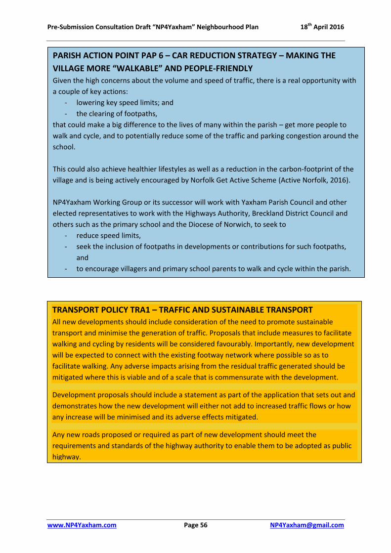
Pre-Submission Consultation Draft “NP4Yaxham” Neighbourhood Plan 18th April 2016
www.NP4Yaxham.com Page 56 [email protected]
PARISH ACTION POINT PAP 6 – CAR REDUCTION STRATEGY – MAKING THE
VILLAGE MORE “WALKABLE” AND PEOPLE-FRIENDLY
Given the high concerns about the volume and speed of traffic, there is a real opportunity with
a couple of key actions:
- lowering key speed limits; and
- the clearing of footpaths,
that could make a big difference to the lives of many within the parish – get more people to
walk and cycle, and to potentially reduce some of the traffic and parking congestion around the
school.
This could also achieve healthier lifestyles as well as a reduction in the carbon-footprint of the
village and is being actively encouraged by Norfolk Get Active Scheme (Active Norfolk, 2016).
NP4Yaxham Working Group or its successor will work with Yaxham Parish Council and other
elected representatives to work with the Highways Authority, Breckland District Council and
others such as the primary school and the Diocese of Norwich, to seek to
- reduce speed limits,
- seek the inclusion of footpaths in developments or contributions for such footpaths,
and
- to encourage villagers and primary school parents to walk and cycle within the parish.
TRANSPORT POLICY TRA1 – TRAFFIC AND SUSTAINABLE TRANSPORT
All new developments should include consideration of the need to promote sustainable
transport and minimise the generation of traffic. Proposals that include measures to facilitate
walking and cycling by residents will be considered favourably. Importantly, new development
will be expected to connect with the existing footway network where possible so as to
facilitate walking. Any adverse impacts arising from the residual traffic generated should be
mitigated where this is viable and of a scale that is commensurate with the development.
Development proposals should include a statement as part of the application that sets out and
demonstrates how the new development will either not add to increased traffic flows or how
any increase will be minimised and its adverse effects mitigated.
Any new roads proposed or required as part of new development should meet the
requirements and standards of the highway authority to enable them to be adopted as public
highway.

Pre-Submission Consultation Draft “NP4Yaxham” Neighbourhood Plan 18th April 2016
www.NP4Yaxham.com Page 57 [email protected]
TRANSPORT POLICY TRA2 – PARKING New residential development should provide sufficient off-road parking in accordance with the following criteria.
Bedrooms Minimum number of off-road car parking spaces
1 or 2 2
3 3
4 or more 4
Garages and parking spaces should be wide enough to allow drivers and passengers easy
access and egress into and out of the vehicles. Garages should have a minimum width of
3.3m. Where parking provision is made to the front of the property, a minimum of an equal
amount of landscaped front garden should be provided to soften the impact of the vehicles
and buildings. In the interests of crime prevention, rear parking courts will be discouraged.
Secure and convenient cycle storage should be provided of a quantity consistent with the
number of bedrooms.

Pre-Submission Consultation Draft “NP4Yaxham” Neighbourhood Plan 18th April 2016
www.NP4Yaxham.com Page 58 [email protected]
5.7 Community Benefit
Provision of Facilities and Services
Yaxham has been fortunate to host a number of useful everyday services and facilities:
• A village hall, with a social club, recreation field and children’s play area;
• Church and Chapel;
• Primary school;
• A farm shop, and café;
• Sheltered Housing Complex;
Although some facilities now have an uncertain future:
• A public house – The Mill, although this currently closed and for sale, is a registered Asset
of Community Value; and
• A shop in Clint Green which had restricted hours and now the owner has died
It is very important to ensure that existing facilities are safeguarded from development that
would lead to their loss. In addition, the parish needs to work with other authorities and
organisations to ensure services from beyond the parish boundaries are developed to meet
the demands of cumulative development from both within and beyond the parish.
COMMUNITY BENEFIT POLICY COM1 – EXISTING PARISH-BASED
COMMUNITY SERVICES
Where applications for change of use are submitted involving a potential loss of existing
facilities they will only be permitted where the developer can demonstrate:
1) They will be satisfactorily relocated to elsewhere in the village; or
2) Adequate other facilities of the same service offering exist within a reasonable
walking distance of the majority of Yaxham residents to meet local needs; or
3) No reasonable prospect of continued viable use which can be demonstrated
through:
a) Twelve months of marketing for the permitted and similar uses, using an
appropriate agent; and
b) Confirmation that it has been offered on a range of terms (including price)
agreed to be reasonable on the advice of an independent qualified assessor.

Pre-Submission Consultation Draft “NP4Yaxham” Neighbourhood Plan 18th April 2016
www.NP4Yaxham.com Page 59 [email protected]
Open Space/Play Areas
Yaxham is currently shown as having approximately the right amount of open space for
general recreation commensurate with its population (with the Recreation Field at 1.53 ha).
However, it is significantly deficient in children’s play areas within the parish – 0.05ha versus
0.61ha in the NPPF, “Open Space Parish Schedule 2015” (Breckland District Council, 2015, p.
307). Further, it is recognised within the village that the children’s play area that does exist
is in need of significant investment. In addition, the existing recreational space and play
area is situated solely at the western end of the parish in the settlement of Yaxham. There
are no such facilities in the eastern settlement of Clint Green. The provision of recreational
space and play area in the settlement of Clint Green is therefore an important requirement
(NP4Yaxham, 2015). This would accord with proposals in the new Local Plan which state:
“In terms of children’s play areas, all dwellings in housing areas should be within 100m
of a local area of play (LAP), 400m of a local equipped area for play (LEAP) and 1000m
of a neighbourhood equipped area for play (NEAP) as recommended by FIT.”
(Breckland Council, 2015)
The village priorities are, depending on where new development takes place include:
- Enhanced children’s play space on the Recreation Field in Yaxham - A new children’s play space in Clint Green - A recreation space in Clint Green
The village priority is to enhance the exiting play area in the settlement of Yaxham and to
create a new children’s play area in the settlement of Clint Green. It is not to have small
areas of grass called “open space” and “children’s play area” as tokens in any new
development, which would not benefit the whole community. The village requires that the
PARISH ACTION POINT PAP 7 – COMMUNITY SERVICES OUTSIDE THE
PARISH
By the nature of a small rural village such as Yaxham, its residents are dependent on
services provided by a myriad of providers beyond the parish boundaries, including, but
not limited to:
- Refuse, Water & sewerage, Education, Medical, Highways, Bus Services,
Broadband & Mobile Telecoms
NP4Yaxham Working Group or its successor will work with Yaxham Parish Council and other
elected representatives to work with the relevant authorities, organisations and
companies to ensure that the service infrastructure is developed to meet the cumulative
demands of the anticipated development of Yaxham, Dereham, Mattishall and the
surrounding area as appropriate, and to report back to the community on progress made

Pre-Submission Consultation Draft “NP4Yaxham” Neighbourhood Plan 18th April 2016
www.NP4Yaxham.com Page 60 [email protected]
LPA and developers instead provide money or land to facilitate the three priorities set out
(Breckland Council, 2015).
Community Priorities for Developer Funding (s.106/CIL)
In the event of developments being of a size to trigger the payment by the developer of
s106 or CIL payments then the village has a strong presumption that those payments be
used within the village. The following Community Action Point sets out the village priorities
identified from consultation (NP4Yaxham, 2015).
COMMUNITY BENEFIT POLICY COM2 – DEVELOPER FUNDING PRIORITIES
Where, as a result of a new development there is the facility for funds to be provided by the
developer for the local community, whether through s.106, Community Infrastructure Levy
or other arrangements the community priorities are:
Commutation of play areas/open-space planning conditions
For developments in or close to the settlement boundary of Yaxham (see Map 5) that
these should be commuted into off-site equivalent financial contributions to the
upgrading of the children’s play area on the Recreation Field.
For developments in or close to the settlement boundary of Clint Green (see Map 6)
then the provision of a new children’s play area on site of any new development, or off-
site, if deemed appropriate.
Community Facilities
Regeneration of the Church Room
Provision of footpath, cycle-way along Dereham Road from Yaxham to Dereham
Provision of footpath along Station Road, Yaxham
Provision of facilities for young people
Pre-school provision
PARISH ACTION POINT PAP 8 – EDUCATION NP4Yaxham or its successor will work with Yaxham Parish Council and other elected representatives
to work with the relevant authorities to enable:
The sustainable development of the village primary school to enable primary age children from
the parish to attend their local school – an integral element of the community, and
To seek to address or alleviate the chronic parking problems and congestion around the school
at the start and close of the school day
To seek to establish a pre-school facility on or close to the Primary School

Pre-Submission Consultation Draft “NP4Yaxham” Neighbourhood Plan 18th April 2016
www.NP4Yaxham.com Page 61 [email protected]
6 Monitoring/Implementation– Future Directions Plan (FDP)
The life of this plan shall be 20 years from 2016. During the life of this plan it shall be
regularly reviewed to ensure it is in compliance with Breckland District Council Local Plan
and with the National Planning Policy Framework. The Breckland Local Plan, proposes;
11.3 The purpose of monitoring and review is to assess the delivery and
implementation of the new Local Plan. The Breckland Authority Monitoring Report
provides a robust and effective review and monitoring approach. The proposed
policies in this Preferred Options document, when fully developed at the Publication
Plan stage, will be complemented by a monitoring framework to assess their
effectiveness through robust monitoring mechanisms. This will allow the
performance of the policies to be assessed, and to inform any changes which may be
required to ensure delivery of the Plan (Breckland Council, 2015, p. 156).
The NP4Yaxham sets out planning policies for applicants for planning permissions, and the
Parish Council and the Local Planning Authority (the LPA - Breckland Council) to formally
take account of. It identifies Parish Action Points that the village has indicated it wishes to
be achieved, and the priorities for the use of any s106/CIL or other developer monies may
be put to within the village. From this fact a number of points arise within the parish:
1. The Parish Council to ensure that it considers all planning applications in the light of
the NP4Yaxham and comments to the LPA as to whether and to what extent any
individual planning application complies with or fails to comply with the NP4Yaxham
and any positive or detrimental effects that follow from this
2. The Parish Council and other village organisations to keep under review whether the
planning policies set out are effective or amendments need to be considered
3. The Parish Council and other village organisations to work together to achieve the
Parish Action Points identified within NP4Yaxham.
4. The Parish Council to consider establishing and funding an NP4Yaxham Action Group
to take forward the issues identified in the NP4Yaxham and to carry out periodic
reviews of its performance and to identify how best to advance the issues set out.
5. As a minimum the Parish Council will initiate a formal review of the NP4Yaxham
every five years and report on its findings to the LPA.
PARISH ACTION POINT PAP 9 – NP4YAXHAM ACTION GROUP For the Parish Council to consider initiating, funding and support the formation of a group of residents – NP4Yaxham Action Group;
Monitor and review the Planning Policies set out in the Plan and where appropriate initiate amendments or additions to it; and
To bring together the Parish Action Points in this Neighbourhood Plan into a formal Neighbourhood Action Plan for Yaxham
To keep residents updated as to the progress of the PAP’s.
At the Annual Parish Meeting annually report to the Parish Council and residents on the progress made and to suggest any recommendations or alteration to NP4Yaxham

Pre-Submission Consultation Draft “NP4Yaxham” Neighbourhood Plan 18th April 2016
www.NP4Yaxham.com Page 62 [email protected]
ATTACHMENTS
Attachment 1 Bibliography
Attachment 2 Glossary
Attachment 3 Pre-submission Consultation Response Form
Supporting Documents
These will be provided with the finalised Plan, but are not provided with this pre-
submission Draft Plan. These will include:
Statement of Basic Conditions (including Sustainability Statement);
Consultation Statement (including Narrative, Bibliography, Compendium of Surveys);
Evidence Base (including Narrative, Source List, File);
SEA Screening Report & LPA Opinion
– see www.NP4Yaxham.com for latest drafts.

Pre-Submission Consultation Draft “NP4Yaxham” Neighbourhood Plan 18th April 2016
www.NP4Yaxham.com Page 63 [email protected]
Attachment 1 Bibliography
Active Norfolk, 2016. http://www.activenorfolk.org/. [Online]
Available at: http://www.activenorfolk.org/.
Birbeck, D. & Kruczkowski, S., 2015. Building for Life Partnerships, Nottingham: Nottingham Trent
University - CADBE.
Breckland Council, 2015. Emerging Local Plan - Preferred Directions Part 1, Dereham: Breckland
Council http://www.breckland.gov.uk/content/document-library-publications.
Breckland District Council, 2014. Tree Preservation and Conservation, Dereham: Breckland Council.
Breckland District Council, 2015. Community Right to Bid (D64-15), Dereham: Breckland Council.
Breckland District Council, 2015. Emerging Local Plan Appendix 2 Emerging Site Options, Dereham:
http://www.breckland.gov.uk/content/document-library-publications.
Breckland District Council, 2015. Open Space Parish Council Schedule.
s.l.:https://www.breckland.gov.uk/sites/default/files/Uploads/planning_building_control/Open%20S
pace%20Parish%20Schedule%202015%20%5BN-S%5D.pdf.
Breckland District Council, 2016. http://www.breckland.gov.uk. [Online]
Available at: http://www.breckland.gov.uk/content/document-library-publications
British Listed Buildings, 2016. British Listed Buildings. [Online]
Available at: http://www.britishlistedbuildings.co.uk/england/norfolk/yaxham#.Vqib5CqLSUl
Campaign to Protect Rural England, 2010. Light Pollution as a Stautory Nuisance: A How to Guide,
London: CPRE.
Church of England, 2012. Getting to Know your Parish, Canterbury: Church of England.
Community Led Plan, 2013. Community Led Plan, Yaxham: Community Led Plan.
DCLG, 2012. www.communities.gov.uk. [Online]
Available at:
https://www.gov.uk/government/uploads/system/uploads/attachment_data/file/6077/2116950.pd
f
DCLG, 2012. www.legislation.gov.uk. [Online]
Available at: http://www.legislation.gov.uk/uksi/2012/637/pdfs/uksi_20120637_en.pdf
Joint Nature Conservation Committee, 2015. Joint Nature Conservation Committee. [Online]
Available at: http://jncc.defra.gov.uk/page-23
Land Use Consultants, 2007. Breckland Landscape Character Assessment, Dereham: Breckland
District Council.
Mid Norfolk Railway, 2015. The Mid Norfolk Railway. [Online]
Available at: http://www.mnr.org.uk/

Pre-Submission Consultation Draft “NP4Yaxham” Neighbourhood Plan 18th April 2016
www.NP4Yaxham.com Page 64 [email protected]
Norfolk County Council, 2011. Market Town Centre Business Study, s.l.: s.n.
Norfolk Insight, 2011. Census 2011, London: Office for National Statistics.
Norfolk Round Tower Churches, 2015. Norfolk Round Tower Churches. [Online]
Available at: http://www.roundtowers.org.uk/
Norfolk Windmills, 2015. Norfolk Windmills. [Online]
Available at: http://www.norfolkmills.co.uk/Windmills/yaxham-towermill.html
NP4Y Environmental Maps, 2015. Environmental Maps - Yaxham Parish http://www.magic.gov.uk/.
Leeds: Magic.
NP4Yaxham, 2015. NP4Yaxham - Survey Data. Yaxham: NP4Y.
NP4Yaxham, 2016. Strategic Green Gap Policy. Yaxham: NP4Yaxham.
Ordnance Survey, 2015. Ordnance Survey. [Online]
Available at: https://www.ordnancesurvey.co.uk/
Yaxham Church of England (VA) Primary School, 2015. www.yaxhamprimaryschool.co.uk. [Online]
Available at: http://www.yaxhamprimaryschool.co.uk/
Yaxham Heritage Register, 1989. Yaxham Heritage Register, Dereham: s.n.
Yaxham Village Hall, 2016. www.yaxhamvillagehall.co.uk. [Online]
Available at: http://www.yaxhamvillagehall.co.uk/

Pre-Submission Consultation Draft “NP4Yaxham” Neighbourhood Plan 18th April 2016
www.NP4Yaxham.com Page 65 [email protected]
Attachment 2 Glossary A supplemented extract from Breckland Local Plan Part 1 Preferred Directions,
December 2015 (Breckland Council, 2015)
Affordable Housing Social rented, affordable rented and intermediate housing, provided to eligible households whose needs are not met by the market. Eligibility is determined with regard to local incomes and local house prices. Affordable housing should include provisions to remain at an affordable price for future eligible households or for the subsidy to e recycled for alternative affordable housing provision.
Allocation An area of land identified for development in a development plan. The allocation will specify the type of development that will be permitted on the land.
Ancient Woodlands
Woodland that is believed to have existed from at least medieval times, including Yaxham Wood (See Breckland Landscape Assessment 2007).
Biodiversity The whole variety of life encompassing all genetics, species and ecosystem variation including plants and animals.
Brownfield Land or Site
Brownfield land is another term for previously developed land.
Central Norfolk Housing Market Area, CNHMA
Housing market area in and around Greater Norwich, Broadland, Breckland, North Norfolk and South Norfolk. A Housing Market Area is the area within which most people moving, without changing employment, would stay.
Community Facilities
Facilities providing for the health, welfare, social, educational, spiritual, leisure and cultural needs of the community
Conservation Area An area of special architectural or historic interest, designated under the Planning (Listed Buildings & Conservation Areas) Act 1990, whose character and appearance
County Wildlife Site(CWS)
A site of important nature conservation value within a County context but which are not protected under the Wildlife and Countryside Act
Density Measurement of the number of dwellings per hectare and often in equivalent dwellings per acre.
Developable For sites to be considered developable, sites should be in a suitable location for housing development and there should be a reasonable prospect that the site is available and could be viably developed at the point envisaged.;
Development Development is defined under the 1990 Town and Country Planning Act as "the carrying out of building, engineering, mining or other operation in, on, over, or under land, or the making of any material change in the use of any building or other land." Most forms of development require planning permission.
Duty to Co-operate Local Councils now have a duty to co-operate with their neighbouring Councils and a set of prescribed bodies as defined by the Localism Act 2011 on planning issues that cross administrative boundaries, particularly those which relate to the strategic priorities
Environmental Impact Assessment (EIA)
EIA is a procedure that must be followed for certain types of development before they are granted permission. The procedure requires the developer to compile an Environmental Statement (ES) describing the likely significant effects of the development on the environment and proposed mitigation measures.
Flood risk Zone 2 (Medium Probability): Land having between a 1 in 100 and 1 in 1,000 annual probability of river flooding; or Land having between a 1 in 200 and 1 in 1,000

Pre-Submission Consultation Draft “NP4Yaxham” Neighbourhood Plan 18th April 2016
www.NP4Yaxham.com Page 66 [email protected]
annual probability of sea flooding. Zone 3a (High Probability): Land having a 1 in 100 or greater annual probability of river flooding; or Land having a 1 in 200 or greater annual probability of sea flooding. Zone 3b (The Functional Floodplain): This zone comprises land where water has to flow or be stored in times of flood.
General Conformity
All planning policy documents must align with the expectations of the National Planning Policy Framework. This is known as general conformity.
Greenfield Site Land that has not previously been used for urban development. It is usually land last used for agriculture and located next to or outside existing built-up areas of a settlement.
Habitat The natural home of an animal or plant, often designated as an area of nature conservation interest.
Infrastructure Basic services necessary for development to take place, for example, roads, electricity, sewerage, water, education and health facilities.
Landscape Character Assessment
A tool to identify and understand the factors that give character to the landscape and to help inform policy and decisions about how the landscape may change in the future.
Listed Building A building or other structure of Special Architectural or Historic Interest. The grades of listing are grade I, II* or II.
Local Development Framework (LDF)
The old-style portfolio or folder of Development Plan Documents and Area Action Plans which collectively set out the Spatial Planning Strategy for a Local Planning Authority area. Local Plans have now replaced the Local Development Framework.
Local Nature Reserve(LNR)
Area designated under the National Parks and Access to the Countryside Act (1949) as being of particular importance to nature conservation and where public understanding of nature conservation issues is encouraged.
Local Plan The plan for the future development of the local area, drawn up by the local planning authority in consultation with the community. In law this is described as the development plan documents adopted under the Planning and Compulsory Purchase Act 2004. Current core strategies or other planning policies which under the regulations would be considered to be development plan documents, form part of the Local Plan. The term includes old policies which have been saved under the 2004 Act.
Local Planning Authority(LPA)
The Local Government body responsible for formulating Planning Policies in an area, controlling development through determining planning applications and taking enforcement action when necessary. This is either a District Council, Unitary Authority, Metropolitan Council or National Park Authority.
Local Transport Plan(LTP)
A five-year integrated transport strategy, prepared by Local Authorities in partnership with the community, seeking funding to help provide local transport projects. The plan sets out the resources predicted for delivery of the targets identified in the strategy.
Material Consideration
A matter that should be taken into account in deciding on a planning application or on an appeal against a planning decision.
Mixed Use (or Mixed Use Development)
Provision of a mix of complementary uses, such as residential, community and leisure uses, on a site or within a particular area.
Nature Conservation
The protection, management and promotion of wildlife habitat for the benefit of wild species, as well as the communities that use and enjoy them.

Pre-Submission Consultation Draft “NP4Yaxham” Neighbourhood Plan 18th April 2016
www.NP4Yaxham.com Page 67 [email protected]
National Nature Reserve(NNR)
An area designated by Natural England to protect and conserve nationally important areas of wildlife habitat and geological formations and to promote scientific research.
National Planning Policy Framework (NPPF)
The NPPF forms the national planning policies that Local Planning Authorities need to take into account when drawing up their Local Plan and other documents and making decisions on planning policies. The NPPF is published by the Department of Communities and Local Government.
National Planning Practice Guidance (PPG)
The national PPG is online guidance that should be read in conjunction with the NPPF.
Neighbourhood Plans
A Plan prepared by a Parish Council or Neighbourhood Forum for a particular neighbourhood area (made under the Planning and Compulsory Purchase Act 2004).
Open Space Open space is defined in the Town and Country Planning Act 1990 as 'land laid out as a public garden, or used for the purposes of public recreation, or land which is a disused burial ground'. Open space should be taken to mean all open space of public value, including not just land, but also areas of water such as rivers, canals, lakes and reservoirs which offer important opportunities for sport and recreation and can also act as a visual amenity.
Planning Condition A condition imposed on a grant of planning permission (in accordance with the Town and Country Planning Act 1990) or a condition included in a Local Development Order or Neighbourhood Development Order
Planning Obligation
A legally enforceable obligation entered into under section 106 of the Town and Country Planning Act 1990 to mitigate the impacts of a development proposal.
Planning Permission
Formal approval sought from a Council, often granted with conditions, allowing a proposed development to proceed. Permission may be sought in principle through outline plans, or be sought in detail through full plans.
Previously Developed Land
Land which is, or was, occupied by a permanent structure, including the curtilage of the developed land (although it should not be assumed that the whole of the curtilage should be developed) and any associated fixed surface infrastructure. This excludes: land that is or has been occupied by agricultural or forestry buildings; land that has been developed for minerals extraction or waste disposal by landfill purposes where provision for restoration has been made through development control procedures; land in built-up areas such as private residential gardens, parks, recreation grounds and allotments; and land that was previously-developed but where the remains of the permanent structure or fixed surface structure have blended into the landscape in the process of time.
Protected Species Plants and animal species afforded protection under certain Acts of Law and Regulations
Section 106 Agreement
A legal agreement under Section 106 of the 1990 Town and Country Planning Act. See also: Planning Obligations and Agreements.
Sequential Approach / Sequential Test
A planning principle that seeks to identify, allocate or develop certain types or locations of land before the consideration of others. For example, ensuring land with no flood risk is developed before land with flood risk.
Site of Special Scientific Interest (SSSI)
A SSSI is identified by Natural England as requiring protection from damaging development on account of its flora, fauna, geological and/or physiological features.
Spatial Planning Spatial planning goes beyond traditional land use planning to bring together and integrate policies for the development and use of land with other policies and programmes which influence the nature of places and how they

Pre-Submission Consultation Draft “NP4Yaxham” Neighbourhood Plan 18th April 2016
www.NP4Yaxham.com Page 68 [email protected]
function. That will include policies which can impact on land use, for example by influencing the demands on, or needs for, development, but which are not capable of being delivered solely or mainly through the granting or refusal of planning permission and which may be implemented by other means.
Special Areas of Conservation (SAC)
Special Areas of Protected sites designated under the EC Habitats Directive.
Special Protection Area (SPA)
Areas given special protection under the European Union’s Habitats Directive, which is transposed into UK law by the Habitats and Conservation of Species Regulations 2010.
Statement of Community Involvement (SCI)
Every Local Planning Authority has to prepare a Statement of Community Involvement. It sets out the Council’s vision and strategy for the standards to be achieved in involving the community and stakeholders in the preparation of planning policy documents and planning applications. Every Neighbourhood Plan has to produce a Statement of Community Involvement detailing the consultation process within the local community that has been undertaken in preparing the Neighbourhood Plan
Strategic Environmental Assessment (SEA)
A procedure (set out in the Environmental Assessment of Plans and Programmes Regulations 2004) which requires the formal environmental assessment of certain plans and programmes which are likely to have significant effects on the environment.
Sustainable Development
Meeting peoples’ needs now, socially, environmentally and economically, without jeopardising the needs of future generations. There are three dimensions to sustainable development as seen in paragraph 7 of the NPPF: - economic contributing to a strong, competitive economy; - social-supporting strong, vibrant and healthy communities and - environmental-contributing to protecting and enhancing the natural, built and historic environment.
Sustainability Appraisal (SA)
To identify and evaluate what the effects of the strategy or plan are likely to be on social, environmental and economic conditions of the strategy or plan area.
Strategic Housing Land Availability Assessment (SHLAA)
An assessment of land availability identifying a future supply of land. Paragraph 159 of the NPPF states that Local Planning Authorities should prepare a Strategic Housing Land Availability Assessment to establish realistic assumptions about the availability, suitability and the likely economic viability of land to meet the identified need for housing over the plan period.
Strategic Housing Market Assessment (SHMA)
An evidence based document providing an analysis of the housing market area to inform policy formation. The purpose of which is to have a clear understanding of housing needs in their area. Paragraph 159 of the NPPF states that local planning authorities should prepare a SHMA to assess their full housing needs, working with neighbouring authorities where housing market areas cross administrative boundaries.
Traffic Impact Assessment (TIA)
An assessment of the effects upon the surrounding area by traffic as a result of a development, such as increased traffic flows that may require highway improvements.
Tree Preservation Order (TPO)
A mechanism for securing the preservation of single or groups of trees of acknowledged amenity value. A tree subject to an order may not normally be topped, lopped or felled without the consent of the Local Planning Authority.
Wastewater Treatment Works (WWTW)
Wastewater treatment works

Pre-Submission Consultation Draft “NP4Yaxham” Neighbourhood Plan 18th April 2016
www.NP4Yaxham.com Page 69 [email protected]
Attachment 3 NP4Yaxham Pre-submission Consultation Response Form
Contact Name
Email address:
Position & Organisation (if applicable)
Postal Address – including post code
……………………………………………………………………………………………
……………………………………………………………………………………………
……………………………………………………………………………………………
Draft Policy Areas – Do you? Agree Disagree No Comment Comments Below
Strategic Gaps Yes/No Yes/No Yes/No Yes/No
Housing Yes/No Yes/No Yes/No Yes/No
Environmental Yes/No Yes/No Yes/No Yes/No
Economic Development Yes/No Yes/No Yes/No Yes/No
Transport Yes/No Yes/No Yes/No Yes/No
Community Benefit Yes/No Yes/No Yes/No Yes/No
Please attach any additional comments on a separate sheet(s) as required, on whether
1. you wish to expand on any points, comments or concerns on the Draft Plan 2. suggest any changes to the Draft Plan or specific policies 3. any areas you think we may have missed 4. any additional evidence you feel we should consider
Thank you for taking the time to complete this Consultation Form. Please then return it
and any attached comments by 5pm 31st May 2016 to:
NP4Yaxham Working Group, Frogs Hall Farm, Cutthroat Lane, Yaxham Norfolk NR19 1RG
OR by email: [email protected] OR via the website www.NP4Yaxham.com
OR place it in the NP4Yaxham “Post” boxes at Yaxham Primary School, St Peter’s Church,
Yaxham Village Hall or at Yaxham Waters shop or café
OR Bring them to the Village Consultation events on:
5pm-7pm, Thursday 12th May at Yaxham Village Hall, prior to the Annual Parish Meeting.
4pm-7pm, Monday 16th May in the Hall at Yaxham CofE (VA) Primary School
For more information or additional copies of this consultation form please see:
www.NP4yaxham.com, email: [email protected], or write to
NP4Yaxham Working Group, Frogs Hall Farm, Cutthroat Lane, Yaxham Norfolk NR19 1RG

Pre-Submission Consultation Draft “NP4Yaxham” Neighbourhood Plan 18th April 2016
www.NP4Yaxham.com Page 70 [email protected]
Printed & Published by
NP4Yaxham Working Group, Frogs Hall Farm, Cutthroat Lane, Yaxham Norfolk NR19 1RG


