Tonkin & Taylor Ltd | Lucas House, Level 1, 51 Halifax Street, Nelson 7010, New Zealand | PO Box 1009, Nelson 7040 P +64-3-546 6339 F +64-9-307 0265 E [email protected]Nelson Plan Flood Model Updates - Orchard/Orphanage, Oldham Stream and Jenkins/Arapiki/Poormans Valley (JAPV) flood models 1 Introduction This letter reports on updates made in 2020/2021 to Nelson City Council’s (NCC’s) Orchard/Orphanage, Oldham and Jenkins/Arapiki/Poorman Valley flood models. The main reason for the model updates is to bring the models in line with the most recent climate change advice from the Ministry for the Environment (MfE) and NIWA, including making use of recent joint probability analysis by NIWA for the Maitai River, Orphanage Stream, and Wakapuaka River catchments. This has resulted in a change to the design tidal boundary that NCC has adopted across the city for modelling extreme river flow events. A number of other minor updates have also been incorporated, as described below. The updated models are to be used by NCC as the basis for preparing flood hazard maps for the Whakamahere Whakatū (Nelson Plan), which is expected to be taken out for public consultation in August/September 2021. The models provided to NCC are able to show the present day and 2130 river flood hazard scenarios and provide information relating to flow depth and velocity to inform NCC’s flood hazard maps. The updates have been made to the existing flood models developed between 2016 and 2019 by MWH (now Stantec) and which were peer reviewed at the time of development. The models were developed using DHI Software’s Mike Flood software package and are 1D/2D coupled models. The piped stormwater networks are not included in these models except where a stream’s main channel is piped for a section (e.g. Orchard Stream), as the purpose of the models is to understand river/stream flood hazard. Table 1.1 describes the climate change and storm scenarios assessed as part of this project. These climate scenarios were based on MfE’s latest projections using the locally adjusted climate change models by NIWA.
Transcript
Tonkin & Taylor Ltd | Lucas House, Level 1, 51 Halifax Street, Nelson 7010, New Zealand | PO Box 1009, Nelson 7040 P +64-3-546 6339 F +64-9-307 0265 E [email protected]
Nelson Plan Flood Model Updates - Orchard/Orphanage, Oldham Stream and Jenkins/Arapiki/Poormans Valley (JAPV) flood models
1 Introduction
This letter reports on updates made in 2020/2021 to Nelson City Council’s (NCC’s) Orchard/Orphanage, Oldham and Jenkins/Arapiki/Poorman Valley flood models.
The main reason for the model updates is to bring the models in line with the most recent climate change advice from the Ministry for the Environment (MfE) and NIWA, including making use of recent joint probability analysis by NIWA for the Maitai River, Orphanage Stream, and Wakapuaka River catchments. This has resulted in a change to the design tidal boundary that NCC has adopted across the city for modelling extreme river flow events. A number of other minor updates have also been incorporated, as described below.
The updated models are to be used by NCC as the basis for preparing flood hazard maps for the Whakamahere Whakatū (Nelson Plan), which is expected to be taken out for public consultation in August/September 2021. The models provided to NCC are able to show the present day and 2130 river flood hazard scenarios and provide information relating to flow depth and velocity to inform NCC’s flood hazard maps.
The updates have been made to the existing flood models developed between 2016 and 2019 by MWH (now Stantec) and which were peer reviewed at the time of development. The models were developed using DHI Software’s Mike Flood software package and are 1D/2D coupled models. The piped stormwater networks are not included in these models except where a stream’s main channel is piped for a section (e.g. Orchard Stream), as the purpose of the models is to understand river/stream flood hazard.
Table 1.1 describes the climate change and storm scenarios assessed as part of this project. These climate scenarios were based on MfE’s latest projections using the locally adjusted climate change models by NIWA.
2
Tonkin & Taylor Ltd Nelson Plan Flood Model Updates - Orchard/Orphanage, Oldham Stream and Jenkins/Arapiki/Poormans Valley (JAPV) flood models Nelson City Council
28 July 2021 Job No: 870888.0012
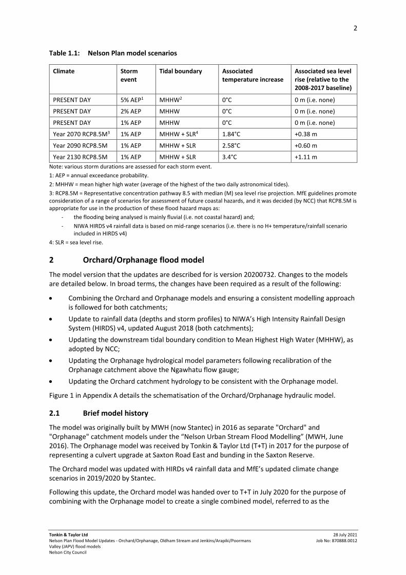
Table 1.1: Nelson Plan model scenarios
Climate Storm event
Tidal boundary Associated temperature increase
Associated sea level rise (relative to the 2008-2017 baseline)
PRESENT DAY 5% AEP1 MHHW2 0°C 0 m (i.e. none)
PRESENT DAY 2% AEP MHHW 0°C 0 m (i.e. none)
PRESENT DAY 1% AEP MHHW 0°C 0 m (i.e. none)
Year 2070 RCP8.5M3 1% AEP MHHW + SLR4 1.84°C +0.38 m
Year 2090 RCP8.5M 1% AEP MHHW + SLR 2.58°C +0.60 m
Year 2130 RCP8.5M 1% AEP MHHW + SLR 3.4°C +1.11 m
Note: various storm durations are assessed for each storm event.
1: AEP = annual exceedance probability.
2: MHHW = mean higher high water (average of the highest of the two daily astronomical tides).
3: RCP8.5M = Representative concentration pathway 8.5 with median (M) sea level rise projection. MfE guidelines promote consideration of a range of scenarios for assessment of future coastal hazards, and it was decided (by NCC) that RCP8.5M is appropriate for use in the production of these flood hazard maps as:
- the flooding being analysed is mainly fluvial (i.e. not coastal hazard) and;
- NIWA HIRDS v4 rainfall data is based on mid-range scenarios (i.e. there is no H+ temperature/rainfall scenario included in HIRDS v4)
4: SLR = sea level rise.
2 Orchard/Orphanage flood model
The model version that the updates are described for is version 20200732. Changes to the models are detailed below. In broad terms, the changes have been required as a result of the following:
• Combining the Orchard and Orphanage models and ensuring a consistent modelling approach is followed for both catchments;
• Update to rainfall data (depths and storm profiles) to NIWA’s High Intensity Rainfall Design System (HIRDS) v4, updated August 2018 (both catchments);
• Updating the downstream tidal boundary condition to Mean Highest High Water (MHHW), as adopted by NCC;
• Updating the Orphanage hydrological model parameters following recalibration of the Orphanage catchment above the Ngawhatu flow gauge;
• Updating the Orchard catchment hydrology to be consistent with the Orphanage model.
Figure 1 in Appendix A details the schematisation of the Orchard/Orphanage hydraulic model.
2.1 Brief model history
The model was originally built by MWH (now Stantec) in 2016 as separate "Orchard" and "Orphanage" catchment models under the “Nelson Urban Stream Flood Modelling” (MWH, June 2016). The Orphanage model was received by Tonkin & Taylor Ltd (T+T) in 2017 for the purpose of representing a culvert upgrade at Saxton Road East and bunding in the Saxton Reserve.
The Orchard model was updated with HIRDs v4 rainfall data and MfE’s updated climate change scenarios in 2019/2020 by Stantec.
Following this update, the Orchard model was handed over to T+T in July 2020 for the purpose of combining with the Orphanage model to create a single combined model, referred to as the
3
Tonkin & Taylor Ltd Nelson Plan Flood Model Updates - Orchard/Orphanage, Oldham Stream and Jenkins/Arapiki/Poormans Valley (JAPV) flood models Nelson City Council
28 July 2021 Job No: 870888.0012
‘Orchard/Orphanage’ model. Checks and updates were carried out as part of T+T assuming ownership of the model. These model updates are summarised in Table 2.1.
2.2 Orchard/Orphanage model updates
Table 2.1: Orchard/Orphanage model updates
Model element update
Update comment
Hydrology A lumped catchment HEC-HMS rainfall-runoff model of the Orpahange Stream hydrology was set up and calibrated using Tasman District Council's stream gauge at Ngawhatu and rainfall station at the same location. Five of the largest flood events were selected from the streamflow record for calibration, which were: The May 2007, April 2013, June 2014, March 2016 and February 2018 flood events.
The SCS unit hydrograph method was adopted to simulate losses base on comparison of observed and simulated hydrograph shapes, and a CN of 65 and a lag time of 64 minutes was adopted for the gauged catchment based on the calibration results.
Rainfall Updated rainfall runoff for Orchard catchment to reflect similar methodology for calculating CN (and other relevant parameters) as per the Orphanage model.
Climate change
Revised extreme climate change scenario (RCP8.5H+ 2130 changed to RCP8.5M 2130 at NCC’s request). Refer to Note 3 in Table 1.1.
Sea Level: • Tidal boundary updated following NCC instruction June/July 2020 from 63% AEP tide to MHHW tidal condition following NIWA’s joint probability assessments of Maitai River, Orphanage Stream and Wakapuaka river flows/sea levels.
• T+T used NIWA’s reported peak MHHW tide level of 13.62 mRL (NCC Datum) in the Orchard/Orphanage catchments (without sea level rise).
Topographical data (2D terrain) – 2015 LiDAR
Mesh:
• Mesh extent revised in order to combine Orchard and Orphanage models. Boundary extended north to prevent ‘glasswalling’, and south-west to Saxton Creek as agreed with NCC (we note that some minor ‘glasswalling’ still does occur at Saxton Creek - this section of the creek is currently being upgraded to provide future 1% AEP capacity. Combining the Orchard/Orphanage and Saxton Creek models is planned for in the future following completion of Saxton Creek upgrade works. In the meantime, results are trimmed in this area.).
• Orphanage Stream 1D extents adjusted, particularly in upstream branches, where the modelled river centreline does not follow the channel’s thalweg/invert, so that 1D/2D lateral linkages are oriented such that modelled spilling occurs at appropriate locations.
• Selected Orchard Stream road crossings re-schematised to allow flow over bridge decks (perpendicular to direction of channel flow).
• Refinement of mesh at Railway Reserve swale to ensure there is sufficient detail for flow from the hydrological loading point.
Terrain mapped to mesh:
• Additional terrain data at the 329 Suffolk Road Development (included in earlier T+T versions of Orphanage model) is added to the model terrain from as-built information.
• Supplementary 2019 LiDAR north-east of Saxton Oval, provided by NCC, (included in earlier T+T versions of Orphanage model) is added to the model terrain.
• Obstruction to Railway Reserve swale at culvert location interpolated to allow overland flow to be represented in the 2D model domain (downstream of Sub-Basin 5 hydrological 2D loading).
4
Tonkin & Taylor Ltd Nelson Plan Flood Model Updates - Orchard/Orphanage, Oldham Stream and Jenkins/Arapiki/Poormans Valley (JAPV) flood models Nelson City Council
28 July 2021 Job No: 870888.0012
Model element update
Update comment
Cross Sections
An analysis of the model results at the Suffolk Road bend along Orphanage Stream has been undertaken with a comparison against local flood information from the April 2013 flood event. The following updates are made to reflect the analysis, as agreed with NCC:
− 90° bend energy loss applied at the four "gauge bends" (upstream of Suffolk Rd)
− 90° bend energy loss applied at the Suffolk Rd bend (downstream of the bridge)
− Roughness of the open channels is increased from Manning's n = 0.03 to n = 0.045
− Suffolk bridge parameters (size, inverts and length) updated using field measurements.
Structures • In addition to these updates, the Orphanage Stream culvert at Saxton Road (previously modelled as “proposed”) has been increased from a 4x2 m box culvert to a 5x2 m box culvert (based on as-built data).
• Suffolk bridge parameters (size, inverts and length) updated using field measurements.
Pipe network • Orchard Stream network from Songer Street to Main Road Stoke modelled in Mike Urban, including Tainui St Overflow (which was originally modelled in Mike 11 as closed cross sections). This was done to better represent the network splitting as well as account for losses.
• Assumptions:
− Pipe inverts taken from Top of the South Maps (TOSM) where available
− Pipe inverts interpolated where TOSM information is not available
− Manhole lid levels taken from mesh (2015 LiDAR)
− Half-benching assumed in manholes
− Small section of open channel modelled as Mike Urban cross section “CRS” (CRS chosen as flows typically < 2 m³/s).
Other changes
• Lateral links updated to better represent spilling.
• Set spilling source to Mike 21 (i.e. 2D terrain level) as per Orphanage model during combining of Orchard/Orphanage models. This is considered best practice for this model.
• Updated floodplain roughness to cover full 2D extent during combining of Orchard/Orphanage models.
• Updated wave approximation in Mike 11 to "Higher Order Fully Dynamic" (best practice).
• Flood and dry formulation updated to “Advanced Flood and Dry” (best practice).
• Simulation duration has been increased to ensure peak flood level is captured.
• Miscellaneous minor adjustments for stability purposes.
Model Limitations
• The Orphanage flood extents interact with Saxton Creek. No allowances have been made for Saxton Creek in this model, and flood behaviour in this area is expected to be influenced by Saxton Creek flows. It is noted Saxton Creek Stage 4 upgrade is now in progress and is expected to contain future 1% AEP flows from Saxton Creek.
• Glass-walling (i.e. flood extent artificially limited by model domain) is noted around Saxton Creek in the 2D model results. Results in this area are therefore considered incomplete until the Saxton Creek upgrade is completed, and Orchard/Orphanage and Saxton Creek models are combined.
• The tidal boundary is not represented in the 2D model as the coastal hazard assessment in this area shows that the highest modelled tide level (including sea level rise) in this model is not expected to overtop the state highway road embankment,
5
Tonkin & Taylor Ltd Nelson Plan Flood Model Updates - Orchard/Orphanage, Oldham Stream and Jenkins/Arapiki/Poormans Valley (JAPV) flood models Nelson City Council
28 July 2021 Job No: 870888.0012
Model element update
Update comment
which effectively acts as a flood barrier. The tidal boundary is instead applied at the ends of the modelled streams, in the 1D model.
• Cross sections from original Stantec model are generally unchanged. Note that these are spaced significant distances apart in some locations. The model could be improved in future through the capture and incorporation of additional cross sectional data. (Note that the model does force a calculation point and interpolated cross section every 10 m during the simulation, i.e. max dx = 10 m).
• Hydrological loading has been altered where it has been considered that it would make a significant improvement to the model results.
3 Oldham flood model
The model version that the updates are described for is version 20200816. Changes to the models are detailed below. In broad terms, the changes have been required as a result of the following:
• Update to rainfall data (depths and storm profiles) to NIWA’s High Intensity Rainfall Design System (HIRDS) v4, updated August 2018;
• Update to the downstream boundary condition to Mean Highest High Water (MHHW) as adopted by NCC;
• Update to the hydrology to align the methodology to be consistent with the findings from the Orphanage hydrological model calibration, considered to have similar catchment characteristics;
• Ensure consistent modelling approach with other Nelson Plan models.
Figure 2 in Appendix A details the schematisation of the Oldham hydraulic model.
3.1 Model history
This model was originally built by MWH (now Stantec) in 2016 under the “Nelson Urban Stream Flood Modelling” (MWH, June 2016). The model was updated with HIRDs v4 rainfall data and MfE’s updated climate change scenarios in 2019/2020 and handed over to T+T in July 2020. The following checks and updates were carried out as part of T+T assuming ownership of the model. The model updates are summarised in Table 3.1.
3.2 Oldham model updates
Table 3.1: Oldham model updates
Model element update
Update comments
Rainfall Hydrology: updated to incorporate the findings from the Orphanage model hydrological model calibration. In particular the derivation of the hydrological parameters (e.g. CN).
Climate change
Revised extreme climate change scenario (RCP8.5H+ 2130 changed to RCP8.5M 2130 at NCC’s request). Refer to Note 3 in Table 1.1.
Sea Level: • Tidal boundary updated following NCC instruction June/July 2020 from 63% AEP tide to MHHW tidal condition following NIWA’s joint probability assessments of Maitai River, Orphanage Stream and Wakapuaka river flows/sea levels.
6
Tonkin & Taylor Ltd Nelson Plan Flood Model Updates - Orchard/Orphanage, Oldham Stream and Jenkins/Arapiki/Poormans Valley (JAPV) flood models Nelson City Council
28 July 2021 Job No: 870888.0012
Model element update
Update comments
• T+T used NIWA’s reported peak MHHW tide level of 13.59 mRL (NCC Datum) in the Oldham catchment (without sea level rise).
Cross sections • Cross sections are interpolated at 10 m intervals to force calculation points every 10 m without requiring branches to be split. Previous maximum dx values of 20, 100 and 1,000 were determined to be too large in some areas to accurately model outbreak locations.
• Cross section inverts were corrected so that they matched at branch confluences.
• Following initial model runs (and the reduction of cross section spacing), a consistent variance between the 1D and 2D topography was noted along Dodson Valley Branch, with the 2D terrain from 2015 LiDAR consistently lower than the 1D cross sections. While cross sections were spaced far apart, the model ID for these cross sections indicated that they had been surveyed. Due to the spilling that occurs onto the (2015 LiDAR) terrain, new cross sections have been extracted from the 2015 LiDAR along this branch to replace all previous cross sections.
• Following identification of an instability at the Atawhai Crescent culvert, cross sections along Oldham Creek were created from 2015 LiDAR to ensure the stream grade was more accurately represented. Additionally, the cross sections upstream and downstream of the structure were updated to match the culvert dimensions to ensure a smooth transition and reduce instabilities.
Structures • Structures shifted to be spatially correct.
• Review and update of structure schematisation, for example Werneth Street intake.
• Some open channels were updated to piped sections following recent subdivision and installation of stormwater mains (e.g. Devenish Place).
• Modelling of some pipes changed from Mike11 to Mike Urban.
Assumptions:
- Inverts and diameters taken from Top of the South Maps (TOSM) where available
- Pipe inverts interpolated where TOSM information is not available
- Ground/lid levels taken from mesh (2015 LiDAR)
- Half-benching assumed in manholes
• Structure information in the Stantec model has come from ground survey and remains unchanged, with the exception of those that appear significantly different from other supporting data as per:
- Frenchay/Dodson Valley Rd stormwater network – see comments regarding Mike Urban network above.
(original inverts of this pipe network were inconsistent with other data sources; for example, the top of Dodson Valley 1.350 m culvert would be ~ 1-1.5 m above LiDAR ground level based on original inverts).
• New culvert added at 111 Dodson Valley Rd, information is taken from TOSM and LiDAR data.
• The culvert at Atawhai Drive is updated to a 5x2 m box culvert to represent the upgrade that occurred in 2017 (i.e. after the original structure survey). Culvert dimensions, inverts and upstream/downstream cross sections updated in the model using as-builts provided by NCC.
Other changes • Lateral links updated to better represent spilling.
• Spilling source set to M21 (as is best practice).
• Flood and dry formulation updated to “Advanced Flooded and Dry” (as is best practice).
7
Tonkin & Taylor Ltd Nelson Plan Flood Model Updates - Orchard/Orphanage, Oldham Stream and Jenkins/Arapiki/Poormans Valley (JAPV) flood models Nelson City Council
28 July 2021 Job No: 870888.0012
Model element update
Update comments
• Eddy viscosity updated to “Smagorinsky formulation” with a constant value of 0.28 (to align with other Nelson Stream models).
• Channel roughness was increased to n=0.045 to align with the findings from the Orchard/Orphanage model comparison and Maitai/Brook/York model calibration.
• The standard link at the downstream end of the Lagoon Culvert was removed and 2D roughness file is updated at downstream highway/estuary to reduce instabilities in the tidal area.
• The tidal boundary was maintained at or above 10.5 mRL (NCC Datum) in the 12 hour duration event to ensure the 2D open boundary remains wet at all times for modelling purposes. This is an artificial level chosen for model stability, and does not affect the maximum results used for the Nelson Plan maps.
Model limitations:
• Glasswalling is noted at downstream boundary end of model as per the original Stantec model. It is unlikely to affect the model results and therefore was not changed.
• Roughness map outside area of interest is out of date (due to land use changes over time for example Devenish Place/Bristol Lane may be new subdivision since model build). Note that these are outside of modelled inundation areas (i.e. the floodplain) and therefore will not affect results.
• Cross sections from original Stantec model remain generally unchanged, with the exception of:
− Dodson Valley Branch which shows 1D levels to be consistently lower than 2015 LiDAR. Cross sections cut from LiDAR in this branch (despite source of original 1D XS data being ‘Survey’),
− Oldham Creek, where a number of cross sections are cut from 2015 LiDAR for stability purposes.
• Structures remain unchanged from the received model, with the exception of:
- Atawhai Culvert which was upgraded in 2017 to a 5x2 m culvert and is represented in the model following NCC instruction.
- Stormwater network at Dodson Valley Road/Frenchay Branch confluence which has invert and diameter information taken from Top of the South Maps where available.
• Hydrological loading has only been altered where it is considered that this will have significant improvement on model results.
4 Jenkins/Arapiki/Poorman Valley flood model
The model version that the updates are described for is version 202104_v006. Changes to the models are detailed below. In broad terms, the changes have been required as a result of the following:
• Update to rainfall data (depths and storm profiles) to NIWA’s High Intensity Rainfall Design System (HIRDS) v4, updated August 2018;
• Update to the downstream boundary condition to Mean Highest High Water (MHHW) as adopted by NCC;
• Update to the hydrology to align the methodology to be consistent with the findings from the Orphanage hydrological model calibration, considered to have similar catchment characteristics;
• Ensure consistent modelling approach with other Nelson Plan models.
8
Tonkin & Taylor Ltd Nelson Plan Flood Model Updates - Orchard/Orphanage, Oldham Stream and Jenkins/Arapiki/Poormans Valley (JAPV) flood models Nelson City Council
28 July 2021 Job No: 870888.0012
Figure 3 in Appendix A details the schematisation of the Jenkins/Arapiki/Poorman Valley (“JAPV”) hydraulic model.
4.1 Model history
This model was originally built by MWH (now Stantec) in 2016 under the “Nelson Urban Stream Flood Modelling” (MWH, June 2016). The model was updated with HIRDs v4 rainfall data and MfE’s updated climate change scenarios in 2019/2020 and handed over to T+T in July 2020. The model updates are summarised in Table 4.1.
4.2 JAPV model updates
Table 4.1: JAPV model updates
Model element update
Update comments
Rainfall • Hydrological parameters (CN, Lag Time) values were recalculated based on approach agreed with NCC during the calibration of the Orphanage model hydrological calibration. In addition to the above the following was also changed for the Poorman Valley hydrology:
o Subcatchments;
o hydrological loading locations; and
o longest flow paths.
− Changes are summarised below:
o 11 subcatchment boundary changes;
o 15 loading node (or reach) location changes; and
o 19 longest flow path changes.
Climate change
Revised extreme climate change scenario (RCP8.5H+ 2130 to RCP8.5M 2130 at NCC’s request). Refer to Note 3 in Table 1.1.
Sea Level: • Tidal boundary updated following NCC instruction June/July 2020 from 63% AEP tide to MHHW tidal condition following NIWA’s joint probability assessments of Maitai River, Orphanage Stream and Wakapuaka river flows/sea levels.
• T+T used NIWA’s reported peak MHHW tide level of 13.62 mRL (NCC Datum) in the Jenkins/Arapiki/Poorman Valley catchments (without sea level rise).
Cross sections • Cross sections are cut from 2015 LiDAR to more accurately represent open channel sections. This is done to ensure lateral linkage bank levels between the 1D and 2D model are accurate and therefore spilling into the 2D/flooding results are representative of reality.
• Cross sections are interpolated at 10 m intervals to simulate a maximum dx of 10 m without requiring branches to be split. Previous maximum dx values of 35-360 were determined to be too large in some areas.
• Cross section inverts of branch connections matched.
• Radius type updated to “Total Area, hydraulic radius” (type varied between "Total Area" and "Resistance Radius" in received model).
• Channel roughness was increased to n=0.045 as per the Orchard-Orphanage model comparison and Maitai/Brook/York model calibration (and verified against aerial photos/google streetview). The exception to this is the upstream each of Poorman Valley (chainage 400-1640) which has a higher roughness of n=0.065 applied, due to the dense vegetation and sinuosity of the reach.
• Localised roughness updates where selected values appear erroneous.
• Minor left and right bank marker updates.
9
Tonkin & Taylor Ltd Nelson Plan Flood Model Updates - Orchard/Orphanage, Oldham Stream and Jenkins/Arapiki/Poormans Valley (JAPV) flood models Nelson City Council
28 July 2021 Job No: 870888.0012
Model element update
Update comments
Topographical data (2D terrain)
Mesh:
• During model updates, it was observed that multiple long culverts (including Whakatu Drive and Olivias Place) were removed (‘blocked out’) from the 2D terrain, thereby preventing any potential overland flowpaths. The mesh was updated for this reason.
• 2D downstream boundary extended south to Orchard Stream to address glass walling in previous model version.
• Following mesh update, the 2015 LiDAR was re-mapped to the new mesh.
Structures • Structures shifted to be spatially correct.
• Eight new structures are modelled based on data from Top of the South maps and site measurements. These are located at:
- Poorman Valley Stream chg 1668 (private bridge at 228-232 Poorman Valley Rd);
- Poorman Valley Stream chg 1783 (private bridge at 216 Poorman Valley Rd);
- Poorman Valley Stream chg 2232 (Sanctuary Drive at Marsden Valley Road);
- Poorman Valley Stream chg 2327 (Quail Rise at Marsden Valley Road);
• Energy losses at culverts are updated as follows.
- To represent “Flow contraction”, k=0.5 at inlets;
- “Flow expansion”, k=1.0 at outlets; and
- “User defined”, k=0.3 at manholes based on assumed ‘half-benching’.
- With the exception of the outlets at Quarantine Road Box Culvert to Arapiki Stream, where it was found that these energy losses caused instabilities and unrealistic water depths in this area (it is expected that removing these energy losses will have little impact on results, as this area is tidally influenced) and the Whakatu Drive culvert, which also had instabilities.
Other changes • 1D river network trimmed upstream of chainage 400, where cross section data does not appear representative of the channel terrain.
• Floodplain roughness updated to cover full 2D extent.
• Solution technique updated from “Lower Order, Fast Algorithm" to "Higher Order”.
• Flood and dry values updated.
• Eddy viscosity formulation updated to “Smagorinsky formulation” with a constant value of 0.28.
• Spilling source set to M21.
Model Limitations
• Long culvert structures remain represented as closed cross sections as per the received Stantec model. Note that this means that spilling cannot occur along the pipe (via manholes), although a desktop analysis of the Top of the South data and aerial imagery/google street view suggests that there may be few areas where spilling could occur in reality.
• The two areas with ‘long culverts’ represented as closed cross sections are:
- 160 m long culvert along Whakatu Drive, opposite Cawthron Crescent.
- Quarantine Road box culvert, which splits and enters Arapiki Stream in two locations.
10
Tonkin & Taylor Ltd Nelson Plan Flood Model Updates - Orchard/Orphanage, Oldham Stream and Jenkins/Arapiki/Poormans Valley (JAPV) flood models Nelson City Council
28 July 2021 Job No: 870888.0012
5 Applicability
This report has been prepared for the exclusive use of our client Nelson City Council, with respect to the particular brief given to us and it may not be relied upon in other contexts or for any other purpose, or by any person other than our client, without our prior written agreement.
We understand and agree that this report will be used by Nelson City Council in undertaking its regulatory functions in connection with Nelson City Plan.
Tonkin & Taylor Ltd
Environmental and Engineering Consultants
Report prepared by: Authorised for Tonkin & Taylor Ltd by:
Sarah Basheer Damian Velluppillai Senior Water Engineer Project Director
SGB p:\870888\870888.0012\issueddocuments\20210728 final model updates reports\20210728 orchardorphanage, oldham and japv model updates - post ncc feedback.docx
Appendix A : Hydraulic model schematisation
• Figure 1 - Hydraulic model schematisation: Orchard/Orphanage flood model
• Figure 2 - Hydraulic model schematisation: Oldham flood model
• Figure 3 - Hydraulic model schematisation: Jenkins/Arapiki/Poorman Valley flood model
FIG No.
COPYRIGHT ON THIS FIGURE IS RESERVED DO NOT SCALE FROM THIS FIGURE - IF IN DOUBT, ASK. T:\Nelson\Projects\870888\870888.0012\WorkingMaterial\GIS\FIGURES\20210723_Figures_OrphOldhJAPV\Figure1_OrchOrph.mxd 2021-Jul-23 9:16:15 AM Drawn by kbbb
870888.0012
JUL.21KBBB
1:25,000
HYDRAULIC MODEL SCHEMATISATION:
ORCHARD/ORPHANAGE FLOOD MODEL
FIGURE 1. 0
NELSON CITY COUNCILNELSON CITY PLAN MODEL UPDATES
KBBB SGB 23/07/210 First version
Basemap: Eagle Technology, Land Information New ZealandModel version shown is "OrchOrph_202007v32".
COPYRIGHT ON THIS FIGURE IS RESERVED DO NOT SCALE FROM THIS FIGURE - IF IN DOUBT, ASK. T:\Nelson\Projects\870888\870888.0012\WorkingMaterial\GIS\FIGURES\20210723_Figures_OrphOldhJAPV\Figure2_Oldham.mxd 2021-Jul-23 9:12:41 AM Drawn by kbbb
870888.0012
JUL.21KBBB
1:15,000
HYDRAULIC MODEL SCHEMATISATION:
OLDHAM FLOOD MODEL
FIGURE 2. 0
NELSON CITY COUNCILNELSON CITY PLAN MODEL UPDATES
KBBB SGB 23/07/210 First version
Basemap: Eagle Technology, Land Information New ZealandModel version shown is "Oldham_202008v16".
COPYRIGHT ON THIS FIGURE IS RESERVED DO NOT SCALE FROM THIS FIGURE - IF IN DOUBT, ASK. T:\Nelson\Projects\870888\870888.0012\WorkingMaterial\GIS\FIGURES\20210723_Figures_OrphOldhJAPV\Figure3_JAPV.mxd 2021-Jul-23 8:51:24 AM Drawn by kbbb
870888.0012
JUL.21KBBB
1:30,000
HYDRAULIC MODEL SCHEMATISATION:
JENKINS/ARAPIKI/POORMAN VALLEY FLOOD MODEL
FIGURE 3. 0
NELSON CITY COUNCILNELSON CITY PLAN MODEL UPDATES
KBBB SGB 23/07/210 First version
Basemap: Eagle Technology, Land Information New ZealandModel version shown is "JAPV_202104_v006".
JENKINS CREEK
POORMAN VALLEY STREAM
Sanctuary branch
Cemetery branch
AR AP IKI STREA M
TLEGENDModelled stream centreline
Poorman Valley hydrological subcatchments
Jenkins/Arapiki hydrological subcatchments
2D model extent
ORIGINAL IN COLOUR
0 0.2 0.4 0.6 0.8 1 (km)
A3 SCALE 1:30,000
KBBB JUL.21
JUL.21SGB
APPROVED DATE
PROJECT No.DESIGNED
DRAWNCHECKED
CLIENTPROJECT
TITLE
SCALE (A3) REVLOCATION PLAN
NOTES:
REV DESCRIPTION GIS CHK DATE
Appendix B: Hydraulic model flood extent maps
• Figure 1 – Flood extents: Orchard/Orphanage
• Figure 2 – Flood extents: Oldham
• Figure 3 – Flood extents: Jenkins/Arapiki/Poorman Valley
APPROVED DATE
PROJECT No.DESIGNED
DRAWNCHECKED
CLIENTPROJECT
TITLE
SCALE (A3) FIG No. REV
NOTES:
REV DESCRIPTION GIS CHK DATE
COPYRIGHT ON THIS FIGURE IS RESERVEDT:\Nelson\Projects\870888\870888.0012\WorkingMaterial\GIS\FIGURES\20210728_FloodExtents_OrphOldhJAPV\Figure1_OrchOrph.mxd 2021-Aug-06 4:54:18 PM Drawn by kbbb
870888.0012JUL.21KBBB
1:15,000
FLOOD EXTENTS: ORCHARD/ORPHANAGE
FIGURE 1. 0
NELSON CITY COUNCILNELSON CITY PLAN MODEL UPDATES1. Basemap: Eagle Technology, Land Information New Zealand
2. Property boundaries: Top of the South maps3. Model version: OrchOrph_202007v324. 2D model model results at coastal boundary and Saxton Creek are trimmed, and extents with areas less than 20m² are removed in post-processing.
KBBB SGB 28/07/210 First version
ORIGINAL IN COLOUR
0 0.2 0.4 0.6 0.8 1 (km)
LEGENDProperty Boundaries
Modelled stormwater network (1D model)
Modelled channel extent (1D model)
Present Day 1% AEP flood extent
2130 RCP8.5M 1% AEP flood extent
T
LOCATION PLAN
A3 SCALE 1:15,000
KBBBSGB
JUL.21JUL.21
APPROVED DATE
PROJECT No.DESIGNED
DRAWNCHECKED
CLIENTPROJECT
TITLE
SCALE (A3) FIG No. REV
NOTES:
REV DESCRIPTION GIS CHK DATE
COPYRIGHT ON THIS FIGURE IS RESERVEDT:\Nelson\Projects\870888\870888.0012\WorkingMaterial\GIS\FIGURES\20210728_FloodExtents_OrphOldhJAPV\Figure2_Oldham.mxd 2021-Aug-06 4:58:09 PM Drawn by kbbb
870888.0012JUL.21KBBB
1:10,000
FLOOD EXTENTS: OLDHAM
FIGURE 2. 0
NELSON CITY COUNCILNELSON CITY PLAN MODEL UPDATES1. Basemap: Eagle Technology, Land Information New Zealand
2. Property boundaries: Top of the South maps3. Model version: Oldham_202008v164. 2D model model results at coastal boundary are trimmed and extents with areas less than 20m² are removed in post-processing.
KBBB SGB 28/07/210 First version
ORIGINAL IN COLOUR
0 0.1 0.2 0.3 0.4 0.5 (km)
LEGENDProperty Boundaries
Modelled stormwater network (1D model)
Modelled channel extent (1D model)
Present Day 1% AEP flood extent
2130 RCP8.5M 1% AEP flood extent
T
LOCATION PLAN
A3 SCALE 1:10,000
KBBBSGB
JUL.21JUL.21
APPROVED DATE
PROJECT No.DESIGNED
DRAWNCHECKED
CLIENTPROJECT
TITLE
SCALE (A3) FIG No. REV
NOTES:
REV DESCRIPTION GIS CHK DATE
COPYRIGHT ON THIS FIGURE IS RESERVEDT:\Nelson\Projects\870888\870888.0012\WorkingMaterial\GIS\FIGURES\20210728_FloodExtents_OrphOldhJAPV\Figure3_JAPV.mxd 2021-Aug-06 5:02:25 PM Drawn by kbbb
870888.0012JUL.21KBBB
1:15,000
FLOOD EXTENTS:
JENKINS/ARAPIKI/POORMAN VALLEY
FIGURE 3. 0
NELSON CITY COUNCILNELSON CITY PLAN MODEL UPDATES1. Basemap: Eagle Technology, Land Information New Zealand
2. Property boundaries: Top of the South maps3. Model version: JAPV_202104_v0064. 2D model model results at coastal boundary are trimmed and extents with areas less than 20m² are removed in post-processing.


![The Omaha Daily Bee. (Omaha, Nebraska) 1874-10-12 [p ].chroniclingamerica.loc.gov/lccn/sn99021999/1874-10-12/ed-1/seq-3.pdf · Nelson Lara Nelson James Nelson Chas J Orchard John](https://static.documents.pub/doc/80x56/5ab90bdf7f8b9ad3038d856a/the-omaha-daily-bee-omaha-nebraska-1874-10-12-p-lara-nelson-james-nelson.jpg)


