75
NEWQUAY CORNWALL ARCHAEOLOGICAL UNIT Cornwall & Scilly Urban Survey Historic characterisation for regeneration Objective One is part-funded by the European Union
NEWQUAY
CORNWALL ARCHAEOLOGICAL
UNIT
Cornwall & Scilly Urban Survey
Historic characterisation for regeneration
Objective One is part-funded by the European Union

April 2003
HES REPORT NO. 2003R030
CORNWALL ARCHAEOLOGICAL UNIT
A service of the Historic Environment Service, Planning Transportation and Estates,
Cornwall County Council
Kennall Building, Old County Hall, Station Road, Truro, Cornwall, TR1 3AY
tel (01872) 323603 fax (01872) 323811 E-mail [email protected]
NEWQUAY
Kate Newell
Cornwall and Scilly Urban Survey
Historic characterisation for regeneration

Cover illustration Newquay: the harbour and historic core, Towan beach and the grass lands of Towan Head (CSUS project image, 2002).
© Cornwall County Council 2003 No part of this document may be reproduced, stored in a retrieval system, or transmitted in any form or by any means without the prior permission of the publisher.
Acknowledgements This report was produced as part of the Cornwall & Scilly Urban Survey project (CSUS), funded by English Heritage, Objective One Partnership for Cornwall and the Isles of Scilly (European Regional Development Fund) and the South West Regional Development Agency (South West RDA). Peter Beacham (Head of Designation), Graham Fairclough (Head of Characterisation), Roger M Thomas (Head of Urban Archaeology), Jill Guthrie (Designation Team Leader, South West) and Ian Morrison (Ancient Monuments Inspector for Devon, Cornwall and Isles of Scilly) liaised with the project team for English Heritage and provided valuable advice, guidance and support.
Nick Cahill (The Cahill Partnership) acted as Conservation Supervisor to the project, providing vital support with the characterisation methodology and advice on the interpretation of individual settlements. Georgina McLaren (Cornwall Enterprise) performed an equally significant advisory role on all aspects of economic regeneration. Additional help has been given by Terry Clarke (Conservation Officer, Restormel Borough Council) and Victoria Northcott (Assistant Conservation Officer, Restormel Borough Council). Gill Moore (Newquay Regeneration Forum), Sally Heard (Restormel Regeneration Partnership) and Angie Rowe (Strategic Economic Development Manager, Restormel Borough Council) provided valuable information regarding regeneration proposals and initiatives. Peter Moore and Richard Moore (Transportation and Waste Management, Cornwall County Council) provided useful briefings on the environmental improvement schemes relating to Newquay’s Transport Strategy.
Bryn Perry-Tapper is the GIS/SMR supervisor for the project and has played a key role in providing training to the project team and developing the GIS, SMR and Internet components of CSUS. The Urban Survey team, within Cornwall County Council Historic Environment Service, is: Kate Newell and Stephanie Russell (Urban Survey Officers), Dr Steve Mills (Archaeological GIS Mapper) and Graeme Kirkham (Project Manager). Jeanette Ratcliffe and Peter Herring have acted as Project Co-ordinators.
i
Contents
Summary 1
Summary 1 1 Introduction 5
Regeneration and the historic towns of Cornwall and Scilly 5 Characterisation and regeneration 5 Cornwall and Scilly Urban Survey 6 CSUS reports 6 Extent of the study area 7
2 Newquay: the context 8 The regeneration context 8 Landscape and setting 10 Physical topography of the urban area 11 Historic environment designations 12
3 Historical and topographic development 13 Early origins 13 Medieval fishing village 13 North coast port 15 Railway resort: from village to town 18 The 20th century 20 Into the 21st century 21
4 Archaeological potential 22 Indicators of archaeological potential 24
5 Present settlement character 25 Understanding character 25 Overall settlement character 25 The character areas 31
6 Heritage-led regeneration and positive management of the historic environment 51 Character-based principles for regeneration 51 Regeneration and the historic environment: key themes for Newquay 52 Regeneration opportunities in the different character areas 55
Sources 69 Published Sources and Documents: 69 Strategic, policy and programme documents: 69 Historic maps: 70 Websites: 70 Cornwall county council historic environment record: 70

ii
Figures (bound at back of report) 1. Location and landscape setting
2. OS revision 1:2500 (c. 1933)
3. Historical development
4. Historic topography
5a and b. surviving historic components
6. Archaeological potential
7. Character areas
8. Character area summary sheets 1 – 11
Abbreviations CAU Cornwall Archaeological Unit
CSUS Cornwall & Scilly Urban Survey
DCMS Department for Culture, Media and Sport
DTLR Department for Transport, Local Government and the Regions
GIS Geographical Information Systems
LOTS Living Over The Shop scheme RBC Restormel Borough Council
RNLI Royal National Lifeboat Institution
South West RDA South West of England Regional Development Agency

Cornwall and Scilly Urban Survey Newquay
April 2003 Summary 1
Summary
Cornwall & Scilly Urban Survey The Cornwall & Scilly Urban Survey is a pioneering initiative aimed at harnessing the quality and distinctive character of the historic environment to successful and sustainable regeneration. The Survey is investigating 19 historic towns and creating for each an information base and character assessment which will contribute positively to regeneration planning. The project is based within Cornwall County Council’s Historic Environment Service and funded by English Heritage, Objective 1 and South West RDA.
Newquay Situated on the north coast of Cornwall, Newquay is the UK’s premier surfing destination and one of the leading seaside resorts in the country. It is Cornwall’s foremost tourist town and bed-space provider, hosting 750,000 visitors a year. Currently there are a number of major regeneration proposals targeting important sites within and close to its historic core, including the creation of a town square, redevelopment of substantial car park areas and improvement of beach facilities. A substantial five-year programme of environmental improvement, part of a well-funded transportation strategy, is making substantial changes to the town.
Historical development Newquay originated as a coastal hamlet known in the medieval period as Towan Blystra. The ‘New Quay’ was first recorded in 1439. Fishing and perhaps small-scale maritime trade were the key elements of the economy into the post medieval period. In the 19th century, provision of a new harbour and a tramway linking it to the mining and china clay industries acted as a catalyst for the growth of the town. By the later years of the century it was in decline due to the collapse of mining and pilchard fishing and the unsuitability of the harbour for larger steam powered vessels. In the later 19th century Newquay developed as a railway resort. The spectacular natural setting led to its overwhelming popularity and amusements
and facilities were developed to please the ever-growing crowds. Newquay became a fashionable, well-appointed resort and expanded dramatically with substantial Edwardian terraced suburbs built to meet the demand for housing.
Historic settlement character Newquay’s history and geographical location has created a town with a strong, locally distinctive character. Major elements of this include:
• Striking natural coastal setting with sandy beaches, coastal and skyscape views, dramatic cliffs and surviving open grasslands;
• Sinuous, linear settlement form of the historic core along the cliff tops. Later expansion planned within a loose grid form on the slopes of Mount Wise to the south;
• Built environment dominated by structures relating to the late 19th and early 20th century urbanisation. Some earlier cottages survive from the pre-urban village. A rich variety of building materials and lavishly ornamented, intensely active facades and roofscapes with a distinctly sea-side character;
• The surviving harbour still used as a place of work, the route of the mineral tramway preserved within the town plan. The buried and standing remains of a rich industrial past including pilchard seining and mining activities;
• Important elements of urban greenery and open space within the historic core and on the periphery
Cornwall and Scilly Urban Survey Newquay
April 2003 Summary 2
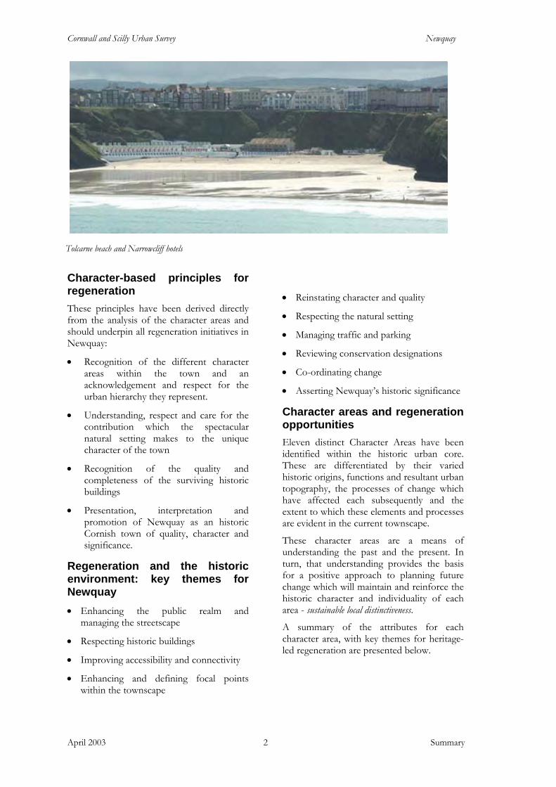
Character-based principles for regeneration These principles have been derived directly from the analysis of the character areas and should underpin all regeneration initiatives in Newquay:
• Recognition of the different character areas within the town and an acknowledgement and respect for the urban hierarchy they represent.
• Understanding, respect and care for the contribution which the spectacular natural setting makes to the unique character of the town
• Recognition of the quality and completeness of the surviving historic buildings
• Presentation, interpretation and promotion of Newquay as an historic Cornish town of quality, character and significance.
Regeneration and the historic environment: key themes for Newquay • Enhancing the public realm and
managing the streetscape
• Respecting historic buildings
• Improving accessibility and connectivity
• Enhancing and defining focal points within the townscape
• Reinstating character and quality
• Respecting the natural setting
• Managing traffic and parking
• Reviewing conservation designations
• Co-ordinating change
• Asserting Newquay’s historic significance
Character areas and regeneration opportunities Eleven distinct Character Areas have been identified within the historic urban core. These are differentiated by their varied historic origins, functions and resultant urban topography, the processes of change which have affected each subsequently and the extent to which these elements and processes are evident in the current townscape.
These character areas are a means of understanding the past and the present. In turn, that understanding provides the basis for a positive approach to planning future change which will maintain and reinforce the historic character and individuality of each area - sustainable local distinctiveness.
A summary of the attributes for each character area, with key themes for heritage-led regeneration are presented below.
Tolcarne beach and Narrowcliff hotels

Cornwall and Scilly Urban Survey Newquay
April 2003 Summary 4
1. Central commercial core. The Central Square area is the historic heart of the town and its principal commercial area. It is the most densely urban area of the town, redeveloped in the late 19th and early 20th centuries. Its strong underlying urban form is based on a level, curving main street flanked by a diverse range of towering high quality historic buildings notable for their ostentatious design, detailing and surface decoration.
• Redefine the primacy of the area within Newquay’s urban hierarchy
• Enhance and develop focal places to create a sense of arrival and strengthen the identity of the town centre
• Increase permeability through the enhancement of available north-south routes
• Recognise and respect the quality of the built environment, public realm rationalisation
• Capitalise on the surrounding natural environment 2. Harbour-related residential area. The harbour-related residential area evokes the character of the pre-urban fishing community. Its domestic architecture includes 18th century and possibly earlier pre-urban stone cottages. Later 19th century and early 20th century cottage rows and stone terraces stand side-by-side with the larger sea-facing residences of the early holiday visitors. Modest detailing and restrained use of colour bring the area alive and provide a ‘sea-side’ atmosphere, as does the semi-exotic planting of the raised front gardens. The Red Lion marks an important area linking the town with Fistral beach and the harbour.
• Enhance the Red Lion roundabout and forecourt • Maintain the built environment and retain historic
architectural details • Reduce vehicular : pedestrian conflict
3. The harbour. The harbour forms a secluded and sheltered, inward looking space set apart from the surrounding bustle of the town. The cliff face and rubble revetment wall surrounding it on the landward side provides a strong sense of enclosure, extended by the overlooking properties of Fore Street and Dane Hill. It is still a working environment, with a fishing fleet of brightly coloured boats and collections of lobster pots and plastic crates stacked along the pier arms. The built environment is a mix of robust stone - built historic structures and more temporary timber framed buildings.
• Raise the profile of the harbour • Improve the harbour’s accessibility • Enhance the public realm • Increase the vitality of the harbour • Explore the potential for interpretation
opportunities
4. Industrial area. Several dispersed areas retain an industrial character, mostly linked to the workings of the harbour and the mineral tramway but also to mining and municipal service provision. Characteristics of this area include large scale buildings and land plots. Surviving features relating to former industrial use include enclosed courtyards and upper floor loading doors. Some areas have experienced erosion through demolition or underdevelopment, resulting in a substantial loss of urban grain. The route of the mineral tramway continues to provide an important link between the town centre and the railway.
• Reinstate character and quality • Enhance the public realm • Enhance the route of the former mineral tramway
5. Secondary commercial - west. This area is a transitional zone between the commercial core and the harbour-related residential area. Now in secondary retail use, structures are of a residential scale but retain high levels of architectural detailing. Roads, pavements and plot widths are wider than in the densely packed commercial core and sea views are provided by breaks in the streetscape. There are a number of good surviving historic shop fronts and architectural details such as iron railed balconies. Later 20th century suburban-style buildings and ‘stage-set’ shop fronts mask the quality of the surviving historic environment.
• Recognise the quality of the surviving historic buildings and shop frontages – repair and reinstate
• Implement the shop front design guide recommendations
• Improve the public realm – review and rationalise street ‘clutter’
• Reinstate enclosure along Fore Street • Enhance Beach Road and Gover Lane – key
approaches to the beach area
Cornwall and Scilly Urban Survey Newquay
April 2003 Summary 4
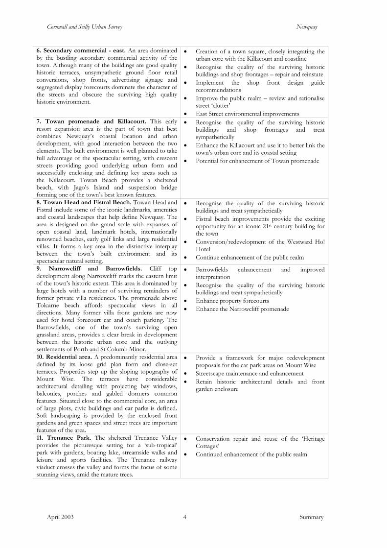
6. Secondary commercial - east. An area dominated by the bustling secondary commercial activity of the town. Although many of the buildings are good quality historic terraces, unsympathetic ground floor retail conversions, shop fronts, advertising signage and segregated display forecourts dominate the character of the streets and obscure the surviving high quality historic environment.
• Creation of a town square, closely integrating the urban core with the Killacourt and coastline
• Recognise the quality of the surviving historic buildings and shop frontages – repair and reinstate
• Implement the shop front design guide recommendations
• Improve the public realm – review and rationalise street ‘clutter’
• East Street environmental improvements 7. Towan promenade and Killacourt. This early resort expansion area is the part of town that best combines Newquay’s coastal location and urban development, with good interaction between the two elements. The built environment is well planned to take full advantage of the spectacular setting, with crescent streets providing good underlying urban form and successfully enclosing and defining key areas such as the Killacourt. Towan Beach provides a sheltered beach, with Jago’s Island and suspension bridge forming one of the town’s best known features.
• Recognise the quality of the surviving historic buildings and shop frontages and treat sympathetically
• Enhance the Killacourt and use it to better link the town’s urban core and its coastal setting
• Potential for enhancement of Towan promenade
8. Towan Head and Fistral Beach. Towan Head and Fistral include some of the iconic landmarks, amenities and coastal landscapes that help define Newquay. The area is designed on the grand scale with expanses of open coastal land, landmark hotels, internationally renowned beaches, early golf links and large residential villas. It forms a key area in the distinctive interplay between the town’s built environment and its spectacular natural setting.
• Recognise the quality of the surviving historic buildings and treat sympathetically
• Fistral beach improvements provide the exciting opportunity for an iconic 21st century building for the town
• Conversion/redevelopment of the Westward Ho! Hotel
• Continue enhancement of the public realm
9. Narrowcliff and Barrowfields. Cliff top development along Narrowcliff marks the eastern limit of the town’s historic extent. This area is dominated by large hotels with a number of surviving reminders of former private villa residences. The promenade above Tolcarne beach affords spectacular views in all directions. Many former villa front gardens are now used for hotel forecourt car and coach parking. The Barrowfields, one of the town’s surviving open grassland areas, provides a clear break in development between the historic urban core and the outlying settlements of Porth and St Columb Minor.
• Barrowfields enhancement and improved interpretation
• Recognise the quality of the surviving historic buildings and treat sympathetically
• Enhance property forecourts • Enhance the Narrowcliff promenade
10. Residential area. A predominantly residential area defined by its loose grid plan form and close-set terraces. Properties step up the sloping topography of Mount Wise. The terraces have considerable architectural detailing with projecting bay windows, balconies, porches and gabled dormers common features. Situated close to the commercial core, an area of large plots, civic buildings and car parks is defined. Soft landscaping is provided by the enclosed front gardens and green spaces and street trees are important features of the area.
• Provide a framework for major redevelopment proposals for the car park areas on Mount Wise
• Streetscape maintenance and enhancement • Retain historic architectural details and front
garden enclosure
11. Trenance Park. The sheltered Trenance Valley provides the picturesque setting for a ‘sub-tropical’ park with gardens, boating lake, streamside walks and leisure and sports facilities. The Trenance railway viaduct crosses the valley and forms the focus of some stunning views, amid the mature trees.
• Conservation repair and reuse of the ‘Heritage Cottages’
• Continued enhancement of the public realm
Cornwall and Scilly Urban Survey Newquay
April 2003 1: Introduction 5
1 Introduction
Regeneration and the historic towns of Cornwall and Scilly
In July 1999 Cornwall and the Isles of Scilly were designated as an Objective 1 area, bringing potential investment from European funds of more than £300m over the nine-year spending period. Economic regeneration schemes and development projects within the region’s towns are likely to form a major element of the Objective 1 Programme.
Regeneration on this scale offers an unparalleled opportunity for contemporary contributions in urban design and architecture to the built environment of Cornwall and Scilly’s towns. At the same time, the Objective 1 programme emphasises environmental sustainability (including the historic environment) and regional distinctiveness as key considerations in regeneration planning. The process of change launched by current regeneration initiatives could, if not carefully managed, have a negative impact on the historic environment and the unique character and sense of place of each of these settlements. The pressure to achieve rapid change could in itself result in severe erosion and dilution of their individuality and particular distinctiveness and, at worst, their transformation into ‘anywhere’ towns.
It is clear from recent research that a high-quality historic urban environment and the distinctiveness and sense of place integral to it are themselves primary assets in promoting regeneration. The effect may be direct, through heritage tourism, for example, but there is a more powerful and decisive emotional and perceptual impact in prompting a strong
sense of identity and pride of place which in turn creates a positive and confident climate for investment and growth.
This synergy between the historic environment and economic regeneration was recognised and strongly advocated in the Power of Place review of policies on the historic environment carried out by English Heritage in 2000, and its value clearly highlighted in the government’s response, The Historic Environment: A Force for the Future (2001). The tool by which the two may be linked to create a framework for sustainable development in historic settlements is characterisation.
Characterisation and regeneration
‘The government . . . wants to see more regeneration projects, large and small, going forward on the basis of a clear understanding of the existing historic environment, how this has developed over time and how it can be used creatively to meet contemporary needs.’
(DCMS / DTLR, The Historic Environment: A Force for the Future
(2001), 5.2) Characterisation is in essence the creation of a comprehensive knowledge base on the historic environment. This includes what is known of the settlement’s historic development and the resulting urban topography - the basic components which have contributed to the physical shaping of the historic settlement such as market places, church enclosures, turnpike roads, railways, etc. – together with an overview of the surviving historic fabric, distinctive architectural forms, materials and treatments and the significant elements of town and streetscapes. Characterisation may also provide the basis for assessing the potential for buried and standing archaeological remains and their likely significance, reducing uncertainty for regeneration interests by providing an
Cornwall and Scilly Urban Survey Newquay
April 2003 1: Introduction 6
indication of potential constraints. Overall, the process offers a means of understanding the diverse range of factors which combine to create ‘distinctiveness’ and ‘sense of place’.
Characterisation is also the means whereby the historic environment can itself provide an inspirational matrix for regeneration. It both highlights the ‘tears in the urban fabric’ wrought by a lack of care in the past and offers an indication of appropriate approaches to their repair. It emphasises the historic continuum which provides the context for current change and into which the regeneration measures of the present must fit if the distinctive and special qualities of each historic town are to be maintained and enhanced. Characterisation is not intended to encourage or provide a basis for imitation or pastiche: rather, it offers a sound basis on which the 21st century can make its own distinct and high-quality contribution to places of enduring value.
Cornwall and Scilly Urban Survey
The Cornwall & Scilly Urban Survey (CSUS) was set up – funded by both English Heritage and the Objective One Partnership for Cornwall and Scilly (European Regional Development Fund) – as a key contributor to regeneration in the region. The project is investigating 19 historic towns and creating for each the information base and character assessment which will provide a framework for sustainable action within these historic settlements.
These towns have been identified, in consultation with planning, conservation and economic regeneration officers within the seven district, borough and unitary authorities in the region, as those which are likely to be the focus for regeneration.
The ‘target’ settlements are:
Hayle Newlyn
Penzance St Ives
Camborne Helston
Redruth Falmouth
Penryn Truro
St Austell Newquay
Bodmin Camelford
Launceston Liskeard
Saltash Torpoint
Hugh Town (St Mary’s, Isles of Scilly).
CSUS is a pioneering initiative aimed directly at cutting across the boundary that traditionally divides conservation and economic development. Nationally, it is the first such project carrying out a characterisation-based assessment of the historic urban environment specifically to inform and support a regional economic regeneration programme. Future regeneration initiatives in other historic settlements, both in Cornwall and further afield, will benefit from the new approach developed by the project.
CSUS reports
CSUS reports present the major findings and recommendations arising from the project’s work on each town. They are complemented by digital data recorded using ArcView Geographical Information System (GIS) software, and together the two sources provide comprehensive information on historic development, urban topography, significant components of the historic environment, archaeological potential and historic character.
Importantly, the reports also identify opportunities for heritage-led regeneration and positive

Cornwall and Scilly Urban Survey Newquay
April 2003 1: Introduction 7
management of the historic environment. However, they are not intended to be prescriptive design guides, but should rather be used by architects, town planners and regeneration officers to inform future development and planning strategies.
The reports and associated digital resources are shared with the appropriate local authorities; economic regeneration, planning and conservation officers therefore have immediate access to the detailed information generated by the project. Additional information is held in the Cornwall and Scilly Historic Environment Record, maintained by the Historic Environment Service of Cornwall County Council.
Public access to the report and to the associated mapping is available via the project’s website - www.historic-cornwall.org.uk - or by appointment at the offices of Cornwall County Council’s Historic Environment Service, Old County Hall, Truro.
Extent of the study area
The history and historic development of each town are investigated and mapped for the whole of the area defined for the settlement by the current Local Plan. However, the detailed characterisation and analysis of urban topography that together form the primary elements of the study are closely focused on the historic urban extent of the settlement. Generally for the purposes of this project the area is defined as that which is recognisably ‘urban’ in character on the second edition c1907 Ordnance Survey (OS) Revision 1:2500 map. However, in the case of Newquay, due to the significant changes that took place after this date the OS revision 1:2500 map of c. 1933 has been used to define the primary study area (Figs 1 and 2). Outlying rural settlements that have been incorporated into the modern urban area since 1933 are intentionally excluded.
Newquay’s historic core from the south east (Project image, 2002)
Cornwall and Scilly Urban Survey Newquay
April 2003 2: Newquay: the context 8
2 Newquay: the context
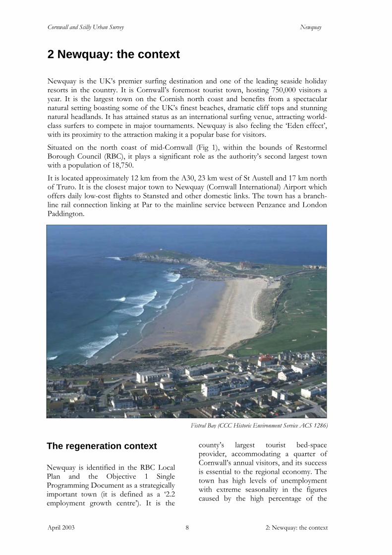
Newquay is the UK’s premier surfing destination and one of the leading seaside holiday resorts in the country. It is Cornwall’s foremost tourist town, hosting 750,000 visitors a year. It is the largest town on the Cornish north coast and benefits from a spectacular natural setting boasting some of the UK’s finest beaches, dramatic cliff tops and stunning natural headlands. It has attained status as an international surfing venue, attracting world-class surfers to compete in major tournaments. Newquay is also feeling the ‘Eden effect’, with its proximity to the attraction making it a popular base for visitors.
Situated on the north coast of mid-Cornwall (Fig 1), within the bounds of Restormel Borough Council (RBC), it plays a significant role as the authority’s second largest town with a population of 18,750.
It is located approximately 12 km from the A30, 23 km west of St Austell and 17 km north of Truro. It is the closest major town to Newquay (Cornwall International) Airport which offers daily low-cost flights to Stansted and other domestic links. The town has a branch-line rail connection linking at Par to the mainline service between Penzance and London Paddington.
The regeneration context
Newquay is identified in the RBC Local Plan and the Objective 1 Single Programming Document as a strategically important town (it is defined as a ‘2.2 employment growth centre’). It is the
county’s largest tourist bed-space provider, accommodating a quarter of Cornwall’s annual visitors, and its success is essential to the regional economy. The town has high levels of unemployment with extreme seasonality in the figures caused by the high percentage of the
Fistral Bay (CCC Historic Environment Service ACS 1286)
Cornwall and Scilly Urban Survey Newquay
April 2003 2: Newquay: the context 9
workforce employed within tourism related industries. Policies in the Local Plan and the Integrated Area Plan seek to increase and diversify employment opportunities, increase commercial and industrial activity and extend the tourist season. Newquay is targeted for a further substantial increase in population and housing provision. A growth area has been proposed to the east of the town and is set to be the county’s largest long-term development in the next two decades. The Plans also outline policies that seek to enhance town centre shopping opportunities and environmental improvements.
Fighting against the general decline in UK seaside holidays, the town has endeavoured to update and modernise itself and its regeneration has been an issue for some time. Atlantic Consultants drew up an action plan for change in 1995. Visible regeneration has already been achieved in a number of areas, and ventures such as the distinctive ‘Coast of Dreams’ branding are seeking to address the town as a whole.
The Newquay Tourism Enhancement Initiative is responsible for much of the visible change achieved to date, and has commissioned several documents that will guide future regeneration. This partnership scheme, led by the Chamber of Commerce, secured £200, 000 funding for 14 targeted projects including:
• Newquay Town Centre Design Guide • Newquay Shopfront Design Guide • Professional marketing and corporate
identity branding of the town • A town trail • Several pieces of public art
Environmental upgrading and transportation management plans have been developed as part the Local Transport Plan 2001-6, being implemented by Cornwall County Council (CCC). Currently in the third year of a five-year programme, preliminary work has been carried out
around the town at the railway station, Headland Road and Manor Road.
The emphasis in recent initiatives has been the developing youth culture market, linked to the growing popularity of surfing and extreme sports. As a result, the town’s provision of nightclubs, bars and surf related retail has grown rapidly. A year-round calendar of event-led attractions has been developed, such as the Ripcurl Newquay Boardmasters
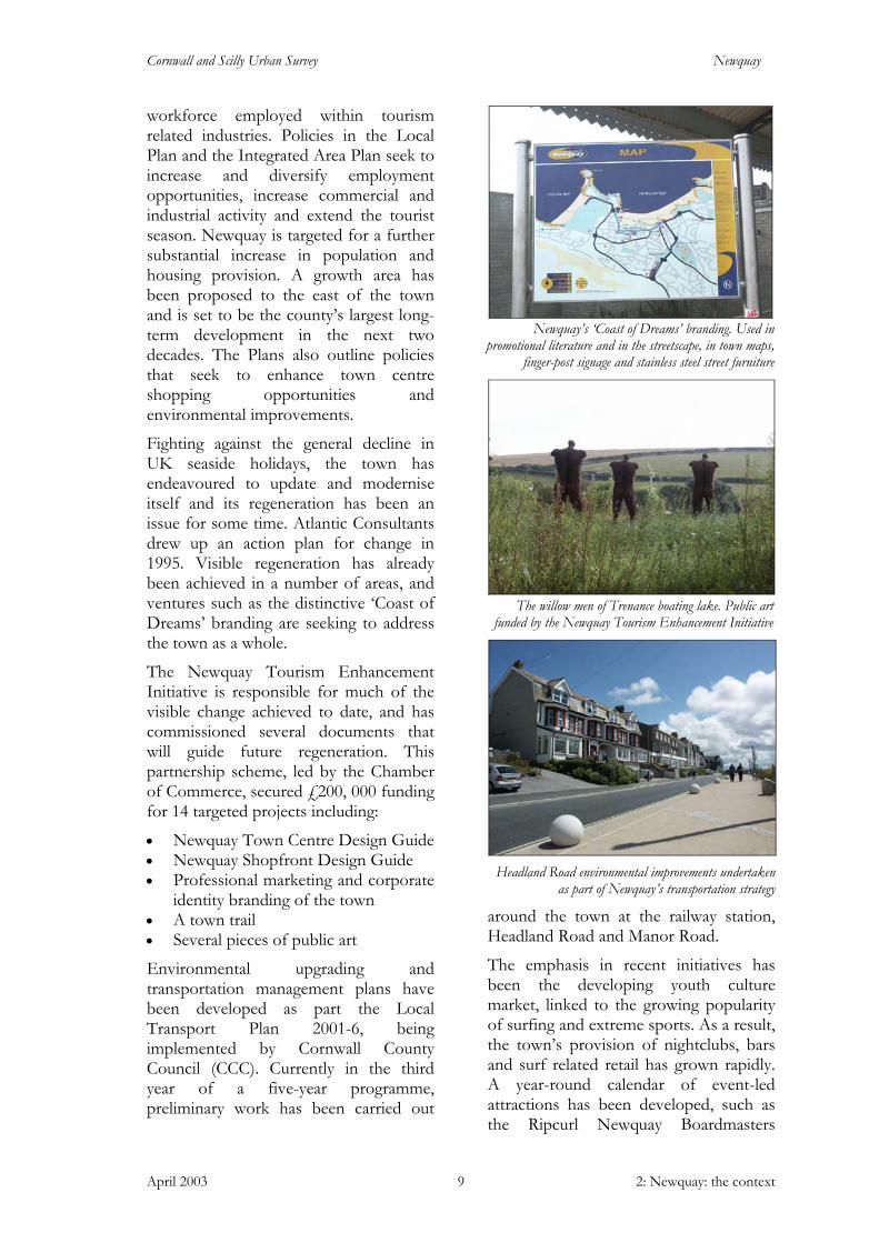
Headland Road environmental improvements undertaken as part of Newquay’s transportation strategy
The willow men of Trenance boating lake. Public art funded by the Newquay Tourism Enhancement Initiative
Newquay’s ‘Coast of Dreams’ branding. Used in promotional literature and in the streetscape, in town maps,
finger-post signage and stainless steel street furniture
Cornwall and Scilly Urban Survey Newquay
April 2003 2: Newquay: the context 10
festival, clubs showcasing national DJ’s and high profile outdoor concerts. The targeting of a single group has led to a degree of alienation among some local residents and dependence on the youth market may be a serious issue for the medium to long term as this segment of the population is diminishing. Arguably Newquay could take a more balanced approach in order not to alienate other sectors of society.
Newquay currently has an unprecedented opportunity for further, comprehensive regeneration. The Objective 1 programme, the popularity and growth of the youth culture market, the provision of a low-cost, daily plane service and a more general economic upturn in the region due to the ‘Eden effect’ all provide the potential for change.
To guide this change a Regeneration Masterplan has been produced by Hyder Consulting. It aims to provide a long-term strategy and clear vision for the town. This is complemented by a Town Centre Design Guide and Shopfront Design Guide. An Urban Design Study is incorporated in a Retail Survey commissioned by RBC.
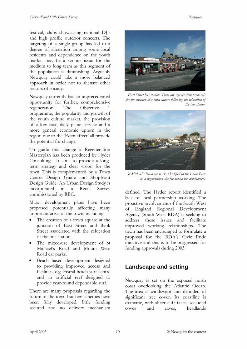
Major development plans have been proposed potentially affecting many important areas of the town, including: • The creation of a town square at the
junction of East Street and Bank Street associated with the relocation of the bus station.
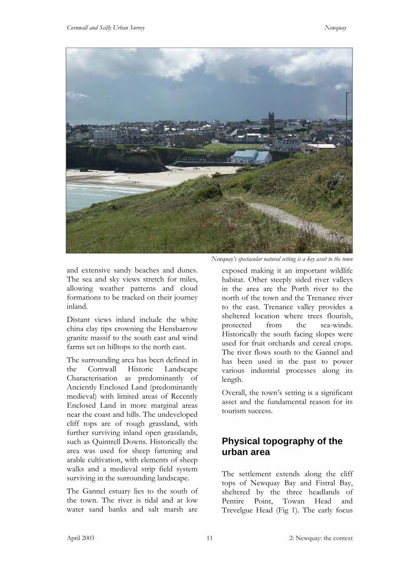
• The mixed-use development of St Michael’s Road and Mount Wise Road car parks.
• Beach based development designed to providing improved access and facilities, e.g. Fistral beach surf centre and an artificial reef designed to provide year-round dependable surf.
There are many proposals regarding the future of the town but few schemes have been fully developed, little funding secured and no delivery mechanism
defined. The Hyder report identified a lack of local partnership working. The proactive involvement of the South West of England Regional Development Agency (South West RDA) is seeking to address these issues and facilitate improved working relationships. The town has been encouraged to formulate a proposal for the RDA’s Civic Pride initiative and this is to be progressed for funding approvals during 2003.
Landscape and setting
Newquay is set on the exposed north coast overlooking the Atlantic Ocean. The area is windswept and denuded of significant tree cover. Its coastline is dramatic, with sheer cliff faces, secluded coves and caves, headlands
St Michael’s Road car park, identified in the Local Planas a regeneration site for mixed use development
East Street bus station. There are regeneration proposals
for the creation of a town square following the relocation of the bus station
Cornwall and Scilly Urban Survey Newquay
April 2003 2: Newquay: the context 11
and extensive sandy beaches and dunes. The sea and sky views stretch for miles, allowing weather patterns and cloud formations to be tracked on their journey inland.
Distant views inland include the white china clay tips crowning the Hensbarrow granite massif to the south east and wind farms set on hilltops to the north east.
The surrounding area has been defined in the Cornwall Historic Landscape Characterisation as predominantly of Anciently Enclosed Land (predominantly medieval) with limited areas of Recently Enclosed Land in more marginal areas near the coast and hills. The undeveloped cliff tops are of rough grassland, with further surviving inland open grasslands, such as Quintrell Downs. Historically the area was used for sheep fattening and arable cultivation, with elements of sheep walks and a medieval strip field system surviving in the surrounding landscape.
The Gannel estuary lies to the south of the town. The river is tidal and at low water sand banks and salt marsh are
exposed making it an important wildlife habitat. Other steeply sided river valleys in the area are the Porth river to the north of the town and the Trenance river to the east. Trenance valley provides a sheltered location where trees flourish, protected from the sea-winds. Historically the south facing slopes were used for fruit orchards and cereal crops. The river flows south to the Gannel and has been used in the past to power various industrial processes along its length.
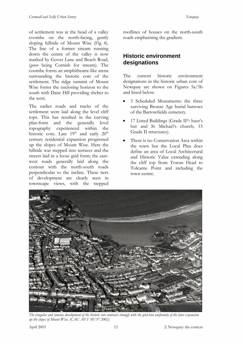
Overall, the town’s setting is a significant asset and the fundamental reason for its tourism success.
Physical topography of the urban area
The settlement extends along the cliff tops of Newquay Bay and Fistral Bay, sheltered by the three headlands of Pentire Point, Towan Head and Trevelgue Head (Fig 1). The early focus
Newquay’s spectacular natural setting is a key asset to the town
Cornwall and Scilly Urban Survey Newquay
April 2003 2: Newquay: the context 12
of settlement was at the head of a valley coombe on the north-facing, gently sloping hillside of Mount Wise (Fig 4). The line of a former stream running down the centre of the valley is now marked by Gover Lane and Beach Road, (gover being Cornish for stream). The coombe forms an amphitheatre-like arena surrounding the historic core of the settlement. The ridge summit of Mount Wise forms the enclosing horizon to the south with Dane Hill providing shelter to the west.
The earlier roads and tracks of the settlement were laid along the level cliff tops. This has resulted in the curving plan-form and the generally level topography experienced within the historic core. Late 19th and early 20th century residential expansion progressed up the slopes of Mount Wise. Here the hillside was stepped into terraces and the streets laid in a loose grid form; the east-west roads generally laid along the contour with the north-south roads perpendicular to the incline. These tiers of development are clearly seen in townscape views, with the stepped
rooflines of houses on the north-south roads emphasising the gradient.
Historic environment designations
The current historic environment designations in the historic urban core of Newquay are shown on Figures 5a/5b and listed below.
• 3 Scheduled Monuments: the three surviving Bronze Age burial barrows of the Barrowfields cemetery.
• 17 Listed Buildings (Grade II*: huer’s hut and St Michael’s church; 15 Grade II structures).
• There is no Conservation Area within the town but the Local Plan does define an area of Local Architectural and Historic Value extending along the cliff top from Towan Head to Tolcarne Point and including the town centre.
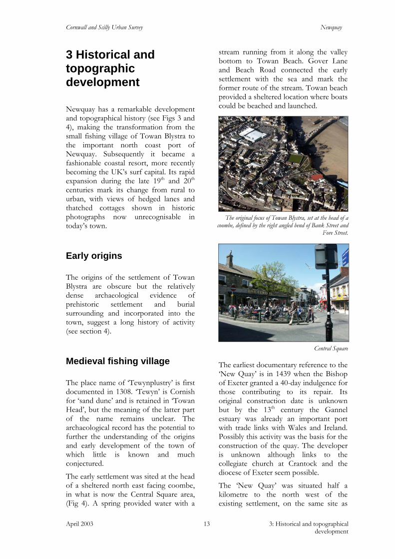
The irregular and sinuous development of the historic core contrasts strongly with the grid-iron uniformity of the later expansion up the slopes of Mount Wise. (CAU AP F 58/37 2002)
Cornwall and Scilly Urban Survey Newquay
April 2003 3: Historical and topographical development
13
3 Historical and topographic development
Newquay has a remarkable development and topographical history (see Figs 3 and 4), making the transformation from the small fishing village of Towan Blystra to the important north coast port of Newquay. Subsequently it became a fashionable coastal resort, more recently becoming the UK’s surf capital. Its rapid expansion during the late 19th and 20th centuries mark its change from rural to urban, with views of hedged lanes and thatched cottages shown in historic photographs now unrecognisable in today’s town.
Early origins
The origins of the settlement of Towan Blystra are obscure but the relatively dense archaeological evidence of prehistoric settlement and burial surrounding and incorporated into the town, suggest a long history of activity (see section 4).
Medieval fishing village
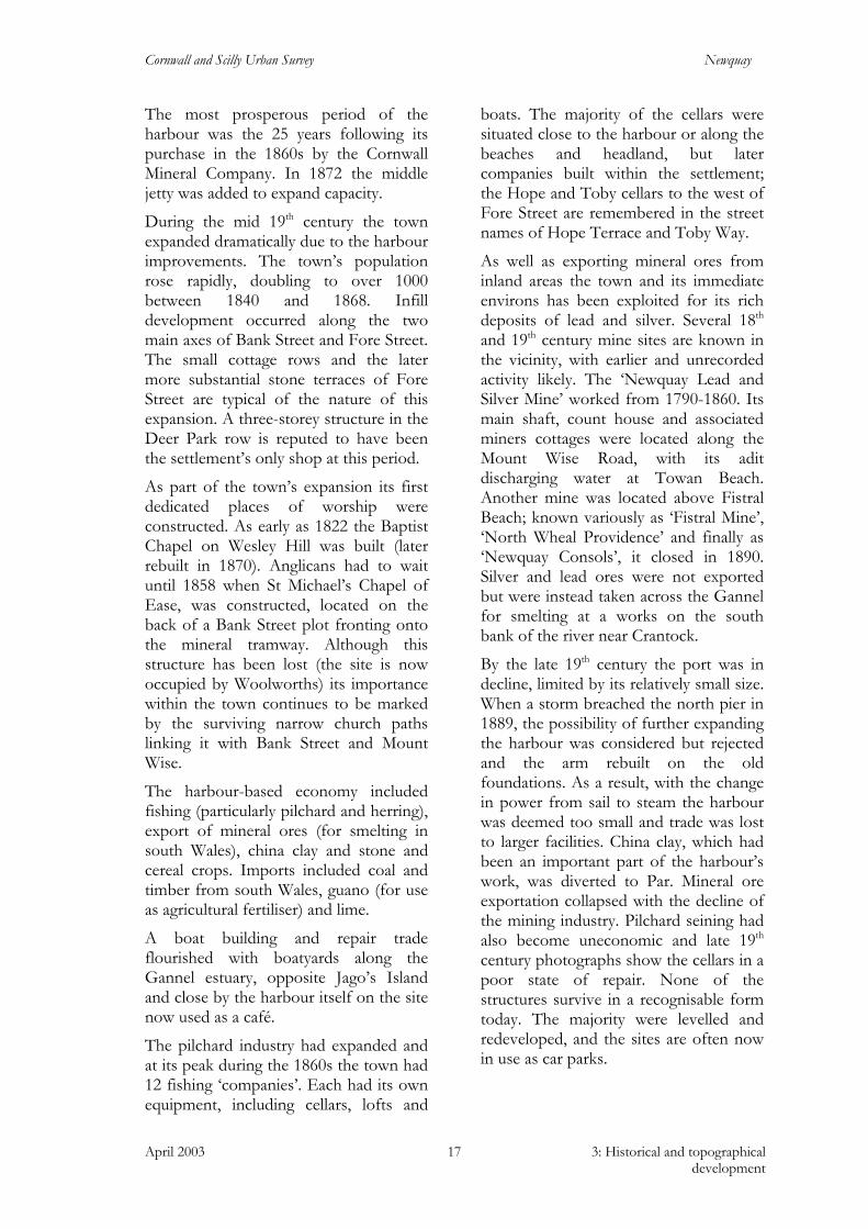
The place name of ‘Tewynplustry’ is first documented in 1308. ‘Tewyn’ is Cornish for ‘sand dune’ and is retained in ‘Towan Head’, but the meaning of the latter part of the name remains unclear. The archaeological record has the potential to further the understanding of the origins and early development of the town of which little is known and much conjectured.
The early settlement was sited at the head of a sheltered north east facing coombe, in what is now the Central Square area, (Fig 4). A spring provided water with a
stream running from it along the valley bottom to Towan Beach. Gover Lane and Beach Road connected the early settlement with the sea and mark the former route of the stream. Towan beach provided a sheltered location where boats could be beached and launched.
The earliest documentary reference to the ‘New Quay’ is in 1439 when the Bishop of Exeter granted a 40-day indulgence for those contributing to its repair. Its original construction date is unknown but by the 13th century the Gannel estuary was already an important port with trade links with Wales and Ireland. Possibly this activity was the basis for the construction of the quay. The developer is unknown although links to the collegiate church at Crantock and the diocese of Exeter seem possible.
The ‘New Quay’ was situated half a kilometre to the north west of the existing settlement, on the same site as
Central Square
The original focus of Towan Blystra, set at the head of a
coombe, defined by the right angled bend of Bank Street and Fore Street.
Cornwall and Scilly Urban Survey Newquay
April 2003 3: Historical and topographical development
14
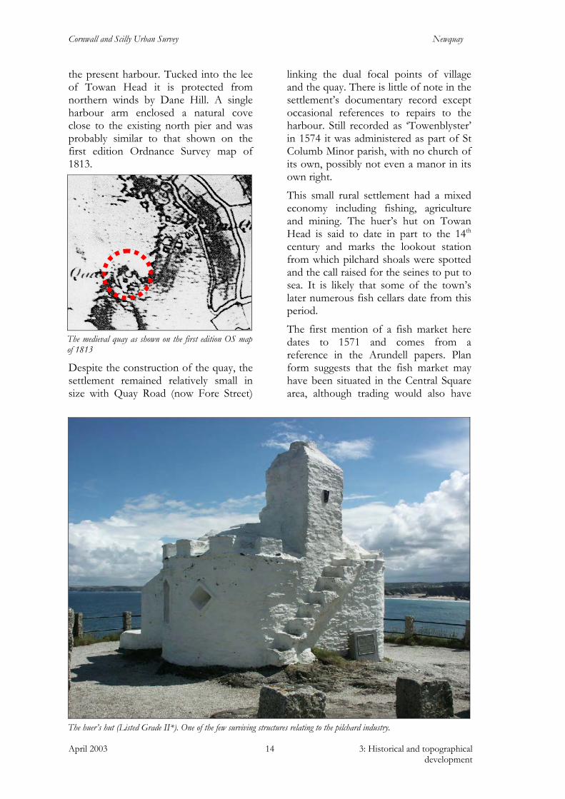
the present harbour. Tucked into the lee of Towan Head it is protected from northern winds by Dane Hill. A single harbour arm enclosed a natural cove close to the existing north pier and was probably similar to that shown on the first edition Ordnance Survey map of 1813.
Despite the construction of the quay, the settlement remained relatively small in size with Quay Road (now Fore Street)
linking the dual focal points of village and the quay. There is little of note in the settlement’s documentary record except occasional references to repairs to the harbour. Still recorded as ‘Towenblyster’ in 1574 it was administered as part of St Columb Minor parish, with no church of its own, possibly not even a manor in its own right.
This small rural settlement had a mixed economy including fishing, agriculture and mining. The huer’s hut on Towan Head is said to date in part to the 14th century and marks the lookout station from which pilchard shoals were spotted and the call raised for the seines to put to sea. It is likely that some of the town’s later numerous fish cellars date from this period.
The first mention of a fish market here dates to 1571 and comes from a reference in the Arundell papers. Plan form suggests that the fish market may have been situated in the Central Square area, although trading would also have
The medieval quay as shown on the first edition OS map of 1813
The huer’s hut (Listed Grade II*). One of the few surviving structures relating to the pilchard industry.
Cornwall and Scilly Urban Survey Newquay
April 2003 3: Historical and topographical development
15
taken place direct from the quay and the cellars. Later the ‘Old Inn’ public house, (now rebuilt as ‘The Central’), is recorded as a place of trade, with farmers parking their wagons of grain in the square outside and trading them inside the inn.
William Borlase’s account of the settlement, following his visit in 1755, probably provides a good representation of the village as it had existed for centuries and may record the first signs of its expansion. ‘Passed the Ganel and went about a mile further to a place of about twelve houses called Towen Blystra, a furlong further to the New Quay in St Columb Parish, here is a little pier, the north point of which is fixed on a rock, the end in a cliff, at the eastern end there is a gap cutt about 25 feet wide into the slatty rock of the cliff. This gap lets small ships into a basin which may hold about six ships of about 80 tons burthen and at spring tides has 18 feet of water in it, upon the brow of the cliff is a dwelling house and a commodious cellar lately built.’ (Taken from Lyon, 1991, 12).
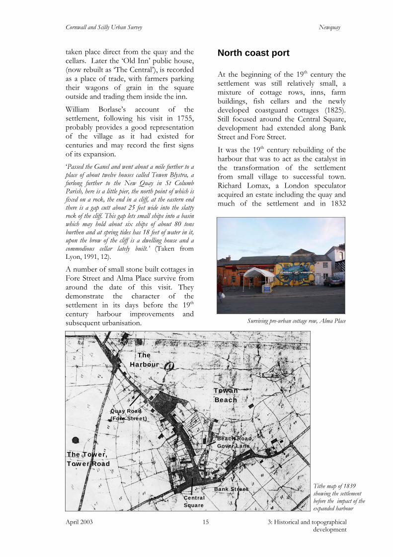
A number of small stone built cottages in Fore Street and Alma Place survive from around the date of this visit. They demonstrate the character of the settlement in its days before the 19th century harbour improvements and subsequent urbanisation.
North coast port
At the beginning of the 19th century the settlement was still relatively small, a mixture of cottage rows, inns, farm buildings, fish cellars and the newly developed coastguard cottages (1825). Still focused around the Central Square, development had extended along Bank Street and Fore Street.
It was the 19th century rebuilding of the harbour that was to act as the catalyst in the transformation of the settlement from small village to successful town. Richard Lomax, a London speculator acquired an estate including the quay and much of the settlement and in 1832
Tithe map of 1839 showing the settlement before the impact of the expanded harbour
The Harbour
The Tower, Tower Road
Quay Road (Fore Street)
Bank Street Central Square
Towan Beach
Beach Road, Gover Lane
Surviving pre-urban cottage row, Alma Place

Cornwall and Scilly Urban Survey Newquay
April 2003 3: Historical and topographical development
16
construction began on the enlarged harbour (the basis of the present day north and south piers). However, Lomax died in 1836 before work had been completed. Joseph Treffry purchased the estate at its sale in 1838 and finished the harbour construction. His ambition was to turn Newquay into the premier north coast port, providing vital import / export support to his own inland mineral ore mining and china clay extraction interests. He saw a mid-county north coast port as a potential fast track route to the smelting furnaces and timber supply of south Wales, reducing journey times from the sheltered south coast ports and avoiding the hazardous navigation around Land’s End.
A vital element in the success of the port was Treffry’s construction of a mineral tramway in 1849, linking the mines in the Newlyn East area and the china clay pits around St Dennis to the harbour. Loads were brought to Newquay railway station by steam engine, pulled along the tramway by horses, and lowered to the harbour via a steeply inclined tunnel. The winding mechanism for the tunnel was powered by two stationary engines in an area called ‘The Whim’ (now a supermarket).
The tramway cutting is still visible in the topography of the town, now known as Manor Road to its west and to the east used as a footpath linking the town centre with the railway station. It marks
an important phase in the town’s history and influenced its subsequent development. The track follows a sinuous route laid around the then southern extent of the town, its line marking the extent of development in 1849.
With the success of the harbour Treffry planned further expansion, proposing a second harbour on the west side of Towan Head, known as ‘The Harbour of Refuge’. This could be reached at all tides and would be linked to the other by a canal cut through the neck of the headland. The scheme was begun in 1848 and a granite ashlar breakwater was constructed. However, with Treffry’s death in 1850 the project was abandoned.
The pedestrianised eastern end of the mineral tramway
Treffry’s Harbour of Refuge, 1st edition 1:2500 OS map of 1879
The expanded harbour
Breakwater
Canal
Cornwall and Scilly Urban Survey Newquay
April 2003 3: Historical and topographical development
17
The most prosperous period of the harbour was the 25 years following its purchase in the 1860s by the Cornwall Mineral Company. In 1872 the middle jetty was added to expand capacity.
During the mid 19th century the town expanded dramatically due to the harbour improvements. The town’s population rose rapidly, doubling to over 1000 between 1840 and 1868. Infill development occurred along the two main axes of Bank Street and Fore Street. The small cottage rows and the later more substantial stone terraces of Fore Street are typical of the nature of this expansion. A three-storey structure in the Deer Park row is reputed to have been the settlement’s only shop at this period.
As part of the town’s expansion its first dedicated places of worship were constructed. As early as 1822 the Baptist Chapel on Wesley Hill was built (later rebuilt in 1870). Anglicans had to wait until 1858 when St Michael’s Chapel of Ease, was constructed, located on the back of a Bank Street plot fronting onto the mineral tramway. Although this structure has been lost (the site is now occupied by Woolworths) its importance within the town continues to be marked by the surviving narrow church paths linking it with Bank Street and Mount Wise.
The harbour-based economy included fishing (particularly pilchard and herring), export of mineral ores (for smelting in south Wales), china clay and stone and cereal crops. Imports included coal and timber from south Wales, guano (for use as agricultural fertiliser) and lime.
A boat building and repair trade flourished with boatyards along the Gannel estuary, opposite Jago’s Island and close by the harbour itself on the site now used as a café.
The pilchard industry had expanded and at its peak during the 1860s the town had 12 fishing ‘companies’. Each had its own equipment, including cellars, lofts and
boats. The majority of the cellars were situated close to the harbour or along the beaches and headland, but later companies built within the settlement; the Hope and Toby cellars to the west of Fore Street are remembered in the street names of Hope Terrace and Toby Way.
As well as exporting mineral ores from inland areas the town and its immediate environs has been exploited for its rich deposits of lead and silver. Several 18th and 19th century mine sites are known in the vicinity, with earlier and unrecorded activity likely. The ‘Newquay Lead and Silver Mine’ worked from 1790-1860. Its main shaft, count house and associated miners cottages were located along the Mount Wise Road, with its adit discharging water at Towan Beach. Another mine was located above Fistral Beach; known variously as ‘Fistral Mine’, ‘North Wheal Providence’ and finally as ‘Newquay Consols’, it closed in 1890. Silver and lead ores were not exported but were instead taken across the Gannel for smelting at a works on the south bank of the river near Crantock.
By the late 19th century the port was in decline, limited by its relatively small size. When a storm breached the north pier in 1889, the possibility of further expanding the harbour was considered but rejected and the arm rebuilt on the old foundations. As a result, with the change in power from sail to steam the harbour was deemed too small and trade was lost to larger facilities. China clay, which had been an important part of the harbour’s work, was diverted to Par. Mineral ore exportation collapsed with the decline of the mining industry. Pilchard seining had also become uneconomic and late 19th century photographs show the cellars in a poor state of repair. None of the structures survive in a recognisable form today. The majority were levelled and redeveloped, and the sites are often now in use as car parks.
Cornwall and Scilly Urban Survey Newquay
April 2003 3: Historical and topographical development
18
Railway resort: from village to town
Tourism had been growing since the early - mid 19th century, with wealthy families building large residences for occupation or subletting during the summer months. Early examples of this kind of building are the Fort on Fore Street (1830) and the Tower on Tower Road (1835).
The Red Lion Inn (1835) was one of the first overtly commercial developments targeted at the tourist trade, providing accommodation to visitors, while the Shipwrights Arms opposite (now Cliff Cottage) continued catering for harbour workers. The appeal of Newquay, then as now, was its spectacular and dramatic natural setting with sea-air and bathing seen as healthy benefits. In addition, the working harbour was also a source of fascination for holidaymakers, with many
of the early residences sited to take advantage of harbour views.
It was the provision of a passenger rail service that was to transform the town into the late 19th and early 20th century fashionable resort that it became. A decline in harbour trade promoted the Cornwall Mineral Railway, owners of the mineral tramway, to diversify into carrying passengers from 1873. In 1877 Newquay railway station was constructed and in 1896 the line was purchased by the Great Western Railway. It was their advertising campaigns, such as the Cornish Riviera poster campaign, that accelerated the transformation of the town and required and sustained the construction of some of the region’s largest hotels.
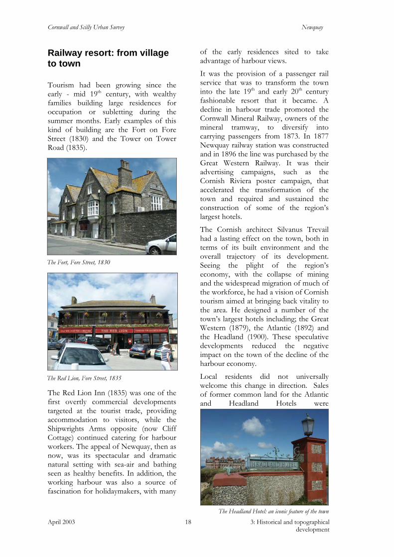
The Cornish architect Silvanus Trevail had a lasting effect on the town, both in terms of its built environment and the overall trajectory of its development. Seeing the plight of the region’s economy, with the collapse of mining and the widespread migration of much of the workforce, he had a vision of Cornish tourism aimed at bringing back vitality to the area. He designed a number of the town’s largest hotels including; the Great Western (1879), the Atlantic (1892) and the Headland (1900). These speculative developments reduced the negative impact on the town of the decline of the harbour economy.
Local residents did not universally welcome this change in direction. Sales of former common land for the Atlantic and Headland Hotels were
The Fort, Fore Street, 1830
The Red Lion, Fore Street, 1835
The Headland Hotel: an iconic feature of the town

Cornwall and Scilly Urban Survey Newquay
April 2003 3: Historical and topographical development
19
met by anger, and construction of the Headland was halted for a time by the riots it provoked in 1897. Although the hotel itself was finally completed, associated plans to develop the rest of Fistral common were abandoned.
By the end of the 19th century there were as many visitors as local residents and the basic infrastructure required to house and entertain them had a dramatic effect on the built environment of the settlement. The development of large-scale attractions and amusements to entertain the masses was paralleled by improved retail provision. Bank Street was developed as a commercial street with densely packed, three and four storey, ornately detailed buildings that dramatically changed the character of the settlement.
Concerts, theatres, cinemas and bathing machines were important elements in holiday activities; the Cosy Nook
Theatre, initially a canvas tent on Towan Promenade, the Victoria Hall and Pavilion Cinema (the latter two both now popular bars) were important features attracting visitors to the town. Fistral Golf Course, another important amenity to the present day, opened in 1894 and was one of the first courses in the region.
Support industries were also developed to cope with the tourist influx, including the country’s first steam laundry. Situated on Towan Promenade this was later relocated to Lanhenvor Avenue.
The improvements of the town and the amenities and entertainments it offered made it an attractive place to live as well as visit and prosperous, middle-class families relocated here. Between 1868 and 1890 the population doubled to 2,000. Substantial terraces and developments of semi-detached villas were laid out close to the town centre, such as Beachfield Avenue, The Crescent and East Street.
Proposed development plans for Fistral common: Atlantic Hotel and Headland Road, shown top centre, were the only elements constructed

Cornwall and Scilly Urban Survey Newquay
April 2003 3: Historical and topographical development
20
The 20th century
The town continued to grow with its population expanding rapidly (1901-3115, 1911-4415, 1921-6637, 1931-7651). In 1911 the current Anglican church on St Michael’s Road replaced the Manor Road Chapel of Ease which had quickly been outgrown. The Narrowcliff area was developed between 1900-1920 as private villas with enclosed front gardens. As tourist numbers continued to grow these buildings were converted and extended into the hotels seen today. During the early 20th century Newquay’s Urban District Council planned an ambitious programme of expansion, led by their surveyor John Ennor. He laid out terrace after terrace of (often tree lined) streets, avenues and crescents. The bulk of this expansion was to the south of the earlier developed cliff edge and was designed along a loose grid pattern, with east-west roads generally running along the contour and north-south routes running against the gradient. This Edwardian development was predominantly of spacious two and three storey brick and stone built houses with well-detailed facades featuring bay windows, porches, decorative gables and dormers, each with enclosed front and back gardens.
Concern was already being voiced about the degradation of the town and its environment. The Council for the Protection of Rural England carried out a survey of the county in 1933 noting the impact on the natural environment of Trevail’s Atlantic and Headland Hotel developments. The UDC set about buying up the remaining unenclosed common land, surrounding the town with the open spaces of the Barrowfields, Killacourt and Fistral common, and preserving its unique setting.
Trenance park and gardens was developed in the early part of the century as a tourist attraction. The gardens were laid out in 1906, with the boating lake
Island Crescent, shown in early stages of construction on the second edition OS map of c1907
St Michael’s Church (Listed Grade II*), 1911, by Sir Ninian Comper
Typical Edwardian terraces, St George’s Road
Trenance park
Cornwall and Scilly Urban Survey Newquay
April 2003 3: Historical and topographical development
21
created as an unemployment relief measure in 1932.
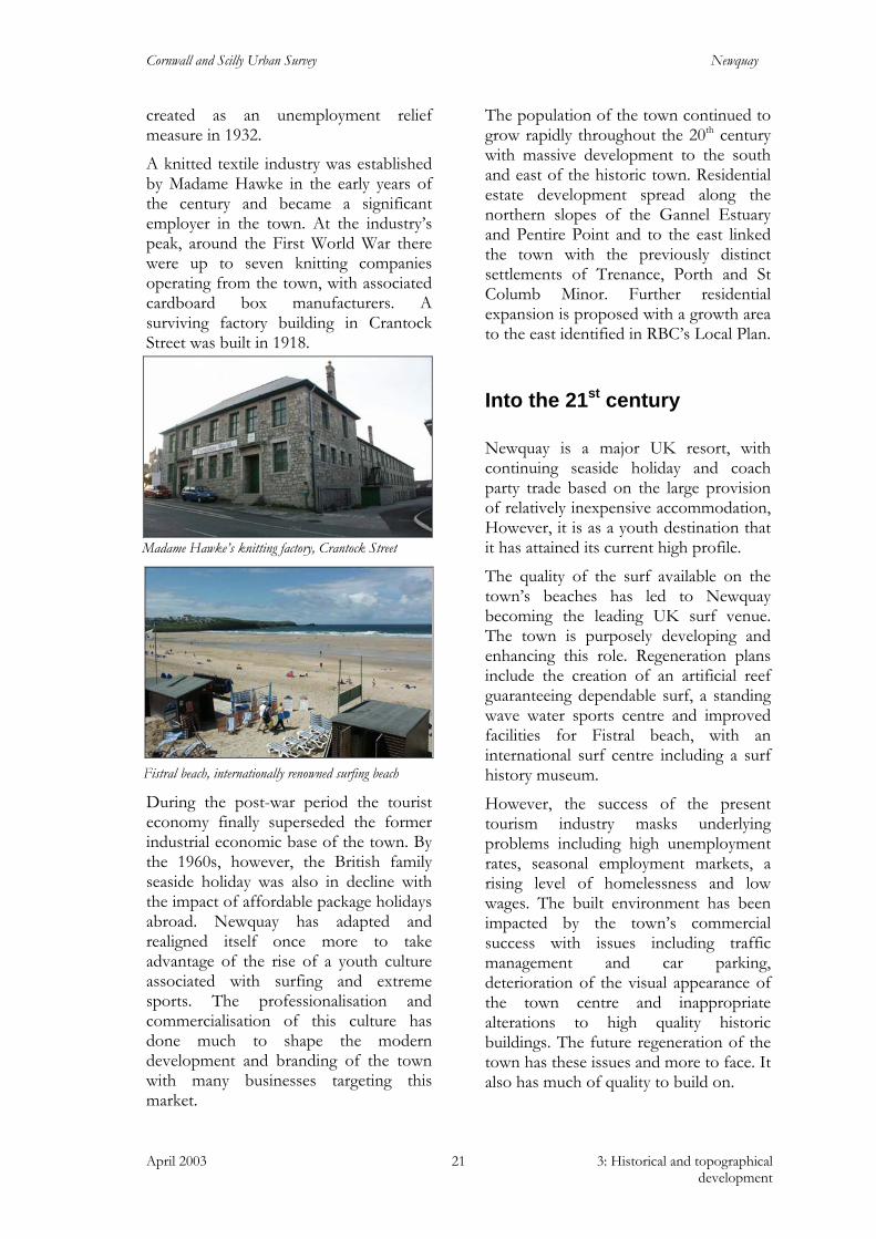
A knitted textile industry was established by Madame Hawke in the early years of the century and became a significant employer in the town. At the industry’s peak, around the First World War there were up to seven knitting companies operating from the town, with associated cardboard box manufacturers. A surviving factory building in Crantock Street was built in 1918.
During the post-war period the tourist economy finally superseded the former industrial economic base of the town. By the 1960s, however, the British family seaside holiday was also in decline with the impact of affordable package holidays abroad. Newquay has adapted and realigned itself once more to take advantage of the rise of a youth culture associated with surfing and extreme sports. The professionalisation and commercialisation of this culture has done much to shape the modern development and branding of the town with many businesses targeting this market.
The population of the town continued to grow rapidly throughout the 20th century with massive development to the south and east of the historic town. Residential estate development spread along the northern slopes of the Gannel Estuary and Pentire Point and to the east linked the town with the previously distinct settlements of Trenance, Porth and St Columb Minor. Further residential expansion is proposed with a growth area to the east identified in RBC’s Local Plan.
Into the 21st century
Newquay is a major UK resort, with continuing seaside holiday and coach party trade based on the large provision of relatively inexpensive accommodation, However, it is as a youth destination that it has attained its current high profile.
The quality of the surf available on the town’s beaches has led to Newquay becoming the leading UK surf venue. The town is purposely developing and enhancing this role. Regeneration plans include the creation of an artificial reef guaranteeing dependable surf, a standing wave water sports centre and improved facilities for Fistral beach, with an international surf centre including a surf history museum.
However, the success of the present tourism industry masks underlying problems including high unemployment rates, seasonal employment markets, a rising level of homelessness and low wages. The built environment has been impacted by the town’s commercial success with issues including traffic management and car parking, deterioration of the visual appearance of the town centre and inappropriate alterations to high quality historic buildings. The future regeneration of the town has these issues and more to face. It also has much of quality to build on.
Madame Hawke’s knitting factory, Crantock Street
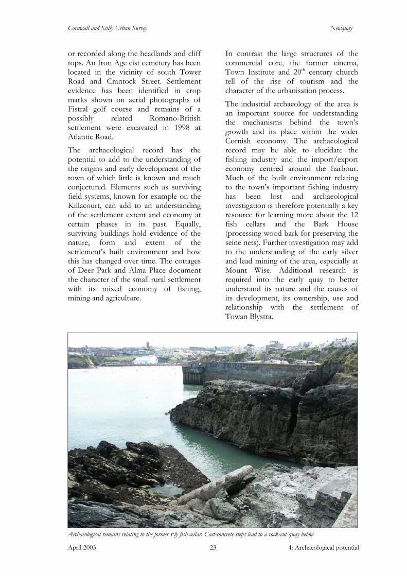
Fistral beach, internationally renowned surfing beach

Cornwall and Scilly Urban Survey Newquay
April 2003 4: Archaeological potential 22
4 Archaeological potential
Archaeology is a potentially rich asset for the town. The documentary record is silent on many aspects of the settlement’s development and archaeological investigation may be the only way in which certain aspects of the town’s historic development and character can be better understood. Archaeology can also make a contribution in both cultural and economic terms with remains of the past having a significant potential for education, tourism and leisure, as well as a role in local pride, sense of place and belonging.
It should be emphasised that ‘archaeology’ does not refer solely to buried remains. These are of undoubted importance, but in the urban context examination of the historical sequences embodied in standing buildings and other structures can also be extremely valuable. Examination of the built environment is likely to yield significant new information. Opportunities for investigation and recording should be sought when buildings are refurbished or undergo substantial alteration. Figure 5 indicates the survival of historic fabric, defined here as standing pre-1933 structures, which may offer potential for fruitful archaeological investigation.
Archaeological remains are an important and non-renewable resource and as such are protected by national legislation and local planning policy. One component of future investigation of both buried archaeological remains and standing buildings could be through more extensive targeted implementation of PPG15 and PPG 16 as part of the development control process.
Newquay has a proven wealth of archaeological remains ranging from the prehistoric to Second World War defences (Fig 6). There have been a number of important archaeological interventions within and around the urban core and several chance finds and antiquarian references that demonstrate the potential of the resource. Overviews of the archaeological potential of the individual ‘character areas’ within the town are presented in section 5 with a summary provided here.
Evidence suggests that the surrounding landscape was densely occupied during the prehistoric period, with numerous settlement and burial sites known through excavation and survey. Nationally important sites include the Iron Age cliff castle at Trevelgue Head to the north, excavated in 1939, and to the south the Bronze Age settlement and Iron Age cemetery excavated in 1987 at Trethellan Farm. There are a number of Bronze Age burial mounds (barrows) grouped in cemeteries mostly surviving
The Barrowfields; 3 surviving barrows from a Bronze Age cemetery (c 1500BC) and medieval ridge and furrow earthworks
Cornwall and Scilly Urban Survey Newquay
April 2003 4: Archaeological potential 23
or recorded along the headlands and cliff tops. An Iron Age cist cemetery has been located in the vicinity of south Tower Road and Crantock Street. Settlement evidence has been identified in crop marks shown on aerial photographs of Fistral golf course and remains of a possibly related Romano-British settlement were excavated in 1998 at Atlantic Road.
The archaeological record has the potential to add to the understanding of the origins and early development of the town of which little is known and much conjectured. Elements such as surviving field systems, known for example on the Killacourt, can add to an understanding of the settlement extent and economy at certain phases in its past. Equally, surviving buildings hold evidence of the nature, form and extent of the settlement’s built environment and how this has changed over time. The cottages of Deer Park and Alma Place document the character of the small rural settlement with its mixed economy of fishing, mining and agriculture.
In contrast the large structures of the commercial core, the former cinema, Town Institute and 20th century church tell of the rise of tourism and the character of the urbanisation process.
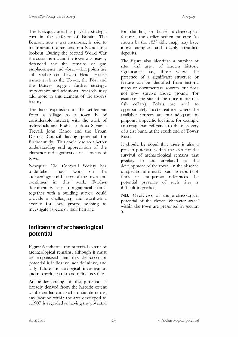
The industrial archaeology of the area is an important source for understanding the mechanisms behind the town’s growth and its place within the wider Cornish economy. The archaeological record may be able to elucidate the fishing industry and the import/export economy centred around the harbour. Much of the built environment relating to the town’s important fishing industry has been lost and archaeological investigation is therefore potentially a key resource for learning more about the 12 fish cellars and the Bark House (processing wood bark for preserving the seine nets). Further investigation may add to the understanding of the early silver and lead mining of the area, especially at Mount Wise. Additional research is required into the early quay to better understand its nature and the causes of its development, its ownership, use and relationship with the settlement of Towan Blystra.
Archaeological remains relating to the former Fly fish cellar. Cast-concrete steps lead to a rock-cut quay below
Cornwall and Scilly Urban Survey Newquay
April 2003 4: Archaeological potential 24
The Newquay area has played a strategic part in the defence of Britain. The Beacon, now a war memorial, is said to incorporate the remains of a Napoleonic lookout. During the Second World War the coastline around the town was heavily defended and the remains of gun emplacements and observation points are still visible on Towan Head. House names such as the Tower, the Fort and the Battery suggest further strategic importance and additional research may add more to this element of the town’s history.
The later expansion of the settlement from a village to a town is of considerable interest, with the work of individuals and bodies such as Silvanus Trevail, John Ennor and the Urban District Council having potential for further study. This could lead to a better understanding and appreciation of the character and significance of elements of town.
Newquay Old Cornwall Society has undertaken much work on the archaeology and history of the town and continues in this work. Further documentary and topographical study, together with a building survey, could provide a challenging and worthwhile avenue for local groups wishing to investigate aspects of their heritage.
Indicators of archaeological potential
Figure 6 indicates the potential extent of archaeological remains, although it must be emphasised that this depiction of potential is indicative, not definitive, and only future archaeological investigation and research can test and refine its value.
An understanding of the potential is broadly derived from the historic extent of the settlement itself. In simple terms, any location within the area developed to c.1907 is regarded as having the potential
for standing or buried archaeological features; the earlier settlement core (as shown by the 1839 tithe map) may have more complex and deeply stratified deposits.
The figure also identifies a number of sites and areas of known historic significance: i.e., those where the presence of a significant structure or feature can be identified from historic maps or documentary sources but does not now survive above ground (for example, the site of the once numerous fish cellars). Points are used to approximately locate features where the available sources are not adequate to pinpoint a specific location; for example an antiquarian reference to the discovery of a cist burial at the south end of Tower Road.
It should be noted that there is also a proven potential within the area for the survival of archaeological remains that predate or are unrelated to the development of the town. In the absence of specific information such as reports of finds or antiquarian references the potential presence of such sites is difficult to predict.
NB. Overviews of the archaeological potential of the eleven ‘character areas’ within the town are presented in section 5.
Cornwall and Scilly Urban Survey Newquay
April 2003 5: Present settlement character 25
5 Present settlement character
Understanding character
The CSUS investigation, in addition to assessing the broad elements of settlement character defining Newquay as a whole, identified eleven distinct character areas within the town’s historic (pre-1933) urban extent (see below; Fig 7 and character area summary sheets 1-11). These character areas are differentiated from each other by their varied historic origins, functions and resultant urban topography, by the processes of change which have affected each subsequently (indicated, for example, by the relative completeness or loss of historic fabric, or significant changes in use and status) and the extent to which these elements and processes are evident in the current townscape. Each character area therefore has its own individual ‘biography’
which has determined its present character.
Together with the assessment of overall settlement character, the eleven character areas offer a means of understanding the past and the present. In turn, that understanding provides the basis for a positive approach to planning future change which will maintain and reinforce the historic character and individuality of each area and the town as a whole – sustainable local distinctiveness.
Overall settlement character
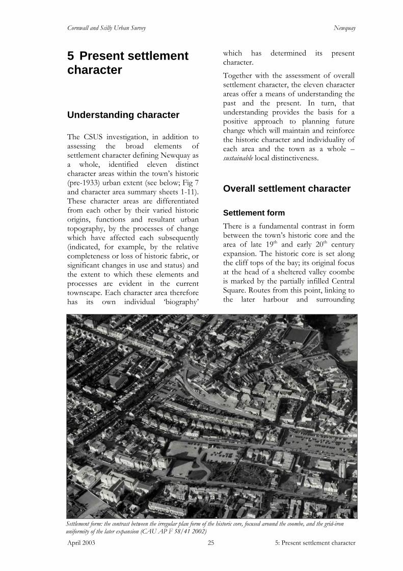
Settlement form There is a fundamental contrast in form between the town’s historic core and the area of late 19th and early 20th century expansion. The historic core is set along the cliff tops of the bay; its original focus at the head of a sheltered valley coombe is marked by the partially infilled Central Square. Routes from this point, linking to the later harbour and surrounding
Settlement form: the contrast between the irregular plan form of the historic core, focused around the coombe, and the grid-iron uniformity of the later expansion (CAU AP F 58/41 2002)

Cornwall and Scilly Urban Survey Newquay
April 2003 5: Present settlement character 26
settlements, follow the level terrain behind the cliffs and form the curving and circuitous but overwhelmingly linear framework of the piecemeal development that characterised the town’s evolution prior to its rapid and planned growth and urbanisation of the late 19th and early 20th century. This earlier area has a mixed, organic form with a variety of plot widths, building scales and discrete planned developments. This type of development has led to shallow plots often resulting in single sided urban blocks (i.e. plots with one active front and an inactive rear equally open to view within the streetscape).
The later planned expansion progressed up the north-facing slopes of the linear ridge of Mount Wise. In contrast to the sinuous form of the historic core the later expansion is laid out in a loose grid form. The hillside is divided into terraced plateaus running east – west along the contours bounded by arterial roads such as Manor Road, St Michaels Road and Mount Wise. The regimented plan form is reinforced by streets of uniform plot size and house style, now softened by personalisation, street trees and mature planting.
The hillside topography gives a distinctive character to the town, with views revealing the successive tiers of development, the grid flanked with stepped terraced rows and the enclosing horizon formed by development along the Mount Wise road. The steep topography has led to limited connectivity between the area of hillside expansion and the historic core. The mineral tramway (now Manor Road) marks the severance between the two areas with the narrow footpaths, originally church paths, extensively used as pedestrian links between them.
Survival of historic standing fabric The town contains much surviving historic fabric of interest and quality (Fig
5). The majority dates to the late 19th and early 20th centuries and represents the enormous growth and urbanisation of the settlement during that time. There are examples of earlier structures, such as the huer’s hut, reputed to date from the 14th century, and a number of small cottages situated close to the harbour relating to the pre-industrialised port (pre-19th century).
The overall high survival level of late 19th and early 20th century structures is a noticeable feature of the town, as is the generally good survival of architectural detail. Many high quality historic shop fronts survive within the town. At present the full impact of this quality built environment is often obscured behind a confusion of signs, hoardings and general street ‘clutter’.
Modernisation and expansion of retail and hotel facilities has in some cases led to unsympathetic modern alteration,
High quality architecture in Bank Street obscured by
modern shop front fittings, unsympathetic extensions and general street ‘clutter’
Surviving historic shop front, East Street
Cornwall and Scilly Urban Survey Newquay
April 2003 5: Present settlement character 27
surface accretion and extension, but in many instances, these changes are reversible.
Building types recurring within the surviving historic fabric include:
• harbour related residential structures (pre – mid 19th century)
• the large houses of the early wealthy residents and visitors (mid 19th century)
• courtyard inns such as the Red Lion and the Central (mid 19th century)
• the large landmark hotels constructed by pioneers of Cornish tourism, such as the Victoria, Atlantic and Headland (late 19th century)
• urban structures relating to the rebuilding and creation of the central commercial core (late 19th – early 20th century)
• ranks of residential terraces (late 19th – early 20th century).
Construction of larger buildings increased during the 20th century, with structures such as the steam laundry and cinema at Towan promenade creating the precedent for the warehouse size and form of today’s Aquarium and Walkabout theme bar and club. This large-scale development form has extended along the cliff top and inland, as seen in the Springbok bar and club and the Battery apartment block on Dane Hill.
The harbour continues as a place of work with the 19th century piers and quays still in daily use. A notable absence in the surviving built environment is any substantial remains relating to the pilchard industry. None of the once numerous cellars survive in a recognisable form, although elements are retained within the public shelters on the sites of the Active and Fly cellars to the north of the harbour.
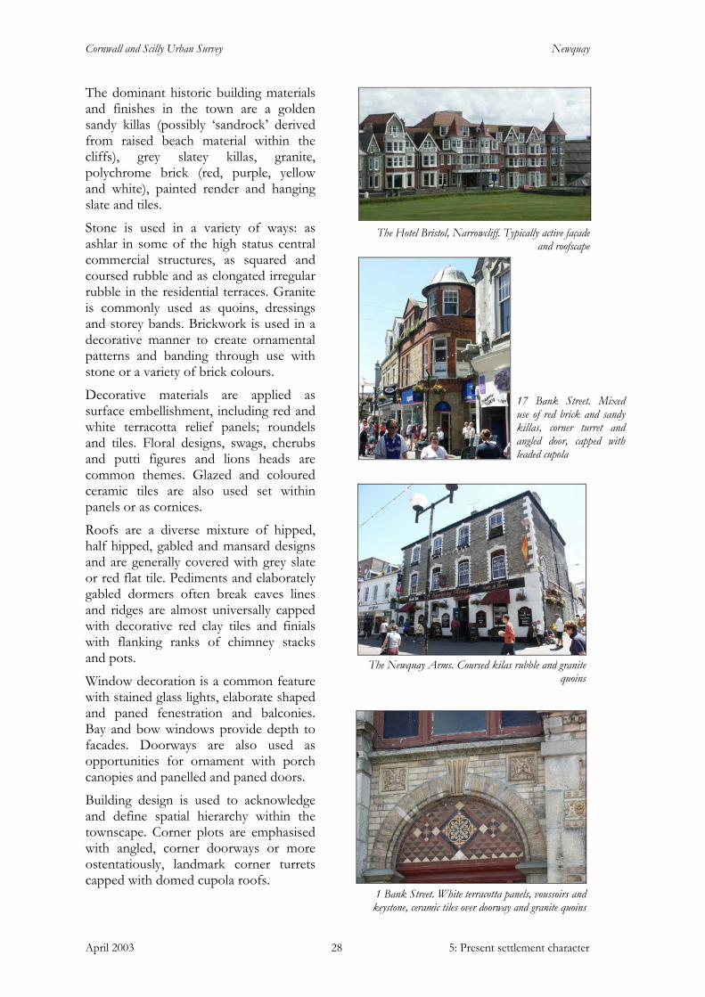
The semi-detached and terraced, middle class villa has also not survived well in its original form. Many of these properties, common throughout the town, for example along East Street and Cliff Street, have been converted into guesthouses and secondary retail units. Their original enclosed front gardens are frequently now used as car parks and display forecourts.
Architecture, materials, and detail Newquay’s built environment is characterised by the wide variety of materials, architectural design and high level of detail and ornamentation seen throughout the town. Its architecture has a distinctly ‘resort’ nature, shown in the sheer scale of some of the cliff top hotels, the flamboyant bay windowed facades and gabled dormer roofscapes of the crescents and avenues, the pastel painted shades of the more modest residences along Fore Street and the ornate and lavish terracotta panels, roundels, cornices and ceramic tiles of the urban structures in the central core.
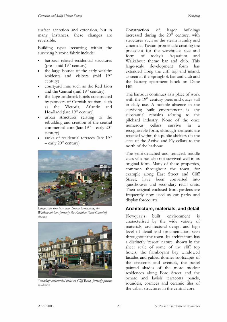
Large-scale structure near Towan promenade, the Walkabout bar, formerly the Pavillion (later Camelot) cinema.
Secondary commercial units on Cliff Road, formerly private residences
Cornwall and Scilly Urban Survey Newquay
April 2003 5: Present settlement character 28
The dominant historic building materials and finishes in the town are a golden sandy killas (possibly ‘sandrock’ derived from raised beach material within the cliffs), grey slatey killas, granite, polychrome brick (red, purple, yellow and white), painted render and hanging slate and tiles.
Stone is used in a variety of ways: as ashlar in some of the high status central commercial structures, as squared and coursed rubble and as elongated irregular rubble in the residential terraces. Granite is commonly used as quoins, dressings and storey bands. Brickwork is used in a decorative manner to create ornamental patterns and banding through use with stone or a variety of brick colours.
Decorative materials are applied as surface embellishment, including red and white terracotta relief panels; roundels and tiles. Floral designs, swags, cherubs and putti figures and lions heads are common themes. Glazed and coloured ceramic tiles are also used set within panels or as cornices.
Roofs are a diverse mixture of hipped, half hipped, gabled and mansard designs and are generally covered with grey slate or red flat tile. Pediments and elaborately gabled dormers often break eaves lines and ridges are almost universally capped with decorative red clay tiles and finials with flanking ranks of chimney stacks and pots.
Window decoration is a common feature with stained glass lights, elaborate shaped and paned fenestration and balconies. Bay and bow windows provide depth to facades. Doorways are also used as opportunities for ornament with porch canopies and panelled and paned doors.
Building design is used to acknowledge and define spatial hierarchy within the townscape. Corner plots are emphasised with angled, corner doorways or more ostentatiously, landmark corner turrets capped with domed cupola roofs.
1 Bank Street. White terracotta panels, voussoirs and keystone, ceramic tiles over doorway and granite quoins
The Hotel Bristol, Narrowcliff. Typically active façade
and roofscape
17 Bank Street. Mixed use of red brick and sandy killas, corner turret and angled door, capped with leaded cupola
The Newquay Arms. Coursed kilas rubble and granite
quoins
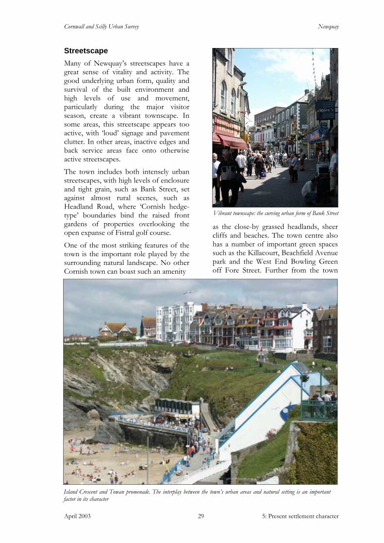
Cornwall and Scilly Urban Survey Newquay
April 2003 5: Present settlement character 29
Streetscape Many of Newquay’s streetscapes have a great sense of vitality and activity. The good underlying urban form, quality and survival of the built environment and high levels of use and movement, particularly during the major visitor season, create a vibrant townscape. In some areas, this streetscape appears too active, with ‘loud’ signage and pavement clutter. In other areas, inactive edges and back service areas face onto otherwise active streetscapes.
The town includes both intensely urban streetscapes, with high levels of enclosure and tight grain, such as Bank Street, set against almost rural scenes, such as Headland Road, where ‘Cornish hedge-type’ boundaries bind the raised front gardens of properties overlooking the open expanse of Fistral golf course.
One of the most striking features of the town is the important role played by the surrounding natural landscape. No other Cornish town can boast such an amenity
as the close-by grassed headlands, sheer cliffs and beaches. The town centre also has a number of important green spaces such as the Killacourt, Beachfield Avenue park and the West End Bowling Green off Fore Street. Further from the town
Vibrant townscape: the curving urban form of Bank Street
Island Crescent and Towan promenade. The interplay between the town’s urban areas and natural setting is an important factor in its character
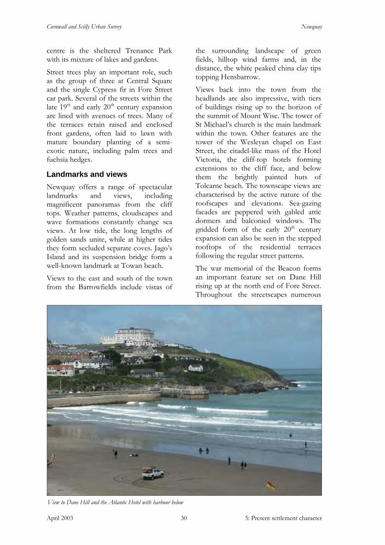
Cornwall and Scilly Urban Survey Newquay
April 2003 5: Present settlement character 30
centre is the sheltered Trenance Park with its mixture of lakes and gardens.
Street trees play an important role, such as the group of three at Central Square and the single Cypress fir in Fore Street car park. Several of the streets within the late 19th and early 20th century expansion are lined with avenues of trees. Many of the terraces retain raised and enclosed front gardens, often laid to lawn with mature boundary planting of a semi-exotic nature, including palm trees and fuchsia hedges.
Landmarks and views Newquay offers a range of spectacular landmarks and views, including magnificent panoramas from the cliff tops. Weather patterns, cloudscapes and wave formations constantly change sea views. At low tide, the long lengths of golden sands unite, while at higher tides they form secluded separate coves. Jago’s Island and its suspension bridge form a well-known landmark at Towan beach.
Views to the east and south of the town from the Barrowfields include vistas of
the surrounding landscape of green fields, hilltop wind farms and, in the distance, the white peaked china clay tips topping Hensbarrow.
Views back into the town from the headlands are also impressive, with tiers of buildings rising up to the horizon of the summit of Mount Wise. The tower of St Michael’s church is the main landmark within the town. Other features are the tower of the Wesleyan chapel on East Street, the citadel-like mass of the Hotel Victoria, the cliff-top hotels forming extensions to the cliff face, and below them the brightly painted huts of Tolcarne beach. The townscape views are characterised by the active nature of the roofscapes and elevations. Sea-gazing facades are peppered with gabled attic dormers and balconied windows. The gridded form of the early 20th century expansion can also be seen in the stepped rooftops of the residential terraces following the regular street patterns.
The war memorial of the Beacon forms an important feature set on Dane Hill rising up at the north end of Fore Street. Throughout the streetscapes numerous
View to Dane Hill and the Atlantic Hotel with harbour below

Cornwall and Scilly Urban Survey Newquay
April 2003 5: Present settlement character 31
other buildings have landmark architectural details, such as the copper-covered, domed corner turrets within the commercial core.
The character areas
1: Central commercial core
(Fig 7 and character area summary sheet 1)
The Central Square area is the historic heart of the town and its principal commercial area. It is the most densely urban area of the town, redeveloped in the late 19th and early 20th centuries. Its strong underlying urban form is based on a level, curving main street flanked by a diverse range of towering high quality historic buildings notable for their ostentatious design, detailing and surface decoration.
This area was the nucleus of the fishing village of Towan Blystra, but was completely redeveloped in the late 19th and early 20th century. Now the central commercial core of the town, Bank Street, Central Square and Fore Street form the main commercial axis, curving along the contour, skirting the upper edge of the valley coombe.
The connections between this area and the rest of the town generally involve lengthy and linear approaches along the cliff top. Connections with the rising terrain to the south are relatively limited with narrow opeways playing an important role in pedestrian movement. The redundant mineral tramway (now Manor Road) effectively cuts this commercial area off from the hinterland of tiered car parks and residential streets.
Central Square, originally an open square later partially infilled, now survives as a triangular road junction. The landmark of the Central public house encloses the western edge and the space is softened by a number of street trees in the pub’s
forecourt. The area’s character as a public open space is currently compromised due to domination by traffic and the commercial flow from Bank Street to Fore Street. The segregation of the pub forecourt further fragments the area.
The quality and survival of the historic built environment complements the area’s excellent underlying urban form. The structures lining the roads are generally of three and four storeys and tower over the curving street below. Sited hard onto the back edge of the pavement the structures form a continuous, if slightly staggered, build line. There is a strong sense of enclosure and urban containment with the ‘big-skies’ common in other core areas of the town absent here. The architectural richness of the area sets it apart from other areas of the town. The variety of architectural design, mix of materials, surface finishes and degree of ornamentation means that structures that in other settlements would be isolated landmark buildings are here set side by side. The majority of the structures are on a grand scale in terms of architectural design and size, examples include bank buildings (for example, 9 Bank Street), the shops and department stores (such as 33-41 Bank Street), developments designed to house a number of stores (such as 2-6 Fore Street) and large commercial premises, such as 1 Bank Street.
Interspersed with these elaborate structures there are also more modest
Central Square, the historic heart of the town
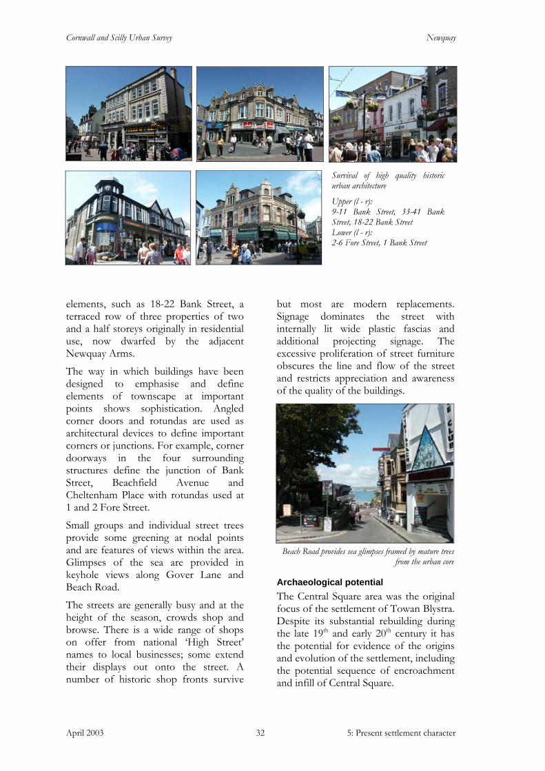
Cornwall and Scilly Urban Survey Newquay
April 2003 5: Present settlement character 32
elements, such as 18-22 Bank Street, a terraced row of three properties of two and a half storeys originally in residential use, now dwarfed by the adjacent Newquay Arms.
The way in which buildings have been designed to emphasise and define elements of townscape at important points shows sophistication. Angled corner doors and rotundas are used as architectural devices to define important corners or junctions. For example, corner doorways in the four surrounding structures define the junction of Bank Street, Beachfield Avenue and Cheltenham Place with rotundas used at 1 and 2 Fore Street.
Small groups and individual street trees provide some greening at nodal points and are features of views within the area. Glimpses of the sea are provided in keyhole views along Gover Lane and Beach Road.
The streets are generally busy and at the height of the season, crowds shop and browse. There is a wide range of shops on offer from national ‘High Street’ names to local businesses; some extend their displays out onto the street. A number of historic shop fronts survive
but most are modern replacements. Signage dominates the street with internally lit wide plastic fascias and additional projecting signage. The excessive proliferation of street furniture obscures the line and flow of the street and restricts appreciation and awareness of the quality of the buildings.
Archaeological potential The Central Square area was the original focus of the settlement of Towan Blystra. Despite its substantial rebuilding during the late 19th and early 20th century it has the potential for evidence of the origins and evolution of the settlement, including the potential sequence of encroachment and infill of Central Square.
Survival of high quality historic urban architecture
Upper (l - r): 9-11 Bank Street, 33-41 Bank Street, 18-22 Bank Street Lower (l - r): 2-6 Fore Street, 1 Bank Street
Beach Road provides sea glimpses framed by mature trees from the urban core
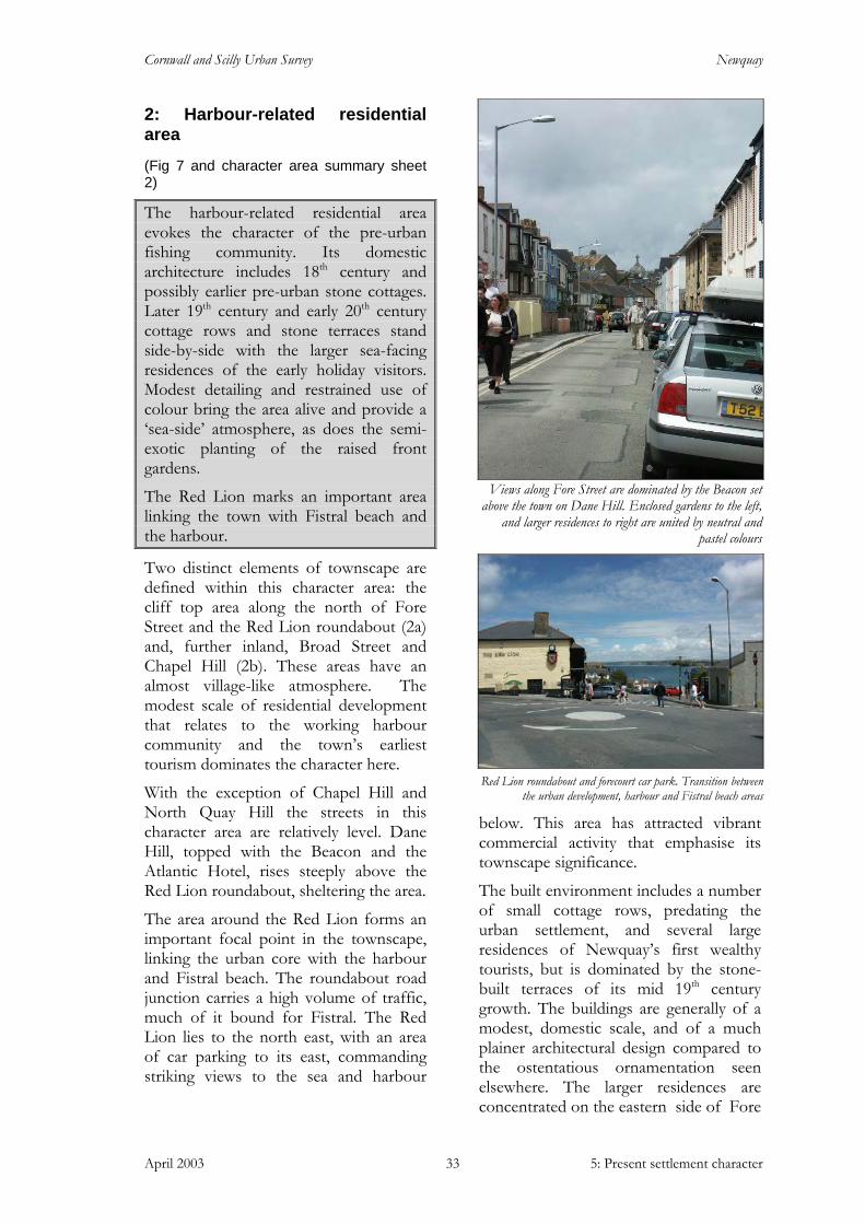
Cornwall and Scilly Urban Survey Newquay
April 2003 5: Present settlement character 33
2: Harbour-related residential area
(Fig 7 and character area summary sheet 2)
The harbour-related residential area evokes the character of the pre-urban fishing community. Its domestic architecture includes 18th century and possibly earlier pre-urban stone cottages. Later 19th century and early 20th century cottage rows and stone terraces stand side-by-side with the larger sea-facing residences of the early holiday visitors. Modest detailing and restrained use of colour bring the area alive and provide a ‘sea-side’ atmosphere, as does the semi-exotic planting of the raised front gardens.
The Red Lion marks an important area linking the town with Fistral beach and the harbour.
Two distinct elements of townscape are defined within this character area: the cliff top area along the north of Fore Street and the Red Lion roundabout (2a) and, further inland, Broad Street and Chapel Hill (2b). These areas have an almost village-like atmosphere. The modest scale of residential development that relates to the working harbour community and the town’s earliest tourism dominates the character here.
With the exception of Chapel Hill and North Quay Hill the streets in this character area are relatively level. Dane Hill, topped with the Beacon and the Atlantic Hotel, rises steeply above the Red Lion roundabout, sheltering the area.
The area around the Red Lion forms an important focal point in the townscape, linking the urban core with the harbour and Fistral beach. The roundabout road junction carries a high volume of traffic, much of it bound for Fistral. The Red Lion lies to the north east, with an area of car parking to its east, commanding striking views to the sea and harbour
below. This area has attracted vibrant commercial activity that emphasise its townscape significance.
The built environment includes a number of small cottage rows, predating the urban settlement, and several large residences of Newquay’s first wealthy tourists, but is dominated by the stone-built terraces of its mid 19th century growth. The buildings are generally of a modest, domestic scale, and of a much plainer architectural design compared to the ostentatious ornamentation seen elsewhere. The larger residences are concentrated on the eastern side of Fore
Views along Fore Street are dominated by the Beacon set
above the town on Dane Hill. Enclosed gardens to the left, and larger residences to right are united by neutral and
pastel colours
Red Lion roundabout and forecourt car park. Transition between
the urban development, harbour and Fistral beach areas

Cornwall and Scilly Urban Survey Newquay
April 2003 5: Present settlement character 34
Street, enjoying the spectacular Atlantic and harbour views. The coastal elevations of these properties are used as the main facades, the rear Fore Street elevations, maintaining the modest character of the architecture here.
The dominant building material in this area is slatey grey killas laid as elongated irregular rubble. In some buildings it is left exposed but many have painted or rendered surface finishes, favouring neutral and pastel shades. Buildings are generally of two storeys, with eaves heights varying between the terraces and cottage rows. Plot widths vary and, within the terrace developments, single fronted and double fronted structures stand side by side.
Although the level of ornamentation is restrained, detailing is still a notable feature. Window and door dressings offer possibilities for decoration, with red brick providing further colour, stone cut voussoirs and, on several windows of the Fort, keystones with moulded lintel dripstones. Windows are generally flat or segmental headed, with two and four pane sashes common. Bay windows, oriel windows and double storey bay projections give depth to elevations. Porches are also common features, ranging from simple gabled hoods over doorways to ornate wooden structures. Bright colours are sparingly used to highlight these architectural details. Combined with sunshine, this restrained use of bright colour and the pastel shades of the rendered structures give a distinctly seaside feel to the area.
On the eastern side of Fore Street, buildings are set hard on the back edge of the pavement while, on the western side, and in most other streets, houses are set back from the road, with small enclosed front gardens bounded by rendered and capped low walls incorporating gates and gate posts. Along the west side of Fore Street the buildings and front gardens are slightly raised from the roadside. Few gates survive, revealing the stepped paths
The east side of Fore Street includes pre-urban cottages, in foreground, with larger residences further along the road
Mid – late 19th century terraces, of slatey grey killas laid as elongated irregular rubble. The streetscape includes double and single fronted facades
Porch detail and sophisticated use of colour, Belmont Place

Cornwall and Scilly Urban Survey Newquay
April 2003 5: Present settlement character 35
leading to front doors and emphasising the elevated position. These gardens provide much of the greenery in this area, with some palm trees, medium sized shrubs and brightly coloured flowers planted around small lawns.
The continuous enclosure of Fore Street reinforces the linear nature of the underlying urban form and presents a sense of progression towards a destination. The road is often busy with groups walking to and from the beach and the town centre, especially in summer. This high level of activity and the active elevations of the houses make the area feel like a vital part of the town despite its predominantly private residential use.
Views seaward are blocked by buildings and instead the eye is drawn to the north, upwards to the Beacon and Dane Hill and south into the commercial shopping areas of town.
Archaeological potential This largely residential area contains the oldest surviving domestic structures in the town and it would be beneficial to research and record these buildings to better understand the pre-urban nature of the town.
Although now largely of residential and secondary commercial use, the area was previously used for industrial activities associated with the fishing industry. Specific sites of archaeological potential in this character area include the sites of the Toby and the Rose fish cellars.
3: The Harbour (Fig 7 and character area summary sheet 3)
The harbour forms a secluded and sheltered, inward looking space set apart from the surrounding bustle of the town. The cliff face and rubble revetment wall surrounding it on the landward side provides a strong sense of enclosure, extended by the overlooking properties of Fore Street and Dane Hill. It is still a working environment, with a fishing fleet of brightly coloured boats and collections of lobster pots and plastic crates stacked along the pier arms. The built environment is a mix of robust stone - built historic structures and more temporary timber framed buildings.
The harbour is one of the most important elements of the townscape. It is still a place of work, with a fishing fleet and tourist-related craft. The Royal National Lifeboat Institution (RNLI) boathouse and gift shop, gig clubhouse, seaman’s mission, restaurant and other fishing and diving related businesses populate the quaysides.
The surrounding topography of the harbour is dramatic. Set in a natural cove, it is surrounded to the west and south by sheer bedrock cliffs and rubble-built revetment walls, covered in lush green foliage during the summer. Above the cliffs stand large residences on the east side of Fore Street and tiers of buildings on the southern slopes of Dane Hill. The
Newquay harbour, overlooked by Fore Street and Dane Hill properties, also offers a sheltered family beach
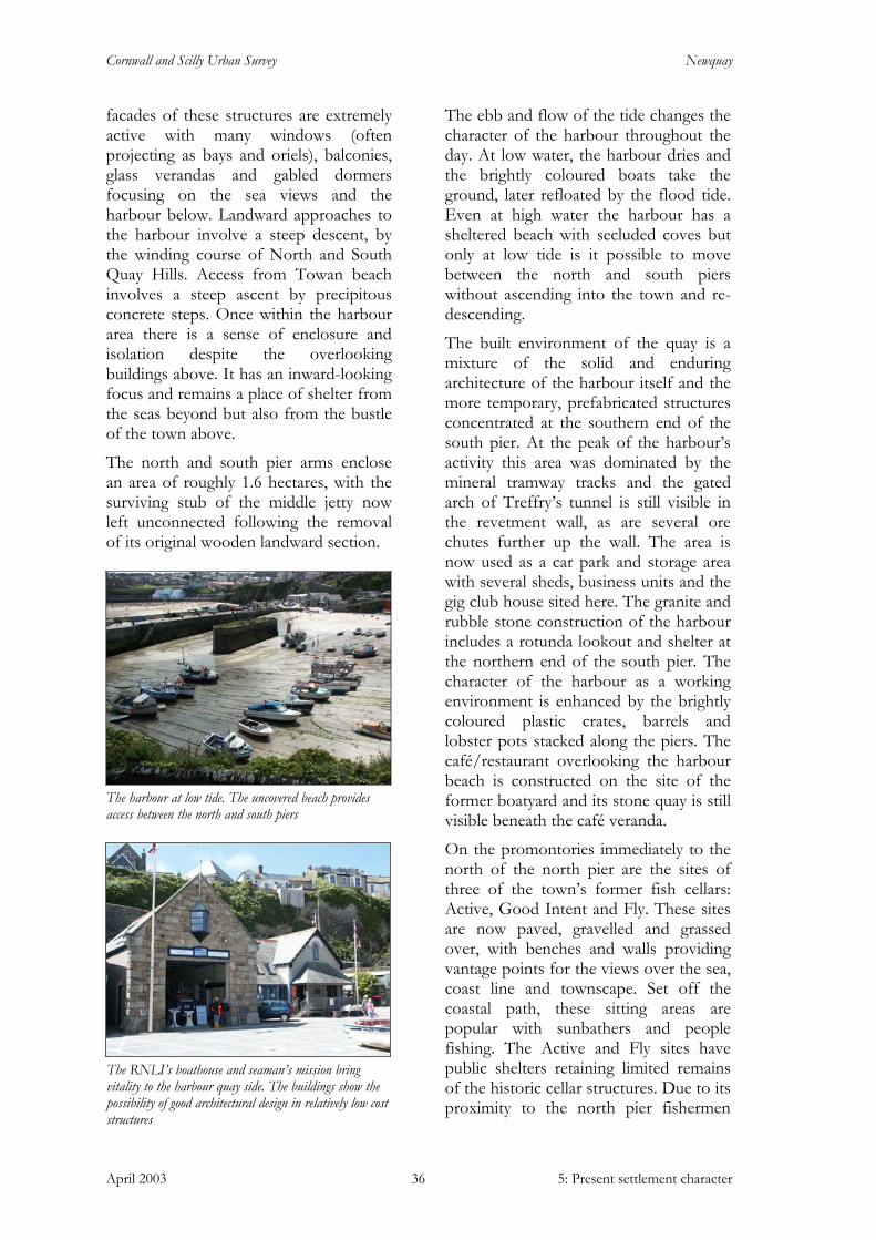
Cornwall and Scilly Urban Survey Newquay
April 2003 5: Present settlement character 36
facades of these structures are extremely active with many windows (often projecting as bays and oriels), balconies, glass verandas and gabled dormers focusing on the sea views and the harbour below. Landward approaches to the harbour involve a steep descent, by the winding course of North and South Quay Hills. Access from Towan beach involves a steep ascent by precipitous concrete steps. Once within the harbour area there is a sense of enclosure and isolation despite the overlooking buildings above. It has an inward-looking focus and remains a place of shelter from the seas beyond but also from the bustle of the town above.
The north and south pier arms enclose an area of roughly 1.6 hectares, with the surviving stub of the middle jetty now left unconnected following the removal of its original wooden landward section.
The ebb and flow of the tide changes the character of the harbour throughout the day. At low water, the harbour dries and the brightly coloured boats take the ground, later refloated by the flood tide. Even at high water the harbour has a sheltered beach with secluded coves but only at low tide is it possible to move between the north and south piers without ascending into the town and re-descending.
The built environment of the quay is a mixture of the solid and enduring architecture of the harbour itself and the more temporary, prefabricated structures concentrated at the southern end of the south pier. At the peak of the harbour’s activity this area was dominated by the mineral tramway tracks and the gated arch of Treffry’s tunnel is still visible in the revetment wall, as are several ore chutes further up the wall. The area is now used as a car park and storage area with several sheds, business units and the gig club house sited here. The granite and rubble stone construction of the harbour includes a rotunda lookout and shelter at the northern end of the south pier. The character of the harbour as a working environment is enhanced by the brightly coloured plastic crates, barrels and lobster pots stacked along the piers. The café/restaurant overlooking the harbour beach is constructed on the site of the former boatyard and its stone quay is still visible beneath the café veranda.
On the promontories immediately to the north of the north pier are the sites of three of the town’s former fish cellars: Active, Good Intent and Fly. These sites are now paved, gravelled and grassed over, with benches and walls providing vantage points for the views over the sea, coast line and townscape. Set off the coastal path, these sitting areas are popular with sunbathers and people fishing. The Active and Fly sites have public shelters retaining limited remains of the historic cellar structures. Due to its proximity to the north pier fishermen
The RNLI’s boathouse and seaman’s mission bring vitality to the harbour quay side. The buildings show the possibility of good architectural design in relatively low cost structures
The harbour at low tide. The uncovered beach provides access between the north and south piers

Cornwall and Scilly Urban Survey Newquay
April 2003 5: Present settlement character 37
also use Active as a storage area for fishing equipment.
Archaeological potential The harbour area and adjacent fish cellar sites have a high industrial archaeological potential. Evidence of the earliest quay may exist, as well as further information regarding the trading and pilchard industry of the town. Physical remains of these activities are visible, such as the stone built quay of the harbour boat yard below the modern café/restaurant and the concrete cast stairs and stone cut quay at the site of the Fly fish cellar. Other little understood elements relating to the industrial use of this area are also visible in the surrounding undergrowth. An audit and survey of the physical, above - ground remains in the area would yield further discoveries and add to understanding and knowledge of the working harbour.
4: Industrial area (Fig 7 and character area summary sheet 4)
Several dispersed areas retain an industrial character, mostly linked to the workings of the harbour and the mineral tramway but also to mining and municipal service provision.
Characteristics of this area include large scale buildings and land plots. Surviving features relating to former industrial use include enclosed courtyards and upper floor loading doors.
Some areas have experienced erosion through demolition or underdevelopment, resulting in a substantial loss of urban grain.
The route of the mineral tramway continues to provide an important link between the town centre and the railway.
The town has a number of areas that retain an industrial character, often associated with the harbour and the mineral tramway.
• The area of the Whim (4a), now a supermarket
• Wesley Yard and the upper extent of St George’s Road (4b) previously bounded by the tramway
• Land around the railway station (4c) • The site of the former silver and lead
mine on the summit of Mount Wise (4d)
• The line of the tramway itself (4e)
The Whim area (4a) and railway station area (4c) are dominated by loss of urban grain. At the Whim this was caused by the demolition of terraces bounding the north and east, causing a loss of enclosure to the surrounding streetscapes. Around the railway land formerly used for related storage and as the town’s initial gas works has been largely left undeveloped and used primarily for un-landscaped car parks.
The site of the Active fish cellar. The current public shelter incorporates elements of the historic structure. The area is also used for harbour related storage
The robust granite architecture of the harbour shelter, south pier. Plastic crates and trailer reflect the working nature of the area
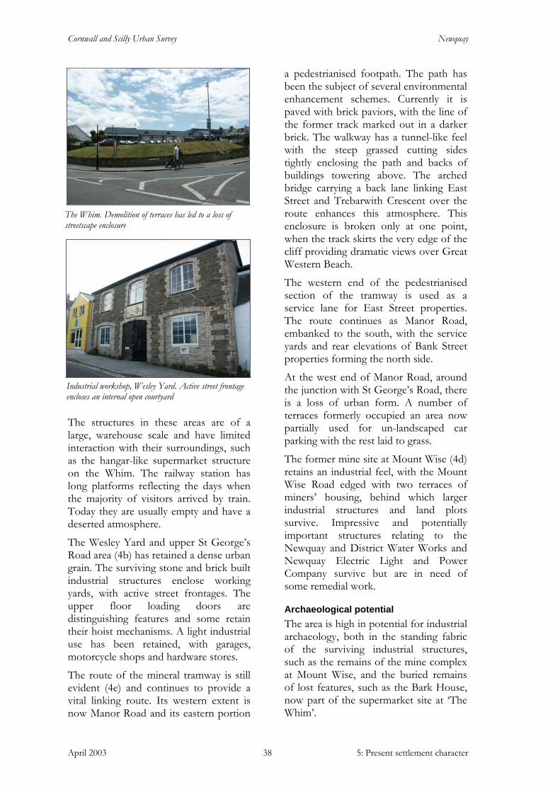
Cornwall and Scilly Urban Survey Newquay
April 2003 5: Present settlement character 38
The structures in these areas are of a large, warehouse scale and have limited interaction with their surroundings, such as the hangar-like supermarket structure on the Whim. The railway station has long platforms reflecting the days when the majority of visitors arrived by train. Today they are usually empty and have a deserted atmosphere.
The Wesley Yard and upper St George’s Road area (4b) has retained a dense urban grain. The surviving stone and brick built industrial structures enclose working yards, with active street frontages. The upper floor loading doors are distinguishing features and some retain their hoist mechanisms. A light industrial use has been retained, with garages, motorcycle shops and hardware stores.
The route of the mineral tramway is still evident (4e) and continues to provide a vital linking route. Its western extent is now Manor Road and its eastern portion
a pedestrianised footpath. The path has been the subject of several environmental enhancement schemes. Currently it is paved with brick paviors, with the line of the former track marked out in a darker brick. The walkway has a tunnel-like feel with the steep grassed cutting sides tightly enclosing the path and backs of buildings towering above. The arched bridge carrying a back lane linking East Street and Trebarwith Crescent over the route enhances this atmosphere. This enclosure is broken only at one point, when the track skirts the very edge of the cliff providing dramatic views over Great Western Beach.
The western end of the pedestrianised section of the tramway is used as a service lane for East Street properties. The route continues as Manor Road, embanked to the south, with the service yards and rear elevations of Bank Street properties forming the north side.
At the west end of Manor Road, around the junction with St George’s Road, there is a loss of urban form. A number of terraces formerly occupied an area now partially used for un-landscaped car parking with the rest laid to grass.
The former mine site at Mount Wise (4d) retains an industrial feel, with the Mount Wise Road edged with two terraces of miners’ housing, behind which larger industrial structures and land plots survive. Impressive and potentially important structures relating to the Newquay and District Water Works and Newquay Electric Light and Power Company survive but are in need of some remedial work.
Archaeological potential The area is high in potential for industrial archaeology, both in the standing fabric of the surviving industrial structures, such as the remains of the mine complex at Mount Wise, and the buried remains of lost features, such as the Bark House, now part of the supermarket site at ‘The Whim’.
The Whim. Demolition of terraces has led to a loss of streetscape enclosure
Industrial workshop, Wesley Yard. Active street frontage encloses an internal open courtyard

Cornwall and Scilly Urban Survey Newquay
April 2003 5: Present settlement character 39
5: Secondary commercial west – lower Fore Street, Gover Lane, Beach Road (Fig 7 and character area summary sheet 5)
This area is a transitional zone between the commercial core and the harbour-related residential area. Now in secondary retail use, structures are of a residential scale but retain high levels of architectural detailing. Roads, pavements and plot widths are wider than in the densely packed commercial core and sea views are provided by breaks in the streetscape. There are a number of good surviving historic shop fronts and architectural details such as iron railed balconies. Later 20th century suburban-style buildings and ‘stage-set’ shop fronts mask the quality of the surviving historic environment.
The lower Fore Street area forms a transitional character area between the central commercial core and the harbour-related residential area. It displays a blend of character elements seen in these two areas. Formerly predominantly residential; today it is dominated by secondary commercial use.
The sense of urban enclosure here is less tightly defined than that of the central core, with wider road and pavement widths, a rising topography (northwards). The smaller - scale buildings allow views to the sky and the wider plot widths create a slower rhythm within the street compared to the commercial core. Breaks in streetscape enclosure, such as at the car park overlooking the bowling green, provide views out of the densely built up urban core to the sea. The single Cypress Fir now standing within Fore Street car park softens views to the north.
The built environment shows a blend of elements, with smaller, domestic-scaled buildings displaying high levels of architectural detailing. There are also isolated examples of larger - scale buildings with a level of detailing that
would not be out of place in the central core. Predominantly of two storeys, many of the structures have gabled dormers lighting attic rooms. Survival is not as comprehensive as in the central core, with later 20th century structures having an impact on the streetscape. These buildings have a more suburban character with less detailing, less fluid lines and materials such as grey pebble dash rendering. Towards the southern end of Fore Street there are a number of good surviving historic shop fronts. Generally upper floor detailing has survived better than ground floor fittings, with some ornate cast iron railed balconies taking advantage of the sea views. Painted render and pebble dash are predominant surface finishes. The same use of colour is seen here as in the harbour-related residential area with pastels and neutrals
Views north into Fore Street are more open to the sky with
a less tightly defined urban enclosure. The single Cypress Fir provides an important focal point within the streetscape
Transitional character; smaller scaled buildings retain high
levels of architectural detail. Survival of historic shop fronts, cast iron balconies and oriel window are notable
features.
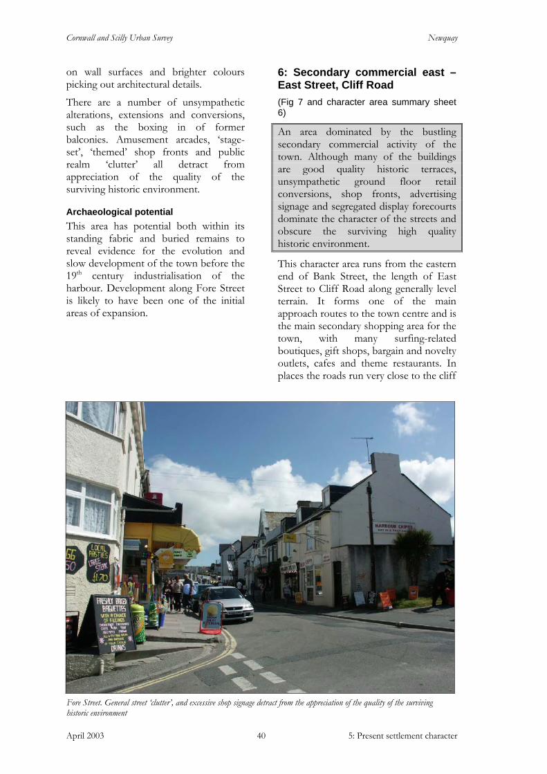
Cornwall and Scilly Urban Survey Newquay
April 2003 5: Present settlement character 40
on wall surfaces and brighter colours picking out architectural details.
There are a number of unsympathetic alterations, extensions and conversions, such as the boxing in of former balconies. Amusement arcades, ‘stage-set’, ‘themed’ shop fronts and public realm ‘clutter’ all detract from appreciation of the quality of the surviving historic environment.
Archaeological potential This area has potential both within its standing fabric and buried remains to reveal evidence for the evolution and slow development of the town before the 19th century industrialisation of the harbour. Development along Fore Street is likely to have been one of the initial areas of expansion.
6: Secondary commercial east – East Street, Cliff Road (Fig 7 and character area summary sheet 6)
An area dominated by the bustling secondary commercial activity of the town. Although many of the buildings are good quality historic terraces, unsympathetic ground floor retail conversions, shop fronts, advertising signage and segregated display forecourts dominate the character of the streets and obscure the surviving high quality historic environment.
This character area runs from the eastern end of Bank Street, the length of East Street to Cliff Road along generally level terrain. It forms one of the main approach routes to the town centre and is the main secondary shopping area for the town, with many surfing-related boutiques, gift shops, bargain and novelty outlets, cafes and theme restaurants. In places the roads run very close to the cliff
Fore Street. General street ‘clutter’, and excessive shop signage detract from the appreciation of the quality of the surviving historic environment
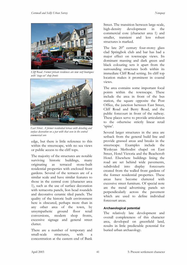
Cornwall and Scilly Urban Survey Newquay
April 2003 5: Present settlement character 41
edge, but there is little reference to this within the streetscape, with no sea views or public access to the cliff tops.
The majority of the structures are notable surviving historic buildings, many originating as terraced stone-built residential properties with enclosed front gardens. Several of the terraces are of a similar scale and have similar features to those in the central core (character area 1), such as the use of surface decoration with terracotta panels, lion head roundels and decorative ceramic tiled panels. The quality of the historic built environment here is obscured, perhaps more than in any other area of the town, by unsympathetic ground floor retail conversions, modern shop fronts, excessive signage and general street clutter.
There are a number of temporary and small-scale structures, with a concentration at the eastern end of Bank
Street. The transition between large-scale, high-density development in the commercial core (character area 1) and smaller, transient and less robust structures is marked.
The late 20th century four-storey glass clad Springbok club and bar has had a major effect on townscape views. Its dominant massing and dark green and black colouring sets it apart from the surrounding structures both within its immediate Cliff Road setting. Its cliff top location makes it prominent in coastal views.
The area contains some important focal points within the townscape. These include the area in front of the bus station, the square opposite the Post Office, the junction between East Street, Cliff Road and Berry Road, and the public forecourt in front of the railway. These places serve to provide articulation to the otherwise strictly linear retail ‘spine’.
Several larger structures in the area are setback from the general build line and provide grassed areas and breaks in the streetscape. Examples include the Wesleyan Methodist chapel on East Street, Hotel Victoria and the Beachcroft Hotel. Elsewhere buildings lining the road are set behind wide pavements, subdivided into display forecourts created from the walled front gardens of the former residential properties. These areas have become cluttered with excessive street furniture. Of special note are the metal advertising panels set perpendicularly across the pavement which are used to define individual forecourt areas.
Archaeological potential The relatively late development and overall completeness of this character area, developed on greenfield land, results in little predictable potential for buried urban archaeology.
Cliff Road. Former private residences are now surf boutiques with ‘stage-set’ shop fronts
East Street. A former residential terrace with detailing and surface decoration on a par with that seen in the central commercial core

Cornwall and Scilly Urban Survey Newquay
April 2003 5: Present settlement character 42
7: Towan promenade and Killacourt (Fig 7 and character area summary sheet 7)
This early resort expansion area is the part of town that best combines Newquay’s coastal location and urban development, with good interaction between the two elements. The built environment is well planned to take full advantage of the spectacular setting, with crescent streets providing good underlying urban form and successfully enclosing and defining key areas such as the Killacourt. Towan Beach provides a sheltered beach, with Jago’s Island and suspension bridge forming one of the town’s best known features.
This area is set to the north of the commercial core of Bank Street and extends along the sea frontage from the harbour to Great Western beach. It was one of the first areas of the town to be developed as part of the late 19th / early 20th century resort expansion, having previously been the site of several fish cellars and open fields.
Although it is a mixed-use area, including some residential properties and retail units, it is dominated by the holiday resort aspect of the town. Many of the former private residences have been converted to small hotels and guesthouses. The area includes two important urban parks - the Killacourt and the Beachfield Avenue park - and the town’s most central beach and promenade. This is the area of town that best relates the built environment to the town’s coastal setting, allowing easy access and views to both.
The built environment here is generally of terraced properties stepped along the gently sloping terrain, descending to the cliff edge. Generally of two or three storeys, with attic rooms lit by gabled dormers, the terrace frontages are extremely active and orientated towards the sea. Slightly curving crescent street
forms are used to good advantage here, some (such as Trebarwith Crescent) following the contour. The Crescent steps down the terrain providing excellent enclosure to both the cliff top and the western side of the Killacourt.
This area has a number of large - scale structures, particularly the Walkabout bar and Blue Reef Aquarium at Towan promenade and the late 20th century blocks of flats surrounding the Killacourt to the south and east. The scale of these structures recalls the former industrial fish cellars, steam laundry and the cinema that once stood here.
The Killacourt is an important feature in townscape views and provides stunning views overlooking Towan Beach, with the spectacular twisted mass of Jago’s Island, below. Towan Beach and its promenade provide a family friendly beach close to the town centre with large expanses of sand exposed at low tide.
Large –scale structures include the Blue Reef Aquarium
and the Walkabout on Towan promenade
Terraced buildings, formerly private residences now small
hotels and guesthouses surrounding the park at Beachfield Avenue
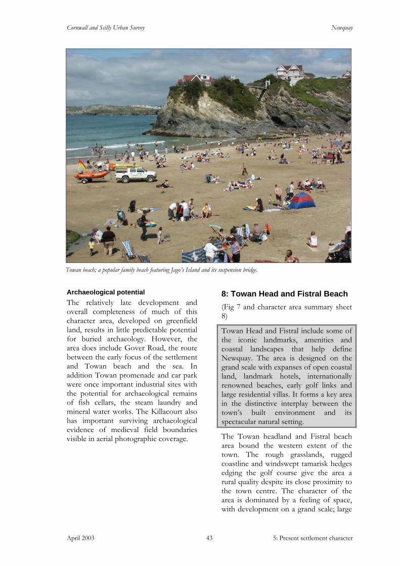
Cornwall and Scilly Urban Survey Newquay
April 2003 5: Present settlement character 43
Archaeological potential The relatively late development and overall completeness of much of this character area, developed on greenfield land, results in little predictable potential for buried archaeology. However, the area does include Gover Road, the route between the early focus of the settlement and Towan beach and the sea. In addition Towan promenade and car park were once important industrial sites with the potential for archaeological remains of fish cellars, the steam laundry and mineral water works. The Killacourt also has important surviving archaeological evidence of medieval field boundaries visible in aerial photographic coverage.
8: Towan Head and Fistral Beach (Fig 7 and character area summary sheet 8)
Towan Head and Fistral include some of the iconic landmarks, amenities and coastal landscapes that help define Newquay. The area is designed on the grand scale with expanses of open coastal land, landmark hotels, internationally renowned beaches, early golf links and large residential villas. It forms a key area in the distinctive interplay between the town’s built environment and its spectacular natural setting.
The Towan headland and Fistral beach area bound the western extent of the town. The rough grasslands, rugged coastline and windswept tamarisk hedges edging the golf course give the area a rural quality despite its close proximity to the town centre. The character of the area is dominated by a feeling of space, with development on a grand scale; large
Towan beach; a popular family beach featuring Jago’s Island and its suspension bridge.

Cornwall and Scilly Urban Survey Newquay
April 2003 5: Present settlement character 44
expanses of open land, the impressive Headland and Atlantic hotels (both buildings designed by Silvanus Trevail), and a number of large residences, now mostly guesthouses, along Headland Road, Tower Road and the eastern slopes of Dane Hill overlooking the harbour.
The golf course, formerly common land, gradually slopes down to Fistral Beach. This is one of Newquay’s largest surfing beaches, enclosed by the twin promontories of Pentire Point and Towan Head. Dane Hill dominates the landward side of Towan Head with the Atlantic Hotel and the Beacon war memorial set along its ridge. The land slopes down to the Headland Hotel, rising again to the coastguard lookout set on the northern peak of the promontory.
This area affords some of the best views back into town, with the active seaward-facing building elevations a notable feature.
The built environment is characterised by its grand scale, active elevations and flamboyant and ostentatious architectural detailing, reflecting and taking advantage of the spectacular topography and seaside location. The terracotta panels, entrance turrets and pedimented projecting end wings of the Headland Hotel make it one of the most photographed and recognisable images of the town. The
gleaming white crenellated form of the Tower is another impressive feature viewed over the earthworks of the golf links.
The development along Headland Road seems strangely out of place, as if it is still waiting for the rest of the proposed common development to take place. ‘Cornish hedge – type’ boundaries retain the raised gardens fronting the buildings, and this has gone some way to integrating them with the surrounding natural environment. In keeping with the grand scale of this area, the roads and pavements are wide, accommodating often large groups of people processing between the beach and the town centre. The southern side of the road has recently been the subject of an environmental enhancement scheme to a modern and urban design. The road is lined with concrete spheres, with sandy coloured bound gravel pavement surfacing, stainless steel street furniture, street trees and surface inset lighting.
Archaeological potential This character area has proven significant archaeological potential with nationally significant prehistoric remains confirmed through excavation, geophysical survey and chance finds.
An Iron Age cist cemetery has been located, but its boundaries not yet
Headland Road; ostentatious development set amidst open common land (now golf links) bounded by tamarisk hedges

Cornwall and Scilly Urban Survey Newquay
April 2003 5: Present settlement character 45
defined, to the south of the golf course extending eastwards in the area of Tower Road and Crantock Street.
Important evidence of a late prehistoric and Romano-British settlement was recovered during an excavation undertaken by Cornwall Archaeological Unit in Atlantic Road in 1998.
Geophysical survey and aerial photography indicate the presence of other archaeological remains across the golf links; a concentration of earthworks and crop marks to the south west suggest a possible extension of the Atlantic Road settlement.
Within this character area there are actual and potential industrial remains relating to lead mining, Treffry’s ‘Harbour of Refuge’ and pilchard seining activity. Several ‘old shafts’ of Newquay Consols are shown on the 1st edition Ordnance Survey map of 1879 on what is now the golf course, with other possible explorations and shafts suggested by earthworks on the headland itself.
The important remains of Treffry’s failed second harbour venture of 1848-50 have further potential. Some dispersed masonry remains of the harbour arm survive, as does the partially back filled canal cut to connect the two harbours. The lime kiln required for the construction survives largely intact. These features could benefit from consolidation and interpretational presentation.
The area also contains the remains of Napoleonic and Second World War defences. The Beacon war memorial was a Napoleonic lookout and is possibly set upon an earlier beacon mound or Bronze Age barrow. The World War Two defences include gun emplacements and platforms, a gunpowder mill, a pill box and observation post.
9: Narrowcliff and Barrowfields (Fig 7 and character area summary sheet 9)
Cliff top development along Narrowcliff marks the eastern limit of the town’s historic extent. This area is dominated by large hotels with a number of surviving reminders of former private villa residences. The promenade above Tolcarne beach affords spectacular views in all directions. Many former villa front gardens are now used for hotel forecourt car and coach parking. The Barrowfields, one of the town’s surviving open grassland areas, provides a clear break in development between the historic urban core and the outlying settlements of Porth and St Columb Minor.
Narrowcliff runs along the cliff top and is level lying, with land rising gradually to the south and the undulating Barrowfields to the north. The sea and sky views stretch for miles and the town and its beaches present a stunning panorama. The development of this area was a progression of the town’s development along the coastal edge. The initial late 19th century development consisted of detached and semi-detached private villa residences constructed on the southern side of the road, with a promenade laid opposite and several steep flights of stairs installed on the cliff face to provide access to Tolcarne beach below.
During the early 20th century the villa properties were converted into guesthouses and hotels and extended and rebuilt, most beyond recognition. The road is now continuously lined on its southern side with hotels of three and four storeys. The massing of the structures is consistently large and imposing, and in distant views from the town centre they appear as one solid block of construction, with the constant roof heights following the very gradual undulations along the cliff top. In these views, the buildings appear to be built on
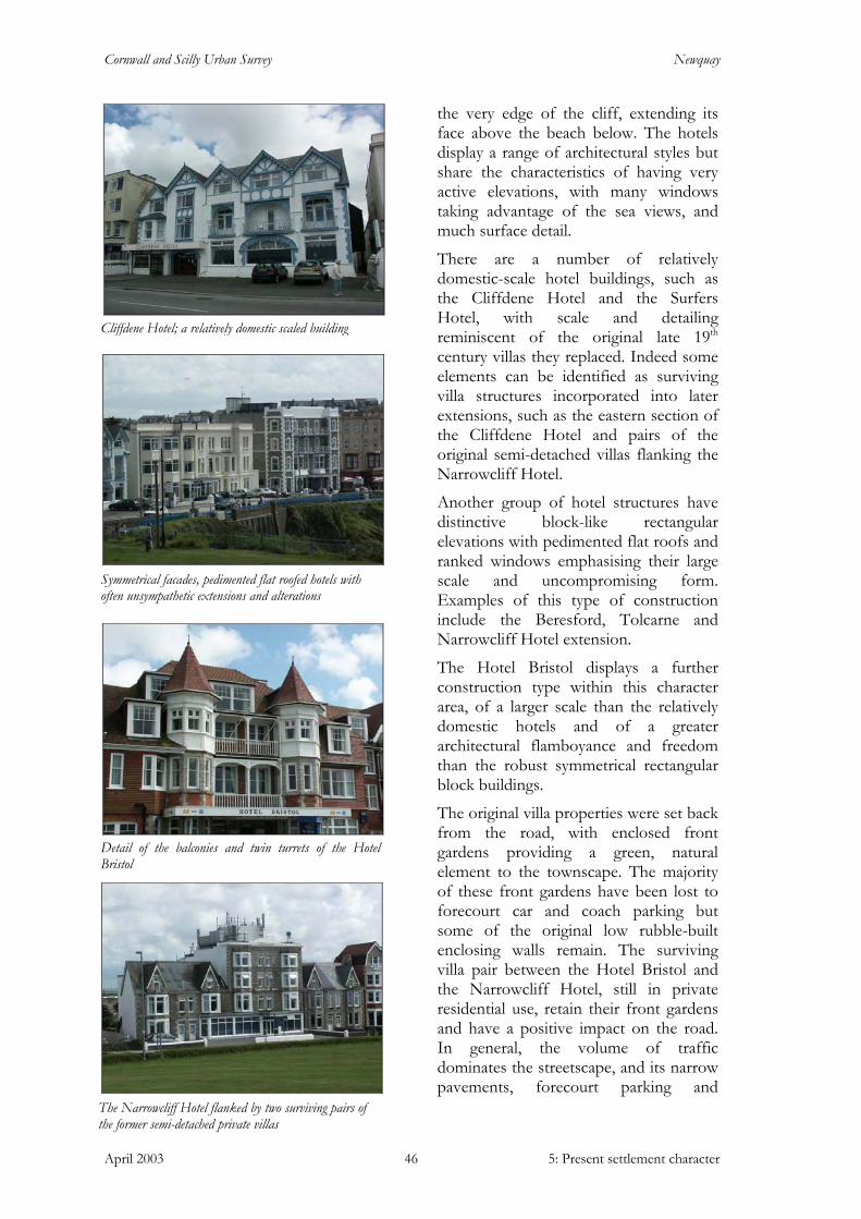
Cornwall and Scilly Urban Survey Newquay
April 2003 5: Present settlement character 46
the very edge of the cliff, extending its face above the beach below. The hotels display a range of architectural styles but share the characteristics of having very active elevations, with many windows taking advantage of the sea views, and much surface detail.
There are a number of relatively domestic-scale hotel buildings, such as the Cliffdene Hotel and the Surfers Hotel, with scale and detailing reminiscent of the original late 19th century villas they replaced. Indeed some elements can be identified as surviving villa structures incorporated into later extensions, such as the eastern section of the Cliffdene Hotel and pairs of the original semi-detached villas flanking the Narrowcliff Hotel.
Another group of hotel structures have distinctive block-like rectangular elevations with pedimented flat roofs and ranked windows emphasising their large scale and uncompromising form. Examples of this type of construction include the Beresford, Tolcarne and Narrowcliff Hotel extension.
The Hotel Bristol displays a further construction type within this character area, of a larger scale than the relatively domestic hotels and of a greater architectural flamboyance and freedom than the robust symmetrical rectangular block buildings.
The original villa properties were set back from the road, with enclosed front gardens providing a green, natural element to the townscape. The majority of these front gardens have been lost to forecourt car and coach parking but some of the original low rubble-built enclosing walls remain. The surviving villa pair between the Hotel Bristol and the Narrowcliff Hotel, still in private residential use, retain their front gardens and have a positive impact on the road. In general, the volume of traffic dominates the streetscape, and its narrow pavements, forecourt parking and
Symmetrical facades, pedimented flat roofed hotels with often unsympathetic extensions and alterations
Cliffdene Hotel; a relatively domestic scaled building
The Narrowcliff Hotel flanked by two surviving pairs of the former semi-detached private villas
Detail of the balconies and twin turrets of the Hotel Bristol
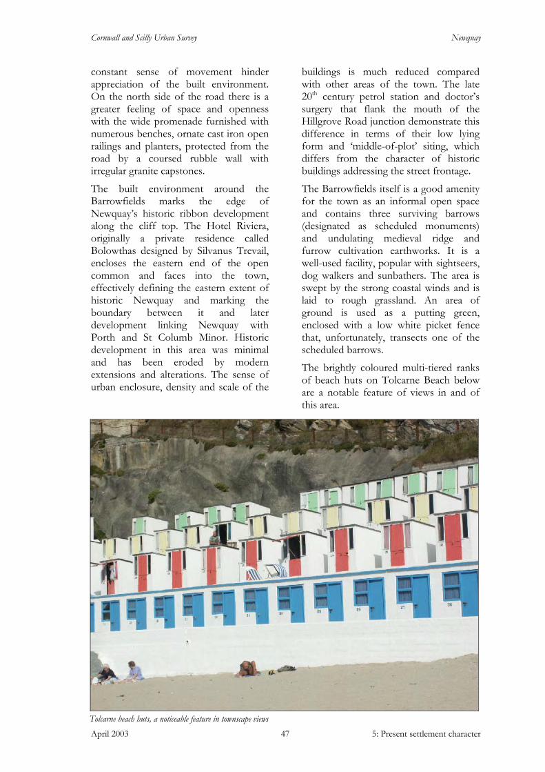
Cornwall and Scilly Urban Survey Newquay
April 2003 5: Present settlement character 47
constant sense of movement hinder appreciation of the built environment. On the north side of the road there is a greater feeling of space and openness with the wide promenade furnished with numerous benches, ornate cast iron open railings and planters, protected from the road by a coursed rubble wall with irregular granite capstones.
The built environment around the Barrowfields marks the edge of Newquay’s historic ribbon development along the cliff top. The Hotel Riviera, originally a private residence called Bolowthas designed by Silvanus Trevail, encloses the eastern end of the open common and faces into the town, effectively defining the eastern extent of historic Newquay and marking the boundary between it and later development linking Newquay with Porth and St Columb Minor. Historic development in this area was minimal and has been eroded by modern extensions and alterations. The sense of urban enclosure, density and scale of the
buildings is much reduced compared with other areas of the town. The late 20th century petrol station and doctor’s surgery that flank the mouth of the Hillgrove Road junction demonstrate this difference in terms of their low lying form and ‘middle-of-plot’ siting, which differs from the character of historic buildings addressing the street frontage.
The Barrowfields itself is a good amenity for the town as an informal open space and contains three surviving barrows (designated as scheduled monuments) and undulating medieval ridge and furrow cultivation earthworks. It is a well-used facility, popular with sightseers, dog walkers and sunbathers. The area is swept by the strong coastal winds and is laid to rough grassland. An area of ground is used as a putting green, enclosed with a low white picket fence that, unfortunately, transects one of the scheduled barrows.
The brightly coloured multi-tiered ranks of beach huts on Tolcarne Beach below are a notable feature of views in and of this area.
Tolcarne beach huts, a noticeable feature in townscape views

Cornwall and Scilly Urban Survey Newquay
April 2003 5: Present settlement character 48
Archaeological potential
The built environment of Narrowcliff is of late development on greenfield land, and results in little predictable potential for buried archaeology. Tolcarne quarry is of possible interest set in the hillside it created a terrace later used for the site of a theatre, now a café.
The Barrowfields is an area of high archaeological potential. Three Bronze Age barrows survive as standing monuments from a former group of about 17. Remains of the destroyed barrows and related features may survive below ground
In addition, the area contains the remains of medieval ridge and furrow cultivation. This is an unusual survival in lowland Cornwall almost entirely confined to marginal coastal areas.
Just to the south of the primary study area is the location of Tolcarne mine, with a single shaft shown on the 1879 OS map.
10: Residential area (Fig 7 and character area summary sheet 10)
A predominantly residential area defined by its loose grid plan form and close-set terraces. Properties step up the sloping topography of Mount Wise. The terraces have considerable architectural detailing with projecting bay windows, balconies, porches and gabled dormers common features. Situated close to the commercial core, an area of large plots, civic buildings and car parks is defined. Soft landscaping is provided by the enclosed front gardens and green spaces and street trees are important features of the area.
This area is predominantly in residential use and was developed during the late 19th / early 20th century expansion of the town. It is characterised by its loosely gridded plan form, laid out by the Urban District Council’s surveyor John Ennor, (remembered in Ennor’s Road). In general terms east-west roads run along the contours and the north-south routes
The Barrowfields denotes the eastern extent of the town’s historic growth and separates it from later development which merges with Porth and St Columb Minor
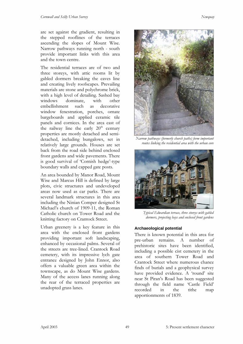
Cornwall and Scilly Urban Survey Newquay
April 2003 5: Present settlement character 49
are set against the gradient, resulting in the stepped rooflines of the terraces ascending the slopes of Mount Wise. Narrow pathways running north - south provide important links with this area and the town centre.
The residential terraces are of two and three storeys, with attic rooms lit by gabled dormers breaking the eaves line and creating lively roofscapes. Prevailing materials are stone and polychrome brick, with a high level of detailing. Sashed bay windows dominate, with other embellishment such as decorative window fenestration, porches, ornate bargeboards and applied ceramic tile panels and cornices. In the area east of the railway line the early 20th century properties are mostly detached and semi-detached, including bungalows, set in relatively large grounds. Houses are set back from the road side behind enclosed front gardens and wide pavements. There is good survival of ‘Cornish hedge’-type boundary walls and capped gate posts.
An area bounded by Manor Road, Mount Wise and Marcus Hill is defined by large plots, civic structures and undeveloped areas now used as car parks. There are several landmark structures in this area including the Ninian Comper designed St Michael’s church of 1909-11, the Roman Catholic church on Tower Road and the knitting factory on Crantock Street.
Urban greenery is a key feature in this area with the enclosed front gardens providing important soft landscaping, enhanced by occasional palms. Several of the streets are tree-lined. Crantock Road cemetery, with its impressive lych gate entrance designed by John Ennor, also offers a valuable green area within the townscape, as do Mount Wise gardens. Many of the access lanes running along the rear of the terraced properties are unadopted grass lanes.
Archaeological potential There is known potential in this area for pre-urban remains. A number of prehistoric sites have been identified, including a possible cist cemetery in the area of southern Tower Road and Crantock Street where numerous chance finds of burials and a geophysical survey have provided evidence. A ‘round’ site near St Piran’s Road has been suggested through the field name ‘Castle Field’ recorded in the tithe map apportionments of 1839.
Narrow pathways (formerly church paths) form important routes linking the residential area with the urban core
Typical Edwardian terrace, three storeys with gabled dormers, projecting bays and enclosed front gardens
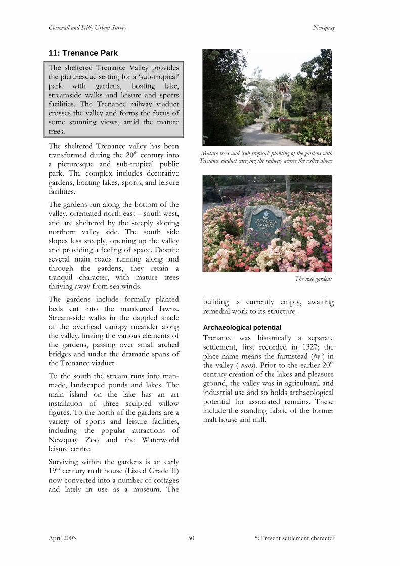
Cornwall and Scilly Urban Survey Newquay
April 2003 5: Present settlement character 50
11: Trenance Park
The sheltered Trenance Valley provides the picturesque setting for a ‘sub-tropical’ park with gardens, boating lake, streamside walks and leisure and sports facilities. The Trenance railway viaduct crosses the valley and forms the focus of some stunning views, amid the mature trees.
The sheltered Trenance valley has been transformed during the 20th century into a picturesque and sub-tropical public park. The complex includes decorative gardens, boating lakes, sports, and leisure facilities.
The gardens run along the bottom of the valley, orientated north east – south west, and are sheltered by the steeply sloping northern valley side. The south side slopes less steeply, opening up the valley and providing a feeling of space. Despite several main roads running along and through the gardens, they retain a tranquil character, with mature trees thriving away from sea winds.
The gardens include formally planted beds cut into the manicured lawns. Stream-side walks in the dappled shade of the overhead canopy meander along the valley, linking the various elements of the gardens, passing over small arched bridges and under the dramatic spans of the Trenance viaduct.
To the south the stream runs into man-made, landscaped ponds and lakes. The main island on the lake has an art installation of three sculpted willow figures. To the north of the gardens are a variety of sports and leisure facilities, including the popular attractions of Newquay Zoo and the Waterworld leisure centre.
Surviving within the gardens is an early 19th century malt house (Listed Grade II) now converted into a number of cottages and lately in use as a museum. The
building is currently empty, awaiting remedial work to its structure.
Archaeological potential Trenance was historically a separate settlement, first recorded in 1327; the place-name means the farmstead (tre-) in the valley (-nans). Prior to the earlier 20th century creation of the lakes and pleasure ground, the valley was in agricultural and industrial use and so holds archaeological potential for associated remains. These include the standing fabric of the former malt house and mill.
Mature trees and ‘sub-tropical’ planting of the gardens with Trenance viaduct carrying the railway across the valley above
The rose gardens
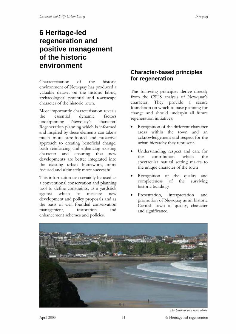
Cornwall and Scilly Urban Survey Newquay
April 2003 6: Heritage-led regeneration 51
6 Heritage-led regeneration and positive management of the historic environment
Characterisation of the historic environment of Newquay has produced a valuable dataset on the historic fabric, archaeological potential and townscape character of the historic town.
Most importantly characterisation reveals the essential dynamic factors underpinning Newquay’s character. Regeneration planning which is informed and inspired by these elements can take a much more sure-footed and proactive approach to creating beneficial change, both reinforcing and enhancing existing character and ensuring that new developments are better integrated into the existing urban framework, more focused and ultimately more successful.
This information can certainly be used as a conventional conservation and planning tool to define constraints, as a yardstick against which to measure new development and policy proposals and as the basis of well founded conservation management, restoration and enhancement schemes and policies.
Character-based principles for regeneration
The following principles derive directly from the CSUS analysis of Newquay’s character. They provide a secure foundation on which to base planning for change and should underpin all future regeneration initiatives:
• Recognition of the different character areas within the town and an acknowledgement and respect for the urban hierarchy they represent.
• Understanding, respect and care for the contribution which the spectacular natural setting makes to the unique character of the town
• Recognition of the quality and completeness of the surviving historic buildings
• Presentation, interpretation and promotion of Newquay as an historic Cornish town of quality, character and significance.
The harbour and town above
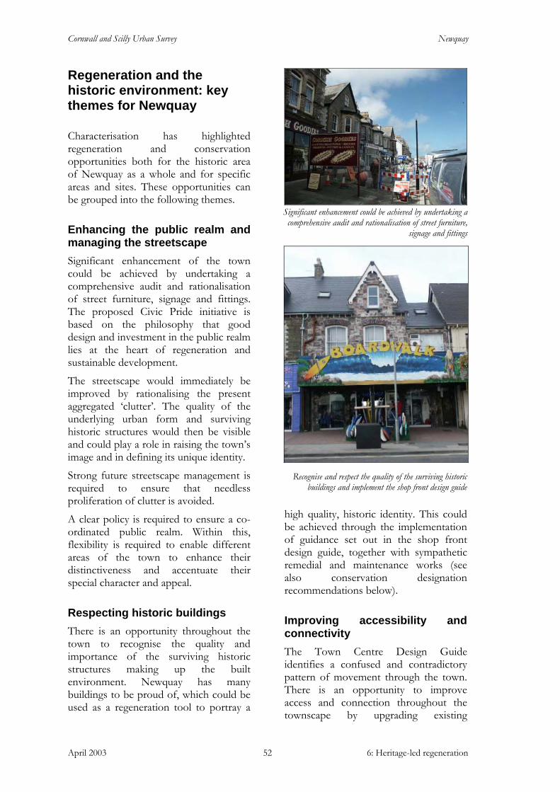
Cornwall and Scilly Urban Survey Newquay
April 2003 6: Heritage-led regeneration 52
Regeneration and the historic environment: key themes for Newquay
Characterisation has highlighted regeneration and conservation opportunities both for the historic area of Newquay as a whole and for specific areas and sites. These opportunities can be grouped into the following themes.
Enhancing the public realm and managing the streetscape Significant enhancement of the town could be achieved by undertaking a comprehensive audit and rationalisation of street furniture, signage and fittings. The proposed Civic Pride initiative is based on the philosophy that good design and investment in the public realm lies at the heart of regeneration and sustainable development.
The streetscape would immediately be improved by rationalising the present aggregated ‘clutter’. The quality of the underlying urban form and surviving historic structures would then be visible and could play a role in raising the town’s image and in defining its unique identity.
Strong future streetscape management is required to ensure that needless proliferation of clutter is avoided.
A clear policy is required to ensure a co-ordinated public realm. Within this, flexibility is required to enable different areas of the town to enhance their distinctiveness and accentuate their special character and appeal.
Respecting historic buildings There is an opportunity throughout the town to recognise the quality and importance of the surviving historic structures making up the built environment. Newquay has many buildings to be proud of, which could be used as a regeneration tool to portray a
high quality, historic identity. This could be achieved through the implementation of guidance set out in the shop front design guide, together with sympathetic remedial and maintenance works (see also conservation designation recommendations below).
Improving accessibility and connectivity The Town Centre Design Guide identifies a confused and contradictory pattern of movement through the town. There is an opportunity to improve access and connection throughout the townscape by upgrading existing
Significant enhancement could be achieved by undertaking a comprehensive audit and rationalisation of street furniture,
signage and fittings
Recognise and respect the quality of the surviving historic
buildings and implement the shop front design guide
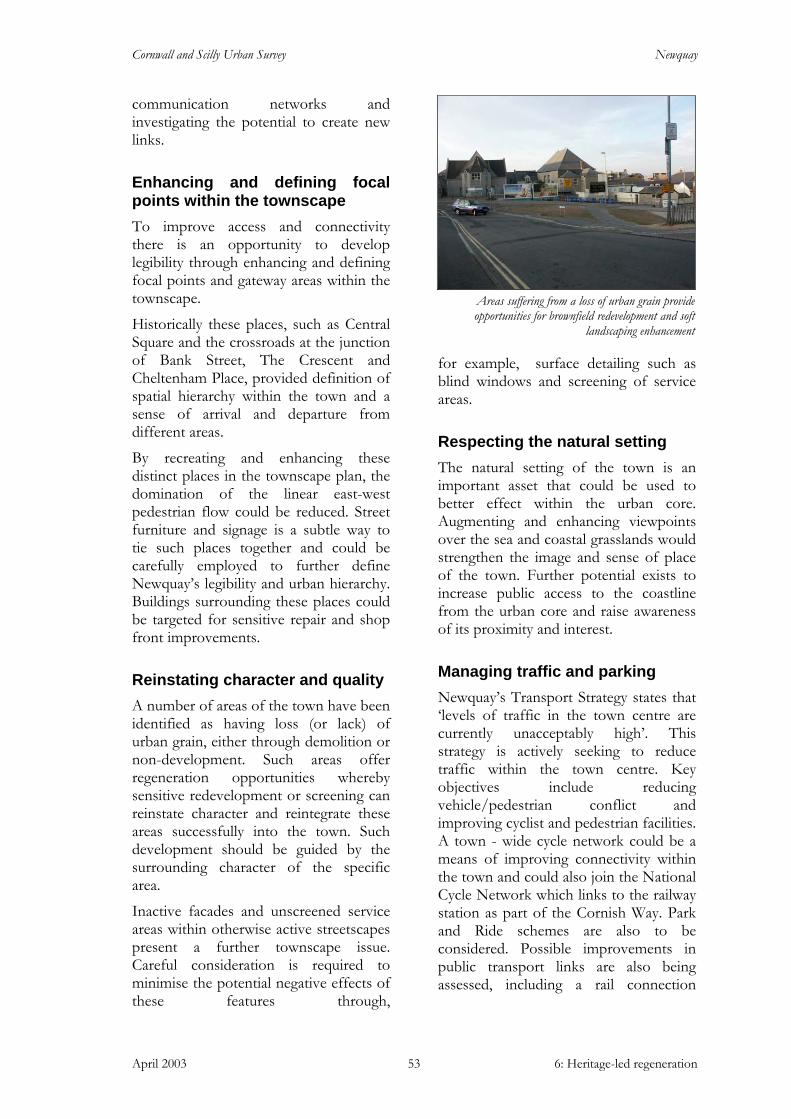
Cornwall and Scilly Urban Survey Newquay
April 2003 6: Heritage-led regeneration 53
communication networks and investigating the potential to create new links.
Enhancing and defining focal points within the townscape To improve access and connectivity there is an opportunity to develop legibility through enhancing and defining focal points and gateway areas within the townscape.
Historically these places, such as Central Square and the crossroads at the junction of Bank Street, The Crescent and Cheltenham Place, provided definition of spatial hierarchy within the town and a sense of arrival and departure from different areas.
By recreating and enhancing these distinct places in the townscape plan, the domination of the linear east-west pedestrian flow could be reduced. Street furniture and signage is a subtle way to tie such places together and could be carefully employed to further define Newquay’s legibility and urban hierarchy. Buildings surrounding these places could be targeted for sensitive repair and shop front improvements.
Reinstating character and quality A number of areas of the town have been identified as having loss (or lack) of urban grain, either through demolition or non-development. Such areas offer regeneration opportunities whereby sensitive redevelopment or screening can reinstate character and reintegrate these areas successfully into the town. Such development should be guided by the surrounding character of the specific area.
Inactive facades and unscreened service areas within otherwise active streetscapes present a further townscape issue. Careful consideration is required to minimise the potential negative effects of these features through,
for example, surface detailing such as blind windows and screening of service areas.
Respecting the natural setting The natural setting of the town is an important asset that could be used to better effect within the urban core. Augmenting and enhancing viewpoints over the sea and coastal grasslands would strengthen the image and sense of place of the town. Further potential exists to increase public access to the coastline from the urban core and raise awareness of its proximity and interest.
Managing traffic and parking Newquay’s Transport Strategy states that ‘levels of traffic in the town centre are currently unacceptably high’. This strategy is actively seeking to reduce traffic within the town centre. Key objectives include reducing vehicle/pedestrian conflict and improving cyclist and pedestrian facilities. A town - wide cycle network could be a means of improving connectivity within the town and could also join the National Cycle Network which links to the railway station as part of the Cornish Way. Park and Ride schemes are also to be considered. Possible improvements in public transport links are also being assessed, including a rail connection
Areas suffering from a loss of urban grain provide opportunities for brownfield redevelopment and soft
landscaping enhancement
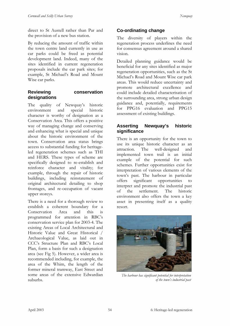
Cornwall and Scilly Urban Survey Newquay
April 2003 6: Heritage-led regeneration 54
direct to St Austell rather than Par and the provision of a new bus station.
By reducing the amount of traffic within the town centre land currently in use as car parks could be freed as potential development land. Indeed, many of the sites identified in current regeneration proposals include the car park sites; for example, St Michael’s Road and Mount Wise car parks.
Reviewing conservation designations The quality of Newquay’s historic environment and special historic character is worthy of designation as a Conservation Area. This offers a positive way of managing change and conserving and enhancing what is special and unique about the historic environment of the town. Conservation area status brings access to substantial funding for heritage-led regeneration schemes such as THI and HERS. These types of scheme are specifically designed to re-establish and reinforce character and vitality; for example, through the repair of historic buildings, including reinstatement of original architectural detailing to shop frontages, and re-occupation of vacant upper storeys.
There is a need for a thorough review to establish a coherent boundary for a Conservation Area and this is programmed for attention in RBC’s conservation service plan for 2003-4. The existing Areas of Local Architectural and Historic Value and Great Historical / Archaeological Value, as laid out in CCC’s Structure Plan and RBC’s Local Plan, form a basis for such a designation area (see Fig 5). However, a wider area is recommended including, for example, the area of the Whim, the length of the former mineral tramway, East Street and some areas of the extensive Edwardian suburbs.
Co-ordinating change The diversity of players within the regeneration process underlines the need for consensus agreement around a shared vision.
Detailed planning guidance would be beneficial for any sites identified as major regeneration opportunities, such as the St Michael’s Road and Mount Wise car park areas. This would reduce uncertainty and promote architectural excellence and could include detailed characterisation of the surrounding area, strong urban design guidance and, potentially, requirements for PPG16 evaluation and PPG15 assessment of existing buildings.
Asserting Newquay’s historic significance There is an opportunity for the town to use its unique historic character as an attraction. The well-designed and implemented town trail is an initial example of the potential for such schemes. Further opportunities exist for interpretation of various elements of the town’s past. The harbour in particular offers significant opportunities to interpret and promote the industrial past of the settlement. The historic environment also offers the town a key asset in presenting itself as a quality resort.
The harbour has significant potential for interpretation
of the town’s industrial past
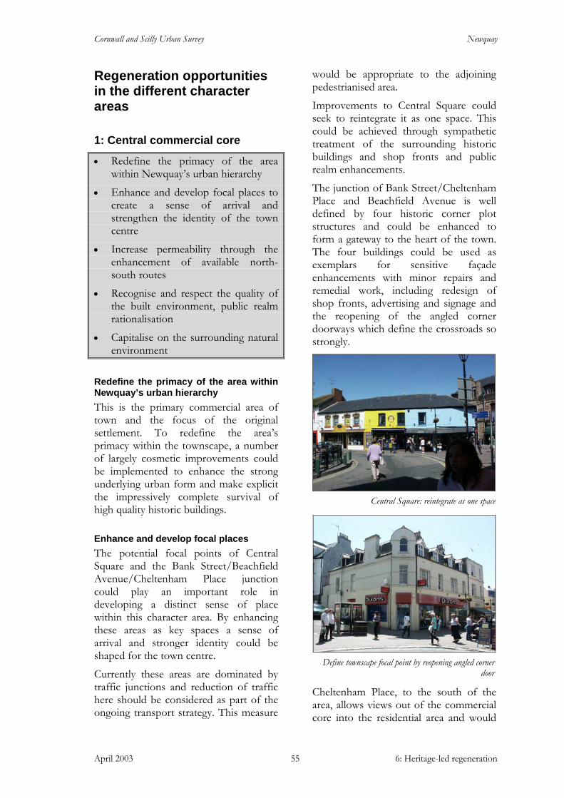
Cornwall and Scilly Urban Survey Newquay
April 2003 6: Heritage-led regeneration 55
Regeneration opportunities in the different character areas
1: Central commercial core
• Redefine the primacy of the area within Newquay’s urban hierarchy
• Enhance and develop focal places to create a sense of arrival and strengthen the identity of the town centre
• Increase permeability through the enhancement of available north-south routes
• Recognise and respect the quality of the built environment, public realm rationalisation
• Capitalise on the surrounding natural environment
Redefine the primacy of the area within Newquay’s urban hierarchy This is the primary commercial area of town and the focus of the original settlement. To redefine the area’s primacy within the townscape, a number of largely cosmetic improvements could be implemented to enhance the strong underlying urban form and make explicit the impressively complete survival of high quality historic buildings.
Enhance and develop focal places The potential focal points of Central Square and the Bank Street/Beachfield Avenue/Cheltenham Place junction could play an important role in developing a distinct sense of place within this character area. By enhancing these areas as key spaces a sense of arrival and stronger identity could be shaped for the town centre.
Currently these areas are dominated by traffic junctions and reduction of traffic here should be considered as part of the ongoing transport strategy. This measure
would be appropriate to the adjoining pedestrianised area.
Improvements to Central Square could seek to reintegrate it as one space. This could be achieved through sympathetic treatment of the surrounding historic buildings and shop fronts and public realm enhancements.
The junction of Bank Street/Cheltenham Place and Beachfield Avenue is well defined by four historic corner plot structures and could be enhanced to form a gateway to the heart of the town. The four buildings could be used as exemplars for sensitive façade enhancements with minor repairs and remedial work, including redesign of shop fronts, advertising and signage and the reopening of the angled corner doorways which define the crossroads so strongly.
Cheltenham Place, to the south of the area, allows views out of the commercial core into the residential area and would
Define townscape focal point by reopening angled corner door
Central Square: reintegrate as one space
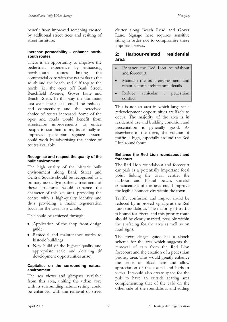
Cornwall and Scilly Urban Survey Newquay
April 2003 6: Heritage-led regeneration 56
benefit from improved screening created by additional street trees and resiting of street furniture.
Increase permeability – enhance north-south routes There is an opportunity to improve the pedestrian experience by enhancing north-south routes linking the commercial core with the car parks to the south and the beach and cliff top to the north (i.e. the opes off Bank Street, Beachfield Avenue, Gover Lane and Beach Road). In this way the dominant east-west linear axis could be reduced and connectivity and the perceived choice of routes increased. Some of the opes and roads would benefit from streetscape improvements to entice people to use them more, but initially an improved pedestrian signage system could work by advertising the choice of routes available.
Recognise and respect the quality of the built environment The high quality of the historic built environment along Bank Street and Central Square should be recognised as a primary asset. Sympathetic treatment of these structures would enhance the character of this key area, providing the centre with a high-quality identity and thus providing a major regeneration focus for the town as a whole.
This could be achieved through:
• Application of the shop front design guide
• Remedial and maintenance works to historic buildings
• New build of the highest quality and appropriate scale and detailing (if development opportunities arise).
Capitalise on the surrounding natural environment The sea views and glimpses available from this area, uniting the urban core with its surrounding natural setting, could be enhanced with the removal of street
clutter along Beach Road and Gover Lane. Signage here requires sensitive siting in order not to compromise these important views.
2: Harbour-related residential area
• Enhance the Red Lion roundabout and forecourt
• Maintain the built environment and retain historic architectural details
• Reduce vehicular : pedestrian conflict
This is not an area in which large-scale redevelopment opportunities are likely to occur. The majority of the area is in residential use and building condition and presentation is generally good. As elsewhere in the town, the volume of traffic is high, especially around the Red Lion roundabout.
Enhance the Red Lion roundabout and forecourt The Red Lion roundabout and forecourt car park is a potentially important focal point linking the town centre, the harbour and Fistral beach. Careful enhancement of this area could improve the legible connectivity within the town.
Traffic confusion and impact could be reduced by improved signage at the Red Lion roundabout. The majority of traffic is bound for Fistral and this priority route should be clearly marked, possibly within the surfacing for the area as well as on road signs.
The town design guide has a sketch scheme for the area which suggests the removal of cars from the Red Lion forecourt and the creation of a pedestrian priority area. This would greatly enhance the sense of place here and allow appreciation of the coastal and harbour views. It would also create space for the pub to have an outside seating area complementing that of the café on the other side of the roundabout and adding

Cornwall and Scilly Urban Survey Newquay
April 2003 6: Heritage-led regeneration 57
to the continental ‘bistro’ ambience advocated by the town’s IAP document.
The area could be used as a gateway to the harbour. Its close proximity needs to be made explicit through pedestrian signage and public realm detailing.
There is an opportunity to improve the streetscape by undergrounding the prominent overhead cables.
Maintain and enhance the built environment Although the majority of structures here are in a good state of repair there is an opportunity for enhancement of the Red Lion’s annexe building on Beacon Road. Through the restrained use of bright colours, noted as a characteristic of the area in section 5, the architectural detail of the blind windows could be emphasised, transforming a currently inactive façade into a positive addition to the streetscape.
Recognition of this area’s special character through the designation of a Conservation Area would help retain and enhance its important features, including the enclosed front gardens and historic architectural items, such as sash windows and porches.
Reduce pedestrian : vehicular conflict During high season the flow of large groups of people cannot be accommodated by the narrow pavements - (in some places there are no pavements) - leading to conflict between pedestrians and vehicles. Compounding this conflict is the on-street parking on the north side of Fore Street which reduces the carriageway to a single lane. Fore Street is provisionally programmed for enhancement as part of the Newquay Transportation Strategy in winter 2004/5. Any environmental improvements should seek to reuse the granite kerb stones that survive well in this part of town.
3: The harbour
• Raise the profile of the harbour
• Improve the harbour’s accessibility
• Enhance the public realm
• Increase the vitality of the harbour
• Explore the potential for interpretation opportunities
The harbour is one of the most historically important areas of the town: its development and success over time is tied closely to that of the town as a whole. It has continued as a place of work, maintaining a fishing fleet, and is currently an important but underused, asset.
Raise the profile of the harbour The harbour does not form an integral part of a typical Newquay visitor experience. Its existence is not promoted within the marketing of the town and signage to the harbour from other urban
Streetscape enhancement: bright colours could be used to pick out the architectural detail of the blind windows, as seen elsewhere in the character area
Potential public open space in front of the Red Lion
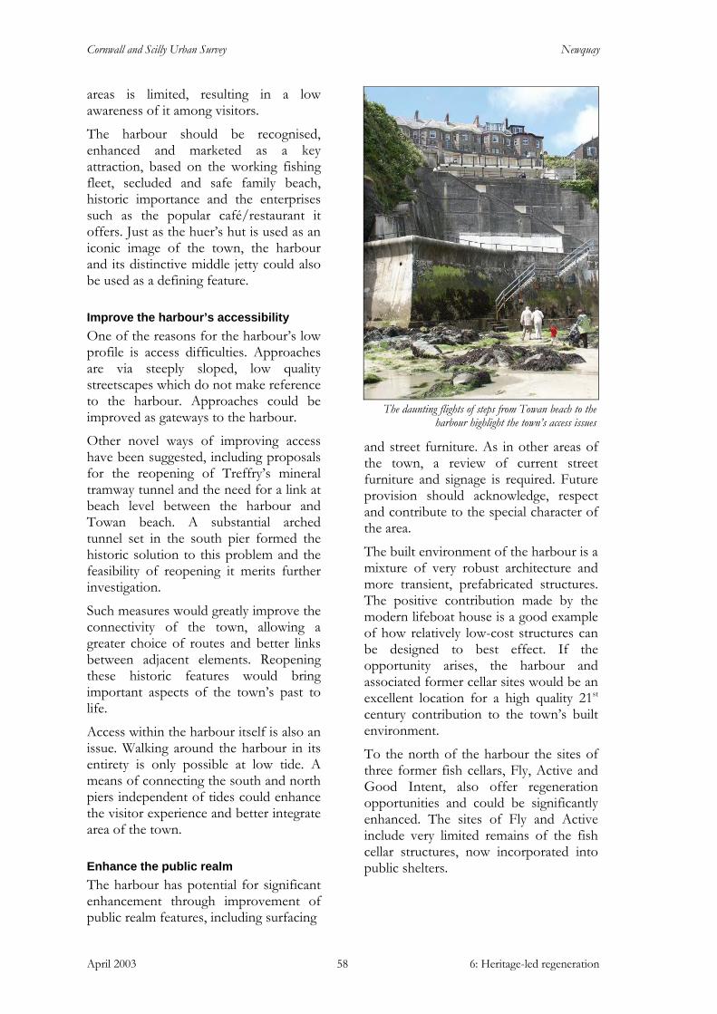
Cornwall and Scilly Urban Survey Newquay
April 2003 6: Heritage-led regeneration 58
areas is limited, resulting in a low awareness of it among visitors.
The harbour should be recognised, enhanced and marketed as a key attraction, based on the working fishing fleet, secluded and safe family beach, historic importance and the enterprises such as the popular café/restaurant it offers. Just as the huer’s hut is used as an iconic image of the town, the harbour and its distinctive middle jetty could also be used as a defining feature.
Improve the harbour’s accessibility One of the reasons for the harbour’s low profile is access difficulties. Approaches are via steeply sloped, low quality streetscapes which do not make reference to the harbour. Approaches could be improved as gateways to the harbour.
Other novel ways of improving access have been suggested, including proposals for the reopening of Treffry’s mineral tramway tunnel and the need for a link at beach level between the harbour and Towan beach. A substantial arched tunnel set in the south pier formed the historic solution to this problem and the feasibility of reopening it merits further investigation.
Such measures would greatly improve the connectivity of the town, allowing a greater choice of routes and better links between adjacent elements. Reopening these historic features would bring important aspects of the town’s past to life.
Access within the harbour itself is also an issue. Walking around the harbour in its entirety is only possible at low tide. A means of connecting the south and north piers independent of tides could enhance the visitor experience and better integrate area of the town.
Enhance the public realm The harbour has potential for significant enhancement through improvement of public realm features, including surfacing
and street furniture. As in other areas of the town, a review of current street furniture and signage is required. Future provision should acknowledge, respect and contribute to the special character of the area.
The built environment of the harbour is a mixture of very robust architecture and more transient, prefabricated structures. The positive contribution made by the modern lifeboat house is a good example of how relatively low-cost structures can be designed to best effect. If the opportunity arises, the harbour and associated former cellar sites would be an excellent location for a high quality 21st century contribution to the town’s built environment.
To the north of the harbour the sites of three former fish cellars, Fly, Active and Good Intent, also offer regeneration opportunities and could be significantly enhanced. The sites of Fly and Active include very limited remains of the fish cellar structures, now incorporated into public shelters.
The daunting flights of steps from Towan beach to the
harbour highlight the town’s access issues

Cornwall and Scilly Urban Survey Newquay
April 2003 6: Heritage-led regeneration 59
Increasing the vitality of the harbour
The IAP and Restormel Local Plan identify the need to increase vitality within the harbour. A scheme has been financed by RBC and a PESCA grant to enable a programme of works designed to improve the harbour for local fishermen. These works will help to keep the harbour viable as a working environment but partnership working with RBC’s conservation team should ensure the historic setting of the grade II listed harbour is not detrimentally affected.
Historically, the harbour was the hub of the town’s economy and a greater sense of this former vitality would contribute positively to the town as a whole. Activity levels are increasing with the success of the café/restaurant and the provision of boat trips during the season. Space is at a premium but further elements could be introduced to attract more visitors. Small kiosks or food preparation/processing units specialising in freshly caught sea food and shell fish would enhance the harbour experience and underpin its future as an active place of work.
Newquay’s recent successful tourism promotion has focused on packaging an event-led season of activities. The harbour offers an excellent venue for such events and could host or feature in such attractions.
Interpretation opportunities Current interpretation in Newquay offers little on the maritime and harbour-based economy on which it was founded. An interpretation centre to bring elements of the town’s maritime past to life could form a part of the revitalisation of the harbour area. The site of the Active cellar offers a good potential site for such a facility, complementing the surf history museum planned as part of the Fistral Beach developments.
Such an interpretation centre could take the architectural form of the former fish
cellars as inspiration for a prestigious contemporary structure, incorporating surviving elements of the original building and taking full advantage of the exceptional views back into the town across the harbour.
The harbour requires a comprehensive conservation plan and management scheme to guide and inform future change. This should include a more detailed analysis of the archaeological remains and potential of the area.
4: Industrial area
• Reinstate character and quality
• Enhance the public realm
• Enhance the route of the former mineral tramway
Several places within this industrial character area have been identified in the RBC Local Plan for change from industrial to other uses: Wesley Yard, Hope Terrace and the area off Mount Wise Road. This change of use has the potential to erode the distinctive industrial character of the area and sympathetic reuse and redevelopment of the existing buildings would minimise such loss.
Reinstate character and quality Several places within this area have an uncharacteristic lack of urban grain, caused either through demolition or underdevelopment. Redevelopment of these brownfield sites or re-enclosure through better boundary definition would reinstate grain and character and reintegrate these areas into the town. The un-landscaped car parks around the Whim supermarket and the junction area of Manor Road, St George’s Road and Crantock Street could both benefit from such treatment.
The former industrial land surrounding the railway station (character area 4c) offers substantial potential for brownfield redevelopment. It is designated in the
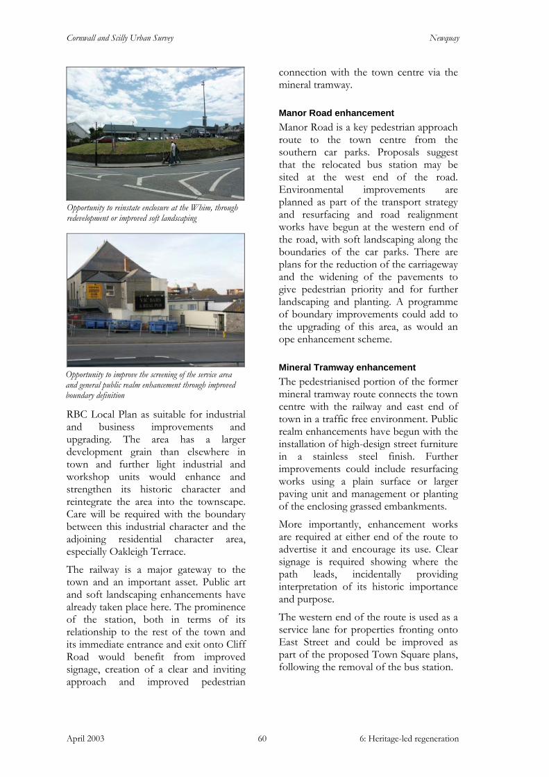
Cornwall and Scilly Urban Survey Newquay
April 2003 6: Heritage-led regeneration 60
RBC Local Plan as suitable for industrial and business improvements and upgrading. The area has a larger development grain than elsewhere in town and further light industrial and workshop units would enhance and strengthen its historic character and reintegrate the area into the townscape. Care will be required with the boundary between this industrial character and the adjoining residential character area, especially Oakleigh Terrace.
The railway is a major gateway to the town and an important asset. Public art and soft landscaping enhancements have already taken place here. The prominence of the station, both in terms of its relationship to the rest of the town and its immediate entrance and exit onto Cliff Road would benefit from improved signage, creation of a clear and inviting approach and improved pedestrian
connection with the town centre via the mineral tramway.
Manor Road enhancement Manor Road is a key pedestrian approach route to the town centre from the southern car parks. Proposals suggest that the relocated bus station may be sited at the west end of the road. Environmental improvements are planned as part of the transport strategy and resurfacing and road realignment works have begun at the western end of the road, with soft landscaping along the boundaries of the car parks. There are plans for the reduction of the carriageway and the widening of the pavements to give pedestrian priority and for further landscaping and planting. A programme of boundary improvements could add to the upgrading of this area, as would an ope enhancement scheme.
Mineral Tramway enhancement The pedestrianised portion of the former mineral tramway route connects the town centre with the railway and east end of town in a traffic free environment. Public realm enhancements have begun with the installation of high-design street furniture in a stainless steel finish. Further improvements could include resurfacing works using a plain surface or larger paving unit and management or planting of the enclosing grassed embankments.
More importantly, enhancement works are required at either end of the route to advertise it and encourage its use. Clear signage is required showing where the path leads, incidentally providing interpretation of its historic importance and purpose.
The western end of the route is used as a service lane for properties fronting onto East Street and could be improved as part of the proposed Town Square plans, following the removal of the bus station.
Opportunity to improve the screening of the service area and general public realm enhancement through improved boundary definition
Opportunity to reinstate enclosure at the Whim, through redevelopment or improved soft landscaping
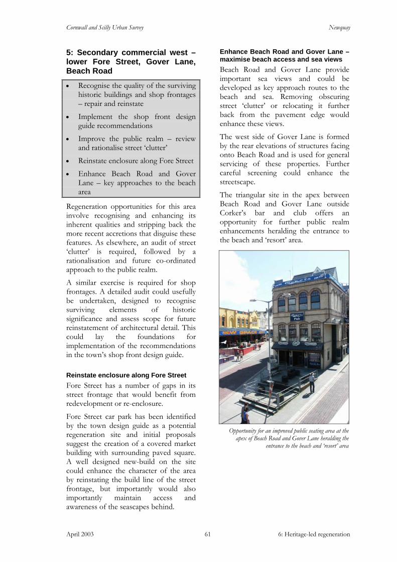
Cornwall and Scilly Urban Survey Newquay
April 2003 6: Heritage-led regeneration 61
5: Secondary commercial west – lower Fore Street, Gover Lane, Beach Road
• Recognise the quality of the surviving historic buildings and shop frontages – repair and reinstate
• Implement the shop front design guide recommendations
• Improve the public realm – review and rationalise street ‘clutter’
• Reinstate enclosure along Fore Street
• Enhance Beach Road and Gover Lane – key approaches to the beach area
Regeneration opportunities for this area involve recognising and enhancing its inherent qualities and stripping back the more recent accretions that disguise these features. As elsewhere, an audit of street ‘clutter’ is required, followed by a rationalisation and future co-ordinated approach to the public realm.
A similar exercise is required for shop frontages. A detailed audit could usefully be undertaken, designed to recognise surviving elements of historic significance and assess scope for future reinstatement of architectural detail. This could lay the foundations for implementation of the recommendations in the town’s shop front design guide.
Reinstate enclosure along Fore Street Fore Street has a number of gaps in its street frontage that would benefit from redevelopment or re-enclosure.
Fore Street car park has been identified by the town design guide as a potential regeneration site and initial proposals suggest the creation of a covered market building with surrounding paved square. A well designed new-build on the site could enhance the character of the area by reinstating the build line of the street frontage, but importantly would also importantly maintain access and awareness of the seascapes behind.
Enhance Beach Road and Gover Lane – maximise beach access and sea views Beach Road and Gover Lane provide important sea views and could be developed as key approach routes to the beach and sea. Removing obscuring street ‘clutter’ or relocating it further back from the pavement edge would enhance these views.
The west side of Gover Lane is formed by the rear elevations of structures facing onto Beach Road and is used for general servicing of these properties. Further careful screening could enhance the streetscape.
The triangular site in the apex between Beach Road and Gover Lane outside Corker’s bar and club offers an opportunity for further public realm enhancements heralding the entrance to the beach and ‘resort’ area.
Opportunity for an improved public seating area at the
apex of Beach Road and Gover Lane heralding the entrance to the beach and ‘resort’ area
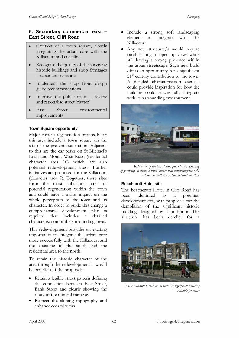
Cornwall and Scilly Urban Survey Newquay
April 2003 6: Heritage-led regeneration 62
6: Secondary commercial east – East Street, Cliff Road
• Creation of a town square, closely integrating the urban core with the Killacourt and coastline
• Recognise the quality of the surviving historic buildings and shop frontages – repair and reinstate
• Implement the shop front design guide recommendations
• Improve the public realm – review and rationalise street ‘clutter’
• East Street environmental improvements
Town Square opportunity Major current regeneration proposals for this area include a town square on the site of the present bus station. Adjacent to this are the car parks on St Michael’s Road and Mount Wise Road (residential character area 10) which are also potential redevelopment sites. Further initiatives are proposed for the Killacourt (character area 7). Together, these sites form the most substantial area of potential regeneration within the town and could have a major impact on the whole perception of the town and its character. In order to guide this change a comprehensive development plan is required that includes a detailed characterisation of the surrounding areas.
This redevelopment provides an exciting opportunity to integrate the urban core more successfully with the Killacourt and the coastline to the south and the residential area to the north.
To retain the historic character of the area through the redevelopment it would be beneficial if the proposals:
• Retain a legible street pattern defining the connection between East Street, Bank Street and clearly showing the route of the mineral tramway
• Respect the sloping topography and enhance coastal views
• Include a strong soft landscaping element to integrate with the Killacourt
• Any new structure/s would require careful siting to open up views while still having a strong presence within the urban streetscape. Such new build offers an opportunity for a significant 21st century contribution to the town. A detailed characterisation exercise could provide inspiration for how the building could successfully integrate with its surrounding environment.
Beachcroft Hotel site The Beachcroft Hotel in Cliff Road has been identified as a potential development site, with proposals for the demolition of the significant historic building, designed by John Ennor. The structure has been derelict for a
Relocation of the bus station provides an exciting
opportunity to create a town square that better integrates the urban core with the Killacourt and coastline
The Beachcroft Hotel: an historically significant building
suitable for reuse
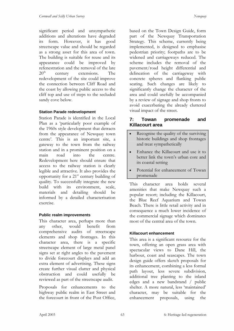
Cornwall and Scilly Urban Survey Newquay
April 2003 6: Heritage-led regeneration 63
significant period and unsympathetic additions and alterations have degraded its form. However, it has good streetscape value and should be regarded as a strong asset for this area of town. The building is suitable for reuse and its appearance could be improved by refenestration and the removal of the late 20th century extensions. The redevelopment of the site could improve the connection between Cliff Road and the coast by allowing public access to the cliff top and use of steps to the secluded sandy cove below.
Station Parade redevelopment Station Parade is identified in the Local Plan as a ‘particularly poor example of the 1960s style development that detracts from the appearance of Newquay town centre’. This is an important site, a gateway to the town from the railway station and in a prominent position on a main road into the centre. Redevelopment here should ensure that access to the railway station is clearly legible and attractive. It also provides the opportunity for a 21st century building of quality. To successfully integrate the new build with its environment, scale, materials and detailing should be informed by a detailed characterisation exercise.
Public realm improvements This character area, perhaps more than any other, would benefit from comprehensive audits of streetscape elements and shop frontages. In this character area, there is a specific streetscape element of large metal panel signs set at right angles to the pavement to divide forecourt displays and add an extra element of advertising. These signs create further visual clutter and physical obstruction and could usefully be reviewed as part of the streetscape audit.
Proposals for enhancements to the highway public realm in East Street and the forecourt in front of the Post Office,
based on the Town Design Guide, form part of the Newquay Transportation Strategy. This scheme, currently being implemented, is designed to emphasise pedestrian priority; footpaths are to be widened and carriageways reduced. The scheme includes the removal of the pavement/road height differential and delineation of the carriageway with concrete spheres and flanking public seating. Such changes are likely to significantly change the character of the area and could usefully be accompanied by a review of signage and shop fronts to avoid exacerbating the already cluttered visual impact of the street.
7: Towan promenade and Killacourt area
• Recognise the quality of the surviving historic buildings and shop frontages and treat sympathetically
• Enhance the Killacourt and use it to better link the town’s urban core and its coastal setting
• Potential for enhancement of Towan promenade
This character area holds several amenities that make Newquay such a popular resort; including the Killacourt, the Blue Reef Aquarium and Towan Beach. There is little retail activity and in consequence a much lower incidence of the commercial signage which dominates most of the central area of the town.
Killacourt enhancement This area is a significant resource for the town, offering an open grass area with spectacular views to Dane Hill, the harbour, coast and seascapes. The town design guide offers sketch proposals for its enhancement, combining a less formal path layout, less severe subdivision, additional tree planting to the inland edges and a new bandstand / public shelter. A more natural, less ‘maintained’ character, may be suitable for the enhancement proposals, using the
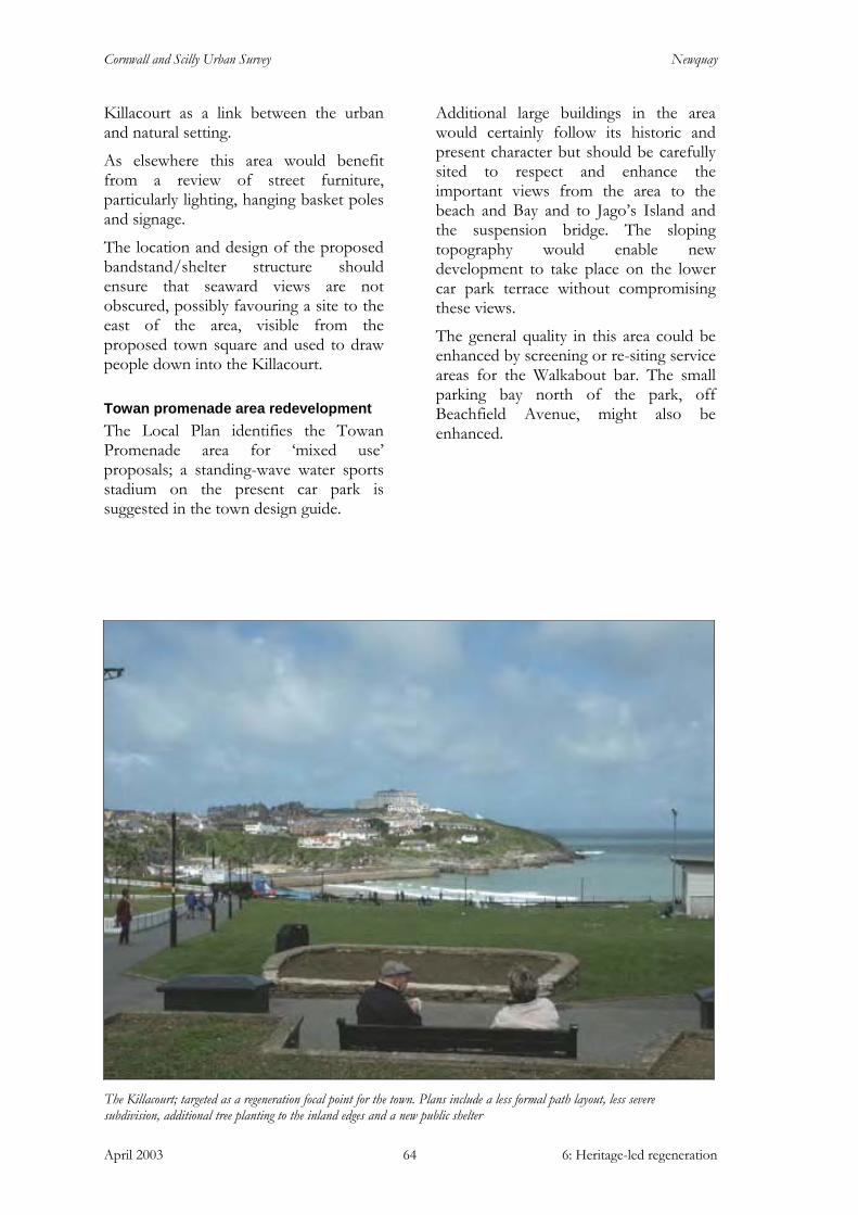
Cornwall and Scilly Urban Survey Newquay
April 2003 6: Heritage-led regeneration 64
Killacourt as a link between the urban and natural setting.
As elsewhere this area would benefit from a review of street furniture, particularly lighting, hanging basket poles and signage.
The location and design of the proposed bandstand/shelter structure should ensure that seaward views are not obscured, possibly favouring a site to the east of the area, visible from the proposed town square and used to draw people down into the Killacourt.
Towan promenade area redevelopment The Local Plan identifies the Towan Promenade area for ‘mixed use’ proposals; a standing-wave water sports stadium on the present car park is suggested in the town design guide.
Additional large buildings in the area would certainly follow its historic and present character but should be carefully sited to respect and enhance the important views from the area to the beach and Bay and to Jago’s Island and the suspension bridge. The sloping topography would enable new development to take place on the lower car park terrace without compromising these views.
The general quality in this area could be enhanced by screening or re-siting service areas for the Walkabout bar. The small parking bay north of the park, off Beachfield Avenue, might also be enhanced.
The Killacourt; targeted as a regeneration focal point for the town. Plans include a less formal path layout, less severe subdivision, additional tree planting to the inland edges and a new public shelter

Cornwall and Scilly Urban Survey Newquay
April 2003 6: Heritage-led regeneration 65
8: Towan Head and Fistral Beach
• Recognise the quality of the surviving historic buildings and treat sympathetically
• Fistral beach improvements provide the exciting opportunity for an iconic 21st century building for the town
• Conversion/redevelopment of the Westward Ho! Hotel
• Continue enhancement of the public realm
This character area holds many of the defining features that make Newquay unique and spectacular, including Fistral beach, the open grassland of the golf links, Towan Head, the Headland Hotel and the huer’s hut. Recent environmental works along the south side of Headland Road formed the model for public realm treatments elsewhere in the town, undertaken as part of the transportation strategy. Overtly urban in design and contrasting strongly with the rural setting and ‘Cornish hedge’-type boundaries on the opposite side of the road, the widened pavements link Fistral with the urban core.
Fistral beach improvements Major new facilities are proposed for Fistral beach, centred on the creation of a surf centre providing cafes, quality restaurants, tourist information, toilets and showers and a surf history museum. The development is heralded as the key to an expansion of Fistral’s role as an international surfing competition venue. The spectacular location, together with the regeneration significance of surfing-related tourism, requires a building of the highest quality, potentially a new 21st century icon of Newquay’s vitality and success. The sensitivity of location and strong visual presence of existing structures on Towan Head, necessitate great care in planning the new development. In particular, both views to
and the isolated historic setting of the Headland Hotel should be safeguarded.
Westward Ho! The former Westward Ho! hotel has been identified as a potential development site, with proposals for the demolition of the significant historic building and replacement with apartments. This structure forms part of an important group of three buildings on the headland designed by Silvanus Trevail (also the Headland Hotel and the Atlantic Hotel). It is a building of high historic quality and is suitable for reuse.
Public realm improvements Several areas could be enhanced by minor, low-cost improvements. Landscaping and planting in the car park off Tower Road would provide improved screening and enclosure to the adjacent harbour-related residential area. The enclosing fence of the golf links could usefully be replaced with an alternative that better respects the upgraded footway of Headland Road.
Westward Ho! Hotel, an important Trevail building threatened with demolition
Much needed improvements to Fistral beach facilities provide an exciting opportunity

Cornwall and Scilly Urban Survey Newquay
April 2003 6: Heritage-led regeneration 66
9: Narrowcliff and Barrowfields
• Barrowfields enhancement and improved interpretation
• Recognise the quality of the surviving historic buildings and treat sympathetically
• Enhance property forecourts
• Enhance the Narrowcliff promenade
Barrowfields enhancement and presentation It is important for the character of the area to maintain the Barrowfields as semi-rural grassland. Improved screening from the very busy Narrowcliff Road, using a more substantial Cornish hedge would enhance the area as a pleasant public space. The cliff edge boundary could be enhanced, possibly using the successful design seen on Towan Head of granite posts with metal bars to replace the current timber and wire construction.
Presentation of the barrows could be improved by relocating the boundary fence of the putting green that currently runs across one of them. Although no further damage is likely to the barrow it would enhance the presentation of this important archaeological site if the surviving monuments were clearly distinguishable by their raised form and unmown grass cover. Some form of vandal-proof interpretation would benefit the area and make clear the significance and spiritual nature of the place.
Narrowcliff streetscape enhancement The historic built environment includes a mixture of the original private villas, boarding houses and hotels, together a significant element in the town’s development. These buildings should be respected and any additions or alterations should be sympathetic to their character and nature as high quality historic structures.
It would be beneficial if former front garden plots could once again be enclosed, possibly using soft landscaping. This would better separate the hotels from the busy road.
Narrowcliff promenade enhancement The promenade provides excellent views over Tolcarne beach and into the town centre. The vitality of this area could be boosted through some limited environmental improvements such as resurfacing, planting and new street furniture, with an emphasis placed on good design. The ornate cast iron railings are an asset and should be maintained. There is potential for the area to be developed into an attractive public space, perhaps a location for an outdoor cafe. As with the Barrowfields, improved screening from Narrowcliff Road would be of benefit to this potentially successful public space.
Narrowcliff promenade could benefit from public realm
enhancement
The Barrowfields has potential for enhancement and interpretation of the important archaeological remains

Cornwall and Scilly Urban Survey Newquay
April 2003 6: Heritage-led regeneration 67
10: Residential area
• Provide a framework for major redevelopment proposals for the car park areas on Mount Wise
• Streetscape maintenance and enhancement
• Retain historic architectural details and front garden enclosure
Provide framework for redevelopment An area of approximately 2.8 hectares, including St Michael’s Road car park and Mount Wise car park, has been identified within the Local Plan for redevelopment for shopping, commercial leisure and community uses. This is an extensive development area with implications for the other potential regeneration sites, the new town square, the Killacourt and the eastern end of Bank Street.
A detailed characterisation exercise would help to successfully integrate the new development with the surrounding townscape. Any new design should respect the prominence and setting of the Grade II* listed St Michael’s church. Issues of building scale, siting, the use of terracing to utilise the sloping topography and the continuation of the strong urban greening element seen along both St Michael’s Road and Mount Wise are important factors for consideration.
The redevelopment provides the exciting opportunity for the commercial core of town to be better integrated with the southern slopes of Mount Wise and for the Manor Road barrier between the two to be reinvented as an attractive connection.
The library and Town Council offices at the east of the area may also be affected by the proposals. The library makes little positive contribution to the streetscape; however, the council offices and tourist information bureau are housed within the former Manor Hotel, designed by John Ennor. This significant historic structure has a very positive presence on the
Marcus Hill streetscape and, more importantly, on that of the Manor Road – Bank Street junction.
An important townscape element that should be retained within any new development is the surviving church path which forms a useful pedestrian route to the town centre from the residential area and is an important component of the urban topography of the town.
Streetscape maintenance and enhancement Many of the streets of terraced houses are planted with street trees. This element could be extended elsewhere within this residential zone, possibly through community planting schemes. Front garden planting could also be encouraged.
Important gateways and principal routes could be targeted for such treatment, including Tower Road, Mount Wise,
St Michael’s Road, view south west. The sloping
topography of Mount Wise is a significant feature of both car parks proposed for development
Mount Wise car park view north
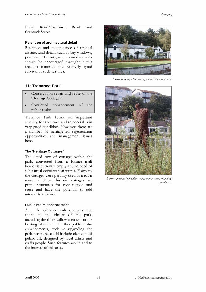
Cornwall and Scilly Urban Survey Newquay
April 2003 6: Heritage-led regeneration 68
Berry Road/Trenance Road and Crantock Street.
Retention of architectural detail Retention and maintenance of original architectural details such as bay windows, porches and front garden boundary walls should be encouraged throughout this area to continue the relatively good survival of such features.
11: Trenance Park
• Conservation repair and reuse of the ‘Heritage Cottages’
• Continued enhancement of the public realm
Trenance Park forms an important amenity for the town and in general is in very good condition. However, there are a number of heritage-led regeneration opportunities and management issues here.
The ‘Heritage Cottages’ The listed row of cottages within the park, converted from a former malt house, is currently empty and in need of substantial conservation works. Formerly the cottages were partially used as a town museum. These historic cottages are prime structures for conservation and reuse and have the potential to add interest to this area.
Public realm enhancement A number of recent enhancements have added to the vitality of the park, including the three willow men set on the boating lake island. Further public realm enhancements, such as upgrading the park furniture, could include elements of public art, designed by local artists and crafts people. Such features would add to the interest of this area.
‘Heritage cottages’ in need of conservation and reuse
Further potential for public realm enhancement including
public art
Cornwall and Scilly Urban Survey Newquay
April 2003 Sources 69
Sources
Published Sources and Documents:
Countryside Commission 1996. Cornwall Landscape Assessment 1994. Report prepared by CAU and Landscape Design Associates. (Truro, Cornwall County Council).
Gossip J 2001. The Gannel Estuary, Cornwall. Archaeological and Historical Assessment (Truro, Cornwall Archaeological Unit).
Gover J E B 1948. The Place-names of Cornwall (unpublished typescript, deposited in the Royal Institution of Cornwall Library, Truro).
Greenham J and Harper S 1999. Newquay (Stroud, Tempus Publishing Limited).
Haigh M and Woolgrove D 1974. Newquay: The story of a Cornish town (Newquay: G J Publications).
Husband S T 1923 (1985 ed). Old Newquay (Redruth, Dyllansow Truran).
Keast J 1982. ‘The King of mid-Cornwall’: The life of Joseph Thomas Treffry (1782-1850) (Redruth, Dyllansow Truran).
Lyon R 1991. The start of Newquay (The Federation of Old Cornwall Societies).
Reynolds A 1998. An Archaeological Assessment of the Newquay Sewage Treatment Works and Pipeline Transfer Route (Truro, Cornwall Archaeological Unit).
Reynolds A 1999. Atlantic Road, Newquay, 1998. The Archaeological Recording. Archive Report (Truro, Cornwall Archaeological Unit).
Reynolds A 2001. Newquay Sewage Treatment Works, Cornwall. Archaeological Mitigation (Truro, Cornwall Archaeological Unit).
Strategic, policy and programme documents:
Cornwall County Council 2000. The Cornwall Local Transport Plan 2001-2006
Cornwall Enterprise 2002. Newquay Civic Pride briefing paper Cornwall Enterprise 2002. Newquay Civic Pride project outline proposal Department for Transport, 1996, Traffic Management in Historic Areas, Traffic Advisory
Leaflets 01/96 (see www.roads.dft.gov.uk/roadnetwork/ditm/tal/traffic/01_96/)
Form Design Group 2000. Newquay town centre design guide Form Design Group 2000. Newquay shop front design guide Hyder Consulting Limited 2001. Newquay and its rural hinterlands: Regeneration masterplan
Lacey Hickie Caley May 2002. Newquay Retail Study Part 3: Urban Design Study Restormel Regeneration Partnership 2000. Strategy for the Borough of Restormel 2000-2010
(RRP document).
Cornwall and Scilly Urban Survey Newquay
April 2003 Sources 70
Restormel Regeneration Partnership 2000. Integrated Area Plan for Newquay and its Rural Hinterland (RRP document).
Restormel Borough Council. Restormel Local Plan (agreed for adoption August 2001).
Historic maps:
1st edition Ordnance Survey (c1813)
Tithe award map (1839)
Ordnance Survey 1st edn 1:2500 (1879)
Ordnance Survey 2nd edn 1:2500 (c1907)
Ordnance Survey 25in: 1:2500, revision (c1933)
Websites:
English Heritage, Images of England
Cornwall county council historic environment record:
Sites and Monuments Record
Aerial photographs (verticals 1946, 1963; obliques c 1988 - 2002)


