15
working in partnership with Newquay Strategic Route Environmental Statement Non Technical Summary 285300EC-WHV/R/003 Communities County Hall, Truro, Cornwall, TR1 3AY

working in partnership with
Newquay Strategic Route Environmental Statement Non Technical Summary
285300EC-WHV/R/003
Communities County Hall, Truro, Cornwall, TR1 3AY

Getting a copy of this document You can view the application and plans on Cornwall Council’s website at http://planning.cornwall.gov.uk/online-applications or make an appointment to view it at one of our main council offices weekdays from 9am-4.45pm. Comments can also be made through the website or to the following address: Cornwall Council Office 3- 5 Barn Lane Bodmin PL31 1LZ Hard copies can be purchased for £150 and electronic copies on a CD for £20.
Newquay Strategic Route Environmental Statement: Non Technical Summary
NSR ES Prepared by Parsons Brinckerhoff July 2012 Page 1 for Cornwall Council
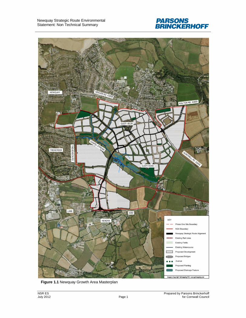
Figure 1.1 Newquay Growth Area Masterplan

Newquay Strategic Route Environmental Statement: Non Technical Summary
NSR ES Prepared by Parsons Brinckerhoff July 2012 Page 2 for Cornwall Council
1 INTRODUCTION
1.1.1 The proposed Newquay Strategic Route (NSR) is a new road that will provide a link from the A392 Hendra Road in the south to the A3508 Quintrell Road and A3059 Rialton Road in the north on the eastern side of Newquay. The road will provide an alternative route for traffic entering Newquay on the A392, provide access to future development within the Newquay Growth Area (NGA), protect the village of Trencreek from the impact of increased traffic, and provide a route for traffic arising from future employment growth at Newquay Airport.
1.1.2 The road will pass through the proposed NGA development area the current
masterplan for which is shown at Figure 1.1. The location of the site in relation to Newquay is shown in Figure 1.2 which also shows the location of Phase 1 of the NSR which is the subject of the current planning application.
Figure 1.2 Site Location Plan 1.1.3 The proposed route crosses a currently undeveloped agricultural valley to the east of
Newquay. This valley is planned to be developed for residential and employment uses as the NGA, which is a longstanding development plan proposal for Newquay. Opportunities for growth within the town are constrained spatially and the proposed NSR will provide the necessary highway infrastructure to support the expansion of Newquay’s economic and service role, which will be driven by development of the NGA.

Newquay Strategic Route Environmental Statement: Non Technical Summary
NSR ES Prepared by Parsons Brinckerhoff July 2012 Page 3 for Cornwall Council
2 METHODOLOGY
2.1.1 Advice (in the form of a Screening Opinion) received from the local planning authority (Cornwall Council) confirmed the need for a formal assessment of the environmental impacts of the proposed NSR. The applicants for planning permission for Phase 1 of the route have therefore undertaken a statutory Environmental Impact Assessment (EIA) for the development. Parsons Brinckerhoff Ltd (PB) was commissioned by the applicants to prepare the EIA and Environmental Statement (ES). The ES presents the findings of the EIA process and this Non-Technical Summary provides a summary of the ES in essentially non-technical language.
2.1.2 EIA is a systematic process that identifies, predicts and evaluates the impacts of a development on the environment. It is a requirement in England under the Town & Country Planning (Environmental Impact Assessment) Regulations 2011. The NSR falls under Schedule 2 of the Regulations, which requires EIA for projects over 1ha, where there are likely to be significant effects due to the characteristics of the development, location of development and characteristics of the potential impact. The EIA has been undertaken in accordance with the guidance presented in Volume 11 of the Department for Transport’s Design Manual for Roads and Bridges (DMRB, 1993).
2.1.3 The EIA reported in this ES considers both Phase 1 of the NSR specifically and the predicted impacts of the entire NSR as described above. This is in order that the environmental effects of Phase 1 can be understood and assessed accurately while at the same time the in-combination effects of the whole route can also be assessed as effectively as possible in advance of final detailed design.
2.1.4 The ES forms part of a planning application for Phase 1 of the NSR extending between the A392 Hendra Road and a point south of the Newquay-Par Railway Line. Planning applications for subsequent phases of the route will be made in conjunction with phases of development within the NGA. On this basis the detailed design and mitigation information presented in the ES pertains to Phase 1 (see Figure 1.1, below).
3 DESCRIPTION OF PROPOSALS
3.1.1 Phase 1 of the NSR will extend north from a new roundabout on the A392 Hendra Road, opposite the Hendra Holiday Park, to an existing field boundary about 100m south of the Newquay-Par railway line. Future planning applications will be made for the subsequent phases of the route northward which will cross the railway line and Chapel Stream by new bridges and will then fork. The western fork will connect to Trevenson Road in the northwest, and the eastern fork will cross the A3058 Quintrell Road with a new junction and join the A3059 Rialton Road at a new junction. The route will include various smaller junctions providing access to development within the NGA and will also include some works on the wider road network.
3.1.2 Phase 1 will extend to about 350m in length. The entire NSR route will extend to approximately 3.2km of new road, with a width of 6m. There will be a further 3m width provision for a cycle and footway on the west side of the route between the A392 Hendra Road to the proposed new railway bridge, thereafter 1.8m footways either side of the route are proposed. 0.5m verges will be provided where practical to allow for street lighting and any boundary treatments where building curtilages do not coincide with the back of footways. In some areas, in particular the crossing of the railway and the Chapel Stream, the footprint will be wider to accommodate earthworks. The planned character of the NSR through the central area of the NGA is illustrated in Figures 3.2 and 3.3.

Newquay Strategic Route Environmental Statement: Non Technical Summary
NSR ES Prepared by Parsons Brinckerhoff July 2012 Page 4 for Cornwall Council
Figure 3.2 Illustration of a main street
Figure 3.3 Cross Section of Phase 1 NSR

Newquay Strategic Route Environmental Statement: Non Technical Summary
NSR ES Prepared by Parsons Brinckerhoff July 2012 Page 5 for Cornwall Council
4 ENVIRONMENTAL IMPACT ASSESSMENT
4.1 Air Quality
4.1.1 Current levels of pollutants in the immediate vicinity of the proposed development are very low and range from low to high in the urban area adjacent to the site. Whilst Cornwall Council has declared a number of Air Quality Management Areas (AQMAs) in respect of exceedences of the UK’s air quality objective for annual mean nitrogen dioxide associated with vehicle emissions on major roads, the closest AQMA to the development lies more than 20km to the north west of the site and will not be affected by the proposal.
4.1.2 An assessment of construction dust impacts has been undertaken following the guidance issued by the Institute for Air Quality Management. Construction activities have the potential to generate dust at the site. However, this risk can be acceptably managed and reduced with good site practices and appropriate mitigation measures adopted through a site-specific Dust Management Plan.
4.1.3 Construction impacts on ambient concentrations of fine particulate matter (PM10) are predicted to be negligible. Existing concentrations are well below the UK’s objectives.
4.1.4 Potential operational impacts are limited to effects due to increased vehicular emissions on the local road network. These could have impacts on both existing and proposed residential properties. Phase 1 of the NSR is predicted to result in a negligible effect upon the majority of residential locations. However, as the nitrogen dioxide concentration at one existing residential location has been detected at just above the annual mean objective, the impact of a small increase in nitrogen dioxide concentration will result in a slight adverse effect.
4.1.5 The completed development has been predicted to result in a negligible effect at the majority of sample locations. A small number of new locations were predicted to experience a slight adverse effect due to the current low concentrations of nitrogen dioxide in ambient at the sites. One new dwelling was predicted to experience a moderate adverse effect, due to the site’s proximity to a planned busy road junction.
4.1.6 Air quality is predicted to improve across the majority of the modelled existing local road network as a consequence of the NSR. With the exception of one new dwelling, Treninnick Hill, air quality is predicted to remain below the objective level. Mitigation, in the form of relocating the future receptor further from the road junction by adjusting the housing layout is proposed.
4.1.7 Assessment of the increase in traffic flow through Newquay during the summer months predicts no exceedances of short-term objectives for either nitrogen dioxide or PM10.
4.1.8 The NGA transport strategy includes the provision of access to public transport options to prevent an increase in emissions associated with use of private vehicles.
4.1.9 Overall, it is considered that the air quality impacts associated with both the proposed NSR are unlikely to:
interfere with or prevent the implementation of actions within Cornwall’s Air Quality Action Plan;
require an AQMA to be declared as a consequence of the development’s impact;
Newquay Strategic Route Environmental Statement: Non Technical Summary
NSR ES Prepared by Parsons Brinckerhoff July 2012 Page 6 for Cornwall Council
adversely affect air quality on the existing road network; or
have any detrimental impact upon human health as a direct consequence of increased vehicle emissions from the scheme route.
4.1.10 It is, therefore, the conclusion of this assessment that air quality considerations associated with the proposed schemes are of low priority and do not present a constraint to the development.
4.2 Cultural Heritage
4.2.1 The cultural heritage resources examined in the ES include archaeological remains, historic buildings and the historic landscape.
4.2.2 Key historic buildings near to the overall NSR are located around Gusti Vean. Settlement around these listed buildings is thought to have originated in the medieval period. However, the existing listed buildings date to the 19th century.
4.2.3 The site lies within a known area of prehistoric and Romano-British activity. Small Iron Age/Romano-British enclosed settlements, known as rounds, are recorded in the vicinity, including within the study area at Trevenson Road. A probable focus of Bronze Age settlement activity has been identified within the north-eastern extent of the NSR, and an area of Iron Age/Romano-British settlement activity has been identified within its southern extent.
4.2.4 The historic landscape which the NSR will bisect is shaped by the field layout of the agricultural land. Many of these fields are defined as Anciently Enclosed Land, and have elements of probable medieval origins. These include the sinuous boundaries that define most of the fields, long narrow fields, and the dog-leg kinks in the field boundaries to the west of the A3058.
4.2.5 The effect on cultural heritage assets will be mitigated through a number of methods, which will be determined in conjunction with the County Archaeologist. Archaeological investigations will focus on the area of Iron Age/Romano-British settlement and the area of probable Bronze Age settlement. Mitigation on the setting of listed buildings and historic landscape is embedded in the design. A stand-off distance between the NSR and the Grade II listed buildings will be implemented. The road itself follows a generally sinuous route, in keeping with existing communication routes in the vicinity.
4.2.6 A summary of the most significant impacts is set out below:
The construction of the NSR following mitigation will result in a slight adverse significance of effect on below-ground archaeological remains, including those associated with Bronze Age and Iron Age/Romano-British settlement. Once mitigated, cumulative effects with the NGA on archaeology are not expected to be of greater significance than for the NSR alone.
Visual changes and noise associated with the construction of the NSR and traffic movement following its completion will potentially result in a slight adverse significance of effect on Grade II listed buildings at Gusti Vean. However, the cumulative impacts associated with the development of the NGA are anticipated to result in a moderate adverse significance of effect.
Physical impacts resulting from the construction of the NSR will potentially result in a slight adverse significance of effect on historic landscape, particularly due to removal of extant field boundaries. Cumulative impacts associated with the construction of the NGA are anticipated to result in a moderate adverse

Newquay Strategic Route Environmental Statement: Non Technical Summary
NSR ES Prepared by Parsons Brinckerhoff July 2012 Page 7 for Cornwall Council
significance of effect on the historic landscape, particularly due to the loss of Anciently Enclosed Land, and the change of landscape type from agricultural to settlement.
4.3 Landscape
4.3.1 In the west of the NGA site area, south of Chapel Stream and east of Trevenson Road, the fields retain a medieval strip pattern which forms strong visual lines in the landscape setting. The topography is defined by the east-west orientation of the shallow valley of the Chapel Stream. The site comprises pasture and arable fields bounded by Cornish hedgebanks.
Figure 4.1 Panorama from south of railway looking towards the northeast
4.3.2 The construction of the NSR is expected to result in a moderate adverse effect on local landscape character due to loss of Cornish hedges and pasture and the change from a broadly rural landscape to a transport corridor. This change needs to be considered alongside development of the wider NGA and ultimately the route will sit within a much more developed setting.
Figure 4.2 Stone wall and hedgebank in field adjacent to Phase 1 of the NSR
4.3.3 The operation of the NSR following mitigation will result in effects ranging from large adverse to neutral due to the changes in composition of views. This is excluding the wider effects of development within the NGA.
4.3.4 The landscape and visual assessment has been undertaken in the context of the ongoing planning process for the NGA. The impacts described are specific to the road, and have been separated from those impacts which are associated with the wider mixed use NGA. At this time the Masterplan for the NGA is at a draft stage, and therefore is not sufficiently developed to contribute significantly to this assessment. However, ultimately it is expected that the proposed NGA will include additional mitigation, which will further alleviate the landscape and visual impacts associated

Newquay Strategic Route Environmental Statement: Non Technical Summary
NSR ES Prepared by Parsons Brinckerhoff July 2012 Page 8 for Cornwall Council
with the NSR although the main effect of the NGA will be to substantially change the landscape context of the NSR. The results of the current assessment should be viewed in this context.
4.4 Nature Conservation
4.4.1 Potential identified impacts of the NSR on ecology comprise habitat loss as a result of landtake for the road and its construction, severance of habitat such as hedgerows for a wide range of species that currently use the area and potentially increased mortality for a few species. For the purposes of the assessment ecological effects were divided into those which relate to Phase 1 of the NSR and effects which relate to the wider NSR.
4.4.2 For Phase 1, the study identifies a range of habitats and species (Valued Ecological Receptors) which might be affected by the NSR. The study area contains five arable fields, bounded by linear features, of which one habitat qualified as ’valuable’, a defunct species-rich hedgerow. There are no statutory or non statutory designated sites within the survey area.
4.4.3 Surveys confirmed the presence of a limited number of protected and notable species within the Phase 1 planning application area, including breeding birds and overall low levels of bat foraging activity (no roosts or commuting routes). The site has low suitability for common dormouse but surveys to confirm absence are ongoing and so for the EIA dormice have been assumed to be present until confirmed otherwise. Legally protected species also include badgers (limited to a territorial latrine and foraging with no setts) and reptiles.
4.4.4 There is potential for Phase 1 of the NSR to have direct and indirect effects on habitats and species for both the construction and operational phases including habitat loss/severance, potential mortality, disturbance and dust deposition. Mitigation measures have been proposed reflecting Natural England Standing Advice with method statements to avoid impacts including appropriate timing of work, a wildlife corridor along the northern boundary of Phase 1 of the NSR and enhancement of the defunct hedgerows present. With this mitigation implemented the residual adverse effects on habitats and species are not considered significant.
4.4.5 The wider NSR is largely improved grassland and arable fields, fauna are supported predominantly by the semi-natural habitats running east west either side of the Chapel Stream and the species rich intact hedgerows. Habitats qualifying as ‘valuable’ include: dense scrub/wet woodland, unimproved neutral grassland marshy grassland, running and standing water.. A desk study of the wider NSR confirmed one non-statutory designated site within 200m.
4.4.6 Surveys confirmed the presence of common dormouse, breeding birds, foraging and commuting bats (roosting outside of the footprint of the NSR), invertebrates and potential habitat to support otters.
4.4.7 The impacts of the wider NSR on ecology are largely related to the construction phase causing initial low level habitat loss and severance of habitat for a wide range of species that currently use the area. A range of mitigation measure has been prescribed as set out above for Phase 1 of the NSR and within Green Infrastructure (GI) areas forming part of the NGA masterplan. These measures will reduce the residual effects such that they are significant at no more than a local level.

Newquay Strategic Route Environmental Statement: Non Technical Summary
NSR ES Prepared by Parsons Brinckerhoff July 2012 Page 9 for Cornwall Council
4.4.8 In combination with the NSR, the NGA increases the potential for habitat loss and severance of habitat to a medium level for the wide range of species utilising the area. A range of mitigation measures including the GI Plan reduces these residual effects such that they are significant at no more than a local level.
4.4.9 In 2045, by which time it is assumed all development of the NSR and NGA will have been completed, the NSR will be operational and the originally prescribed mitigation within the Green Infrastructure Plan will be fully implemented and established. On completion it is predicted that impacts will have reduced in the main to be neutral, such that the residual effects are no more than a local level.
4.4.10 Given the nature of the overall NSR and NGA development, repeat surveys and monitoring are proposed to ensure the mitigation measures prescribed remain relevant and proportionate to a changing baseline.
4.5 Geology and Soils
4.5.1 The geological and soils study area of the scheme is a parcel of land 8.66 ha in area. The topography of the site varies over the length of the proposed route.
4.5.2 Published information indicates that the bedrock geology of the site consists of Meadfoot Beds of the Devonian period. Shallow soils were observed to be very weathered natural bedrock consisting of silty clay and fragments of slate gravels and quartz. The Groundwater Vulnerability Map indicates that the study area is underlain by a Minor Aquifer that is designated as having Variable Permeability with an Intermediate Soil Class.
4.5.3 There are a number of potential contaminative issues from businesses, mining activities, landfill and waste sites, and pollution incidents. Gusti Veor Quarry and associated mining activities in particular may have affected the ground conditions and geology of the area. The potential also exists for land contamination in the vicinity of the former mine with heavy metals and hydrocarbons. The recorded historic landfill, Gusti Veor, St Columb Minor, Newquay, may be related to the above quarrying works.
4.5.4 Desk-based research and the intrusive investigation of the study area indicate that in its current condition, potential contamination could exist. Mitigation measures will therefore be provided both prior to, and during the construction stages, to minimise any potential impacts to identified receptors, these are summarised below:
Development of the site affords the opportunity to investigate any potential risks associated with contamination and underground mine workings. These can be mitigated therefore providing overall environmental betterment.
Construction will take place using best practice techniques in line with all relevant legislation.
Additional site investigation to confirm the presence or absence of asbestos and hazardous vapours, and Quantitative Risk Assessment of Controlled Waters are also part of the mitigation approach
In the event of potentially contaminated material being encountered on-site, their handling, storage and removal would be subject to current waste management legislation and guidance (A Site Waste Management Plan (SWMP) will be implemented by the contractor to this effect).

Newquay Strategic Route Environmental Statement: Non Technical Summary
NSR ES Prepared by Parsons Brinckerhoff July 2012 Page 10 for Cornwall Council
Sustainable Urban Drainage System (SUDS) will be implemented to mitigate the impact on the water environment to ensure the development has no net detrimental impact on flooding, drainage and water quality.
4.6 Materials
4.6.1 Using good and best practice much of the material (e.g. soils, aggregates,) could be specified to be re-used on-site. Where this is not possible, recycling at local facilities will be considered before disposal in landfill is considered. A preliminary Site Waste Management Plan has been prepared for Phase 1 of the NSR, and will be prepared for subsequent phases as they progress through planning.
4.6.2 Provided that the design, construction and operational mitigation measures outlined in the materials section are adopted, the overall environmental impacts of the scheme will align with accepted industry good practice.
4.7 Noise
4.7.1 In the long term, 1864 dwellings (existing and proposed) within the noise assessment study area would experience a minimal increase in road traffic noise levels, 229 dwellings would experience a minor increase and 6 dwellings would experience a moderate increase in traffic noise levels. At the same time, 380 dwellings would experience no discernible change, 136 dwellings would experience a minimal decrease, 130 dwellings would experience a minor decrease, 12 dwellings would experience a moderate decrease and 20 dwellings would experience a major decrease in traffic noise levels.
4.7.2 There would be a minimal decrease in the number of people affected by traffic noise from 434 to 427 people. It can therefore be concluded that on balance, the NSR would have a minimal net benefit in terms of noise impact.
4.7.3 There would be a minimal decrease in the number of people affected by traffic vibration from 387 to 361 people. It can therefore be concluded that on balance, the NSR would have a negligible net benefit in terms of vibration impact.
4.7.4 The construction noise assessment concludes that the threshold for construction noise impacts of 65dBA (A-weighted decibels for human hearing) for rural locations and 70dB(A) for roadside locations are unlikely to be exceeded at nearby properties provided the distance between property and the construction site exceeds 250m for a rural location, and 130m for receptors near a road. Mitigation measures will be adopted where necessary to reduce noise levels at properties. These include the use of barriers and reducing the use of the noisiest equipment such that the average noise levels do not exceed the noise thresholds for construction noise levels.
Newquay Strategic Route Environmental Statement: Non Technical Summary
NSR ES Prepared by Parsons Brinckerhoff July 2012 Page 11 for Cornwall Council
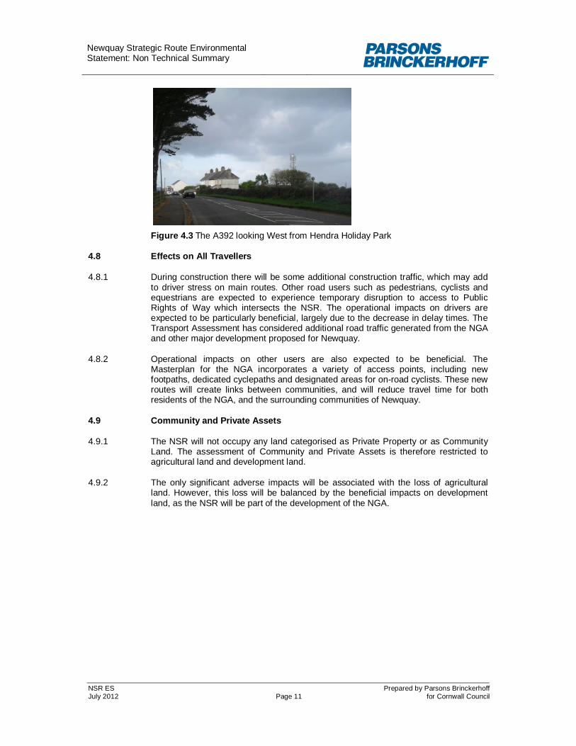
Figure 4.3 The A392 looking West from Hendra Holiday Park
4.8 Effects on All Travellers
4.8.1 During construction there will be some additional construction traffic, which may add to driver stress on main routes. Other road users such as pedestrians, cyclists and equestrians are expected to experience temporary disruption to access to Public Rights of Way which intersects the NSR. The operational impacts on drivers are expected to be particularly beneficial, largely due to the decrease in delay times. The Transport Assessment has considered additional road traffic generated from the NGA and other major development proposed for Newquay.
4.8.2 Operational impacts on other users are also expected to be beneficial. The Masterplan for the NGA incorporates a variety of access points, including new footpaths, dedicated cyclepaths and designated areas for on-road cyclists. These new routes will create links between communities, and will reduce travel time for both residents of the NGA, and the surrounding communities of Newquay.
4.9 Community and Private Assets
4.9.1 The NSR will not occupy any land categorised as Private Property or as Community Land. The assessment of Community and Private Assets is therefore restricted to agricultural land and development land.
4.9.2 The only significant adverse impacts will be associated with the loss of agricultural land. However, this loss will be balanced by the beneficial impacts on development land, as the NSR will be part of the development of the NGA.

Newquay Strategic Route Environmental Statement: Non Technical Summary
NSR ES Prepared by Parsons Brinckerhoff July 2012 Page 12 for Cornwall Council
Figure 4.4 Agricultural land between Quintrell and Rialton Road
4.10 Road Drainage and the Water Environment
4.10.1 The ES examines factors which might influence the water environment, including hydrology, water resources, flood risk and water quality. The key feature is the Chapel Stream, which runs through the valley in which the NSR is located. The Environment Agency Indicative Floodplain Map shows that the greater part of the proposed scheme lies within an area at low risk from flooding. However, areas immediately adjacent to Chapel Stream are assessed as having a higher probability of flooding.
4.10.2 A number of potential impacts have been identified during the construction phase of the scheme. These include: accidental spillage from construction plant; increased surface water runoff due to additional hard surfacing (for the construction compound); and the impact of increase silt on water quality in surface water drainage systems. These potential impacts will be mitigated through best practice methods, which will be set out in detail in the Construction Environmental Management Plan.
4.10.3 During the operational phase of the overall NSR the key potential impacts include: increase in surface water runoff due to additional (approx. 4ha) of hard surfacing; additional risk of flooding related to culverting and structures across Chapel Stream; and potential surface water or groundwater pollution due to vehicular traffic.
4.10.4 Operational impacts will be mitigated by careful planning and design of the surface water drainage system and structures. The main measures include: ensuring that the proposed bridges will not inhibit water flow on the Chapel Stream; and where possible the drainage systems will seek to reduce the impact of additional surface water runoff through use of infiltration techniques. The potential impact on quality of surface water and groundwater will be mitigated via Sustainable Urban Drainage System techniques, which filter out potential contaminants. An assessment for the addition of oil interceptors will be carried out in areas where vehicle movements are slower or industrial in type, and a higher risk of oil/petrol spillage exists. Foul water drainage will be provided to serve development areas. Details of these requirements will be established with the developers as phased built development takes place. Allowable discharge rates and possible discharge points will be agreed with South West Water.
4.10.5 All of the potential impacts on the water environment can be mitigated by appropriate design of the Chapel Stream bridge crossing, infiltration and attenuation of drainage, and inclusion of pollution control measures such that residual impacts will be neutral.

Newquay Strategic Route Environmental Statement: Non Technical Summary
NSR ES Prepared by Parsons Brinckerhoff July 2012 Page 13 for Cornwall Council
5 CUMULATIVE EFFECTS AND CONCLUSIONS
5.1 Cumulative Effects
5.1.1 Cumulative effects can arise when a number of different impacts of a project affect the same receptor or resource, or alternatively when impacts from a number of projects affect the same receptor or resource. The cumulative effects of the NSR and the NGA were assessed within each topic described above due to some of the synergies between the two developments, for example green infrastructure proposals and traffic generated.
5.1.2 Cumulative nuisance to local properties from dust, noise, traffic and change of views during construction of the scheme was assessed as being minor to moderate adverse. Cumulative effects are not predicted to be significant once construction is complete.
5.1.3 There are a number of other proposed developments in and around Newquay and these are detailed within the Environmental Statement. The transport assessment for the NSR has taken these developments into account, therefore the cumulative effects on Travellers, Air and Noise are already covered within these sections. Potential minor cumulative effects were identified for landscape, associated with landscape change from rural to urban. No further cumulative effects were identified for other topics.
5.2 Conclusion
5.2.1 In summary, the following residual impacts have been assessed for the NSR:
Effects on air quality as a result of traffic are largely negligible, although slight adverse effects have been identified in some locations.
Slight adverse effects on archaeology and listed building.
Moderate adverse effects on landscape character are predicted, the visual effects of the scheme will range from neutral to large adverse.
Effects on ecology are predicted to be either not significant or local.
Minor adverse effects due to loss of agricultural land.
Minor to large adverse effects to road users (motorised and non-motorised) during construction, there would be large to very large benefits to road users during operation.
Effects of traffic noise have been assessed to be up to moderate adverse, although this is likely to be reduced as the NGA is built as the buildings will provide screening of traffic noise to some existing dwellings.
There are a few existing sources of contamination in the study area, no unacceptable risks have been identified.
No overall effect on water resources and drainage
5.2.2 Cumulative effects with the NGA and other developments will increase the significance of some of these effects as described above.
5.2.3 A range of mitigation measure to avoid or reduce environmental impacts have been identified. The majority of these have either been built into the design of the road or will be implemented prior to or during construction.


