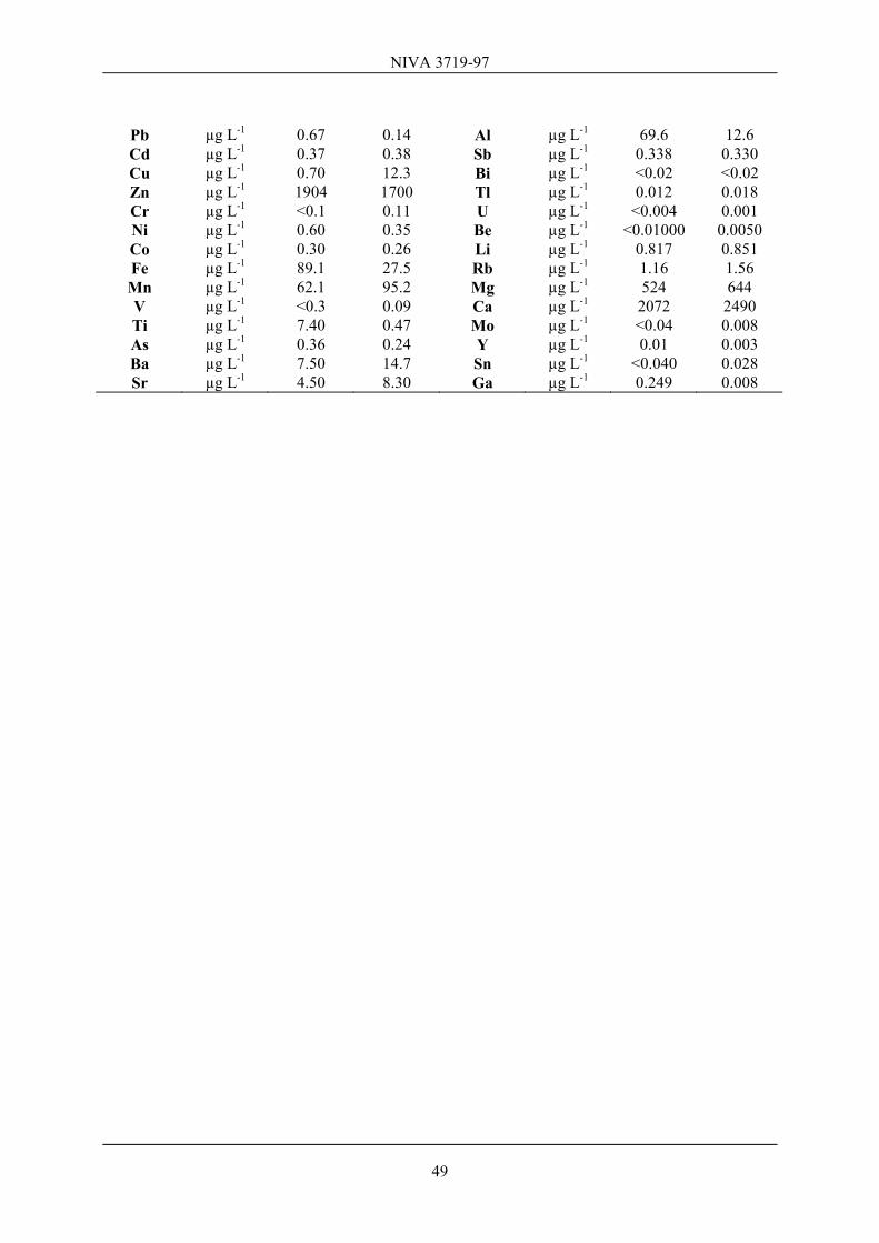
Norwegian Institute for Water Research REPORT Main Office Regional Office, Sørlandet Regional Office, Østlandet Regional Office, Vestlandet Akvaplan-NIVA A/S P.O. Box 173, Kjelsås Televeien 1 Sandvikaveien 41 Nordnesboder 5 Søndre Tollbugate 3 N-0411 Oslo N-4890 Grimstad N-2312 Ottestad N-5005 Bergen N-9000 Tromsø Norway Norway Norway Norway Norway Phone (47) 22 18 51 00 Phone (47) 37 29 50 55 Phone (47) 62 57 64 00 Phone (47) 55 30 22 50 Phone (47) 77 68 52 80 Telefax (47) 22 18 52 00 Telefax (47) 37 04 45 13 Telefax (47) 62 57 66 53 Telefax (47) 55 30 22 51 Telefax (47) 77 68 05 09 Title Planning of an Integrated Acidification Study and Survey on Acid Rain Impacts in China. Final Report. Serial No. 3719-97 Report No. Sub-No. 48/97 O-97061 Date 98.01.26 Pages Price 77 pp + Appendix Author(s) Espen Lydersen, Valter Angell (NUPI), Odd Eilertsen (NINA), Thorjørn Larssen (UiO), Jan Mulder (NISK), Ivar P. Muniz (NINA), Hans Martin Seip (UiO), Arne Semb (NILU), Rolf D. Vogt (UiO), Per Aagaard (UiO). Topic group Acid Rain Geographical area China Distribution 250 Printed NIVA Client(s) World Bank and NORAD Client ref. Abstract The PIAC-project has been a multidisciplinary survey on acid rain in China. One goal has been to document effects of airborne acidifying compounds on vegetation, soil, soil- and surface- water and aquatic biota. Other goals have been to exchange knowledge between Chinese and Norwegian scientists, as well as visiting research sites in highly polluted areas in China and evaluating their need of support in a future collaborative monitoring and research program. Besides doing field measurements, we have collected samples at more than 20 sites in three areas in China, i.e. Chongqing, Guiyang and Guangzhou. Data from this survey may also be used in the RAINS-Asia model work, where more data are needed to validate and improve this model. Our survey documents negative effects of air pollution on all ecosystem levels investigated. The air concentration of sulfur in the urban and nearby areas is very high. The concentration of volatile organic compounds is generally high, which means that increased NOx emissions in coming years may create increasing O 3 problems. Reduced photosynthetic activity in some plants is documented, as well as soil and surface water acidification. Aquatic biota also reflects the acidification status of the surface waters investigated. However, the degree of damage in these regions is difficult to assess, since too few sites are incorporated in the survey. Surface water acidification is currently not a major environmental problem in China and will presumably not become one during the next decades. This report also contains a status report about acidification in China (in Appendix A) as well as a proposed framework for a monitoring program based on Norwegian experiences (in Appendix D). 4 keywords, Norwegian 4 keywords, English 1. Luft forurensning 1. Air pollution 2. Forsuring 2. Acidification 3. Økosystem 3. Ecosystems 4. Kina 4. China Espen Lydersen (NIVA) ISBN 82-577-3287-7 Bjørn Olav Rosseland Project co-ordinator Head of Research Department
Planning of an Integrated Acidification Study and Survey on Acid Rain Impacts in China. Final Report.
Serial No.
3719-97
Report No. Sub-No.
48/97 O-97061
Date
98.01.26
Pages Price
77 pp + Appendix
Author(s)
Espen Lydersen, Valter Angell (NUPI), Odd Eilertsen (NINA), Thorjørn Larssen (UiO), Jan Mulder (NISK), Ivar P. Muniz (NINA), Hans Martin Seip (UiO), Arne Semb (NILU), Rolf D. Vogt (UiO), Per Aagaard (UiO).
Topic group Acid Rain
Geographical area
China
Distribution
250
Printed
NIVA
Client(s)
World Bank and NORAD
Client ref.
Abstract
The PIAC-project has been a multidisciplinary survey on acid rain in China. One goal has been to document effects of airborne acidifying compounds on vegetation, soil, soil- and surface- water and aquatic biota. Other goals have been to exchange knowledge between Chinese and Norwegian scientists, as well as visiting research sites in highly polluted areas in China and evaluating their need of support in a future collaborative monitoring and research program. Besides doing field measurements, we have collected samples at more than 20 sites in three areas in China, i.e. Chongqing, Guiyang and Guangzhou. Data from this survey may also be used in the RAINS-Asia model work, where more data are needed to validate and improve this model. Our survey documents negative effects of air pollution on all ecosystem levels investigated. The air concentration of sulfur in the urban and nearby areas is very high. The concentration of volatile organic compounds is generally high, which means that increased NOx emissions in coming years may create increasing O3 problems. Reduced photosynthetic activity in some plants is documented, as well as soil and surface water acidification. Aquatic biota also reflects the acidification status of the surface waters investigated. However, the degree of damage in these regions is difficult to assess, since too few sites are incorporated in the survey. Surface water acidification is currently not a major environmental problem in China and will presumably not become one during the next decades. This report also contains a status report about acidification in China (in Appendix A) as well as a proposed framework for a monitoring program based on Norwegian experiences (in Appendix D).
4 keywords, Norwegian 4 keywords, English
1. Luft forurensning 1. Air pollution 2. Forsuring 2. Acidification 3. Økosystem 3. Ecosystems 4. Kina 4. China
Espen Lydersen (NIVA) ISBN 82-577-3287-7 Bjørn Olav Rosseland
Project co-ordinator Head of Research Department
Planning of an Integrated Acidification Study and Survey on Acid Rain Impacts in China
PIAC
NIVA 3719-97
Preface
This report is prepared for the Norwegian Agency for Development Co-operation (NORAD) and Environmental and Natural Resource Division, Asia Technical Department, the World Bank (WB-ASTEN), as the main product from the joint WB/NORAD funded PIAC-project (Planning of an Integrated Acidification Study and Survey on Acid Rain Impacts in China. According to the contract we have also made a report "Acid rain and its effects in China". The report is based on information available in printed form, basically from international and Chinese scientific journals about acidification status and impacts of acid rain in China. This report is enclosed as Appendix A. The main report contains results from our 1 month travel in China during April/May 1997 and presents data from visited sites as well as a general impression from meetings with Chinese scientific and management institutions. A proposed framework on monitoring and research in China is presented in Appendix D. The Norwegian project participants are: Dr. Arne Semb, Norwegian Institute for Air Research; Professor Hans M. Seip, Associate professor Rolf D. Vogt and Research Fellow Thorjørn Larssen, Department of Chemistry, University of Oslo; Professor Per Aagaard, Department of Geology, University of Oslo; Dr. Ivar P. Muniz and Senior Research Fellow Odd Eilertsen, Norwegian Institute for Nature Research; Dr. Espen Lydersen, Norwegian Institute for Water Research; Dr. Jan Mulder, Norwegian Institute for Forest Research; Senior Research Fellow Valter Angell, Norwegian Institute for International Affairs. Dr. Espen Lydersen is the technical leader of both the WB and NORAD funded parts of the project, while Valter Angell is the administrative coordinator between WB-ASTEN and the scientific Norwegian group. We gratefully acknowledge Dr. Tang Dagang, Director of Atmospheric Environment Institute at the China Research Academy of Environmental Science (CRAES), Beijing, who was our excellent guide during the trip in China. His excellent English, his administrative talent and humor were decisive for the success of the trip. Further, we would like to thank Counselor (Environmental Affairs) Gunnar Mathisen at the Royal Norwegian Embassy in Beijing for valuable support during the planning phase and the dinner sponsored by the Norwegian Embassy. We also want to thank Director Zhang Yutian, Director of International Co-operation Division at CRAES, who together with Dr. Tang was responsible for the implementation of our China visit and the Chinese-Norwegian seminar on acid rain held at the National Environmental Pollution Agency (NEPA) in Beijing. Selection of actual sites in China was made in cooperation with Dr. Marcus Amman (IIASA), Prof. Leen Hordijk (Project manager RAINS-Asia), Dr. Jean-Paul Hettelingh (IIASA, RIVM) and local Chinese scientists. During our travel to these regions, we met a lot of friendly people and we were excellently treated. Therefore, we are most grateful to everyone, in particular Senior Engineer Zhao Dawei, Chongqing Institute of Environmental Science in Chongqing, Dr. Xiong Ji Ling, Director at the Guizhou Institute of Environmental Sciences in Guiyang and Professor Zhou Guoyi, South China Institute of Botany, Chinese Academy of Sciences, Guangzhou. We feel that our visit in China was very successful. We experienced the gradient from extremely beautiful nature to highly polluted sites. We have established numerous important contacts with open-minded Chinese scientists and people from Chinese environmental management institutions and politicians. This will obviously be of major importance for a successful implementation of a larger project on acidification in China.
Oslo, 1. September 1997 Espen Lydersen
NIVA 3719-97
Contents
Executive summary 6
1. Introduction 9
2. Material and methods 11 2.1 Air measurements - analyses 11 2.2 Vegetation measurements - analyses 12 2.3 Soil and soil water measurements - analyses 12 2.4 Surface water measurements - analyses 13 2.5 Invertebrate measurements - analyses 13
3. Data from the Chinese sites 15 3.1 Chongqing area 16 3.1.1 Nanshan 16 3.1.2 Tie Shan Ping 19 3.1.3 Simian Shan 23 3.2 Guiyang area 26 3.2.1 Liu Chong Guang 27 3.2.2 Leishan 32 3.3 Guangzhou area 36 3.3.1 Dinghushan 36 3.3.2 Heshan 39 3.3.3 Guangzhou Botanical Garden 42 3.3.4 Baiyun Shan 42 3.3.5 Liu Xi River 44 3.4 Volatile organic compounds in air 46 3.5 Intercalibration of water analyses 48 3.6 Data Synthesis 51 3.6.1 Deposition and precipitation chemistry 51 3.6.2 Soil and soil water 52 3.6.3 Vegetation 56 3.6.4 Surface water 57 3.6.5 Aquatic invertebrates 59
4. Other information related to acid rain in China 62 4.1 The Chinese-Norwegian seminar 62 4.2 The RAINS-Asia model 62 4.3 Management and scientific relationships 63 4.4 Acid rain research activity in China 65 4.5 Conclusions from the Forth Expert Meeting on Acid Deposition in East Asia. 65
5. Main conclusions and recommendations 67 5.1 Main findings 67 5.2 A framework for further cooperation 70
NIVA 3719-97
6. References 73
7. Appendix 77 Appendix A Appendix B Appendix C Appendix D
NIVA 3719-97
Executive summary
Introduction Economic and social development in China is intimately linked to production of energy through combustion of fossil fuels, primarily by using high sulfur coal. The resulting emissions of sulfur dioxide cause serious air pollution in urban areas and relatively high concentrations of air pollutants and acid rain in many rural areas, affecting the environments. Future developments will involve further building of electric power plants and increased industrial activities. This development, together with a strong increase in the use of motor vehicles, may result in rapid increases in the emission of nitrogen oxides. This may increase the photochemical production of ozone on a regional scale, as has been observed both in Europe and in North America. As urban air pollution problems are being solved, emissions of fly ash and dust may also decrease, causing a decrease in the emissions of basic particles that has to some extent reduced the effects of acid deposition. Three following issues are addressed in this report: ■ How and to what extent are natural environments in China affected by acid rain ? ■ To what extent may the RAINS Asia model be useful in China in simulating present and forecasting future effects of acid rain ? ■ How may China benefit from foreign assistance in addressing its acid rain problems ? Effects of acid deposition are clearly seen on biota, and in water and soil chemistry in China. Current emission intensities and deposition rates in some areas are much higher than in Europe and North America where most earlier studies of acid precipitation and the effects have been carried out. However, since the climate and the character of the natural environments in China are vastly different from conditions in the western countries affected by acid rain, the knowledge can not be applied directly. The survey has increased the scientific basis for translating the experience with acid rain in Europe and North America to China. The RAINS-Asia model is a valuable tool, particularly for determining the relationship between economic activity, emissions and deposition rates; and for identifying potential problem areas. It should be realized, however, that the limited geographical resolution is a problem when working in areas where a large fraction of airborne deposits derives from sources within a few tens of kilometers, and with strong deposition gradients due to topographic conditions. The critical loads derived for the RAINS-Asia model on the basis of European experience are also very crude and their value as a predictive tool needs to be qualified. There is a strong need for further refinement and validation of the model. In order for the model to become an instrument in Chinese abatement policy, transfer of ownership to Chinese users appears to be necessary. The understanding of the nature and the impacts of acid rain in China is growing. Abatement strategies have been introduced and important policy instruments are being developed. But, even though the Chinese authorities have most of the qualifications needed for implementing adequate control measures, there still appear to be gaps in the scientific knowledge about air pollution effects in China. Monitoring activities in China need to be improved, and monitoring of air pollution and acid deposition should be coordinated with effect studies and monitoring of vegetation, soil and runoff water. In order to provide a sound scientific basis for control measures and planning of future developments involving emissions of acidifying substances, the Chinese may find it beneficial to
6
NIVA 3719-97
exploit foreign experience and expertise, methodologies and "state of the art" equipment. This can be achieved through cooperation with bilateral and multilateral development agencies. Key findings Findings from the PIAC-survey relate to assessments of ambient air quality, vegetation including forests, soils, water chemistry and aquatic biota: * Precursors for the formation of O3 and other photooxidants occur at levels which are high compared to European conditions. Their presence is caused both by regional emissions and by long range transport, and the concentration levels suggest that increased emissions of nitrogen oxides (NOx) may lead to seriously increased O3-concentrations, which may further damage vegetation and reduce yields in agriculture. * Severe effects of acid deposition in China relate to soils. The investigated top and sub soils appear prone to acidification in the sense that acidity and aluminum concentrations in soil water increase. In areas with high deposition the conditions may cause damage to forests. Deeper soils and bedrock have in general higher neutralizing capacities. * Reduced photosynthesis in plants and changes in the chemical composition in plant tissues in urban and suburban areas and necrosis of plant tissues may be attributable to high levels of sulfur dioxide (SO2), photochemical ozone (O3), lack of phosphorous or high aluminum content in soil water. * Some water bodies in regions with high loading show typical signs of being acidified, i.e. high acidity or weakened natural buffering systems and elevated levels of strong acid anions and toxic aluminum compounds. Sensitive waters low in dissolved salts and hence poorly buffered, were found in some sparsely populated rural areas with low acid loading at present. * Ecological effects of acidification have be observed on surface water organisms. Many of our observations resemble those of acidified systems in Norway and other countries in Europe and North America , i.e. that the diatom communities in streams are clearly associated with the level of water acidity and invertebrate abundance and biodiversity are lower in low pH streams. The total information collected and evaluated by the PIAC team confirms that China has serious air pollution problems, not only in the urban areas and in the immediate surroundings of large conurbations, but also at considerable distances from emission sources. The problems are complex, involving damage to human health, materials, and terrestrial and aquatic ecosystems. In addition to the compounds usually involved in acid rain, photochemical ozone formation may also be a serious problem in the future. Scientific understanding of these problems requires close cooperation between different disciplines with quite different academic traditions. We have found the Chinese scientists knowledgeable and well informed, also with respect to acid rain issues. However, to make full use of previous studies in other countries, more bilateral or multilateral scientific cooperation is needed. In order to be able to run long-term monitoring studies with permanent measuring programs, it is essential to provide Chinese scientists with more resources, including equipment and training. The RAINS-Asia model
7
NIVA 3719-97
The RAINS-Asia model may become a valuable tool for understanding acid rain in Asia and for developing mitigation strategies in China. Scientists and administrators at many of the institutions and institutes visited had been introduced to the RAINS model. They expressed strong interest in using the model both for research and for policy-related activities. The RAINS-Asia formulations are based on a similar model for Europe, (RAINS-Europe) which includes the Critical Loads Concept and different options and energy pathways. The PIAC team would like to stress that there are some obvious problems related to the applied spatial and temporal scales. The model forecasts become inaccurate on small spatial scales (m/km), because of the large heterogeneity in sensitivity. Likewise, the criteria for assessing soil sensitivity based on soil types and bedrock sensitivities to anthropogenic inputs have barely been studied for Chinese conditions. In this connection it is important, as our surveys have repeatedly remained us, to consider the extensive and multiple use of forests and vegetation as part of local subsistence agriculture or forestry. Throughout the millennia, the ecosystems have been impoverished by gathering of edible plants, grazing of domestic animals, collection of litter and organic material as firewood or as soil fertilizing material. The model does not, at this stage, pretend to cover the relationships between soils, freshwater chemistry and biotic responses, like the RAINS-Europe model. Therefore, further work is necessary in order to make the RAINS-Asia model a more effective tool in future planning. Another set of issues is related to the question of transferring the "ownership" of the Rains model to the users in China. Several Chinese researchers expressed interest to have access to the modalities of the model in order to refine its operation and improve the quality of the data used. The authorities were particularly interested to incorporate their own emission data and emission forecasts. Concluding remarks We recommend that Chinese authorities and scientific institutions embark upon a joint process of creating, and partly funding, a nationwide network of cooperating scientists and administrators with the overall objective to lay the foundations for sound federal and provincial policies regarding air pollution. # We recommend that the World Bank assists in funding R&D projects needed in order to develop
Critical Load criteria and response models for vegetation, soils, freshwater and aquatic and terrestrial biota.
# We suggest that bilateral cooperation is established in a 5 year Chinese-Norwegian monitoring and research project which includes transfer of expertise, training and technologies to Chinese counterparts in order to (a) develop a national network for integrated monitoring of air pollution and acid rain of high international standard and (b) promote basic and applied research into the cause and effects of such pollution on Chinese environments as well as forecasting future changes. More details about the scientific conclusions and the proposed framework for a monitoring/research and training program on acid rain in China are presented in Chapter 5 (Main conclusions and recommendations) and Appendix D (Proposed framework for future research, monitoring and training program).
8
NIVA 3719-97
1. Introduction
The energy consumption in China has increased annually by 5.3% over the period 1980-1991 (Byrne et al., 1996) and coal accounts for more than 75% of the commercial energy production. The average sulfur content of the coal consumed is 1.2%, but in the Sichuan and Guizhou provinces the average S-content is 2.8% and 3.2%, respectively. The nitrogen emissions in China are dominated by NH3 from fertilizer and domestic animal waste (Zhao and Wang, 1994; Galloway et al., 1996). Commercial fertilizers account for about 80% of China’s total 20 million tons per year of nitrogen mobilization to the atmosphere. Acid rain was recognized as a potential environmental problem in China in the late 1970s and early 1980s (Zhao and Sun, 1986; Zhao et al., 1988; Wang et al., 1997a; Wang et al., 1996). Although the SO2 emissions have shown a lower growth rate during the last years due to cleaner technology used in power plants and boilers, the emissions are still increasing. Published reasonable scenarios have predicted that the Chinese SO2 emissions will continue to increase for years. At present there are several acid rain projects under implementation in China. These projects are included in the National Ninth Five-Year Plan for Environmental Protection and the Long-Term Targets for the Year 2010. According to this plan the amount of sulfur dioxide emissions will be reduced from 22.3 million tons in 1995 to 22.0 million tons in the year 2000, a reduction of 1.5%. Even if China manages to reduce the SO2-emissions in the nearest future, the nitrogen (NH3 and NOx) emissions are expected to increase significantly in the coming decades due to increased use of fertilizer and the fast increasing number of motor vehicles in the cities. This means that air pollution problems are expected to increase in China. Consequently, the country is likely to face increasing health problems and material damage (corrosion), reduced crop production, and negative impacts at several ecosystem levels such as vegetation (including forest), soil- and surface water biology. Preliminary calculations, e.g. by the RAINS-Asia model, suggest that the critical loads of forest ecosystems are seriously exceeded in many areas already (Hettelingh et al., 1995). However, there is an urgent need for improving the critical load estimates. More details about the acidification status and impacts of acidification in China are presented in Appendix A. Most of the knowledge of effects of acid deposition has been supplied from studies in Europe and North America. Due to the severe impacts of acidification in these regions, scientists have shown increasing concerns about the situation in China and in nearby countries. Already in 1988, Professor Hans M. Seip at the University of Oslo established contacts with Chinese scientists, and Seip and co-workers have collaborated with several Chinese groups since then (Seip et al., 1995). In particular this has resulted in detailed studies in small catchments close to Guiyang and Chongqing. Acid rain research has a long tradition in Norway and is among the most successful examples of interdisciplinary research carried out in this country. A broad international contact net has also been established, and Norwegian scientists have been involved in many international research activities related to acidification and its effects on terrestrial and aquatic ecosystems. One of the main goals of this project was to transfer our experience and knowledge to Chinese colleagues. Concurrently, our cooperation will allow us to learn from Chinese experience and it will broaden our understanding of the effects of acidification because the ecosystems are quite different from those considered in the past. The differences between Chinese and European and North American ecosystems may reduce the applicability of the most used acidification models. At present there are no reliable estimates of critical loads for China. Assessment of critical loads for different ecosystems in China is necessary before effective emission reductions plans can be made. Experience from acidification research in Europe and North America shows that critical loads of pollutants may vary depending on the target studied. An optimal strategy for air pollution control can therefore only be obtained if environmental problems are treated in an integrated way. This implies
9
NIVA 3719-97
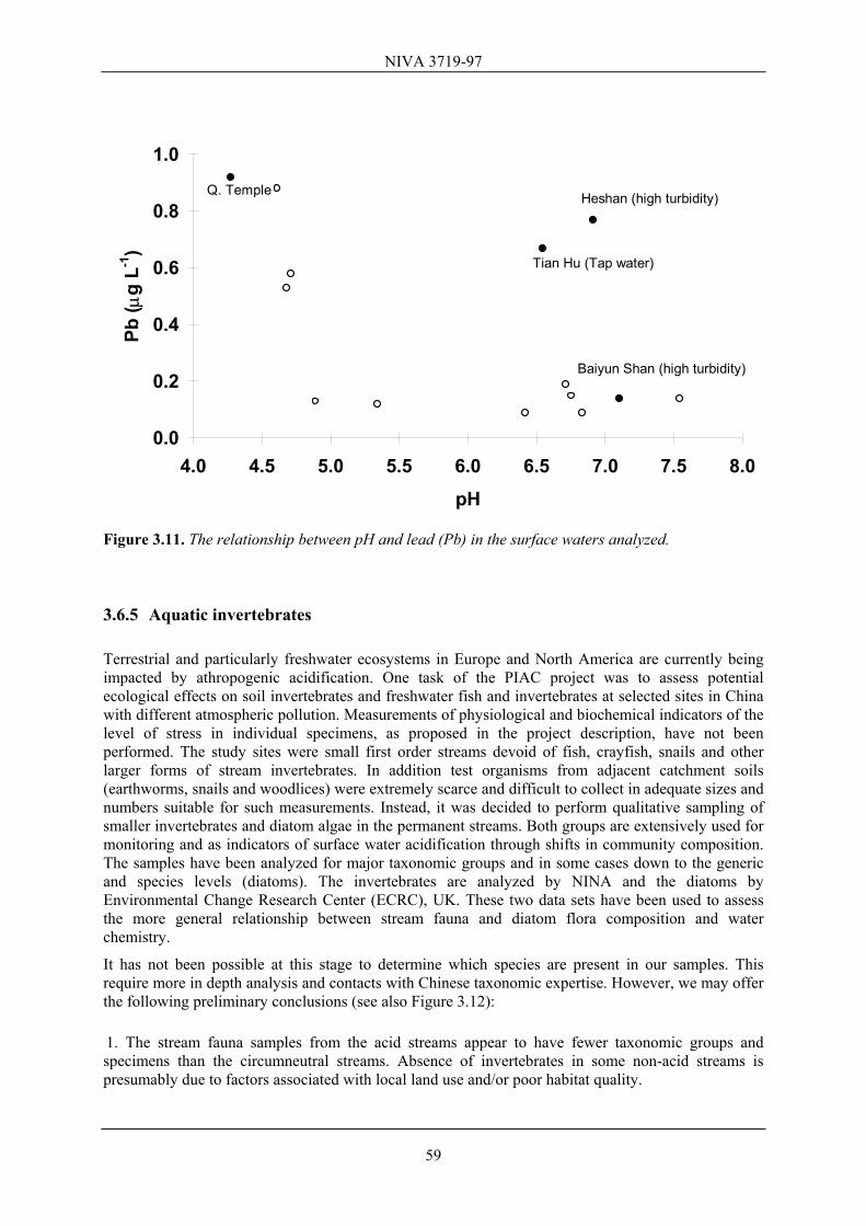
that effects on ecosystems, human health, materials and climate must be considered at the same time (see e.g. Aunan et al., 1995). We are convinced that problems related to emissions of acidifying compounds are severe in China and, if proper measures are not taken, very likely will get worse. Accordingly we conclude that a highly interdisciplinary research program is necessary as a basis for action. Consequently, an important aspect of this project is a tight link between different scientific disciplines. At present China primarily focuses on the health and corrosion problems caused by air pollutants. Our project will focus on terrestrial and aquatic ecosystems, because as China follows the same emission strategy as the Western world, negative impacts are to be expected. In the pilot project, PIAC (Planning of an Integrated Acidification Study and Survey on Acid Rain Impacts in China), proposed to NORAD and WB, we had six major objectives: 1) Establish contacts between scientific institutions and environmental authorities in China and Norway. 2) Obtain an overview of existing knowledge and activities within acidification research in China at both local and national level, and if necessary contribute with our knowledge and experience. 3) Evaluate needs for education, training, analytical tools, spare parts etc. for implementation of the action plan for monitoring. 4) Evaluation of the acidification problems in China. 5) Collect and analyze samples as an aid in getting quantitative information on acid rain and acidification in China. The data are also relevant for the RAINS-Asia modeling work. 6) Based on the pilot project, propose an action plan for monitoring and research in China in close cooperation with Chinese partners. This action plan should be useful for our Chinese counterparts when they apply for economic support to NORAD/WB. In order to obtain these goals we have had frequent contacts with Chinese colleagues since late 1996. Accordingly, we arranged a one day seminar in Beijing together, and thereafter implemented a one month travel in China (April/May 1997) including visits to potential sites for future monitoring. During this travel, a lot of measurements and samples were taken. In addition we received much information from Chinese scientists, environmental institutions and industrial companies. Most of this information is presented in this report.
10
NIVA 3719-97
2. Material and methods
Three regions in China have been visited: the Chongqing area, the Guiyang area and Guangzhou area. In Chongqing we visited three main sites: Nanshan, Tie Shan Ping and Simian Shan. In Guiyang we visited two major sites: Liu Chong Guang and Leishan; and in Guangzhou another four sites: Dingushan, Heshan, Baiyun Shan and Liu Xi River catchment. Where possible, measurements were conducted and samples were collected at the sites. Totally 27 different locations were visited. An overview of the main sites and the sampling/measuring program is given in Table 2.1. More details are presented in Appendix B, while all data from the survey are presented in Appendix C. Table 2.1. Overview of sites where samples were collected during the tour. N: Needle samples; PEA: Plant Efficiency Activity measurements Soil
No. of plots Soil water Surface
water Vegetation
Chongqing Nanshan East 1 No No PEA Nanshan West 1 No No No Tie Shan Ping 71 Yes Yes N, PEA Simian Shan 1 No Yes PEA Guiyang Liu Chong Guang 7 + 132 Yes Yes N, PEA Leishan 3 No Yes PEA Guangzhou Dingushan 3 No Yes N, PEA Heshan 1 No Yes N, PEA Baiyun Shan 1 No Yes N, PEA Guangzhou Bot. G. No No No PEA Liu Xi River 1 No Yes N, PEA 1. Studied by Zhao Dawei, Chongqing Inst. of Environmental Science and Monitoring 2. The 7 plots are included in the study by Larssen et al. (1997). In addition soils from 12 locations along a transect and one additional plot were sampled. 2.1 Air measurements - analyses Measurements of the airborne concentrations of sulfur dioxide, nitrogen oxides, ozone and particulate matter require heavy instrumentation and are not easy to perform on a field trip. Moreover, since concentrations vary from day to day, the results of such measurements are difficult to interpret in the absence of long data series and supplementary information, e.g. in the form of air mass trajectories and detailed emission inventories. Information on the concentration levels of sulfur dioxide in the cities and at some of the measurement sites was supplied by our Chinese colleagues. Precipitation chemistry data for these sites were also received. These data give information not only on the acidity of the precipitation, but also on the general air quality. The only direct air quality measurements carried out by the group were determinations of the concentrations of light hydrocarbons and carbonyl compounds (aldehydes and ketones). The sampling procedure followed the EMEP Manual (Hanssen et al., 1996). Table C.16. gives the sampling sites, dates and time of sampling. The samples were analyzed by gas chromatography and high performance liquid chromatography at NILU. Some estimates of atmospheric residence times of different compounds are presented in Table C.17 (Appendix). All samples were taken some distance away from
11
NIVA 3719-97
major roads and motor vehicles. Contamination sources were generally absent. However, some of the sites were more close to urban centers as described under site description. The concentrations of these compounds are indicative of the influence of combustion sources on the air quality at the sampling sites, and also of the photochemical reactivity and the ozone formation potential. The data may be directly compared with corresponding data from Europe. 2.2 Vegetation measurements - analyses Chlorophyll emits a red fluorescence when excited by visible light. When a leaf is illuminated at constant intensity it will fluoresce at a steady level. However, if a leaf is kept in darkness for several minutes and then is brightly illuminated, fluorescence rapidly rises to a peak level and then gradually decays to a low level (F0) level. The maximum achievable fluorescence level at a given light intensity is known as FM. The difference between FM and the low level signal (F0) is the variable component of fluorescence (FV). The ratio FV/FM has been shown to be proportional to the quantum yield of photochemistry and shows a high correlation with the quantum yield of net photosynthesis of intact leaves (Björkman & Demmig 1987). Recently, chlorophyll fluorescence has been used to study cellular processes other than photosynthesis, in particular, the response of plants to environmental stress. A number of stress factors cause a progressive decline in FV/FM. Changes in chlorophyll fluorescence may well occur before any physical signs of deterioration are evident. Early indications of this type allow the collection of valuable data on the onset of stress conditions and tolerance threshold values. One of the objectives in the PIAC project was to make a screening for stress tolerance by chlorophyll fluorescence, by studying the FV/FM ratio, on different species at geographically separated localities in a gradient from central to south-east China. In our study a portable Plant Efficiency Analyzer (PEA) was used for measuring chlorophyll fluorescence in the field. Early detection of reduced photosynthetic capacity may be achieved non-destructively by measurement of chlorophyll fluorescence using a PEA. Tree damage parameters, including crown density, and crown color, have been estimated. Furthermore, samples of fresh needles from Masson pine and Chinese fir have been collected and analyzed for the content of plant nutrients, aluminum and several heavy metals. The chemical composition of the needles was compared to soil chemical parameters, which were determined at the same site. All chemical analyses of plant samples were conducted at the Norwegian Forest Research Institute (NISK), according to accredited methods. The main purpose of these analysis was to evaluate the possible direct effects of air pollutants and indirect effects of soil acidification on trees and ground vegetation. 2.3 Soil and soil water measurements - analyses Soil samples were analyzed at the Department of Chemistry, University of Oslo (cation exchange characteristics) and at the Department of Soil and Water Sciences, Agricultural University of Norway (C and N analysis). The soils’ bulk density, porosity and moisture characteristics were determined at NISK and the soil mineralogy was determined at Department of Geology, University of Oslo. In some cases, published results from soil analyses at Chinese institutes are presented. Data on soil water chemistry from Tie Shan Ping are provided by Dr. Zhao Dawei, Chongqing Institute of Environmental
12
NIVA 3719-97
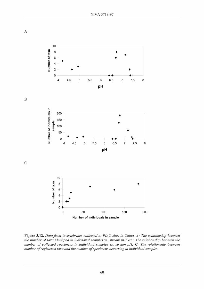
Science and Monitoring (CIESM). Soil water chemistry date in the Liu Chong Guang site are from Larssen et al. (1997). The following soil analyses have been conducted: Total content of carbon and nitrogen, bulk density, porosity and water retention in soil, effective cation exchange capacity (CECE), base cation saturation (BS), grain size and mineralogy. Fractionation of aluminum in soil water has been conducted, and soil water samples have been analyzed for all major anions and cations. Parameters essential in evaluating effects of acid rain and for the critical load estimates connected to RAINS-Asia have been determined. Based on the soil chemical and physical analyses, soil and soil water sensitivity to acidification can be estimated. Mechanisms for interactions between soil and soil water can be discussed where soil water data, including Al-fractionation, exist. Furthermore, the content of major plant nutrients in the soil, important for forest health, can be assessed. 2.4 Surface water measurements - analyses Water pH, conductivity and temperature measurements were conducted directly in field. Water samples were collected for major chemical analyses at the Norwegian Institute for Water Research (NIVA) and for trace-elements and heavy metals at the Norwegian Institute for Air Research (NILU). Both NIVA and NILU are accredited laboratories. On the basis of our analyses and existing Chinese data on surface water chemistry, it should be possible to document water acidification and to assess the resistance or buffering capacity of the different water bodies in light of likely increases in acidic inputs. Based on these analyses we are also able to give a first estimate of the water chemical conditions in relation to critical loads for some fish species according to our knowledge of critical loads for some European and North American fish species. The data from our China tour are not sufficient to assess the critical loads for the different water bodies in relation to the current sulfur and nitrogen deposition. This will be one goal in a future project on acid rain in China. 2.5 Invertebrate measurements - analyses The visited localities are all very small first order streams, some of which probably periodically dry out. Fish, crayfish, larger forms of snails and stream invertebrates were absent in all the actual streams. Macro-invertebrates in adjacent soils (earthworms, snails and woodlices) were also extremely scarce and difficult to collect in adequate sizes and numbers. Measurements of physiological (fish) and biochemical (soil and freshwater invertebrates) indicators of the level of stress in individual specimens, as proposed in the project description, have therefore not been performed. Consequently the sampling of stream invertebrates, microalgae and diatoms was merely qualitative. These groups of organisms are frequently used in Europe and North America to indicate the level of freshwater acidification through shifts in community composition. The invertebrates were collected by using a fine meshed dipnet and/or by collecting specimens on stones from the streambed. When specimens were scarce or seemed absent from these samples, diatom samples (see below) were later examined for the presence of invertebrates. The field samples were preserved in ethylalcohol and later examined under the microscope. Only major taxonomic groups have been identified and registered. To determine which species are present in our samples, there is a need for establishing contacts with Chinese taxonomic expertise on stream invertebrates. The data sets
13
NIVA 3719-97
have been used to assess the more general relationship between stream fauna and environmental variables like water chemistry. Diatoms, like invertebrates, occur in many habitats, and are also frequently used in the context of freshwater acidification, for monitoring and for comparative purposes. Their most widely sampled habitat in streams is the surface of upwards facing stones, submerged in the stream. Samples were taken by removing them from surfaces of several closely spaced stones by brushing into a tray, decanted into plastic vials and a pooled sample was preserved with Lugols Iodine. The material consists of 12 samples of such epilithon material collected from various stream localities. The diatom samples have been processed using standard protocols and analyzed by Professor R. Battarbee at the Environmental Change Research Center (ECRC), UK. The samples were rapidly screened in the microscope and identification at this stage has been restricted in most cases to the generic level. Based on these results and known pH preferences, the diatom flora for each site have also been used to assess its relationship with ambient water quality.
14
NIVA 3719-97
3. Data from the Chinese sites
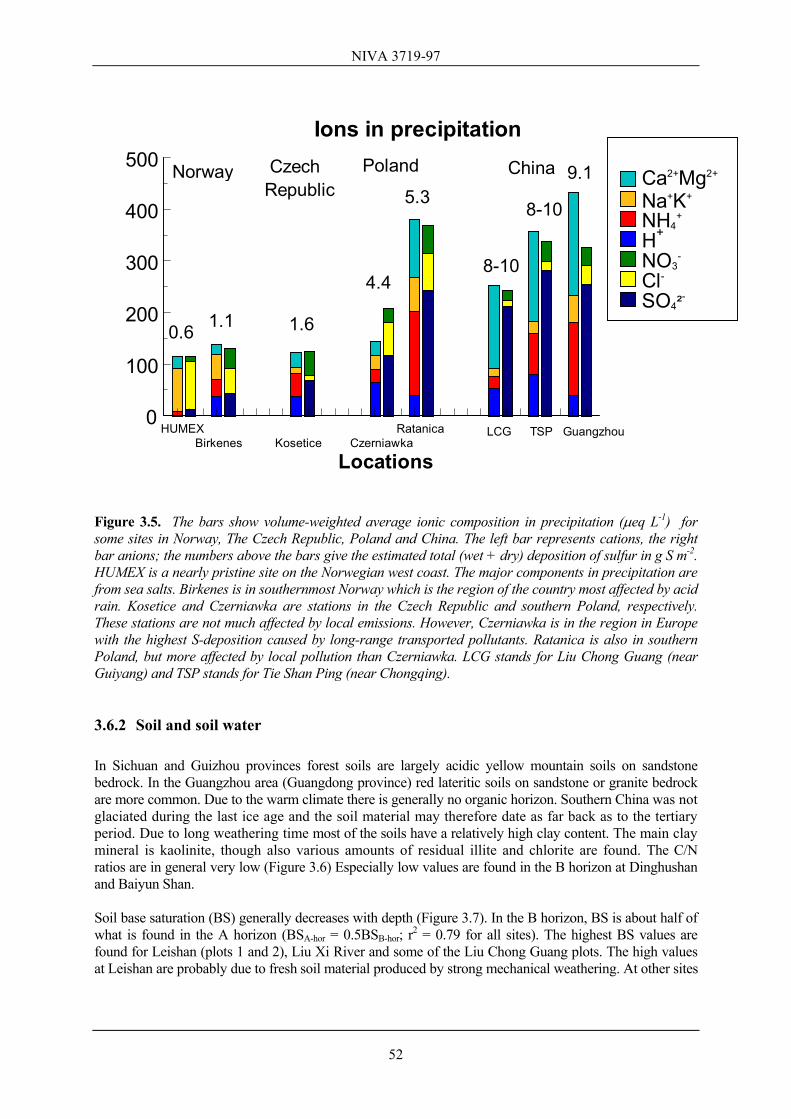
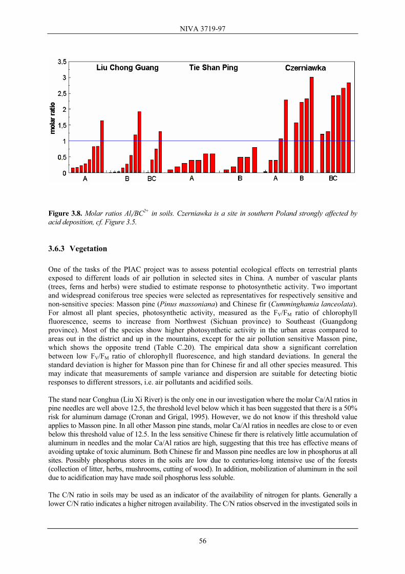
In China 3 different classes of air pollution standards are used. Class III is for industrial areas, Class II for urban residential areas, while Class I is for specially protected areas and nature. The annual average standard for SO2 is 60 µg m-3 for Class II. (WHO gives 40-60 µg m-3). The National standard for SO2 for 24-hour averaging time is 150 µg m-3 for Class II and 50 µg m-3 for Class I. The acidity (pH) of the precipitation is governed by a balance between acidic and basic components. Emissions of sulfur dioxide (SO2) and nitrogen oxides (NOx) are main contributors to the acids while basic dust (both man-made and natural) containing Ca and Mg tends to neutralize the precipitation (see e.g. Hedin et al., 1994). Emissions of ammonia (NH3) will neutralize the precipitation, but may cause acidification of soils and waters when ammonium is oxidized to nitrate. Direct damage to forest vegetation is usually caused by short-term exposure to concentrations of several hundred micrograms of sulfur dioxide during a few hours, while frequent exposure to somewhat lower concentrations may result in general weakening of the plants and needle loss in the case of conifers. Conifers are generally susceptible to SO2 and HF damage. When discussing the sensitivity to acid deposition at the various sites, one must distinguish between further acidification of soil, soil water and streamwater. Defining soil acidification as a decrease in base saturation, the most sensitive soils are those with low cation exchange capacity and moderate BS. Soil water acidification is likely to occur where BS is low. For water chemistry the acid neutralization capacity (ANC) is an expression of base cations (ΣCa,Mg, Na,K) in relation to strong acid anions (ΣSO4,Cl,NO3), i.e. ANC = ΣCa,Mg,Na,K - ΣSO4,Cl,NO3 (in µeq L-1) . This variable gives a measure of the acidification status and the water's ability to resist acidification. In Norway and Sweden countermeasures like liming of acidic waters are never conducted in surface water with ANC > 50 µeq L-1. Lakes with ANC > 100-150 µeq L-1 are assessed to be well buffered towards acidification. No fish damage is documented in Norway in lakes with annual average ANC > 20 µeq L-1. The fish incorporated in the Norwegian surveys (salmonids) are among the most sensitive species in the world to acid water. Ala and Ali are two fractions of aluminum. Ala primarily represents the total concentrations of low molecular weight Al forms, while Ali is the inorganic fraction of Ala and represents the acute toxic forms of Al. The molar ratio Ali/BC2+, where BC2+ = Ca2+ + Mg2+, is an important variable, especially in soil water. It has been suggested that values > 1 may cause forest damage (Sverdrup and de Vries, 1994). The molar Ca/Al ratio in needles is often used as a diagnostic criteria to indicate the risk for aluminum damage in forest trees (e.g. Cronan and Grigal, 1995). A value < 12.5 is believed to indicate a 50 % risk for aluminum damage. However, it is not known if this threshold value also applies for the Chinese tree species investigated in our survey. The evapotranspiration is high in the places we visited. This implies that ion concentrations increase relative to concentrations in precipitation.
15
NIVA 3719-97
3.1 Chongqing area The Chongqing region is within the most air-polluted area in China. In the center of the city of Chongqing, average pH in rain is about 4.1, but pH increases to about 4.4 in the nearby rural areas. Predominant wind directions are north and north-east and rain pH varies according to emission sources and wind direction. The concentration of SO2 is 200 - 400 µg m-3. The Chongqing area has a subtropical climate. Average air temperature is 18°C, with an average humidity of 80%. The soils in the Chongqing area are very variable. Three soil types predominate (Professor Ma, Vice-director of forestry Bureau of Chongqing Municipality and Professor at Southwest China Normal University, personal com.): 1) Non-acidic, well buffered soils developed from purple mudstone and shale (with 6-17% CaCO3
covering about 81% of the area. These soils are mostly used for agriculture and relatively little for forestry (some bamboo).
2) Acidic yellow soils derived from gray and yellow sandstone. These soils have little or no CaCO3 and cover about 17% of the area. Yellow soils have a pH between 4 and 5 and the base saturation is generally low. This means that these soils and/or the soil waters are sensitive to acidification. Normal pH in yellow soil water is about 4.3. About 80% of the local forests occur on yellow soil and these forests are dominated by Masson pine. Soil depth in Masson pine forest is 20-80 cm.
3) Soils derived from limestone containing more than 17% CaCO3 cover about 3.3% of the area, Chongqing city covers an area of 23 000 km2, and the forest stand is about 12 mill m3, covering 17% of the area. The annual growth is 0.8 mill m3 and 0.5 mill m3 is cut down annually for private use and because of diseases/insect attacks etc. Forest harvesting is strictly regulated by the authorities. The primary function of forests in Chongqing is to reduce soil erosion in the steep terrain. They are also used for recreational purposes. At the end of the 1950’s, when coal combustion increased markedly, significant reductions in forest growth were reported in the area. According to Professor Ma, the predominant forest vegetation is Masson pine (≈ 68% of the forest), evergreens (≈ 13%), Chinese fir (≈ 10%) and Cypress (≈ 6%). Large parts of the forest were deforested in 1958 and 1962 during the "The Great Leap Forward", a common situation over large areas of China. The forests of today are mainly planted, and accordingly nearly 40 years old. 3.1.1 Nanshan Site description Nanshan is a hilly area just outside the center of Chongqing city (29°32'N, 106°39'E). Annual precipitation is about 1100 mm yr-1, and almost 60% falls during April-September. Maximum intensity of rain is about 100 mm day-1. Annual evapotranspiration is about 900 mm (Professor Ma, personal comm.), while annual mean temperature is about 17-18°C. We visited both the east and west side of the mountain. In the 1980´s, forest dieback occurred in a 700 ha area at Nanshan. Some of this has been reported at the Rio Conference. Also foliar damage, including yellow needle tips (likely chlorosis), has been observed. Possible reasons for the dieback have been discussed in several scientific papers, also internationally. There seems to be general agreement that insect pest (e.g. bark beetles) was the direct cause of tree death, but that the trees were already stressed from pollution. Professor Ma believes that indirect effects through soils are more important than direct effects through SO2. He suggested toxic
16
NIVA 3719-97
Al and nutrient problems (Mg shortage) as probable causes, while other scientists like Bian and Yu (1992) assumed the direct effects from SO2 and hydrogenfluoride (HF) to be the most important reasons. On the east side of the Nashan mountain, facing away from the city, we observed scattered signs of damage to the most dominating tree species (i.e. Masson pine) and some bryophytes species. The forest vegetation showed a considerable crown thinning because of such damage to Masson pine. The second most dominating tree species (i.e. Chinese fir) and a number of vascular plants showed better vitality. In areas with thin soils (20-50 cm) coniferous forests predominate while deciduous trees populate areas with thicker soils (> 50 cm). Soils are generally acidic yellow mountain soil with a thin O horizon on top of an approximately 3 cm deep A horizon. Below the A horizon is a B horizon with high clay content (Bt). On the west side of the hill, facing Chongqing city, extensive dieback of Masson pine occurred in the mid-1980's. According to our guide, a number of other sensitive species had disappeared from this part of the mountain, and been replaced by more tolerant species. Currently, some deciduous trees and vascular plants seem to manage the levels of air pollution in the area, while others showed stress symptoms. On the west side of Nanshan the soils are considerably more sandy than on the east side, but also here they classify as yellow mountain soils. Air pollution Precipitation chemistry (Table 3.1) and concentrations of some pollutants in air have been extensively studied in the Chongqing area, see Zhao et al. (1994) and Xue and Schnoor (1994). The sulfate concentrations in precipitation are very high, while the nitrate values are still fairly low. Of the cations, calcium and ammonium show the highest values. The former dominates in the urban areas, the latter in the rural areas. In addition to deposition by precipitation, dry deposition of both sulfur dioxide and particles should be considered. Annual SO2 deposition in this area could easily amount to several grams per m2 (i.e. > 10 g S m-2). The SO2-gas concentrations in Chongqing are about 30 times greater than those measured in the Bavarian and Black Forests of Germany (Blank, 1985; Blank et. al., 1988), and 3-4 times greater than those reported from the most polluted regions in the prior Czechoslovakia (Moldan and Schnoor, 1992). Table 3.1. Precipitation chemistry (µeq L-1) in the Chongqing area. The three upper rows correspond to two urban (U) and one suburban (SU) station (for the years 1982-86), based on Xue and Schnoor (1994). The two lower rows are from one urban and one rural (R) station (for 1987-89), from Zhao et al. (1994). Ca2+ Mg2+ Na+ K+ NH4
At both sites the effective cation exchange capacity (CECE) in the mineral soil is relatively high, presumably due to the high clay content. On the east side the soils are highly acidic with a base saturation in the A and B horizon below 10% (see table C.1). High clay content was especially noticeable at the east side site, showing a somewhat higher CECE than the west side. The exchange sites are dominated by aluminum so that the base saturation (BS) is low, rendering the soil water sensitive to acid deposition, despite the high CECE. C/N ratios decrease from 15.0 in the A horizon to 10.5 in the B (Table C.1). These C/N ratios are rather low, compared with values reported for forest soils in temperate and boreal regions. The low C/N ratios suggest that the availability of N is high. On the west side of Nanshan we sampled the soil close to one of the remaining Masson pines. At this site the soils have a considerably higher base saturation in the topsoil (A-horizon) than in the deeper B-horizon, and the values are higher in both horizons than on the east side (Table C.1). The higher base saturation on the west side, facing the local pollution sources in Chongqing, may be due to the elevated input of alkaline dust. However, also the input of base cations from mineralizing woody debris after the dieback may have contributed. The C/N ratio (Table C.1) is extremely low in the A horizon (11.9) suggesting that the organic matter is well decomposed and that nitrogen is highly available. Leaching of nitrate from this site may be considerable, but unfortunately no data are available. Surface water At the east side of Nanshan, there was one small artificial pool, but this was considered to be too much affected by human activity. No water body was present at the Nanshan west site. We also visited a second catchment on the hillside facing westwards towards Chongqing, but at a lower altitude than Nanshan west. In this catchment, there were two small streams originating as groundwater springs, one clearwater stream with pH 4.3 and one with pH 7. The latter probably contained high concentrations of heavy metals, presumably iron, since significant amounts of red precipitate (ochre) were found in the stream. We did not collect samples from this site for further analysis, because we did not find this catchment applicable as a future monitoring site. Thus, no water body was found suitable for monitoring. Xue and Schnoor (1994) sampled two lakes in the area (Table 3.2). The concentrations of ions in Lake I are so extreme that we will not discuss these data further. Even in Lake II, the concentrations of ions are very high, and the acid neutralizing capacity (ANC) of the water is 822 µeq L-1. The ANC of the lake is a result of neutralization and buffering of strong acids in the atmosphere (primarily H2SO4) by dry-deposited compounds (e.g. CaCO3 dust) and weathering and cation exchange reactions in the watersheds. The calcium concentration in Lake II is close to saturation concentration for calcium in surface water in equilibrium with CO2 in air. Such high concentrations of calcium are normally found only in calcite areas, where acidification is unimportant. Some surface waters in Nanshan Mountain were also analyzed by Zhao Dawei and coworkers (Chongqing Inst. of Environmental Science and Monitoring). These data have not been published, but show the same picture, i.e. high concentrations of calcium and sulfate and high ANC and pH. This does not rule out the possible presence of other harmful compounds, in particular heavy metals, since the area is highly polluted by atmospheric inputs of SO2/H2SO4 and dust. Such compounds should be analyzed in the future, because they may have negative impacts on aquatic life. The concentration of dissolved organic carbon in the surface waters analyzed is high, and much higher than the other surface waters within our China survey. Table 3.2. Water chemistry in two Nanshan Mountain lakes near Chongqing, sampled 4 times during 1987-88 (Xue and Schnoor, 1994). All concentrations in µeq L-1, except for DOC (Dissolved organic carbon) which is in mg C L-1.
18
NIVA 3719-97
Lake pH H+ Ca2+ Mg2+ Na+ K+ SO42- Cl- NO3
- F- ANC DOC I 8.46 0.004 3336 1010 855 115 1934 1241 17 16.3 2026 13.1 II 6.79 0.16 1450 364 205 118 979 216 86 0 822 9.3 Vegetation Nanshan Mountain is an area of dramatic forest decline, and the Masson pine forests at the top of this mountain are dying (Xue and Schnoor, 1994). Photosynthesis activity was only measured on the east side of the mountain. The few remaining specimens were so damaged that it was not possible to measure photosynthesis activity on the west side. For Masson pine the mean value of three measurements from six ramets was 0.75, the lowest value both within the Sichuan province and the other 12 studied areas. The standard deviation of these measurements was 0.043, the highest registered in our material (Table C.20). The FV/FM ratio measured on the tree showing the best condition was 0.80, while the lowest FV/FM ratio was 0.69. This may indicate that some of the trees have more sub-optimal growth conditions, due to more air pollution and/or less available soil nutrients, than others. For Chinese fir, the other dominant coniferous tree species, the mean value was 0.80 and the standard deviation very low (0.008), indicating that Chinese fir is a non-sensitive species compared to Masson pine. For a number of randomly selected vascular plants the measurements showed more or less the same picture as for Chinese fir. Because Nanshan did not appear to be one of the potential monitoring sites, we have not carried out chemical analysis of needles. 3.1.2 Tie Shan Ping Site description The Tie Shan Ping area (29°38’N, 106°41’E) is approximately 25 km north-east from Chongqing center, at an elevation of about 450 meters. The catchment visited is located within a protected area. The forest area is partly protected, but heavily used for recreational purposes. It consists of 1200 ha forest where Masson pine is the predominant tree species. Large parts of the forest were logged in 1958 and 1962. Later forest has been replanted. The area receives about 1 million Yuan annually from tourists, while 0.1 million Yuan come from governmental funding. The administrative management of the forest is undertaken by Jiang Bei District, Agricultural Dept., Chongqing. The main soil type is yellow mountain soil. The soils are reported to be homogenous and they are relatively rich in finer particles (i.e. < 63 µm, see Table C.15). In general the soils are 50 - 80 cm deep with a thin A horizon (about 3 cm) on top of a B1 (3 - 13 cm depth) and a B2 horizon. During previous co-operation between CIESM and the UiO, equipment for sampling precipitation, throughfall and soilwater has been installed at seven plots within the catchment. Throughfall and soil water chemistry data given in this report are unpublished results from these plots provided by Dr. Zhao Dawei at CIESM. Air pollution
19
NIVA 3719-97
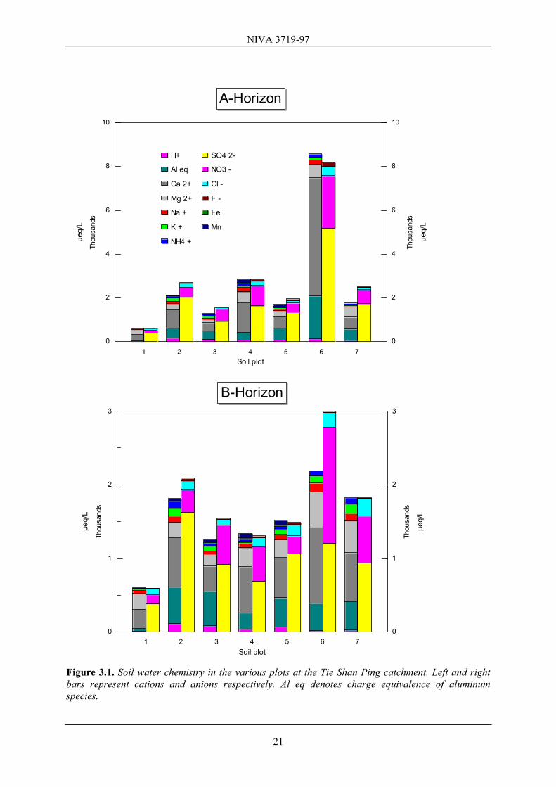
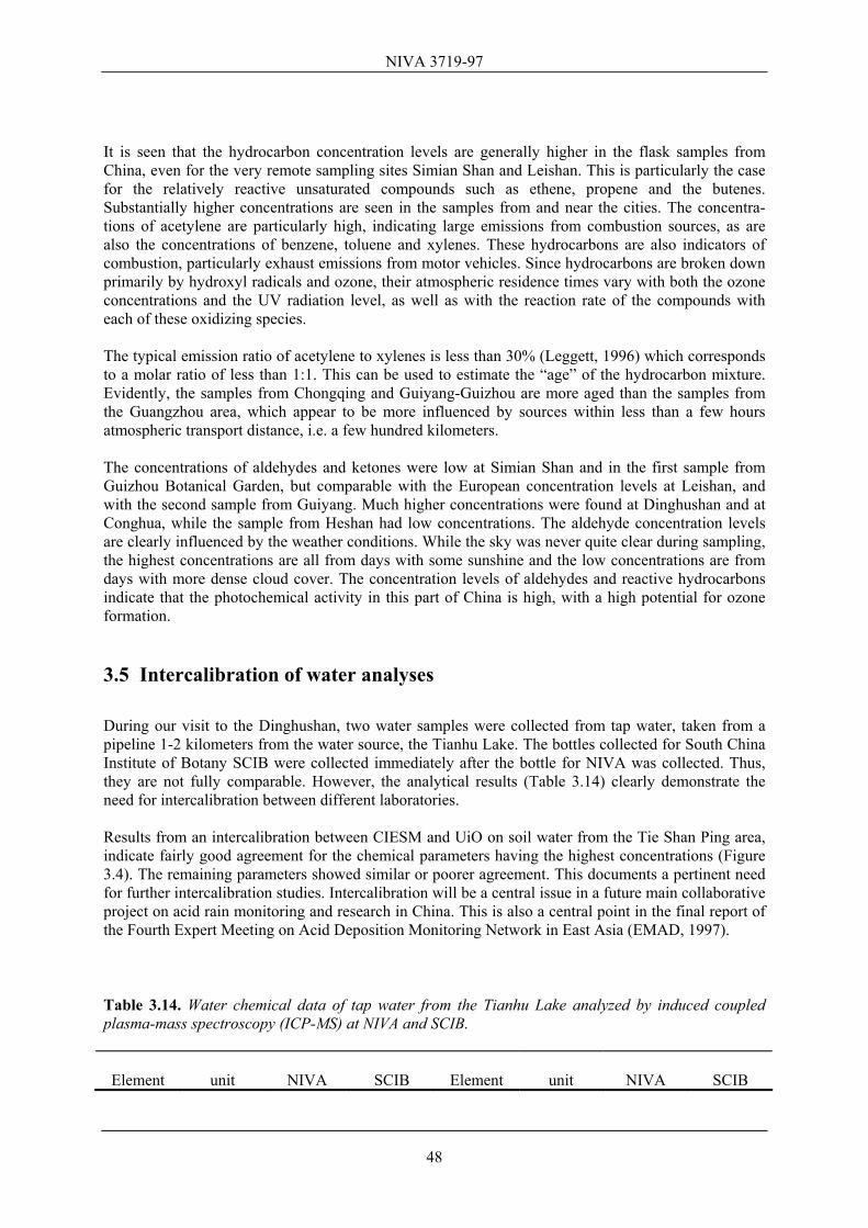
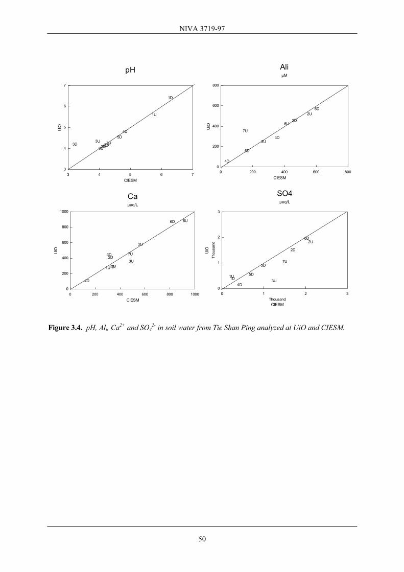
The site appears to be downwind of Chongqing industrial areas, and may therefore experience quite high airborne concentrations of sulfur dioxide and other pollutants, particularly in the winter season. Inputs by dry deposition may be similar to or higher than the wet deposition. pH in volume weighted precipitation is low with values during winter months dropping to 4.6 in open air and below 4 in throughfall (annual avg. 5.0 and 4.1 respectively). Due to high concentrations of calcium, the lime potential (Lp = pH - ½p(Ca+Mg)) in precipitation was 3.0, dropping to 2.5 in the throughfall. Ammonium deposition is significant, i.e. 32 µM in throughfall (0.29 g N m-2yr-1). Fluoride concentrations in throughfall are also relatively high (up to 14.4 µM). Soil and soil water The soils at Tie Shan Ping are rather dense with bulk densities increasing from 1.25 kg dm-3 in the A horizon to 1.34 kg dm-3 in the B2 horizon (Table C.4). Soil porosity is 50% and 47% in the A and B horizon, respectively. The generally high densities and low porosities are mainly due to a large fraction of fine secondary silt and clay material (< 63 µm). The grain fraction less than 63 µm decreases somewhat down into the profile. Increasing grain size with depth is common in soils developed through chemical weathering. Water retention characteristics are similar for the A and B horizon and typical for clay rich soils. The soils are mainly composed of quartz (74%) and clay minerals (14%). The remaining material being both plagioclase and K-feldspar (Table C.15). Moderate and similar amounts of plagioclase and K-feldspar probably reflect the generally low amounts of these minerals found in the indigenous sandstone bedrock. Water contents in the A horizon decrease from 36% at field capacity to 22% at wilting point (Table C.5). This suggests that the upper 60 cm of the soil, which is assumed to be the rooting zone, has a storage capacity of water available for plants of only 69 mm. This indicates that the site is rather drought sensitive. The C/N ratio of soil organic matter decreases from 16.1 in the A to 8.1 in the B2 horizon (Table C.1). These values are rather low and suggest that that nitrogen availability for the vegetation is good and that nitrate is likely to leak from the soils causing high concentrations in soil water and surface water (see below). The total store of nitrogen in the soil is estimated at 5100 kg ha-1 (from the soil surface to 28 cm depth; Table C.4). Average soil water chemistry data from the A and B horizon in the seven plots are presented in Figure 3.1 and Table C.9. Charge balance calculations on the soil water data show that there is no clear bias, though the agreement is not good; average deviation was 7.5% in excess of anions, with a standard deviation of 25.0% (see figure 3.1). Results from an intercalibration between CIESM and University of Oslo indicate fairly good agreement, but there is a pertinent need for further intercalibration studies. See Chapter 3.5 for further discussion of the intercalibration data. The major anion in soil water is as usual sulfate, though also nitrate concentration is high at this site. The high nitrate values suggest that ammonium from deposition may oxidize and leach out causing high nitrate and even significant ammonia concentrations in surface water (see below). As in deposition, fluoride concentrations are relatively high. Large spatial and temporal variations in pH and Ali are observed. In plot 2, pH is generally low (median 4.2) and [Ali] is high, especially in the B-horizon. Lowest acidity was found in plot 1, which is a groundwater spring, feeding water into a lake.
20
NIVA 3719-97
0
2
4
6
8
10
0
2
4
6
8
10
Thou
sand
s
Thou
sand
s
Soil plot
µeq/
L
µeq/
L
1 2 3 4 5 6 7
H+
Al eq
Ca 2+
Mg 2+
Na +
K +
NH4 +
SO4 2-
NO3 -
Cl -
F -
Fe
Mn
A-Horizon
0
1
2
3
0
1
2
3
Thou
sand
s
Thou
sand
s
Soil plot
µeq/
L
µeq/
L
1 2 3 4 5 6 7
B-Horizon
Figure 3.1. Soil water chemistry in the various plots at the Tie Shan Ping catchment. Left and right bars represent cations and anions respectively. Al eq denotes charge equivalence of aluminum species.
21
NIVA 3719-97
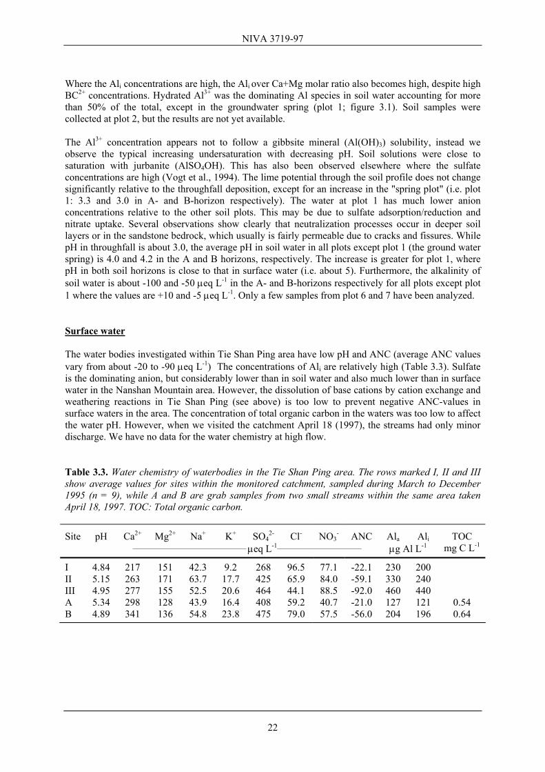
Where the Ali concentrations are high, the Ali over Ca+Mg molar ratio also becomes high, despite high BC2+ concentrations. Hydrated Al3+ was the dominating Al species in soil water accounting for more than 50% of the total, except in the groundwater spring (plot 1; figure 3.1). Soil samples were collected at plot 2, but the results are not yet available. The Al3+ concentration appears not to follow a gibbsite mineral (Al(OH)3) solubility, instead we observe the typical increasing undersaturation with decreasing pH. Soil solutions were close to saturation with jurbanite (AlSO4OH). This has also been observed elsewhere where the sulfate concentrations are high (Vogt et al., 1994). The lime potential through the soil profile does not change significantly relative to the throughfall deposition, except for an increase in the "spring plot" (i.e. plot 1: 3.3 and 3.0 in A- and B-horizon respectively). The water at plot 1 has much lower anion concentrations relative to the other soil plots. This may be due to sulfate adsorption/reduction and nitrate uptake. Several observations show clearly that neutralization processes occur in deeper soil layers or in the sandstone bedrock, which usually is fairly permeable due to cracks and fissures. While pH in throughfall is about 3.0, the average pH in soil water in all plots except plot 1 (the ground water spring) is 4.0 and 4.2 in the A and B horizons, respectively. The increase is greater for plot 1, where pH in both soil horizons is close to that in surface water (i.e. about 5). Furthermore, the alkalinity of soil water is about -100 and -50 µeq L-1 in the A- and B-horizons respectively for all plots except plot 1 where the values are +10 and -5 µeq L-1. Only a few samples from plot 6 and 7 have been analyzed. Surface water The water bodies investigated within Tie Shan Ping area have low pH and ANC (average ANC values vary from about -20 to -90 µeq L-1) The concentrations of Ali are relatively high (Table 3.3). Sulfate is the dominating anion, but considerably lower than in soil water and also much lower than in surface water in the Nanshan Mountain area. However, the dissolution of base cations by cation exchange and weathering reactions in Tie Shan Ping (see above) is too low to prevent negative ANC-values in surface waters in the area. The concentration of total organic carbon in the waters was too low to affect the water pH. However, when we visited the catchment April 18 (1997), the streams had only minor discharge. We have no data for the water chemistry at high flow. Table 3.3. Water chemistry of waterbodies in the Tie Shan Ping area. The rows marked I, II and III show average values for sites within the monitored catchment, sampled during March to December 1995 (n = 9), while A and B are grab samples from two small streams within the same area taken April 18, 1997. TOC: Total organic carbon.
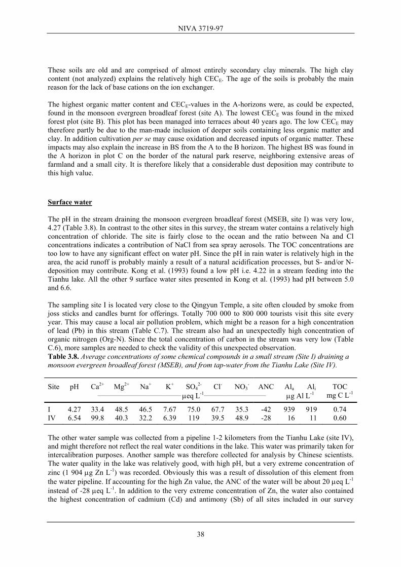
Site pH Ca2+ Mg2+ Na+ K+ SO42- Cl- NO3
- ANC Ala Ali TOC ___________________________________ µeq L-1__________________________ µg Al L-1 mg C L-1
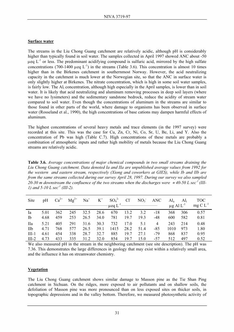
The concentrations of heavy and trace metals in the waterbodies are not extreme (Table C.7). One exception is manganese (Mn) at site B, which had the highest concentration (632 µg Mn L-1) of all water bodies investigated. Zhao Dawei and coworkers at CIESM have also documented high concentrations of manganese, i.e. from 417 µg Mn L-1 at site I to 538 µg Mn L-1 at site III. Manganese is not a very toxic metal, but the concentrations in the surface water in Tie Shan Ping are very high. Manganese interferes in the determination of aluminum. This has not been corrected for due to lack of Mn data for the other sites. At site B this has led to a 3.5% overestimate of Al. The concentration of iron is close to the median concentration of this element in our survey. At site B, we observed a redbrown precipitate on the stream bed, probably indicating high levels of iron and/or manganese. Vegetation The trees at Tie Shan Ping appear less defoliated than at Nanshan, although Masson pine on exposed ridges showed occasionally low crown densities. This was reflected by the chlorophyll fluorescence, showing a mean FV/FM ratio of 0.82 (maximum value: 0.84, minimum value: 0.77). The standard deviation of these measurements, 0.025, was considerably lower than in Nanshan, indicating more stable and better growth conditions. Chinese fir, on the other hand, shows the opposite picture: The mean FV/FM ratio was 0.80, which was slightly lower than at Nanshan. It is difficult to explain this difference. But we cannot preclude differences in local climate and nutrient conditions. Chemical analyses of needles (Table C.3) indicate that phosphorus nutrition is sub-optimal for both Masson pine and Chinese fir. Nitrogen contents in the needles indicate that this nutrient is in good supply reflecting the low C/N ratios in soils and high nitrate values in soil water. The content of Ca in needles is quite different for Masson pine and Chinese fir, being highest in the latter. By contrast the Al content is lowest in the fir needles. In Masson pine the Ca/Al ratio in the needles even approaches 12.5, which is believed to indicate a 50% risk for aluminum damage. Invertebrates and diatoms Diatom samples were taken below the confluence of the two small streams (A and B, Table 3.3). This station had pH 4.95 and conductivity 66.4 µS cm-1 at 16.6 °C. This sample is of low floristic diversity, containing several small Pinnularia spp., Eunotia spp. and Brachysira serians, indicating a strongly acidic environment. We observed no stream invertebrates at this site through visual inspection of the substrate. But by later examination of the diatom samples we observed a few (15) very small Diptera (midge) larvae, one pupae and one little Trichoptera (caddisfly) larvae. This signifies a poor fauna with very low species diversity which probably is related to the ambient water quality. The hydrological effects of the upstream dams are not known, but even if the stream periodically carries very little water, this alone cannot explain the absence of major common invertebrate groups. 3.1.3 Simian Shan
23
NIVA 3719-97
Site description The Simian Shan (or Four Side Mountain) is located about 110 km south of Chongqing (28°40’N, 106°22’E) and about 200 km from Guiyang. The sampling site was a few hundred meters behind the Forest Management Department, in the catchment of a small stream named Piao Chang Qoy, located about 1100 m a.s.l. Annual mean temperature in the area is 15-17°C. Air temperature is normally 3-5°C during winter, but temperatures ≤ 0° are not uncommon. Annual precipitation is about 1200 mm. Deciduous forest is the dominating forest type, but there are also areas with conifers. The area under the Forest Management Department administration is 40 000 ha. The major soil type is yellow mountain soil derived from sandstone. Average soil pH representative for this area was reported to be 4.2 in the A-horizon, 4.6 in the B-horizon and 4.5 in the C-horizon. Average organic matter contents were 81%, 2.2% and 2.2% in the A, B, and C horizon, respectively. The information was presented by a representative from the Forest Management Department. At the site sampled by us, there was a few cm thick forest floor on top of a 4 cm deep A horizon. Below the A is a B1 (6 cm deep) and a B2 horizon. More information about the Simian Shan Site is given in Zhao et al. (1994). Air pollution According to Zhao et al. (1994), the volume weighted pH of rain in this area is about 4.4, the sulfate concentration in precipitation about 130 µeq L-1, and wet deposition about 2.3 g S m-2. Some data (20 samples) presented to us by the representative of the Forest Management Dept., collected during a short period in the summer, showed high pH in precipitation, varying from pH 6.2 to 6.9. Sulfur dioxide concentrations were a few miocrograms per m3 (cf. Lei et al., 1997). Soil The soil plot sampled at Simian Shan was dominated by Chinese fir and broadleaf trees. C/N ratios in soil organic matter are rather low, being 17.0 in the A horizon and 15.2 in the B2 (Table C.1). Nitrogen stores in the upper 18 cm of the soil (including A, B1 and B2 horizon) are estimated at 3800 kg ha-1 (Table C.4). The soils at Simian Shan have a relatively low bulk density increasing from 0.57 kg dm-3 in the A horizon to 0.92 kg dm-3 in the B. Soil porosity is 69% and 58% in the A and B horizon, respectively (see Table C.15). More than 80% of the soil material is quartz, which is the highest amount among our sampled sites. Furthermore, the soils do not contain the secondary mineral kaolinite. Instead the clay minerals are mainly residuals as illite and chlorite. This may indicate that the soils are relatively young. A lack of plagioclase mineral in these soils may be due to the sandstone bedrock being previously depleted of plagioclase. The mineralogy does not change much with depth. The CECE is high in the topsoil horizons (Table C.1). This is probably caused by fairly high organic matter content probably due to rather slow organic breakdown in the relatively cold climate (see above). Also the B-horizon has a relatively high CECE considering that the soil material consisted mainly of quartz sand. The soils are among the most acidic ones sampled on our trip through China, with base saturation values decreasing slightly down into the profile from 8.5% in the A horizon to 6.4% in the B2. These low BS values suggest that soil water at this site may be easily acidified even though the CECE is high. Increased acid deposition is likely to result in elevated concentrations of toxic aluminum in soil water. Despite the acid soils the streamwater was not acid (see below). This is likely due to deep hydrological flowpaths, passing soils or bedrock richer in base cations. The high alkalinity in the stream sample collected further downstream even indicates the presence of some carbonates in the bedrock.
24
NIVA 3719-97
Water contents in the A horizon decrease from 40% at field capacity to only 9% at wilting point. In the upper 60 cm this soil has a storage capacity of water available to plants of 165 mm, indicating that this site is far less drought sensitive than Tie Shan Ping. Surface water Water samples were taken from the Piao Chang Qoy stream, between two small artificial dams stocked with carp (site A), and from another stream further down the road draining a small valley where rice and vegetables were grown (site B). The data from Zhao Dawei and coworkers at CIESM presented in Table 3.4 are from sites located at somewhat higher altitudes. Even though the Simian Shan area is located 110 km south of Chongqing, the concentration of sulfate in runoff is relatively high, probably mainly due to the substantial S-deposition (see above). Since the concentrations of base cations are even higher than of sulfate, the ANC of surface water is high, and Ali negligible. The concentrations of trace- and heavy metals are generally low (Table C.7), but the concentrations of titanium (80 µg Ti L-1) and vanadium (0.80 µg V L-1) at site B are the highest, and the concentration of strontium (125 µg Sr L-1) the second highest recorded in this survey. Titanium is normally closely associated with iron (Fe), and even Fe is at relatively high levels. These elements, especially Fe and Ti, are presumably primarily associated with clay particles and organic compounds, and not dissolved in the water as true ions. The turbidity, and therefore concentration of particles in this stream is relatively high (Table C.6), explaining the high Fe and Ti. Table 3.4. Average concentrations of some chemical compounds in surface water at the Simian Shan Mountain located from 1000-1350 m a.s.l. Data set I gives average values for three sites based on unpublished data from Zhao Dawei and coworkers at CIESM, while the data denoted A and B are from sites collected during our survey April 19-20, 1997.
Data pH Ca2+ Mg2+ Na+ K+ SO42- Cl- NO3
- ANC Ala Ali TOC set ___________________________________ µeq L-1__________________________ µg Al L-1 mg C L-1
I 7.17 333 92.1 200 462 A 6.83 434 64.2 33.5 13.6 373 11.3 26.4 125 64 9 2.0 B 7.54 898 125 46.5 15.9 433 14.1 65.3 573 19 8 2.1 Vegetation At this mountain site there are very few Masson pines. The forest was dominated by other Pinus species, but sufficient ramets of Masson pine were available for photosynthetic activity measurements. All these trees were located close to arable land. The specimens were probably planted and looked after by the local farmer, and thus given good growth conditions. This fits in with the measured FV/FM ratio (Table C.20), showing very high values in spite of the sub-optimal climate conditions at this altitude. The standard deviation, 0.005, is the lowest registered at all our sites. This may indicate that the six measured trees are exposed to the same low level of air pollutants. Measurements of Chinese fir showed a relatively low photosynthetic activity (mean FV/FM ratio 0.79). Similar values are only found in other mountain areas like Leishan and Dinghushan. The trees at Simian Shan are less defoliated than at Nanshan and Tie Shan Ping. However, Simian Shan, where only a few Masson pine trees occur, is not an appropriate reference site for the affected Masson pine forests near Chongqing. Needle samples were therefore not taken for chemical analysis. Invertebrates and diatoms
25
NIVA 3719-97
Diatom samples were taken from the same streams as the water samples. The sample from site A had a relatively rich and diverse diatom flora with Achnanthes minutissima, Sellaphora pupula, Gomphonema spp., Navicula spp., Pinnularia spp, and Cocconeis spp. suggesting circumneutral water. The site B sample had a range of taxa characteristic of circumneutral to alkaline waters including large Cymbellas, Achnanthes spp., Gomphonema spp. and Fragilaria spp. We observed no invertebrates in the two streams, neither through visual inspection of the substrate nor by later examination of the diatom samples. This is surprising particularly for the stream between two small artificial dams. These dams are stocked with carp which shows that the overall water quality should be suitable for fish. The cause of absence of stream invertebrates could in this case be drought and for the other stream, which drains the cultivated valley, perhaps local use of agrochemicals. This case still remains somewhat obscure because, as shown to us by the local people, the nearby main river was fished in and had several species. 3.2 Guiyang area The Guiyang city covers an area of 8000 km2. The city is located about 1000 m a.s.l. and is surrounded by mountains. The temperature is 4 - 8°C in winter and 24-28°C in summer. Frequent inversion periods occur during the winter (80% of the time), and 27% of the year there is almost no wind. The annual precipitation amount is 1175 mm and the major part falls during summer. The energy source is primarily coal, with a sulfur content of 3 - 5%. Many countermeasures towards particle and SO2 emission have been conducted or are planned. In 1980, 95% of the energy was based on coal, while in 1997 this was reduced to 70-80%. Before the reductions the urban SO2 emissions in Guiyang were 270 000 tons yr-1. According to Guiyang EPB, the emission of SO2 in the rural area of Guiyang is today reduced by about 60 000 tons yr-1. In addition the total emission of solid particles (TSP) has been reduced by 30 000 tons yr-1. Accordingly, while the annual average SO2 concentration in the city was 460 µg m-3 in 1990, it was reduced to about 300 µg m-3 in 1996. Thus, the concentration in Guiyang is still about 6 times greater than recommended by the National standard, Class II, and by WHO. The pH of the precipitation was reported to have increased from around 4 to around 5 during the same period (1990-1996). This increase is unexpectedly large, especially because emissions of alkaline dust particles have decreased concurrently with SO2 emissions. Continued observations of precipitation chemistry are necessary to study the trends. In 1990 pH < 5.6 occurred in almost 60% of the rain events. Guiyang city is the major source for air pollution in this province. Accordingly, countermeasures in this city are essential for the future emissions of this province. The authorities are particularly concerned about corrosion, health problems and tree health (e.g. early shedding of leaves in the autumn and yellowing of conifer needles) due to air pollution. Besides having meetings with local scientists and the local EPB, we also visited different demonstration projects for air emission reductions at three factories in Guiyang city. We visited a tire-factory, which by using a lime (CaCO3) injecting technique, had managed to reduce their SO2 emission by 70 - 80%. Today the annual emission of SO2 from this factory is about 3 000 tons. The lime injection technique produces about 50 000 tons of relatively polluted CaSO4 waste, a product primarily used in bitumen surfaces. Further, we visited a factory producing special steel for airplanes, which had a cyclone boiler flue gas scrubber using limewater for removal of SO2 and particles. This was only a small demonstration unit. The removal of S by this technique was about 85%. Finally we visited Guiyang Steel Mills which started in 1958 and has 9 300 employees at present. They produce
26
NIVA 3719-97
annually about 300 000 tons raw steel, and 250 000 tons more refined steel. The annual emissions are 6 500 tons (SO2), 1 350 tons dust, and 1 200 tons industrial dust. About 65 000 tons of industrial wastes are stored in land deposits. The factory is also discharging 23 mill tons of waste water annually. The factory is therefore an important emitter of both SO2 and dust to the Guiyang city. However, the process is old, and the old boilers will be closed in the nearest future and/or retrofitted with gas fired boilers. In a few years time, all the ovens will be run on low sulfur coal gas instead of raw coal with a S-content of about 5%. Thus in 1998, the SO2 emissions are expected to be about 1000 tons yr-1. Large efforts are being directed towards solving the dust problems, and it was claimed that they will be under control in 1999. At present, there are three major countermeasures for reducing the emissions of S in Guiyang: 1) Limestone injection technique 2) Production of desulfurized coal briquettes or patent fuel. 3) More LPG (Liquid Petroleum Gas) products, e.g. the private stoves are today using more gas for cooking instead of raw coal. 3.2.1 Liu Chong Guang Site description The catchment is located about 10 km north-east of Guiyang center (26°34’N, 106°38’E). The catchment is about 7 ha, and the elevation ranges from 1320 to 1400 m a.s.l.. It is drained by two small streams which below their confluence run into a small artificial dam. Another stream draining the neighboring catchment enters the outlet stream from the dam. The annual discharge has been estimated at 630 mm which means that the evapotranspiration is roughly 45%. SO2 concentrations in air (approximately 1 month's average) varied between 10 and 100 µg m-3 which can be characterized as medium to high pollution level in China. The predominant vegetation is Chinese fir, Masson pine and wild rose bushes. The catchment was deforested in 1958 and hit by fire soon after, but replanted after the fire. Thus, the catchment is in a dynamic succession stage, clearly experienced by the vegetation changes that have occurred since last time the Norwegian scientists (Rolf Vogt and Thorjørn Larssen, UiO) visited the catchment in 1995. During previous cooperation between Guizhou Institute for Environmental Sciences (GIES) and Dept. of Chemistry, UiO, equipment for sampling precipitation, throughfall and soil water has been installed at 7 plots within the catchment. A lot of scientific activity has been conducted or is still going on in this catchment. Previous results from this site are presented in Larssen et al. (1997) and their major findings are given below. Soils are acidic yellow mountain soils with a relatively high clay content (Table C.15). The soils on the steep hill-slopes in the catchment are clearly affected by solifluction processes and by landslides. At several places we observed layers of colluvium (a layer of erosion products forming an inhomogeneous mixture of material from A, B and C horizons) on top of buried A horizons (the original top soil; see Table C.1). The colluvium layer can be in various stages of soil development. Because erosion contributes to the supply of fresh mineral material to the soil surface this process may help keeping up the acid neutralization capacity in the root zone. There is a discontinuous O horizon in the catchment ranging from 0 to 15 cm in depth. Generally there is an A horizon underneath (ranging from 1 to 10 cm). In some cases the O horizon occurs directly on colluvium. In most places there is a transition zone (from 4 to 25 cm thick) between A and B horizon, indicated as an AB horizon, which still has a relatively high organic matter content.
27
NIVA 3719-97
When we visited the catchment, we observed several landslides which had occurred during a very high flow in early spring 1996. Parts of the streambed were covered by deposits from the slides, and some trees had fallen over the stream. To date parts of the slides have been eroded by the stream water. Prior to our visit in the catchment, there had been several days with rain. The streams were at high flow and the water in the dam had a grayish color, probably caused by soil colloids. Air pollution The median precipitation pH was 4.40. Sulfate was the dominant anion in the precipitation and accounted for between 80 and 90 % of the total anionic charge on an annual basis (Table 3.5). The dominating cation in the precipitation was calcium, usually accounting for between 45 and 60 % of the total positive charge. The concentrations are generally similar to those found in Chongqing in the neighboring province, Sichuan. Large differences in concentration in throughfall at the different plots were observed, probably mainly due to differences in vegetation density. A clear increase in base cation concentrations and a decrease in H+ concentrations in the throughfall compared to precipitation strongly indicate that dry deposition of alkaline dust is important for the total deposition chemistry. Larssen et al. (1997) estimated a likely average total deposition of sulfur to be between 8.5 to 10 g S m-2 yr-1, which is about 10 times higher than at Birkenes, southernmost Norway, an area strongly affected by acidification. Average concentration of SO2 in air in 1993/94 was reported to be 44 µg m-3 in the Liu Chong Guang catchment. Table 3.5. Median and quartile concentrations (µeq L-1) of major ions in the precipitation in the catchment (Larssen et al., 1997). pH SO4
2- NO3- F- Cl- Ca2+ Mg2+ NH4
+ Median 4.40 228 19 5 6 133 30 29 Lower quartile 4.19 147 11 0 0 79 16 6 Upper quartile 4.74 334 35 10 14 199 53 79 Soil and soil water Most data from the Liu Chong Guang catchment, except for the soil transect and plot H, have been published in Larssen et al. (1997). Precipitation-, throughfall-, soil water- and stream water samples were analyzed at GIES in Guiyang. Some samples have in addition been analyzed at Department of Chemistry, UiO. Soils from 8 soil plots were analyzed at UiO. Soils from plot H and a transect have been analyzed for C/N ratios at NISK (Table C.2) and particle size distribution and mineralogy at Department of Geology, UiO. Soil physical characteristics at Liu Chong Guang are quite variable. At plot C bulk density is rather low with values of about 0.80 kg dm-3 at least to 55 cm depth. Soil porosity is nearly constant with depth (about 64%). At plot H the soil is considerably more dense (1.05 kg dm-3 in the A and 1.32 kg dm-3 in the AB) and less porous (porosity of 59% and 48% in the A and AB horizon, respectively). The differences in the soil’s density and porosity at plots C and H are also reflected in the water retention characteristics, particularly in the sub-soil. For example, between 20 and 25 cm depth soil moisture content decreases from 44% at field capacity to 12% at wilting point on plot C, whereas these values are 37% (field capacity) and 18% (wilting point) at plot H (Table C.5). We estimate that the soil root zone (0 to 60 cm depth) has a storage capacity
28
NIVA 3719-97
for plant available water amounting to about 200 mm (plot C) and 120 mm (plot H). This indicates that drought stress may occur in some parts of the catchment, but not in others. Aluminum is the major exchangeable cation in the soil. In the mineral soil, the median aluminum saturation (AlS) is 83.7%. Hence the base saturation is generally quite low (Table C.1). The median effective cation exchange capacity (CECE) for the mineral soil is high (86.2 meq/kg). In the upper horizon, rich in organic matter, the CECE is especially high, up to 223 meq/kg. Generally CECE decreases with depth together with the organic matter content. The median pH in the soils (pHH2O) is 4.09. As shown in Table C.13, the sulfate adsorption is low despite the relatively high clay and sesquioxide content (Liao et al., 1994). The soil mineralogy is rather homogeneous and similar to what was found for the Tie Shan Ping site. The soils are dominated by quartz and clay minerals (median percentages 78 and 14 respectively). The remaining percentage was made up by varying amounts of plagioclase and K-feldspar. The main clay mineral is kaolinite and there is some vermiculite, partly hydroxy-interlayered. Also various amounts of residual illite and chlorite were found. C/N ratios decrease from about 18 in the O horizon to values between 11 and 18 in the A horizon. In the AB and B horizons the C/N ratio is between 6 and 14. As in the soils investigated at other sites on our trip in China, the C/N ratios are low, suggesting that nitrogen is available in considerable amounts. The total store of nitrogen in the upper 59 cm of the soil at plot H was estimated 7 400 kg ha-1 (Table C.4). As in throughfall, there are large differences in ion concentrations in soil water within the catchment (Figure 3.2, Table C.10). The median total ion concentration varies with a factor of five. This large spatial variation in the catchment makes generalizations on the soil water chemistry difficult. At all plots, the pH decreases from throughfall to the upper soil horizon. This is probably partly due to high concentrations of natural organic acids in the upper soil layer and partly due to ion exchange with soil organic matter and to base cation uptake and release of protons by plant roots. pH in soil water tends to increase with depth. Sulfate is the dominating anion also in the soil water. In some horizons nitrate is of significance. The source of the nitrate is not certain; the direct input is low, but there is considerable deposition of NH4
+ which may be oxidized in the upper soil layer. Considering the low C/N ratios, nitrate production in the soil either by decay of organic matter or by nitrogen fixing bacteria, is also possible. Mineralization of organic matter as an effect of lysimeter installation cannot be excluded, even though there is no clear time trend in the data. The median total fluoride concentrations vary from 1 µeq L-1 to about 60 µeq L-1, suggesting that minerals in the soil are likely to be an important source. Calcium accounts for roughly half of the cationic charge and magnesium gives a significant contribution. Generally hydrated Al3+ was the dominating Al species in soil water accounting for more than 50% of the Ala fraction. As found for the Tie Shan Ping catchment, the Al3+ concentrations do not appear to be controlled by the solubility of a gibbsite mineral (Al(OH)3). Instead we observe the typical increasing undersaturation with decreasing pH. A somewhat better agreement was found for a jurbanite (AlSO4OH) equilibrium, although this does not necessarily imply the occurrence of a mineral of this type. The concentrations of aluminum in many soil water samples are high, and likely to increase with increased acid deposition. However, in many cases high concentrations of base cations may dampen biological effects. The median molar ratio Ali/BC2+ for the different plots in the catchment, exceeds unity in a few horizons. The temporal variation is large. One should also note the large differences even within this small catchment, which illustrate the difficulties in making critical load maps for an area. Laboratory studies (Liao et al., 1997a,b) indicate that the soil may tolerate the present deposition for decades before the Ali/BC2+ ratio increases substantially.
29
NIVA 3719-97
0
1
2
3
0
1
2
3
Thou
sand
Thou
sand
Soil plot
µeq/
L
µeq/
L
A B C D E F G
H + Al eq. Ca 2+ Mg 2+ Na+ K+
NH4 + SO4 2- NO3 - Cl - F -
A-Horizon
0
1
2
3
0
1
2
3
Thou
sand
Thou
sand
Soil plot
µeq/
L
µeq/
LA B C D E F G
B-Horizon
Figure 3.2. Soil water chemistry in the various plots at the Liu Chong Guang catchment. Left and right side bars represent cations and anions respectively (from Larssen et al., 1997). Rough critical load mapping has been implemented in the RAINS-Asia program on a raster of 1°x1° grid cells (Hettelingh et al., 1995). In the Guiyang area a critical load of 0.32-0.80 g S m-2 yr-1 was estimated (with 75% of the ecosystems protected). Since the studied catchment is not likely to be particularly resistant to acidification, the values seem low considering that the Ali/BC2+ ratios are generally < 1 and that only minor effects on the vegetation have been reported (see below) with a present deposition estimate in the catchment of 8.5 to 10 g S m-2 yr-1. There may be several explanations for this. The critical load calculation does not say how fast damage will occur. Hettelingh et al. (1995) stated that the deposition of base cations is a major uncertainty; the value used is very low compared to the present deposition in the catchment.
30
NIVA 3719-97
Surface water The streams in the Liu Chong Guang catchment are relatively acidic, although pH is considerably higher than typically found in soil water. The samples collected in April 1997 showed ANC about -50 µeq L-1 or less. The predominant acidifying compound is sulfuric acid, mirrored by the high sulfate concentrations (700-1400 µeq L-1) in the streams (Table 3.6). This concentration is almost 10 times higher than in the Birkenes catchment in southernmost Norway. However, the acid neutralizing capacity in the catchment is much lower at the Norwegian site, so that the ANC in surface water is only slightly higher at Birkenes. The nitrate concentration, which is high in some soil water samples, is fairly low. The Ali concentration, although high especially in the April samples, is lower than in soil water. It is likely that acid neutralizing and aluminum removing processes in deep soil layers (where we have no lysimeters) and the sedimentary sandstone bedrock, reduce the acidity of stream water compared to soil water. Even though the concentrations of aluminum in the streams are similar to those found in other parts of the world, where damage to organisms has been observed in surface water (Rosseland et al., 1990), the high concentrations of base cations may dampen harmful effects of aluminum. The highest concentrations of several heavy metals and trace elements (in the 1997 survey) were recorded at this site. This was the case for Cu, Zn, Cr, Ni, Co, Sr, U, Be, Li, and Y. Also the concentration of Pb was high (Table C.7). High concentrations of these metals are probably a combination of atmospheric inputs and rather high mobility of metals because the Liu Chong Guang streams are relatively acidic. Table 3.6. Average concentrations of major chemical compounds in two small streams draining the Liu Chong Guang catchment. Data denoted Ia and IIa are unpublished average values from 1992 for the western and eastern stream, respectively (Xiong and coworkers at GIES), while Ib and IIb are from the same streams collected during our survey April 28, 1997. During our survey we also sampled 20-30 m downstream the confluence of the two streams when the discharges were ≈ 40-50 L sec-1 (III-1) and 5-10 L sec-1 (III-2).
Site pH Ca2+ Mg2+ Na+ K+ SO42- Cl- NO3
- ANC Ala Ali TOC ___________________________________ µeq L-1__________________________ µg Al L-1 mg C L-1 Ia 5.01 362 245 32.5 28.6 670 13.2 3.2 -18 368 306 0.57 Ib 4.68 459 253 26.5 34.0 781 19.7 19.3 -48 600 582 0.81 IIa 5.21 405 291 31.6 30.3 732 17.0 5.1 4 243 214 0.48 IIb 4.71 768 577 26.5 39.1 1415 28.2 51.4 -85 1010 973 1.80 III-1 4.61 454 338 28.7 32.7 885 19.7 27.1 -79 868 837 0.95 III-2 4.73 433 335 31.2 32.0 854 19.7 15.0 -57 512 497 0.52 We also measured pH in the stream in the neighboring catchment (see site description). The pH was 7.36. This demonstrates the large differences in geology that may exist within a relatively small area, and the influence it has on streamwater chemistry. Vegetation The Liu Chong Guang catchment shows similar damage to Masson pine as the Tie Shan Ping catchment in Sichuan. On the ridges, more exposed to air pollutants and on shallow soils, the defoliation of Masson pine was more pronounced than on less exposed sites on thicker soils, in topographic depressions and in the valley bottom. Therefore, we measured photosynthetic activity of
31
NIVA 3719-97
species on both types of localities (Table C.20). On the ridges the mean FV/FM ratio was lower than in the depressions (0.79 vs. 0.80), although one of the measurements on the ridge showed a very high value, 0.84, which is the highest value recorded. The standard deviation of these measurements is similar to those at sites close to the cities (0.02), but higher than for most of the measurements done at remote sites. Corresponding measurements of Chinese fir show high values, indicating that this species is not affected by air pollutants at current levels. Most of the specimens were in excellent condition, although some seemed to be affected by soil erosion, which causes changes in light and temperature conditions and damages to the root systems. As at most of the other investigated sites in China, the needles of Chinese fir and Masson pine suggest sub-optimal availability of phosphorus. In general the needles of Chinese fir have higher contents of base cations (Ca, Mg, K) than the needles of Masson pine. In contrast, the content of aluminum is highest in Masson pine. Molar Ca/Al ratios in Masson pine needles are close to 12.5, which may indicate aluminum damage. Molar Ca/Al ratios in fir needles range from 41 to 141, which is well above the levels where aluminum damage is likely to occur (Table C.3). Invertebrates and diatoms Diatoms were collected from site I (western stream), site II (eastern stream), site III (below the confluence of the streams), site IV (the neutral tributary with pH 7.36 and conductivity 254 µS cm-1 at 12.8 °C entering the stream below the dam), and from site V (50-100 m below the confluence of streams III and IV, pH 7.16, conductivity 157.7 µS cm-1 at 13.6 °C). The site I and II samples contained much fine silt, and diatoms were very sparse. Only a few Eunotias were observed, suggesting quite acid waters. The site III sample was very similar to samples from sites I and II in overall appearance with much fine silt. However, a greater range of diatom taxa was observed with Pinnularia spp., Eunotia spp. and Achnanthes spp. being the most abundant. The sample from site IV also contained much fine silt and few diatoms. The dominance by Achnanthes spp. and small Navicula spp. suggests circumneutral waters. Site V is one of the richest sites in the series. Diatoms are abundant and diverse with taxa indicative of circumneutral waters and of a higher nutrient status. Taxa with affinities close to Gomphonema parvulum, Achnanthes minutissima and Nitzschia palea were the most common. Invertebrate dipnet samples exist from site V and site III (low flow), and from site IV where some stones were inspected. In the acid confluent stream (site III: pH 4.6-4.7) we found no animals in the dipnet sample, but by examining the diatoms samples we found a few (6) small stoneflies (Plecoptera), 2 midge larvae (Chironomidae) and 1 as yet unidentified larvae. From site IV, where the substrate is affected by siltation, we collected a few invertebrates, i.e. two very small pulmonate snails (Gastropoda), some (10) stoneflies (Plecoptera) and one unidentified insect pupae. At site V on the other hand, we collected a variety of invertebrates belonging to several taxonomic groups: worms (Oligochaeta) (4 specimens), pulmonate snails (Gastropda) (2), mayfly larvae (Ephemeroptera) (1), stonefly larvae (Plecoptera) (16), caddislarvae (Trichoptera) (10), midges (Chironomidae) (24), seed or mussel shrimps (Ostracoda) (8) and two unidentified insect larvae (possibly Diptera). The clear differences in stream fauna between the acid stream sites and the more neutral are most probably related to water quality, particularly since snails are very acid sensitive and frequently used as indicators for acidification. But in addition to the considerable spatial variation in water quality observed in Liu Chong Guang, catchment processes like erosion and siltation also affect stream fauna and flora and should be noted. 3.2.2 Leishan
32
NIVA 3719-97
Site description The Leishan or Leigong Mountains are located about 140 km to the east of Guiyang in the Guizhou Province. The sampling site (26°10’N, 108°10’E) is at 1600 m a.s.l. about 40 km south-east of the city Kaili where a large coal-fired power plant is under construction. In a catchment located 100-200 meters upstream of a plant bottling natural water, samples were collected on both sides of the small steep valley (slope facing west: plot 1; slope facing east: plot 2). On a ridge some way down the road another sampling site was selected in order to include a site with Masson pine (plot 3). There are 10 weather stations in these mountains, 5 of which have data from the last 30 years. Air temperature, amount of precipitation, wind speed, wind direction, cloud cover and extreme weather conditions are normally recorded. Highest amounts of rain occur on the southern side of the mountains. A weather station located immediately downstream of the catchment was run from June 1, 1985 to December 31, 1988. Based on these monitoring data, annual precipitation in the catchment area varied from 1200 to 1600 mm, and about 80% of the rain was found to fall during April-September. At this weather station up to 315 days with fog have been recorded during a year (in 1987). Only two mountain areas in China have more foggy days than the Leishan Mountains. The number of foggy days decreases significantly further down in the valleys. Annually the area has 1200-1400 sun hours. Data from the different weather stations showed large temperature and precipitation gradients with respect to altitude in these mountains. The amount of precipitation increases with height, and is about 1700 mm in the upper areas (1800 - 2100 m a.s.l.). Snow may occur during winter, primarily at altitudes > 1400 m a.s.l.. Last February, a snow fall caused severe damage to many trees in the area. Wind speed is 4 m sec-1 80-90% of the time at 1600 m a.s.l., but on the mountain tops wind speeds up to 30 m sec-1 have been recorded. The temperature decreases with 8-10°C from the valley bottom to the mountain tops. At altitudes > 1500 m a.s.l. the air temperature is seldom > 20°C. Relative humidity is often > 80%. Soil development is different for the three sampled plots. This difference is most pronounced with respect to the thickness of the transitional AB horizon, ranging from 10 cm in the mixed stand (Masson pine, Chinese fir, broadleaf; plot 3) to 20 cm under Chinese fir (plot 1) and 30 cm under broadleaf (plot 2). The profiles on the slopes (plots 1 and 2) had a 2-3 cm organic litter layer on thick A and AB horizons. The yellow soil in plot 3 had only a 1 cm thick fermentation (F) layer on thin A and AB horizons. The soil at plot 2 was covered by colluvium deposits of shale derived soil (about 1 cm thick) from the mountain side above. Air pollution As the area is long away from large emission sources, we may assume that the air is relatively clean, and that the sulfate concentration in precipitation is similar to, or lower than, the concentrations reported for Simian Shan (≤ 2 mg S L-1). However, the concentration levels of light hydrocarbons show that the area is influenced by pollution sources on the regional scale. Soil The content of organic matter in the A and AB horizons was relatively high (Table C.1). The highest organic matter content was found in the A horizon of the broadleaf plot. Also the mineral sub-soils at these sites have the highest content of soil organic matter (see Table C.1). Soil mineralogy was
33
NIVA 3719-97
determined in plot 1 and plot 3 (Table C.15). Except for a somewhat lower K-feldspar content, the composition is quite similar to that found in soils originating from granitic bedrock. This indicates a generally low degree of chemical weathering and that the indigenous sandstone bedrock is unusually rich in the more easily weatherable plagioclase and feldspar minerals. The quartz content was lower in plot 1 (<60%) than in plot 3. Furthermore, the clay fraction in plot 1 contained no secondary kaolinite minerals in contrast to plot 3. This may indicate an even lower degree of chemical weathering of the soil profile in plot 1 than in plot 3. The A-horizon soil in the mixed forest plot (3) was a sandy loam (33.3% less than 63 µm), while the B-horizon soil in the Chinese fir plot (1) contained less silt and clay, thus making it a sand (89.6% greater than 63 µm). Stones were observed to be common throughout all the profiles at plots 1 and 2. Furthermore the stone content decreased down into the plot 2 profile, indicating that other pedogenetic processes than chemical weathering are dominating also here. The base saturation (BS) generally decreases with depth. In the A horizon BS is well over 50%, and in the AB and B horizon it decreases to values between 20% and 40%. The soils in the small valley (Chinese fir and broadleaf stands) are less acidic and have higher BS (see Table C.1) than plot 3 (on the ridge). In the mixed stand BS decreases from 17% in the A to 6% in the B horizon. Nutrient cycling is likely to contribute to the observed decrease in BS with depth. However, other processes may also play a role. Considering the mineralogy and the observed distribution of stones, the high BS in plots 1 and 2 may be caused by the steep slopes causing enhanced physical erosion. The strong physical erosion exposes fresh primary minerals (richer in basic constituents) to chemical weathering. Furthermore, the B-horizons were rather compact, probably allowing little water to penetrate; lateral water flow in the A horizon may therefore be an important hydrological pathway. This flowpath may cause a transport of basic constituents down-slope within the upper horizons instead of down in the profile. Due to the distance to anthropogenic emission sources, including farming activities, base cation deposition is not likely to be the cause of the observed decrease in BS with depth. The high BS at plots 1 and 2 indicates that these sites are rather resistant to soil acidification. However, the large amounts of stones may imply that the actual reservoirs of exchangeable cations are fairly limited and the sites therefore more sensitive than intuitively estimated from the BS. The CECE ranges from the highest to lowest values among the sampled sites. The high values were found in soils with high organic matter content and there is a good correlation between organic matter content (i.e. tot C %) and CECE (r2= 0.81) at these sites and horizons. Plot 3 has high CECE even in the B-horizon (Table C.1). This is partly due to relative high organic content and partly to the clay minerals. At this plot there is much less supply of fresh soil material and the profile has the lowest base saturation levels among these soils. The soil water at plot 3 will be rather sensitive to acid deposition due to low BS. C/N ratios in the soils of the Chinese fir and broadleaf stands are low, particularly in the A horizon (about 11). In the mixed stand the C/N ratios are slightly higher, but still low compared to values common in forest ecosystems of the temperate and boreal zone (Table C.1). Surface water The electric conductivity in the two streams investigated was extremely low, i.e. 11-12 µS cm-1. This is presumably related to low atmospheric deposition and lack of significant amounts of carbonates in the catchment. Even so, both streams have relatively high ANC and pH. Compared to the other sites visited, sodium (Na+) and not calcium was the predominant base cation in the streams (Table 3.7),
34
NIVA 3719-97
which indicates a sodium rich soil. We also checked the conductivity in the main river about 20 km downstream from the main sampling site (14-15 µS cm-1) and in Leishan city (35 µS cm-1). This confirms a very electrolyte poor water in large areas of the Leishan Mountain. Accordingly, the water bodies in the Leishan Mountain area could be relatively sensitive to acid rain. At present impacts from acid rain are minor. The very high concentrations of tin (Sn) in stream I (25.4 µg Sn L-1) is difficult to explain (Table C.7). This stream should be resampled to confirm this result, especially since a mineral water company bottling natural water was located nearby. Tin is a very toxic element. Table 3.7. Average concentrations of major chemical compounds in two small streams draining a catchment in the Leishan Mountains, 1600 m a.s.l.. Site I is the stream draining the catchment containing soil plots 1 and 2.
Site pH Ca2+ Mg2+ Na+ K+ SO42- Cl- NO3
- ANC Ala Ali TOC ___________________________________ µeq L-1__________________________ µg Al L-1 mg C L-1
I 6.75 25.5 14.8 60.9 3.07 25.0 5.64 14.6 59 5 0 0.20 II 6.71 26.0 15.6 61.3 2.81 29.2 5.64 22.1 49 5 0 0.28 Vegetation Leishan Mountains contain many different vegetation units, which cover a number of habitats for different vascular plants and bryophytes. Therefore, the biodiversity of plant species is very high, compared to the other visited areas. Some of the species were damaged by chilling or spring frost. The last winter was very hard in this area, compared to normal conditions, so some trees, shrubs and herbs showed visible defects like malformation and discoloration. Defoliation was observed on Masson pine, and a number of needles showed necrosis. The unripe tips of many new shoots have been killed, while well developed needles were brown from the tip. Such damage was, to a lesser degree, also seen on Chinese fir. Compared to the Simian Shan catchment the PEA measurements show surprisingly low values: The mean FV/FM ratio for healthy ramets of Masson pine and Chinese fir was 0.80 and 0.79 respectively, and for both species the standard deviation showed very high values (0.03 and 0.02). This was expected due to the obvious effect of frost and chilling. Still it is interesting to observe that the FV/FM ratio is higher in this mountain area with harsher climatic condition than in areas close to the cities (Table C.20). Invertebrates and diatoms Diatoms and stream invertebrates were collected from stream I and II. These streams were fast flowing with small pockets of water between boulders and stones. The streambed consisted of gravel, coarse sand and some organic debris. The diatom sample from site I contained a relatively diverse flora, dominated by Diatoma sp., Cocconeis cf. placentula, Nitzschia sp., Gomphonema spp., Synedra ulna and a Surinella sp. Diatoms from site II (the left brook facing upstream ) appeared very similar to the sample from site I. These taxa are typical of circumneutral (pH 6-7) water. These sites had also a quite diverse stream fauna with at least 9 and 8 taxonomic groups respectively and with relatively high numbers of individuals in the samples (184 and 126). At these sites we found flatworms (Turbellaria), small aquatic worms (Oligichaeta), mayfly larvae (Ephmeropters), stonefly (Plecoptera) larvae, larval and adult water beetles (Coleoptera), caddisfly larvae (Trichoptera), midge larvae (Chironomidae), blackfly larvae (Simulidae), some primary terrestrial insects and some specimens which currently are unidentified. No snails were found, a fact which perhaps can be related
35
NIVA 3719-97
to the low concentration of base cations, Ca and Mg (see above). Although we lack information about the species composition of these samples and their respective acid tolerance, we believe that these streams have intact biological communities and may serve as reference site for comparable sites in more impacted areas. 3.3 Guangzhou area Of the 29 ecosystem monitoring stations in China run by the Chinese Academy of Science (CAS), three are located in the Guangdong province; at Dinghushan, Heshan and Chonghua. Guangzhou city (Canton) is situated on the Pearl river delta, about 120 km north-west of Hong Kong. For 1988 Qi and Wang (undated) gave the following concentrations (in µeq/L) in precipitation: Ca2+: 175, NH4
+: 141, NO3-: 33, SO4
2-: 255 and H+: 41. It was stated that the annual average SO2 concentration had decreased from 90 µg m-3 in 1981 to about 50 µg m-3 at present. In contrast, the NOx concentration had increased from 50 µg m-3 in 1981 to about 100 µg m-3 mainly due to the increasing number of motor vehicles. About 80 km north of Guangzhou city lies the Conghua city. It is located 230 km south of the city Shaoguan, having the highest emissions of air pollutants in the Guangdong Province. In Conghua, acid rain has been documented back to 1985/86. The Guangzhou Environment Monitoring Center has an acid rain monitoring site on the roof of their building in Conghua. In 1991 pH in rain was < 5.6, 61% of the year, while in 1996 only 30% of the time. While weighted average pH was 4.1 in 1991, it was 5.0 in 1996. The concentration of SO4
2- in precipitation has been reduced from 7.1 mg L-1 down to 3.9 mg L-1 in 1995. The precipitation sampler was just a simple container, which also collected dry deposition and allowed water to evaporate. Air concentrations of NOx and SO2 are < 60 µg m-3 which are lower than the Class II national standard. NOx emissions are likely to increase significantly in the coming decades as in Guangzhou city. The reduction in S-concentration, and the resulting increase in rain pH, are mainly caused by the building of high stacks in the area, and the reduced emissions in Hong Kong the last years. There are also data on damage to materials caused by air pollution in the area. 3.3.1 Dinghushan Site description About 80 km west of Guangzhou city nearby the city of Zhaoqing, the Dinghushan mountains rise above the plains. Annual mean temperature is 20.9° C, while mean annual precipitation and evapotranspiration are 1956 mm and 1115 mm, respectively. Most of the precipitation falls from April to September, when mean monthly rainfall normally exceeds 200 mm. Mean annual relative humidity is 81.5%. Dinghushan Biosphere Reserve (DHSBR) covers major parts of the Dinghushan mountain area. The area is very hilly, and a few lakes are also present in the area. Total area of the reserve is 1155 ha and about 79% is forested (Kong et al., 1993). DHSBR is located at 23°10' N and 112°32' E, near the Tropic of Cancer. While 2/3 of the area of the world near the Tropic of Cancer consists of deserts and semideserts, the Dinghushan area is covered by tropical-subtropical forests. This is mainly due to the unique geographic location and climatic conditions. Many forest types with high biodiversity and vast
36
NIVA 3719-97
genetic-stock resources are present in the area. Compared to surrounding degraded forests which have been subjected to long-term human disturbance, DHSBR contains a rare, more than 400 years old, primary forest. The geology in Dinghushan consists of sandstone, sandy shale, shale and quartz sandstone. Research has been performed in DHSBR since the 1950's. However, systematic and multidisciplinary research was initiated only after 1978, the year that Dinghushan Forest Ecosystem Research Station (DHSFERS) of CAS was established here. There are several ongoing international projects at DHSFERS. The soils are in general shallow yellow soil, between 30 - 65 cm deep, with only a thin (1 cm) litter (L) layer and no organic (O) horizon. The soils in the sampled areas consist mainly of lateritic red-earth. Three sites were visited in the Dinghushan mountain: A) One soil profile was collected below a very old tree, approximately in the middle of a more than 400 years old monsoon evergreen broadleaf forest (MEBF). This forest is located above the Qingyun Temple, built towards the end of the Ming Dynasty. The catchment (about 370 m a.s.l.) is drained by a small stream. B) The site is located on a steep hillside (about 200 m a.s.l.) facing an artificial hydroelectric reservoir (named Grass pond). The site was managed (terraced) some 40 years ago giving rise to a 30 cm ploughed A horizon (Ap) top soil. The vegetation is primarily pine broadleaf mixed forest (PBMF) and secondary monsoon evergreen broadleaf forest (MSEB). C) A site called Tang e Ling which primarily is a 40 years old pine forest (PF). Typical soil depth is 30 cm. The ground vegetation is removed by local farmers every year. There is also a problem connected with increasing number of tombs in the area. In addition, a water sample from the Lake Tianhu (Heaven or Sky lake in English), a headwater situated at 358 m a.s.l., was collected from a pipeline close to where the soils of site B were sampled. The sample was taken 5 minutes after the water was turned on. Samples were also collected for local scientists (CAS) for intercalibration purposes. Air pollution Wet-deposition chemistry data exist but we have not received this information. However, according to Qi and Wang (undated), the precipitation pH in this area was about 4.7 in 1988. Soil The effective cation exchange capacity (CECE) is high in these soils relative to the organic matter content, that range from the lowest measured value (0.37%) in the B horizon to moderate values (up to 5.33%) in the A-horizon. In all three forest stands at Dinghushan the soils are strongly acidic with base saturation below 10%, even in the A horizons (Table C.1). The exchange sites are therefore dominated by aluminum. Despite the high CECE, the low BS causes these soils to have poor capacity to buffer any acid deposition by base cation release. Instead, leaching of aluminum is to be expected. This was confirmed by labile aluminum values close to 1 mg L-1 in the stream (see below). The C and N contents are low, as is the C/N ratio, indicating well decomposed organic matter, due to the warm subtropical conditions.
37
NIVA 3719-97
These soils are old and are comprised of almost entirely secondary clay minerals. The high clay content (not analyzed) explains the relatively high CECE. The age of the soils is probably the main reason for the lack of base cations on the ion exchanger. The highest organic matter content and CECE-values in the A-horizons were, as could be expected, found in the monsoon evergreen broadleaf forest (site A). The lowest CECE was found in the mixed forest plot (site B). This plot has been managed into terraces about 40 years ago. The low CECE may therefore partly be due to the man-made inclusion of deeper soils containing less organic matter and clay. In addition cultivation per se may cause oxidation and decreased inputs of organic matter. These impacts may also explain the increase in BS from the A to the B horizon. The highest BS was found in the A horizon in plot C on the border of the natural park reserve, neighboring extensive areas of farmland and a small city. It is therefore likely that a considerable dust deposition may contribute to this high value.
Surface water The pH in the stream draining the monsoon evergreen broadleaf forest (MSEB, site I) was very low, 4.27 (Table 3.8). In contrast to the other sites in this survey, the stream water contains a relatively high concentration of chloride. The site is fairly close to the ocean and the ratio between Na and Cl concentrations indicates a contribution of NaCl from sea spray aerosols. The TOC concentrations are too low to have any significant effect on water pH. Since the pH in rain water is relatively high in the area, the acid runoff is probably mainly a result of a natural acidification processes, but S- and/or N-deposition may contribute. Kong et al. (1993) found a low pH i.e. 4.22 in a stream feeding into the Tianhu lake. All the other 9 surface water sites presented in Kong et al. (1993) had pH between 5.0 and 6.6. The sampling site I is located very close to the Qingyun Temple, a site often clouded by smoke from joss sticks and candles burnt for offerings. Totally 700 000 to 800 000 tourists visit this site every year. This may cause a local air pollution problem, which might be a reason for a high concentration of lead (Pb) in this stream (Table C.7). The stream also had an unexpectedly high concentration of organic nitrogen (Org-N). Since the total concentration of carbon in the stream was very low (Table C.6), more samples are needed to check the validity of this unexpected observation. Table 3.8. Average concentrations of some chemical compounds in a small stream (Site I) draining a monsoon evergreen broadleaf forest (MSEB), and from tap-water from the Tianhu Lake (Site IV).
Site pH Ca2+ Mg2+ Na+ K+ SO42- Cl- NO3
- ANC Ala Ali TOC ___________________________________ µeq L-1__________________________ µg Al L-1 mg C L-1
I 4.27 33.4 48.5 46.5 7.67 75.0 67.7 35.3 -42 939 919 0.74 IV 6.54 99.8 40.3 32.2 6.39 119 39.5 48.9 -28 16 11 0.60 The other water sample was collected from a pipeline 1-2 kilometers from the Tianhu Lake (site IV), and might therefore not reflect the real water conditions in the lake. This water was primarily taken for intercalibration purposes. Another sample was therefore collected for analysis by Chinese scientists. The water quality in the lake was relatively good, with high pH, but a very extreme concentration of zinc (1 904 µg Zn L-1) was recorded. Obviously this was a result of dissolution of this element from the water pipeline. If accounting for the high Zn value, the ANC of the water will be about 20 µeq L-1 instead of -28 µeq L-1. In addition to the very extreme concentration of Zn, the water also contained the highest concentration of cadmium (Cd) and antimony (Sb) of all sites included in our survey
38
NIVA 3719-97
(Table C.7). It is important to note that the water sample was collected after letting the tap run for 5 minutes. Thus, the high concentrations of Zn, Cd and Sb are potential dangerous to people drinking this water. Vegetation At Dinghushan, the vegetation was investigated at two locations: Station B, close to the main road within the DHSBR and Station C, a few km away from DHSBR (Tang e Ling ). The mean FV/FM ratio measured for both Masson pine and Chinese fir was lower in the site close to the road (Table C.20). For Masson pine the ratio was high compared to values observed in the areas close to Guangzhou city (0.79 and 0.81). The content of phosphorus in the needles of Chinese fir and Masson pine is low, similar to what is found at the other sites investigated (Table C.3). Despite the low base saturation in the soil the content of base cations (Ca, Mg, K) in the needles does not indicate a lack of these nutrients. Also the Ca/Al ratio in the pine needles is relatively high, indicating that aluminum damage is unlikely. As observed at the other sites, the content of aluminum is considerably higher in the pine than in the fir needles. Invertebrates and diatoms We took diatom and invertebrate samples from site I. The water, which runs over the cliffs and with some cobbles in the crevices, provides few microhabitats for stream invertebrates. The water is very acid and low in dissolved salts. The diatom sample from this site is of very low diversity, almost completely dominated by small Eunotia taxa, confirming an extremely acidic water. The invertebrate sample consisted of worms (Oligochaeta)(1), water mites (Hydracarina)(1), adult beetles (Coleoptera)(2), Caddisfly larvae (Trichoptera)(3), midge larvae (Chironomidae)(12) and one unidentified specimen. The specimens were all very small in size. The general impression is that of a poor stream fauna. At this point it is impossible to fully assess which main factors are responsible for the apparently poor fauna at this site. Data on freshwater fauna are largely lacking. Some data on freshwater fauna are presented in Kong et al., 1993. 3.3.2 Heshan Site description Heshan is also one of 29 ecosystem monitoring stations in China run by CAS, and is primarily a forest research station. The area is divided into 8 subcatchments with different types of vegetation. A local poultry farm located in this area emits large quantities of ammonia (NH3). We performed our measurements and sampling in subcatchment 2. The site was located at 80-100 m a.s.l. (22°41’N, 112°54’E). The subcatchment was classified as a mixed pine deciduous forest (PDMF), however with few coniferous trees. Soil samples were collected in a bamboo forest with some other broadleaf bushes and some Masson pines. It was located on the left side in the lowest part of the catchment. Soils at the sampling site lack an O-horizon and have a relatively thin organic-rich A horizon on top of a shallow B-horizon (10 cm thick.). The site was cultivated and most of the soils were terraced. The samples were collected from an area that appeared undisturbed. This catchment had a drained swamp in the valley bottom and no other streams than the drainage water from the bog/marsh. The water flow was monitored by a V-notch weir. Runoff was minimal during our visit.
39
NIVA 3719-97
We got no data on freshwater biology, perhaps because some or most of the drainage streams only carry water during the monsoon. We received many publications from research conducted at this station. Most of them deal with input/output studies of chemical macro constituents, some inventories of soil chemistry (no soil water samples), stream water chemistry, soil organisms (major taxonomic groups only), and some biomass estimates. Air pollution Table 3.9 shows that the precipitation in the area is heavily polluted mainly with ammonium and sulfate. The very high amounts of ammonium are clearly related to the local poultry farm, which emits significant amounts of NH3. Table 3.9. Average chemical composition (µeq L-1) of rain (R), throughfall (TF), stem flow (SF), percolating water (PW) and surface water (SW) in an Acacia mangium forest in Heshan during 1993 (Fang et al., 1995). pH Ca2+ Mg2+ K+ NH4
+ SO42- NO3
- PO43-
R 4.44 51.4 21.4 10.2 191 440 32.9 7.2 TF 4.87 209 88.0 97.4 284 1092 57.1 5.8 SF 3.86 273 153 125 344 2794 73.6 7.6 PW 5.15 147 57.6 29.2 351 420 11.4 7.5 SW 6.64 34.9 82.3 50.4 227 389 13.6 4.4 Soil Soils at the Heshan site have intermediate CECE and BS values in the A-horizon; in the B-horizons the BS is low (Table C.1). BS in the A horizon is about 13% which is slightly higher than the values observed at Dingushan. Soil pH in forest soils is low with values ranging from 3.7 in the forest floor to 4.1 at 50-80 cm depth. Furthermore, increase in the Si/(Al+Fe) ratio with depth indicates relocation of Al and Fe within the soil profile (Li et al., 1995). C/N ratios of soil organic matter are low and similar to those found at Dingushan. Our values are in good agreement with those of Li et al. (1995) who reported that the ratio decreases from 13 in the forest floor to 9 at 50-80 cm depth. The nitrogen store in the upper 15 cm of the soil at Heshan (including A and B horizon) is about 2700 kg ha-1 (Table C.4). The soil texture was mainly clay loam and loamy clay. The bulk density of the soil at Heshan is rather high and the porosity low (Table C.4). In this respect the soil at Heshan is similar to the one at Tie Shan Ping. Soil moisture content in the A horizon at Heshan decreases from 37% at field capacity to 25% at wilting point (Table C.5). Water retention is even stronger in the B horizon where the soil moisture content decreases from 36% at field capacity to 32% at wilting point, i.e. even at high suction little of the water can be removed from the soil. Water available for plant in the upper 60 cm of this soil is estimated at only 35 mm, which makes this soil extremely drought sensitive.
40
NIVA 3719-97
Surface water Runoff in the stream draining this catchment was minimal during our sampling and the turbidity (concentrations of particles) was very high compared to that in other surface waters in this survey. Sodium is the predominant cation in the stream, and much higher than chloride, indicating a Na-rich soil (Table 3.10). Table 3.10. Average concentrations of some chemical compounds in a small stream (Site I) draining catchment 2 in Heshan Forest Research area.
Site pH Ca2+ Mg2+ Na+ K+ SO42- Cl- NO3
- ANC Ala Ali TOC ___________________________________ µeq L-1__________________________ µg Al L-1 mg C L-1 I 6.91 38.4 51.8 101 39.9 39.6 28.2 0.36 163 15 3 1.20 Table 3.11. Yearly inputs by rain (R), outputs by surface water (SW) and percentage leakage [(R/SW)*100] of major chemical compounds in an Acacia mangium forest in Heshan during 1993 (Fang et al., 1995). Unit Ca2+ Mg2+ K+ NH4
+ SO42- NO3
- PO43- Sum
R kg ha-1 8.793 2.363 4.751 47.57 75.25 4.88 1.029 144.6 SW kg ha-1 0.178 0.267 0.629 1.031 1.174 0.053 0.015 3.423 Leakage % 2.0 11.3 13.2 2.3 1.6 1.1 1.5 2.4 Since the ANC of water is high, the catchment should be well protected against acid precipitation. However, the acid neutralization processes may be much less efficient during high flow periods. Despite the very high inputs of NH4
+ in the area, leakage of both NH4+
and NO3- is very low. Generally
percent leakage of all major ions investigated is extremely low in this catchment (Table 3.11). Further studies on this phenomenon seem warranted. Of trace elements, the concentration of rubidium (Rb) in the stream was very high (8.16 µg L-1). Similar values were observed in another stream in the same region (Baiyun Shan; Table C.7). Since these stream waters also had the highest turbidity (concentration of particles), it is reasonable to assume that Rb primarily is associated with clay particles. Vegetation The area around Heshan biological station presents a wide range of vegetation types, containing a number of different habitats from more or less natural to heavy manipulated habitats. Studies of photosynthesis activity was performed in areas with as little as possible human influence. For both pine and fir the ratios were high. The measured value of one of the Masson pines was as high as 0.83, the highest value measured by us. This site seems to have favorable climatic conditions in addition to good nutrient conditions and limited influence of air pollution. It can be observed that the standard deviations for both species are very low (0.009), also reflecting the favorable conditions (Table C.20).
41
NIVA 3719-97
Also at Heshan the content of phosphorus in the needles of Chinese fir and Masson pine are rather low (Table C.3). As observed at the other sites, the content of aluminum is considerably higher in the pine than in the fir needles. The Ca/Al ratios in the needles of Masson pine are among the lowest observed in this study and suggest a high risk for aluminum damage. Unfortunately, a direct comparison of the low Ca/Al ratio in the pine needles with soil acidity characteristics at this site cannot be made, because we did not sample the soils in the vicinity of the investigated pine and fir trees. Invertebrates and diatoms The small stream draining catchment 2 had no stone substrate suitable for sampling stream fauna and diatoms. No samples of freshwater biota were therefore collected. No other data on freshwater biology exist probably due to lack of permanent water flow. 3.3.3 Guangzhou Botanical Garden Site description South China Botanical Garden is situated in the northeastern suburb of Guangzhou. It was established in 1956, and is now the largest botanical garden in the subtropics of China, with total area of 300 ha. The garden is divided into two major parts, an exhibition and an experimental section. Its main objective is research on introduction and acclimatization of plants. There are registered about 5000 plant species within the garden, both domestic and aliens. The horticultural impact is of course prominent, but there are corridors and ridges in the landscape and some more or less inaccessible areas for the public that partly show unaffected vegetation structure and composition. Small groves of coniferous and deciduous trees are similar to corresponding areas at other sites. A unit belonging to the Chinese Academy of Sciences (CAS) is situated within the garden, in the Long Dong area. The academy has a staff of well qualified scientists in taxonomy, plant physiology and environmental ecology with access to well equipped laboratory facilities. Only some vegetation measurements were conducted at this site. However, a number of published papers are based on scientific activities from "natural" and "manipulated" habitats within the park, most of them in Chinese. Scientists at CAS have an extensive collaboration with colleagues in the US and Japan. Many papers based on dose-response studies have been published in international journals. Vegetation Within the South China Botanical Garden the health condition of Masson pine varies a lot. On some of the ridges defoliation is common. The distance to Guangzhou is short and some areas are directly exposed to pollution from the city, so it is not surprising that symptoms of severe injuries are observed. The mean FV/FM ratios for healthy ramets of Masson pine and Chinese fir were respectively 0.80 and 0.82, and for both of the species the standard deviation approaches the mean values for our measurements in the Guangdong province (Table C.20). There were no severe injuries seen on Chinese fir within the site. Non of the selected specimens seem to be affected by direct exposure to air pollutants from Guangzhou. The same is true for a number of herbs within the park. Many of the species were surprisingly healthy and not affected by stress. The only species that appears to be sensitive is Masson pine.
3.3.4 Baiyun Shan
42
NIVA 3719-97
Site description The site is located 189 m a.s.l. (23°03'N, 113°19'E) at the base of the Baiyun Shan mountain, 7 km from the downtown of Guangzhou. It is located quite close to the Guangzhou airport and there is a water reservoir higher up in the catchment. The sampled stream probably dries out temporarily, but this stream was chosen because a presumably more permanent inlet stream to the reservoir was strongly influenced by human activities (recreation, agriculture and dwellings). Annual average temperature is 21.8 °C and precipitation is about 1700 mm. The soil is laterite, developed from granite and sandstone. Organic matter in the soil varies between 2.5 - 4.2%, and pH in soil solution is < 4.8. A relatively thin A horizon overlies an AB and B horizons low in organic matter content. Air pollution We have no air chemistry data from this site, but as mentioned above, it is located close to the airport, 7 km from downtown Guangzhou. Hence, it presumably has rather high concentrations of air pollutants. Soil The CECE ranges from close to median values (47.2 meq kg-1) for the sampled sites in the A-horizon to less than the 20 percentile value in the AB- and B-horizons (23.4 and 22.5 meq kg-1, respectively). Similarly, the aluminum saturation (AlS) on the ion exchanger ranges from the median value (89.6%) in the A-horizon to the highest values found (95.7%) in the B-horizon. The highest recorded AlS and relatively low CECE render this site one of the most sensitive to soil water acidification among the sites included in this survey. As observed elsewhere, C/N ratios in soils are low. The proximity to the large emissions in Guangzhou and Hong Kong gives therefore rise for concern regarding the soil water quality in the future (e.g. the Al3+/BC2+ molar ratio may become high). Surface water The stream water seems to be well buffered against acidification (ANC: 282 µeq L-1). Since the soil profile sampled showed very low base saturation, the water must be in contact with other soils and/or bedrock which are richer in base cations. As in Heshan and a tributary to Liu Xi river, Na+ is the predominant cation, and this streamwater is the only waterbody within this survey where Cl- exhibits the highest concentration of the strong acid anions (Table 3.12). The reason may be that this site is located closer to the ocean than all the other sites in this survey. Table 3.12. Average concentrations of some chemical compounds in a small stream in Baiyun Shan.
Site pH Ca2+ Mg2+ Na+ K+ SO42- Cl- NO3
- ANC Ala Ali TOC ___________________________________ µeq L-1__________________________ µg Al L-1 mg C L-1 I 7.10 142 92.1 149 51.2 56.2 59.2 36.4 282 11 4 1.30 As mentioned earlier, the concentration of Rb in this stream was the highest recorded in this survey (Table C.7). This stream also showed the highest concentration of Fe, despite high pH and low TOC.
43
NIVA 3719-97
Most likely, these high concentrations are a consequence of the high turbidity (Table C.6). Accordingly, both Rb and Fe are primarily associated with clay particles. This may also be the explanation why the highest concentration of arsenic (As) was recorded in the same stream. To what extent high concentration of As might be due to other factors, e.g. the short distance to the Guangzhou airport, is difficult to assess at present. Vegetation Data from Baiyun Shan show particularly low values for the chlorophyll fluorescence measurements on the Masson pine (Table C.20). The median FV/FM ratio of 0.78 and a minimum value of 0.69 are approaching the record low values from the Nanshan catchment in Chongqing. The standard deviation is very high compared to all the other sites, indicating sub-optimal growth condition. The needles of China fir have relatively high contents of both calcium and aluminum. Yet the Ca/Al ratio in the needles is rather high. Element contents in the needles of Masson pine are quite similar to the levels observed at the other sites. The Ca/Al ratios in the pine needles at Baiyun Shan are all below 12.5. As observed at all other sites, the phosphorus contents in the needles of pine and fir indicate a sub-optimal availability of this nutrient (Table C.3). Invertebrates and diatoms No diatoms or invertebrates were collected in the stream sampled for water chemistry because it probably dries out during dry spells. The more permanent inlet stream to the reservoir was also rejected due to heavy human influence in the catchment. The reservoir holds fish but more detailed information is lacking. 3.3.5 Liu Xi River Site description Nearby Conghua we can find one acid rain monitoring site and one vegetation monitoring site 10 km apart. Besides measuring air temperature, evapotranspiration and tree growth, some soil chemistry data exist (Pb, Cu, Zn, Ni, Cr, Cd, Hg, As, Mo, P and B). The soil in this area is red-soil on granite. There should also be some surface water and other biological data, but we have so far not received such information. These sites were very difficult to reach because of very bad roads and lack of time. Therefore, we found another site within this area, located some distance from the city Conghua (23°28'N, 113°10'E). The site was close to the main drinking water reservoir of Guangzhou city, the Liu Xi reservoir. The stream in the chosen catchment enters the Liu Xi River a few hundred meters downstream from the outlet of the reservoir/artificial lake. The water was very clear, running directly on the granite bedrock in a very steep catchment. Just above the road, terraces are planted with tea shrubs. Soil samples were collected above this area, on the right hand side of the stream looking upwards. The sampled site had a mixed forest dominated by Masson pine and some bamboo. The soil is sandy and contains many stones. There is a thick layer of litter (grass, leaves) above a thick soil layer of A and AB horizons with many roots. The B horizon contained many large rocks. Air pollution
44
NIVA 3719-97
We did not receive air quality data from this area, but according to Qi and Wang (undated) the pH in precipitation is about 4.7 in the region. Soil According to the particle size distribution, the soil material is ranging from loamy sand in the A-horizon to sand in the B-horizon, in this respect similar to the soils of Simian Shan. The CECE values are all less than the 15 percentile of our data (Table C.1). This low exchange capacity is likely to be due to the lack of finer material in the soil. Base saturation of the soil ranges from 31%, which is the highest value found among the sampled sites, in the A horizon, to 14% in the AB-horizon. The low CECE and high BS render these soils sensitive to soil acidification, although the effects of a minor acidification may not be serious. Similarly to the soil at Baiyun, the carbon content in the soil at the Liu Xi River site is a few percent in the A and less than 1% in the AB and B horizon. C/N ratios in soil organic matter are low in all soil horizons. Surface water The electrical conductivity of the stream water was extremely low, 10.8 µS cm-1, but pH was relatively high pH (6.42). Na+ is the predominant cation and SO4
2- is predominant anion (Table 3.13) Despite high pH, the ANC is not very high in this stream. Accordingly, the streamwater may be sensitive to acidification in spite of fairly high base saturation in the sampled soils. Since granite predominates in these areas, this region is sensitive to increased inputs of acid rain. An important drinking water reservoir for the Guangzhou city is located nearby. It is therefore important to follow the trends in water chemistry by a monitoring program with focus on acidification effects. Chemical/biological monitoring has been carried out for this reservoir, but the parameters analyzed are not applicable for documentation of water acidification. The stream had the highest concentration of uranium (U) within this survey (Table C.7). However, the concentration is not very high, and not unexpected because granites often contain a certain amount of this element. The highest concentration of molybdenum was also measured in this stream, but also this concentration was relatively low. Table 3.13. Average concentrations of some chemical compounds in a small tributary entering into the Liu Xi River.
Site pH Ca2+ Mg2+ Na+ K+ SO42- Cl- NO3
- ANC Ala Ali TOC ___________________________________ µeq L-1__________________________ µg Al L-1 mg C L-1 I 6.42 19.5 6.58 49.6 12.8 31.2 14.1 17.1 26 24 4 1.10 Vegetation Data from the Liu Xi River site show, just like data from Guangzhou Botanical Garden, particularly low values for the chlorophyll fluorescence measurements on the Masson pine. The median FV/FM ratios of 0.77 and a minimum value of 0.72 indicate sub-optimal growth conditions (Table C.20). The standard deviation is high, but not as high as in Guangzhou Botanical Garden. Data from the measurements on Chinese fir show the opposite: Here the FV/FM ratio is slightly higher than the mean value for the Guangdong province. Both fir and pine needles at this site have relatively high Ca/Al ratios (Table C.3). Even for pine this ratio is considerably higher than 12.5. These relatively high ratios in the needles correlate well with the relatively high base saturation levels found in the soil.
45
NIVA 3719-97
Invertebrates and diatoms The tributary to the Liu Xi River was sampled for diatoms and stream invertebrates. The stream runs in a steep sloping terrain with bare rock and huge boulders forming small pools with whitewaters in-between. The riverbed consists of open rock and large stones and cobbles and no gravel or sand was observed. Despite extensive dipnetting, no invertebrates were found. This can be related to the inhospitable character of this habitat. It is not known if this is a permanent stream carrying water in the dry season. The diatom sample contains a slightly acidophilous (pH 6-7) flora with Achnanthes minutissima, Gomphonema and a range of Eunotia taxa. 3.4 Volatile organic compounds in air Introduction Sampling for volatile organic compound analyses was conducted during the PIAC trip. The analyses and interpretations are made by Arne Semb, Christian Dye and Norbert Schmidbauer (all at NILU). Emissions of sulfur dioxide and airborne particles have so far been the central air pollution issues in China, while emissions of nitrogen oxides and the photochemical formation of ozone have received little attention so far. This is understandable, since the emissions of nitrogen oxides are still relatively small in China compared to Europe and North America, but the number of motor vehicles is increasing. The building of new coal-fired power plants will also increase the emissions of nitrogen oxides in the next decades. The photochemical production of ozone is initiated by the reaction of hydrocarbons with OH radicals or ozone, and requires nitrogen oxides as catalysts. Hydrocarbons are released from evaporation of solvents and gasoline, and from incomplete combustion. Incomplete combustion occurs in motor vehicles, but also in small domestic fires, burning of litter and firewood, and coal combustion at low temperatures. While natural hydrocarbons are mostly alkanes, combustion processes tend to remove hydrogen so that alkenes and alkynes are formed. Acetylene is a good indicator of hydrocarbons from combustion processes. Even benzene and other aromatic hydrocarbons may be formed in combustion processes, by condensation of 3 alkyne molecules. However, benzene and other aromatic hydrocarbons are also found in coal tar and are produced in petroleum refineries, as major constituents both in solvents and in motor gasoline. Measurements of volatile hydrocarbons are useful for characterizing air quality and, particularly, as background information for modeling of photochemical oxidant formation. For this latter purpose, emission surveys of nitrogen oxide emissions are also needed.
46
NIVA 3719-97
Grab samples may conveniently be taken in steel flasks for subsequent analysis and determination of individual hydrocarbons up to C8 by use of a simple membrane pump. Carbonyls, which are the first stable intermediate reaction products, are sampled using 2,4-dinitrophenylhydrazine, and the resulting hydrazones are determined by high performance liquid chromatography (HPLC). Both these techniques have been used successfully in the EMEP program in Europe to provide documentation for the concentration level and emissions of hydrocarbons, and the chemical reactions which determine the ozone formation. The sampling could easily be carried out under field conditions during the PIAC study. Results and discussion The results of the chemical analyses are given in Appendix (Table C.18 and C.19) and Figure 3.3 and 3.4. Because of high field blanks, the measured concentrations of acetone in some samples are less reliable than the other aldehydes and ketones. The other components are generally well above their detection limits. For comparison purposes, measurement results at some European background sites are also given. These are Birkenes in South Norway, Waldhof in Germany, and Kosetice in the Czech Republic. Hydrocarbons and carbonyl compounds have been measured at these sites since 1992, and show a well-defined seasonal trend with the highest concentrations of hydrocarbons in the winter, when the
0
1
2
3
4
5
6
7
8
Eth
ane
Eth
ene
Pro
pane
Pro
pene
Ace
tyle
ne
I-But
ane
n-B
utan
e
Sum
But
enes
i-Pen
tane
n-P
enta
ne
1,3-
But
adie
ne
Sum
Pen
tene
s
Sum
Unr
esol
ved
C6
n-H
epta
ne
Ben
zene
Tolu
ene
Eth
ylbe
nzen
e
m+p
Xyl
enes
o-X
ylen
e
Nan ShanSiMian ShanGuiyangLeiGong ShanLei Gong ShanGuiyangDingHu ShanHe ShanBaiYun ShanConghuaBirkenesWaldhofKosetice
Figure 3.3. Measured concentrations of hydrocarbons at sites in China (April/May 1997) compared with monthly mean concentrations for 3 EMEP sites in June 1996. concentration of hydroxyl radicals is low, and progressively lower concentrations during the spring and summer. Aldehydes and ketones show an opposite trend, with higher concentrations in summer. Since South China is much further south, with correspondingly higher UV radiation levels, the concentrations at European sites in June are used for comparison with the Chinese values for both hydrocarbons and carbonyl compounds.
47
NIVA 3719-97
It is seen that the hydrocarbon concentration levels are generally higher in the flask samples from China, even for the very remote sampling sites Simian Shan and Leishan. This is particularly the case for the relatively reactive unsaturated compounds such as ethene, propene and the butenes. Substantially higher concentrations are seen in the samples from and near the cities. The concentra-tions of acetylene are particularly high, indicating large emissions from combustion sources, as are also the concentrations of benzene, toluene and xylenes. These hydrocarbons are also indicators of combustion, particularly exhaust emissions from motor vehicles. Since hydrocarbons are broken down primarily by hydroxyl radicals and ozone, their atmospheric residence times vary with both the ozone concentrations and the UV radiation level, as well as with the reaction rate of the compounds with each of these oxidizing species. The typical emission ratio of acetylene to xylenes is less than 30% (Leggett, 1996) which corresponds to a molar ratio of less than 1:1. This can be used to estimate the “age” of the hydrocarbon mixture. Evidently, the samples from Chongqing and Guiyang-Guizhou are more aged than the samples from the Guangzhou area, which appear to be more influenced by sources within less than a few hours atmospheric transport distance, i.e. a few hundred kilometers. The concentrations of aldehydes and ketones were low at Simian Shan and in the first sample from Guizhou Botanical Garden, but comparable with the European concentration levels at Leishan, and with the second sample from Guiyang. Much higher concentrations were found at Dinghushan and at Conghua, while the sample from Heshan had low concentrations. The aldehyde concentration levels are clearly influenced by the weather conditions. While the sky was never quite clear during sampling, the highest concentrations are all from days with some sunshine and the low concentrations are from days with more dense cloud cover. The concentration levels of aldehydes and reactive hydrocarbons indicate that the photochemical activity in this part of China is high, with a high potential for ozone formation. 3.5 Intercalibration of water analyses During our visit to the Dinghushan, two water samples were collected from tap water, taken from a pipeline 1-2 kilometers from the water source, the Tianhu Lake. The bottles collected for South China Institute of Botany SCIB were collected immediately after the bottle for NIVA was collected. Thus, they are not fully comparable. However, the analytical results (Table 3.14) clearly demonstrate the need for intercalibration between different laboratories. Results from an intercalibration between CIESM and UiO on soil water from the Tie Shan Ping area, indicate fairly good agreement for the chemical parameters having the highest concentrations (Figure 3.4). The remaining parameters showed similar or poorer agreement. This documents a pertinent need for further intercalibration studies. Intercalibration will be a central issue in a future main collaborative project on acid rain monitoring and research in China. This is also a central point in the final report of the Fourth Expert Meeting on Acid Deposition Monitoring Network in East Asia (EMAD, 1997). Table 3.14. Water chemical data of tap water from the Tianhu Lake analyzed by induced coupled plasma-mass spectroscopy (ICP-MS) at NIVA and SCIB. Element unit NIVA SCIB Element unit NIVA SCIB
48
NIVA 3719-97
Pb µg L-1 0.67 0.14 Al µg L-1 69.6 12.6 Cd µg L-1 0.37 0.38 Sb µg L-1 0.338 0.330 Cu µg L-1 0.70 12.3 Bi µg L-1 <0.02 <0.02 Zn µg L-1 1904 1700 Tl µg L-1 0.012 0.018 Cr µg L-1 <0.1 0.11 U µg L-1 <0.004 0.001 Ni µg L-1 0.60 0.35 Be µg L-1 <0.01000 0.0050 Co µg L-1 0.30 0.26 Li µg L-1 0.817 0.851 Fe µg L-1 89.1 27.5 Rb µg L-1 1.16 1.56 Mn µg L-1 62.1 95.2 Mg µg L-1 524 644 V µg L-1 <0.3 0.09 Ca µg L-1 2072 2490 Ti µg L-1 7.40 0.47 Mo µg L-1 <0.04 0.008 As µg L-1 0.36 0.24 Y µg L-1 0.01 0.003 Ba µg L-1 7.50 14.7 Sn µg L-1 <0.040 0.028 Sr µg L-1 4.50 8.30 Ga µg L-1 0.249 0.008
49
NIVA 3719-97
3 4 5 6 73
4
5
6
7
1U
1D
2U2D3U
3D
4D5D
6U6D7U
CIESM
UiO
pH
0 200 400 600 800 10000
200
400
600
800
1000
1U1D
2U
2D3U
3D
4D
5D
6U6D
7U
CIESM
UiO
Caµeq/L
0 1 2 30
1
2
3
1U1D
2U
2D
3U
3D
4D
5D
6D
7U
Thousand
Thou
sand
CIESM
UiO
SO4µeq/L
0 200 400 600 8000
200
400
600
800
2U
2D
3U3D
4D
5D
6U
6D
7U
CIESM
UiO
AliµM
Figure 3.4. pH, Ali, Ca2+ and SO4
2- in soil water from Tie Shan Ping analyzed at UiO and CIESM.
50
NIVA 3719-97
3.6 Data Synthesis 3.6.1 Deposition and precipitation chemistry The deposition of sulfate by precipitation in the visited areas is very high, compared to deposition levels in Europe and North America. There are also very important differences with respect to the average chemical composition of precipitation samples, shown in Figure 3.5. The concentration of base cations, particularly calcium, is very high in China compared to Europe. This is caused by anthropogenic as well as by natural sources. Fly ash from coal-burning is alkaline, and many process industries such as cement manufacturing, lime production, and iron and steel production emit dust which contain calcium carbonate and other acid-neutralizing material. It has been shown that the base cation concentrations in precipitation have been strongly reduced both in Europe and North America (Hedin et al., 1994), presumably as a result of more efficient control of anthropogenic emissions. An analysis by Semb et al. (1995) showed that anthropogenic emissions are still the dominating source for base cations in air and precipitation in Northern Europe, and Saharan dust was only of importance in Southern Europe. Windblown dust from the arid areas in Central Asia and Northern China contributes strongly to the deposition of alkaline material and base cations in China, so that most of the areas in Northern and Eastern China do not experience acid rain. Chang et al. (1996) have presented model estimates for calcium deposition from this source. In south-western China, where precipitation with pH < 4.5 does occur, the monthly deposition of calcium from this source is estimated to < 10 mg m-2. However, anthropogenic emissions are considerable, as evidenced by the very high concentrations of airborne particles in the cities of Chongqing and Guiyang. Control of the emissions of particulate matter is relatively inexpensive and highly desirable for improving human health and the quality of living in urban and industrial areas. It is quite likely that new measures will reduce the concentrations of base cations in precipitation in the future also in China. Quite high concentrations of fluoride ion are also reported for Chinese precipitation samples. Fluoride in precipitation is not routinely monitored in Europe, but concentration levels in Southern Norway are at least 1-2 orders of magnitude lower than in China (Sæther et al., 1993). These data indicate high levels of hydrogenfluoride in air, which may have important phytotoxic implications. Fluorides in air may originate from coal combustion, possibly also from production of brick and tiles. The concentration level of nitrate ions in precipitation is still relatively low in China. However, emissions of nitrogen oxides have increased substantially during this decade, due both to increased road transport and electric power production, and this trend will continue. In rural areas the concentrations of ammonia are generally high. Data on airborne concentrations are more scarce, and it is therefore difficult to estimate dry deposition. Since the distances to the emission sources are comparatively short, dry deposition of sulfur dioxide is expected to contribute relatively more to the total deposition than sulfate in precipitation. Experiments with collection of throughfall precipitation seem to confirm that this may be the case, but there is lack of more thorough observations of throughfall and comparison with airborne concentrations and dry deposition estimated by the inference method. Dry deposition of particles and sedimentation of particles during dry periods may also be of interest.
51
NIVA 3719-97
Ions in precipitation
HUMEXBirkenes Kosetice Czerniawka
Ratanica LCG TSP Guangzhou0
100
200
300
400
500
Locations
Ca2+Mg2+
Na+K+
NH4+
H+
NO3-
Cl-SO4²-
Norway CzechRepublic
Poland China
0.6 1.1
9.1
1.6
4.4
5.3
8-10
8-10
Figure 3.5. The bars show volume-weighted average ionic composition in precipitation (µeq L-1) for some sites in Norway, The Czech Republic, Poland and China. The left bar represents cations, the right bar anions; the numbers above the bars give the estimated total (wet + dry) deposition of sulfur in g S m-2. HUMEX is a nearly pristine site on the Norwegian west coast. The major components in precipitation are from sea salts. Birkenes is in southernmost Norway which is the region of the country most affected by acid rain. Kosetice and Czerniawka are stations in the Czech Republic and southern Poland, respectively. These stations are not much affected by local emissions. However, Czerniawka is in the region in Europe with the highest S-deposition caused by long-range transported pollutants. Ratanica is also in southern Poland, but more affected by local pollution than Czerniawka. LCG stands for Liu Chong Guang (near Guiyang) and TSP stands for Tie Shan Ping (near Chongqing). 3.6.2 Soil and soil water In Sichuan and Guizhou provinces forest soils are largely acidic yellow mountain soils on sandstone bedrock. In the Guangzhou area (Guangdong province) red lateritic soils on sandstone or granite bedrock are more common. Due to the warm climate there is generally no organic horizon. Southern China was not glaciated during the last ice age and the soil material may therefore date as far back as to the tertiary period. Due to long weathering time most of the soils have a relatively high clay content. The main clay mineral is kaolinite, though also various amounts of residual illite and chlorite are found. The C/N ratios are in general very low (Figure 3.6) Especially low values are found in the B horizon at Dinghushan and Baiyun Shan. Soil base saturation (BS) generally decreases with depth (Figure 3.7). In the B horizon, BS is about half of what is found in the A horizon (BSA-hor = 0.5BSB-hor; r2 = 0.79 for all sites). The highest BS values are found for Leishan (plots 1 and 2), Liu Xi River and some of the Liu Chong Guang plots. The high values at Leishan are probably due to fresh soil material produced by strong mechanical weathering. At other sites
52
NIVA 3719-97
the higher values in the A-horizon may indicate contribution of basic dust deposition (either of natural or man-made origin) in addition to natural cycling of nutrients. The relatively low C/N ratios in the Chinese forest soils, combined with soil nitrogen stores that probably exceed 5000 kg ha-1 (when considering complete profiles), suggest that nitrate leaching may occur. Obviously this strongly depends on the ability of the vegetation and soil biota to assimilate mineralized nitrogen. As has been shown in Europe and North America, destabilization of forest ecosystems due to various stress factors (e.g. drought, acidification, cutting and thinning) may increase nitrogen mineralization and decrease the demand for this nutrient. Consequently, considerable nitrate leaching may occur with possible eutrophication and health hazards. The relatively low C/N ratios in the Chinese soils suggest that forest destabilization may lead to even more pronounced nitrate leaching than reported for temperate and boreal forests in Europe and North America. We have only soil water data from two sites, Tie Shan Ping and Liu Chong Guang; both are strongly affected by acid deposition. The C/N ratios in soils at these sites are relatively high in the A horizon and close to average values in the B horizon (Figure 3.6). The Tie Shan Ping site experiences high concentrations of nitrate in soil water while the concentrations are more variable at the Liu Chong Guang catchment. As mentioned previously, it has been suggested that molar ratios Ali/BC2+ in soil water greater than 1 may cause forest damage (Sverdrup and de Vries, 1994). This assumption is generally used in calculations of critical loads. Although the basis for the limit is weak (Løkke et al., 1996) and it has not been tested on Chinese environments, the values give an indication of possible harmful effects. In Figure 3.8, Ali/BC2+ ratios for Tie Shan Ping and Liu Chong Guang are compared to values found at a Polish site where forest damage from pollution is severe. At Liu Chong Guang some values exceed 1, but in general the Chinese values are less than 1, mainly due to high calcium concentrations. Large variations in soil properties and atmospheric deposition within short distances make assessments of critical loads very difficult. Acidification of soils is clearly not only affected by the S- and N-deposition; the deposition of base cations is equally important. Except at plots 1 and 2 at Leishan, base saturation is low and the aluminum saturation is high (see Fig. 3.7 and Table C.1). This implies that there is a danger for increased acidity and aluminum concentrations in soil water with increasing S- and/or N-deposition. These increases may be transferred to streamwater. However, streamwater is made up of different types of soil water and the sensitivity towards acidification depends strongly on water pathways. From our surveys and the scientific literature it seems that in most places there is sufficient neutralizing capacity, usually in deeper soils and bedrock, to make water bodies relatively resistant towards acidification. Increased concentrations of sulfate will then be accompanied mainly by increased concentrations of calcium and magnesium, generally with no harmful effects. Exceptions are found, usually in small headwater streams.
53
NIVA 3719-97
0
5
1 0
1 5
2 0
S o il P lo t
C/N
E a s tW e s t 2 H
E 12
3 M E B FP B M F
P F
C /N ra tioA h o r izo n
S im ian shan L iu C hong
Guang
Le ishan
Tie S han P ing
Nanshan
Heshan
B a iy un S han
L iu X iRive r
D inghushan
0
5
1 0
1 5
2 0
S o il P lo t
C/N
E a s tW e s t 2 H 1
23 M E B F
P B M FP F
C /N ra tioB h o r izo n
S im ian shan
L iu C hong G uang
Le ishan
Tie S han P ingNanshan
Heshan
B a iy un S han
L iu X iRive r
D inghushan
Figure 3.6. The C/N ratios in soils.
54
NIVA 3719-97
0
20
40
60
80
100
Plots
Base
sat
urat
ion
%
FrontsiBacksi A
BC
CD
G 12
3 MEBFPBMF
PF
A-horizon
NanshanSimianshan
Liu Chong Guang
Leishan
Dinghushan
HeshanBaiyunShan
Liu XiRiver
0
20
40
60
80
100
Plots
Base
sat
urat
ion
%
FrontsBacks
AB
CD
DE
FG 1
23 MEBF
PBMFPF
B-horizon
NanshanSimianshan
Liu Chong Guang
Leishan
Dinghushan BaiyunShan
Liu XiRiverHeshan
Figure 3.7. Base saturation in soils
55
NIVA 3719-97
Figure 3.8. Molar ratios Ali/BC2+ in soils. Czerniawka is a site in southern Poland strongly affected by acid deposition, cf. Figure 3.5. 3.6.3 Vegetation One of the tasks of the PIAC project was to assess potential ecological effects on terrestrial plants exposed to different loads of air pollution in selected sites in China. A number of vascular plants (trees, ferns and herbs) were studied to estimate response to photosynthetic activity. Two important and widespread coniferous tree species were selected as representatives for respectively sensitive and non-sensitive species: Masson pine (Pinus massoniana) and Chinese fir (Cumminghamia lanceolata). For almost all plant species, photosynthetic activity, measured as the FV/FM ratio of chlorophyll fluorescence, seems to increase from Northwest (Sichuan province) to Southeast (Guangdong province). Most of the species show higher photosynthetic activity in the urban areas compared to areas out in the district and up in the mountains, except for the air pollution sensitive Masson pine, which shows the opposite trend (Table C.20). The empirical data show a significant correlation between low FV/FM ratio of chlorophyll fluorescence, and high standard deviations. In general the standard deviation is higher for Masson pine than for Chinese fir and all other species measured. This may indicate that measurements of sample variance and dispersion are suitable for detecting biotic responses to different stressors, i.e. air pollutants and acidified soils. The stand near Conghua (Liu Xi River) is the only one in our investigation where the molar Ca/Al ratios in pine needles are well above 12.5, the threshold level below which it has been suggested that there is a 50% risk for aluminum damage (Cronan and Grigal, 1995). However, we do not know if this threshold value applies to Masson pine. In all other Masson pine stands, molar Ca/Al ratios in needles are close to or even below this threshold value of 12.5. In the less sensitive Chinese fir there is relatively little accumulation of aluminum in needles and the molar Ca/Al ratios are high, suggesting that this tree has effective means of avoiding uptake of toxic aluminum. Both Chinese fir and Masson pine needles are low in phosphorus at all sites. Possibly phosphorus stores in the soils are low due to centuries-long intensive use of the forests (collection of litter, herbs, mushrooms, cutting of wood). In addition, mobilization of aluminum in the soil due to acidification may have made soil phosphorus less soluble. The C/N ratio in soils may be used as an indicator of the availability of nitrogen for plants. Generally a lower C/N ratio indicates a higher nitrogen availability. The C/N ratios observed in the investigated soils in
56
NIVA 3719-97
China are extremely low compared to the values commonly found in forest soils of the temperate and boreal regions. Considering all sites, the nitrogen contents in the needles of Chinese fir and Masson pine range from 1.0% to 1.6%. These levels suggest a reasonably good supply with nitrogen. Our data on soils and vegetation suggest therefore that phosphorus rather than nitrogen is growth limiting for both Chinese fir and Masson pine. Vegetation damage has mainly been found for Masson pine. The generally low Ca/Al ratios in needles may indicate that soil conditions are of some importance and there may be a lack of available phosphorus. At the most affected sites, the SO2 concentrations are so high that direct effects may be expected. In the future, ozone is likely to become an increasingly important factor in connection with vegetation damage. The main dangers to ecosystems in China due to acid precipitation and its precursors seem therefore to be increased aluminum concentrations in soil water with accompanying effects on the vegetation and direct effects of harmful gases, in particular SO2 and ozone. 3.6.4 Surface water The acid neutralizing capacities (ANC) of surface waters were highly variable (Figure 3.9), reflected by large variations in water pH. The streams in Tie Shan Ping and in Liu Chong Guang were all significantly affected by acid precipitation, primarily by sulfuric acid. They do not represent the acidification status in larger areas of these provinces. An illustration of this is the stream very near Liu Chong Guang with high pH and ANC. The very acid surface water draining a Monsoon Evergreen Broadleaf Forest in Dinghushan in the Guangdong province is probably a combination of acid precipitation and specific catchment properties in this subtropic forest. Interesting areas investigated were the Leishan Mountains and Liu Xi River area. The ionic concentrations in these waters were extremely low, but because these areas are almost unaffected by acid rain, at present, the surface water is not acidified. However, important aspects of the air pollution abatement strategy in China are to reduce emissions of particles (which may be rich in base cations) and to build higher stacks for the main air pollution sources. Therefore, the acid rain problem may increase in areas further away from the emission sources. Even though available results show that water acidification is not likely to become a serious regional problem in China, one should be aware of possible future acidification in some very sensitive areas like Leishan Mountains and the Liu Xi River area. Only large regional surveys can document the extent of surface water acidification in China. As illustrated in Figure 3.10, a significant increase in the concentration of Ali occurs when pH drops below 5.5. It is well documented in Europe and USA that this Al fraction includes the main toxic compounds in acidified surface waters. Also the concentrations of many heavy metals tend to be high at low pH, as illustrated for lead (Pb) in Figure 3.11. For heavy metals the concentrations are often a combination of increase in atmospheric inputs as a direct consequence of high air pollution, and increased mobilization of metals as the acid inputs contribute to soil and surface water acidification. The surface water analyzes also revealed extremely high concentration of zinc (Zn) in the tap water from the Lake Tianhu in the Dinghushan area, and very high concentration of tin (Sn) in one stream in the Leishan Mountains. Since Lake Tianhu is used as drinking water for the local people and a factory bottling fresh water is located near the Simian Shan stream, these sites should be carefully followed up very soon. The parallel analyses of surface water from the Lake Tianhu conducted at NIVA and SCIB, and of soil water from Tie Shan Ping at UiO and CIESM, illustrate the need for further intercalibration of methods.
57
NIVA 3719-97
-100
0
100
200
300
400
500
600
Tie Shan
Tie Shan
Simian
Simian
Lie C
hong
Lie C
hong
Lie C
hong
Leigong
Leigong
Q. T
emple
Tian H
u
Heshan
Baiyun
Liu X
iA
NC
( µeq
L-1
)
Figure 3.9. The acid neutralizing capacity (ANC) in the different surface waters analyzed.
0
250
500
750
1000
4.0 4.5 5.0 5.5 6.0 6.5 7.0 7.5 8.0pH
Al i
( µg
Al L
-1)
Figure 3.10. The relationship between pH and Ali in the surface waters analyzed.
58
NIVA 3719-97
0.0
0.2
0.4
0.6
0.8
1.0
4.0 4.5 5.0 5.5 6.0 6.5 7.0 7.5 8.0
pH
Pb ( µ
g L-1
)
Heshan (high turbidity)
Tian Hu (Tap water)
Q. Temple
Baiyun Shan (high turbidity)
Figure 3.11. The relationship between pH and lead (Pb) in the surface waters analyzed. 3.6.5 Aquatic invertebrates Terrestrial and particularly freshwater ecosystems in Europe and North America are currently being impacted by athropogenic acidification. One task of the PIAC project was to assess potential ecological effects on soil invertebrates and freshwater fish and invertebrates at selected sites in China with different atmospheric pollution. Measurements of physiological and biochemical indicators of the level of stress in individual specimens, as proposed in the project description, have not been performed. The study sites were small first order streams devoid of fish, crayfish, snails and other larger forms of stream invertebrates. In addition test organisms from adjacent catchment soils (earthworms, snails and woodlices) were extremely scarce and difficult to collect in adequate sizes and numbers suitable for such measurements. Instead, it was decided to perform qualitative sampling of smaller invertebrates and diatom algae in the permanent streams. Both groups are extensively used for monitoring and as indicators of surface water acidification through shifts in community composition. The samples have been analyzed for major taxonomic groups and in some cases down to the generic and species levels (diatoms). The invertebrates are analyzed by NINA and the diatoms by Environmental Change Research Center (ECRC), UK. These two data sets have been used to assess the more general relationship between stream fauna and diatom flora composition and water chemistry.
It has not been possible at this stage to determine which species are present in our samples. This require more in depth analysis and contacts with Chinese taxonomic expertise. However, we may offer the following preliminary conclusions (see also Figure 3.12): 1. The stream fauna samples from the acid streams appear to have fewer taxonomic groups and specimens than the circumneutral streams. Absence of invertebrates in some non-acid streams is presumably due to factors associated with local land use and/or poor habitat quality.
59
NIVA 3719-97
A
0
2
4
6
8
10
4 4.5 5 5.5 6 6.5 7 7.5 8
pH
Num
ber o
f tax
a
B
0
50
100
150
200
4 4.5 5 5.5 6 6.5 7 7.5 8
pH
Num
ber o
f ind
ivid
uals
insa
mpl
e
C
0
2
4
6
8
10
0 50 100 150 200
Number of individuals in sample
Num
ber o
f tax
a
Figure 3.12. Data from invertebrates collected at PIAC sites in China. A: The relationship between the number of taxa identified in individual samples vs. stream pH; B: : The relationship between the number of collected specimens in individual samples vs. stream pH; C: The relationship between number of registered taxa and the number of specimens occurring in individual samples.
60
NIVA 3719-97
2. The preliminary analysis of the diatom samples shows that there is an excellent correspondence between the approximate acidity of the water inferred from the diatoms and the measured pH. This indicates that biotic changes in some of the investigated freshwater communities can be attributed to the current level of water acidity. 3. If resources become available to support further work to refine the identification of the organisms and to increase the number of samples, we can develop powerful, quantitative relationships between freshwater communities and water chemistry that can be used for sophisticated environmental analysis and monitoring.
61
NIVA 3719-97
4. Other information related to acid rain in China
4.1 The Chinese-Norwegian seminar A most valuable start of our work in China was an invitation to a joint seminar on acid rain. It was arranged by NEPA on April 15. This Chinese/Norwegian seminar represented the first bilateral arrangement of NEPA on acid rain, and the Norwegian team was the first group of scientists to be invited by NEPA to work in this field. The seminar gave an opportunity to share information on the state of knowledge on acid rain research in both countries, and to discuss the work program of the Norwegian team. The contacts made at the seminar helped to strengthen the basis for future cooperation between Norwegian and Chinese scientists. The seminar demonstrated that Chinese authorities are giving increasing attention to acid rain problems in China and that the scientific understanding of the impacts of acid rain is growing. On April 14, the Norwegian research group visited CRAES and met with senior managers and researchers of the academy. CRAES is a multidisciplinary research institution under NEPA. It was established in 1979 to conduct applied research on a wide range of environmental issues. 4.2 The RAINS-Asia model The Asian version of atmospheric dispersion and deposition module of RAINS-Asia (Regional Air pollution Information and Simulation model) has been reviewed by D. M. Whelpdale and H. Ueda (in Dovland, 1995). The model builds on experience from Europe and North America, and has been modified to correspond to Asian conditions. The strength of this type of model is the mass balance, the deposition of sulfur is closely related to emissions, and the atmospheric lifetimes will typically correspond to average transport distances of a few hundred kilometers. The major uncertainties involved in the model are spatial resolution, correct atmospheric chemistry with respect to the transformation of sulfur dioxide to sulfate aerosol, and deposition processes. Spatial resolution is particularly important in areas which are affected by emission sources within the nearest 100 kilometers. This is certainly the case for the areas most heavily impacted by acid precipitation in China. In these areas, model predictions in the RAINS-Asia grid can only give an order-of-magnitude prediction of the annual deposition to a small watershed or research plot. The transformation of sulfur dioxide to sulfate aerosol follows two pathways. One is by the gas-phase reaction with hydroxyl radicals (Calvert and Stockwell, 1984 ), the other involves absorption of sulfur dioxide into cloud droplets or deliquescent aerosols and oxidation by hydrogen peroxide or ozone. Ammonia may significantly increase the conversion rate in the latter case if hydrogen peroxide is not available. In the RAINS-Asia model, higher OH levels have been assumed than in the original model because of more UV radiation, resulting in more rapid transformation to sulfate aerosol than in Europe. Limited measurements are available for validation of the models. Sulfur dioxide has been measured by passive samplers, and precipitation samples from a number of monitoring sites have been analyzed (Wang et al., 1997b). However, since many of the sampling sites for precipitation were located in cities and suburbs, it is difficult to obtain a coherent picture of the deposition pattern. Dry deposition estimates by the inferential method (e.g. Hicks et al., 1987) also require knowledge of the vegetation cover and photosynthetic activity in relation to ambient concentration levels.
62
NIVA 3719-97
In the report from the Hiroshima meeting (EMAD, 1997), the Chinese representative stated that China did not have a proper monitoring network to satisfy the needs of the Acid Deposition Monitoring Network in East Asia. This is in accordance with our impressions, with some modifications. During our visit, we have seen that scientists and monitoring agencies have considerable experience and knowledge, and that the quality of the instruments and equipment varies. The measurements have either been short-term research activities with external funding, or are part of municipal monitoring with sampling in the cities. Measurements at remote sites are scarce, because of the costs involved in shipment of samples, lack of electricity and difficulties in finding qualified attendants in the rural districts. Some programs have been conducted in remote areas and in natural reserves which have been developed for tourist activities and which are also used as field stations for scientific research. Examples of such sites are Emei Mountains and Fanjin Mountains, which both are high-elevation sites. Even if the height of the mixing layer is higher in South China than in Europe, measurements at sites which are above 1500 m a.s.l. will generally give concentrations of pollutants in air and precipitation which are smaller than at lower altitudes. This also applies to the mountain of Leishan in Guizhou, which was visited by our team. Critical loads have been computed and mapped in China (Hettelingh et al., 1995). Critical loads are part of the impact module of the RAINS-Asia model. A critical load map has been derived based on 31 vegetation types, taking into account information on soil types and climatic and meteorological conditions which are specific to the Asian region. The ecosystems incorporated ranged from tropical rain forests to near desert conditions and from mangroves to areas of taiga with associated soil types. Variations in land use have been accounted for. Therefore, extensive validation procedures are required to improve the assessment of the risk of damage on more local scales. To further improve the model, better input data are required. In the PIAC project, we have contributed with data that may be used for this purpose. Further work is also required to include other causes of damage in addition to acid deposition. SO2, NOx and O3 in air have been shown to cause direct damage to natural ecosystems and crops, as well as to materials and health, in large urban areas. 4.3 Management and scientific relationships There are several scientific institutions and environmental agencies/commissions working with pollution problems in China. The central units collaborating with the Norwegian PIAC-team are presented in Figure 4.1. The PIAC-team was invited to visit China by the National Environmental Protection Agency (NEPA) of China. NEPA was formally established as a directorate as late as in 1988 and has its head office in Beijing with about 300 employees. NEPA is the key governmental body in China with branches at province level and bureaus in the larger cities, among others the cities we visited. The provincial and local units are called EPB's and are directly under the local government. There are 2 300 local EPB's in China, with 88 000 people employed. NEPA and EPB also have Environmental Monitoring Centers (NEMC or EMC), but they are not directly under NEPA (Figure 4.1), but relatively independent units, which is also the case for the Chinese Research Academy of Environmental Sciences (CRAES).
63
NIVA 3719-97
NEPA
APCD
CRAES NEMC
Network
NEPA NEPALocal Gov.
EPB CAS
Research Inst. EMC
NEPACAS
BCD STD
NRCRCEES SCIB
Provincial
Municipal
Figure 4.1. Organization map of central scientific institutions and environmental agencies in China. NEPA: National Environmental Protection Agency; BCD: Bilateral Co-operation Division, Dept. of International Co-operation; APCD: Atmospheric Pollution Control Division, Dept. of Pollution Control; SID: Science and Technology Division, Dept. of Science, Technology and Standards; CRAES: China Research Academy of Environmental Sciences; NEMC: National Environmental Monitoring Center with a network division; EPB: Environmental Protection Bureau; EMC: Environmental Monitoring Center; CAS: Chinese Academy of Sciences; RCEES: Research Center of Eco-Environmental Sciences; NRC: Nature Resources Center; SCIB: South China Institute of Botany. Among NEPA's responsibilities are drafting environmental laws, rules, regulations and guidelines. NEPA prepares national environmental plans and is responsible for monitoring and control of emissions. Furthermore, NEPA supervises environmental impact assessments of large projects and has responsibility for environmental public relations and education. NEPA is not linked to a separate ministry, but is under the Environmental Protection Commission (EPC), which incorporates leaders from the state ministries and central governmental organs. EPC meets quarterly to assess the national environmental policy. NEPA is the secretariat of EPC. In November 1995 a collaboration agreement between The Norwegian Ministry of Environment and NEPA was established. The first working program should start, hopefully in 1998, and will consist of 8-10 projects, with a total economic frame of 5 mill NOK pr. year. Professor Tang Dagang was our contact person in CRAES and was responsible for all arrangements regarding our travel and work in China. Tang is director of the Atmospheric Institute at CRAES. This institute has a professional staff of more than 40 and consists of six divisions: Atmospheric Physics; Atmospheric Chemistry; Global Climate Change; Wind Tunnel; Aerosols; and Air Pollution Control. The Chinese Academy of Sciences (CAS) is organized in central and local units. The universities are under the CAS-organization. Some places the local CAS might be directly under the local government but totally independent of NEPA/EPB. A large number scientists with great experience in environ-mental studies are within the CAS-system. Based on our experience, the collaboration between local, provincial and central CAS units and corresponding EPB's needs to be significantly improved. Accordingly it is an important challenge in a
64
NIVA 3719-97
future collaborative monitoring and research project to improve these relationships. The positive contacts we established within both the CAS and NEPA/EPB family may put us in a very important in-between position in order to improve this climate. It is highly important that the information of data flows smoothly between the local scientists running the local monitoring sites, and the local, provincial and central Environmental Agencies, which also need the same data in their policy planning. To obtain this, it is important that the scientists generating the data also get the possibility to publish their results. If not, the data flow from scientists to policy makers will be far more difficult. Regarding future projects, the economic contribution from the Chinese counterparts has to come from the NEPA-system, since CAS has no money for such initiatives. On the other hand, having research cooperation with China without involving leading scientists from CAS will mean a great loss of scientific knowledge. Thus, a joint Chinese-Norwegian project on acid rain and its effects in China has to involve both CAS and NEPA. 4.4 Acid rain research activity in China CRAES plays an important role in the national acid rain projects under implementation in China. These projects are included in the National Ninth Five-Year Plan for Environmental Protection and the Long-Term Targets for the Year 2010 (NEPA, 1997). According to the plan the amount of sulfur dioxide emissions will be reduced from 22.3 mill. tons in 1995 to 22.0 mill. tons in the year 2000, a reduction of 1.5%. Of a total of 1 591 environmental projects to be implemented in the five year period , 109 are related to acid rain pollution control. 36 of these are located in Central China, 28 in South, 36 in Southwest and 9 in East China. In addition, there will be 209 projects on control of air pollution in major cities. Total investments in prevention and control of air pollution amount to 208 billion Yuan and represents 46% of all environmental protection investments under the five year plan 1995-2000. The basic principle is that total amount control shall be enforced for emission of sulfur dioxide. The key objective is to restrict the discharge amount of sulfur dioxide back to the level at the end of the Eighth Five-Year Plan period (i.e. 1995). After a national overall balance is worked out, the permissible discharge amount of pollutants during the plan period will be distributed among the provinces, autonomous regions and municipalities, directly under the control of Central government. The provincial-level authorities are responsible for the implementation of the plan. Annual plans will be worked out and annual inspections and examination will be conducted. The progress will be made public on a regular basis. Two key principles are important when implementing the environmental projects; i.e. the polluter pays and that input of funds shall mainly come from enterprises and local authorities. The desired results of the reduction strategy in major cities within the acid rain- and the SO2 pollution control regions are as follows: 1) Flue gas desulfurization in power plants generating 9.3 million kW; 2) A coal washing and blending capacity of 24 million tons a year; 3) A gas supply capacity of 1.41 million cubic meter a day; 4) An additional central heating area of 240 million square meter; 5) Smoke abatement and dust removal equipment in boilers generating 13.000 tons of steam shall be renovated. This will lead to an annual reduction of emissions in sulfur by 1.8 million tons and in soot by 1.5 million tons. 4.5 Conclusions from the Forth Expert Meeting on Acid Deposition in East Asia.
65
NIVA 3719-97
The conclusions from the PIAC-project are similar to the conclusions drawn in the final report of the Fourth Expert Meeting on Acid Deposition Monitoring Network in East Asia (EMAD, 1997) in Hiroshima, February 1997. This meeting concluded that acid rain in China is a large and difficult task and it is necessary to further optimize the acid rain monitoring network. They further concluded that at present, in terms of acid rain monitoring, there is a gap between the practical situation and the State's needs, and that monitoring technology in China is inferior compared to that in many developed countries. This was indicated by the following points mentioned in the report from the meeting:
• Better technological guidelines for acid rain monitoring are needed and more comprehensive information should be obtained with reasonable financial input.
• Too few monitoring locations for acid rain relative to the large regional variance in acid rain. There is especially a lack of data from background stations. As a result, information is not sufficient to evaluate the air quality in large regions.
• Too few parameters are monitored. All major anions and cations have to be analyzed.
• Quite weak quality control of acid rain, and the applied technology is not up to date.
• Unsatisfactory financial input and instruments for acid rain monitoring. Except for very few cities, the sampling for acid rain monitoring is manual. The Chinese Government is attaching greater importance to environmental protection and more financial input is expected in the near future. The general target for modernized acid rain monitoring in China is to monitor dry fall out and wet precipitation by using advanced and uniform technologies and sampling means. This will enable scientists to collect comparable data. On this basis accurate time trends may be obtained. With regard to the East-Asia Acid Rain Monitoring Network, NEPA supports this initiative and is willing to participate and to take a leading role. NEPA suggests that the establishment of the Network and its activities should follow the principle of conducting step by step and gradually developing. Specific suggestions from NEPA include: ■ The cities proposed to be in the Network should be representative and be identified according to their specific situation. The monitoring station should have sufficient expertise. ■ The national centers should be chosen among the participators of the Network. The national centers are responsible for technical management and data integration. At present, the activities within the Network should focus on information exchange. ■ In the future, uniform guidelines for sampling, sampling frequency and analyses should be required to produce comparable data, provided that sufficient funds are guaranteed. Some information about essential ongoing research and countermeasures towards acid rain in China is presented in Chapter 4.4.
66
NIVA 3719-97
5. Main conclusions and recommendations
5.1 Main findings This report is based on a study tour by a team of Norwegian scientists and Dr. Tang Dagang, Director of Atmospheric Environment Institute at the China Research Academy of Environmental Science (CRAES), Beijing. A map showing the locations visited is presented in Figure 5.1. The group visited a number of sites in China affected by, or expected to be sensitive to, acid precipitation. Such areas are mostly in the southern part of the country. In most other regions soils and water are not likely to be affected by acid deposition although direct effects of pollutants on flora and fauna may occur. During the trip, field measurements of surface water pH and net photosynthesis (mainly of Masson pine and Chinese fir) were carried out. Samples of needles, soils and water were collected and later analyzed. Our results are supplemented with information obtained from Chinese scientists and literature studies as well as some results from ongoing Chinese-Norwegian cooperation projects. Many studies have documented high concentrations of sulfur dioxide (SO2) and airborne particles in air as well as low pH in precipitation in Chinese cities and nearby areas. This is largely because of the widespread use of coal with high ash and sulfur contents, inefficient combustion and low release heights of the combustion products. The acidity of the precipitation and the ecological effects are largely governed by emissions of SO2, basic particles and (in rural areas) of ammonia (NH3). Efforts being made to improve the air quality include introduction of cleaner fuels, such as LPG (Liquid Petroleum Gas) for cooking purposes, mixing of limestone with coal in coal briquettes, and control measures in polluting industries. This has already improved the air quality in some cities with respect to SO2 and particles. Increased demand for electricity will lead to increased emissions of SO2 from power plants unless strict mitigation measures are introduced in new as well as old plants. Yet the intention of the Chinese National Ninth Five-Year Plan for Environmental Protection and the Long-Term Targets for the Year 2010 is to reduce the SO2 emissions from 22.3 million tons in 1995 to 22.0 million tons in the year 2000, a reduction of 1.5 per cent. During the Ninth Five-Year Plan, 109 projects related to acid rain pollution control will be implemented, most of these are located in central or southern China. In addition, there will be 209 projects on control of air pollution in major cities. Total investments in prevention and control of air pollution amount to 208 000 million Yuan, representing 46% of all environmental protection investments under the five year plan 1995-2000. In contrast to the reduction plans for SO2 and particles, emissions of nitrogen oxides (NOx) and the photochemical formation of ozone (O3) have so far received little attention in China. The emissions of NOx are still relatively low in China compared to Europe and North America, but the number of motor vehicles is dramatically increasing. The building of new coal-fired power plants will also increase the emissions of NOx in the next decades. The photochemical production of O3 is initiated by the reaction of hydrocarbons with OH radicals or O3, and requires nitrogen oxides as catalysts. The concentration levels of reactive hydrocarbons and carbonyl compounds have been determined at sites in the Chongqing region and in the Guizhou and Guangdong provinces during the PIAC journey. The measurements show that volatile organic carbon (VOC) concentration levels are high, so that emissions of NOx are probably the controlling factor of O3 formation. Photochemical reactivity is high, as demonstrated by the high concentrations of carbonyl compounds. This indicates high OH concentration levels leading to more rapid conversion of SO2 to sulfuric acid (H2SO4) and sulfate (SO4
2-), compared to European conditions. The relative high concentration levels of the less reactive hydrocarbons, such as acetylene and benzene, show that even the remote sites are affected by the high regional emissions.
67
NIVA 3719-97
Figure 5.1. Map of China showing the main sites visited in the Sichuan, Guizhou and Guangdong provinces.
68
NIVA 3719-97
Our data as well as already published material document that air pollution is a severe problem in China and ecological degradation already occurs as a consequence of air pollution and acidification. The deposition of acidifying compounds in the most polluted areas is much higher than in Central and Eastern Europe, regions considered to have very severe pollution problems. It is clear that some plant species including coniferous trees are affected in the most air-polluted areas. This is confirmed by our measurements of photosynthesis. Although the Al/Ca ratios are high and phosphorous (P) content low in needles of Masson pine in polluted areas, it is not possible to assess at present if the damage is due to aluminum in soil water, to reduced availability of phosphorus or to direct effects of SO2 and/or O3,. Other factors, e.g. nutrient depletion due to intensive use of forests, may also have negative impacts on plants. The C/N ratios in needles are low, indicating that nitrogen is not a limiting factor. We emphasize that the data base is too small and the quality of data too variable to assess the extent of damage due to air pollution on Chinese ecosystems. Table 5.1. Estimates of atmospheric inputs, catchment sensitivity to acidification and present acidification status on different levels in the ecosystems investigated. H: high; M: Medium, L: Low Site Air Catchment sensitivity to
acidification Net effects of atmospheric inputs on ecosystems at present
Acid1
input
Alkaline input
Soil water2
Vege-tation
Surfacewater
Soil water2
Vege-tation
Surfacewater
Diatom algae
Aquatic inverte-brates
Nanshan H H H H H H no water no water no water
Tie Shan Ping
H
M
M
H
M
H
M/H
H
H
H
Simian Shan
M
L
H
H
L
M
L
L
L
not found
Liu Chong Guang3
H
M/H
M
H
M
H
M/H
H
H
H
Leishan
L
L
L/M
M
H
L
L
L
L
L
Dinghu- shan3
M
L/M
H
M
H
M
L/M
M
M
M
Heshan
M
L/M
H
H
L
M
L
L
not sampled
not sampled
Baiyun Shan
M
M/H
H
H
L
M
H
L
not sampled
not sampled
Liu Xi River
L/M
L
M
M
H
L/M
M
L
L
not found
1 The input of acidifying substances is considered, essentially (sulfate + nitrate - calcium) in precipitation + dry deposition, essentially SO2. 2 We consider changes with respect to soil water rather than soil properties. Most of the soils have low base saturation (BS), implying that only severe acid deposition is able to further reduced BS. However, increased acid input will affect the composition of soil water, in particular increase the aluminum concentrations. In terms of changes in BS (i.e. soil acidification), soils with intermediate BS (20 - 40 %) and low CECE are most sensitive, but minor reductions in BS are not likely to have serious ecological effects. 3 Liu Chong Guang refers to the monitored catchment, while a neighboring catchment showed much higher buffering capacity, based on surface water measurements. This indicates large local differences in geological properties. Estimates in Dinghushan is also very uncertain, because soil and surface water indicate a relatively
69
NIVA 3719-97
sensitive system with acid, Al-rich water, even though the inputs of acidic compounds are rather low, based on the data we have. In the areas investigated in this study, the top- and sub-soils are generally quite acid with low base saturation. Deeper soils and bedrock seem in most cases to have greater neutralizing capacity judging from water chemistry. The ratios of organic carbon/organic nitrogen are low in accordance with the ratios found in needles. The main problems, at present and in the future, are related to soils and soil waters with possible consequences for the vegetation. Soil waters have been studied only at two heavily polluted sites. The aluminum/(calcium + magnesium) molar ratios are in some soil water samples greater or close to 1, a limit often used in critical load estimates. Surface water acidification is not likely to become a severe regional problem. However, there is very limited information on variations in streamwater acidity with flow. In some areas the percolating water may not get into sufficient contact with neutralizing material during storm flow events. Furthermore, our survey documented relatively large rural mountainous areas where the surface waters had very low acid buffering capacity. With the strategy of building higher stacks as well as eliminating the particle emissions, one should be aware of possible future acidification in some very sensitive areas which at present do not receive high amounts of acid rain. Increased emissions of nitrogen compounds may also cause a gradual eutrophication of surface water. Thus, monitoring of surface water should be incorporated in future acid rain monitoring programs in China. There are very few field studies on soil and surface water organisms documenting ecological effects of high acidity in China. Some of our observations resemble those of acidified systems in Norway, but there are several important differences. Assessments of current status and future biotic changes based on scientific studies in sensitive soils and freshwaters are needed. Attempts to assess the inputs of acid and alkaline compounds (A), catchment sensitivity towards acidification (B) and net effects of A and B at the different ecosystems investigated are presented in Table 5.1. The net effects are an "at present estimate". More detailed discussions of our findings are given in the Chapter 3.6 - Data Synthesis. The PIAC-project has also made a status report about acidification in China, based on international and Chinese literature. This report, which will be published shortly in Environmental Science, is also presented in Appendix A. 5.2 A framework for further cooperation One major goal in the PIAC project was to propose a frame for a monitoring and research program on acid rain in affected areas in China, i.e. the Chongqing, Guiyang and Guangzhou areas. The framework is presented in Appendix D, and is already presented to our Chinese counterparts, in order to have them formulate a request for cooperation. We expect to receive their reactions early 1998. According to the framework presented, the objective of the main project should be: To obtain a reliable picture of the extent and severity of effects of acid precipitation on Chinese ecosystems and to give predictions of their future development under different scenarios. In order to meet this objective, the following has to be done: 1. Establish a network of Chinese institutions in cooperation with institutions from Norway and other countries, in order to develop best possible basis for research and monitoring of acid precipitation and the effects. 2. Establish a monitoring program for determining the extent, severity and trends of acid precipitation.
70
NIVA 3719-97
3. Improve the knowledge of processes determining the impacts of acid deposition on ecosystems. 4. Use the obtained knowledge to improve acidification models that are suitable for predictions of future effects (e.g. the RAINS-Asia model). 5. Cooperate with decision makers in applying the knowledge to make cost-efficient countermeasures. To be as useful as possible for decision makers, one should combine determination of physical, chemical and biological effects with estimates of economic values of effects on the ecosystems. Our survey and contact with Chinese scientists and people in local, provincial and central Environmental Agencies reveal large variations in knowledge within acidification research. We also found infrastructure problems and large differences with respect to scientific equipment, spare parts and the scientific quality of monitoring and research. During the establishment and implementation of a monitoring program in the different areas particular consideration will be given to these differences. Intercalibration of techniques should be an important component of the project. Many conclusions from the PIAC-project are similar to those drawn in the final report from the Fourth Expert Meeting on Acid Deposition Monitoring Network in East Asia (EMAD, 1997). This meeting concluded that acid rain is an important environmental problem in China and that it is necessary to improve the acid rain monitoring network with respect to data quantity and quality. The monitoring technology in China is not state of the art and needs further improvements. Lack of data from background stations was also criticized. Our survey documented that relatively large rural regions with low acid neutralizing capacity exist both in the Guizhou and Guangdong provinces. According to our data, these acid sensitive areas are little affected by air pollution at present. Thus, these sites may serve as background monitoring stations. To what extent these areas will be affected by acid rain in the years to come is difficult to assess at present, but they are located relatively close to large urban areas. Accordingly, a monitoring program should be initiated relatively soon in these areas, prior to the anticipated increase in air pollution. The PIAC-survey has also resulted in enough knowledge to locate other suitable monitoring/research sites, besides those already running. The selected locations should include sites receiving both high and low atmospheric inputs of acidifying air pollution as well as high and low resistance towards inputs of these pollutants. NEPA suggests that the establishment of the Network and its activities should follow the principle of "conducting step by step" and "gradually developing", and has several special suggestions for a proper strategy, see Chapter 4.5. We recommend a careful monitoring of soil, soil water, vegetation and soil invertebrates, as well as streamwater and aquatic invertebrates where permanent surface water is present. Monitoring at other ecosystem levels than air quality and deposition is also in accordance with the Chinese policy. EMAD (1997) stated that "improvements of air quality are highly important not only for the human health, but also for the eco-environment" in China. Our program proposal also incorporates research activities of importance for dose-response assessments at different ecosystem levels. Such documentation is absolutely necessary for emission reduction plans or other countermeasures to be effectuated. The proposed framework for a monitoring and research program in China is presented in Appendix D, ("Elements in a framework for further cooperation"). Data from corresponding monitoring programs in Europe have been used in RAINS-Europe to successfully assess abatement strategies of sulfur emissions in this region. High quality data, that may be obtained through a comprehensive research and monitoring program, are of great importance, not only for China but for the whole Southeastern Asia. Based on such data it should be possible to make relevant estimates for critical loads on different ecosystems in China. At present the scientific basis for the critical loads is generally weak, and for Asian ecosystems the situation is even worse due to lack of data. A thorough evaluation of the concept seems necessary.
71
NIVA 3719-97
The Chinese Government is paying more and more attention to environmental protection and increased financial input is expected in the near future. A collaborative Chinese-Norwegian monitoring and research program on acid rain, supported by NORAD and/or the WB, may help the Chinese Government to fulfill their ambitious intentions. The Norwegian PIAC-institutions will contribute with their knowledge and experience from corresponding programs in Europe in order to implement a high quality program in accordance with the strategy made by NEPA. We expect our Chinese counterparts, coordinated by NEPA/CRAES, to develop their proposal for a monitoring, research and training program to be sent to NORAD and the World Bank, hopefully early in 1998. This proposal will be a collaborative product between local and central Chinese scientific institutions and NEPA/EPB's. We will recommend a proposal to NORAD for economic support to the establishment and daily running of selected monitoring sites. We will further recommend another proposal to WB-Asten for economic support for the implementation of regional surveys. Data from the regional survey are highly needed for improving and validating the RAINS-Asia model. It should be an important issue for the WB to help improve the RAINS-Asia model so it may serve as a proper tool for assessing abatement strategies for emissions of air pollutants within China, and provide a basis for negotiations between countries in the area on this issue. The proposal for economic support to a monitoring/research program most likely will have a time frame of 5 years.
72
NIVA 3719-97
6. References
Aunan, K., Seip, H.M. Aaheim, H.A., 1995. A model framework for ranking of measures to reduce air pollution with a focus on damage assessment. In: I. Hargittai and T. Vidóczy (eds.) Combustion Efficiency and Air Quality, Plenum Press, 269-283. Bian, Y.-M., Yu, S.-W., 1992. Forest decline on Nanshan, China. For. Ecol. Managem., 51, 53-59. Blank, L.W., 1985. A new type of forest decline in Germany. Nature, 314, 311-314. Blank, L.W., Roberts, T.M., Skeffington, R.A., 1988. New perspective on forest decline. Nature, 336, 27-30. Björkman, O. and Demming, B. 1987. Photon yield of O2 evolution and chlorophyll fluorescence characteristics at 77K among vascular plants of diverse origin. Planta, 170, 489-504. Byrne, J., Shen, B., Li, X., 1996. The challenge of sustainability. Balancing China’s energy, economic and environmental goals. Energy Policy, 24, 455-462. Calvert, J. G., and Stockwell, W.R., 1984. Mechanism and rates of the gas-phase oxidations of sulfur oxides and nitrogen oxides in the atmosphere. In: Calvert, J.G.(ed.): SO2, NO and NO2 Oxidation Mechanisms: Atmospheric Considerations. Acid Precipitation Series, Vol. 3. Boston, Butterworth, 1-62. Carr, M.R., 1990. Practical notes for using the computer programmes prepared for the training workshop on statistical treatment and interpretation of marine community data. - Plymouth Marine Laboratory, Plymouth. Chang Young-Soo, Arndt, R.L. and Carmichael, G.R., 1996. Mineral base-cation deposition in Asia. Atmos. Environm., 30, 2417-2427. Clarke, B., 1991. Lecture notes for training workshop on multivariate analysis of bentic community data. - Univ. Oslo, Oslo. Cronan, C. S. and Grigal, D. F. , 1995. Use of calcium aluminum ratios as indicators of stress in forest ecosystems. J. Environm. Qual., 24, 209-226. Derwent, R.G., 1993. Hydrocarbons in the Atmosphere: their sources, distributions and fates. Conference Proc. Volatile Organic Compounds in the Environment, London, 27-28 October 1993. Indoor Air International, London, 19-25. Dovland, H., 1995. Report on the International Peer Review of RAINS-ASIA (H. Dovland, ed.). Kjeller, Norwegian Institute for Air Research (NILU OR 49/95). EMAD, 1997. Acid deposition. Monitoring Network in East Asia. Final Report of the Fourth Expert Meeting on Acid Deposition Monitoring Network in East Asia. Hiroshima, 4.-6. February 1997. Japan Environment Agency, Tokyo, 185-188. Fang, W., Ding, M., Lu, D., Li, Z., Cai, X., Zhou, G., Yu Z., 1995. Hydrological dynamics and nutrient migration with precipitation of artificial Acacia mangium forest in low subtropical downland. Acta Ecol. Sinicia, 15, 115-123.
73
NIVA 3719-97
Galloway, J.N., Zhao, D., Thomson, V.E., Chang, L., 1996. Nitrogen mobilization in the United States of America and the Peoples Republic of China. Atmos. Environm., 30, 1551-1561. Hanssen, J.E., Schaug, J., Semb, A., 1996 Manual for sampling and chemical analysis. EMEP/CCC -Report 1/95, revised 1996. Norwegian Institute for Air Research, Kjeller Norway (O-7726). Hedin, L.O., Granat, L., Likens, G.E., Buishand, T.A., Galloway, J.N., Butler, T.J., Rohde, H., 1994. Steep declines in atmospheric base cations in regions of Europe and North America. Nature, 367, 351-354. Hettelingh J-P., Sverdrup H., Zhao D., 1995. Deriving Critical Loads for Asia. Water Air Soil Pollut., 85, 2565-2570. Hicks, B.B., Baldocchi, D.D., Meyers, T.P., Hosker, R.P., Matt, D.R., 1987. A preliminary multiple resistance routine for deriving dry deposition velocities from measured quantities. Water Air Soil Pollut., 36, 311-330. Hill, M.O. 1979. DECORANA - A FORTRAN program for detrended correspondence analysis and reciprocal averaging. Cornell Univ., Ithaca, NY. Kong, G., Liang, C., Wu H., Huang Z., 1993. Dinghushan Biosphere Reserve. Ecological research history and perspective. Science Press, Beijing, 39 pp. Larssen, T., Xiong, J., Vogt, R.D., Seip, H.M., Liao, B., Zhao, D., 1997. Studies of soils, soil water and stream water at a small catchment near Guiyang, China. Water Air Soil Pollut. (in press). Leggett, S., 1996. Forecast distributions of species and their atmospheric reactivities for the U.K. VOC emission inventory. Atmos. Environm., 30, 215-226. Lei, H.C., Tanner, P.A., Huang, M.Y., Shen, Z.L., Wu, Y.X., 1997. The acidification process under the cloud in southwest China: observation results and simulation. Atmos. Environ., 31, 851-861. Li Z., Fang, W., Lu D., 1995. Physical and chemical properties of soils in Heshan hilly land. Acta Ecol. Sinica, 15, Supp. A, 93-102. (In Chinese with English abstract). Liao, B., Larssen, T., Seip, H.M., Vogt, R.D., 1994. Anion adsorption and aluminum release from Chinese soils treated with different concentrations of (NH4)2SO4 and NH4NO3. J. Ecol. Chem., 3, 281-301. Liao, B., Seip, H.M., Larssen, T., 1997a. Response of two Chinese forest soils to acidic inputs: Leaching experiment. Geoderma, 75, 53-73. Liao, B., Larssen, T., Seip, H.M., 1997b. Response of five Chinese soils to acidic inputs: batch experiment. Geoderma (submitted). Løkke, H., Bak, J., Falkengren-Grerup, U., Finlay, R.D., Ilvesniemi, H., Nygaard, P.H., and Starr, M., 1996. Critical loads of acidic deposition for forest soils: is the current approach adequate? Ambio, 25: 510-516. Moldan, G. and Schnoor, J.L., 1992. Czechoslovakia, examining a critically ill environment. Environ. Sci. Technol., 26, 14-21.
74
NIVA 3719-97
NEPA, 1997. The National Ninth Five-year Plan for Environmental Protection and the Long-term targets for the year 2010. The National Environmental Protection Agency; Beijing, China. Økland, R.H. & Eilertsen, O., 1996. Dynamics of understorey vegetation in an old-growth boreal coniferous forest, 1988-1993. J. Vegetation Sci. 7, 747-762. Pylvänäinen, M., 1993. Manual for integrated monitoring. Program Phase 1993-1996. Environ. Data Centre, National Board of Waters and the Environment. Helsinki. Qi, L. and Wang, W., (undated). The character of precipitation at Guangdong and Guangxi provinces in China. Report/Manuscript. Chinese Research Academy of Sciences, Beijing, China. Rosseland, B.O., Eldhuset, T.D., Staurnes, M., 1990. Environmental effects of aluminum. Environ. Geochem. Health, 12, No 1/2, 17-27. Sæther, O.M., Andreassen, B. Th. and Semb, A., 1995. Amounts and sources of fluoride in precipitation over southern Norway. Atmos. Environm., 29, 1785-1794. Seip, H.M., Zhao, D., Xiong, J., Zhao, D., Larssen, T., Liao, B., Vogt, R.D., 1995. Acidic deposition and its effects in southwestern China. Water Air Soil Pollut., 85, 2301-2306. Semb, A., Hanssen, J.E., Francois, F., Maenhaut, W. and Pacyna, J.M., 1995. Long range transport and deposition of mineral matter as a source for base cations. Water, Air, Soil Pollut., 85, 1933-1940. Skjelkvåle, B.L., Henriksen, A., Vadset, M., Røyset, O. (1996) Trace elements in Norwegian lakes. Preliminary results for 473 lakes (In Norwegian). Norwegian Institute for Water Research, Oslo, SNR 3457-97. Solberg, S., Dye, C., Schmidbauer, N., Herzog, A., Gehrig, R., 1996. Carbonyls and Nonmethane Hydrocarbons at Rural European Sites from the Mediterranean to the Arctic. J. Atmosph. Chem., 25, 33-66. Solberg, S., Dye, C., Reimann, S., Schmidbauer, N., 1997. VOC measurements 1996. Norwegian Institute for Air Research Kjeller, EMEP/CCC-Report 7/97. Sverdrup, H., and de Vries, W., 1994. Calculating critical loads for acidity with the simple mass balance method. Water Air Soil Pollut., 72, 143-162. ter Braak, C.J.F., 1986. Canonical correspondence analysis: a new eigenvector technique for multivariate direct gradient analysis. Ecology, 67, 1167-1179. ter Braak, C.J.F., 1987a. The analysis of vegetation-environment relationships by canonical correspondence analysis. Vegetatio, 69, 69-77. ter Braak, C.J.F., 1987b. CANOCO - a FORTRAN program for canonical community ordination by (partial) (detrended) (canonical) correspondence analysis, principal components analysis and redundancy analysis (version 2.1). TNO Inst. of Appl. Computer Science, Wageningen. ter Braak, C.J.F., 1990. Update notes: CANOCO version 3.10. Agricult. Math. Group, Wageningen.
75
NIVA 3719-97
Vogt, R.D., Godzik, S., Kotowskim M., Niklinska, M., Pawlowski, L., Seip, H.M., Sienkiewicz, J., Skotte, G., Staszewski, T., Szarek, G., Tyszka, J., Aagaard, P., 1994. Soil, soil water and streamwater chemistry in some Polish sites with varying acid deposition. J. Ecol. Chem., 3, 325-356. Wang R., Yang, J., Tang, H., 1996. Impacts of Acid Deposition on Ecosystems in China. Research report, Research Center for Eco-Environmental Sciences, Academia Sinica, P.O. Box 934, Beijing 100083, China. Wang W., Chen F., Zhang, Y., Hong S., Tang, D., Zhang, W., 1997a. The current state of acid rain in China. Report. Chinese Research Academy of Sciences, Beijing, China. Wang W., Ding, G., Wang, T., 1997b. Geographical distribution of rain acidity over China. Water Air Soil Pollut. (submitted). Xue, H.B., and Schnoor, J.L., 1994. Acid deposition and lake chemistry in Southwest China. Water Air Soil Pollut., 75, 61-78. Zhao, D. and Sun B., 1986. Air pollution and acid rain in China. Ambio, 15, 2-5. Zhao, D. and Wang A., 1994. Estimation of anthropogenic ammonia emissions in Asia. Atmos. Environm., 28, 689-694. Zhao D., Xiong J., Xu Y., Chan, W.H., 1988. Acid rain in southwestern China. Atmos. Environm., 22, 349-358. Zhao D., Seip, H.M, Zhao Di., Zhang D., 1994. Pattern and cause of acidic deposition in the Chongqing region, Sichuan Province, China. Water Air Soil Pollut., 77, 27-48.