94
NR Foxton Level Crossing Closure GRIP 2 Feasibility Study Report MMD-301848-FS-01 Rev C May 2013 Network Rail

NR Foxton Level Crossing Closure
GRIP 2 Feasibility Study Report
MMD-301848-FS-01 Rev C May 2013
Network Rail


318484 WTD MID 001 B
P:\Birmingham\BNI\318484 Foxton Level CrossingElimination\Reports\Foxton Level Crossing Elimination GRIP 2 Report
April 2013
NR Foxton Level Crossing Closure
GRIP 2 Feasibility Study Report
NR Foxton Level Crossing Closure
GRIP 2 Feasibility Study Report
May 2013
Network Rail
Mott MacDonald, 35 Newhall Street, Birmingham, B3 3PU, United Kingdom T +44 (0)121 234 1500 F +44 (0)121 200 3295 W www.mottmac.com
4th Floor, East Anglia House, 12-34 Gt Eastern St, London EC2A 3EH


NR Foxton Level Crossing Closure GRIP 2 Feasibility Study Report
318484/WTD/MID/001/C May2013 P:\Birmingham\BNI\318484 Foxton Level Crossing Elimination\Reports\Foxton Level Crossing Elimination GRIP 2 Report Rev C.docx
Chapter Title Page
Executive Summary iii
1 Introduction 1
1.1 General ___________________________________________________________________________ 11.2 Foxton Level Crossing ________________________________________________________________ 11.3 Report Objectives ___________________________________________________________________ 21.4 Geographical Boundaries _____________________________________________________________ 4
2 Objectives and Considerations 7
2.1 Description of the challenges __________________________________________________________ 72.1.1 Risks Involved ______________________________________________________________________ 72.2 Key Challenges in the scheme development ______________________________________________ 82.2.1 Local community ____________________________________________________________________ 82.2.2 Network Rail _______________________________________________________________________ 82.2.3 Statutory Undertakers ________________________________________________________________ 92.2.4 Land ownership ____________________________________________________________________ 102.2.5 Geography and general site condition ___________________________________________________ 112.2.6 Ground data and groundwater conditions ________________________________________________ 11
3 Options 14
3.1 Route Options _____________________________________________________________________ 143.1.1 Do-Nothing Option __________________________________________________________________ 153.1.2 Route A: On-line Grade Separation ____________________________________________________ 163.1.3 Route B: By-Pass South Side _________________________________________________________ 183.1.4 Route C: By-Pass North Side _________________________________________________________ 183.1.4.1 Route C1 – Highway Alignment with 50V & 50H Curves ____________________________________ 193.1.4.2 Route C2 – Highway Alignment with 40V & 50H Curves ____________________________________ 213.1.4.3 Route C3 – Highway Alignment with 40V & 40H Curves (Avoiding the existing depot) _____________ 223.1.4.4 Route C4 – Highway Alignment with 40V & 40H Curves (Min land take) ________________________ 233.2 Bridge Options _____________________________________________________________________ 243.2.1 Overbridge Options _________________________________________________________________ 243.2.1.1 Precast Prestressed Concrete (PPC) Beams on Cantilever abutments (Option 1) ________________ 243.2.1.2 Integral/Semi Integral Bridge on bankseat abutments (Option 2 & 3) ___________________________ 253.2.1.3 Steel Composite deck (Option 4) ______________________________________________________ 283.2.1.4 Summary of Overbridge Options _______________________________________________________ 293.2.2 Underbridge/Underpass Options _______________________________________________________ 313.2.2.1 Gradual Jacking method (Option 5). ____________________________________________________ 323.2.2.2 Jacking During a Blockade (Cut and Cover) (Option 6) _____________________________________ 323.2.3 Passenger/Public Footbridge-Options ___________________________________________________ 353.2.3.1 Footbridge with approach ramps and stairs (MMD-318484-C-DR-BR-103) (Option 7) _____________ 363.2.3.2 Footbridge with stairs and lift shafts (MMD-318484-C-DR-BR- 102 & 104) (Option 8)______________ 373.2.3.3 Footbridge with approach ramps to accommodate Equestrians (MMD-318484-C-DR-BR-105) (Option 9)373.2.3.4 Subway with approach ramps (MMD-318484-C-DR-BR- 101) (Option 10) ______________________ 38
Contents

NR Foxton Level Crossing Closure GRIP 2 Feasibility Study Report
318484/WTD/MID/001/C May2013 P:\Birmingham\BNI\318484 Foxton Level Crossing Elimination\Reports\Foxton Level Crossing Elimination GRIP 2 Report Rev C.docx
4 Development Requirements for the Existing Equipment 41
4.1 Survey & Mapping __________________________________________________________________ 414.2 Electrification and Plant ______________________________________________________________ 414.3 Signalling _________________________________________________________________________ 424.4 Telecoms _________________________________________________________________________ 444.4.1 Operational _______________________________________________________________________ 444.4.2 SISS ____________________________________________________________________________ 444.5 Track ____________________________________________________________________________ 484.6 Vehicle Incursion Measures __________________________________________________________ 484.7 Platform Gauging Compliance ________________________________________________________ 494.8 Drainage _________________________________________________________________________ 49
5 Environment and Ecological Study 52
5.1 Environmental appraisal _____________________________________________________________ 525.2 Ecological Constraints Study __________________________________________________________ 52
6 Programme and Construction Methodology 53
6.1 Disruption to Rail Operations _________________________________________________________ 536.1.1 Existing possession opportunities ______________________________________________________ 536.2 Indicative construction programme _____________________________________________________ 566.2.1 Construction Sequence ______________________________________________________________ 566.3 Reliability and maintainability _________________________________________________________ 56
7 Cost Estimates 57
7.1 Option cost estimates _______________________________________________________________ 577.2 Assumptions and exclusions __________________________________________________________ 587.3 Risk _____________________________________________________________________________ 58
8 Consultation 59
8.1 Stakeholders ______________________________________________________________________ 59
9 Discussion Summary 60
9.1 Preferred Options __________________________________________________________________ 699.1.1 Routes ___________________________________________________________________________ 699.1.2 Overbridge Options _________________________________________________________________ 699.1.3 Underbridge Options ________________________________________________________________ 699.1.4 Pedestrian Access Options ___________________________________________________________ 69
10 Conclusion and Recommendations for Further Work 70
11 Appendices 73
Appendix A. Strengths Weaknesses Opportunities and Threats (SWOT) Analysis __________________________ 74Appendix B. SIFT Determination _________________________________________________________________ 75

NR Foxton Level Crossing Closure GRIP 2 Feasibility Study Report
318484/WTD/MID/001/C May2013 P:\Birmingham\BNI\318484 Foxton Level Crossing Elimination\Reports\Foxton Level Crossing Elimination GRIP 2 Report Rev C.docx
Appendix C. Layout Option Sketches _____________________________________________________________ 76Appendix D. Signalling Sketches _________________________________________________________________ 77Appendix E. Cost Estimates ____________________________________________________________________ 78Appendix F. Risk and Opportunity Register ________________________________________________________ 79Appendix G. Designers Hazard Elimination and Management Record ____________________________________ 80Appendix H. Register of Technical Queries (TQ) _____________________________________________________ 81Appendix I. Indicative Construction Programme ____________________________________________________ 82Appendix J. Combined Certificate of Interdisciplinary Review and Interdisciplinary Check ____________________ 83Appendix K. DRN Comments ___________________________________________________________________ 84Appendix L. Designers Compliance Certificate ______________________________________________________ 85Appendix M. Level Crossing Use Census __________________________________________________________ 86Appendix N. Topographic Survey Specifications for GRIP 3 ____________________________________________ 87Appendix O. Land Ownership ___________________________________________________________________ 88Appendix P. Statutory Undertakers’ Apparatus (Buried Services)________________________________________ 89Appendix Q. Platform Gauging Compliance ________________________________________________________ 90Appendix R. Environmental Appraisal & Action Plan __________________________________________________ 91Appendix S. Ecological Constraints Study __________________________________________________________ 92Appendix T. Benefits of Closure _________________________________________________________________ 93Appendix U. Network Rail’s Approach to Level Crossing Safety _________________________________________ 94Appendix V. Site Photographs ___________________________________________________________________ 95

NR Foxton Level Crossing Closure GRIP 2 Feasibility Study Report
ii
318484/WTD/MID/001/C May2013 P:\Birmingham\BNI\318484 Foxton Level Crossing Elimination\Reports\Foxton Level Crossing Elimination GRIP 2 Report Rev C.docx
Abbreviations
AFC Approved for construction
DNO
EA 2010
Distribution network operator
Equality Act 2010
ELR Engineers line reference
GRIP Governance in railway investment projects
LV Low voltage
OLE
TOC
OSR
Overhead line equipment
Train Operating Companies
Option Selection Report
RAM Route asset manager
DMRB
NR
ROR
OC
DCO
BGS
OS
SWOT
Design Manual for Roads and Bridges
Network Rail
Rules of Route
Overhead Cables
Development Consent Order
British Geological Survey
Ordnance Survey
Strength, Weaknesses, Opportunity & Threats
NR Foxton Level Crossing Closure GRIP 2 Feasibility Study Report
iii
318484/WTD/MID/001/C May2013 P:\Birmingham\BNI\318484 Foxton Level Crossing Elimination\Reports\Foxton Level Crossing Elimination GRIP 2 Report Rev C.docx
Mott MacDonald Ltd has been appointed by Network Rail to undertake a GRIP-2 feasibility study to review options to close the existing railway level crossing at Foxton, Cambridgeshire, and provide a suitable replacement infrastructure to cross the railway safely. The existing level crossing accommodates traffic using the A10, pedestrians, cyclists and equestrians. This report discusses the impact of closing the existing rail crossing on the local community and the A10 road user and identifies options investigated to close the crossing.
The rail level crossing at Foxton is on the Up and Down main Cambridge line which intersects with the A10 Cambridge Road adjacent to the station and is located approximately 7.6miles south of Cambridge City Centre and 2.2 miles west of junction 11 of the M11 motorway. Foxton’s population is currently approximately 1300 with the village bisected by the A10 and the railway line.
Option Study
The options considered mainly fall into three categories,
1. Route options (Route A, B and C).
2. Structural Options (Overbridge or Underbridge).
3. Pedestrian/cyclist and equestrians crossing (footbridge or subway adjacent to the existing level crossing designed in compliance to the Equality Act (EA) 2010).
Route Options
The option study evaluated a number of routes and types of construction which would be feasible. The online option (Route A) was dismissed due to the likely disruption caused to the A10 users and local network, and the option of a route to the south of the A10 (Route B) was not developed due to the presence of existing dwellings and statutory undertakers services. The area to the north of the A10 consists of large areas of farm land which can be utilised for the scheme development. The four sub-routes considered on the north of existing crossing (Route C) have been identified for further development and considered in the feasibility assessment. Each route is considered with the option of an overbridge and underbridge at the proposed crossing location, with approach embankments or cuttings of 1 vertical to 3 horizontal, with this stable slope dictating the acquisition of land for the scheme development. The speed limit on the existing highway is 50mph which is maintained in all the options considered with all routes allowing A10 traffic to flow freely without any disruption and is designed to minimise the impact on the local community.
Sub-Route C1: Highway alignment is designed to maintain the current design speed of 50mph for both horizontal and vertical alignment in accordance with TD 9/93 Highway Link Design.
Sub-Route C2: This Route is designed to consider a relatively smaller curve radius as compared to route C1. The route is designed to maintain 40mph design speed for the vertical and 50mph for the horizontal alignment. The 40mph design speed is below the desirable limit but falls within the acceptable range of TD 9/93.
Sub-Route C3: This route was developed to avoid land take to the Network Rail Depot on the north/west of the existing level crossing. This is the largest curve radius compared to other routes which leads to a significantly large structural span (54m) increasing the area of land take. The route is designed to maintain 40mph design speed for vertical and horizontal alignment.
Executive Summary

NR Foxton Level Crossing Closure GRIP 2 Feasibility Study Report
iv
318484/WTD/MID/001/C May2013 P:\Birmingham\BNI\318484 Foxton Level Crossing Elimination\Reports\Foxton Level Crossing Elimination GRIP 2 Report Rev C.docx
Sub-Route C4: Similar to route C3, this alignment is designed based on 40mph design speed for both vertical and horizontal with a minimum curve radius. This route would require demolition of the existing Network Rail depot.
Bridge Options
Each by-pass route considers an option of an underpass and an overpass at the proposed crossing point. Numerous forms of construction were studied based on the cost, constructability in a railway environment and environmental impact. In this option study, attention is given to limit the amount of work and time on site by considering a solution which involves as much prefabrication as possible.
The existing level crossing at Foxton is a highway crossing with full pedestrian, cycle and equestrians rights of way. Once the existing level crossing is closed, pedestrian, cyclist and equestrian access must be provided over the existing level crossing to maintain the connectivity between neighbourhoods and link between the station platforms. To achieve this, the report discusses options of providing a footbridge or subway at or adjacent to the existing level crossing location. The options would comply with the Equality Act 2010 and provide full disabled access either by ramps or provision of lifts. This report also illustrates the provision of providing bridle route over the main bridge crossing and at the existing level crossing.
Preferred Options
Taking into account the capital cost, the advantages and disadvantages of the respective options, and the opportunities for minimising risks; it is recommended that route option C4 with a road overbridge proposal is developed as the preferred solution. This is the shortest of all the routes which has an advantage of minimum land acquisition and improves site safety by limiting the construction period. This route offers a minimum structure span over the new level crossing thus minimising the disruption to rail movement and impact on the local community. The overbridge option limits the requirement for possessions when compared to an underpass option. The capital cost estimate of this option is £11,650,000 which is the cheapest of all options and is one of the key factors in preferring this route.
In addition to the main road overbridge option, to facilitate pedestrians and cyclists at the existing level crossing, a footbridge will be provided with lift access. The provision of this additional pedestrian route will require a minimum land take and will limit the impact on local community during construction. The capital cost estimate of this option is £2,300,000. The preferred route for equestrians is the bypass route over the main road bridge crossing. This route will be more convenient for the riders compared to a combined footbridge for pedestrians and equestrians over the existing level crossing.
In order to progress the work we recommend the review of the following key issues in the next GRIP stage,
• Undertake detail ground investigation and prepare a factual report based on the investigation.
• Carry out a topographic survey of areas where the proposed works impact on existing infrastructure or external land owners.
• Investigate the existing buried services and negotiate with the land owners.
• Carry out an outline design of the structure, to facilitate early acceptance from key stakeholders.
• Consult with the local community.

NR Foxton Level Crossing Closure GRIP 2 Feasibility Study Report
v
318484/WTD/MID/001/C May2013 P:\Birmingham\BNI\318484 Foxton Level Crossing Elimination\Reports\Foxton Level Crossing Elimination GRIP 2 Report Rev C.docx
Indicative Route Plan – Figure 1

NR Foxton Level Crossing Closure GRIP 2 Feasibility Study Report
318484/WTD/MID/001/C May2013 P:\Birmingham\BNI\318484 Foxton Level Crossing Elimination\Reports\Foxton Level Crossing Elimination GRIP 2 Report Rev C.docx
1
1.1 General
There are approximately 9,000 level crossings in Great Britain and of these, around 7,700 are on the national rail network. Within Cambridgeshire, Network Rail has 176 level crossings (on the Anglia Route), 72 carry public vehicular rights, 51 carry public footpath or bridleway rights, and 53 carry private vehicular rights.
Almost half of all rail related accidents occur at level crossings and the number of incidents of near misses and misuse of level crossings is increasing steadily. Network Rail (NR) is committed to reduce this risk by closing level crossings where reasonably practicable, to improve safety for the general public (refer to NR policy statement in Appendix ‘U’).
The level crossing at Foxton crosses the A10 Royston to Cambridge Road. The NR assessment score for this level crossing is within tolerable limits as no major accidents have been reported, but there have been a number of recorded instances of misuse and threatening behaviour by members of the public impatient to cross the line.
1.2 Foxton Level Crossing
The level crossing is currently carrying the A10 Royston to Cambridge Road (indicated as 2 in figure below) across the Up Cambridge and Down Cambridge line at a skew.
The level crossing at Foxton is a highway crossing with full pedestrian, cyclist and equestrian right of way. Currently, the crossing is controlled from the adjacent gate box located to the west of Foxton station. The crossing has an electronic barrier across the full width of the road which stops the A10 traffic passing. There is no footbridge at the crossing but there are two pedestrian/cycle and bridleway points at the intersection (indicated as 1 & 3 in figure below). These points are secured by steel gates on either side of the crossing and are locked remotely using electromagnets during train crossings to prevent pedestrian or equestrian movements. The risks associated with the level crossing are discussed in section 2.1 of this report.
1 Introduction

NR Foxton Level Crossing Closure GRIP 2 Feasibility Study Report
318484/WTD/MID/001/C May2013 P:\Birmingham\BNI\318484 Foxton Level Crossing Elimination\Reports\Foxton Level Crossing Elimination GRIP 2 Report Rev C.docx
2
Figure 1.1: Plan of existing crossing
1.3 Report Objectives
The aim of this GRIP 2 Feasibility report is to assess engineering options for replacing the level crossing with a grade separated solution, which would comprise either an overbridge over the railway or an underbridge which allows the A10 vehicular traffic to go under the existing railway lines.
A separate pedestrian facility to link the existing platforms and to maintain the existing public rights of ways for pedestrians, cyclist and equestrians will be considered local to the existing level crossing. The facility must be in full compliance with the Equality Act 2010. The fundamental design goals of this scheme are to:
Promote efficient operation of railway and highway and aims to reduce risk of accidents/collision;
Promotes village amenity;
Provide neighbourhood connectivity;

NR Foxton Level Crossing Closure GRIP 2 Feasibility Study Report
318484/WTD/MID/001/C May2013 P:\Birmingham\BNI\318484 Foxton Level Crossing Elimination\Reports\Foxton Level Crossing Elimination GRIP 2 Report Rev C.docx
3
Facilitates pedestrian/cyclist and bridleway safety and
Provide a parking facility for the railway station.
The scheme will relieve A10 traffic congestion and delays from barrier closure due to frequent train movements. It will also allow the local highway and railway network to develop in the future, if required.
The report identifies the options to close the existing Foxton level crossing and adjacent Barrington Road foot crossing, including the removal /alteration of associated signalling equipment and the provision of suitable fencing/vehicle incursion restraint systems at the site of the crossing.
The proposal highlighted in this study must ensure that Network Rail’s plan to improve the platform lengthening in the future is safeguarded.
This report considers the following:
It discusses the options to provide relief from traffic congestion and improve the road safety of the A10 traffic, and convenience for the community using the level crossing;
It summarise the forms of construction and discusses structural alternatives based on the existing constraints, buildability, associated risks, traffic management, track possession, cost estimation, maintenance and sustainability;
It lists the technical studies and analysis that have been prepared as part of this study;
It lists the estimated construction time and cost of considered options;
It lists the advantages and disadvantages of the options studied and
It recommends a preferred option, which will require further design development during the GRIP 3 stage.

NR FoxtGRIP 2 Fe
ton Level Ceasibility Stu
Crossing Cudy Report
4
1.4
Closure
318484/WTD/P:\BirminghamCrossing Elim
This report of works, dthem.
This reporprocess witstage.
Geograph
The geograand interfac
The EngineBranch: Hit74 chains G
Figure 1.2: E
/MID/001/C Maym\BNI\318484 F
mination GRIP 2
describes thdescribing th
rt forms theth the prefer
hical Boun
aphical scopece infrastruc
eering Line Rtchin, CambrGrid Referen
Extract from th
y2013 Foxton Level CrReport Rev C.d
he evolution e key decisi
e preliminaryrred option b
ndaries
e of this worture.
Reference of ridge Jn-Shence TL40840
he 5 mile Plan
ossing Eliminatdocx
of the projecons taken an
y stage of teing taken fo
k covers the
the crossingepreth Branch7.
tion\Reports\Fox
ct from the ornd the reaso
the Technicforward to th
Foxton Leve
g is SBR. Shh Jn. Mileage
xton Level
riginal scopeoning behind
cal Approvale next GRIP
el crossing
epreth e is 50 miles
e d
l P
s

NR FoxtGRIP 2 Fe
ton Level Ceasibility Stu
Crossing Cudy Report
5
Closure
318484/WTD/P:\BirminghamCrossing Elim
Figure 1.3:(0100040692
Photo 1.1:
/MID/001/C Maym\BNI\318484 F
mination GRIP 2
Foxton OS e2)
Foxton Leve
y2013 Foxton Level CrReport Rev C.d
extract (Crown
el Crossing loo
ossing Eliminatdocx
n copyright and
oking west
tion\Reports\Fox
d database rig
xton Level
ghts 2012

NR Foxton Level Crossing Closure GRIP 2 Feasibility Study Report
318484/WTD/MID/001/C May2013 P:\Birmingham\BNI\318484 Foxton Level Crossing Elimination\Reports\Foxton Level Crossing Elimination GRIP 2 Report Rev C.docx
6
Photo 1.2: Foxton Level crossing looking north-east
NR Foxton Level Crossing Closure GRIP 2 Feasibility Study Report
318484/WTD/MID/001/C May2013 P:\Birmingham\BNI\318484 Foxton Level Crossing Elimination\Reports\Foxton Level Crossing Elimination GRIP 2 Report Rev C.docx
7
2.1 Description of the challenges
The A10 is a main route which links the Greater London Boroughs with Cambridge and Royston. A traffic survey was carried out by WS Atkins in 2001 to establish the existing traffic levels on the A10. The manual traffic count (12 hours) survey revealed approximately 11,800 vehicles crossing the junction every day.
A minimum off peak traffic count was undertaken in November 2012 by Network Rail, which provides a more up to date data on volume of traffic using the level crossing. See Appendix ‘M’ for details.
The volume of through traffic using this crossing point is expected to grow in line with national trends and due to the future development of local housing. The existing railway level crossing stops the road traffic frequently due to the busy nature of the main railway route into London via Royston, therefore causing traffic delays and inconvenience to the road users. The existence of the level crossing also presents a possible weakness to the operation of the Train Operating Companies (TOC) services and safety to their staff.
2.1.1 Risks Involved
The level crossing at Foxton does pose a safety risk to road and rail users. The particular risks involved at the existing level crossing(s) are highlighted below:
If the gates for the pedestrian crossing are locked of use, then pedestrians, cyclists and equestrians have to use the route under the main barrier, sharing this with the high speed (50 mph) traffic on the A10;
If the crossing is not used correctly (i.e. ‘misuse’), there is a significant risk of an accident and injury;
There is a risk of slips, trips and falls while crossing the railway line;
Equipment may be damaged due to vandalism.
In order to eliminate these risks, this study discusses different options for the removal of this level crossing.
2 Objectives and Considerations

NR Foxton Level Crossing Closure GRIP 2 Feasibility Study Report
318484/WTD/MID/001/C May2013 P:\Birmingham\BNI\318484 Foxton Level Crossing Elimination\Reports\Foxton Level Crossing Elimination GRIP 2 Report Rev C.docx
8
It must be noted that the crossing in its current form is safe if used correctly, and is fully compliant with Network Rail’s Level Crossings Standards.
2.2 Key Challenges in the scheme development
The key issues relevant to this feasibility study are summarised below:
1. Local community; 2. Network Rail; 3. Statutory Undertakers’; 4. Land ownership; 5. Geography and general site condition; 6. Ground data and groundwater condition.
2.2.1 Local community
The impacts on local residents are considered to take a key issue during the scheme development. The route options selection will be developed to minimise the potential social effects on the local community by providing easy access as part of the preferred option. Where possible conflict between the through traffic and local village traffic will be minimised. The options have been assessed to meet the importance of providing continuous emergency and police service access to the village of Foxton.
Construction traffic movements and noise during construction will have a detrimental impact on the community. Construction stages and techniques that minimise the disruption to rail traffic and noise impact on the local community are considered in this feasibility study.
All route options have to ensure considered by ensuring that the existing public right of way and bridleway is facilitated. This can be incorporated into Network Rail’s passengers’ requirement to link platform 1 and platform 2.
2.2.2 Network Rail
Network Rail is keen to ensure that the continuous operation of the network is maintained. Therefore, in any option selected, the effects on

NR Foxton Level Crossing Closure GRIP 2 Feasibility Study Report
318484/WTD/MID/001/C May2013 P:\Birmingham\BNI\318484 Foxton Level Crossing Elimination\Reports\Foxton Level Crossing Elimination GRIP 2 Report Rev C.docx
9
the operational railway operation must be kept to a minimum, and any proposed structural options must be constructible during any rule of the route (ROR) possession, and or within reasonable blockade duration.
Network Rail requires a direct link between platforms 1 and 2 to be maintained to ensure passenger connectivity and operational flexibility of their network.
An existing Network Rail Depot is located to the northwest of the level crossing, adjacent to Barrington Road. It is understood that this Depot is of a non-critical operational nature, and the land can be considered as non-essential during the options study.
Due to the presence of the level crossing, the overhead line equipment (OLE) adjacent to the crossing is set at a higher level than desirable. Where possible, the OLE is to be lowered to meet Network Rail standards.
It is understood that the level crossing signal/gate box building is not listed. Therefore it can be demolished as part of the proposal, if considered necessary. However, the interlocking building to the west of the signal/gate box must be maintained to allow the continuous operation of the line.
2.2.3 Statutory Undertakers
Based on the data provided by the Network Rail, various statutory undertakers’ apparatus have apparatus present in the area of the level crossing, along the A10, Station Road and Barrington Road.
A medium pressure gas main, BT and virgin media cables run underneath the existing level crossing location. Electricity and telecom cables supporting the railway operation run at the ground level. Drawing records also indicate the presence of a 3” diameter water main crossing the track from the existing bridleway crossing point. These services are would require diversion if an underpass online option is considered.
A pumping station is located to the northwest of the level crossing together with an associated foul sewer (6” rising main) crossing the A10 carriageway from north and south of the existing crossing point.

NR Foxton Level Crossing Closure GRIP 2 Feasibility Study Report
318484/WTD/MID/001/C May2013 P:\Birmingham\BNI\318484 Foxton Level Crossing Elimination\Reports\Foxton Level Crossing Elimination GRIP 2 Report Rev C.docx
10
Diversion of this foul sewer will need to be considered for any underpass route option.
A number of overhead cables (OC), supported on timber posts were observed during the initial site visit on 15th Jan 2013. The overhead cables run from the village of Foxton, crossing the A10 to the west of Station Road, and the farm field before running almost parallel to the railway. The cable location will need to be reviewed, for any route options to the north of the railway.
The service information provided by Network Rail is a guide indicating the approximate location of the existing services. It will be necessary to investigate these further with Statutory Undertakers’ to determine the exact location and any other allocated apparatus. If there is a clash with a proposed option, then this will need to be discussed with affected Statutory Undertaker and costs for relocation or protection will need to be included. This will be undertaken in the next GRIP stages.
2.2.4 Land ownership
Bypass options will require a large area of land (approx. 45,000 m2) to be purchased. The land width will have to be wide enough to allow for future maintenance. The route options developed are based on the availability and ownership of land, attention is given to limit the level of land acquisition and optimise the land readily available. The majority of the site area for the new routes proposed consists of undeveloped farmland. Where the use or the permanent acquisition of land is required, Network Rail will seek to acquire the land or rights of land through negotiations. However, if this is not possible to reach an agreement with the current land owner, then a compulsorily purchase of the land may be required, which will be obtained through the Development Consent Order (DCO) process.
Based on the information provided by the Land Registry Department, the primary land owners affected by this project are indicated in the plan of land ownership attached to Appendix ‘O’.

NR Foxton Level Crossing Closure GRIP 2 Feasibility Study Report
318484/WTD/MID/001/C May2013 P:\Birmingham\BNI\318484 Foxton Level Crossing Elimination\Reports\Foxton Level Crossing Elimination GRIP 2 Report Rev C.docx
11
2.2.5 Geography and general site condition
The area of the study includes land within the village of Foxton. The proposed route options will commence approximately 220m along the A10 from the level crossing in both directions. The total length of any proposed by-pass will be approximately 500m.
The approximate National Grid Reference co-ordinates of the proposed level crossing are 540862 Easting and 248752 Northing. The terrain of the site area is generally flat comprising undeveloped farm land to the northwest and southeast, with domestic properties and small farm holdings to the northeast and southwest.
Based on the Environment Agency’s website information, the site is located within Flood Zone 1, which is defined as land assessed as having a less than 1 in 1000 annual probability of river or sea flooding in any year. Therefore the site is located in an area of lowest flood risk.
In the absence of any topographic information, the topography of the site is considered to be flat, based on observation from the initial site visit.
2.2.6 Ground data and groundwater conditions
The British Geological Survey (BGS) records have been searched to ascertain the ground data records adjacent to the proposed site. Records of a number of exploratory boreholes in close vicinity of the site were available as follows:
BGS Ref TL44NW11- a borehole located towards the eastern end of the route options, less than 50m from the site near the existing petrol filling station on the A10 (see figure 2.1 below).
BGS Ref TL4NW7- a borehole located less than 200m from the site, at the junction of Station Road and Hall Close (see figure 2.1 below).

NR Foxton Level Crossing Closure GRIP 2 Feasibility Study Report
318484/WTD/MID/001/C May2013 P:\Birmingham\BNI\318484 Foxton Level Crossing Elimination\Reports\Foxton Level Crossing Elimination GRIP 2 Report Rev C.docx
12
Figure 1.4: Borehole Locations
The borehole records indicate the following strata in the vicinity of site:
The bore hole record TL44NW11 indicates:
The bore hole record TL4NW7 indicates:
FROM TO MATERIAL
EGL 0.3m Topsoil
0.3m 2.8m River gravels (Gravels and sand)
2.8m 21.4m Chalk Marl and Cambridge Greensand
FROM TO MATERIAL
EGL 0.3m Topsoil
0.3m 3.0m River gravels (Gravels and sand)
3m 18.3m Chalk Marl and Cambridge Greensand
TL44 NW11
TL4 NW7
TL44 NW11
TL4 NW7

NR Foxton Level Crossing Closure GRIP 2 Feasibility Study Report
318484/WTD/MID/001/C May2013 P:\Birmingham\BNI\318484 Foxton Level Crossing Elimination\Reports\Foxton Level Crossing Elimination GRIP 2 Report Rev C.docx
13
Ground water levels were encountered at 2.4m bgl in borehole TL44NW11 and 1.8m bgl in borehole TL4NW7. Based on this information, the water table will have a significant impact on the structural form, so a detailed ground investigation and preparation of factual and interpretation reports are recommended in the next GRIP stage to justify the options discussed.
NR Foxton Level Crossing Closure GRIP 2 Feasibility Study Report
318484/WTD/MID/001/C May2013 P:\Birmingham\BNI\318484 Foxton Level Crossing Elimination\Reports\Foxton Level Crossing Elimination GRIP 2 Report Rev C.docx
14
3.1 Route Options
This section provides an outline evaluation of the route options considered to eliminate the Foxton level crossing. The route options are developed based on the Ordnance Survey (OS) mapping available. The following sections discuss each Route option considered and the reasoning behind its continued development or discounting from the process. Following the completion of evaluation, recommendations will be made as to which options are not viable and which proposal should be taken forward into the next GRIP stage. A summary of the strengths, weaknesses, opportunities and threats (SWOT) of each option is provided which can be found in Appendix ‘A’ of this report.
This study considers the Do-nothing option as well as the following road route options:
Route A – On-line Option Grade Separation
Route B – By-pass South of the A10
Route C – By-pass North of the A10
While considering the options, reference was made to the previous study undertaken by WS Atkins on behalf of Cambridgeshire County Council (CCC) in 2002.
3 Options
NR Foxton Level Crossing Closure GRIP 2 Feasibility Study Report
318484/WTD/MID/001/C May2013 P:\Birmingham\BNI\318484 Foxton Level Crossing Elimination\Reports\Foxton Level Crossing Elimination GRIP 2 Report Rev C.docx
15
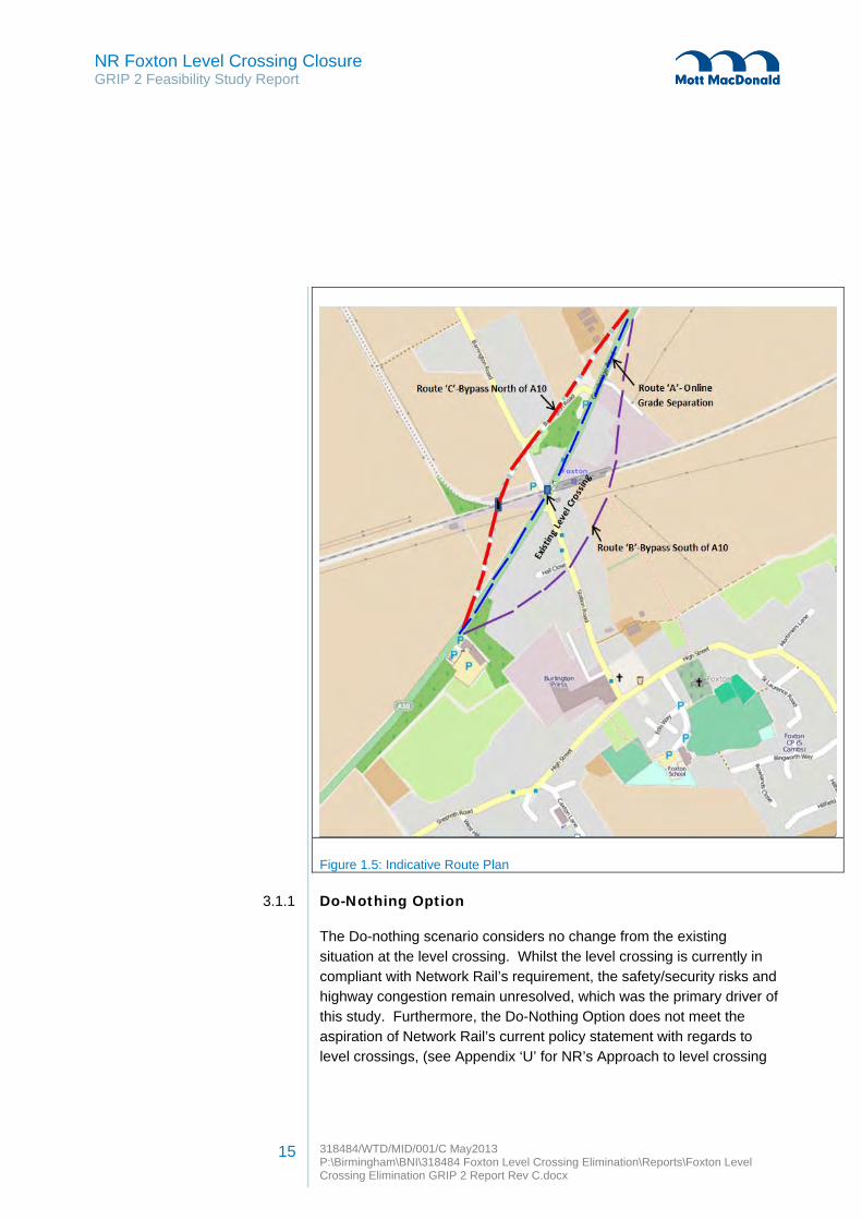
Figure 1.5: Indicative Route Plan
3.1.1 Do-Nothing Option
The Do-nothing scenario considers no change from the existing situation at the level crossing. Whilst the level crossing is currently in compliant with Network Rail’s requirement, the safety/security risks and highway congestion remain unresolved, which was the primary driver of this study. Furthermore, the Do-Nothing Option does not meet the aspiration of Network Rail’s current policy statement with regards to level crossings, (see Appendix ‘U’ for NR’s Approach to level crossing

NR Foxton Level Crossing Closure GRIP 2 Feasibility Study Report
318484/WTD/MID/001/C May2013 P:\Birmingham\BNI\318484 Foxton Level Crossing Elimination\Reports\Foxton Level Crossing Elimination GRIP 2 Report Rev C.docx
16
safety), therefore the Do-nothing Option will not be taken forward at this stage for further consideration, but may be revisited once all other options have been exhausted.
Photo 1.3: Existing Level Crossing
3.1.2 Route A: On-line Grade Separation
On-line grade separation option utilises the existing A10 corridor. This proposal maintains the railway line on its current alignment and level:
Option A1 - is the construction of a new underpass to take the A10 below the railway line.
Option A2 - is the construction of a new flyover to take the A10 above the railway line.
The underpass option A1 will require the construction of a railway underbridge to carry the existing railway lines and OLE. This will require a substantial length of approach retaining walls on either approaches to

NR Foxton Level Crossing Closure GRIP 2 Feasibility Study Report
318484/WTD/MID/001/C May2013 P:\Birmingham\BNI\318484 Foxton Level Crossing Elimination\Reports\Foxton Level Crossing Elimination GRIP 2 Report Rev C.docx
17
the railway, approximately 220m long and up to 6.5m in height, to support the existing ground and adjacent properties.
The flyover option A2 will consist of a bridge constructed over the existing railway line to carry the A10 with a series of approach structures on either side of the railway line supported on piers. An alternative option is to support the approaches to the flyover on solid earth embankments with retaining walls, or with a standard 1 in 3 sloped embankment. This option will require a significant land take outside the current A10 footprint and has been discounted for this reason.
Issues cited as reasons to favour or not favour this option are listed in section 10 of this report.
Due to the significant traffic disruption envisaged on the A10, the disruption to Foxton Railway Station, the permanent closure of Station Road, the significant adverse effects to the residences immediate to the A10, together with the other Route option available, the On-line grade separation option is consider in practicable, hence will not be considered further in this report.

NR Foxton Level Crossing Closure GRIP 2 Feasibility Study Report
318484/WTD/MID/001/C May2013 P:\Birmingham\BNI\318484 Foxton Level Crossing Elimination\Reports\Foxton Level Crossing Elimination GRIP 2 Report Rev C.docx
18
3.1.3 Route B: By-Pass South Side
The Route B option is to construct a by-pass for the A10 to the south of the existing route as indicated in fig 1.5.
This route option will have a significant impact on the local environment and population. This route option will have direct impact on the residential dwellings immediately to the south of the A10 which will make selection of this route difficult. Up to 10 houses will be affected by this route, located on both the east and west side of the level crossing and would have to be demolished. Noise and dust emission levels during construction would be high directly affecting the residents of the community in the short term. This route option is likely to receive strong opposition from local residents, resulting in a public inquiry.
Station Road is a main route to Foxton Village Centre; this route option will require a closure of Station Road with a provision of either an alternate route or an overbridge over the road which would significantly increase the cost of the scheme. This route will interface with existing utility services (water mains and sewer). The diversion of these services is unavoidable and will have significant cost implications. Moreover, the presence of the station platform on the south side is unavoidable and would require a long span crossing over the existing platform. The route to avoid station platform is not advisable as it would restrict future extension of platforms in that direction.
3.1.4 Route C: By-Pass North Side
Unlike the area to the south of the A10, the area to the north comprises of open farm land which allows several sub-routes to be developed without having, as a severe direct impact on residential properties, as Route B.
Cambridgeshire County Council’s (CCC) current requirement for the by-pass is to accommodate a 7.3m wide two lane carriageway with a 1m grass verge to accommodate equestrian use and a further 3m for a combined pedestrian footway and cycleway on one or both sides of the carriageway. During the next stage of this scheme development, the detail of this will be agreed.

NR Foxton Level Crossing Closure GRIP 2 Feasibility Study Report
318484/WTD/MID/001/C May2013 P:\Birmingham\BNI\318484 Foxton Level Crossing Elimination\Reports\Foxton Level Crossing Elimination GRIP 2 Report Rev C.docx
19
The sub-route options consider alternatives for a fly-over and an underpass. The sub-route alignments are designed based on the appropriate vertical and horizontal alignment curve to comply with the relevant design speed, in accordance with TD 9/93 Highway Link Design. The highway alignment will be designed to:
To keep the connectivity of local streets to the A10 Cambridge Road, particularly to a number of dwellings in Barrington Road.
To provide turning facilities for the vehicles due to the closure of the main road at the existing level crossing.
To create a new car parking facility in between the bypass route junction on the south side and existing level crossing. The proposal will create upto 85 car parking spaces which will encourage further train usage.
The alignments are developed using the geometric requirements contained within TD9/93. Cambridge County Council as the local Highway Authority has stipulated a 50mph design speed limit for the by-pass; therefore in accordance with TD 9/93, the vertical and horizontal design curves appropriate to 50mph will be preferred. However, TD 9/93 also accepts design curves for 40mph. The following sub-routes are considered for Route C.
1. Sub-Route C1: 50mph road design speed for vertical and
horizontal alignment ; 2. Sub-Route C2: 40mph road design speed for vertical and 50mph
design speed for the horizontal alignment ; 3. Sub-Route C3: 40mph road design speed for vertical and
horizontal alignment avoiding the existing Network Rail depot.
4. Sub-Route C4: 40mph road design speed for vertical and horizontal alignment (min land take).
3.1.4.1 Route C1 – Highway Alignment with 50V & 50H Curves
This option proposes to provide a by-pass route north of the A10, and crosses the railway line with an option of an overbridge or underbridge to the west of the Foxton station. In this option, the highway alignment is designed to meet the desirable minimum vertical and horizontal

NR Foxton Level Crossing Closure GRIP 2 Feasibility Study Report
318484/WTD/MID/001/C May2013 P:\Birmingham\BNI\318484 Foxton Level Crossing Elimination\Reports\Foxton Level Crossing Elimination GRIP 2 Report Rev C.docx
20
curves, appropriate for a design speed of 50mph. The slope of approach embankments or cutting considered for the highway alignment is generally 1 in 3. This slope is chosen to check the design feasibility of routes, although embankment slopes can be varied to limit the level of land take if necessary. The route leads to larger curve radius resulting in a 32m span bridge span. The route will require a small retaining structure at Barrington Road (as shown on the scheme plan). The main drawback of this route is that it clashes with the rear garden of a residential property located on the Barrington road. This route clashes with Network Rail depot car park.
Figure 1.6: Route C1 Layout
Route C1 Structure Configurations
An overbridge/flyover at this location will comprise a single span bridge, approximately 32.6m clear skew span, with a 40 degrees skew between the abutments and the deck. The width of the structure will be approximately 22.6m.
An underbridge/underpass at this location will comprise a single span bridge, approximately 20.1m clear skew span, with a 42 degrees skew between the abutments and the deck. The width of the structure will be approximately 26.6m.
Retaining wall

NR Foxton Level Crossing Closure GRIP 2 Feasibility Study Report
318484/WTD/MID/001/C May2013 P:\Birmingham\BNI\318484 Foxton Level Crossing Elimination\Reports\Foxton Level Crossing Elimination GRIP 2 Report Rev C.docx
21
3.1.4.2 Route C2 – Highway Alignment with 40V & 50H Curves
This option is similar to the Route C1; the highway alignment is designed to maintain a vertical alignment suitable for a design speed of 50mph and a horizontal alignment suitable for a design speed of 40mph. Although the horizontal design speed is less than the desirable limit it still lies within the acceptable standard of TD 9/93. This route option has slightly smaller curve radius compared to route C1, resulting in reduction to the total length of the by-pass. Similar to Route C1, this route clashes with Network Rail depot car park.
Figure 1.7: Route C2 Layout
Structure Configurations
The proposed overbridge/flyover at this location will comprise of a single span bridge, approximately 31.5m clear skew span, with a 42
degrees skew between the abutments and the deck. The width of the structure is approximately 22.5m.
The proposed underbridge/underpass at this location will comprise a single span bridge, approximately 19.8m clear skew span, with a 43 degrees skew between the abutments and the deck. The width of the structure is approximately 26.6m.

NR Foxton Level Crossing Closure GRIP 2 Feasibility Study Report
318484/WTD/MID/001/C May2013 P:\Birmingham\BNI\318484 Foxton Level Crossing Elimination\Reports\Foxton Level Crossing Elimination GRIP 2 Report Rev C.docx
22
3.1.4.3 Route C3 – Highway Alignment with 40V & 40H Curves (Avoiding the existing depot)
For this route, the highway alignment design is based on the design speed of 40mph for both horizontal and vertical alignment, which is less than desirable but within the acceptable standard of TD 9/93. The option is proposed to limit the effects to the existing Network Rail Depot located northwest of the existing level crossing. As illustrated below, this option has largely avoided the Depot and also eliminates the need for retaining walls at Barrington Road, but has increased land take substantially, as well as increase in the size of the over or under bridge.
Figure 1.8: Route C3 Layout
Structure Configurations
The proposed overbridge/flyover at this location will comprise a two or three span bridge, of overall length of approximately 50m clear skew span, with a 40 degrees skew between the abutments and the deck. The width of the structure is approximately 22.8m. The increase in bridge span (compared to Routes C1 and C2) is necessary to support the railway track on the branch line.
The proposed underbridge/underpass at this location will comprise of a single span structure, approximately 22.9m clear skew span, with a 43 degrees skew, between the abutments and the deck. The width of the structure is approximately 50m. Alternatively, the structure can be split

NR Foxton Level Crossing Closure GRIP 2 Feasibility Study Report
318484/WTD/MID/001/C May2013 P:\Birmingham\BNI\318484 Foxton Level Crossing Elimination\Reports\Foxton Level Crossing Elimination GRIP 2 Report Rev C.docx
23
into two small width structures, one to carry the Cambridge Up and Dn line, and the other to carry the branch line.
The merit of these underpass options should be considered further if this sub-route option was selected for further consideration.
3.1.4.4 Route C4 – Highway Alignment with 40V & 40H Curves (Min land take)
The highway alignment of this sub-route option is based on the design speed of 40mph for both horizontal and vertical alignment. The proposed alignment is shown in Figure 1.9 below.
This route is the shortest of proposed options and minimises the area of land take and the structural span of the bridge. This route will require demolition of the existing Network Rail Depot. Unlike other routes, this route protects the access track to the derelict building located to the west of bypass.
Figure 1.9: Route C4 Layout
Route C4 Structure Configurations
The proposed overbridge/flyover at this location will comprise a single span bridge, approximately 19.7m clear skew span, with a 36 degrees skew between the abutments and the deck. The width of the structure is approximately 26.7m.

NR Foxton Level Crossing Closure GRIP 2 Feasibility Study Report
318484/WTD/MID/001/C May2013 P:\Birmingham\BNI\318484 Foxton Level Crossing Elimination\Reports\Foxton Level Crossing Elimination GRIP 2 Report Rev C.docx
24
The proposed underbridge/underpass at this location will comprise a single span bridge, approximately 20.8m clear skew span with a 36 degrees skew, between the abutments and the deck. The width of the structure is approximately 21.7m.
3.2 Bridge Options
The level crossing is on the main Up and Down Cambridge line which is the main route to London and has been assessed as a high demand route with restricted access. Therefore, in any structure option selection, the option effects on the railway operation must kept to a minimum, and any proposed structural options must be constructible during a ‘Rules of the Route’ (ROR) possession or within a reasonable blockage duration.
3.2.1 Overbridge Options
For all overbridge options, the substructure will be set 4.5m back from the running edge of the cess rail on either side. This is to ensure that the substructures can be constructed with minimum or no possession. This setback will also eliminate the need to design the substructure for derailment impact, which means the substructure can be more cost-effective.
To minimise the possession requirement for constructing the superstructure, a quick and self-supporting solution should be considered, e.g. beam and slab deck. The beams can be erected during a night-time possession, with permanent shutters spanning between the beams. This would allow the construction of the deck to follow continuously without possession.
The overbridge option should be able to accommodate future widening of the A10 to a dual carriageway with minimal to no demolition.
3.2.1.1 Precast Prestressed Concrete (PPC) Beams on Cantilever abutments (Option 1)
This form of superstructure construction is quick and requires minimum possession time. The bridge will consist of PPC beams simply supported on full height reinforced concrete abutments. An insitu
NR Foxton Level Crossing Closure GRIP 2 Feasibility Study Report
318484/WTD/MID/001/C May2013 P:\Birmingham\BNI\318484 Foxton Level Crossing Elimination\Reports\Foxton Level Crossing Elimination GRIP 2 Report Rev C.docx
25
reinforced concrete deck is designed to act compositely. Permanent formwork will be used to support the wet deck concrete during construction.
PPC beams are heavy and require a bigger crane for lifting when compared to other forms of construction. As the access and space at site is unlikely to be restricted, the lifting requirement for a heavy crane is not considered to be an issue.
A preliminary assessment of the foundation type required for the proposed structure has been undertaken based on the available ground information in the proximity of the level crossing. The assessment concludes that spread foundations are not appropriate for the bridge abutments and a piled solution is required with the piles socketed into Chalk Marl. A detailed investigation of the pile design has not been undertaken at this GRIP stage, but an initial assessment suggests that a CFA piling system will be appropriate due to its vibration free and quick installation. A high groundwater table will require casing for the installation of the CFA piles. Note that full height abutments will generate additional horizontal pressures on the piles but these can be designed accordingly. The piling activity and full height abutments will increase the proportion of wet concreting on site, which will have an impact on health and safety, and will be a risk for the site force working in the close proximity of the live rail traffic.
It is important to mention here that the final choice of foundation should be confirmed following a more detailed site investigation, which is outside the scope of this study.
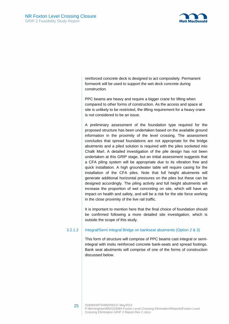
3.2.1.2 Integral/Semi Integral Bridge on bankseat abutments (Option 2 & 3)
This form of structure will comprise of PPC beams cast integral or semi-integral with insitu reinforced concrete bank-seats and spread footings. Bank seat abutments will comprise of one of the forms of construction discussed below.

NR FoxtGRIP 2 Fe
ton Level Ceasibility Stu
Crossing Cudy Report
26
Closure
318484/WTD/P:\BirminghamCrossing Elim
Figure 1.10:
Figure 1.11:
Fully Integ
The use omovement reduce theabutments normally atdistance frwould signcost associ
The span oon vertical
/MID/001/C Maym\BNI\318484 F
mination GRIP 2
Semi-Integra
Semi-Integra
gral Bridge (
of an integjoints. This
e whole life would be
t 1:2.5. The rom the tracificantly increiated to this w
of the structureinforced e
Free End
y2013 Foxton Level CrReport Rev C.d
l Bridge
l Bridge
(Option 2)
ral form newill minimisecost of each
seated onbankseat wo
ck to accomease the spawhen compa
ure can be reearth walls fo
ossing Eliminatdocx
egates the ne the maintenh structure. compactedould require modate slop
an of the bridared to full he
educed by sounded on a
tion\Reports\Fox
need for benance requirIn this optiod granular to be set ba
pes of the mdge and the eight abutme
supporting than unreinforc
Fixed En
xton Level
earings andrements and
on, bankseatfill material
ack at somematerial andconstruction
ents.
e bankseatsced concrete
nd
d d t l
e d n
s e

NR Foxton Level Crossing Closure GRIP 2 Feasibility Study Report
318484/WTD/MID/001/C May2013 P:\Birmingham\BNI\318484 Foxton Level Crossing Elimination\Reports\Foxton Level Crossing Elimination GRIP 2 Report Rev C.docx
27
levelling pad (as discussed in option 3 below). This option is not viable in this situation due to a significantly larger span of the structure (40m), as the reinforced earth walls are not normally designed to take significant thermal movements occurring from a fully integral connection. The maximum span limit for a fully integral bridge resting on reinforced earth wall is 18m in accordance with BD70/03.
Based on the available ground data, it is difficult to justify the feasibility of this option at this stage. The available ground strata may be too soft to support the fill material and a piled foundation underneath the bankseat footing may be necessary, which would make this option more expensive. A detailed ground investigation is recommended in the next GRIP stage to confirm the viability of this option.
Semi-Integral Bridge (Option 3)
The proposal is similar to the fully integral option. Instead of resting bankseats on granular fill material, the bankseat abutments will be supported on vertical reinforced earth walls founded on an unreinforced concrete levelling pad. Independent reinforced earth wingwalls to retain approach embankments will also form part of the structure.
Reinforced earth walls consist of interlocking precast concrete facing panels tied back to the granular backfill with reinforcing straps. The structure is a standard form of construction and would overcome the issue of an increased span with bankseat abutments as discussed in the integral option above. In this option, one abutment will be cast integral with the superstructure providing full movement continuity. The other abutment will have bearings to accommodate the thermal movements of the deck. An end screen will be provided at the bearing abutment to protect the bearings from the backfill material. The end screen will be separated from the back face of cantilever abutment by means of a compressible joint filler. The joint will cater for the movement of the superstructure arising from thermal, shrinkage and creep effects, and the possibility of deck leakage through expansion joints will be significantly reduced. The maintenance cost of the structure will be higher than fully integral bridge will be lower than a full abutment height option. However there will be significant cost savings in terms of the overall construction cost of the structure.
NR Foxton Level Crossing Closure GRIP 2 Feasibility Study Report
318484/WTD/MID/001/C May2013 P:\Birmingham\BNI\318484 Foxton Level Crossing Elimination\Reports\Foxton Level Crossing Elimination GRIP 2 Report Rev C.docx
28
The construction will be undertaken in phases. In the first phase, reinforced earth abutments will be constructed along with embankment construction using precast concrete facing panels and reinforcing strips. Backfilling activity behind abutments will be carried out in stages as the facing panels progressed towards top. This phase will give programme advantage in terms of construction.
The integral end of the structure will eliminate the need for the inspection of bearings, thus minimising maintenance and inspection costs. The option is economical as the reinforced earth walls use reinforced concrete facing panels as opposed to a full height abutment. Pre-stressed beams are low maintenance and there is also a minimal requirement for insitu concrete, which reduces the health and safety risk on site. The structure can be decommissioned easily and recycled at the end of its serviceable life.
The reinforced earth option minimises the amount of excavation. The inherent flexibility of the reinforced earth solution makes it possible to construct bridge abutments on relatively soft soil. The settlement of compacted reinforced earth material is normally the main risk in this design, which can be controlled with traditional soil improvement techniques.
3.2.1.3 Steel Composite deck (Option 4)
A steel composite deck on cantilever abutment or semi-integral structure on bankseat is another option considered for overbridges. This form of construction will require rail possessions for the installation of the steel beams. The steel beams can be installed in pairs with cross bracing, with the permanent framework already attached, providing the necessary stability during erection and reducing the possession duration. The steel beams are generally spaced between 2.5 to 3.5m apart resulting in fewer girders compared to a PPC beams solution.
Steel beams are lighter compared to PPC and allow for quick installation utilising a smaller crane with minimal possession duration. A steel composite bridge will also benefit the construction by minimising the construction depth and the height of the approach embankments when compared to the PPC option.

NR Foxton Level Crossing Closure GRIP 2 Feasibility Study Report
318484/WTD/MID/001/C May2013 P:\Birmingham\BNI\318484 Foxton Level Crossing Elimination\Reports\Foxton Level Crossing Elimination GRIP 2 Report Rev C.docx
29
However, the long term maintenance cost of steel structure is generally recognised as higher than a PPC beam solution, particularly with regards to the protected paint system. Alternatively, the use of weathering steel should be considered to eliminate the requirement of maintenance painting. A steel bridge will require earth bonding as it will be adjacent to the OLE.
3.2.1.4 Summary of Overbridge Options
A summary of the advantages and disadvantages of overbridge options is shown below.
Ref Bridge Type
Advantages Disadvantages
1 PPC Beams-Cantilever abutments
1. Low maintenance cost
compared to steel
construction but higher
than integral form of
construction.
2. Horizontal thrust will be
sustained by the
substructure when
compared to integral
options.
1. Large amount of crane
lifts during erection.
2. High volume of insitu
concrete.
3. Maintenance cost due to
bearings and movement
joints.
4. Prestressed beams are
heavier than steel beams.
5. Construction depth will be
greater than integral or
semi-integral option.
6. Will require longer
construction time when
compared to the integral
form of construction.
7. Substructure cost will be
higher than integral or
semi-integral options.

NR Foxton Level Crossing Closure GRIP 2 Feasibility Study Report
318484/WTD/MID/001/C May2013 P:\Birmingham\BNI\318484 Foxton Level Crossing Elimination\Reports\Foxton Level Crossing Elimination GRIP 2 Report Rev C.docx
30
2. PPCs Beams-Semi-integral bridge
1. Can be constructed on
soft ground.
2. Low construction depth.
3. Low maintenance cost.
4. Easy to demolish
5. Simple, rapid and safe
construction.
6. Reduced need for piles or
foundation improvement.
7. Less volume of in-situ
concrete when compared
to alternatives.
8. Panels can be modified
on site to suit geometric
constraints.
1. As (1) above
2. Drainage outlets are
required to prevent
settlement.
3. No cracks or warning of
settlement is apparent on
the structure.
4. Requires additional cost
of ground improvement to
limit settlement issues.
3 Steel Composite Deck.
1. Easy to pre-camber
during fabrication.
2. Due to its lighter weight,
smaller crane may be
used during erection.
3. Easy transportation and
rapid erection.
4. Shallow construction
depth compared to PPC
beams.
5. Less number of beams
will reduce the
possession requirement.
1. Bracing between beams
is required for their
stability during erection.
2. Higher long term
maintenance cost.
3. Bonding require for steel
deck, due to close
proximity to OLE.
Table 1.1: Bridge Option’s Comparison Summary

NR Foxton Level Crossing Closure GRIP 2 Feasibility Study Report
318484/WTD/MID/001/C May2013 P:\Birmingham\BNI\318484 Foxton Level Crossing Elimination\Reports\Foxton Level Crossing Elimination GRIP 2 Report Rev C.docx
31
3.2.2 Underbridge/Underpass Options
The underbridge/underpass option will follow the road geometry similar to the overbridge option and will accommodate a 7.3m wide carriageway and 4.5m wide verges to protect pedestrian/cycleway and equestrian right of ways. The underbridge option will require a significant amount of excavation, which could be an issue due to the high ground water table. The risk of slope instability can be mitigated by considering cutting a slope of 1:3 in the alignment design, but this requires greater land acquisition. The amount of land take could be minimised by providing steeper slopes stabilised by ground anchors or retaining structures. In the absence of sufficient geotechnical information, this report does not consider the feasibility of soil strengthening or retaining wall techniques. Based on the initial assessment, it seems that acquisition of additional land will not be a major problem, but a detailed cost-effective analysis will required in the next GRIP stage.
A lower structure headroom can be achieved with this type of construction. The minimum headroom clearance of 5.3m (from carriageway level to the soffit) will be achieved in accordance with TD 27/01. This minimum headroom will require a structure to be designed for collision loading. Based on the site constraints, the following underpass construction proposals are considered feasible for the scheme.
To meet Network Rail’s construction requirements, a reinforced concrete box option is the only feasible underbridge option.
The concrete box can be installed using the following methods:
1. Gradual jacking, under live railway operation; 2. Jacking during a blockade (cut and cover).
In both methods, a reinforced concrete box will be constructed in the approach cutting excavation adjacent to the rail track. No bearings or movement joints would be required for this option, thus significantly reducing the maintenance costs. Both types of construction will require large wingwalls on all four corners of the box, which could consist of steel sheet piles or concrete bored piles construction, and be

NR Foxton Level Crossing Closure GRIP 2 Feasibility Study Report
318484/WTD/MID/001/C May2013 P:\Birmingham\BNI\318484 Foxton Level Crossing Elimination\Reports\Foxton Level Crossing Elimination GRIP 2 Report Rev C.docx
32
constructed prior to the installation to retain any excavation or cutting. The configuration of wingwalls has a huge impact in determining the box length, which ultimately affects the construction cost of the structure. The configuration of the wingwalls parallel or perpendicular to the box will lead to significant larger lengths and is not considered to be an optimum solution. It is appropriate to angle wingwalls and provide battered slopes at the ends, which will minimise the construction cost of wingwalls and visual tunnelling effect of the underbridge. However, the high water table level may affect the decision on the alignment of the wingwalls. This must be investigated further in the next GRIP stage.
The methods considered for the box construction are discussed in the following sections:
3.2.2.1 Gradual Jacking method (Option 5).
This technique provides the benefit of construction with minimal disruption to the rail movement. This method will generally require a deeper road alignment to accommodate more fill over the structure, and constant track monitoring. Train speed over the structure will need to be restricted during the box installation for safety.
In this method, the concrete box will be constructed in an excavation adjacent to the rail track, with a leading cutting shield attached to the front of the box. As the box is jacked into the embankment, the existing ground is excavated carefully from within the box from the cut face. The process will continue until the structure is pushed to its final position.
This non-disruptive nature of the process, together with its safety mitigation measures and simplicity, has been considered as a best possible solution for tunnelling under the busy track. This type of construction requires a high level of precision and accuracy, along with constant track monitoring of track levels during the process, as this could affect the twist and cant of the permanent way.
3.2.2.2 Jacking During a Blockade (Cut and Cover) (Option 6)
In this method, the reinforced concrete box will be constructed adjacent to the railway in the approach cutting excavated for the road alignment

NR Foxton Level Crossing Closure GRIP 2 Feasibility Study Report
318484/WTD/MID/001/C May2013 P:\Birmingham\BNI\318484 Foxton Level Crossing Elimination\Reports\Foxton Level Crossing Elimination GRIP 2 Report Rev C.docx
33
as discussed above. Once the box is constructed the rail track would be closed to remove totally the fill under the track for the positioning of the box. This type of construction will require a possession of approximately 65 hours.
This technique was adopted for the replacement of Owen Street level crossing in Tipton. A photograph of the underpass showing excavation of the existing railway embankment in readiness for the jacking of the box structure are shown below, together with the completed structure.
Photo 1.4: Owen Street during main possession for installation.

NR Foxton Level Crossing Closure GRIP 2 Feasibility Study Report
318484/WTD/MID/001/C May2013 P:\Birmingham\BNI\318484 Foxton Level Crossing Elimination\Reports\Foxton Level Crossing Elimination GRIP 2 Report Rev C.docx
34
Photo 1.5 – Owen Street Underpass after completion.
When planned and resourced properly, this type of installation can be successful. Unlike the gradual jacking method, this method eliminates the need for track monitoring, the risk of potential unforeseen objects within the excavation, and potential emergency stoppage due to any unacceptable settlement.
This installation technique will require minimum fill material over the structure. Therefore, the approach road alignment design will be shallower, potentially reducing cost for the excavation and retaining wall heights associated to the structure.
Construction Issues for the Underpass Options:
This option will require the use a considerable amount of concrete and reinforcement, not just for the box structure, but also for the jacking slab built beneath the box. The volume of excavation will be an issue for this form of construction due to the existing ground conditions.
NR Foxton Level Crossing Closure GRIP 2 Feasibility Study Report
318484/WTD/MID/001/C May2013 P:\Birmingham\BNI\318484 Foxton Level Crossing Elimination\Reports\Foxton Level Crossing Elimination GRIP 2 Report Rev C.docx
35
The high water table on site may lead to a high risk of flooding during the construction requiring de-watering works. The high water table will also have an great impact on the long term maintenance of the structure and may require constant pumping of water to ensure the structure is not subject to flooding. From a design perspective, the structure will have to be designed to withstand high hydrostatic pressures which will make this option an expensive alternative. The presence of existing 8” diameter Anglian water foul sewer (rising main) is also an obstruction in the development of the underpass, which makes this option expensive and difficult to achieve.
A portal frame structure was considered as an alternative option, but discounted at early stage due to the complex construction requirements, extensive concreting and possession periods involved in building the structure.
3.2.3 Passenger/Public Footbridge-Options
The closure of the existing level crossing at Foxton will require an alternative safe crossing route for the pedestrians, cyclists and equestrians. This section investigates the different options to facilitate the community and provide a link between station platforms after the level crossing has been closed. The following requirements have been identified as critical for the optioneering of the proposals:
Minimal adverse impact on the local environment, adjacent land and properties;
Minimal capital cost implications; Long term maintenance liabilities; Compliance with Network Rail design standard and Equality Act
2010 requirements; Constructability; Safeguard plan for future extension of the existing platforms; Continuous operation of the railway.
The following footbridge options are considered to be reasonable options and are discussed further in the report:
1. Footbridge with approach ramps and stairs; 2. Footbridge with stairway and lift shaft. ;

NR Foxton Level Crossing Closure GRIP 2 Feasibility Study Report
318484/WTD/MID/001/C May2013 P:\Birmingham\BNI\318484 Foxton Level Crossing Elimination\Reports\Foxton Level Crossing Elimination GRIP 2 Report Rev C.docx
36
3. Footbridge with approach ramps to accommodate equestrians; 4. Subway with approach ramps.
3.2.3.1 Footbridge with approach ramps and stairs (MMD-318484-C-DR-BR-103) (Option 7)
In this option, the bridge will be facilitated with stairs and Equality Act 2010 compliant ramps. The ramps will form a U-shape formation in line with station platforms. The footbridge and ramps will be owned and maintenance by Network Rail and the main aim of the footbridge is to provide the link between station platforms. It is preferred to position the bridge over the platforms or as close to the station as possible. The footbridge also serves as a local public right of way over the railway. The provision of using the footbridge for equestrians is considered as a separate option (refer to section 3.2.4.3).
Based on the available information, there were no undue constraints identified that will preclude the construction of a bridge or ramps.
There is an opportunity to minimise the land acquisition by opening the corridor between station platforms and the land owned by Network Rail which is currently being obstructed by a residential property (No. 2 Barrington Road). If this property was acquired, it will not only benefit the construction of proposed footbridge but will also facilitate the future extension of platforms.
The bridge span configuration is derived by positioning the bridge square to the track. An initial assessment suggests that this will provide a span saving of approximately 15% compared to its position in line with the carriageway. The footbridge supports will be set to a minimum of 4.5m away from the nearest rail or constructed at the back of the platforms. The proposed footbridge will be 2m wide, with a span of approximately 16m.
The ramps are located on private land, parallel to and behind the back of the existing station platforms. The approach ramps are designed to comply with Equality Act 2010 requirements for full disabled access with a maximum slope of 1:20, with 2m landings at 6m intervals.

NR Foxton Level Crossing Closure GRIP 2 Feasibility Study Report
318484/WTD/MID/001/C May2013 P:\Birmingham\BNI\318484 Foxton Level Crossing Elimination\Reports\Foxton Level Crossing Elimination GRIP 2 Report Rev C.docx
37
The minimum required width of a bridge is 2m for unsegregated cycle and pedestrian access with a minimum headroom requirement of 5.1m from rail level as specified in NR/L2/TRK/2049. This headroom clearance will dictate a total ramp length of approximately 128m in accordance to Equality Act 2010 requirements. This will require more land acquisition and cause significant problems for people with walking difficulties and wheelchair users. This is not recommended by the ‘Code of Practice for Disable People’.
3.2.3.2 Footbridge with stairs and lift shafts (MMD-318484-C-DR-BR- 102 & 104) (Option 8)
In this option, lift shafts will be provided instead of ramps to facilitate disabled access which satisfies the requirement for wheelchair users and other people with disabilities. Stairways can be provided in a form of normal stairs or a wrap round solution which will provide a smaller structural footprint when compared to a normal. This option will comprise of two sets of stairs and lift shafts, located on each side of the footbridge. The configuration of bridge span will remain same as discussed above. Lift lobby areas will have a minimum headroom of 2.3m to canopies and suspended fittings and should accommodate minimum 16 passengers at a time. The main advantage of this option over the ramp is that it minimises the requirement for land acquisition, hence reducing the cost of the option. However, the continuous operational and maintenance cost of this option will also need to be considered in the whole life cost.
As with the previous footbridge option, this option cannot accommodate equestrian use on safety grounds. Therefore, equestrians will be directed to use the path provided by the by-pass.
3.2.3.3 Footbridge with approach ramps to accommodate Equestrians (MMD-318484-C-DR-BR-105) (Option 9)
In this option, a footbridge and access ramps will be provided to accommodate pedestrians, together with a cyclists and equestrian. The minimum width of the footbridge and ramps, for a combined equestrian/ pedestrian access would be 3.5m (BD29/04) with solid side panels/parapets of 1.8m height to accommodate equestrian use. The construction of ramps will be similar to option 7, but they will not be and

NR Foxton Level Crossing Closure GRIP 2 Feasibility Study Report
318484/WTD/MID/001/C May2013 P:\Birmingham\BNI\318484 Foxton Level Crossing Elimination\Reports\Foxton Level Crossing Elimination GRIP 2 Report Rev C.docx
38
suitable for wheel chairs and people with walking difficulties as discussed above in section 2.4.4.1.
A steel deck is unacceptable due to its noise under equestrian use with the clanging noise made by hooves which could frighten the horses. A timber decking over steel deck plate would be adopted on the bridge and ramps to deaden the sound of horses hooves. Small gaps are recommended in between the decking panels to aid drainage. The requirement for equestrian use on the bridge will require regular cleaning and maintenance. This option does not lead to a safe solution, as there is a possibility of horses being startled while crossing the bridge during train movement. However, this option is still viable should be considered in the next GRIP stage for further development. With an alternate route available, it is considered likely that riders would prefer to use a larger bridge (bypass route) rather than small steel pedestrian footbridge.
Footbridge Form and Construction
The bridge construction will require a night closure or a day possession during the weekend. The possession requirement and restricted site access will limit the amount of work and time on site and will require as much prefabrication as possible. A steel bridge is considered to be the best option as it can be installed in a single lift operation in a limited possession time. The Network Rail standard U-frame steel bridge is the preferred option due to its long term success and popularity. The bridge should include a minimum 1.5m high steel clad restraint system for pedestrians or 1.8m high for equestrians.
3.2.3.4 Subway with approach ramps (MMD-318484-C-DR-BR- 101) (Option 10)
An alternative is to construct a subway with approach ramps under the existing platforms and tracks. As the existing level crossing is a designated bridleway route, this underpass option will accommodate equestrians along with pedestrians and cyclists. The structure will be a precast reinforced concrete box with a width and headroom clearance (mounted access) of 5.0m and 3.5m respectively as specified in BD29/04 in compliance with IAN 124/11. It is proposed to provide chamfers at the bottom of subway for pedestrian safety. There is

NR Foxton Level Crossing Closure GRIP 2 Feasibility Study Report
318484/WTD/MID/001/C May2013 P:\Birmingham\BNI\318484 Foxton Level Crossing Elimination\Reports\Foxton Level Crossing Elimination GRIP 2 Report Rev C.docx
39
another option of reducing the headroom of the structure to 2.7m, but this would restrict equestrians to dismounted access. Equality Act 2010 compliant ramps associated with the structure will require approximately 90m long ramps (based on full mounted equestrian access) which will require substantial land acquisition to create the length of path needed for such a height gain and fall.
Construction Issues
The main issues that would be involved in the construction of a subway are:
The subway will be constructed under the existing tracks, which will stop train movements during the construction period;
The subway will be constructed under the existing platforms. This option will not be feasible if platforms are founded on piles (not likely);
The available data shows no presence of existing services but unforeseen obstructions i.e. HV cables could have a great impact on the construction cost and timescale;
Due to high groundwater table level, other issues involving possible flooding during construction and the high cost of maintenance are similar to an underpass option as already discussed in section 2.4.2 above. These issues will increase financial cost and preclude this from further consideration.
The estimated construction cost of these options is given in section 7.1.
Equestrian Route
Equestrian right of way must be consideration, following the closure of Foxton level crossing. Below is a summary of equestrian route options considered as part of this study.
At the existing level crossing, equestrian have been consider in:
Option 9 - Footbridge with approach ramps to accommodate equestrian;

NR Foxton Level Crossing Closure GRIP 2 Feasibility Study Report
318484/WTD/MID/001/C May2013 P:\Birmingham\BNI\318484 Foxton Level Crossing Elimination\Reports\Foxton Level Crossing Elimination GRIP 2 Report Rev C.docx
40
Option 10 - Subway with approach ramps.
Alterative to the above options, equestrian will be directed to use the by-pass route option (Route C).

NR Foxton Level Crossing Closure GRIP 2 Feasibility Study Report
318484/WTD/MID/001/C May2013 P:\Birmingham\BNI\318484 Foxton Level Crossing Elimination\Reports\Foxton Level Crossing Elimination GRIP 2 Report Rev C.docx
41
4.1 Survey & Mapping
Refer to ‘Topographic Survey Specification Report’ in Appendix ‘N’
4.2 Electrification and Plant
Drawing MMD-318484-C-DR-HW-07
The road lighting will be designed in accordance with BS5489-1; 2013;
The design will take into account the surrounding area and any environmental issues;
Where necessary the lighting will be integrated with the existing road lighting;
All lighting will conform to the Local Authority’s standards; Lighting adjacent to the railway will be provided by full cut-off flat
glass lanterns, taking in to account Network Rail standards and requirements.
Drawing MMD-318484-C-DR-BR-101 & 102
Lighting adjacent to the railway will be provided by full cut-off flat glass lanterns, taking into account Network Rail standards and requirements;
Lighting to the footbridge across the tracks will be provided by low level lighting contained within the bridge structure;
All lighting levels provided for accessible routes will be in accordance with the Equalities Act 2010.
Subway
Lighting adjacent to the railway will be provided by full cut-off flat glass lanterns, taking into account Network Rail standards and requirements;
All lighting levels provided for accessible routes will be in accordance with the Equalities Act 2010;
Lighting to the subway will include emergency coverage.
4 Development Requirements for the Existing Equipment

NR Foxton Level Crossing Closure GRIP 2 Feasibility Study Report
318484/WTD/MID/001/C May2013 P:\Birmingham\BNI\318484 Foxton Level Crossing Elimination\Reports\Foxton Level Crossing Elimination GRIP 2 Report Rev C.docx
42
4.3 Signalling
It is understood that this line is currently scheduled for resignalling, with Foxton LC being renewed as MCB-OD. The following assessment assumes that the crossing is closed prior to this signalling scheme taking place. It should be noted that closure prior to resignalling will entail a cost benefit of approximately £1M."
The assets requiring alteration are as follows:
Foxton Gate Box;
Foxton Interlocking;
Cambridge PSB relay room;
Cambridge PSB control panel;
Interlocking interface.
This assessment has been undertaken as a desktop study using information provided by Network Rail in the form of Signalling Infrastructure Condition Assessment (SICA) reports. The findings are as follows:
Foxton Gate Box. This was the subject of a secondary SICA inspection on 13th December 2012 (Report ref. NR/AN/SIG/ACR/12-13/40). Foxton Gate Box will be made fully redundant by these works and will therefore be decommissioned. There is no listed structure in close proximity which could affect the proposed scheme. The level crossing was completely renewed in 1998, with further minor renewals and additions in 2012. The wiring is classified as Normal and all equipment is in a generally good condition.
Foxton Interlocking. This was the subject of a secondary SICA inspection on 16th January 2013 (Report ref. NR/AN/SIG/ACR/12-13/53). Foxton interlocking will require alteration to remove the slotting controls on signals 113 and 114. The interlocking dates from 1983 and the overall category of the wiring is poor due to significant dry degradation. The risk of disruption due to wire damage is significant. Alterations to this interlocking will therefore require special measures to ensure that unaffected circuits are not damaged. The technician’s

NR Foxton Level Crossing Closure GRIP 2 Feasibility Study Report
318484/WTD/MID/001/C May2013 P:\Birmingham\BNI\318484 Foxton Level Crossing Elimination\Reports\Foxton Level Crossing Elimination GRIP 2 Report Rev C.docx
43
indication panel will also require updating to remove the level crossing. This consists of a single-piece fascia which is in good condition.
Cambridge PSB relay room. This was the subject of a secondary SICA inspection on 25th February 2010 (Report ref. NR/AN/SIG/ACR/10/09). Alterations will be required to recover the slot indications associated with the level crossing. The interlocking dates from 1983, with wiring of the geographical sets classified as Fair but other wiring classified as Poor due to dry degradation. The limited nature of the alterations suggests that the risk of disruption due to wire damage is low.
Cambridge PSB control panel. This is assessed in the same report as the relay room and its overall condition is considered to be good. The panel is an Entrance-Exit (NX) type panel of domino tile construction. Alterations to remove the level crossing and slot indications will be required.
Interlocking interface. This is provided via a GETS Delphin 1024 TDM provided in 2010. This equipment will be suitable for alteration.
Signal Sighting Issues
The road bridge is currently planned to be positioned above 1038B and 1039A points. Whilst the OLE design would normally prohibit points under bridges, the crossover (1039) and siding connection (1038) are not electrified. The closest signal on the Up Royston line is CA114, located on Foxton station platform. Sighting of this signal will not be affected by the road bridge. The signal ahead, CA110, is located at Shepreth station, 1990 yards beyond CA114. This signal will not be affected by the road bridge. The Down Royston signal closest to the road bridge is CA113, located 808 yards on the approach to the level crossing, placing the bridge between the signal and the crossing. The signal ahead of the bridge, CA115, is not visible from Foxton station. As a result of the above, the current planned road bridge has no impact on signal sighting.
The current design of the footbridge, as depicted on drawing MMD-318484-C-DR-BR-01, shows the bridge deck approximately above CA114 signal with the DDA-compliant ramps on the outside of the platform. This signal is approached along a gradual right-hand curve

NR Foxton Level Crossing Closure GRIP 2 Feasibility Study Report
318484/WTD/MID/001/C May2013 P:\Birmingham\BNI\318484 Foxton Level Crossing Elimination\Reports\Foxton Level Crossing Elimination GRIP 2 Report Rev C.docx
44
with the last 200 yards or so being straight. This information has been deduced from Google Earth and Google Street view. This arrangement means that the current bridge design should not adversely impact the sighting of CA114, although this will be subject to a formal signal sighting committee at a later development stage. This may be undertaken using the Bentley signal sighting tool applied to a Building Information Management (BIM) model of the bridge design prior to construction. No other signals are affected.
4.4 Telecoms
4.4.1 Operational
The proposed works will have no effect on the existing Track/P’ way alignment and signal sighting.
At the existing level crossing point it is proposed to provide a palisade fence gate controlled by Network Rail which will be used as a railway access point (RAP) for future Track/ P’way maintenance
It is understood that the existing gate box is to be made fully redundant and decommissioned. Any associated telephones and fax machines contained therein will be recovered and handed back to the maintainer as maintenance spares if required.
Once the level crossing has been decommissioned any existing emergency telephones will also be recovered and handed back to the maintainer as maintenance spares if required.
Any GSM-R coverage issues (e.g., the provision of lifts and/or footbridge) will be investigated at the GRIP 4 stage of the project and the requirements of Project Advice Notes PAN/E/TE/FT/0060 and PAN/E/TE/FT/0061 will be required to be adhered to.
4.4.2 SISS
Telecommunications – SISS
Site visits were carried out by others and the following conclusions reached:

NR Foxton Level Crossing Closure GRIP 2 Feasibility Study Report
318484/WTD/MID/001/C May2013 P:\Birmingham\BNI\318484 Foxton Level Crossing Elimination\Reports\Foxton Level Crossing Elimination GRIP 2 Report Rev C.docx
45
Closed Circuit Television (CCTV)
There is currently no CCTV coverage of the station, although there is coverage of the level crossing. It is understood that at present the CCTV is provided by Cambridge County Council or the police to monitor movements at existing level crossing and is not part of the NR infrastructure.
Customer Information System (CIS)
There are currently two existing CIS Information Boards at the station. One Next Train Indicator (NTI) is located on the shelter of Platform 1 and a Next Train Indicator is located on a gallows post on Platform 2. The indicator displays appear to be new but at the time of a site visit did not appear to be working correctly.
The customer information systems appeared to be in good condition but their life expectancy and the condition of the associated cabling cannot be confirmed.
Public Address (PA)
There are a number of PA speakers on both Platforms 1 & 2 and as the station is unmanned these are thought to be Long Line Public Address (LLPA), but it has not been confirmed from where the announcements are made.
The public address (PA) appears to be in good condition, but will require maintaining. The life expectancy and the condition of the associated cabling cannot be confirmed.
Passenger Help Point (PHP)
There is an existing help point at the station on Platform 1, only sited on the wall of the shelter.
The PHP appears to be in good condition, but is understood not to be working and will require maintaining. The life expectancy and the condition of the associated cabling cannot be confirmed.

NR Foxton Level Crossing Closure GRIP 2 Feasibility Study Report
318484/WTD/MID/001/C May2013 P:\Birmingham\BNI\318484 Foxton Level Crossing Elimination\Reports\Foxton Level Crossing Elimination GRIP 2 Report Rev C.docx
46
Proposed Telecoms Options
As there is currently no CCTV coverage at the station, it is assumed that the addition to any existing CCTV system or the provision of any new CCTV system will be the responsibility of the TOC.
New Subway
CCTV
CCTV coverage will be required in order to view the top and bottom of the ramps leading to and from Platforms 1 and 2 and at each end of the underpass covering its length.
It is proposed that CCTV coverage will consist of a camera looking at the ramps leading to and from Platforms 1 and 2 and two cameras at each end of the underpass covering its length.
Customer Information Systems
There is an option to provide new NTI screens at the top of each ramp leading to and from to Platforms 1 and 2 in order to inform passengers as to which platform their train is arriving/departing from and the time of the next train from that platform.
It is proposed that one new CIS screen will be provided at the top of each of the ramps leading to and from Platforms 1 and 2 and will be of the same type as the existing.
Public Address
New PA speakers will be required within the new underpass in order to inform passengers as to which platform their train is arriving/departing from and of any delays/disruptions to services.
It is proposed that a new PA speaker will be provided within the underpass.
PHP
There will no requirement for PHP units within the new underpass.

NR Foxton Level Crossing Closure GRIP 2 Feasibility Study Report
318484/WTD/MID/001/C May2013 P:\Birmingham\BNI\318484 Foxton Level Crossing Elimination\Reports\Foxton Level Crossing Elimination GRIP 2 Report Rev C.docx
47
New footbridge and Ramps
CCTV
CCTV coverage will be required in order to view the stairs leading to and from Platforms 1 and 2, covering the footbridge itself.
It is proposed that the CCTV coverage will consist of two cameras looking at the stairs leading to and from Platform 2, one camera looking at the stairs leading to and from Platform1, and two cameras at each end of the footbridge covering its length.
Customer Information Systems
There is an option to provide new NTI screens at the top of each ramp leading to and from Platforms 1 and 2 in order to inform passengers as to which platform their train is arriving/departing from, and the time of the next train from that platform.
Public Address
There will not be a requirement for PA speakers on the footbridge or the ramps.
PHP
There will not be a requirement for PHP units on the footbridge or the ramps.
New footbridge with lifts
CCTV
CCTV coverage will be required in order to view the stairs leading to and from Platforms 1 and 2, the lifts and the footbridge.
CCTV coverage will also be required within each lift.
It is proposed that CCTV coverage will consist of a camera at ground level looking at the stairs leading to and from Platforms 1 and 2, a camera at ground level looking at the lifts leading to and from Platforms

NR Foxton Level Crossing Closure GRIP 2 Feasibility Study Report
318484/WTD/MID/001/C May2013 P:\Birmingham\BNI\318484 Foxton Level Crossing Elimination\Reports\Foxton Level Crossing Elimination GRIP 2 Report Rev C.docx
48
1 and 2, two cameras on the footbridge covering the lifts and top of the stairs, and two cameras at each end of the footbridge covering its length.
A new camera will be provided within each lift as part of the lift build.
Customer Information Systems
There is an option to provide new NTI screens at the bottom of the stairs and the bottom of the ramps, in order to inform passengers as to which platform their train is arriving/departing from, and the time of the next train from that platform.
Public Address
There will not be a requirement for PHP units on the footbridge or the ramps or within the lifts.
PHP
A new assistance unit will be required within each lift as part of the lift build.
4.5 Track
Due to the existing condition of the track over the crossing, it is proposed to replace 18m (60 feet) length of track over the level crossing.
4.6 Vehicle Incursion Measures
This study considers the following measures to improve road safety and mitigate risk of vehicle incursion:
1. Appropriate road signage will be provided on both sides of the existing level crossing, at the proposed A10 tie-in as well as at the blocked off location to confirm new layout.
2. Vehicle access to the existing level crossing will be made impossible with permanent kerbs and protection bollards (if deemed necessary).

NR Foxton Level Crossing Closure GRIP 2 Feasibility Study Report
318484/WTD/MID/001/C May2013 P:\Birmingham\BNI\318484 Foxton Level Crossing Elimination\Reports\Foxton Level Crossing Elimination GRIP 2 Report Rev C.docx
49
3. When the new alternative for pedestrian crossing is constructed, the existing level crossing route will be permanently blocked for pedestrians by installing 1.8m high steel palisade fence.
4. Driver’s visibility at night will be improved by illuminating the area with an appropriate lighting system.
5. The new A10 by-pass route will be protected by the appropriate class of safety barriers on either side to prevent errant vehicles falling from the embankment or encroach into cutting.
6. Road gradients and bend radii are designed to improve visibility, thus reducing probability of accidents.
7. Wider footways on the bridge will be proposed to reduce risk and give drivers extra width to avoid accidents.
8. For an overbridge option, a high containment parapet (1.8m high) is proposed at each side of the structure continuing past the abutment and connecting with the highway safety fence by means of transition.
4.7 Platform Gauging Compliance
Based on the platform gauging information provided by Network Rail, the existing platforms at Foxton Station are non-compliant. These should be brought up to current standard when the proposed platform extension improvement works are planned.
Refer to Appendix ‘Q’ for platform gauging data.
Since the work proposed in this work scope is outside the boundary of platforms, there is no effect on existing platform gauging.
4.8 Drainage
There are open watercourses on 3 sides of the site (north, east and west) within a distance of 1km from the current crossing point. Based on the available sewer records, there appears to be no public surface water drains in the vicinity of the site. There may be some local streams or tributaries that drain the surface water of the area to these watercourses. These will need to be confirmed at the next stage of the project via consultation with the Local Authorities and site visits. The flooding potential of these local streams, if present, and their impacts to the proposal will need to be assessed.

NR Foxton Level Crossing Closure GRIP 2 Feasibility Study Report
318484/WTD/MID/001/C May2013 P:\Birmingham\BNI\318484 Foxton Level Crossing Elimination\Reports\Foxton Level Crossing Elimination GRIP 2 Report Rev C.docx
50
The available sewer records show only foul drains present in the vicinity of the current crossing point. They are generally of 150mm diameter. There appears to be a pumping station located next to the existing crossing point. The local foul sewers are draining to this pumping station and a 250mm dia. rising main is also connecting to it from the east. From the pumping station, twin rising mains take the flow to the west. No information on the depths of the foul sewers and rising mains is available at present.
Potential Flood and Drainage Impacts of the Proposed Options
Overbridge Option
The approximately 0.5km long embankment will alter the current surface water overland flow paths. The impacts of this are not known at this stage and will need to be assessed at the next stage of the project. There may be requirements to provide culvert crossings underneath the embankment to maintain the current flow conditions. Similarly, if there are existing local watercourses draining the area which are disturbed by the embankment proposal, they will also need to be diverted. This will need confirmation at the next stage of the project.
Part of the embankment will be constructed on top of the existing foul sewers and rising mains. Anglian Water will need to be consulted on the proposals and they may require diversion of these services for the construction of the proposed works. Similarly, the proposed embankment may also affect other services serving the existing pumping station such as signalling and power cables. These services will also need to be positioned if affected.
For the new road itself, the new paved area will generate additional surface water runoff and it should not be discharged to the foul system unless Anglian Water agrees to it. Consultation with Anglian Water will need to be made at the next stage of the project on this matter. If it is confirmed not acceptable to drain to the foul system, alternative options including a soak away, draining to the local, or other nearby, watercourses will need to be considered.

NR Foxton Level Crossing Closure GRIP 2 Feasibility Study Report
318484/WTD/MID/001/C May2013 P:\Birmingham\BNI\318484 Foxton Level Crossing Elimination\Reports\Foxton Level Crossing Elimination GRIP 2 Report Rev C.docx
51
Underpass Option
Most of the impact of the overbridge option, including its impact on existing overland flow paths, and additional surface water generated by the new paved surface also applies to the underpass option. However, the underpass option will very likely require diversions of the existing sewers and rising mains where the new cutting intercepts with these services. The scale of the diversion works required are also expected to be more significant than that required for the overbridge option, as the new sewer alignments will need to clear the cutting area.
For draining the new underpass, pumping facilities will probably be required. As with the overbridge option, the outfall for the additional runoff will need to be investigated.

NR Foxton Level Crossing Closure GRIP 2 Feasibility Study Report
318484/WTD/MID/001/C May2013 P:\Birmingham\BNI\318484 Foxton Level Crossing Elimination\Reports\Foxton Level Crossing Elimination GRIP 2 Report Rev C.docx
52
5.1 Environmental appraisal
Refer to Appendix ‘R’ for ‘Environmental Appraisal and Action Plan’.
5.2 Ecological Constraints Study
Refer to Appendix ‘S’ for ‘Ecological Constraints Study’.
5 Environment and Ecological Study

NR Foxton Level Crossing Closure GRIP 2 Feasibility Study Report
318484/WTD/MID/001/C May2013 P:\Birmingham\BNI\318484 Foxton Level Crossing Elimination\Reports\Foxton Level Crossing Elimination GRIP 2 Report Rev C.docx
53
6.1 Disruption to Rail Operations
None
6.1.1 Existing possession opportunities
The underpass structure option will be constructed adjacent to the rail embankment. The bridge will be installed using a box jacking technique, and will approximately require 65 hour blockade of the line during Easter or Christmas period. This possession duration is too long for operational requirement and against the Network Rail’s policy of possessions. For this reason, the underpass solution is not considered as a viable option and is not considered for further development.
The substructure of the overbridge can be constructed in a separated green zone working, but the installation of the superstructure will require approximately a 24 hour possession plus other ROR possessions which can be achieved during the weekend blockade.
Recent possession planning meeting held at the end of April 2013 identified the following possessions are available on this line:
4no 27hours weekend possession in October 2017;
2no 27 hours weekend possessions in December 2017.
The following is the extract from the Network Rail Engineering Access statement for 2013 version 4.2 and 2014 version 2 that shows possession opportunities for the route between Royston to Shepreth Branch Junction.
6 Programme and Construction Methodology

NR FoxtGRIP 2 Fe
ton Level Ceasibility Stu
Crossing Cudy Report
54
Closure
318484/WTD/P:\BirminghamCrossing Elim
/MID/001/C Maym\BNI\318484 F
mination GRIP 2
y2013 Foxton Level CrReport Rev C.d
ossing Eliminatdocx
tion\Reports\Foxxton Level

NR FoxtGRIP 2 Fe
ton Level Ceasibility Stu
Crossing Cudy Report
55
Closure
318484/WTD/P:\BirminghamCrossing Elim
/MID/001/C Maym\BNI\318484 F
mination GRIP 2
y2013 Foxton Level CrReport Rev C.d
ossing Eliminatdocx
tion\Reports\Foxxton Level

NR Foxton Level Crossing Closure GRIP 2 Feasibility Study Report
318484/WTD/MID/001/C May2013 P:\Birmingham\BNI\318484 Foxton Level Crossing Elimination\Reports\Foxton Level Crossing Elimination GRIP 2 Report Rev C.docx
56
6.2 Indicative construction programme
The route options considered will have a similar construction programme. The construction programme is prepared based on the options of approach embankments or cutting.
Refer to ‘Appendix I’ for indicative construction programme.
6.2.1 Construction Sequence
Once the construction site is mobilized:
Remove site constraints and divert required services. Construct new bypass route; Divert A10 traffic to new route; Close A10 road for traffic at existing level crossing by installing
proposed incursion protection; Construct footbridge foundations and supports with associated
ramps or lift shafts; Block existing level crossing with palisade fence; During a night possession, remove OLE and install footbridge; Reinstate OLE to reduce height below the bridge.
6.3 Reliability and maintainability
Removal of the crossing asset reduces the scope for problems occurring and on-going maintenance of the asset.

NR Foxton Level Crossing Closure GRIP 2 Feasibility Study Report
318484/WTD/MID/001/C May2013 P:\Birmingham\BNI\318484 Foxton Level Crossing Elimination\Reports\Foxton Level Crossing Elimination GRIP 2 Report Rev C.docx
57
7.1 Option cost estimates
Estimates have been developed for the options identified, based on assumptions and exclusions mention in section 7.2.
Contingencies of 30% and 40% are considered for the main bridge options and pedestrian access options respectively. Estimates are
detailed in Appendix ‘E’ and are summarised below, (*Estimated cost not
calculated as the options are unfeasible).
Route Options Estimated Cost
Route C1 based on Overbridge Option £ 13,200,000
Route C1 based on Underpass Option £ 21,150,000
*Route C2 based on Overbridge Option -
*Route C2 based on Underpass Option -
*Route C3 based on Overbridge Option -
*Route C3 based on Underpass Option -
Route C4 based on Overbridge Option £ 11,650,000
Route C4 based on Underpass Option £ 19,170,000
Structure Options - Pedestrian/Cycleway Crossing
Footbridge with Ramps £ 3,000,000
Footbridge & Lift shafts - straight stairs £ 2,300,000
Footbridge & Lift shafts - Compact stairs £ 2,400,000
Footbridge with Ramps for Equestrians £ 4,500,000
Subway/Bridleway with Ramps £ 3,100,000
7 Cost Estimates
NR Foxton Level Crossing Closure GRIP 2 Feasibility Study Report
318484/WTD/MID/001/C May2013 P:\Birmingham\BNI\318484 Foxton Level Crossing Elimination\Reports\Foxton Level Crossing Elimination GRIP 2 Report Rev C.docx
58
7.2 Assumptions and exclusions
The assumptions and exclusions are included within the cost estimates detailed in Appendix ‘E’.
7.3 Risk
Main risks applicable to all options are as follows:
1. Land acquisition; 2. Existing buried services; 3. Exceptional inclement weather during construction; 4. Estimate variance.
Refer to Appendix ‘F’ for detailed description.

NR Foxton Level Crossing Closure GRIP 2 Feasibility Study Report
318484/WTD/MID/001/C May2013 P:\Birmingham\BNI\318484 Foxton Level Crossing Elimination\Reports\Foxton Level Crossing Elimination GRIP 2 Report Rev C.docx
59
8.1 Stakeholders
The primary groups of stakeholders identified so far for this scheme include full Network Rail list are:
a. Internal:
Sponsors Network Operations RAM Team Foxton Maintenance Depot Maintenance Operations Manager ORA Team and Level Crossing Manager Liabilities Manager Network Strategy and Planning IP Anglia
b. External:
ORR DfT FCC FOCs Barrington Cement Works Local Authority (CCC) Highways Agency Local Residents Road Users Rail Users Adjoining Landowners Utilities Environment Agency Natural England Protection for Rural England Cycle User Groups Equine User Groups (British Horse Society) Pedestrians/Ramblers
c. CDM Stakeholders:
Client Clients Representative CDM Coordinator Designer Principal Contractor
8 Consultation

NR Foxton Level Crossing Closure GRIP 2 Feasibility Study Report
318484/WTD/MID/001/C May2013 P:\Birmingham\BNI\318484 Foxton Level Crossing Elimination\Reports\Foxton Level Crossing Elimination GRIP 2 Report Rev C.docx
60
Options Comparison Summary
Route Advantages Disadvantages R
ou
te A
1. Relatively short span bridge 2. No additional structure
required for pedestrians and equestrians at the level crossing.
3. Minimises the requirement of land acquisition.
4. No significant cost compared to bypass options.
1. Disruption to the A10 traffic. The A10
will have to be closed for a significant period (over 18 months), with traffic being diverted via A1198 and B603 to the north or via A505 to the south for the duration of the construction period.
2. Diversion of existing services is unavoidable and expensive for both the flyover and underbridge options.
3. Frontage access to existing dwelling adjacent to the A10 will be severely restricted, due to the embankment or retaining structure required to support/retain the adjacent ground from the road.
4. In order to accommodate this option, two properties (No.2 Barrington Road and No.4 Royston Road) adjacent to the level crossing will need to be acquired and demolished.
5. Noise and dust emissions due to demolition and construction.
6. The overbridge flyover headroom will be higher due to higher OLE at the existing level crossing location.
7. Station Road will be permanently closed.
8. There will be considerable disruption to rail services during construction.
9. Future extension of platforms will be affected.
9 Discussion Summary

NR Foxton Level Crossing Closure GRIP 2 Feasibility Study Report
318484/WTD/MID/001/C May2013 P:\Birmingham\BNI\318484 Foxton Level Crossing Elimination\Reports\Foxton Level Crossing Elimination GRIP 2 Report Rev C.docx
61
Route Advantages Disadvantages
Ro
ute
B
None 1. Clash with existing residential properties (approx. 10. No. properties will be affected).
2. Noise and dust emission levels during construction would be high.
3. Diversion of existing services is unavoidable and will have significant cost implication.
4. Existing of station would require long span crossing over the existing platforms.
5. Station Road is a main route to Foxton Village Centre, this route option will require alternate route to Station Road.

NR Foxton Level Crossing Closure GRIP 2 Feasibility Study Report
318484/WTD/MID/001/C May2013 P:\Birmingham\BNI\318484 Foxton Level Crossing Elimination\Reports\Foxton Level Crossing Elimination GRIP 2 Report Rev C.docx
62
Route C Sub-Routes
Options Estimated Cost
Advantages Disadvantages
Su
b-R
ou
te C
1
£13,200,000
(overpass)
£21,150,000
(Underpass)
1. Designed to maintain
existing design
speed.
2. Cheaper than route
C3.
3. No interface with
Network Rail Depot.
1. Relatively bigger
structural span (32.6m).
2. Significant land
acquisition
(approximately 45,000
m2).
3. Interfaces with private
property located on
Barrington Road.
4. Requires a short
retaining structure at
Barrington road.
Su
b-R
ou
te C
2
*
1. Slightly shorter route
compared than C1.
2. Cheaper than route
C1 and C3.
3. No interface with
Network Rail Depot.
1. Interfaces with private
property located on
Barrington road.
2. One step down from
current design speed
but within limit TD 9/93.
3. Requires a retaining
structure at Barrington
road.

NR Foxton Level Crossing Closure GRIP 2 Feasibility Study Report
318484/WTD/MID/001/C May2013 P:\Birmingham\BNI\318484 Foxton Level Crossing Elimination\Reports\Foxton Level Crossing Elimination GRIP 2 Report Rev C.docx
63
Su
b-R
ou
te C
3
*
1. Least impact on
properties.
2. No requirement of
retaining structure.
3. No impact on
Network Rail Depot.
1. Required most land
takes (approximately
45,000 m2).
2. Largest structural span
(54 m).
3. Most expensive of all
routes.
4. Longest construction
timescale.
5. One step down from
current design speed
but within limit TD 9/93.
Su
b-R
ou
te C
4
£ 11,650,000
(Overpass)
£ 19,170,000
(Underpass)
1. Cheapest of all
options
2. Minimum land take
3. Smallest structural
span
4. Shortest of all routes
1. Interfaces with network
rail depot which would
require
relocation/demolition.
2. Noise and dust
emissions due to
demolition.
3. One step down from
current design speed
but within limit TD 9/93.
Route C Sub-Routes
Options Estimated Cost
Advantages Disadvantages

NR Foxton Level Crossing Closure GRIP 2 Feasibility Study Report
318484/WTD/MID/001/C May2013 P:\Birmingham\BNI\318484 Foxton Level Crossing Elimination\Reports\Foxton Level Crossing Elimination GRIP 2 Report Rev C.docx
64
Bridge Alternatives
Options Estimated Cost
Advantages Disadvantages O
verb
rid
ge
Op
tio
n
£ 2,200,000
1. Minimises disruption
to rail movements
during construction.
2. No risk of flooding
during construction.
3. Minimises the
construction
programme.
4. Cheaper than the
underpass option.
5. Less chances to
interface with buried
services.
1. High headroom
requirement due to
existing OLE.
2. High headroom requires
high abutments and
approach embankments
which extensively
increase the construction
cost.
3. High containment parapet
is required over the
bridge.
4. Possible clash with
existing overhead power
lines.

NR Foxton Level Crossing Closure GRIP 2 Feasibility Study Report
318484/WTD/MID/001/C May2013 P:\Birmingham\BNI\318484 Foxton Level Crossing Elimination\Reports\Foxton Level Crossing Elimination GRIP 2 Report Rev C.docx
65
Un
der
pas
s O
pti
on
£ 2,450,000
1. Lower headroom
requirement.
2. Using box jacking
method, rapid
construction can be
done without any
disruption to train
movements.
1. Box jacking technique
requires high level of
precession and accuracy.
2. Constant monitoring of
track levels is required
during construction.
3. Risk of flooding during
excavation due to high
water table.
4. Risk of flooding will
enhance the construction
timescale.
5. De-watering required
during construction due to
low water table i.e. 2m
from ground level.
6. High water table will
require permanent
pumping station which
enhances the cost of this
option.
7. Diversion of unknown
buried services or
obstructions would
significantly increase the
cost and timescale of
construction.
8. Would require extensive
site work due to insitu
concrete.
Bridge Alternatives
Options Estimated Cost
Advantages Disadvantages

NR Foxton Level Crossing Closure GRIP 2 Feasibility Study Report
318484/WTD/MID/001/C May2013 P:\Birmingham\BNI\318484 Foxton Level Crossing Elimination\Reports\Foxton Level Crossing Elimination GRIP 2 Report Rev C.docx
66
Pedestrian, Cycle & Bridleway Crossing Alternatives
Options Estimated Cost
Advantages Disadvantages P
edes
tria
n F
oo
tbri
dg
e w
ith
Eq
ual
ity
Act
201
0 R
amp
s
£ 3,000,000
1. Easy and cheaper to
construct compared to
the subway option.
2. Prefabricated steel
footbridge minimises
disruption to train
movements.
3. Does not require any
casting of concrete
over the track and is a
quick and clean
solution.
1. Ramps would require
bigger land acquisition.
2. Longer ramps will cause
significant problems for
people with walking
difficulties and
wheelchair users.
3. Capital cost of ramps
will be higher than lift
shafts.
4. Ramp will require
departure from
standard.
5. Cannot accommodate a
bridleway.
6. Footbridge would
require regular
inspections and
maintenance of
bearings.

NR Foxton Level Crossing Closure GRIP 2 Feasibility Study Report
318484/WTD/MID/001/C May2013 P:\Birmingham\BNI\318484 Foxton Level Crossing Elimination\Reports\Foxton Level Crossing Elimination GRIP 2 Report Rev C.docx
67
Fo
otb
rid
ge
wit
h E
qu
alit
y A
ct 2
010
Ram
ps
for
Ped
estr
ian
s &
Eq
ues
tria
ns
£ 4,500,000
1. Shorter route for the
riders.
2. Existing route, familiar
to riders and horses.
3. Non-traffic route,
much safer for the
riders.
1. Horses likely to get
frightened while
crossing the bridge.
2. Riders would prefer to
choose longer route
over small metal bridge.
3. Will require wooden
decking over the bridge
to deaden the noise.
4. Inconvenient for
pedestrians & cyclists.
5. Regular cleaning of
ramps & surface.
Fo
otb
rid
ge
wit
h E
qu
alit
y A
ct 2
010
Lif
t sh
afts
£ 2,400,000
1. Cheapest of all
options
2. Easy and quick to
install.
3. Minimum land
acquisition.
4. Convenient for wheel
chairs and people with
walking difficulties.
5. Minimum disturbance
to neighbourhood
communities.
1. Lift shafts will require
constant maintenance
to keep it in operation.
2. Steel footbridge
requires regular painting
which will require
possession thus
increases the whole life
costs of the structure.
3. Cannot accommodate a
bridle way.
4. The new steel structure
will require earth
bonding.
Pedestrian, Cycle & Bridleway Crossing Alternatives
Options Estimated Cost
Advantages Disadvantages

NR Foxton Level Crossing Closure GRIP 2 Feasibility Study Report
318484/WTD/MID/001/C May2013 P:\Birmingham\BNI\318484 Foxton Level Crossing Elimination\Reports\Foxton Level Crossing Elimination GRIP 2 Report Rev C.docx
68
Pedestrian, Cycle & Bridleway Crossing Alternatives
Options Estimated Cost
Advantages Disadvantages E
qu
alit
y A
ct 2
010
Co
mp
lian
ce S
ub
way
£ 3,100,000
1. Subway can a
accommodate
bridleway route.
2. Low maintenance
cost.
3. Lower headroom
requirement would
minimise ramps length
in compliance DDA
standard.
1. Most expensive of all
options.
2. Risk of flooding during
excavation due to high
water table which is
approximately 2m below
existing ground level.
3. Bigger land acquisition
and higher maintenance
cost.
4. Subway construction
will require longer
possession compared
to other options.
5. This will undermine the
foundations of existing
platform. The option
would be unfeasible if
platforms are founded
on piles.
6. Unknown buried
services will have an
impact on the cost and
construction timescale.
7. Longer ramps will cause
significant problems for
people with walking
difficulties and
wheelchair

NR Foxton Level Crossing Closure GRIP 2 Feasibility Study Report
318484/WTD/MID/001/C May2013 P:\Birmingham\BNI\318484 Foxton Level Crossing Elimination\Reports\Foxton Level Crossing Elimination GRIP 2 Report Rev C.docx
69
9.1 Preferred Options
Based on SIFT study, following options to be considered in GRIP 3 stage. Underpass options have not been forwarded due to the high risks involved during the construction. The matrix produced is attached in Appendix ‘B’ of the report.
9.1.1 Routes
Based on the significant direct effect on the number of residential properties, the Route A and B is considered to be inappropriate, particular with other Route options available for consideration. Therefore, Route B is not considered for further development.
Following a sift exercise, it is concluded that route option C1 and C4 has been put forward for further development. The route option C3 has not been put forward due to its complex construction and high cost.
9.1.2 Overbridge Options
Precast Prestressed Concrete (PPC) Beams on Cantilever abutments (Option 1)
Integral Bridge on bankseat abutments (Option 2) Integral Bridge on bankseat abutments (Option 3)
9.1.3 Underbridge Options
None
9.1.4 Pedestrian Access Options
Footbridge with approach ramps and stairs (Option 7). Footbridge with lift shafts and stairs (Option 8). Footbridge with approach for pedestrian and equestrians (Option 9).

NR Foxton Level Crossing Closure GRIP 2 Feasibility Study Report
318484/WTD/MID/001/C May2013 P:\Birmingham\BNI\318484 Foxton Level Crossing Elimination\Reports\Foxton Level Crossing Elimination GRIP 2 Report Rev C.docx
70
The feasibility study of existing level crossing closure identified three main routes A-C. Route C is divided into four sub-route options, and each route discusses the opportunity of underpass or overpass, across the railway lines. All routes have been evaluated and their strength, weaknesses, opportunities and threats are highlighted in Appendix ‘A’. Risks and opportunities that have arised from the study are detailed in Appendix 'F' of this report.
Route A (online) & Route B (bypass south side) has been discounted at early stage because these present the least attractive solutions in terms of disruption to vehicular users along the A10, and potential demolition of up to 10 residential properties along the proposed line of the by-pass respectively. The remaining Route C, was further developed and an outline estimated cost (Refer to Section 7) was produced to compare the cost of sub-options C1 & C4 which were deemed the most favourable sub-options. Sub-option C3 was determined to be the most expensive solution due to its larger curve radius which in turn extended the limit of the works and increased the difficulties due to the larger bridge span. This route avoids the interface with existing Network Rail Depot but the benefits achieved versus cost comparison is not significant therefore this route is not taken forward to the next GRIP stage. Further consideration was given to develop routes with an approach cutting or embankment. The study concluded that an approach cutting with an underpass option is more problematic to construct due to the presence of high water table and will require a permanent pumping system within the cutting area, with considerable long term financial maintenance impact.
During the bridge option development an RC box insitu construction was considered at early stage but was discounted due to the extensive concreting and possession requirements. The bridge feasibility considers a solution which involves as much prefabrication as possible to minimise disruption to rail movements. The overbridge options are economical and simple to construct and will require less possession time when compared to an underpass solution. The estimated cost of the overbridge is 18.5% less than underpass for the same route. The estimated cost of an overbridge and underbridge proposal is given as below:
10 Conclusion and Recommendations for Further Work

NR Foxton Level Crossing Closure GRIP 2 Feasibility Study Report
318484/WTD/MID/001/C May2013 P:\Birmingham\BNI\318484 Foxton Level Crossing Elimination\Reports\Foxton Level Crossing Elimination GRIP 2 Report Rev C.docx
71
Overbridge Option Underpass Option
£2,000,000 £2,450,000
The increased cost of an underpass option is mainly due to the significant excavation and it is anticipated that the construction work programme for the underpass structure will be longer than overbridge solution (refer to Appendix ‘E’ for estimated construction work programmes). It is concluded that an underpass solution is an undesirable option due to its complex construction and increased capital and maintenance cost.
Different overbridge options were discussed in the report (refer to section 2.4.1), but it is not intended to draw specific conclusion or make recommendations on the choice of bridge type at this stage. This study will allow the next GRIP stage to develop these options further and conclude the optimum solution.
The report has also identifies a preferred location for the construction of a new footbridge or subway at existing level crossing. Provision of providing a combine footbridge for bridleway and pedestrian has been anticipated over the existing level crossing but this would significantly increases the capital cost of the structure and is a serious safety risk. The option of 'Footbridge with ramp approaches and stairways' is considered as an unfeasible alternative due to the requirement for excessive ramp lengths adding to the construction cost. Moreover, this option does not compliance fully with Equality Act 2010 requirements and will require departure for acceptance. A tunnel/subway option may incur excessive costs due to unforeseen site constraints and unfavourable ground conditions. The works programme to construct the subway will be considerably longer and will require a longer possession of the track when compared to alternatives. A footbridge with lift shafts is considered to be a preferred alternative as it provides simple and cost effective solution, so this option is sifted for further development.
The recommendation of the above options is based on a number of considerations that have been taken into account to achieve the most suitable form of structure for the client, road users, construction issues

NR Foxton Level Crossing Closure GRIP 2 Feasibility Study Report
318484/WTD/MID/001/C May2013 P:\Birmingham\BNI\318484 Foxton Level Crossing Elimination\Reports\Foxton Level Crossing Elimination GRIP 2 Report Rev C.docx
72
and the surrounding environment. The options recommended for further development are summarised in the SIFT sheet (refer Appendix ‘B’).
In order to progress the work we recommend the review of the following key issues in the next GRIP stage,
• Undertake detail ground investigation and prepare a factual report based on the investigation.
• Carry out a topographic survey of areas where the proposed intervention impacts on existing infrastructure or external land owners.
• Investigate the existing buried services and negotiate with the land owners.
• Carry out an outline design of the structure, to facilitate early acceptance from key stakeholders.
• Consult with the local community.

NR Foxton Level Crossing Closure GRIP 2 Feasibility Study Report
318484/WTD/MID/001/C May2013 P:\Birmingham\BNI\318484 Foxton Level Crossing Elimination\Reports\Foxton Level Crossing Elimination GRIP 2 Report Rev C.docx
73
11 Appendices
Appendix A. Strengths Weaknesses Opportunities and Threats (SWOT) Analysis ___________________________ 74Appendix B. SIFT Determination _________________________________________________________________ 75Appendix C. Layout Option Sketches ______________________________________________________________ 76Appendix D. Signalling Sketches _________________________________________________________________ 77Appendix E. Cost Estimates _____________________________________________________________________ 78Appendix F. Risk and Opportunity Register _________________________________________________________ 79Appendix G. Designers Hazard Elimination and Management Record ____________________________________ 80Appendix H. Register of Technical Queries (TQ) _____________________________________________________ 81Appendix I. Indicative Construction Programme _____________________________________________________ 82Appendix J. Combined Certificate of Interdisciplinary Review and Interdisciplinary Check ____________________ 83Appendix K. DRN Comments ____________________________________________________________________ 84Appendix L. Designers Compliance Certificate ______________________________________________________ 85Appendix M. Level Crossing Use Census ___________________________________________________________ 86Appendix N. Topographic Survey Specifications for GRIP 3 ____________________________________________ 87Appendix O. Land Ownership ____________________________________________________________________ 88Appendix P. Statutory Undertakers’ Apparatus (Buried Services) ________________________________________ 89Appendix Q. Platform Gauging Compliance _________________________________________________________ 90Appendix R. Environmental Appraisal & Action Plan __________________________________________________ 91Appendix S. Ecological Constraints Study __________________________________________________________ 92Appendix T. Benefits of Closure __________________________________________________________________ 93Appendix U. Network Rail’s Approach to Level Crossing Safety _________________________________________ 94Appendix V. Site Photographs ___________________________________________________________________ 95

NR Foxton Level Crossing Closure GRIP 2 Feasibility Study Report
318484/WTD/MID/001/C May2013 P:\Birmingham\BNI\318484 Foxton Level Crossing Elimination\Reports\Foxton Level Crossing Elimination GRIP 2 Report Rev C.docx
74
Appendix A. Strengths Weaknesses Opportunities and Threats (SWOT) Analysis

Options Description Strengths and Opportunities Weaknesses and Threats
Do Nothing
No
ch
ang
e fr
om
th
e ex
isti
ng
No infrastructure works required. No blockade or possession
requirements. No requirement of land acquisition.
Does not meet the basic objectives of the study.
Safety risk to the public. Disruption to A10 traffic. Weakness to the operation of Train
Operating Companies. Route A
On
-lin
e G
rad
e S
epar
atio
n
No additional structure requirement for pedestrians, cyclist and bridleways.
Can achieve the requirement with minimal investment compared to other options.
Minimum land acquisition. Relatively smaller bridge span.
Disruption to the A10 traffic. The A10 will have to be closed for a significant period (over 18 months), with traffic being diverted via A1198 and B603 to the north or via A505 to the south for the during the construction period.
Presence of existing services makes this expensive for both over and underbridge options.
Demolition of existing houses adjacent to the level crossing.
Noise and dust emission due to demolition. Would have an effect on future extension
of platforms. Station Road will be permanently closed. 췅얺엍siderable disruption to rail services
during construction. Route B
Byp
ass-
So
uth
S
ide
Bridge would span over two track lines resulting in shorter span of the structure.
Interface with existing residential dwellings requiring demolition.
Noise and dust emission due to demolition. Diversions of existing services are
unavoidable and possibly would increase the cost of the scheme.
May result in longer route in order to avoid existing station.
Sub-Route C1
Byp
ass-
No
rth
Sid
e Designed to maintain existing design speed.
Shorter Route than Sub-Route C3. Minimal effect on Network Rail Depot.
Relatively bigger structure span than c2 and C4.
Large land acquisition compared to C4. Interfaces with private property located on
the Barrington Road. Requires a short retaining structure at
Barrington road. Will be cheaper than C3 but expensive
than C2 and C4. Sub-Route C2
Byp
ass-
No
rth
Sid
e Slightly shorter route compared to C1. Cheaper than route C1 and C3. Minimal effect on Network Rail Depot.
Interfaces with private property located on Barrington road.
One step down from current design speed but within limit TD 9/93.
Requires a retaining structure at Barrington road
Sub-Route C3
Byp
ass-
No
rth
S
ide
Least impact on properties.
No requirement of retaining structures.
No impact on Network Rail Depot.
Required maximum land take. Would require large span structure. Most expensive of all routes. Enhance construction timescale.
One step down from current design speed but within limit TD 9/93.

Options Description Strengths and Opportunities Weaknesses and Threats
Sub-Route C4
Byp
ass-
No
rth
S
ide
Cheapest of all options. Minimum land take. Small structure span. Shortest of all routes.
Interfaces with network rail depot which would require demolition.
Noise and dust emissions due to demolition.
One step down from current design speed but within limit TD 9/93.
Bridge Alternatives Option 1
Sim
ply
su
pp
ort
ed d
eck
- P
rest
ress
bea
ms
Low maintenance cost compared to steel construction but higher than integral form of construction.
Horizontal thrust will be lowered on substructure and foundations compared to integral options.
Large amount of crane lifts during erection.
High volume of insitu concrete. Maintenance cost due to bearings and
movement joints. Prestress beams are heavier than steel
beams. Higher construction depth compared to
Integral/semi-integral options. Would require longer construction time
scale compared to integral for of construction.
Option 2
Fu
lly In
teg
ral
bri
dg
e o
n b
ank
seat
s
Minimum maintenance cost. Minimises insitu concreting for the
substructure. Relatively less vertical load on the
foundations. Minimal construction depth of the
structure. Easy to demolish due to less smaller
substructure.
This form would significantly increase the structural span.
Longer span is likely to increase the cost of the structure compared to other options.
Option 3
Sem
i -in
teg
ral b
rid
ge
on
ban
k se
ats
Can be constructed on soft ground. Low construction depth. Low maintenance cost Easy to demolish Simple rapid & safe construction. Reduce need for piles or foundation
improvement. Less volume of concrete compared to
alternatives. Panels can be modified on site to suit
geometric constraints. No requirement for scaffolding &
formwork during installation.
Drainage outlets are required to prevent settlement.
No cracks or warning of settlement is apparent on the structure.
Option 4
Ste
el C
om
po
site
D
eck.
Easy to pre-camber during fabrication. Due to its lighter weight, smaller crane
may be use during erection. Easy transportation and rapid erection. Shallow construction depth compared
to prestress beams.
Bracing between beams is required for their stability during erection.
Higher long term maintenance cost.

Options Description Strengths and Opportunities Weaknesses and Threats
Option 5 & 6
Un
der
pas
s O
pti
on
s
Lower headroom requirement compared to overbridge.
Using box jacking method, rapid construction can be done without any disruption to train movements.
Box jacking technique requires high level of precession and accuracy.
Constant monitoring of track levels is required during construction.
Diversion of unknown buried services or obstructions would significantly increase the cost and timescale of construction.
Risk of flooding during excavation would require de-watering works which will enhance the construction time scale.
High water table will require permanent pumping station which enhances the cost of this option.
Would require extensive site work due to insitu concrete.
Pedestrian/Cyclists/Equestrian Crossing Alternatives
Option 7
Fo
otb
rid
ge
wit
h E
qu
alit
y A
ct
2010
Ram
ps
Easy and cheaper to construct compared to the subway option.
Prefabricated steel footbridge minimises disruption to train movements.
Does not require any casting of concrete over the track and is a quick and clean solution.
Ramps would require bigger land acquisition.
Longer ramps will cause significant problems for people with walking difficulties and wheelchair users.
Capital cost of ramps will be higher than lift shafts.
Ramp may require departure from standard.
Cannot accommodate a bridleway. Footbridge would require regular
inspections and maintenance of bearings.
Option 8
Fo
otb
rid
ge
wit
h
Eq
ual
ity
Act
201
0 lif
t sh
aft
Cheapest of all options Easy and quick to install. Minimum land acquisition. Convenient for wheel chairs and
people with walking difficulties. Minimum disturbance to
neighbourhood communities.
Lift shafts would require constant monitoring/maintenance to keep it in operation.
Steel footbridge requires regular painting which will require possession thus increases the whole life costs of the structure.
Cannot accommodate a bridle way. The new steel structure will require earth
bonding.

Option 9
Fo
otb
rid
ge
wit
h r
amp
s fo
r P
edes
tria
ns/
Cyc
lists
/Eq
ues
tria
ns
Allow equestrians to cross the railway at or close to existing bridleway route.
Prefabricated steel footbridge minimises disruption to train movements.
Does not require any casting of concrete over the track and is a quick and clean solution.
Ramps would require bigger land acquisition.
Longer ramps will cause significant problems for people with walking difficulties and wheelchair users.
Wider footbridge and ramps to accommodate equestrians as well as pedestrians, hence capital cost will be higher.
Ramp may require departure from standard.
Risk of horses being frightened by passing train, while they are crossing the bridge.
Potential higher daily maintenance required to remove horse excrement.
Potential requirement for additional wooden decking to reduce noise from horse crossing the steel deck.
Footbridge would require regular inspections and maintenance of bearings.
Option 10
Su
bw
ay w
ith
Eq
ual
ity
Act
201
0 R
amp
s
Subway can a accommodate bridleway route.
Low maintenance cost. Lower headroom requirement would
minimise ramps length in compliance DDA standard.
Most expensive of all options. Risk of flooding during excavation due to
high water table which is approximately 2m below existing ground level.
Bigger land acquisition and higher maintenance cost.
Subway construction will require longer possession compared to other options.
This will undermine the foundations of existing platform. The option would be unfeasible if platforms are founded on piles.
Unknown buried services will have an impact on the cost and construction timescale.
Longer ramps will cause significant problems for people with walking difficulties and wheelchair users.

NR Foxton Level Crossing Closure GRIP 2 Feasibility Study Report
318484/WTD/MID/001/C May2013 P:\Birmingham\BNI\318484 Foxton Level Crossing Elimination\Reports\Foxton Level Crossing Elimination GRIP 2 Report Rev C.docx
75
Appendix B. SIFT Determination

Key318484 High Impact, not beneficial or does not meet basic requirementFoxton Neutral;no significant effect;middle cost effect (relative to options considered)
2 Meets requirement;beneficial;low capital cost (relative to options considered)
Carry forward to Next GRIP StageOption dismissed - due to the clear fact the option is not practical.Option dismissed with stakeholders' agreement
Do Nothing Option NORoute A NORoute B NORoute C1 YESRoute C2 YESRoute C3 NORoute C4 YES
Option 1 YESOption 2 YESOption 3 YESOption 4 NOOption 5 NOOption 6 NOStructural Option - Pedestrains, Cyclist and EquestriansOption 7 YESOption 8 YESOption 9 YES Non traffic route but could friegthen horses during train movement.Option 10 NO Expensive, possible flooding during construction & max land intake
Requires high level of precession and accuracyRisk of flooding during excavation due to high water table
Long ramp lengths, unsuitable for disable people.Cost effective, minimum land acquisition.
Shortest of all route, minimum land intake, shorter structure span.
High volume of insitu concrete.Longer bridge span, minimum maintainance cost
High maintenance and capital cost
Structural Options at new level crossing
Semi-Integral, overbridge Less concrete, no excavation, easy to demolish, low maintainance
Bypass north side
Simply supported, overbridge
Does not meet the objectiveDisruption to A10 traffic, Interface with existing houses & services.
Interface with existing housesInterfaces with private property located on Barrington road.Not designed to current design speed but within the desirable limit of DLonger route, capital cost not feasible
Footbridge with ramps for PedestrainFootbridge with stairs and lift shaft
Subway with ramps
ProjectInterventionGrip Stage
Route Options
Lan
d I
nta
ke
Integral, overbridge
Steel composite overbridge deckBox Jacking technique, Underpass Cut & Cover, Underpass
Tak
e O
pti
on
Fo
rwar
d
CommentaryImp
act
on
th
ird
P
arti
es
Op
tio
n
Ben
efit
Rea
lisa
tio
n
Per
form
ance
Co
nse
nts
Req
uir
ed
Sta
keh
old
er I
ssu
es
Sys
tem
Saf
ety
En
viro
nm
enta
lC
on
stra
ints
Dis
rup
tio
n t
o R
ail
Op
erat
ion
s
Co
nst
ruct
ion
Acc
ess
Co
nst
ruct
ion
Met
ho
do
log
y
Cap
ital
Co
st
Op
erat
ion
alF
lexi
bil
ity
Footbridge with ramps for Pedestrains, Cyclist and Equestrains
Bypass north side
Pro
visi
on
fo
r fu
ture
Pro
ofi
ng
Op
erat
ion
alS
avin
g
Option Type
No Infrastructure worksOnline routeBypass south sideBypass north isdeBypass north side


