Page 1
Department of Commerce National Oceanic & Atmospheric Administration National Weather Service NATIONAL WEATHER SERVICE INSTRUCTION 10-518
SEPTEMBER 21, 2021
Operations and Services
Public Weather Services, NWSPD 10-5
NON-WEATHER EMERGENCY PRODUCTS SPECIFICATION
NOTICE: This publication is available at: https://www.nws.noaa.gov/directives/.
OPR: W/AFS13 (T. Schott) Certified by: W/AFS13 (D. Young)
Type of Issuance: Unscheduled
SUMMARY OF REVISIONS: This instruction supersedes NWSI 10-518, “Non-Weather
Emergency Products Specification,” dated August 5, 2019. The following revisions were
made to this instruction:
1) Replaced references to NWS All Hazards Emergency Message Collection System
(HazCollect) with NWS Enhanced Non-Weather Emergency Message (NWEM)
Dissemination Application.
2) Added new information on Statewide Non-Weather Emergency Messages.
3) Updated policy and examples on the optional addition of polygon information to
WMO-formatted messages.
4) Updated policy and examples to implement mixed-case WMO-formatted messages.
5) Updated Uniform Resource Locator (URL) addresses
_______________________________________9/8/2021
Andrew D. Stern Date
Director
Analyze, Forecast, and Support Office
Page 2
NWSI 10-518 SEPTEMBER 21, 2021
2
Non-Weather Emergency Products Specification
Table of Contents Page
1 Introduction .............................................................................................................................3
2 NWS Support of Hazardous Releases and Homeland Security ..............................................3 2.1 Mission Connection ........................................................................................................3 2.2 Atmospheric Transport and Dispersion Models .............................................................3 2.3 Small Scale, Short Duration Releases .............................................................................3
2.3.1 WFO Support ......................................................................................................4
2.4 Large Atmospheric Release ............................................................................................4 2.4.1 WFO Support ......................................................................................................4
2.5 Procedures for Obtaining HYSPLIT Dispersion Model Results for Familiarization and
Hazardous Releases .........................................................................................................5 2.5.1 Request for On-Demand HYSPLIT Forecast .....................................................5 2.5.2 Backup Means to Request On-Demand HYSPLIT Forecast from the SDM. .....6
2.5.3 Routine HYSPLIT Forecasts ..............................................................................8 2.5.4 WFO HYSPLIT Testing .....................................................................................8 2.5.5 HYSPLIT models available on NOAA’s public website ....................................9
2.6 Interagency Modeling and Atmospheric Assessment Center (IMAAC) ........................9 2.6.1 IMAAC Concept of Operations ..........................................................................9
3 Non-Weather Emergency Messages ......................................................................................10 3.1 Mission Connection ......................................................................................................10 3.2 Issuance Guidelines .......................................................................................................11
3.2.1 Creation Software..............................................................................................11
3.2.2 Issuance Criteria ................................................................................................11 3.2.3 Issuance Time....................................................................................................12 3.2.4 Valid Time ........................................................................................................12
3.2.5 Product Expiration Time ...................................................................................12 3.2.6 Event Expiration Time ......................................................................................12
3.2.7 Technical Description .......................................................................................12 3.2.8 AWIPS Product Identifier line ..........................................................................12 3.2.9 Universal Geographic Code Type .....................................................................12
3.2.9.1 NWEMs issued by an alert originator for an entire state...…………. 12
3.2.10 Mass News Disseminator (MND) Header Block Broadcast Instruction line ...13
3.2.11 Mass News Disseminator Product Type Line ...................................................13 3.2.12 NWEM Content ................................................................................................14
3.2.13 NWEM Generic Format ....................................................................................15 3.2.13.1 Relayed from the Contiguous U.S. Regions and Pacific Region ...... 15 3.2.13.2 Relayed in Alaska Region ................................................................. 16
3.2.14 NWS Dissemination Systems ...........................................................................16 3.2.15 Earthquake Information ....................................................................................16
3.3 NWEM Agreements ......................................................................................................17 3.3.1 Non-Weather Emergencies Covered by WrittenAgreement ............................17 3.3.2 Non-Weather Emergencies Not Covered by WrittenAgreement .....................17
Page 3
NWSI 10-518 SEPTEMBER 21, 2021
3
3.4 Updates and Corrections ...............................................................................................17
APPENDIX A - Weather Emergency Models and Product Examples ....................................... A-1
APPENDIX B - NWEM Product Description Guidelines and Examples ...................................B-1
1 Introduction
This procedural directive describes National Weather Service (NWS) support of hazardous
releases and homeland security, and non-weather emergency products issued by the National
Centers for Environmental Prediction (NCEP) and NWS Weather Forecast Offices/Weather
Service Offices (WFOs/WSOs).
2 NWS Support of Hazardous Releases and Homeland Security
2.1 Mission Connection
NWS is the primary provider of weather information to emergency responders and other
government agencies, to include observations, forecasts and warnings, model data and model
interpretation. To enhance and protect public safety, WFOs and NCEP Centers should work
closely with the emergency management community and other government agencies to provide
decision makers with the appropriate weather information.
2.2 Atmospheric Transport and Dispersion Models
NWS participates with and supports the Atmospheric Transport and Dispersion (ATD)
community from local first responders and emergency managers to large agencies such as
Environmental Protection Agency (EPA), Department of Defense (DOD), Department of
Homeland Security (DHS), Federal Emergency Management Agency (FEMA), and Department
of Energy (DOE). NWS observations and forecasts, including NCEP models, provide input to a
variety of ATD models such as the NOAA/National Ocean Service Areal Locations of
Hazardous Atmospheres (ALOHA) model, the NOAA/Air Resources Laboratory Hybrid Single-
Particle Lagrangian Integrated Trajectory (HYSPLIT) model, DOD’s Hazard Prediction &
Assessment Capability (HPAC) model, and DOE’s National Atmospheric Release Advisory
Center (NARAC) model. Some models, such as NARAC and HPAC, can use surface
observations for an initial period (up to two hours from release). Most ATD models can also use
DOD hydrometeorological models to initiate and run. (Section 2.6 addresses the Interagency
Modeling and Atmospheric Assessment Center (IMAAC).)
2.3 Small Scale, Short Duration Releases
For small scale (0-10 km), short duration (less than one hour) releases, many local jurisdictions
including emergency responders use ALOHA (part of the Computer-Aided Management of
Emergency Operations (CAMEO) software suite) to forecast the dispersion impact. ALOHA
contains a database of hundreds of chemical agents, and is designed to work in concert with
CAMEO and Mapping Application for Response, Planning, and Local Operational Tasks
(MARPLOT), a companion mapping program. A brief technical description of
CAMEO/ALOHA is provided in Appendix A.
Page 4
NWSI 10-518 SEPTEMBER 21, 2021
4
2.3.1 WFO Support
WFOs are not expected to run other models such as ALOHA. However, they may be asked to
provide a site-specific observation or estimate (usually a wind vector but may include other
factors such as stability class or relative humidity [RH]). Forecasters should be familiar with the
various types of models to know what types of input may be requested of them by the local
emergency responders. Generally, responders use the nearest observation or take an in-situ
observation and enter the information into the model.
2.4 Large Atmospheric Release
In the event of a large atmospheric release (horizontal extent usually >10 km lasting more than
an hour) of some chemical, biological or radioactive contaminant, an emergency manager may
call the WFO and request atmospheric transport and dispersion information.
2.4.1 WFO Support
The senior forecaster on duty should perform the following steps when providing atmospheric
transport and dispersion information:
a. Obtain appropriate information such as location and time of release (start and end, if
known), rate of release, source term characteristics (if known), size and/or height of
release, and who (and how) to contact with the results.
b. Be prepared to provide local observation and forecast information such as: hourly
observations (hourly roundup including Automated Surface Observing System
(ASOS) observations, as well as any local mesonets or available remote sensors), site-
specific (SPOT) forecasts of wind, weather, temperature, RH, and stability. (A
commonly used stability index for dispersion is the Pasquill Stability Index, shown in
Table 1.)
c. Offer to provide HYSPLIT model output to the requestor (see section 2.5 for
procedures to obtain HYSPLIT model results). If accepted, the forecaster will remind
the requestor that HYSPLIT output cannot be released to the public without the
consent of the coordinating agency.
d. If actual conditions, especially wind speed and direction, are different than the
meteorological model forecast (typically the North American Mesoscale Forecast
System [NAM]) used by HYSPLIT, the forecaster will notify the requester with their
interpretation of potential model error.
Table 1. Pasquill Stability Index
A: Extremely unstable conditions D: Neutral conditions
B: Moderately unstable conditions E: Slightly stable conditions
C: Slightly unstable conditions F: Moderately stable conditions
G: Extremely stable conditions
Meteorological conditions defining Pasquill stability classes. Source: Pasquill, 1961.
Page 5
NWSI 10-518 SEPTEMBER 21, 2021
5
2.5 Procedures for Obtaining HYSPLIT Dispersion Model Results for Familiarization
and Hazardous Releases
2.5.1 Request for On-Demand HYSPLIT Forecast
When a WFO or Outside Contiguous United States (OCONUS) MWO is asked for a dispersion
forecast, usually by an emergency manager or another federal agency such as the Nuclear
Regulatory Commission (NRC), the forecaster should perform the following steps:
a. Obtain appropriate source information such as specific location (latitude and
longitude), size and/or height of release, start and end time of release, and type of
contaminant (if known).
b. Go to Interactive Web-based HYSPLIT for WFOs (WOC HYSPLIT) . A web-based
version of HYSPLIT has been developed by the NOAA Air Resources Laboratory to
be used by the WFO to run HYSPLIT interactively and is available at:
(https://www.hysplit.noaa.gov) WOC HYSPLIT allows the forecaster to choose the
model parameters and the meteorological data on which to base the run, and provides
him or her the ability to run multiple scenarios without impacting the resources of the
NCEP Senior Duty Meteorologist (SDM). Access to the WOC HYSPLIT website is
available to all NOAA employees. The WOC HYSPLIT website has links to the
Page 6
NWSI 10-518 SEPTEMBER 21, 2021
6
operational NCEP website and to HYSPLIT training and informational materials.
Model results from the web-based version of HYSPLIT will usually be available to
the user within a few minutes of submitting the model run. If problems are
encountered with the website or questions arise with the inputs, the on-demand run
should be requested from the SDM (see section 2.5.2).
c. Enter log-in name and password (NOAA e-mail address and password)
d. Under Dispersion Model, choose “Run the model with current data.” (The trajectory
model can also be used, if needed, but will not be discussed here.)
e. Using the pull- down menus, choose:
- the release type, meteorology, and source location. West longitudes are prefixed
with – (minus) and tenths of a degree as -90.9 which is to say 90 degrees 54
minutes W)
- meteorological data cycle hour and output options
- confirm/modify the run details and output parameters (e.g., shapefiles, Keyhole
Markup Language (.kmz [Google Earth©]))
- quality control the input
f. Request the run and pass the graphical results to the requestor via email, fax, or other
similar method.
2.5.2 Backup Means to Request On-Demand HYSPLIT Forecast run from the
SDM.
If problems are encountered with the website or questions arise with the inputs, the on-demand
run should be requested from the SDM. Note, some products available on the website may not
be available to the SDM.
a. Obtain appropriate source information such as specific location (latitude and
longitude), size and/or height of release, start and end time of release, type of
contaminant (if known), and an identifier for the incident which is mutually agreed
upon by both the requestor and the forecaster.
b. Call the SDM. The SDM phone number should be included in local office emergency
procedures.
c. The SDM will run the HYSPLIT model with the inputs provided by the WFO, post
the results to the NCEP secure website, and notify the requesting WFO when the
HYSPLIT output is available.
d. The output will be made available on the NCEP secure website
https://hysplit.ncep.noaa.gov/ within 10to 15 minutes (see Figure 1 for an example of
the type of output). The requested run will be located under the section titled “On-
Demand Runs” with the above- mentioned incident identifier (Figure 2).
e. Click on the incident identifier. From the table presented, find the model run time
(most recent will be at the top) for links to the model output in individual and looping
GIF images, .kmz files (Google Earth©), Postscript files (ideal for detailed printing),
Page 7
NWSI 10-518 SEPTEMBER 21, 2021
7
and Geographical Information System (GIS) shapefiles in compressed tape archive
(TAR) format.
f. The forecaster should coordinate with the requestor to determine how the output will
be disseminated (e.g., email attachment, fax, file transfer protocol (FTP)).
Figure 1. Sample dispersion output from HYSPLIT.
Page 8
NWSI 10-518 SEPTEMBER 21, 2021
8
Figure 2. Format of NCEP secure website.
2.5.3 Routine HYSPLIT Forecasts
The same NCEP website used to access on-demand HYSPLIT requests also provides real-time
access to HYSPLIT output for about 20 changeable locations run routinely in NCEP operations
(Figure 2). The output is based on HYSPLIT runs using the current NAM meteorological data
that is updated four times daily. This option can be useful for a continuing situation at a fixed
location, such as a wildfire that burns for days. Contact your Regional Operations Center (ROC)
for access or to request additional sites be added to the list.
2.5.4 WFO HYSPLIT Testing
All forecasters at WFOs will run annual drills using the WOC HYSPLIT interactive website and
an occasional on-demand test from the SDM. Forecasters should become familiar with
Page 9
NWSI 10-518 SEPTEMBER 21, 2021
9
procedures to request and access HYSPLIT model runs from both sources in the event of a real
emergency.
To test system viability and operational readiness, the Analyze, Forecast, and Support Office’s
Analysis and Mission Support Division (AFS1) will coordinate periodic testing at specific sites
with prior notification of the responsible WFO. ROCs and Meteorologists In Charge (MICs)
should inform AFS1 of any conflicts or local critical needs that may allow local offices to opt out
of a test and may alter the schedule according to local needs. By spreading out access over a
period of several weeks, impacts on the SDM and the Web will be minimized. However, any
office may access the NCEP secure website or the WOC HYSPLIT website at any time. Any
problems should be noted and relayed to the SDM. Comments, concerns and issues may be sent
to AFS1.
2.5.5 HYSPLIT Models Available on NOAA’s Public Website
HYSPLIT may be run interactively by the public on ARL’s READY (Real-time Environmental
Applications and Display sYstem at https://www.ready.noaa.gov/index.php/index.php or
installed on a personal computer (PC) and run using a graphical user interface.
2.6 Interagency Modeling and Atmospheric Assessment Center (IMAAC)
As described in the Nuclear/Radiological Incident Annex to the National Response Framework,
the IMAAC provides the single source of federal airborne hazard consequences predictions
(plume prediction) for incidents requiring federal coordination. The IMAAC will leverage the
combined expertise of all federal departments and agencies with ATD capabilities to provide a
single, best, prediction of airborne hazard consequence. The IMAAC recognizes and subscribes
to all statutory requirements pertaining to airborne transport and dispersion.
2.6.1 IMAAC Concept of Operations
The IMAAC is a virtual construct in that it recognizes that many federal agencies have ATD
models, each model has one or more areas for which they specialize, and some federal
departments and agencies are, by law, the agency responsible for providing dispersion
predictions for specific situations. For example, Defense Threat Reduction Agency (DTRA) is
responsible for supporting incidents requiring dispersion modeling when the source is under
DOD control or on a DOD facility or property. When an incident has progressed to the point
where federal coordination may be required, the IMAAC Operations Coordinator (IOC), located
in the Department of Homeland Security’s National Operations Center (DHS/NOC) will be
directed by the DHS Senior Watch Officer (SWO) to request a plume prediction. The IOC will
determine which federal ATD model is best suited for the situation and direct the agency
responsible to produce a plot. The resulting output from the model will be sent to the Incident
Commander, the DHS/NOC, and other subject matter experts. The IMAAC will coordinate and
consult directly with the local NWS WFO, Regional Operations Center (ROC) and the NOAA
Watch Desk in the DHS/NOC regarding the local meteorological conditions as they relate to the
plume prediction run and provided by the IMAAC.
Page 10
NWSI 10-518 SEPTEMBER 21, 2021
10
3 Non-Weather Emergency Messages
WFOs will relay Non-Weather Emergency Messages (NWEMs) to provide time-critical, life- or
property-saving emergency information from federal, state, tribal and local officials, hereafter
referred to as alerting authorities. The specific NWEMs in this directive are those authorized for
use by the Emergency Alert System (EAS) as listed in 47 Code of Federal Regulations (CFR)
Part 11. WFOs may relay other non-weather messages, such as Air Quality Alerts, at the request
of alerting authorities as referenced in other NWS directives; however, these messages, not listed
in 47 CFR Part 11, will not be conveyed to the EAS.
3.1 Mission Connection
The NWS encourages the use of its dissemination systems by other government agencies and
authorized alerting authorities for a wide distribution of potentially life-saving “all hazards”
messages.
a. FEMA’s Integrated Public Alert Warning System (IPAWS) is the Nation’s alert
aggregator. NWS Warning Coordination Meteorologists (WCMs) will encourage non-
NWS alerting authorities to directly transmit NWEMs to IPAWS. The NWS Enhanced
NWEM Dissemination Application, retrieves these NWEMs from IPAWS to achieve the
widest message dissemination in an automated manner and across multiple NWS
pathways. See National Weather Service Instruction (NWSI) 10-1708, All Hazards
Emergency Message Collection System (HazCollect).
b. WCMs will encourage non-NWS alerting authorities lacking the capability to directly
transmit NWEMs to IPAWS to establish agreements, or otherwise partner, with their
respective state or other appropriate alerting authority capable of directly transmitting
NWEMs to IPAWS and the Enhanced NWEM Dissemination Application on their
behalf.
c. In the event a non-NWS alerting authority has no capacity to convey NWEMs to IPAWS
and also does not have another local or state partner who can transmit a NWEM to
IPAWS on their behalf, WFOs may obtain message content from the alerting authority,
generate the World Meteorological Organization (WMO)-formatted message, using the
traditional Graphical Forecast Editor (GFE) NWEM entry method, and relay the NWEM
over NWS dissemination systems at the request of the alerting authority. For security
reasons and to minimize the possibility of false or inappropriate releases of a NWEM by
NWS, WFOs will use established authentication procedures when contacted by an
alerting authority. See Section 3.3.2 for emergency situations not covered by written
agreement. Note that since NWS is not authorized to transmit NWEMs to IPAWS and
IPAWS is the sole conduit to Wireless Emergency Alerts (WEAs), NWS cannot activate
WEA for NWEMs. NWEMs relayed by NWS on behalf of non-NWS alerting authorities
will only be disseminated across NWS systems, to include NWR, and to the EAS for
potential broadcast according to state and local EAS plans.
d. In order to avoid confusion and duplicate EAS alerting issues, NWS should not generate
a WMO-formatted message and relay an alert on behalf of an alerting authority if the
authority, or its assisting partner has already or plans to transmits the alert to the IPAWS
EAS Channel. Doing so may result in confusion and duplicate EAS alerting issues.
Page 11
NWSI 10-518 SEPTEMBER 21, 2021
11
WFOs will collaborate with alerting authorities to develop agreements and EAS Plans for
conveying NWEMs over NWS dissemination systems. NWEMs for events affecting all or a
significant portion of a state should be coordinated through a single state authority, such as the
state public health department or state emergency management agency. This coordination
reduces the number of messages issued and provides a more coherent service to the public.
3.2 Issuance Guidelines
WCMs will encourage alerting authorities to use the NWS’ Enhanced NWEM Dissemination
Application, which incorporates authentication procedures maintained by FEMA and additional
authentication by NWS.
When contacted by an alerting authority to relay a message, WFOs will use established
authentication procedures to minimize the possibility of a false or inappropriate release of a
NWEM by NWS.
3.2.1 Creation Software
Authorized public safety organizations should generate NWEMs through the use of alert
authoring software that is interoperable with IPAWS and the Enhanced NWEM Dissemination
Application. See NWSI 10-1708.
When requested by an alerting authority that does not have alert authoring capability through
IPAWS, WFOs should use the Advanced Weather Interactive Processing System (AWIPS)
Graphical Hazards Generator (GHG) software to create a NWEM on their behalf. If the WFO’s
AWIPS is not operational, the AWIPS backup office should enter the NWEM on a workstation
assigned to the disabled WFO.
3.2.2 Issuance Criteria
NWEMs will comply with all the following criteria:
a. PUBLIC SAFETY IS INVOLVED-Information to be disseminated will aid in
reducing the loss of life or the substantial loss of property.
b. OFFICIAL INFORMATION-The source of the information should be a federal, state,
tribal or local government agency, whose information directly supports agency
responsibilities concerning the protection of life and property.
c. TIME CRITICAL-Event requires immediate public knowledge to avoid adverse
impact.
d. Other means of disseminating the information are not adequate to ensure rapid
delivery of urgent information of an immediate threat or of significant importance to
protect life and property.
e. Information length and format is consistent with other NWS disseminated messages.
The free-text narrative section will be limited to 200 words to accommodate the
approximate two-minute maximum audio length imposed by the EAS.
f. Information is non-routine and infrequent (see Appendix B).
Page 12
NWSI 10-518 SEPTEMBER 21, 2021
12
g. Information is complementary and not counterproductive to the NWS warning
program.
3.2.3 Issuance Time
A NWEM is a nonscheduled product and will be relayed at the request of alerting authorities
over NWS dissemination systems.
3.2.4 Valid Time
A NWEM is valid for the time designated by the requesting alerting authority in the text
message, when appropriate.
3.2.5 Product Expiration Time
The expiration time is designated by the requesting alerting authority and is placed in the
Universal Geographic Code (UGC).
3.2.6 Event Expiration Time
The event expiration time is designated by the requesting alerting authority in the text message,
when appropriate.
3.2.7 Technical Description
NWEMs follow the format and content described in this section.
3.2.8 AWIPS Product Identifier Line
NWEM AWIPS product identifiers use the form NNNXXX or NNNXX defined where NNN is
defined in Table 2 and XXX and XX is defined as follows:
a. AWIPS ID NNNXXX, where XXX = site identifier (SID), is used for NWEM
products issued by local city or county jurisdictions
b. AWIPS ID NNNXX, where XX = U.S. Postal Service (USPS) two-character state or
territorial ID, is used for NWEM products requested by state or federal agencies
authorized to issue alerts for one county, multiple counties or all counties of a state. See
also Section 3.2.9.1.
c. AWIPS ID NNNXXX, where XXX = site ID, is used for any NWEM that includes a
marine zone (this requirement is caused by the AWIPS zone-county correlation file and
software relationships, regardless of whether the alert is for a portion of a state or an
entire state). In the event the message includes land and marine areas, two discrete
NWEM products will be generated for the event, e.g., NNNXXX (site ID) or NNNXX
(state ID) for the land area and NNNXXX (site ID) for the marine zone(s).
3.2.9 Universal Geographic Code Type
WFOs/WSOs in the Alaska Region, Guam and American Samoa will use the (Z) form of the
UGC. Elsewhere, WFOs will use the (C) form or (Z) form of the UGC. The UGC for the
Enhanced NWEM Dissemination Application will use the (C) form, except those issued for
Page 13
NWSI 10-518 SEPTEMBER 21, 2021
13
marine zones. The UGC will include the county(ies) or zone(s) affected by the event. UGC rules
prohibit use of both county (C) form and the zone (Z) form of the UGC in the same product
segment.
3.2.9.1 NWEMs issued by an alert originator for an entire state
The NWS State/Territorial Liaison Offices (SLOs/TLOs) are configured in AWIPS to issue
NWEMs for an entire state. These messages should always be issued by the SLO/TLO (or their
AWIPS backup WFO on a workstation assigned to the disabled WFO) to ensure proper
dissemination to all WFOs with NWR service to the state. NWEMs issued for all counties in a
state should use the entire-state UGC county code of 000. For example, a statewide message for
Pennsylvania should be encoded as PAC000, rather than listing all of the individual county codes
for the entire state.
3.2.10 Mass News Disseminator (MND) Header Block Broadcast Instruction line
The MND Broadcast Instruction Line will include one of the following phrases at the request of
the authorizing agency:
"BULLETIN - EAS ACTIVATION REQUESTED"
"BULLETIN - IMMEDIATE BROADCAST REQUESTED"
"URGENT - IMMEDIATE BROADCAST REQUESTED"
Note: The use of "EAS ACTIVATION REQUESTED" or "IMMEDIATE
BROADCAST REQUESTED" is at the discretion of, and coordinated with, state and local
emergency communications committees which develop policies for EAS activation.
The use of "BULLETIN" and "URGENT" follows convention established by the print
and electronic media. These terms signify levels of dissemination urgency. The NWS
only uses "BULLETIN" and "URGENT" in weather-related messages, but other
instructions may be used at the request of the alerting authority. The complete list of MND
Broadcast Instruction Lines is in NWSI 10-1701, Text Product Formats and Codes.
3.2.11 MND Product Type Line
The MND will include the Product Type Line from Table 2 that matches an appropriate event
description in Appendix C. The listed AWIPS product identifier categories (NNN) and MND
Product Type Line titles intentionally mimic the NWR Specific Area Message Encoding
(SAME) and EAS Event Code and Nature of Activation titles of the identical non-weather
emergency messages
Table 2. NWEM AWIPS NNNs and Product Type Lines
AWIPS
NNN MND Product Type Line
AWIPS
NNN MND Product Type Line
ADR Administrative Message LEW Law Enforcement Warning
AVA Avalanche Watch NUW Nuclear Power Plant Warning
AVW Avalanche Warning RHW Radiological Hazard Warning
BLU Blue Alert SPW Shelter In Place Warning
CAE Child Abduction Emergency TOE 911 Telephone Outage
Emergency
CDW Civil Danger Warning VOW Volcano Warning
Page 14
NWSI 10-518 SEPTEMBER 21, 2021
14
AWIPS
NNN MND Product Type Line
AWIPS
NNN MND Product Type Line
CEM Civil Emergency Message
EQW Earthquake Warning DMO Practice/Demo Warning
EVI Evacuation Immediate RMT** Required Monthly Test
FRW Fire Warning RWT** Required Weekly Test
HMW Hazardous Materials Warning NPT* National Periodic Test
LAE Local Area Emergency
*for future use
**These messages are only conveyed over NWR. There are no corresponding WMO-formatted
messages.
3.2.12 NWEM Content
a. Headline. A headline statement may be included if appropriate.
b. Information Source. The lead-in to the NWEM will contain the source of the
information in a format consistent with the following:
"The following message is transmitted at the request of (other government agency)
(remainder of text)."
c. Content of Text. Detailed content is obtained from the civil authority(s) requesting
agency and provided in mixed-case text/95 American Standard Code for Information
Interchange (ASCII) character set format. If the alerting authority requests EAS activation,
the word count of the message should be 200 words or less, so that broadcast over NWS
and EAS takes less than two minutes. The following information will be included as
appropriate:
1) type of hazard
2) location of hazard
3) actions to be taken by affected people
4) where to get additional information (such as point of contact, phone number,
website)
d. Polygon (optional). The latitude and longitude of the polygon, if available, may be
appended in the WMO-formatted message below the double ampersand (&&) and follow
the polygon requirements specified in NWSI 10-1701, Text Product Formats and Codes.
Polygons will not be appended if the number of vertices exceeds the limit specified in
NWSI 10-1701.
e. Where demographics demand and logistics have been preplanned, the originator may
provide text in multiple languages for NWS dissemination.
Page 15
NWSI 10-518 SEPTEMBER 21, 2021
15
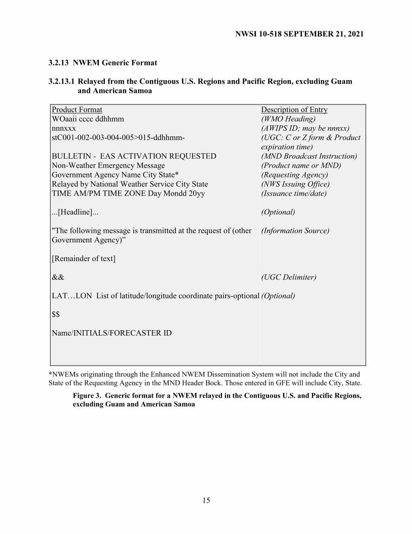
3.2.13 NWEM Generic Format
3.2.13.1 Relayed from the Contiguous U.S. Regions and Pacific Region, excluding Guam
and American Samoa
Product Format
WOaaii cccc ddhhmm
nnnxxx
stC001-002-003-004-005>015-ddhhmm-
BULLETIN - EAS ACTIVATION REQUESTED
Non-Weather Emergency Message
Government Agency Name City State*
Relayed by National Weather Service City State
TIME AM/PM TIME ZONE Day Mondd 20yy
...[Headline]...
"The following message is transmitted at the request of (other
Government Agency)”
[Remainder of text]
&&
LAT…LON List of latitude/longitude coordinate pairs-optional
$$
Name/INITIALS/FORECASTER ID
Description of Entry
(WMO Heading)
(AWIPS ID; may be nnnxx)
(UGC: C or Z form & Product
expiration time)
(MND Broadcast Instruction)
(Product name or MND)
(Requesting Agency)
(NWS Issuing Office)
(Issuance time/date)
(Optional)
(Information Source)
(UGC Delimiter)
(Optional)
*NWEMs originating through the Enhanced NWEM Dissemination System will not include the City and
State of the Requesting Agency in the MND Header Bock. Those entered in GFE will include City, State.
Figure 3. Generic format for a NWEM relayed in the Contiguous U.S. and Pacific Regions,
excluding Guam and American Samoa
Page 16
NWSI 10-518 SEPTEMBER 21, 2021
16
3.2.13.2 Relayed in Alaska Region, Guam and American Samoa
Product Format WOaaii cccc ddhhmm nnnxxx stZ001-002-003-004-005>015-ddhhmm- BULLETIN - EAS ACTIVATION REQUESTED Non-Weather Emergency Message Government Agency Name City State* Relayed by National Weather Service City StateTIME AM/PM TIME ZONE Day Mondd 20yy ...[Headline... "The following message is transmitted at the request of (other Government Agency” [Remainder of Text] &&
LAT…LON List of latitude/longitude coordinate pairs-optional
$$ Name/INITIALS/FORECASTER ID
Description of Entry (WMO Heading) (AWIPS ID; may be nnnxx) (UGC: Z form & Product expiration time) (MND Broadcast Instruction) (Product name or MND) (Requesting Agency) (NWS Issuing Office) (Issuance time/date) (Optional) (Information Source) (UGC Delimiter) (Optional)
*NWEMs originating through the Enhanced NWEM Dissemination System will not include the City and
State of the Requesting Agency in the MND Header Bock. Those entered in GFE will include City, State.
Figure 4. Generic format for a NWEM relayed in Alaska Region. Guam and American
Samoa
3.2.14 NWS Dissemination Systems
NWEMs will be disseminated on NWS systems, including NOAA Weather Wire Service
(NWWS), Emergency Managers Weather Information Network (EMWIN), NOAAPORT and
NOAA Weather Radio All Hazards (NWR). See NWSI 10-1710, NWR Dissemination, for
SAME and 1050 Hz Warning Alarm Tone recommendations for NWEMs.
3.2.15 Earthquake Information
Comprehensive earthquake information, which includes the latest earthquakes and maps for all
US states and territories, is provided by the US Geological Survey’s National Earthquake
Information Center (NEIC) at https://earthquake.usgs.gov/earthquakes. However, WFOs may
convey earthquake information in a Public Information Statement after first confirming with the
NEIC that an event was an earthquake.
Page 17
NWSI 10-518 SEPTEMBER 21, 2021
17
3.3 NWEM Agreements
3.3.1 Non-Weather Emergencies Covered by Written Agreement
Written agreements should cover most anticipated situations with local, state, federal and tribal
officials. In some cases, such as Amber Alerts, a separate agreement may be necessary with a
law enforcement or justice agency. Copies of these agreements and detailed procedures to carry
out the agreements should be kept in the WFO operations area. Agreements to disseminate non-
weather emergency information (including possible use of the warning alarm tones and NWR-
SAME codes) will be approved by the NWS regional headquarters
3.3.2 Non-Weather Emergencies Not Covered by Written Agreement
Any crisis could have facets that are different from, or unaddressed by, this directive. As a
result, nothing in this directive should supersede good judgment, common sense, and the need to
preserve life and prevent injury. At times when events occur requiring the use of NWS
dissemination systems by known and verified government sources that are not covered by any
written agreements, the senior forecaster on duty should accept the request for relay of the
emergency information. The regional headquarters should be contacted as soon as possible
afterward with details of the event and to assess the need for a new agreement or addendum to
cover future similar events. Examples of situations that would fall under this category are (1) a
serious chemical spill or leak, (2) an explosion in a populated area, or (3) a dangerous nuclear or
bio-hazard release, whether accidental or the result of an act of terrorism. (4) an alerting
authority requesting message relay during a loss of internet capability or when IPAWS is not
available.
3.4 Updates and Corrections
WFOs should relay a time-critical, updated NWEM over NWS dissemination systems at the
request of an alerting authority. Updates (including cancellations) of an event in progress should
be sent as an Administrative Message (see ADR description in Appendix B). If an event has
expanded into additional county(s) or geographic zone(s), or if the expiration time has been
extended, a new NWEM of the same event type should be issued. No additional formatting for
an updated non-weather emergency message is required. Proofread your non-weather emergency
message prior to sending messages. If typographical errors significant enough to cause confusion
in individuals that need to take protective action or to change the intent of the message are found
after transmission, correct the error and retransmit the product using the original AWIPS product
category in the following format:
WOaaii cccc ddhhmm CCx
Nnnxxx
(Where, x=A,B,C...,X)
stC001-ddhhmm- (UGC: C or Z form for all Regions,
except Z-only form for Alaska
Region)
BULLETIN - EAS ACTIVATION REQUESTED
non-weather emergency message...CORRECTED
government agency name city state
(City State only added for GFE
NWEM Entry)
Page 18
NWSI 10-518 SEPTEMBER 21, 2021
18
Relayed by National Weather Service city state
time AM/PM TIME ZONE day mon dd yyyy
Corrected for typographical error
The following message is transmitted at the request of ...
Page 19
NWSI 10-518 SEPTEMBER 21, 2021
A-1
APPENDIX A - Weather Emergency Models and Product Examples
A.1 Introduction
This section contains information and examples of models and products used for non-weather
related emergency events.
A.2 Technical Description of Atmospheric Transport and Dispersion Models (ATD)
A.2.1 CAMEO - Computer-Aided Management of Emergency Operations
CAMEO is a suite of software designed to help first responders and emergency planners plan for
and quickly respond to chemical accidents. Within CAMEO, ALOHA (Areal Locations of
Hazardous Atmospheres) is an ATD program that uses simplified meteorological input (for
example a single point wind vector), along with physical property data from its extensive
chemical library, to predict how a hazardous gas cloud might disperse in the atmosphere after an
accidental chemical release. ALOHA can estimate rates of chemical release from broken gas
pipes, leaking tanks, and evaporating puddles, and can model the dispersion of both neutrally-
buoyant and heavier-than-air gases. In addition to toxic threats, ALOHA can also estimate the
danger from flammable and explosive chemical releases.
ALOHA can display a "footprint" plot or Threat Zone of the area downwind of a release where
either concentrations may exceed a user-set toxic threshold level, or an area where thermal or
overpressure limits are exceeded if a flammable gas cloud is ignited. It can also display plots of
source strength (release rate), as well as concentration, over time. ALOHA accepts weather data
transmitted from portable monitoring stations, and can plot footprints on electronic maps
displayed in a companion mapping application, MARPLOT, as in the example below or in
ArcMap by ESRI (with a supplied Arc Tool).
Additional information on CAMEO/ALOHA is available at
https://response.restoration.noaa.gov/cameo
Figure A-1. Example of CAMEO/ALOHA Output
Page 20
NWSI 10-518 SEPTEMBER 21, 2021
A-2
A.2.2 HYSPLIT - Hybrid Single-Particle Lagrangian Integrated Trajectory Model
The NOAA Air Resources Laboratory’s (ARL) HYSPLIT (HYbrid Single-Particle Lagrangian
Integrated Trajectory) model is a complete system for computing trajectories, complex
dispersion, and deposition simulations using either puff or particle approaches. The model
calculation method is a hybrid between the Lagrangian approach, which uses a moving frame of
reference as the air parcels move from their initial location, and the Eulerian approach, which
uses a fixed three-dimensional grid as a frame of reference. In the model, advection and diffusion
calculations are made in a Lagrangian framework following the transport of the air parcel, while
pollutant concentrations are calculated on a fixed grid.
The current version of the model uses an iterative
advection algorithm, updated stability and
dispersion equations, a graphical user interface
(GUI), and the option to include modules for
chemical transformations. HYSPLIT can be run
interactively by the public on ARL’s READY
(Real-time Environmental Applications and
Display sYstem:
https://www.ready.noaa.gov/index.phpwebsite or
installed on a PC and run using a graphical user interface.
The model is designed to support a wide range of simulations related to the atmospheric
transport and dispersion of pollutants and hazardous materials, as well as the deposition of these
materials to the earth’s surface. Some of the applications include tracking and forecasting the
release of radioactive material, volcanic ash, wildfire smoke, and pollutants from various
stationary and mobile emission sources. Operationally, the model is currently used by NOAA’s
National Weather Service (NWS) through the National Centers for Environmental Prediction
(NCEP) and by local Weather Forecast Offices (WFOs). Operational prediction of wildfire
smoke forecast guidance that combines HYSPLIT model with detections of smoke sources from
satellite imagery is available at the NOAA National Air Quality Forecast Guidance website
(https://airquality.weather.gov).
At the local and regional level, field forecasters
regularly respond to requests for dispersion forecasts
from state and local emergency managers. At the state
level, air quality forecasters routinely run HYSPLIT
on the ARL web server for daily air quality impacts.
At the national level, the model is often applied to
needs from the aviation industry and air quality
regulators. Nationally and internationally, NOAA
supports and provides dispersion model forecasts in
the event of large- scale nuclear incidents through its
participation with the Interagency Modeling and
Atmospheric Assessment Center (IMAAC) World
Meteorological Organization (WMO) and the
International Atomic Energy Agency (IAEA) as a
Regional Specialized Meteorological Center (RSMC). Particle Display
Google Earth Display
Page 21
NWSI 10-518 SEPTEMBER 21, 2021
A-3
The accidental or intentional release of chemical,
biological or nuclear agents can have significant
health, safety, security, economic, and ecological
implications. The HYSPLIT model is a tool that
helps explain how, where, and when hazardous
materials are atmospherically transported,
dispersed, and deposited. Having this
understanding is essential for responding
appropriately and preventing disaster. For instance,
accurate predictions of the path of a chemical
release help emergency managers evacuate the
right people. Predictions of volcanic ash plume
locations allow aircraft to avoid dangerous areas.
Understanding the sources of hazardous air
pollutants allows air quality managers to develop
targeted policies and plans to mitigate the problem.
Gridded meteorological data, on a latitude-
longitude grid or one of three conformal (Polar, Lambert, Mercator) map projections, are
required by the model at regular time intervals to drive the transport of pollutants. The input data
are interpolated to an internal sub-grid centered over the computation area to reduce memory
requirements and increase computational speed. Calculations may be performed sequentially or
concurrently on multiple meteorological grids, usually specified from fine resolution near the
source to coarse resolution farther away.
Air concentration calculations require the definition of the pollutant's emissions and physical
characteristics (if deposition is required). When multiple pollutant species are defined, an
emission would consist of one particle or puff associated with each pollutant type. Alternately,
the mass associated with a single particle or puff may contain several species. The latter
approach is used for calculation of chemical transformations when all the species follow the
same transport pathway. Some simple chemical transformation routines are provided with the
standard PC model distribution.
The dispersion of a pollutant is calculated by assuming
either a Gaussian or Top-Hat horizontal distribution
within a puff or from the dispersal of a fixed number of
particles. A single released puff will expand until its size
exceeds the meteorological grid cell spacing and then it
will split into several puffs. An alternate approach
combines both puff and particle methods by assuming a
puff distribution in the horizontal and particle dispersion
in the vertical direction. The resulting calculation may
be started with a single particle, but as its horizontal
distribution expands beyond the meteorological grid size,
it will split into multiple particle-puffs, each with their respective fraction of the pollutant mass.
In this way, the greater accuracy of the vertical dispersion parameterization of the particle model
is combined with the advantage of having an expanding number of particles represent the
Trajectory Display
Air Concentration Display
Page 22
NWSI 10-518 SEPTEMBER 21, 2021
A-4
pollutant distribution as the spatial coverage of the pollutant increases and therefore a single
particle can represent increasingly lower concentrations.
Air concentrations are calculated at a specific grid point for puffs and as cell-average
concentrations for particles. A concentration grid is defined by latitude-longitude intersections.
Simultaneous multiple grids with different horizontal resolutions and temporal averaging periods
can be defined for each simulation. Each pollutant species is summed independently on each
grid.
The routine meteorological data fields required for the calculations may be obtained from
existing archives or from forecast model outputs already formatted for input to HYSPLIT. In
addition, several different pre-processor programs are provided with the PC model distribution to
convert NOAA, NCAR (National Center for Atmospheric Research) reanalysis, or ECMWF
(European Centre for Medium-Range Weather Forecasts) model output fields to a format
compatible for direct input to the model. The model's meteorological data structure is
compressed and in "direct-access" format. For each time period within the data file, the file
contains an index record that includes grid definitions of the spatial domain, check-sums for each
record to ensure data integrity, meteorological variable identification, and level information.
These data files require no conversion between computing platforms.
The PC-based modeling system includes a graphical user interface (GUI) to set up a trajectory,
air concentration, and/or deposition simulation. The post-processing part of the model package
incorporates graphical programs to generate multicolor or black and white publication quality
Postscript printer graphics, .kml files for display with Google Earth & Maps, and pdf files.
A complete description of all the equations and model calculation methods for trajectories and
air concentrations has been published an is available online at:
https://www.arl.noaa.gov/hysplit/hysplit
HYSPLIT model simulations, in support of requests from Emergency Managers to WFOs and
driven by the NAM or Global Forecast System (GFS) meteorological forecast data, are
operationally supported 24x7 at NCEP. Backup/contingency operations support is in place.
Outputs are posted to an NCEP secure website, for electronic access by NWS field forecasters
and other registered users, or faxed/emailed, if necessary. Field forecasters regularly respond
with HYSPLIT model results to requests from government and other emergency managers. Two
product streams are currently available:
a. Routine - Nationwide, four times each day, linked to the NAM forecast data.
Scenarios are produced four times each day for ~25 sample locations and WFO
requested locations, for model evaluation, forecaster training, and prolonged events.
b. On-demand - NWS Senior Duty Meteorologist (SDM) at NCEP runs HYSPLIT
interfaced to models such as the NAM and GFS, for specified locations, at the request
of NWS field forecasters, 24x7.
In addition to GIF and PostScript, graphical outputs of NWS/NCEP HYSPLIT simulations are
also available in Google Earth© formatted .kml files and GIS shapefile format, which can be
imported into ArcView or similar GIS systems.
Page 23
NWSI 10-518 SEPTEMBER 21, 2021
A-5
Note: a web-based version of HYSPLIT has been made available (https://www.hysplit.noaa.gov)
to all WFOs (HYSPLIT WFO, Section 2.2.8). This system has several enhanced capabilities that
are not currently available to the SDM. As the system continues to be developed, all comments
and suggestions are encouraged using the email link on the main page of the site called
“Questions/Comments?”.
A.2.2.1 When to Use HYSPLIT
HYSPLIT is well suited for calculations of dispersion from pollutant point sources for situations
where a quick turnaround is essential. The model's performance has been evaluated by
comparing the calculations for a variety of different applications to real data observations, such
as observed balloon trajectories, measured air concentrations of inert tracers, measured
radioactive deposition, and satellite photographs of ash from volcanic eruptions, smoke from
wildfires, and dust. Various assessment studies have been conducted and summarized at
https://www.arl.noaa.gov/hysplit/hysplit
It is appropriate to use HYSPLIT:
to address problems with source-to-receptor distances greater than 1/4 the resolution
of the meteorological data driving the model simulation.
to estimate source strengths based upon the ratio of the air concentration
measurement to the model's unit emission air concentration prediction.
to model the transport and dispersion of neutral1y-buoyant materials, or buoyant
plumes after stabilization.
to estimate air concentration or exposure over time at specific locations or areas
downwind when temporal and/or spatial variations in meteorological conditions are
expected and when estimates of dry and/or wet deposition of the pollutant are
required.
to obtain a forecast of plume position using the most recent NWS/NCEP forecast
meteorological data.
A.2.2.2 When not to use HYSPLIT
HYSPLIT is not appropriate for:
plume height changes due to non-meteorological factors (i.e., plume rise from the
heat of a large fire). If the plume rise has been constrained, for instance by a thermal
inversion, then the model could be run using the inversion height as the initial height
of the source. A HYSPLIT configuration that includes a plume rise scheme is used to
produce NWS operational wildfire smoke forecast guidance that is available at the
NOAA National Air Quality Forecast Guidance website
(https://airquality.weather.gov).
transport or dispersion at distances less than 1 km (~1/2 mile) from the source..
emissions containing dense gases, especially very near the source (flow controlled by
gravity, not meteorology).
emissions involving any chemical reactions more complex than radioactive decay if
quantitative concentration estimates are required. The model can be run for all
situations to infer plume transport directions and plume width estimates.
Page 24
NWSI 10-518 SEPTEMBER 21, 2021
A-6
cases where the plume may be diverted due to local topographic features and effects
such as sea breezes, unless the local topography and effects are well represented by
the meteorological model used to run HYSPLIT. Plume transport within HYSPLIT is
driven only by the input meteorological data.
A.2.2.3 Where to run HYSPLIT
The primary location for WFOs to run HYSPLIT interactively is the WOC HYSPLIT website at
https://www.hysplit.noaa.gov. The model can also be run on Desktop PCs, Apple computers,
UNIX/LINUX workstations, or through the NOAA ARL READY website
(http://www.ready.noaa.gov). A backup WOC HYSPLIT website for WFOs is available on the
non-operational ARL Web server at https://www.ready.noaa.gov/hysplitcameo/). The Windows
Desktop PC and Apple executables, user manuals, and other documentation, can be downloaded
from ARL’s website: https://www.ready.noaa.gov/HYSPLIT.php.
WFO forecasters can run the HYSPLIT model on the ARL web server using their NOAA login
information (LDAP). However, registration is required for non-NOAA personnel to run the
dispersion model on the ARL READY website using forecast meteorological data or to
download the registered version executables. Registration is not needed in order to run
HYSPLIT trajectories or archived dispersion simulations on the public version of HYSPLIT,
however the public version does not have some of the input options that are on the WOC site.
Registration is open to all government, commercial, and educational institutions at no cost. In
summary, these are the URLs for running HYSPLIT:
Operational (WOC) HYSPLIT for WFOs:
https://www.hysplit.noaa.gov (retrieve results only)
Non-operational (ARL) HYSPLIT for WFOs: https://www.ready.noaa.gov/hysplitcameo/
Public (ARL) HYSPLIT: https://www.ready.noaa.gov/HYSPLIT.php
A.2.2.4 Meteorological Data
Gridded fields of meteorological variables are required by HYSPLIT at regular temporal
intervals. The time interval between fields should be constant for each defined grid.
Meteorological data fields may be provided on a variety of different vertical coordinate systems.
At a minimum, the model requires horizontal wind components, temperature, height or pressure,
and the surface pressure. The precipitation field is required for wet deposition calculations.
Current forecast meteorological data files produced at NCEP in a format compatible for input to
HYSPLIT are available from https://www.ready.noaa.gov/READYmetdata.php or
ftp://ftp.arl.noaa.gov/forecast/ . The web interfaces provide a drop-down menu to choose a
meteorological data set to use. Access to the data from the PC version is configured in the
HYSPLIT GUI and obtained automatically from the NCEP ftp server. Meteorological data may
also be available by special arrangement with the NWS and from other sources using standard
GRIB decoding software provided with the model.
A.2.2.5 Estimating Model Parameters
On the PC, the model can be run in batch mode with simulation parameters specified in a
“CONTROL” file or run interactively through a GUI. The range of model configurations is
more limited for the current on-line web-based versions. A model simulation requires, at a
minimum, the emission location, release start time, duration, and height of the release. Pollutant
Page 25
NWSI 10-518 SEPTEMBER 21, 2021
A-7
specific simulations are possible if more detailed characteristics, such as particle size, density,
deposition velocity, and emission rate, are known in advance. Typically, the model is run with a
unit source strength emission unless more detailed information is available. The operational and
non-operational web-based interfaces for WFOs provide options for using the NOAA ALOHA
model to provide a more refined estimate of the chemical release rate when details on the release
scenario are available.
A.2.2.6 Typical Model Output
Two basic types of output are available: trajectories and air concentrations (Figures A-2 and A-
3). Trajectories represent the transport pathway of a single pollutant particle with the mean
wind, while air concentration simulations model the transport and dispersion of many particles
released over the duration of the emission. The latter, therefore, provides a more realistic and
quantitative estimate. Post-processing graphics programs are integrated within the GUI or web-
based menus for the display of trajectories and air concentrations. Output averaging intervals
and display heights are specified by the user. HYSPLIT will also produce output in Google
Earth© format (.kml/kmz).
Figure A-2. Example of HYSPLIT Trajectories Using NAM 12 km Forecast
Page 26
NWSI 10-518 SEPTEMBER 21, 2021
A-8
Figure A-3. Example of HYSPLIT Dispersion Plume Using NAM 12 km Forecast
The following is a description of what the standard concentration graphic contains:
Identification of the product as a NOAA HYSPLIT MODEL product.
Indicates at the top of the chart that the air concentration is averaged vertically (in this
example) between the ground (0 meters) and 100 meters and the units are in mass per
cubic meter (mass/m3). Ground-level deposition maps, if available, are identified
with units of mass per square meter (mass/m2) unless a specific chemical is chosen
for the source, in which case the units will be either parts per million (ppm) or
milligrams per cubic meter (mg/ m3).
The integration or averaging period, also indicated at the top, is the time that the time-
integrated or time-averaged concentrations apply. All times are in Coordinated
Universal Time (UTC) and are indicated by the start and end of the
integration/averaging period. In this case, this simulation was for a one hour
averaging period.
The UTC time that the release started is the last line indicated at the top of the chart.
In this case, a pollutant release duration of ten minutes started at this release time.
Page 27
NWSI 10-518 SEPTEMBER 21, 2021
A-9
The latitude, longitude, and height of the release are indicated on the left-hand side of
the graphic. Latitude and longitude are in decimal degrees. Single letter
abbreviations are used for East, West, North and South. Source heights are in meters
and indicate the height or layer of the release. A star is used to represent the source
location on the map.
Colors used for plotting the four contour intervals and their corresponding values with
yellow representing the highest concentrations (chemical results are indicated with
red, orange and yellow for Levels of Concern). If the range of values on the map is
less than eight orders of magnitude then the contour intervals are at factors of 10. If
the range is greater, then the contour intervals are at factors of 100. Any values
smaller than the smallest concentration range indicated are not plotted on the map.
The size of the solid red square (white box on Google Earth & Google Maps)
indicates the size and location of the concentration grid cell with the maximum
concentration.
Information about the model run is displayed immediately below the map.
In this example, the yellow shaded area represents the 1.0E-09 mass/m3 contour. If
the actual pollutant emission rate were known, say 1.0E+7 particles, then the
predicted 1-hour average air concentration in this region would be 1.0E-02
particles/m3 (1.0E-09 x 1.0E+7 = 1.0E-02).
A.2.2.7 WOC HYSPLIT Output.
HYSPLIT is now available to all WFOs through a Web-based
systemhttps://www.hysplit.noaa.gov in a more operational environment (NOAA Web
Operations Center) than the ARL READY website. In addition, this site allows the user to select
a chemical from the CAMEO database if the source term is known. HYSPLIT will calculate a
concentration of the chemical and display the results in both the standard GIF image or in .kml
(Google Earth) format. At this time, no chemical transformations are performed during the
HYSPLIT calculation and dense gases cannot be modeled.
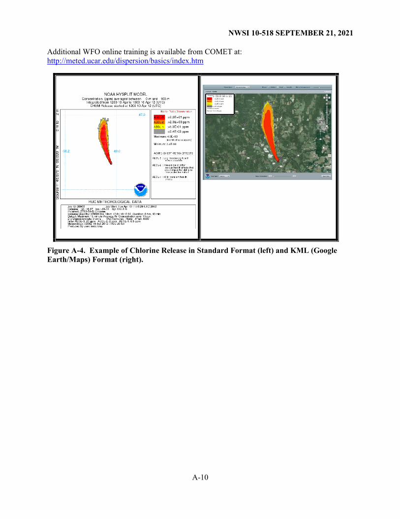
Figure A-4 shows the HYSPLIT results using the new WOC HYSPLIT Web-based version of
HYSPLIT for a hypothetical chlorine release in both standard HYSPLIT output format (left) and
the .kml (Google Earth) format (right). HYSPLIT formats the output of chemical releases by
default as concentration thresholds of concern (AEGL, ERPG, TEEL), terms familiar to
emergency responders and users of the NOAA CAMEO/ALOHA program (additional
information is available on the WOC HYSPLIT website). WFOs can enter most of the
chemicals used by CAMEO/ALOHAThe ALOHA chemical source term model has been
incorporated directly into the menus for running HYSPLIT so that the forecaster can enter
specific information on the release scenario (size of container, leak type, hole size, state of
chemical, etc.) to obtain a more realistic HYSPLIT forecast of a chemical release.
A.2.3 User Support
Additional information on HYSPLIT and the output products produced are available to WFOs on
the WOC HYSPLIT website. Also, more detailed information about the HYSPLIT model may
be obtained from the ARL HYSPLIT website at: https://www.arl.noaa.gov/hysplit/hysplit/
WFOs with immediate HYSPLIT questions should contact the SDM at NCEP, who may contact
ARL if they cannot answer the question.
Page 28
NWSI 10-518 SEPTEMBER 21, 2021
A-10
Additional WFO online training is available from COMET at:
http://meted.ucar.edu/dispersion/basics/index.htm
Figure A-4. Example of Chlorine Release in Standard Format (left) and KML (Google
Earth/Maps) Format (right).
Page 29
NWSI 10-518 SEPTEMBER 21, 2021
B-1
APPENDIX B - NWEM Product Description Guidelines and Examples
B.1 Introduction
This section provides descriptive guidelines used for NWEMs.
B.2 Background
In 2002, the Federal Communications Commission (FCC) adopted a Report and Order (FCC-02-
64) allowing local and state Emergency Alert System (EAS) committees the option of utilizing
new event codes for non-weather related events. The NWS adopted the EAS non-weather event
codes as NWS Advanced Weather Interactive Processing System (AWIPS) Identifier product
category codes for use in non-weather emergency text products (WMO heading WOUSii
Kxxx/WOAKii PAxx/WOPAii Pxxx/WOCAii Txxx) to align the audio broadcast codes and text
message identifiers to improve message dissemination.
B.3 Message Description Guidance
The most recently approved EAS Event Code is BLU, for Blue Alerts. The Federal
Communications Commission (FCC) and FEMA have not provided definitions or criteria for the
NWEM Event Codes. Therefore, using language provided in previous FCC Reports and Orders
along with help of the Houston, Texas Local Emergency Communications Committee, the NWS
provides general definitions for each NWEM in Section B.4. Local and State Emergency
Communication Committees (LECCs/SECCs) are encouraged to follow these guidelines to
provide consistent use of these codes across state borders. Use of specific, unambiguous code is
preferred.
LECCs and SECCs can best determine which state and local officials are authorized to request
specific NWEMs and EAS event codes, and/or transmit them through the NWS NWEM
Dissemination Application. Such authority will vary by local ordinance, state law, and/or federal
regulation, as will the agency names and titles of authorized officials. For example, in the State
of Texas, only the governor of the state, mayor of an incorporated city, or county judge of an
unincorporated area are authorized to recommend evacuation. However, in Texas any
evacuation is voluntary, not mandatory or required, as may be true in other states.
A warning, watch, or emergency message is normally issued only once to provide initial alert of
the event. A new warning, watch, or emergency message should be issued if the hazard or
recommended public protective action(s) has expanded into another county or geographic zone,
or if the expiration time has been extended. All other updates or cancellations of the event
should be sent as a non-emergency Administrative Message (ADR) or by other means (e.g.,
telephone, fax, e-mail, or media briefings) to local news media outlets.
B.4 NWEMs
The following list of FCC-authorized NWEMs may be relayed by NWS in text products and
broadcast on NWR, as coordinated with respective LECCs and SECCs.
B.4.1 Administrative Message (ADR)
Page 30
NWSI 10-518 SEPTEMBER 21, 2021
B-2
A non-emergency message providing updated information about an event in progress, an event
that has expired or concluded early, pre-event preparation or mitigation activities, post-event
recovery operations, or other administrative matters pertaining to the Emergency Alert System.
B.4.2 Avalanche Watch (AVA)
A message issued by authorized officials when conditions are forecast to become favorable for
natural or human-triggered avalanches that could affect roadways, structures, or backcountry
activities.
B.4.3 Avalanche Warning (AVW)
A warning of current or imminent avalanche activity when avalanche danger is considered high
or extreme. Authorized officials may recommend or order protective actions according to state
law or local ordinance when natural or human-triggered avalanches are likely to affect roadways,
structures, or backcountry activities.
B.4.4 Blue Alert (BLU)
A message issued by state and local authorities to warn the public when there is actionable
information, related to a law enforcement officer who is missing, seriously injured or killed in
the line of duty, or when there is an imminent, credible threat to an officer. A Blue Alert could
quickly warn the public if a violent suspect may be in your community, along with providing
instructions on what to do if the suspect is spotted and how to stay safe.
B.4.5 Child Abduction Emergency (CAE)
Widely referred to as an “Amber Alert,” this is an emergency message, based on established
criteria, about a missing child believed to be abducted. Note that the agency/organization
establishing the criteria varies by jurisdiction but most criteria loosely follow those of the
Department of Justice (DOJ) and National Center for Missing and Exploited Children
(NCMEC). The law enforcement agency investigating the abduction will describe the missing
child, provide a description of the suspect and/or vehicle, and ask the public to notify the
requesting agency if they have any information on the whereabouts of the child or suspect.
B.4.6 Civil Danger Warning (CDW)
A warning of an event that presents a danger to a significant civilian population. The CDW,
which usually warns of a specific hazard and gives specific protective action, has a higher
priority than the Local Area Emergency (LAE). Examples include contaminated water supplies
and imminent or in-progress military or terrorist events. Public protective actions could include
evacuation, shelter in place, or other actions (such as boiling contaminated water or seeking
medical treatment).
B.4.7 Civil Emergency Message (CEM)
An emergency message regarding an in-progress or imminent significant threat(s) to public
safety and/or property. The CEM is a higher priority message than the Local Area Emergency
(LAE), but the hazard is less specific than the Civil Danger Warning (CDW).
Page 31
NWSI 10-518 SEPTEMBER 21, 2021
B-3
B.4.8 Demonstration Message (DMO)
A demonstration or test message used for particular purposes in established state, local, tribal or
territorial EAS plans. Purposes may include testing of a siren system, audio quality checks or
alert origination system and pathway demonstration.
B.4.9 Earthquake Warning (EQW)
A warning of current or imminent earthquake activity. Authorized officials may recommend or
order protective actions according to state law or local ordinance.
B.4.10 Evacuation Immediate (EVI)
A warning where immediate evacuation is recommended or ordered according to state law or
local ordinance. As an example, authorized officials may recommend the evacuation of affected
areas due to an approaching tropical cyclone. In the event a flammable or explosive gas is
released, authorized officials may recommend evacuation of designated areas where casualties or
property damage from a vapor cloud explosion or fire may occur.
B.4.11Fire Warning (FRW)
A warning of a spreading structural fire or wildfire that threatens a populated area. Evacuation
of areas in the fire’s path may be recommended by authorized officials according to state law or
local ordinance.
B.4.112 Hazardous Materials Warning (HMW)
A warning of the release of a non-radioactive hazardous material (such as a flammable gas, toxic
chemical or biological agent) that may recommend evacuation (for an explosion, fire or oil spill
hazard) or shelter-in-place (for a toxic fume hazard).
B.4.13 Law Enforcement Warning (LEW)
A warning of a bomb explosion, riot, or other criminal event (e.g. a jailbreak). An authorized
law enforcement agency may blockade roads, waterways, or facilities, evacuate or deny access to
affected areas, and arrest violators or suspicious persons.
B.4.14 Local Area Emergency (LAE)
An emergency message that defines an event that, by itself, does not pose a significant threat to
public safety and/or property. However, the event could escalate, contribute to other more
serious events, or disrupt critical public safety services. Instructions, other than public protective
actions, may be provided by authorized officials. Examples include a disruption in water,
electric or natural gas service, or a potential terrorist threat where the public is asked to remain
alert.
B.4.15 Network Message Notification (NMN)
Not yet defined and not in the suite of products for relay by NWS.
Page 32
NWSI 10-518 SEPTEMBER 21, 2021
B-4
B.4.16 911 Telephone Outage Emergency (TOE)
An emergency message that defines a local or state 9-1-1 telephone network outage by
geographic area or telephone exchange. Authorized officials should provide alternative phone
numbers with which to reach 9-1-1 or dispatch personnel.
B.4.17 Nuclear Power Plant Warning (NUW)
A warning of an event at a nuclear power plant classified as a Site Area Emergency or General
Emergency by the Nuclear Regulatory Commission (NRC).
A Site Area Emergency is confined to the plant site; no off-site impact is
expected.
A General Emergency is confined to an area less than a 10-mile radius around the
plant. Authorized officials may recommend evacuation or medical treatment of
exposed persons in nearby areas.
B.4.18 Radiological Hazard Warning (RHW)
A warning of the loss, discovery, or release of a radiological hazard. Examples include, the theft
of a radioactive isotope used for medical, seismic, or other purposes; the discovery of radioactive
materials; a transportation (aircraft, truck or rail, etc.) accident which may involve nuclear
weapons, nuclear fuel, or radioactive wastes. Authorized officials may recommend protective
actions to be taken.
B.4.19 Shelter in Place Warning (SPW)
A warning of an event where the public is recommended to shelter in place (go inside, close
doors and windows, turn off air conditioning or heating systems, and turn on the radio or TV for
more information). Examples include the release of hazardous materials where toxic fumes or
radioactivity may affect designated areas.
B.4.20 Volcano Warning (VOW)
A warning of current or imminent volcanic activity. Authorized officials may recommend or
order protective actions according to state law or local ordinance.
NWEM Product Examples
Avalanche Warnings
WOUS46 KOTX 140034
AVWOTX
IDC009-017-021-055-079-150100-
Avalanche Warning
Idaho Panhandle Avalanche Center
Relayed by National Weather Service Spokane WA
434 PM PST Wed Jan 13 2016
The Idaho Panhandle Avalanche Center has issued an Avalanche Warning
indicating high avalanche hazard for the entire forecast region, which
Page 33
NWSI 10-518 SEPTEMBER 21, 2021
B-5
includes Benewah, Bonner, Boundary, Kootenai and Shoshone Counties. This
warning does not apply to local ski areas within the forecast region.
This warning is valid for today, Wednesday, Jan 13 and will remain in effect
through 5 PM PST on Thursday.
For specific information on avalanche activity and expected trends in
stability...contributing weather factors...and mountain travel
recommendations please refer to the Idaho Panhandle Avalanche Advisory at
http://www.idahopanhandleavalanche.org
Or call the IPNF Avalanche Hotline 208-765-7323 OR 866-489-
8664.
For resources on avalanche awareness and education and other regional
avalanche advisories go to
https://www.avalanche.org
This information has been transmitted by the National Weather Service at the
request of the Idaho Panhandle Avalanche Center. This center typically only
issues warnings on Fridays. The absence of a warning on any other day of the
week should not be used to infer avalanche conditions on those days.
&&
LAT...LON 4787 12052 4779 12030 4770 12037 4780 12064
4787 12060
$$
WOUS45 KREV 152253
AVWREV
CAZ072-NVZ002-171400-
URGENT - IMMEDIATE BROADCAST REQUESTED
Avalanche Warning
Forest Service Sierra Avalanche Center
Relayed by National Weather Service Reno NV
353 PM PDT Thu Mar 15 2018
The Sierra Avalanche Center in Truckee has issued a Backcountry
Avalanche Warning for the following areas: Greater Lake Tahoe
* Timing...In effect through 7 AM PDT Saturday.
* Affected Area...Central Sierra Nevada Mountains between Yuba
Pass (Highway 49) on the north and Ebbetts Pass (Highway 4) on
the south, including the Greater Lake Tahoe area. This warning
applies only to backcountry areas outside of established ski
area boundaries and highway corridors where avalanche mitigation
programs exist.
* Avalanche Danger...HIGH avalanche danger (4 out of 5) will exist
in the warning area.
* Reason/Impacts...Strong winds, significant snow accumulation,
Page 34
NWSI 10-518 SEPTEMBER 21, 2021
B-6
and intense snowfall rates will create unstable avalanche
conditions. Expect widespread avalanches both above and below
treeline.
* Precautionary / Preparedness Actions...Very dangerous avalanche
conditions exist. Travel in or near avalanche terrain is not
recommended. Natural avalanches are likely and human-triggered
avalanches are very likely. Large destructive avalanches may
occur and could run long distances.
Child Abduction Emergency (CAE). Example of “Entire State” message
WOUS42 KRAH 030728
CAENC
NCC000-031028
BULLETIN – EAS ACTIVATION REQUESTED
Child Abduction Emergency
North Carolina Department of Public Safety
Relayed by National Weather Service Raleigh NC
328 AM EDT Sat Apr 3 2021
…EAS Child Abduction Emergency…
The following message is transmitted at the request of the NC Department of Public Safety.
This is a North Carolina Amber Alert for a child abduction…The Greensboro Police Department
is searching for Josea Andre Petty. Josea is a 1 year old black male weighing 35 pounds. He has
short black hair and brown eyes. Josea was last seen wearing a green sweater, gray sweat pants
and white socks.
The abductor is a black male, 20 to 25 years old with black hair, last known wearing a black
jacket and gray pants.
They were last seen traveling westbound on West Meadowview Road in a dark gray Kia
Sorrento, NC registration 5D16DV.
If you have any information regarding this abduction call the Greensboro Police Department
immediately at 3 3 6 3 7 3 2 2 2 3 or call 9 1 1 or STAR 4 7
$$
Civil Emergency Messages
WOUS44 KHGX 280310
CEMHGX
TXC201-290315-
BULLETIN - EAS ACTIVATION REQUESTED
Civil Emergency Message
Page 35
NWSI 10-518 SEPTEMBER 21, 2021
B-7
Harris County Flood Control District
Relayed by National Weather Service Houston/Galveston TX
1010 PM CDT Sun Aug 27 2017
The following message is transmitted at the request of the Harris County
Flood Control District.
This is a voluntary evacuation for all residents in the following areas of
Inverness Forest Subdivision...All streets north of Whitestone Lane,
including East and West Greenbrook Drive, and all of Kenchester Drive. Water
levels on Cypress Creek near I-45 will possibly top the levee by tomorrow
morning. Residents in this area are encouraged to seek higher ground. For
more information, please contact the Harris County Flood Control District at
7 1 3 6 8 4 4 0 0 0.
$$
WOUS43 KUNR 292012
CEMUNR
SDC103-300815-
BULLETIN - EAS ACTIVATION REQUESTED
Civil Emergency Message
Pennington County Emergency Management
Relayed by National Weather Service Rapid City SD
212 PM MDT Mon Mar 29 2021
The following message is transmitted at the request of the Pennington County
Emergency Management.
A wildfire is burning just west of Rapid City. Residents of Dark Canyon Road
and Magic Canyon Road are asked to evacuate immediately into Rapid City. A
reception center has been set up at South Baptist Church. All others should
avoid this area. Follow the instructions of your local emergency management
or law enforcement officials.
Call the 2 1 1 Helpline for additional information.
$$
WOUS45 KBOU 291405
CEMBOU
COC073-292000-
BULLETIN - EAS ACTIVATION REQUESTED
Civil Emergency Message
Colorado Emergency Management Agency Denver CO
Relayed by National Weather Service Denver CO
814 AM MDT Thu Apr 29 2021
Page 36
NWSI 10-518 SEPTEMBER 21, 2021
B-8
The following message is transmitted at the request of the Colorado
Emergency Management Agency.
...This is a Flash Flood Emergency for Lincoln County...
Local law enforcement and emergency management reported Flash Flooding in
several locations. 4 to 6 inches of rain has fallen in some places this
morning.
Extensive and severe flash flooding will continue over portions of Lincoln
County. This is a life-threatening situation for people in Flagler, Seibert,
and along I-70 between Arriba and Seibert. Persons in and near these areas
should move to high ground immediately and avoid driving into flood waters.
&&
LAT...LON 3917 10336 3931 10316 3930 10315 3913 10316
3908 10316 3905 10324
$$
Fire Warning
WOUS44 KOUN 070304
FRWOUN
OKZ010-070400-
BULLETIN - EAS ACTIVATION REQUESTED
Fire Warning
Woodward County Emergency Management
Relayed by National Weather Service Norman OK
859 PM CST Mon Mar 6 2017
The following message is being transmitted at the request of Woodward County
Emergency Management.
A fire was located near Boiling Springs State Park and moving southward.
Residents between County Road EW 36 and County Road EW 41...and between
County Road NS 206 and County Road NS 211 should evacuate southward. There
are shelters set up at the Mooreland Community Center in Mooreland and the
Woodward Pioneer Room at 1212 9th Street in Woodward.
PRECAUTIONARY/PREPAREDNESS ACTIONS...
Follow safety instructions from local law enforcement officials.
Heed any evacuation orders and follow all safety precautions.
&&
LAT...LON 3416 9883 3416 9887 3417 9887 3419 9893
3420 9894 3427 9897 3445 9866 3434 9866
3433 9861 3419 9861 3415 9876 3415 9880
Page 37
NWSI 10-518 SEPTEMBER 21, 2021
B-9
$$