Lambert, J. 2010. Teachers’ Version 1 Ocean Currents: Highways of the Sea Grade Levels: Grades 4-8 Guiding Question How are ocean currents formed and what role do they play in Earth’s climate? Project 2061 Benchmarks for Science Literacy Thermal energy carried by ocean currents has a strong influence on climates around the world. Areas near ocean tend to have more moderate temperatures than they would if they were farther inland but at the same latitude because water in the oceans can hold a large amount of thermal energy. 4B/M9 (6-8) Atoms and molecules are perpetually in motion. Increased temperatures means greater average energy of motion, so most substances expand when heated. 4D/M3ab (6-8) Thermal energy is transferred through a material by the collisions of atoms within the material. Thermal energy can be transferred by means of currents in air, water, or other fluids. 4E/M3 (6-8) Learning Goals Students will understand the location of the major surface currents of the oceans, how surface currents affect nearby landmasses, the relationship between temperature of water and density, the relationship between salinity of water and density, how density differences cause ocean water to sink and then flow along the bottom throughout the major oceans, and the relationship between deep currents and climate change. Vocabulary buoyancy density salinity convection currents mass volume currents molecules water mass
Transcript
Lambert, J. 2010. Teachers’ Version 1
Ocean Currents: Highways of the Sea
Grade Levels: Grades 4-8 Guiding Question How are ocean currents formed and what role do they play in Earth’s climate? Project 2061 Benchmarks for Science Literacy Thermal energy carried by ocean currents has a strong influence on climates around the world. Areas near ocean tend to have more moderate temperatures than they would if they were farther inland but at the same latitude because water in the oceans can hold a large amount of thermal energy. 4B/M9 (6-8) Atoms and molecules are perpetually in motion. Increased temperatures means greater average energy of motion, so most substances expand when heated. 4D/M3ab (6-8) Thermal energy is transferred through a material by the collisions of atoms within the material. Thermal energy can be transferred by means of currents in air, water, or other fluids. 4E/M3 (6-8) Learning Goals Students will understand
the location of the major surface currents of the oceans, how surface currents affect nearby landmasses, the relationship between temperature of water and density, the relationship between salinity of water and density, how density differences cause ocean water to sink and then flow along the bottom
throughout the major oceans, and the relationship between deep currents and climate change.
Vocabulary buoyancy density salinity convection currents mass volume currents molecules water mass
Lambert, J. 2010. Teachers’ Version 2
Materials Exploration 1
map of currents (per student) colored pencils (per team)
Exploration 2 clear plastic box
metric ruler Styrofoam cup snap-type clothespin sharpened pencil 250 ml beaker graduated cylinder food coloring plastic spoon fresh water (hot and ice-cold) salt masking tape two thermometers
Engaging the Learner
In this lesson, you will learn about the oceans, the most dominant feature on Earth. The
ocean makes our planet Earth different from all other planets in the Solar System. There would be no life on Earth without the ocean. The ocean provides much of our oxygen and food. The ocean also helps regulate our climate and provides water for the water cycle. The oceans transport people, animals, plants, nutrients, pollution, and heat energy around the globe. In this lesson you will explore how currents form and are able to transport so many things around the Earth.
The focus of this lesson is on currents, which are like “rivers” flowing through the ocean. Currents have played an important role in history. They have affected the paths of ships and migration of people around the Earth for thousands of years. Currents also affect the climate of coastal areas as well as the entire planet. The ocean helps regulate Earth’s climate because it moves heat that is absorbed from the sun’s rays. In this lesson, you will learn about the two types of currents – surface and deep-density currents.
Did you know that currents are like “rivers in the ocean?…
Lambert, J. 2010. Teachers’ Version 3
Exploring the Concept Exploration 1: Surface Currents
In 1947, the Norweigian explorer, Thor Heyerdahl set sail from the coast of Peru on a raft made of balsa wood. He sailed about 7000 kilometers in 110 days with help of the South Equatorial Current. His voyage to Tahiti is described in the book Kon-Tiki. The purpose of Heyerdahl’s voyage was to test his theory that Peruvian Indians of South America could have crossed the Pacific ocean by riding the ocean currents, centuries before Columbus traveled across the Atlantic. We now know that ocean currents have played a major role in human exploration for thousands of years. The Gulf Stream is another ocean current that played a historical role in the European settlement of North America. Benjamin Franklin published the first chart of the Gulf Stream in 1770, after he observed that ships which took the southern route from England to North America arrived several days sooner than ships taking the northern route. The Gulf Stream helped these ships that took the southern route to arrive first.
Did you know that in 1990, 60,000 Nike tennis shoes fell off a ship during a storm and were carried for years by the currents, eventually landing on several beaches around the Pacific Ocean? …
Ocean Drifters, a National Geographic film tells the amazing story of how ocean currents play an important role in the life cycles of many organisms on our planet. This clips shows the journey of a Loggerhead Sea Turtle hatchling. http://www.youtube.com/watch?v=2GNP__YpAjo Pre or Alternative Conceptions:
Some students may think that a tide or a wave is a current. A rip current is also another typical response. A rip current is actually caused by a longshore current (the current flowing along the shore due to waves approaching at an angle), which flows up onto the shore and then flows back into the ocean. Students may also think that surface currents cause the global wind patterns, when in fact the opposite is true. Many students will not know about the deep density driven currents and the role that both surface and deep currents play in distributing heat around the planet.
Lambert, J. 2010. Teachers’ Version 4
Surface waters of the Earth’s ocean are moved primarily by winds. The sun’s energy drives the major wind systems of the atmosphere - the sun’s rays heat the Earth’s surface unequally because of the spherical shape of the planet. The result is global wind patterns. These winds blow across the oceans and move surface water. Where winds blow in the same direction for long periods of time, currents develop and transport large masses of water over long distances.
In this activity you will identify some surface currents and determine their effect on the climates of the landmasses they border. The following table lists some surface currents in the ocean. Each current is identified with a number and classified as a cold current or a warm current. These same currents are represented by numbered arrows on the map at the end of the lesson. Procedure
1. Label each of the currents on the map by writing the name next to the arrow. 2. Choose two different colored pencils. Shade in the arrows that represent the cold-
water currents in one color and the warm-water currents in another color. Include a key to identify which colors represent the cold and warm currents.
Number Name of Surface Current Characteristic Temperature of Water Transported by Current
1 Kuroshio Current warm 2 California Current cold 3 East Australian Current warm 4 Antarctic Circumpolar Current cold 5 Peru Current (Humboldt) cold 6 Gulf Stream warm 7 Canary Current cold 8 Brazil Current warm 9 Benguela Current cold
After identifying and coloring the currents on the map, answer the following questions. 1. Look at the patterns of cold and warm currents. What seems to determine whether a current
carries warm or cold water? Currents originating in low latitudes near the equator tend to carry warmer water. Currents originating in high latitudes near the north or south pole tend to carry colder water.
2. Cold-water currents tend to have a cooling effect on the continental coastlines they border, while warm-water currents tend to have a warming effect.
Find Florida on the map. Look at the pattern of currents in the Northern Hemisphere. What current affects Florida and the eastern coast of the United States? How do you think this current affects the climate on the east coast? The Gulf Stream affects Florida and eastern coast of the U.S. The Gulf Stream carries warm water and causes Florida and the eastern coast of the U.S. to have a warmer climate.
Lambert, J. 2010. Teachers’ Version 5
Now, find California on the map. Look at the pattern of currents in the Northern Hemisphere. What current affects California and the western coast of the United States? How do you think this current affects the climate in the western coast? The California Current affects the western coast of the U.S., including California. The California Current carries cold water and causes the western coast of the U.S. to have a cooler climate.
Explanation
Currents, which are like “rivers” flowing through the ocean, have played an important role in history. They transport heat, people, animals, plants, nutrients, and pollution around the globe. They have affected the paths of ships and migration of people around the Earth. The currents affect the climate of coastal areas.
The sun’s energy drives the major wind systems of the atmosphere. See http://tiny.cc/globalwinds. Because of Earth’s spherical shape, the surface is heated unequally. The result is global wind patterns, which cause winds to blow across the oceans and drive surface ocean currents. As these currents flow along the edges of continents they affect the land’s climate. On the East Coast, the Gulf Stream, which comes from the equatorial region, carries warm water and keeps the eastern coast of the U.S. relatively warm. The California Current comes from the polar region and carries cold water along the West Coast. This is why it is too cold for most people to swim at northern California beaches. Exploration 2: Deep Density Ocean Currents
In this activity, you will first review a few concepts about water and density. Water is one of the few substances on Earth that can be naturally found in all three states of matter: solid, liquid, and gas. One difference between these three states is their density, or how close the water molecules are to each other. Density is defined as the amount of particles (mass) within a certain space (volume). You have learned that water vapor, which is a gas, is the least dense form of water because the molecules are furthest apart from each other.
Adding certain materials to water, such as salt, can increase its density. If salt is added to fresh water, the amount of matter within the space the water occupies is increased, since salt molecules are crowded into the same space as the water. This makes salt water more dense than fresh water. Oceanographers use the word salinity to describe the amount of salt in water.
Just as adding salt to water increases its density, heating and cooling water also affects its density. Heating water causes water molecules to speed up and bounce off of each other more, and thus move further apart. Therefore, warm water is less dense than cold water. When water is heated, it becomes less dense and rises. Cooler, denser water sinks. As water is cooled, water molecules move more slowly and get closer together, becoming more dense and sinking. The process of warm water rising and cool water sinking forms convection currents. Convection currents transfer most of the heat energy in the oceans. The process of convection also happens in atmosphere when warm air rises and cool air sinks.
In the following simulations, you will learn what happens to water masses with different
temperatures and salinities. A water mass is a body of water that can be identified by its temperature and salinity. You will study how deep ocean currents form, by making density currents.
Lambert, J. 2010. Teachers’ Version 6
Simulation A. How do density currents flow in water masses of different temperatures? Select a hypothesis
___ A cold current will sink and flow across the bottom of the aquarium filled with warm water. or
___A cold current will flow across the top of the warm water in the aquarium. Explain why you chose this hypothesis.
Procedure
1. Using a clothespin, clamp the styrofoam cup to the inside edge of the aquarium. 2. Pour about 3 liters of warm fresh water into the clear plastic aquarium. The water level should be about 5 cm below the top of the aquarium. 3. Place three ice cubes and 100 mL of cold water in a beaker. 4. Add 3 drops of food coloring to the cup of cold water. Stir until the food coloring mixes completely with the water. 5. Slowly, pour the colored, cold water into the Styrofoam cup. 6. Use a sharp pencil point to carefully make the hole in the Styrofoam cup. The hole should be approximately 5 cm from the cup’s bottom (under the surface of the water). 7. Observe the flow of the cold water as it moves out of the cup into the aquarium water.
Results
Diagram the movement of the cold water on the illustration.
Figure 1. Diagram of cold water current
Simulation B. How do density currents flow in water masses of different salinities?
Select a hypothesis ___ A saline current will sink and flow across the bottom of the aquarium filled with fresh water. or
___ A saline current will flow across the top of the fresh water in the aquarium.
Explain why you chose this hypothesis.
Lambert, J. 2010. Teachers’ Version 7
Procedure
clear plastic box metric ruler Styrofoam cup snap-type clothespin sharpened pencil 250 ml beaker graduated cylinder food coloring plastic spoon fresh water salt
Follow the procedures: 1. Using a clothespin, clamp the Styrofoam cup to the inside edge of the aquarium. 2. Pour about 3 liters of room temperature fresh water into the clear plastic aquarium. The water level should be about 5 cm below the top of the aquarium. 3. Put about 100 mL of fresh water into the beaker and add 3 tablespoons of salt. 4. Add 3 drops of food coloring to the cup of cold water. Stir until the food coloring mixes completely with the water. 5. Slowly, pour the colored, cold water into the Styrofoam cup.
6. Use a sharp pencil point to carefully make the hole in the Styrofoam cup. The hole should be approximately 5 cm from the cup’s bottom (under the surface of the water). 7. Observe the flow of the saline water as it moves out of the cup into the aquarium water.
Results
Diagram the movement of the saline water on the illustration.
Figure 2. Diagram of saline current 1. Describe where the cold water went when it emerged from the hole in the cup. Why do you think this happened? The cold water flowed downward as it came out of the hole in the cup and then continued to flow across the bottom of the aquarium. This happened because cold water is more dense than warm water. Remind students that this is actually a convection current.
Lambert, J. 2010. Teachers’ Version 8
2. Describe where the saline water went when it emerged from the hole in the cup. Why do you think this happened? The saline water flowed downward as it came out of the hole in the cup and then continued to flow across the bottom of the aquarium. This happened because saline water is more dense than fresh water. 3. What do you think would happen to water that is both cold and saline as it flows out from a cup? Cold and saline would be the densest of all water masses. It would flow out of the cup, sink, and continue to flow across the bottom. 4. At what locations on the Earth would you expect to find very cold and saline water entering the ocean? How would this water cause the deep currents in the ocean? Very cold and saline water is found near Antarctica and in the North Atlantic Ocean. The water is colder because these water masses are at high latitudes. The water is more saline because when ice freezes, salt is left behind in the water causing it to be more saline and denser.
Explanation
Deep ocean currents are caused by density differences in water. Warmer, less saline water masses rise and colder, more saline water masses sink. Warmer water masses are found near equatorial regions and colder water masses are found near polar regions. More saline water masses are found in areas where there is a lot of evaporation or in polar areas where ice is formed. Less saline water is found where there is more precipitation or river input. Elaborating on the Concept
Currents and Earth’s Climate Together, the surface and deep currents of the oceans distribute heat. The ocean regulates global climate by absorbing and releasing heat as the water is transported around the Earth. Over the past few million years, ocean currents have flowed in the same general patterns. Some small changes have occurred as Earth’s climate has slowly varied between ice ages and warmer periods. Today, however, we are facing a situation unlike any in the past. Due to an increased amount of greenhouse gases in Earth’s atmosphere, the Earth’s temperature could rise by as much as 10°C over the next 100 years. Warmer ocean temperatures will have a great effect on currents, sea level, and the climate of the Earth.
The surface ocean currents have a strong effect on Earth’s climate. Areas near the equator receive more heat than areas near the poles. However, these areas are not constantly getting warmer and warmer. This is because the oceans and winds transport heat around the Earth from lower latitudes near the equator to higher latitudes near the pole. The deep (density) ocean currents also have a strong effect on Earth’s climate. Water in the North Atlantic Ocean is cold and salty. This colder, salty water sinks because of its greater density. It then flows southward deep in the ocean. This deep current flows throughout the Earth’s oceans and eventually mixes with the surface currents and helps return surface water to the North Atlantic. This “conveyer belt” circulation of water moves heat around the Earth. One drop of ocean water in the North Atlantic Ocean takes about 1000 years to return to the same spot. Scientists do not completely understand this flow of water, but they do believe that if Earth’s atmosphere continues to warm, water will not sink in the North Atlantic Ocean. This may
Lambert, J. 2010. Teachers’ Version 9
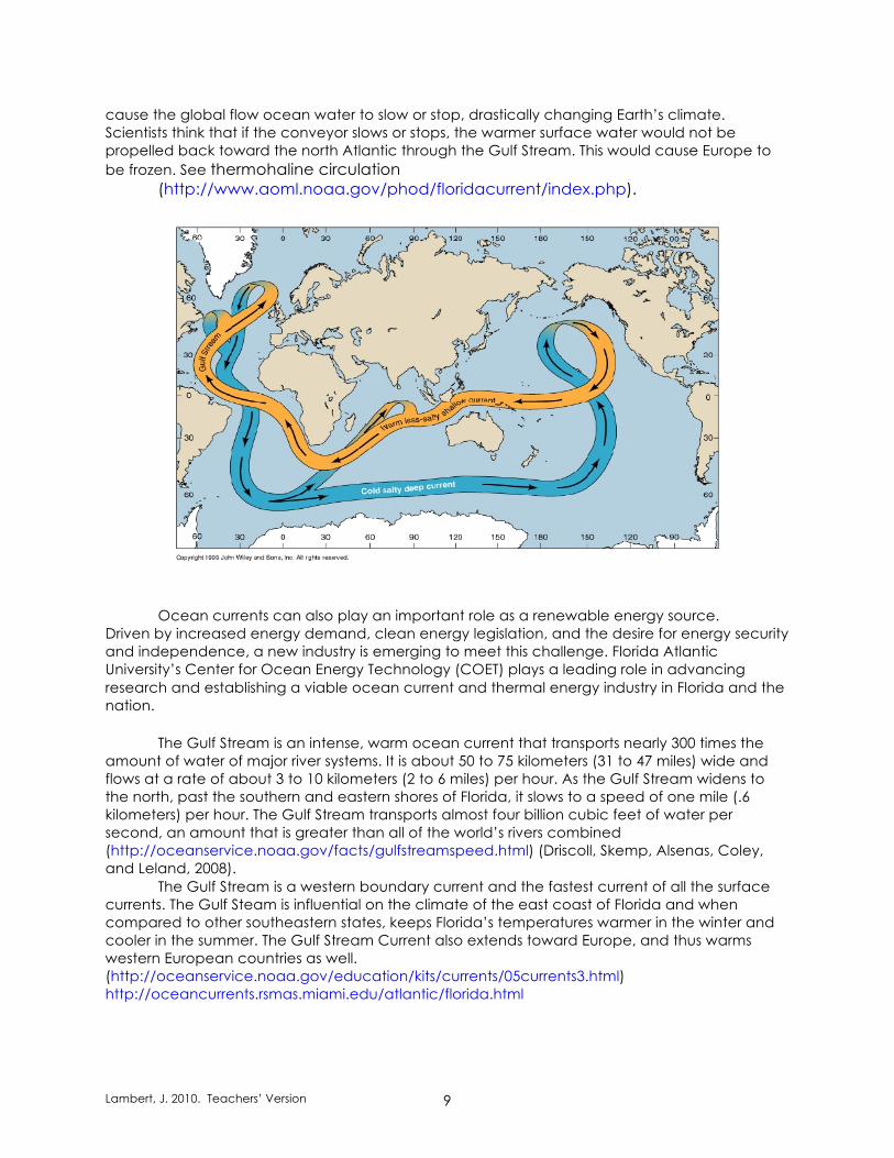
cause the global flow ocean water to slow or stop, drastically changing Earth’s climate. Scientists think that if the conveyor slows or stops, the warmer surface water would not be propelled back toward the north Atlantic through the Gulf Stream. This would cause Europe to be frozen. See thermohaline circulation
Ocean currents can also play an important role as a renewable energy source. Driven by increased energy demand, clean energy legislation, and the desire for energy security and independence, a new industry is emerging to meet this challenge. Florida Atlantic University’s Center for Ocean Energy Technology (COET) plays a leading role in advancing research and establishing a viable ocean current and thermal energy industry in Florida and the nation.
The Gulf Stream is an intense, warm ocean current that transports nearly 300 times the amount of water of major river systems. It is about 50 to 75 kilometers (31 to 47 miles) wide and flows at a rate of about 3 to 10 kilometers (2 to 6 miles) per hour. As the Gulf Stream widens to the north, past the southern and eastern shores of Florida, it slows to a speed of one mile (.6 kilometers) per hour. The Gulf Stream transports almost four billion cubic feet of water per second, an amount that is greater than all of the world’s rivers combined (http://oceanservice.noaa.gov/facts/gulfstreamspeed.html) (Driscoll, Skemp, Alsenas, Coley, and Leland, 2008).
The Gulf Stream is a western boundary current and the fastest current of all the surface currents. The Gulf Steam is influential on the climate of the east coast of Florida and when compared to other southeastern states, keeps Florida’s temperatures warmer in the winter and cooler in the summer. The Gulf Stream Current also extends toward Europe, and thus warms western European countries as well. (http://oceanservice.noaa.gov/education/kits/currents/05currents3.html) http://oceancurrents.rsmas.miami.edu/atlantic/florida.html
Lambert, J. 2010. Teachers’ Version 10
Websites
Currents of the Ocean http://www.windows.ucar.edu/tour/link=/earth/Water/ocean_currents.html Surface Current Animations