19
Govt. of India MINISTRY OF WATER RESOURCES CENTRAL GROUND WATER BOARD OF DHENKANAL DISTICT South Eastern Region Bhubaneswar May , 2013

Govt. of India
MINISTRY OF WATER RESOURCES
CENTRAL GROUND WATER BOARD
OF DHENKANAL DISTICT
South Eastern Region
Bhubaneswar May , 2013

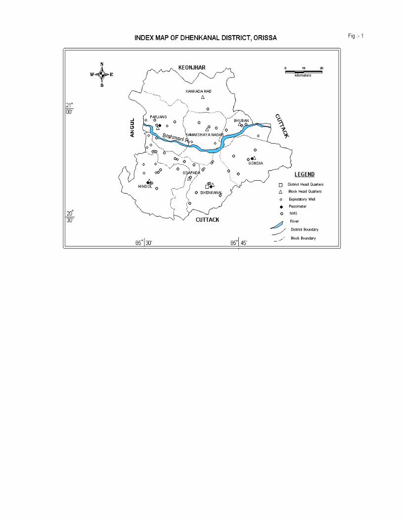
1.0 Introduction Dhenkanal is one of the centrally located districts of Orissa with a total geographical area of 4452 sq.km and lies between north latitude 20o29’00” and 21o11’00”and east longitude 85o58’00” and 86o02’00”. The area of the district is 4452 sq. km, which is about 2.78% of the total area of the state. It is bounded by the Keonjhar district in the north, Cuttack district in the east and south and Angul district in the west. The district is divided into three Sub-divisions namely Hindol, Dhenkanal and Kamakhyanagar and eight Community Development Blocks with the district headquarters located at Dhenkanal town (Fig-1). It very often reels under severe water scarcity condition, especially during the lean season of the year. According to 2001 Census data, the total population of the district is 10,67,000. The population in the rural and the urban areas are 9,73,964 and 92,914 respectively and the rural population constitutes about 91.28% of the total population of the district. The economy of the district is basically dependent on agriculture. The agriculture is mainly rain fed as the irrigation facility in the district is limited till date and hence the food grains production often suffers due to vagaries of rainfall. The areas irrigated through all sources are 27.3% during kharif and 7.5% during rabi seasons as per the available data. The source-wise irrigation potential from different sources is 33,464 Ha during kharif and 9,215 Ha during rabi. The on-going Rengali irrigation project covers major part of the district. In addition, there are number of minor (flow) irrigation projects and minor lift irrigation projects in the district. The minor (flow) irrigation projects irrigate 17,519 Ha during kharif and 1,330 Ha during rabi seasons while the lift irrigation projects cover 2,200 Ha during kharif and 1,740 Ha during rabi seasons. The irrigation potential from ground water resources is mainly through dug wells. The river Brahmani controls the drainage of the district and it’s tributaries. Brahmani is the second longest river in Orissa and flows through the district in a general east-west direction. It divides the district into two halves. Initially, the river flows in a north-south direction, then follows a northwest-southeast course and subsequently changes to northeast-southwest direction. Finally, it changes to a northwest-southeast course near the eastern border of the district. Most part of the district falls within It’s basin. The Brahmani is perennial in nature with a nominal flow during the summer season. It’s important tributaries are Ramiala Nadi, Nigre Nadi, Purajhor Nadi etc. The smaller streams show dendritic pattern while the major river and it’s tributaries show sub-parallel drainage, indicating structural control. The Geological Survey of India has done systematic geological mapping of the district. The district has been further covered by Reappraisal Hydrogeological Survey by the Central Ground Water Board during 1994-95.The CGWB also has carried out ground water exploration by deep drilling down to the depth of 200 m in different formations to delineate the deeper potential fracture zones. The locations of the bore wells thus constructed are depicted in Fig-1. Besides, ground water monitoring is regularly done the CGWB through 46 National Hydrograph Stations four times a year. 2.0 Rainfall & Climate The southwest monsoon is the principal source of rainfall in the district .The average annual rainfall is 1472.0 mm and the block wise average rainfall varies from 888.0 to 1282.0 mm. About 80% of the rainfall is received during the period from June to August. Water scarcity is prevalent during the summer season, which quite
often leads to mild drought in the area. The rainfall is more or less evenly distributed over the district. The climate of the district is tropical with hot and dry summer and pleasant winter. The summer season extends from March to middle of June followed by the rainy season from June to September and the winter from November to February. Humidity is high and varies from 26% in summer to 82% in rainy season. The temperature ranges from 6.7oC in winter to 46oC in the summer. The mean monthly potential evapotranspiration value ranges from 40 mm in December to 326 mm in May, the wind velocity in general is low to moderate with slight increase in speed in summer as well as in the rainy season. The mean annual wind speed is 6.80 km/hour. 3.0 Geomorphology & Soil Types The district can be broadly divided into four natural physiographic units. These are (i) Southern Mountainous Region, (ii) Eastern Valley and Plain, (iii) Central Undulating Plain and (iv) Northern Mountainous Region. The Southern Mountainous Region comprises hill ranges trending NNW-ESE and is covered by part of Hindol block of Hindol sub-division and also parts of Dhenkanal, Odopada and Gondia blocks of the Dhenkanal sub-division. The elevation varies from 60 m to 971 m above mean sea level. These hill ranges form the water divide between the Mahanadi and Brahmani basins. The hill slopes are covered with moderate to dense forest. The Eastern Valley and Plain occurs as small strips along the curves of the river Brahmani and it’s tributaries. Residual hills and ridges characterize it. The elevation varies from 40 m to 630 m above mean sea level. The Central Undulating Plain spreads over Parjang block of the Kamakhyanagar sub-division. The area is characterized by undulating to broad flat topography with low-lying hills having flat top. The Northern Mountainous Region covers the Kankadahad, Bhuban and Kamakhyanagar block of Kamakhyanagar sub-division. This terrain is covered with dense forest. Broad valleys and low-lying hilly regions separate the hills. The distribution of different soil types in the district depends much on it’s physiographic and lithological variation. Based on the physical and chemical characteristics, mode of original occurrence, soils of the district are classified into three types, namely Alfisols, Ultisols and Entisols. Alfisols: The major part of the district is covered by this type of soils, which include red sandy soil, red loamy soil, red gravelly and old alluvial soils. The red soil is tight textured, usually devoid of concretions and is also free of carbonates. It is usually deficient in nitrogen, phosphste, organic matter and lime. Adoption of proper irrigation practices makes it suitable for cultivation of paddy and a large variety of other crops. Ultisols: These include lateritic soil found as patches innorthern, eastern and central part of the district. The laterite and lateritic soil are characterized by a compact to vesicular mass in the sub-soil horizon, composed essentially of a mixture of hydrated oxides of aluminum and iron. The peculiar granular condition of the soil makes it suitable for cultivation immediately after heavy rain. Entisols: These are younger alluvial soils, found along the Mahanadi river in the eastern part of the district. It contains high amount of Fe, Ca and Mg. It is poor in organic matter, nitrogen and phosphorous but rich in potash and lime. pH of this soil

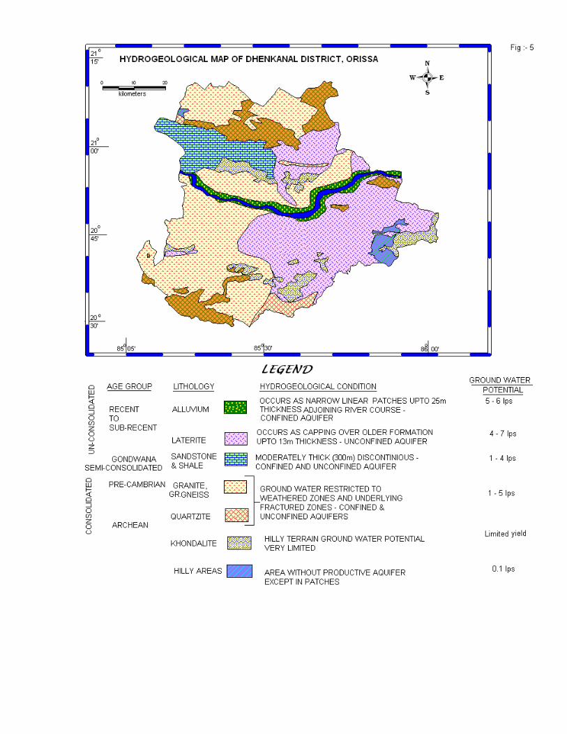
varies from normal to alkaline. The texture varies from sandy to loamy sand. It is quite fertile and crops grown are generally paddy, cotton, wheat, sugarcane, banana, tobacco and chilly. 4.0 Groundwater Scenario 4.1 Hydrogeology: The geological set-up of the area, to a large extent, governs the occurrence as well as the movement of groundwater in the district. The major part of the district is underlain by hard crystalline rocks and is devoid of any primary porosity and hence when weathered and fractured, secondary porosity is developed. The semi-consolidated Gondwana sandstone forms moderately good aquifer, when weathered and fractured. The recent alluvium, which occurs in limited patches, sustains very good yield. Since major part of the district is underlain by hard rocks of diverse lithological compositions and structures, the water-bearing properties of the formations vary widely (Fig –5). Hydrogeological surveys reveal the lithological characteristics and the role of the tectonic deformation thus resulting deep-seated intersecting fractures, on the occurrence and distribution of groundwater reservoirs and their water-bearing as well as water-yielding properties. The lineaments formed due to tensile deformations have been picked up from the Remote Sensing Studies. Groundwater occurs under water table condition in recent alluvium as well as in the semi-consolidated formations whereas in the deeper fractured rocks, the groundwater occurs under semi-confined to confined condition. Depending on the different aquifer systems and their parameters in different lithounits, the major hydrogeological units in the state can be divided into three categories: i) Consolidated formations, ii) Semi-consolidated formations and iii) Un-consolidated formations.
Water-bearing properties of the Consolidated Formations The crystalline rocks like granite, granite gneiss, khondalite etc that comprise most part of the district are devoid of any primary porosity. But the process of weathering and fracturing imparts secondary porosity in these rocks, permitting storage and transmission of groundwater. The thickness of the weathered zone is usually more in the topographic lows and undulating plains than in the highland areas. Groundwater occurs under water table condition in the weathered zone and under semi-confined to confined condition in the deeper fractured zones. The water-yielding capacity of the fractured rocks largely depends on the degree of fracturing, their horizontal extent as well as their interconnection.
Aquifer System and Aquifer Parameters of the Different Litho-units
Granite and Granite Gneiss: Major parts in the district are occupied by the granite, granite gneiss that are highly weathered and fractured. The thickness of the weathered zone varies from 5m to 20 m, which form the repository of groundwater at shallow depth. Groundwater occurs under phreatic condition in this zone and can be developed through dug wells. The depth of dug wells varies from 4.5 m to 14.0 m and the water level varies from 1.26 to 13.70 m below ground level during pre-monsoon and from 0.60 to 12.50 m below ground level during post-monsoon period. The deep bore wells yield up to 12.0 litre per second depending upon the topographic setting, proximity to major lineaments, thickness of weathered zone and number as well as potential of saturated fracture zones. The result of shallow deposit wells constructed by CGWB in this district indicates that weathered as well as semi-weathered granite gneiss form moderately potential aquifer.
Khondalite: These rocks are restricted to higher elevations forming steep linear ridges and hence groundwater potential is limited although foliated nature of the rock facilitates deep weathering. In pediment areas, the thickness of the weathering varies widely. The average depth of dug wells is about 10 m. The water level varies from 7.0 to 8.0 m below ground level during pre-monsoon and from 3.0 to 6.0 m below ground level during post-monsoon period. Water-bearing Properties of the Semi-consolidated Formations These are represented by rocks of Gondwana formation, which have faulted contact with the Pre-Cambrian rocks. It consists mainly of sandstone and shale. The friable and loosely cemented sandstone forms the aquifer. Ground water occurs in pheratic condition in the weathered zone and semi-confined to confined condition in deeper fractured and friable sandstone beds. The aquifer in these formations may sustain limited to moderate yield. Auto-flowing condition has been encountered at Kumuda. The average depth of dug wells in these formations range from 7.40 to 8.60 m below ground level. The depth of wells drilled by CGWB varies from 28.24 m (Kusponga) to 289.0 m (Kumuda) and the yield ranges from 0.50 to 12.0 litres per second. Water-bearing Properties of the Un-consolidated Formations Laterites and alluvium of Sub-Recent to Recent age constitute the un-consolidated formations which occur as thin, discontinuous patches adjoining the rivers. Laterites occur as capping over the older formations and tapped through dug wells. The depth to water level ranges from 3.34 to 10.12 m below ground level during pre-monsoon and from 0.97 to 6.87 m below ground level during post-monsoon period. The thickness of alluvium is about 25 m and form shallow potential aquifer. The aquifer sustains moderate yield. Recent alluvium occurs in thin, discontinuous patches as valley fills and also along the course of major rivers and streams. Aquifer Characteristics of Crystalline Rocks In the hard crystalline rocks, the recharge of ground water from precipitation or seepage from surface water bodies percolate into the weathered and semi-weathered (Saprolite) zone. The presence of fractures in the basement rock, which opens up to the overlain saprolite zone facilitates downward percolation and movement of the water, which can be tapped through dug wells in the weathered and semi-weathered zone and through bore wells in the deeper horizons. At places, confined condition gives rise auto flowing wells (Kumuda). The groundwater potential of various zones i.e. saprolite (tapped through dug wells), weathered basement rock and shallow fractured rocks (tapped mostly through hand pumps) and deeper fractured rock (tapped through deep bore wells) vary considerably depending upon their lithological and structural characteristics. By conducting pumping tests both in dug wells and in bore wells in different litho-units and by analysing the data adopting various methods, it has been concluded that granite gneiss forms the most potential aquifer followed by khondalites. Yield is poor in Gondwana sediments in deeper horizons whereas moderate yield can be obtained in the weathered zone. But the un-consolidated alluvium forms the most prolific aquifer. 4.2 Ground Water Exploration Exploratory drilling has been taken up CGWB in Dhenkanal district with an objective to delineate the nature and degree of connectivity of fractures and their

yield potential down to a depth of 200 m. Till March 2011, 25 no. of bore wells have been constructed in the crystalline as wells as semi-consolidated formation in this district under normal and also accelerated ground water exploration programmes. The depth range of these wells varies from 70 to 200 m and the yield of these wells varies from negligible to 5.9 lps. The yield range of these wells is given as under:
No. of wells
Depth ranges
(m)
No. of wells with yield (lps)
<2 2 to 5 >5
25 38-202 15 6 4
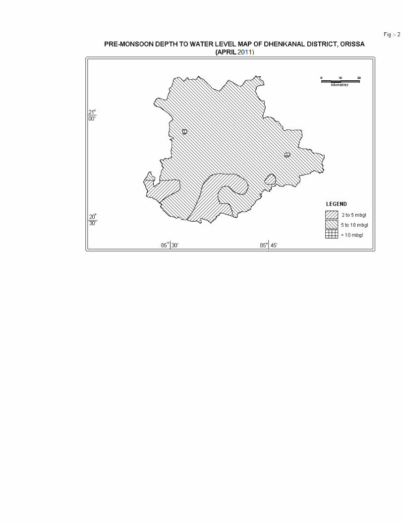
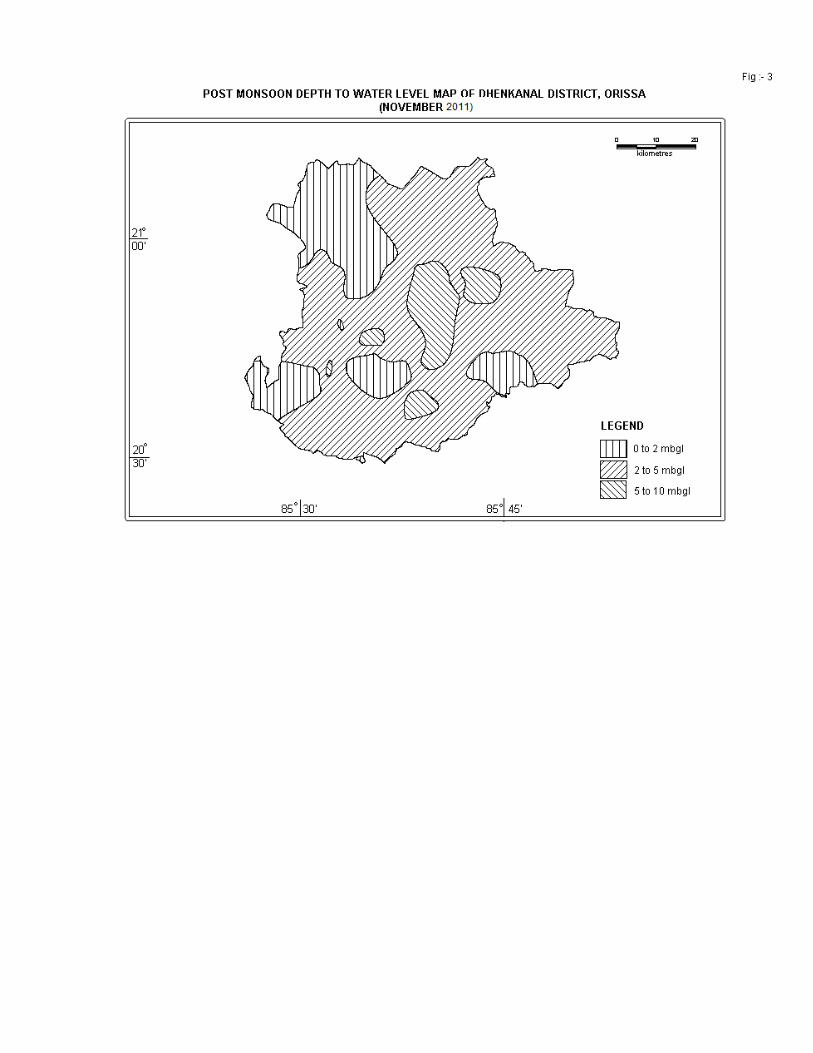
Depth to Water Level (Pre-monsoon and Post- monsoon), 2011 The depth to water level is measured from the National Hydrograph Stations located in different blocks of Dhenkanal district (Fig-1). The pre-monsoon, 2011 water level data varies 3.34 to 10.99 meter below ground level. The depth to water level map of pre-monsoon, 2011 is depicted in Fig - 2. The post monsoon, 2011 water level data varies 1.08 to 8.0 meter below ground level. The depth to water level map of post-monsoon 2011 is depicted in Fig -3. Seasonal Fluctuations The fluctuations in the depth to water level in 2011 shows rise in water level from 1.10 to 7.30 m in all the NHS wells. Long Term Water Level Trend in last 10 years in Ground Water monitoring Wells The long-term trend in depth to water level in Dhenkanal district over the last 10 years period shows that i) a rise of 0.03 to 0.30 m in 68% of wells and 0.02 to 0.16 m fall in 32% of wells during the pre-monsoon period and ii) a rise of 0.03 to 0.30 m in 31% of wells and 0.02 to 0.58 m fall in 67% of wells during the post-monsoon period . Ground Water Resources The groundwater resources of the district have been assessed adopting the methodology recommended by the Ground Water Estimation Committee (1997), constituted by the Govt. of India. The task was jointly carried out by the Central Ground Water Board and the Ground Water Survey & Investigation, Dept. of Water Resources, Govt. of Orissa. The block wise computation of ground water resources has been presented in the following table. The net annual replenishable ground water resources in the district has been computed as 44264 Ha m, out of which the Ground Water Draft for irrigation is 2745 Ha m. The ground water draft for irrigation is through dug wells and shallow tube wells. A large number of hand pumps, fitted in PHED bore wells and tube wells, also cater to the rural and urban water supply needs. On the basis of the estimated ground water potentials, a detailed scheme for ground water development may be launched in the district. So far, ground water development in the district has been meagre and all the blocks fall under the safe category. The stage of ground water development varies from 13.55% to 39.55% in different blocks. The overall stage of ground water development of the district is 16.82%. Hence, there is ample scope for stepping up ground water development in the district. The ground water budget of the district is presented in Fig-4.
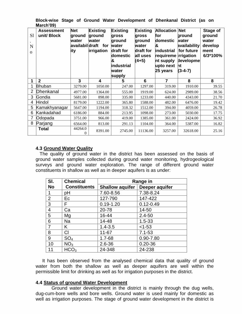
Block-wise Stage of Ground Water Development of Dhenkanal District (as on March’09)
Sl
.
N
o
Assessment unit/ Block
Net ground water availability
Existing ground water draft for irrigation
Existing gross ground water draft for domestic & industrial water supply
Existing gross ground water draft for all uses (4+5)
Allocation for domestic & industrial requirement supply upto next 25 years
Net ground water availability for future irrigation development (3-4-7)
Stage of ground water development 6/3*100%
1 2 3 4 5 6 7 8 8
1 Bhuban 3279.00 1050.00 247.00 1297.00 319.00 1910.00 39.55
2 Dhenkanal 4977.00 1364.00 555.00 1919.00 624.00 2989.00 38.56
3 Gondia 5681.00 898.00 335.00 1233.00 440.00 4343.00 21.70
4 Hindol 8179.00 1222.00 365.80 1588.00 482.00 6476.00 19.42
5 Kamakhyanagar 5647.00 1194.00 318.32 1512.00 394.00 4059.00 26.78
6 Kankadahad 6186.00 884.00 213.95 1098.00 273.00 5030.00 17.75
7 Odopada 3751.00 966.00 419.00 1385.00 361.00 2424.00 36.92
8 Parjang 6564.00 813.00 291.13 1104.00 364.00 5387.00 16.82
Total 44264.0
0 8391.00 2745.00 11136.00 3257.00 32618.00 25.16
4.3 Ground Water Quality The quality of ground water in the district has been assessed on the basis of ground water samples collected during ground water monitoring, hydrogeological surveys and ground water exploration. The range of different ground water constituents in shallow as well as in deeper aquifers is as under:
Sl. No
Chemical Constituents
Range in
Shallow aquifer Deeper aquifer
1 pH 7.60-8.56 7.38-8.24
2 Ec 127-790 147-422
3 F 0.19-1.20 0.12-0.49
4 Ca 20-78 14-50
5 Mg 16-44 2.4-50
6 Na 14-48 1.5-33
7 K 1.4-3.5 <1-53
8 Cl 11-67 7.1-53
9 SO4 1.7-68 0.90-7.80
10 NO3 2.6-36 0.20-36
11 HCO3 24-348 24-238
It has been observed from the analysed chemical data that quality of ground water from both the shallow as well as deeper aquifers are well within the permissible limit for drinking as well as for irrigation purposes in the district. 4.4 Status of ground Water Development Ground water development in the district is mainly through the dug wells, dug-cum-bore wells and bore wells. Ground water is used mainly for domestic as well as irrigation purposes. The stage of ground water development in the district is

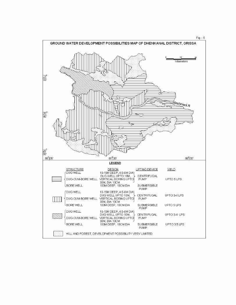
low and only 25.16% of it’s resources has so far been exploited. Hence, there is ample scope to develop the existing resources through suitable structures in hydrogeologically suitable sites to increase the irrigation potentiality as well as to meet the drinking water need. The hydrogeological, remote sensing studies and ground water exploration so far have been carried out to depict the tentative possibilities of ground water development through suitable ground water abstraction structures in various hydrogeological settings (Fig. 6). Dug wells: Dug wells are the most common groundwater abstraction structure in the district. These are generally feasible in the topographic lows including the flood plains and intermundane valleys, where the water table is within 4-6 mbgl and also the thickness is maximum. The dug wells may be 4.5-6 m in diameter and the depth may be 9-12 m in the low-lying areas and 12-15 m in the upland areas. The yield is expected to be less than 3.0 lps and centrifugal pumps of 2-3 HP may be suitable for dug wells. In the hilly tracts, dug wells are feasible particularly in areas, which are low-lying or located in proximity to streams and streamlets where thickness of weathered zone is considerably high. Dug-cum-bore wells: these are essentially dug wells with a bore drilled at the bottom of the well. The dug portion taps the weathered zone while the bore taps the underlying shallow fractures. The depth of the bore may be down to a depth of 25-30 m with a diameter of 100-150 cm. Centrifugal pumps of 2-3 HP may be suitable for these structures. Shallow Tube wells: Shallow tube wells are feasible in very limited areas, especially in the flood plains of the Brahmani river. The depth of these wells may be <30m, tapping (through slotted pipe) 5-10m thickness of the aquifer. The effective diameter of these wells can be even 155 mm and the yield may be upto 15.0 lps with the average value of 5-10 lps. Submersible pumps of 3-5 HP can be installed in these wells depending on the yield. Bore wells: Bore wells tap saturated fracture zones occurring within 100-150 m depth range in the hard rock as well as in the semi-consolidated Lower Gondwana sedimentary formations existing in the district. The diameter of these wells can be even 175-200 mm and the yield is expected to be less than 5.0 lps. Submersible pumps of 2-3 HP can be installed in these wells depending on the yield. Suitable sites for drilling should be selected with the aid of detail hydrogeological, geophysical and remote sensing studies. Medium Deep Tube wells: The medium deep tube wells are feasible in semi- consolidated Lower Gondwana sedimentary formations, occurring in the northwest part of the district in Parjang block. The depth of these wells may range from 100 to 200 m tapping aquifers in fractured sandstones. The diameter of these wells can be 155 mm and the yield is expected to be less than 5.0 lps. Submersible pumps of 2-3 HP can be installed in these wells depending on the yield. As the surface water resources are inadequate and the district often comes under the grip of mild drought, the development of ground water resources may help in expanding irrigation in the district. Proper utilization of ground water resources requires adoption of a suitable cropping pattern and also energisation of the wells. Conjunctive Utilisation: The major portion of the district is a part of the Rengali Irrigation Project. The command area also includes patches of non-command area.

It is apparent that the surface water resources are not adequate for agriculture. Moreover, it may not be possible to extend irrigation facility in certain pockets located even within the command area. The groundwater development potential of the district, already described earlier, shows that there is ample scope for groundwater development. An optimal cropping pattern and judicious use of surface as well as groundwater resources can maximise the return from irrigation. 5.0 Ground Water Management Strategy 5.1 Ground Water Development: The ground water development of the entire Dhenkanal district is depicted in Fig-6. Depending on the hydrogeological condition of the area, the various possibilities have been predicted. 5.2 Water Conservation and Artificial Recharge: Major part of the district is characterized by rugged topography and often hilly areas where surface runoff is very high. The central part of the district, covering mostly Parjang block is marked by moderate to gently undulating topography. Also in many other places, deeper water levels have been observed. This is mainly due to prevailing topographic condition, which facilitates flow of ground water through the drainage system as base flow. To arrest the surface runoff in these areas, special studies may be taken up to pin point the areas where water scarcity problems are more pronounced. Artificial recharge and rainwater harvesting structures may be constructed in these areas to increase ground water storage, so that irrigation and domestic need of water can be fulfilled from the increased resources and also the quality of ground water can be improved. The most feasible artificial recharge and rain water harvesting structures are percolation tanks, nalla/contour bunding, small check dams, renovation of old tanks, sub-surface dykes, gully plugging, etc. 6.0 Ground Water Related Issues and Problems Ground Water Problems include water pollution, water level depletion and also in some case water logging. Water Logging: Permanent water logging condition does not exist in the district. During pre-monsoon period depth to water level remains greater than 2 m throughout the district, even in canal command areas. Water Table Depletion: Water table depletion is not pronounced in the district. Ground Water Pollution: Based on the chemical analysis of water samples collected from different aquifers, it is observed that almost all chemical constituents are well within the permissible limits for drinking as well as irrigational purposes. Scope of Conjunctive Utilisation of Surface and Ground Water: Suitable measures may be taken up for conjunctive use of surface and ground water in canal command areas to prevent waterlogging condition. 7.0 Awareness and Training Activity Mass Awareness Programme (MAP) and Water Management Training Programme (WMTP) by CGWB. The Water Management Training programme was organised on 19.01.2004 in the and 21.01.2004 in the Panchayat Samiti Hall, Kamakhyanagar. The Collector & District Magistrate was the chief guest of the function. More than 50 persons

including State govt. officers and officials as well as representatives from different NGOs were present in the function. Deliberations on ground water development, conservation and protection were given by different Scientists of CGWB. The Mass Awareness Programme was arranged in the Science Centre at Dhenkanal Town. Project Director, DRDA was the chief guest of the function. More than 150 persons including State govt. officers and officials as well as farmers and representatives from different NGOs were present in the function. 8.0 Areas notified by CGWA The stage of ground water development (15.94%) is well within safe category and there is no over exploitation and threat to ground water pollution as well as depletion of water level; hence no area has been notified by CGWA. 9.0 Recommendations Large scale planning for ground water resources development should be
preceded by remote sensing studies and followed by intensive hydrogeological and geophysical surveys. Since the stage of ground water development in
the district is only 25.16%, there is vast scope for development of available ground water resources for irrigation.
Both old and defunct wells may be renovated by deepening down to the fresh rocks. For optimal utilization of ground water potential, the existing wells should be energized.
In the hard rock areas, dug and bore and dug-cum-bore wells are feasible. Exploratory drilling aided by remote sensing studies followed by intensive hydrogeological and geophysical surveys may be carried out to delineate deep potential fracture zones in crystalline rocks.
In areas where irrigation facility is available, three-crop season such as Kharif, Rabi-I and Rabi-II should be followed to make irrigation economically viable. The farmers should be educated through agricultural extension services, mass awareness and water management training programmes to adopt suitable cropping pattern, conservation of ground water and irrigation practices especially for drought tolerant crops for optimal utilization of available ground water resources.
As the erratic and uneven pattern of rainfall sometimes causes mild drought in the district, ground water resources may be augmented through adoption of different artificial recharge techniques such as percolation tanks, nalla/contour bunding, small check dams, renovation of old tanks, sub-surface dykes, gully plugging, etc. in areas where deeper water levels coupled with high water level fluctuation are observed.
The excess runoff in hilly and forest areas can be stopped by construction of percolation tanks in the higher reaches to enable the recharge of shallow aquifer.
In case of shallow water table (3 to 5m) during post monsoon, surface water bodies like local ponds and small earthen dams may be constructed to hold water for longer duration.
Conjunctive use of surface and ground water is recommended to ensure irrigation facility in all seasons in tail end areas of canal command and also to increase gross irrigation potential.
For augmentation of drinking water supply to the major towns and villages near the major rivers, infiltration galleries or collector wells should be constructed in suitable locations to harness the base flow.

Growing sugarcane and cash crops may be encouraged along the alluvial patches adjacent to rivers and streams flowing through the district.
All major industries should be asked to have wastewater treatment plant mandatory to minimize water pollution.
The State Ground Water Organisation should render expert guidance for selection of ground water structures as well as should ensure conjunctive use of surface and ground water in the canal command areas in order to supplement irrigation in water scarcity areas .
The financial institutions should generally come forward for financing ground water development schemes.

MAP -5