80
LOOKING AT EARTH FROM SPACE GLOSSARY OF TERMS Educational Reference Teachers Grades 7-12 National Aeronautics and Space Administration Office of Mission to Planet Earth
LOOKING AT EARTHFROM SPACE
GLOSSARY OF TERMS
Educational Reference
Teachers Grades 7-12
National Aeronautics andSpace AdministrationOffice of Mission to Planet Earth

This series of publications is printed in black and white to facilitate copying and distributionto the broadest audience possible.
Words that are italicized are listed in the Glossary.
ntroduction
NASA’s Office of Mission to Planet Earth is responsible for mounting a global-scale examination of the Earth’s environment and how it is changing. Researchers will usedata from satellites carrying specialized instruments to study all components of theEarth system—air, water, land, and biota—and their interactions. NASA will archive,analyze, and distribute these data through a comprehensive data and information system. These efforts will help to increase our understanding of the global environmentand how human activities affect our planet.
The NASA series of publications entitled “Looking at Earth From Space” was developed tofamiliarize educators with global change issues and Mission to Planet Earth, and to enableteachers to enhance classroom studies with hands-on activities using satellite images. Theseries, available through the NASA Teacher Resource Center network, includes:
• Direct Readout from Environmental Satellites (January 1994); • Guide to Equipment and Vendors, which reviews hardware requirements for
environmental satellite ground stations and identifies sources for the equipment (January 1994);
• Glossary of Terms which includes science and technology terms relevant to Mission to Planet Earth, remote sensing, and direct readout (August 1994);
• Teacher’s Guide to Global Change, which includes background information and lessons for high school classrooms on topics related to the science issues of global climate change (Fall 1994);
• Training Manual, designed to help teachers (elementary grades through high school) use an environmental satellite Earth station and understand the atmosphericconditions displayed in the images (Fall 1994); and
• Teacher’s Resource Guide to Direct Readout, which contains lesson plans for grades 4–12 (Fall 1994).
For additional information, please contact:Dr. Gerald Soffen, Director, University Programs, Goddard Space Flight Center, Code 160Greenbelt Road, Greenbelt, Maryland 20771
cknowledgments
This publication was developed and illustrated for NASA by Colleen Steele, WT Chen &Company, with graphic design by Kelly Kavanaugh, Earth Science Support Office, andediting by Jan Timmons, Earth Science Support Office. Special thanks to Dr. GeraldSoffen, Director, Office of University Programs, Goddard Space Flight Center for nurturingthis series of publications and to Mr. William Bandeen of Hughes STX Corporation forhis meticulous review of, and contributions to the Glossary. Thanks also to Dr. GhassemAsrar, NASA Headquarters; Mr. Louis Caudill, NASA Headquarters; Mr. Charles Davis,Dallas Remote Imaging Group; Mr. Ron Gird, National Weather Service; Dr. RobertHudson, University of Maryland; Dr. Jack Kaye, NASA Headquarters; Mr. Martin Ruzek,Universities Space Research Association; Ms. Theresa Schwerin, WT Chen & Company;Mr. Hobard Swartwood, Jr., Goddard Space Flight Center; Mr. John Tillery, RobinsonHigh School, and the many other scientists at NASA Headquarters and NASA GoddardSpace Flight Center who contributed and reviewed material.
August 1994.
1
I
A

absolute humidity In a system of moist air, the ratio of the massof water vapor present to the volume occupiedby the mixture; that is, the density of thewater vapor component. Absolute humidity isnormally expressed in grams of water vapor ina cubic meter of air (25 g/m3).
absorption The process in which radiant energy isretained by a substance. A further processalways results from absorption, that is, the irre-versible conversion of the absorbed radiationinto some other form of energy within andaccording to the nature of the absorbingmedium. The absorbing medium itself mayemit radiation, but only after an energy con-version has occurred
acid rainAcids form when certain atmospheric gases(primarily carbon dioxide, sulfur dioxide, andnitrogen oxides) come in contact with waterin the atmosphere or on the ground and arechemically converted to acidic substances.Oxidants play a major role in several of theseacid-forming processes. Carbon dioxide dis-solved in rain is converted to a weak acid (carbonic acid). Other gases, primarily oxidesof sulfur and nitrogen, are converted tostrong acids (sulfuric and nitric acids).
Although rain is naturally slightly acidicbecause of carbon dioxide, natural emissionsof sulfur and nitrogen oxides, and certainorganic acids, human activities can make itmuch more acidic. Occasional pH readings ofwell below 2.4 (the acidity of vinegar) havebeen reported in industrialized areas.
The principal natural phenomena that con-tribute acid-producing gases to the atmo-sphere are emissions from volcanoes and frombiological processes that occur on the land, in
wetlands, and in the oceans. The effects ofacidic deposits have been detected in glacialice thousands of years old in remote parts ofthe globe. Principal human sources are indus-trial and power-generating plants and trans-portation vehicles. The gases may be carriedhundreds of miles in the atmosphere beforethey are converted to acids and deposited.
Since the industrial revolution, emissions ofsulfur and nitrogen oxides to the atmospherehave increased. Industrial and energy-generat-ing facilities that burn fossil fuels, primarilycoal, are the principal sources of increased sulfur oxides. These sources, plus the trans-portation sector, are the major originators ofincreased nitrogen oxides.
The problem of acid rain not only has increasedwith population and industrial growth, it hasbecome more widespread. The use of tallsmokestacks to reduce local pollution has con-tributed to the spread of acid rain by releasinggases into regional atmospheric circulation.The same remote glaciers that provide evi-dence of natural variability in acidic depositionshow, in their more recently formed layers,the increased deposition caused by humanactivity during the past half century.
Acquisition of Signal (AOS) The time you begin receiving a signal from aspacecraft. For polar-orbiting satellites, radioreception of the APT signal can begin onlywhen the polar-orbiting satellite is above thehorizon of a particular location. This is deter-mined by both the satellite and its particularpath during orbit across the reception rangeof a ground station.
2
CONCEPTS AND TERMS
A
battery acid
vinegar
baking soda and sea water
fishreproduction
affected
adult fish die
normal range of
precipitationpH
normal range of
stream pH
neutral
alkalineacid
acid rain
0 1 2 3 4 5 6 7 8 9 10 11 12 pH
absolute humidity =mass of water vapor
volume of air
active system (active sensor)A remote-sensing system that transmits itsown radiation to detect an object or area forobservation and receives the reflected ortransmitted radiation. Radar is an example ofan active system. Compare with passive system.
A/D Analog to Digital. Used to refer to the conver-sion of analog data to its digital equivalent.
Advanced Very High ResolutionRadiometer (AVHRR) A five-channel scanning instrument thatquantitatively measures electromagnetic radiation, flown on NOAA environmentalsatellites. AVHRR remotely determines cloudcover and surface temperature. Visible andinfrared detectors observe vegetation,clouds, lakes, shorelines, snow, and ice.TIROS Automatic Picture Transmissions (APT)are derived from this instrument. See TIROS.
aerosol Particles of liquid or solid dispersed as a suspension in gas.
afforestationThe act or process of establishing a forest,especially on land not previously forested.
AI See artificial intelligence.
AIRAirborne Imaging Radar.
air mass Large body of air, often hundreds or thou-sands of miles across, containing air of a simi-lar temperature and humidity. Sometimes thedifferences between air masses are hardlynoticeable, but if colliding air masses havevery different temperatures and humidityvalues, storms can erupt. See front.
air pollution The existence in the air of substances in con-centrations that are determined unaccept-able to human health and the environment.Contaminants in the air we breathe comemainly from manufacturing industries, elec-tric power plants, exhaust from automobiles,buses, and trucks.
air pressure The weight of the atmosphere over a particu-lar point, also called barometric pressure.Average air exerts approximately 14.7 pounds(6.8 kg) of force on every square inch (or101,325 newtons on every square meter) atsea level.
aka Also known as.
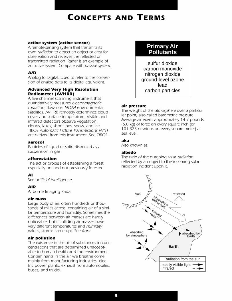
albedo The ratio of the outgoing solar radiationreflected by an object to the incoming solarradiation incident upon it.
3
CONCEPTS AND TERMS
Primary Air Pollutants
sulfur dioxidecarbon monoxidenitrogen dioxide
ground-level ozonelead
carbon particles
Sun reflected
absorbedby atmosphere
absorbed by Earth
Earth
Radiation from the sun
mostly visible lightinfrared
ultraviolet &
visible lightinfrared
radio
algorithm A mathematical relation between an observedquantity and a variable used in a step-by-stepmathematical process to calculate a quantity.
In the context of remote sensing, algorithmsgenerally specify how to determine higher-level data products from lower-level sourcedata. For example, algorithms prescribe howatmospheric temperature and moisture pro-files are determined from a set of radiationobservations originally sensed by satellitesounding instruments.
alkaline Substance capable of neutralizing acid, with apH greater than 7.0. See pH.
altimeter An active instrument (see active system) usedto measure the altitude of an object above afixed level. For example, a laser altimeter canmeasure height from a spacecraft to an ice-sheet. That measurement, coupled with radialorbit knowledge, will enable determination ofthe topography.
altitude Height above the Earth’s surface.
AM See amplitude modulation.
ampere (amp) Standard unit to measure the strength of anelectric current. One amp is the amount ofcurrent produced by an electromotive force ofone volt acting through the resistance of oneohm. The ampere is 10-1 of the theoreticalelectromagnetic unit of current. Named for theFrench physicist Andre Marie Ampere. See ohm.
amplitude The magnitude of the displacement of a wavefrom a mean value. For a simple harmonicwave, it is the maximum displacement fromthe mean. For more complex wave motion,amplitude is usually taken as one-half of themean distance (or difference) between maximaand minima.
amplitude modulation (AM) One of three ways to modify a sine wave sig-nal in order to make it “carry” information.
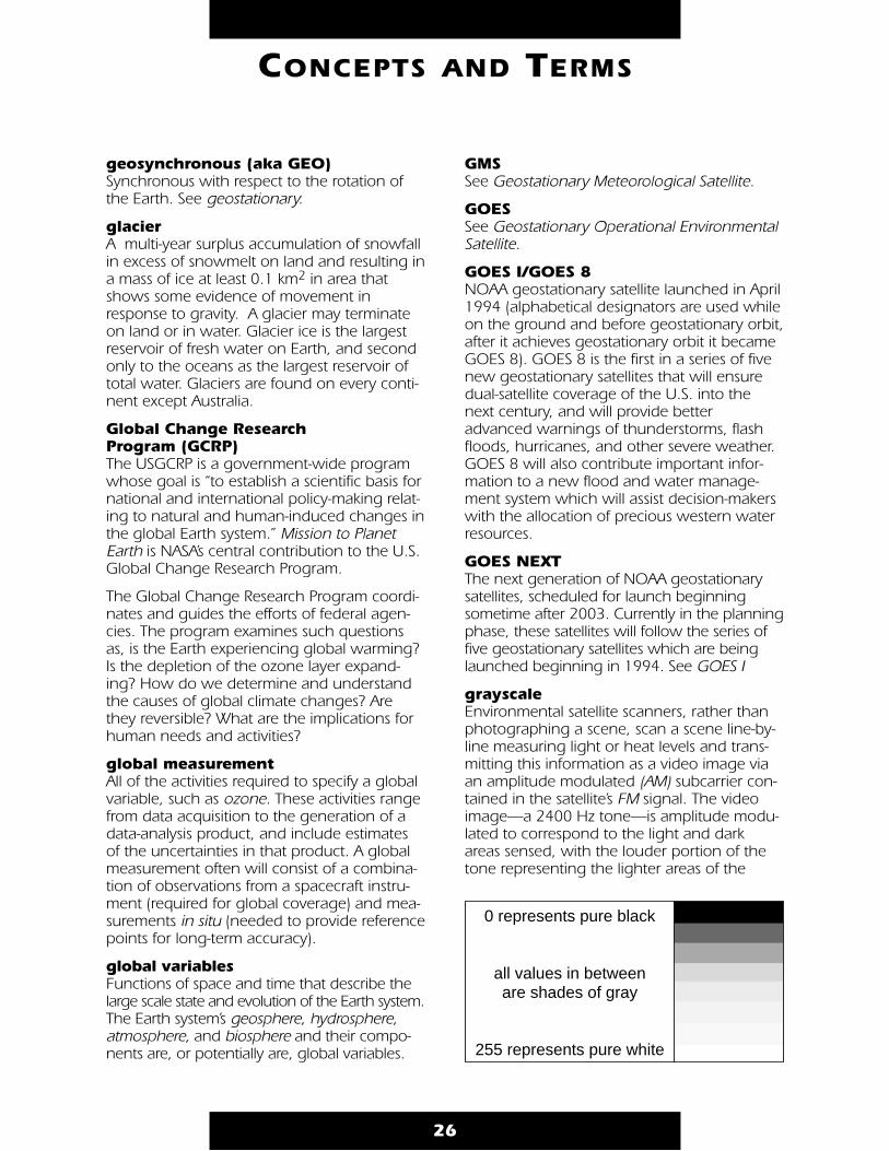
The strength (amplitude) of a signal varies(modulates) to correspond to the transmittedinformation. As applied to APT, an audibletone of 2400 Hz is amplitude modulated, withthe maximum signal corresponding to lightareas of a photograph, the minimum levelsblack, and the intermediate strengths variousshades of gray. See grayscale.
analogTransmission of a continuously variable signalas opposed to a discretely variable signal.Compare with digital. A system of transmittingand receiving information in which one value(i.e., voltage, current, resistance, or, in the APTsystem, the volume level of the video tone)can be compared directly to the information(in the APT system, the white, black, and grayvalues) in the image.
ancillary dataData other than instrument data required toperform an instrument’s data processing.Ancillary data includes such information asorbit and/or attitude data, time information,spacecraft engineering data, and calibrationinformation.
anemometer Instrument used tomeasure wind speed,usually measured eitherfrom the rotation of wind-driven cups or from windpressure through a tubepointed into the wind.
anomaly 1. The deviation of (usually) temperature orprecipitation in a given region over a specifiedperiod from the normal value for the sameregion.
2. The angular distance of an Earth satellite(or planet) from its perigee (or perihelion) asseen from the center of the Earth (sun). SeeKeplerian elements for examples of use.
antennaA wire or set of wires used to send andreceive electromagnetic waves. Two primaryfeatures must be considered when selectingantennas: beamwidth, or the “width” of the
4
CONCEPTS AND TERMS
anemometer

antenna pattern (wide beamwidth suggeststhe ability to receive signals from a number ofdifferent directions), and gain, or the increasein signal level. Generally beamwidth or gaincan be increased only at the expense of theother. Gain can be increased by multiplyingthe number of antenna elements, althoughthis adds “directionality” that reducesbeamwidth.
Important antenna considerations include the following:
1) The physical size of antenna components isdetermined by the frequency of the transmis-sions it will receive—the higher the frequency,the shorter the elements. At high frequencies,use of a satellite dish will compensate for thereduced amount of energy intercepted byshortened components.
2) The antenna design should fit the type ofradio frequency (RF) signal polarization it willreceive. The orientation of radio waves inspace is a function of the orientation of theelements of the transmitting antenna. A circu-larly polarized wave rotates as it propagatesthrough space. Antennas can be designed foreither right or left-handed circular polarization.Earth-based communication antennas areeither vertical or horizontal in polarization,and not suited for space communication.Police and cellular phone transmissions usevertical polarization because a simple verticalwhip antenna is the easiest sort of omnidirec-tional antenna to mount on a vehicle.
3) The antenna needs to produce sufficientsignal gain to produce noise-free reception.
4) The antenna should be clear of conductiveobjects such as power lines, phone wires,etc., so height above the ground becomesimportant.
Basic antenna components are:
1) Driven element—the parts connected toand receiving power from the receiver/transmitter;
2) Parasitic elements—the parts dependentupon resonance rather than connection to apower source;
• A director or parasitic element that reinforces radiation on a line pointing to it from the driven element;
• A reflector or parasitic element that reinforces radiation on a line pointing from it to the driven element.
A fundamental form of antenna is a single wirewhose length approximately equals half thetransmitting wavelength. Known as a dipoleantenna, it is the unit from which many morecomplex forms of antennas are constructed.
One of the most common forms of VHFantenna is the Yagi/beam, named for theJapanese scientist who first described the principles of combining a basic dipole (drivenelement) and parasitic elements. A commonTV antenna is an example of this type. AYagi/beam antenna is directional and there-fore includes a rotator to aim (direct) theantenna. See yagi.
An omnidirectional antenna has a widebeamwidth and consequently does not require“tracking” (aiming the antenna toward the sig-nal source). An example of an omnidirectional
5
CONCEPTS AND TERMS
receiver
dipole antenna
transmissionlines
dipole antenna
Yagi/beam antenna
receiver
reflector
driven element
directors boom
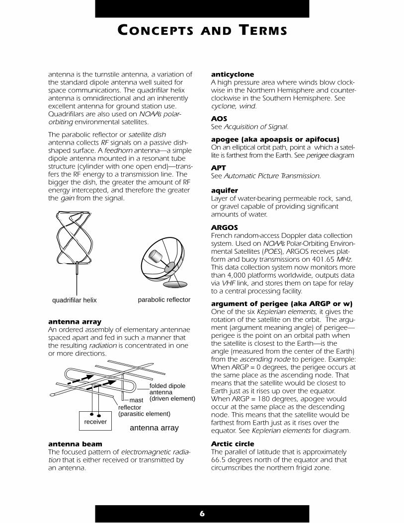
antenna is the turnstile antenna, a variation ofthe standard dipole antenna well suited forspace communications. The quadrifilar helixantenna is omnidirectional and an inherentlyexcellent antenna for ground station use.Quadrifilars are also used on NOAA’s polar-orbiting environmental satellites.
The parabolic reflector or satellite dishantenna collects RF signals on a passive dish-shaped surface. A feedhorn antenna—a simpledipole antenna mounted in a resonant tubestructure (cylinder with one open end)—trans-fers the RF energy to a transmission line. Thebigger the dish, the greater the amount of RFenergy intercepted, and therefore the greaterthe gain from the signal.
antenna arrayAn ordered assembly of elementary antennaespaced apart and fed in such a manner thatthe resulting radiation is concentrated in oneor more directions.
antenna beam The focused pattern of electromagnetic radia-tion that is either received or transmitted byan antenna.
anticyclone A high pressure area where winds blow clock-wise in the Northern Hemisphere and counter-clockwise in the Southern Hemisphere. Seecyclone, wind.
AOS See Acquisition of Signal.
apogee (aka apoapsis or apifocus) On an elliptical orbit path, point a which a satel-lite is farthest from the Earth. See perigee diagram
APT See Automatic Picture Transmission.
aquifer Layer of water-bearing permeable rock, sand,or gravel capable of providing significantamounts of water.
ARGOS French random-access Doppler data collectionsystem. Used on NOAA’s Polar-Orbiting Environ-mental Satellites (POES), ARGOS receives plat-form and buoy transmissions on 401.65 MHz.This data collection system now monitors morethan 4,000 platforms worldwide, outputs datavia VHF link, and stores them on tape for relayto a central processing facility.
argument of perigee (aka ARGP or w) One of the six Keplerian elements, it gives therotation of the satellite on the orbit. The argu-ment (argument meaning angle) of perigee—perigee is the point on an orbital path whenthe satellite is closest to the Earth—is theangle (measured from the center of the Earth)from the ascending node to perigee. Example:When ARGP = 0 degrees, the perigee occurs atthe same place as the ascending node. Thatmeans that the satellite would be closest toEarth just as it rises up over the equator.When ARGP = 180 degrees, apogee wouldoccur at the same place as the descendingnode. This means that the satellite would befarthest from Earth just as it rises over theequator. See Keplerian elements for diagram.
Arctic circle The parallel of latitude that is approximately66.5 degrees north of the equator and thatcircumscribes the northern frigid zone.
6
CONCEPTS AND TERMS
antenna array
folded dipoleantenna(driven element)
receiver
mastreflector(parasitic element)
quadrifilar helix parabolic reflector

artificial intelligence Neural networks. The branch of computer sci-ence that attempts to program computers torespond as if they were thinking—capable ofreasoning, adapting to new situations, andlearning new skills. Examples of artificial intelli-gence programs include those that can locateminerals underground and understandhuman speech.
ascending nodeThe point in an orbit (longitude) at which asatellite crosses the equatorial plane fromsouth to north.
aspect ratioThe ratio of image width to image height.Weather Facsimile (WEFAX) images have a 1:1aspect ratio (square); a conventional TV aspectratio is 4:3 (rectangle).
Astronomical Unit (AU) The distance from the Earth to the sun. Onaverage, the sun is 149,599,000 kilometersfrom Earth.
ATLAS (Atmospheric Laboratory forApplications and Science) missionThe focus of ATLAS is to study the chemistry of the Earth’s upper atmosphere (mainly thestratosphere/mesosphere) and the solar radia-tion incident on the Earth system (both totalsolar irradiance and spectrally resolved radi-ance, especially ultraviolet). Science opera-tions onboard ATLAS 1 (March 1992) andATLAS 2 (March-April, 1993) began a compre-hensive and systematic collection of data thatwill help establish benchmarks for atmo-spheric conditions and the sun’s stability.
atmosphere The air surrounding the Earth, described as aseries of shells or layers of different characteris-tics. The atmosphere, composed mainly ofnitrogen and oxygen with traces of carbondioxide, water vapor, and other gases, acts as abuffer between Earth and the sun. The layers,troposphere, stratosphere, mesosphere, thermo-sphere, and the exosphere, vary around theglobe and in response to seasonal changes.
Troposphere stems from the Greek word tropos, which means turning or mixing. Thetroposphere is the lowest layer of the Earth’satmosphere, extending to a height of 8-15km, depending on latitude. This region, con-stantly in motion, is the most dense layer ofthe atmosphere and the region that essentiallycontains all of Earth’s weather. Molecules ofnitrogen and oxygen compose the bulk of thetroposphere.
The tropopause marks the limit of the tropo-sphere and the beginning of the stratosphere.The temperature above the tropopauseincreases slowly with height up to about 50 km.
The stratosphere and stratopause stretch abovethe troposphere to a height of 50 km. It is aregion of intense interactions among radia-tive, dynamical, and chemical processes, inwhich horizontal mixing of gaseous compo-nents proceeds much more rapidly than verti-cal mixing. The stratosphere is warmer thanthe upper troposphere, primarily because of astratospheric ozone layer that absorbs solarultraviolet energy.
7
CONCEPTS AND TERMS
80°
80°
N
S
0°
ascending node
Exosphere
TroposphereStratosphereMesosphere
Earth
Thermosphere
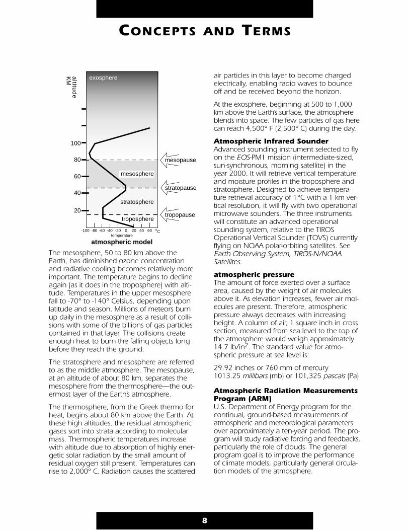
The mesosphere, 50 to 80 km above theEarth, has diminished ozone concentrationand radiative cooling becomes relatively moreimportant. The temperature begins to declineagain (as it does in the troposphere) with alti-tude. Temperatures in the upper mesospherefall to -70° to -140° Celsius, depending uponlatitude and season. Millions of meteors burnup daily in the mesosphere as a result of colli-sions with some of the billions of gas particlescontained in that layer. The collisions createenough heat to burn the falling objects longbefore they reach the ground.
The stratosphere and mesosphere are referredto as the middle atmosphere. The mesopause,at an altitude of about 80 km, separates themesosphere from the thermosphere—the out-ermost layer of the Earth’s atmosphere.
The thermosphere, from the Greek thermo forheat, begins about 80 km above the Earth. Atthese high altitudes, the residual atmosphericgases sort into strata according to molecularmass. Thermospheric temperatures increasewith altitude due to absorption of highly ener-getic solar radiation by the small amount ofresidual oxygen still present. Temperatures canrise to 2,000° C. Radiation causes the scattered
air particles in this layer to become chargedelectrically, enabling radio waves to bounceoff and be received beyond the horizon.
At the exosphere, beginning at 500 to 1,000km above the Earth’s surface, the atmosphereblends into space. The few particles of gas herecan reach 4,500° F (2,500° C) during the day.
Atmospheric Infrared SounderAdvanced sounding instrument selected to flyon the EOS-PM1 mission (intermediate-sized,sun-synchronous, morning satellite) in theyear 2000. It will retrieve vertical temperatureand moisture profiles in the troposphere andstratosphere. Designed to achieve tempera-ture retrieval accuracy of 1°C with a 1 km ver-tical resolution, it will fly with two operationalmicrowave sounders. The three instrumentswill constitute an advanced operationalsounding system, relative to the TIROSOperational Vertical Sounder (TOVS) currentlyflying on NOAA polar-orbiting satellites. SeeEarth Observing System, TIROS-N/NOAASatellites.
atmospheric pressure The amount of force exerted over a surfacearea, caused by the weight of air moleculesabove it. As elevation increases, fewer air mol-ecules are present. Therefore, atmosphericpressure always decreases with increasingheight. A column of air, 1 square inch in crosssection, measured from sea level to the top ofthe atmosphere would weigh approximately14.7 lb/in2. The standard value for atmo-spheric pressure at sea level is:
29.92 inches or 760 mm of mercury1013.25 millibars (mb) or 101,325 pascals (Pa)
Atmospheric Radiation MeasurementsProgram (ARM) U.S. Department of Energy program for thecontinual, ground-based measurements ofatmospheric and meteorological parametersover approximately a ten-year period. The pro-gram will study radiative forcing and feedbacks,particularly the role of clouds. The generalprogram goal is to improve the performanceof climate models, particularly general circula-tion models of the atmosphere.
8
CONCEPTS AND TERMS
20
60
40
80
100
tropopause
stratopause
mesopause
altitu
de
K
M
troposphere
stratosphere
mesosphere
thermosphere
atmospheric model
exosphere
-20 0 20 40-100 -80 -60 -40 60 °Ctemperature
atmospheric response variablesVariables that reflect the response of theatmosphere to external forcing (e.g., tempera-ture, pressure, circulation, and precipitation).
atmospheric windows The range of wavelengths at which watervapor, carbon dioxide, or other atmosphericgases only slightly absorb radiation.Atmospheric windows allow the Earth’s radia-tion to escape into space unless clouds absorbthe radiation. See greenhouse effect.
atoll A coral island consisting of a ring of coral sur-rounding a central lagoon. Atolls are commonin the Indian and Pacific Oceans.
attenuation The decrease in the magnitude of current,voltage, or power of a signal in transmissionbetween points. Attenuation may beexpressed in decibels, and can be caused byinterferences such as rain, clouds, or radio frequency signals.
audio frequencies Frequencies that the human ear can hear(usually 30 to 20,000 cycles per second).
aurorasSee solar wind.
Automatic Picture Transmission (APT)System developed to make real-time receptionof satellite images possible whenever an APT-equipped satellite passes within range of anenvironmental satellite ground station.Transmission (analog video format) consists ofan amplitude-modulated audible tone thatcan be displayed as an image on a computermonitor when received by an appropriateground station.
APT images are transmitted by polar-orbitingsatellites such as the TIROS-N/NOAA satellites,Russia’s METEOR, and the Chinese Feng Yun,which orbit 500-900 miles above the Earth,and offer both visible and infrared images. AnAPT image has thousands of squares calledpicture elements or pixels. Each pixel repre-sents a four-km square.
AVHRR See Advanced Very High ResolutionRadiometer.
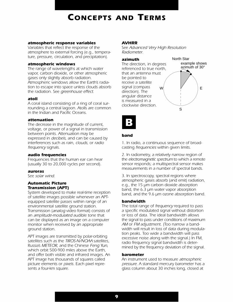
azimuth The direction, in degrees referenced to true north, that an antenna must be pointed to receive a satellite signal (compass direction). The angular distance is measured in a clockwise direction.
band
1. In radio, a continuous sequence of broad-casting frequencies within given limits.
2. In radiometry, a relatively narrow region ofthe electromagnetic spectrum to which a remotesensor responds; a multispectral sensor makesmeasurements in a number of spectral bands.
3. In spectroscopy, spectral regions whereatmospheric gases absorb (and emit) radiation,e.g., the 15 µm carbon dioxide absorptionband, the 6.3 µm water vapor absorptionband, and the 9.6 µm ozone absorption band.
bandwidth The total range of frequency required to passa specific modulated signal without distortionor loss of data. The ideal bandwidth allowsthe signal to pass under conditions of maximumAM or FM adjustment. (Too narrow a band-width will result in loss of data during modula-tion peaks. Too wide a bandwidth will passexcessive noise along with the signal.) In FM,radio frequency signal bandwidth is deter-mined by the frequency deviation of the signal.
barometer An instrument used to measure atmosphericpressure. A standard mercury barometer has aglass column about 30 inches long, closed at
9
CONCEPTS AND TERMS
North Star
EW
S
example shows azimuth of 30°
B
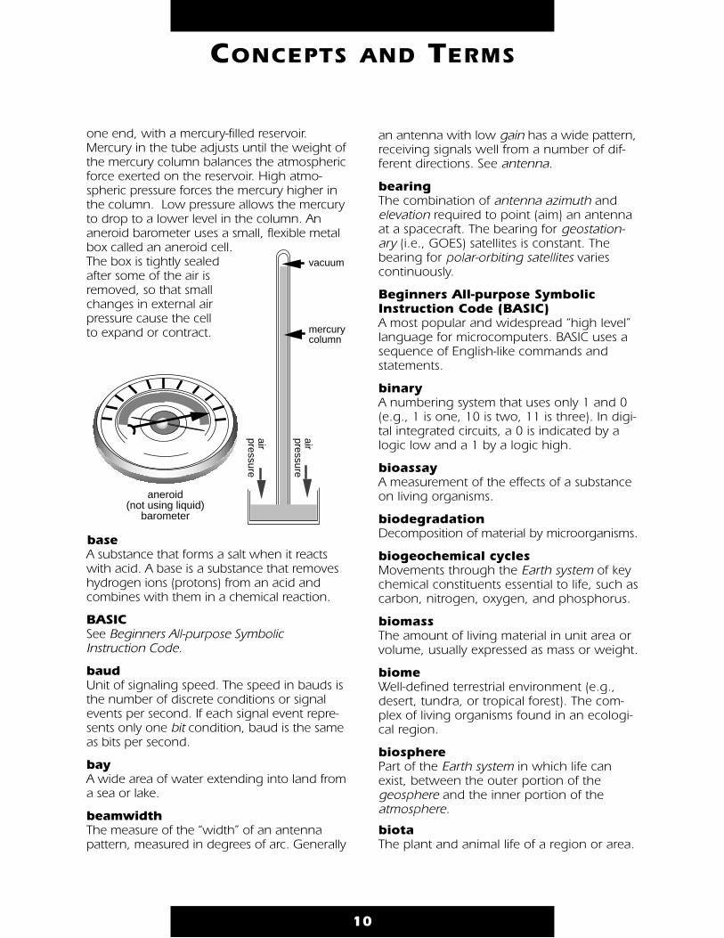
one end, with a mercury-filled reservoir.Mercury in the tube adjusts until the weight ofthe mercury column balances the atmosphericforce exerted on the reservoir. High atmo-spheric pressure forces the mercury higher inthe column. Low pressure allows the mercuryto drop to a lower level in the column. Ananeroid barometer uses a small, flexible metalbox called an aneroid cell.The box is tightly sealedafter some of the air isremoved, so that smallchanges in external air pressure cause the cell to expand or contract.
base A substance that forms a salt when it reactswith acid. A base is a substance that removeshydrogen ions (protons) from an acid andcombines with them in a chemical reaction.
BASIC See Beginners All-purpose Symbolic Instruction Code.
baud Unit of signaling speed. The speed in bauds isthe number of discrete conditions or signalevents per second. If each signal event repre-sents only one bit condition, baud is the sameas bits per second.
bay A wide area of water extending into land froma sea or lake.
beamwidth The measure of the “width” of an antennapattern, measured in degrees of arc. Generally
an antenna with low gain has a wide pattern,receiving signals well from a number of dif-ferent directions. See antenna.
bearing The combination of antenna azimuth andelevation required to point (aim) an antennaat a spacecraft. The bearing for geostation-ary (i.e., GOES) satellites is constant. Thebearing for polar-orbiting satellites varies continuously.
Beginners All-purpose SymbolicInstruction Code (BASIC) A most popular and widespread “high level”language for microcomputers. BASIC uses asequence of English-like commands and statements.
binary A numbering system that uses only 1 and 0(e.g., 1 is one, 10 is two, 11 is three). In digi-tal integrated circuits, a 0 is indicated by alogic low and a 1 by a logic high.
bioassay A measurement of the effects of a substanceon living organisms.
biodegradation Decomposition of material by microorganisms.
biogeochemical cycles Movements through the Earth system of keychemical constituents essential to life, such ascarbon, nitrogen, oxygen, and phosphorus.
biomass The amount of living material in unit area orvolume, usually expressed as mass or weight.
biome Well-defined terrestrial environment (e.g.,desert, tundra, or tropical forest). The com-plex of living organisms found in an ecologi-cal region.
biosphere Part of the Earth system in which life canexist, between the outer portion of thegeosphere and the inner portion of theatmosphere.
biota The plant and animal life of a region or area.
10
CONCEPTS AND TERMS
mercury column
air pressure
vacuum
air pressure
aneroid(not using liquid)
barometer

bitA contraction of “binary digit.” The basic ele-ment of a two-element (binary) computer language.
bit rate The speed at which bits are transmitted, usu-ally expressed in bits per second. See baud.
blizzard A severe weather condition characterized bylow temperatures and strong winds (greaterthan 35 mph) bearing a great amount ofsnow, either falling or blowing. When theseconditions persist after snow has stoppedfalling, it is called a ground blizzard.
boundaries Lines indicating the limits of countries, states,or other political jurisdictions, or different airmasses.
British Thermal Unit (BTU) The amount of heat needed to raise the tem-perature of one pound of water by onedegree Fahrenheit. Compare with calorie.
busThe basic frame of a satellite system thatincludes the propulsion and stabilization sys-tems, but not the instruments or data systems.
byteA unit of eight bits of data or memory inmicrocomputer systems.
calibration Act of comparing an instrument’s measuringaccuracy to a known standard.
calorie The amount of heat needed to raise the tem-perature of one gram of water at 15° centi-grade one degree centigrade. Compare withBritish Thermal Unit.
canal A man-made watercourse designed to carrygoods or water.
canopy The layer formed naturally by the leaves andbranches of trees and plants.
canyon A large but narrow gorge with deep sides.
cape (or point) A piece of land extending into water.
carbon cycleAll parts (reservoirs) and fluxes of carbon. Thecycle is usually thought of as four main reser-voirs of carbon interconnected by pathways ofexchange. The reservoirs are the atmosphere,terrestrial biosphere (usually includes freshwatersystems), oceans, and sediments (includes fossilfuels). The annual movements of carbon, thecarbon exchanges between reservoirs, occurbecause of various chemical, physical, geologi-cal, and biological processes. The ocean con-tains the largest pool of carbon near the sur-face of the Earth, but most of that pool is notinvolved with rapid exchange with the atmo-sphere. See appendix for diagram, page 71.
carbon dioxide (CO2) A minor but very important component of theatmosphere, carbon dioxide traps infraredradiation. Atmospheric CO2 has increasedabout 25 percent since the early 1800s, withan estimated increase of 10 percent since1958 (burning fossil fuels is the leading causeof increased CO2, deforestation the secondmajor cause). The increased amounts of CO2in the atmosphere enhance the greenhouseeffect, blocking heat from escaping into spaceand contributing to the warming of Earth’slower atmosphere.
carrier Radio frequency capable of being modulatedwith some type of information. See modulation.
carrying capacity The steady-state density of a given species thata particular habitat can support.
catalog number A five-digit number assigned to a catalogedorbiting object. This number may be found inthe NASA Satellite Situation Report and on theNASA Prediction Bulletins.
11
CONCEPTS AND TERMS
C
cathode ray tube (CRT) A television picture tube for image display.
CD-ROM See Compact Disk–Read Only Memory.
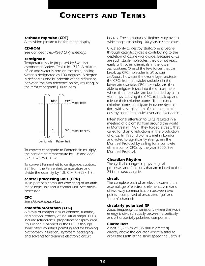
centigrade Temperature scale proposed by Swedishastronomer Anders Celsius in 1742. A mixtureof ice and water is zero on the scale; boilingwater is designated as 100 degrees. A degreeis defined as one hundredth of the differencebetween the two reference points, resulting inthe term centigrade (100th part).
To convert centigrade to Fahrenheit: multiplythe centigrade temperature by 1.8 and add32°. F = 9/5 C + 32
To convert Fahrenheit to centigrade: subtract32° from the Fahrenheit temperature anddivide the quantity by 1.8. C = (F -32) / 1.8.
central processing unit (CPU)Main part of a computer consisting of an arith-metic logic unit and a control unit. See micro-processor.
CFC See chlorofluorocarbon.
chlorofluorocarbon (CFC) A family of compounds of chlorine, fluorine,and carbon, entirely of industrial origin. CFCsinclude refrigerants, propellants for spray cans(this usage is banned in the U.S., althoughsome other countries permit it) and for blowingplastic-foam insulation, styrofoam packaging,and solvents for cleaning electronic circuit
boards. The compounds’ lifetimes vary over awide range, exceeding 100 years in some cases.
CFCs’ ability to destroy stratospheric ozonethrough catalytic cycles is contributing to thedepletion of ozone worldwide. Because CFCsare such stable molecules, they do not reacteasily with other chemicals in the loweratmosphere. One of the few forces that canbreak up CFC molecules is ultravioletradiation, however the ozone layer protectsthe CFCs from ultraviolet radiation in thelower atmosphere. CFC molecules are thenable to migrate intact into the stratosphere,where the molecules are bombarded by ultra-violet rays, causing the CFCs to break up andrelease their chlorine atoms. The releasedchlorine atoms participate in ozone destruc-tion, with a single atom of chlorine able todestroy ozone molecules over and over again.
International attention to CFCs resulted in ameeting of diplomats from around the worldin Montreal in 1987. They forged a treaty thatcalled for drastic reductions in the productionof CFCs. In 1990, diplomats met in Londonand voted to significantly strengthen theMontreal Protocol by calling for a completeelimination of CFCs by the year 2000. SeeMontreal Protocal.
Circadian Rhythm The cyclical changes in physiologicalprocesses and functions that are related to the24-hour diurnal cycle.
circuit The complete path of an electric current; anassemblage of electronic elements; a means of two-way communication between twopoints—comprised of associated “go” and“return” channels.
circularly polarized RF Radio frequency transmissions where the waveenergy is divided equally between a vertically-and a horizontally-polarized component.
Clarke Belt A belt 22,245 miles (35,800 kilometers)directly above the equator where a satelliteorbits the Earth at the same speed the Earth is
12
CONCEPTS AND TERMS
Fahrenheit
water freezes32°
water boils212°100°
centigrade
0°
rotating. Science fiction writer and scientistArthur C. Clarke wrote about this belt in 1945,hence the name.
climate The average weather conditions in an areadetermined over a period of years.
climatology Science dealing with climate and climate phenomena.
clone A person or thing very much like another, e.g.,a copy of another manufacturer’s computer.
cloudburst Any sudden, heavy rain shower.
clouds A visible mass of water vapor suspended inthe atmosphere above Earth’s surface. Cloudsform in areas where air rises and cools. Thecondensing water vapor forms small dropletsof water (0.012 mm) that, when combinedwith billions of other droplets, form clouds.Clouds can form along warm and cold fronts,where air flows up the side of the mountainand cools as it rises higher into the atmo-sphere, and when warm air blows over acolder surface, such as a cool body of water.
Clouds fall into two general categories: sheet-like or layer-looking stratus clouds (stratusmeans layer) and cumulus clouds (cumulusmeans piled up). These two cloud types aredivided into four more groups that describethe cloud’s altitude.
High clouds form above 20,000 feet in thecold region of the troposphere, and aredenoted by the prefix CIRRO or CIRRUS. At thisaltitude water almost always freezes so cloudsare composed of ice crystals. The clouds tendto be wispy, are often transparent, andinclude cirrus, cirrocumulus, and cirrostratus.
Middle clouds form between 6,500 and20,000 feet and are denoted by the prefixALTO. They are made of water droplets andinclude altostratus and altocumulus.
Low clouds are found up to 6,500 feet andinclude the stratocumulus and nimbostratus
clouds. When stratus clouds contact theground they are called fog.
Vertical clouds, such as cumulus, rise farabove their bases and can form at manyheights. Cumulonimbus clouds, or thunder-heads, can start near the ground and soar upto 75,000 feet.
cloud streets Lines or rows of cumuliform clouds.
Coastal Zone Color Scanner (CZCS)The first spacecraft instrument devoted tomeasurement of ocean color. Although instru-ments on other satellites have sensed oceancolor, their spectral bands, spatial resolution,and dynamic range were optimized for geo-graphical or meteorological use. In the CZCS,every parameter is optimized for use overwater to the exclusion of any other type ofsensing. The CZCS flew on the Nimbus-7spacecraft.
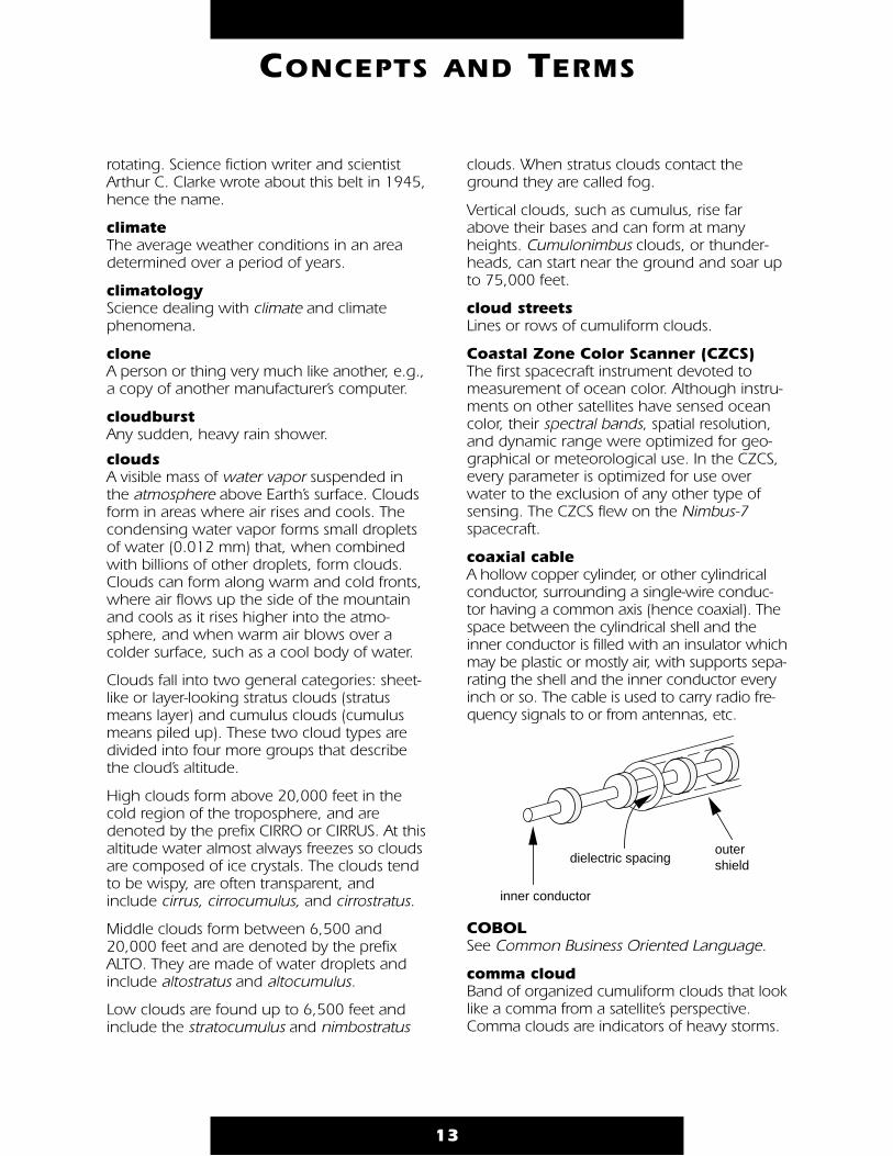
coaxial cable A hollow copper cylinder, or other cylindricalconductor, surrounding a single-wire conduc-tor having a common axis (hence coaxial). Thespace between the cylindrical shell and theinner conductor is filled with an insulator whichmay be plastic or mostly air, with supports sepa-rating the shell and the inner conductor everyinch or so. The cable is used to carry radio fre-quency signals to or from antennas, etc.
COBOL See Common Business Oriented Language.
comma cloud Band of organized cumuliform clouds that looklike a comma from a satellite’s perspective.Comma clouds are indicators of heavy storms.
13
CONCEPTS AND TERMS
inner conductor
dielectric spacingoutershield
Common Business Oriented Language(COBOL) A computer programming language writtenfor business application.
Compact Disk–Read Only Memory (CD-ROM)Type of computer memory that reads anduses information, but does not allow informa-tion to be added, changed, or erased. Digitalinformation is read by laser. CD-ROM does notdepend upon any proprietary hardware orsoftware, making it an accessible vehicle forelectronic publishing.
computer Electronic machine capable of performing cal-culations and other manipulations of varioustypes of data, under the control of a stored setof instructions. Themachine itself is thehardware; theinstructions arethe programor software.Dependingupon size,computers arecalled mainframes,minicomputers, and micro-computers. Microcomputers include desk-topand portable personal computers.
condensation Change of a substance to a denser form, suchas gas to a liquid. The opposite of evaporation.
conduction The transfer of heat from one substance toanother by direct contact. Denser substancesare better conductors; the transfer is alwaysfrom warmer to colder substances.
contrails Condensation trails. Artificial clouds made bythe exhaust of jet aircraft.
convection The rising of warm air and the sinking of coolair. Heat mixes and moves air. When a layer ofair receives enough heat from the Earth’s sur-face, it expands and moves upward. Colder,
heavier air flows under it which is thenwarmed, expands, and rises. The warm risingair cools as it reaches higher, cooler regions ofthe atmosphere and begins to sink.Convection causes local breezes, winds, andthunderstorms.
Coordinated Universal Time (UTC) (aka Greenwich Mean Time [GMT]) Local timeat zero degrees longitude at the GreenwichObservatory, England. UTC uses a 24-hourclock, i.e., 2:00 a.m. is 0200 hours, 2:00 p.m.is 1400 hours, midnight is 2400 or 0000hundred hours.
continent One of the large, continuous areas of theEarth into which the land surface is divided.The six geographically defined continents arepolitically defined as seven; Africa, Asia,Australia, Europe, North America, SouthAmerica, and Antarctica.
continental drift See plate tectonics.
Coriolis force The apparent tendency of a freely moving par-ticle to swing to one side when its motion isreferred to a set of axes that is itself rotating inspace, such as Earth. The acceleration is per-pendicular to the direction of the speed of thearticle relative to the Earth’s surface and isdirected to the right in the northern hemi-sphere. Winds are affected by rotation of theEarth so that instead of a wind blowing in thedirection it starts, it turns to the right of thatdirection in the northern hemisphere; left inthe southern hemisphere.
coupled system Two or more processes that affect oneanother.
CPU See central processing unit.
crop calendar The schedule of the maturing and harvestingof seasonal crops.
CRT See cathode ray tube.
14
CONCEPTS AND TERMS

cryosphere One of the interrelated components of theEarth’s system, the cryosphere is frozen waterin the form of snow, permanently frozenground (permafrost), floating ice, and glaciers.Fluctuations in the volume of the cryospherecause changes in ocean sea-level, whichdirectly impact the atmosphere and biosphere.
culmination The point at which a satellite reaches its high-est position or elevation in the sky, relative toan observer (aka the closest point of approach).
cyclone An area of low pressure where winds blowcounterclockwise in the Northern Hemisphereand clockwise in the Southern Hemisphere.See anticyclone, wind.
CZCS See Coastal Zone Color Scanner.
data collection system (DCS) DCS units are flown on both GOES and NOAApolar-orbiting spacecraft. They gather and relaydata from both mobile and stationary plat-forms at various locations. DCS units on NOAAsatellites can also determine the precise loca-tion of moving platforms at the time the datawere acquired. See TIROS-N/NOAA satellites.
data rate The amount of information transmitted perunit time.
decay See period decay.
decibel (dB) A tenth of a bel. A unit used to measure thevolume of a sound, equal to ten times thecommon logarithm of the ratio of the intensityof the sound to the intensity of an arbitrarilychosen standard sound. The decibel also isused to measure relative strengths of antennaand amplified signals and always refers to aratio or difference between two values.
declination The angular distance from the equator to the satellite, measured as positive north andnegative south.
Defense Meteorological SatelliteProgram (DMSP) A U.S. Air Force-managed meteorologicalsatellite program with satellites circling insun-synchronous orbit. Imagery is collectedin the visible- to near-infrared band (0.4 to1.1 micrometers) and in the thermal-infraredband (about 8 to 13 micrometers) at a reso-lution of about three kilometers. DMSP datais available directly from the satellite forlocal use aboard ships and at militarydeployment locations, but is also usuallyavailable to civilian users.
degree A unit of angular measure represented by thesymbol °. The circumference of a circle con-tains 360 degrees. When applied to theroughly spherical shape of the Earth for geo-graphic and cartographic purposes, degreesare each divided into 60 minutes.
delta The fan-shaped area at the mouth or lowerend of a river, formed by eroded material thathas been carried downstream and dropped inquantities larger than can be carried off bytides or currents.
demodulation The process of retrieving information (data)from a modulated carrier wave, the reverse of modulation.
Department of the Interior (DOI) Responsible for our nationally-owned publiclands and natural resources, the DOI is char-tered to foster the wisest use of our land andwater resources, protect fish and wildlife, pre-serve the environmental and cultural values ofnational parks and historical places, and pro-vide for the enjoyment of life through outdoorrecreation. The department assesses energyand mineral resources and is responsible forassuring that their development is in the bestinterest of all citizens. The U.S. GeologicalSurvey (USGS) is part of the DOI.
15
CONCEPTS AND TERMS
D
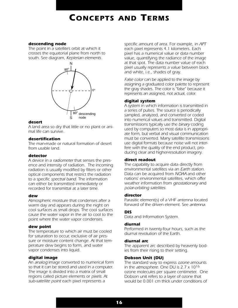
descending node The point in a satellite’s orbit at which itcrosses the equatorial plane from north tosouth. See diagram, Keplerian elements.
desert A land area so dry that little or no plant or ani-mal life can survive.
desertification The man-made or natural formation of desertfrom usable land.
detector A device in a radiometer that senses the pres-ence and intensity of radiation. The incomingradiation is usually modified by filters or otheroptical components that restrict the radiationto a specific spectral band. The informationcan either be transmitted immediately orrecorded for transmittal at a later time.
dew Atmospheric moisture that condenses after awarm day and appears during the night oncool surfaces as small drops. The cool surfacescause the water vapor in the air to cool to thepoint where the water vapor condenses.
dew point The temperature to which air must be cooledfor saturation to occur, exclusive of air pres-sure or moisture content change. At that tem-perature dew begins to form, and watervapor condenses into liquid.
digital imageAn analog image converted to numerical formso that it can be stored and used in a computer.The image is divided into a matrix of smallregions called picture elements or pixels. Atsub-satellite point each pixel represents a
specific amount of area. For example, in APTeach pixel represents 4.1 kilometers. Eachpixel has a numerical value or data numbervalue, quantifying the radiance of the imageat that spot. The data number value of eachpixel usually represents a value between blackand white, i.e., shades of gray.
False color can be applied to the image byassigning a graduated color palette to representthe gray shades. The color is “false” because itrepresents an assigned, not actual, color.
digital system A system in which information is transmitted ina series of pulses. The source is periodicallysampled, analyzed, and converted or codedinto numerical values and transmitted. Digitaltransmissions typically use the binary codingused by computers so most data is in appropri-ate form, but verbal and visual communicationmust be converted. Many satellite transmissionsuse digital formats because noise will not inter-fere with the quality of the end product, pro-ducing clear and higher-resolution imagery.
direct readout The capability to acquire data directly fromenvironmental satellites via an Earth station.Data can be acquired from NOAA and othernations’ environmental satellites, which offerweather information from geostationary andpolar-orbiting satellites.
director Parasitic element(s) of a VHF antenna locatedforward of the driven element. See antenna.
DIS Data and Information System.
diurnal Performed in twenty-four hours, such as thediurnal revolution of the Earth.
diurnal arcThe apparent arc described by heavenly bod-ies from their rising to their setting.
Dobson Unit (DU) The standard way to express ozone amountsin the atmosphere. One DU is 2.7 x 10¹⁶
ozone molecules per square centimeter. OneDobson unit refers to a layer of ozone thatwould be 0.001 cm thick under conditions of
16
CONCEPTS AND TERMS
80°
80°
N
S
0°
descending node
standard temperature (0° C) and pressure (theaverage pressure at the surface of the Earth).For example, 300 Dobson units of ozonebrought down to the surface of the Earth at 0°C would occupy a layer only 0.3 cm thick in acolumn. Dobson was a researcher at OxfordUniversity who, in the 1920s, built the firstinstrument (now called the Dobson meter) tomeasure total ozone from the ground.
doldrums Region near the equator characterized by lowpressure and light shifting winds. See wind.
Doppler effect (aka Doppler shift) The apparent change in frequency of sound orlight waves, varying with the relative velocityof the source and the observer. If the sourceand observer draw closer together, the fre-quency is increased. Named for ChristianDoppler, Austrian mathematician and physicist(1803–1853).
Doppler radarThe weather radar system that uses theDoppler shift of radio waves to detect airmotion that can result in tornadoes and pre-cipitation, as previously-developed weatherradar systems do. It can also measure thespeed and direction of rain and ice, as well asdetect the formation of tornadoes soonerthan older radars.
downconverter Any radio frequency circuit that converts ahigher frequency to a lower frequency. Thisenables signal processing by a receiver. A typi-cal downconverter will feature one or morestates of RF preamplification, a mixer wherethe frequency conversion occurs, a local oscil-lator chain, and often one or more intermedi-ate frequency preamplifiers to minimize theeffect of line losses between the converter andthe receiver.
drag (aka N1) A retarding force caused by the Earth’satmosphere. Thus by definition, drag will actopposite to the vehicle’s instantaneous velocityvector with respect to the atmosphere. Themagnitude of the drag force is directly pro-portional to the product of the vehicle’s cross-sectional area, its drag coefficient, its velocity,and the atmospheric density, and inversely
proportional to its mass. The effect of drag isto cause the orbit to decay, or spiral down-ward. A satellite of very high mass and verylow cross-sectional area, and in a very highorbit, may be very little affected by drag,whereas a large satellite of low mass, in a lowaltitude orbit may be affected very strongly bydrag. Drag is the predominant force affectingsatellite lifetime.
driven element See antenna.
dynamics The study of the action of forces on bodiesand the changes in motion they produce.
Earth Observing System (EOS) A series of small- to intermediate-sized space-craft that is the centerpiece of NASA’s Missionto Planet Earth (MTPE). Planned for launchbeginning in 1998, each of the EOS space-craft will carry a suite of instruments designed
17
CONCEPTS AND TERMS
E
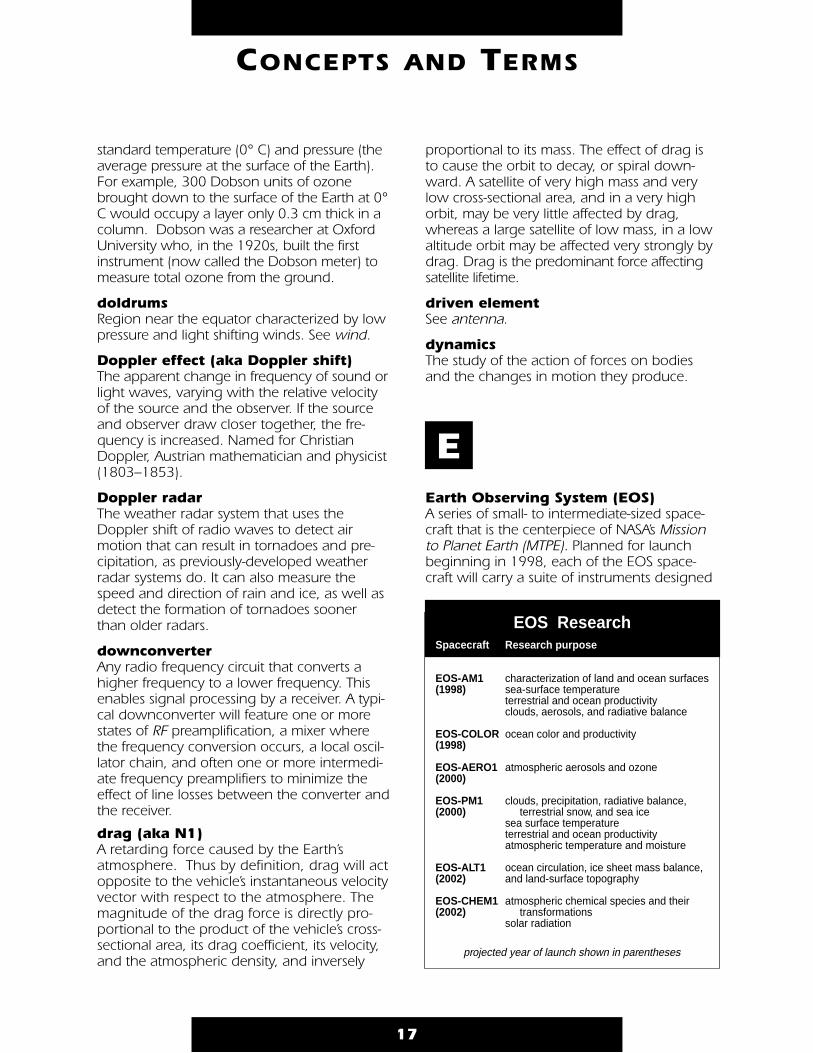
EOS Research
projected year of launch shown in parentheses
Research purpose
characterization of land and ocean surfacessea-surface temperatureterrestrial and ocean productivityclouds, aerosols, and radiative balance
ocean color and productivity
atmospheric aerosols and ozone
clouds, precipitation, radiative balance, terrestrial snow, and sea icesea surface temperatureterrestrial and ocean productivityatmospheric temperature and moisture
ocean circulation, ice sheet mass balance, and land-surface topography
atmospheric chemical species and their transformationssolar radiation
Spacecraft
EOS-AM1(1998)
EOS-COLOR(1998)
EOS-AERO1(2000)
EOS-PM1(2000)
EOS-ALT1(2002)
EOS-CHEM1(2002)
to study global climate change. MTPE will usespace-, aircraft-, and ground-based measure-ments to study our environment as an inte-grated system. Designing and implementingthe MTPE is, of necessity, an internationaleffort. The MTPE program involves the cooper-ation of the U.S., the European Space Agency(ESA), and the Japanese National SpaceDevelopment Agency (NASDA). The MTPE pro-gram is part of the U.S. interagency effort, theGlobal Change Research Program.
Earth Observing System Data &Information System (EOSDIS) The system that will manage a dataset ofEarth science observations to be collectedover a 15-year period. Existing data indicatesthat the Earth is changing, and that humanactivity increasingly contributes to this change.To monitor these changes, a baseline of “nor-mal” performance characteristics must beobtained. For the Earth, these baseline char-acteristics must cover a global scale and along enough period that the variation causedby seasonal changes and other cyclical orperiodic events (e.g., El Niño and the solarcycle) may be included in the analyses. Thebaseline characteristics also must enable scien-tists to quantify processes that govern theEarth’s system. Functionally, EOSDIS will pro-vide computing and networking facilities sup-porting EOS research activities, including datainterpretation and modeling; processing, dis-tribution, and archiving of EOS data; andcommand and control of EOS observatories.
Earth Probes Discipline-specific satellites and instrumentsthat will be used by NASA to obtain observa-tions before the launch of EOS spacecraft.Generally smaller than the EOS satellites andinstruments, Earth Probes are planned to com-plement the broad environmental measure-ments from EOS with highly focused studies inareas such as tropical rainfall (TRMM), oceanproductivity (SeaWiFS), atmospheric ozone(TOMS), and ocean surface winds (NSCAT).
Earth Radiation Budget Experiment (ERBE) An experiment to obtain data to study theaverage radiation budget of the Earth anddetermine the energy transport gradient from
the equator to the poles. Three satellites wereflown in different orbits to obtain the data:the Earth Radiation Budget Satellite, ERBS(launched in October 1984), NOAA-9(launched in December 1984), and NOAA-10(launched in September 1986). See Televisionand Infrared Observation Satellite (TIROS).
Earth station (aka ground station) Hardware necessary to acquire data directlyfrom environmental satellites. The WEFAXEarth station diagram illustrates a basicground station configuration for obtainingdirect readout data from geostationary envi-ronmental (weather) satellites. (See diagrampage 19.)
Earth system The Earth regarded as a unified system ofinteracting components, including geosphere(land), atmosphere (air), hydrosphere (waterand ice), and biosphere (life).
Earth system science An integrated approach to the study of theEarth that stresses investigations of the interac-tions among the Earth’s components in orderto explain Earth dynamics, evolution, andglobal change.
18
CONCEPTS AND TERMS
Physical elements of the Earth's surface, crust, and interior. Processes in the geosphere include continental drift, volcanic eruptions, and earthquakes.
Thin layer of gas or air that surrounds the Earth. Processes in the atmosphere include winds, weather, and the exchange of gases with living organisms.
Water and ice on or near the surface of the Earth. Includes water vapor in clouds; ice caps and glaciers; and water in the oceans, rivers, lakes, and aquifers. Processes in the hydrosphere include the flow of rivers, evaporation, and rain.
The wealth and diversity of living organisms on the Earth. Processes in the biosphere include life and death, evolution, and extinction.
Earth’s Interacting Components
geosphere
atmosphere
hydrosphere
biosphere
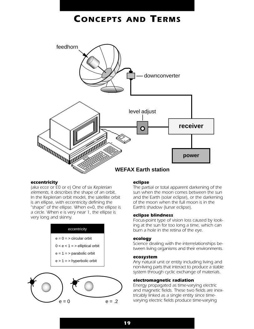
eccentricity (aka ecce or E0 or e) One of six Keplerian elements, it describes the shape of an orbit. In the Keplerian orbit model, the satellite orbitis an ellipse, with eccentricity defining the“shape” of the ellipse. When e=0, the ellipse isa circle. When e is very near 1, the ellipse isvery long and skinny.
eclipse The partial or total apparent darkening of thesun when the moon comes between the sunand the Earth (solar eclipse), or the darkeningof the moon when the full moon is in theEarth’s shadow (lunar eclipse).
eclipse blindness Focus-point type of vision loss caused by look-ing at the sun for too long a time, which canburn a hole in the retina of the eye.
ecology Science dealing with the interrelationships be-tween living organisms and their environments.
ecosystem Any natural unit or entity including living andnon-living parts that interact to produce a stablesystem through cyclic exchange of materials.
electromagnetic radiation Energy propagated as time-varying electricand magnetic fields. These two fields are inex-tricably linked as a single entity since time-varying electric fields produce time-varying
19
CONCEPTS AND TERMS
level adjust
WEFAX Earth station
receiver
power
downconverter
feedhorn
e = 0 = > circular orbit
0 < e < 1 = > elliptical orbit
e = 1 = > parabolic orbit
e > 1 = > hyperbolic orbit
eccentricity
e = .2e = 0
magnetic fields and vice versa. Light andradar are examples of electromagnetic radia-tion differing only in their wavelengths (or fre-quency). Electric and magnetic fields propa-gate through space at the speed of light.
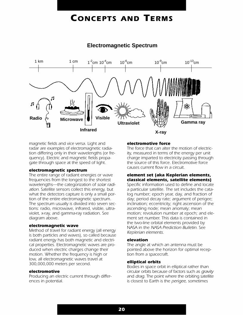
electromagnetic spectrum The entire range of radiant energies or wavefrequencies from the longest to the shortestwavelengths—the categorization of solar radi-ation. Satellite sensors collect this energy, butwhat the detectors capture is only a small por-tion of the entire electromagnetic spectrum.The spectrum usually is divided into seven sec-tions: radio, microwave, infrared, visible, ultra-violet, x-ray, and gamma-ray radiation. Seediagram above.
electromagnetic wave Method of travel for radiant energy (all energyis both particles and waves), so called becauseradiant energy has both magnetic and electri-cal properties. Electromagnetic waves are pro-duced when electric charges change theirmotion. Whether the frequency is high orlow, all electromagnetic waves travel at300,000,000 meters per second.
electromotive Producing an electric current through differ-ences in potential.
electromotive force The force that can alter the motion of electric-ity, measured in terms of the energy per unitcharge imparted to electricity passing throughthe source of this force. Electromotive forcecauses current flow in a circuit.
element set (aka Keplerian elements,classical elements, satellite elements) Specific information used to define and locatea particular satellite. The set includes the cata-log number; epoch year, day, and fraction ofday; period decay rate; argument of perigee;inclination; eccentricity; right ascension of theascending node; mean anomaly; meanmotion; revolution number at epoch; and ele-ment set number. This data is contained inthe two-line orbital elements provided byNASA in the NASA Prediction Bulletin. SeeKeplerian elements.
elevation The angle at which an antenna must bepointed above the horizon for optimal recep-tion from a spacecraft.
elliptical orbits Bodies in space orbit in elliptical rather thancircular orbits because of factors such as gravityand drag. The point where the orbiting satelliteis closest to Earth is the perigee, sometimes
20
CONCEPTS AND TERMS
Radio VisibleMicrowave
Infrared
Ultraviolet
X-ray
Gamma ray
1 km 1 cm 1-2cm 10-4cm 10-6cm 10-9cm 10-13cm
Electromagnetic Spectrum

called peri-apsisor perifocus. Thepoint where thesatellite is farthestfrom Earth iscalled apogee,apoapsis, or api-focus. A linedrawn fromperigee to apogee is theline-of-apsides,sometimes calledthe major-axis of the ellipse. It’s simply a linedrawn through the ellipse the long way.
El NiñoA warming of the surface waters of the east-ern equatorial Pacific that occurs at irregularintervals of 2–7 years, usually lasting 1–2years. Along the west coast of South America,southerly winds promote the upwelling ofcold, nutrient-rich water that sustains largefish populations, that sustain abundant seabirds, whose droppings support the fertilizerindustry. Near the end of each calendar year,a warm current of nutrient-poor tropical waterreplaces the cold, nutrient-rich surface water.Because this condition often occurs aroundChristmas, it was named El Niño (Spanish forboy child, referring to the Christ child). Inmost years the warming lasts only a fewweeks or a month, after which the weatherpatterns return to normal and fishingimproves. However, when El Niño conditionslast for many months, more extensive oceanwarming occurs and economic results can bedisastrous. El Niño has been linked to wetter,colder winters in the United States; drier, hot-ter summers in South America and Europe;and drought in Africa. See ENSO.
ELT Emergency Locator Transmitter. See Searchand Rescue.
energy budget A quantitative description of the energyexchange for a physical or ecological system.The budget includes terms for radiation, con-duction, convection, latent heat, and forsources and sinks of energy.
ENSO (El Niño-Southern Oscillation)Interacting parts of a single global system ofclimate fluctuations. ENSO is the most promi-nent known source of interannual variability in weather and climate around the world,though not all areas are affected. TheSouthern Oscillation (SO) is a global-scale seesaw in atmospheric pressure betweenIndonesia /North Australia, and the southeastPacific. In major warm events El Niño warmingextends over much of the tropical Pacific andbecomes clearly linked to the SO pattern.Many of the countries most affected by ENSOevents are developing countries witheconomies that are largely dependent upontheir agricultural and fishery sectors as a majorsource of food supply, employment, and for-eign exchange. New capabilities to predictthe onset of ENSO events can have a globalimpact. While ENSO is a natural part of theEarth’s climate, whether its intensity or fre-quency may change as a result of globalwarming is an important concern.
environment The complex of physical, chemical, and bio-logical factors in which a living organism orcommunity exists.
EOS See Earth Observing System.
EOSDIS See Earth Observing System Data andInformation System.
EPA (Environmental ProtectionAgency)U.S. agency that ensures: Federal environ-mental laws are implemented and enforcedeffectively; U.S. policy—both foreign anddomestic—fosters the integration of economicdevelopment and environmental protection sothat economic growth can be sustained overthe long term; public and private decisionsaffecting energy, transportation, agriculture,industry, international trade, and naturalresources fully integrate considerations ofenvironmental quality; national efforts toreduce environmental risk are based on thebest available scientific information communi-cated clearly to the public; everyone in our
21
CONCEPTS AND TERMS
apogee
perigee
line-of-apsides

society recognizes the value of preventing pol-lution before it is created; people have theinformation and incentives they need to makeenvironmentally-responsible choices in theirdaily lives; and schools and community institu-tions promote environmental stewardship as anational ethic.
ephemeris A tabulation of a series of points that definethe position and motion of a satellite. SeeKeplerian elements.
EPIRB Emergency Position Indicating Radio Beacon.See Search and Rescue.
epoch (aka Epoch Time or T0) Epoch specifies the time of a particulardescription of a satellite orbit. See Keplerianelements.
equator An imaginary circle around the Earth that iseverywhere equally distant (90°) from theNorth Pole and the South Pole. The equator isa great circle and defines latitude 0°.
ERBE See Earth Radiation Budget Experiment.
ESA European Space Agency.
eutrophication The process whereby a body of waterbecomes rich in dissolved nutrients throughnatural or man-made processes. This oftenresults in a deficiency of dissolved oxygen,producing an environment that favors plantover animal life.
evaporation Change from a liquid (more dense) to a vaporor gas (less dense) form. When water is heatedit becomes a vapor that increases humidity.Evaporation is the opposite of condensation.
exosphere The uppermost layer of the atmosphere, itslower boundary is estimated at 500 km to1000 km above the Earth’s surface. It is onlyfrom the exosphere that atmospheric gasescan, to any appreciable extent, escape intoouter space.
external forcing Influence on the Earth system (or one of itscomponents) by an external agent such assolar radiation or the impact of extraterrestrialbodies such as meteorites.
FAA
Federal Aviation Administration.
facsimile (FAX) A process by which graphic or photographicinformation is transmitted or recorded by elec-tronic means.
false color See digital image.
Fahrenheit Temperature scale designed by the Germanscientist Gabriel Fahrenheit in 1709, basedupon water freezing at 32 °F and water boil-ing at 212 °F under standard atmosphericpressure. Compare with centrigrade.
far infrared Electromagnetic radiation, longer than thethermal infrared, with wavelengths betweenabout 25 and 1000 micrometers. See electro-magnetic spectrum.
feedhorn A metallic cylinder closed at one end, used toobtain and direct radio frequency (RF) energyreflected from a satellite dish. It acts as a waveguide at microwave frequencies. RF energy inside the horn is picked up by a small probe; once inside the horn, the wavelength (energy) of the micro-wave radiation changes to a guided wave.
FEMA U.S. Federal Emergency Management Agency.
22
CONCEPTS AND TERMS
F
feedhorn
Feng YunChinese geostationary environmental satellitethat was destroyed by an explosion beforelaunch in April 1994. The name Feng Yun,meaning Wind and Cloud, was originallyapplied to the Chinese polar-orbiting environ-mental satellite launched in September 1991(Feng Yun 1-2), which offered direct readoutservices. The Chinese polar-orbiter programhas since been abandoned.
field The set of influences (electricity, magnetism,gravity) that extend throughout space.
field of view The range of angles that are scanned orsensed by a system or instrument, measuredin degrees of arc.
filter Device that while selectively passing desiredfrequencies removes undesired ones.
FM See frequency modulation.
focal length 1) In optics, the distance—usually expressedin millimeters—from the principal point of alens or concave mirror to its focal point.
2) The distance, measured from the centerof the surface of a parabolic or sphericalreflector (e.g., satellite dish) where RF energyis brought to essential point focus.
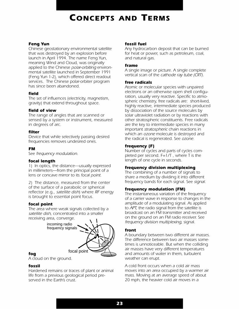
focal point The area where weak signals collected by asatellite dish, concentrated into a smallerreceiving area, converge.
fog A cloud on the ground.
fossil Hardened remains or traces of plant or animallife from a previous geological period pre-served in the Earth’s crust.
fossil fuelAny hydrocarbon deposit that can be burnedfor heat or power, such as petroleum, coal,and natural gas.
frame A single image or picture. A single completevertical scan of the cathode ray tube (CRT).
free radicals Atomic or molecular species with unpairedelectrons or an otherwise open shell configu-ration, usually very reactive. Specific to atmo-spheric chemistry, free radicals are: short-lived,highly reactive, intermediate species producedby dissociation of the source molecules bysolar ultraviolet radiation or by reactions withother stratospheric constituents. Free radicalsare the key to intermediate species in manyimportant stratospheric chain reactions inwhich an ozone molecule is destroyed andthe radical is regenerated. See ozone.
frequency (F) Number of cycles and parts of cycles com-pleted per second. F=1/T , where T is thelength of one cycle in seconds.
frequency division multiplexing The combining of a number of signals toshare a medium by dividing it into differentfrequency bands for each signal. See signal.
frequency modulation (FM) The instantaneous variation of the frequencyof a carrier wave in response to changes in theamplitude of a modulating signal. As appliedto APT, the radio signal from the satellite isbroadcast on an FM transmitter and receivedon the ground on an FM radio receiver. Seefrequency division multiplexing, signal.
front A boundary between two different air masses.The difference between two air masses some-times is unnoticeable. But when the collidingair masses have very different temperaturesand amounts of water in them, turbulentweather can erupt.
A cold front occurs when a cold air massmoves into an area occupied by a warmer airmass. Moving at an average speed of about20 mph, the heavier cold air moves in a
23
CONCEPTS AND TERMS
focal point
incoming radio frequency signals

wedge shape along the ground. Cold frontsbring lower temperatures and can create nar-row bands of violent thunderstorms. In NorthAmerica, cold fronts form on the easternedges of high pressure systems.
A warm front occurs when a warm air massmoves into an area occupied by a colder airmass. The warm air is lighter, so it flows upthe slope of the cold air below it. Warm frontsusually form on the eastern sides of low pres-sure systems, create wide areas of clouds andrain, and move at an average speed of 15 mph.
When a cold front follows and then overtakesa warm front (warm fronts move more slowlythan cold fronts) lifting the warm air off theground, an occluded front forms.
frost Water condensation occurring on surfacesbelow freezing. Condensing water turns to ice.
Gaia hypothesis
The hypothesis that the Earth’s atmosphere,biosphere, and its living organisms behave asa single system striving to maintain a stabilitythat is conducive to the existence of life.
gain The increase in signal power produced by anamplifier, usually expressed in decibels as theratio of the output to the input. A measure ofthe effectiveness of a directional antenna ascompared to a non-directional antenna. Seeantenna.
geodesy A branch of applied mathematics concernedwith measuring the shape of the Earth anddescribing variations in the Earth’s gravity field.
Geographic Information System (GIS) A system for archiving, retrieving, and manip-ulating data that has been stored and indexedaccording to the geographic coordinates of itselements. The system generally can utilize avariety of data types, such as imagery, maps,tables, etc.
geoid A surface of constant gravitational potentialaround the Earth—an averaged surface per-pendicular to the force of gravity.
geosphere The physical elements of the Earth’s surface,crust, and interior.
geostationary Describes an orbit in which a satellite is alwaysin the same position (appears stationary) withrespect to the rotating Earth. The satellite trav-els around the Earth in the same direction, atan altitude of approximately 35,790 km(22,240 statute miles) because that producesan orbital period equal to the period of rota-tion of the Earth (actually 23 hours, 56 minutes,04.09 seconds). A worldwide network of operational geostationary meteorological satel-lites provides visible and infrared images ofEarth’s surface and atmosphere. The satellite
24
CONCEPTS AND TERMS
warm airmasscold
air mass
cold front
cold air mass
warm front
warm airmass
G
systems include the U.S. GOES, METEOSAT(launched by the European Space Agencyand operated by the European WeatherSatellite Organization–EUMETSAT), theJapanese GMS, and most commercial,telecommunications satellites. See Clarke Belt.
Geostationary Meteorological Satellite (GMS) Japan’s geostationary weather satellite.
Geostationary OperationalEnvironmental Satellite (GOES)NASA-developed, NOAA-operated series ofsatellites that:
• provide continuous day and night weather observations;
• monitor severe weather events such as hurricanes, thunderstorms, and flash floods;
• relay environmental data from surface collection platforms to a processing center;
• perform facsimile transmissions of processed weather data to low-cost receiving stations;
• monitor the Earth’s magnetic field, the ener-getic particle flux in the satellite’s vicinity, and x-ray emissions from the sun;
• detect distress signals from downed aircraft and ships.
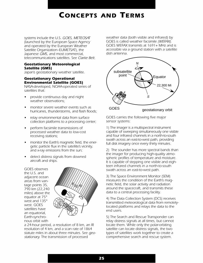
GOES observesthe U.S. andadjacent oceanareas from van-tage points 35,790 km (22,240miles) above theequator at 75°west and 135°west. GOESsatellites havean equatorial,Earth-synchro-nous orbit witha 24-hour period, a resolution of 8 km, an IRresolution of 4 km, and a scan rate of 1864statute miles in about three minutes. See geo-stationary. The transmission of processed
weather data (both visible and infrared) byGOES is called weather facsimile (WEFAX).GOES WEFAX transmits at 1691+ MHz and isaccessible via a ground station with a satellitedish antenna.
GOES carries the following five major sensor systems:
1) The imager is a multispectral instrumentcapable of sweeping simultaneously one visibleand four infrared channels in a north-to-southswath across an east-to-west path, providingfull disk imagery once every thirty minutes.
2) The sounder has more spectral bands thanthe imager for producing high-quality atmo-spheric profiles of temperature and moisture.It is capable of stepping one visible and eigh-teen infrared channels in a north-to-southswath across an east-to-west path.
3) The Space Environment Monitor (SEM)measures the condition of the Earth’s mag-netic field, the solar activity and radiationaround the spacecraft, and transmits thesedata to a central processing facility.
4) The Data Collection System (DCS) receivestransmitted meteorological data from remotely-located platforms and relays the data to theend users.
5) The Search and Rescue Transponder canrelay distress signals at all times, but cannotlocate them. While only the polar-orbitingsatellite can locate distress signals, the twotypes of satellites work together to create acomprehensive search and rescue system.
25
CONCEPTS AND TERMS
N
S
22,300 Mi
subsatellitepoint Equator
geostationary orbitGOES
geosynchronous (aka GEO) Synchronous with respect to the rotation ofthe Earth. See geostationary.
glacier A multi-year surplus accumulation of snowfallin excess of snowmelt on land and resulting ina mass of ice at least 0.1 km2 in area thatshows some evidence of movement inresponse to gravity. A glacier may terminateon land or in water. Glacier ice is the largestreservoir of fresh water on Earth, and secondonly to the oceans as the largest reservoir oftotal water. Glaciers are found on every conti-nent except Australia.
Global Change Research Program (GCRP) The USGCRP is a government-wide programwhose goal is “to establish a scientific basis fornational and international policy-making relat-ing to natural and human-induced changes inthe global Earth system.” Mission to PlanetEarth is NASA’s central contribution to the U.S.Global Change Research Program.
The Global Change Research Program coordi-nates and guides the efforts of federal agen-cies. The program examines such questionsas, is the Earth experiencing global warming?Is the depletion of the ozone layer expand-ing? How do we determine and understandthe causes of global climate changes? Arethey reversible? What are the implications forhuman needs and activities?
global measurement All of the activities required to specify a globalvariable, such as ozone. These activities rangefrom data acquisition to the generation of adata-analysis product, and include estimatesof the uncertainties in that product. A globalmeasurement often will consist of a combina-tion of observations from a spacecraft instru-ment (required for global coverage) and mea-surements in situ (needed to provide referencepoints for long-term accuracy).
global variables Functions of space and time that describe thelarge scale state and evolution of the Earth system.The Earth system’s geosphere, hydrosphere,atmosphere, and biosphere and their compo-nents are, or potentially are, global variables.
GMS See Geostationary Meteorological Satellite.
GOES See Geostationary Operational EnvironmentalSatellite.
GOES I/GOES 8NOAA geostationary satellite launched in April1994 (alphabetical designators are used whileon the ground and before geostationary orbit,after it achieves geostationary orbit it becameGOES 8). GOES 8 is the first in a series of fivenew geostationary satellites that will ensuredual-satellite coverage of the U.S. into thenext century, and will provide betteradvanced warnings of thunderstorms, flashfloods, hurricanes, and other severe weather.GOES 8 will also contribute important infor-mation to a new flood and water manage-ment system which will assist decision-makerswith the allocation of precious western waterresources.
GOES NEXT The next generation of NOAA geostationarysatellites, scheduled for launch beginningsometime after 2003. Currently in the planningphase, these satellites will follow the series offive geostationary satellites which are beinglaunched beginning in 1994. See GOES I
grayscale Environmental satellite scanners, rather thanphotographing a scene, scan a scene line-by-line measuring light or heat levels and trans-mitting this information as a video image viaan amplitude modulated (AM) subcarrier con-tained in the satellite’s FM signal. The videoimage—a 2400 Hz tone—is amplitude modu-lated to correspond to the light and darkareas sensed, with the louder portion of thetone representing the lighter areas of the
26
CONCEPTS AND TERMS
0 represents pure black
all values in betweenare shades of gray
255 represents pure white

image and the lower portion of the tone rep-resenting the darker areas of the image.Intermediate volumes form the shades of thegrayscale (up to 256 shades) needed to com-plete the image. This is an analog type of datatransmission, and enables the assessment ofsuch features as heat, light, temperature, andcloud heights.
greenhouse effect Process by which significant changes in thechemistry of Earth’s atmosphere may enhancethe natural process that warms our planet andelevates temperatures. If the effect is intensi-fied and Earth’s average temperatures change,a number of plant and animal species couldbe threatened with extinction.
Certain gaseous components of the atmo-sphere, called greenhouse gases, transmitthe visible portion of solar radiation butabsorb specific spectral bands of thermalradiation emitted by the Earth. The theory isthat terrain absorbs radiation, heats up, andemits longer wavelength thermal radiationthat is prevented from escaping into spaceby the blanket of carbon dioxide and othergreenhouse gases in the atmosphere. As aresult, the climate warms.
Because atmospheric and oceanic circulationsplay a central role in the climate of the Earth,improving our knowledge about their inter-action becomes essential.
greenhouse gas A gaseous component of the atmosphere con-tributing to the greenhouse effect. Green-house gases are transparent to certain wave-lengths of the sun’s radiant energy, allowingthem to penetrate deep into the atmosphere orall the way into the Earth’s surface. Green-house gases and clouds prevent some ofinfrared radiation from escaping, trapping theheat near the Earth’s surface where it warmsthe lower atmosphere. Alteration of this naturalbarrier of atmospheric gases can raise or lowerthe mean global temperature of the Earth.
Greenhouse gases include carbon dioxide,methane, nitrous oxide, chlorofluorocarbons,and water vapor. Carbon dioxide, methane,and nitrous oxide have significant natural andhuman sources while only industries produce
27
CONCEPTS AND TERMS
Space Ozone Layer Shields the Earth from theSun’s Harmful Ultraviolet Radiation.
Atmosphere
Incoming Energy
(Ultraviolet Light)
Ref
lect
ed E
nerg
y
Out
goin
g E
nerg
y
(Infra
red
Hea
t)
TrappedIR radiation
Key Greenhouse Gases
water vapor
ozone
carbon dioxide
methane
nitrous oxide
chlorofluorocarbons (CFCs)
Greenhouse Effect

chlorofluorocarbons. Water vapor has thelargest greenhouse effect, but its concentra-tion in the troposphere is determined withinthe climate system. Water vapor will increasein response to global warming, which in turnmay further enhance global warming.
Greenwich Mean Time (GMT) See Coordinated Universal Time.
gross feature map Map that displays geographic characteristicsrather than political boundaries.
ground control (points)Identifiable points on the ground whose loca-tions on the surface of the Earth are accu-rately known for use as geodetic references inmapping, charting, and other related mensu-ration applications.
ground station See Earth station.
ground track The inclination of a satellite, together with itsorbital altitude and the period of its orbit, cre-ates a track defined by an imaginary line con-necting the satellite and the Earth’s center. Theintersection on the line with the Earth’s sur-face is the subsatellite point. As the Earth turnson its axis and the satellite orbits overhead, aline is created by the satellite’s apparent pathover the ground (the series of subsatellitepoints connected). A geostationary satellitehas an inclination of essentially zero, and,because its orbital period exactly matches theEarth’s rotation, its ground track is reduced toan apparent stationary point on the equator.
GSFC NASA Goddard Space Flight Center, located inGreenbelt, Maryland. See NASA Centers.
guided wave Electromagnetic or acoustic wave that is con-strained within certain boundaries, as in awave guide (transmission line).
gulf A large arm of an ocean or sea extending intoa land mass.
gulf stream A warm, swift ocean current that flows alongthe coast of the Eastern United States andmakes Ireland, Great Britain, and theScandinavian countries warmer than theywould be otherwise.
habitat The area or region where a particular type ofplant or animal lives and grows.
hail Precipitation composed of balls or irregularlumps of ice. Hail is produced when largefrozen raindrops, or almost any particles, incumulonimbus clouds act as embryos thatgrow by accumulating supercooled liquiddroplets. Violent updrafts in the cloud carrythe particles in freezing air, allowing thefrozen core to accumulate more ice. Whenthe piece of hail becomes too heavy to be carried by upsurging air currents it falls to the ground.
hardware The electrical and mechanical components ofa system, as opposed to software.
haze Fine dry or wet particles of dust, salt, or otherimpurities that can concentrate in a layer nextto the Earth when air is stable.
heat balance The equilibrium existing between the radiationreceived and emitted by a planetary system.
28
CONCEPTS AND TERMS
satellite
H
Heat Capacity Mapping Mission (HCMM) A two-channel radiometer launched by NASAto measure the thermal properties of the ter-restrial surface. It had an application to iden-tify and locate rocks and minerals. Oneradiometer channel was in the visible to nearinfrared (0.5–1.1 micrometers), and the otherin the thermal infrared (10.5–12.5 microme-ters). The instantaneous field of view (IFOV)was about 600 meters.
hemisphere Half of the Earth, usually conceived as result-ing from the division of the globe into twoequal parts, north and south or east and west.
hertz (Hz) The international unit of frequency equal toone cycle per second. Radio frequencies areusually expressed in kilohertz/kHz (1,000cycles per second) or megahertz/MHz(1,000,000 cycles per second).
Hertzian waves Radio waves or other electromagnetic radia-tion resulting from the oscillations of electricityin a conductor.high A digital logic state corresponding to a binary“1.” See low.
High Resolution Doppler Imager (HRDI) Carried on UARS, it measures stratosphericwinds.
High-Resolution Infrared RadiationSounder (HIRS)Instrument carried by NOAA polar-orbitingsatellites that detects and measures energyemitted by the atmosphere to construct a ver-tical temperature profile from the Earth’s sur-face to an altitude of about 40 km.Measurements are made in 20 spectralregions in the infrared band.
High-Resolution Picture Transmission (HRPT) Real-time, 1.1-kilometer resolution, digitalimages provided by NOAA’s polar-orbitingenvironmental satellites, containing all fivespectral channels and telemetry data transmit-ted as high-speed digital transmissions. The
Advanced Very High Resolution Radiometer(AVHRR) provides the primary imaging systemfor APT and HRPT. See TIROS.
horse latitudes The subtropical latitudes (30–35 degrees),where winds are light and weather is hot anddry. According to legend, ships traveling tothe New World often stagnated in this regionand had to throw dead horses overboard oreat them to survive, hence the name horselatitudes. See wind.
HRDI See High Resolution Doppler Imager.
HRPT See High Resolution Picture Transmission.
humidity The amount of water vapor in the air. Thehigher the temperature, the greater the num-ber of water molecules the air can hold. Forexample: at 60 °F (15 °C), a cube of air oneyard on each side can hold up to 4.48 ouncesof water. At 104 °F (40 °C), the same cube ofair can hold up to 17.9 ounces of water.
Relative humidity describes the amount ofwater in the air compared with how muchthe air can hold at the current temperature.Example: 50% relative humidity means the airholds half the water vapor that it is capable ofholding; 100% relative humidity means the airholds all the water vapor it can. At 100%humidity, no more evaporation can occuruntil the temperature rises, or until the watervapor leaves the air through condensation.Absolute humidity is the ratio of the mass ofwater vapor present in a system of moist air tothe volume occupied by the mixture, that is,the density of water vapor.
hurricanes Severe tropical storms whose winds exceed74 mph. Hurricanes originate over the tropicaland subtropical North Atlantic and NorthPacific oceans, where there is high humidityand light wind. These conditions prevailmostly in the summer and early fall. Since hur-ricanes can take days or even weeks to form,time is usually available for preventive or pro-tective measures.
29
CONCEPTS AND TERMS
From space, hurricanes look like giant pin-wheels, their winds circulating around an eyethat is between 5 and 25 miles in diameter.The eye remains calm with light winds andoften a clear sky.
Hurricanes may move as fast as 50 mph, andcan become incredibly destructive when theyhit land. Although hurricanes lose powerrapidly as soon as they leave the ocean, theycan cause high waves and tides up to 25 feetabove normal. Waves and heavy floodingcause the most deaths during a hurricane.The strongest hurricanes can cause tornadoes.
hydrochlorofluorocarbon (HCFC)One of a class of compounds used primarilyas a CFC substitute. Work on CFC alternativesbegan in the late 1970s after the first warn-ings of CFC damage to stratospheric ozone.By adding hydrogen to the chemical formula-tion, chemists made CFCs less stable in thelower atmosphere enabling them to breakdown before reaching the ozone layer.However, HCFCs do release chlorine and havecontributed more to atmospheric chlorinebuildup than originally predicted.Development of non-chlorine based chemicalcompounds as a substitute for CFCs andHCFCs continues.
hydrologic cycle The pathways through which water is cycledin the terrestrial biosphere.
hydrosphere The totality of water encompassing the Earth,comprising all the bodies of water, ice, andwater vapor in the atmosphere.
hygrometer Instrument that measures water vapor contentin the air and communicates changes inhumidity visibly and immediately through agraph or a dial. There are three types ofhygrometers:
• The hair hygrometer uses a human hair asthe sensing instrument. The hair lengthenswhen the air is moist and contracts when the air is dry, but remains unaffected by air temperature. However, the hair hygro-meter cannot respond to rapid fluctua-tions in humidity.
• An electric hygrometer uses a plate coatedwith carbon. Electrical resistance of the carbon coating changes as the moisture content of the air changes—changes that translate into relative humidity. This type ofhygrometer is used frequently in the radiosonde.
• An infrared hygrometer uses a beam of light containing two separate wave lengths to gauge atmospheric humidity. One of the wavelengths is absorbed by water vapor, the other is unaffected, pro-viding an extremely accurate index of water vapor for paths of a few inches or thousands of feet. See psychrometer.
Hz See Hertz.
ice shelf A thick mass of ice extending from a polarshore. The seaward edge is afloat and some-times extends hundreds of miles into the sea.
IFOVInstantaneous Field of View. See MultispectralScanner for sample usage.
IGY See International Geophysical Year.
image Pictorial representation of data acquired bysatellite systems, such as direct readoutimages from environmental satellites. Animage is not a photograph. An image is com-posed of two-dimensional grids of individualpicture elements (pixels). Each pixel has anumeric value that corresponds to the radi-ance or temperature of the specific groundarea it depicts. See grayscale.
image resolution The area represented by each pixel of a satel-lite image. The smaller the area representedby a pixel, the more accurate and detailed theimage. For example, if a U.S. map and aworld map are printed on identically sized
30
CONCEPTS AND TERMS
I

sheets of paper, one square inch on the U.S.map will represent far less area and providefor more detail than one square inch on theworld map. In this example the U.S. map hashigher resolution. APT has a resolution of 4km, HRPT has a resolution of 1.1 km andWEFAX resolution is 8 km.
imager A satellite instrument that measures and mapsthe Earth and its atmosphere. Imager data areconverted by computer into pictures.
inclination (aka i)One of the six Keplerian elements, it indicatesthe angle of the orbit plane to the central body’sequator. See Keplerian elements for diagram.
The elliptical path of a satellite orbit lies in aplane known as the orbital plane. The orbitalplane always goes through the center of theEarth but may be tilted at any angle relative tothe equator. Inclination is the angle betweenthe equatorial plane and the orbital plane mea-sured counter-clockwise at the ascending node.
A satellite in an orbit that exactly matches theequator has an inclination of 0°, whereas onewhose orbit crosses the Earth’s poles has aninclination of 90°. Because the angle is mea-sured in a counterclockwise direction, it isquite possible for a satellite to have an inclina-tion of more than 90°. An inclination of 180°would mean the satellite is orbiting the equa-tor, but in the opposite direction of the Earth’srotation. Some sun-synchronous satellites thatmaintain the same ground track throughoutthe year have inclinations of as much as 98°.U.S. scientific satellites that study the sun areplaced in orbitscloser to theequator, fre-quently at 28°inclination. Mostweather satellitesare placed inhigh-inclinationorbits so they canoversee weatherconditions world-wide. See orbitalinclination.
information system All of the means and mechanisms for datareceipt, processing, storage, retrieval, andanalysis. Information systems can be designedfor storage and dissemination of a variety ofdata products—including primary data setsand both intermediate and final analyses—and for an interface providing connections toexternal computers, external data banks, andsystem users. To be effective, the design andoperation of an information system must becarried out in close association with the pri-mary producers of the data sets, as well asother groups producing integrated analysesor intermediate products.
infrared radiation (IR) Infrared is electromagnetic radiation whosewavelength spans the region from about 0.7to 1000 micrometers (longer than visibleradiation, shorter than microwave radiation).Remote-sensing instruments work by sensingradiation that is naturally emitted or reflectedby the Earth’s surface or from the atmosphere,or by sensing signals transmitted from asatellite and reflected back to it. In the visibleand near-infrared regions, surface chemicalcomposition, vegetation cover, and biologi-cal properties of surface matter can be mea-sured. In the mid-infrared region, geologicalformations can be detected due to theabsorption properties related to the structureof silicates. In the far infrared, emissions fromthe Earth’s atmosphere and surface offerinformation about atmospheric and surfacetemperatures and water vapor and othertrace constituents in the atmosphere. Since IR data are based on temperatures ratherthan visible radiation, the data may beobtained day or night.
INSATIndian National Satellite.
in situ Latin for “in original place.” Refers to measure-ments made at the actual location of theobject or material measured. Compare withremote sensing.
insolation Solar radiation incident upon a unit horizontalsurface on or above the Earth’s surface.
31
CONCEPTS AND TERMS
angle of inclination (measured counterclockwise
at the ascending node)
i
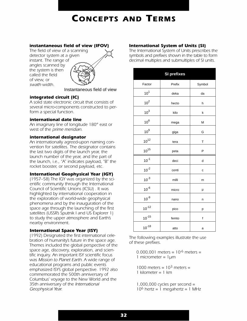
32
CONCEPTS AND TERMS
instantaneous field of view (IFOV) The field of view of a scanning detector system at a given instant. The range ofangles scanned by the system is then called the field of view, or swath width.
integrated circuit (IC) A solid state electronic circuit that consists ofseveral micro-components constructed to per-form a special function.
international date line An imaginary line of longitude 180° east orwest of the prime meridian.
international designator An internationally agreed-upon naming con-vention for satellites. The designator containsthe last two digits of the launch year, thelaunch number of the year, and the part ofthe launch, i.e., “A” indicates payload, “B” therocket booster, or second payload, etc.
International Geophysical Year (IGY) (1957–58) The IGY was organized by the sci-entific community through the InternationalCouncil of Scientific Unions (ICSU) . It washighlighted by international cooperation inthe exploration of world-wide geophysicalphenomena and by the inauguration of thespace age through the launching of the firstsatellites (USSR’s Sputnik I and US Explorer 1)to study the upper atmosphere and Earth’snearby environment.
International Space Year (ISY)(1992) Designated the first international cele-bration of humanity’s future in the space age.Themes included the global perspective of thespace age, discovery, exploration, and scien-tific inquiry. An important ISY scientific focuswas Mission to Planet Earth. A wide range ofeducational programs and public eventsemphasized ISY’s global perspective. 1992 alsocommemorated the 500th anniversary ofColumbus’ voyage to the New World and the35th anniversary of the InternationalGeophysical Year.
International System of Units (SI)The International System of Units prescribes thesymbols and prefixes shown in the table to formdecimal multiples and submultiples of SI units.
The following examples illustrate the use of these prefixes.
0.000,001 meters = 10-6 meters = 1 micrometer = 1µm
1000 meters = 103 meters = 1 kilometer = 1 km
1,000,000 cycles per second = 106 hertz = 1 megahertz = 1 MHz
Instantaneous field of view
SI prefixes
deka
hecto
kilo
mega
giga
tera
peta
deci
centi
milli
micro
nano
pico
femto
atto
Prefix
P
T
G
M
da
h
k
d
c
m
µ
n
p
f
a
SymbolFactor
101
102
103
106
109
1012
1015
10-1
10-2
10-3
10-6
10-9
10-12
10-15
10-18

ion Atom or molecule that has acquired an electriccharge by the loss/gain of one or more electrons.
IPS Inches per second.
IR See infrared.
isobars Lines drawn on a weather map joining placesof equal barometric pressure.
isothermalOf or indicating equality of temperature.
isotherms Lines connecting points of equal temperatureon a weather map.
isthmus Narrow strip of land located between two bod-ies of water, connecting two larger land areas.
ITOS (Improved TIROS OperationalSatellite)Second generation, polar-orbiting, environ-mental satellites utilized to augment NOAA’sworld-wide weather observation capabilities.ITOS were launched from 1970–1976, buteventually replaced by the third generation of polar-orbiting, environmental satellitesTIROS-N (first launched in 1978). See TIROS.
Japanese National SpaceDevelopment Agency (NASDA) The agency reports to the Japanese Ministryof Science and Technology.
JPL (Jet Propulsion Laboratory) See NASA Centers.
jet stream Rivers of high-speed air in the atmosphere. Jetstreams form along the boundaries of globalair masses where there is a significant differ-ence in atmospheric temperature. The jetstreams may be several hundred miles acrossand 1–2 miles deep at an altitude of 8–12
miles. They generally move west to east, andare strongest in the winter with core windspeeds as high as 250 mph. Changes in thejet stream indicate changes in the motion ofthe atmosphere and weather.
Joint Education Initiative (JEI) The JEI project was developed by USGS, NOAA,NASA, industry, and teachers to enable teachersand students to explore the massive quantities ofEarth science data published by the U.S. Govern-ment on CD-ROM. JEI encourages a researchand analysis approach to science education.
JSC (Johnson Space Center) See NASA Centers.
KSC (Kennedy Space Center) See NASA Centers.
Keplerian elements (aka satellite orbital elements) The set of six independent constants whichdefine an orbit—named for Johannes Kepler[1571–1630]. The constants define the shape ofan ellipse or hyperbola, orient it around its centralbody, and define the position of a satellite onthe orbit. The classical orbital elements are:
a: semi-major axis, gives the size of the orbit, e: eccentricity, gives the shape of the orbit, ι: inclination angle, gives the angle of the
orbit plane to the central body’s equatorΩ: right ascension of the ascending node,
which gives the rotation of the orbit plane from reference axis,
ω: argument of perigee is the angle from the ascending nodes to perigee point, measuredalong the orbit in the direction of thesatellite’s motion,
θ: true anomaly gives the location of the satel-lite on the orbit.
33
CONCEPTS AND TERMS
K
J
perigeegeocenter
line ofapsides
a (1-e)
rθ
apogee
2a
.
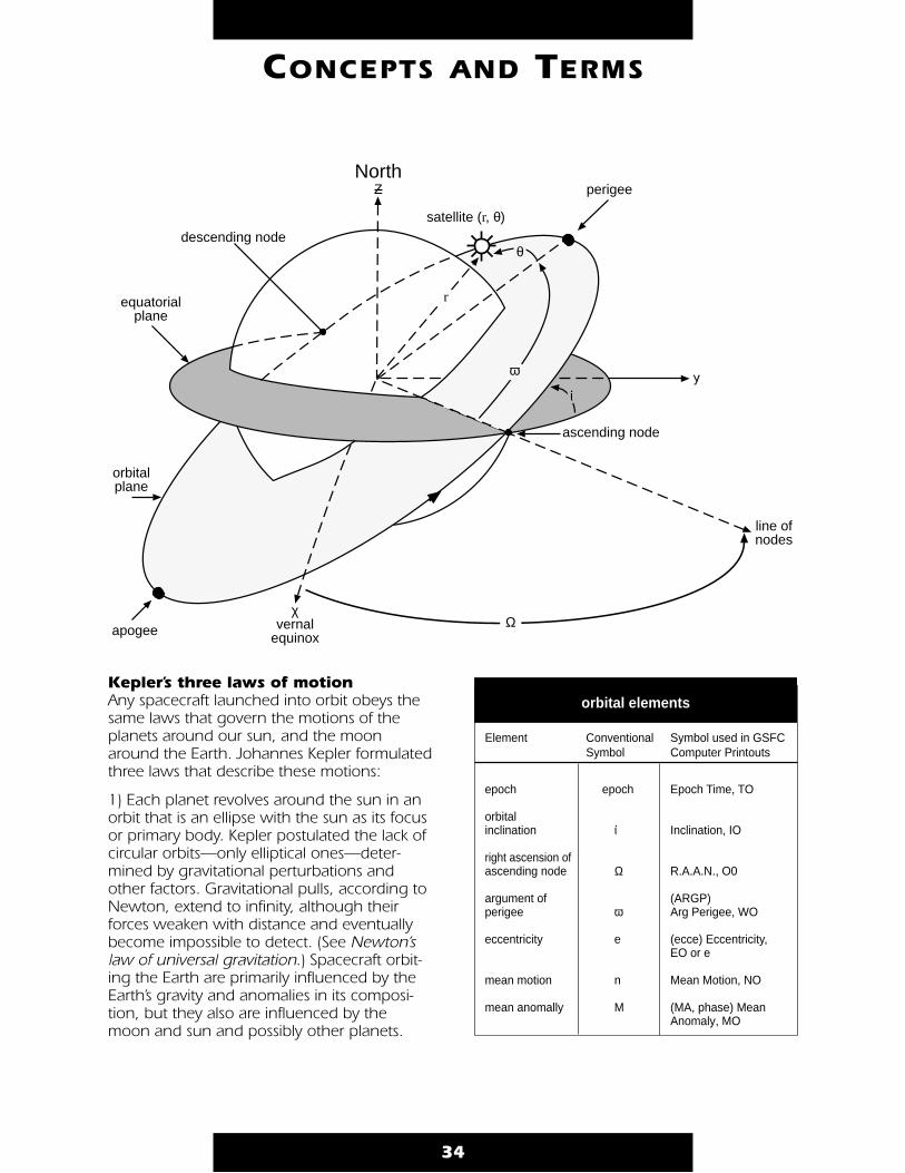
Kepler’s three laws of motion Any spacecraft launched into orbit obeys thesame laws that govern the motions of theplanets around our sun, and the moonaround the Earth. Johannes Kepler formulatedthree laws that describe these motions:
1) Each planet revolves around the sun in anorbit that is an ellipse with the sun as its focusor primary body. Kepler postulated the lack ofcircular orbits—only elliptical ones—deter-mined by gravitational perturbations andother factors. Gravitational pulls, according toNewton, extend to infinity, although theirforces weaken with distance and eventuallybecome impossible to detect. (See Newton’slaw of universal gravitation.) Spacecraft orbit-ing the Earth are primarily influenced by theEarth’s gravity and anomalies in its composi-tion, but they also are influenced by themoon and sun and possibly other planets.
34
CONCEPTS AND TERMS
North
satellite (r, θ)
Ζ
descending node
equatorialplane
orbitalplane
apogee
χvernal
equinoxΩ
ascending node
line ofnodes
perigee
λω
ι.
r
θ
Keplerian Elements
Element Conventional Symbol used in GSFCSymbol Computer Printouts
epoch epoch Epoch Time, TO
orbitalinclination ι Inclination, IO
right ascension ofascending node Ω R.A.A.N., O0
argument of (ARGP)perigee ω Arg Perigee, WO
eccentricity e (ecce) Eccentricity,EO or e
mean motion n Mean Motion, NO
mean anomally M (MA, phase) MeanAnomaly, MO
orbital elements
.
2) The radius vector—such as the line fromthe center of the sun to the center of aplanet, from the center of Earth to the centerof the moon, or from the center of Earth tothe center of gravity of a satellite—sweepsout equal areas in equal periods of time.
3) The square of a planet’s orbital period isequal to the cube of its mean distance fromthe sun times a constant. As extended andgeneralized, this means that a satellite’sorbital period increases with its mean dis-tance from the planet. See Newton’s law ofuniversal gravitation and laws of motion.
kilohertz (kHz) One thousand hertz, i.e., one thousandcycles per second.
kilometer (km) Metric unit of distance equal to 3,280.8 feetor .621 statute miles.
knot Unit of speed of one nautical mile (6,076.1feet) an hour.
lake A body of fresh or salt water entirely sur-rounded by land.
land breeze A nocturnal coastal breeze that blows fromland to sea. In the evening the water may bewarmer than the land, causing pressure dif-ferences. The land breeze is the flow of airfrom land to sea equalizing these pressuredifferences. See sea breeze.
Landsat Land Remote-Sensing Satellite, operated bythe U.S. Earth Observation Satellite Company(EOSAT). Commercialized under the LandRemote-Sensing Commercialization Act of1984, Landsat is a series of satellites (formerlycalled ERTS) designed to gather data on theEarth’s resources in a regular and systematic
manner. Objectives of the mission are: landuse inventory, geological/mineralogicalexploration, crop and forestry assessment,and cartography. Landsat has a spatial reso-lution of 28.5 meters.
Restructured Federal agency responsibilitiesfor the Landsat program are effective for theacquisition and operation of Landsat 7. Newoperating policy specifies that NOAA will beresponsible for satellites after they are placedin orbit, NASA will be responsible for thedevelopment and launch of Landsat 7, andthat the U.S. government will provide unen-hanced data to users at no cost beyond thecost of fulfilling their data request.
landsats (aka Earth resources satellites) Any land remote-sensing satellites. Includesthe U.S. Landsat system and the French SPOT.
LaRC (Langley Research Center) See NASA Centers.
laser (light amplification by stimu-lated emission of radiation) Active instrument that produces discretelycoherent pulses of light (light waves with nophase differences, or with predictable phasesdifferences, are said to be coherent).
laser ranging The use of lasers to measure distances.
latitude (aka the geodetic latitude)The angle between a perpendicular at a location, and the equatorial plane of the Earth.
legend A listing that contains symbols and otherinformation about a map.
LeRC (Lewis Research Center) See NASA Centers.
light 1) Form of radiant energy that acts upon theretina of the eye, optic nerve, etc., makingsight possible. This energy is transmitted at avelocity of about 186,000 miles per secondby wavelike or vibrational motion.
35
CONCEPTS AND TERMS
L
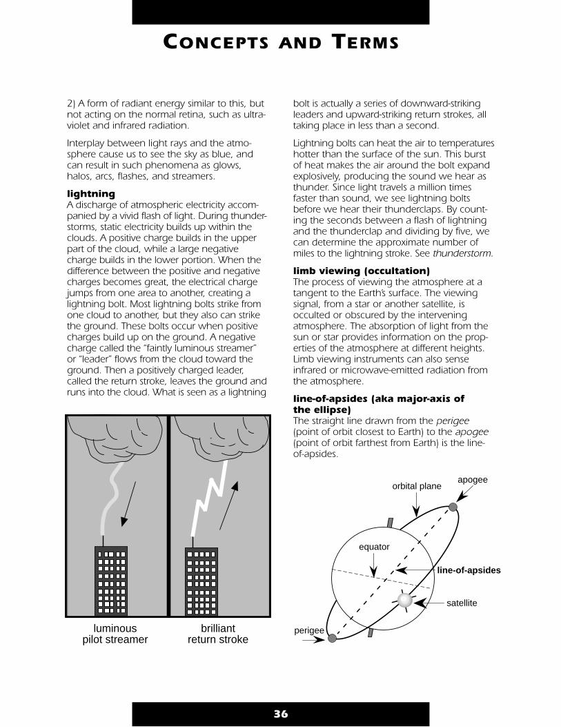
2) A form of radiant energy similar to this, butnot acting on the normal retina, such as ultra-violet and infrared radiation.
Interplay between light rays and the atmo-sphere cause us to see the sky as blue, andcan result in such phenomena as glows,halos, arcs, flashes, and streamers.
lightning A discharge of atmospheric electricity accom-panied by a vivid flash of light. During thunder-storms, static electricity builds up within theclouds. A positive charge builds in the upperpart of the cloud, while a large negativecharge builds in the lower portion. When thedifference between the positive and negativecharges becomes great, the electrical chargejumps from one area to another, creating alightning bolt. Most lightning bolts strike fromone cloud to another, but they also can strikethe ground. These bolts occur when positivecharges build up on the ground. A negativecharge called the “faintly luminous streamer”or “leader” flows from the cloud toward theground. Then a positively charged leader,called the return stroke, leaves the ground andruns into the cloud. What is seen as a lightning
bolt is actually a series of downward-strikingleaders and upward-striking return strokes, alltaking place in less than a second.
Lightning bolts can heat the air to temperatureshotter than the surface of the sun. This burstof heat makes the air around the bolt expandexplosively, producing the sound we hear asthunder. Since light travels a million timesfaster than sound, we see lightning boltsbefore we hear their thunderclaps. By count-ing the seconds between a flash of lightningand the thunderclap and dividing by five, wecan determine the approximate number ofmiles to the lightning stroke. See thunderstorm.
limb viewing (occultation) The process of viewing the atmosphere at atangent to the Earth’s surface. The viewingsignal, from a star or another satellite, isocculted or obscured by the interveningatmosphere. The absorption of light from thesun or star provides information on the prop-erties of the atmosphere at different heights.Limb viewing instruments can also senseinfrared or microwave-emitted radiation fromthe atmosphere.
line-of-apsides (aka major-axis of the ellipse) The straight line drawn from the perigee(point of orbit closest to Earth) to the apogee(point of orbit farthest from Earth) is the line-of-apsides.
36
CONCEPTS AND TERMS
luminous pilot streamer
brilliantreturn stroke
perigee
apogee
line-of-apsides
orbital plane
equator
satellite
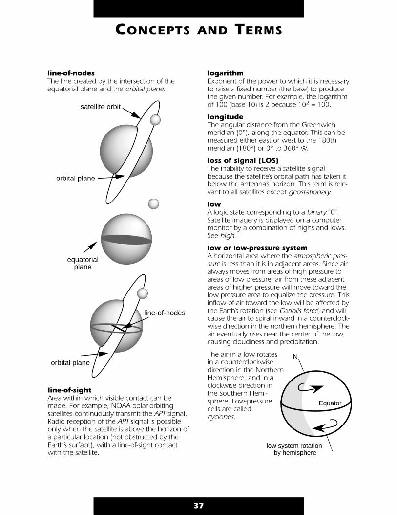
line-of-nodes The line created by the intersection of theequatorial plane and the orbital plane.
line-of-sight Area within which visible contact can bemade. For example, NOAA polar-orbitingsatellites continuously transmit the APT signal.Radio reception of the APT signal is possibleonly when the satellite is above the horizon ofa particular location (not obstructed by theEarth’s surface), with a line-of-sight contactwith the satellite.
logarithm Exponent of the power to which it is necessaryto raise a fixed number (the base) to producethe given number. For example, the logarithmof 100 (base 10) is 2 because 102 = 100.
longitude The angular distance from the Greenwichmeridian (0°), along the equator. This can bemeasured either east or west to the 180thmeridian (180°) or 0° to 360° W.
loss of signal (LOS) The inability to receive a satellite signalbecause the satellite’s orbital path has taken itbelow the antenna’s horizon. This term is rele-vant to all satellites except geostationary.
low A logic state corresponding to a binary “0”.Satellite imagery is displayed on a computermonitor by a combination of highs and lows.See high.
low or low-pressure system A horizontal area where the atmospheric pres-sure is less than it is in adjacent areas. Since airalways moves from areas of high pressure toareas of low pressure, air from these adjacentareas of higher pressure will move toward thelow pressure area to equalize the pressure. Thisinflow of air toward the low will be affected bythe Earth’s rotation (see Coriolis force) and willcause the air to spiral inward in a counterclock-wise direction in the northern hemisphere. Theair eventually rises near the center of the low,causing cloudiness and precipitation.
The air in a low rotates in a counterclockwise direction in the NorthernHemisphere, and in aclockwise direction inthe Southern Hemi-sphere. Low-pressurecells are called cyclones.
37
CONCEPTS AND TERMS
line-of-nodes
orbital plane
equatorialplane
satellite orbit
orbital plane
N
Equator
low system rotation by hemisphere
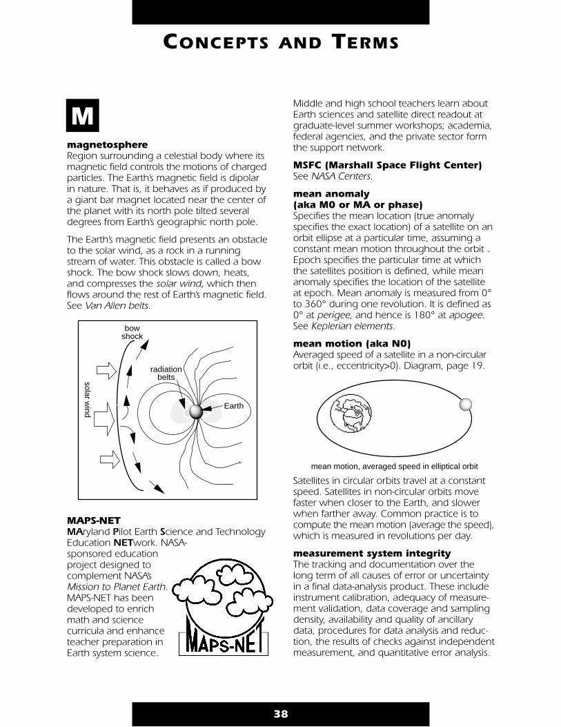
magnetosphere Region surrounding a celestial body where itsmagnetic field controls the motions of chargedparticles. The Earth’s magnetic field is dipolarin nature. That is, it behaves as if produced bya giant bar magnet located near the center ofthe planet with its north pole tilted severaldegrees from Earth’s geographic north pole.
The Earth’s magnetic field presents an obstacleto the solar wind, as a rock in a runningstream of water. This obstacle is called a bowshock. The bow shock slows down, heats,and compresses the solar wind, which thenflows around the rest of Earth’s magnetic field.See Van Allen belts.
MAPS-NET MAryland Pilot Earth Science and TechnologyEducation NETwork. NASA-sponsored education project designed to complement NASA’sMission to Planet Earth.MAPS-NET has been developed to enrich math and science curricula and enhanceteacher preparation inEarth system science.
Middle and high school teachers learn aboutEarth sciences and satellite direct readout atgraduate-level summer workshops; academia,federal agencies, and the private sector formthe support network.
MSFC (Marshall Space Flight Center) See NASA Centers.
mean anomaly (aka M0 or MA or phase) Specifies the mean location (true anomalyspecifies the exact location) of a satellite on anorbit ellipse at a particular time, assuming aconstant mean motion throughout the orbit .Epoch specifies the particular time at whichthe satellites position is defined, while meananomaly specifies the location of the satelliteat epoch. Mean anomaly is measured from 0°to 360° during one revolution. It is defined as0° at perigee, and hence is 180° at apogee.See Keplerian elements.
mean motion (aka N0) Averaged speed of a satellite in a non-circularorbit (i.e., eccentricity>0). Diagram, page 19.
Satellites in circular orbits travel at a constantspeed. Satellites in non-circular orbits movefaster when closer to the Earth, and slowerwhen farther away. Common practice is tocompute the mean motion (average the speed),which is measured in revolutions per day.
measurement system integrity The tracking and documentation over thelong term of all causes of error or uncertaintyin a final data-analysis product. These includeinstrument calibration, adequacy of measure-ment validation, data coverage and samplingdensity, availability and quality of ancillarydata, procedures for data analysis and reduc-tion, the results of checks against independentmeasurement, and quantitative error analysis.
38
CONCEPTS AND TERMS
M
bow shock
solar wind
radiation belts
Earth
mean motion, averaged speed in elliptical orbit
measurement validation The establishment of confidence in thenumerical relationship between the calibratedsensor output and the actual variable beingmeasured.
Mercator projection A method of making maps in which theEarth’s surface is shown as a rectangle withthe meridians as parallel straight lines spacedat equal intervals and the parallels of latitudeas parallel straight lines intersecting the merid-ians at right angles. Areas away from theequator appear larger than they are, with thegreatest distortion near the poles.
mesopause The upper boundary of the mesospherewhere the temperature of the atmospherereaches its lowest point.
mesosphere The atmospheric layer above the stratosphere,extending from about 50 to 85 kilometers alti-tude. The temperature generally decreaseswith altitude.
metadata Information describing the content or utility ofa data set. For example, the dates on whichdata were procured are metadata.
Meteor The former Soviet Union’s series of polar-orbit-ing weather satellites. The Meteor satellitestransmit images in a system compatible withthe NOAA polar-orbiting satellites.
meteorology Study of the atmosphere and its phenomena.
METEOSAT METEOrological SATellite. Europe’s geostation-ary weather satellite, launched by theEuropean Space Agency and now operatedby an organization called Eumetsat.METEOSAT transmits at 1691 and 1694.5 MHz.
Metsat Generic term for meteorological (weather)satellites.
MHz (megahertz) 106 hertz.
micrometer (µm, aka micron) One millionth of a meter, used to measurewavelengths in the electromagnetic spectrum.
microprocessor Controlling unit of a microcomputer, laidout on a tiny silicon chip and containingthe logical elements for handling data, per-forming calculations, carrying out storedinstructions, etc.
microwave Electromagnetic radiation with wavelengthsbetween about 1000 micrometers and onemeter.
middle infrared Electromagnetic radiation between the nearinfrared and the thermal infrared, about2–5 micrometers.
millibar (mb) One thousandth of a bar, a unit of atmosphericpressure. The average atmospheric pressure atsea level is 1.01325 bars or 1013.25 mb. Seepascal (Pa), atmospheric pressure.
Mission to Planet Earth (MTPE) International research program to under-stand our planet’s environment as a system.A major challenge of MTPE is to observe,understand, model, assess, and eventuallypredict global change. Meeting this chal-lenge will help to evaluate the impact thathuman activity (e.g., clearing forests andburning fossil fuels) has on our environ-ment, and to distinguish human-inducedchanges from the effects of natural events(e.g. volcanic eruptions, erosion).
NASA’s MTPE uses space-, aircraft-, andground-based measurements to provide thescientific basis for understanding globalchange. The program will produce long-term global maps of clouds, land and oceanvegetation, atmospheric ozone, sea-surfacetemperature, and other global processesnecessary to understand the state of theEarth and to detect any patterns of change.This information will be available to scien-tists and policy makers through the EarthObserving System Data and InformationSystem (EOSDIS).
39
CONCEPTS AND TERMS

The centerpiece of NASA’s MTPE will be theEarth Observing System (EOS), a series ofsatellites planned for launch beginning in1998. Measurements from EOS will be com-plemented by the Earth Probes, a series ofdiscipline-specific satellites and instrumentsdesigned to observe Earth processes wheresmaller platforms and/or different orbits fromEOS are required. Planned Earth Probes willmeasure tropical rainfall, ocean productivity,ozone, and ocean surface winds. In addition,MTPE includes current NASA Earth sciencemissions collecting important data on theglobal environment, such as the UpperAtmosphere Research Satellite (UARS) and the Ocean Topography Experiment (TOPEX/POSEIDON), Space Shuttle experiments suchas ATLAS, and aircraft campaigns.
model (noun) A mathematical representation of a process,system, or object developed to understand itsbehavior or to make predictions. The repre-sentation always involves certain simplifica-tions and assumptions.
modem (modulator/demodulator)Device that allows two computers (which usebinary data in the form of bits) to communicateusing a telephone line (which uses tones).When the computer is transmitting data, themodem is needed to modulate binary data intotones. When receiving data, the device isneeded to demodulate the tones to obtain thebinary data required by the computer. Since thecomputer must be both a transmitter andreceiver of data, the modem must be able tomodulate and demodulate data.
modulation Variation in the frequency of a radio wave inaccordance with some other impulse.Modulation is essential to communication sys-tems in which a number of different signalsmust all share the same medium. One waythis sharing can be accomplished is to placeeach signal in its own band of frequencies inthe medium. Amplitude modulation and fre-quency modulation are two ways in whichsignals can be moved within the frequencydomain to accomplish placement and sharing.
40
CONCEPTS AND TERMS
Buoys GroundStations
ResearchInstitutions
Data andInformationSystems
Aircraft
Balloons
EarthProbes
GeostationarySatellites EOS Polar-Orbiting
Platforms
Space Shuttle
Surface Instrumentation
Low-Inclination Orbiting Platforms
Ships
NASA’s Mission to Planet Earth

The combining of a number of signals toshare a communication medium by dividing itinto different frequency bands for each signalis called frequency-division multiplexing.
Amplitude modulation (AM) is technologicallyquite simple, and the bandwidth of theamplitude-modulated carrier is at most twicethe bandwidth of the modulating signal.However, an amplitude-modulated carrier isvery prone to the effects of additive noise.
Frequency modulation (FM) is more compli-cated than amplitude modulation, and thebandwidth of the frequency-modulated carriercan be many times that of the modulatingsignal. However, the process of demodulat-ing a frequency-modulated carrier eliminatesmuch of the deleterious effects of additivenoise. This trade-off between bandwidth andnoise reduction characterizes most communi-cation situations.
monsoon Heavy winds characterized by a pronouncedseasonal change in direction. Winds usuallyblow from land to sea in the winter, while inthe summer, the flow reverses and precipita-tion is more common. Monsoons are mosttypical in India and southern Asia.
Montreal Protocol An international agreement to drasticallyreduce CFC production, the Protocol wasadopted in Montreal in 1987. It was signifi-cantly strengthened at a subsequent meetingin London in 1990 that called for a completeelimination of CFCs by the year 2000. Theagreement was again amended by a Meetingof the Parties in Copenhagen in November1992. Consumption of controlled substances–such as CFCs and halons–was greatlyreduced or eliminated, and many account-ability dates were moved forward, often fromJanuary 2000 to 1 January 1996.
mosaic A composite picture built up from a numberof image segments. An example of a mosaicis the WEFAX transmission, which includesboth polar and mercator mosaics derivedfrom TIROS-N/NOAA polar orbit image data.
mountain and valley breezes System of winds that blow downhill duringthe night (mountain breeze) and uphill duringthe day (valley breeze).
MTPE See Mission to Planet Earth.
41
CONCEPTS AND TERMS
NASA'sMission To Planet Earth (MTPE)
with inter-govt and international partners
International Environmental Efforts
U.S. Global Change Research Program
18 U.S. agencies and organizations sharing responsibility of Earth science research
EOSDIS
Current Missions
Shuttle Experiments Earth Probes
Earth Observing System (EOS)
Aircraft Campaigns

multiplexer A device that combines several separate com-munications signals into one and outputsthem on a single line.
Multispectral Scanner (MSS) A line-scanning instrument flown on Landsatsatellites that continually scans the Earth in a185 km (100 nautical miles) swath. OnLandsats 1, 2, 4, and 5, the MSS had fourspectral bands in the visible and near-infraredwith an IFOV of 80 meters. Landsat-3 had afifth band in the thermal infrared with anIFOV of 240 meters.
nadirPoint on Earth directly beneath a satellite, theopposite of zenith. Compare with subsatellitepoint.
nanoSee International System of Units.
nanometer (nm)One billionth of a meter. Nanometers are usedto measure wavelengths in the electromag-netic spectrum.
NASA See National Aeronautics and SpaceAdministration.
NASA Centers The ten major NASA Centers are:
Ames Research Center (ARC) Located atMoffett Field, California. ARC is active in aero-nautical research, life sciences, space science,and technology research. The Center housesthe world’s largest wind tunnel and theworld’s most powerful supercomputer system.
The Dryden Flight Research Center,Edwards Air Force Base, California, formerlypart of ARC, became a separate entity March1994. Since the 1940s, this Mojave desert sitehas been a testing ground for high-performanceaircraft and is one of two prime landing sitesfor the Space Shuttle.
Goddard Space Flight Center (GSFC)Goddard was NASA’s first major scientific lab-oratory devoted entirely to the exploration ofspace. Located in Greenbelt, Maryland, GSFC’sresponsibilities include design and constructionof new scientific and applications satellites, aswell as tracking and communication with exist-ing satellites in orbit. GSFC is the lead centerfor the Earth Observing System, a key elementof Mission to Planet Earth. GSFC also directsoperations at the Wallops Flight Facility onWallops Island, Virginia, which each yearlaunches some 50 scientific missions to sub-orbital altitudes on small sounding rockets.
Jet Propulsion Laboratory (JPL) Located inPasadena, California, JPL is operated undercontract to NASA by the California Institute ofTechnology. Its primary focus is the scientificstudy of the solar system, including explo-ration of the planets with automated probes.Most of the lunar and planetary spacecraft ofthe 1960s and 1970s were developed at JPL.JPL also is the control center for the world-wide Deep Space Network, which tracks allplanetary spacecraft.
Lyndon B. Johnson Space Center (JSC)Johnson Space Center, located betweenHouston and Galveston, Texas, is the lead cen-ter for NASA’s manned space flight program.JSC has been Mission Control for all pilotedspace flights since 1965, and now managesthe Space Shuttle program. JSC’s responsibili-ties include selecting and training astronauts;designing and testing vehicles and other sys-tems for piloted space flight; and planningand executing space flight missions. The cen-ter has a major role in developing the SpaceStation. In addition, JSC directs operations atthe White Sands Test Facility in New Mexico,which conducts Shuttle-related tests. Thenearby White Sands Missile Range also servesas a backup landing site for the Space Shuttle.
Kennedy Space Center (KSC) Located nearCape Canaveral, Florida, KSC is NASA’s primarylaunch site. The Center handles the prepara-tion, integration, checkout, and launch ofspace vehicles and their payloads. All pilotedspace missions since the Mercury programhave been launched from here, including
42
CONCEPTS AND TERMS
N

Gemini, Apollo, Skylab, and Space Shuttleflights. KSC is the Shuttle’s home port, whereorbiters are serviced and outfitted betweenmissions, and then assembled into a com-plete Shuttle “stack” before launch. TheCenter also manages the testing and launchof unpiloted space vehicles from an array oflaunch complexes, and conducts researchprograms in areas of life sciences related tohuman spaceflight.
Langley Research Center (LaRC) Oldest ofNASA’s field centers, LaRC is located in Hampton,Virginia, and focuses primarily on aeronauticalresearch. Established in 1917 by the NationalAdvisory Committee for Aeronautics, the Centercurrently devotes two-thirds of its programs toaeronautics, and the rest to space. LaRCresearchers use more than 40 wind tunnels tostudy improved aircraft and spacecraft safety,performance, and efficiency.
Lewis Research Center (LeRC) LewisResearch Center, located outside Cleveland,Ohio, conducts a varied program of researchin aeronautics and space technology.Aeronautical research includes work onadvanced materials and structures for aircraft.Space-related research focuses primarily onpower and propulsion. Another significantarea of research is in energy and powersources for spacecraft, including the SpaceStation, for which LeRC is developing thelargest space power system ever designed.
George C. Marshall Space Flight Center(MSFC) The MSFC, located in Huntsville,Alabama, is responsible for developing space-craft hardware and systems, and is perhapsbest known for its role in building the Saturnrockets that sent astronauts to the Moon dur-ing the Apollo program. It is NASA’s primarycenter for space propulsion systems and playsa key role in the development of payloads tobe flown on the shuttle (such as Spacelab).MSFC also manages two other NASA sites: theMichoud Assembly Facility in New Orleanswhere the Shuttle’s external tanks are manu-factured, and the Slidell Computer Complex inSlidell, Louisiana, which provides computersupport to Michoud and to NASA’s John C.Stennis Space Center.
John C. Stennis Space Center (SSC) ThisCenter, located on Mississippi’s Gulf Coast, isNASA’s prime test facility for large liquid propel-lant rocket engines and propulsion systems.The main mission of the Center is to supporttesting, on a regular basis, of the SpaceShuttle’s main propulsion system. SSC isresponsible for a variety of research programsin the environmental sciences and the remote-sensing of Earth resources, weather, andoceans, and is the lead NASA Center for thecommercialization of space remote sensing.
NASA Prediction Bulletins Reports published by NASA’s Goddard SpaceFlight Center providing the latest orbit informa-tion on satellites. The report gives informationin three parts: 1) two line orbital elements, 2) longitude of the south to north equatorialcrossings, and 3) longitude and heights of thesatellite crossings for other latitudes.
NASDA See Japanese National Space DevelopmentAgency.
National Aeronautics and SpaceAdministration (NASA) U.S. Civilian Space Agency created by Congress.Founded in 1958, NASA belongs to the exec-utive branch of the Federal Government.
NASA’s mission to plan, direct, and conductaeronautical and space activities is imple-mented by NASA Headquarters inWashington, D.C., and by ten major centersspread throughout the United States. Dozensof smaller facilities, from tracking antennas toSpace Shuttle landing strips to telescopes arelocated around the world. The agencyadministers and maintains these facilities,builds and operates launch pads, trains astro-nauts, designs aircraft and spacecraft, andsends satellites into Earth orbit and beyond,and processes, analyzes, and distributes the resulting data and information. See NASA Centers.
NASA shares responsibility for aviation andspace activities with other federal agencies,including the Departments of Commerce,Transportation, and Defense. Much of thework on major projects such as the Space
43
CONCEPTS AND TERMS
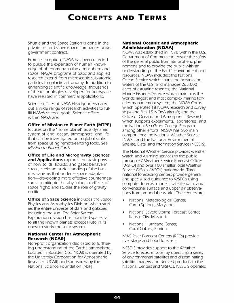
Shuttle and the Space Station is done in theprivate sector by aerospace companies undergovernment contract.
From its inception, NASA has been directedto pursue the expansion of human knowl-edge of phenomena in the atmosphere andspace. NASA’s programs of basic and appliedresearch extend from microscopic sub-atomicparticles to galactic astronomy. In addition toenhancing scientific knowledge, thousandsof the technologies developed for aerospacehave resulted in commercial applications.
Science offices at NASA Headquarters carryout a wide range of research activities to ful-fill NASA’s science goals. Science officeswithin NASA are:
Office of Mission to Planet Earth (MTPE)focuses on the “home planet” as a dynamicsystem of land, ocean, atmosphere, and lifethat can be investigated on a global scalefrom space using remote-sensing tools. SeeMission to Planet Earth.
Office of Life and Microgravity Sciencesand Applications explores the basic physicsof how solids, liquids, and gases behave inspace; seeks an understanding of the basicmechanisms that underlie space adapta-tion—developing more effective countermea-sures to mitigate the physiological effects ofspace flight; and studies the role of gravityon life.
Office of Space Science includes the SpacePhysics and Astrophysics Division which stud-ies the entire universe of stars and galaxies,including the sun. The Solar SystemExploration division has launched spacecraftto all the known planets except Pluto in itsquest to study the solar system.
National Center for AtmosphericResearch (NCAR) Non-profit organization dedicated to further-ing understanding of the Earth’s atmosphere.Located in Boulder, Co., NCAR is operated bythe University Corporation for AtmosphericResearch (UCAR) and sponsored by theNational Science Foundation (NSF).
National Oceanic and AtmosphericAdministration (NOAA) NOAA was established in 1970 within the U.S.Department of Commerce to ensure the safetyof the general public from atmospheric phe-nomena and to provide the public with anunderstanding of the Earth’s environment andresources. NOAA includes: the NationalOcean Service which charts the oceans andwaters of the U.S. and manages 265,000acres of estuarine reserves; the NationalMarine Fisheries Service which maintains theworld’s largest and most complex marine fish-eries management system; the NOAA Corpswhich operates 18 NOAA research and surveyships and flies 15 NOAA aircraft; and theOffice of Oceanic and Atmospheric Researchwhich supports experiments, laboratories, andthe National Sea Grant College Program,among other efforts. NOAA has two maincomponents: the National Weather Service(NWS), and the National EnvironmentalSatellite, Data, and Information Service (NESDIS).
The National Weather Service provides weatherwatch and warning services to the publicthrough 57 Weather Service Forecast Offices(WSFO) and over 100 smaller local WeatherService Offices (WSOs) nationwide. Threenational forecasting centers provide generaland specialized guidance to WSFOs usingcomputer forecast models, satellite data, andconventional surface and upper air observa-tions from around the world. The centers are:
• National Meteorological Center, Camp Springs, Maryland;
• National Severe Storms Forecast Center, Kansas City, Missouri;
• National Hurricane Center, Coral Gables, Florida.
NWS River Forecast Centers (RFCs) provideriver stage and flood forecasts.
NESDIS provides support to the WeatherService forecast mission by operating a seriesof environmental satellites and disseminatingsatellite imagery and derived products to theNational Centers and WSFOs. NESDIS operates
44
CONCEPTS AND TERMS
three national data and information centers:the National Geophysical Data Center, theNational Climatic Data Center (NCDC), andthe National Oceanographic Data Center(NODC). See SOCC
NOAA organizations perform numerous servicesin addition to monitoring weather conditions.They assess crop growth and other agricul-tural conditions, sense shifting ocean currents,and measure surface temperatures of oceansand land. They relay data from surface instru-ments that sense tide conditions, Earthtremors, river levels, and precipitation.
National Space Science Data Center (NSSDC) The NSSDC provides on-line and off-lineaccess to a wide variety of astrophysics, spaceplasma and solar physics, lunar and plane-tary, and Earth science data from NASA spaceflight missions, in addition to selected otherdata, models, and software. Located atGoddard Space Flight Center (GSFC) inGreenbelt, Maryland, the NSSDC is sponsoredby the Information Systems Office of NASA’sOffice of Space Sciences. NSSDC on-line dataand services are currently free of charge, off-line support (e.g., replications and mailing ofmagnetic tapes) are available for the cost offulfilling the request.
The NSSDC Master Catalog (NMC) provides anon-line listing of available data sets and theforms that the data are available in (such asCD-ROM), and provides information about thespacecraft and experiments (including past,present, and future NASA and non-NASA)from which these data were obtained. Theon-line NASA Master Directory (NMD) identi-fies and briefly describes data of potentialinterest to the NASA research community, andwhere possible, provides electronic links topublicly-accessible data at sites world-wide.On-line information services are made avail-able through the menu-based NSSDC OnlineData Information Service (NODIS).
For more information contact: CRUSO(Coordinated Request & User Support Office)National Space Science Data Center
c/o World Data Center-A-R&S (only if corresponding from outside the USA)NASA Goddard Space Flight Center, Code 633.4Greenbelt, Maryland 20771phone: (301) 286-6695, FAX: (301) 286-1771Internet: [email protected]: NSSDCA::REQUEST
National Weather Service (NWS) See National Oceanic and AtmosphericAdministration.
nautical mile A unit of distance (U.S.) equal to exactly 1.852kilometers or about 6076.1 feet. A nauticalmile is approximately equal to 1/60 of adegree or 1 minute of arc of a great circle ofthe Earth (i.e., 1 minute of arc of latitude or oflongitude at the equator).
NCAR See National Center for Atmospheric Research.
NCDC National Climatic Data Center, located inAsheville, North Carolina. See NationalOceanic and Atmospheric Administration.
near infrared Electromagnetic radiation with wavelengthsfrom just longer than the visible (about 0.7micrometers) to about two micrometers. Seeelectromagnetic spectrum.
nephanalysis A type of analysis using satellite cloud picturesto study the relationship between cloudforms and storm systems. In classical mythol-ogy, Nephele was a woman Zeus formedfrom a cloud.
nepheloccygia Clouds that resemble recognizable shapes.
NESDIS National Environmental Satellite Data andInformation Service. See National Oceanic andAtmospheric Administration.
Newton’s law of universal gravitationAll bodies attract each other with what is calledgravitational attraction. This applies to the largeststars as well as the smallest particles of matter.
45
CONCEPTS AND TERMS

The force of attraction between two smallbodies (or between two spherical bodies ofany size) is proportional to the product of theirmasses and inversely proportional to thesquare of the distance between their centers.In other words, the closer two bodies are toeach other, the greater their mutual attraction.As a result, to stay in orbit, a satellite needsmore speed in a low than a high orbit.
Kepler’s three laws of planetary motion, whichhad been derived empirically by JohannesKepler, were obtained with mathematical rigoras a consequence of Newton’s law of universalgravitation in conjunction with his three lawsof motion. See Kepler’s three laws of motion.
Newton’s laws of motionNewton’s three laws of motion are:
1) Every body continues in a state of uniformmotion in a straight line unless acted upon by some external force.
2) The time rate of change of momentum (mass x velocity) is proportional to the impressed force. In the usual case where the mass does not change, this law can be expressed in the familiar form:
force = mass x acceleration or F = ma.
3) To every force or action, there is always anequal and opposite reaction.
Kepler’s three laws of planetary motion, whichhad been derived empirically by JohannesKepler, were obtained with mathematical rigoras a consequence of Newton’s law of universalgravitation in conjunction with his three lawsof motion. See Kepler’s three laws of motion.
NGDCNational Geophysical Data Center, located inBoulder, Colorado. See National Oceanic andAtmospheric Administration.
nibble Four bits of data.
Nimbus Satellite Program A NASA program to develop observation sys-tems meeting the research and developmentrequirements of atmospheric and Earth scien-tists. The Nimbus satellites, first launched in
1964, carried a number of instruments:microwave radiometers, atmosphericsounders, ozone mappers, the Coastal ZoneColor Scanner (CZCS), infrared radiometers,etc. Nimbus-7, the last in the series, providedsignificant global data on sea-ice coverage,atmospheric temperature, atmospheric chem-istry (i.e. ozone distribution), the Earth’s radia-tion budget, and sea-surface temperature. SeeTotal Ozone Mapping Spectrometer (TOMS).
NOAA See National Oceanic and AtmosphericAdministration. Operational designation forthe U.S. polar-orbiting meteorological satel-lites. Current NOAA spacecraft are variationsof the TIROS-N bus.
NODCNational Oceanographic Data Center, locatedin Washington, D.C. See National Oceanicand Atmospheric Administration.
NRA NASA Research Announcement.
NREN National Research and Education Network.
NSF National Science Foundation.
NSFNET National Science Foundation NETwork.
NSSDC See National Space Science Data Center.
oasis
A spot in a desert made fertile by water, whichnormally originates as groundwater.
occluded front (occlusion) A composite of two fronts formed as a coldfront overtakes a warm front. A cold occlusionresults when the coldest air is behind the coldfront. The cold front undercuts the warm frontand, at the Earth’s surface, coldest air replacesless-cold air.
46
CONCEPTS AND TERMS
O

A warm occlusion occurs when the coldest airlies ahead of the warm front. Because thecold front can not lift the colder air mass, itrides piggyback up on the warm front overthe coldest air.
ocean The salt water surrounding the great landmasses. The land masses divide the ocean intoseveral distinct portions, each of which also iscalled an ocean. The oceans include thePacific Ocean, the Atlantic Ocean, the IndianOcean, and the Arctic Ocean.
ohmThe unit of electrical resistance, equal to theresistance of a circuit in which an electromo-tive force of one volt maintains a current ofone ampere. Named for German physicistGeorg S. Ohm (1787–1854).
orbit The path described by a heavenly body in itsperiodic revolution. Earth satellite orbits withinclinations near 0° are called equatorial orbitsbecause the satellite stays nearly over theequator. Orbits with inclinations near 90° arecalled polar orbits because the satellite crossesover (or nearly over) the north and southpoles. See inclination.
orbital decay See period decay.
orbital inclination See inclination.
orbital plane An imaginary gigantic flat plate containing anEarth satellite’s orbit. The orbital plane passesthrough the center of the Earth.
ozone An almost colorless, gaseous form of oxygenwith an odor similar to weak chlorine. A rela-tively unstable compound of three atoms ofoxygen, ozone constitutes—on the average—less than one part per million (ppm) of thegases in the atmosphere (peak ozone concen-tration in the stratosphere can get as high as10 ppm). Yet ozone in the stratosphereabsorbs nearly all of the biologically damagingsolar ultraviolet radiation before it reaches theEarth’s surface where it can cause skin cancer,cataracts, and immune deficiencies, and canharm crops and aquatic ecosystems. Seeozone layer.
47
CONCEPTS AND TERMS
satellite orbitorbital plane
Destruction of ozoneis a catalytic process–
Chlorofluorocarbon (1)atoms in the stratosphereare split by ultravioletradiation and release their chlorine atom (2).
The chlorine atom takesone oxygen atom fromthe unstable ozonemolecule (3) and formschlorine monoxide (4),leaving an ordinaryoxygen molecule (5).
When a free atom of oxygen (6) collides withthe chlorine monoxide(7) the two oxygenatoms form a molecule(8) – releasing thechlorine atom (9) todestroy more ozone (10).
ChlorineAtom
OzoneMolecule
(3)
UV
Chlorofluorocarbon (CFC)Molecule
Oxygen Molecule
ChlorineMonoxide
(4)
Ozone Molecule
(10)
(1)(2)
(5)
(6)
(7)
(8)
(9)
F
C
ClCl
Cl

Ozone is produced naturally in the middleand upper stratosphere through dissociationof molecular oxygen by sunlight. In theabsence of chemical species produced byhuman activity, a number of competing chem-ical reactions among naturally-occurringspecies—primarily atomic oxygen, molecularoxygen, and oxides of hydrogen and nitrogen—maintains the proper ozone balance.
In the present-day stratosphere, this naturalbalance has been altered, particularly by theintroduction of man-made chlorofluorocar-bons. If the ozone decreases, the ultravioletradiation at the Earth’s surface will increase.See greenhouse gas.
Tropospheric ozone is a by-product of thephotochemical (light-induced) processes asso-ciated with air pollution. See photochemicalsmog. Ozone in the troposphere can damageplants and humans.
ozone hole A large area of intense stratospheric ozonedepletion over the Antarctic continent thattypically occurs annually between late Augustand early October, and generally ends in mid-November. This severe ozone thinning hasincreased conspicuously since the late seven-ties and early eighties. This phenomenon isthe result of chemical mechanisms initiated byman-made chlorofluorocarbons (see CFCs).Continued buildup of CFCs is expected to leadto additional ozone loss worldwide.
The thinning is focused in the Antarcticbecause of particular meteorological condi-tions there. During Austral spring (Septemberand October in the Southern Hemisphere) abelt of stratospheric winds encircles Antarcticaessentially isolating the cold stratospheric airthere from the warmer air of the middle lati-tudes. The frigid air permits the formation ofice clouds that facilitate chemical interactionsamong nitrogen, hydrogen, and chlorine (ele-vated from CFCs) atoms, the end product ofwhich is the destruction of ozone.
ozone layerThe layer of ozone that begins approximately15 km above Earth and thins to an almostnegligible amount at about 50 km, shields the
Earth from harmful ultraviolet radiation fromthe sun. The highest natural concentration ofozone (approximately 10 parts per million byvolume) occurs in the stratosphere at approxi-mately 25 km above Earth. The stratosphericozone concentration changes throughout theyear as stratospheric circulation changes withthe seasons. Natural events such as volcanoesand solar flares can produce changes inozone concentration, but man-made changesare of the greatest concern.
ozone-measuring satellite instruments Satellite-based ozone-measuring instrumentscan measure ozone by looking at theamount of ultraviolet absorption reflectedfrom the Earth’s surface and clouds. Someinstruments provide data within the differentlevels of the atmosphere. The Total OzoneMapping Spectrometer (TOMS) maps thetotal amount of ozone between ground andthe top of the atmosphere.
The amount and distribution of ozone mole-cules in the stratosphere varies greatly overthe globe, changing in response to naturalcycles such as seasons, sun cycles, and winds.Utilizing satellites has enabled scientists toassess ozone levels simultaneously over theentire Earth, and has led them to concludethat global ozone levels are being depleted.
ozone mini-hole(s) Rapid, transient, polar-ozone depletion. Thesedepletions, which take place over a 50-kilometer
48
CONCEPTS AND TERMS
20
60
40
80
troposphere
mesosphere
thermosphere
altitude KM
tropospheric ozone is principal component of photochemical smog
stratospheric ozone layer shields Earth from ultraviolet radiation, maximum ozone at 25 km,above 50 km thins tonegligible amountstratosphere
ozone layer
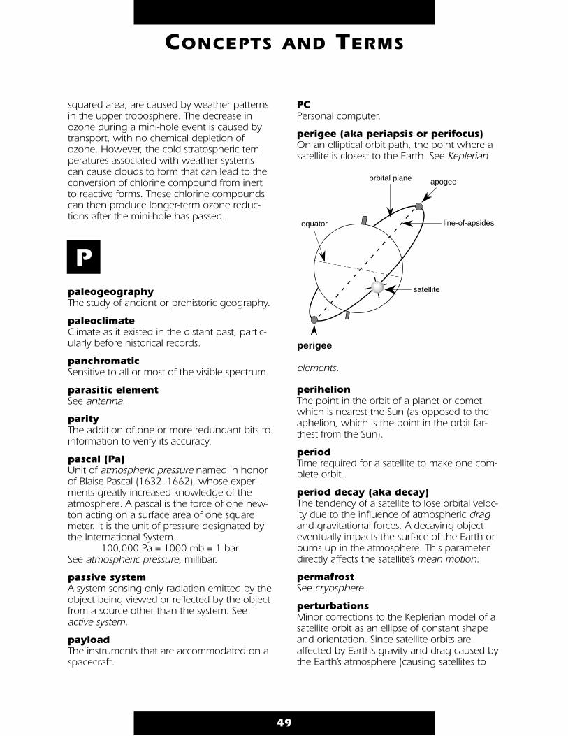
squared area, are caused by weather patternsin the upper troposphere. The decrease inozone during a mini-hole event is caused bytransport, with no chemical depletion ofozone. However, the cold stratospheric tem-peratures associated with weather systemscan cause clouds to form that can lead to theconversion of chlorine compound from inertto reactive forms. These chlorine compoundscan then produce longer-term ozone reduc-tions after the mini-hole has passed.
paleogeography The study of ancient or prehistoric geography.
paleoclimate Climate as it existed in the distant past, partic-ularly before historical records.
panchromatic Sensitive to all or most of the visible spectrum.
parasitic element See antenna.
parity The addition of one or more redundant bits toinformation to verify its accuracy.
pascal (Pa) Unit of atmospheric pressure named in honorof Blaise Pascal (1632–1662), whose experi-ments greatly increased knowledge of theatmosphere. A pascal is the force of one new-ton acting on a surface area of one squaremeter. It is the unit of pressure designated bythe International System.
100,000 Pa = 1000 mb = 1 bar. See atmospheric pressure, millibar.
passive system A system sensing only radiation emitted by theobject being viewed or reflected by the objectfrom a source other than the system. Seeactive system.
payloadThe instruments that are accommodated on aspacecraft.
PC Personal computer.
perigee (aka periapsis or perifocus) On an elliptical orbit path, the point where asatellite is closest to the Earth. See Keplerian
elements.
perihelionThe point in the orbit of a planet or cometwhich is nearest the Sun (as opposed to theaphelion, which is the point in the orbit far-thest from the Sun).
period Time required for a satellite to make one com-plete orbit.
period decay (aka decay) The tendency of a satellite to lose orbital veloc-ity due to the influence of atmospheric dragand gravitational forces. A decaying objecteventually impacts the surface of the Earth orburns up in the atmosphere. This parameterdirectly affects the satellite’s mean motion.
permafrost See cryosphere.
perturbations Minor corrections to the Keplerian model of asatellite orbit as an ellipse of constant shapeand orientation. Since satellite orbits areaffected by Earth’s gravity and drag caused bythe Earth’s atmosphere (causing satellites to
49
CONCEPTS AND TERMS
P
perigee
apogee
line-of-apsides
orbital plane
equator
satellite
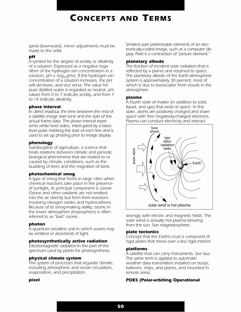
spiral downward), minor adjustments must bemade to the orbit.pH A symbol for the degree of acidity or alkalinityof a solution. Expressed as a negative loga-rithm of the hydrogen ion concentration in asolution, pH = -log10[H+]. If the hydrogen ionconcentration of a solution increases, the pHwill decrease, and vice versa. The value forpure distilled water is regarded as neutral, pHvalues from 0 to 7 indicate acidity, and from 7to 14 indicate alkalinity.
phase interval In direct readout, the time between the end ofa satellite image start tone and the start of theactual frame data. The phase interval repre-sents white level video, interrupted by a blacklevel pulse marking the start of each line and isused to set up phasing prior to image display.
phenology Subdiscipline of agriculture, a science thattreats relations between climate and periodicbiological phenomena that are related to orcaused by climatic conditions, such as thebudding of trees and the migration of birds.
photochemical smog A type of smog that forms in large cities whenchemical reactions take place in the presenceof sunlight, its principal component is ozone.Ozone and other oxidants are not emittedinto the air directly but form from reactionsinvolving nitrogen oxides and hydrocarbons.Because of its smog-making ability, ozone inthe lower atmosphere (troposphere) is oftenreferred to as “bad” ozone .
photon A quantum (smallest unit in which waves maybe emitted or absorbed) of light.
photosynthetically active radiation Electromagnetic radiation in the part of thespectrum used by plants for photosynthesis.
physical climate system The system of processes that regulate climate,including atmospheric and ocean circulation,evaporation, and precipitation.
pixel
Smallest part (addressable element) of an elec-tronically-coded image, such as a computer dis-play. Pixel is a contraction of “picture element.”
planetary albedoThe fraction of incident solar radiation that isreflected by a planet and returned to space.The planetary albedo of the Earth-atmospheresystem is approximately 30 percent, most ofwhich is due to backscatter from clouds in theatmosphere.
plasma A fourth state of matter (in addition to solid,liquid, and gas) that exists in space. In thisstate, atoms are positively charged and sharespace with free negatively-charged electrons.Plasma can conduct electricity and interact
strongly with electric and magnetic fields. Thesolar wind is actually hot plasma blowingfrom the sun. See magnetosphere.
plate tectonics Concept that the Earth’s crust is composed ofrigid plates that move over a less rigid interior.
platforms A satellite that can carry instruments. See bus.The same term is applied to automaticweather data transmitters installed on buoys,balloons, ships, and planes, and mounted inremote areas.
POES (Polar-orbiting Operational
50
CONCEPTS AND TERMS
bow shock
solar wind
Van Allen
radiation belts
Earth
solar wind is hot plasma

Environmental Satellite)Operated by the National Oceanic andAtmospheric Administration, they are desig-nated “NOAA satellites.” Includedin this group are the cur-rent series of TIROS-N satel-lites, the third-genera-tion polar-orbitingenvironmentalspacecraft oper-ated by NOAA.
polar orbit An orbit with anorbital inclinationof near 90° wherethe satellite groundtrack will crossboth polarregions once during each orbit.The term is used to describe the near-polarorbits of spacecraft such as the USA’s NOAA/TIROSand Landsat satellites.
precession The comparatively slow torquing of the orbitalplanes of all satellites with respect to theEarth’s axis, due to the bulge of the Earth atthe equator which distorts the Earth’s gravita-tional field. Precession is manifest by the slowrotation of the line of nodes of the orbit (west-ward for inclinations less than 90° and east-ward for inclinations greater than 90°).
precipitation Moisture that falls from clouds. Althoughclouds appear to float in the sky, they arealways falling, their water droplets slowlybeing pulled down by gravity. Because theirwater droplets are so small and light, it cantake 21 days to fall 1,000 feet and wind cur-rents can easily interrupt their descent. Liquidwater falls as rain or drizzle. All raindrops formaround particles of salt or dust. (Some of thisdust comes from tiny meteorites and even thetails of comets.) Water or ice droplets stick tothese particles, then the drops attract morewater and continue getting bigger until theyare large enough to fall out of the cloud.Drizzle drops are smaller than raindrops. Inmany clouds, raindrops actually begin as tiny
ice crystals that form when part or all of acloud is below freezing. As the ice crystals fallinside the cloud, they may collide with waterdroplets that freeze onto them. The ice crystalscontinue to grow larger, until large enough tofall from the cloud. They pass through warmair, melt, and fall as raindrops.
When ice crystals move within a very coldcloud (10 °F and -40 °F) and enough waterdroplets freeze onto the ice crystals, snow willfall from the cloud. If the surface temperature iscolder than 32 °F, the flakes will land as snow.
Precipitation Weights:one raindrop .000008 lbsone snowflake .0000003 lbsone cumulus cloud 10,000,000 lbsone thunderstorm 10,000,000,000 lbsone hurricane 10,000,000,000,000 lbs
prevailing westerlies Winds in the middle latitudes (approximately30° to 60°) that generally blow from west toeast. The subtropical high pressure regions atthe horse latitudes (30°) forces surface airpoleward, and the rotation of the Earthcauses these winds to bear to the right (east)in the Northern Hemisphere and to the left(east) in the Southern Hemisphere (see Coriolisforce). This is, to some extent, an idealized pic-ture of the atmospheric circulation. The actualcirculation on individual days includes modifi-cations and variations due to the migratorycyclones and anticyclones of middle latitudes,causing rapid and often violent weatherchanges, as warm semi-tropical air from thehorse latitudes meets cold polar air from thehigh latitudes. See wind.
prime meridian An imaginary line running from north tosouth through Greenwich, England, used asthe reference point for longitude.
printed circuit A fiber card on which integrated circuits andother electronic components can be mounted.Connections between the components areetched in the correct circuit patterns.
process An association of phenomena governed by
51
CONCEPTS AND TERMS
N
orbit path
Equator
S
near 90°orbit

physical, chemical, or biological laws. Anexample of a process is the vertical mixing ofocean waters in the so-called surface-mixedlayer; the state variables for this processinclude temperature, salinity in the water on avertical scale of tens of meters, and heat flowand wind stress at the sea surface. Otherexamples include the volcanic deposition ofdust and gases into the atmosphere, eddy for-mation in the atmosphere and oceans, andsoil development.
process study An organized, systematic investigation of aparticular process designed to identify all ofthe state variables involved and to establishthe relationships among them. Process studiesyield numerical algorithms that connect thestate variables and determine their rates ofchange; such algorithms are essential ingredi-ents of Earth system models.
prograde orbit Orbits of the Earth in the same direction asthe rotation of the Earth (west-to-east).
psychrometer An instrument designed to measure dewpoint and relative humidity, consisting of twothermometers (one dry bulb and one wetbulb). The dew point and humidity levels aredetermined by drying the wet bulb (either byfanning or whirling the instrument) and com-
paring the difference between the wet anddry bulbs with preexisting calculations. Seehygrometer.
R&D Research and Development.
radiant 1. In optics, the point or object from whichlight proceeds. 2. In geometry, a straight lineproceeding from a given point, or fixed pole,about which it is conceived to revolve. 3. Inastronomy, the point in the heavens fromwhich a shower of meteors seems to proceed.
radiation Energy transfer in the form of electromagneticwaves or particles that release energy whenabsorbed by an object.
radiation budget A measure of all the inputs and outputs ofradiative energy relative to a system, such asEarth. See Earth Radiation Budget Experiment.
radiative cooling Cooling process of the Earth’s surface andadjacent air, which occurs when infrared(heat) energy radiates from the surface of theEarth upward through the atmosphere intospace. Air near the surface transfers its thermalenergy to the nearby ground through con-duction, so that radiative cooling lowers thetemperature of both the surface and the low-est part of the atmosphere.
radiative transfer Theory dealing with the propagation of elec-tromagnetic radiation through a medium.
radioactive Giving off or capable of giving off radiantenergy in the form of particles or rays, as inalpha, beta, and gamma rays.
radiometer An instrument that quantitatively measureselectromagnetic radiation. Weather satellitescarry radiometers to measure radiation fromsnow, ice, clouds, bodies of water, the Earth’ssurface, and the sun.
radio frequency (RF) A frequency that is useful for radio transmission,usually between 10 kHz and 300,000 MHz.
radiosonde A balloon-borne instrument that measuresmeteorological parameters from the Earth’ssurface up to 20 miles in the atmosphere.The radiosonde measures temperature,pressure, and humidity, and transmits or“radios” these data back to Earth. Upper airwinds also are determined through trackingof the balloon ascent.
Radiosonde observations generally aretaken twice a day (0000 and 1200 UTC)around the globe. NOAA’s National Weather
52
CONCEPTS AND TERMS
R
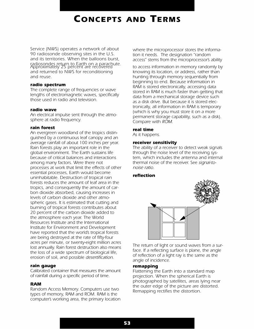
Service (NWS) operates a network of about90 radiosonde observing sites in the U.S.and its territories. When the balloons burst,radiosondes return to Earth on a parachute.Approximately 25 percent are recoveredand returned to NWS for reconditioningand reuse.
radio spectrum The complete range of frequencies or wavelengths of electromagnetic waves, specificallythose used in radio and television.
radio wave An electrical impulse sent through the atmo-sphere at radio frequency.
rain forest An evergreen woodland of the tropics distin-guished by a continuous leaf canopy and anaverage rainfall of about 100 inches per year.Rain forests play an important role in theglobal environment. The Earth sustains lifebecause of critical balances and interactionsamong many factors. Were there notprocesses at work that limit the effects of otheressential processes, Earth would becomeuninhabitable. Destruction of tropical rainforests reduces the amount of leaf area in thetropics, and consequently the amount of car-bon dioxide absorbed, causing increases inlevels of carbon dioxide and other atmo-spheric gases. It is estimated that cutting andburning of tropical forests contributes about20 percent of the carbon dioxide added tothe atmosphere each year. The WorldResources Institute and the InternationalInstitute for Environment and Developmenthave reported that the world’s tropical forestsare being destroyed at the rate of fifty-fouracres per minute, or twenty-eight million acreslost annually. Rain forest destruction also meansthe loss of a wide spectrum of biological life,erosion of soil, and possible desertification.
rain gauge Calibrated container that measures the amountof rainfall during a specific period of time.
RAM Random Access Memory. Computers use twotypes of memory, RAM and ROM. RAM is thecomputer’s working area, the primary location
where the microprocessor stores the informa-tion it needs. The designation “randomaccess” stems from the microprocessor’s ability
to access information in memory randomly byknowing its location, or address, rather thanhunting through memory sequentially frombeginning to end. Because information inRAM is stored electronically, accessing datastored in RAM is much faster than getting thatdata from a mechanical storage device suchas a disk drive. But because it is stored elec-tronically, all information in RAM is temporary(which is why you must store it on a morepermanent storage capability, such as a disk).Compare with ROM.
real time As it happens.
receiver sensitivity The ability of a receiver to detect weak signalsthrough the noise level of the receiving sys-tem, which includes the antenna and internalthermal noise of the receiver. See signal-to-noise ratio.
reflection
The return of light or sound waves from a sur-face. If a reflecting surface is plane, the angleof reflection of a light ray is the same as theangle of incidence.remapping Flattening the Earth into a standard map projection. When the spherical Earth is photographed by satellites, areas lying nearthe outer edge of the picture are distorted.Remapping rectifies the distortion.
53
CONCEPTS AND TERMS
remote sensing The technology of acquiring data and infor-mation about an object or phenomena by adevice that is not in physical contact with it. In
other words, remote sensing refers to gatheringinformation about the Earth and its environ-ment from a distance, a critical capability ofthe Earth Observing System.
For example, spacecraft in low-Earth orbit passthrough the outer thermosphere, enablingdirect sampling of chemical species there.These samples have been used extensively todevelop an understanding of thermosphericproperties. Explorer-17, launched in 1963,was the first satellite to return quantitativemeasurements of gaseous stratification in thethermosphere. However, the mesosphere andlower layers cannot be probed directly in thisway—global observations from space requireremote sensing from a spacecraft at an altitudewell above the mesopause. The formidabletechnological challenges of atmosphericremote sensing, many of which are now beingovercome, have delayed detailed study of thestratosphere and mesosphere by comparisonwith thermospheric research advances.
Some remote-sensing systems encountered ineveryday life include the human eye andbrain, and photographic and video cameras.
resolution A measure of the ability to separate observ-able quantities. In the case of imagery, itdescribes the area represented by each pixelof an image. The smaller the area representedby a pixel, the more accurate and detailed theimage. APT has a resolution of 4 km, i.e., eachpixel represents a square, 4 km on each side.HRPT has a resolution of 1.1 km at nadir (4 km at edge of scan), and WEFAX of 8 km.See resolution cell.
resolution cell The smallest unit of area in an image of discreteelements. The area represented by a pixel.
retrograde orbit An east-to-west orbit of Earth (Earth spins westto east). See prograde orbit.
revolution
Process of the Earth circling the sun in itsorbit. Revolution determines the seasons, andthe length of the year. In addition, differencesin seasons occur because of Earth’s inclination(tilt on its axis) of about 23.5 degrees as itrevolves around the sun. Compare with rotation.
RF See radio frequency.
right ascension of ascending node(aka Ω, RAAN or RA of Node) One of six Keplerian elements, it indicates therotation of the orbit plane from some refer-ence point. Two numbers orient an orbitalplane in space; inclination is the first, this isthe second. After specifying inclination, aninfinite number of orbital planes are possible.The intersection of the equatorial plane andthe orbital plane (see diagram, line of nodes)must be specified by a location on the equa-tor that fully defines the orbital plane. The lineof nodes occurs in two places. However, byconvention, only the ascending node (wherethe satellite crosses the equator going fromsouth to north) is specified. The descendingnode (where the satellite crosses the equatorgoing from north to south) is not.
Because the Earth spins, conventional latitudeand longitude points are not used to separatewhere the lines of node occur. Instead, anastronomical coordinate system is used,known as the right-ascension/declinationcoordinate system, which does not spin withthe Earth. Right ascension of ascending nodeis an angle, measured at the center of theEarth, from the vernal equinox to the ascend-ing node. For example, draw a line from thecenter of the Earth to the point where thesatellite crossed the equator (going fromsouth to north). If this line points directly atthe vernal equinox, then RAAN = 0°.
ROM Read Only Memory. Refers to the computermemory chips that contain information thecomputer uses (along with system files)throughout the system, including the informa-tion it needs to get itself started. Informationin ROM is permanent; it doesn’t vanish whenthe power is turned off. Compare with RAM.
54
CONCEPTS AND TERMS
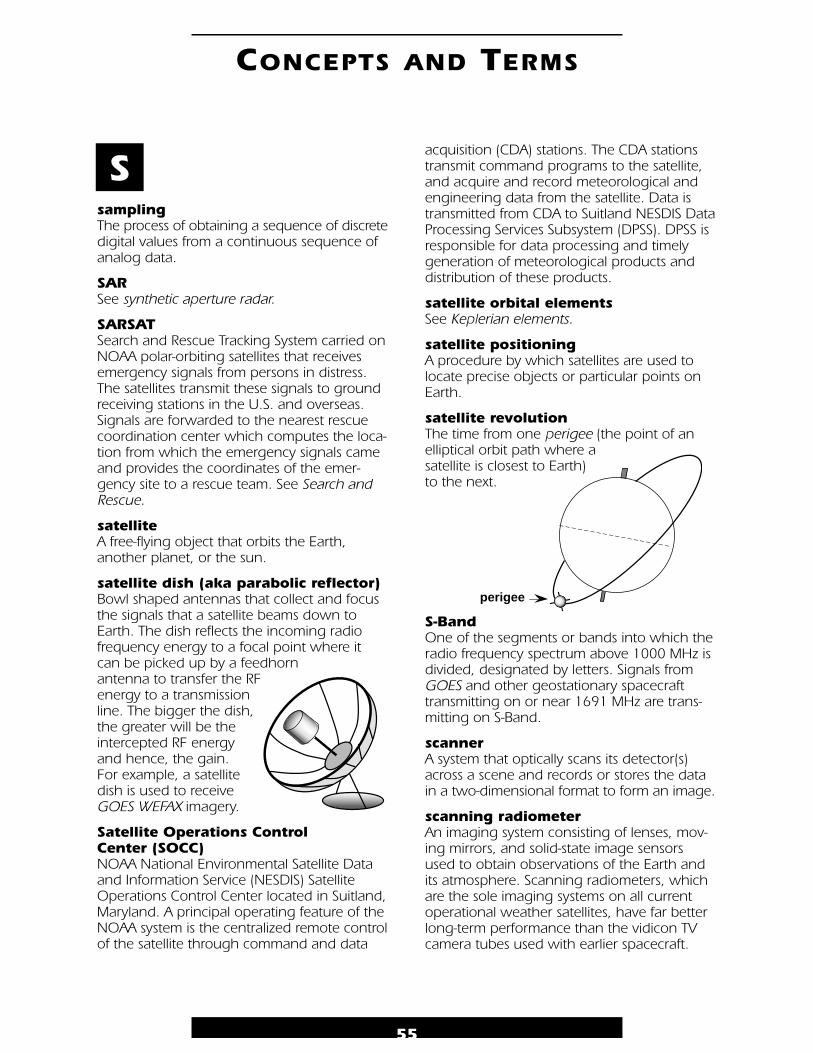
sampling The process of obtaining a sequence of discretedigital values from a continuous sequence ofanalog data.
SAR See synthetic aperture radar.
SARSAT Search and Rescue Tracking System carried onNOAA polar-orbiting satellites that receivesemergency signals from persons in distress.The satellites transmit these signals to groundreceiving stations in the U.S. and overseas.Signals are forwarded to the nearest rescuecoordination center which computes the loca-tion from which the emergency signals cameand provides the coordinates of the emer-gency site to a rescue team. See Search andRescue.
satellite A free-flying object that orbits the Earth,another planet, or the sun.
satellite dish (aka parabolic reflector) Bowl shaped antennas that collect and focusthe signals that a satellite beams down toEarth. The dish reflects the incoming radio frequency energy to a focal point where it can be picked up by a feedhorn antenna to transfer the RF energy to a transmission line. The bigger the dish, the greater will be the intercepted RF energy and hence, the gain. For example, a satellite dish is used to receive GOES WEFAX imagery.
Satellite Operations Control Center (SOCC) NOAA National Environmental Satellite Dataand Information Service (NESDIS) SatelliteOperations Control Center located in Suitland,Maryland. A principal operating feature of theNOAA system is the centralized remote controlof the satellite through command and data
acquisition (CDA) stations. The CDA stationstransmit command programs to the satellite,and acquire and record meteorological andengineering data from the satellite. Data istransmitted from CDA to Suitland NESDIS DataProcessing Services Subsystem (DPSS). DPSS isresponsible for data processing and timelygeneration of meteorological products anddistribution of these products.
satellite orbital elements See Keplerian elements.
satellite positioning A procedure by which satellites are used tolocate precise objects or particular points onEarth.
satellite revolution The time from one perigee (the point of anelliptical orbit path where a satellite is closest to Earth) to the next.
S-Band One of the segments or bands into which theradio frequency spectrum above 1000 MHz isdivided, designated by letters. Signals fromGOES and other geostationary spacecrafttransmitting on or near 1691 MHz are trans-mitting on S-Band.
scanner A system that optically scans its detector(s)across a scene and records or stores the datain a two-dimensional format to form an image.
scanning radiometer An imaging system consisting of lenses, mov-ing mirrors, and solid-state image sensorsused to obtain observations of the Earth andits atmosphere. Scanning radiometers, whichare the sole imaging systems on all currentoperational weather satellites, have far betterlong-term performance than the vidicon TVcamera tubes used with earlier spacecraft.
55
CONCEPTS AND TERMS
S
perigee
An imaging system consisting of lenses, mov-ing mirrors, and solid-state image sensorsused to obtain observations of the Earth andits atmosphere. Scanning radiometers, whichare the sole imaging systems on all currentoperational weather satellites, have far betterlong-term performance than the vidicon TVcamera tubes used with earlier spacecraft.
scattering The process by which electromagnetic radia-tion interacts with and is redirected by the mol-ecules of the atmosphere, ocean, or land sur-face. The term is frequently applied to theinteraction of the atmosphere on sunlight,which causes the sky to appear blue (sincelight near the blue end of the spectrum is scat-tered much more than light near the red end).
screaming eagles Cloud pattern so named because someobservers maintain they can see the head ofan eagle facing west in these cloud patterns.The pattern is similar to a comma, only thepattern is disorganized and not solid.Weather associated with screaming eaglesconsists of rain showers and gusty surfacewinds up to about 25 knots. The eagles canintensify and enlarge when moving into areaseast of troughs; in that case, intense thunder-storms can develop. Screaming eagles arecommon in the Pacific Ocean betweenHawaii and the equator, and are uncommonin the western Atlantic.
sea breeze Local coastal wind that blows from the oceanto land. Sea breezes usually occur during theday, because the heating differences of landand sea cause pressure differences. Cooler,heavier air from the sea moves in to replacerising warm air on the coastline. See land breeze.
sea level The datum against which land elevation andsea depth are measured. Mean sea level is theaverage of high and low tides.
Search and Rescue International satellite-aided search and rescueproject. COSPAS/ SARSAT satellites monitor theentire surface of the Earth, and transmit distresssignals to special ground receiving stations.
The receiving stations compute the location of the signal, and notify the nearest rescuecoordination center. Satellite search has cutrecovery time from days to hours, and hasaided downed airplanes, capsized boats, andpersons in other emergencies.
SEM See Space Environment Monitor, TIROS.
semi-major axis (aka a)One of the six Keplerian elements, it indicatesthe size of an orbit. The semi-major axis is one-half of the longest diameter of an orbitalellipse, e.g., one-half of the distance betweenthe apogee and perigee of an Earth orbit.(The semi-major axis is related to the orbitalperiod and mean motion by Kepler’s third law.See Kepler’s three laws of motion.) SeeKeplerian elements for diagram.
sensor Device that produces an output (usually electri-cal) in response to stimulus such as incidentradiation. Sensors aboard satellites obtain infor-mation about features and objects on Earth bydetecting radiation reflected or emitted in dif-ferent bands of the electromagnetic spectrum.Analyzing the transmitted data provides valu-able scientific information about Earth.
Weather satellites commonly carry radiome-ters, which measure radiation from snow, ice,clouds, and bodies of water. Spaceborneradars are used for Earth observations, bounc-ing radar waves off land and ocean surfacesto study sea-surface conditions, ice thickness,and land surface features. A wind scatterome-ter is a special type of radar designed to mea-sure ocean surface winds indirectly by bounc-ing signals off the water and measuring themfrom various angles. Infrared (IR) detectorsmeasure heat generated by Earth features inthe IR band of the spectrum.
Photographic reconnaissance sensors in theirsimplest form are large telescope-camera sys-tems used to view objects on Earth’s surface.The bigger the lens, the smaller the objectthat can be detected. Camera-telescope sys-tems now incorporate all sorts of sophisticatedelectronics to produce better images, buteven these systems need cloudless skies, excel-
56
CONCEPTS AND TERMS
lent lighting, and good color contrastbetween objects and their surroundings todetect objects the size of a basketball. Some ofthe satellites produce film images that must bereturned to Earth, but a more convenientmethod is to record the image as a series ofdigital code numbers, then reconstruct theimage from the electronic code using a com-puter at a ground station.
sensor calibration The relationship between input and outputfor a given measurement.
signal Electrical impulses, sound or picture elements,etc., received or transmitted. Signals can existin many different forms and media (electri-cal/wires, acoustic/air, light/transparent fibers,etc.), but all signals will vary with time.
The signal shape plotted as a function oftime is called the waveshape or waveform.Some waveforms are repetitive or periodic,that is, a small segment of the waveformrepeats itself regularly. Other waveforms,such as noise, are nonperiodic or aperiodic.All waveforms can be distilled into the combi-nation of pure waves called sine waves. Thefrequency of a sine wave is the rate at whichthe fundamental shape repeats itself.
Most signals occupy a limited range of fre-quencies between a lower limit and anupper limit. This range or band of frequen-cies occupied by a signal is called the band-width of the signal.
Communication medium or channel can passonly a specific range or band of frequencies,which is called the bandwidth of the channel.The bandwidths of the channel and the signaldetermine the number and types of signalsthat can be transmitted by a particular com-munication channel. Signals often are toosmall and need to be made larger through aprocess called amplification. The amount ofamplification is measured in decibels.However, amplification is an imperfectprocess, and inadvertently introduces variousdistortions, noise, and bandwidth limitations.Often, multiple signals must share the samemedium. One way the sharing can be accom-
plished is to place each signal in its own bandof frequencies within the total band of themedium. The combining of a number of sig-nals to share a medium by dividing it into dif-ferent frequency bands for each signal iscalled frequency-division multiplexing.
Frequency-division multiplexing requires theability to move signals around so that eachmultiplexed signal occupies its own band.This is accomplished through a processcalled modulation, in which a high-fre-quency sine wave carries the signal into thespecified band. Either the amplitude or thefrequency of the carrier wave can be varied,or modulated, in synchrony with the infor-mation-bearing signal. These methods arecalled amplitude modulation (AM) and fre-quency modulation (FM). FM is the morecomplex process of the two, and the band-width of the FM carrier can be many timesthat of the modulating signal. The process ofdemodulating a frequency-modulated signaleliminates much of the deleterious effects ofadditional noise. (The trade-off betweenbandwidth and noise immunity characterizesmost communication systems. Both are ana-log modulation schemes for multiplexing sig-nals in the frequency spectrum.)
Digitizing a signal requires a number of stepsand results in a binary digital signal thattakes on one of two discrete values. Thisprocess results in considerable immunity toadditive noise, but requires a considerableincrease in bandwidth.
signal-to-noise ratio (SNR) In decibels (dB), the difference between theamplitude of a desired radio frequency (RF)signal and the internal or external RF noiselevel in a system. A negative SNR indicatesthe signal is below the system noise leveland unusable. The greater the positive SNR,the less effect noise will have on the finalquality. SNR of at least +12dB is necessary toproduce imagery with minimal noise effects.
sine wave A smoothly varying wave that repeats itself; itsfrequency is the rate at which the fundamen-tal shape repeats itself. Any waveform can be
57
CONCEPTS AND TERMS
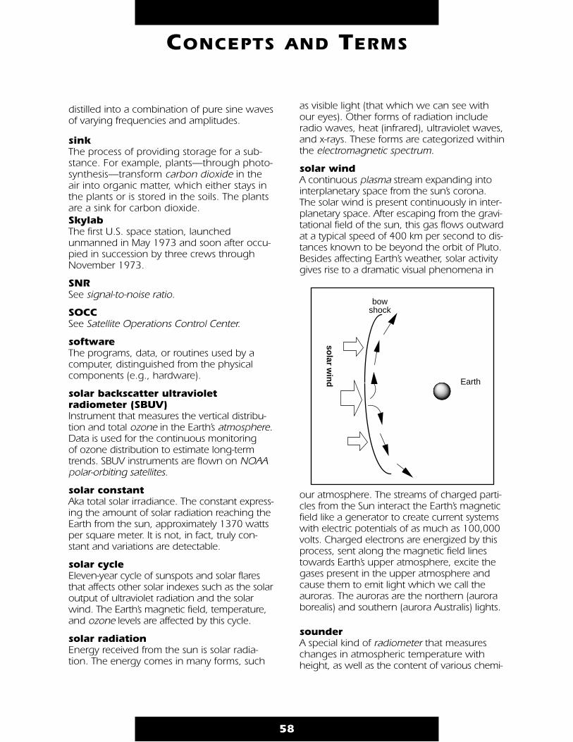
distilled into a combination of pure sine wavesof varying frequencies and amplitudes.
sinkThe process of providing storage for a sub-stance. For example, plants—through photo-synthesis—transform carbon dioxide in theair into organic matter, which either stays inthe plants or is stored in the soils. The plantsare a sink for carbon dioxide.SkylabThe first U.S. space station, launchedunmanned in May 1973 and soon after occu-pied in succession by three crews throughNovember 1973.
SNR See signal-to-noise ratio.
SOCC See Satellite Operations Control Center.
software The programs, data, or routines used by acomputer, distinguished from the physicalcomponents (e.g., hardware).
solar backscatter ultraviolet radiometer (SBUV) Instrument that measures the vertical distribu-tion and total ozone in the Earth’s atmosphere.Data is used for the continuous monitoring of ozone distribution to estimate long-termtrends. SBUV instruments are flown on NOAApolar-orbiting satellites.
solar constant Aka total solar irradiance. The constant express-ing the amount of solar radiation reaching theEarth from the sun, approximately 1370 wattsper square meter. It is not, in fact, truly con-stant and variations are detectable.
solar cycle Eleven-year cycle of sunspots and solar flaresthat affects other solar indexes such as the solaroutput of ultraviolet radiation and the solarwind. The Earth’s magnetic field, temperature,and ozone levels are affected by this cycle.
solar radiation Energy received from the sun is solar radia-tion. The energy comes in many forms, such
as visible light (that which we can see withour eyes). Other forms of radiation includeradio waves, heat (infrared), ultraviolet waves,and x-rays. These forms are categorized withinthe electromagnetic spectrum.
solar wind A continuous plasma stream expanding intointerplanetary space from the sun’s corona.The solar wind is present continuously in inter-planetary space. After escaping from the gravi-tational field of the sun, this gas flows outwardat a typical speed of 400 km per second to dis-tances known to be beyond the orbit of Pluto.Besides affecting Earth’s weather, solar activitygives rise to a dramatic visual phenomena in
our atmosphere. The streams of charged parti-cles from the Sun interact the Earth’s magneticfield like a generator to create current systemswith electric potentials of as much as 100,000volts. Charged electrons are energized by thisprocess, sent along the magnetic field linestowards Earth’s upper atmosphere, excite thegases present in the upper atmosphere andcause them to emit light which we call theauroras. The auroras are the northern (auroraborealis) and southern (aurora Australis) lights.
sounder A special kind of radiometer that measureschanges in atmospheric temperature withheight, as well as the content of various chemi-
58
CONCEPTS AND TERMS
Earth
solar w
ind
bow shock
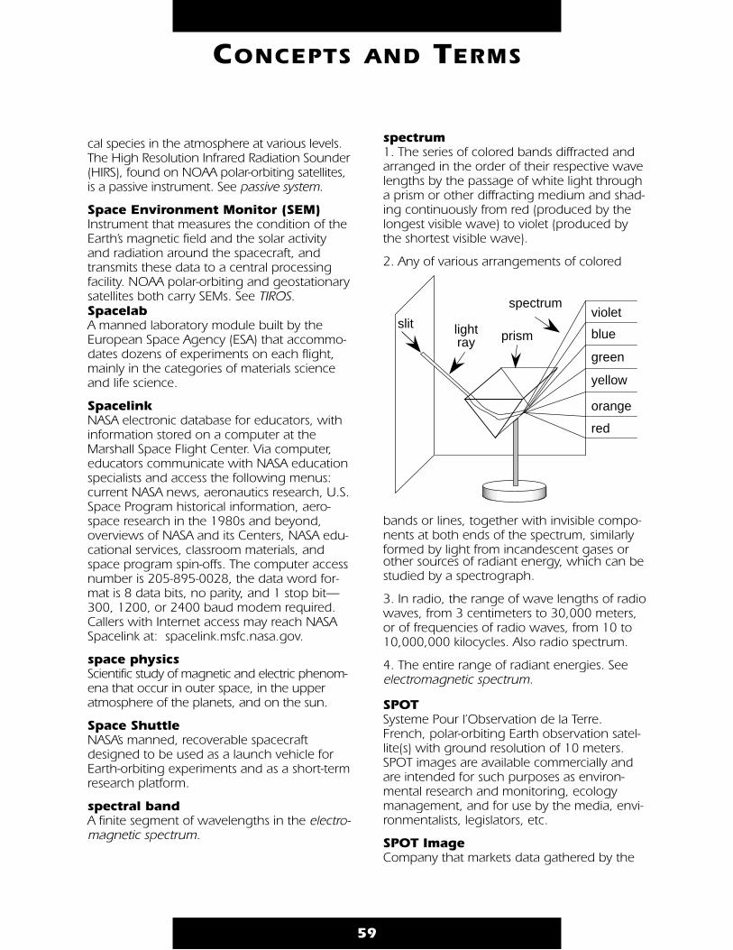
cal species in the atmosphere at various levels.The High Resolution Infrared Radiation Sounder(HIRS), found on NOAA polar-orbiting satellites,is a passive instrument. See passive system.
Space Environment Monitor (SEM) Instrument that measures the condition of theEarth’s magnetic field and the solar activityand radiation around the spacecraft, andtransmits these data to a central processingfacility. NOAA polar-orbiting and geostationarysatellites both carry SEMs. See TIROS.Spacelab A manned laboratory module built by theEuropean Space Agency (ESA) that accommo-dates dozens of experiments on each flight,mainly in the categories of materials scienceand life science.
Spacelink NASA electronic database for educators, withinformation stored on a computer at theMarshall Space Flight Center. Via computer,educators communicate with NASA educationspecialists and access the following menus:current NASA news, aeronautics research, U.S.Space Program historical information, aero-space research in the 1980s and beyond,overviews of NASA and its Centers, NASA edu-cational services, classroom materials, andspace program spin-offs. The computer accessnumber is 205-895-0028, the data word for-mat is 8 data bits, no parity, and 1 stop bit—300, 1200, or 2400 baud modem required.Callers with Internet access may reach NASASpacelink at: spacelink.msfc.nasa.gov.
space physics Scientific study of magnetic and electric phenom-ena that occur in outer space, in the upperatmosphere of the planets, and on the sun.
Space Shuttle NASA’s manned, recoverable spacecraftdesigned to be used as a launch vehicle forEarth-orbiting experiments and as a short-termresearch platform.
spectral band A finite segment of wavelengths in the electro-magnetic spectrum.
spectrum 1. The series of colored bands diffracted andarranged in the order of their respective wavelengths by the passage of white light througha prism or other diffracting medium and shad-ing continuously from red (produced by thelongest visible wave) to violet (produced bythe shortest visible wave).
2. Any of various arrangements of colored
bands or lines, together with invisible compo-nents at both ends of the spectrum, similarlyformed by light from incandescent gases orother sources of radiant energy, which can bestudied by a spectrograph.
3. In radio, the range of wave lengths of radiowaves, from 3 centimeters to 30,000 meters,or of frequencies of radio waves, from 10 to10,000,000 kilocycles. Also radio spectrum.
4. The entire range of radiant energies. Seeelectromagnetic spectrum.
SPOT Systeme Pour l’Observation de la Terre.French, polar-orbiting Earth observation satel-lite(s) with ground resolution of 10 meters.SPOT images are available commercially andare intended for such purposes as environ-mental research and monitoring, ecologymanagement, and for use by the media, envi-ronmentalists, legislators, etc.
SPOT Image Company that markets data gathered by the
59
CONCEPTS AND TERMS
slit lightray prism
spectrum
green
yellow
orange
red
violet
blue

SPOT satellite worldwide.
start tone Five seconds of 300 Hz black to white squarewave modulation of the WEFAX subcarrier sig-naling the start of a frame transmission (thebeginning of a direct readout image).
stop tone Five seconds of 450 Hz black to white squarewave modulation of the WEFAX subcarrier, sig-naling the stop of a frame transmission (endof a direct readout image).
stratosphere Region of the atmosphere between the tro-posphere and mesosphere, having a lowerboundary of approximately 8 km at the polesto 15 km at the equator and an upper bound-ary of approximately 50 km. Depending uponlatitude and season, the temperature in thelower stratosphere can increase, be isother-
mal, or even decrease with altitude, but thetemperature in the upper stratosphere gener-ally increases with height due to absorption ofsolar radiation by ozone.
subcarrier The 2400 Hz audio tone transmitted by APTand WEFAX spacecraft. Amplitude modulationof this tone is used to convey video information.
subsatellite point Point where a straight line drawn from a satel-lite to the center of the Earth intersects theEarth’s surface.
subsatellite track See ground track.
subsystem 1. A subunit of either the physical climate sys-tem (e.g., ocean dynamics) or the biogeo-chemical cycles (e.g., terrestrial ecosystems).
2. A subunit of a spacecraft, e.g., the teleme-try subsystem, the power subsystem, the sen-sor subsystem, etc.
sun The closest star to Earth (149,599,000 kmaway on average). The sun dwarfs the otherbodies in the solar system, representing approx-imately 99.86 percent of all the mass in thesolar system. One hundred and nine Earthswould be required to fit across the Sun’s disk, itsinterior could hold over 1.3 million Earths.
The source of the Sun’s energy is the nuclearreactions that occur in its core. There, at tem-peratures of 15 million degrees Celsius (27 million degrees Fahrenheit) hydrogen atomnuclei, called protons, are fused and becomehelium atom nuclei. The energy producedthrough fusion at the core moves outward,first in the form of electromagnetic radiationcalled photons. Next, energy moves upwardin photon heated solar gas—this type ofenergy transport is called convection.Convective motions within the solar interiorgenerate magnetic fields that emerge at thesurface as sunspots and loops of hot gascalled prominences. Most solar energy finallyescapes from a thin layer of the Sun’s atmo-sphere called the photosphere—the part ofthe Sun observable to the naked eye.
The sun appears to have been active for 4.6billion years and has enough fuel for another5 billion years or so. At the end of its life, theSun will start to fuse helium into heavier ele-ments and begin to swell up, ultimately grow-ing so large that it will swallow Earth. After abillion years as a “red giant,” it will suddenlycollapse into a “white dwarf.” It may take a tril-lion years to cool off completely.
sun-synchronous Describes the orbit of a satellite that providesconsistent lighting of the Earth-scan view. Thesatellite passes the equator and each latitudeat the same time each day. For example, asatellite’s sun-synchronous orbit might cross
60
CONCEPTS AND TERMS
N
S
subsatellitepoint

the equator twelve times aday, each time at 3:00 p.m.local time. The orbitalplane of a sun-syn-chronous orbit mustalso precess (rotate)approximately onedegree each day, east-ward, to keep pacewith the Earth’s revolu-tion around the sun.
survey mode Refers to observationalemphasis upon frequentglobal coverage, usually with restricted spatialand spectral resolution, aimed at developing aconsistent, long-term data product for laterinterpretation.
swath The area observed by a satellite as it orbits the Earth.
synoptic chart Chart showing mete-orological conditionsover a region at a given time; weather map.
synoptic view
The ability to see large areas at the same time.
synthetic aperture radar (SAR)A high-resolution ground-mapping techniquethat effectively synthesizes a large receivingantenna by processing the phase of thereflected radar return. The along-track resolu-tion is obtained by timing the radar return(time-gating) as for ordinary radar. The cross-track (azimuthal) resolution is obtained by pro-cessing the Doppler phase of the radar return.The cross-track “dimension” of the antenna is afunction of the length of time over which theDoppler phase is collected. See Doppler effect.
TDRSSSee Tracking and Data Relay Satellite System.
telemetry 1. Telecommunications transmission to a dis-tance of measured magnitude by radio ortelephony with suitably coded modulation,e.g., amplitude, frequency, phase, pulse.
2. Transmission of data collected at a remotelocation over communications channels to acentral station.
3. Surveying measurement of linear distancesby use of tellurometer—a device that usesmicrowaves to measure distance.
telephony Used to transmit sounds between widely re-moved points with or without connecting wires.
Television and Infrared ObservationSatellite (TIROS) A series of NASA and NOAA satellites launchedto monitor Earth’s weather from outer space.The era of the meteorological satellites beganwith the launch of TIROS-1 on April 1, 1960.For the first time, it was possible to monitorweather conditions over most of the worldregularly from space. A series of these satelliteswere launched throughout the 1960s, those
funded by NASA for research and develop-ment were called TIROS, and those funded bythe Environmental Science ServicesAdministration (ESSA, the predecessor of NOAA)for the operational system were called ESSA.
A second generation of ITOS/NOAA* environ-mental satellites was initiated by the launch ofITOS-1 in 1970, followed by a number ofNOAA satellites. The third generation of TIROS-N/NOAA environmental satellites was initiatedby the launch of TIROS-N in 1978.
61
CONCEPTS AND TERMS
T
N
swath
TIROSspacecraft
* Pairs of acronyms such as ITOS/NOAA arisebecause NASA funds and names its prototypesatellites and then the operating agency fundsand names the rest of the series.
TIROS-N/NOAA satellitesNOAA satellites that continuously orbit theEarth from North to South Pole (hence, polarorbiting) at an altitude of approximately 470nautical miles (870.44 km or 540.86 statutemiles). These environmental satellites collectvisible and infrared imagery and provideatmospheric-sounding data and meteorologi-cal data relay and collection. A primary mis-sion of TIROS-N/NOAA is to monitor the 70percent of the globe covered by water–whereweather data is sparse and provide continuousdata to the National Weather Service for usein numerical forecast modeling. Each TIROS-N/NOAA carries six primary systems:
1. The Advanced Very High ResolutionScanning Radiometer (AVHRR) senses cloudsover both ocean and land, using the visibleand infrared parts of the spectrum. It storesmeasurements on tape, and later plays themback to NOAA’s command and data acquisi-tion stations. The satellites also broadcast inreal time, and the broadcasts can be receivedaround the world by anyone equipped with adirect readout receiving station.
2. The TIROS Operational Vertical Sounder(TOVS) is a 3-part TIROS system to measure:
• Temperature profile of the Earth’s atmo-sphere from the surface to 10 millibars;
• Water content of the Earth’s atmosphere;
• Total ozone content of the Earth’s atmosphere;
3. The ARGOS Data Collection and PlatformLocation System (DCS) collects data from sen-sors placed on fixed and moving platforms,including ships, buoys, and weather balloons,and transmits data to a ground stationantenna. Because ARGOS also determines theprecise location of these moving sensors, itcan serve wildlife managers by monitoringand tracking the transmitters placed on birdsand animals.
4. The Space Environment Monitor (SEM)measures energetic particles emitted by thesun over essentially the full range of energiesand magnetic field variations in the Earth’snear-space environment. Readings made bythese instruments are invaluable in measuringthe sun’s radiation activity.
5. Search and Rescue Tracking(COSPAS/SARSAT) equipment receives emergency signals from persons in distress.The satellites transmit the signals to groundreceiving stations. The signals then are for-warded to rescue coordination centers. Therescue centers compute the location of thesignals and provide the coordinates of theemergency site (usually within a few miles).
6. Earth Radiation Budget Experiment (ERBE)is a radiometer, flown on NOAA 9 and 10,designed to measure all radiation striking andleaving the Earth. This enables scientists tomeasure the loss or gain of terrestrial energyto space. Shifts in this energy “budget” affectthe Earth’s average temperatures. Even slightchanges can affect climatic patterns.
temperature Measure of the energy in a substance. The moreheat energy in the substance, the higher thetemperature. The Earth receives only one two-billionth of the energy the sun produces. Muchof the energy that hits the Earth is reflected backinto space. Most of the energy that isn’t reflectedis absorbed by the Earth’s surface. As the surfacewarms, it also warms the air above it.
terabit A trillion (1012) bits.
thematic mapper (TM) A Landsat multispectral scanner designed toacquire data to categorize the Earth’s surface.Particular emphasis was placed on agriculturalapplications and identification of land use.The scanner continuously scans the surface ofthe Earth, simultaneously acquiring data inseven spectral channels. Overlaying two ormore bands produces a false color image. Theground resolution of the six visible and short-wave bands of the Thematic Mapper is 30meters, and the resolution of the thermalinfrared band is 120 meters. Thematic map-
62
CONCEPTS AND TERMS
pers have been flown on Landsats-4 and -5.
thermal infrared Electromagnetic radiation with wavelengthsbetween about 3 and 25 micrometers.
thunder The sound that results from lightning.Lightning bolts (static electricity) produceintense heat. This burst of heat makes the airaround the bolt expand explosively, produc-ing the sound we hear as thunder. Since lighttravels faster than sound, we see the lightningbefore we hear the thunder.
thunderstorm Local storm resulting from warm humid air ris-ing in an unstable environment. Air may startmoving upward because of unequal surfaceheating, the lifting of warm air along a frontalzone, or diverging upper-level winds (thesediverging winds draw air up beneath them).The scattered thunderstorms that develop inthe summer are called air-mass thunderstormsbecause they form in warm, maritime tropicalair masses away from other weather fronts.More violent severe thunderstorms form inareas with a strong vertical wind shear thatforces the updraft into the mature stage, themost intense stage of the thunderstorm.Severe thunderstorms can produce large hail,forceful winds, flash floods, and tornadoes.
TIROS See Television and Infrared Observation Satellite.
TM See thematic mapper.
TNL Thermal Noise Level.
TOGA See Tropical Ocean Global Atmosphere Program.
TOMS See Total Ozone Mapping Spectrometer.
TOPEX/POSEIDON Ocean Topography Experiment, United States(NASA)/France (CNES). Launched in 1992, themission carries a radar sensor—called analtimeter—to measure the ocean’s surfacetopography with unprecedented precision.
TOPEX/POSEIDON is a core element of theinternational World Ocean CirculationExperiment (WOCE) and the Tropical OceanGlobal Atmosphere (TOGA) seagoing mea-surements program. Mission objectives are to:
• Study ocean circulation and its interaction with the atmosphere to understand climatechange better;
• Improve our knowledge of heat transport in the ocean;
• Model global ocean tides;
• Study the marine gravity field;
• Calculate sea-level variations on both global and local scales.
tornado A twisting, spinning funnel of low pressure air.The most unpredictable weather event, torna-does are created during powerful thunder-storms. As a column of warm air rises, airrushes in at ground level and begins to spin. Ifthe storm gathers energy, a twisting, spinningfunnel develops. Because of the funnel’s cloudand rain composition and the dust, soil, anddebris it draws up, the funnel appears black-ish in color. The most energetic storms resultin the funnel touching the ground. In thesetornadoes, the roaring winds in the funnelcan reach 300 mph, the strongest winds onEarth. Funnels usually travel at 20 to 40 mph,moving toward the northeast. When torna-does form over lakes or oceans they suckwater into the funnel cloud and are calledwaterspouts.
Total Ozone Mapping Spectrometer (TOMS) Flown on NASA’s Nimbus-7 satellite, its primarygoal is to continue the high-resolution globalmapping of total ozone on a daily basis. TheNimbus-7 launch in 1978 enabled TOMS tobegin delivering data in 1979 and continueproviding information until 1993. TOMS hasmapped the total amount of ozone betweenthe ground and the top of the atmosphere,provided the first maps of the ozone hole, andcontinues to monitor this phenomenon.
Because of its longevity, TOMS also has
63
CONCEPTS AND TERMS
obtained information on the more subtletrends in ozone outside the ozone holeregion. This results from development of apowerful new calibration technique thatremoves the instrument measurement driftthat developed over the years. With this tech-nique applied to the TOMS 14.5-year datarecord, a global ozone decrease of 2.69 per-cent per decade was detected.
To ensure that ozone data will be availablethrough the next decade, NASA will continuethe TOMS program using U.S. and foreignlaunches. In 1991, the former Soviet Unionlaunched a Meteor-3 satellite carrying aTOMS instrument provided by NASA. A thirdTOMS will be launched onboard a NASAEarth probe satellite in 1994, and theJapanese Advanced Earth ObservationsSatellite (ADEOS) will carry a fourth TOMSwhen it launches in 1996.
TOVS TIROS Operational Vertical Sounder. SeeTelevision Infrared Operational Satellite (TIROS).
Tracking and Data Relay SatelliteSystem (TDRSS) An orbiting communications satellite, devel-oped by NASA, used to relay data from satel-lite sensors to ground stations and to track thesatellites in orbit.
trade winds Surface air from the horse latitudes that movesback toward the equator and is deflected bythe Coriolis Force, causing the winds to blowfrom the Northeast in the NorthernHemisphere and from the Southeast in theSouthern Hemisphere. These steady winds arecalled trade winds because they providedtrade ships with an ocean route to the NewWorld. See wind.
TRMM See Tropical Rainfall Measuring Mission.
Tropical Ocean-Global Atmosphere (TOGA) TOGA is a program jointly sponsored by theUnited Nations World MeteorologicalOrganization (WMO); the International Councilof Scientific Unions (ICSU); the United NationsEducational, Scientific, and Cultural Organization
(UNESCO) Intergovernmental OceanographicCommission (IOC); and the ICSU ScientificCommittee on Oceanic Research (SCOR).
TOGA has four major objectives:
• To collect and catalog observations of the tropical atmosphere and ocean;
• To assess the evolution of the tropical atmosphere/ocean system in real time;
• To promote the development of short-termclimate-prediction computer models for the tropics;
• To study the influence of the tropical atmosphere/ocean system on the climate at higher latitudes.
Tropical Rainfall Measuring Mission (TRMM) A joint NASA/NASDA mission planned forlaunch in 1997. The goal of TRMM is to obtaina minimum of 3 years of climatologically signifi-cant observations of rainfall in the tropics.Because rainfall is such a variable phenome-non, adequate sampling is a difficult problem.By averaging the instantaneous rainfall ratesfor 30 days over a 5° by 5° grid, TRMM willobtain observations that meet climatologicalrequirements. TRMM measurements, usedtogether with cloud models, also will provideaccurate estimates of vertical distributions oflatent heating in the atmosphere.
The present uncertainty about the quantityand distribution of precipitation, especially inthe tropics, prohibits definition of the massand energy exchange between the tropicalocean and atmosphere. Since the tropicalatmosphere and oceans are closely coupled,cloud radiation and rainfall are likely to havesignificant effects on ocean circulation andmarine biomass.
TRMM data will play a significant role in globalchange studies, especially in developing aninterdisciplinary understanding of atmosphericcirculation, ocean-atmospheric coupling, andtropical biology. TRMM data on tropical clouds,evaporation, and heat transfer will be used tounderstand the larger scale coupling of theatmosphere to oceans. See Earth Probes.
64
CONCEPTS AND TERMS
tropical storm formation Tropical storms generally form in the easternportion of tropical oceans and track westward.Hurricanes, typhoons, and willy-willies all startout as weak low pressure areas that form overwarm tropical waters (e.g., surface water tem-perature of at least 80 °F). Initially, winds andcloud formations over the warm tropicalwaters are minimal. Both intensify with time.Formation of tropical storms also requires a sig-nificant Coriolis effect to induce proper spin inthe wind formation. As the storm begins toorganize itself into a coherent pattern, it willexperience increased activity and intensity.
When a storm develops a clearly recognizablepattern, it is referred to as a tropical depression.When wind speeds reach 35 knots (40.3 mph),it is called a tropical storm and is given aname. When wind speed equals or exceeds74 mph, the storm is called a hurricane. In thewestern Pacific, a hurricane is referred to as atyphoon. In waters around Australia it is calleda cyclone or willy-willy.
Hurricanes intensify when moving over areasof increased water temperatures, and weakenover colder water surfaces. Upper atmospherewind shear (different wind direction andspeeds at different elevations) will frequentlyprevent or slow intensification of tropicalstorms by “spreading out” the storm horizon-tally and preventing the formation of strongupdrafts of warm, humid air. Movement overa land-mass will weaken hurricane winds butwill result in large-scale rain that can result inlarge-scale flooding. When encountering astrong frontal system (such as a polar front)the hurricane will curve and track along theleading edge of the front or becomeimplanted in it.
Satellite infrared imagery can identify surfacewater temperatures that will foster tropicalstorm development.
tropics The area between 23.5 degrees north andsouth of the equator. This region has smalldaily and seasonal changes in temperature,but great seasonal changes in precipitation.
troposphere
The lower atmosphere, to a height of 8-15 kmabove Earth, where temperature generallydecreases with altitude, clouds form, precipita-tion occurs, and convection currents areactive. See atmosphere.
tropospheric emission spectrometer
A high-resolution infrared spectrometer formonitoring the minor components of thelower atmosphere.
trough Elongated area of low atmospheric pressure,either at the surface or in the upper atmosphere.
true anomaly (aka J) One of six Keplerian elements, it locates asatellite on an orbit. True anomaly is the trueangular distance of a satellite (planet) from itsperigee (perihelion) as seen from the center ofthe Earth (sun). See Keplerian elements.
typhoon Hurricanes in the Western Pacific Ocean.
ultraviolet radiation The energy range just beyond the violet endof the visible spectrum. Although ultravioletradiation constitutes only about 5 percent ofthe total energy emitted from the sun, it is themajor energy source for the stratosphere andmesosphere, playing a dominant role in bothenergy balance and chemical composition.
Most ultraviolet radiation is blocked by Earth’satmosphere, but some solar ultraviolet pene-trates and aids in plant photosynthesis andhelps produce vitamin D in humans. Toomuch ultraviolet radiation can burn the skin,cause skin cancer and cataracts, and damagevegetation.
UARS See Upper Atmosphere Research Satellite
United States Geological Survey (USGS)A bureau of the Department of the Interior.USGS was established in 1879 following sev-
65
CONCEPTS AND TERMS
U
eral Federally-sponsored independent naturalresource surveys of the West and Midwest.The Department of the Interior has responsibil-ity for most of our nationally owned publiclands and natural resources. The USGS moni-tors resources such as energy, minerals, water,land, agriculture, and irrigation. The resultingscientific information contributes to environ-mental-policy decision making and publicsafety. For example, USGS identifies flood- andlandslide-prone areas and maintains maps ofthe United States.
United States Global Change Research Program (USGCRP) The USGCRP addresses significant uncertaintiesconcerning the natural and human-inducedchanges to Earth’s environment. The USGCRPhas a comprehensive and multidisciplinary sci-entific research agenda. See Global ChangeResearch Program.
Upper Atmosphere Research Satellite (UARS) UARS is part of a long-term, international program of space research into global atmo-spheric change. Beginning in 1991, NASA’sUARS program began to carry out the first sys-tematic, detailed satellite study of the Earth’sstratosphere, mesosphere, and lower thermo-sphere; establish the comprehensive data base
needed for an understanding of stratosphericozone depletion; and bring together scientistsand governments around the world to assessthe role of human activities in atmosphericchange. Launched on September 12, 1991,UARS became the first official space compo-nent of Mission to Planet Earth.
USGCRP See United States Global Change ResearchProgram.
UTC See Coordinated Universal Time.
UV Ultraviolet. See ultraviolet radiation.
Van Allen belts or Van AllenRadiation belts Doughnut-shaped regions encircling Earthand containing high energy electrons andions trapped in the Earth’s magnetic field (themagnetic field has definite boundaries, and isdistorted into a tear-drop shape by the solarwind). Explorer I, launched by NASA in 1958,discovered this intense radiation zone. Theseregions are called the inner and outer VanAllen radiation belts, named after the scientistwho first observed them. See magnetosphere.
vernal equinox The beginning of spring in the NorthernHemisphere. The time/day that the sun crossesthe equatorial plane going from south to north.Very High Frequency (VHF) Referring to the 50–400 MHz portion of theradio frequency spectrum. Polar-orbitingsatellite transmissions (APT) are made in the136–138 MHz range using FM modulation.
video A signal containing information on thebrightness levels of different portions of animage along with information on line andframe synchronization. In the case of satel-lite signals, the video information is trans-mitted in the form of an AM modulatedsubcarrier.
visible That part of the electromagnetic spectrumto which the human eye is sensitive,between about 0.4 and 0.7 micrometers.See spectrum.
Visible/Infrared Spin Scan Radiometer (VISSR) High-resolution, multi-spectral imaging sys-tem flown on the pre-GOES-8 geostationaryGOES spacecraft. Similar systems are flownon the METEOSAT and GMS spacecraft.
volcano A naturally occurring vent or fissure at theEarth’s surface through which erupt molten,solid, and gaseous materials. Volcanic erup-tions inject large quantities of dust, gas,and aerosols into the atmosphere. A major
66
CONCEPTS AND TERMS
V

component of volcanic clouds is sulfur diox-ide, a strong absorber of ultraviolet radia-tion. Chemical interactions between sulfurdioxide and water cause sulfuric acidaerosols which can scatter some of the inci-dent solar radiation back to space, thuscausing a global cooling effect. For exam-ple, Mt. Pinatubo in the Philippines eruptedin June 1991, and in the following year theglobal surface temperature was observed todecrease by about 0.3° C.
volt The unit of electromotive force, or difference
of potential, which will cause a current ofone ampere to flow through a resistance ofone ohm. Named for Italian physicistAlessandro Volta (1745–1827).W Degrees west longitude, referenced to theGreenwich (prime) meridian.
water vapor (aka moisture) Water in a gaseous form.
wave 1. In electricity, a periodic variation of an electric current or voltage.
2. In physics, any of the series of advancingimpulses set up by a vibration, pulsation, ordisturbance in air or some other medium, asin the transmission of heat, light, sound, etc.wavelength Physical distance of one period (wave repeat).
weather Atmospheric condition at any given time orplace. Compare with climate.
Weather Facsimile (WEFAX)
A system for transmitting visual reproductionsof weather forecast maps, temperature sum-maries, cloud analyses, etc. via radio waves.WEFAX transmissions are relayed by NOAA’sgeostationary GOES spacecraft.
weather symbolsSome commonly used symbols are illustratedin the chart on the right.
weather terms• Clear: Sky cloud-free to 30 percent
covered.
• Sunny: Sunshine 70-100 percent of the day.
• Partly sunny and partly cloudy: Both terms refer to 40 to 70 percent cloud cover. Partly sunny is used in the day; partly cloudy is used at night.
• Fog: A cloud on the ground. Fog is com-
67
CONCEPTS AND TERMS
W
one wavelength
cold front
warm front
occluded front
stationary front
thunderstorm
moderate snowmoderate rain
completely overcast
half the skycovered with clouds
2/10 - 3/10 cloudy
clear sky, no clouds
Weather Symbols

posed of billions of tiny water droplets floating in the air.
• Snow: Precipitation of ice crystals.
• Snow flurries: Intermittent snowfall thatmay result in little accumulation.
• Sleet: Pellets of ice that form when rain or melting snowflakes freeze while falling. (Occurs in cold weather; hail usually occurs in summer.)
• Freezing rain: Rain that turns to ice on impact with the surface.
• Rain: Extended period of precipitation. Associated with large storm systems ratherthan single clouds or thunder storms.
• Showers: Brief interval of rain that does not affect a large area.
• Squall: Fast-moving thunderstorm or lineof thunderstorms that often can produce damaging winds, hail, and tornadoes.
• Hail: Pieces of ice that fall from thunder-storms. Hail often is composed of concen-tric rings of ice that form as the particle moves through “wet” and “dry” areas of
the thunderstorm.
Weather watch Statement about a particularly dangerousweather system that may occur at some speci-fied time in the future.
Weather warning Statement that dangerous weather is likely oris occurring. Take action.
WEFAX See weather facsimile.
willy-willy Australian term for tropical cyclone, hurricane.
wind A natural motion of the air, especially a notice-able current of air moving in the atmosphereparallel to the Earth’s surface. Winds are
68
CONCEPTS AND TERMS
* Beaufort Number
whole trees in motion;waves 13 feet tall7 near gale32-38
twigs break off trees;waves up to 16 feet tall8 gale39-46
branches break;waves up to 21 feet9 strong gale47-54
trees blown over;waves up to 26 feet10 whole gale55-63
widespread damage;waves up to 35 feet tall11 storm64-73
large branches sway;whitecaps 8-13 feet tall6 strong
breeze25-31
small trees sway;whitecaps 4-8 feet tall5 fresh
breeze19-24
small branches move;small waves 2-4 feet tall4 moderate
breeze13-18
leaves & twigs in motion;large wavelets3 gentle breeze8-12
leaves rustle;small wavelets2 slight breeze4-7
smoke drifts slowly;ripples on the water1 light air1-3
smoke rises straight up;water like mirror0 calm0-1
widespread damage;large ships sink12 hurricane74-up
MPH EffectsDescription*
high pressure
high pressure
low pressure
North Pole
South Pole
60°
30°
0°
60°
30°
horselatitudes
horselatitudes
doldrums
northeasterlies
southeasterlies
prevailing westerlies
prevailing westerlies
southeast trades
northeast trades
Earth’s large-scale wind belts
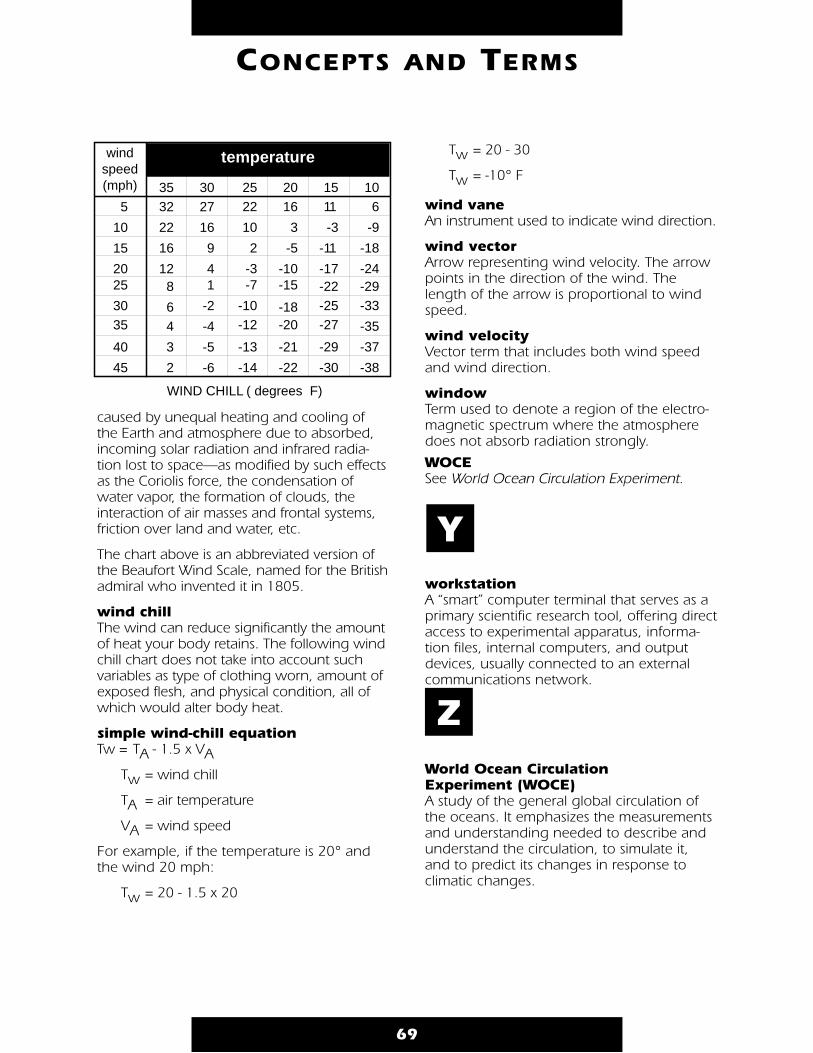
caused by unequal heating and cooling ofthe Earth and atmosphere due to absorbed,incoming solar radiation and infrared radia-tion lost to space—as modified by such effectsas the Coriolis force, the condensation ofwater vapor, the formation of clouds, theinteraction of air masses and frontal systems,friction over land and water, etc.
The chart above is an abbreviated version ofthe Beaufort Wind Scale, named for the Britishadmiral who invented it in 1805.
wind chill The wind can reduce significantly the amountof heat your body retains. The following windchill chart does not take into account suchvariables as type of clothing worn, amount ofexposed flesh, and physical condition, all ofwhich would alter body heat.
simple wind-chill equationTw = TA - 1.5 x VA
Tw = wind chill
TA = air temperature
VA = wind speed
For example, if the temperature is 20° andthe wind 20 mph:
Tw = 20 - 1.5 x 20
Tw = 20 - 30
Tw = -10° F
wind vane An instrument used to indicate wind direction.
wind vector Arrow representing wind velocity. The arrowpoints in the direction of the wind. Thelength of the arrow is proportional to windspeed.
wind velocity Vector term that includes both wind speedand wind direction.
window Term used to denote a region of the electro-magnetic spectrum where the atmospheredoes not absorb radiation strongly.
WOCE See World Ocean Circulation Experiment.
workstation A “smart” computer terminal that serves as aprimary scientific research tool, offering directaccess to experimental apparatus, informa-tion files, internal computers, and outputdevices, usually connected to an externalcommunications network.
World Ocean Circulation Experiment (WOCE) A study of the general global circulation ofthe oceans. It emphasizes the measurementsand understanding needed to describe andunderstand the circulation, to simulate it,and to predict its changes in response to climatic changes.
69
CONCEPTS AND TERMS
WIND CHILL ( degrees F)
windspeed(mph)
temperature
106
-9
-18
-24-29-33
-35
-37
-38
1511
-3
-11
-17-22-25-27
-29
-30
2522
10
2
-3-7
-10-12
-13
-14
2016
3
-5
-10-15
-18-20
-21
-22
3532
22
16
128
64
3
2
3027
16
9
41
-2
-4
-5
-6
5
10
15
2025
3035
40
45
Y
Z

70
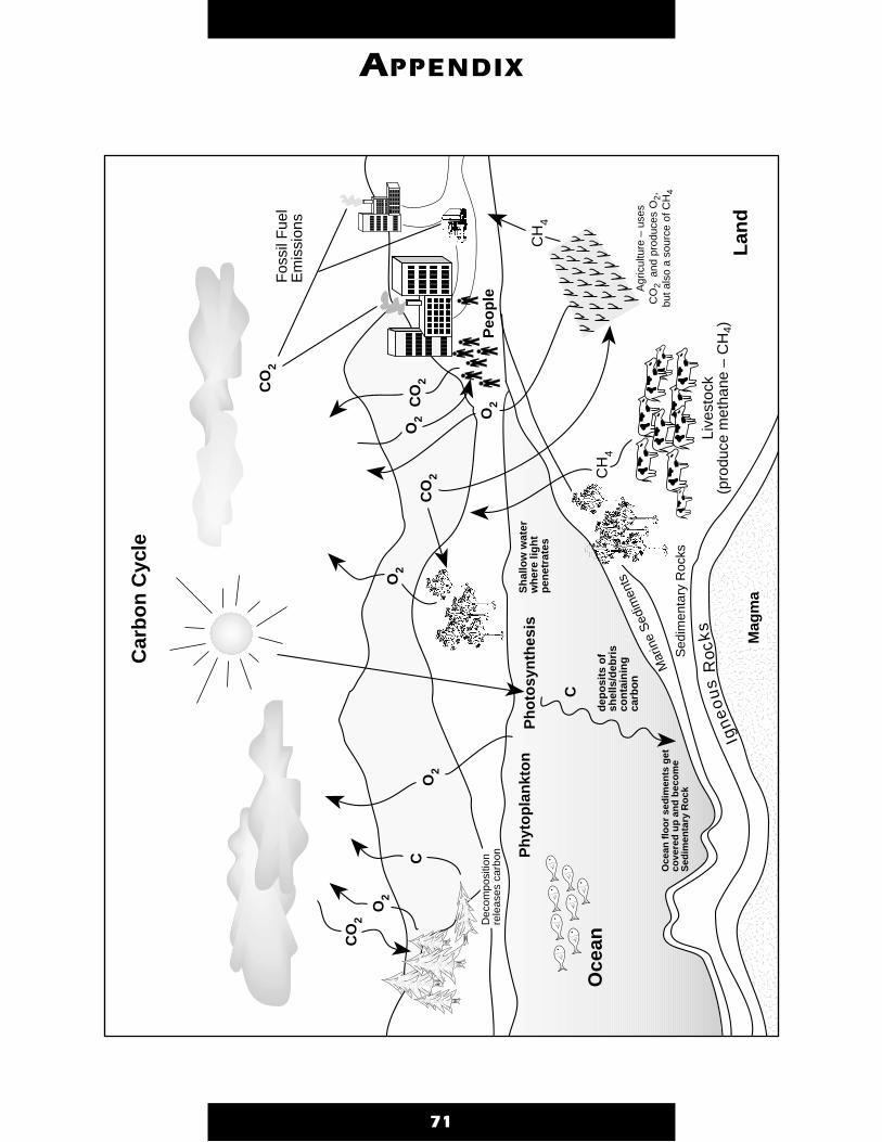
71
APPENDIX
aaaaaaaaaaaaaaaaaaaaaaaaaaaaaaaaaaaaaaaaaaaaaaaaaaaaaaaaaaaaaaaaaaaaaaaaaaaaaaaaaaaaaaaaaaaaaaaaaaaaaaaaaaaaaaaaaaaaaaaaa aa Igneous RocksSed
imen
tary
Roc
ksM
arin
e S
edim
ents
Ph
yto
pla
nkt
on
CO
2
CO
2
CH
4
Agr
icul
ture
– u
ses
CO
2 a
nd p
rodu
ces
O2,
bu
t als
o a
sour
ce o
f CH
4
Fos
sil F
uel
Em
issi
ons
O2
Ph
oto
syn
thes
is
Mag
ma
C
Live
stoc
k(p
rodu
ce m
etha
ne –
CH
4)
Oce
an f
loo
r se
dim
ents
get
co
vere
d u
p a
nd
bec
om
e S
edim
enta
ry R
ock
O2 aaa aa aa C C
O2
O2
O2
CO
2
O2
dep
osi
ts o
f sh
ells
/deb
ris
con
tain
ing
ca
rbo
n
Oce
an
Sh
allo
w w
ater
w
her
e lig
ht
pen
etra
tes
Peo
ple
Dec
ompo
sitio
n re
leas
es c
arbo
naa LandCH
4
Car
bo
n C
ycle

Aaron, Gregory C. The Weather Trackers Handbook. Philadelphia, Pennsylvania:Running Press, 1991.
Aeronautics and Space Report of the President, 1989-1990 Activities. Washington, DC:National Aeronautics and Space Administration, 1991
Ahrens, Donald C. Meteorology Today: An Introduction to Weather, Climate, and theEnvironment, Fourth edition. St. Paul, Minnesota: West Publishing Company, 1991.
Earth Science Education for the 21st Century. American Geological Institute.Alexandria, Virginia: National Center for Earth Science Education, 1991.
Angelo, Jr., Ph.D, Joseph A., and Irving W. Ginsberg, PhD., editors. Earth Observationsand Global Change Decision Making: 1990, A National Partnership: A Conference spon-sored by National Aeronautics and Space Administration, Environmental Research Instituteof Michigan. Volume 2, 1990. Malabar, Florida: Krieger Publishing Company, 1991.
Astro-1 Teachers Guide with Activities: Seeing in a New Light. Huntsville, Alabama:NASA Marshall Space Flight Center, January 1990.
ATLAS 1: Encountering Planet Earth. Huntsville, Alabama: NASA Marshall Space Flight Center.
Baker, James D. Planet Earth View from Space. Cambridge, Massachusetts andLondon, England: Harvard University Press, 1990.
Boyer, William. “Satellite Tracks El Niño.” Space News. March 8-14, 1993, pg. 11.
Earth Observing System (EOS) Glossary and List of Acronyms and Abbreviations. EOSProject Science Office. Greenbelt, Maryland: NASA Goddard Space Flight Center.
Earth System Monitor, Volume 3, No. 2. U.S. Department of Commerce, NOAA,December 1992.
Earth System Science, A Closer View. Report of the Earth System Sciences Committee,NASA Advisory Council. National Aeronautics and Space Administration, January 1988.
The Early Earth Observing System Reference Handbook Earth Science and ApplicationsDivision Missions 1990-1997. NASA Goddard Space Flight Center.
Educator’s Guide for Building and Operating Environmental Satellite Receiving Stations.U.S. Department of Commerce, National Oceanic and Atmospheric Administration,October 1991.
“Electromagnetic Spectrum Chart.” Science Scope, Volume 16, No. 6. March 1993.
EOS, A Mission To Planet Earth. National Aeronautics and Space Administration,February 1990.
EOS Reference Handbook. David Dokken, Editor. NASA Goddard Space Flight Center,May 1991, NP-144.
Forrester, Frank H. 1001 Questions Answered About the Weather. New York: DoverPublications, Inc., 1981.
Ganeri, Anita. The Usborne Book of Weather Facts. Oklahoma: EDC Publishing, 1987.
Gurney, R.J., J.L. Foster, and C.L. Parkinson, eds. Atlas of Satellite Observations Relatedto Global Change. Cambridge, New York and Melbourne: Press Syndicate of theUniversity of Cambridge, 1993.
Landsat. Earth Observation Satellite Company (EOSAT). Lanham, Maryland.
72
BIBLIOGRAPHY
LASA Lidar Atmospheric Sounder and Altimeter Earth Observing System InstrumentPanel Report. Vol IId. National Aeronautics and Space Administration, 1987.
The Living Ocean, SeaWiFS: Studying Ocean Color From Space, National Aeronauticsand Space Administration, EP–307, 1994.
Lye, Keith, and Shirley Carpenter, editors. Encyclopedia of World Geography. New York: Dorset Press, 1987.
NASA Earth Science and Applications Division: The Program and Plans for FY 1988-1989-1990. National Aeronautics and Space Administration, September 1988.
NASA Pocket Statistics. Published and distributed by the National Aeronautics and SpaceAdministration, January 1992.
National Aeronautics and Space Administration. National Aeronautics and SpaceAdministration, NP-111.
The National Space Science Data Center. NASA Goddard Space Flight Center. NSSDC88-26, January 1989.
NIMBUS-7 CZCS, Coastal Zone Color Scanner Imagery. Prepared for NASA GoddardSpace Flight Center by the Walter A. Bohan Company, 2026 Oakton Street, Park Ridge,Illinois, 60068.
Science and Technology Desk Reference. Gale Publishing, 1993.
Scientific Assessment of Climate Change The Policymakers’ Summary of the Report ofWorking Group I to the Intergovernmental Panel on Climate Change. WorldMeteorological Organization/United Nations Environment Programme. Geneva, 1990.
Sentinels in the Sky: Weather Satellites. National Aeronautics and Space Administration,National Oceanic and Atmospheric Administration, NF-152(s).
Space-Based Remote Sensing of the Earth: A Report to the Congress. NationalAeronautics and Space Administration, National Oceanic and AtmosphericAdministration, September 1987.
SPOT One Earth, One Environment. SPOT Image Corporation. Reston, Virginia.
TOGA Tropical Ocean Global Atmosphere Program. U.S. TOGA Project Office.Published by the Joint Climate Projects/Planning Office of the University Corporationfor Atmospheric Research.
Topex/Poseidon. The Oceans and Climate: A Global Approach. CNES, NASA, January1992 Edition.
UARS Upper Atmosphere Research Satellite. National Aeronautics and SpaceAdministration.
US Geological Survey: Earth Science in the Public Service. U.S. Department of theInterior/US Geological Survey. US Government Printing Office, 1991-291-351.
Walker, P. B. M., et al., eds. Cambridge Air and Space Dictionary. Cambridge:Cambridge University Press, 1990.
Weather. Irving, Texas: The Boy Scouts of America, 1992 Edition.
Webster’s New Universal Unabridged Dictionary. Second Deluxe Edition, 1983
Williams, Jack. The Weather Book. “USA TODAY.” Vintage Original, 1st edition, April 1992.
73
BIBLIOGRAPHY
74
IF YOU LIVE IN: Center Education Teacher Resource CenterProgram Officer
Alaska Nevada Mr. Garth A. Hull NASA Teacher Resource CenterArizona Oregon Chief, Educational Prog. Branch Mail Stop T12-ACalifornia Utah Mail Stop 204-12 NASA Ames Research CenterHawaii Washington NASA Ames Research Center Moffett Field, CA 94035-1000Idaho Wyoming Moffett Field, CA 94035-1000 PHONE: (415) 604-3574Montana PHONE: (415) 604-5543
Connecticut New Hampshire Mr. Richard Crone NASA Teacher Resource Lab.Delaware New Jersey Acting Chief, Educational Prog. Mail Code 130.3DC New York Public Affairs Office (130) NASA GSFCMaine Pennsylvania NASA GSFC Greenbelt, MD 20771-0001Maryland Rhode Island Greenbelt, MD 20771-0001 PHONE: (301) 286-8570Massachusetts Vermont PHONE: (301) 286-7206
Colorado North Dakota Dr. Robert W. Fitzmaurice NASA Teacher Resource RoomKansas Oklahoma Center Education Program Officer Mail Code AP-2Nebraska South Dakota Public Affairs Office (AP-2) NASA Johnson Space CenterNew Mexico Texas NASA Johnson Space Center Houston, TX 77058-3696
Houston, TX 77058-3696 PHONE: (713) 483-8696PHONE: (713) 483-1257
Florida Mr. Steve Dutczak NASA Educators Resource Lab.Georgia Chief, Education Services Branch Mail Code ERLPuerto Rico Mail Code PA-ESB NASA Kennedy Space CenterVirgin Islands NASA Kennedy Space Center Kennedy Space Center, FL
Kennedy Space Center, FL 32899-000132899-0001 PHONE: (407) 867-4090PHONE: (407) 867-4444
Kentucky Ms. Patricia Link NASA Teacher Resource CenterNorth Carolina Acting, Center Educ. Prog. Officer Virginia Air and SpaceSouth Carolina Mail Stop 400 600 Settler’s Landing RoadVirginia NASA Langley Research Center Hampton, VA 23669-4033West Virginia Hampton, VA 23681-0001 PHONE: (804) 727-0800 x 757
PHONE: (804) 864-8102
Illinois Minnesota Ms. Jo Ann Charleston NASA Teacher Resource CenterIndiana Ohio Acting Chief, Office of Educ. Prog. Mail Stop 8-1Michigan Wisconsin Mail Stop 7-4 NASA Lewis Research Center
NASA Lewis Research Center 21000 Brookpark Road21000 Brookpark Road Cleveland, OH 44135-3191Cleveland, OH 44135-3191 PHONE: (216) 433-2017PHONE: (216) 433-2957
GENERAL INFORMATION FORTEACHERS AND STUDENTS
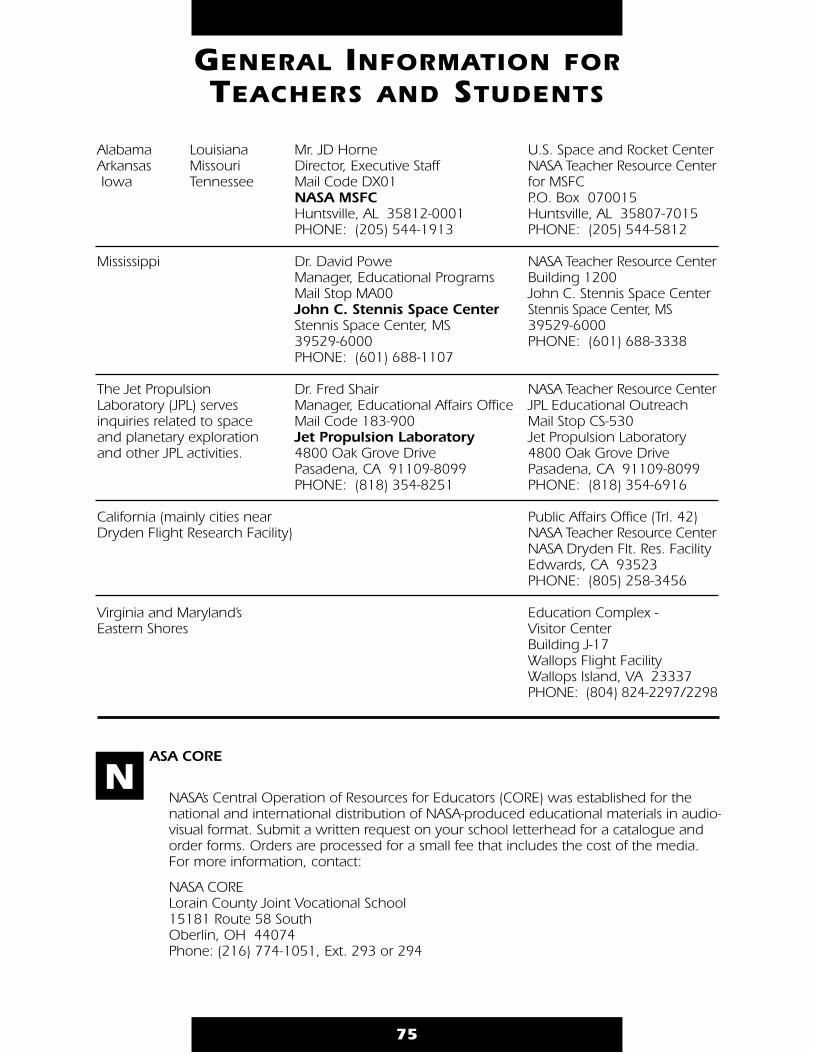
75
Alabama Louisiana Mr. JD Horne U.S. Space and Rocket CenterArkansas Missouri Director, Executive Staff NASA Teacher Resource CenterIowa Tennessee Mail Code DX01 for MSFC
NASA MSFC P.O. Box 070015Huntsville, AL 35812-0001 Huntsville, AL 35807-7015PHONE: (205) 544-1913 PHONE: (205) 544-5812
Mississippi Dr. David Powe NASA Teacher Resource CenterManager, Educational Programs Building 1200Mail Stop MA00 John C. Stennis Space CenterJohn C. Stennis Space Center Stennis Space Center, MSStennis Space Center, MS 39529-600039529-6000 PHONE: (601) 688-3338PHONE: (601) 688-1107
The Jet Propulsion Dr. Fred Shair NASA Teacher Resource CenterLaboratory (JPL) serves Manager, Educational Affairs Office JPL Educational Outreachinquiries related to space Mail Code 183-900 Mail Stop CS-530and planetary exploration Jet Propulsion Laboratory Jet Propulsion Laboratoryand other JPL activities. 4800 Oak Grove Drive 4800 Oak Grove Drive
Pasadena, CA 91109-8099 Pasadena, CA 91109-8099PHONE: (818) 354-8251 PHONE: (818) 354-6916
California (mainly cities near Public Affairs Office (Trl. 42)Dryden Flight Research Facility) NASA Teacher Resource Center
NASA Dryden Flt. Res. Facility Edwards, CA 93523PHONE: (805) 258-3456
Virginia and Maryland’s Education Complex - Eastern Shores Visitor Center
Building J-17Wallops Flight FacilityWallops Island, VA 23337PHONE: (804) 824-2297/2298
ASA CORE
NASA’s Central Operation of Resources for Educators (CORE) was established for thenational and international distribution of NASA-produced educational materials in audio-visual format. Submit a written request on your school letterhead for a catalogue andorder forms. Orders are processed for a small fee that includes the cost of the media. For more information, contact:
NASA CORELorain County Joint Vocational School15181 Route 58 SouthOberlin, OH 44074Phone: (216) 774-1051, Ext. 293 or 294
GENERAL INFORMATION FORTEACHERS AND STUDENTS
N
76
ASA Spacelink
NASA Spacelink is a computer information service that allows individuals to receivenews about current NASA programs, activities, and other space-related information,including historical and astronaut data, lesson plans, classroom activities, and evenentire publications. Although primarily intended as a resource for teachers, anyonewith a personal computer and a modem can access the network.
The Spacelink computer access number is (205) 895-0028. Users need a computer,modem, communications software, and a long-distance telephone line to accessSpacelink. It is also available through the Internet, a worldwide computer network con-necting a large number of educational institutions and research facilities. Callers withInternet access may reach NASA Spacelink at any of the following addresses:
spacelink.msfc.nasa.gov.xsl.msfc.nasa.gov.192.149.89.61(The data word format for direct and Internet access is 8 bits, no parity, and 1 stop bit.)
For more information, contact:Spacelink AdministratorNASA Marshall Space Flight CenterMail Code CA21Huntsville, AL 35812-0001 Phone: (205) 544-6360
ducation Satellite Videoconference Series
The Education Satellite Videoconference Series for Teachers is offered as an inserviceeducation program for educators through the school year. The content of each pro-gram varies, but includes aeronautics or space science topics of interest to elementaryand secondary teachers. NASA program managers, scientists, astronauts, and educa-tion specialists are featured presenters. The videoconference series is free to registerededucational institutions. To participate, the institution must have a C-band satellitereceiving system, teacher release time, and an optional long distance telephone line forinteraction. Arrangements may also be made to receive the satellite signal through thelocal cable television system. The programs may be videotaped and copied for later use.
For more information, contact:Videoconference CoordinatorNASA Teaching From Space ProgramOklahoma State University300 North CordellStillwater, OK 74078-0422
GENERAL INFORMATION FORTEACHERS AND STUDENTS
N
E


M T P E
MISSION TO PLANET EARTHEP–302


