Självständigt arbete Nr 86 Map analysis of Fogo, Cape Verde Map analysis of Fogo, Cape Verde Olle Risby & Björn Sandback Olle Risby & Björn Sandback Uppsala universitet, Institutionen för geovetenskaper Kandidatexamen i Geovetenskap, 180 hp Självständigt arbete i geovetenskap, 15 hp Tryckt hos Institutionen för geovetenskaper Geotryckeriet, Uppsala universitet, Uppsala, 2014. This bachelor thesis has been produced as a project preparation for an MFS project during the autumn of 2014 on Fogo, Cape Verde. The long term aim for the MFS project is to conduct a geological survey on Fogo, gather geological information and assess the magma storage depth for future geothermal applications. Understanding the mechanisms of ocean island volcanism, magma feeding behavior and requirements for geothermal energy is essential for the future survey. Previous geological surveys done on Fogo are few in numbers and are primarily focused on slope stability, volcanic features or geophysical surveys, focusing on mantle plume depth. By describing rock samples from Fogo and understanding what environment the rock samples have formed in, a more accurate description of the volcanism at present can be produced. For this project we described 11 rock samples and 9 thin sections from Fogo, in terms of the samples; mineralogical composition, colour, structure, texture, matrix, phenocrysts and alteration features. By merging the rock descriptions with a previously produced geological map, we produced two digital maps with geological information. One displays Fogo on a larger scale with correlated localities of representative rock samples. The maps will be used during the field work during 2014 when additional implementations to the maps will be made.
Transcript
Självständigt arbete Nr 86
Map analysis of Fogo, Cape Verde
Map analysis of Fogo, Cape Verde
Olle Risby & Björn Sandback
Olle Risby & Björn Sandback
Uppsala universitet, Institutionen för geovetenskaperKandidatexamen i Geovetenskap, 180 hpSjälvständigt arbete i geovetenskap, 15 hpTryckt hos Institutionen för geovetenskaper Geotryckeriet, Uppsala universitet, Uppsala, 2014.
This bachelor thesis has been produced as a project preparation for an MFS project during the autumn of 2014 on Fogo, Cape Verde. The long term aim for the MFS project is to conduct a geological survey on Fogo, gather geological information and assess the magma storage depth for future geothermal applications. Understanding the mechanisms of ocean island volcanism, magma feeding behavior and requirements for geothermal energy is essential for the future survey. Previous geological surveys done on Fogo are few in numbers and are primarily focused on slope stability, volcanic features or geophysical surveys, focusing on mantle plume depth. By describing rock samples from Fogo and understanding what environment the rock samples have formed in, a more accurate description of the volcanism at present can be produced. For this project we described 11 rock samples and 9 thin sections from Fogo, in terms of the samples; mineralogical composition, colour, structure, texture, matrix, phenocrysts and alteration features. By merging the rock descriptions with a previously produced geological map, we produced two digital maps with geological information. One displays Fogo on a larger scale with correlated localities of representative rock samples. The maps will be used during the field work during 2014 when additional implementations to the maps will be made.
Självständigt arbete Nr 86
Map analysis of Fogo, Cape Verde
Olle Risby & Björn Sandback
Sammanfattning Detta kandidatarbete har producerats som ett förberedande projekt inför ett MFS-
projekt som kommer att genomföras på ön Fogo, Kap Verde hösten 2014. Det
långsiktiga målet för MFS-projektet är att utföra en geologisk kartering på Fogo med
syfte att samla geologisk information för att uppskatta magmans lagringsdjup med
framtida geotermala applikationer. Den framtida studien kräver stor kunskap inom
mekanismer bakom vulkaniska öars aktivitet, magma-lagringssystem samt kriterierna
för geotermal energi. Tidigare geologiska studier på Fogo är begränsade i antal och
fokuserar främst på skredrisk, vulkaniska strukturer eller geofysiska undersökningar,
inriktade mot bestämning av mantelplymens djup. Genom att beskriva stenstuffer
från Fogo samt att förstå deras bildningsmiljö, kan en mer detaljerad beskrivning utav
den rådande vulkanismen produceras. För detta projekt har vi kategoriserat 11
stenstuffer och nio tunnslip från Fogo och tolka dessa efter; mineralsammansättning,
färg, struktur, textur, matrix, kristaller samt omvandlingstendenser. Genom att
sammanfoga granskade stenar med en tidigare producerade karta över området, har
vi blir producerat två digitala kartor med geologisk information. En karta visar Fogo
på en större skala, med lokaler och korrelerade granskade stenar. Kartorna kommer
att användas under fältarbetet 2014 och vidareutvecklas som en geologisk karta.
Abstract This bachelor thesis has been produced as a project preparation for an MFS project during the autumn of 2014 on Fogo, Cape Verde. The long term aim for the MFS project is to conduct a geological survey on Fogo, gather geological information and assess the magma storage depth for future geothermal applications. Understanding the mechanisms of ocean island volcanism, magma feeding behavior and requirements for geothermal energy is essential for the future survey. Previous geological surveys done on Fogo are few in numbers and are primarily focused on slope stability, volcanic features or geophysical surveys, focusing on mantle plume depth. By describing rock samples from Fogo and understanding what environment the rock samples have formed in, a more accurate description of the volcanism at present can be produced. For this project we described 11 rock samples and 9 thin sections from Fogo, in terms of the samples; mineralogical composition, colour, structure, texture, matrix, phenocrysts and alteration features. By merging the rock descriptions with a previously produced geological map, we produced two digital maps with geological information. One displays Fogo on a larger scale with correlated localities of representative rock samples. The maps will be used during the field work during 2014 when additional implementations to the maps will be made.
Preface
This project has been produced for the purpose as a learning exercise in preparation for a Minor Field Study on Fogo, Cape Verde during the autumn of 2014.
Key words Ocean Island, Cape Verde, Fogo, volcanism, geological map, geothermal energy, lithology
Table of content
Chapter 1 – Introduction 1
1.1 Purpose of this bachelor project 1
1.2 Cape Verde 1
Chapter 2 – Background 2
2.1 Volcanism 2
2.2 Geological background 3
2.3 Potential of geothermal energy 5
Chapter 3 – Method 6
3.1 Rock description 6
3.2 Thin section study 7
3.3 Production of the geological map of Fogo 8
Chapter 4 – Results 8
4.1 – Rock description 8
4.2 – Thin section study 10
4.3 – Geological maps of Fogo 14
Chapter 5 – Discussion 16
5.1 Purpose 16
5.2 Rock sample location 16
5.3 Geothermal energy 17
5.4 Our project compared to previous surveys 17
5.5 Conclusion and continuation of the project 18
Acknowledgements 18
Referenses: 19
Appendix 22
Appendix 1 – Volcanic rock dictionary: 22
Appendix 2 – Rock sample photos: 25
1
Chapter 1 – Introduction
1.1 Purpose of this bachelor project The aim of the thesis is the production of a geological map of Fogo. The map will contain representative information about lithology, important geological structures and features. The project is tailored to increase our knowledge of the geological background of Fogo, Cape Verde along with the possibility to study representative rock samples from the region. During the autumn of 2014, the two authors of the project will travel to the area to conduct an eight week field study on Fogo with a SIDA scholarship funding. Geological surveys done on the Cape Verde are few in comparison to other volcanic islands and the recently magmatically and seismically active areas are the islands of Fogo, Brava and the Cadamosto seamount, all situated to the southwest. The aim of the field study is to try and investigate the volcanic structure and magma storage on Fogo. A shallow magma storage depth beneath Fogo could make the island a potential candidate for geothermal energy.
1.2 Cape Verde
Figure 1, Cape Verde, Fiedler,B et al.
Cape Verde is an archipelago located 800 km west of the African continent, shown in figure 1, and it consists in the Atlantic Ocean. As a former Portuguese colony the country became independent in 1975 (Encyclopaedia Britannica Online 2014, Cape Verde) and has therefore large influences from the former occupant, such as spoken language and cultural heritage (Encyclopaedia Britannica Online 2014, Cape Verde). The ethnicity of the population is mixed of European and African ancestry. Situated close to the equator, Cape Verde´s climate is hot and affected by the changing pattern of the intertropical convergence zone (ITCZ) which changes the precipitation patterns for
2
the region. Seasonal draughts are common which affects vegetation, agricultural possibilities and drinking water quantity and quality. Cape Verde is classified as a developing economy by the International Monetary Fund, and the main sources of income are trade, fishing, transport and tourism. A large portion of the population is not self-proficient with food production, therefore a large amount of food is imported, resulting in a heavy strain on the national economy (Encyclopaedia Britannica Online 2014, Cape Verde). Therefore an addition of cheap renewable energy for the developing nation could be a large contribution.
Chapter 2 – Background
2.1 Volcanism V c m E ’ c y g the boundaries of geological plates. Different types of plates, plate-movements and plate-boundary types produce different types of volcanism. The most common type of volcanism is subduction related volcanism, illustrated in figure 2. The cold, heavier oceanic plate is being subducted beneath a continental plate. At increased depth, the oceanic plate begins to melt, due to increased geothermal gradient, volatile content (water presence) which produces magma within the continental plate, producing volcanism on the continent. At mid-oceanic ridges (MOR), another type of volcanism is present. Within a central rift, new oceanic crust is produced, pushing the oceanic plates on either MOR’ p P m m , y m c m c n composition, has reached the ocean floor, ascending from the upper mantle. The movement of the plates is produced by the convection and heat from within the earth.
Figure 2, Plate subduction, Encyclopaedia Britannica
A third type is intraplate volcanism. Intraplate volcanism occurs when a large, magmatic plume (hot magmatic body) is situated below the plate and producing magma through decompression melting. The magmatic plume rises from the mantle due to a density contrast to the surrounding rock. Intra-plate volcanism or “ p ” p c c c , Y w c , which is one of the largest calderas in the world. The mantle plume is generally stationary whilst the plate will move at a constant rate, capable of producing large scale plains/plateaus and other volcanic structures, depending on the time, size of volcanic activity and plate movement. The end product of intra-plate volcanism in
3
oceanic settings is a long chain of volcanic islands; the best example is the Emperor Chain and later Hawaii which together extend for over 2000 km in the Pacific Ocean
Intra-plate volcanism in oceanic setting is more abundant, examples being, Hawaii, the Canaries, Galapagos and La reunion. Volcanic islands undergo different phases of evolution and activity (Encyclopaedia Britannica Online 2014, atoll). First a seamount is produced, then the island emerges above sea level and a shield volcano-structure is present. After a while the magma composition changes from mafic composition (low silica-content) to a more mature intermediate or felsic (increased silica-content) composition. The following stage is the formation of a composite cone or stratovolcano. Later on volcanic activity usually decreases and eventually ceases to exist. Erosional processes affect the island, eventually submerging the island, illustrated by figure 3. The island submerges back to the seamount stage. In tropical climates, the now submerged island-remains can take on several different shapes, depending on biological activity, wave-based erosion producing structures such as atolls, guyots and reefs (Encyclopaedia Britannica Online 2014, atoll).
Figure 3, volcanic island stages, Encyclopaedia Britannica
2.2 Geological background The first hotspot activity of the Cape Verde island-chain occurred around 20 Ma ago, during mid-Cenozoic (McNutt 1988; De Paepe et al. 1974). The island-chain is shaped as a horseshoe, ranging in age, oldest to the east and younging to the west, shape shown in fig. 4. The southern chain of the archipelago is called Sotavento (windward), whereas the northern islands are called Barlavento (leeward).The southern island group of Cape Verde is characterized by highly alkaline mafic composition (Day et al.1999) whereas the northern islands have a lower rate of alkalinity with intermediate to mafic composition (Barker et al. 2011).
4
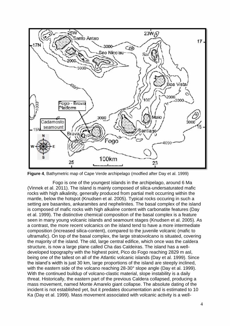
Figure 4, Bathymetric map of Cape Verde archipelago (modfied after Day et al. 1999)
Fogo is one of the youngest islands in the archipelago, around 6 Ma (Vinnek et al. 2011). The island is mainly composed of silica-undersaturated mafic rocks with high alkalinity, generally produced from partial melt occurring within the mantle, below the hotspot (Knudsen et al. 2005). Typical rocks occuring in such a setting are basanites, ankaramites and nephelinites. The basal complex of the island is composed of mafic rocks with high alkaline content with carbonatite features (Day et al. 1999). The distinctive chemical composition of the basal complex is a feature seen in many young volcanic islands and seamount stages (Knudsen et al. 2005). As a contrast, the more recent volcanics on the island tend to have a more intermediate composition (increased silica-content), compared to the juvenile volcanic (mafic to ultramafic). On top of the basal complex, the large stratovolcano is situated, covering the majority of the island. The old, large central edifice, which once was the caldera structure, is now a large plane called Cha das Caldeiras. The island has a well-developed topography with the highest point, Pico do Fogo reaching 2829 m asl, being one of the tallest on all of the Atlantic volcanic islands (Day et al. 1999). Since ’ w j 30 km, arge proportions of the island are steeply inclined, with the eastern side of the volcano reaching 28-30° slope angle (Day et al. 1999). With the continued buildup of volcano-clastic material, slope instability is a daily threat. Historically, the eastern part of the previous Caldera collapsed, producing a mass movement, named Monte Amarelo giant collapse. The absolute dating of the incident is not established yet, but it predates documentation and is estimated to 10 Ka (Day et al. 1999). Mass movement associated with volcanic activity is a well-
5
documented field, especially for the Canary Islands, by e.g. Caracedo (1994 & 1999) and Elsworth & Day (1999). The large collapse has produced vast amounts of sediment deposition on the eastern flank as well as large scale submarine debris further out. Another significant feature on the higher altitudes of Fogo is the Bordeira cliffs and escarpment. This is the remaining western section from the Caldera and collapse-structure which separates the western slope from the Cha das Calderias (plane of craters). The Bordeira escarpment is around 800-900 meters high, 9km long and almost vertical in certain parts (Day, 1999). Debate is still ongoing about the genesis of the Bordeira and Cha das Caldeiras, whether if solely the Monte Amarelo giant collapse is responsible or if the structures are the products of several collapse sequences (Day et al. 1999).
Within the Cha das Caldeiras, Pico de Fogo is situated. Pico de Fogo is the large volcanic edifice which is the highest point on the island. Within Cha das Caldeiras post-fissure structures, a large amount of lateral dikes, fumarole fields and several smaller scoria cones can be observed. Pico de Fogo and most of the rocks within the Cha das Calderias belong to the post-collapse sequence (Day et al, 1999). Fogo has a well recorded eruption history, with transcriptions from as early as the 15th century, since the Portuguese colonization. Eruptions from 15th to the 18th century primarily focused on the building up of Pico de Fogo, whilst after, during the 18th century, sudden changes in the volcanism occurred, both in location and style (Day et al. 1999). Tendencies of north-south aligning fissure eruptions, dyke propagation along the same direction and flank eruptions indicate rift zone volcanism. The two most recent volcanic events of Fogo occurred 1951 and 1995. Both eruptions were fissure eruptions located in the west/southwestern part of Cha das Caldeiras (Day et al. 1999).
2.3 Potential of geothermal energy On several locations in the world today, geothermal energy is harnessed for production of electricity or heating of water through different methods. All methods generate from the harnessing the vast heat and energy source that is produced in the E ’ D c v c y p c cc E ’ c , generally from decay of potassium, thorium and uranium-isotopes(Encyclopaedia Britannica Online (2014), Geothermal energy) where elements with a certain half-life decay, release energy and producing heating of the core of the Earth. The heat of the molten rock surrounding the core transports energy and heats the upper layers of the Earth, through convection and thermal conduction (Gupta & Roy 2007). The heat circulation through convection and conduction are two of the key processes sustaining plate tectonics which is substantial for life on Earth.
Geothermal energy has been used to some extent for over 100 years (Gupta & Roy 2007). Today, the methods used for geothermal energy can primarily be categorized into two groups:
Warm water heating
Production of electricity The applications for direct use, heating/cooling using the heat stored in the bedrock, is primarily used in countries situated in cold climates and with a low geothermal gradient, such as Scandinavia. The old, relatively cold, shield areas, such as Sweden, do not possess the necessary geothermal gradient to produce electricity; therefore direct use is more suitable. The secondary category focuses on the production of electricity through geothermal energy where the geothermal gradient is significantly larger. Areas as such are often situated on plate boundaries or hot-spot
6
setting, where volcanism occurs. Electrical production can be subdivided into five different types of methods depending on the geological setting. The controlling parameters for the subgroup are: the geothermal gradient, host rock, cap rock, distance to source, geothermal fluids, and environmental factors such as precipitation/evaporation (Gupta & Roy 2007).
Vapor dominated geothermal field Reykjavik, Iceland
Hot water geothermal systems Salton sea, USA
Hot dry rock (HDR) geothermal systems Soultz-sous-foréts, France
Magma The first three methods of harnessing electricity are being used today, whilst the two latter methods are still under development. Several technical issues must first be resolved before the methods can be put to use and economically sustainable (Gupta & Roy 2007).
Chapter 3 – Method
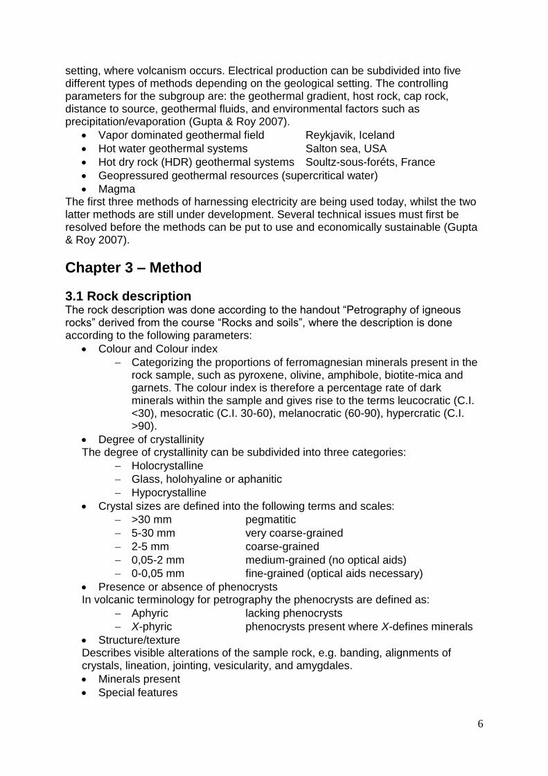
3.1 Rock description ck c p w cc “P p y ck ” v m c “R ck ”, w c p according to the following parameters:
Colour and Colour index
Categorizing the proportions of ferromagnesian minerals present in the rock sample, such as pyroxene, olivine, amphibole, biotite-mica and garnets. The colour index is therefore a percentage rate of dark minerals within the sample and gives rise to the terms leucocratic (C.I. <30), mesocratic (C.I. 30-60), melanocratic (60-90), hypercratic (C.I. >90).
Degree of crystallinity The degree of crystallinity can be subdivided into three categories:
Holocrystalline
Glass, holohyaline or aphanitic
Hypocrystalline
Crystal sizes are defined into the following terms and scales:
>30 mm pegmatitic
5-30 mm very coarse-grained
2-5 mm coarse-grained
0,05-2 mm medium-grained (no optical aids)
0-0,05 mm fine-grained (optical aids necessary)
Presence or absence of phenocrysts In volcanic terminology for petrography the phenocrysts are defined as:
Aphyric lacking phenocrysts
X-phyric phenocrysts present where X-defines minerals
Structure/texture Describes visible alterations of the sample rock, e.g. banding, alignments of crystals, lineation, jointing, vesicularity, and amygdales.
Minerals present
Special features
7
Description of secondary minerals, magnetic features, fossilization or alterations.
Summary A written summary of the sample describing the above mentioned parameters.
3.2 Thin section study The petrological study has been conducted by using a microscopy, with polarized light. The thin sections are cut out from the sample rock using specialized cutting tools and afterwards glued onto a thin glass lens. Judging from the minerals optical features in the microscope; birefringences, relief, pleichroism, crystal shape, angle of extinction and cleavage the different mineral have been distinguished. A simplified version of a microscopy with polarizing light can be seen below in figure 5. Different abbreviations used in the thin section study may be: XPL – crossed polarized light, PPL – Plane polarized light or PL – Plane light.
The different samples have been described as according to:
Matrix composition/fabric
Amount of phenocrysts percentage of thin section
Minerals present
Mineral sizes
Mineral colours
Mineral percentage of phenocrysts content
Figure 5, Microscope using polarizing light, modified from Bristol University 2014.
8
3.3 Production of the geological map of Fogo The production of the geological map has been done primarily by scanning an A0-sized map (Torr , 998) F ’ -east corner at SGU (Swedish Geological Survey), using a large scanner and printer. The map is a highly detailed geological map, focusing on historical lava-flows and formations. The digitalized map was stored as a TIFF-file and incorporated into a global information system, ArcGIS. The scanned map was georeferenced, and given a coordinate system (UTM zone 26 WGS 84). A satellite image of Fogo was downloaded using a program called GeoMapApp, with the same coordinate system the two images were compatible. Using various tools in ArcMap the satellite image was overlain with the scanned map, cut and adjusted to fit. Using polygon shapefiles, created in ArcCatalog, the historical lava-flows were traced to create polygons. The polygons were given an ID representative to the year of the eruption. Information on lithology, geological features and structures in each of the polygons will be added later, when the two authors examine the areas in the field.
Chapter 4 – Results
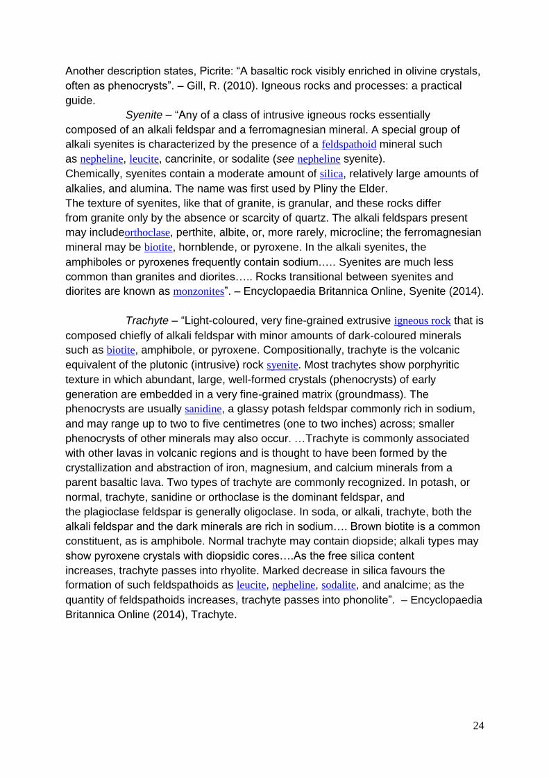
4.1 – Rock description The studied rock specimens originated from Fogo Island and Cadamosto seamount which is situated on the western seaboard of Fogo. Rock- sample from 11 different locations were examined. The rock description results only focus on the summary of each rock-set. For a description of the rock names, see appendix 1 – volcanic rock dictionary. For further pictures of rock samples, see appendix 2 – rock sample photos. Rock sample 1, ID: F605-26-OL2 Dark grey melanocratic (C.I. 85), holocrystalline, medium to coarse grained porphyric rock, consisting of phenocrysts of clinopyroxene (25% of total rock, 0.5-4 mm, black with 8-sided prismatic crystals), olivine (5%, 0.5-2 mm, yellowish/green), anortite (3%, 0.05-0.5 mm, white) in a fine-grained mafic, grey matrix. Identification: Clinopyroxene and olivine-phyric basanite.
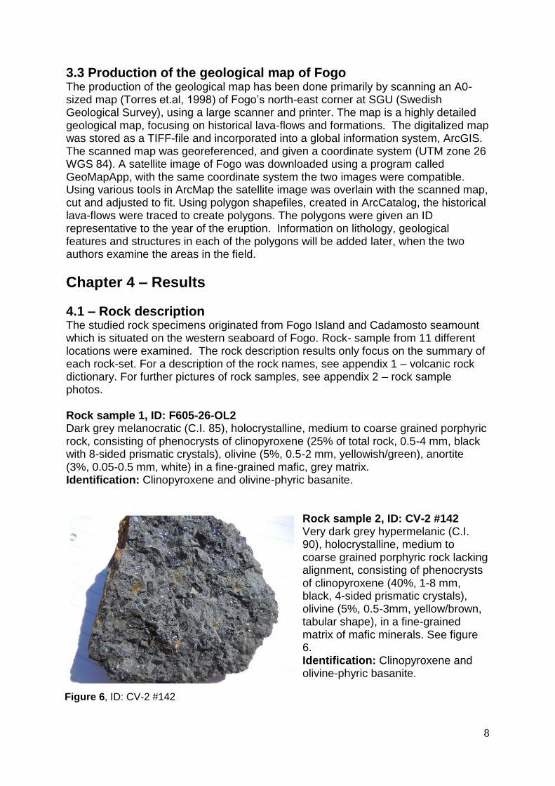
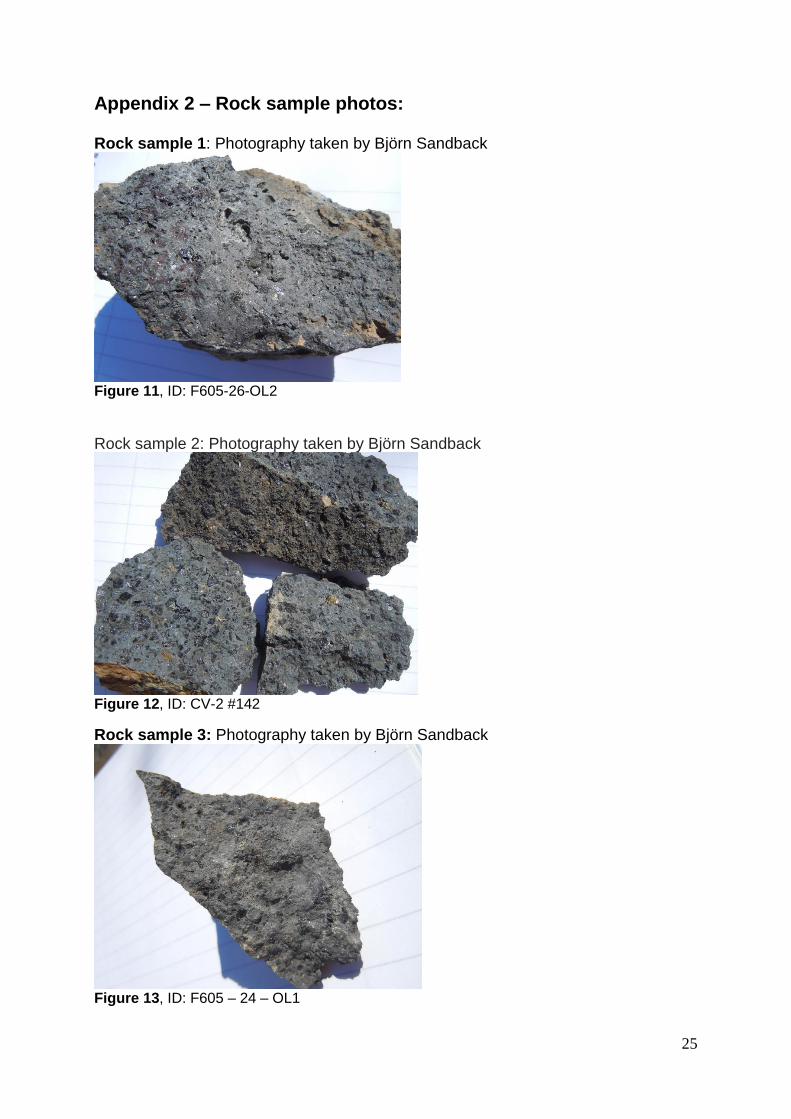
Rock sample 2, ID: CV-2 #142 Very dark grey hypermelanic (C.I. 90), holocrystalline, medium to coarse grained porphyric rock lacking alignment, consisting of phenocrysts of clinopyroxene (40%, 1-8 mm, black, 4-sided prismatic crystals), olivine (5%, 0.5-3mm, yellow/brown, tabular shape), in a fine-grained matrix of mafic minerals. See figure 6. Identification: Clinopyroxene and olivine-phyric basanite.
Figure 6, ID: CV-2 #142
9
Rock sample 3, ID: F605 – 24 – OL1 Dark grey melanocratic (C.I. 60), holocrystalline, medium to coarse-grained porphyric rock, containing phenocrysts of augite (20%, 0.05-5mm, black, 4-sided prismatic crystals), olivine (5%, 0.5-2mm, yellow, tabular shape), Unidentified mineral (1%, 0.05-0.5mm, turquoise-blue, requires thin-section study), phenocrysts randomly oriented within a mafic fine-grained matrix. Identification: Augite and olivine-phyric basanite (grading into tephrite). Rock sample 4, ID: F605 – 18 –AB4 Grey/light brown estimated mesocratic (C.I. 50), aphanitic rock containing gas vesicles ranging from 0.5-2mm throughout the sample without alignment. Identification: Scoria of intermediate/mafic composition.
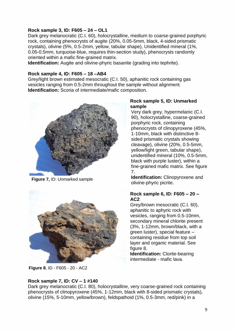
Rock sample 5, ID: Unmarked sample Very dark grey, hypermelanic (C.I. 90), holocrystalline, coarse-grained porphyric rock, containing phenocrysts of clinopyroxene (45%, 1-10mm, black with distinctive 8-sided prismatic crystals showing cleavage), olivine (20%, 0.5-5mm, yellow/light green, tabular shape), unidentified mineral (10%, 0.5-5mm, black with purple luster), within a fine-grained mafic matrix. See figure 7. Identification: Clinopyroxene and olivine-phyric picrite.
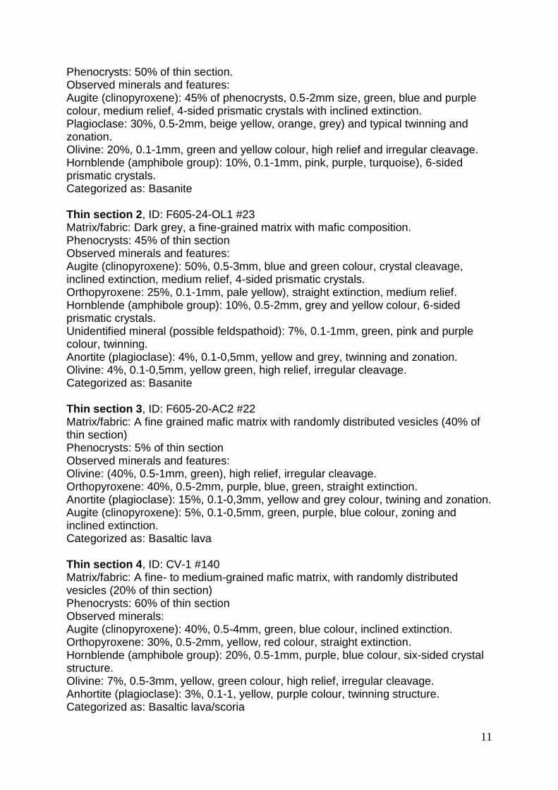
Rock sample 6, ID: F605 – 20 – AC2 Grey/brown mesocratic (C.I. 60), aphanitic to aphyric rock with vesicles, ranging from 0.5-10mm, secondary mineral chlorite present (3%, 1-12mm, brown/black, with a green luster), special feature – containing residue from top soil layer and organic material. See figure 8. Identification: Clorite-bearing intermediate - mafic lava.
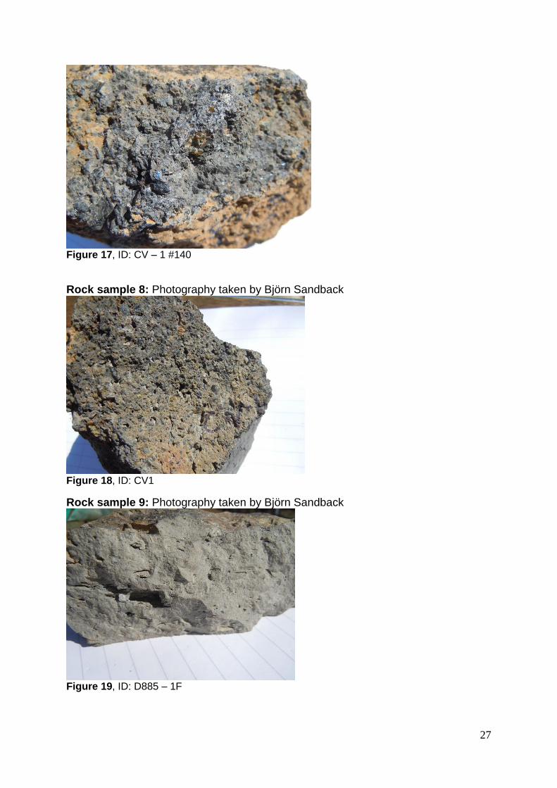
Rock sample 7, ID: CV – 1 #140 Dark grey melanocratic (C.I. 80), holocrystalline, very coarse-grained rock containing phenocrysts of clinopyroxene (45%, 1-12mm, black with 8-sided prismatic crystals), olivine (15%, 5-10mm, yellow/brown), feldspathoid (1%, 0.5-3mm, red/pink) in a
Figure 7, ID: Unmarked sample
Figure 8, ID - F605 - 20 - AC2
10
medium-grained mafic matrix. Special feature: sample exhibits weak magnetic attraction. Identification: Clinopyroxene and olivine-bearing picrite. Rock sample 8, ID: CV1 Dark grey melanocratic (C.I. 75), holocrystalline, medium to coarse-grained rock containing randomly aligned phenocrysts of clinopyroxene (30%, 0.5-5mm, black with 8-sided prismatic crystals), olivine (25%, 0.5-7mm, green with a tabular shape), anortite (10%, 2-7mm, white with a distinctive parallel twinning), feldspathoid (3%, 0.5-3mm, red) in a mafic matrix. Special feature: secondary clay minerals present and sample displays weak magnetic attraction. Identification: Clinopyroxene and olivine-phyric picrite. Rock sample 9, ID: D885 – 1F Light grey mesocratic (C.I. 30), holocrystalline, medium-grained rock with aligned vesicles containing phenocrysts of clinopyroxene (15%, 0.05-2mm, black with 8-sided prismatic crystals), plagioclase (15%, 0.05-2mm, white twinned structure), calcite (7%, 0.05-2mm, milky-white, reaction with HCL), olivine (3%, 0 – 0.05mm, green with tabular shape), embedded in a fine-grained matrix. Special feature – Additional secondary mineral calcite within aligned vesicules. Identification: Clinopyroxene, calcite and plagioclase-phyric phonolite lava. Rock sample 10, ID: D885/1B F Light grey mesocratic (C.I. 40), holocrystalline, fine to medium-grained porphyric rock, containing clinopyroxene (30%, 0.05-2mm, black with 8-sided prismatic crystals), plagioclase (35%,0-2mm, white, parallel twinning), amphibole (5%, 0.05-1mm, black with 6-sided prismatic crystals), within a fine-grained mafic matrix. Special feature: vesicles coated by secondary mineral calcite. Identification: Clinopyroxene and plagioclase-phyric phonolite.
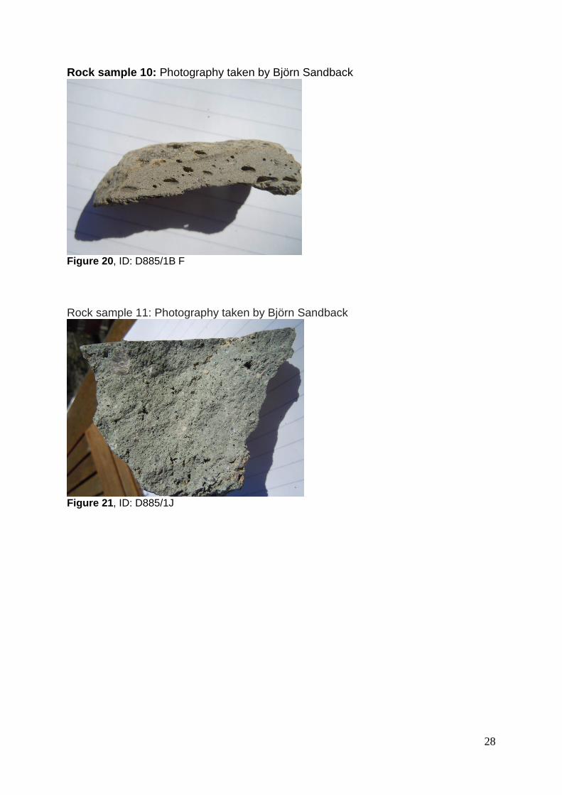
Rock sample 11, ID: D885/1J Light green/grey mesocratic (C.I. 45), holocrystalline, medium-grained rock containing phenocrysts of augite (40%, 0.05-2mm, black with 4-sided prismatic crystals), plagioclase (30%, 0.05-12mm, grey/white, parallel twinning), feldspathoid (5%, 0.05-1mm, red/rust), biotite (3%, 0.05-1mm, black with thin tabular crystals), within a fine-grained mafic matrix. Special feature: secondary mineral calcite present. See figure 9. Identification: Augite and plagioclase-phyric phonolite.
4.2 – Thin section study Thin section 1, ID: F605-26-0L2 Matrix/fabric: dark grey,fine-grained matrix with mafic composition
Figure 9, ID - D885/1J
11
Phenocrysts: 50% of thin section. Observed minerals and features: Augite (clinopyroxene): 45% of phenocrysts, 0.5-2mm size, green, blue and purple colour, medium relief, 4-sided prismatic crystals with inclined extinction. Plagioclase: 30%, 0.5-2mm, beige yellow, orange, grey) and typical twinning and zonation. Olivine: 20%, 0.1-1mm, green and yellow colour, high relief and irregular cleavage. Hornblende (amphibole group): 10%, 0.1-1mm, pink, purple, turquoise), 6-sided prismatic crystals. Categorized as: Basanite Thin section 2, ID: F605-24-OL1 #23 Matrix/fabric: Dark grey, a fine-grained matrix with mafic composition. Phenocrysts: 45% of thin section Observed minerals and features: Augite (clinopyroxene): 50%, 0.5-3mm, blue and green colour, crystal cleavage, inclined extinction, medium relief, 4-sided prismatic crystals. Orthopyroxene: 25%, 0.1-1mm, pale yellow), straight extinction, medium relief. Hornblende (amphibole group): 10%, 0.5-2mm, grey and yellow colour, 6-sided prismatic crystals. Unidentified mineral (possible feldspathoid): 7%, 0.1-1mm, green, pink and purple colour, twinning. Anortite (plagioclase): 4%, 0.1-0,5mm, yellow and grey, twinning and zonation. Olivine: 4%, 0.1-0,5mm, yellow green, high relief, irregular cleavage. Categorized as: Basanite Thin section 3, ID: F605-20-AC2 #22 Matrix/fabric: A fine grained mafic matrix with randomly distributed vesicles (40% of thin section) Phenocrysts: 5% of thin section Observed minerals and features: Olivine: (40%, 0.5-1mm, green), high relief, irregular cleavage. Orthopyroxene: 40%, 0.5-2mm, purple, blue, green, straight extinction. Anortite (plagioclase): 15%, 0.1-0,3mm, yellow and grey colour, twining and zonation. Augite (clinopyroxene): 5%, 0.1-0,5mm, green, purple, blue colour, zoning and inclined extinction. Categorized as: Basaltic lava Thin section 4, ID: CV-1 #140 Matrix/fabric: A fine- to medium-grained mafic matrix, with randomly distributed vesicles (20% of thin section) Phenocrysts: 60% of thin section Observed minerals: Augite (clinopyroxene): 40%, 0.5-4mm, green, blue colour, inclined extinction. Orthopyroxene: 30%, 0.5-2mm, yellow, red colour, straight extinction. Hornblende (amphibole group): 20%, 0.5-1mm, purple, blue colour, six-sided crystal structure. Olivine: 7%, 0.5-3mm, yellow, green colour, high relief, irregular cleavage. Anhortite (plagioclase): 3%, 0.1-1, yellow, purple colour, twinning structure. Categorized as: Basaltic lava/scoria
12
Thin section 5, ID: F605-18-AB4 #21 Matrix/fabric: A fine-grained mafic matrix, with semi-aligned vesicles, 50% of thin section and sizing 0.1-5mm Phenocrysts: 25% of thin section. Observed minerals: Augite (clinopyroxene): 45%, 0.5-3mm, red/purple colour, inclined extinction, moderate to high relief. Orthopyroxene: 45%, 0.5-2mm, yellow and orange colour, straight extinction, medium relief. Anortite (plagioclase): 10%, 0.1-1mm, weak yellow/grey colour, twinning. Categorized as: Basaltic ejactae/scoria Thin section 6, ID: CV-2 #142 #26 Matrix: A fine-grained mafic matrix, dark grey to brown, 60% of thin section. Phenocrysts: 40% Observed minerals: Unidentified mineral: 60%, 0.5-5mm, pale colours in XPL and indistinguishable in PPL. Augite (clinopyroxene): 20%, 0.5-2mm, yellow, green, light grey colour, inclined extinction, 4-sided prismatic crystals, moderate relief. Ortopyroxene: 10%, 0.5-2mm, orange, yellow colour, straight extinction, moderate relief. Olivine: 5%, 0.1-1mm, light green colour, tabular shape, high relief, irregular cleavage. Anhortite (plagioclase): 5%, 0.1-1mm, yellow, green, orange colour, twinning pattern. Categorized as: Foidolite/Ijolite Thin section 7, ID: CV-F-Xenon1 #29 Matrix/fabric: A very fine-grained mafic matrix. Phenocrysts: 20% of thin section Observed minerals: Augite (clinopyroxene): 60%, 0.1-1mm, green, yellow and purple, inclined extinction, medium relief, resemblance of 4-sided prismatic crystals, with overgrowth of other minerals. Orthopyroxene: 40%, 0.1-0.5mm, yellow and grey, straight extinction, medium relief. Xenolith: 50% of thin section, 0.5-3mm, Dark grey in XPL, no extinction, semi-crystalline, grainy mass in PPL. Categorized as: Augite- and enstatite-picrite Thin section 8, ID: D882-10 #16 – Cadamosto Seamount Matrix/fabric: Green/grey fine-grained matrix of intermediate composition. Phenocrysts: 40% of thin section. Observed minerals: Augite (clinopyroxene): 45%, 0.1-3mm, green, 4-sided prismatic crystals, inclined extinction. Orthopyroxene: 20%, 0.1-3mm, brown, yellow and green, straight extinction. Sanidine: 20%, 0.5-3mm, yellow and white, euhedral phenocrysts, twinning and biaxial.
13
K-feldspar (anorthite): 15%, 0.1-2mm, white, lacking twinning, 6-sided prismatic crystals. Categorized as: Phonolite Thin section 9, ID: D885/1HJ – Cadamosto Seamount Matrix/fabric: Fine-grained matrix with an intermediate composition Phenocrysts: 10% of thin section. Observed minerals: Plagioclase: 50%, 0.1-2mm, white/grey colour in XPL, parallel twinning. Unidentified mineral: 30%, 0.1-0.5mm, white/pink colour in XPL), high relief and pleochroism. Orthopyroxene: 20%, 0.1-0.5mm, brown/yellow colour in XPL, medium relief and straight extinction. Special feature: Unidentified inclusions with no optical properties in XPL, 20% of sample, 0.5-3mm, grainy structure in PPL. Categorized as: Phonolite, (estimated nepheline bearing phonolite)
14
4.3 – Geological maps of Fogo
Figure 10, geological map of north-eastern Fogo.
15
Figure 11, geological map of Fogo with rock sample localities.
Locality and sample correlation:
Locality 1 – Rock sample 1&2
Locality 2 – Rock sample 3
Locality 3 – Rock sample 4
Locality 4 – Rock sample 5,7 & 8
Locality 5 – Rock sample 6
Locality 6 – Rock sample 9
Locality 7 – Rock sample 10 & 11
The finished products figure 10 and figure 11 reveal different features. Figure 10 illustrates the north-east corner of the island and show smaller structural features; cinder cones, boundaries of previous eruptions and extensions of these extrusive layers. Figure 11 shows a wider area where boundaries and larger geological structures like; The Bordeira Escarpment, coastal lines and larger cinder cones are visible. The correlation with the sample rock description is marked as stars in figure 11, and motivation of placement is discussed in 5.2.
16
Chapter 5 – Discussion
5.1 Purpose The purpose of this bachelor project was to produce a geological map of Fogo whilst increasing our geological knowledge of hotspot volcanism and the Cape Verde. To achieve this aim, a wide variety of methods and tools have been used, e.g. analysis of representative hand specimens, and thin sections, along with correlation of maps and published literature. The results of the project can be summarized as eleven rock samples described, nine thin sections studied and two geological maps produced with ArcGIS.
5.2 Rock sample location The geological map with rock sample localities (fig. 11) is marked with numbers. These locations serve as points on the islands, which have been selected to represent the different rock samples and their estimated origin. Since this study has been conducted without information regarding the sample orientation, lithology or other data, the results produce w b ’ c c m L c y , (marked by a red star) has been chosen to represent rock samples 1 and 2. Motivated by the coarse grain size, and with a high content of dark minerals (hypermelanic), both samples represent basanite dykes, situated on the left flank of the island. Location 2 represents rock sample 3, which we identified as: augite and olivine-bearing basanite. Comparing locality 1 and 2, the main difference would be the ratio contrast in mafic minerals and the feldspathoid content in locality 2. The increase of feldspathoids indicates a higher rate of silica undersaturation in the magma during rock formation, forcing aluminum to replace silica. A cinder cone within Cha das Caldeiras, locality 3, has been selected to represent rock sample 4, a scoria (volcanic ejactae). This rock has been ejected during a smaller eruption, producing this smaller volcanic structure. The aphanitic matrix indicates a rapid cooling process. Gas exsolution produced a random vesicularity. Locality 5 is correlated to sample 6 which has several similarities to locality 3. Features regarding crystallinity, composition and vesicularity are alike, the major difference is larger aligned vesicles in locality 5. This indicates a longer travel time for the rock from the edifice. The aligned vesicles indicate a flow direction within the lava. The rock samples 5, 7 and 8 have been grouped to be representative of locality 4, situated on the old Bordeira structure. This area of the Bordeira structure is a remnant part of the basal complex, which has survived the caldera collapse. The rock samples are coarse-grained, containing a very large content of mafic minerals, primarily clinopyroxene, olivine and possible feldspathoids. Some of the rock samples indicate weak magnetic features, which is not uncommon with ultramafic rocks. The rock classification is therefore clinopyroxene, olivine-bearing picrite which has large similarities with peridotite. Locality 6 and 7 represent samples 9, 10 and 11 which originate from Cadamosto Seamount, shown in figure. 4. The two localities have been placed outside Fogo on the eastern side in our produced geological map (figure. 11). The seamount juvenile stage of a volcanic island has a compositional difference from the later mafic rocks. The seamount rocks have a lighter colour and a different mineralogical composition, an increase in silica content, producing an intermediate lithology. Locality 6 represents rock sample 9, which has features of gas vesicles, a
17
medium-grained matrix with coating of calcite. The rock has been identified by us as phonolitic lava. Locality 7 represents samples 10 and 11, which lack distinctive gas vesicles, and subsequently identified as phonolite lavas, but with larger phenocrysts in a fine-grained matrix in comparison to locality 6.
The chosen method, primarily a rock description exercise with representative sample from the area was motivated by the methods available for us in the field during the MFS project. The second method, the thin section study, was given less time and attention since it would not be available during our trip. With the lack of courses in mineralogy and petrology, the produced results and interpretations may have flaws, as previously stated in the beginning of this chapter. Subsequently, our project has been a learning process which we both have enjoyed to a very large extent.
5.3 Geothermal energy Today, with the current geothermal energy techniques available, the two possible methods suitable to the geological and hydrological settings on Fogo are HDR and magma. Today globally and historically, geothermal methods involving ground/meteoric water are the most commonly used (Gupta & Roy 2007). The local arid climate with seasonal precipitation and long draughts prevents the usage of water as a medium in the geothermal plants. This presents an issue for the Cape Verde and Fogo settings, where freshwater is highly valued. Seawater could be one possible solution but salt precipitation within a closed circulation system is not optimal either. On several locations in the world the HDR method has been proven successful, e.g. Soultz-sous-foréts (France), Fenton Hill (New Mexico, USA) and ongoing tests at Cooper Basin (Australia). By fracturing an impermeable rock, drilling wells and pumping down highly pressurized water, a circulation system is produced by hydraulic fracturing. This requires as previously stated a closed system (impermeable rock) with thermo-conductive properties. The Fenton Hill plant is closed today due to the high initial costs. Meanwhile new pilot plants are being tried out elsewhere globally (Gupta & Roy 2007). The other possible method is harvesting energy directly from magma, which is essentially molten rock. Tests with magma have been done but the techniques and materials are not adequate enough to deal with the harsh environment, regarding temperature, pH and redox chemistry. With increased research funding, a growing demand for sustainable electricity in the world, the methods and material will improve over the next decades. Hopefully a larger portion of the total energy produced in the world is from geothermal power plants in the future.
5.4 Our project compared to previous surveys F ’ y w C p V mainly been focused on the volcanic features (Knudsen et al., 2005), structures and slope stability (Elsworth & Day, 1999; Day et al., 1999). Geophysical surveys have their focus on mantle plume, depth, melting anomalies and other geophysical information (Vinnik et al., 2011; Mcnutt, 1988).
Since our field project is directed at mapping the island, the survey will have large similarities to the work Day et al., (1999) have done on the Island. The most thorough geological surveys have presumably been by Day and coworkers with several articles out as well as an unpublished field guide. Since our intent has been
18
to interpret the geological structures and rocks on Fogo to try to estimate the magma storage depth, our project differs from most of the previous studies.
Every deposited rock is a part of the volcanic eruption sequence which has been ongoing for estimated 6 Ma (Vinnek et al., 2011). With large parts of the prominent volcanic structures being covered by the caldera collapse structure and subsequent slide deposits, producing an accurate mapping is not an easy task. Volcanic islands are constantly changing geometry on the outside along with magmatic activity within (e.g. Carracedo, 1999). By the large build-up of volcanic rocks and volcanoclastic sediments, the slope angles change and eventually force large scale landslides to occur (e.g. Carracedo, 1994). As slope and island geometry change, the magma transport within is also forced to adapt, which can be correlated F ’ y A stated earlier, after the 18th century the eruption patterns changed, volcanic activity at the summit of Pico de Fogo stopped and was replaced by fissure eruptions and fumarole fields (Day et al., 1999). The alignment of dykes in Cha das Caldeiras also changed from this point which indicates structural reconfiguration of the magma system (Day et al., 1999). This is not deviating from other volcanic islands, just illustrating the dynamic evolving pattern of volcanoes and the material buildup which they cause.
It has been 16 years since the previous map (Torres et.al. 1998) was published; therefore we might observe geological and structural changes in the field, e.g. new cinder cones, alterations to the fumaroles fields and new fissures. The composed geological maps from the thesis will be used in the field, reworked during the autumn project and possibly for future master theses.
5.5 Conclusion and continuation of the project The knowledge gathered through this thesis has prepared us for the project that lies ahead. The digitalized maps are ready to be filled with information collected in the field. The literature study of geothermal energy has given us an understanding of the parameters and requirements. A greater knowledge on hotspot volcanos and their structures is required to produce geological maps, understand magma feeding behavior and finally locate suitable sites for geothermal energy production. The upcoming field project will focus on the investigation of:
Lithology and geological structures o Volcanic rocks o Cinder cones, dykes and sills
Different hydrothermal manifestations o Fumarole fields o Fluids and gases
By examining these five areas we hope to find indicators that will hopefully lead to pinpointing the magma storage depth. Further study on Fogo is needed to understand the settings and conditions required for a sustainable energy source on Fogo.
Acknowledgements Primarily, we would like to thank our supervisor Steffi Burchardt for encouraging words, thoughts and ideas we have received throughout this thesis. Thanks are also directed to Abigail Barker, for the opportunity to travel to the Cape Verde and guiding us towards this project. Many thanks Rickard Pettersson, for the troubleshooting in ArcGis and who has saved us on several occations from complete frustration.
19
Also a thank you to Anna Ladenberg at SGU is in order, for the help with scanning the map. And finally, thanks to Cecilia and Elina for the never-ending support and patience.
Referenses:
Articles: Barker, A. K., Troll, V. R., Ellam, R. M., Hansteen, T. H., Harris, C., Stillman, C. J. & Andersson, A (2012).
Magmatic evolution of the Cadamosto Seamount, Cape Verde: beyond the spatial extent of EM1. Contributions to Mineralogy and Petrology 163, 949-965.
Carracedo, J.C. (1994). The Canary Islands: An example of structural control on the growth of large oceanic-island volcanoes. Journal of Volcanology and Geothermal research 60 (1994), 225-241
Carracedo, J.C. (1999). Growth, structure, instability and collapse of Canarian volcanoes and comparison with Hawaiian volcanoes. Journal of Volcanology and Geothermal research 94 (1999), 1-19
Day, S., Da Silva, H. & Fonseca, J.F.B.D. (1999). A past giant lateral collapse and present-day flank instability of Fogo, Cape Verde Islands. Journal of Volcanology and Geothermal research 94, 191-218
De Paepe, P., Klerkx, J. & Plinke, P. (1974). Oceanic Tholeiites on Cape Verde Islands: Petrochemical and Geochemical Evidence. Earth and Planetary Science Letters 22, 347-354.
Elsworth, D. & Day, S. (1999). Flank collapse triggered by intrusion: the Canarian and Cape Verde archipelagos. Journal of Volcanology and Geothermal Research 94, 323-340
Knudsen, M.F., Abrahamsen, N. & Riisanger, P. (2005). A rock and palaeomagnetic study of geologically recent lavas and 1995 volcanic glass on Fogo (Cape Verde Islands). Bulletin of the Geological Society of Denmark. 52, 39-52.
McNutt, M. (1988). Thermal and Mechanical Properties of the Cape Verde Rise. Journal of Geophysical Research 93(B4), 2784-2794
Vinnek, L., Silveira, G., Kiselev, S., Farra, V., Weber, M. & Stutzmann, E. (2011). Cape Verde hotspot from the upper crust to the top of the lower mantle. Earth and Planetary Science Letters 319-320 (2012), 259-268
20
Books: Gill, R. (2010). Igneous rocks and processes: a practical guide. 1 Ed., Chichester:
H.Gupta & S.Roy (2007). Geothermal energy: An alternative resource for the 21st century. 1 Ed., Amsterdam: Elsvier.
Internet sources: Encyclopaedia Britannica Online 2014, Atoll http://www.britannica.com.ezproxy.its.uu.se/EBchecked/topic/41543/atoll [2014-05-27] Encyclopaedia Britannica Online (2014). Basanite.
http://www.britannica.com.ezproxy.its.uu.se/EBchecked/topic/577508/syenite [2014-05-02] Jolyon Ralph , Mindat.org, definition of QAPF diagram (2014). http://www.mindat.org/glossary/qapf_diagram [2014-05-02] University of Manitoba (2014), Foidolite:
Map: Torres.P.C, Madeira.J, Silva.L.C, Brum Da Silveria.A, Serralhiero.A, Mota Gomes.A. (1998). Carta Geológica Da Ihla Do Fogo, República Do Cabo Verde,1:25000, Lisabon: DEPARTAMENTO DO GEOLOGIA DA FACULDADE DE CIÊNCIAS DA UNIVERSIDADE DE LISBOA
Picture: Bristol Univeristy, School of Earth Sciences (2014). Changed 2014-04-21 by Olle Risby. http://www.gly.bris.ac.uk/www/teach/opmin/pm3.GIF [2014-04-21] Encyclopaedia Britannica Online (2013), Plate boundary, relation to volcanoes
Appendix 1 – Volcanic rock dictionary: Ankaramite –“A b c ck c v p c y ” – Gill, R. (2010). Igneous rocks and processes: a practical guide.
Basanite, -“ x v igneous rock that contains calcium-rich plagioclase feldspar (usually labradorite or bytownite), feldspathoid (usually nepheline or leucite), olivine, and pyroxene (titanaugite).Basanite grades into tephrite, which contains no olivine. In basanites and tephrites, the plagioclase occurs as large, single crystals (phenocrysts). The feldspathoid (nepheline) in nepheline-basanite and nepheline-tephrite occurs mainly in the matrix(groundmass), whereas that in leucite-basanite and leucite-tephrite (leucite) occurs abundantly in crystals as well. Olivine occurs as phenocrysts, as does the augite. Biotite, apatite, and titanium-rich magnetite are common accessories” - Encyclopaedia Britannica Online (2014), Basanite.
Carbonatite -” Carbonatites are igneous rocks rich in carbonate (containing at least 50 percent) that commonly occur in ring complexes in association with other silica-poor rocks such p y ” – Encyclopaedia Britannica Online (2014), Carbonatite.
Foidolite – “Foidolites are intrusive igneous rocks in which the total amount of feldspars is 1.5 times less than the amount of feldspathoid minerals. On the APF diagram, these rocks plot in the corner closest to F. The term "foidolite" is too general and, wherever possible, should be replaced with a name that clarifies which of the feldspathoid minerals is predominant and whether other minerals are present in any significant amount. For example, nephelinolites are foidolites comprising mostly nepheline; they can be further categorized as melteigite, ijolite or urtite depending on the relative proportion of dark-colored minerals (most of all, clinopyroxene and biotite) c mp ” - University of Manitoba( 2014), Foidolite. Comment: APF – QAPF, abbreviation stands for quartz, alkaline feldspars, plagioclase feldspars& feldspathiods content. A diagram (also known as Streickeisen diagram) used to classify plutonic or volcanic rocks (Mindat.org (2014), definition of QAPF-diagram).
Ijolite –” v igneous rock that is composed essentially of nepheline and an alkali pyroxene, usually aegirine-augite. It is the plutonic equivalent of the volcanic nephelinites. Typically, the pyroxene is well-crystallized and is surrounded by the nepheline. Accessory minerals include garnet, titanite, perovskite, apatite, cancrinite, and calcite. Ijolites form characteristic members of carbonatite–alkali igneous complexes, such as
those of Alno, Swed.; Fen, Nor.; Kola Peninsula, Russia, where they contain
b w ; H , C , U S ” – Encyclopaedia Britannica Online
(2014), Ijolite.
Monzonite – “intrusive igneous rock that contains abundant and approximately equal amounts of plagioclase and potash feldspar; it also contains subordinate amounts of biotite and hornblende, and sometimes minor quantities of orthopyroxene. Quartz, nepheline, and olivine, which are occasionally present, produce quartz, nepheline, and olivenemonzonite … Monzonite is not a rare rock type, but it generally occurs in rather small, heterogeneous masses
associated with (and perhaps gradational to) diorites, pyroxenites, bb ” – Encyclopaedia Britannica Online (2014), Monzonite.
Nepheline syenite – “m m- to coarse-grained intrusive igneous rock, a member of the alkali-syenite group (see syenite) that consists largely of feldspar and nepheline. It is always considerably poorer in silica and richer in alkalies than granite. The extraordinarily varied mineralogy of the nepheline syenites and their remarkable variation in habit, fabric, appearance, and composition have attracted much attention; more petrographic research has been devoted to them than to any p c ck … c mm ark silicate is green pyroxene; and alkaline amphibole (green, brown, or blue) is also abundant. In some areas pyroxene is virtually absent, and it is replaced by a mixture of hornblende and biotite. Rocks that contain more than 30 percent (by volume) of either dark silicates or nepheline usually are not called nepheline syenite. Quartz and calcium-rich plagioclase feldspar are absent, but calcite is almost never absent and may be abundant. Minerals rich in zirconium, titanium, and rare earths occur frequently and sometimes in great abundance. The amount of nepheline syenite and related volcanic or plutonic rocks in the lithosphere is very small, yet they occur in great variety on every major landmass, and volcanic representatives are known from a considerable number of oceanic islands. Plutonic nepheline rocks ordinarily occur in small complexes, some quite isolated, but most in close association with effusive rocks of similar c mp ” – Encyclopaedia Britannica Online (2014), Nepheline syenite.
Phonolite – “ y m mb p x v ck ( v )
that are rich in nepheline and potash feldspar. The typical phonolite is a fine-grained,
compact igneous rockthat splits into thin, tough plates which make a ringing sound
w ck by mm , c ck’ m
The most important constituent of phonolite is alkali feldspar,
either sanidine or anorthoclase, which forms not only the bulk of the groundmass
(matrix) but most of the large crystals (phenocrysts) in porphyritic varieties. Nepheline
rarely appears in large crystals but may occur either interstitially or in well-formed
microphenocrysts. The principal dark-coloured mineral is pyroxene: aegirine or
titaniferous augite. Pyroxene phenocrysts occur as well-formed crystals; in the
groundmass, pyroxene occurs characteristically as slender needles, often abundant
enough to colour the rock green. An alkaline amphibole nearly always occurs as
phenocrysts; barkevikite, riebeckite, or arfvedsonite are typical. Feldspathoids other
than nepheline may be present as accessory minerals; the most common are
nosean, sodalite, and leucite” - Encyclopaedia Britannica Online (2014), Phonolite.
Picrite – “ v igneous rock of ultramafic (very silica-poor)
composition that is composed largely of olivine and augite and is somewhat similar
to peridotite. Picrites are dark, heavy rocks and contain a small but variable amount of
plagioclase feldspar; hornblende and biotite may also be present. Picrites usually
occur in sills (tabular bodies inserted while molten between other rocks), but, unlike
peridotites, they seldom are found in large plutonic masses. Varieties include augite-,
enstatite-, and hornblende-picrite. The term picrite-basalt is reserved for feldspar-
p b c v ”. – Encyclopaedia Britannica Online (2014), Picrite.