+ All Categories
Home > Documents > Open Transport Map - INSPIREinspire.ec.europa.eu/events/conferences/inspire_2016/pdfs/2016... ·...

Open Transport Map - INSPIREinspire.ec.europa.eu/events/conferences/inspire_2016/pdfs/2016... ·...

Date post: 09-Nov-2018
Category:
Upload: nguyenkhanh
View: 218 times
Download: 0 times
Share this document with a friend
21
Open Transport Map Jan Ježek, Dmitrij Kozuch, Franta Kolovský, Daniel Beran, Jan Martolos, Jan Šťastný, Pavel Hájek, Karel Charvát, Přemysl Vohnout, Otakar Čerba, Tomáš Mildorf, Tomáš Řezník, Karel Jedlička
Transcript

Open Transport Map

Jan Ježek, Dmitrij Kozuch, Franta Kolovský, Daniel Beran, Jan Martolos, Jan Šťastný, Pavel Hájek, Karel Charvát, Přemysl Vohnout, Otakar 

Čerba, Tomáš Mildorf, Tomáš Řezník, Karel Jedlička

• Open Transport Map– Why a new map?– What it can do / what it will do?– How is it done?

• Methodology• Technology

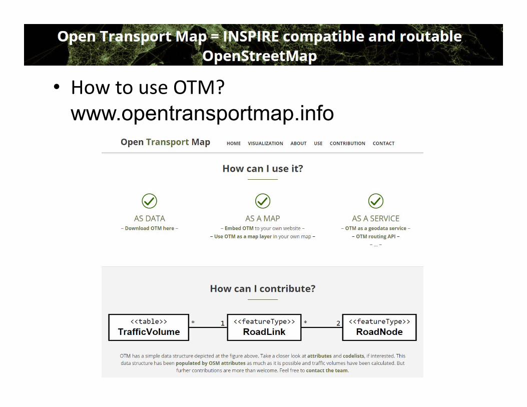
– How it can be used?

• How is it achieved?– INSPIRE Transport Network specification– Model simplification (with respect to available data), – INSPIRE compatible– Model extension by adding domain specific attributes (various projects OTN, SDI4Apps a Foodie)

– Transformation schema deffinition for OSM to OTM– Transformation schema for local data to OTM– Traffic volume calculation (pilot regions, Evropa)– Traffic capacity calculation– Real time calculation– Data OTM – OSM synchronization

• Why Open Transport Map?– OSM

– OTM• Routing• Traffic volume• INSPIRE compatible

• How is it achieved?– INSPIRE Transport Network specification– Model simplification (with respect to available data), – INSPIRE compatible– Model extension by adding domain specific attributes (various projects OTN, SDI4Apps a Foodie)

– Transformation schema deffinition for OSM to OTM– Transformation schema for local data to OTM– Traffic volume calculation (pilot regions, Evropa)– Traffic capacity calculation– Real time calculation– Data OTM – OSM synchronization

• INSPIRE Transport Network

• INSPIRE compatible data model OTM

<<featureType>>

RoadLink+inspireID: Identifier = DatasetSource_ID+beginLifeSpanVersion: DateTime+endLifeSpanVersion: DateTime+validFrom: DateTime+validTo: DateTime+fictitious: Boolean+centerLineGeometry: GM_Curve+direction: LinkDirectionValue+fromRoadNode: Identifier = RoadNode.inspireID+toRoadNode: Identifier = RoadNode.inspireID+RoadName: GeographicalName+nationalRoadCode: CharacterString+functionalRoadClass: FunctionalRoadClassValue+formOfWay: FormOfWayValue+roadSurfaceCategory: roadSurfaceCategoryValue+speedLimit: SpeedLimitValue+capacity: NumberOfMaximalTrafficVolumeValue+maximumHeight: Float = meters+maximumTotalWeight: Float = meters+maximumWidth: Float = meters+vehicleType: VehicleTypeValue

<<featureType>>

RoadNode+inspireID: Identifier = DatasetSource_ID+beginLifeSpanVersion: DateTime+endLifeSpanVersion: DateTime+validFrom: DateTime+validTo: DateTime+fictitious: Boolean+geometry: GM_Point+geographicalName: GeographicalName+formOfRoadNode: FormOfRoadNodeValue+country: Identifier+area: Identifier

*

1

*

1

<<table>>

Traff icVolume+ID: Identifier+roadLinkID: Identifier = RoadLink.inspireID+trafficVolume: NumberOfVehiclesCrossingTheSegmentInTimePeriod+trafficVolumeTimePeriod: TimePeriodValue+fromTime: DateTime+toTime: DateTime+vehicleType: VehicleTypeValue

*

1

• INSPIRE compatible data model OTMLinkDirect ionValue

< < codeList> >

bothDirect ionsinDirect ioninOppositeDirect ion

Funct ionalRoadClassValue< < enum erat ion> >

m ainRoadfirstClasssecondClassthirdClassfourthClassfifthClass

Form OfWayValue< < codeList> >

bicycleRoaddualCarriagewayenclosedTrafficAreaent ranceOrExitCarParkent ranceOrExitServicefreewaym otorwaypedest rianZoneroundaboutserviceRoadsingleCarriagewayslipRoadtractort rafficSquarewalkway

VehicleTypeValue< < codeList> >

all vehiclebicyclecar with t railerdelivery t ruckem ergency vehicleem ployee vehiclefacilit y vehiclefarm vehiclehigh occupancy vehiclelight railm ail vehiclem ilitary vehiclem opedm otorcyclepassenger carpedest rianprivate buspublic busresident ial vehicleschool bussnow chain equipped vehicletankertaxit ransport t ruckt rolley busvehicle for disabled personvehicle with explosive loadvehicle with other dangerous loadvehicle with water pollut ing load

Form OfRoadNodeValue< < codeList> >

enclosed t raffic areajunct ionlevel crossingpseudo noderoad endroad service arearoundaboutt raffic square

Form OfRoadNodeValue< < codeList> >

enclosed t raffic areajunct ionlevel crossingpseudo noderoad endroad service arearoundaboutt raffic square

RoadSurfaceCategoryValue< < codeList> >

pavedunpaved

Tim ePeriodValue< < codeList> >

hourdaym onday, ..., sundayweekdayweekendweekm onthyear

• OSM → OTM conversion shema

• OSM → OTM transforma on schema======== ======«featureType»RoadLink source======== ======+ inspireID: Identifier [1] OSM.roads.osm_id_segments ..+ roadSurfaceCategory: RoadSurfaceCategoryValue «codelist» OSM.roads.surface..

================«codeList»RoadSurfaceCategoryValue OSM.roads.surface================+ paved: paved, asphalt, cobblestone, cobblestone:flattened,

sett, concrete, concrete:lanes, concrete:plates, paving_stones, paving_stones:30, paving_stones:20, metal

+ unpaved: <all other values>

• Traffic volume

3. Modal split Individual: Public:

carscyclistspedestrian

bustraincity transport …

1. Traffic generators

zones

2. Traffic flow

matrix

4. Traffic Flow allocated on the net

volume of traffic

• Traffic volume– Number of cars per time 

interval unit– Dynamic. Different for:

• Time• Direction• Car type

• Road segment capacity– Maximal number of cars per 

time interval– Static – e.g. different in each 

direction

• Traffic flow– Free, without traffic– Traffic jam

Flow speed

Vehicles count per time unit

• Used technology

• How to use OTM? www.opentransportmap.info

• Road Map of Open Transport Map– January 2016

• WMS• WFS

– March 2016• Traffic volume for pilot regions of OTN

– September 2016• Periodic update• Road capacities

– January 2017• Traffic volume for whole Evrope• Real time calcuation• Redy for production envirionmnet

• Applications – traffic volume calculation– Traffic volume for large scale network (millions of edges)

• Based on Apache Spark• Enable to calculate traffic volume country

• Applications – traffic volume calculation

• Applications – visualization based on webglayer.org Interactive visualization of changes in traffic volume ‐ http://home.zcu.cz/~jezekjan/otn/ 

• Applications – visualization – HSLayers and OTN portal ‐http://opentransportnet.eu/cs/pilsen‐traffic‐volumes

Thank you for your attention!

http://opentransportmap.info/


Recommended