Page 1 – Redlands Quarry, Todber Regulatory Committee Date of Meeting 5 September 2014 Officer Head of Planning Subject of Report To consider planning application 2/2013/0759 for the continued quarrying of building stone, retention of associated buildings, provision of additional structures for storage and working of building stone and ancillary uses together with sale from site of rough stone, worked stone and arisings and restoration of site to wildlife area at Redlands Quarry, Red Lane, Todber, Sturminster Newton, Dorset DT10 1HT. Executive Summary The application seeks approval for the proposal detailed above. As originally submitted, the application sought permission to work the site across two phases for up to 30 years of stone extraction through a significant extension of the quarry. However, the information necessary to assess the full implications of that extension was not forthcoming. Consequently, the applicant has agreed to exclude the extension area (Phase 2) from the application. This reduces the proposed length of operation to 5 years. Equalities Impact Assessment: The report concerns the determination of an application for planning permission and not any changes to any new or existing policy with equality implications. Impact Assessment: Use of Evidence: The recommendation has been made following consideration of the application and supporting documents, the development plan, government policy and guidance, representations received and all other material planning considerations detailed in the main body of the report. Agenda Item: 8
Transcript
Page 1 – Redlands Quarry, Todber
Regulatory Committee
Date of Meeting 5 September 2014
Officer Head of Planning
Subject of Report To consider planning application 2/2013/0759 for the continued quarrying of building stone, retention of associated buildings, provision of additional structures for storage and working of building stone and ancillary uses together with sale from site of rough stone, worked stone and arisings and restoration of site to wildlife area at Redlands Quarry, Red Lane, Todber, Sturminster Newton, Dorset DT10 1HT.
Executive Summary The application seeks approval for the proposal detailed above. As originally submitted, the application sought permission to work the site across two phases for up to 30 years of stone extraction through a significant extension of the quarry. However, the information necessary to assess the full implications of that extension was not forthcoming. Consequently, the applicant has agreed to exclude the extension area (Phase 2) from the application. This reduces the proposed length of operation to 5 years.
Equalities Impact Assessment: The report concerns the determination of an application for planning permission and not any changes to any new or existing policy with equality implications.
Impact Assessment:
Use of Evidence: The recommendation has been made following consideration of the application and supporting documents, the development plan, government policy and guidance, representations received and all other material planning considerations detailed in the main body of the report.
Agenda Item:
8
Page 2 – Redlands Quarry, Todber
Budget: Generally the determination of planning applications will not give rise to any budget implications for the Committee.
Risk Assessment: As the subject matter of this report is the determination of a planning application the County Council’s approved Risk Assessment methodology has not been applied.
Other Implications: None
Recommendation Grant planning permission subject to the conditions set out in Section 9.1 of this report.
Reason for Recommendation
The reasons for granting planning permission are summarised in paragraphs 6.42-6.45 of this report.
Background Papers PA File 2/2013/0759 NB: Copies of representations may be inspected in the Directorate for Environment and the Economy and will be available for inspection in the Committee Room prior to the meeting.
Report Originator and Contact
If you have any queries on this report please contact: Name: Mr Stephen Cornwell Tel: (01305) 228647 Email: [email protected]
Page 3 – Redlands Quarry, Todber
1. Background
1.1 The application was received on 01 July 2013 and a Planning Committee site visit was held on 30 May 2014.
1.2 The site has been worked for stone under various permissions since 1949. The most recent planning permission granted in 1992 expired at the end of December 2012.
1.3 The applicant (Dorset Stone Company Ltd) has operated the site since 2007. During this time there has been some debate with the applicant as to whether or not particular ongoing operations were within the scope of the 1992 planning permission. Concerns have also been raised in relation to the presence of a number of unauthorised structures erected on site. However, owing to the nature of the site and its operation, it has not been considered expedient to instigate formal enforcement action, but instead seek to address the apparent breaches of planning control and provide for the future operation of the quarry through a new application. It was in this context that the application was registered in July 2013.
1.4 At that time, Officers’ understanding was that the site had been mothballed following the expiry of the 1992 permission i.e. that the winning and working of minerals had been suspended.
1.5 Between January 2013 and February 2014, Officers visited the site on a total of 9 occasions. During this time, the site did not appear to be in active use. Clarification of various aspects of the application proposal was necessary and further information was requested from the applicant. That information was not readily forthcoming.
1.6 In March 2014, Officers visited the site and noted that stone processing was being undertaken. A digger was observed raking through piles of stone to identify suitable pieces for processing that were then being fed through saws and guillotines. Officers were given to understand that this was to satisfy an order that the quarry operator had to supply building stone. This was the first occasion Officers had seen this level of activity since the 1992 planning permission expired in December 2012. On further enquiry, the applicant acknowledged that the site did not close down after the planning permission expired.
1.7 At the end of March 2014, a hydrological report, noise assessment and further general information on the way the business operates was submitted. Since the end of May 2014, discussions with the applicant have resulted in a revision to the application. The red line application site remains the same, but the application is only to work the Phase 1 area. The Phase 2 area has been removed from the application.
2. Site Description
2.1 The application site is located 4.5km north of Sturminster Newton on the corner formed by the junction of the B3092 Sturminster Newton to Gillingham road and Red Lane, Todber.
Page 4 – Redlands Quarry, Todber
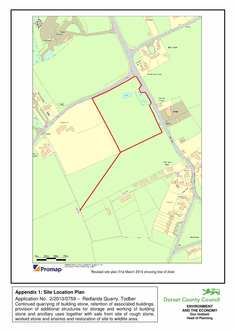
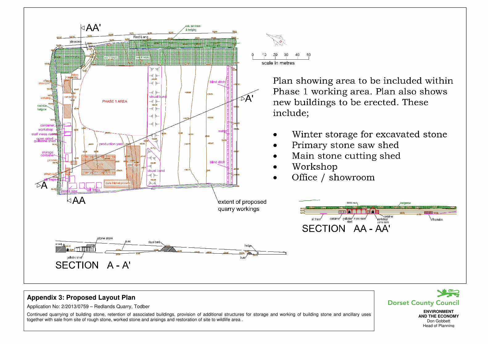
2.2 The location of and extent of the application site is illustrated at Appendix 1 of this report. The site extends to approximately 1.7 hectares.
2.3 In the north, the site boundary follows a low hedge which separates the quarry and the B3092. To Red Lane (the east), the boundary runs along the edge of a roadside hedge and tree belt. The hedgerow is only broken 45 metres down from the B3092 junction by the site access, which comprises a concrete apron leading to double gates. The gates provide the only means of vehicular access to the site. Screens have recently been added to the gates limiting views into the site. 115 metres south of the access, the site boundary turns away from the road and runs down the inside boundary of the tree screen and roadside hedge. The hedge continues around the western boundary of the field and the application site.
2.4 Approximately 50 metres south of the site access a visual bund divides the site in two. The bund is approximately 4 metres high and is made up of overburden extracted from the quarry.
2.5 The active quarry operations lie to the north of the bund, with the land to the south comprising rough grassland (Class 3 agricultural land). Top soil has been removed from the field and some pieces of scrap and old equipment lie in this open area. A trench referred to as a ‘blind ditch’ has been cut across the land running east-west 20 metres in from the southern boundary. This ditch is used to receive water pumped out of the quarry void.
2.6 Past quarrying operations have reduced the ground levels of the site north of the bund below those of the surrounding land and have left a 5 metre tall face abutting the B3092 boundary. A range of open sided structures, metal containers/portacabins are positioned up against this old quarry face. At the western end are 4 stone cutting machines with diesel generators. These machines are not currently enclosed. The present excavation area which has been holding water, lies to the south east, adjacent to the Red Lane boundary, south of the site access and north of the visual bund.
2.7 Beyond the site boundary to the west is a garden/landscaped area associated with a residential property (Orchard Lea), which is situated approximately 80 metres from the site boundary.
2.8 To the south, is an open agricultural field, south of which is Red Lane Farm (approximately 90 metres from the site and 160 metres from the bund), beyond which are a number of residential properties.
2.9 There are a number of residential properties and a car sales business along the eastern side of Red Lane. A cluster of properties lie to the north east of the application site adjacent to the B3092 junction and Red Lane Cottage is located opposite the site.
2.10 The general character of the surrounding area is rural, but the area around the junction exhibits evidence of former quarry working. To the north, 170 metres from the site and largely screened by trees, is a concrete batching plant which is accommodated within a former quarry area.
2.11 Neither the site nor the surrounding area carries any national designation relating to ecological or landscape interest.
Page 5 – Redlands Quarry, Todber
3. The Proposal
3.1 The proposal comprises a number of elements:
i. the continued extraction of Marnhull stone:
• to supply local builders with building stone;
• for use as rough stone for walling; and
• for sale of arisings for hardcore;
ii. importation of a quantity of stone for processing and sale or resale;
iii. retention of the existing buildings and structures; and
iv. the erection of a number of new buildings.
3.2 Following discussions with the applicant, it has been agreed that whilst the application site remains unchanged, permission is sought to continue extraction of stone from the Phase 1 area only. This ground, which measures 47 metres by 46 metres, consists of the existing quarry area located between the access roadway and the central bund. The remaining estimated reserves in the Phase 1 area are 16,000 tonnes, which would be worked out over a four-year period. When excavating, after 1.5 metres of overburden, the next 1.5 metres would provide the rough walling stone and the rubble for hardcore sales. Any unused broken stone would be placed in the Phase 1 area. The good building stone occurs from 3 metres down to 7 metres.
3.3 Extraction would be to a maximum depth of 52 metres Above Ordnance Datum (AOD). Extraction would be by excavator and take place between May and September inclusive. Digging would not take place on more than 30 days in any calendar year, removing a maximum of 4,000 tonnes of raw building stone, sufficient for predicted sales. The stone would be moved to the summer storage area by dumper truck. Finished stone would be sold as paving, walling cut stone, fireplaces, window and door details.
3.4 It is proposed that an average of 2,000 tonnes of material for hardcore use is taken off site per year. No figure is given for rough stone sales. Permission is also sought for the importation, processing and sale or resale of an unspecified quantity of stone from other quarries.
3.5 Stone would be removed by vehicles ranging in size from small vans to 10 tonne trucks or 6-wheeler HGVs. The applicant estimates that stone sales are likely to generate 3 HGV movements per week and ballast sales 2 movements per week.
3.6 The buildings, containers, portacabins and structures to be retained consist of a range of facilities not exceeding 5.8 metres tall that are all positioned up against the old quarry face at the northern end of the site, including the cutting equipment in the north western corner.
3.7 The proposed new buildings would be sited in the western side of the quarry with timber or profile steel clad walls under steel sheeting roofs, colour matt brown or grey.
Page 6 – Redlands Quarry, Todber
3.8 The two largest proposed buildings would be located in the south western part of the active quarry site north of the bund and would accommodate stone saws and provide over-winter stone storage and storage for finished products. The saw building would be 29 metres by 17 metres with a 5 metre ridge. The storage building would be L-shaped (36 metres by 31 metres and a width varying from 7 metres to 11.5 metres). It would be 5 metres in height and accommodate up to 3,500 tonnes of stone that would be worked over the autumn and winter months. In the past, it is understood that the quarry has operated with 30% of material loss due to deterioration of material left in the open through the winter months. The other proposed buildings comprise an office/showroom (to be used to display and promote products), a workshop (to provide a dry environment for the maintenance of machinery and equipment), and a saw housing shed (for a primary saw). These buildings would be sited along the old quarry face an the northern end of the site, together with a generator.
3.9 It is proposed to retain the blind ditch that runs across the site close to the southern boundary. This is used to receive water pumped out of the quarry void when the level gets too high. In March 2014 a proposal to construction a pipe running 180m under an agricultural field from the SW corner of the application site off to the SW to link up with a field drainage ditch was submitted as a revision to the application.
3.10 Once extraction is completed, the site would be restored for use as a wildlife haven. A water body with 30-45 degree slopes would remain in the base of the quarry. However, it is the applicant’s preference that stone extraction from the site should continue in the long term well beyond the life of this proposal (perhaps 30-60 years). Final restoration may therefore not take place for many years and arrangements for restoration are not addressed in detail in the application. A final reinstatement plan has been submitted which shows a shallow basin feature with water in the lowest part and planting around the edges. However, this landform would involve significant extraction well beyond the scope of this application. Little weight should therefore be given to that plan.
4. Consultations and Representations
4.1 The application was advertised in the local press, by site notice and neighbour notification. Additional information was received from the applicant in March 2014 and a limited re-consultation was undertaken. Consultee responses and other representations received are summarised below. The consultees notified of the additional information received are indicated, together with any further comments made. The decision was made not to re-consult on the reduction of the proposed extraction area as this reduction must be a positive move in terms of any potential impact on local residents.
4.2 North Dorset District Council No objection subject to landscaping and restoration.
Comments on Additional Information None received.
Page 7 – Redlands Quarry, Todber
4.3 Todber Parish Council Noted instances when Red Lane, the B3092 and Church Lane severely contaminated with stone slurry making road surface treacherous. Understood from applicant this was the result of wheel washing arrangements on site being unable to cope with large size of tyres on vehicles concerned. To avoid re-occurrence suggest condition seeking wheel washing arrangements at exit to site. Note proposal includes request to increase working days from 20 to 30. To protect amenity of residents, this should not be allowed. Parish Council note applicant’s offer to sponsor construction of two bus shelters in Todber in interests of good community relations. Subject to conditions suggested by applicant and those proposed above, Parish Council supports application as means of preserving local employment and a source of building stone for repairs and vernacular building.
Comments on Additional Information No further comment to make.
4.4 Highway Liaison Engineer No objection, in principle, subject to conditions imposed upon previous application.
4.5 Environment Agency Whilst no “in principle” objection there is insufficient information to allow us to assess risk to controlled waters. Recommend planning authority seek clarification on matters of ground water protection and disposal of water from void prior to determination of this application.
Comments on Additional Information Withdraw objection. Welcome Hydrological Assessment and satisfied proposed development unlikely to represent risk to third party abstractors. Proposed pumping and discharge may require Environment Permit. Applicant advised to keep records of volumes and times water abstracted. Proposals to monitor water levels in quarry void and in licensed wells are sensible. Note Hydrological Assessment states it does not address comments made in their first letter of 29 November 2013 and states decision pending on need for infiltration tests. From this, not clear whether decision made to demonstrate suitability of blind ditch to act as an infiltration swale? No objection to proposal, but suggest the mineral planning authority may wish to seek further clarification on matter of disposal of water from quarry void to blind ditch prior to determining this application.
4.6 Natural Environment Manager Satisfied there are no particular ecological constraints associated with this application. As for restoration to a wildlife area, sees no reason to ask for detail now and would expect that a condition be applied to any permission for the submission of a restoration scheme to maximise the benefit to wildlife.
4.7 Senior Landscape Officer Would like to see detail of how important existing vegetation will be protected and managed to secure its long term viability.
Page 8 – Redlands Quarry, Todber
4.8 Senior Archaeologist No comment.
4.9 Minerals & Waste Policy Team Policy 34 of the Dorset Minerals & Waste Local Plan does not exclude other uses. Such uses will need to be assessed on general considerations. If appropriate, suggest limitation to ensure primary use of site remains the supply of blockstone.
4.10 Environmental Protection & Private Sector Housing Manager, NDDC Noise impact Assessment Criteria Analysis indicates noise generated from quarry and associated activities would fall within the MPS2 criteria and have “no impact” according to the IEMA guidance. Does not dispute the results of the assessment in relation to the standards quoted. However, feels it appropriate to point out that the noise levels predicted for overall works (53/d/b or +7.3dB over background) would be viewed very differently if generated from a fixed commercial installation and assessed against different criteria such as BS4142. In such a situation a +5dB penalty would apply meaning a rating of +12.3dB over background, and under BS4142 a difference of +10dB is an indication that complaints are likely. Whilst BS4142 may not be an appropriate standard to employ in this instance it does serve to demonstrate that the noise assessment criteria in MSP2 and the IEMA guidance might be considered generous in comparison. With this in mind, have some concerns at proposed conditions put forward by applicant. Recommend clear operating hours condition and that temporary activities are restricted.
Comments on Additional Information If noise assessment does not take account of location where all the activities will occur and relevant noise sensitive properties likely to be affected, it would not appear to provide an accurate description of future noise environment and Mineral Planning Authority should not make decision based on information. If noise assessment does not take into account all noise generating activities or equipment this also significant deficiency. Use of BS5228 may well be more appropriate than BS4142. Unable to comment on potential impact of use of stone saws with or without enclosures in absence of a suitable noise survey and report to consider.
4.11 Other Representations Following initial publicity, 13 letters received including one from a solicitor written on behalf of an adjoining landowner who has also written in themselves, a letter from a local resident with enclosures (including a number of photographs) and 7 model objection letters signed by local residents. The main points can be summarised as:
• No objection to continuation, but pumping out of water needs to be resolved as it is flooding business property.
• Concerned over publicity associated with application.
• Concerned over level of traffic moving in and out of site which trails mud, stone and dust out onto lane.
• No control over dust or noise.
• Note supporting letters with application do not come from people living near quarry.
• Vehicles using Church Lane are a danger to pedestrians.
Page 9 – Redlands Quarry, Todber
• Quarry gives nothing to village.
• Have attended meetings over past 4-5 years relating to flooding issues of land used for calf rearing adjacent Red Lane Farm.
• Advised water pumped from quarry into land outside quarry owners control.
• Question accuracy of information set out in the Flood Risk Assessment submitted with planning application.
• Pumping occurs all year round.
• No knowledge of the open days applicant claims to have run.
• Application only claims to create one new job, but impact on local community will be felt for years.
• Number of days quarrying allowed should not be increased.
• Request for planning permission for 30 years is too long. Suggest 5 years.
• Unclear if site will be open to public like a garden centre.
• Understand applicant has offered to build two bus shelters in village, but unclear how this will be achieved.
• Hoped at end of last consent quarry would close and impact on village would cease.
• Quarry has impacted on highway safety at junction of Red Lane with B3029 on sharp bend.
• Activity and noise in and at entrance has enormous impact on dwellings.
• Note no assessment of crushing in documents.
• Since quarrying first started, other dwellings have been built in locality and bigger machinery now used so impacts much different.
• Note in 1990s a Stop Notice and Enforcement Notice issued and then DCC had to pay compensation after operator appealed which lead to 1992 permission.
• Historic monitoring of site and current application handled in unfortunate manner.
• 1992 permission placed number of limitations on operation. Since arrival of current operator around 2007, most if not all limitations ignored or contravened.
• Despite limitation on hours of operation (Condition 9), occasions when a diesel powered water pump left running 24 hours over public holiday weekend.
• During wetter months, so much water pumped off site that blind ditch overflowed and flooded adjoining field and road.
• No crushing allowed on site (Condition 10) yet quarry has crushed stone.
• Although noise report submitted with current application it ignores noisiest activity which has been practice of breaking up large pieces of stone by placing them on concrete access and hitting them with bucket of JCB. This process goes on for hours.
• MPS2 states if no controls possible then permission should be denied.
• Consider that BS4142 should have been used to assess noise and this referred to in MPS2.
• Request new noise survey under directly supervision of Mineral Planning Authority when all activities undertaken.
• No liaison occurred between site operator and residents.
Page 10 – Redlands Quarry, Todber
• Despite requirement (Condition 12), no dust suppression measures employed within quarry. Unable to open windows in summer and garden and car covered by dust.
• Question why applicant wishes to dig deeper.
• Despite requirements (Condition 15) to stop slurry getting onto lane, no measures taken. Worst case in August 2012 when so much slurry on lane cars could not get any traction. Remedy to release bowser full of water at top of lane and this just washed slurry down lane. Enclose 3 photos taken at time.
• Despite prohibition (Condition 18) scrap and redundant plant, machinery and vehicles kept on site. Claim these provide spare parts for stone processing machinery not proven.
• Site has visual impact when viewed from lane through gates. Enclose photos of site and signage.
• Site broken into including by company seeking to recover hired equipment. Police called to calm things down.
• Attach 7 letters signed by people all living within 100 yards of site all objecting to proposal.
• Application should be refused due to lack of control as outlined above.
• Operation ruins peace and quiet of countryside.
• Operation will result in more traffic, already seen increase over last 6 months.
• Concerned over reference to a temporary noise level of 70dBA as quoted by EHO, no approaches been made to residents.
• Request application considered by Committee.
• Noise, dust and slurry issues must be addressed prior to any consent.
• Site only 30-40 ft from my house. Operations grown over years and dust problems arisen after saws imported onto site. Starting to affect health. Tolerated activity as believed after 2012 everything would cease.
Comments on Additional Information 4 further representations have been received in response to the additional information. The main points from these letters may be summarised as:
• Concerns remain the same: history of abuse of regulations; length of planning permission sought; increase in range of activities on site; increase in road traffic; and detrimental impact on residents living nearby.
• Hope Planning Committee will have visited site to see proximity to residents.
• Proposed water pipe discharge point is on land not in control of applicant and consent not given by relevant landowner.
• Read new information, but still have major concerns regarding drainage of water from site.
• Concerned that ditch pipes joint could flood/back up impacting on our drainage and potentially flooding our home.
• Drainage of Moorside works at present. Who will guarantee it continuing to do so in future?
• Hydrological Assessment makes no allowance for climate change.
• Contrary to claim, trees in leaf do not provide any acoustic barrier.
• Have lived opposite a stone crusher in past and aware of noise they can make.
• Will stone be leaving the site to be crushed elsewhere in local area?
Page 11 – Redlands Quarry, Todber
• Applicant should only be given for 2-3 years to enable review of environmental impacts such as record keeping of vehicle movements; efficiency of wheel washing and monitoring of traffic to showroom.
5. Planning Policy Framework
5.1 Applications for planning permissions must be determined in accordance with the development plan unless material considerations indicate otherwise. The term ‘other material considerations’ is wide ranging, but includes national and emerging planning policy documents.
The Development Plan
5.2 The development plan includes the Bournemouth Dorset and Poole Minerals Strategy (adopted May 2014), the remaining saved policies of the Dorset Minerals & Waste Local Plan (originally adopted April 1999) and the saved policies of the North Dorset District Wide Local Plan originally adopted in January 2003.
5.3 The most relevant policies in the Minerals Strategy are:
• Policy SSI - Presumption in Favour of Sustainable Development.
• Policy BS1 - Building Stone Quarries.
• Policy RS1 - Restoration, Aftercare and Afteruse of Minerals Development.
• Policy DM1 - Key Criteria for Sustainable Minerals Development.
• Policy DM2 - Managing Impacts on Amenity.
• Policy DM3 - Managing Impacts on Surface Water and Ground Water Resources.
• Policy DM4 - Protection and Enhancement of Landscape Character and the Countryside.
• Policy DM5 - Biodiversity and geological interest.
• Policy DM7 - The Historic Environment.
• Policy DM8 - Transport and Minerals Development.
5.4 Policy 6 (Applications Outside Preferred Areas) of the Dorset Minerals & Waste Local Plan is also relevant.
5.5 The most relevant policies of the North Dorset District Wide Local Plan are:
• 1.6 - Development in the countryside.
• 1.8 - Standard assessment criteria.
• 1.16 - Groundwater source protection.
• 1.33 - Landscape character areas.
• 1.40 - Landscaping of new development.
• 3.5 - Employment development within the countryside.
National Planning Policy
5.6 The National Planning Policy Framework (NPPF) sets out the Government’s planning policies for England and how these are expected to be applied. The framework is an important material consideration and can be accorded significant weight. Particularly relevant provisions relate to:
• Presumption in favour of sustainable development (paragraph 14);
• Building a strong, competitive economy (paragraphs 18 & 19);
Page 12 – Redlands Quarry, Todber
• Supporting a prosperous rural economy: (paragraph 28);
• Conserving and enhancing the natural environment (paragraph 109, 114, 115, 116, 117, 118, 120 123 and 125);
• Facilitating the sustainable use of minerals (paragraph 142 and 144); and
5.7 Further Government direction is provided by Planning Practice Guidance. Amongst other matters, relevant guidance is provided on minerals, the natural environment, noise and use of planning conditions.
6. Planning Assessment
6.1 Having regard to the provisions of the development plan, the information submitted in support of the application, consultee responses and the representations received, the main planning considerations in determining the application are:
i. the acceptability of the principle of the proposed development;
ii. whether the impact on the landscape character and visual amenity of the surrounding area is acceptable;
iii. impact on hydrology, hydrogeology and water resources;
iv. impact on the amenity of nearby residential properties;
v. whether the traffic generated by the proposed development can be satisfactorily accommodated on the local road network; and
vi. whether the indicated restoration use is acceptable.
Principle of Development
6.2 The application site is located outside any development envelope and within an area that in terms of planning policy is considered to be part of the open countryside.
6.3 Policy BS1 of the Minerals Strategy acknowledges that there is a need for small scale building stone quarries beyond Portland and Purbeck and sets out 3 criteria for consideration. These are:
i. the stone is of a type historically used for building in the local area and is used to maintain the fabric or character of individual buildings or settlements in the local area, or significant historic buildings elsewhere;
ii. the proposal would be of a type, scale and output appropriate to the market identified above; and
iii. the proposal would not individually or cumulatively with any other site result in a level of activity, or traffic generation, which would have an unacceptable effect on landscape, the environment or local amenity.
Page 13 – Redlands Quarry, Todber
6.4 A number of these considerations are addressed later in this assessment. However, the benefits of opening up the site were recognised in the 1992 grant of permission and the site is one of a number in the northern part of the county fulfilling a niche market for building stone. The application does include information on the supply/demand of building stone to help maintain local character and distinctiveness. Support for small scale local quarries is also provided by the NPPF and the more recently published Planning Practice Guidance (PPG). Having regard to this policy context, the proposal to continue stone extraction at the site is considered to be acceptable in principle.
6.5 In addition to the winning, working and sale of local building stone, the application also promotes a number of other business activities. First, it is proposed to sell material for use as both walling stone and as hardcore. The intention is to utilise the broken stone bed above that which provides the building stone. The applicant has referred to a quantity of 2,000 tonnes of hardcore, equating to approximately 133 x 15 tonne HGVs per year (less than 3 per week). It is accepted that this could provide a useful supplement to quarry income. Second, there is also a reference to the importation of stone to sell on to builders and reference is made to the benefits of offering a builder the full range of stone needed to undertake a specific project.
6.6 Regarding the sourcing of walling stone and hardcore, there is no clear policy guidance in the development plan or in any national policy on how this should be assessed. Even if the hardcore is viewed as an aggregate, the policy guidance is not specific. However, it is considered that demand would be quite local. In relation to hardcore, the properties of the stone available suggest it is likely to be of relatively limited use and that the quantity suggested by the applicant would not prejudice the appropriate restoration of the site. The volume of walling stone has not been specifically indicated, but if supported, it is recommend that this should be included within the suggested limit of 2,000 tonnes per year. This will ensure that the primary purpose of the site remains the supply of local building stone. On this basis, the additional product output is also considered to be acceptable in principle.
6.7 The importation of stone from other sites is proposed to be a small element and a figure of less than 15% of output has been quoted. Reference to selling Bath Stone and Portland Stone is included in correspondence from the agent. This type of operation is quite common with the small operators, although again there is little relevant policy guidance. However, the NPPF does encourage flexibility in meeting any demand for small-scale extraction of building stone and provides that planning should operate to encourage and not act as impediment to sustainable economic growth. Accordingly, subject to the ability to regulate the level of imported stone to a level that is clearly ancillary to the primary purpose of the quarry, there is not considered to be an ‘in principle’ objection to a small degree of importing. 15% of 4,000 tonnes equates to 600 tonnes of imports. This is in the region of 40 x 15 tonne vehicles first delivering and then collecting the finished material from the site per year. The assessment below considers the implications of this level of importing, processing and sale or resale on traffic movements and on the operation of machinery on site.
Page 14 – Redlands Quarry, Todber
Landscape and Visual Impacts
6.8 The site does not lie within any nationally designated landscape area. Minerals Strategy Policies BS1 (Building Stone Quarries), DM1 (Key Criteria for Sustainable Minerals Development) and DM4 (Protection and Enhancement of Landscape Character and the Countryside), saved Policy 6 (Applications Outside the Preferred Areas) of the Dorset Minerals & Waste Local Plan and saved Policy 1.33 (Landscape Character Areas) of the North Dorset District Wide Local Plan each seek to ensure that development does not adversely effect the character of an area.
6.9 The site lies within the Blackmore Vale Landscape Character Zone for which the Landscape Character Assessment recognises the following main character traits:
• A broad expansive clay Vale which is tranquil and unified.
• A unique mosaic of woods, straight hedgerows and grassland fields ‘dotted’ with distinctive mature hedgerow Oaks.
• Open views across the undulating to flat pastoral landscape to the chalk escarpment backdrop.
• Dense network of twisting lanes often with grass verges and sharp double 90o bends.
• Small hump backed bridges with low stone or brick parapets.
• Many very small villages and hamlets built with locally distinctive materials, such as stone, redbrick, tile and thatch.
• A network of ditches, streams and brooks which drain into the tributaries of the Stour.
• Lydlinch Common (an SSSI) and Stock Gaylard Deer Park (an SNCI) are both key locally important features.
6.10 Although bounded on two sides (north and east) by roads, the quarry is well screened with substantial vegetation on the southern and eastern boundaries. This in part reflects the reinforcement of the original hedgerows which was a requirement of the 1992 permission. There is a break in the boundary to Red Lane at the site access, but this is only for a short distance and the recently installed screens on the entrance gate limit views into the site. Any views that can be obtained are only fleeting and are not considered to have a significant adverse impact on the character of the countryside. This section of the lane is also partly commercialised by the presence of the car sales business just south of the access on the other side of the lane.
6.11 The boundary to the B3092 is a lower hedge with a narrow grass verge. However, the road occupies an elevated position relative to the quarry and whilst this does offer some views down into the site, I consider that this busy road is less likely to attract pedestrian traffic and when people are walking along it they are more likely to be focused on road safety than looking south. There are also no local footpaths providing public views that are significantly affected by the presence of the quarry.
6.12 Overall, the landscape and visual impact of the quarry is modest. Whilst the current proposal would see additional buildings in the quarry, these would not have a significant adverse impact on either landscape character or visual amenity. The existing hedgerows and trees should be protected and this has been recognised by the applicant . The intended afteruse as a wildlife area
Page 15 – Redlands Quarry, Todber
with an area of water in the centre site would enhance the biodiversity potential of the area. Accordingly, the proposals are considered to be in accordance with the landscape protection policies outlined above.
6.13 Part of the site has been used for the storage of scrap equipment. The specific area that appears to be allocated for this use is just to the south of the visual bund, although it is difficult to identify a precise area as the operator has placed equipment and even vehicles in several areas. It has been claimed that this material represents spare parts for stone processing machinery, but this claim is disputed. Some of the items have been removed.
6.14 During the Committee site visit on 30 May 2014, it was observed that the access through to the southern area was being obstructed by a partial bund formed on the access track linking the northern and southern areas. The applicant has indicated that this was only a temporary blockage. An assessment of the use of space on the north side of the bund shows an area used for the storage of firewood and that a more rational use of this area would free up adequate space for any genuine storage needs. Whether it is the current intention of the applicant or not, it is considered that the central bund should represent a clear separation between the active and inactive parts of the site. Accordingly, it is proposed to prevent the storage of any machinery south of the bund by means of a planning condition. This would not prohibit the presence or use of the blind ditch that is discussed further below.
Hydrology, Hydrogeology and Water Resources
6.15 Minerals Strategy Policies DM3 (Managing the Impact on Surface Water and Ground Water Resources) and BS1 (Building Stone Quarries), saved Policy 6 (Applications Outside the Preferred Areas) of the Dorset Minerals & Waste Local Plan and saved Policy 1.16 (Ground Water Protection) of the North Dorset District Wide Local Plan seek to protect water resources from the risk of pollution and the surrounding area from the risk of flooding. Subject to the imposition of appropriate conditions, it is considered that the proposal is in accordance with the relevant provisions of these policies.
6.16 The Environment Agency does not object to the application and the nature of the proposed development is such that it can be conditioned to protect ground water from the risk of pollution. The greater concern regarding water resources relates to the method of disposing of the water that is periodically removed from the quarry void to enable the extraction of stone to take place. The application indicates this would occur on around 6 occasions a year, but it is anticipated that during the time of year when the stone is dug out, that the water level in the quarry void would have dropped naturally. However, it is also acknowledged that outside this part of the year, pumping may also occur if the water level threatens the operations elsewhere in the quarry. Potentially, these may coincide with periods of naturally high ground water. Objectors claim that pumping has taken place all year round.
6.17 The current arrangements have developed in response to problems experienced over recent years. The applicant has dug what is referred to as a ‘blind ditch’ across the southern part of the site near the southern boundary. Water is pumped into this ditch and allowed to dissipate into the surrounding ground. It has been suggested that water has overflowed from the application
Page 16 – Redlands Quarry, Todber
site out into the adjoining field, although it is not clear if this has occurred since the ditch was constructed or only previously when the applicant let the water just spill out onto the ground.
6.18 In April 2014 a hydrological report was submitted and this indicated that groundwater naturally migrates to the south and south west, but passes slowly through the rock beds. The assessment did not evaluate the ability of the blind ditch to function or the hydrological implications of discharging via the pipe into the ditch off to the south west. Whilst the Environment Agency has not objected to this arrangement, it has been suggested that the Mineral Planning Authority might wish to seek clarification on the ability of the blind ditch and/or the pipe and field ditch to accommodate the volume of water involved.
6.19 The farmer who occupies land and buildings 90 metres to the south has expressed a concern that water is entering his cattle buildings and a link is made to the application site. The concern has been reinforced by a solicitor’s letter.
6.20 Given the separation distance between the ditch and the farm buildings, the volume of water concerned and the fact that no greater quantity of water is being placed in the ground than would exist if the quarry was not there, no clear correlation has been established between the water being pumped from the quarry and water finding its way directly into the farm buildings. However, the hydrological assessment has not addressed this element, focussing instead on a review of the movement of water through the beds directly under the application site and nothing beyond.
6.21 A further concern has also been raised regarding the impact of water on the immediately field to the south. It has been acknowledged that some impact has occurred, but the applicant claims this has no direct impact on the crop that was grown in that field.
6.22 The potential for problems to arise relating to water disposal is a genuine concern. The need for a satisfactory resolution to this issue must include a review of the ability of either the blind ditch or the pipe and field ditch to accommodate the amount of water removed from the Phase 1 quarry void. To date this information has not been submitted. However, there is no desire to delay the consideration of this application unnecessarily and so it is proposed to prohibit any pumping by way of planning condition until the matter is resolved through the submission of a detailed assessment of the use of either or both the blind ditch and the pipe discharge. As extraction is only proposed during the summer months when the water table should fall naturally, access to the quarry may become available without pumping and hence such a restriction should not place an unreasonable constraint on the applicant.
Amenity of Nearby Residential Properties;
6.23 Minerals Strategy Policies DM2 (Managing Impacts on Amenity) and BS1 (Building Stone Quarries), saved Policy 6 (Applications Outside the Preferred Areas) of the Dorset Minerals & Waste Local Plan and saved Policy 1.8 (Standard Assessment Criteria) each seek to protect residential amenity and other sensitive land uses.
Page 17 – Redlands Quarry, Todber
6.24 There are a number of residential properties near to the application site, particularly on the eastern side of Red Lane. The Old School House and Red Lane Cottage are situated directly opposite the site boundary and a similar distance from the processing area (Red Lane Cottage being significantly closer to the extraction area).
6.25 There are several activities that could potentially result in a loss of amenity to local residents. Generally these are associated with the digging of stone, on site processing and subsequent movement off site. Noise and dust are particular concerns.
6.26 The application is supported by a noise report prepared by an acoustic consultant. The report considers the digging and processing of material and concludes that the noise impact would be acceptable and that, subject to appropriate conditions, planning permission should be granted.
6.27 North Dorset District Council’s Environmental Protection and Private Sector Housing Manager has reviewed the report and does not dispute the results of the assessment in relation to the standards quoted. Subject to the imposition of conditions establishing maximum noise levels and associated controls, continued extraction in the Phase 1 area can therefore be supported. However, as the noise report defined a study area that covered the Phase 1 area only and given other limitations of the assessment, the mineral planning authority has been advised not to grant planning permission for extraction beyond the Phase 1 area. The 1992 planning permission did cover the whole of the current application site, but extraction from what is now referred to as the Phase 2 area (i.e. the land to the south of the visual bund) was not proposed as close to the Red Lane boundary as was initially the case in the current application and a further bund was to be formed along the Red Lane boundary to provide noise attenuation. This matter has been discussed with the applicant who has agreed to scale back the proposal and withdraw the Phase 2 extraction area.
6.28 The application as submitted was inconsistent in its approach to the processing (screening and crushing) of hardcore and the noise report does not consider the implications of these operations. It is therefore proposed to allow hardcore to be extracted and sold from the site, but to prohibit mechanical screening and crushing on site.
6.29 Noise has been generated by the operation of two stone saws brought onto the site and left in the open. One of the objectors has referred to hearing the saws. The submitted noise assessment considered the operation and use of the saws, but the question has been raised with the applicant whether the scaling back of the operation would affect the intention to proceed with the building to enclose the saws. The applicant has stated that it will not.
6.30 Unless properly controlled, fugitive dust that could materially detract from amenity is likely to arise from operations and vehicle movements within the site and from vehicles leaving the site. However, dust impacts can be controlled. A condition requiring the submission, approval and implementation of a dust control scheme should be imposed. Conditions are also proposed requiring that:
Page 18 – Redlands Quarry, Todber
i. the surface of the access road into the shall be maintained in a good state of repair and shall be kept clean and free of mud and other debris at all times; and
ii. any loads of walling stone and hardcore be sheeted.
6.31 Subject to the appropriate operation of the site in accordance with recommended conditions, it is considered that operation of the site will be accordance with policy requirements.
Traffic Impact
6.32 The quarry benefits from an access with good visibility onto Red Lane and its proximity to the main Sturminster Newton to Shaftsbury road (the B3092) provides good access to the main road network. The junction to B3092 is also of a good standard.
6.33 The proposed level of output is such that there are not considered to be any concerns regarding the total number of traffic movements. This view is supported by the comments from the highway liaison engineer.
6.34 The application seeks permission for the export of walling stone and hardcore, which was prohibited in the 1992 permission. However, notwithstanding that prohibition, this activity does appear to have occurred in the past and given rise to concerns regarding the dragging out of debris on the wheels of vehicles. The situation is confused by a recent approach to the Council from a local agricultural contractor claiming he was responsible for the worst example of mud occurring on Red Lane.
6.35 Whilst residents representations refer to this incident, the highway officer has indicated that there is no formal record of this problem being reported to the highway authority. It appears that the nature of the traffic (tractor and trailer) used to move much of this material, especially the hardcore, is particularly susceptible to problems of this type and on-site measures to reduce the amount of debris being carried off site onto the road do not appear to have been very effective in the past. The access roadway is only concreted for a short distance beyond the entrance gates and once past that point is made up of scalpings and then waste stone which appears to turn into a “mush” when driven over after rain. In dry weather it becomes dusty.
6.36 Despite a claim to the contrary by the applicant, there is no formal wheel washing facility. What passes for a wheel wash is a depression in the access track in which water puddles. A broom is stated to be available to supplement this. Given the scale of the operations at the site, reluctance to invest in a full wheel wash facility is understandable.
6.37 The standard approach is to require operators to ensure that all vehicles leaving a site do not carry mud and other debris out onto the highway. How that is achieved is a matter generally left to the individual operator to propose for approval in writing. However, it is clear that there are simple on site measures that could be adopted to reduce the problem, such as segregating the movement of quarry vehicles and road traffic and extending the surfaced access roadway further into the site. Whilst not disputing that problems have occurred in the past, it is therefore considered that the issue is capable of
Page 19 – Redlands Quarry, Todber
resolution and that permission need not be withheld pending receipt of satisfactory proposals. The applicant can be required to submit a strategy to deal with this issue and an appropriate condition is recommended.
6.38 Accordingly, the traffic implications of the proposal are assessed to be acceptable and in accordance with policy requirements.
Restoration
6.39 Minerals Strategy Policy RS1 (Restoration, Aftercare and Afteruse of Minerals Development) provides that proposals for minerals development will be permitted where they demonstrate a high quality and appropriate restoration scheme which will enable an appropriate afteruse and long-term maintenance of the environment. Restoration proposals should have regard to the Landscape Management Guidelines and, where possible, contribute to the targets of the Dorset Biodiversity Strategy. Proposals should also demonstrate that restoration will maximise the potential of the site for the successful adoption of the proposed afteruse and, where necessary, offer flexibility for a range of potential afteruses.
6.40 Very limited information has been submitted in relation to restoration and the application submission is far from ideal in this respect. However, in broad term, a nature conservation use of the site is considered to be acceptable and conditions can be imposed requiring further details in due course.
Other Matter Raised by Third Parties
6.41 Comments from Todber Parish Council and others refer to an offer from the applicant to provide two bus shelters in the village and a number of residents have asked how this will be achieved. These facilities are not being offered to mitigate against any specific impact arising from the proposed development and are not considered necessary to make the development acceptable in planning terms. Accordingly, the possible provision of bus shelters by the applicant is not material to the consideration of the application. For this reason, a planning obligation cannot be required.
Conclusion
6.42 For the reasons outlined above, it is considered that the extraction proposed from the Phase 1 area can be supported. The other elements that make up the proposal alongside the Phase 1 extraction can also be supported.
6.43 The proposal allows for the intensification of the use of the site relative to the permission granted in 1992 through the formalisation of the processing of quarried stone on site, the export an amount of broken stone for rough walling and/or for use as hardcore and also by the processing sale and/or the resale of an ancillary level of imported stone.
6.44 The primary purpose of the quarry i.e. the provision of a local building stone is an operation that is in accordance with the development plan and is supported by the wider planning policy framework. Whist the 1992 permission specifically prohibited some of the secondary/ancillary activities now proposed, it would not be appropriate to reject these proposals simply because they where excluded by an earlier condition. The requirement is for
Page 20 – Redlands Quarry, Todber
the Mineral Planning Authority to consider each element against the development plan and other material considerations and determine their acceptability accordingly.
6.45 The Mineral Planning Authority does not condone any of the apparent breaches of planning control that may have occurred at this site but, when assessed in light of planning policy and having regard to the controls that can be established through the imposition of planning conditions, the proposal is assessed to be in accordance with the development plan. Taking into account the information submitted in support of the application and the representations received, it is considered that there are no material considerations that suggest the application should be determined other than in accordance with the development plan. Accordingly, planning permission should be granted. Nevertheless, it is recognised that operation of the site will need to be closely monitored. The more limited duration proposed in the application as revised does offer the applicant the opportunity to operate the site in an authorised manner and demonstrate that it can be worked in the context of appropriate limitations and restrictions.
7. Human Rights Implications
7.1 The provisions of the Human Rights Act and principles contained in the Convention of Human Rights have been taken into account in reaching the recommendation contained in this report. The articles/protocols of particular relevance are:
i. Article 8 - Right to respect for private and family life
ii. The First Protocol, Article 1 - Protection of Property.
7.2 Having considered the impact of the development, as set out in the assessment above as well as the rights of the applicant and the general interest, the opinion is that any effect on human rights does not outweigh the granting of the permission in accordance with adopted and prescribed planning principles.
8. Statement of Positive Involvement
8.1 In accordance with paragraphs 186 and 187 of the NPPF, the Council, as local planning authority, takes a positive and proactive approach to development proposals focused on solutions. The Council worked with the applicant/agent in a positive and proactive manner by:
i. providing a pre-application advice service;
ii. updating the applicant/agent of any issues as they arose in the processing of the application;
iii. discussing possible solutions to potential planning issues; and
iv. providing the applicant with the opportunity to address issues so that a positive recommendation to grant permission could be given.
Page 21 – Redlands Quarry, Todber
9. Recommendation
9.1 That planning permission is granted subject to the following conditions:
Time Limit 1. The development to which this permission relates must be begun not
later than the expiration of three years from the date of this permission.
Reason In accordance with Section 91 of the Town and Country Planning Act 1990 (as amended).
Duration of Permission 2. The development, subject of this permission shall cease by 30 June
2019 on or before which date all operations/activity at the site shall cease and the site shall be cleared of all buildings, structures, equipment and plant and the whole site shall be restored in accordance with a scheme to be submitted to the Mineral Planning Authority no later than 31 December 2017 which has been approved in writing.
Reason To limit disturbance caused by the development having regard to Policy DM4 (Protection and Enhancement of Landscape Character) of the adopted Bournemouth, Dorset and Poole Minerals Strategy.
Development in Accordance with Approved Plans 3. Unless otherwise approved in writing by the Mineral Planning
Authority or required by the conditions of this permission, the development hereby permitted shall be carried out in accordance with the approved plans and drawings comprising:
• Revised Site Plan 31 March 2014 showing line of drain;
• Drg No. SJM 14 / 0609 B Ref: Existing layout revision B dated 1st July 2014;
• Drg No. SJM 14 / 0609 C Ref: Phase 1 revision B dated 1st July 2014;
• Drg No. SJM 14 / 0609 C Ref: Building layout revision B dated 1st July 2014;
• Drg No. SJM 13 / 0101 F revision A entitled Proposed buildings Stone Storage dated 19th December 2012;
• Drg No. SJM 13 / 0101 G revision A entitled Proposed buildings Saw building dated 19th December 2012;
• Drawing No: SJM 13/0101 H entitled Existing buildings and showing existing guillotine shed, existing workshop, existing containers, existing office/showroom & existing staff mess room dated 19th December 2012; and
• Drawing No: SJM 13/0101 H entitled Proposed buildings and showing primary saw, workshop & office/showroom dated 19th December 2012.
Reason For the avoidance of doubt and to ensure proper control of the development in the interests of local amenity having regard to Policies
Page 22 – Redlands Quarry, Todber
DM1 (Key Criteria for Sustainable Minerals Development) and DM2 (Managing Impacts on Amenity) of the adopted Bournemouth, Dorset and Poole Minerals Strategy.
Limits of Extraction to Phase 1 Area Only 4. Notwithstanding the details shown in the planning application, the
extraction of stone from the application site shall be limited to the Phase 1 area only, the limits of which are shown on Drg No. SJM 14/0609C revision B entitled Phase 1 area.
Reason Having regard to Policy DM2 (Managing Impact on Amenity) of the adopted Bournemouth, Dorset and Poole Minerals Strategy, it is considered that the information supplied with the application regarding the potential impact on the amenity of nearby properties only justifies a partial grant of permission.
Limits on Time of Extraction 5. The extraction of stone from the application site shall be limited to no
more than 30 days within the period 01 May to 30 September (inclusive) in each calendar year. No extraction of stone shall take place within the period 1 October to 30 April (inclusive) in each calendar year. A written record of the days on which extraction is undertaken (‘Extraction Days’) shall be kept at the site office and shall be made available for inspection by the Mineral Planning Authority on demand at any reasonable time. The record shall be kept for a minimum of 2 years before disposal. An Extraction Day shall be taken to mean a day on which stone is extracted from the quarry irrespective of the duration of the time this activity goes on for during that day. A record of all the Extraction Days for the previous year shall be submitted to the Mineral Planning Authority before the end of February of the following year.
Reason To protect the amenities of the surrounding area having regard to Policy DM2 (Managing Impact on Amenity) of the adopted Bournemouth, Dorset and Poole Minerals Strategy.
Maximum Output of Stone Produce 6. The annual output from the application site shall not exceed the
following limits:
• Finished Building Stone 4,000 tonnes.
• Walling stone and arisings sold for hardcore 2,000 tonnes (combined total).
The operator shall maintain a weekly record of all output and sales a copy of which shall be kept on site. The record shall be made available to the Mineral Planning Authority upon request at any reasonable time. The records shall be kept for a minimum of 2 years before disposal. Annual returns of production and output for the preceding calendar year shall be submitted to the Mineral Planning Authority before the end of February each year.
Page 23 – Redlands Quarry, Todber
Reason This permission has been granted principally in recognition of the benefits of providing a source for building stone to maintain local distinctiveness having regard to Policy BS1 (Building Stone Quarries) of the adopted Bournemouth, Dorset and Poole Minerals Strategy. Accordingly, other activities should remain ancillary to this primary purpose.
Limitation on Imported Stone 7. The maximum amount of stone imported for processing and sale and
resale shall not exceed 420 tonnes (combined) in any calendar year. The operator shall maintain a record of weekly sales of imported stone, a copy of which shall be kept on site. The record shall be made available to the Mineral Planning Authority upon request at any reasonable time. The records shall be kept for a minimum of 2 years before disposal. Annual returns of sales for the preceding calendar year shall be submitted to the Mineral Planning Authority before the end of February each year.
Reason This permission has been granted principally in recognition of the benefits of providing a source for building stone to maintain local distinctiveness having regard to Policy BS1 (Building Stone Quarries) of the adopted Bournemouth, Dorset and Poole Minerals Strategy. Accordingly, other activities should remain ancillary to this primary purpose.
Dust Management 8. Within 28 days of the date of this permission, a scheme which
identifies the potential sources of dust generation and measures to be adopted to control dust emissions shall be submitted to the Mineral Planning Authority for approval in writing. Unless otherwise agreed in writing by the Mineral Planning Authority, the measures detailed in the approved scheme shall then be implemented throughout the life of this permission.
Reason To protect the amenities of the surrounding area having regard to Policy DM2 (Managing Impacts on Amenity) of the adopted Bournemouth, Dorset and Poole Minerals Strategy.
Traffic Management within Site 9. Within 28 days of the date of this permission a scheme to control the
movement within the site of visiting vehicles with the intention of minimising the potential for them to pick up debris on their wheels or chassis which could then be taken out onto the highway shall be submitted to the Mineral Planning Authority for approval in writing. The measures detailed in the approved scheme shall then be implemented throughout the life of this permission.
Reason To prevent mud or debris being carried onto the highway having regard to Policy DM2 (Managing Impacts on Amenity) and Policy DM8
Page 24 – Redlands Quarry, Todber
(Transport and Minerals Development) of the adopted Bournemouth, Dorset and Poole Minerals Strategy.
Identification of Survey Control Point 10. Within 3 months of the date of this permission a plan identifying the
location of a survey control point from which survey measurements may be taken to check the depth of the quarry void shall be submitted to and agreed in writing with the Waste Planning Authority. The submitted details will include information on how the control point was formed including any reference back to an identified Ordnance Survey level located outside the application site. The survey control point shall be retained throughout the life of this permission.
Reason For the avoidance of doubt and to ensure proper control of the development in the interests of local amenity having regard to Policies DM1 (Key Criteria for Sustainable Minerals Development) and DM2 (Managing Impacts on Amenity) of the adopted Bournemouth, Dorset and Poole Minerals Strategy.
Identification of Storage Areas for Imported Stone 11. Within 3 months of the date of this permission a plan nominating
specific areas within the application site for the storage of raw unprocessed and finished imported stone products shall be submitted to the Mineral Planning Authority for approval in writing. The details will include maximum heights for any stored material. Only approved nominated areas shall be used for the storage of any imported stone.
Reason This permission has been granted principally in recognition of the benefits of providing a source for building stone to maintain local distinctiveness having regard to Policy BS1 (Building Stone Quarries) of the adopted Bournemouth, Dorset and Poole Minerals Strategy. Accordingly, other activities should remain ancillary to this primary purpose.
Management of Land South of Bund 12. Within 3 months of the date of this permission a scheme for the
management of the land within the application site to the south of the visual bund that runs east-west across the application site as indicated on Drawing No.SJM 14/0609E revision B Existing Layout dated 1 July 2014 shall be submitted to the Mineral Planning Authority for approval in writing. The approved management scheme shall be implemented in accordance with the approved details for the life of this permission.
Reason In the interests of the landscape character of the surrounding area having regard to Policy DM4 (Protection and Enhancement of Landscape Character and the Countryside) of the adopted Bournemouth, Dorset and Poole Minerals Strategy.
Page 25 – Redlands Quarry, Todber
Water Monitoring and Management 13. Within 3 months of the date of this permission, a scheme for the
monitoring and management of groundwater and surface water shall be submitted to the Mineral Planning Authority for approval in writing. The scheme shall be implemented and maintained in accordance with the approved details.
Reason In accordance with the recommendation of the submitted Hydrogeological Assessment and to ensure that operation of the site does not have an adverse impact on adjoining land or nearby buildings having regard to Policy DM3 of the adopted Bournemouth, Dorset and Poole Minerals Strategy.
Establishing Adequate Outlet for Water Removed From Quarry Void 14. No water shall be pumped out of the quarry void unless a scheme for
the disposal of this water has been submitted to and approved in writing by the Mineral Planning Authority. The submitted scheme shall include details of the capability of the intended disposal point to accommodate the quantity of water to be released and any measures required to ensure that the release of the water does not have any adverse impact on adjoining land or buildings. The disposal of any water from the quarry void shall only be undertaken in accordance with the approved details.
Reason To ensure that the release of any water pumped out of the quarry void does not have any adverse impact on adjoining land or nearby buildings having regard to Policy DM3 of the adopted Bournemouth, Dorset and Poole Minerals Strategy.
Operating Hours 15. Except in emergencies in order to maintain safe quarry working, or
unless otherwise agreed in writing by the Mineral Planning Authority, no operations including the movement of any stone in or out of the site shall be carried out within the application site except between the following times:
• 08:00 and 18:00 Monday to Friday; and
• 08:00 and 13:00 Saturdays. Except in emergencies in order to maintain safe quarry working, no operations including the movement of any stone in or out of the site shall be carried out within the application site shall take place on Sundays, Bank Holidays or Public Holidays,
Reason To protect the amenities of the surrounding area having regard to Policy DM2 (Managing Impacts on Amenity) of the adopted Bournemouth, Dorset and Poole Minerals Strategy.
Maximum Depth of Working 16. The extraction of stone shall not be undertaken below the 52 metres
Above Ordnance Datum level.
Page 26 – Redlands Quarry, Todber
Reason For the avoidance of doubt and to ensure proper control of the development in the interests of local amenity having regard to Policies DM1 (Key Criteria for Sustainable Minerals Development) and DM2 (Managing Impacts on Amenity) of the adopted Bournemouth, Dorset and Poole Minerals Strategy.
No Crushing or Screening on Site 17. Notwithstanding any statement within the application no crushing or
mechanical screening of stone arisings shall take place on any part of the application site unless otherwise approved in writing by the Mineral Planning Authority.
Reason To protect the amenity of the surrounding area having regard to Policy DM2 (Managing Impacts on Amenity) of the adopted Bournemouth, Dorset and Poole Minerals Strategy.
No Breaking of Stone 18. No stone shall be broken up on any part of the concrete access track
on the application site.
Reason To protect the amenity of the surrounding area having regard to Policy DM2 (Managing Impacts on Amenity) of the adopted Bournemouth, Dorset and Poole Minerals Strategy.
Blasting 19. No blasting shall be carried out within the application site.
Reason To protect the amenity of the surrounding area having regard to Policy DM2 (Managing Impacts on Amenity) of the adopted Bournemouth, Dorset and Poole Minerals Strategy.
Noise 20. Unless otherwise approved in writing by the Mineral Planning
Authority, noise at the site and associated with the development hereby permitted shall not exceed 55dBL(A)(eq)1hr or 10dB(A)t above the background noise level, whichever is the lowest, when measured at or recalculated at a height of 1.2 metres above ground level and 3.6 metres from the facade of any residential property or listed building during any 1 hour period [LAeq, (1hr) = {L90 + 10} dB(A)].
Reason To protect the character of the surrounding area having regard to Policy DM2 (Managing Impacts on Amenity) of the adopted Bournemouth, Dorset and Poole Minerals Strategy.
Noise Monitoring 21. Within 28 days of a reasoned written request to the operator from the
Mineral Planning Authority following a justifiable noise complaint, the operator shall undertake noise monitoring and submit for approval a detailed noise scheme. The noise scheme shall detail procedures to
Page 27 – Redlands Quarry, Todber
be adopted for noise suppression and mitigation to ensure that the maximum permitted noise levels are not exceeded. The scheme shall then be implemented in accordance with the approved details.
Reason To protect the character of the surrounding area having particular regard to Policy DM2 (Managing Impacts on Amenity) of the adopted Bournemouth, Dorset and Poole Minerals Strategy.
Use of Land South of Bund 22. No equipment, plant, machinery or spare parts shall be stored on any
part of the application site south of the visual bund that runs east-west across the application site as indicated on Drawing No: SJM 14/0609E revision B Existing Layout dated 1 July 2014.
Reason To protect the visual amenities of the surrounding landscape having regard to Policy DM4 (Protection and Enhancement of Landscape Character and the Countryside) of the adopted Bournemouth, Dorset and Poole Minerals Strategy.
Location of Water Pump 23. Unless otherwise agreed in writing by the Mineral Planning Authority,
any equipment or machinery to be used to pump water out of the quarry void shall be located on the north side of the visual bund that runs east-west across the application site as indicated on Drawing No. SJM 14/0609E revision B Existing Layout dated 1 July 2014.
Reason To protect the amenities of nearby properties having regard to Policy DM2 (Managing Impacts on Amenity) of the adopted Bournemouth, Dorset and Poole Minerals Strategy.
Floodlights 24. Before any external illumination is installed on the application site
details of the number, position and power of the proposed lighting units shall be submitted to the Mineral Planning Authority for approval in writing. Any installation shall then conform to the approved details.
Reason To protect the visual amenities of the surrounding landscape having regard to Policy DM4 (Protection and Enhancement of Landscape Character and the Countryside) of the adopted Bournemouth, Dorset and Poole Minerals Strategy.
Restriction of Permitted Development Rights 25. Save for those buildings and structures hereby permitted and shown
on the approved plans listed in Condition 3 above, the following limitations shall apply to the site:
• Notwithstanding the provisions of Parts 19 and 21 of Schedule 2 of the Town and Country Planning (General Permitted Development) Order 1995 (or any Order amending, replacing or re-enacting that Order) no fixed plant or machinery, buildings, structures and erections, or private ways shall be
Page 28 – Redlands Quarry, Todber
erected, extended, installed or replaced on the application site without the prior written approval of the Mineral Planning Authority; and
• No waste materials other than naturally excavated quarry waste arising from this quarry shall be deposited on the application site.
Reason To protect the amenities of nearby residents and of the surrounding landscape having regard to Policy DM2 (Managing Impacts on Amenity) and Policy DM4 (Protection and Enhancement of Landscape Character and the Countryside) of the adopted Bournemouth, Dorset and Poole Minerals Strategy.
Maintenance of Equipment on Site 26. All vehicles, plant or machinery operated within the application site
shall be maintained in accordance with the manufacturers specifications at all times and shall be fitted with and use effective silencers.
Reason To protect the character of the surrounding area having regard to Policy DM2 (Managing Impacts on Amenity) of the adopted Bournemouth, Dorset and Poole Minerals Strategy.
Maintenance of Access Road 27. The surface of the concrete access road into the application shall be
maintained in a good state of repair and shall be kept clean and free of mud and other debris at all times.
Reason To prevent mud or debris being carried onto the highway having regard to Policy DM2 (Managing Impacts on Amenity) of the adopted Bournemouth, Dorset and Poole Minerals Strategy.
Vehicle Cleaning 28. No vehicle exiting the application site shall enter the public highway
unless its wheels and chassis are sufficiently clean to prevent the deposit of any material on the road.
Reason To ensure that all vehicles on exiting the site do not carry any mud out onto the highway having regard to Policy DM2 (Managing Impacts on Amenity) and Policy DM8 (Transport and Minerals Development) of the adopted Bournemouth, Dorset and Poole Minerals Strategy.
Sheeting of Vehicles 29. All lorries leaving the site carrying loads of walling stone and/or
hardcore shall be sheeted to prevent any loss of load or emission of dust.
Reason In the interests of local amenity and highway safety and having regard to Policy DM2 (Managing Impacts on Amenity) and Policy DM8
Page 29 – Redlands Quarry, Todber
(Transport and Minerals Development) of the adopted Bournemouth, Dorset and Poole Minerals Strategy.
Remedial Action to Remove Detritus from Highway 30. In the event that any mud or debris is carried onto the highway by
vehicles, leaving the site the operator shall immediately employ measures to clean the carriageway.
Reason In the interests of highway safety having regard to Policy DM2 (Managing Impacts on Amenity) and Policy DM8 (Transport and Minerals Development) of the adopted Bournemouth, Dorset and Poole Minerals Strategy.
Water Protection 31. Any oil, fuel, lubricant and other potential pollutants shall be handled
on the site in such a manner as to prevent pollution of any watercourse or aquifer. No storage of such liquids shall occur on site without the prior agreement in writing of the Mineral Planning Authority. There shall be no discharge of foul or contaminated drainage or trade effluent from the site into either ground water or any surface waters, whether direct or via soakaways. Provision must be made to ensure that all existing drainage systems continue to operate effectively and that silt traps are maintained in good order.
Reason To protect the ground water having regard to Policy 3 (Managing the Impact on Surface Water and Ground Water of the adopted Bournemouth, Dorset and Poole Minerals Strategy.
Materials for Construction of New Buildings 32. Before any of the roofs of the proposed new buildings identified on
Drawing Nos: SJM 13/0101H dated 19 December 2012, SJM 13/ 0101F revision A dated 19 December 2012 and SJM 13 /0101G revision A dated 19 December 2012 are constructed, details of the colour of the steel sheeting to be used on the roofs shall be submitted to and approved in writing by the Mineral Planning Authority. The development shall then take place in accordance with the approved details.
Reason To protect the character of the surrounding area having regard to Policy DM4 (Protection and Enhancement of Landscape Character and the Countryside) of the adopted Bournemouth, Dorset and Poole Minerals Strategy.
Processing of Stone 33. No mechanical saw shall be used to cut stone unless the sawing
equipment being used is located within a building.
Reason To protect the amenities of the locality having particular regard to Policy DM2 (Managing Impacts on Amenity) of the Bournemouth, Dorset and Poole Minerals Strategy.
Page 30 – Redlands Quarry, Todber
Screening of Site from Entrance Gates 34. Unless otherwise agreed in writing by the Mineral Planning Authority,
the green fabric netting that covers both entrance gates and obscures views into the site shall be retained and maintained in a condition to obscure views through the wire mesh sheets attached to the gates throughout the life of this permission.
Reason In the interests of protecting the landscape character of the surrounding area. Having regard to Policy DM4 (Protection and Enhancement of Landscape Character and the Countryside of the Bournemouth, Dorset and Poole Minerals Strategy.
Boundary Hedge Retention 35. All hedgerows and landscape screens on the application site shall be
retained and managed to maintain a height no less than 4 metres. Any plant or trees forming part of a hedgerow and/or landscape screen that are removed or become seriously damaged or diseased shall be replaced in the next planting season with others of a similar species unless otherwise agreed in writing with the Waste Planning Authority.
Reason To maintain the existing screening to the site having regard to Policy DM4 (Protection and Enhancement of Landscape Character and the Countryside of the adopted Bournemouth, Dorset and Poole Minerals Strategy.
Retention of Bund 36. The visual bund that runs east-west across the application site as
indicated on Drawing No.SJM 14/0609E revision B Existing Layout dated 1 July 2014 shall be retained and maintained so long as any stone excavation is to be undertaken on the application site.
Reason To reduce the potential impact of the operations on the amenities of surrounding residents having regard to Policy DM2 (Managing Impacts on Amenity) of the adopted Bournemouth, Dorset and Poole Minerals Strategy.
Export of Waste and Overburden 37. No waste or overburden from the workings shall be deposited outside
the application site.
Reason In the interests of the amenities of the locality having particular regard to Policy RS1 (Restoration, Aftercare and Afteruse) of Minerals Development of the adopted Bournemouth, Dorset and Poole Minerals Strategy.
Site Maintenance 38. All disturbed areas of the site and all topsoil, soil making material and
overburden mounds shall be kept free from pernicious weeds such as thistle, dock, Japanese knotweed and ragwort.
Page 31 – Redlands Quarry, Todber
Reason To prevent the build up of harmful weed seeds in soils that are being or will be used for agriculture or wildlife conservation purposes having regard to Policy RS1 (Restoration, Aftercare and Afteruse) of Minerals Development of the adopted Bournemouth, Dorset and Poole Minerals Strategy.
Soil Stripping and Handling 39. Topsoil and subsoil shall only be stripped when they are in a dry and
friable condition. Unless otherwise agreed in writing by the Mineral Planning Authority, no movement of soils shall occur during the months October to March (inclusive).
Reason To prevent damage to soil having regard to Policy RS1 (Restoration, Aftercare and Afteruse) of Minerals Development of the adopted Bournemouth, Dorset and Poole Minerals Strategy.
Restoration Scheme 40. No later than 31 December 2017 a scheme for the restoration and
after use as a wildlife area of the application site shall be submitted to the Mineral Planning Authority for approval in writing. The submitted scheme shall include details of the following:
• the use of the material in the bunds that run east-west across the application site as indicated on Drg No. SJM / 0609 B revision B entitled Existing layout and dated 1st July 2014;
• the treatment of the sides of the quarry void;
• the ripping up of that area of the site north of the visual bund that runs east-west across the application site as indicated on Drawing No.SJM 14/0609E revision B Existing Layout dated 1 July 2014 excluding the quarry void;
• the choice of seed to be sown over the ripped up area;
• arrangements for aftercare; and
• a timetable for these works. The approved scheme shall be carried out in accordance with the approved details.
Reason To ensure the successful integration of the site into the surrounding landscape having regard to Policy RS1 (Restoration, Aftercare and Afteruse) of Minerals Development of the adopted Bournemouth, Dorset and Poole Minerals Strategy.
Aftercare 41. The site shall be subject to a 5 year period of aftercare on completion
of restoration. An aftercare scheme that promotes nature conservation through appropriate management of the site shall be submitted to the Mineral Planning for written approval at least three months before the spreading of topsoil commences. The aftercare scheme shall specify the steps to be taken, the period during which they would be undertaken and who will be responsible for those steps. The scheme shall also provide for an annual meeting and review of aftercare with the Mineral Planning Authority and shall be implemented in accordance with the approved details.
Page 32 – Redlands Quarry, Todber
Reason To ensure the beneficial afteruse of the land and the viability of newly created habitats having regard to Policy RS1 (Restoration, Aftercare and Afteruse) of Minerals Development of the adopted Bournemouth, Dorset and Poole Minerals Strategy.
9.2 ADDITIONAL INFORMATION FOR INCLUSION IN DECISION NOTICES
I. Informative notes.
II. A statement explaining how the Council worked with the applicant in a positive and proactive way as set out in paragraph 8.1 above.
Don Gobbett Head of Planning 13 August 2014
ENVIRONMENT AND THE ECONOMY
Don Gobbett
Head of Planning
Appendix 1: Site Location Plan
Application No: 2/2013/0759 – Redlands Quarry, Todber Continued quarrying of building stone, retention of associated buildings, provision of additional structures for storage and working of building stone and ancillary uses together with sale from site of rough stone, worked stone and arisings and restoration of site to wildlife area.
Continued quarrying of building stone, retention of associated buildings, provision of additional structures for storage and working of building stone and ancillary uses together with sale from site of rough stone, worked stone and arisings and restoration of site to wildlife area .
Continued quarrying of building stone, retention of associated buildings, provision of additional structures for storage and working of building stone and ancillary uses together with sale from site of rough stone, worked stone and arisings and restoration of site to wildlife area .