Paleogeographic reconstruction of the Eocene Idaho River, North American Cordillera
Lauren M. Chetel1,†, Susanne U. Janecke2, Alan R. Carroll1, Brian L. Beard1, Clark M. Johnson1, and Brad S. Singer1
1Department of Geoscience, University of Wisconsin–Madison, 1215 West Dayton Street, Madison, Wisconsin 53706, USA2Department of Geology, Utah State University, Logan, Utah 84322, USA
71
GSA Bulletin; January/February 2011; v. 123; no. 1/2; p. 71–88; doi: 10.1130/B30213.1; 9 fi gures; 2 tables; Data Repository item 2010213.
†Current address: BP America, 200 Westlake Park Boulevard, Houston, Texas 77079, USA; e-mail: [email protected]
ABSTRACT
Eocene Lake Gosiute in southwestern Wyo-ming was progressively fi lled in by volcani-clastic sediment between 49.6 and 47.0 Ma. The source of this material has long been thought to have been the Absaroka volcanic province, immediately north of the greater Green River Basin. Lead isotope compositions of sandstone from this interval, however, are consistent with derivation from the Challis volcanic fi eld. The 40Ar/39Ar ages of single de-trital K-feldspar crystals from greater Green River Basin sandstones are nearly identical to 40Ar/39Ar eruptive ages for volcanic rocks of the Challis volcanic fi eld (49.8–45.5 Ma), but we also identify Mesozoic and Proterozoic crystals that are consistent with cooling ages for rocks that were likely exposed in the Idaho segment of the North American Cordillera during the Eocene. Most of these rocks are traversed by or are up-gradient of a major Eocene paleovalley in central Idaho. The sud-den appearance of Challis-derived sediment in the greater Green River Basin indicates that a major river, here named the Idaho River, connected the interior of the North American Cordillera to the greater Green River Basin. This connection requires 500 km to reach from central Idaho to the greater Green River Ba-sin. The Idaho River probably carried detritus that was stripped from distant uplifted moun-tains above the active Challis volcanic fi eld as far south as the Piceance Creek Basin, suggest-ing a total length of at least 1000 km. Middle Eocene metamorphic core complexes in the northern Cordillera likely produced a major highland in the headwaters of the Idaho River, which generated river systems that drained both eastward into the Wyoming foreland and westward into the Oregon Coast ranges.
INTRODUCTION
Lacustrine sedimentary basins have long been exploited as important archives of paleocli-mate due to their well-known ability to resolve highly detailed and localized histories of past climate change on the continents. Additionally, many contain important records of vertebrate (including hominid) evolution, and substantial economic resources (most notably evaporite minerals, coal, oil, and oil shale). The Eocene Green River Formation in the western United States is arguably the world’s most famous and best-documented assemblage of pre-Quaternary lake strata, as evidenced by ~2000 published books, papers, and abstracts dating back to its original naming by Hayden (1869). It is also a classic locality for interpreting Milankovitch-scale climatic forcing of sedimentation (e.g., Bradley, 1929; Fischer and Roberts, 1991; Roe-hler, 1993; Machlus et al., 2008; Meyers, 2008; Smith et al., 2010). Deposition of the Green River Formation also coincided with the most recent period of unusually warm climate (the early Eocene climatic optimum; Zachos et al., 2001; Smith et al., 2003), and thus it provides an unparalleled opportunity to examine poten-tial feedbacks between warm climate and conti-nental weathering (Smith et al., 2008a). Finally, the Green River Formation contains the world’s largest commercial deposits of both soda ash (Dyni, 1996) and oil shale (Dyni, 2006).
Studies of ancient lake systems often fail to adequately consider modern analogs. Many large modern lakes receive drainage from re-gional or even interregional rivers, but ancient lake systems are often inferred to have re-ceived runoff only from relatively local water-sheds (e.g., Dickinson et al., 1988; Smith et al., 2008b). In some cases, the source or signifi -cance of surface runoff is not considered at all.
This diffi culty commonly arises from the lack of adequate data to reconstruct the detailed paleo-hydrologic relationships between ancient rivers and the lakes they fed. Recent advances in de-trital and other isotopic provenance techniques offer the opportunity to greatly ameliorate the problem (e.g., Heller et al., 1985; Riggs et al., 1996; DeGraaff-Surpless et al., 2002; Dickinson and Gehrels, 2008), but relatively few studies of ancient lake systems have yet adopted this ap-proach (e.g., Rhodes et al., 2002; Gierlowski-Kordesch et al., 2008; Ping et al., 2009; Davis et al., 2009). Incorporation of long-distance drain-age means that lacustrine sedimentation and pa-leoenvironments may have been infl uenced by climatic, tectonic, and geomorphic conditions at locations far removed from the lake itself. As an extreme example, the modern Caspian Sea receives drainage from up to 1000 km north in the Urals, whereas the adjacent Aral Sea re-ceives drainage from over 1500 km southeast in the Pamir. The effect of anthropogenic drainage modifi cation has been dramatically demon-strated for the Aral Sea, which has been reduced to little more than a playa by upstream reduc-tions in river fl ow. Natural modifi cation of an-cient river courses due to tectonic, volcanic, or geomorphic changes could be expressed in sim-ilarly dramatic fashion, through facies changes in associated lacustrine strata.
The Green River Formation presents an ideal opportunity to test the importance of long- distance regional drainage in determining the character of ancient lacustrine deposits by using the extensive geologic framework that has al-ready been erected for both it and the surround-ing North American Cordillera and its foreland. In particular, recent geochronologic advances have made the Green River Formation one of the best-dated intervals of lacustrine strata in the world (Smith et al., 2003, 2008b, 2010). The
Chetel et al.
72 Geological Society of America Bulletin, January/February 2011
present study focuses on the sudden introduc-tion of volcaniclastic sediment at ca. 49.6 Ma, which is interpreted to refl ect the expansion of the drainage basin feeding Lake Gosiute (Sur-dam and Stanley, 1980). It has long been as-sumed that the source of the volcanic sediment was the Absaroka volcanic province of north-western Wyoming and southern Montana (Koe-nig, 1960; Ebens, 1963; Bradley, 1964; Surdam and Stanley, 1980), primarily because of the proximity of the Absaroka volcanic province to the greater Green River Basin and because of south-directed paleocurrents observed in volca-niclastic strata along the northern margin of the basin (Groll and Steidtmann, 1987). The Absa-roka volcanic province, however, was not the only major volcanic system active in the region during the middle Eocene. The Challis volcanic fi eld in central Idaho was active from 49.8 to 45.5 Ma (Fisher et al., 1992; Janecke and Snee, 1993; M’Gonigle and Dalrymple, 1996; Janecke et al., 2005) and produced volcanic rock and volcaniclastic sandstone that was similar in bulk chemical composition to rocks of the Absaroka volcanic province. Carroll et al. (2008) and Doe-bbert et al. (2010) proposed on the basis of δ18O and 87Sr/86Sr data in lacustrine carbonate facies that an abrupt change in sedimentation in the Washakie subbasin that occurred at ca. 49 Ma from balance-fi lled to overfi lled lake condi-tions (cf. Carroll and Bohacs, 1999; Bohacs et al., 2000) occurred due to the sudden capture of a major volcaniclastic-sediment–bearing river system, upstream of the basin, which rose not in the Absaroka volcanic province, but rather in the Challis volcanic fi eld, ~500 km away in cen-tral Idaho. The present study directly tests this hypothesis, based on detailed examination of regional geologic relationships in Idaho and on petrographic and radioisotopic analyses of the volcaniclastic detritus itself. Our results estab-lish the source of volcaniclastic sandstone in the greater Green River Basin and permit discussion of the confi guration of the Eocene landscape in the northwestern United States.
GEOLOGIC SETTING
The largest and longest-lived Eocene lakes of the western United States occupied the pon-ded basins discussed by Dickinson et al. (1988), which include the greater Green River Basin as well as the Piceance Creek, Uinta, Wind River, and Bighorn Basins (Fig. 1). These basins were impounded in the portion of the Sevier foreland that was segmented by Laramide basement-cored uplifts beginning in the Maastrichtian (Love, 1960; Dickinson et al., 1988; DeCelles, 2004). Deposition of the youngest lacustrine strata in the greater Green River Basin was coeval with
late-stage Laramide deformation (Dickinson et al., 1988; Smith et al., 2008b; Chetel and Carroll, 2010), eruptions in upstream volcanic provinces (McIntyre et al., 1982; Janecke and Snee, 1993; Hiza, 1999; Feeley et al., 2002), and a funda-mental, long-term shift from convergent to ex-tensional tectonics (Janecke, 1994; Constenius, 1996; Foster et al., 2007).
The lacustrine strata of the Green River Formation in the greater Green River Basin is encased in alluvial clastic sedimentary rocks (Bradley, 1964; Roehler, 1992). Alluvial de-posits are differentiated into two classes on the basis of petrography: internally sourced quartzo-feldspathic sandstone, assigned to the Wasatch Formation (Denson and Pipiringos, 1969; Braunagel and Stanley, 1977; Sullivan, 1985), and volcaniclastic sandstone (Surdam and Stanley, 1980; Dickinson et al., 1988) that was externally derived from a distant source, assigned to the Bridger, Washakie, and Uinta Formations (Matthew, 1909; Roehler, 1973b; Cashion and Donnell, 1974), as well as the Sand Butte Bed of the Laney Member of the Green River Formation (Roehler, 1973a).
EOCENE VOLCANISM IN THE WESTERN INTERIOR UNITED STATES
Thick-skinned, Laramide-type deformation in the western interior in the latest Cretaceous-Paleocene was notably amagmatic (cf. Dick-inson and Snyder, 1978), although volcanic activity was voluminous in the Eocene be-tween 55 and 40 Ma along a belt that stretched from Washington into Montana and Wyoming (Snyder et al., 1976; Armstrong and Ward, 1991). This belt includes the Clarno volcanic arc, the Absaroka volcanic province of Mon-tana and Wyoming, and the Challis volcanic fi eld of central Idaho.
Absaroka Volcanic Province
The volcanic and volcaniclastic rocks of the Absaroka volcanic province (Fig. 1) were erupted from more than 13 major volcanic centers that covered an area of ~23,000 km2 in western Wyoming and southwestern Montana (Smedes and Prostka, 1972). A northwest to southeast progression of ages shows that the lo-cus of volcanism shifted through time (Fig. 2). Absaroka volcanic rocks are divided into three groups based on age and composition (Smedes and Prostka, 1972). In ascending stratigraphic order, they are the Washburn, Sunlight, and Thorofare Creek Groups.
The rocks of the Washburn Group are re-stricted to the northern part of the fi eld and are composed of hornblende and pyroxene andesite,
and lesser amounts of biotite andesite and dacite, minor amounts of basaltic lavas, and rhyodacite ash-fl ow tuff (Smedes and Prostka, 1972). An age of 55.20 ± 0.61 Ma for a dacite fl ow at the base of the sequence (Feeley et al., 2002) sug-gests that volcanism may have commenced as early as 55 Ma (Fig. 2). Note: All 40Ar/39Ar ages cited in this study have been normalized to the intercalibration values of Renne et al. (1998), and are reported with 2σ analytical and inter-calibration uncertainties. All ages are based on the 40Ar/39Ar clock unless otherwise noted.
Eruption of the overlying Sunlight Group is constrained between 49.83 ± 0.19 Ma and 48.37 ± 0.15 Ma (Feeley and Cosca, 2003). Sun-light Group rocks are distributed over a broader area than the Washburn Group and are com-posed of dark-colored pyroxene andesite lava fl ows, volcaniclastic rocks, and potassic basalts (Smedes and Prostka, 1972).
The youngest rocks of the Absaroka volcanic province belong to the Thorofare Creek Group and largely postdate deposition of volcaniclastic sandstone in the greater Green River Basin. The base of the Thorofare Creek Group overlaps the age of the youngest rocks of the Sunlight Group at ca. 48 Ma (Hiza, 1999). These rocks are composed of volcaniclastic strata and andesite lavas (Smedes and Prostka, 1972). The end of volcanism in the Absaroka volcanic province is constrained by an age of 43.95 ± 0.20 Ma (Hiza, 1999) for intrusive rocks at the southern end of the province.
Small volumes of intrusive rocks in the Crazy Mountains Basin, located north of the Absa-roka volcanic province in west-central Montana (Fig. 1), are also Eocene in age. A 40Ar/39Ar age of 50.89 ± 0.18 Ma (Harlan, 2006) for a trachyte sill and a 49.47 ± 0.17 Ma diorite (Wilson and Elliott, 1997) constrain the ages of volcanic ac-tivity in the Crazy Mountains Basin. Volcanic rocks in the Crazy Mountains Basin include sodium-rich, alkaline mafi c syenites and tra-chytes and subalkaline rocks consisting of po-tassium-rich diorites and granodiorites (du Bray and Harlan, 1996; Harlan, 2006).
Challis Volcanic Field
The Challis Volcanic Group of central Idaho (Fig. 1) preserves remnants between 42°N and 49°N, forming the largest region of Eocene vol-canic rocks in the United States. Today, Chal-lis volcanic rocks are preserved over an area of ~25,000 km2; however, if the Challis volcanic fi eld is expanded to include areas where the Idaho Batholith is intruded by Eocene plutons, then the full spatial extent of volcanic activ-ity expands to >100,000 km2 (Link and Lewis, 2009). The calc-alkaline rocks of the Challis
Paleogeographic reconstruction of the Eocene Idaho River, North American Cordillera
Geological Society of America Bulletin, January/February 2011 73
SouthwestSouthwestMontanaMontana
Re-entrantRe-entrant
BoulderBoulderBatholithBatholith
PowderPowderRiverRiverBasinBasin
Bighorn Bighorn BasinBasin
PowderRiverBasin
UT
NV
Wind River Uplift
RockSprings
Uplift
Uinta Uplift
UintaUintaBasinBasinUintaBasin
PiceancePiceanceCreekCreekBasinBasin
PiceanceCreekBasin
Bighorn Basin
Wind RiverWind RiverBasinBasin
Wind RiverBasin
Granite Mountains
Granite Mountains
Granite Mountains
Bighorn
Mountains
Beartooth
MountainsW
Y
ID
Snake River P
lain
San
Raf
ael
Upl
ift
Atlanta LobeAtlanta Lobeof the Idahoof the Idaho
BatholithBatholith
Atlanta Lobeof the Idaho
Batholith
AbsarokaAbsarokaVolcanicVolcanicProvinceProvince
AbsarokaVolcanicProvince
Sierra Madre
LCVLCVLCV
ID
UT
MTWY
WYCOCOCO
COUT
BridgerBridgerSub-basinSub-basin
Great DivideGreat DivideSub-basinSub-basin
WashakieWashakieSub-basinSub-basin
Sand WashSand WashSub-basinSub-basin
Bridgersubbasin
Great Dividesubbasin
Washakiesubbasin
Sand Washsubbasin
Fo
ssil
Bas
inF
oss
il B
asin
Fo
ssil
Bas
in
114° 109°
41°
45°
42°
43°
44°
46°
47°
40°
39°
113° 112° 111° 110° 108° 107°115°
41°
45°
42°
43°
44°
46°
47°N
40°
39°
114° 109°113° 112° 111° 110° 108° 107°115°W
Precambrian
Cambrian - Jurassicsedimentary rock
Volcanic rocks
Sedimentary basins
Cretaceous plutons
Do
ug
las
Cre
ekA
rch
White River Uplift
Rawlins Uplift
CasperArch
BoulderBatholith
CrazyCrazyMountainMountain
BasinBasin
Bull MountainBull MountainBasinBasin
CrazyMountain
Basin
Bull MountainBasin
Owl Creek MountainsOwl Creek MountainsOwl Creek Mountains
Eruptive center
Caldera
Paleogene
East margin of fold-and-thrust belt
0 50 100
kilometers
FowkesBasin
Teto
ns
PBPBPB
Bitterroot LobeBitterroot Lobeof the Idahoof the Idaho
BatholithBatholith
Bitterroot Lobeof the Idaho
Batholith
SouthwestMontana
Re-entrant
Greater GreenRiver Basin
ChallisVolcanic
Field
SR
SZ
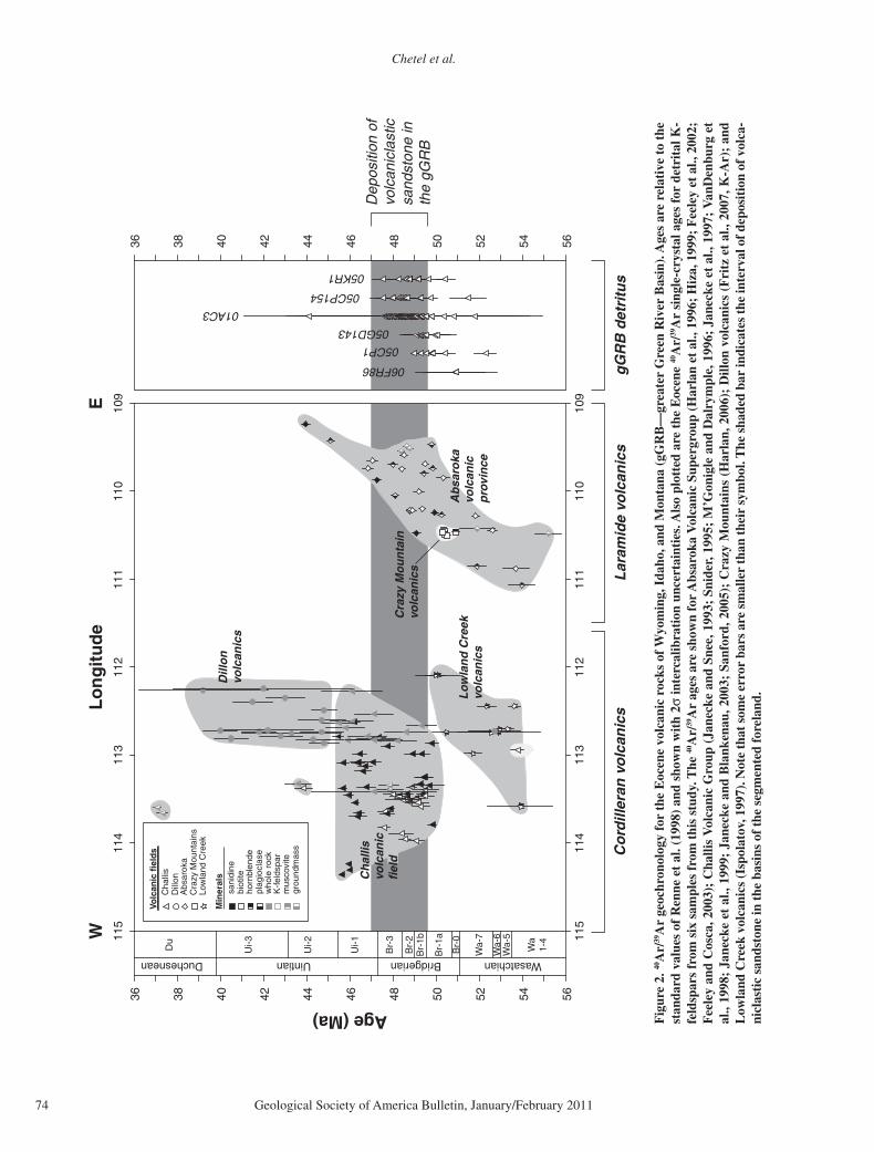
Figure 1. Map showing the locations of Eocene nonmarine basins in the Sevier segmented foreland, compiled from Ross et al. (1955), Bond and Wood (1978), and Love and Christiansen (1985). Abbreviations: SRSZ—Salmon River shear zone, PB— Pioneer Batholith.
Chetel et al.
74 Geological Society of America Bulletin, January/February 2011
WasatchianBridgerianUintian
36 38 40 42 44 46 48 50 52 54 56
Age (Ma)
Br-
2
Br-
3
Br-
1b
Br-
1a
Br-
0
Wa-
7
Wa-
5W
a-6
Ui-1
Ui-2 Wa
1-4
Ui-3Du
Duchesnean
Co
rdill
eran
vo
lcan
ics
Lar
amid
e vo
lcan
ics
Dep
ositi
on o
fvo
lcan
icla
stic
sand
ston
e in
the
gGR
B
06FR86
05CP1
05GD143
01AC3
05CP154
05KR1
WE
Cra
zy M
ou
nta
invo
lcan
ics
gG
RB
det
ritu
s
109
110
111
112
113
114
115
Lo
ng
itu
de
36 38 40 42 44 46 48 50 52 54 5610
911
011
111
211
311
411
5
Cha
llis
Dill
onA
bsar
oka
Cra
zy M
ount
ains
Low
land
Cre
ek
sani
dine
biot
iteho
rnbl
ende
plag
iocl
ase
who
le r
ock
mus
covi
tegr
ound
mas
s
K-f
elds
par
Min
eral
s
Volc
anic
fie
lds
Ab
saro
kavo
lcan
icp
rovi
nce
Lo
wla
nd
Cre
ekvo
lcan
ics
Ch
allis
volc
anic
fiel
d
Dill
on
volc
anic
s
Fig
ure
2. 40
Ar/
39A
r ge
ochr
onol
ogy
for
the
Eoc
ene
volc
anic
roc
ks o
f W
yom
ing,
Ida
ho, a
nd M
onta
na (
gGR
B—
grea
ter
Gre
en R
iver
Bas
in).
Age
s ar
e re
lati
ve t
o th
e st
anda
rd v
alue
s of
Ren
ne e
t al
. (19
98)
and
show
n w
ith
2σ in
terc
alib
rati
on u
ncer
tain
ties
. Als
o pl
otte
d ar
e th
e E
ocen
e 40
Ar/
39A
r si
ngle
-cry
stal
age
s fo
r de
trit
al K
-fe
ldsp
ars
from
six
sam
ples
fro
m t
his
stud
y. T
he 40
Ar/
39A
r ag
es a
re s
how
n fo
r A
bsar
oka
Vol
cani
c Su
perg
roup
(H
arla
n et
al.,
199
6; H
iza,
199
9; F
eele
y et
al.,
200
2;
Fee
ley
and
Cos
ca, 2
003)
; C
halli
s V
olca
nic
Gro
up (
Jane
cke
and
Snee
, 199
3; S
nide
r, 1
995;
M’G
onig
le a
nd D
alry
mpl
e, 1
996;
Jan
ecke
et
al.,
1997
; V
anD
enbu
rg e
t al
., 19
98;
Jane
cke
et a
l., 1
999;
Jan
ecke
and
Bla
nken
au, 2
003;
San
ford
, 200
5);
Cra
zy M
ount
ains
(H
arla
n, 2
006)
; D
illon
vol
cani
cs (
Fri
tz e
t al
., 20
07, K
-Ar)
; an
d L
owla
nd C
reek
vol
cani
cs (I
spol
atov
, 199
7). N
ote
that
som
e er
ror
bars
are
sm
alle
r th
an th
eir
sym
bol.
The
sha
ded
bar
indi
cate
s th
e in
terv
al o
f dep
osit
ion
of v
olca
-ni
clas
tic
sand
ston
e in
the
bas
ins
of t
he s
egm
ente
d fo
rela
nd.
Paleogeographic reconstruction of the Eocene Idaho River, North American Cordillera
Geological Society of America Bulletin, January/February 2011 75
Volcanic Group were erupted onto an irregular surface of Proterozoic quartzite, Paleozoic sedi-mentary rock, and the Cretaceous Idaho Batho-lith (Rodgers and Janecke, 1992). Stratigraphic relations within the Challis volcanic fi eld are highly complex due to an irregular basal sur-face, as well as extensional faulting that oc-curred during and after Challis volcanic activity (McIntyre et al., 1982; Kiilsgaard et al., 1986, 2000; Snider, 1995; Janecke et al., 1997).
The Challis volcanic fi eld is composed of (1) intermediate lava fl ows, fi ssure eruptions, and point source centers in the southeastern two-thirds of the fi eld, (2) large calderas fi lled with 2–3-km-thick ash-fl ow tuffs, northeast-striking grabens, and trap door calderas in the central axis of the fi eld, and (3) Eocene granites and granodiorites encased in the Cretaceous Idaho Batholith along the more deeply exhumed west-ern margin (Hardyman, 1981, 1985; McIntyre et al., 1982; Leonard and Marvin, 1982; Ekren, 1985, 1988; Janecke and Snee, 1993; Snider, 1995; Janecke et al., 1997; Gaschnig et al., 2007; Link and Lewis, 2009; Skipp et al., 2009). Activity in the Challis volcanic fi eld is con-strained by a suite of 40Ar/39Ar ages from sev-eral studies in the southeast part of the fi eld and K-Ar and U-Pb data elsewhere (Fig. 2). These data refl ect both effusive and explosive phases of activity in the Challis volcanic fi eld. The early phase (ca. 50–47 Ma) was primarily effu-sive, with andesitic and dacitic lavas produced from fi ssures and other point source centers (Snider, 1995). U-Pb ages for detrital zircons from modern streams that have headwaters in the Challis volcanic fi eld suggest that volcanic activity may have commenced as early as 52 Ma (Stroup et al., 2008). However, 40Ar/39Ar ages of 49.78 ± 0.31 Ma, 49.82 ± 0.20 Ma, and 49.46 ± 0.37 Ma from the same basal quartzite-bearing ash-fl ow tuff in the eastern Challis volcanic fi eld mark the base of the preserved Challis sequence (M’Gonigle and Dalrymple, 1996; Janecke et al., 1999; Janecke and Blankenau, 2003). The overlying rocks are primarily dacitic and an-desitic lava fl ows interbedded with tuff and vol-caniclastic sandstone distributed over an area southeast of the main caldera zone (Janecke and Snee, 1993; M’Gonigle, and Dalrymple, 1996; Snider, 1995; Sanford, 2005).
A K-Ar age of 48.4 ± 1.6 Ma for the rhyo-dacitic Tuff of Ellis Creek constrains the ini-tiation of widespread explosive volcanism in the central axis of the Challis volcanic fi eld (McIntyre et al., 1982). This explosive phase is related to development of large cauldron-complexes (Ekren, 1985), and culminated with the eruption of the 46.1–45.7 Ma Tuff of Chal-lis Creek across east-central Idaho (Hardyman, 1985; Janecke and Snee, 1993; Janecke et al.,
1997; Janecke and Blankenau, 2003) and south-west Montana (M’Gonigle and Dalrymple, 1996; VanDenburg et al., 1998; Janecke et al., 1999). A thin quartz-sanidine ash-fl ow tuff rec-ognized throughout the area is thought to be a distal remnant of this tuff (Janecke and Snee, 1993). The broad distribution of the Tuff of Challis Creek and the widespread and uniform distribution of the underlying biotite-bearing tuffs (i.e., biotite ash-fl ow tuff in Muddy Creek Basin dated at 47.33 ± 0.30 Ma; Janecke et al., 1999) suggest that dacitic and andesitic lava fl ows fi lled and leveled pre-Eocene erosional to-pography prior to eruption of the Tuff of Challis Creek (Janecke and Snee, 1993).
Other Eocene Volcanism
Volcanic activity immediately adjacent to the Challis volcanic fi eld is documented in several other localities in the North American Cordillera during the middle Eocene. The Dillon volcanic fi eld contains relatively thin and discontinuous units, and occupies the easternmost edge of the Challis volcanic fi eld in western Montana. The lower Dillon volcanic rocks are temporally equivalent to the Challis volcanic rocks, are plotted as such in Figure 2, and are considerably more felsic than middle and upper Dillon volca-nic rocks (Fritz et al., 2007). The Lowland Creek volcanics, farther to the north, are a sequence of quartz-latitic rocks that rest unconformably on the Cretaceous Boulder Batholith, northeast of the main Challis zone (Fig. 1; Smedes and Thomas, 1965). The 40Ar/39Ar ages (Ispolatov, 1997) indicate that the earliest volcanic activity in the Lowland Creek volcanic fi eld predates the earliest activity in the Challis volcanic fi eld by ~4 m.y. and overlaps temporally with volcanism in the Absaroka volcanic province (Fig. 2).
VOLCANICLASTIC SEDIMENTATION IN THE EOCENE FORELAND
Sandstone that has been described in the past as volcaniclastic is observed in several Laramide basins beginning in the middle Eocene (e.g., Van Houten, 1964; Love, 1970; Surdam and Stanley, 1980; Johnson, 1981). The stratigraphic and temporal constraints on these units, as well as petrographic analyses, are summarized next. Although stratigraphic and temporal constraints are highly variable, a basic understanding of these constraints is critical to the interpretation of paleodrainage patterns in the middle Eocene.
Greater Green River Basin
Volcaniclastic sandstone was deposited in the greater Green River Basin between 49.6 Ma
and 47 Ma (Fig. 3). This interval is constrained by the age of the Sixth Tuff (49.58 ± 0.17 Ma; Smith et al., 2008b) and the age for the young-est dated material in the greater Green River Ba-sin, the Sage Creek Mountain pumice (47.14 ± 0.16 Ma; Smith et al., 2008b), which has a biostratigraphic age of Bridger E (ca. 47 Ma; Fig. 3). Volcaniclastic sandstones are assigned to three units, the alluvial/fl uvial Bridger and Washakie Formations, as well as the deltaic Sand Butte Bed of the Laney Member of the Green River Formation (Culbertson, 1962; Roe-hler, 1973a, 1973b; Chetel and Carroll, 2010). In the greater Green River Basin, volcaniclas-tic sandstone is temporally equivalent to the lacustrine Laney Member: the oldest volcani-clastic sandstone occurs between the transition between underfi lled (Wilkins Peak Member) and balance-fi lled (lower Laney Member) strata and the overlying transition to overfi lled strata (upper Laney Member) in the Bridger subbasin (Smith et al., 2008b; Chetel and Carroll, 2010). High-resolution correlation indicates that the oldest volcaniclastic sandstone is closer in age to the underfi lled to balance-fi lled transition and that volcaniclastic sandstone progressively infi lled the greater Green River Basin from northwest to southeast. Point counts of 41 thin sections from the Bridger and Washakie Forma-tion as well as the Sand Butte Bed show that volcaniclastic sandstone in the greater Green River Basin has a composition that is consistent with a magmatic source (Fig. 4; see GSA Data Repository Table DR1 for raw data1). These samples belong to the volcaniclastic petrofa-cies described in Chetel and Carroll (2010). The most common lithic fragment is volcanic, the plutonic:volcanic ratio is low, there is abundant biotite and hornblende, and muscovite is absent.
Piceance Creek Basin
Volcaniclastic sandstone was deposited in the Piceance Creek Basin beginning ca. 48.4 Ma (Fig. 3). This is constrained by the age for the Wavy Tuff, which is ~30 m above the Mahogany zone in the Piceance Creek and Uinta Basins (48.33 ± 0.27 Ma; Remy, 1992; Smith et al., 2008b). The age of the youngest volcaniclastic-bearing strata is more diffi cult to constrain, but it is estimated to have a biostratigraphic age of late Bridger-3 or early Uintan-1 (Fig. 3; Smith et
1GSA Data Repository item 2010213, Raw point count data, full documentation of 40Ar/39Ar geochro-nology, and documentation of existing 40Ar/39Ar and U-Pb geochronology for potential source rocks and supporting references, is available at http://www.geosociety.org/pubs/ft2010.htm or by request to [email protected].
Chetel et al.
76 Geological Society of America Bulletin, January/February 2011
WRB gGRB PCB
Uin
tian
Brid
geria
nW
asat
chia
n
55
54
53
52
51
50
49
48
47
46
45
44
43
42
Br2
Br3
Br1b
Br1a
Br0
Wa7
Wa6
Wa5
Wa1-4
Ui3
Ui2
Ui1
age zone Facies
VolcaniclasticArkosic
EvaporativeFluctuating profundal
Fluvial-lacustrine
Formations and Members
TuTuTu
TdTdTd
Tgc
Tgg
TgpTgpTgp
Twr
Twr
Twrl
Twrl
Twrc
Twrc
Twr
Twb
Twb
Twb
?
Twb - Wagon Bed FormationTwbg - Green and Brown MemberTwbh - Hendry Ranch MemberTu - Uinta FormationTb - Bridger FormationTbtb - Turtle Bluff MemberTbt - Twin Buttes MemberTbb - Blacks Fork MemberTwa - Washakie FormationTwka - Adobe Town MemberTwkk - Kinney Rim MemberTg - Green River FormationTgl - Laney Member b - buff marker bedTgw - Wilkins Peak MemberTgt - Tipton MemberTglu - Luman TongueTgp - Parachute Creek Member m - Mahogany zoneTga - Anvil Points MemberTgg - Garden Gulch MemberTgc - Cow Ridge MemberTwr - Wind River FormationTwrl - Lysite MemberTwrc - Lost Cabin MemberTw - Wasatch FormationTwc - Cathedral Bluffs TongueTwn - Niland TongueTd - Debeque Formation
TwTw
TwnTwn
Tw
TgluTwn
Tgt
Tgl
Tgw
Twc
Tga
Tga
Tga
mm
bAB
C
D
E
Brid
ger
Bed
s of
Mat
thew
(19
09)
Twkk
Twkk
Tbt
Tbt
Tbb
Tbb
Twkk
Twka
Twka
Twka
Tbt
TbtbTbtbTbtb
Tbb
Twrl
Twrc
Twbg
Twbh
Twbh
Twbh
Ag
e (M
a)
SampledSampledIntervalIntervalSampledInterval
Figure 3. Composite stratigraphic sections, age model, and bio-stratigraphic zonation for basins that preserve Eocene sediment that has been described in the past as volcaniclastic. The age model is based on the work of Smith et al. (2008b). The sampled inter-val is highlighted; more detailed information regarding the strati-graphic positions of each sample can be found in Figure DR1 (see text footnote 1). Abbreviations: gGRB—greater Green River Ba-sin, WRB—Wind River Basin, PCB—Piceance Creek Basin.
al., 2008b). Volcaniclastic sandstone is assigned to the Uinta Formation, which is a fi ne-grained sandstone unit that periodically interrupted la-custrine deposition, which created an interfi n-gered relationship between the deltaic facies of the Uinta Formation and the lacustrine facies of the Parachute Creek Member of the Green River Formation (Trudell et al., 1970; Johnson, 1981). The Uinta Formation covers the whole Piceance Creek Basin. Correlation of subsurface well logs demonstrates that the sediments entered the ba-sin from the north and prograded south (John-son, 1981). Point counts of three thin sections of samples from the Uinta Formation yield results that are consistent with a volcanic source (Fig. 4; see Table DR1 for raw data [see footnote 1]). The mean composition of these samples is indistin-guishable from the mean composition of greater Green River Basin sandstone at the 1σ level.
Wind River Basin
Eocene sandstone strata of the Wagon Bed Formation have also been described as volcani-clastic by previous authors (Van Houten, 1964; Surdam and Stanley, 1980), suggesting a possible genetic relationship with volcaniclastic strata in the greater Green River Basin. However, detailed petrographic examination raises doubts about this interpretation. The presence of rounded cobbles of graphitic granite (up to 10 cm in diameter) and a zircon-rich heavy mineral assemblage (Den-son and Pipiringos, 1969) suggest a basement source in the Granite Mountains to the south (Love, 1970). Point counts of seven samples from the Wagon Bed Formation indicate that the framework grains in these samples are not vol-canic in origin (Fig. 4; see Table DR1 for raw
Qt
F L
Recycledorogen
provenance
Magmatic arcprovenance
Continental blockprovenance
WRB
gGRB
PCB
Figure 4. Volcaniclastic sandstone compo-sitional data for sandstone samples from three basins plotted on a QtFL and ternary diagram. Composition means are plotted, and 1σ standard deviations are indicated by the patterned polygons. Shaded provenance fi elds are from Dickinson and Suczek (1979). Symbols: squares—greater Green River Basin, triangles—Piceance Creek Basin, circles—Wind River Basin. Abbreviations: Qt—total quartz, F—feldspar, L—lithic fragments, gGRB—greater Green River Basin, WRB—Wind River Basin, PCB—Piceance Creek Basin.
Paleogeographic reconstruction of the Eocene Idaho River, North American Cordillera
Geological Society of America Bulletin, January/February 2011 77
data [see footnote 1]). The most common lithic fragments in these samples are polycrystalline and graphitic quartz, microcline is abundant, and the plutonic:volcanic ratio is higher than that of the samples from the greater Green River Basin and Piceance Creek Basin (Fig. 4). It therefore appears unlikely that the Wagon Bed Formation is genetically related to volcaniclastic deposits as-sociated with the Green River Formation.
ISOTOPIC RESULTS
Pb Isotopes
There are signifi cant differences in the Pb isotope composition of volcanic rocks from the Absaroka and Challis volcanic fi elds (Peterman et al., 1970; Meen and Eggler, 1987; Norman and Leeman, 1989; Norman and Mertzman,
1991; Hiza, 1999). Absaroka volcanic rocks tend to have lower 206Pb/204Pb and 208Pb/204Pb values as compared to rocks from the Challis volcanic fi eld (Fig. 5). There is some overlap in 206Pb/204Pb between Challis and Absaroka vol-canic rocks, but for most rocks that have these overlapping 206Pb/204Pb ratios, the Absaroka volcanic rocks tend to have higher 207Pb/204Pb values (Fig. 5); this likely refl ects the old
Figure 5. Pb isotope discrimina-tion diagrams showing measured whole-rock Pb isotope ratios for greater Green River Basin vol-caniclastic sandstone (triangles) against the compositional ranges for the Challis and Absaroka vol-canic fi elds and the Idaho Batho-lith. The source-rock fi elds were constructed using the data of Pe-terman et al. (1970), Shuster and Bickford (1985), Meen and Egg-ler (1987), Norman and Leeman (1989), Norman and Mertzman (1991), Hiza (1999), and Unruh et al. (2008). Assumptions for mixing calculations between average Ab-saroka and Challis compositions as well as mixing lines are dis-played; the tick marks denote 10% intervals. Average compositions are shown with error bars that in-dicate one standard deviation.
Chetel et al.
78 Geological Society of America Bulletin, January/February 2011
Archean-age Wyoming cratonic crust through which the samples erupted. These differences in Pb isotope compositions can be used to evaluate the source of volcanic detritus that was deliv-ered to the greater Green River Basin.
Bulk-rock Pb isotope analyses were ob-tained from 16 volcaniclastic sandstone samples from the greater Green River Basin (Table 1). The suite of samples that were ana-lyzed was chosen to refl ect both the geographic extent of volcaniclastic sandstone in the greater Green River Basin and the stratigraphic range (Fig. 3; Fig. DR1 [see footnote 1]). Volcani-clastic sandstone samples from the greater Green River Basin have 206Pb/204Pb ratios from 17.37 to 20.17, 207Pb/204Pb ratios from 15.50 to 15.77, and 208Pb/204Pb ratios from 37.37 to 39.36, and these overlap in composition with Challis volcanic rocks (Fig. 5). Because these are bulk-rock analyses, they represent a mixture of the different sources that supplied sediment to the greater Green River Basin, and thus it is possible that some of the ana-lyzed sedimentary rocks represent a mixture of both Challis and Absaroka volcanogenic sources. Because, however, the Pb concen-trations of the Challis and Absaroka volcanic rocks are subequal, the relative proportion of possible Absaroka- derived detritus for most of the samples must be small, as shown by the mixing line for average Absaroka and Challis compositions (Fig. 5). Indeed, because many samples have 206Pb/204Pb and 208Pb/204Pb ratios
greater than the Challis volcanic fi eld rocks, it is expected that some of the detritus was de-rived from sources that match the composition of Idaho Batholith rocks (Fig. 5), located to the north and west of the Challis volcanic fi eld.
40Ar/39Ar Geochronology
We obtained a total of 256 K-feldspar ap-parent ages from six samples of volcaniclastic sandstone from the greater Green River Basin (see Table DR2 [see footnote 1]). Five of the six samples are from strata on the eastern side of the greater Green River Basin and fall into biostrati-graphic zones Br-1b to Br-3. The sixth sample is stratigraphically the lowest and was collected from a locality on the western edge of the greater Green River Basin (Fig. DR1 [see footnote 1]). These data represent analyses of both seemingly pristine grains, as well as altered grains, an ap-proach intended to minimize sampling bias. Although both sanidine and orthoclase crystals were analyzed, no correlation was observed between composition and age. The 40Ar/39Ar ages range from 44 to 2366 Ma (Figs. 6 and 7; Table 2). The most prominent population is Ce-nozoic in age; however, Mesozoic (23% of the grains) and Proterozoic (32% of the grains) pop-ulations are also present. These results are inter-preted through comparison to a compilation of published 40Ar/39Ar, K-Ar, and U-Pb data from the rocks of the Idaho–Montana segment of the North American Cordillera (see Tables DR3
and DR4 [footnote 1]). Comparison of Eocene and Mesozoic ages provides a high degree of confi dence when inferring sources, whereas interpretation of Proterozoic ages is less certain because the majority of Neoproterozoic and Mesoproterozoic tectonic and magmatic events are based on U-Pb geochronology. Thus, the feldspar cooling ages of these old sources are not well known.
These results show that juvenile volcanic sediment was mixed with grains derived from other prevolcanic sources. The youngest detrital ages are broadly consistent with the distribution of previously reported ages of Challis volcanic rocks (Fig. 2). Conversely, ages similar to base-ment exposed within the foreland (1.6–1.8 Ga; Premo and VanSchmus, 1989) are absent.
THE EOCENE LANDSCAPE
Four major rock types were exposed in cen-tral Idaho and western Montana during the Eo-cene (Fig. 8). Eocene volcanic rocks overlie Paleozoic sedimentary rock as well as the gra-nitic rocks of the Cretaceous Idaho Batholith and Proterozoic quartzite. The prominent Eo-cene, Cretaceous, and Proterozoic populations that are observed in the detrital K-feldspar data (Fig. 6) are consistent with the interpreted Eo-cene geology. We note that Paleozoic sedimen-tary rocks are primarily limestone, which would not have contributed detrital feldspars to greater Green River Basin sandstone.
TABLE 1. Pb ISOTOPE COMPOSITIONS OF GREATER GREEN RIVER BASIN SANDSTONE
Note: The errors are 2σ based on in-run statistics for each Pb isotope analysis (fi fty 5 s integrations with a 208Pb ion current of 2 × 10–11 amps). Bulk-rock samples from the greater Green River Basin (gGRB) were dissolved in HF and HNO3, and Pb was separated using HBr-HCl anion exchange columns. Total procedural blanks ranged from 99 to 128 pg of Pb. Pb isotope ratios were measured by thermal ionization mass spectrometry using Re fi laments and Si-gel on a Micromass Sector 54 instrument at the University of Wisconsin–Madison Radiogenic Isotope Laboratory. Repeat analyses of NIST SRM-981 (9 analyses) and SRM-982 (8 analyses) were used to correct for instrumental mass bias, where the pooled average mass dependent fractionation factor determined from the measured 207Pb/206Pb and 208Pb/206Pb ratios of NIST SRM-981 and SRM-982, respectively, was 0.0014 ± 0.0008 (2 S.D.) per amu. Eight bulk rocks were analyzed twice, and reproducibility was within the uncertainty of the empirically determined fractionation factor. The stratigraphic positions of all analyzed samples are illustrated in Figure DR1 (see text footnote 1).
*Duplicate Pb isotope analyses on the same dissolution.
Paleogeographic reconstruction of the Eocene Idaho River, North American Cordillera
Geological Society of America Bulletin, January/February 2011 79
Prior to the eruption of the Challis volcanic fi eld, Middle Proterozoic rocks at the surface in the north transitioned to progressively younger strata to the west, south, and east (Rodgers and Janecke, 1992). Challis volcanic rocks were erupted onto a dissected surface, which featured a network of preexisting paleovalleys (Janecke et al., 2000). In the southeast part of the Chal-lis volcanic fi eld, many complete sections of Challis volcanic rocks are preserved in numer-ous late Eocene to early Miocene half grabens. Calderas in the central axis of the fi eld also preserve complete sections, but exposure of the older units is limited, except in tilted trap-door calderas (Ekren, 1988; Janecke et al., 1997). In contrast, the western and northern third of the volcanic fi eld has been denuded of its volcanic cover, and the plutonic roots are exposed in the eastern part of the Idaho Batholith.
The western third of the volcanic fi eld is the most likely source of voluminous volcaniclastic sediment. The documented paleovalleys, which are all in the southeast part of the Challis vol-canic fi eld, preserve thicker sections of middle Eocene volcanic and sedimentary rocks that in-clude shoestring deposits of unwelded ash-fall tuff. The 49.34 ± 0.28 Ma quartzite-bearing tuff (M’Gonigle and Dalrymple, 1996), which forms a shoestring deposit that is 85 km long and up to 5 km wide at the base of the Lemhi Pass pa-leovalley (Janecke et al., 2000), the lithic-rich tuff, also preserved in the Lemhi Pass paleo-valley, and the 47.87 ± 0.20 Ma Tuff of Curtis Ranch, are poorly welded and today are mostly confi ned to the paleovalley and the source calde-ras (Blankenau, 1999; Janecke and Blankenau, 2003). Based on these observations, we infer that, at times, the Eocene landscape was blan-keted with easily eroded pyroclastic rocks, most of which have been subsequently eroded.
The Idaho Batholith is composed of two tem-porally and geographically distinct lobes. The older Atlanta Lobe intruded Paleozoic sedimen-tary rock west of the Challis volcanic fi eld and is both overlain and intruded by Eocene rocks (Link and Lewis, 2009). The northern Bitter-root Lobe invaded Proterozoic metasedimentary rocks, is heavily intruded by Eocene plutons (Toth and Stacey, 1992), and hosted three Eo-cene metamorphic core complexes that formed as the region underwent extensional collapse (Foster et al., 2007). Thermochronology from the Bitterroot metamorphic core complex indi-cates that extension was initiated between 54 and 52 Ma (Foster et al., 2001), although rapid exhu-mation did not begin until ca. 50 Ma (Foster and Fanning, 1997; Foster et al., 2001; House et al., 2002), and continued until after 40 Ma (Fig. 9; Foster et al., 2007). Total Eocene exhumation was likely ~20–25 km in the eastern part of the
0
2
4
6
8
0 500 1000 1500 2000 2500
Age (Ma)
0
5
10
15Cenozoic and Mesozoic ages
(n = 24)
Cenozoic and Mesozoic ages(n = 12)
02
4
6
8
10
12 Cenozoic and Mesozoic ages(n = 19)
0
5
10
15
20
Nu
mb
er o
f G
rain
s
Cenozoic and Mesozoic ages(n = 36)
010203040506070
0
5
10
15
20Cenozoic and Mesozoic ages
(n = 21) 05KR1All agesn = 30
0
0
0
0
0
0 50 100 150 200
250250
250
0 50 100 150 200 250
06FR86All agesn = 27
05GD143All agesn = 39
0 50 100 150 200 250
Cenozoic and Mesozoic ages(n = 72)
01AC3All agesn = 82
0 50 100 150 200
0 50 100 150 200 250
05CP1All agesn = 43
05CP154All agesn = 36
0 50 100 150 200 250
0 500 1000 1500 2000 2500
250250250
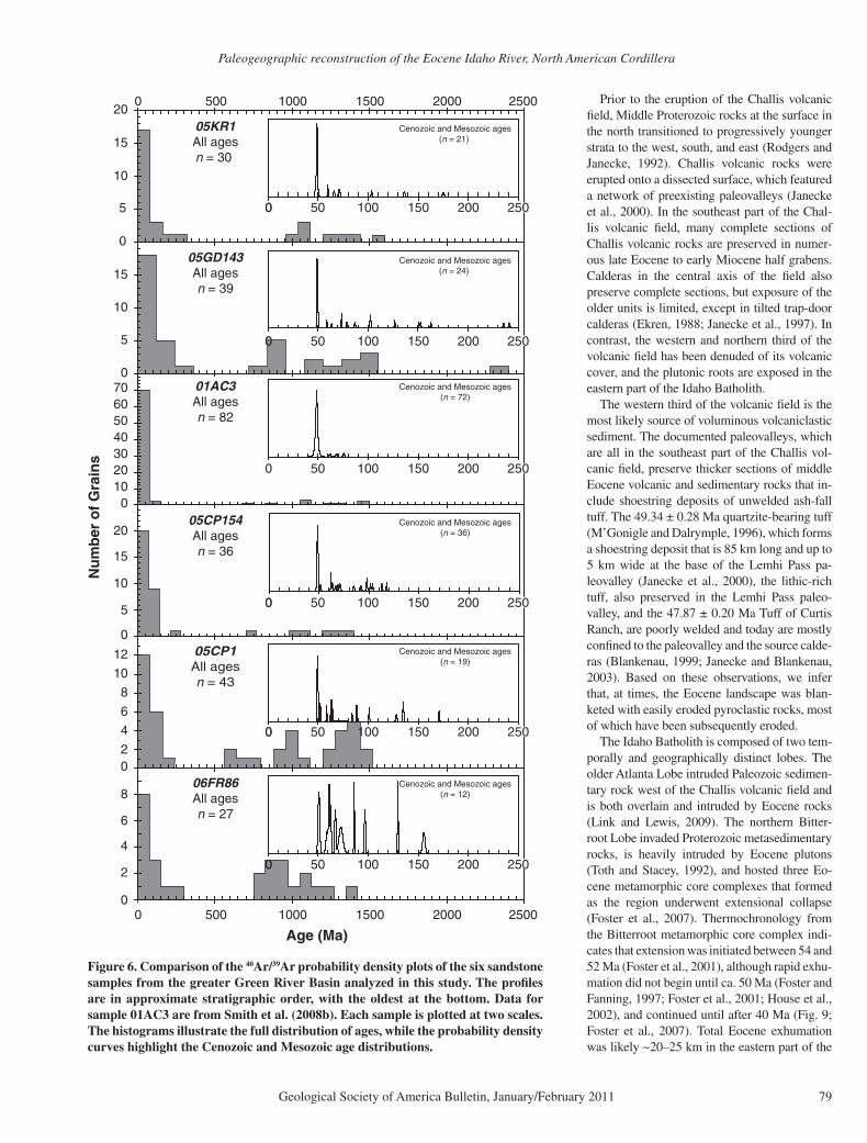
Figure 6. Comparison of the 40Ar/39Ar probability density plots of the six sandstone samples from the greater Green River Basin analyzed in this study. The profi les are in approximate stratigraphic order, with the oldest at the bottom. Data for sample 01AC3 are from Smith et al. (2008b). Each sample is plotted at two scales. The histograms illustrate the full distribution of ages, while the probability density curves highlight the Cenozoic and Mesozoic age distributions.
Chetel et al.
80 Geological Society of America Bulletin, January/February 2011
Bitterroot lobeBitterroot lobeBitterroot lobe
Nu
mb
er
Relative p
rob
ability
0 50 100 150 200 250 300 3500
20
40
60
80
100
120
140
Age (Ma)
This study[40Ar/39Ar](n = 180)
Literature ages[K-Ar and 40Ar/39Ar](n = 552)
47
65
76
94
112135
153 282
Atlanta lobeChallis
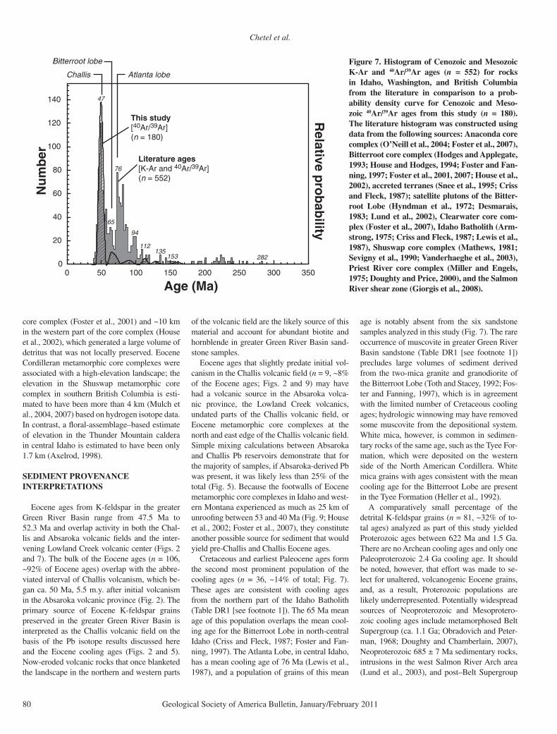
Figure 7. Histogram of Cenozoic and Mesozoic K-Ar and 40Ar/39Ar ages (n = 552) for rocks in Idaho, Washington, and British Columbia from the literature in comparison to a prob-ability density curve for Cenozoic and Meso-zoic 40Ar/39Ar ages from this study (n = 180). The literature histogram was constructed using data from the following sources: Anaconda core complex (O’Neill et al., 2004; Foster et al., 2007), Bitterroot core complex (Hodges and Applegate, 1993; House and Hodges, 1994; Foster and Fan-ning, 1997; Foster et al., 2001, 2007; House et al., 2002), accreted terranes (Snee et al., 1995; Criss and Fleck, 1987); satellite plutons of the Bitter-root Lobe (Hyndman et al., 1972; Desmarais, 1983; Lund et al., 2002), Clearwater core com-plex (Foster et al., 2007), Idaho Batholith (Arm-strong, 1975; Criss and Fleck, 1987; Lewis et al., 1987), Shuswap core complex (Mathews, 1981; Sevigny et al., 1990; Vanderhaeghe et al., 2003), Priest River core complex (Miller and Engels, 1975; Doughty and Price, 2000), and the Salmon River shear zone (Giorgis et al., 2008).
core complex (Foster et al., 2001) and ~10 km in the western part of the core complex (House et al., 2002), which generated a large volume of detritus that was not locally preserved. Eocene Cordilleran metamorphic core complexes were associated with a high-elevation landscape; the elevation in the Shuswap metamorphic core complex in southern British Columbia is esti-mated to have been more than 4 km (Mulch et al., 2004, 2007) based on hydrogen isotope data. In contrast, a fl oral-assemblage–based estimate of elevation in the Thunder Mountain caldera in central Idaho is estimated to have been only 1.7 km (Axelrod, 1998).
SEDIMENT PROVENANCE INTERPRETATIONS
Eocene ages from K-feldspar in the greater Green River Basin range from 47.5 Ma to 52.3 Ma and overlap activity in both the Chal-lis and Absaroka volcanic fi elds and the inter-vening Lowland Creek volcanic center (Figs. 2 and 7). The bulk of the Eocene ages (n = 106, ~92% of Eocene ages) overlap with the abbre-viated interval of Challis volcanism, which be-gan ca. 50 Ma, 5.5 m.y. after initial volcanism in the Absaroka volcanic province (Fig. 2). The primary source of Eocene K-feldspar grains preserved in the greater Green River Basin is interpreted as the Challis volcanic fi eld on the basis of the Pb isotope results discussed here and the Eocene cooling ages (Figs. 2 and 5). Now-eroded volcanic rocks that once blanketed the landscape in the northern and western parts
of the volcanic fi eld are the likely source of this material and account for abundant biotite and hornblende in greater Green River Basin sand-stone samples.
Eocene ages that slightly predate initial vol-canism in the Challis volcanic fi eld (n = 9, ~8% of the Eocene ages; Figs. 2 and 9) may have had a volcanic source in the Absaroka volca-nic province, the Lowland Creek volcanics, undated parts of the Challis volcanic fi eld, or Eocene metamorphic core complexes at the north and east edge of the Challis volcanic fi eld. Simple mixing calculations between Absaroka and Challis Pb reservoirs demonstrate that for the majority of samples, if Absaroka-derived Pb was present, it was likely less than 25% of the total (Fig. 5). Because the footwalls of Eocene metamorphic core complexes in Idaho and west-ern Montana experienced as much as 25 km of unroofi ng between 53 and 40 Ma (Fig. 9; House et al., 2002; Foster et al., 2007), they constitute another possible source for sediment that would yield pre-Challis and Challis Eocene ages.
Cretaceous and earliest Paleocene ages form the second most prominent population of the cooling ages (n = 36, ~14% of total; Fig. 7). These ages are consistent with cooling ages from the northern part of the Idaho Batholith (Table DR1 [see footnote 1]). The 65 Ma mean age of this population overlaps the mean cool-ing age for the Bitterroot Lobe in north-central Idaho (Criss and Fleck, 1987; Foster and Fan-ning, 1997). The Atlanta Lobe, in central Idaho, has a mean cooling age of 76 Ma (Lewis et al., 1987), and a population of grains of this mean
age is notably absent from the six sandstone samples analyzed in this study (Fig. 7). The rare occurrence of muscovite in greater Green River Basin sandstone (Table DR1 [see footnote 1]) precludes large volumes of sediment derived from the two-mica granite and granodiorite of the Bitterroot Lobe (Toth and Stacey, 1992; Fos-ter and Fanning, 1997), which is in agreement with the limited number of Cretaceous cooling ages; hydrologic winnowing may have removed some muscovite from the depositional system. White mica, however, is common in sedimen-tary rocks of the same age, such as the Tyee For-mation, which were deposited on the western side of the North American Cordillera. White mica grains with ages consistent with the mean cooling age for the Bitterroot Lobe are present in the Tyee Formation (Heller et al., 1992).
A comparatively small percentage of the detrital K-feldspar grains (n = 81, ~32% of to-tal ages) analyzed as part of this study yielded Proterozoic ages between 622 Ma and 1.5 Ga. There are no Archean cooling ages and only one Paleoproterozoic 2.4 Ga cooling age. It should be noted, however, that effort was made to se-lect for unaltered, volcanogenic Eocene grains, and, as a result, Proterozoic populations are likely underrepresented. Potentially widespread sources of Neoproterozoic and Mesoprotero-zoic cooling ages include metamorphosed Belt Supergroup (ca. 1.1 Ga; Obradovich and Peter-man, 1968; Doughty and Chamberlain, 2007), Neoproterozoic 685 ± 7 Ma sedimentary rocks, intrusions in the west Salmon River Arch area (Lund et al., 2003), and post–Belt Supergroup
Paleogeographic reconstruction of the Eocene Idaho River, North American Cordillera
Geological Society of America Bulletin, January/February 2011 81
TABLE 2. 40Ar/ 39Ar SINGLE CRYSTAL AGES
Sample 06FR86 05CP1 05GD143 05CP154 05KR1
Single-crystal agesMa ± 2σ Ma ± 2σ Ma ± 2σ Ma ± 2σ Ma ± 2σ(n = 27) (n = 43) (n = 38) (n = 36) (n = 30)
1509.8 ± 8.50 Note: The data from sample 01AC3 are not included here because they are already published in Smith et al. (2008b). Feldspar crystals between 200 and 500 microns in
length were isolated using the methods described by Smith et al. (2003) and irradiated together with fl ux monitors at the Oregon State University Triga reactor. Ar isotopic compositions were determined from single crystals via automated CO2 laser degassing and mass spectrometry in single crystal total fusion experiments [according to the procedure of Smith et al. (2003)]. The 28.34 Ma Taylor Creek sanidine was used as the neutron fl uence standard (Renne et al., 1998) against which ages for individual experiments were calculated using the decay constant of Steiger and Jäger (1977).
anorogenic granite and gabbro (ca. 1.4 Ga; Doughty and Chamberlain, 1996, 2007; Ta-ble DR2 [see footnote 1]). Syn–Belt Supergroup volcanic rocks (ca. 1.5–1.4 Ga) are so small in volume that they are unlikely sources of sedi-ment (Evans et al., 2000).
It is noteworthy that 24 grains have ages that match Grenville cooling. To date, the only areas of documented Grenville-aged meta-morphism in the North American Cordillera are north of the Bitterroot lobe of the Idaho Batholith (Vervoort et al., 2005; McClelland et al., 2005; Dragovich et al., 2009; Reed Lewis, 2009, oral commun.). Alternatively, these grains could have been recycled from pre-Eocene sandstone units that undoubtedly contain some Grenville-aged detritus. Areas adjacent to the Idaho Batholith were so strongly affected by Cretaceous contact metamorphism during em-placement of the arc that no Proterozoic cooling ages are recorded (Table DR2 [see footnote 1];
Criss and Fleck, 1987; Lewis et al., 2007; Dra-govich et al., 2009). Eleven grains have cooling ages that overlap with the ca. 1.4 Ga anorogenic plutonism of central Idaho. The largest bodies of ca. 1.4 Ga anorogenic plutons align southeast to northwest along the axis of the Salmon River Arch (Link and Lewis, 2009) and coincide with the upstream end of an Eocene paleovalley (Ja-necke et al., 2000). If this paleovalley was the main trunk stream fl owing toward the greater Green River Basin, it would have sampled the largest bodies of the anorogenic plutons. Eight detrital K-feldspar grains yield cooling ages between 600 and 900 Ma; the only magmatic rocks of similar age are fairly small-volume orthogneisses in central and western Idaho and southwestern Montana (Table DR2 [see foot-note 1]). For a larger volume of material, we consider older plutonic and metaplutonic rocks that were shocked and thermally reset within the Neoproterozoic Beaverhead impact aureole of
southwestern Montana. The 40Ar/39Ar geochro-nology shows that these rocks could have been the source for 600 and 900 Ma cooling ages in the detrital feldspars (Kellogg et al., 2003). The Eocene Hawley Creek paleovalley fl owed through the center of the impact area (Fig. 8; Ja-necke et al., 2000).
IMPLICATIONS FOR PALEODRAINAGE
The prevailing model for delivery of volca-niclastic sediment to the greater Green River Basin was the progressive infi ll of the Wind River, greater Green River, and Piceance Creek Basins with volcaniclastic sediment derived from the Absaroka volcanic province (Surdam and Stanley, 1980). Recognition of a signifi -cant volume of Challis-derived sediment in the foreland necessitates revision of this model. We propose a connection between an orogenic river
Chetel et al.
82 Geological Society of America Bulletin, January/February 2011
IBCIBCgr
eate
rG
reen
Riv
er B
asin
Beaverhead Fault
Beaverhead fault
BCCIBCIBCIB
II
?
?
??
?
McCT McCT
Anacond
a d
etachm
ent
Anacond
a d
etachm
ent
Pio
neer
thrus
t
Scarface thrust
Paris thr.
Mea
de th
ru
stAbsar
oka
thru
st
Prosp
ect t
hrus
t
DC
F
BDCFBDCFBDCF
BGF
BGF
Lem
P
eak
Fau
lt
Lem
P
eak
Fau
lt
Cooper B
asin thrust
Bla
ckta
il-Snowcrest Uplift
Bla
ckta
il-Snowcrest Uplift
Continental Divide
Snak
e Rive
r Pla
in
Yellowjacket
Yellowjacket
Mine culm
.
Mine culm
.
Yellowjacket
Mine culm
.
Patterso
n culm
.
Cobalt
culm
.
Cobalt
culm
.
Cobalt
culm
.
Grasshopper th
rust
Grasshopper th
rust
Iron
Lak
e thr.
Iron
Lak
e thr.
CT
Carmen C
ulminatio
n
Carmen C
ulminatio
n
Carmen C
ulminatio
n
Hawley Creek t
hr.
Hawley Creek t
hr.
Hawley Creek t
hr.
Idah
o B
atho
lith
Idah
o B
atho
lith
Bitt
erro
ot L
obe
Bitt
erro
ot L
obe
Idah
o B
atho
lith
Bitt
erro
ot L
obe
Idah
o B
atho
lith
Idah
o B
atho
lith
Atla
nta
Lobe
Atla
nta
Lobe
Idah
o B
atho
lith
Atla
nta
Lobe
Bou
lder
Bou
lder
Bat
holit
hB
atho
lith
Bou
lder
Bat
holit
h
Pio
neer
Pio
neer
Plu
ton
Plu
ton
Pio
neer
Plu
ton
MPC
TT
McCT McCT
MLT
MLT
Mad
ison
-Gal
latin
Upl
ift
Mad
ison
-Gal
latin
Upl
ift
Mad
ison
-Gal
latin
Upl
iftBe
arto
oth
Uplift
Bear
toot
h Upl
ift
Bear
toot
h Upl
iftBuffalo Fork thrust
Wyo
min
gM
onta
na
WyomingIdaho
Put
nam
thru
st
Mon
tana
Idah
o
Wind R
iver M
tns.
Wind R
iver M
tns.
Wind R
iver M
tns.
Madison-Graveelly Arch
Madison-Gravelly Arch
40 k
m
N
Bitt
erro
otB
itter
root
Cor
eC
ore
Com
plex
Com
plex
Bitt
erro
otC
ore
Com
plex
Pio
neer
Pio
neer
Cor
eC
ore
Com
plex
Com
plex
Pio
neer
Cor
eC
ompl
ex
Was
haki
e-O
wl C
reek
Upl
ift
?
?
??
GT
Johnson thrust
WP
WP
WP
WP
WP
RC
RC
RC
RC
RC
PR
PR
PR
PR
PR
CG
CG
CG
CG
CG
CS
CS
CS
CS
CS
PH
PH
PH
PH
PH
LHS
LHS
LHS
LHS
LHS
CJP
CJP
CJP
Cody Arch
Arc
hean
to P
rote
rozo
ic b
asem
ent
Cam
bria
n-Ju
rass
ic s
edim
ents
Intr
usiv
e ro
cks
Ord
ovic
ian
Bea
verh
ead
Plu
ton
1.37
Ga
porp
hyrit
ic g
rani
te
Gun
sigh
t, S
wau
ger,
equi
vale
nt fm
s.
App
le C
reek
Fm
.
Yello
wja
cket
and
Hoo
doo
Fm
s.
Plu
tons
Low
land
Cre
ek v
olca
nics
Abs
arok
a vo
lcan
ics
Cha
llis
volc
anic
sE
oce
ne
Cre
tace
ou
s
Pal
eozo
ic
Bel
t Sup
ergr
oup
Sed
imen
tary
roc
ks
Pre
cam
bri
an
Thr
ust f
ault
Low
-ang
le n
orm
al fa
ult
Pal
eova
lley
Nor
mal
faul
t
Str
ike-
slip
faul
t
Dra
inag
e di
vide
Abs
arok
aB
asin
Big
horn
Bas
in
Win
d R
iver
Bas
in
Hayde
n Cre
ek c
ulm
.
Hayde
n Cre
ek c
ulm
.
Bea
verh
ead
impa
ctst
ruct
ure
111°
112°
113°
114°
110°
109°
111°
112°
113°
114°
110°
109°
45°
46°
47°
44°
43°
45°
46°
47°
44°
43°
Paleogeographic reconstruction of the Eocene Idaho River, North American Cordillera
Geological Society of America Bulletin, January/February 2011 83
with headwaters in the Idaho-Montana segment of the North American Cordillera that fl owed through the southwest Montana re-entrant in the fold-and-thrust belt and entered the greater Green River Basin through its northwest corner. We name this drainage system the Idaho River (Fig. 8). The proposed Idaho River fl owed ESE along the two paleovalleys of Janecke et al. (2000), with the larger and more northern Lemhi Pass paleovalley being the main trunk stream. Both paleovalleys are fi lled with Eocene volcanic rocks and compositionally diverse conglomerate derived from distant western source areas (Fig. 8). Cut-and-fi ll relations be-tween units indicate that a river occupied the paleovalleys between the eruption of the oldest ash-fl ow tuff (dated at 49.78 ± 0.31 Ma; Jan-ecke et al., 1999) and the overlying ca. 46 Ma Tuff of Challis Creek.
The distribution of Cretaceous detrital ages constrains the position of the continental divide during the Eocene east of the Atlanta Lobe of the
Idaho Batholith and within or west of the Bitter-root Lobe (Fig. 8). As shown already, erosional products of the Bitterroot Lobe were transported east toward the greater Green River Basin, and ultimately south into the Piceance Creek Basin. The absence of either a 76 Ma population of detrital K-feldspar (Fig. 7) or granitic clasts in pre- to early Challis conglomerates deposited immediately east of the Atlanta Lobe (Janecke et al., 2000) suggests that the erosional products of the Atlanta Lobe were transported westward during the middle Eocene. The middle Eocene Tyee Formation in the Oregon Coast Ranges is the probable depocenter for this sediment (Heller et al., 1992). The up-section changes in the composition of sedimentary rocks from volcaniclastic to arkosic and a prominent popu-lation of 75 Ma white mica in detrital spectra from the Tyee Formation suggest that the At-lanta Lobe of the Idaho Batholith and its now-eroded carapace of Challis volcanic rocks were the dominant source of sediment (Chan and Dott, 1983; Heller et al., 1992). The youngest detrital ages from the Tyee Sandstone (Heller et al., 1992) establish deposition coeval with depo-sition of volcaniclastic sandstone in the greater Green River Basin.
We infer that the Idaho River drained toward the southeast until it reached the southwest Montana re-entrant. This divide is a full degree of longitude east of the drainage divide that separated east- and west-draining paleovalleys in the Nevada segment of the North American Cordillera beginning ca. 46 Ma and continuing into the Miocene (Henry, 2008). The major bend needed to align the continental divide of Henry (2008) with the Eocene one in central Idaho (Janecke et al., 2000) coincides with the major original bend in the Proterozoic rifted margin and the Cretaceous batholith belt (Lund, 2008).
The path between southwest Montana and the northern end of the greater Green River Basin is poorly constrained due to the widespread cover of the Eastern Snake River Plain. The path may have passed close to the Absaroka volcanic prov-ince (Fig. 8); however, the detrital K- feldspar age data and bulk-rock Pb isotope compositions provide clear evidence of Challis-derived juve-nile volcanic detritus in greater Green River Ba-sin volcaniclastic sandstone samples and little evidence for a signifi cant amount of Absaroka-derived detritus. There are two possible expla-nations for the absence of Absaroka-derived Pb in greater Green River Basin volcaniclastic sandstone. The fi rst is that a major drainage di-vide separated the Absaroka volcanic province from the Lake Gosiute watershed, and the other is that relatively little Absaroka volcanic rock has been eroded in comparison to the Challis volcanic fi eld.
We hypothesize that the Washakie Range acted as a drainage divide that separated the Ab-saroka volcanic province from the Lake Gos-iute watershed (Fig. 8). The Washakie Range, in conjunction with the Wind River Mountains and the Granite Mountains, would have iso-lated the Absaroka volcanic province and the Wind River and Bighorn Basins from the Lake Gosiute watershed, which is consistent with the petrographic composition of temporally equiva-lent sandstone strata from each basin (Fig. 4). Although abundant south-oriented paleocur-rents are observed in Eocene strata in the greater Green River Basin at the southeastern end of the Wind River Mountains (Groll and Steidt-mann, 1987), they are limited to strata with a depositional age of ca. 47 Ma, which is younger than any of the samples analyzed as part of this study. Prior to the uplift of the Washakie Range, drainage from the Cordillera traveled east toward the Bighorn Basin (Sears and Ryan, 2003). An up-section shift in paleocurrent di-rection from east to south within the Paleocene Pinyon Conglomerate (Lindsey, 1972) is inter-preted to refl ect uplift of the Washakie Range and diversion of Cordilleran drainage south into the Lake Gosiute watershed. Eocene quartzite clast conglomerates in the Bighorn Basin are interpreted to have been recycled from Pinyon Conglomerate deposits that formed the crests of the Washakie and Basin Creek uplifts (Kraus, 1985) and document the continued high topo-graphic relief of the range.
The uplift of the Washakie Range not only defl ected Cordillera-derived drainage south into the Lake Gosiute watershed, but it was also one of several Laramide uplifts that impounded a subsiding synformal basin beneath what is now the Absaroka volcanic province (Fig. 8; Sundell, 1990). Although the presence of the Absaroka Basin is masked today by the high-relief volcanic landscape of the Absaroka volca-nic province, surfi cial geology and seismic and drill-core data are consistent with the presence of a relatively shallow northwest-trending basin (Sundell, 1990).
Prior to eruption of the Absaroka volcanic province, the Absaroka Basin was likely a closed basin. Lacustrine and paludal rocks assigned to the Willwood Formation are observed in asso-ciation with basal volcanic units at several lo-cations (Torres, 1985). The oldest sedimentary unit in the Absaroka Basin that is not deformed over the tops of Laramide anticlines is the Up-per Wiggins Formation. The depositional age of the Wiggins Formation postdates the deposi-tion of volcaniclastic sandstone in the greater Green River Basin (Sundell, 1990; Smith et al., 2008b), which indicates that the basin contin-ued to subside until after the deposition of the
Figure 8. Eocene subcrop of the greater Green River Basin upstream drainage basin showing pre-Eocene structure, locations of Challis-age plutons, the paleovalleys of Ja-necke et al. (2000) and this study, and the reconstructed drainage pattern of the Idaho River. This map was expanded from Rodg-ers and Janecke (1992) and Janecke et al. (2000) and extrapolates between the Chal-lis volcanic fi eld and the Absaroka volcanic province, which has limited Cenozoic over-lap. Transparent overlays show the pres-ent distribution of Eocene volcanic rocks. Note that this map has not been corrected for post-Eocene extension. The subcrop was constructed according to the methodology of Rodgers and Janecke (1992) using data from Harrison et al. (1986), Schmidt et al. (1988), Tysdal (1988), Rodgers and Janecke (1992), O’Neill et al. (1996), Janecke et al. (2000), Kellogg and Williams (2000), Van Gosen et al. (2000), O’Neill and Christian-sen (2004), and Skipp and Janecke (2004). Abbreviations: BCDF—Bloody Dick Creek fault; MLT—Medicine Lodge thrust; MPC—Maiden Peak culmination; DCF—Divide Creek fault; WP—Whistling Pig Pluton; RC—Running Creek Pluton; PR—Painted Rocks Pluton; CG—Crags Pluton; PH—Phillipsburg Pluton; CS—Casto Plu-ton; CJP—Chief Joseph Pluton; BGF—Brushy Gulch fault; CT—Cabin thrust; TT—Tendoy thrust; McCT—McKenzie Canyon thrust; GT—Georgetown thrust; IBC—Island Butte culmination.
Chetel et al.
84 Geological Society of America Bulletin, January/February 2011
Figure 9. Detrital geochronology from this study includes Eocene ages that predate volcanism in the Challis volcanic fi eld. There are several alternative sources for pre-Challis detrital ages, including meta-morphic core complexes, the Absaroka vol-canic province, and smaller Eocene volcanic zones. The histograms display the distribu-tion of existing 40Ar/39Ar and K-Ar geochro-nology for metamorphic core complexes and Eocene volcanic systems. The bin width for the histograms is 200 k.y. There are 132 40Ar/39Ar and K-Ar ages shown for the Eocene Anaconda (Montana; O’Neill et al., 2004; Foster et al., 2007), Bitterroot (Idaho-Montana; House and Hodges, 1994; Foster and Fanning, 1997; Foster et al., 2001, 2007; House et al., 2002), Clearwater (Idaho; Fos-ter et al., 2007), Priest River (Washington-Idaho; Miller and Engels, 1975; Doughty and Price, 2000), and Shuswap (British Co-lumbia; Mathews, 1981; Vanderhaeghe et al., 2003) metamorphic core complexes. The source of the data for Eocene volcanic rocks can be found in the caption for Figure 2. The superimposed probability density curve represents the distribution of Eocene ages from this study. All 40Ar/39Ar ages have been intercalibrated to the values of Renne et al. (1998). The shaded bar indicates the inter-val of deposition of volcaniclastic sandstone in the greater Green River Basin. Ages for source rocks that lie to the left of the shaded bar cannot have contributed to the sand-stones, but they are shown for completeness.
Paleogeographic reconstruction of the Eocene Idaho River, North American Cordillera
Geological Society of America Bulletin, January/February 2011 85
youngest volcaniclastic strata in the greater Green River Basin.
Eruption of Absaroka volcanic rocks into a subsiding northwest-trending synformal ba-sin would have inhibited erosion and favored preservation; volcaniclastic detritus is common in the Absaroka volcanic province and formed large debris aprons that were preserved around volcanic centers (Smedes and Prostka, 1972). In contrast, little middle Eocene sediment is pre-served in the Challis volcanic fi eld outside of the Eocene paleovalleys. The volcanic rocks of the northern part of the Challis volcanic fi eld were erupted onto a landscape that experienced con-tinued development of topographic relief due to the development of Eocene metamorphic core complexes (Foster et al., 2007; Mulch et al., 2007) in the northern Cordillera. Erosional de-nudation exhumed the roots of the volcanic fi eld in the west. The ongoing uplift in the northern and western half of the Challis volcanic fi eld is consistent with the deeper level of exposure there and limited preservation of volcanic rocks (Link and Lewis, 2009).
The absence of a signifi cant volume of Ab-saroka-derived sediment in greater Green River Basin volcaniclastic sandstone is explained either by a drainage divide or a structural and topographic rim around the Absaroka volca-nic province. The most likely explanation is a combination of the two. While the Washakie Range restricted dispersal of Absaroka-derived sediment to the west and south, the eruption of Absaroka volcanic rocks into a closed drainage basin favored local preservation of Absaroka-derived sediment.
CONCLUSIONS
This study documents a link between a source of water and sediment in central Idaho and non-marine strata in the foreland. Lead isotope mea-surements of volcaniclastic sandstone samples from the greater Green River Basin indicate that volcaniclastic sandstone in the greater Green River Basin originated from the Challis volcanic fi eld and not the Absaroka volcanic province as previously thought. This result is consistent with the overlap between cooling ages of K-feldspar grains isolated from these samples and the short ca. 50–45 Ma interval of Challis magmatism, and not the longer 55–44 Ma Absaroka volcanic province. Pre-Eocene populations demonstrate that the Challis volcanic fi eld was not the only source of greater Green River Basin sediment. The smaller northern Bitterroot Lobe also pro-vided sediment to the basin, based on a mean age of 65 Ma for Cretaceous–earliest Paleocene detrital K-feldspar grains. The much larger At-lanta Lobe fl ooded the area that became the Ore-
gon Coast Range at the same time, and was also being denuded of its Eocene volcanic cover and Cretaceous batholithic basement. We infer that the volcaniclastic sediment now in the greater Green River Basin originated primarily from the northern and western part of the Challis volcanic fi eld. These areas have been denuded of their original volcanic cover, preserve the deep plutonic roots of the volcanic fi eld where they intruded the Idaho Batholith, lie up gradi-ent of the Eocene paleovalleys inferred to form the trunk stream of the Idaho River, and were demonstrably forming signifi cant topographic relief during middle Eocene core-complex– related extension. The central and southeast parts of the Challis volcanic fi eld are still largely intact, except for tilting, burial, and erosion dur-ing younger extensional events. Further work is needed to confi rm our preliminary interpre-tation that subsidiary components in greater Green River Basin volcaniclastic sandstone were delivered to the Idaho River by tributaries that crossed the large 1.4 Ga anorogenic plutons aligned along the axis of the Salmon River Arch, crossed the center of the Neoproterozoic Bea-verhead impact site of southwest Montana, and tapped areas of Grenville-aged metamorphism north of the Bitterroot Lobe of the Idaho Batho-lith. Zircon geochronology is in progress to fur-ther test these hypotheses.
This result necessitates revision of the model for the river that delivered volcaniclastic sedi-ment to the greater Green River Basin. Although the inferred path of the river passed close to the Absaroka volcanic province, signifi cant mix-ing between Challis- and Absaroka-derived sediment was minimal because little Absaroka-derived sediment was deposited outside the Absaroka Basin. Furthermore, the Idaho River connected the footwalls of large Eocene meta-morphic core complexes with a distant foreland, likely due to tumescence during magmatism, infl ow of middle or lower crust, and creation of new topographic highlands in the major exten-sional terranes.
The results of this study help to demonstrate that regional drainage relationships exerted a primary infl uence on paleoenvironments and sedimentation in the Green River Formation and likely on other major lake systems. The abrupt shift toward permanently freshwater conditions in Lake Gosiute might easily be misinterpreted as indicating a climate change, whereas this shift can also be explained by the capture of a river draining higher elevations, upstream of the ba-sin. Carroll et al. (2008) and Davis et al. (2009) suggested that the simultaneous deepening of Lake Uinta and deposition of the Mahogany oil shale across the Piceance Creek and Uinta Ba-sins (in Colorado and Utah) occurred because
of water spilling over from Lake Gosiute. If so, then deposition of one of the world’s richest and best known oil shale resources may be linked not to climate change, but instead to increased magmatism, crustal fl ow, and extension nearly 1000 km away.
ACKNOWLEDGMENTS
We are grateful to L. Colville, B. Jicha, X. Zhang, G. Nelson, and T. Mackey for technical and fi eld as-sistance related to data collection. Janecke thanks her students C. VanDenberg, J. Blankenau, and B. Ham-mond, and colleagues P. Link, B. Skipp, J. M’Gonigle, R. Lewis, J. Evans, and D. Winston for discussions. This manuscript has been greatly improved through discussion with B. Tikoff and thoughtful reviews by S. Tyrell, P. Heller, and B. McConnell. Funding for this work was provided by American Association of Petroleum Geologists (AAPG) Grants-in-Aid, a Geo-logical Society of American (GSA) Research grant, BP, Conoco Phillips, National Science Foundation (NSF) grants EAR-0516760 and ATM-0081852, the Center for Oil Shale Technology and Research (CO-STAR) at Colorado School of Mines, and the Van Hise Graduate Fellowship.
REFERENCES CITED
Armstrong, R.L., 1975, The geochronometry of Idaho: Isochron-West, v. 14, p. 1–50.
Armstrong, R.L., and Ward, P., 1991, Evolving geographic patterns of Cenozoic magmatism in the North Ameri-can Cordillera: The temporal and spatial association of magmatism and metamorphic core complexes: Journal of Geophysical Research, v. 96, p. 13,201–13,224, doi: 10.1029/91JB00412.
Axelrod, D.I., 1998, The Eocene Thunder Mountain Flora of Central Idaho: University of California Publications in Geological Sciences 142, 61 p.
Blankenau, J.J., 1999, Cenozoic Structural and Stratigraphic Evolution of the Southeastern Salmon Basin, East-Central Idaho [M.S. thesis]: Logan, Utah, Utah State University, 113 p.
Bohacs, K.M., Carroll, A.R., Neal, J.E., and Mankiewicz, P.J., 2000, Lake-basin type, source potential, and hydrocarbon character: An integrated sequence-stratigraphic-geochemical framework, in Gierlowski-Kordesch, E.H., and Kelts, K.R., eds., Lake Basins through Space and Time: American Association of Pe-troleum Geologists, Studies in Geology, v. 46, p. 3–34.
Bond, J.G., and Wood, C.H., 1978, Geologic Map of Idaho: Moscow, Idaho, Idaho Department of Lands, Bureau of Mines and Geology, scale 1:500,000, 1 sheet.
Bradley, W.H., 1929, The Varves and Climate of the Green River Epoch: U.S. Geological Survey Professional Pa-per 158-E, 110 p.
Bradley, W.H., 1964, The Geology of the Green River For-mation and Associated Eocene Rocks in Southwestern Wyoming and Adjacent Parts of Colorado and Utah: U.S. Geological Survey Professional Paper 496-A, 86 p.
Braunagel, L.H., and Stanley, K.O., 1977, Origin of varie-gated red beds in the Cathedral Bluffs Tongue of the Wasatch Formation (Eocene), Wyoming: Journal of Sedimentary Petrology, v. 47, p. 1201–1219.
Carroll, A.R., and Bohacs, K.M., 1999, Stratigraphic clas-sifi cation of ancient lakes: Balancing tectonic and cli-matic controls: Geology, v. 27, p. 99–102, doi: 10.1130/0091-7613(1999)027<0099:SCOALB>2.3.CO;2.
Carroll, A.R., Doebbert, A.C., Booth, A.L., Chamberlain, C.P., Rhodes-Carson, M., Smith, M.E., Johnson, C.M., and Beard, B.L., 2008, Capture of high altitude precipi-tation by a low altitude Eocene lake: Geology, v. 36, no. 10, p. 791–794, doi: 10.1130/G24783A.1.
Cashion, W.B., and Donnell, J.R., 1974, Revision of the No-menclature of the Upper Part of the Green River For-mation, Piceance Creek Basin, Colorado, and Eastern
Chetel et al.
86 Geological Society of America Bulletin, January/February 2011
Uinta Basin, Utah: U.S. Geological Survey Bulletin 1394-G, 9 p.
Chan, M.A., and Dott, R.H., Jr., 1983, Shelf and deep-sea sedimentation in Eocene forearc basin, western Oregon-fan or non-fan?: The American Association of Petroleum Geologists Bulletin, v. 67, p. 2100–2116.
Chetel, L.M., and Carroll, A.R., 2010, Terminal Infi ll of Eo-cene Lake Gosiute, Wyoming: Journal of Sedimentary Research v. 80, p. 492-514.
Constenius, K.N., 1996, Late Paleogene extensional col-lapse of the Cordilleran foreland fold and thrust belt: Geological Society of America Bulletin, v. 108, p. 20–39, doi: 10.1130/0016-7606(1996)108<0020:LPECOT>2.3.CO;2.
Criss, R.E., and Fleck, R.J., 1987, Petrogenesis, geochro-nology, and hydrothermal systems of the northern Idaho Batholith and adjacent areas based on 18O/16O, D/H, 87Sr/86Sr, K-Ar, and 40Ar/39Ar, in Vallier, T.L., and Brooks, H.C., eds., Geology of the Blue Mountains Region of Oregon, Idaho, and Washington: The Idaho Batholith and its Border Zone: U.S. Geological Survey Professional Paper 1436, p. 95–137.
Culbertson, W.C., 1962, Laney Shale Member and Tower Sandstone Lentil of the Green River Formation, Green River Area, Wyoming: U.S. Geological Survey Profes-sional Paper 449-C, p. 54–57.
Davis, S.J., Mulch, A., Carroll, A.R., Horton, T.W., and Chamberlain, C.P., 2009, Paleogene landscape evo-lution of the central North American Cordillera: De-veloping topography and hydrology in the Laramide foreland: Geological Society of America Bulletin, v. 121, no. 1/2, p. 100–116.
DeCelles, P.G., 2004, Late Jurassic to Eocene evolution of the Cordilleran thrust belt and foreland basin system, western U.S.A.: American Journal of Science, v. 304, p. 105–168, doi: 10.2475/ajs.304.2.105.
DeGraaff-Surpless, K., Graham, S.A., Wooden, J.L., and McWilliams, M.O., 2002, Detrital zircon provenance analysis of the Great Valley Group, California: Evo-lution of an arc-forearc system: Geological Society of America Bulletin, v. 114, no. 12, p. 1564–1580, doi: 10.1130/0016-7606(2002)114<1564:DZPAOT>2.0.CO;2.
Denson, N.M., and Pipiringos, G.N., 1969, Stratigraphic im-plications of heavy-mineral studies of Paleocene and Eocene rocks of Wyoming, in Barlow, J.A., Jr., ed., Symposium on Tertiary Rocks of Wyoming: 21st An-nual Field Conference Guidebook: Casper, Wyoming Geological Association, p. 9–18.
Desmarais, N.R., 1983, Geology and Geochronology of the Chief Joseph Plutonic-Metamorphic Complex, Idaho-Montana [Ph.D. thesis]: Seattle, Washington, Univer-sity of Washington, 151 p.
Dickinson, W.R., and Gehrels, G.E., 2008, U-Pb ages of detrital zircons in relation to paleogeography; Triassic paleodrainage networks and sediment dispersal across southwest Laurentia: Journal of Sedimentary Research, v. 78, p. 745–764, doi: 10.2110/jsr.2008.088.
Dickinson, W.R., and Snyder, W.S., 1978, Plate tectonics of the Laramide orogeny, in Matthews, V., III, ed., Laramide Folding Associated with Basement Block Faulting in the Western United States: Geological So-ciety of America Memoir 151, p. 355–366.
Dickinson, W.R., and Suczek, C.A., 1979, Plate tectonics and sandstone compositions: The American Associa-tion of Petroleum Geologists Bulletin, v. 63, no. 12, p. 2164–2181.
Dickinson, W.R., Klute, M.A., Hayes, M.J., Janecke, S.U., Lundin, E.R., McKittrick, M.A., and Oliva-res, M.D., 1988, Paleogeographic and paleotectonic setting of Laramide sedimentary basins in the cen-tral Rocky Mountain region: Geological Society of America Bulletin, v. 100, p. 1023–1039, doi: 10.1130/0016-7606(1988)100<1023:PAPSOL>2.3.CO;2.
Doebbert, A.C., Carroll, A.R., Mulch, A., Chetel, L.M., and Chamberlain, C.P., 2010, Geomorphic controls on lacustrine isotopic compositions: Evidence from the Laney Member, Green River Formation (Wyo-ming): Geological Society of America Bulletin, v. 122, p. 236–252, doi: 10.1130/B26522.1.
Doughty, P.T., and Chamberlain, K.R., 1996, Salmon River Arch revisited: New evidence for 1370 Ma rifting
near the end of deposition in the Middle Proterozoic Belt basin: Canadian Journal of Earth Sciences, v. 33, p. 1037–1052.
Doughty, P.T., and Chamberlain, K.R., 2007, Age of Paleo-proterozoic basement and related rocks in the Clearwa-ter Complex, northern Idaho, U.S.A., in Link, P.K., and Lewis, R.S., eds., Paleoproterozoic Geology of West-ern North America and Siberia: SEPM (Society for Sedimentary Geology) Special Publication 86, p. 9–35.
Doughty, P.T., and Price, R.A., 2000, Geology of the Pur-cell Trench rift valley and Sandpoint Conglomerate: Eocene en echelon normal faulting and synrift sedi-mentation along the eastern fl ank of the Priest River metamorphic complex, northern Idaho: Geological So-ciety of America Bulletin, v. 112, no. 9, p. 1356–1374.
Dragovich, J.D., Burmester, R.F., and Lewis, R.S., 2009, Structure and Metamorphism of the Elk City Area, North-Central Idaho: Idaho Geological Survey Techni-cal Report 09–1, 33 p.
du Bray, E.A., and Harlan, S.S., 1996, The Eocene Big Timber stock, south-central Montana: Development of extensive compositional variation in an arc-related intrusion by side-wall crystallization and culminate glomerocryst remixing: Geological Society of America Bulletin, v. 108, no. 11, p. 1404–1424, doi: 10.1130/0016-7606(1996)108<1404:TEBTSS>2.3.CO;2.
Dyni, J.R., 1996, Sodium Carbonate Resources of the Green River Formation: U.S. Geological Survey Open-File Report 96-729, 39 p.
Dyni, J.R., 2006, Geology and Resources of Some World Oil-Shale Deposits: U.S. Geological Survey Scientifi c Investigations Report 2005–5294, 42 p.
Ebens, R.J., 1963, Petrography of the Eocene Tower Sand-stone Lenses at Green River, Sweetwater County, Wyo-ming [M.A. thesis]: Laramie, Wyoming, University of Wyoming, 46 p.
Ekren, E.B., 1985, Eocene Cauldron-Related Volcanic Events in the Challis Quadrangle: U.S. Geological Survey Bulletin 1658-C, p. 43–58.
Ekren, E.B., 1988, Stratigraphic and Structural Relations of the Hoodoo Quartzite and Yellowjacket Formation of Middle Proterozoic Age from Hoodoo Creek Eastward to Mount Taylor, Central Idaho: U.S. Geological Sur-vey Bulletin 1570, 17 p.
Evans, K.V., Aleinikoff, J.N., Obradovich, J.D., and Fan-ning, C.M., 2000, SHRIMP U-Pb geochronology of volcanic rocks, Belt Supergroup, western Montana: Evidence for rapid deposition of sedimentary strata: Canadian Journal of Earth Sciences, v. 37, p. 1287–1300, doi: 10.1139/cjes-37-9-1287.
Feeley, T.C., and Cosca, M.A., 2003, Time vs. composi-tion trends of magmatism at Sunlight volcano, Ab-saroka volcanic province, Wyoming: Geological Society of America Bulletin, v. 115, p. 714–728, doi: 10.1130/0016-7606(2003)115<0714:TVCTOM>2.0.CO;2.
Feeley, T.C., Cosca, M.A., and Lindsay, C.R., 2002, Pet-rogenesis and implications of calc-alkaline cryptic hybrid magmas from Washburn Volcano, Absaroka volcanic province, USA: Journal of Petrology, v. 43, p. 663–703, doi: 10.1093/petrology/43.4.663.
Fischer, A.G., and Roberts, L.T., 1991, Cyclicity in the Green River Formation (lacustrine Eocene) of Wyoming: Journal of Sedimentary Petrology, v. 61, p. 1146–1154.
Fisher, F.S., McIntyre, D.H., and Johnson, K.M., compilers, 1992, Geologic Map of the Challis 1° × 2° Quadrangle, Idaho: U.S. Geological Survey Miscellaneous Investi-gations Series Map I-1819, scale 1:250,000, 1 sheet, 39 p. text.
Foster, D.A., and Fanning, C.M., 1997, Geochronology of the northern Idaho Batholith and the Bitterroot meta-morphic core complex: Magmatism preceding and contemporaneous with extension: Geological Soci-ety of America Bulletin, v. 109, no. 4, p. 379–394, doi: 10.1130/0016-7606(1997)109<0379:GOTNIB>2.3.CO;2.
Foster, D.A., Schafer, C., Fanning, C.M., and Hyndman, D.W., 2001, Relationships between crustal partial melting, plutonism, orogeny, and exhumation: Idaho-Bitterroot Batholith: Tectonophysics, v. 342, p. 313–350, doi: 10.1016/S0040-1951(01)00169-X.
and timing of exhumation of metamorphic core com-plexes along the Lewis and Clark fault zone, northern Rocky Mountains, USA, in Till, A.B., Roeske, S.M., Sample, J.C., and Foster, D.A., eds., Exhumation As-sociated with Continental Strike-Slip Fault Systems: Geological Society of America Special Paper 434, p. 207–232.
Fritz, W.J., Sears, J.W., McDowell, R.J., and Wampler, J.M., 2007, Cenozoic volcanic rocks of southwestern Mon-tana: Northeastern Geology, v. 36, p. 91–110.
Gaschnig, R.M., Vervoort, J., Lewis, R.S., King, E., and Val-ley, J., 2007, Multiple punctuated pulses of voluminous silicic magmatism in Idaho: In situ geochronology and isotope geochemistry of the Idaho Batholith: Geologi-cal Society of America Abstracts with Programs, v. 39, no. 6, p. 608.
Gierlowski-Kordesch, E.H., Jacobson, A.D., Blum, J.D., and Valero Garces, B.L., 2008, Watershed reconstruction of a Paleocene-Eocene lake basin using Sr isotopes in carbonate rocks: Geological Society of America Bul-letin, v. 120, no. 1/2, p. 85–95, doi: 10.1130/B26070.1.
Giorgis, S., McClelland, W., Fayon, A., Singer, B.S., and Tikoff, B., 2008, Timing of deformation and exhuma-tion in the western Idaho shear zone, McCall, Idaho: Geological Society of America Bulletin, v. 120, p. 1119–1133, doi: 10.1130/B26291.1.
Groll, P.E., and Steidtmann, J.R., 1987, Fluvial response to Eocene tectonism, the Bridger Formation, south-ern Wind River Range, Wyoming, in Ethridge, F.G., Flores, R.M., and Harvey, M.D., eds., Recent Develop-ments in Fluvial Sedimentology: Society of Economic Paleontologists and Mineralogists Special Publication 39, p. 263–268.
Hardyman, R.F., 1981, Twin Peaks Caldera of central Idaho, in Tucker, T.E., ed., Montana Geological Society, 1981 Field Conference, Southwest Montana: Billings, Mon-tana, Montana Geological Society, p. 317–322.
Hardyman, R.F., 1985, The Twin Peaks Caldera and Asso-ciated Ore Deposits: U.S. Geological Survey Bulletin 1658-G, p. 97–105.
Harlan, S.S., 2006, 40Ar/39Ar dates from alkaline intrusions in the northern Crazy Mountains, Montana: Implica-tions for the timing and duration of alkaline magma-tism in the central Montana alkalic province: Rocky Mountain Geology, v. 41, no. 1, p. 45–55, doi: 10.2113/gsrocky.41.1.45.
Harlan, S.S., Snee, L.W., and Geissman, J.W., 1996, 40Ar/39Ar geochronology and paleomagnetism of Independence volcano, Absaroka Volcanic Supergroup, Beartooth Mountains, Montana: Canadian Journal of Earth Sci-ences, v. 33, p. 1648–1654, doi: 10.1139/e96-125.
Harrison, J.E., Griggs, A.B., and Wells, J.D., 1986, Geologic and Structure Maps of the Wallace 1° × 2° Quadrangle, Montana and Idaho: U.S. Geological Survey Miscel-laneous Investigation Series Map I-1509-A, scale 1:250,000, 2 sheets.
Hayden, F.V., 1869, Preliminary Field Report of the United States Geological Survey of Colorado and New Mex-ico: U.S. Geological Survey of the Territories, Third Annual Report, 155 p.
Heller, P.L., Peterman, Z.E., O’Neil, J.R., and Shafi qullah, M., 1985, Isotopic provenance of sandstones from the Eocene Tyee Formation, Oregon Coast Range: Geological Society of America Bulletin, v. 96, p. 770–780, doi: 10.1130/0016-7606(1985)96<770:IPOSFT>2.0.CO;2.
Heller, P.L., Renne, P.R., and O’Neil, J.R., 1992, River mix-ing rate, residence time, and subsidence rates from isotopic indicators: Eocene sandstones of the U.S. Pacifi c Northwest: Geology, v. 20, p. 1095–1098, doi: 10.1130/0091-7613(1992)020<1095:RMRRTA>2.3.CO;2.
Henry, C.D., 2008, Ash-fl ow tuffs and paleovalleys in north-eastern Nevada: Implication for Eocene paleogeogra-phy and extension in the Sevier hinterland, northern Great Basin: Geosphere, v. 4, no. 1, p. 1–35, doi: 10.1130/GES00122.1.
Hiza, M.M., 1999, The Geochemistry and Geochronology of the Eocene Absaroka Volcanic Province, Northern Wyoming and Southern Montana, USA [Ph.D. thesis]: Corvallis, Oregon, Oregon State University, 243 p.
Hodges, K.V., and Applegate, J.D., 1993, Age of Tertiary extension in the Bitterroot metamorphic core com-
Paleogeographic reconstruction of the Eocene Idaho River, North American Cordillera
Geological Society of America Bulletin, January/February 2011 87
plex, Montana and Idaho: Geology, v. 21, p. 161–164, doi: 10.1130/0091-7613(1993)021<0161:AOTEIT>2.3.CO;2.
House, M.A., and Hodges, K.V., 1994, Limits on the tectonic signifi cance of rapid cooling events in extensional settings: Insights from the Bitterroot meta-morphic core complex, Idaho-Montana: Geology, v. 22, p. 1007–1010, doi: 10.1130/0091-7613(1994)022<1007:LOTTSO>2.3.CO;2.
House, M.A., Bowring, S.A., and Hodges, K.V., 2002, Implications of middle Eocene epizonal plutonism for the unroofi ng history of the Bitterroot metamor-phic core complex, Idaho-Montana: Geological So-ciety of America Bulletin, v. 114, no. 4, p. 448–461, doi: 10.1130/0016-7606(2002)114<0448:IOMEEP>2.0.CO;2.
Hyndman, D.W., Obradovich, J.D., and Ehinger, R., 1972, Potassium-argon age determinations of the Philips-burg Batholith: Geological Society of America Bul-letin, v. 83, p. 473–474, doi: 10.1130/0016-7606(1972)83[473:PADOTP]2.0.CO;2.
Ispolatov, V.O., 1997, 40Ar/39Ar Geochronology of the Low-land Creek Volcanic Field and its Temporal Relations with Other Eocene Volcanic Areas [M.S. thesis]: Nor-folk, Virginia, Old Dominion University, 106 p.
Janecke, S.U., 1994, Sedimentation and paleogeography of an Eocene to Oligocene rift zone, Idaho and Mon-tana: Geological Society of America Bulletin, v. 106, p. 1083–1095, doi: 10.1130/0016-7606(1994)106<1083:SAPOAE>2.3.CO;2.
Janecke, S.U., and Blankenau, J.J., 2003, Extensional folds associated with Paleogene detachment faults in SE part of the Salmon Basin: Northeastern Geology, v. 32, p. 51–73.
Janecke, S.U., and Snee, L.W., 1993, Timing and episodicity of middle Eocene volcanism and onset of conglomer-ate deposition, Idaho: The Journal of Geology, v. 101, p. 603–621, doi: 10.1086/648252.
Janecke, S.U., Hammond, B.F., Snee, L.W., and Geiss-man, J.W., 1997, Rapid extension in an Eocene volcanic arc: Structure and paleogeography of an intra-arc half graben in central Idaho: Geological So-ciety of America Bulletin, v. 109, p. 253–267, doi: 10.1130/0016-7606(1997)109<0253:REIAEV>2.3.CO;2.
Janecke, S.U., McIntosh, W., and Good, S., 1999, Test-ing models of rift basins: Structure and stratig-raphy of an Eocene-Oligocene supradetachment basin, Muddy Creek half graben, south-west Montana: Basin Research, v. 11, p. 143–165, doi: 10.1046/j.1365-2117.1999.00092.x.
Janecke, S.U., VanDenburg, C.J., Blankenau, J.J., and M’Gonigle, J.W., 2000, Long-distance longitudinal transport of gravel across the Cordilleran thrust belt of Montana and Idaho: Geology, v. 28, p. 439–442, doi: 10.1130/0091-7613(2000)28<439:LLTOGA>2.0.CO;2.
Janecke, S.U., Dorsey, R.J., Kickham, J.C., Matoush, J.P., and McIntosh, W., 2005, Geologic Map of the Bach-elor Mountain Quadrangle, Southwest Montana: Montana Bureau of Mines Open-File Report 525, scale 1:24,000, 28 p. text.
Johnson, R.C., 1981, Stratigraphic evidence for a deep Eocene Lake Uinta, Piceance Creek Basin, Colorado: Geology, v. 9, p. 55–62, doi: 10.1130/0091-7613(1981)9<55:SEFADE>2.0.CO;2.
Kellogg, K.S., and Williams, V.S., 2000, Geologic Map of the Ennis 30′ × 60′ Quadrangle, Madison and Gallatin Counties, Montana, and Park County, Wyoming: U.S. Geological Survey Geologic Investigations Series Map I-2690, scale 1:100,000, 1 sheet, 16 p. text.
Kellogg, K.S., Snee, L.W., and Unruh, D.M., 2003, The Mesoproterozoic Beaverhead impact structure and its tectonic setting, Montana-Idaho: 40Ar/39Ar and U-Pb isotopic constraints: The Journal of Geology, v. 111, p. 639–652, doi: 10.1086/378339.
Kiilsgaard, T.H., Fisher, F.S., and Bennett, E.H., 1986, The trans-Challis fault system and associated precious metal deposits, Idaho: Economic Geology and the Bulletin of the Society of Economic Geologists, v. 81, p. 721–724.
Kiilsgaard, T.H., Lewis, R.S., and Bennett, E.H., 2000, Plutonic and Hypabyssal Rocks of the Hailey 1° × 2°
Quadrangle, Idaho: U.S. Geological Survey Bulletin 2064-U, 18 p.
Koenig, K.J., 1960, Bridger Formation in the Bridger Ba-sin, Wyoming, in McGookey, D.P., and Miller, D.N., Jr., ed., Overthrust Belt of Southwestern Wyoming and Adjacent Areas: Casper, Wyoming Geological As-sociation, 15th Annual Field Conference Guidebook, p. 163–168.
Kraus, M.J., 1985, Early Tertiary quartzite conglomerates of the Bighorn Basin and their signifi cance for paleo-geographic reconstruction of northwest Wyoming, in Flores, R.M., and Kaplan, S.S., eds., Cenozoic Paleo-geography of the West Central United States: Denver, Colorado, Rocky Mountain Section, SEPM (Society for Sedimentary Geology) Rocky Mountain Paleoge-ography Symposium 3, p. 71–91.
Leonard, B.F., and Marvin, R.F., 1982, Temporal evolution of the Thunder Mountain caldera and related features, central Idaho, in Breckenridge, R.M., and Bonnichsen, B., eds., Cenozoic Geology of Idaho: Idaho Bureau of Mines and Geology Bulletin 26, p. 23–41.
Lewis, R.S., Kiilsgaard, T.H., Bennett, E.H., and Hall, W.E., 1987, Lithologic and chemical characteristics of the central and southeastern part of the southern lobe of the Idaho Batholith, in Vallier, T.L., and Brooks, H.C., eds., Geology of the Blue Mountains Region of Or-egon, Idaho, and Washington: The Idaho Batholith and its Border Zone: U.S. Geological Survey Professional Paper 1436, p. 171–196.
Lewis, R.S., Vervoort, J.D., Burmester, R.F., McClelland, W.C., and Chang, Z., 2007, Geochronological con-straints on Mesoproterozoic and Neoproterozoic(?) high-grade metasedimentary rocks of north-central Idaho, U.S.A., in Link, P.K., and Lewis, R.S., eds., Proterozoic Geology of Western North America and Siberia: SEPM (Society for Sedimentary Geology) Special Publication 86, p. 37–53.
Lindsey, D.A., 1972, Sedimentary Petrology and Paleocur-rents of the Harebell Formation, Pinyon Conglomerate, and Associated Coarse Clastic Deposits, Northwestern Wyoming: U.S. Geological Survey Professional Paper 734-B, 68 p.
Link, P.K., and Lewis, R., 2009, Geologic Map of Idaho: http://geology.isu.edu/Digital_Geology_Idaho/Intro/Geology_Idaho.pdf (last accessed 25 September 2009).
Love, J.D., 1960, Cenozoic sedimentation and crustal move-ment in Wyoming: American Journal of Science, v. 258-A, p. 204–214.
Love, J.D., 1970, Cenozoic Geology of the Granite Moun-tains Area, Central Wyoming: U.S. Geological Survey Professional Paper 495-C, 154 p.
Love, J.D., and Christiansen, A.C., compilers, 1985, Geo-logic Map of Wyoming: U.S. Geological Survey, scale 1:500,000, 3 sheets.
Lund, K.I., 2008, Geometry of Neoproterozoic and Paleo-zoic rift margin of western Laurentia: Implications for mineral deposit settings: Geosphere, v. 4, p. 429–444, doi: 10.1130/GES00121.1.
Lund, K.I., Aleinikoff, J.N., Kunk, M.J., Unruh, D.M., Zei-hen, G.D., Hodges, W.C., du Bray, E.A., and O’Neill, J.M., 2002, SHRIMP U-Pb and 40Ar/39Ar age con-straints for relating plutonism and mineralization in the Boulder Batholith region, Montana: Economic Geology and the Bulletin of the Society of Economic Geologists, v. 97, p. 241–267.
Lund, K.I., Aleinikoff, J.N., Evans, K.V., and Fanning, C.M., 2003, SHRIMP U-Pb geochronology of Neo-proterozoic Windermere Supergroup, central Idaho: Implications for rifting of western Laurentia and synchroneity of Sturtian glacial deposits: Geologi-cal Society of America Bulletin, v. 115, p. 349–372, doi: 10.1130/0016-7606(2003)115<0349:SUPGON>2.0.CO;2.
Machlus, M.L., Olsen, P.E., Christie-Blick, N., and Hem-ming, S.R., 2008, Spectral analysis of the Lower Eo-cene Wilkins Peak Member, Green River Formation, Wyoming: Support for Milankovitch cyclicity: Earth and Planetary Science Letters, v. 268, p. 64–75, doi: 10.1016/j.epsl.2007.12.024.
Mathews, W.H., 1981, Early Cenozoic resetting of potassium-argon dates and geothermal history of north Okanagan area, British Columbia: Canadian Journal of Earth Sciences, v. 18, p. 1310–1319.
Matthew, W.D., 1909, The carnivora and insectivora of the Bridger Basin, middle Eocene: American Museum of Natural History Memoir 9, part 6, p. 289–567.
McClelland, W.C., Vervoort, J.D., Oldow, J.S., Watkinson, A.J., and Sha, G.S., 2005, Grenville-age metamor-phism on the western margin of Laurentia, northern Idaho: Evidence from Lu-Hf garnet geochronology, in 15th Annual V.M. Goldschmidt Conference Abstracts: Geochimica et Cosmochimica Acta, Special Supple-ment, p. A305, v. 69, no. 10S.
McIntyre, D.H., Ekren, E.B., and Hardyman, R.F., 1982, Stratigraphic and structural framework of the Chal-lis volcanics in the eastern half of the Challis 1° × 2° quadrangle, in Breckenridge, R.M., and Bonnichsen, B., eds., Cenozoic Geology of Idaho: Idaho Bureau of Mines and Geology Bulletin 26, p. 3–22.
Meen, J.K., and Eggler, D.H., 1987, Petrology and geochem-istry of the Cretaceous Independence volcanic suite, Absaroka Mountains, Montana: Clues to the composi-tion of the Archean sub-Montana mantle: Geological Society of America Bulletin, v. 98, p. 238–247, doi: 10.1130/0016-7606(1987)98<238:PAGOTC>2.0.CO;2.
Meyers, S.R., 2008, Resolving Milankovitchian contro-versies: The Triassic Latemar Limestone and Eocene Green River Formation: Geology, v. 36, p. 319–322, doi: 10.1130/G24423A.1.
M’Gonigle, J.W., and Dalrymple, G.B., 1996, 40Ar/39Ar Ages of Challis Volcanic Rocks and the Initiation of Tertiary Sedimentary Basins in Southwestern Montana: U.S. Geological Survey Bulletin 2132, 17 p.
Miller, F.K., and Engels, J.C., 1975, Distribution and trends of discordant ages of the plutonic rocks of northeastern Washington and northern Idaho: Geo-logical Society of America Bulletin, v. 86, p. 517–528, doi: 10.1130/0016-7606(1975)86<517:DATODA>2.0.CO;2.
Mulch, A., Teyssier, C., Cosca, M.A., Vanderhaeghe, O., and Vennemann, T.W., 2004, Reconstructing paleoeleva-tion in eroded orogens: Geology, v. 32, no. 6, p. 525–528, doi: 10.1130/G20394.1.
Mulch, A., Teyssier, C., Cosca, M.A., and Chamberlain, C.P., 2007, Stable isotope paleoaltimetry of Eocene core complexes in the North American Cordillera: Tec-tonics, v. 26, p. TC4001, doi: 10.1029/2006TC001995.
Norman, M.D., and Leeman, W.P., 1989, Geochemical evo-lution of Cenozoic-Cretaceous magmatism and its re-lation to tectonic setting, southwestern Idaho, U.S.A.: Earth and Planetary Science Letters, v. 94, p. 78–96, doi: 10.1016/0012-821X(89)90085-X.
Norman, M.D., and Mertzman, S.A., 1991, Petrogenesis of Challis volcanics from central and southwestern Idaho: Trace element and Pb isotopic evidence: Jour-nal of Geophysical Research, v. 96, no. B8, p. 13,279–13,293, doi: 10.1029/91JB00285.
Obradovich, J.D., and Peterman, Z.E., 1968, Geochronology of the Belt Series, Montana: Canadian Journal of Earth Sciences, v. 5, p. 737–747.
O’Neill, J.M., and Christiansen, R.L., 2004, Geologic Map of the Hegben Lake Quadrangle, Beaverhead, Madi-son, and Gallatin Counties, Montana, Park and Teton Counties, Wyoming, and Clark and Fremont Counties, Idaho: U.S. Geological Survey Scientifi c Investigations Map I-2816, scale 1:100,000, 1 sheet.
O’Neill, J.M., Klepper, M.R., Smedes, H.W., Hanneman, D.L., Frazer, G.D., and Mehnert, H.H., 1996, Geologic Map and Cross Sections of the Central and Southern Highland Mountains, Southwestern Montana: U.S. Geological Survey Miscellaneous Investigations Series Map I-2525, scale 1:50,000, 1 sheet.
O’Neill, J.M., Lonn, J.D., Lageson, D.R., and Kunk, M.J., 2004, Early Tertiary Anaconda metamorphic core complex, southwestern Montana: Canadian Journal of Earth Sciences, v. 41, p. 63–72, doi: 10.1139/e03-086.
Peterman, Z.E., Doe, B.R., and Prostka, H.J., 1970, Lead and strontium isotopes in rocks of the Absaroka volcanic fi eld, Wyoming: Contributions to Mineralogy and Pe-trology, v. 27, p. 121–130, doi: 10.1007/BF00371979.
Ping, K., Granger, D.E., Wu, F., Caffee, M.W., Wang, Y., Zhao, X., and Zheng, Y., 2009, Cosmogenic nuclide burial ages and provenance of the Xigeda paleo-lake; implications for evolution of the Middle Yangtze River: Earth and Planetary Science Letters, v. 278, p. 131–141, doi: 10.1016/j.epsl.2008.12.003.
Chetel et al.
88 Geological Society of America Bulletin, January/February 2011
Premo, W.R., and Van Schmus, W.R., 1989, Zircon geochro-nology of Precambrian rocks in southeastern Wyoming and northern Colorado, in Grambling, J.A., and Tewks-bury, B.J., eds., Proterozoic Geology of the Southern Rocky Mountains: Geological Society of America Spe-cial Paper 235, p. 13–32.
Remy, R.R., 1992, Stratigraphy of the Eocene Parts of the Green River Formation in the South-Central Part of the Uinta Basin, Utah: U.S. Geological Survey Bulletin 1787-BB, 77 p.
Renne, P.R., Swisher, C.C., Deino, A.L., Karner, D.B., Ow-ens, T.L., and DePaolo, D.J., 1998, Intercalibration of standards, absolute ages and uncertainties in 40Ar/39Ar dating: Chemical Geology, v. 145, p. 117–152, doi: 10.1016/S0009-2541(97)00159-9.
Rhodes, M.K., Carroll, A.R., Pietras, J.T., Beard, B.L., and Johnson, C.M., 2002, Strontium iso-tope record of paleohydrology and continen-tal weathering, Eocene Green River Formation, Wyoming: Geology, v. 30, no. 2, p. 167–170, doi: 10.1130/0091-7613(2002)030<0167:SIROPA>2.0.CO;2.
Riggs, N.R., Lehman, T.M., Gehrels, G.E., and Dickinson, W.R., 1996, Detrital zircon link between headwaters and terminus of the Upper Triassic Chinle-Dockum paleoriver system: Science, v. 273, p. 97–100, doi: 10.1126/science.273.5271.97.
Rodgers, D.W., and Janecke, S.U., 1992, Tertiary paleogeo-logic maps of the western Idaho-Wyoming-Montana thrust belt, in Link, P.K., Kuntz, M.A., and Platt, L.B., eds., Regional Geology of Eastern Idaho and Western Wyoming: Geological Society of America Memoir 179, p. 83–94.
Roehler, H.W., 1973a, Stratigraphic Divisions and Geologic History of the Laney Member of the Green River For-mation in the Washakie Basin in Southwestern Wyo-ming: U.S. Geological Survey Bulletin 1372-E, 28 p.
Roehler, H.W., 1973b, Stratigraphy of the Washakie Forma-tion in the Washakie Basin, Wyoming: U.S. Geological Survey Bulletin 1369, 40 p.
Roehler, H.W., 1992, Correlation, Composition, Areal Distribution, and Thickness of Eocene Stratigraphic Units, Greater Green River Basin, Wyoming, Utah, and Colorado: U.S. Geological Survey Professional Paper 1506-E, 49 p.
Roehler, H.W., 1993, Eocene Climates, Depositional Envi-ronments, and Geography, Greater Green River Basin, Wyoming, Utah, and Colorado: U.S. Geological Sur-vey Professional Paper 1506-F, 74 p.
Ross, C.P., Andrews, D.A., and Witkind, I.J., 1955, Geologic Map of Montana: Washington, D.C., U.S. Geological Survey, scale 1:500,000, 2 sheets.
Sanford, R.F., 2005, Geology and Stratigraphy of the Challis Volcanic Group and Related Rocks, Little Wood River Area, South-Central Idaho: U.S. Geological Survey Bulletin 2064-II, 22 p.
Schmidt, C.J., O’Neill, J.M., and Brandon, W.C., 1988, Infl uence of Rocky Mountain foreland uplifts on the development of the frontal fold and thrust belt, south-western Montana, in Schmidt, C.J., and Perry, W.J.J., eds., Interaction of the Rocky Mountain Foreland and the Cordilleran Thrust Belt: Geological Society of America Memoir 171, p. 171–201.
Sears, J.W., and Ryan, P.C., 2003, Cenozoic evolution of the Montana Cordillera: Evidence from paleovalleys, in Raynolds, R.G., and Flores, R.M., eds., Cenozoic Systems of the Rocky Mountain Region: Denver, Col-orado, Rocky Mountain Section, SEPM (Society for Sedimentary Geology), p. 289–301.
Sevigny, J.H., Parrish, R.R., Donelick, R.A., and Gh-ent, E.D., 1990, Northern Monashee Mountains, Omineca crystalline belt, British Columbia: Tim-ing of metamorphism, anatexis, and tectonic denudation: Geology, v. 18, p. 103–106, doi: 10.1130/0091-7613(1990)018<0103:NMMOCB>2.3.CO;2.
Shuster, R.D., and Bickford, M.E., 1985, Chemical and iso-topic evidence for the petrogenesis of the northeastern Idaho Batholith: The Journal of Geology, v. 93, p. 727–742, doi: 10.1086/628999.
Skipp, B., and Janecke, S.U., 2004, Geologic Map of the Montana Part of the Dubois 30′ × 60′ Quadrangle, Southwest Montana: Montana Bureau of Mines and Geology Open-File Report MBMG 490, scale 1:100,000, 1 sheet, 13 p. text.
Skipp, B., Snider, L. G., Janecke, S. U., and Kuntz, M. A., 2009, Geologic Map of the Arco 30 × 60 Minute Quad-rangle, South-Central Idaho: Idaho Geological Survey Geologic Map 47, 1 sheet, 43 p. text, scale 1:100,000.
Smedes, H.W., and Prostka, H.J., 1972, Stratigraphic Frame-work of the Absaroka Volcanic Supergroup in the Yellowstone National Park Region: U.S. Geological Survey Professional Paper 729-C, 33 p.
Smedes, H.W., and Thomas, H.H., 1965, Reassignment of the Lowland Creek volcanics to Eocene age: The Jour-nal of Geology, v. 73, p. 508–510, doi: 10.1086/627082.
Smith, M.E., Singer, B., and Carroll, A.R., 2003, 40Ar/39Ar geochronology of the Eocene Green River Formation, Wyoming: Geological Soci-ety of America Bulletin, v. 115, p. 549–565, doi: 10.1130/0016-7606(2003)115<0549:AGOTEG>2.0.CO;2.
Smith, M.E., Carroll, A.R., and Mueller, E.R., 2008a, Ele-vated weathering rates in the Rocky Mountains during the early Eocene climatic optimum: Nature Geosci-ence, v. 1, no. 6, p. 370–374, doi: 10.1038/ngeo205.
Smith, M.E., Carroll, A.R., and Singer, B.S., 2008b, Syn-optic reconstruction of a major ancient lake system: Eocene Green River Formation, western United States: Geological Society of America Bulletin, v. 120, no. 1, p. 54–84, doi: 10.1130/B26073.1.
Smith, M.E., Chamberlain, K.R., Singer, B.S., and Carroll, A.R., 2010, Eocene clocks agree: Coeval 40Ar/39Ar, U-Pb, and astronomical ages from the Green River Formation: Geology, v. 38, p. 527–530.
Snee, L.W., Lund, K.I., Sutter, J.F., Balcer, D.E., and Ev-ans, K.V., 1995, An 40Ar/39Ar chronicle of the tectonic development of the salmon river suture zone, western Idaho, in Vallier, T.L., and Brooks, H.C., eds., Geol-ogy of the Blue Mountains Region of Oregon, Idaho, and Washington: U.S. Geological Survey Professional Paper 1438, p. 359–414.
Snider, L.G., 1995, Stratigraphic Framework, Geochemistry, Geochronology and Eruptive Styles of Eocene Volca-nic Rocks in the White Knob Mountains Area, South-eastern Challis Volcanic Field, Central Idaho [M.S. thesis]: Pocatello, Idaho, Idaho State University, 212 p.
Snyder, W.S., Dickinson, W.R., and Silberman, M.J., 1976, Tectonic implications of space-time patterns of Ceno-zoic magmatism in the western United States: Earth and Planetary Science Letters, v. 32, p. 91–106, doi: 10.1016/0012-821X(76)90189-8.
Steiger, R.H., and Jäger, E., 1977, Subcommission on Geochronology: Convention on the use of decay constants in geo- and cosmochronology: Earth and Planetary Science Letters, v. 36, p. 359–362, doi: 10.1016/0012-821X(77)90060-7.
Stroup, C.N., Link, P.K., Janecke, S.U., Fanning, C.M., Yaxley, G.M., and Beranek, L.P., 2008, Eocene to Oli-gocene provenance and drainage in extensional basins of southwest Montana and east-central Idaho: Evi-dence from detrital zircon populations in the Renova Formation and equivalent strata, in Spencer, J.E., and Titley, S.R., eds., Ores and Orogenesis: Circum-Pacifi c Tectonics, Geologic Evolution, and Ore Deposits: Ari-zona Geological Society Digest, v. 22, p. 529–546.
Sullivan, R., 1985, Origin of lacustrine rocks of the Wilkins Peak Member, Wyoming: The American Association of Petroleum Geologists Bulletin, v. 69, p. 913–922.
Sundell, K.A., 1990, Sedimentation and tectonics of the Absaroka Basin of northwestern Wyoming, in Specht, R.W., ed., Sedimentation and Tectonics: Casper, Wyo-
ming, Wyoming Geological Association, 41st Annual Field Conference Guidebook, p. 105–122.
Surdam, R.C., and Stanley, K.O., 1980, Effects of changes in drainage-basin boundaries on sedimentation in Eocene Lakes Gosiute and Uinta of Wyoming, Utah, and Colorado: Geology, v. 8, p. 135–139, doi: 10.1130/0091-7613(1980)8<135:EOCIDB>2.0.CO;2.
Torres, V., 1985, Stratigraphy of the Eocene Willwood, Ay-cross, and Wapiti Formations along the North Fork of the Shoshone River, north-central Wyoming: Uni-versity of Wyoming Contributions to Geology, v. 23, p. 83–97.
Toth, M.I., and Stacey, J.S., 1992, Constraints on the For-mation of the Bitterroot Lobe of the Idaho Batholith, Idaho and Montana, from U-Pb Zircon Geochronology and Feldspar Pb Isotopic Data: U.S. Geological Survey Bulletin 2008, 14 p.
Trudell, L.G., Beard, T.N., and Smith, J.W., 1970, Green River Formation Lithology and Oil-Shale Correlations in the Piceance Creek Basin, Colorado: U.S. Bureau of Mines Report of Investigations 7357, 226 p.
Tysdal, R.G., 1988, Geologic Map of the Northeast Flank of the Blacktail Mountains, Beaverhead County, Mon-tana: U.S. Geological Survey Miscellaneous Field Studies Map MF-2041, scale 1:24,000, 1 sheet.
Unruh, D.M., Lund, K.I., Kuntz, M.A., and Snee, L.W., 2008, Uranium-Lead Zircon Ages and Sr, Nd, and Pb Isotope Geochemistry of Selected Plutonic Rocks from Western Idaho: U.S. Geological Survey Open-File Re-port 2008–1142, 37 p.
VanDenburg, C.J., Janecke, S.U., and McIntosh, W.C., 1998, Three-dimensional strain produced by >50 My of episodic extension, Horse Prairie Basin area, SW Montana, U.S.A.: Journal of Structural Geology, v. 20, p. 1747–1767, doi: 10.1016/S0191-8141(98)00084-4.
Vanderhaeghe, O., Teyssier, C., McDougall, I., and Dun-lap, W.J., 2003, Cooling and exhumation of the Shuswap metamorphic core complex constrained by 40Ar/39Ar thermochronology: Geological Soci-ety of America Bulletin, v. 115, p. 200–216, doi: 10.1130/0016-7606(2003)115<0200:CAEOTS>2.0.CO;2.
Van Gosen, B.S., Elliott, J.E., LaRock, E.A., du Bray, E.A., Carlson, R.R., and Zientek, M.L., 2000, General-ized Geologic Map of the Absaroka-Beartooth Study Area, South-Central Montana: U.S. Geological Sur-vey Miscellaneous Field Studies Map MF-2338, scale 1:126,720, 1 sheet.
Van Houten, F.B., 1964, Tertiary Geology of the Beaver Rim Area Fremont and Natrona Counties, Wyoming: U.S. Geological Survey Bulletin 1164, 99 p.
Vervoort, J.D., McClelland, W.C., Oldow, J.S., Watkinson, A.J., and Sha, G.S., 2005, Grenville-age metamor-phism on the western margin of Laurentia, northern Idaho; evidence from Lu-Hf garnet geochronology: Geological Society of America Abstracts with Pro-grams, v. 37, no. 7, p. 89.
Wilson, A.B., and Elliott, J.E., 1997, Geologic Maps of Western and Northern Parts of Gallatin National For-est, South-Central Montana: U.S. Geological Survey Geologic Investigations Series I-2584, scale 1:126,720, 2 sheets.
Zachos, J., Pagani, M., Sloan, L., Thomas, E., and Billups, K., 2001, Trends, rhythms, and aberrations in global climate 65 Ma to present: Science, v. 292, p. 685–693.
MANUSCRIPT RECEIVED 21 NOVEMBER 2009REVISED MANUSCRIPT RECEIVED 2 APRIL 2010MANUSCRIPT ACCEPTED 5 APRIL 2010