Francis Street Part 8 Public Realm Improvements Part VIII Explanatory Booklet for Francis Street Environmental Improvement Scheme April 2017 Prepared by Cunnane Stratton Reynolds Ltd for Dublin City Council
Transcript
Francis Street Part 8 Public Realm Improvements
Part VIII Explanatory Booklet for Francis Street Environmental Improvement Scheme
April 2017
Prepared by Cunnane Stratton Reynolds Ltd
for
Dublin City Council
.
CONTENTS
1.0 Introduction
2.0 History and Heritage
3.0 Policy Context
4.0 Analysis of Existing Situation
5.0 Aims and Objectives
6.0 Proposal
7.0 Conclusion
8.0 References
9.0 Proposed Design
Francis Street Part 8 Public Realm Improvements 2
1.0 Introduction
1.1 Cunnane Stratton Reynolds has been appointed by Dublin City Council to provide the explanatory
text for the part 8 process for the Francis Street Environmental Improvement Scheme. This document
should be read in conjunction with the scheme drawings.
1.2 Dublin City Council’s plan for public realm improvements on Francis Street is part of a wider policy for
street improvements in the city. The proposal has been developed in accordance with the policies in
the relevant statutory plans and guidance documents.
2.0 History and Heritage
2.1 As one of the longest established streets in Dublin, Francis Street has a rich heritage which is evident
in its built form and arrangement. Please see attached Baseline Archaeological Study for in-depth
review of the archaeological context of the street.
Topographical development of Francis Street
2.2 One of the factors that aided Dublin’s development was its location on the convergence of four
highways (Irish slighte) during the early medieval period. One of these was the Slighe Chualann
which ran southwards from a crossing over the River Liffey along what was to become Francis Street
(Clarke 2002, 1). This road formed a crossroads with the Slighe Mhór, a highway that ran east-west
across Ireland, at the north end of what is now Francis Street.
2.3 Although it was outside the city defences, Francis Street was a significant part of the topography of
medieval Dublin given its mention in documentary sources: it was known as Great Street in c. 1200,
the King’s highway in 1325, and by 1337 was known as St. Francis‘s Street (Clarke 2002, 14). An
area called the Fair Green lay between Francis Street and the city wall and ditch, at the north end,
where the Iveagh Market now stands. This had a defensive purpose, as well as hosting a market. The
Franciscan Friary which gives the street its name was established by 1233, on the site of the current
church.
2.4 Seventeenth century maps (Speed 1610 and de Gomme 1673) are somewhat conflicting, with the
former showing houses on both sides of the street, and the latter showing houses on one side of the
street only. By the early eighteenth century, Francis Street was firmly integrated into the urban
environment of Dublin, as shown on Brooking’s map in 1728. This map also shows laneways running
east and west of the street, many of which survive today (Lennon 2008, map 12). Directly across from
the site of the Iveagh Markets, on the opposite side of the street, was St. Nicholas’s Hospital which
Francis Street Part 8 Public Realm Improvements 3
was founded in 1753-54. St. Nicholas’s of Myra, a Roman Catholic chapel was founded on the site of
the medieval Franciscan abbey in 1685, at the end of ‘Chappel Lane’, and a Presbyterian meeting
house was founded south-east of this a short time later (Rocque’s map, 1756). This same century, the
Fair Green was built upon, while the defensive mural gates and extramural gates were dismantled in
the late seventeenth and early eighteenth century.
Above ground Architectural Heritage on Francis Street
2.5 Francis Street prospered in the 17th and early 18th century due to the increase in population in what
was then the western suburb of Dublin, including skilled craftspeople attracted by the ready access to
watercourses for brewing, tanning and textile trades. Its fortunes subsequently declined along with the
wider area of the city due to a number of factors, including the development of fashionable suburbs to
the east, the decline in fortunes of the Liberties’ industries, and the Act of Union in 1801. By 1830, it
was described by the Ordnance Survey as follows:
The street is of ordinary breadth but very dirty. Houses, Four stories high,
old and in bad repair. Occupied by shop Keepers, the Upper part of the
houses let to room Keepers. There is a Roman Catholic Chapel in this
Street.
2.6 In 1901, merchants and traders premises were still prevalent, including cigar manufacturers, bacon
curers, timber yards, and a dozen “grocery, tea, wine, & spirit” dealers. Many of these are likely to
have had cellars, which typically extend under the pavement. These merchants’ houses were
interspersed with tenement houses, with many families living in single rooms in houses in poor repair.
Figure 2 Dereliction at Thomas St end, now the site of Reilly's Pharmacy and Bertram Court
2.7 Today the architecture of Francis Street is varied, a testament to the street’s early origins and its
development and redevelopment over time. Most of the surviving early structures are commercial in
nature. The houses used as tenements fell into poor repair and many were demolished in the
twentieth century. The residential buildings today are largely a result of late twentieth-century urban
regeneration developments which were built on the site of these.
Figure 1 Kehoe's, now Myra House
Francis Street Part 8 Public Realm Improvements 4
2.8 A number of protected structures line the street. The most striking of these are the Church of St.
Nicholas of Myra (construction 1829-1834, alterations 1850s; presbytery, 1834) on the site of the
Franciscan Friary, and the Iveagh Markets (construction 1902-1906) on the site of the Fair Green.
2.9 The other protected structures include many commercial structures with attractive shopfronts,
including the Liberty Belle pub at no. 33, with its Victorian plasterwork, nos. 41-42 with paired
Victorian timber shopfronts, the late Georgian building at no. 59, with an Edwardian shopfront, and no.
77 at the corner of Dean Street, which shows the influence of the Wide Streets Commission’s work in
the area in the early nineteenth century. Myra House at no. 100 was formerly a bacon merchant’s
premises, and no. 79 Thomas Street, a former bank, forms the north-west corner of the street.
2.10 A number of other buildings are more modest in appearance, but nonetheless by their scale and
fabric make a contribution to the character of the street. In some cases, their architectural significance
and early date is evident in their interiors or rear elevation, such as no. 43 and no. 44, which are
among the earliest on the street. Some of the early spirit/grocery stores survive as today’s public
houses; others may have surviving cellars under the pavement.
2.11 In addition to the buildings, Francis Street has existing granite kerbs, protected under Appendix 8 of
the City Development Plan.
3.0 Policy Context
3.1 Dublin City Council’s plan for public realm improvements on Francis Street is part of a wider policy for
street improvements in the city.
3.2 The proposal has been developed in accordance with the policies in: the Dublin City Development
Plan 2016-22, the Liberties Local Area Plan 2009 (extended to 2020) the Liberties Greening Strategy
2014, the Dublin City Public Realm Strategy 2012, the Design Manual for Urban Roads and Streets
(2013), and the Ministerial Guidelines Paving: The Conservation of Historic Ground Surfaces.
Dublin City Development Plan 2016-22
3.3 The Dublin City Development Plan contains a number of policies of relevance. In accordance with the
National Transport Authority strategy, a hierarchy of transport users is supported, with pedestrians,
cyclists and public transport users at the top of this hierarchy, having their needs considered first in
the planning of transport provision.
Francis Street Part 8 Public Realm Improvements 5
MT10: To provide 30kph speed limits and traffic calmed areas at appropriate locations
throughout the city and subject to stakeholder consultation.
MT12: To improve the pedestrian environment and promote the development of a network of
pedestrian routes which link residential areas with recreational, educational and employment
destinations to create a pedestrian environment that is safe and accessible to all.
3.4 The historic granite kerbs are protected under Appendix 8 of the Dublin City Development Plan 2016.
In addition, the Development Plan contains a number of Objectives of relevance:
CHCO19: To promote the Liberties as an area of historical, archaeological, industrial and
cultural heritage in Dublin City through authentic exhibits, improving access to cultural
heritage sites and fostering engagement through community archaeology and heritage
projects.
MTO9: To develop, within the lifetime of this plan, the Strategic Cycle Network for Dublin city -
connecting key city centre destinations to the wider city and the national cycle network, and to
implement the NTA’s Greater Dublin Area Cycle Network Plan; to bring forward planning and
design of the Santry River Greenway, incorporating strongly integrative social and community
development initiatives.
MTO10: To improve existing cycleways and bicycle priority measures throughout the city, and
to create guarded cycle lanes, where appropriate and feasible.
MTO13: In accordance with cycle routes identified in the National Transport Authority’s
Greater Dublin Area Cycle Network Plan:
(i) To improve permeability for cyclists by reducing speed limits to 30kph and allowing
contraflow cycling on all single lane one way streets, and to provide a segregated contraflow
cycle lane on all one way streets with two or more lanes, except where engineering report
demonstrates risk is too high.
(ii) To improve the traffic environment for cycling by reducing traffic speeds through the
introduction or expansion of 30kph zones in compliance with the Department of Transport,
Tourism & Sport document ‘Guidelines for Setting and Managing Speed Limits in Ireland’.
MTO15: To provide Sheffield Stand type parking near the entrance to all publicly accessible
buildings such as schools, hotels, libraries, theatres, churches etc.
Francis Street Part 8 Public Realm Improvements 6
Liberties Local Area Plan 2009 (extended to 2020)
3.5 The Liberties Local Area Plan (LAP) notes that (along with Cork Street, Thomas/James’s Street,
Meath Street and Marrowbone Lane) Francis Street is one of the main thoroughfares of the Liberties
(p. 103). The plan has several key objectives for the Liberties/The Coombe character area which are
relevant to the public realm of Francis Street and the side streets off it, including:
the creation of continuous street frontage to the back of the pavement;
development of active ground floor frontage;
development of new pedestrian connections;
enhancement of the setting of existing buildings with improvements to the public realm; and
the development of a highly permeable network of narrow pedestrian friendly alleys, streets,
and squares (p. 65).
3.6 Economic objectives of note include:
encouraging destination shopping and markets;
encouraging attractive cafés, bars and restaurants;
improving pedestrian links to the city centre;
improving the established specialist retail offer on Francis Street (p. 94).
3.7 The public realm strategy for the LAP (p. 118) sets out general guidelines including the provision of
stone pavements and speed tables, convenient crossing places, the widening of pavements,
improving pedestrian permeability and provision of generous walking and cycling space. These are
reiterated specifically for Francis Street on p. 119 (Table copied below).
Figure 3 Extract from The Liberties LAP
3.8 The Liberties Greening Strategy 2014 aims to provide additional planting and greening to streets in
the Liberties, as well as enhancing and creating parks and public open spaces. Francis Street is
indicated as a key linking route, which would benefit from street tree planting, and a variety of
greening interventions. The Dublin City Public Realm Strategy 2012 has the aim of creating a more
Francis Street Part 8 Public Realm Improvements 7
pleasant street experience in the city area between the canals. The Design Manual for Urban Roads
and Streets (2013) has as a core principle the creation of comfortable safe streets for pedestrians and
other vulnerable road users by using design to modify driver behaviour and slow motor traffic speeds.
The Ministerial Guidelines Paving: The Conservation of Historic Ground Surfaces note that granite
kerbstones should be kept in situ where possible.
4.0 Analysis of Existing Situation
4.1 Francis Street is approximately 500 metres in length, running between Thomas Street at the north
(R810) and Dean Street (R110) at the south. It is a one-way street, variable in width between 6.5 and
9.5 metres, narrower at the north end.
4.2 Community members and stakeholders (local residents and business owners) highlighted a number
of key issues in consultation in 2014 and 2015, both positive and negative.
Figure 4: Francis Street Environmental Improvements-Draft Proposals November 2015: Headline Issues By Áit Urbanism & Landscape
Francis Street Part 8 Public Realm Improvements 8
4.3 Since then, An ‘Arts & Antiques Quarter’ branding exercise has been undertaken. Carman’s Hall has
been converted to a homeless hostel. Some greening has taken place, with semi-mature trees in
planters. The other issues highlighted above can be considered to still stand.
Land Uses
4.4 Francis Street can be described as a typical multi-function urban street, with commercial and
residential activity running its length. It is notable as Dublin’s ‘antiques quarter’. Other significant uses
are the church and the Tivoli Theatre, which both generate considerable pedestrian and motor traffic
on occasion. A live planning application (reg ref 4447/16) for the Tivoli Theatre and its surface car
park proposes its redevelopment as an aparthotel with no parking. This is currently under
consideration. The Iveagh Markets complex is currently unused, and has a grant of permission for a
major redevelopment (reg ref 1238/07, extended under 1238/07/x2). The Dublin Bikes stand outside
the Markets is well-used.
Pavements
4.5 The pavements are a mix of concrete pavers, poured concrete and concrete blocks. There are granite
kerbs in place. The pavements are approximately 1.3 to 2.5 metres in width, with some localised
wider areas. The pavements are not sufficiently wide enough to allow two people pass each other
comfortably on the footway.
Lighting
4.6 The street is lit by pole-mounted lamps, on alternate sides of the street.
Other Street Furniture
4.7 A series of trials of street furniture was undertaken in 2016 including planters and a bench, to assess
public attitudes to changing the street environment. There are a number of pole-mounted street signs
aimed at motorists, set into the pavement. There are bollards at the junction of Thomas Street and at
the junction of Dean Street.
Francis Street Part 8 Public Realm Improvements 9
Vehicular Traffic
4.8 A series of traffic surveys were undertaken in January & February 2017. These included the following
elements:
I. Parking & Loading Surveys on Francis Street and adjoining streets.
II. Classified Junction Turning Counts at several junctions along the length of Francis Street
including pedestrian surveys at the Thomas Street/Francis Street junction.
III. Automatic Traffic Counts to determine vehicular speeds.
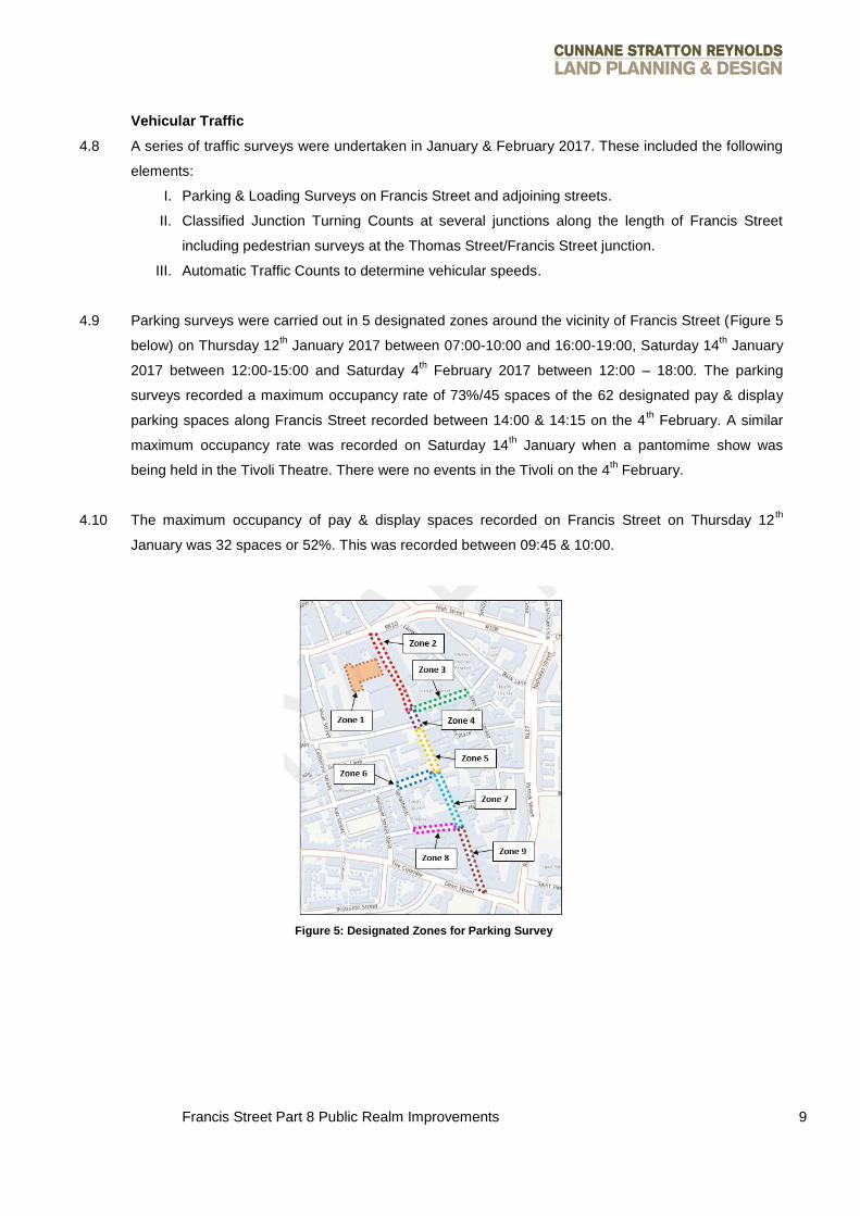
4.9 Parking surveys were carried out in 5 designated zones around the vicinity of Francis Street (Figure 5
below) on Thursday 12th January 2017 between 07:00-10:00 and 16:00-19:00, Saturday 14
th January
2017 between 12:00-15:00 and Saturday 4th February 2017 between 12:00 – 18:00. The parking
surveys recorded a maximum occupancy rate of 73%/45 spaces of the 62 designated pay & display
parking spaces along Francis Street recorded between 14:00 & 14:15 on the 4th February. A similar
maximum occupancy rate was recorded on Saturday 14th January when a pantomime show was
being held in the Tivoli Theatre. There were no events in the Tivoli on the 4th February.
4.10 The maximum occupancy of pay & display spaces recorded on Francis Street on Thursday 12th
January was 32 spaces or 52%. This was recorded between 09:45 & 10:00.
Figure 5: Designated Zones for Parking Survey
Francis Street Part 8 Public Realm Improvements 10
4.11 In terms of the quantum of traffic on Francis Street, the peak hours as well as the corresponding
volumes on approach to the Dean Street junction are presented below.
Peak Period Traffic Flow (No Vehicles)
Weekday AM Peak (07:00 – 08:00) 337
Weekday PM Peak (16:00 – 17:00) 356
Saturday Peak (12:00 – 13:00) 317
Table 1: Traffic Flows
4.12 The posted speed limit was 50 Km/hr on Francis Street when the survey was undertaken. The speed
surveys conducted adjacent to Carman’s Hall recorded an 85th percentile of 40 Km/h. That is, 85% of
drivers were travelling at or below 40 Km/h. As of 1st April, 2017, the speed limit is now 30 Km/hr on
Francis Street.
4.13 A stage 1 Road Safety Assessment carried out by NRB in November 2016 found evidence of collision
clusters at the Thomas Street junction and the Dean Street junction.
Cycling
4.14 A constructability statement by DBFL in February 2015 found that cycling was popular on the street,
with bicycles locked to any available fixed structures. Additional cycle parking has recently been
installed at the north end of the street and at Carman’s Hall. Cyclists are observed travelling both
south and north. A stage 1 Road Safety Assessment by NRB also found relatively high levels of
pedestrian and cyclist activity along the street. The Dublin Bikes stand is used regularly.
Underground Services
4.15 A Ground Penetrating Radar Survey was carried out to ascertain the number and location of
underground services. These include electricity, gas, telecoms, and water supply and drainage pipes.
Trees
4.16 Some small trees in planters have recently been installed on the street on a temporary basis. There
are currently no trees requiring pits.
Francis Street Part 8 Public Realm Improvements 11
5.0 Proposal Aims and Objectives
Aims and Objectives
5.1 The following are the project aims and objectives:
Provide a more pedestrian friendly environment which encourages people to visit Francis
Street on foot, and to remain longer on Francis Street;
Create a safe environment for vulnerable road users (pedestrians and bike users);
Provide an environment suitable for people of all ages and levels of physical ability, including
wheelchair users and those with walking aids;
Ensure sufficient access, parking and loading is maintained to facilitate and encourage the
continued commercial operation of the Arts and Antiques quarter, in light of the sale of
typically bulky and heavy goods;
Maintain Francis Street as a through route for motor traffic;
Assess the feasibility of a separate cycle lane, including a contra-flow cycle lane;
Use high quality durable stone materials in keeping with Francis Street’s existing character,
and in compliance with the adopted Local Area Plan;
Increased greening and landscaping.
5.2 The brief was developed from the existing policies adopted in statutory and advisory documents, and
advanced by consultation with stakeholders from 2014 onwards (as noted in Section 4 above).
6.0 Proposal
Overview
6.1 The proposal comprises improvements to the public realm along the full length of Francis Street,
Hanover Lane and part of Dean Street to include kerb buildouts on both sides of the carriageway
along with footway repaving, raised junction plateaus, kerb buildouts to formalise parallel parking and