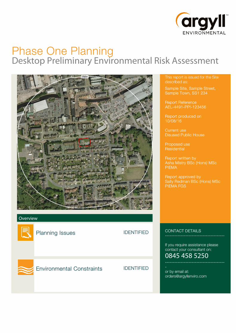
Phase One Planning Desktop Preliminary Environmental Risk Assessment This report is issued for the Site described as: Sample Site, Sample Street, Sample Town, SS1 234 Report Reference AEL-4491-PP!-123456 Report produced on 10/08/16 Current use Disused Public House Proposed use Residential Report written by Asha Mistry BSc (Hons) MSc PIEMA Report approved by Sally Redman BSc (Hons) MSc PIEMA FGS Overview Planning Issues IDENTIFIED CONTACT DETAILS -------------------------------------- If you require assistance please contact your consultant on: 0845 458 5250 -------------------------------------- - or by email at: [email protected]Environmental Constraints IDENTIFIED
Transcript
Phase One PlanningDesktop Preliminary Environmental Risk Assessment
If you require assistance please contact your consultant on:
0845 458 5250---------------------------------------or by email at:[email protected]
Environmental Constraints IDENTIFIED
Recommendations
Planning Issues
The Phase I should be submitted to the Local Authority for consideration.
An intrusive asbestos survey for the existing public house is to be conducted by RB Asbestos Consultants. The asbestos survey should be a Type 3 Refurbishment/Demolition Asbestos Survey. Upon completion of the survey, a management and demolition plan should be formulated to manage the risks presented. Areas concerned should be marked out, labelled and left undisturbed whilst awaiting demolition, and appropriate signage put in place to warn third parties of the presence of asbestos.
Tameside Metropolitan Borough Council have verbally requested that soil samples be taken at the garden areas to identify if contaminants present are within the soil/groundwater. If necessary remediation may have to be completed. An indicative quote has been provided, and below is a scope of works. The cost of such an investigation will be between £3000 and £4000.
• Procurement of service plans;• Scanning of all proposed exploratory hole locations with a
cable avoidance tool (CAT) and signal generator;• Progression of up to 8No. hand dug pits to a maximum depth
of 1.2m including obtaining samples for laboratory analysis;• In-situ screening of all samples undertaken using a photo
ionisation detector;• Logging of all arisings to BS5930;• Chemical analysis of selected samples• Factual and interpretive reporting
If any unsuspected contamination is identified during redevelopment, all work must cease and you must alert the Local Authority.
Environmental Constraints
RadonThe Site is in an intermediate probability radon area, as between 1 and 3% of homes are above the action level. Therefore in accordance with BRE 211:2007, the Site lies in an area where Basic/Full Radon Protection Measures are required.
• Basic radon protection - Protection is provided by a damp proof membrane modified and extended to form a radon-proof barrier across the ground floor of the building.
• Full radon protection - Comprises a radon-proof barrier across the ground floor and provision for subfloor depressurization (a radon sump) or ventilation (a ventilated subfloor void). It is important to realise with full radon protection that the sump is not activated when the property is built. It is capped and available for use as a secondary measure in case the radon-proof barrier is insufficient for reducing radon levels below the Action Level 200 Bq m-3.
AEL-4491-PP!-123456 Phase One // Planning 2
Executive Summary
Argyll Environmental Limited (AEL) was commissioned by Joe Bloggs, to conduct a Phase One Desktop Preliminary Environmental Risk Assessment for Sample Site, Sample Street, Sample Town, SS1 234, (the Site). This report presents the key findings and potential environmental liabilities identified during the assessment.
Key findings
Introduction
The Site located at Sample Site, Sample Street, Sample Town, SS1 234 is currently occupied by the disused pub. We have been advised by the Client that 4 no. semi-detached houses will be erected and the public house will undergo a change of use into 3 no. terraced houses under planning application number 12/345678/FUL.
Site History
A review of historical maps indicates the Site was occupied by buildings of mixed residential and commercial appearance from at least c.1875. A public house is visible in the north west corner of the Site from the time of the 1909 map edition. No significant changes were identified to the Site until the 1965 map edition when the centre became labelled as a yard. All buildings aside from the public house were later demolished between c.1966 and 1976. The vacant part of the Site appears to have remained in use as a car park throughout subsequent mapping. No other changes were observed.
Sources of contamination
The following potentially contaminative sources of concern have been identified at the Site:
• Made ground
• Surface run off from car park
• Heating oil from public house
• Asbestos Containing Materials
The following potentially contaminative sources of concern have been identified in the surrounding area which may affect the Site:
• Petrol filling station
• Historical yard areas
Conclusion
Although no significant contaminant linkages have been identified associated with the proposed redevelopment, and the risk under the planning regime (NPPF) is considered to be low to moderate, Tameside Metropolitan Borough Council have verbally requested further investigation. This includes soil sampling in the garden areas to check for any residual contaminants associated with within the soil.
Your attention is drawn to the recommendations on page 2 for a summary of appropriate suggested actions.
Overall Planning Risk Assessment Low to Moderate Note: This Executive Summary forms part of AEL's Phase One Preliminary Environment Risk Assessment (Ref. AEL-4491-SSR-123456) and should be read in conjunction with the body of the report.
Phase One // Planning
Understanding this report
This report is a Phase One preliminary desktop study without a walkover survey which is compliant with Contaminated Land Report (CLR) 11 Model Procedures for the Management of Land Contamination. The report identifies potential land quality issues associated with the proposed re/development. The works were completed in accordance with AEL’s Conditions of Contract for Environmental Consulting Services version 2.0.1
1. Introduction
Scope of Works
The agreed scope of works and the data sources included in this assessment are detailed below:
• A Site inspection on the 22/07/2016; This was undertaken by Asha Mistry BSc (Hons) MSc PIEMA;
• Liaison and correspondence with the current occupiers/owner/site representative;
• A review of available current and historical Ordnance Survey maps and other sources of historical information relating to the Site and surrounding area;
• Where appropriate information provided by, or publicly available from, the statutory authorities, e.g. Local Authority’s’ Environmental Health and Planning Departments, the Environment Agency and the Petroleum Licensing Authority;
• A study of the environmental sensitivity of the Site, with reference to the local geological, hydrological and hydrogeological setting;
• The derivation of a Conceptual Site Model, identifying risk from potential contaminant linkages associated with the re/development at the Site; and
• Formation of conclusions and recommendations for further work (if required) to include estimated capital expenditure for each material issue identified.
Overview of planning application
It is understood that there are proposals to develop the Site to residential use. Planning permission has been conditionally granted through planning application No:12/34567/FUL. Condition 10 requires an investigation into the risk posed from contamination, which should take a phased approach.
Therefore in the first instance a Phase One Preliminary Risk Assessment should be undertaken. To satisfy national guidance, the Phase One Preliminary Risk Assessment should include a site reconnaissance with photographs, a full history of the Site and surrounds including the environmental setting of the Site and a preliminary conceptual site model and associated risk assessment.
1 Please refer to the Methodology section at the end of this report for more details
AEL-4491-PP!-123456 Phase One // Planning 4
2. Historical Review
AEL has reviewed available historical Ordnance Survey maps and pre-Ordnance Survey (County Series) maps plus recent aerial photography for the Site and surrounding area. This information, in conjunction with historical data provided by the Local Authority Environmental Heath & Planning Departments and information from the site visit, has been used to develop a description of the Site and the surrounding area.
2.1 Summary of Site and Surrounding Area
On Site
A review of historical maps indicates the Site was occupied by buildings of mixed residential and commercial appearance from at least c.1875. A public house is visible in the north west corner of the Site from the time of the 1909 map edition. No significant changes were identified to the Site until the 1965 map edition when the centre became labelled as a yard. All buildings aside from the public house were later demolished between c.1966 and 1976. The vacant part of the Site appears to have remained in use as a car park throughout subsequent mapping. No other changes were observed.
Surrounding Area
The surrounding area has remained largely in mixed residential and commercial use since the 1875 map edition. The only potentially contaminative use of concern identified were the following yard areas which were present from the 1965 map edition:
• Whitehead’s Yard 30m south east;
• Bakehouse Yard 32m south;
• Lawton’s Yard 32m north east;
• Garside’s Yard 38m east;
• Hilton’s Yard 60m south, and
• Burtons Yard 71m south west.
All of the yards with the exception of Lawton’s Yard were no longer labelled after the 1966 map edition and had entered into residential use by 1976. Lawton’s Yard was cleared by 1976 and was in use as a car park between 1981 and 1999. The car park was later developed for use as a petrol filling station prior to 2006.
3. Site Location and Setting
The Site (1427.79m2) is located at Sample Site, Sample Street, Sample Town, SS1 234. Adjacent and nearby surrounding land uses include:
Direction Current Surrounding Area
North High Street is located adjacent north to a distance of 12m. Beyond this road lies a mixture of commercial and residential premises to a distance of at least 100m.
South A mixture of commercial and residential premises are located from adjacent south to a distance of at least 100m. The buildings are separated by Grasscroft Road and Crossfield Close Road which are located between 22-36m and 85-99m south respectively.
East Residential premises are located from adjacent east to a distance of 67m. Hough Hill Road is present between 68-83m east followed by commercial premises including a school to a distance of at least 100m.
West Kenworthy Street is located adjacent west to a distance of 12m. Beyond this road predominantly lies residential premises to a distance of at least 100m.
Phase One // Planning
4. Site Inspection
A Site walkover was undertaken by Asha Mistry BSc (Hons) MSc PIEMA on 22nd July 2016 and the findings are summarised below:
Site Description
General description The Site itself comprises of a disused public house in the north west with associated car parking facilities and grassed area to the east. The disused public house is a detached building and is constructed of bricks. The two storey building is also likely to have a basement although this is not confirmed.
4 no. semi-detached houses are to be erected at the Site and the public house will undergo a change of use into 3 no. terraced houses under planning application number 14/00696/FUL. A number of the houses will have their own outdoor areas which will be covered with grass.
Argyll have not been provided with service plans for the Site, however it is assumed that each individual house will be connected to its own mains gas, electricity and water supply.
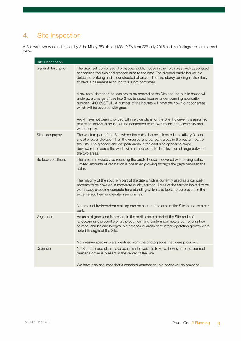
Site topography The western part of the Site where the public house is located is relatively flat and sits at a lower elevation than the grassed and car park areas in the eastern part of the Site. The grassed and car park areas in the east also appear to slope downwards towards the west, with an approximate 1m elevation change between the two areas.
Surface conditions The area immediately surrounding the public house is covered with paving slabs. Limited amounts of vegetation is observed growing through the gaps between the slabs.
The majority of the southern part of the Site which is currently used as a car park appears to be covered in moderate quality tarmac. Areas of the tarmac looked to be worn away exposing concrete hard standing which also looks to be present in the extreme southern and eastern peripheries.
No areas of hydrocarbon staining can be seen on the area of the Site in use as a car park.
Vegetation An area of grassland is present in the north eastern part of the Site and soft landscaping is present along the southern and eastern perimeters comprising tree stumps, shrubs and hedges. No patches or areas of stunted vegetation growth were noted throughout the Site.
No invasive species were identified from the photographs that were provided.
Drainage No Site drainage plans have been made available to view, however, one assumed drainage cover is present in the center of the Site.
We have also assumed that a standard connection to a sewer will be provided.
AEL-4491-PP!-123456 Phase One // Planning 6
Sources of Contamination
Source Description
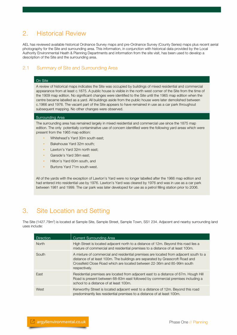
Non - Hazardous waste A wheelie bin with unknown contents is located in the center of the Site and the refurbishment works is likely to generate non-hazardous waste. It is recommended that skips are provided which segregates construction waste.
Made Ground The western part of the Site where the public house is located sits at a lower elevation than the grassed and car park areas in the eastern part of the Site. The grassed and car park areas in the east also appear to slope downwards towards the west, with an approximate 1m elevation change between the two areas. It is therefore assumed that made ground is present beneath the Site.
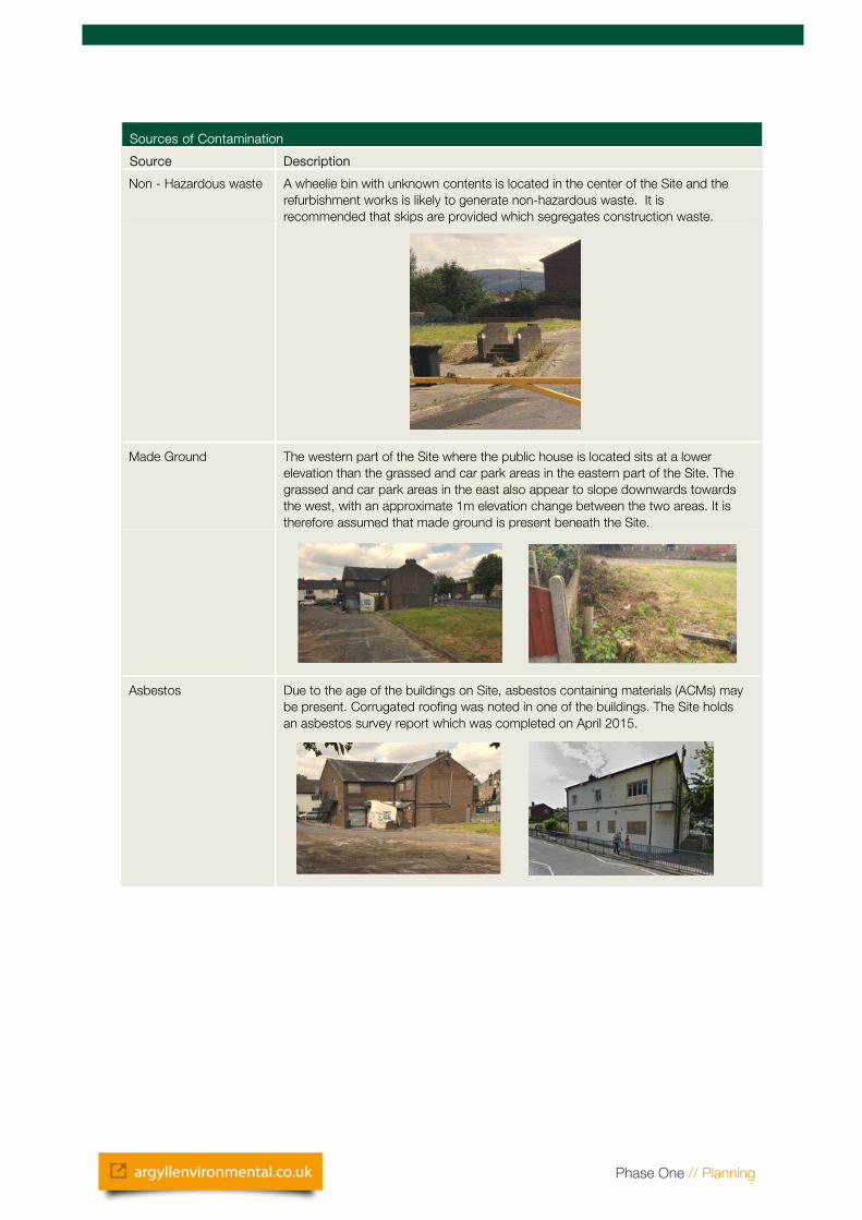
Asbestos Due to the age of the buildings on Site, asbestos containing materials (ACMs) may be present. Corrugated roofing was noted in one of the buildings. The Site holds an asbestos survey report which was completed on April 2015.
Phase One // Planning
5. Regulatory Authority Consultation
Statutory bodies and authorities have been consulted as part of this assessment. Responses are summarised in the table below:
Regulatory Authority Response
Environmental Health Department
Enquires were directed to the Brighton and Hove City Council's Environmental Health Department. A response was received from Gregory Sampson (Contaminated Land Officer) on the 10/07 2016. The pertinent information from which is summarised below:
• The Local Authority is aware of past industrial uses at the Site and the surrounding area.
• The Local Authority has no records relating to ground conditions, pollution incidents, or public complaints associated at the Site or within the surrounding area.
• As such, the Local Authority has not identified the Site for further investigation under Part2A of the Environmental Protection Act 1990.
Planning Department Entries on the online planning platform of Brighton and Hove City Council identified the following applications:
• Ref. No: 12/34567 for the (residential development on vacant land). This was approved with contaminated land conditions.
6. Report and Data Review AEL reviewed the following data as part of this assessment. A copy is attached in Appendix 1.
6.1 Landmark Data
A review of a Landmark data (ref: 123456-1-1) was undertaken as part of this assessment. Relevant information from the report on Site is summarised below:
In addition a summary of the relevant information from the report in proximity to the Site is as follows:
• According to trade directories, current or recent operations in proximity to the Site include commercial cleaning services (48m east).
• In addition the following licences, consents and authorisations of note were identified: a Local Authority Pollution Prevention and Control (49m north east) for a petrol filling station.
AEL-4491-PP!-123456 Phase One // Planning 8
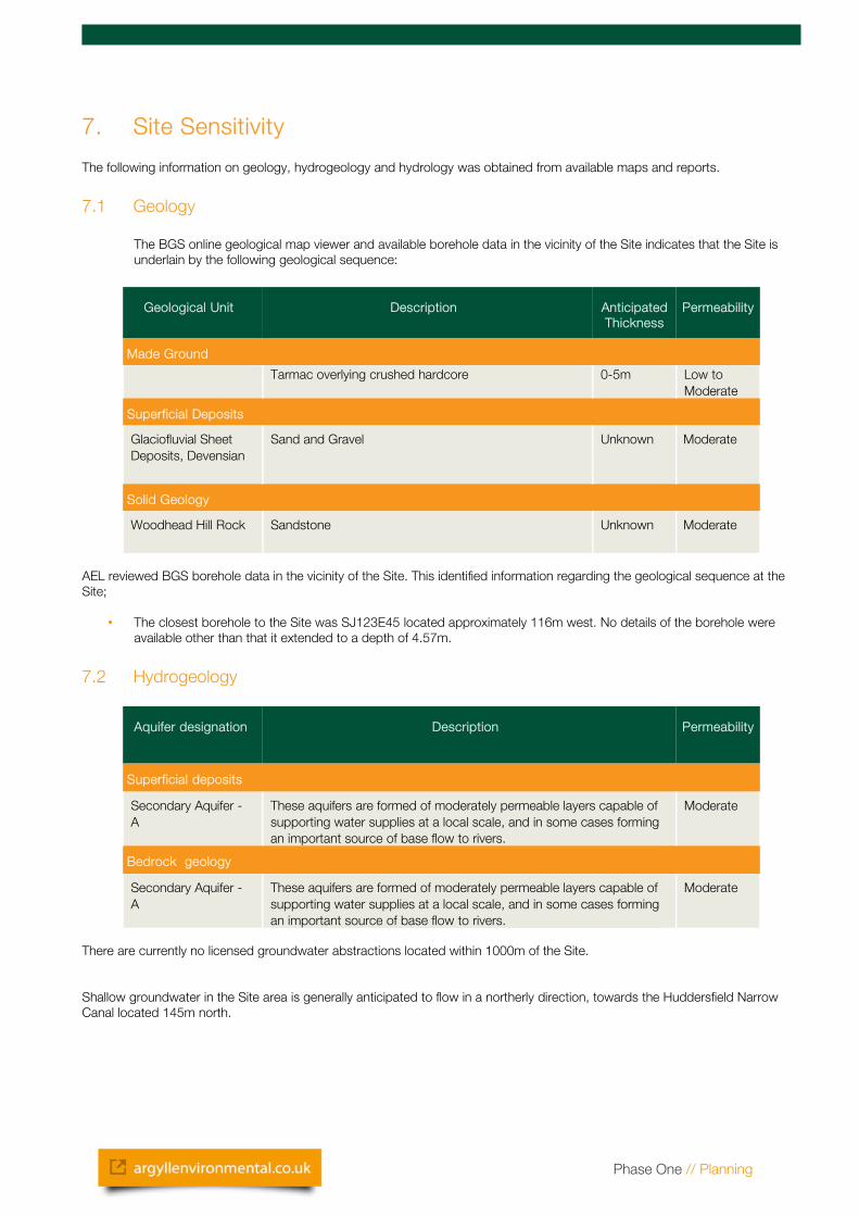
7. Site Sensitivity
The following information on geology, hydrogeology and hydrology was obtained from available maps and reports.
7.1 Geology
The BGS online geological map viewer and available borehole data in the vicinity of the Site indicates that the Site is underlain by the following geological sequence:
Geological Unit Description Anticipated Thickness
Permeability
Made Ground
Tarmac overlying crushed hardcore 0-5m Low to Moderate
Superficial Deposits
Glaciofluvial Sheet Deposits, Devensian
Sand and Gravel Unknown Moderate
Solid Geology
Woodhead Hill Rock Sandstone Unknown Moderate
AEL reviewed BGS borehole data in the vicinity of the Site. This identified information regarding the geological sequence at the Site;
• The closest borehole to the Site was SJ123E45 located approximately 116m west. No details of the borehole were available other than that it extended to a depth of 4.57m.
7.2 Hydrogeology
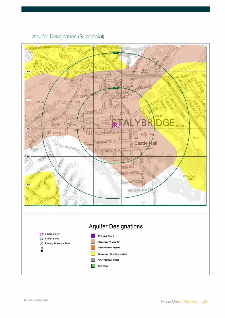
Aquifer designation Description Permeability
Superficial deposits
Secondary Aquifer - A
These aquifers are formed of moderately permeable layers capable of supporting water supplies at a local scale, and in some cases forming an important source of base flow to rivers.
Moderate
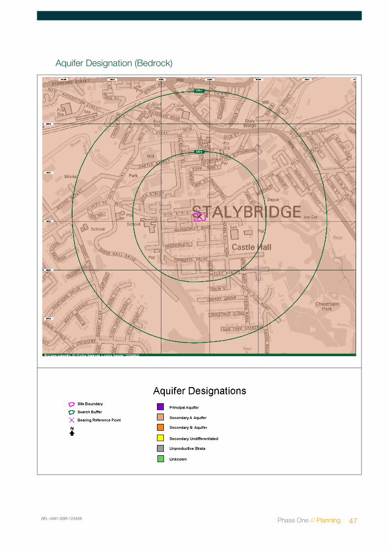
Bedrock geology
Secondary Aquifer - A
These aquifers are formed of moderately permeable layers capable of supporting water supplies at a local scale, and in some cases forming an important source of base flow to rivers.
Moderate
There are currently no licensed groundwater abstractions located within 1000m of the Site.
Shallow groundwater in the Site area is generally anticipated to flow in a northerly direction, towards the Huddersfield Narrow Canal located 145m north.
Phase One // Planning
7.3 Hydrology
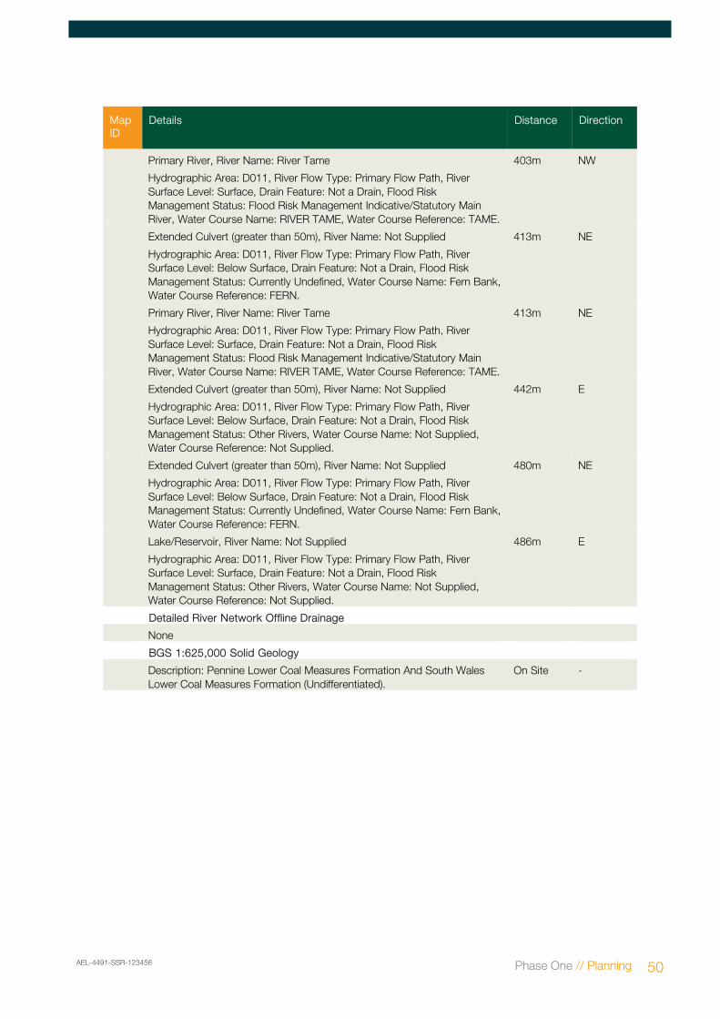
The nearest water feature ((a canal) is located 145m north.
There are currently no licensed surface water abstractions located within 1000m of the Site.
7.4 Sensitive Land Uses
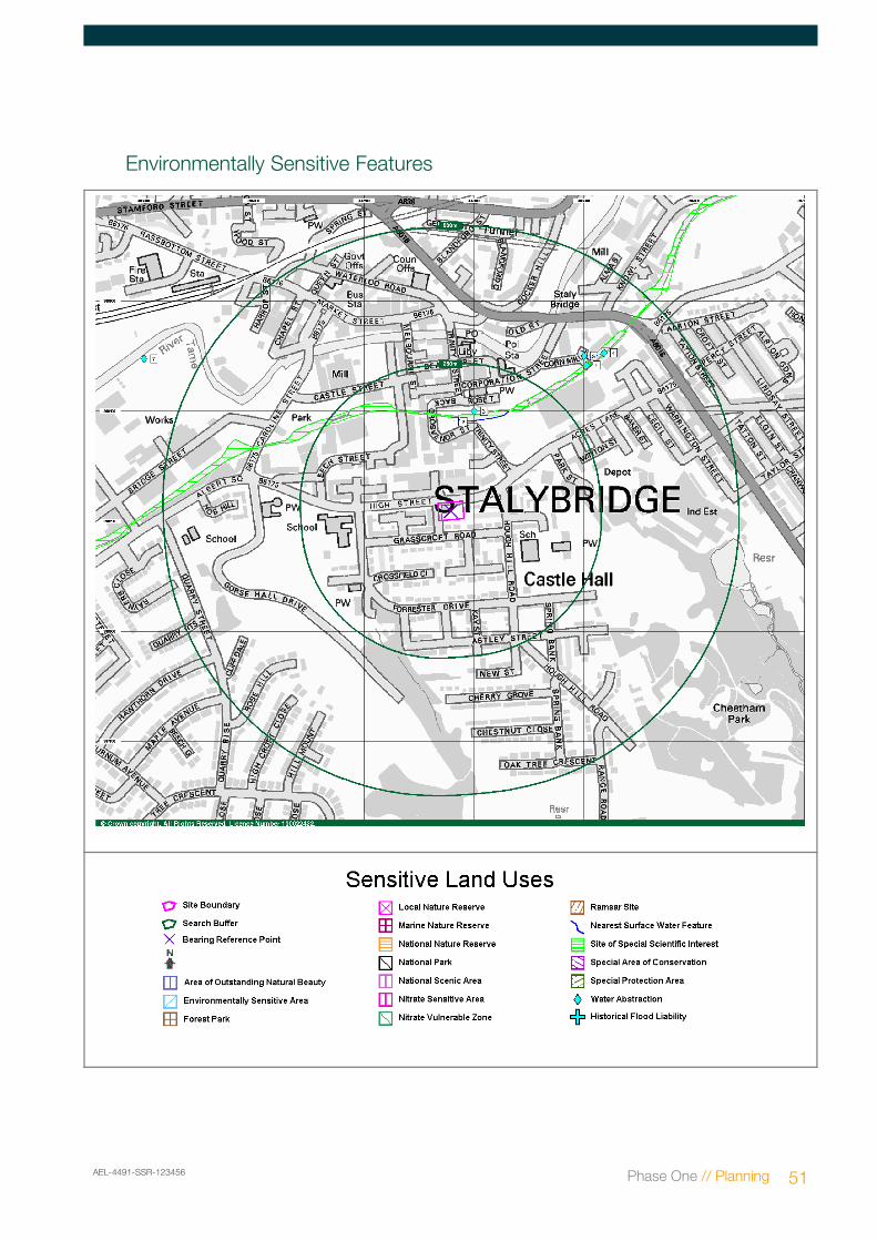
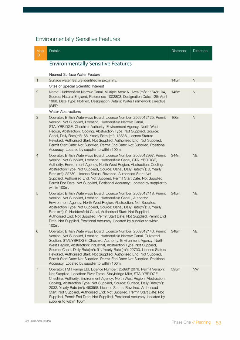
The following designated eco-receptors were identified within 1000m: Brighton Canal (Site of Special Scientific Interest) located 145m north
In addition, the nearest residential property is located adjacent south and east.
Furthermore, the Site is to be redeveloped and therefore end users and ground workers are considered to be sensitive receptors.
AEL-4491-PP!-123456 Phase One // Planning 10
8. Environmental Constraints
8.1 Subsidence
The Subsidence Risk Rating assesses the risk of subsidence caused by soil shrinkage in England and Wales at the specified postcode (it is not property specific). This is the largest geohazard in the UK and accounts for over 75% of Building Insurance subsidence incidents. It is particularly related to the influence of tree roots in clay shrinkage soil (60% of the total incidents) or leakage from drains (15% of the total incidents).
A low risk of subsidence has been identified at the Site. The level of subsidence risk associated with this site is Low as it is equal to or below the insurance subsidence incidence profile for England and Wales. This is based on analysis of historic insurance subsidence incidence data within 0.5 kilometres of this postcode.
8.2 Radon
The Site is in an intermediate probability radon area, as between 1 and 3% of homes are above the action level. Therefore in accordance with BRE 211:2007, the Site lies in an area where Radon Protection Measures are required.
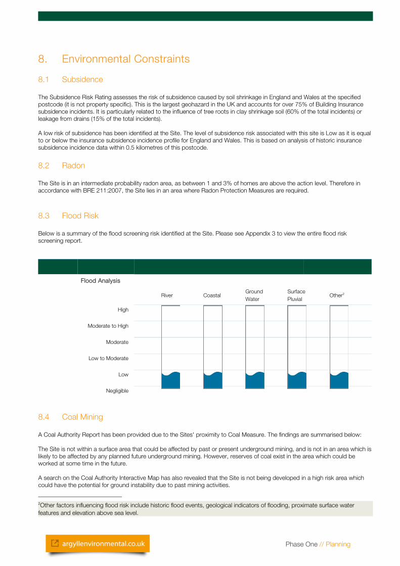
8.3 Flood Risk
Below is a summary of the flood screening risk identified at the Site. Please see Appendix 3 to view the entire flood risk screening report.
Flood Analysis
River CoastalGround Water
Surface Pluvial
Other2
High
Moderate to High
Moderate
Low to Moderate
Low
Negligible
8.4 Coal Mining
A Coal Authority Report has been provided due to the Sites' proximity to Coal Measure. The findings are summarised below:
The Site is not within a surface area that could be affected by past or present underground mining, and is not in an area which is likely to be affected by any planned future underground mining. However, reserves of coal exist in the area which could be worked at some time in the future.
A search on the Coal Authority Interactive Map has also revealed that the Site is not being developed in a high risk area which could have the potential for ground instability due to past mining activities.
2Other factors influencing flood risk include historic flood events, geological indicators of flooding, proximate surface water features and elevation above sea level.
Phase One // Planning
9. Risk Assessment
The following Conceptual Site Model (CSM) comprises an evaluation of the findings detailed in the previous sections of this report and outlined in the scope of works described in section 1.
9.1 Conceptual Site Model: Outline
The potential for an environmental risk to be present is assessed qualitatively using the contaminant-pathway-receptor concept introduced by Part 2A of the Environmental Protection Act 1990. .
The National Planning and Policy Framework (NPPF) details re/development should prevent unacceptable risks from pollution and should ensure that new development is appropriate for its location and its new use and to such a standards that the Site cannot meet the definition of “Contaminated Land”.
In accordance with the above and CLR 11, Model Procedures for the Management of Land Contamination, the following tabulated discussion is based on the observations gathered from the Site inspection and evaluation of the other available information.
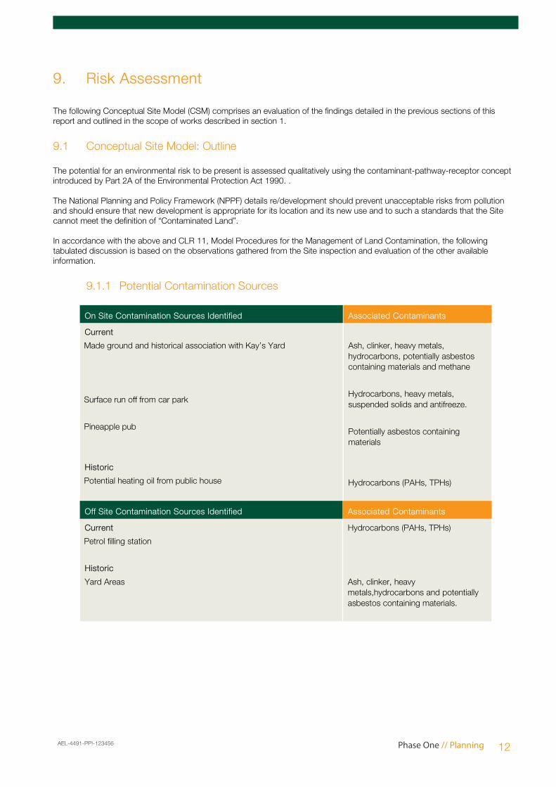
9.1.1 Potential Contamination Sources
On Site Contamination Sources Identified Associated Contaminants
Current
Made ground and historical association with Kay’s Yard
Surface run off from car park
Pineapple pub
Historic
Potential heating oil from public house
Ash, clinker, heavy metals, hydrocarbons, potentially asbestos containing materials and methane
Hydrocarbons, heavy metals, suspended solids and antifreeze.
Potentially asbestos containing materials
Hydrocarbons (PAHs, TPHs)
Off Site Contamination Sources Identified Associated Contaminants
Current
Petrol filling station
Historic
Yard Areas
Hydrocarbons (PAHs, TPHs)
Ash, clinker, heavy metals,hydrocarbons and potentially asbestos containing materials.
AEL-4491-PP!-123456 Phase One // Planning 12
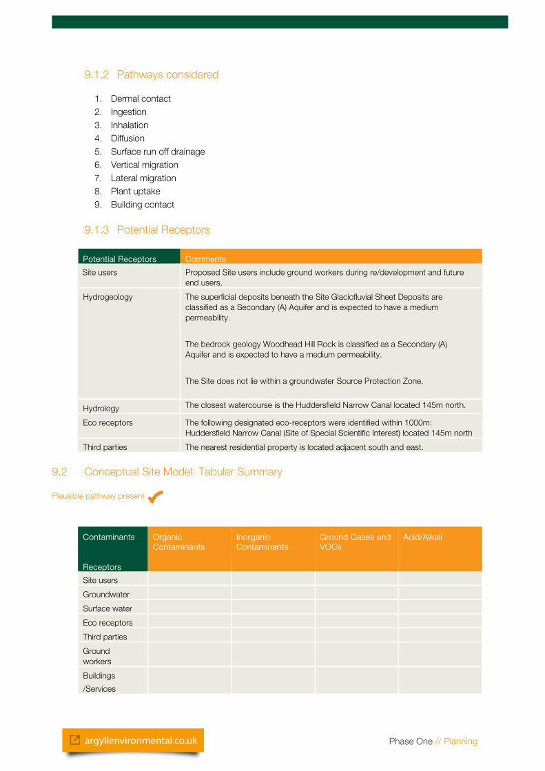
9.1.2 Pathways considered
1. Dermal contact2. Ingestion3. Inhalation4. Diffusion5. Surface run off drainage6. Vertical migration7. Lateral migration8. Plant uptake9. Building contact
9.1.3 Potential Receptors
Potential Receptors Comments
Site users Proposed Site users include ground workers during re/development and future end users.
Hydrogeology The superficial deposits beneath the Site Glaciofluvial Sheet Deposits are classified as a Secondary (A) Aquifer and is expected to have a medium permeability.
The bedrock geology Woodhead Hill Rock is classified as a Secondary (A) Aquifer and is expected to have a medium permeability.
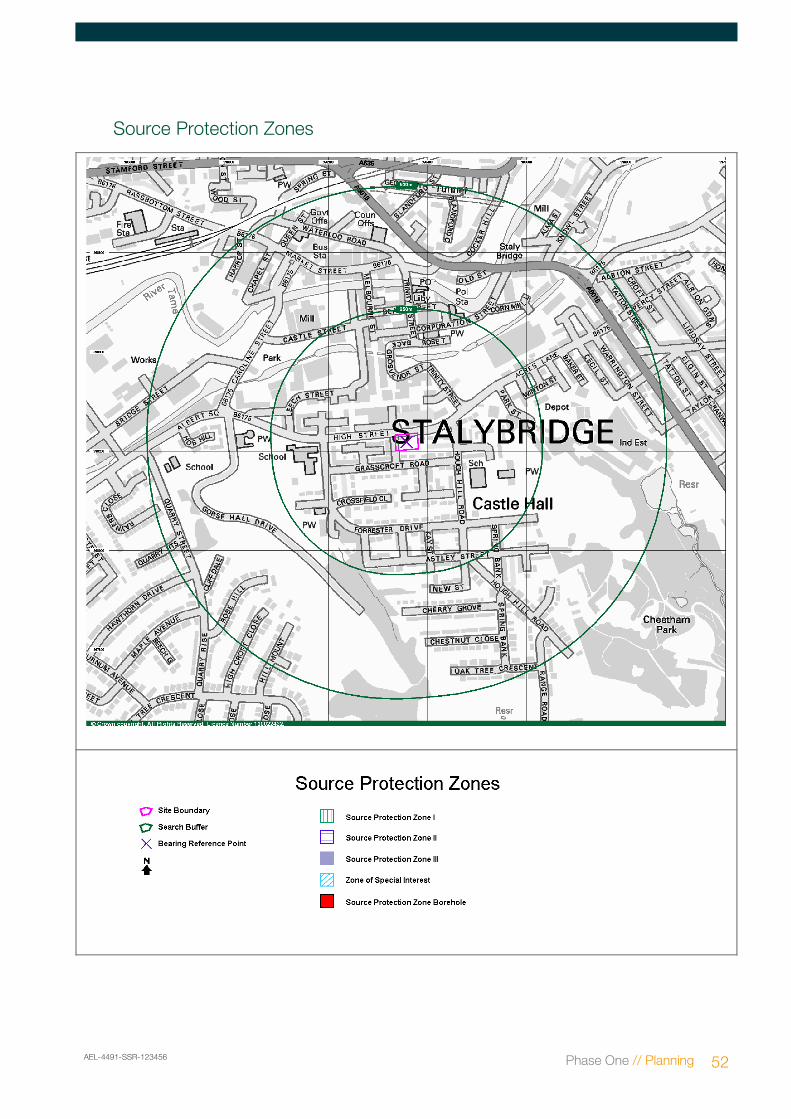
The Site does not lie within a groundwater Source Protection Zone.
Hydrology The closest watercourse is the Huddersfield Narrow Canal located 145m north.
Eco receptors The following designated eco-receptors were identified within 1000m: Huddersfield Narrow Canal (Site of Special Scientific Interest) located 145m north
Third parties The nearest residential property is located adjacent south and east.
9.2 Conceptual Site Model: Tabular Summary
Plausible pathway present
Contaminants
Receptors
Organic Contaminants
Inorganic Contaminants
Ground Gases and VOCs
Acid/Alkali
Site users
Groundwater
Surface water
Eco receptors
Third parties
Ground workers
Buildings
/Services
Phase One // Planning
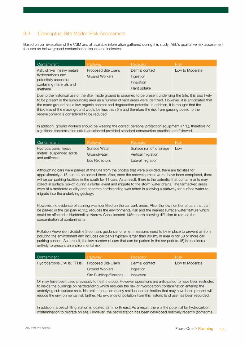
9.3 Conceptual Site Model: Risk Assessment
Based on our evaluation of the CSM and all available information gathered during this study, AEL’s qualitative risk assessment focuses on below ground contamination issues and indicates:
Contaminant Pathway Receptor Risk
Ash, clinker, heavy metals, hydrocarbons and potentially asbestos containing materials and methane
Proposed Site Users
Ground Workers
Dermal contact
Ingestion
Inhalation
Plant uptake
Low to Moderate
Due to the historical use of the Site, made ground is assumed to be present underlying the Site. It is also likely to be present in the surrounding area as a number of yard areas were identified. However, it is anticipated that the made ground has a low organic content and degradation potential. In addition, it is thought that the thickness of the made ground would be less than 5m and therefore the risk from gassing posed to the redevelopment is considered to be reduced.
In addition, ground workers should be wearing the correct personal protection equipment (PPE), therefore no significant contamination risk is anticipated provided standard construction practices are followed.
Contaminant Pathway Receptor Risk
Hydrocarbons, heavy metals, suspended solids and antifreeze
Surface Water
Groundwater
Eco Receptors
Surface run off drainage
Vertical migration
Lateral migration
Low
Although no cars were parked at the Site from the photos that were provided, there are facilities for approximately c.15 cars to be parked there. Also, once the redevelopment works have been completed, there will be car parking facilities in the south for 11 cars. As a result, there is the potential that contaminants may collect in surface run-off during a rainfall event and migrate to the storm water drains. The tarmacked areas were of a moderate quality and concrete hardstanding was noted in allowing a pathway for surface water to migrate into the underlying geology.
However, no evidence of staining was identified on the car park areas. Also, the low number of cars that can be parked in the car park (c.15), reduces the environmental risk and the nearest surface water feature which could be affected is Huddersfield Narrow Canal located 145m north allowing diffusion to reduce the concentration of contaminants.
Pollution Prevention Guideline 3 contains guidance for when measures need to be in place to prevent oil from polluting the environment and includes car parks typically larger than 800m2 in area or for 50 or more car parking spaces. As a result, the low number of cars that can be parked in the car park (c.15) is considered unlikely to present an environmental risk.
Contaminant Pathway Receptor Risk
Hydrocarbons (PAHs, TPHs) Proposed Site Users
Ground Workers
Site Buildings/Services
Dermal contact
Ingestion
Inhalation
Low to Moderate
Oil may have been used previously to heat the pub. However operations are anticipated to have been restricted to inside the buildings on hardstanding which reduces the risk of hydrocarbon contamination entering the underlying sub surface soils. Natural attenuation of any residual contamination that may have been present will reduce the environmental risk further. No evidence of pollution from this historic land use has been recorded.
In addition, a petrol filling station is located 32m north east. As a result, there is the potential for hydrocarbon contamination to migrate on site. However, the petrol station has been developed relatively recently (sometime
AEL-4491-PP!-123456 Phase One // Planning 14
between 1999 and 2006) and therefore operations and pollution prevention is likely to be of a higher standard than for older petrol filling stations. Any contaminants associated with the petrol filling station in the area surrounding the northern part of the Site is generally anticipated to flow away from the Site in a northerly direction, towards a Huddersfield Narrow Canal located 145m north. There are no pollution incidents associated with the petrol filling station.
Finally, ground workers should be wearing the correct personal protection equipment (PPE), therefore no significant contamination risk is anticipated provided standard construction practices are followed.
Contaminant Pathway Receptor Risk
Potentially asbestos containing materials
Proposed Site Users
Ground Workers
Ingestion
Inhalation
Low
No Asbestos Register or Management Plan is held for the Site. Given the age of the disused public house, the presence of Asbestos Containing materials cannot be discounted in the building. However, the client has confirmed that an intrusive asbestos survey for the existing public house is to be conducted by RB Asbestos Consultants.
Ground workers should be wearing the correct personal protection equipment (PPE). Additionally, upon completion of the survey, a management and demolition plan should be formulated to manage any risks presented. Areas concerned should be marked out, labelled and left undisturbed whilst awaiting demolition, and appropriate signage put in place to warn third parties of the presence of asbestos. As a result, no significant contamination risk is anticipated to any potential receptors provided standard construction practices are followed.
Phase One // Planning
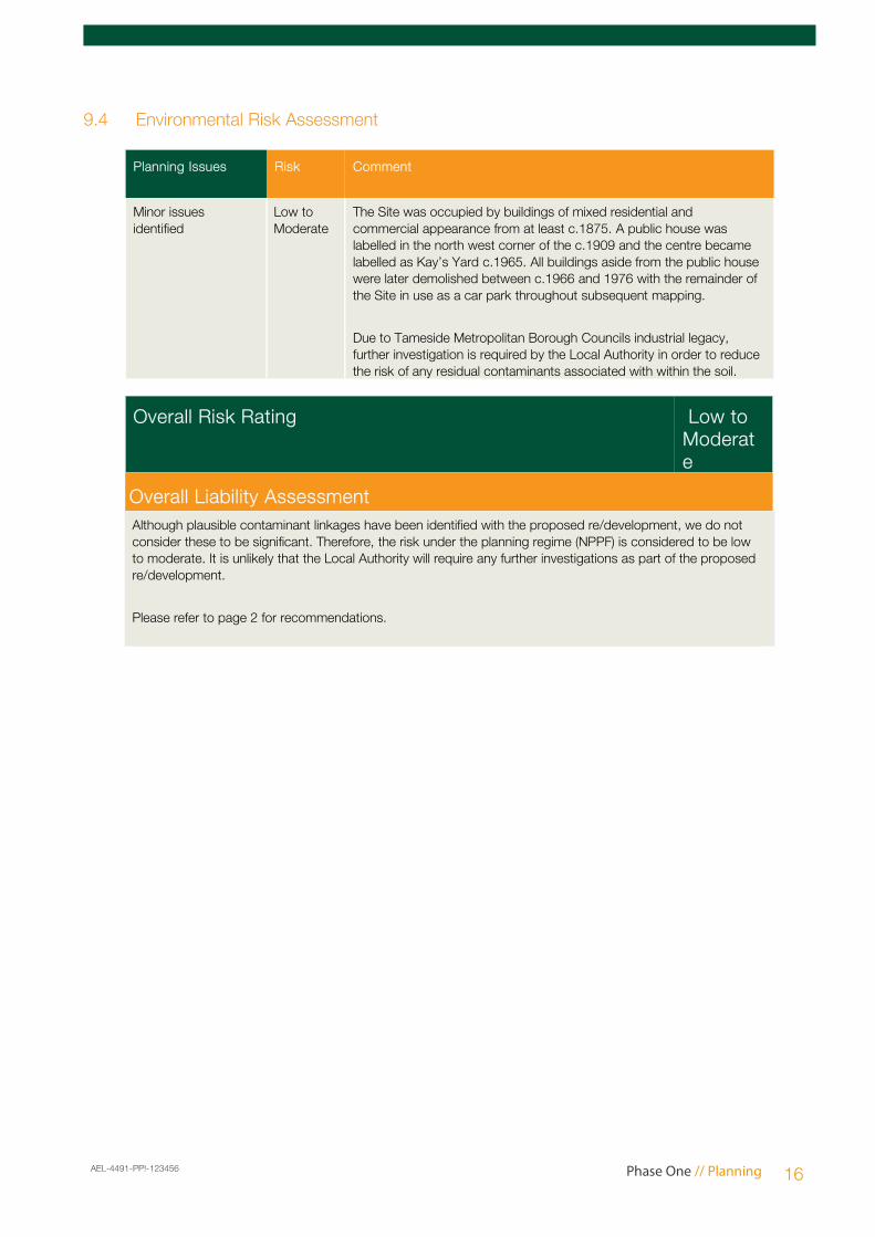
9.4 Environmental Risk Assessment
Planning Issues Risk Comment
Minor issues identified
Low to Moderate
The Site was occupied by buildings of mixed residential and commercial appearance from at least c.1875. A public house was labelled in the north west corner of the c.1909 and the centre became labelled as Kay’s Yard c.1965. All buildings aside from the public house were later demolished between c.1966 and 1976 with the remainder of the Site in use as a car park throughout subsequent mapping.
Due to Tameside Metropolitan Borough Councils industrial legacy, further investigation is required by the Local Authority in order to reduce the risk of any residual contaminants associated with within the soil.
Overall Risk Rating Low to Moderate
Overall Liability AssessmentAlthough plausible contaminant linkages have been identified with the proposed re/development, we do not consider these to be significant. Therefore, the risk under the planning regime (NPPF) is considered to be low to moderate. It is unlikely that the Local Authority will require any further investigations as part of the proposed re/development.
Please refer to page 2 for recommendations.
AEL-4491-PP!-123456 Phase One // Planning 16
Appendix 1 –Environmental Data
Contents of the Data Section
Tabular Summary This section presents a tabular summary of information found for the Site and surrounding area. The data is presented in three buffer zones for ease of reference: data found at the Site, from 1-250m and from 251-500m.
If a database has been searched the number of records found will be displayed under the relevant search band. If a database is not available or has not been searched, this will be represented by the abbreviation N/A under the relevant search band.
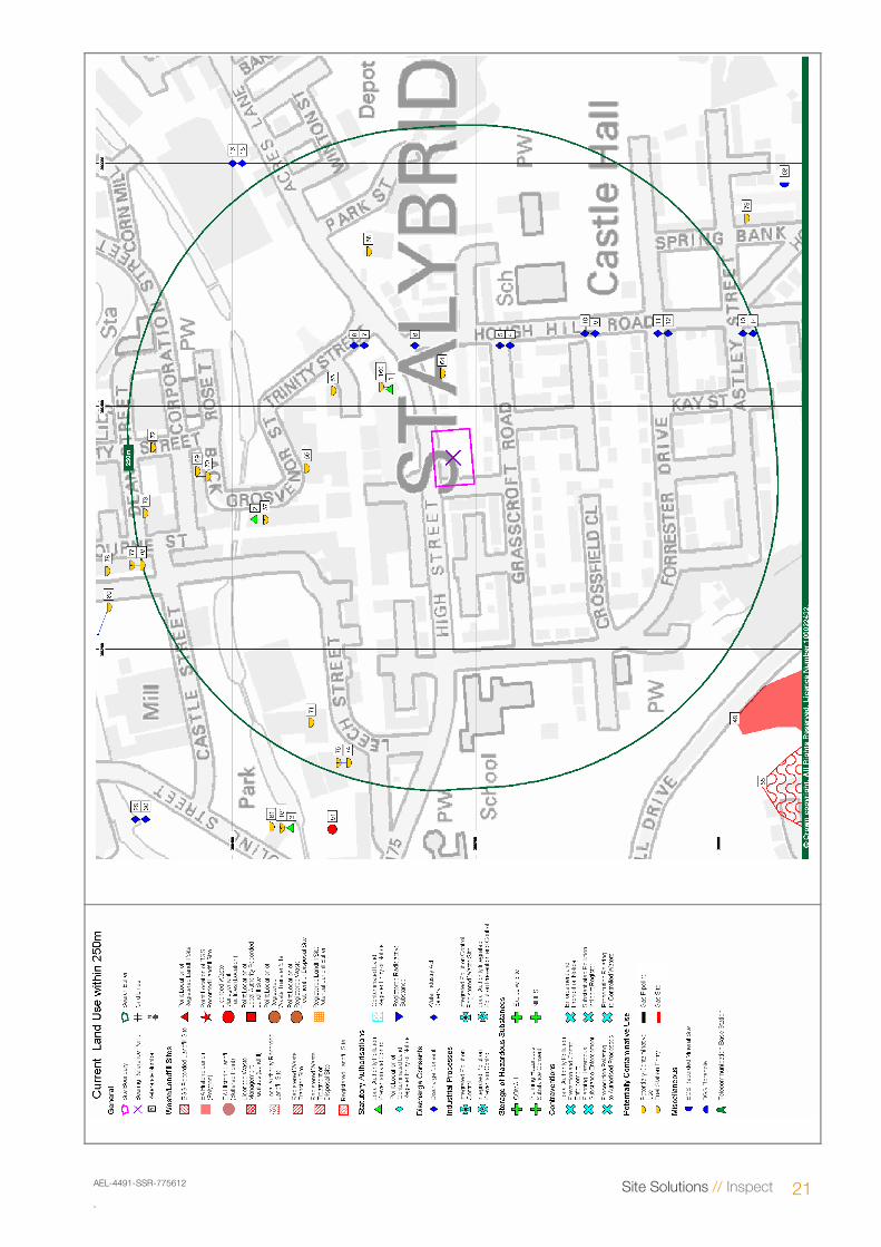
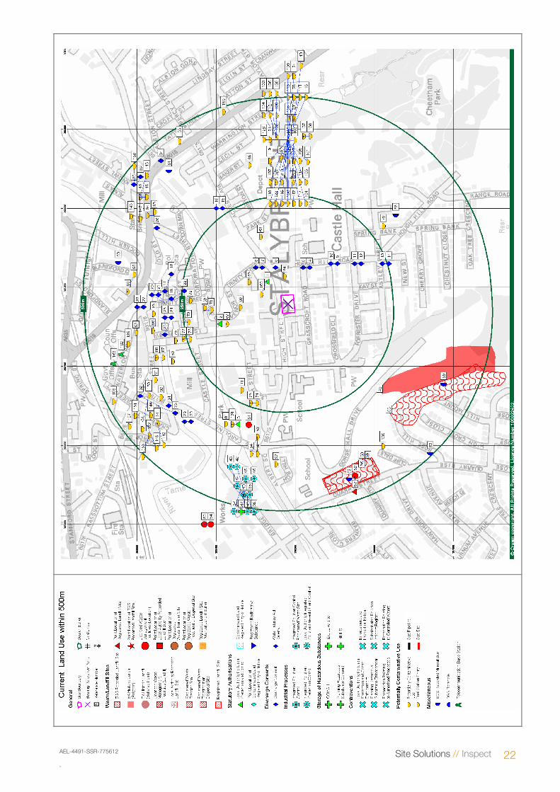
Current Land Use This section provides information on current land uses and is divided into three sections, statutory information, waste and current industrial uses. It is preceded by two maps.
The accurate large-scale Site Layout Plan confirms the Site boundary with statutory, waste and current land use information presented within 250m.
The smaller scale map Site Location Map presents the Site’s setting and statutory, waste and current land use information within 500m of the Site boundary.
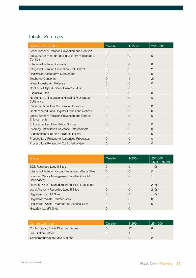
Statutory Information
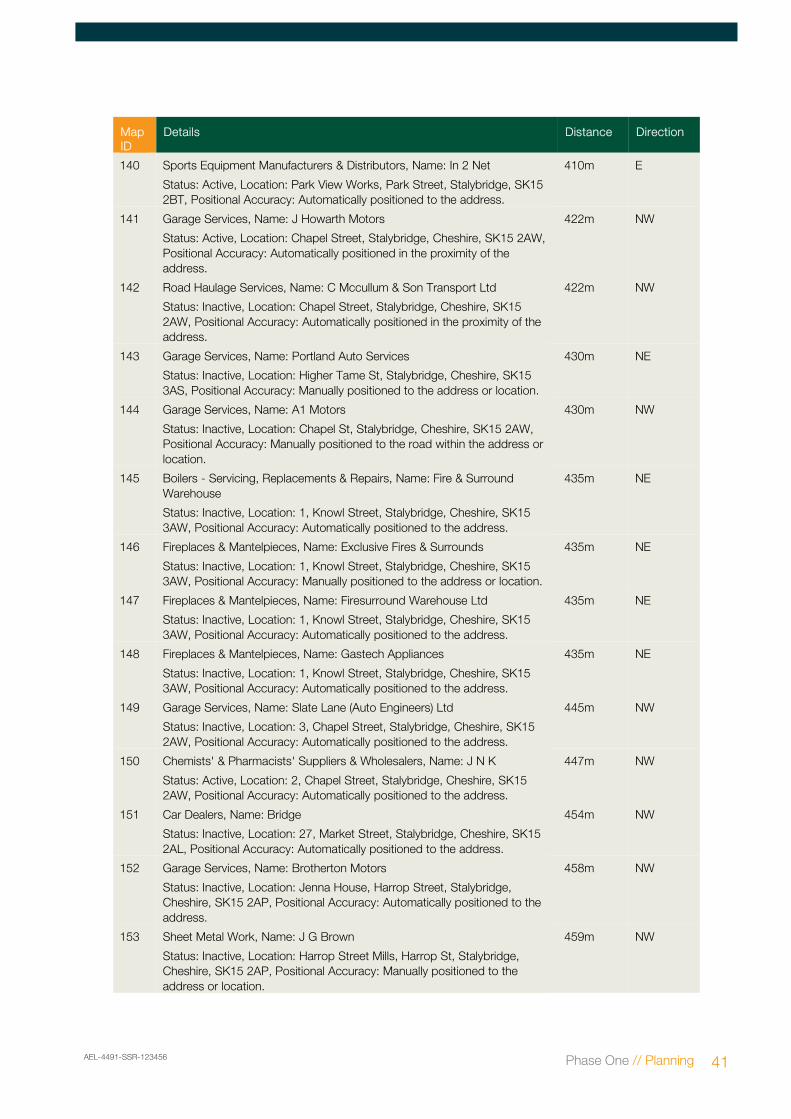
This section presents detailed statutory information for the Site and surrounding area (up to 500m depending upon dataset). The Map ID of each feature is indicated (where applicable) followed by specific information on each feature and its distance and direction from the Site.
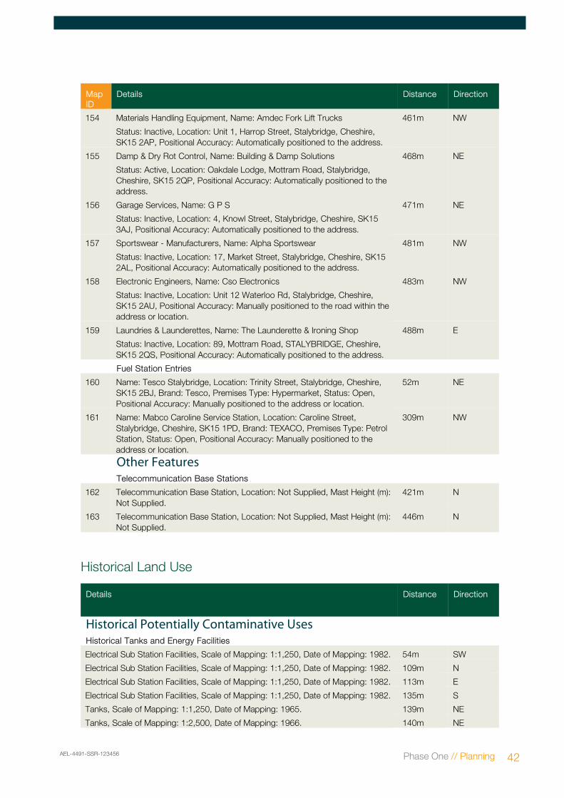
Waste This section presents detailed information on waste and landfill sites for the Site and surrounding area (up to 500m depending upon dataset). The Map ID of each feature is indicated (where applicable) followed by specific information on each feature and its distance and direction from the Site.
Current Industrial Land Use
This section presents detailed information on current land use for the Site and surrounding area (0-250m). The Map ID of each feature is indicated (where applicable) followed by specific information on each feature and its distance and direction from the Site.
Historical Land Use
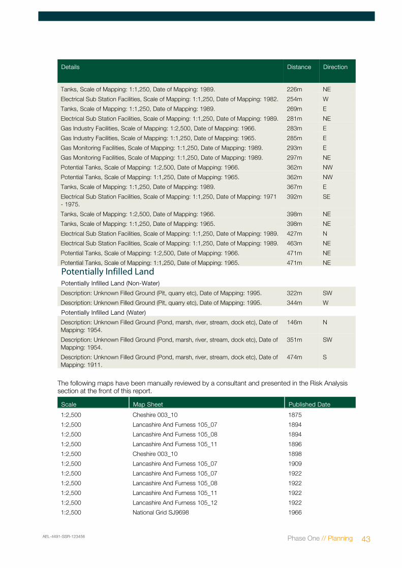
This section presents selected information on historical land use for the Site and surrounding area (0-500m). These features are not mapped. A table listing the historical maps used in the risk assessment is also provided.
Aquifer Designations and Geology
This section is preceded by two maps that present information relating to the aquifer designations beneath the Site. The first of these maps indicates the designation of the Superficial geology. The second map presents the aquifer designation of the solid geology.
These maps are followed by detailed information in relation to aquifer designations/groundwater vulnerability and geology at the Site and surrounding area (0-500m).
Environmental Sensitivity
This section presents detailed information on the environmental sensitivity of the Site and surrounding area (up to 500m depending upon dataset) and is preceded by two maps. The first shows areas with statutory designations, the second shows source protection zones. The Map ID of each feature is indicated (where applicable) followed by specific information on each feature and its distance and direction from the Site.
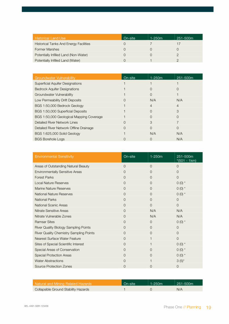
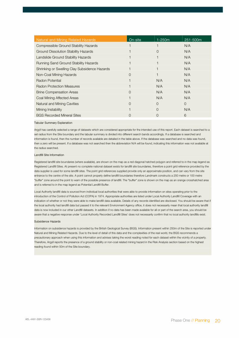
Natural and Mining Related Hazards
This section contains information on natural and mining related hazards which may affect the Site. These include subsidence, radon and mining.
Natural and Mining Related Hazards On-site 1-250m 251-500m
Collapsible Ground Stability Hazards 1 0 N/A
AEL-4491-SSR-123456 Phase One // Planning 19
Natural and Mining Related Hazards On-site 1-250m 251-500m
Compressible Ground Stability Hazards 1 1 N/A
Ground Dissolution Stability Hazards 1 0 N/A
Landslide Ground Stability Hazards 1 1 N/A
Running Sand Ground Stability Hazards 1 1 N/A
Shrinking or Swelling Clay Subsidence Hazards 1 1 N/A
Non-Coal Mining Hazards 0 1 N/A
Radon Potential 1 N/A N/A
Radon Protection Measures 1 N/A N/A
Brine Compensation Areas 0 N/A N/A
Coal Mining Affected Areas 1 N/A N/A
Natural and Mining Cavities 0 0 0
Mining Instability 1 0 N/A
BGS Recorded Mineral Sites 0 0 6
Tabular Summary Explanation
Argyll has carefully selected a range of datasets which are considered appropriate for the intended use of this report. Each dataset is searched to a
set radius from the Site boundary and the tabular summary is divided into different search bands accordingly. If a database is searched and
information is found, then the number of records available are detailed in the table above. If the database was searched and no data was found,
then a zero will be present. If a database was not searched then the abbreviation N/A will be found, indicating this information was not available at
the radius searched.
Landfill Site Information
Registered landfill site boundaries (where available), are shown on the map as a red diagonal hatched polygon and referred to in the map legend as
Registered Landfill Sites. At present no complete national dataset exists for landfill site boundaries, therefore a point grid reference provided by the
data supplier is used for some landfill sites. The point grid references supplied provide only an approximate position, and can vary from the site
entrance to the centre of the site. A point cannot properly define landfill boundaries therefore Landmark constructs a 250 metre or 100 metre
"buffer" zone around the point to warn of the possible presence of landfill. The "buffer" zone is shown on the map as an orange crosshatched area
and is referred to in the map legend as Potential Landfill Buffer.
Local Authority landfill data is sourced from individual local authorities that were able to provide information on sites operating prior to the
introduction of the Control of Pollution Act (COPA) in 1974. Appropriate authorities are listed under Local Authority Landfill Coverage with an
indication of whether or not they were able to make landfill data available. Details of any records identified are disclosed. You should be aware that if
the local authority had landfill data but passed it to the relevant Environment Agency office, it does not necessarily mean that local authority landfill
data is now included in our other Landfill datasets. In addition if no data has been made available for all or part of the search area, you should be
aware that a negative response under 'Local Authority Recorded Landfill Sites' does not necessarily confirm that no local authority landfills exist.
Subsidence Hazards
Information on subsidence hazards is provided by the British Geological Survey (BGS). Information present within 250m of the Site is reported under
Natural and Mining Related Hazards. Due to the level of detail of this data and the complexities of the real world, the BGS recommends a
precautionary approach when using this information and advises taking the worst reading noted for each dataset within the vicinity of a property.
Therefore, Argyll reports the presence of a ground stability or non-coal related mining hazard in the Risk Analysis section based on the highest
reading found within 50m of the Site boundary.
AEL-4491-SSR-123456 Phase One // Planning 20
AEL-4491-SSR-775612 Site Solutions // Inspect 21,
AEL-4491-SSR-775612 Site Solutions // Inspect 22,
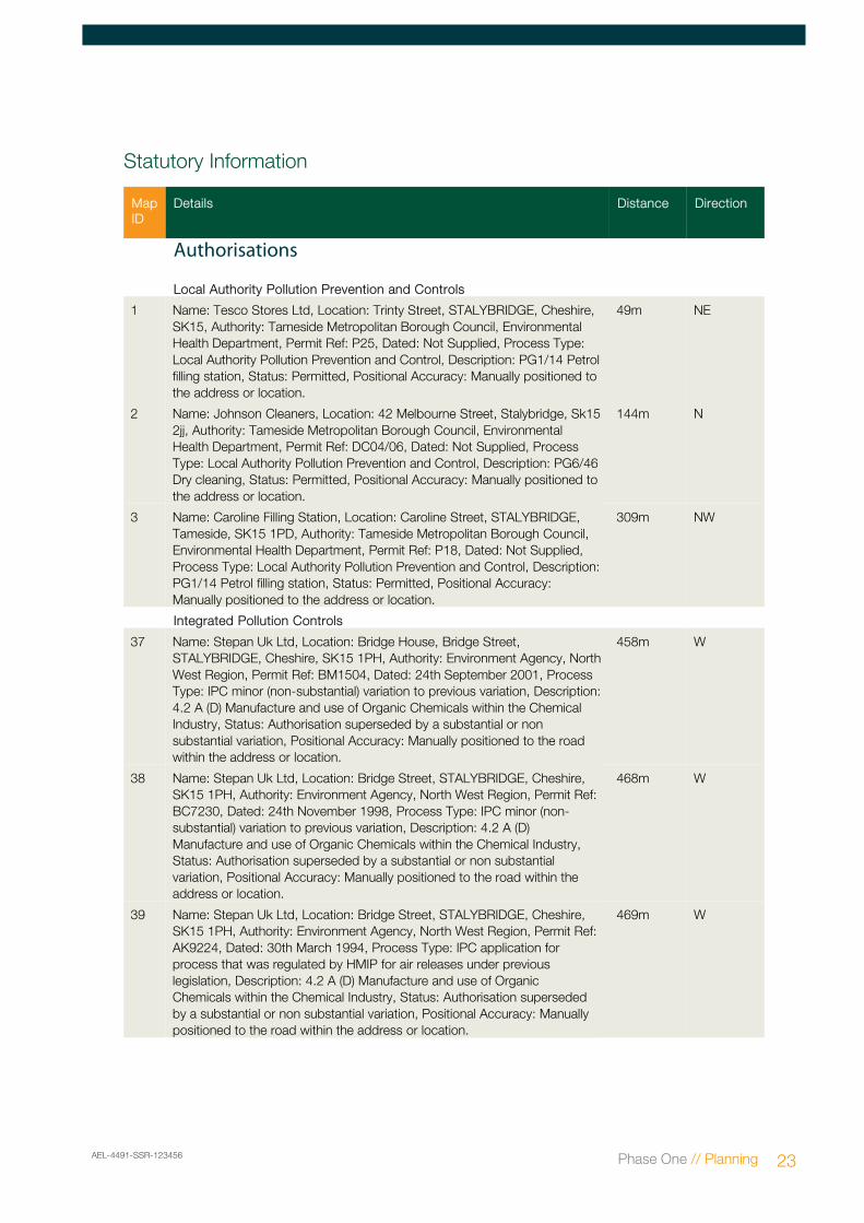
Statutory Information
Map ID
Details Distance Direction
Authorisations
Local Authority Pollution Prevention and Controls
1 Name: Tesco Stores Ltd, Location: Trinty Street, STALYBRIDGE, Cheshire, SK15, Authority: Tameside Metropolitan Borough Council, Environmental Health Department, Permit Ref: P25, Dated: Not Supplied, Process Type: Local Authority Pollution Prevention and Control, Description: PG1/14 Petrol filling station, Status: Permitted, Positional Accuracy: Manually positioned to the address or location.
49m NE
2 Name: Johnson Cleaners, Location: 42 Melbourne Street, Stalybridge, Sk15 2jj, Authority: Tameside Metropolitan Borough Council, Environmental Health Department, Permit Ref: DC04/06, Dated: Not Supplied, Process Type: Local Authority Pollution Prevention and Control, Description: PG6/46 Dry cleaning, Status: Permitted, Positional Accuracy: Manually positioned to the address or location.
144m N
3 Name: Caroline Filling Station, Location: Caroline Street, STALYBRIDGE, Tameside, SK15 1PD, Authority: Tameside Metropolitan Borough Council, Environmental Health Department, Permit Ref: P18, Dated: Not Supplied, Process Type: Local Authority Pollution Prevention and Control, Description: PG1/14 Petrol filling station, Status: Permitted, Positional Accuracy: Manually positioned to the address or location.
309m NW
Integrated Pollution Controls
37 Name: Stepan Uk Ltd, Location: Bridge House, Bridge Street, STALYBRIDGE, Cheshire, SK15 1PH, Authority: Environment Agency, North West Region, Permit Ref: BM1504, Dated: 24th September 2001, Process Type: IPC minor (non-substantial) variation to previous variation, Description: 4.2 A (D) Manufacture and use of Organic Chemicals within the Chemical Industry, Status: Authorisation superseded by a substantial or non substantial variation, Positional Accuracy: Manually positioned to the road within the address or location.
458m W
38 Name: Stepan Uk Ltd, Location: Bridge Street, STALYBRIDGE, Cheshire, SK15 1PH, Authority: Environment Agency, North West Region, Permit Ref: BC7230, Dated: 24th November 1998, Process Type: IPC minor (non-substantial) variation to previous variation, Description: 4.2 A (D) Manufacture and use of Organic Chemicals within the Chemical Industry, Status: Authorisation superseded by a substantial or non substantial variation, Positional Accuracy: Manually positioned to the road within the address or location.
468m W
39 Name: Stepan Uk Ltd, Location: Bridge Street, STALYBRIDGE, Cheshire, SK15 1PH, Authority: Environment Agency, North West Region, Permit Ref: AK9224, Dated: 30th March 1994, Process Type: IPC application for process that was regulated by HMIP for air releases under previous legislation, Description: 4.2 A (D) Manufacture and use of Organic Chemicals within the Chemical Industry, Status: Authorisation superseded by a substantial or non substantial variation, Positional Accuracy: Manually positioned to the road within the address or location.
469m W
AEL-4491-SSR-123456 Phase One // Planning 23
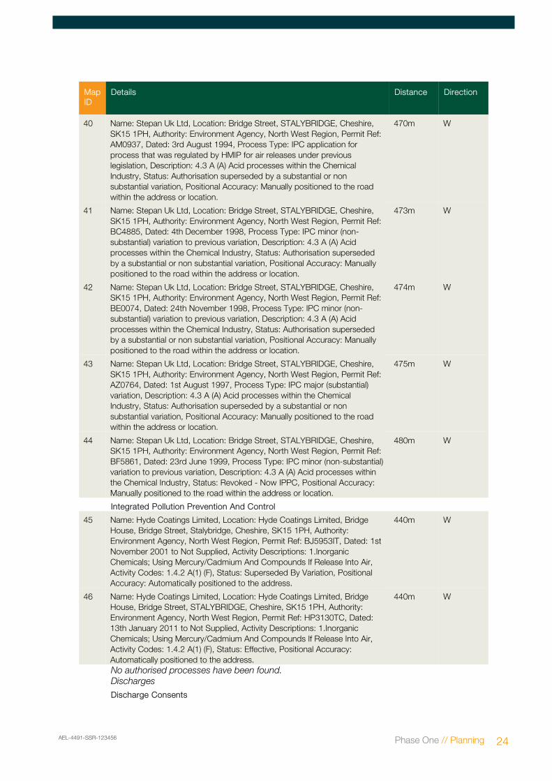
Map ID
Details Distance Direction
40 Name: Stepan Uk Ltd, Location: Bridge Street, STALYBRIDGE, Cheshire, SK15 1PH, Authority: Environment Agency, North West Region, Permit Ref: AM0937, Dated: 3rd August 1994, Process Type: IPC application for process that was regulated by HMIP for air releases under previous legislation, Description: 4.3 A (A) Acid processes within the Chemical Industry, Status: Authorisation superseded by a substantial or non substantial variation, Positional Accuracy: Manually positioned to the road within the address or location.
470m W
41 Name: Stepan Uk Ltd, Location: Bridge Street, STALYBRIDGE, Cheshire, SK15 1PH, Authority: Environment Agency, North West Region, Permit Ref: BC4885, Dated: 4th December 1998, Process Type: IPC minor (non-substantial) variation to previous variation, Description: 4.3 A (A) Acid processes within the Chemical Industry, Status: Authorisation superseded by a substantial or non substantial variation, Positional Accuracy: Manually positioned to the road within the address or location.
473m W
42 Name: Stepan Uk Ltd, Location: Bridge Street, STALYBRIDGE, Cheshire, SK15 1PH, Authority: Environment Agency, North West Region, Permit Ref: BE0074, Dated: 24th November 1998, Process Type: IPC minor (non-substantial) variation to previous variation, Description: 4.3 A (A) Acid processes within the Chemical Industry, Status: Authorisation superseded by a substantial or non substantial variation, Positional Accuracy: Manually positioned to the road within the address or location.
474m W
43 Name: Stepan Uk Ltd, Location: Bridge Street, STALYBRIDGE, Cheshire, SK15 1PH, Authority: Environment Agency, North West Region, Permit Ref: AZ0764, Dated: 1st August 1997, Process Type: IPC major (substantial) variation, Description: 4.3 A (A) Acid processes within the Chemical Industry, Status: Authorisation superseded by a substantial or non substantial variation, Positional Accuracy: Manually positioned to the road within the address or location.
475m W
44 Name: Stepan Uk Ltd, Location: Bridge Street, STALYBRIDGE, Cheshire, SK15 1PH, Authority: Environment Agency, North West Region, Permit Ref: BF5861, Dated: 23rd June 1999, Process Type: IPC minor (non-substantial) variation to previous variation, Description: 4.3 A (A) Acid processes within the Chemical Industry, Status: Revoked - Now IPPC, Positional Accuracy: Manually positioned to the road within the address or location.
480m W
Integrated Pollution Prevention And Control
45 Name: Hyde Coatings Limited, Location: Hyde Coatings Limited, Bridge House, Bridge Street, Stalybridge, Cheshire, SK15 1PH, Authority: Environment Agency, North West Region, Permit Ref: BJ5953IT, Dated: 1st November 2001 to Not Supplied, Activity Descriptions: 1.Inorganic Chemicals; Using Mercury/Cadmium And Compounds If Release Into Air, Activity Codes: 1.4.2 A(1) (F), Status: Superseded By Variation, Positional Accuracy: Automatically positioned to the address.
440m W
46 Name: Hyde Coatings Limited, Location: Hyde Coatings Limited, Bridge House, Bridge Street, STALYBRIDGE, Cheshire, SK15 1PH, Authority: Environment Agency, North West Region, Permit Ref: HP3130TC, Dated: 13th January 2011 to Not Supplied, Activity Descriptions: 1.Inorganic Chemicals; Using Mercury/Cadmium And Compounds If Release Into Air, Activity Codes: 1.4.2 A(1) (F), Status: Effective, Positional Accuracy: Automatically positioned to the address.
440m W
No authorised processes have been found.Discharges
Discharge Consents
AEL-4491-SSR-123456 Phase One // Planning 24
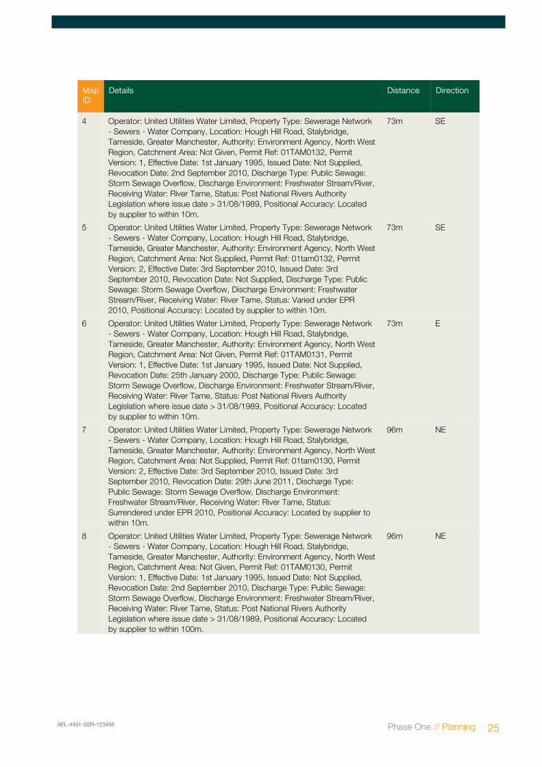
Map ID
Details Distance Direction
4 Operator: United Utilities Water Limited, Property Type: Sewerage Network - Sewers - Water Company, Location: Hough Hill Road, Stalybridge, Tameside, Greater Manchester, Authority: Environment Agency, North West Region, Catchment Area: Not Given, Permit Ref: 01TAM0132, Permit Version: 1, Effective Date: 1st January 1995, Issued Date: Not Supplied, Revocation Date: 2nd September 2010, Discharge Type: Public Sewage: Storm Sewage Overflow, Discharge Environment: Freshwater Stream/River, Receiving Water: River Tame, Status: Post National Rivers Authority Legislation where issue date > 31/08/1989, Positional Accuracy: Located by supplier to within 10m.
73m SE
5 Operator: United Utilities Water Limited, Property Type: Sewerage Network - Sewers - Water Company, Location: Hough Hill Road, Stalybridge, Tameside, Greater Manchester, Authority: Environment Agency, North West Region, Catchment Area: Not Supplied, Permit Ref: 01tam0132, Permit Version: 2, Effective Date: 3rd September 2010, Issued Date: 3rd September 2010, Revocation Date: Not Supplied, Discharge Type: Public Sewage: Storm Sewage Overflow, Discharge Environment: Freshwater Stream/River, Receiving Water: River Tame, Status: Varied under EPR 2010, Positional Accuracy: Located by supplier to within 10m.
73m SE
6 Operator: United Utilities Water Limited, Property Type: Sewerage Network - Sewers - Water Company, Location: Hough Hill Road, Stalybridge, Tameside, Greater Manchester, Authority: Environment Agency, North West Region, Catchment Area: Not Given, Permit Ref: 01TAM0131, Permit Version: 1, Effective Date: 1st January 1995, Issued Date: Not Supplied, Revocation Date: 25th January 2000, Discharge Type: Public Sewage: Storm Sewage Overflow, Discharge Environment: Freshwater Stream/River, Receiving Water: River Tame, Status: Post National Rivers Authority Legislation where issue date > 31/08/1989, Positional Accuracy: Located by supplier to within 10m.
73m E
7 Operator: United Utilities Water Limited, Property Type: Sewerage Network - Sewers - Water Company, Location: Hough Hill Road, Stalybridge, Tameside, Greater Manchester, Authority: Environment Agency, North West Region, Catchment Area: Not Supplied, Permit Ref: 01tam0130, Permit Version: 2, Effective Date: 3rd September 2010, Issued Date: 3rd September 2010, Revocation Date: 29th June 2011, Discharge Type: Public Sewage: Storm Sewage Overflow, Discharge Environment: Freshwater Stream/River, Receiving Water: River Tame, Status: Surrendered under EPR 2010, Positional Accuracy: Located by supplier to within 10m.
96m NE
8 Operator: United Utilities Water Limited, Property Type: Sewerage Network - Sewers - Water Company, Location: Hough Hill Road, Stalybridge, Tameside, Greater Manchester, Authority: Environment Agency, North West Region, Catchment Area: Not Given, Permit Ref: 01TAM0130, Permit Version: 1, Effective Date: 1st January 1995, Issued Date: Not Supplied, Revocation Date: 2nd September 2010, Discharge Type: Public Sewage: Storm Sewage Overflow, Discharge Environment: Freshwater Stream/River, Receiving Water: River Tame, Status: Post National Rivers Authority Legislation where issue date > 31/08/1989, Positional Accuracy: Located by supplier to within 100m.
96m NE
AEL-4491-SSR-123456 Phase One // Planning 25
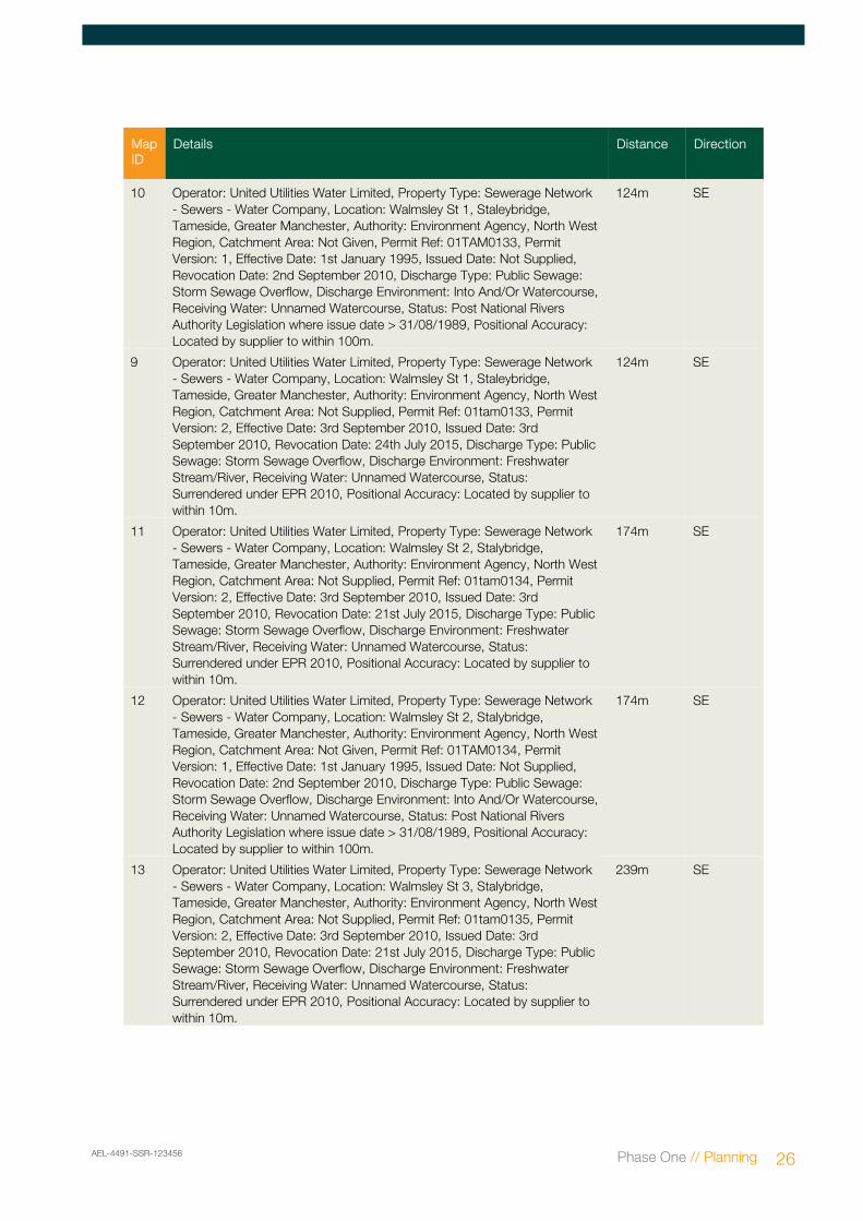
Map ID
Details Distance Direction
10 Operator: United Utilities Water Limited, Property Type: Sewerage Network - Sewers - Water Company, Location: Walmsley St 1, Staleybridge, Tameside, Greater Manchester, Authority: Environment Agency, North West Region, Catchment Area: Not Given, Permit Ref: 01TAM0133, Permit Version: 1, Effective Date: 1st January 1995, Issued Date: Not Supplied, Revocation Date: 2nd September 2010, Discharge Type: Public Sewage: Storm Sewage Overflow, Discharge Environment: Into And/Or Watercourse, Receiving Water: Unnamed Watercourse, Status: Post National Rivers Authority Legislation where issue date > 31/08/1989, Positional Accuracy: Located by supplier to within 100m.
124m SE
9 Operator: United Utilities Water Limited, Property Type: Sewerage Network - Sewers - Water Company, Location: Walmsley St 1, Staleybridge, Tameside, Greater Manchester, Authority: Environment Agency, North West Region, Catchment Area: Not Supplied, Permit Ref: 01tam0133, Permit Version: 2, Effective Date: 3rd September 2010, Issued Date: 3rd September 2010, Revocation Date: 24th July 2015, Discharge Type: Public Sewage: Storm Sewage Overflow, Discharge Environment: Freshwater Stream/River, Receiving Water: Unnamed Watercourse, Status: Surrendered under EPR 2010, Positional Accuracy: Located by supplier to within 10m.
124m SE
11 Operator: United Utilities Water Limited, Property Type: Sewerage Network - Sewers - Water Company, Location: Walmsley St 2, Stalybridge, Tameside, Greater Manchester, Authority: Environment Agency, North West Region, Catchment Area: Not Supplied, Permit Ref: 01tam0134, Permit Version: 2, Effective Date: 3rd September 2010, Issued Date: 3rd September 2010, Revocation Date: 21st July 2015, Discharge Type: Public Sewage: Storm Sewage Overflow, Discharge Environment: Freshwater Stream/River, Receiving Water: Unnamed Watercourse, Status: Surrendered under EPR 2010, Positional Accuracy: Located by supplier to within 10m.
174m SE
12 Operator: United Utilities Water Limited, Property Type: Sewerage Network - Sewers - Water Company, Location: Walmsley St 2, Stalybridge, Tameside, Greater Manchester, Authority: Environment Agency, North West Region, Catchment Area: Not Given, Permit Ref: 01TAM0134, Permit Version: 1, Effective Date: 1st January 1995, Issued Date: Not Supplied, Revocation Date: 2nd September 2010, Discharge Type: Public Sewage: Storm Sewage Overflow, Discharge Environment: Into And/Or Watercourse, Receiving Water: Unnamed Watercourse, Status: Post National Rivers Authority Legislation where issue date > 31/08/1989, Positional Accuracy: Located by supplier to within 100m.
174m SE
13 Operator: United Utilities Water Limited, Property Type: Sewerage Network - Sewers - Water Company, Location: Walmsley St 3, Stalybridge, Tameside, Greater Manchester, Authority: Environment Agency, North West Region, Catchment Area: Not Supplied, Permit Ref: 01tam0135, Permit Version: 2, Effective Date: 3rd September 2010, Issued Date: 3rd September 2010, Revocation Date: 21st July 2015, Discharge Type: Public Sewage: Storm Sewage Overflow, Discharge Environment: Freshwater Stream/River, Receiving Water: Unnamed Watercourse, Status: Surrendered under EPR 2010, Positional Accuracy: Located by supplier to within 10m.
239m SE
AEL-4491-SSR-123456 Phase One // Planning 26
Map ID
Details Distance Direction
14 Operator: United Utilities Water Limited, Property Type: Sewerage Network - Sewers - Water Company, Location: Walmsley St 3, Stalybridge, Tameside, Greater Manchester, Authority: Environment Agency, North West Region, Catchment Area: Not Given, Permit Ref: 01TAM0135, Permit Version: 1, Effective Date: 1st January 1995, Issued Date: Not Supplied, Revocation Date: 2nd September 2010, Discharge Type: Public Sewage: Storm Sewage Overflow, Discharge Environment: Into And/Or Watercourse, Receiving Water: Unnamed Watercourse, Status: Post National Rivers Authority Legislation where issue date > 31/08/1989, Positional Accuracy: Located by supplier to within 100m.
239m SE
15 Operator: Delta Enfield Cables Ltd, Property Type: Insulated Wires & Cables, Location: Delta Enfield Cables Ltd, Castle Works, Stalybridge, Greater Manchester, Sk15 2bs, Authority: Environment Agency, North West Region, Catchment Area: Not Given, Permit Ref: 0169/500/1978/1, Permit Version: 1, Effective Date: 1st April 1991, Issued Date: Not Supplied, Revocation Date: 10th May 1995, Discharge Type: Trade Discharges - Cooling Water, Discharge Environment: Canal, Receiving Water: Huddersfield Canal, Status: Revoked: New Consent issued (Water Act 1989, Section 113), Positional Accuracy: Located by supplier to within 100m.
273m NE
16 Operator: Delta Enfield Cables Ltd, Property Type: Insulated Wires & Cables, Location: Delta Enfield Cables Ltd, Castle Works, Stalybridge, Greater Manchester, Sk15 2bs, Authority: Environment Agency, North West Region, Catchment Area: Not Given, Permit Ref: 016992366, Permit Version: 1, Effective Date: 10th May 1995, Issued Date: Not Supplied, Revocation Date: 10th May 1995, Discharge Type: Trade Discharges - Cooling Water, Discharge Environment: Canal, Receiving Water: Huddersfield Canal, Status: Authorisation revoked, Positional Accuracy: Located by supplier to within 100m.
275m NE
17 Operator: United Utilities Water Limited, Property Type: Sewerage Network - Sewers - Water Company, Location: Trinity Street, Tameside, Greater Manchester, Authority: Environment Agency, North West Region, Catchment Area: Not Supplied, Permit Ref: 01tam0104, Permit Version: 2, Effective Date: 3rd September 2010, Issued Date: 3rd September 2010, Revocation Date: Not Supplied, Discharge Type: Public Sewage: Storm Sewage Overflow, Discharge Environment: Freshwater Stream/River, Receiving Water: River Tame, Status: Varied under EPR 2010, Positional Accuracy: Located by supplier to within 10m.
294m N
18 Operator: United Utilities Water Limited, Property Type: Sewerage Network - Sewers - Water Company, Location: Trinity Street, Tameside, Greater Manchester, Authority: Environment Agency, North West Region, Catchment Area: Not Given, Permit Ref: 01TAM0104, Permit Version: 1, Effective Date: 1st January 1995, Issued Date: Not Supplied, Revocation Date: 2nd September 2010, Discharge Type: Public Sewage: Storm Sewage Overflow, Discharge Environment: Freshwater Stream/River, Receiving Water: River Tame, Status: Post National Rivers Authority Legislation where issue date > 31/08/1989, Positional Accuracy: Located by supplier to within 100m.
294m N
AEL-4491-SSR-123456 Phase One // Planning 27
Map ID
Details Distance Direction
19 Operator: United Utilities Water Plc (?), Property Type: Sewerage Network - Sewers - Water Company, Location: Trinity St/Dean St, Stalybridge, Tameside, Greater Manchester, Authority: Environment Agency, North West Region, Catchment Area: Tame, Permit Ref: 016993730, Permit Version: 2, Effective Date: 31st March 2010, Issued Date: 31st March 2010, Revocation Date: 24th March 2013, Discharge Type: Public Sewage: Storm Sewage Overflow, Discharge Environment: Freshwater Stream/River, Receiving Water: The River Tame, Status: Modified (Water Resources Act 1991, Schedule 10 as amended by Environment Act 1995), Positional Accuracy: Located by supplier to within 10m.
295m N
20 Operator: United Utilities Water Plc, Property Type: Sewerage Network - Sewers - Water Company, Location: Trinity St/Dean St, Stalybridge, Tameside, Greater Manchester, Authority: Environment Agency, North West Region, Catchment Area: Tame, Permit Ref: 016993730, Permit Version: 1, Effective Date: 31st March 2010, Issued Date: 16th February 2005, Revocation Date: Not Supplied, Discharge Type: Public Sewage: Storm Sewage Overflow, Discharge Environment: Freshwater Stream/River, Receiving Water: The River Tame, Status: New Consent (Water Resources Act 1991, Section 88 & Schedule 10 as amended by Environment Act 1995), Positional Accuracy: Located by supplier to within 10m.
295m N
21 Operator: United Utilities Water Limited, Property Type: Sewerage Network - Sewers - Water Company, Location: Trinity St/Dean St, Stalybridge, Tameside, Greater Manchester, Authority: Environment Agency, North West Region, Catchment Area: Tame, Permit Ref: 01TAM0103, Permit Version: 1, Effective Date: 1st January 1995, Issued Date: 1st January 1995, Revocation Date: 30th March 2010, Discharge Type: Public Sewage: Storm Sewage Overflow, Discharge Environment: Freshwater Stream/River, Receiving Water: River Tame, Status: Post National Rivers Authority Legislation where issue date > 31/08/1989, Positional Accuracy: Located by supplier to within 100m.
295m N
22 Operator: United Utilities Water Plc (?), Property Type: Sewerage Network - Sewers - Water Company, Location: Trinity St/Dean St, Stalybridge, Tameside, Greater Manchester, Authority: Environment Agency, North West Region, Catchment Area: Tame, Permit Ref: 016993730, Permit Version: 3, Effective Date: 25th March 2013, Issued Date: 25th March 2013, Revocation Date: Not Supplied, Discharge Type: Public Sewage: Storm Sewage Overflow, Discharge Environment: Freshwater Stream/River, Receiving Water: The River Tame, Status: Varied under EPR 2010, Positional Accuracy: Located by supplier to within 10m.
295m N
23 Operator: United Utilities Water Limited, Property Type: Sewerage Network - Sewers - Water Company, Location: Melbourne Street, Stalybridge, Tameside, Greater Manchester, Authority: Environment Agency, North West Region, Catchment Area: Tame, Permit Ref: 01TAM0105, Permit Version: 1, Effective Date: 1st January 1995, Issued Date: 1st January 1995, Revocation Date: 1st June 2008, Discharge Type: Public Sewage: Storm Sewage Overflow, Discharge Environment: Freshwater Stream/River, Receiving Water: River Tame, Status: Post National Rivers Authority Legislation where issue date > 31/08/1989, Positional Accuracy: Located by supplier to within 100m.
303m N
AEL-4491-SSR-123456 Phase One // Planning 28
Map ID
Details Distance Direction
24 Operator: United Utilities Water Plc (?), Property Type: Sewerage Network - Sewers - Water Company, Location: Melbourne Street, Stalybridge, Tameside, Greater Manchester, Authority: Environment Agency, North West Region, Catchment Area: Tame, Permit Ref: 016993731, Permit Version: 2, Effective Date: 2nd June 2008, Issued Date: 2nd June 2008, Revocation Date: Not Supplied, Discharge Type: Public Sewage: Storm Sewage Overflow, Discharge Environment: Freshwater Stream/River, Receiving Water: The River Tame, Status: Modified (Water Resources Act 1991, Schedule 10 as amended by Environment Act 1995), Positional Accuracy: Located by supplier to within 10m.
303m N
25 Operator: United Utilities Water Plc (?), Property Type: Sewerage Network - Sewers - Water Company, Location: Melbourne Street, Stalybridge, Tameside, Greater Manchester, Authority: Environment Agency, North West Region, Catchment Area: Tame, Permit Ref: 016993731, Permit Version: 1, Effective Date: 16th February 2005, Issued Date: 16th February 2005, Revocation Date: 1st June 2008, Discharge Type: Public Sewage: Storm Sewage Overflow, Discharge Environment: Freshwater Stream/River, Receiving Water: The River Tame, Status: New Consent (Water Resources Act 1991, Section 88 & Schedule 10 as amended by Environment Act 1995), Positional Accuracy: Located by supplier to within 10m.
303m N
26 Operator: United Utilities Water Limited, Property Type: Sewerage Network - Sewers - Water Company, Location: Corporation Street, Stalybridge, Tameside, Greater Manchester, Authority: Environment Agency, North West Region, Catchment Area: Not Given, Permit Ref: 01TAM0099, Permit Version: 1, Effective Date: 1st January 1995, Issued Date: Not Supplied, Revocation Date: Not Supplied, Discharge Type: Public Sewage: Storm Sewage Overflow, Discharge Environment: Freshwater Stream/River, Receiving Water: River Tame, Status: Post National Rivers Authority Legislation where issue date > 31/08/1989, Positional Accuracy: Located by supplier to within 100m.
358m NE
27 Operator: United Utilities Water Limited, Property Type: Sewerage Network - Sewers - Water Company, Location: Market St/Trinity St, Stalybridge, Tameside, Greater Manchester, Authority: Environment Agency, North West Region, Catchment Area: Not Given, Permit Ref: 01TAM0100, Permit Version: 1, Effective Date: 1st January 1995, Issued Date: Not Supplied, Revocation Date: 3rd September 2010, Discharge Type: Public Sewage: Storm Sewage Overflow, Discharge Environment: Freshwater Stream/River, Receiving Water: River Tame, Status: Post National Rivers Authority Legislation where issue date > 31/08/1989, Positional Accuracy: Located by supplier to within 100m.
365m N
28 Operator: United Utilities Water Limited, Property Type: Sewerage Network - Sewers - Water Company, Location: Market St/Trinity St, Stalybridge, Tameside, Greater Manchester, Authority: Environment Agency, North West Region, Catchment Area: Not Supplied, Permit Ref: 01tam0100, Permit Version: 2, Effective Date: 3rd September 2010, Issued Date: 3rd September 2010, Revocation Date: Not Supplied, Discharge Type: Public Sewage: Storm Sewage Overflow, Discharge Environment: Freshwater Stream/River, Receiving Water: River Tame, Status: Varied under EPR 2010, Positional Accuracy: Located by supplier to within 10m.
365m N
AEL-4491-SSR-123456 Phase One // Planning 29
Map ID
Details Distance Direction
29 Operator: United Utilities Water Plc (?), Property Type: Sewerage Network - Sewers - Water Company, Location: Caroline St/Castle St, Stalybridge, Tameside, Greater Manchester, Authority: Environment Agency, North West Region, Catchment Area: Tame, Permit Ref: 016993734, Permit Version: 1, Effective Date: 31st March 2010, Issued Date: 16th February 2005, Revocation Date: 8th December 2010, Discharge Type: Public Sewage: Storm Sewage Overflow, Discharge Environment: Freshwater Stream/River, Receiving Water: The River Tame, Status: Revoked under EPR 2010, Positional Accuracy: Located by supplier to within 10m.
370m NW
30 Operator: United Utilities Water Limited, Property Type: Sewerage Network - Sewers - Water Company, Location: Caroline St/Castle St, Stalybridge, Tameside, Greater Manchester, Authority: Environment Agency, North West Region, Catchment Area: Tame, Permit Ref: 01TAM0106, Permit Version: 1, Effective Date: 1st January 1995, Issued Date: 1st January 1995, Revocation Date: 30th March 2010, Discharge Type: Public Sewage: Storm Sewage Overflow, Discharge Environment: Freshwater Stream/River, Receiving Water: River Tame, Status: Post National Rivers Authority Legislation where issue date > 31/08/1989, Positional Accuracy: Located by supplier to within 100m.
370m NW
31 Operator: United Utilities Water Limited, Property Type: Sewerage Network - Sewers - Water Company, Location: Caroline St(North Of Brg), Stalybridge, Cheshire, Authority: Environment Agency, North West Region, Catchment Area: Not Supplied, Permit Ref: 016982690, Permit Version: 2, Effective Date: 31st March 2010, Issued Date: 31st March 2010, Revocation Date: 5th August 2011, Discharge Type: Public Sewage: Storm Sewage Overflow, Discharge Environment: Freshwater Stream/River, Receiving Water: River Tame, Status: Modified (Water Resources Act 1991, Schedule 10 as amended by Environment Act 1995), Positional Accuracy: Located by supplier to within 10m.
371m NW
32 Operator: United Utilities Water Limited, Property Type: Sewerage Network - Sewers - Water Company, Location: Caroline St(North Of Brg), Stalybridge, Cheshire, Authority: Environment Agency, North West Region, Catchment Area: Not Given, Permit Ref: 016982690, Permit Version: 1, Effective Date: 30th September 1994, Issued Date: 30th September 1994, Revocation Date: 30th March 2010, Discharge Type: Public Sewage: Storm Sewage Overflow, Discharge Environment: Freshwater Stream/River, Receiving Water: River Tame, Status: Post National Rivers Authority Legislation where issue date > 31/08/1989, Positional Accuracy: Located by supplier to within 100m.
391m NW
33 Operator: United Utilities Water Limited, Property Type: Sewerage Network - Sewers - Water Company, Location: Caroline St(North Of Brg), Stalybridge, Cheshire, Authority: Environment Agency, North West Region, Catchment Area: Not Given, Permit Ref: 01TAM0155, Permit Version: 1, Effective Date: 1st January 1995, Issued Date: Not Supplied, Revocation Date: 1st January 1995, Discharge Type: Public Sewage: Storm Sewage Overflow, Discharge Environment: Freshwater Stream/River, Receiving Water: River Tame, Status: Consent revoked or revised: New Consent issued (Section 37(1)), Positional Accuracy: Located by supplier to within 100m.
395m NW
AEL-4491-SSR-123456 Phase One // Planning 30
Map ID
Details Distance Direction
34 Operator: United Utilities Water Limited, Property Type: Sewage Disposal Works - Water Company, Location: Albion St/Huddersfield Rd, Stalybridge, Tameside, Greater Manchester, Authority: Environment Agency, North West Region, Catchment Area: Not Given, Permit Ref: 01TAM0124, Permit Version: 1, Effective Date: 1st January 1995, Issued Date: Not Supplied, Revocation Date: 25th January 2000, Discharge Type: Public Sewage: Storm Sewage Overflow, Discharge Environment: Freshwater Stream/River, Receiving Water: Stocks Brook, Status: Post National Rivers Authority Legislation where issue date > 31/08/1989, Positional Accuracy: Located by supplier to within 100m.
457m NE
35 Operator: United Utilities Water Plc (?), Property Type: Sewerage Network - Sewers - Water Company, Location: Knowle Street, Stalybridge, Tameside, Greater Manchester, Authority: Environment Agency, North West Region, Catchment Area: Tame, Permit Ref: 016993732, Permit Version: 1, Effective Date: 31st March 2010, Issued Date: 16th February 2005, Revocation Date: Not Supplied, Discharge Type: Public Sewage: Storm Sewage Overflow, Discharge Environment: Freshwater Stream/River, Receiving Water: The River Tame, Status: New Consent (Water Resources Act 1991, Section 88 & Schedule 10 as amended by Environment Act 1995), Positional Accuracy: Located by supplier to within 10m.
460m NE
36 Operator: United Utilities Water Limited, Property Type: Sewerage Network - Sewers - Water Company, Location: Knowle Street, Stalybridge, Tameside, Greater Manchester, Authority: Environment Agency, North West Region, Catchment Area: Tame, Permit Ref: 01TAM0097, Permit Version: 1, Effective Date: 1st January 1995, Issued Date: 1st January 1995, Revocation Date: 30th March 2010, Discharge Type: Public Sewage: Storm Sewage Overflow, Discharge Environment: Freshwater Stream/River, Receiving Water: River Tame, Status: Post National Rivers Authority Legislation where issue date > 31/08/1989, Positional Accuracy: Located by supplier to within 100m.
460m NE
Hazardous Sites
Control of Major Accident Hazard Sites (COMAH)
47 Name: Stepan Uk Ltd, Location: Bridge Street, STALYBRIDGE, Cheshire, SK15 1PH, Reference: Not Supplied, Type: Upper Tier, Status: Active, Positional Accuracy: Manually positioned to the address or location.
474m W
Contraventions
No contraventions have been found.
AEL-4491-SSR-123456 Phase One // Planning 31
Waste
Map ID
Details Distance Direction
Waste/Landfill Sites
Local Authority Landfill Coverage
Tameside Metropolitan Borough Council - Has supplied landfill data
BGS Recorded Landfill Sites
48 Name: Quarry St, Location: STALYBRIDGE, Cheshire, Authority: British Geological Survey, National Geoscience Information Service, Ground Water: Information not available, Surface Water: Information not available, Geology: N/A, Positional Accuracy: Positioned by the supplier, Boundary Accuracy: Moderate.
50 Name: Tameside M B C Inert Landfill Site, Licence Number: 53761, Location: Quarry Street, Stalybridge, Tameside, OL6 6DL, Licence Holder: Tameside M B C, Authority: Environment Agency - North West Region, South Area, Site Category: Landfills Taking Non-biodegradeable Wastes (Not Construction), Maximum Input Rate: Not Supplied, Licence Status: Closure, Issued Date: Not Supplied, Last Modified: Not Supplied, Expiry Date: Not Supplied, Revoked Date: Not Supplied, Surrendered Date: Not Supplied, Positional Accuracy: Positioned by the supplier, Boundary Accuracy: As Supplied.
403m SW
Licenced Waste Management Facilities (Locations)
51 Licence Number: 401435, Location: Caroline House, High Street, Stalybridge, Cheshire, SK15 1SE, Operator: Northern Insulation Contractors L L P, Operator Location: Not Supplied, Authority: Environment Agency - North West Region, South Area, Site Category: Asbestos Waste Transfer Station, Licence Status: Issued, Issued Date: 20th May 2014, Last Modified: Not Supplied, Expiry Date: Not Supplied, Suspended Date: Not Supplied, Revoked Date: Not Supplied, Surrendered Date: Not Supplied, IPPC Reference: Not Supplied, Positional Accuracy: Located by supplier to within 10m.
295m W
52 Licence Number: 53761, Location: Quarry Street, Stalybridge, Tameside, OL6 6DL, Operator: Tameside M B C, Operator Location: Not Supplied, Authority: Environment Agency - North West Region, South Area, Site Category: Landfills Taking Non-biodegradeable Wastes (Not Construction), Licence Status: Closed, Issued Date: 16th December 1993, Last Modified: Not Supplied, Expiry Date: Not Supplied, Suspended Date: Not Supplied, Revoked Date: Not Supplied, Surrendered Date: Not Supplied, IPPC Reference: Not Supplied, Positional Accuracy: Located by supplier to within 10m.
439m W
53 Licence Number: 50225, Location: Land/premises At, Bayley Street, Stalybridge, Cheshire, SK15 1PY, Operator: Viridor Waste ( Greater Manchester ) Ltd, Operator Location: Not Supplied, Authority: Environment Agency - North West Region, South Area, Site Category: Special Waste Transfer Stations, Licence Status: Revoked, Issued Date: 26th May 2004, Last Modified: 19th May 2009, Expiry Date: Not Supplied, Suspended Date: Not Supplied, Revoked Date: 7th August 2014, Surrendered Date: Not Supplied, IPPC Reference: Not Supplied, Positional Accuracy: Located by supplier to within 10m.
570m W
AEL-4491-SSR-123456 Phase One // Planning 32
Map ID
Details Distance Direction
54 Licence Number: 100195, Location: Land / Premises At, Bayley Street, Stalybridge, Cheshire, SK15 1PY, Operator: Viridor Waste ( Greater Manchester ) Ltd, Operator Location: Not Supplied, Authority: Environment Agency - North West Region, South Area, Site Category: Household, Commercial And Industrial Transfer Stations, Licence Status: Modified, Issued Date: 27th March 2008, Last Modified: 18th May 2009, Expiry Date: Not Supplied, Suspended Date: Not Supplied, Revoked Date: Not Supplied, Surrendered Date: Not Supplied, IPPC Reference: Not Supplied, Positional Accuracy: Located by supplier to within 10m.
570m W
Licence Number: 100248, Location: Land/ Premises At, Dale Street, Bayley Ind Est, Stalybridge, Cheshire, SK15 1PU, Operator: H J Hambley Ltd, Operator Location: Not Supplied, Authority: Environment Agency - North West Region, South Area, Site Category: Special Waste Transfer Stations, Licence Status: Modified, Issued Date: 18th March 2008, Last Modified: 2nd December 2015, Expiry Date: Not Supplied, Suspended Date: Not Supplied, Revoked Date: Not Supplied, Surrendered Date: Not Supplied, IPPC Reference: Not Supplied, Positional Accuracy: Located by supplier to within 10m.
689m W
Local Authority Recorded Landfill Sites
55 Location: Gorse Hall Drive, Stalybridge, Reference: Not Supplied, Authority: Tameside Metropolitan Borough Council, Last Reported Status: Not Supplied, Types of Waste: Household Refuse, Date of Closure: Not Supplied, Boundary Quality: Moderate, Positional Accuracy: Positioned by the supplier.
341m SW
56 Location: Quarry St, Stalybridge, Reference: Not Supplied, Authority: Tameside Metropolitan Borough Council, Last Reported Status: Not Supplied, Types of Waste: Inert, Date of Closure: Not Supplied, Boundary Quality: Moderate, Positional Accuracy: Positioned by the supplier.
405m SW
Registered Landfill Sites
57 Licence Holder: Tameside M.B.C., Licence Reference: 00915, Site Location: Former Quarry At Quarry Street, Stalybridge, Cheshire, Easting: 395920, Northing: 398050, Operator Location: Council Offices, Wellington Road, ASHTON UNDER LYNE, Greater Manchester, OL6 6DL, Authority: Environment Agency - North West Region, South Area, Site Category: Landfill, Maximum Input Rate: Large (Equal to or greater than 75,000 and less than 250,000 tonnes per year), Waste Source Restrictions: Waste produced/controlled by licence holder, Dated: 16th December 1993, Preceded By Licence: Not Given, Superseded By Licence: Not Given, Positional Accuracy: Manually positioned to the address or location, Boundary Accuracy: Not Applicable, Authorised Waste: 1. max.waste permitted by licence, 2. uncontam. soil,clay,sand, 3. uncontam.rubble,hardcore,stone,brickwk, Prohibited Waste: 1.Asbestos, 2.Liquid Wastes, 3.Skip Waste, 4.Sludge Wastes, 5.Special Wastes, 6.Waste In Drums, 7.Waste N.O.S..
443m W
Historical Landfill Sites
49 Licence Holder: Not Supplied, Location: Stalybridge, Tameside, Name: Gorse Hill Drive, Operator Location: Not Supplied, Boundary Accuracy: As Supplied, Provider Reference: EAHLD35190, First Input Date: 31st December 1966, Last Input Date: Not Supplied, Specified Waste Type: Deposited Waste included Household Waste, EA Waste Ref: 0, Regis Ref: Not Supplied, WRC Ref: Not Supplied, BGS Ref: Not Supplied, Other Ref: Not Supplied
289m SW
AEL-4491-SSR-123456 Phase One // Planning 33
Map ID
Details Distance Direction
Licence Holder: Greater Manchester Waste Disposal Authority, Location: Wakefield Road, Stalybridge, Greater Manchester, Name: Glent Quarry, Operator Location: Not Supplied, Boundary Accuracy: As Supplied, Provider Reference: EAHLD16483, First Input Date: 31st December 1965, Last Input Date: 31st March 1979, Specified Waste Type: Deposited Waste included Inert, Industrial, Commercial and Household Waste, and Liquid Sludge, EA Waste Ref: 0, Regis Ref: Not Supplied, WRC Ref: 4200/9717, BGS Ref: 436, Other Ref: K041, 4200/9718
Status: Inactive, Location: 13, Corporation Street, Stalybridge, Cheshire, SK15 2JL, Positional Accuracy: Automatically positioned to the address.
196m N
70 Blinds, Awnings & Canopies, Name: C & J Blinds
Status: Active, Location: 11, Corporation Street, Stalybridge, Cheshire, SK15 2JL, Positional Accuracy: Automatically positioned to the address.
196m N
71 Plastics - Injection Moulding, Name: Plastube
Status: Active, Location: The Old Foundry, Leech Street, Stalybridge, Cheshire, SK15 1SD, Positional Accuracy: Automatically positioned to the address.
220m NW
72 Garage Services, Name: Fleet Street Garage
Status: Inactive, Location: Trinity St, Stalybridge, Cheshire, SK15 2BN, Positional Accuracy: Manually positioned to the road within the address or location.
231m N
73 Joinery Manufacturers, Name: Bridge Frames Ltd
Status: Inactive, Location: 2, Dean Street, Stalybridge, Cheshire, SK15 2JD, Positional Accuracy: Automatically positioned to the address.
241m N
74 Cookers - Sales & Service, Name: Empire Spares
Status: Active, Location: Unit 2, Clock Tower Works, Leech Street, Stalybridge, Cheshire, SK15 1SD, Positional Accuracy: Automatically positioned to the address.
242m W
75 Precision Engineers, Name: Brook House Aerospace Ltd
Status: Inactive, Location: Clock Tower Works, Leech Street, Stalybridge, Cheshire, SK15 1SD, Positional Accuracy: Automatically positioned to the address.
242m W
AEL-4491-SSR-123456 Phase One // Planning 35
Map ID
Details Distance Direction
76 Fireplaces & Mantelpieces, Name: The Fireplace Centre
Status: Inactive, Location: 19-21, Melbourne Street, Stalybridge, Cheshire, SK15 2JE, Positional Accuracy: Automatically positioned to the address.
259m N
77 Fireplaces & Mantelpieces, Name: Creations
Status: Inactive, Location: 19-21, Melbourne Street, Stalybridge, Cheshire, SK15 2JE, Positional Accuracy: Manually positioned to the address or location.
259m N
78 Office Furniture & Equipment, Name: Hunters North
Status: Inactive, Location: 11, Melbourne Street, Stalybridge, Cheshire, SK15 2JE, Positional Accuracy: Automatically positioned to the address.
280m N
79 Fork Lift Trucks, Name: C B Fork Lift Truck Training
Status: Inactive, Location: 97, Spring Bank, Stalybridge, Cheshire, SK15 2HL, Positional Accuracy: Automatically positioned to the address.
287m SE
80 Car Body Repairs, Name: Portman Motor Co
Status: Inactive, Location: Longlands Mill, Castle Street, Stalybridge, Cheshire, SK15 1NX, Positional Accuracy: Automatically positioned to the address.
304m NW
81 Petrol Filling Stations, Name: Texaco
Status: Active, Location: Caroline Street, Stalybridge, Cheshire, SK15 1PD, Positional Accuracy: Automatically positioned to the address.
308m NW
82 Engineering Services, Name: Blue Range Tools
Status: Active, Location: Caroline House, High Street, Stalybridge, Cheshire, SK15 1SE, Positional Accuracy: Automatically positioned to the address.
Status: Inactive, Location: 17, Hob Hill, Stalybridge, Cheshire, SK15 1TP, Positional Accuracy: Automatically positioned to the address.
383m W
98 Toys, Games & Sporting Goods - Manufacturers, Name: Haba
Status: Active, Location: 18, Stamford Street, Stalybridge, Cheshire, SK15 1JZ, Positional Accuracy: Automatically positioned to the address.
389m N
99 Engineers - General, Name: C T I D Ltd
Status: Inactive, Location: 18-20, Stamford Street, Stalybridge, Cheshire, SK15 1JU, Positional Accuracy: Automatically positioned to the address.
389m N
100 Clothing & Fabrics - Manufacturers, Name: A & E Combs Cutting Service
Status: Inactive, Location: Second Floor, Cheethams Mill, Park St, Stalybridge, Cheshire, SK15 2BT, Positional Accuracy: Manually positioned to the address or location.
391m E
101 Engineers - General, Name: Mtd Engineering
Status: Inactive, Location: Park View Works, Park St, Stalybridge, Cheshire, SK15 2BT, Positional Accuracy: Manually positioned to the address or location.
Status: Inactive, Location: Cheethams Mill, Park Street, Stalybridge, Cheshire, SK15 2BT, Positional Accuracy: Manually positioned to the address or location.
Status: Active, Location: Park View Works, Park Street, Stalybridge, Cheshire, SK15 2BT, Positional Accuracy: Automatically positioned to the address.
392m E
104 Screen Process Printers, Name: Signwear Plastics Ltd
Status: Inactive, Location: Cheethams Mill, Park Street, Stalybridge, Cheshire, SK15 2BT, Positional Accuracy: Manually positioned to the address or location.
392m E
105 Engineers - General, Name: Jan Engineering
Status: Inactive, Location: Cheethams Mill, Park Street, STALYBRIDGE, Cheshire, SK15 2BT, Positional Accuracy: Automatically positioned to the address.
392m E
106 Engineers - General, Name: Barnes & Thomas Ltd
Status: Active, Location: Cheethams Mill, Park Street, Stalybridge, Cheshire, SK15 2BT, Positional Accuracy: Automatically positioned to the address.
392m E
107 Printers Textile, Name: Dribar Ltd
Status: Inactive, Location: Cheethams Mill, Park Street, Stalybridge, Cheshire, SK15 2BT, Positional Accuracy: Automatically positioned to the address.
392m E
108 Engineers - General, Name: M P Engineering Ltd
Status: Inactive, Location: Park View Works, Park Street, Stalybridge, Cheshire, SK15 2BT, Positional Accuracy: Automatically positioned to the address.
392m E
109 Engineers - General, Name: Jan Engineering Ltd
Status: Inactive, Location: Cheethams Mill, Park Street, Stalybridge, Cheshire, SK15 2BT, Positional Accuracy: Automatically positioned to the address.
Status: Inactive, Location: Park View Works, Park Street, Stalybridge, Cheshire, SK15 2BT, Positional Accuracy: Automatically positioned to the address.
Status: Inactive, Location: V G House, Park Street, Stalybridge, Cheshire, SK15 2BT, Positional Accuracy: Automatically positioned to the address.
392m E
114 Engineers - General, Name: Trevus Tools
Status: Inactive, Location: Park View Works, Park Street, Stalybridge, Cheshire, SK15 2BT, Positional Accuracy: Automatically positioned to the address.
392m E
115 Boilers - Servicing, Replacements & Repairs, Name: Steam Direct
Status: Inactive, Location: Cheethams Mill, Park Street, Stalybridge, Cheshire, SK15 2BT, Positional Accuracy: Manually positioned to the address or location.
392m E
AEL-4491-SSR-123456 Phase One // Planning 38
Map ID
Details Distance Direction
116 Joinery Manufacturers, Name: The Joiners Shop
Status: Inactive, Location: Cheethams Mill, Park Street, Stalybridge, Cheshire, SK15 2BT, Positional Accuracy: Manually positioned to the address or location.
392m E
117 Electronic Engineers, Name: J T D Electronics
Status: Active, Location: Cheethams Mills, Park Street, Stalybridge, Cheshire, SK15 2BT, Positional Accuracy: Automatically positioned to the address.
392m E
118 Printing Equipment Manufacturers, Name: Green Cat Co Ltd
Status: Inactive, Location: Cheethams Mill, Park Street, Stalybridge, Cheshire, SK15 2BT, Positional Accuracy: Automatically positioned to the address.
392m E
119 Air Conditioning Equipment & Systems, Name: Icecap Cooling Ltd
Status: Active, Location: Unit A23 Cheethams Mills, Park Street, Stalybridge, Cheshire, SK15 2BT, Positional Accuracy: Manually positioned to the address or location.
392m E
120 Engineers - General, Name: Jan Engineering Ltd
Status: Active, Location: Cheethams Mill, Park Street, Stalybridge, Cheshire, SK15 2BT, Positional Accuracy: Automatically positioned to the address.
Status: Inactive, Location: Cheethams Mill, Park Street, Stalybridge, Cheshire, SK15 2BT, Positional Accuracy: Automatically positioned to the address.
392m E
126 Print Finishers, Name: Foldermatics Ltd
Status: Active, Location: Cheethams Mill, Park Street, STALYBRIDGE, Cheshire, SK15 2BT, Positional Accuracy: Automatically positioned to the address.
392m E
127 Leisure & Sportswear Manufacturers & Wholesalers, Name: P Hutchinson
Status: Inactive, Location: Cheethams Mill, Park Street, Stalybridge, Cheshire, SK15 2BT, Positional Accuracy: Manually positioned to the address or location.
392m E
AEL-4491-SSR-123456 Phase One // Planning 39
Map ID
Details Distance Direction
128 Engineers - General, Name: Green Engineering
Status: Active, Location: Park View Works, Park Street, Stalybridge, Cheshire, SK15 2BT, Positional Accuracy: Automatically positioned to the address.
392m E
129 Central Heating Supplies & Equipment, Name: All Gas
Status: Inactive, Location: Waterloo Rd, Stalybridge, Cheshire, SK15 2AU, Positional Accuracy: Manually positioned to the road within the address or location.
399m N
130 Blinds, Awnings & Canopies, Name: M B Shading Systems Ltd
Status: Inactive, Location: Cheethams Mill, Park St, Stalybridge, Cheshire, SK15 2BT, Positional Accuracy: Manually positioned to the address or location.
Status: Active, Location: Cheethams Mill, Park Street, Stalybridge, Cheshire, SK15 2BT, Positional Accuracy: Automatically positioned to the address.
402m E
133 Photographic Equipment & Supplies - Wholesale, Name: D P M Wallbank
Status: Active, Location: Cheethams Mill, Park Street, STALYBRIDGE, Cheshire, SK15 2BT, Positional Accuracy: Automatically positioned to the address.
402m E
134 Machinery - Industrial & Commercial, Name: G T M Sales Ltd
Status: Active, Location: Cheethams Mill, Park Street, STALYBRIDGE, Cheshire, SK15 2BT, Positional Accuracy: Automatically positioned to the address.
402m E
135 Furniture Manufacturers - Home & Office, Name: Bridgemill Oak Furniture Studios
Status: Inactive, Location: Cheethams Mill, Park Street, Stalybridge, Cheshire, SK15 2BT, Positional Accuracy: Manually positioned to the address or location.
402m E
136 Air Conditioning & Refrigeration Contractors, Name: Coolcare
Status: Inactive, Location: Cheethams Mill, Park Street, Stalybridge, Cheshire, SK15 2BT, Positional Accuracy: Manually positioned to the address or location.
Status: Inactive, Location: Bankwood Mills, Park Street, Stalybridge, Cheshire, SK15 2BT, Positional Accuracy: Automatically positioned to the address.
402m E
138 Sheet Metal Work, Name: A One Sheet Metal
Status: Inactive, Location: Bankwood Mills, Park Street, Stalybridge, Cheshire, SK15 2BT, Positional Accuracy: Automatically positioned to the address.
402m E
139 Fireplaces & Mantelpieces, Name: G & S Hazell
Status: Active, Location: 10, Cliff Dale, Stalybridge, Cheshire, SK15 1UU, Positional Accuracy: Automatically positioned to the address.
406m SW
AEL-4491-SSR-123456 Phase One // Planning 40
Map ID
Details Distance Direction
140 Sports Equipment Manufacturers & Distributors, Name: In 2 Net
Status: Active, Location: Park View Works, Park Street, Stalybridge, SK15 2BT, Positional Accuracy: Automatically positioned to the address.
410m E
141 Garage Services, Name: J Howarth Motors
Status: Active, Location: Chapel Street, Stalybridge, Cheshire, SK15 2AW, Positional Accuracy: Automatically positioned in the proximity of the address.
422m NW
142 Road Haulage Services, Name: C Mccullum & Son Transport Ltd
Status: Inactive, Location: Chapel Street, Stalybridge, Cheshire, SK15 2AW, Positional Accuracy: Automatically positioned in the proximity of the address.
422m NW
143 Garage Services, Name: Portland Auto Services
Status: Inactive, Location: Higher Tame St, Stalybridge, Cheshire, SK15 3AS, Positional Accuracy: Manually positioned to the address or location.
430m NE
144 Garage Services, Name: A1 Motors
Status: Inactive, Location: Chapel St, Stalybridge, Cheshire, SK15 2AW, Positional Accuracy: Manually positioned to the road within the address or location.
Status: Inactive, Location: 17, Market Street, Stalybridge, Cheshire, SK15 2AL, Positional Accuracy: Automatically positioned to the address.
481m NW
158 Electronic Engineers, Name: Cso Electronics
Status: Inactive, Location: Unit 12 Waterloo Rd, Stalybridge, Cheshire, SK15 2AU, Positional Accuracy: Manually positioned to the road within the address or location.
483m NW
159 Laundries & Launderettes, Name: The Launderette & Ironing Shop
Status: Inactive, Location: 89, Mottram Road, STALYBRIDGE, Cheshire, SK15 2QS, Positional Accuracy: Automatically positioned to the address.
488m E
Fuel Station Entries
160 Name: Tesco Stalybridge, Location: Trinity Street, Stalybridge, Cheshire, SK15 2BJ, Brand: Tesco, Premises Type: Hypermarket, Status: Open, Positional Accuracy: Manually positioned to the address or location.
52m NE
161 Name: Mabco Caroline Service Station, Location: Caroline Street, Stalybridge, Cheshire, SK15 1PD, Brand: TEXACO, Premises Type: Petrol Station, Status: Open, Positional Accuracy: Manually positioned to the address or location.
309m NW
Other FeaturesTelecommunication Base Stations
162 Telecommunication Base Station, Location: Not Supplied, Mast Height (m): Not Supplied.
421m N
163 Telecommunication Base Station, Location: Not Supplied, Mast Height (m): Not Supplied.
446m N
Historical Land Use
Details Distance Direction
Historical Potentially Contaminative UsesHistorical Tanks and Energy Facilities
Electrical Sub Station Facilities, Scale of Mapping: 1:1,250, Date of Mapping: 1982. 54m SW
Electrical Sub Station Facilities, Scale of Mapping: 1:1,250, Date of Mapping: 1982. 109m N
Electrical Sub Station Facilities, Scale of Mapping: 1:1,250, Date of Mapping: 1982. 113m E
Electrical Sub Station Facilities, Scale of Mapping: 1:1,250, Date of Mapping: 1982. 135m S
Tanks, Scale of Mapping: 1:1,250, Date of Mapping: 1965. 139m NE
Tanks, Scale of Mapping: 1:2,500, Date of Mapping: 1966. 140m NE
AEL-4491-SSR-123456 Phase One // Planning 42
Details Distance Direction
Tanks, Scale of Mapping: 1:1,250, Date of Mapping: 1989. 226m NE
Electrical Sub Station Facilities, Scale of Mapping: 1:1,250, Date of Mapping: 1982. 254m W
Tanks, Scale of Mapping: 1:1,250, Date of Mapping: 1989. 269m E
Electrical Sub Station Facilities, Scale of Mapping: 1:1,250, Date of Mapping: 1989. 281m NE
Gas Industry Facilities, Scale of Mapping: 1:2,500, Date of Mapping: 1966. 283m E
Gas Industry Facilities, Scale of Mapping: 1:1,250, Date of Mapping: 1965. 285m E
Gas Monitoring Facilities, Scale of Mapping: 1:1,250, Date of Mapping: 1989. 293m E
Gas Monitoring Facilities, Scale of Mapping: 1:1,250, Date of Mapping: 1989. 297m NE
Potential Tanks, Scale of Mapping: 1:2,500, Date of Mapping: 1966. 362m NW
Potential Tanks, Scale of Mapping: 1:1,250, Date of Mapping: 1965. 362m NW
Tanks, Scale of Mapping: 1:1,250, Date of Mapping: 1989. 367m E
Electrical Sub Station Facilities, Scale of Mapping: 1:1,250, Date of Mapping: 1971 - 1975.
392m SE
Tanks, Scale of Mapping: 1:2,500, Date of Mapping: 1966. 398m NE
Tanks, Scale of Mapping: 1:1,250, Date of Mapping: 1965. 398m NE
Electrical Sub Station Facilities, Scale of Mapping: 1:1,250, Date of Mapping: 1989. 427m N
Electrical Sub Station Facilities, Scale of Mapping: 1:1,250, Date of Mapping: 1989. 463m NE
Potential Tanks, Scale of Mapping: 1:2,500, Date of Mapping: 1966. 471m NE
Potential Tanks, Scale of Mapping: 1:1,250, Date of Mapping: 1965. 471m NE
Potentially Infilled LandPotentially Infilled Land (Non-Water)
Description: Unknown Filled Ground (Pit, quarry etc), Date of Mapping: 1995. 322m SW
Description: Unknown Filled Ground (Pit, quarry etc), Date of Mapping: 1995. 344m W
Potentially Infilled Land (Water)
Description: Unknown Filled Ground (Pond, marsh, river, stream, dock etc), Date of Mapping: 1954.
146m N
Description: Unknown Filled Ground (Pond, marsh, river, stream, dock etc), Date of Mapping: 1954.
351m SW
Description: Unknown Filled Ground (Pond, marsh, river, stream, dock etc), Date of Mapping: 1911.
474m S
The following maps have been manually reviewed by a consultant and presented in the Risk Analysis section at the front of this report.
Scale Map Sheet Published Date
1:2,500 Cheshire 003_10 1875
1:2,500 Lancashire And Furness 105_07 1894
1:2,500 Lancashire And Furness 105_08 1894
1:2,500 Lancashire And Furness 105_11 1896
1:2,500 Cheshire 003_10 1898
1:2,500 Lancashire And Furness 105_07 1909
1:2,500 Lancashire And Furness 105_07 1922
1:2,500 Lancashire And Furness 105_08 1922
1:2,500 Lancashire And Furness 105_11 1922
1:2,500 Lancashire And Furness 105_12 1922
1:2,500 National Grid SJ9698 1966
AEL-4491-SSR-123456 Phase One // Planning 43
Scale Map Sheet Published Date
1:10,560 Lancashire And Furness 105_00 1848
1:10,560 Cheshire 003_00 1882
1:10,560 Lancashire And Furness 105_NE 1894
1:10,560 Cheshire 003_SW 1899
1:10,560 Cheshire 003_SW 1911
1:10,560 Lancashire And Furness 105_NE 1911
1:10,560 Lancashire And Furness 105_NE 1922
1:10,560 Lancashire And Furness 105_SE 1922
1:10,560 Cheshire 003_SW 1938
1:10,560 National Grid SJ99NE 1954
1:10,000 National Grid SJ99NE 1977
1:10,000 National Grid SJ99NE 1983
1:10,000 National Grid SJ99NE 1995
1:10,000 National Grid SJ99NE 2014
1:1,250 National Grid SJ9698NE 1965
1:1,250 National Grid SJ9698NW 1965
1:1,250 National Grid SJ9698SE 1965
1:1,250 National Grid SJ9698SW 1965
1:1,250 National Grid SJ9697NE 1966
1:1,250 National Grid SJ9697NW 1966
1:1,250 National Grid SJ9697NE 1971
1:1,250 National Grid SJ9697NW 1975
1:1,250 National Grid SJ9698SW 1982
1:1,250 National Grid SJ9698NW 1989
1:1,250 National Grid SJ9698SE 1989
1:1,250 National Grid SJ9697NE 1975
1:1,250 National Grid SJ9698NE 1974
1:1,250 National Grid SJ9698NW 1976
1:1,250 National Grid SJ9698SW 1976
1:1,250 National Grid SJ9697NE 1992
1:1,250 National Grid SJ9697NW 1992
1:1,250 National Grid SJ9698NE 1992
1:1,250 National Grid SJ9698NW 1992
1:1,250 National Grid SJ9698SE 1992
1:1,250 National Grid SJ9698SW 1992
1:1,250 National Grid SJ9698SE 1995
1:1,250 National Grid SJ9698NW 1977
1:1,250 National Grid SJ9698SE 1978
1:1,250 National Grid SJ9698SW 1981
1:1,250 National Grid SJ9698NE 1984
1:1,250 National Grid SJ9697NE 1991
1:1,250 National Grid SJ9697NW 1991
1:1,250 National Grid SJ9698NW 1984
1:1,250 National Grid SJ9698NE 1987
1:1,250 National Grid SJ9698SW 1991
AEL-4491-SSR-123456 Phase One // Planning 44
Scale Map Sheet Published Date
1:1,250 National Grid SJ9698NE 1991
1:1,250 National Grid SJ9698NW 1991
AEL-4491-SSR-123456 Phase One // Planning 45
Aquifer Designation (Superficial)
AEL-4491-SSR-123456 Phase One // Planning 46
Aquifer Designation (Bedrock)
AEL-4491-SSR-123456 Phase One // Planning 47
Groundwater Vulnerability
Map ID
Details Distance Direction
Hydrogeology
Superficial Aquifer Designations
Secondary Aquifer - A
These aquifers are formed of moderately permeable layers capable of supporting water supplies at a local scale, and in some cases forming an important source of base flow to rivers.
On Site -
Secondary Aquifer - Undifferentiated
These aquifers have a variable permeability, yielding varying amounts of groundwater at different locations but not capable of supporting water supplies at a more than a local scale.
183m NE
Secondary Aquifer - Undifferentiated
These aquifers have a variable permeability, yielding varying amounts of groundwater at different locations but not capable of supporting water supplies at a more than a local scale.
377m N
Bedrock Aquifer Designations
Secondary Aquifer - A
These aquifers are formed of moderately permeable layers capable of supporting water supplies at a local scale, and in some cases forming an important source of base flow to rivers.
On Site -
Groundwater Vulnerability
Soil Classification: Soils of High Leaching Potential (U) - Soil information for restored mineral workings and urban areas is based on fewer observations than elsewhere. A worst case vulnerability classification (H) assumed, until proved otherwise, Map Scale: 1:100,000, Map Name: Sheet 17 Derbyshire & North Staffordshire.
On Site -
Soil Classification: Soils of Low Leaching Potential - Soils in which pollutants are unlikely to penetrate the soil layer because water movement is largely horizontal or they have large ability to attenuate diffuse pollutants. Lateral flow from these soils contribute to groundwater recharge elsewhere in the catchment, Map Scale: 1:100,000, Map Name: Sheet 17 Derbyshire & North Staffordshire.
337m S
GeologyLow Permeability Drift Deposits
Drift Deposit: Low permeability drift deposits occuring at the surface and overlying Major and Minor Aquifers are head, clay-with-flints, brickearth, peat, river terrace deposits and marine and estuarine alluvium, Map Sheet: Sheet 17 Derbyshire & North Staffordshire, Scale: 1:100,000.
166m NE
BGS 1:50,000 Bedrock Geology
LEX Code: WH, Rock Name: Woodhead Hill Rock, Rock Type: Sandstone, Min Age: Langsettian, Max Age: Langsettian.
On Site -
LEX Code: PLCM, Rock Name: Pennine Lower Coal Measures Formation, Rock Type: Mudstone, Siltstone and Sandstone, Min Age: Langsettian, Max Age: Langsettian.
35m SW
LEX Code: GAS, Rock Name: Great Arc Sandstone, Rock Type: Sandstone, Min Age: Langsettian, Max Age: Langsettian.
141m SW
AEL-4491-SSR-123456 Phase One // Planning 48
Map ID
Details Distance Direction
LEX Code: HER, Rock Name: Helpet Edge Rock, Rock Type: Sandstone, Min Age: Langsettian, Max Age: Langsettian.
208m SW
LEX Code: RR, Rock Name: Rough Rock, Rock Type: Sandstone, Min Age: Yeadonian, Max Age: Yeadonian.
226m E
LEX Code: DF, Rock Name: Darwen Flags, Rock Type: Sandstone, Min Age: Langsettian, Max Age: Langsettian.
268m SW
LEX Code: PLCM, Rock Name: Pennine Lower Coal Measures Formation, Rock Type: Mudstone, Siltstone and Sandstone, Min Age: Langsettian, Max Age: Langsettian.
306m SW
LEX Code: MLRS, Rock Name: Milnrow Sandstone, Rock Type: Sandstone, Min Age: Langsettian, Max Age: Langsettian.
378m SW
LEX Code: ROSSE, Rock Name: Rossendale Formation, Rock Type: Mudstone and Siltstone, Min Age: Yeadonian, Max Age: Yeadonian.
420m E
BGS 1:50,000 Superficial Deposits
LEX Code: GFSDD, Rock Name: Glaciofluvial Sheet Deposits, Devensian, Rock Type: Sand and Gravel, Min Age: Devensian, Max Age: Devensian.
On Site -
LEX Code: TILLD, Rock Name: Till, Devensian, Rock Type: Diamicton, Min Age: Devensian, Max Age: Devensian.
273m NE
LEX Code: TILLD, Rock Name: Till, Devensian, Rock Type: Diamicton, Min Age: Devensian, Max Age: Devensian.
278m N
LEX Code: ALV, Rock Name: Alluvium, Rock Type: Clay, Silt, Sand and Gravel, Min Age: Flandrian, Max Age: Flandrian.
317m NW
BGS 1:50,000 Geological Mapping Coverage
Map Sheet No: 085, MapName: Manchester, Map Date: 2011, Bedrock Geology: Available, Superficial Geology: Available, Artificial Geology: Available, Faults: Not Supplied, Landslip: Available, Rock Segments: Not Supplied.
On Site -
Detailed River Network Lines
Canal, River Name: Ashton Canal
Hydrographic Area: D011, River Flow Type: Primary Flow Path, River Surface Level: Above Surface, Drain Feature: Not a Drain, Flood Risk Management Status: Other Rivers, Water Course Name: Not Supplied, Water Course Reference: Not Supplied.
152m N
Extended Culvert (greater than 50m), River Name: Tame
Hydrographic Area: D011, River Flow Type: Primary Flow Path, River Surface Level: Below Surface, Drain Feature: Not a Drain, Flood Risk Management Status: Other Rivers, Water Course Name: Not Supplied, Water Course Reference: Not Supplied.
199m SW
Tertiary River, River Name: Not Supplied
Hydrographic Area: D011, River Flow Type: Primary Flow Path, River Surface Level: Surface, Drain Feature: Not a Drain, Flood Risk Management Status: Other Rivers, Water Course Name: Not Supplied, Water Course Reference: Not Supplied.
228m SW
Primary River, River Name: River Tame
Hydrographic Area: D011, River Flow Type: Primary Flow Path, River Surface Level: Surface, Drain Feature: Not a Drain, Flood Risk Management Status: Flood Risk Management Indicative/Statutory Main River, Water Course Name: RIVER TAME, Water Course Reference: TAME.
281m NE
AEL-4491-SSR-123456 Phase One // Planning 49
Map ID
Details Distance Direction
Primary River, River Name: River Tame
Hydrographic Area: D011, River Flow Type: Primary Flow Path, River Surface Level: Surface, Drain Feature: Not a Drain, Flood Risk Management Status: Flood Risk Management Indicative/Statutory Main River, Water Course Name: RIVER TAME, Water Course Reference: TAME.
403m NW
Extended Culvert (greater than 50m), River Name: Not Supplied
Hydrographic Area: D011, River Flow Type: Primary Flow Path, River Surface Level: Below Surface, Drain Feature: Not a Drain, Flood Risk Management Status: Currently Undefined, Water Course Name: Fern Bank, Water Course Reference: FERN.
413m NE
Primary River, River Name: River Tame
Hydrographic Area: D011, River Flow Type: Primary Flow Path, River Surface Level: Surface, Drain Feature: Not a Drain, Flood Risk Management Status: Flood Risk Management Indicative/Statutory Main River, Water Course Name: RIVER TAME, Water Course Reference: TAME.
413m NE
Extended Culvert (greater than 50m), River Name: Not Supplied
Hydrographic Area: D011, River Flow Type: Primary Flow Path, River Surface Level: Below Surface, Drain Feature: Not a Drain, Flood Risk Management Status: Other Rivers, Water Course Name: Not Supplied, Water Course Reference: Not Supplied.
442m E
Extended Culvert (greater than 50m), River Name: Not Supplied
Hydrographic Area: D011, River Flow Type: Primary Flow Path, River Surface Level: Below Surface, Drain Feature: Not a Drain, Flood Risk Management Status: Currently Undefined, Water Course Name: Fern Bank, Water Course Reference: FERN.
480m NE
Lake/Reservoir, River Name: Not Supplied
Hydrographic Area: D011, River Flow Type: Primary Flow Path, River Surface Level: Surface, Drain Feature: Not a Drain, Flood Risk Management Status: Other Rivers, Water Course Name: Not Supplied, Water Course Reference: Not Supplied.
486m E
Detailed River Network Offline Drainage
None
BGS 1:625,000 Solid Geology
Description: Pennine Lower Coal Measures Formation And South Wales Lower Coal Measures Formation (Undifferentiated).
On Site -
AEL-4491-SSR-123456 Phase One // Planning 50
Environmentally Sensitive Features
AEL-4491-SSR-123456 Phase One // Planning 51
Source Protection Zones
AEL-4491-SSR-123456 Phase One // Planning 52
Environmentally Sensitive Features
Map ID
Details Distance Direction
Environmentally Sensitive Features
Nearest Surface Water Feature
1 Surface water feature identified in proximity. 145m N
Sites of Special Scientific Interest
2 Name: Huddersfield Narrow Canal, Multiple Area: N, Area (m2): 116481.04, Source: Natural England, Reference: 1002803, Designation Date: 12th April 1988, Date Type: Notified, Designation Details: Water Framework Directive (WFD).
145m N
Water Abstractions
3 Operator: British Waterways Board, Licence Number: 2569012125, Permit Version: Not Supplied, Location: Huddersfield Narrow Canal, STALYBRIDGE, Cheshire, Authority: Environment Agency, North West Region, Abstraction: Cooling, Abstraction Type: Not Supplied, Source: Canal, Daily Rate(m3): 68, Yearly Rate (m3): 13638, Licence Status: Revoked, Authorised Start: Not Supplied, Authorised End: Not Supplied, Permit Start Date: Not Supplied, Permit End Date: Not Supplied, Positional Accuracy: Located by supplier to within 100m.
166m N
4 Operator: British Waterways Board, Licence Number: 2569012997, Permit Version: Not Supplied, Location: Huddersfield Canal, STALYBRIDGE, Authority: Environment Agency, North West Region, Abstraction: Cooling, Abstraction Type: Not Supplied, Source: Canal, Daily Rate(m3): 0, Yearly Rate (m3): 22730, Licence Status: Revoked, Authorised Start: Not Supplied, Authorised End: Not Supplied, Permit Start Date: Not Supplied, Permit End Date: Not Supplied, Positional Accuracy: Located by supplier to within 100m.
344m NE
5 Operator: British Waterways Board, Licence Number: 2569012118, Permit Version: Not Supplied, Location: Huddersfield Canal , Authority: Environment Agency, North West Region, Abstraction: Not Supplied, Abstraction Type: Not Supplied, Source: Canal, Daily Rate(m3): 0, Yearly Rate (m3): 0, Huddersfield Canal, Authorised Start: Not Supplied, Authorised End: Not Supplied, Permit Start Date: Not Supplied, Permit End Date: Not Supplied, Positional Accuracy: Located by supplier to within 100m.
345m NE
6 Operator: British Waterways Board, Licence Number: 2569012140, Permit Version: Not Supplied, Location: Huddersfield Narrow Canal, Culverted Section, STALYBRIDGE, Cheshire, Authority: Environment Agency, North West Region, Abstraction: Industrial, Abstraction Type: Not Supplied, Source: Canal, Daily Rate(m3): 91, Yearly Rate (m3): 22730, Licence Status: Revoked, Authorised Start: Not Supplied, Authorised End: Not Supplied, Permit Start Date: Not Supplied, Permit End Date: Not Supplied, Positional Accuracy: Located by supplier to within 100m.
348m NE
7 Operator: I M I Range Ltd, Licence Number: 2569012078, Permit Version: Not Supplied, Location: River Tame, Stalybridge Mills, STALYBRIDGE, Cheshire, Authority: Environment Agency, North West Region, Abstraction: Cooling, Abstraction Type: Not Supplied, Source: Surface, Daily Rate(m3): 2032, Yearly Rate (m3): 490968, Licence Status: Revoked, Authorised Start: Not Supplied, Authorised End: Not Supplied, Permit Start Date: Not Supplied, Permit End Date: Not Supplied, Positional Accuracy: Located by supplier to within 100m.
595m NW
AEL-4491-SSR-123456 Phase One // Planning 53
Map ID
Details Distance Direction
Operator: John Hargreaves (Collyhurst & Stalybridge) Ltd, Licence Number: 2569012097, Permit Version: 100, Location: Borehole At Tameside Paper Mills, Stalybridge, Nr Oldham, Authority: Environment Agency, North West Region, Abstraction: Other Industrial/Commercial/Public Services: Process Water, Abstraction Type: Water may be abstracted from a single point, Source: Groundwater, Daily Rate(m3): Not Supplied, Yearly Rate (m3): Not Supplied, Tameside Paper Mill, Stalybridge, Authorised Start: 01 January, Authorised End: 31 December, Permit Start Date: 21st February 1966, Permit End Date: Not Supplied, Positional Accuracy: Located by supplier to within 10m.
786m NE
Operator: John Hargreaves (Collyhurst & Stalybridge) Ltd, Licence Number: 2569012097, Permit Version: 100, Location: Borehole At Tameside Paper Mills, Stalybridge, Nr Oldham, Authority: Environment Agency, North West Region, Abstraction: Other Industrial/Commercial/Public Services: Boiler Feed, Abstraction Type: Water may be abstracted from a single point, Source: Groundwater, Daily Rate(m3): 546, Yearly Rate (m3): 0, Tameside Paper Mill, Stalybridge, Authorised Start: 01 January, Authorised End: 31 December, Permit Start Date: 21st February 1966, Permit End Date: Not Supplied, Positional Accuracy: Located by supplier to within 100m.
786m NE
Operator: Canal And River Trust, Licence Number: 2569012115, Permit Version: 101, Location: Huddersfield Canal At Stalybridge, Nr. Oldham, Lancs., Authority: Environment Agency, North West Region, Abstraction: Other Industrial/Commercial/Public Services: General Cooling (Existing Licences Only) (Low Loss), Abstraction Type: Water may be abstracted from a single point, Source: Surface, Daily Rate(m3): Not Supplied, Yearly Rate (m3): Not Supplied, Land At Total Petrochemicals Uk Ltd, Globe House, Bayley Street, Stalybridge, Cheshire Sk15 1py, Authorised Start: 01 January, Authorised End: 31 December, Permit Start Date: 8th November 2007, Permit End Date: Not Supplied, Positional Accuracy: Located by supplier to within 10m.
905m W
Operator: British Waterways Board, Licence Number: 2569012115, Permit Version: 100, Location: Huddersfield Canal At Stalybridge, Nr. Oldham, Lancs., Authority: Environment Agency, North West Region, Abstraction: Other Industrial/Commercial/Public Services: General Cooling (Existing Licences Only) (Low Loss), Abstraction Type: Water may be abstracted from a single point, Source: Surface, Daily Rate(m3): 1364, Yearly Rate (m3): 120469, Premisis At Ato Chemical Products (Uk) Ltd, Stalybridge, Nr Oldham, Authorised Start: 01 January, Authorised End: 31 December, Permit Start Date: 22nd June 1988, Permit End Date: Not Supplied, Positional Accuracy: Located by supplier to within 10m.
905m W
Source Protection ZonesNone
AEL-4491-SSR-123456 Phase One // Planning 54
Natural and Mining Related Hazards
Map ID
Details Distance Direction
SubsidenceCollapsible Ground Stability Hazards
Risk: Very Low, Source: British Geological Survey, National Geoscience Information Service.
On Site -
Compressible Ground Stability Hazards
Risk: No Hazard, Source: British Geological Survey, National Geoscience Information Service.
On Site -
Risk: Very Low, Source: British Geological Survey, National Geoscience Information Service.
113m NE
Ground Dissolution Stability Hazards
Risk: No Hazard, Source: British Geological Survey, National Geoscience Information Service.
On Site -
Landslide Ground Stability Hazards
Risk: Very Low, Source: British Geological Survey, National Geoscience Information Service.
On Site -
Risk: Moderate, Source: British Geological Survey, National Geoscience Information Service.
194m SW
Running Sand Ground Stability Hazards
Risk: Very Low, Source: British Geological Survey, National Geoscience Information Service.
On Site -
Risk: No Hazard, Source: British Geological Survey, National Geoscience Information Service.
136m S
Shrinking or Swelling Clay Subsidence Hazards
Risk: No Hazard, Source: British Geological Survey, National Geoscience Information Service.
On Site -
Risk: Very Low, Source: British Geological Survey, National Geoscience Information Service.
35m SW
Non-Coal Mining Hazards
Risk: Rare, Source: British Geological Survey, National Geoscience Information Service.
243m E
RadonRadon Potential
The property is in an intermediate probability radon area, as between 1 and 3% of homes are above the action level, Source: British Geological Survey, National Geoscience Information Service.
On Site -
Radon Protective Measures
None, Source: British Geological Survey, National Geoscience Information Service.
On Site -
MiningBrine Compensation Areas
None.
Coal Mining Affected Areas
AEL-4491-SSR-123456 Phase One // Planning 55
Map ID
Details Distance Direction
In an area which may be affected by coal mining activity. It is recommended that a coal mining report is obtained from the Coal Authority. Contact details are included in the Useful Contacts section of this report..
On Site -
Mining Instability
Mining Evidence: Inconclusive Coal Mining, Source: Ove Arup & Partners, Boundary Quality: As Supplied.
On Site -
BGS Recorded Mineral Sites
58 Site Name: Stalybridge, Site Location: Dukinfield, Ashton Under Lyne, Lancashire, Source: British Geological Survey, National Geoscience Information Service, Reference: 95139, Type: Opencast, Status: Ceased, Operator: Not Supplied, Operator Location: Not Supplied, Periodic Type: Carboniferous, Geology: Woodhead Hill Rock, Commodity: Sandstone, Positional Accuracy: Located by supplier to within 10m.
329m SE
59 Site Name: Hall, Site Location: Castle Hall, Stalybridge, Cheshire, Source: British Geological Survey, National Geoscience Information Service, Reference: 11712, Type: Opencast, Status: Ceased, Operator: Not Supplied, Operator Location: Not Supplied, Periodic Type: Carboniferous, Geology: Darwen Flags, Commodity: Sandstone, Positional Accuracy: Located by supplier to within 10m.
418m SW
60 Site Name: Castle Hall Quarry, Site Location: Stalybridge, Cheshire, Source: British Geological Survey, National Geoscience Information Service, Reference: 95134, Type: Opencast, Status: Ceased, Operator: Not Supplied, Operator Location: Not Supplied, Periodic Type: Carboniferous, Geology: Woodhead Hill Rock, Commodity: Sandstone, Positional Accuracy: Located by supplier to within 10m.
421m N
61 Site Name: Castle Hall Sand Pit, Site Location: Stalybridge, Cheshire, Source: British Geological Survey, National Geoscience Information Service, Reference: 95135, Type: Opencast, Status: Ceased, Operator: Not Supplied, Operator Location: Not Supplied, Periodic Type: Carboniferous, Geology: Rough Rock, Commodity: Sand, Positional Accuracy: Located by supplier to within 10m.
425m NE
62 Site Name: Stalybridge, Site Location: Stalybridge, Manchester, Greater Manchester, Source: British Geological Survey, National Geoscience Information Service, Reference: 23139, Type: Opencast, Status: Ceased, Operator: Not Supplied, Operator Location: Not Supplied, Periodic Type: Carboniferous, Geology: Milnrow Sandstone, Commodity: Sandstone, Positional Accuracy: Located by supplier to within 10m.
443m W
63 Site Name: Stalybridge, Site Location: Stalybridge, Manchester, Greater Manchester, Source: British Geological Survey, National Geoscience Information Service, Reference: 23140, Type: Opencast, Status: Ceased, Operator: Not Supplied, Operator Location: Not Supplied, Periodic Type: Carboniferous, Geology: Milnrow Sandstone, Commodity: Sandstone, Positional Accuracy: Located by supplier to within 10m.
494m SW
AEL-4491-SSR-123456 Phase One // Planning 56
Appendix 2 – Proposed site plan & planning application
AEL-4491-SSR-123456 Phase One // Planning 57
Appendix 3 – Flood Risk Screening Report
AEL-4491-SSR-123456 Phase One // Planning 58
Appendix 4 – Report Methodology, Limitations and Reliance
Reliance AEL has prepared this Phase One Environmental Assessment with all reasonable skill, care and diligence within the terms and conditions for Environmental Consultancy Services September 2011. This report has been prepared solely and exclusively for []. If reliance on this report is required by a third party, this may be arranged for an agreed fee.
The assessment has been carried out with due regard to industry guidelines including the Contaminated Land Guidance documents issued by the Department for Environment, Food and Rural Affairs (and its Predecessors), the British Standards Institute (the BSi), the Royal Institution of Chartered Surveyors (RICS). The methods used follow a risk-based approach, with the potential environmental risk assessed qualitatively using the ‘contaminant-pathway-receptor pollutant linkage’ concept introduced in the Environmental Protection Act 1990.
Report Methodology and Limitations The evaluations and recommendations presented within this report are based only on the examination of available historical maps, directories, environmental records, discussions with regulatory bodies, and any previous reports made available to AEL. No intrusive surveys or environmental sampling was conducted as part of this study. AEL accepts no responsibility for the accuracy or completeness of third party data reviewed within this assessment. Copies of the third party data used in this report can be provided upon request (subject to any copyright limitations).
Where budget estimates have been provided, the figures have been identified on the basis of documentation gathered on the Site and discussions with Site management. AEL is unable to warrant the accuracy of these figures and you are recommended to seek appropriate quotations where reliance on a budget estimate is required.
The scope of this report does not include an assessment of the presence of asbestos containing materials within or below buildings at the Site. However if the presence of asbestos is known or suspected, recommendations will be provided to develop an asbestos management plan to comply with current regulations and additional survey/sampling works may then be required.
The conclusions of this study are not necessarily indicative of future conditions or operating practices at or adjacent to the Site.
The liabilities for contaminated land in England and Wales are primarily set out under Part 2A of the Environmental Protection Act 1990, although in certain circumstances action may also be taken under the Water Resources Act 1991. Where re/development is taking place then any necessary remediation is carried out under the statutory planning regime. The main policy document is the National Planning Policy Framework (NPPF) March 2012 which sets out the principles that local planning authorities should follow when determining planning applications for contaminated or potentially contaminated land. The key paragraphs for contamination are 120 and 121 which read:
‘Where a site is affected by contamination or land stability issues, responsibility for securing a safe development rests with the developer and/or landowner’ (Para 120) ‘after remediation, as a minimum, land should not be capable of being determined as contaminated land under Part 2A of the Environmental Protection Act 1990’ (Para 121).
More detailed guidance is provided in Planning Practice Guidance – Land Affected by Contamination (6 March 2014). The legislation that is relevant to the remediation of contaminated land (Part 2A of the Environmental Protection Act 1990, the Water Resources Act 1991 and the relevant provisions of the statutory planning regime) are referred to here as Relevant Legislation.
The interpretation of the wording "significant risk" within the context of exiting legislation is based on the following:
“Significant harm is being caused or there is a significant possibility of such harm being caused, (where harm is defined as harm to health of living organisms or other interference with the ecological systems of which they form a part and, in the case of man, includes harm to his property); and / or, pollution of Controlled Waters is being caused”.
AEL's assessment of risk and environmental liability under the Relevant Legislation is thus based upon the principle of determining the presence of a potential contaminant-pathway-receptor relationship. Where a ‘contaminant’ is a source of contamination, a ‘pathway’ a medium through which the contamination can mobilise and ‘a receptor’ something that could be detrimentally affected by the contamination. Where each of these elements is present, it is considered that a potential contaminant linkage exists at the Site.
AEL-4491-SSR-123456 Phase One // Planning 59
A Site will be assessed by AEL, based on the risk of there being contaminative substances present in, under or on the Site (excluding asbestos containing materials, lead based paints, invasive plant species or mould infestations) such that, on the basis of its proposed use, there is a reasonable likelihood of a Local Planning Authority requiring the remediation of the Site to the requirements of Para 121 of the NPPF.
AEL-4491-SSR-123456 Phase One // Planning 60
Glossary of Terms
BS1075 Investigation of potentially contaminated sites. Code of Practice.
This British Standard provides recommendations and guidance on the investigation of land potentially affected by contamination or naturally elevated concentrations of potentially harmful substances in order to determine or manage any risks.
Contaminated Land (Part 2A definition)
Part 2A of the Environmental Protection Act 1990 was brought into force on 1st April 2000. The legal definition of contaminated land is “any land which appears to the local authority in whose area it is situated to be in such a condition, by reason of substances in, on, or under the land that:
• A significant harm is being caused or there is the significant possibility of such harm being caused; or• Significant pollution of controlled waters is being caused of there is a significant possibility of such pollution being
caused. A key element of the Part 2A regimes is the Source-Pathway-Receptor, known as the “contaminant linkage”. Meaning:The source is the contamination in, on or under the land; the pathway is the route by which the contamination reaches the receptor; and the receptor is defined as living organisms, ecological systems or property which may be harmed.
Without these three elements of the contaminant linkage, land cannot be identified as contaminated land under the Part 2A regime.
CLR 11 Model Procedures for the Management of Land Contamination
This document provides the technical framework for applying a risk management process when dealing with land affected by contamination which is consistent with government policies and legislation within the UK.
Conceptual Site Model
A conceptual site model (CSM) identifies all the potential contaminant linkages (contaminant-pathway-receptors) and drives the risk assessment.
National Planning Policy Framework (NPPF 2012)
NPPF acts as guidance for local planning authorities about planning applications. Planning practice guidance are regularly updated online in support of the framework. The paragraphs below highlight the relevant sections are Paragraph 120 and 121 of the NPPF.
Paragraph 120 of NPPF
‘To prevent unacceptable risks from pollution and land instability, planning policies and decision should ensure that new development is appropriate for its location.’
Paragraph 121 of NPPF
‘Ensure that site is suitable for its new use and after remediation, as a minimum should not be capable of being determined as contaminated land under Part IIA of EPA 1990. Site investigation information must be prepared by competent person.’
Phase 1 Land Contamination Assessment or Preliminary Risk Assessment (PRA)
To establish the previous uses of land under consideration or land nearby or adjacent to it, and to identify potential sources of contamination, receptors and pathways.
Phase 2 Intrusive Site Investigation
Assessment consists of an intrusive site investigation with quantitative risk assessment from chemical analysis. The aim of a Phase 2 is to get a representation of the ground conditions on the entire Site.
Phase 3 Land Remediation
AEL-4491-SSR-123456 Phase One // Planning 61
Required after Phase 1 and 2 and develops a land contamination remediation strategy to demonstrate how the site will be safely developed in respect to the land’s end use.
Phase 4 Verification
Verification of remediation, provides documentary evidence that the remediation has been carried out to the required standard.
Watching brief
A watching brief is a document maintained on site during site clearance works to determine the presence of previously unidentified zones of soils or groundwater contamination. Documentation will need to be produced if a planning condition needs to be discharged. The developer should contact the contaminated land officer to agree the required extent of reporting.
It is best to employ a 'competent person' to provide ongoing advice, undertake a site inspections and produce or review and sign off a report.
The 'watching brief' will implement a series of actions as follows:
• General removal of topsoil and subsoils should be undertaken in a manner that limited exposure of soil to surface water run-off and allows visual and olfactory observation of all materials by a competent, designated clerk of works or equivalent;
• In an event that visual or olfactory evidence indicates a potential area of concern, then all excavation works will cease to ensure that potentially unknown sources of contamination from the ground or groundwater are not mobilised further;
• The clerk of works will contact the environmental advisor will determine what steps can be taken to isolate the material pending further investigation. The Environment Agency and Local Planning Authority will be informed and an appropriate course of action will be agreed;
• The potential area of concern will be appropriately assessed, primarily through sampling and laboratory analysis, and any requirement for remedial works will be identified. This scope of works must be agreed by the Local Planning Authority and Environment Agency prior to the works taking place.
• Records should be maintained of all areas investigated and actions taken to remediate these including validation/verification reports. These then should be submitted to the Local Planning Authority.
1APP
Online planning portal for planning applications which is used by the Local Authorities.