53

STUDY DESIGN REPORT PLANNING, PRELIMINARY DESIGN & CLASS ENVIRONMENTAL ASSESSMENT STUDY FOR THE HIGHWAY 6 LITTLE CURRENT SWING BRIDGE (GWP 5268-14-00)
November 2018
i
Table of Contents
1.0 PROJECT OVERVIEW ................................................................................................ 1.1
1.1 STUDY AREA .............................................................................................................. 1.1
1.2 PURPOSE OF THE REPORT ...................................................................................... 1.2
1.3 STUDY BACKGROUND ............................................................................................... 1.2 1.3.1 History of the Bridge .................................................................................... 1.2 1.3.2 Previous Design Studies ............................................................................. 1.2 1.3.3 Existing Land Use ....................................................................................... 1.3 1.3.4 Provincial Responsibilities ........................................................................... 1.6 1.3.5 Existing Transportation Network .................................................................. 1.6 1.3.6 Traffic Characteristics and Operations ........................................................ 1.7
2.0 TRANSPORTATION NEEDS ASSESSMENT .............................................................. 2.1
2.1 TRANSPORTATION PROBLEM AND OPPORTUNITY ............................................... 2.1 2.1.1 Transportation Problem ............................................................................... 2.1 2.1.2 Transportation Opportunity .......................................................................... 2.2
2.2 ALTERNATIVES TO THE UNDERTAKING .................................................................. 2.2 2.2.1 Assessment of Alternatives to the Undertaking ........................................... 2.5
3.0 CONSULTATION PROCESS ....................................................................................... 3.1
3.1 GOVERNMENT MINISTRY/AGENCY LIAISON ........................................................... 3.2
3.2 PUBLIC CONSULTATION ............................................................................................ 3.6 3.2.1 Public Information Centres .......................................................................... 3.6 3.2.2 Community Engagement Events ................................................................. 3.7 3.2.3 Agency Webinars ........................................................................................ 3.7 3.2.4 Municipal Meetings ..................................................................................... 3.7 3.2.5 Business Owner Meetings ........................................................................... 3.8
3.3 INDIGENOUS ENGAGEMENT..................................................................................... 3.8 3.3.1 Indigenous Communities and Organizations ............................................... 3.9 3.3.2 Community Information Sharing Sessions (CISS) ....................................... 3.9 3.3.3 Meetings with Community Leadership ....................................................... 3.10
4.0 STUDY PROCESS ....................................................................................................... 4.1
4.1 ENVIRONMENTAL ASSESSMENT APPROVAL REGULATIONS ............................... 4.1 4.1.1 Ontario Environmental Assessment Act ...................................................... 4.1 4.1.2 Canadian Environmental Assessment Act ................................................... 4.1 4.1.3 Project Specific Environmental Assessment Process .................................. 4.2 4.1.4 Environmental and Engineering Principles and Protection .......................... 4.4 4.1.5 Other Approval Requirements ..................................................................... 4.5 4.1.6 Acceptance of Study Process and Recommendations ................................ 4.5
4.2 PROPOSED EVALUATION PROCESS ....................................................................... 4.6 4.2.1 Evaluation Criteria ....................................................................................... 4.7
4.3 PROPOSED STUDY PROCESS .................................................................................. 4.7 4.3.1 Transportation Needs Assessment.............................................................. 4.9 4.3.2 Planning Stage ............................................................................................ 4.9 4.3.3 Preliminary Design and Documentation .................................................... 4.11 4.3.4 Next Steps - EA Clearance ....................................................................... 4.12

STUDY DESIGN REPORT PLANNING, PRELIMINARY DESIGN & CLASS ENVIRONMENTAL ASSESSMENT STUDY FOR THE HIGHWAY 6 LITTLE CURRENT SWING BRIDGE (GWP 5268-14-00)
Table of Contents
November 2018
ii
5.0 ENVIRONMENTAL AND ENGINEERING STUDIES .................................................... 5.1
5.1 APPROACH TO SPECIALIST WORK .......................................................................... 5.2 5.1.2 Fish and Fish Habitat .................................................................................. 5.3 5.1.3 Terrestrial Ecosystems ................................................................................ 5.5 5.1.4 Groundwater ............................................................................................... 5.7 5.1.5 Noise ........................................................................................................... 5.8 5.1.6 Land Use..................................................................................................... 5.8 5.1.7 Contamination Overview Study ................................................................. 5.10 5.1.8 Archaeology and Cultural Heritage ............................................................ 5.10 5.1.9 Landscape Architecture ............................................................................. 5.12 5.1.10 Air Quality and Greenhouse Gas ............................................................... 5.12 5.1.11 Erosion and Sediment Control ................................................................... 5.13 5.1.12 Engineering Studies .................................................................................. 5.13
TABLES
Table 1: Stakeholder Consultation Work Plan.......................................................................... 3.5 Table 2: Factor-Specific Environmental Elements ................................................................... 5.2
EXHIBITS
Exhibit 1: Study Area .................................................................................................. 1.1 Exhibit 2: Existing Conditions ...................................................................................... 1.5 Exhibit 3: Alternatives to the Undertaking ................................................................... 2.3 Exhibit 4: Overview of Class EA Process for Group A Projects ................................... 4.3 Exhibit 5: Project Specific Class EA Process .............................................................. 4.8 Exhibit 6: Evaluation Process ................................................................................... 4.11

STUDY DESIGN REPORT PLANNING, PRELIMINARY DESIGN & CLASS ENVIRONMENTAL ASSESSMENT STUDY FOR THE HIGHWAY 6 LITTLE CURRENT SWING BRIDGE (GWP 5268-14-00)
November 2018
1.1
1.0 PROJECT OVERVIEW
The Ontario Ministry of Transportation (MTO) has initiated a Planning, Preliminary Design, and Class
Environmental Assessment (Class EA) Study for the Highway 6 Little Current Swing Bridge located in the
Town of Northeastern Manitoulin and the Islands in Northeastern Ontario. The bridge provides year-round
highway access between the community of Little Current and Manitoulin Island, and mainland areas of
Northeastern Ontario.
This Study Design Report represents the first phase of the study and provides an outline of why the study
was initiated and how the study will be carried out.
The study is being carried out following the MTO Class Environmental Assessment (EA) for Provincial
Transportation Facilities (2000) process for a Group ‘A’ project, which includes major realignments of
existing provincial highways; and new provincial ferryboat connections, docks and terminals.
A Study Design Report is a requirement for Group ‘A’ projects following the Class EA process.
1.1 STUDY AREA
The study area is shown on Exhibit 1.
Exhibit 1: Study Area

STUDY DESIGN REPORT PLANNING, PRELIMINARY DESIGN & CLASS ENVIRONMENTAL ASSESSMENT STUDY FOR THE HIGHWAY 6 LITTLE CURRENT SWING BRIDGE (GWP 5268-14-00)
Project Overview
November 2018
1.2
1.2 PURPOSE OF THE REPORT
The Class Environmental Assessment for Provincial Transportation Facilities (Class EA, 2000) describes
the Study Design Report as documentation of the study process that will lead to the final submission of a
Transportation Environmental Study Report (TESR).
Preparation and circulation of a Study Design Report early in a study identifies the fundamental
decision-making processes and the level of detail associated with environmental and engineering work to
be carried out during a study. As described in the Class EA, the Study Design Report is mandatory for
Group ‘A’ projects since they have potential to affect a wide range of diverse environmental features.
The purpose of this report is to:
• Document the need and justification for the project
• Define the study area
• Identify alternative methods of carrying out the undertaking
• Describe the environmental assessment process that will be undertaken
• Define the scope of work that will be carried out
1.3 STUDY BACKGROUND
1.3.1 History of the Bridge
The Little Current Swing Bridge was built in 1913 by Algoma East Rail as a rail bridge connecting
Manitoulin Island to the mainland. In 1946 the bridge was modified to allow motor vehicles to cross in
addition to rail traffic. Rail traffic to Manitoulin Island ended in the 1980’s and ownership of the bridge was
transferred from the CP Rail to the Ontario Ministry of Transportation. The railway track was removed and
the bridge was modified for motor vehicle traffic only.
The bridge is a five-span bridge with a centre pivot swing bridge consisting of two 56 m spans with a
sidewalk on the west side of the bridge. The bridge is listed on the Ontario Heritage Bridge List.
1.3.2 Previous Design Studies
From 2002 to 2009 MTO initiated several design studies to identified rehabilitation and replacement
recommendations for the Little Current Swing Bridge. The following is a summary of the studies
undertaken:
• A Detail Design Study (2002) was carried out in 2002 to identify a Recommended Plan for the
rehabilitation of the Little Current Swing Bridge on Highway 6. The Recommended Plan included
structural steel inspection, structural evaluation and replacement of the current centre bearing with a
modern low maintenance bearing including replacement of any bearing component or housing as

STUDY DESIGN REPORT PLANNING, PRELIMINARY DESIGN & CLASS ENVIRONMENTAL ASSESSMENT STUDY FOR THE HIGHWAY 6 LITTLE CURRENT SWING BRIDGE (GWP 5268-14-00)
Project Overview
November 2018
1.3
required, reconstruction of the concrete base under the centre bearing, and repair/replacement of
corroded structural steel below the deck of the main swing spans
• A Preliminary Design Study was carried out in 2009 to identify a Recommended Plan for the deck
replacement and substructure rehabilitation of the Little Current Swing Bridge on Highway 6. The
Recommended Plan included deck replacement with pre-fabricated timber deck panels, refacing the
entire surface of each pier following the removal of the outer layer of the existing concrete, refacing
the north and south abutments and retaining walls
• A Detail Design Study was carried out in 2009 to develop the recommended preliminary design
alternative and investigate options for carrying out the work on the Little Current Swing Bridge on
Highway 6. The Detail Design study was documented in a Design and Construction Report (DCR,
2009), and split the proposed deck replacement and rehabilitation of the substructure into two work
phases. Phase 1 included replacement of the existing timber deck and repairs to various structural
steel components. Phase 2 included repair of the substructure (piers and abutments) by removing
approximately 150 mm of concrete and replacing with new concrete
1.3.3 Existing Land Use
The study area is located within the Town of Northeastern Manitoulin and the Islands (NEMI) in
Manitoulin District. The Little Current Swing Bridge is located on Highway 6 in the community of Little
Current. The only roadway access to Manitoulin Island is provided via the Little Current Swing Bridge and
Highway 6.
1.3.3.1 Official Plan & Land Use
The NEMI Official Plan (2014) and District of Manitoulin Official Plan (2016) provide guidance for land use
and development in the study area. No land use is designated on Goat Island to the north of the Little
Current Swing Bridge. To the south of the swing bridge, the immediate area is designated as Open Space
Area, surrounded by Arterial Commercial Areas. There are no areas marked for future development in or
adjacent to the study area.
Two specific policy areas exist in the vicinity of the study area but are not located immediately adjacent to
the swing bridge or study area. To the southeast of the study area, an area is designated for seasonal
residential uses that only have access by water and have no access to maintained roads. The Official
Plan indicates that four season residential uses may be permitted in this area if access is provided by a
municipal road that is maintained year-round. The other specific policy area lies to the southwest of the
study area, where endangered and/or threatened species have been identified through a habitat
evaluation completed by a qualified professional. There are no wetlands, areas of scientific interest,
conservation reserves, or provincial parks in or adjacent to the study area.
1.3.3.2 Mineral Resources
There are no parcels of land that have been identified as Mineral Reserve, Aggregate Resource or
Protected Areas in the study area. However, there are two aggregate operations in proximity to the

STUDY DESIGN REPORT PLANNING, PRELIMINARY DESIGN & CLASS ENVIRONMENTAL ASSESSMENT STUDY FOR THE HIGHWAY 6 LITTLE CURRENT SWING BRIDGE (GWP 5268-14-00)
Project Overview
November 2018
1.4
community of Little Current that contribute to the region’s economic growth. Other sources of economic
growth in the area include seasonal tourism, health care/social services, local retail, small business, and
agricultural sectors.
1.3.3.3 Education Facilities
There are two schools in the community of Little Current, Little Current Public School and Cambrian
College (Manitoulin Campus). Students that do not live on Manitoulin Island use the Little Current Swing
Bridge to access these schools, as the bridge provides the only land access to the island.
1.3.3.4 Marine Navigation and Infrastructure
Six marinas operate in the community of Little Current. One marina is located to the southeast of the
study area, while the other five marinas are located to the west of the study area. A water aerodrome is
also located to the west of Little Current, on the north shore of Manitoulin Island. The Little Current Swing
Bridge spans the North Channel, which is protected under the Navigation Protection Act.
1.3.3.5 Active Transportation and Recreational Trails
Highway 6, including the Little Current Swing Bridge, has been identified as part of the province-wide
cycling network. This corridor has been identified as part of the on-road cycling route, which follows the
entirety of Highway 6, from Highway 17 north of Espanola, to South Baymouth.
The study area lies in District 12 of the Ontario Federation of Snowmobile Clubs (OFSC). Side roads in
Little Current and portions of Lake Huron are used as snowmobile trails in the winter months. No OFSC
trails utilize the swing bridge, or the North Channel conveyed under the bridge.
Land use and existing environmental conditions in the study area are provided in Exhibit 2.

STUDY DESIGN REPORT PLANNING, PRELIMINARY DESIGN & CLASS ENVIRONMENTAL ASSESSMENT STUDY FOR THE HIGHWAY 6 LITTLE CURRENT SWING BRIDGE (GWP 5268-14-00)
Project Overview
November 2018
1.5
Exhibit 2: Existing Conditions
STUDY DESIGN REPORT PLANNING, PRELIMINARY DESIGN & CLASS ENVIRONMENTAL ASSESSMENT STUDY FOR THE HIGHWAY 6 LITTLE CURRENT SWING BRIDGE (GWP 5268-14-00)
Project Overview
November 2018
1.6
1.3.4 Provincial Responsibilities
The Ministry of Transportation (MTO)’s current priorities are to:
• Promote a multimodal transportation network
• Be a leader in road safety
• Improve highway, bridge, and border infrastructure
• Increase transit ridership
• Integrate sustainability into the Ministry’s programs
The above is intended to support the MTO vision to be a world leader in moving people and goods safely,
efficiently, and sustainably, and to support a globally competitive economy and a high quality of life.
The Ministry’s actions are guided by the transportation policies included in the Provincial Policy Statement
(PPS, 2014), which indicates that:
• A transportation system should be provided that is safe, energy efficient, facilitates the movement of
people and goods, and is appropriate to address projected needs
• Efficient use shall be made of existing and planned infrastructure
The transportation needs assessment for this study was carried out within the context of the MTO
responsibilities and requirements of the PPS.
1.3.5 Existing Transportation Network
1.3.5.1 Provincial
The Little Current Swing Bridge is located on Highway 6, within the Town of Northeastern Manitoulin and
the Islands (NEMI), and spans the North Channel of Lake Huron between Manitoulin Island and Goat
Island. Highway 6 is a critical link connecting Manitoulin Island to the mainland. The bridge
accommodates vehicular traffic on Highway 6 when it is in the closed position, and when open, it permits
the passage of marine traffic for vessels through the North Channel. The bridge typically swings open for
15 minutes of each daylight hour to permit the passage of marine traffic through the North Channel. The
swing bridge is the only roadway access to Manitoulin Island.
Highway 6 is classified as a two-lane collector undivided highway and provides a link between
Highway 17 and Manitoulin Island. The posted speed on Highway 6 when approaching the bridge from
the south is 40 km/h; and 20 km/h when approaching from the north. The posted speed when travelling
northbound from the bridge is 80 km/h. Highway 6 runs through Little Current, southerly to South
Baymouth, and provides direct access to the communities of Whitefish Falls, Shequiandah, and
Manitowaning.

STUDY DESIGN REPORT PLANNING, PRELIMINARY DESIGN & CLASS ENVIRONMENTAL ASSESSMENT STUDY FOR THE HIGHWAY 6 LITTLE CURRENT SWING BRIDGE (GWP 5268-14-00)
Project Overview
November 2018
1.7
Highway 540 is classified as a two-lane local undivided highway and provides a link between the western
portion of Manitoulin Island and Highway 6. Highway 540 runs through Little Current and provides direct
access to communities including M’Chigeeng and Kagawong and western Manitoulin Island.
In an effort to keep cyclists safe and encourage more active transportation in Ontario, the province has
identified a long-term network of cycling routes across Ontario. Highway 6 and the Swing Bridge form part
of MTO’s Provincial Cycling Network and provide the only permanent access point to Manitoulin Island.
1.3.5.2 Municipal
There is a well-established network of municipal roads in the community of Little Current. The majority of
the municipal roads in the study area do not extend beyond the boundaries of Little Current, with the
exception of North Channel Drive. Provincial highways generally provide the connections between
communities on Manitoulin Island.
1.3.6 Traffic Characteristics and Operations
This study includes a Traffic Study Report (on file with the MTO) that summarizes existing traffic
conditions in the study area.
The characteristics of Highway 6 within the vicinity of Little Current are as follows:
• Across the bridge span, there is one single lane that is used for two-way traffic
• There are signals that control traffic on both the north and south approaches of the bridge. At the
southern traffic light, there are three separate lanes on the approach which are each controlled by a
separate signal head. At the northern traffic light, there is one lane on the approach
• During the summer, the swing bridge opens for 15 minutes of each daylight hour to allow boats to
pass through the channel
The following traffic operation characteristics have been extracted from the Traffic Study Report:
• The existing mainline traffic volumes on Highway 6 are low within the vicinity of Little Current. As the
study area is located within an area that is popular with tourists, there is high seasonal variation in
traffic patterns. The summer traffic volumes are notably higher than winter and annual average daily
traffic volumes. The current (2018) Annual Average Daily Traffic (AADT) volume is 3,200 vehicles per
day (vpd), and the Summer Average Daily Traffic (SADT) is 4,250 vpd
• The intersection capacity analysis at Highway 6 and Highway 540 shows that the intersection
currently operates well and there are no mitigation measures recommended for typical traffic
operations at the intersection
• The capacity analysis shows that the bridge generally operates at a poor level of service with
significant delays. This is to be expected in a signalized one-lane bridge operation due to the delay
that vehicles experience as they wait for their phase to be called

STUDY DESIGN REPORT PLANNING, PRELIMINARY DESIGN & CLASS ENVIRONMENTAL ASSESSMENT STUDY FOR THE HIGHWAY 6 LITTLE CURRENT SWING BRIDGE (GWP 5268-14-00)
Project Overview
November 2018
1.8
• The collision analysis demonstrates that there is a higher collision rate than average within the study
area. Most of the collisions occur either on the bridge itself, or on either approach to the bridge. After
exploring a variety of factors as well as the detailed collision records, it was concluded that a number
of collisions, particularly rear-end collisions, may be attributed to the sudden slowing and stopping
that occurs at the traffic signal control at either approach to the bridge

STUDY DESIGN REPORT PLANNING, PRELIMINARY DESIGN & CLASS ENVIRONMENTAL ASSESSMENT STUDY FOR THE HIGHWAY 6 LITTLE CURRENT SWING BRIDGE (GWP 5268-14-00)
November 2018
2.1
2.0 TRANSPORTATION NEEDS ASSESSMENT
The Transportation Needs Assessment process is part of the ongoing management and administration of
the transportation system by the Province and others. Assessment of needs can result in a number of
recommendations, including initiating a study, initiating major or minor improvements, initiating routine
maintenance, monitoring a situation, or doing nothing. The transportation needs assessment process
includes the following key tasks:
• Identifying transportation problems and opportunities
• Evaluating and selecting reasonable alternatives, including ‘do nothing’
• Developing potential transportation study objectives
• Initiating the study process
The Class EA process requires that ‘reasonable alternatives’ be considered in addressing an identified
problem. This involves two levels of analysis. The Alternatives to the Undertaking considers a broad
range of alternatives that could address the project needs. Once the best alternative is selected, the
Alternative Methods of Carrying out the Undertaking can be studied.
This section of the report provides an overview of the transportation problem and opportunities that led to
the initiation of this study and the development of the Alternatives to the Undertaking.
2.1 TRANSPORTATION PROBLEM AND OPPORTUNITY
2.1.1 Transportation Problem
The Little Current Swing Bridge provides year-round, single-road access between the community of Little
Current and Manitoulin Island and mainland areas of Northeastern Ontario. Currently, road access is not
available for 15 minutes of each daylight hour during the summer months, to provide boat access along
the North Channel. Continuous road access with traffic signals is provided at night and during the winter
months when the bridge is closed to boat traffic. This current study has been initiated to address the
following problems with the existing swing bridge:
• The bridge requires significant and ongoing maintenance and repairs to maintain a safe and reliable
connection between Manitoulin Island and the mainland
• Due to its age, there is a significant risk of mechanical breakdown causing major disruption to the
transportation network
• The type of structure (truss) provides no redundancy in the design, which increases the risk of a
bridge closure causing major disruption to the transportation network
• There is potential for disruptions to emergency access due to bridge closures and Highway 6 traffic is
also disrupted for 15 minutes of each hour to accommodate boat traffic during summer daylight hours
These problems are further magnified by the fact that the bridge is the only permanent link to the island
from the mainland.

STUDY DESIGN REPORT PLANNING, PRELIMINARY DESIGN & CLASS ENVIRONMENTAL ASSESSMENT STUDY FOR THE HIGHWAY 6 LITTLE CURRENT SWING BRIDGE (GWP 5268-14-00)
Transportation Needs Assessment
November 2018
2.2
2.1.2 Transportation Opportunity
The transportation opportunity is to identify alternatives that provide a year-round reliable link across the
North Channel between the community of Little Current and Manitoulin Island and mainland areas of
Northern Ontario that also improve traffic and access. Specifically, there are opportunities for this study
to:
• Improve the reliability of the crossing
• Reduce maintenance and operating costs
• Improve access and reduce traffic delays
• Improve emergency access (shorter wait times)
• Reduce closure times
• Improve boat access (shorter wait times)
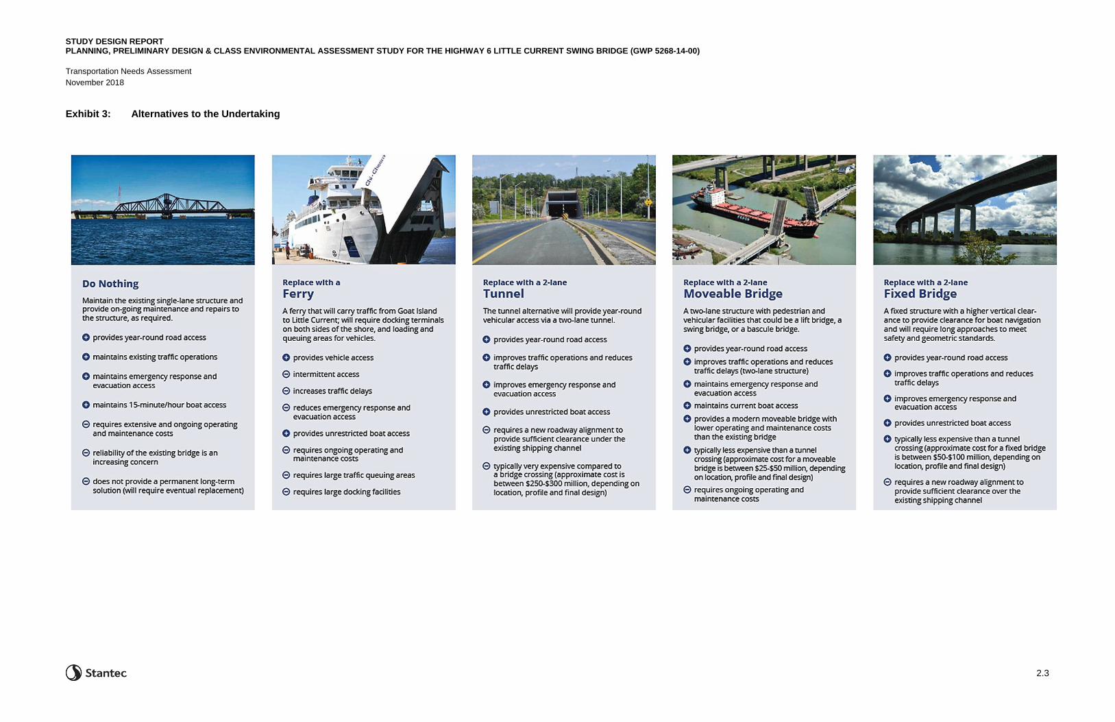
2.2 ALTERNATIVES TO THE UNDERTAKING
The Environmental Assessment Act requires that ‘reasonable alternatives’ be considered in addressing
the identified deficiency. This involves two levels of analysis. The Alternatives to the Undertaking
considers a broad range of alternatives that could address the project needs. All alternatives considered
will accommodate active transportation. Once the best alternative is selected, the Alternative Methods of
Carrying out the Undertaking are studied in greater detail.
An overview of the Alternatives to the Undertaking is provided in Exhibit 3.
STUDY DESIGN REPORT PLANNING, PRELIMINARY DESIGN & CLASS ENVIRONMENTAL ASSESSMENT STUDY FOR THE HIGHWAY 6 LITTLE CURRENT SWING BRIDGE (GWP 5268-14-00)
Transportation Needs Assessment
November 2018
2.3
Exhibit 3: Alternatives to the Undertaking

STUDY DESIGN REPORT PLANNING, PRELIMINARY DESIGN & CLASS ENVIRONMENTAL ASSESSMENT STUDY FOR THE HIGHWAY 6 LITTLE CURRENT SWING BRIDGE (GWP 5268-14-00)
Transportation Needs Assessment
November 2018
2.4
This page intentionally left blank.
STUDY DESIGN REPORT PLANNING, PRELIMINARY DESIGN & CLASS ENVIRONMENTAL ASSESSMENT STUDY FOR THE HIGHWAY 6 LITTLE CURRENT SWING BRIDGE (GWP 5268-14-00)
Transportation Needs Assessment
November 2018
2.5
2.2.1 Assessment of Alternatives to the Undertaking
Following the development of the Alternatives to the Undertaking and public and stakeholder feedback
from Public Information Centre 1 (PIC 1), an assessment will be completed to evaluate the Alternatives to
the Undertaking and select a Preferred Transportation Undertaking that adequately address the problem
and opportunity statements and can be carried forward for further development into the Preliminary
Design Alternatives. The Preferred Transportation Undertaking will be presented at the second PIC.
For this current study, the assessment will be designed to evaluate the Alternatives to the Undertaking
and select only the most reasonable alternatives for more detailed study. This process allows
unreasonable alternatives or alternatives that do not address the problem and opportunity to be
eliminated from consideration in advance of detailed development and evaluation.
The assessment of the conceptual alternatives uses two screening criteria. They are:
• Does the alternative realistically address all of the problem/opportunity statements?
• Does the alternative, when used in combination with other alternatives, make a significant
contribution towards realistically addressing all of the problem/opportunity statements?
• Only those alternatives which satisfy at least one of the above criteria are carried forward.

STUDY DESIGN REPORT PLANNING, PRELIMINARY DESIGN & CLASS ENVIRONMENTAL ASSESSMENT STUDY FOR THE HIGHWAY 6 LITTLE CURRENT SWING BRIDGE (GWP 5268-14-00)
Transportation Needs Assessment
November 2018
2.6
This page intentionally left blank.
STUDY DESIGN REPORT PLANNING, PRELIMINARY DESIGN & CLASS ENVIRONMENTAL ASSESSMENT STUDY FOR THE HIGHWAY 6 LITTLE CURRENT SWING BRIDGE (GWP 5268-14-00)
November 2018
3.1
3.0 CONSULTATION PROCESS
The Consultation Process provides an opportunity for the project team to discuss the study process
and/or any other issues relating to the project with the public, agencies, indigenous communities, and
other interested parties.
The process aims to notify all interested parties of the project and to provide an opportunity for input to
the study and decision-making processes. This is accomplished by presenting the findings of each stage
of work and obtaining input from the public, government agencies and ministries, indigenous
communities, non-government interest groups and property owners.
The consultation plan will include all project notification materials including notification schedules, the
Notice of Study Commencement, Notices of PICs, Notice of Review of the SDR, Notice of TESR Public
Review, and project website content for MTO’s review and approval. Providing a consultation plan at the
beginning of a project allows for ease of review for MTO and consistent messaging throughout the
project.
The Consultation approach for external consultation will include:
• Notices in local newspapers - Manitoulin Expositor, the Sudbury Star, and the Manitoulin West
Recorder
• Communication with external agencies in order to obtain pertinent technical information and identify
the requirement for legislative or regulatory approvals related to the undertaking
• An interactive, accessible project website (www.swingbridgestudy.ca)
• Indigenous engagement plan
• Meetings with municipal staff and Council (Town of Northeastern Manitoulin and the Islands,
Manitoulin Municipal Association)
• Communication with affected property owners where temporary or permanent interest in property is
required
• Communication with local residents, businesses, and local highway users
• Three Public Information Centres
• Attendance at two local community events (e.g. Haweater Festival)
• Three Business Owner Information sessions, one prior to each PIC
• 30-day Review Period for the Study Design Report and all related consultation
• Agency webinars (2) to review the Study Design Report and to confirm environmental mitigation in
advance of the TESR
• 30-day Review Period for the TESR and all related consultation to address comments and bump-up
requests

STUDY DESIGN REPORT PLANNING, PRELIMINARY DESIGN & CLASS ENVIRONMENTAL ASSESSMENT STUDY FOR THE HIGHWAY 6 LITTLE CURRENT SWING BRIDGE (GWP 5268-14-00)
Consultation Process
November 2018
3.2
The goal of the public notification program is to ensure that the public and all stakeholders are kept
informed at key points during the course of the study. These key points are:
• Study Commencement—Newspaper notices, Canada Post unaddressed admail, and direct
correspondence to project mailing list in order to announce the study start-up (July 2018)
• Public Information Centre 1—Present Preliminary Alternatives and Preliminary Evaluation Criteria/
Process (August 22, 2018)
– The first PIC provided an opportunity for the public to review and comment on the Alternatives to
the Undertaking, and identify existing (natural, social, and cultural) conditions in the study area.
• Notice of Study Design Report (SDR) – Newspaper notices, Canada Post unaddressed admail, and
direct correspondence to project mailing list to announce the 30-day SDR Review Period
• Public Information Centre 2 – Present Feasible Route and Crossing Alternatives (scheduled for
Summer 2019)
– The purpose of PIC 2 is to present the screening results of the Alternatives to the Undertaking,
the Feasible Route and Crossing Alternatives, and the proposed evaluation criteria and
evaluation process.
• Public Information Centre 3 – Present Preferred Plan (scheduled for Summer 2020)
– The purpose of PIC 3 is to present the results of the evaluation and the Preferred Plan, including
a proposed implementation schedule, and recommended design and mitigation measures to
minimize potential impacts.
• Notice of Study Completion – Newspaper notices, Canada Post unaddressed admail, and direct
correspondence to project mailing list to announce the 30-day Transportation Environmental Study
Report Public Review Period
To make sure that all interested members of the public are contacted, an extensive notification process
will be followed that will include announcements in newspapers and mailings to members of the public
who express an interest in the study, including a Canada Post admail mailing for the entire Island of
Manitoulin.
The consultation program will continue through subsequent study stages, including detail design and
construction.
3.1 GOVERNMENT MINISTRY/AGENCY LIAISON
Each ministry/agency is contacted at the outset of the study to inform them of the study commencement
and to discuss the project need, justification, goals and objectives.

STUDY DESIGN REPORT PLANNING, PRELIMINARY DESIGN & CLASS ENVIRONMENTAL ASSESSMENT STUDY FOR THE HIGHWAY 6 LITTLE CURRENT SWING BRIDGE (GWP 5268-14-00)
Consultation Process
November 2018
3.3
The contact list includes the following agencies and will be updated as the study progresses:
Provincial
• Infrastructure Ontario
• Ministry of Natural Resources and Forestry,
Sudbury District
• Ministry of the Environment, Conservation and
Parks- Sudbury District
• Ministry of Northern Development and Mines
• Ministry of Tourism, Culture and Sport –
Heritage Program Unit
• Ministry of Tourism, Culture and Sport –
Archaeology Programs Unit
• Ministry of Municipal Affairs and Housing
• Ministry of Indigenous Affairs
Federal
• Fisheries and Oceans Canada
• Environment and Climate Change Canada
• International Joint Commission
• U.S. State Department
• Transport Canada – Ontario Region Office
• Transport Canada – Navigation Protection
Program
• Global Affairs Canada
Municipal
• Town of Northeastern Manitoulin and The
Islands – Clerk, Chief Administrative Officer,
Manager of Public Works, Director of Planning
and Development, Economic Development
Officer
• Town of Gore Bay – CAO/Clerk, Public Works
Foreman
• Municipality of Central Manitoulin – Chief
Administrative Officer/Clerk, Roads
Superintendent
• Township of Assiginack – Clerk, Administrative
Officer, Public Works Superintendent
• Municipality of Billings – Clerk Treasurer,
Public Works Superintendent
• Township of Burpee & Mills – Clerk-Treasurer,
Road Superintendent
• Municipality of Gordon/Barrie Island – Chief
Administrative Officer/Clerk-Treasurer, Roads
Superintendent
• Township of Tehkummah – Reeve
• Manitoulin Municipal Association
Local Elected Representatives
• MPP – Algoma-Manitoulin
• Town of Northeastern Manitoulin and The
Islands – Mayor, Councillors
• Town of Gore Bay– Mayor, Councillors
• Municipality of Central Manitoulin– Mayor,
Councillors (via Clerk)
• Township of Assiginack– Mayor, Councillors
(via Clerk)
• Township of Burpee & Mills– Mayor,
Councillors (via Clerk)
• Municipality of Gordon/Barrie Island– Mayor,
Councillors (via Clerk)
• Township of Tehkummah– Mayor, Councillors
(via Clerk)

STUDY DESIGN REPORT PLANNING, PRELIMINARY DESIGN & CLASS ENVIRONMENTAL ASSESSMENT STUDY FOR THE HIGHWAY 6 LITTLE CURRENT SWING BRIDGE (GWP 5268-14-00)
Consultation Process
November 2018
3.4
Emergency Services
• Ontario Provincial Police - Little Current
• Manitoulin-Sudbury District Services Board
• Northeastern Manitoulin and the Islands Fire
Department
• Township of Assiginack Fire Department
• Township of Burpee & Mills Fire Department
• Municipality of Central Manitoulin Fire
Department
• Gore Bay/Allen Township Fire Department
• Canadian Coast Guard/Fisheries and Oceans
Canada
• UCCM Anishnaabe Police Service
School Boards/ Bus Service
• Rainbow District School Board
• Conseil Scolaire de District du Grand Nord de
l'Ontario
• Le Conseil Scolaire Catholique du Nouvel
Ontario
• Sudbury Catholic District School Board
• Sudbury Student Services Consortium
Other Stakeholders
• Owen Sound Transportation Company
• Ontario Trucking Association
• Ontario Federation of Agriculture
• Manitoulin Snowdusters Club - OFSC
District 12
• LaCloche & Manitoulin Business Assistance
Corporation (CFDC)
• Manitoulin Tourism Association
• Waubetek Business Development Corporation
• North Channel Martine Tourism Council
• Spider Bay Marina/Port of Little Current
• Canadian Pacific Railway
• Little Current Yacht Club
• Manitoulin Island Cycling Advocates (MICA)
Provincial agencies, local municipalities, and other relevant stakeholders play an important role in the
study. The staff of each agency and municipality will be kept informed of all aspects of the project. Where
required, meetings will be held with relevant agencies or municipalities to discuss project specific issues.
Indigenous community consultation is discussed in Section 3.3.
Table 1 provides an overview of the approach to consultation with relevant stakeholders.

STUDY DESIGN REPORT PLANNING, PRELIMINARY DESIGN & CLASS ENVIRONMENTAL ASSESSMENT STUDY FOR THE HIGHWAY 6 LITTLE CURRENT SWING BRIDGE (GWP 5268-14-00)
Consultation Process
November 2018
3.5
Table 1: Stakeholder Consultation Work Plan
Stakeholder Consultation Work Plan
Requirements How Our Team Will Complete These Requirements
Notify Stakeholders, Ministries and Agencies of Start of Study
Municipalities, Interest Groups, Indigenous Communities.
Property Owners Directly affected by the Project
• Contacting relevant ministries, agencies, etc., and confirming proper contact people and current mailing addresses
• Identify any stakeholder groups unique to this project
• Send initial contact letter to ministries/agencies, municipalities and interest groups, provide comment form and location plan
• Contact Indigenous communities in accordance with MTO protocol and Duty to Consult
• Provide responses to all letters, comments and inquiries
• Project Team to initiate discussion with property owners directly affected by the project
Notify Ministry of the Environment, Conservation and Parks
• Confirm current MECP contact(s) and relevant office(s)
• Send initial letter of notification describing project following “Group A” EA process and respond to letters and issues
Contact Municipalities • Confirm current contacts and relevant office(s) for the Town of Northeastern Manitoulin and the Islands (Town of NEMI)
• Send initial letter of notification describing current assignment, seeking input
• Take input into consideration during development of the Preliminary Design Alternatives and selection of the Preferred Plan and involve throughout the project, as necessary
• Provide responses to all letters, comments, and inquiries
• Obtain information on noise by-law exemption, if required
Involve Indigenous Communities, Ministries/Agencies, Municipalities
• Initiate notification through correspondence (as described above) directly from MTO
• Confirm concerns and input and any permits or approvals required either during Detail Design or the construction phase
• Meet with stakeholders as necessary
• Respond to all correspondence, comments and inquiries
Contact MTO District Staff
• Consult at start-up meeting and notify of start of project and take input into consideration
• Record input in study documentation
Document Consultation in TESR
• The TRACER document will ensure that every issue is resolved and included in final study documentation (TESR) to confirm accountability in the EA process
• Send TESR Public Review notification letters and notice to all external agencies, stakeholders, property owners and the public and respond to external agencies/public comments received during the public review period

STUDY DESIGN REPORT PLANNING, PRELIMINARY DESIGN & CLASS ENVIRONMENTAL ASSESSMENT STUDY FOR THE HIGHWAY 6 LITTLE CURRENT SWING BRIDGE (GWP 5268-14-00)
Consultation Process
November 2018
3.6
3.2 PUBLIC CONSULTATION
The public plays a key role in the study. Public input is received at each of the Public Information Centres
as well as continuously during the study. As the project progresses, contact will be made with a number
of groups and organizations who have interest in the study. The range of public organizations with an
interest in the project can include communities and cottage groups, interest groups including snowmobile
clubs, local associations (i.e. for trucking, campgrounds etc.) and tourist associations. As discussed
above, the public will be notified of opportunities for public input through:
• Notices in newspapers – each notice will be placed in papers relevant to the study area
• Direct mailings to the project mailing list and property owners (where possible)
• Canada Post Unaddressed Ad Mailings (to all mailing addresses on Manitoulin Island)
• The project website (www.swingbridgestudy.ca), a Facebook page and a Twitter account
People interested in the project are requested to express their interest to be added to the project mailing
list by contacting a member of the project team.
Additional meetings and discussions will be held with the general public and property owners during the
study, as required.
3.2.1 Public Information Centres
The PICs form part of the overall consultation plan for the project and are designed to involve
stakeholders early and throughout the study to identify concerns and provide opportunities for input.
Three Public Information Centres are planned as part of this project.
The purpose of PIC 1 was to present the objectives of the study, background information, existing
conditions, the Transportation Needs Assessment (‘Alternatives To’) and seek input on the preliminary
crossing types and potential locations. PIC 1 was held on August 22, 2018 at the Manitoulin Hotel and
Conference Centre in Little Current. The PIC was well-attended with approximately 87 attendees and
members of various agencies including the Ministry of Environment, Conservation and Parks, the Town of
NEMI, Town of Gore Bay and the Township of Assiginack.
The purpose of PIC 2 is to present and seek input on the results of the Transportation Needs Assessment
(Assessment of ‘Alternatives to the Undertaking’) bridge and alignment alternatives, and the evaluation
process and criteria.
The purpose of PIC 3 is to present and seek input on the evaluation of alternatives, the Preferred Plan,
proposed mitigation and protection measures and obtain feedback on the Preferred Plan.
The PICs will be organized as a drop-in format. Text panels and displays will be made available for
review, and members of the Project Team will be available at the PICs to answer questions. Reference
materials, including drawings and background reports will be made available at the PICs. Comment

STUDY DESIGN REPORT PLANNING, PRELIMINARY DESIGN & CLASS ENVIRONMENTAL ASSESSMENT STUDY FOR THE HIGHWAY 6 LITTLE CURRENT SWING BRIDGE (GWP 5268-14-00)
Consultation Process
November 2018
3.7
sheets will be provided, and attendees will be encouraged to return them either in the comment sheet box
at the PICs, or by mail, fax, or e-mail.
3.2.2 Community Engagement Events
As part of an enhanced consultation program for this project, the project team will plan to attend two local
community events and present project materials including hand-out material and attend a booth/table at
the events. The purpose of attending these local events is to engage the local communities in a more
informal manner, to engage the summer populations, and to provide an alternative method of
engagement and information-sharing to the communities.
The project team attended the 2018 Haweater Festival in August and shared information on the project
via a booth at the festival and project flyers.
The local events could also include the NEMI Farmer’s Market in Little Current and would be planned for
summertime to engage tourists and cottagers, in addition to year-round residents.
3.2.3 Agency Webinars
Two agency webinars have been planned as part of the consultation program for this project. The main
purpose of the agency webinars is to provide an alternative and additional consultation venue where
agencies can connect to webinar sessions for project updates and to discuss the project with the project
team.
The agency webinars will be interactive and are intended to encourage involvement from the agencies.
The goal of these webinars is to employ the connections and collective experience of the agency
representatives to:
1. Provide project information and updates to agencies
2. Identify permitting and regulatory requirements of agencies
3. Provide opportunities for agencies to ask questions about the project
3.2.4 Municipal Meetings
The project team will provide Council presentations to the Town of NEMI in advance of each PIC for the
project. In addition, the team will also provide presentations to the Manitoulin Municipal Association
throughout the project. The Manitoulin Municipal Association (MMA) is a collective association with
representation from all the municipalities and townships on Manitoulin Island and form a council that
meets regularly to discuss municipal topics of Manitoulin Island. The MMA has representation from the
Town of Gore Bay, Town of Northeastern Manitoulin and the Islands, Township of Assiginack,
Municipality of Billings, Township of Burpee & Mills, Municipality of Central Manitoulin, Municipality of
Gordon/Barrie Island, and the Township of Tehkummah.

STUDY DESIGN REPORT PLANNING, PRELIMINARY DESIGN & CLASS ENVIRONMENTAL ASSESSMENT STUDY FOR THE HIGHWAY 6 LITTLE CURRENT SWING BRIDGE (GWP 5268-14-00)
Consultation Process
November 2018
3.8
The project team provided a presentation of PIC 1 materials to the Town of NEMI Council in advance of
the first PIC (on August 7th, 2018) and answered questions from the Council. The project team also
presented the PIC materials to the Manitoulin Municipal Association on September 19th, 2018. In addition,
the project team will also meet with other local municipalities, as required throughout the project.
3.2.5 Business Owner Meetings
The project team will meet with interested Business Owners during the study. Business owners will be
invited to the Public Information Centres to discuss the study with the project team and to identify
sensitivities and document areas of potential impact, so that mitigation measures and appropriate
commitments can be included in the final design. Business Owner Sessions are planned in advance of
each PIC. These sessions will be held in the same location as the PICs. PIC text panels and displays will
be made available for review and the meetings will be held as informal drop-in sessions.
A Business Owner Meeting was held in advance of the first PIC 1, and 23 businesses attended. During
the meeting, business owners provided input on the study and were given forms to sign if they wanted to
participate in the Business Impact Assessment being completed as part of this study.
Feedback from business owners will be a key part of this assessment and will include interviews and
surveys with local business owners.
3.3 INDIGENOUS ENGAGEMENT
As part of the first stage of the study, contact was initiated with Indigenous communities who may have
an interest in the study. MTO initiated contact with Indigenous communities via letter in April 2018. This
initial letter introduced the study and indicated MTO’s interest in engaging the community and sharing
information in relation to this project. The letters also indicated MTO’s interest in following established
consultation protocols. Stantec reached out to each of the seven communities following their receipt of
these initial letters to discuss the project, existing community consultation protocols, and how each
community would like to be involved in the study.
Indigenous engagement will be coordinated with the Public and Agency Engagement Plan to the extent
possible and with a similar timeline. Engagement will seek to coincide with key milestones such as study
notifications and PICs. Indigenous Consultation will be carried out to ensure that each community has an
opportunity to review project information and share information knowledge with respect to the study area.
Individual letters will be prepared to accompany the Notice of Study Commencement (1), Notice of the
Review of the Study Design Report (1), Notice of PICs (3), and the Notice of TESR Public Review (1),
and will be addressed to appropriate community contacts established through the pre-consultation
activities.
Where possible, Community Information Sharing Sessions (CISSs) will be scheduled in coordination with
the PICs. Notification for CISSs will be coordinated in discussion with the individual communities, based
on their interest in being engaged. Indigenous communities will be engaged through letter notifications
and invitations, email correspondence, telephone conversations, CISSs, Chief and Council meetings,

STUDY DESIGN REPORT PLANNING, PRELIMINARY DESIGN & CLASS ENVIRONMENTAL ASSESSMENT STUDY FOR THE HIGHWAY 6 LITTLE CURRENT SWING BRIDGE (GWP 5268-14-00)
Consultation Process
November 2018
3.9
meetings with Tribal Council, and will be encouraged to participate in project planning throughout the
study. Strategies to encourage community engagement and participation are described herein.
3.3.1 Indigenous Communities and Organizations
Manitoulin Island and the immediate surrounding area is home to seven First Nations and and one
organization, including: Aundeck Omni Kaning, Sheguiandah, M’Chigeeng, Sheshegwaning, Whitefish
River, Zhiibaahaasing and Wiikwemikoong Unceded Territory. With the exception of Wiikwemikoong
Unceded Territory, these First Nations are members of the United Chiefs of Mnidoo Mnising (UCCMM)
Tribal Council. In addition, the Métis Nation of Ontario will also be consulted as part of this project through
study notifications. These Indigenous communities and organizations will be consulted throughout the
duration of the project.
3.3.2 Community Information Sharing Sessions (CISS)
Providing clear information to communities can support efficient identification of potential impacts and
possible avoidance and/or mitigation measures. At this time, it is assumed that one CISS will be held in
each community during each scheduled round of community and/or public meetings. As such, three
rounds of six CISSs are planned for this assignment, as it is assumed that meetings with Zhiibaahaasing
and Sheshegwaning First Nations will be held concurrently, given that these communities are adjoined.
This approach gives community members an opportunity to attend each CISS in person, to share their
ideas, concerns and interests directly with members of the project team.
Each CISS will be planned in coordination with the PIC planning for this project. The format of each CISS
will be confirmed in discussion with each community’s representative. Stantec will encourage each
community’s involvement in CISS planning by asking community representatives to provide guidance on
selecting appropriate venues, participating in the arrangement of the events, and preparing food for each
event.
To-date, CISSs have been held in four Indigenous communities as follows:
• Aundeck-Omni-Kaning on August 23, 2018
• Sheshegwaning First Nation on August 24, 2018
• Wiikwemikoong Unceded First Nation on October 23, 2018
• M’Chigeeng First Nation on October 24, 2018
Community members were notified of their community’s CISS event via posters distributed by one or
more of the following means:
• Inclusion in community newsletter and delivered to residents
• Posting on community’s website and/or social media page
• Posting in community spaces, including Band office and/or community centre

STUDY DESIGN REPORT PLANNING, PRELIMINARY DESIGN & CLASS ENVIRONMENTAL ASSESSMENT STUDY FOR THE HIGHWAY 6 LITTLE CURRENT SWING BRIDGE (GWP 5268-14-00)
Consultation Process
November 2018
3.10
Indigenous communities will continue to be consulted throughout the duration of the study and future
CISSs will be planned. The communities will also be notified regarding PIC events, should they wish to
attend these events in lieu of the CISSs.
3.3.3 Meetings with Community Leadership
Face-to-face meetings with community leaders will help build strong relationships and trust, as well as
provide opportunities to identify and address potential issues and concerns. Meetings are anticipated to
be held in advance of each round of CISSs with the United Chiefs and Councils of Mnidoo Mnising and
the Wiikwemikoong Unceded Territory. To date, meetings with the Wiikwemikoong Unceded Territory
leadership have been held as follows:
• Meeting with Chief, Director of Operations, and Senior Policy Analysis/Communications on
August 8, 2018
• Meeting with Chief and Council on September 10, 2018
Members of the project team will continue to plan and facilitate these meetings to:
• Discuss the project background and future stages in project planning
• Seek guidance on engaging the broader community and future information sharing opportunities
• Review, discuss and consider potential issues and concerns and gather pertinent information
• Review draft CISS materials in advance of presenting to the broader community
As an alternative to face-to-face meetings, other methods of sharing information with these community
leaders may be considered, including:
1. Issue draft CISS materials via email for review and consideration at Chief/Council meetings. Project
team members would not attend these meetings, but rather Chief and Council members would be
asked to review and return comments to the project team.
2. Schedule a webinar during Chief and Council meetings to review and discuss draft CISS materials
with the study team.

STUDY DESIGN REPORT PLANNING, PRELIMINARY DESIGN & CLASS ENVIRONMENTAL ASSESSMENT STUDY FOR THE HIGHWAY 6 LITTLE CURRENT SWING BRIDGE (GWP 5268-14-00)
November 2018
4.1
4.0 STUDY PROCESS
This Little Current Swing Bridge Planning, Preliminary Design, and Environmental Assessment study is
being carried out under the requirements of the Class Environmental Assessment (EA) for Provincial
Transportation Facilities (2000), which has been approved under the Ontario Environmental Assessment
Act for provincial transportation projects of a defined scope and magnitude.
This study falls within the scope of a Group "A" project, which includes major realignments and by-passes
to existing provincial highways and freeways.
Other aspects of the Class EA process and environmental documentation required by the process are
contained in the Class EA document. A copy of the Class EA for Provincial Transportation Facilities is
available on the project website (www.swingbridgestudy.ca) on the ‘About the Study’ page.
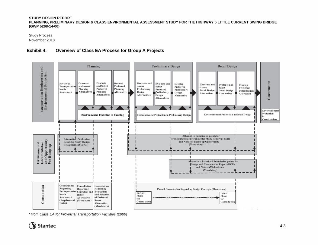
The study process is illustrated in Exhibit 4. This study includes all aspects of the Planning and
Preliminary Design stages of the study process.
4.1 ENVIRONMENTAL ASSESSMENT APPROVAL REGULATIONS
The work on a planning study of this type must be carried out in accordance with the applicable
environmental legislation and the current government policies and procedures. These are described
below.
4.1.1 Ontario Environmental Assessment Act
The Ontario Environmental Assessment Act (EAA, 1990) governs the conduct of planning studies in the
province.
The purpose of the Environmental Assessment Act (EAA) is to protect, conserve and wisely manage
Ontario's environment. It sets out a planning and decision-making process to ensure the environmental
effects of a project are evaluated and documented prior to decisions being made about proceeding to
construction. The EAA promotes responsible environmental decision-making and ensures that interested
persons have an opportunity to comment on projects that may affect them. In the EAA, environment is
broadly defined and includes the natural, social, cultural and economic environment.
The EAA requires an environmental assessment of any major public sector undertaking that has the
potential for significant environmental effects, including public roads, transit, wastewater and stormwater
installations.
4.1.2 Canadian Environmental Assessment Act
The Canadian Environmental Assessment Act, 2012 (CEAA 2012) and its regulations establish the
legislative basis for the federal environmental assessment process. Under CEAA 2012, an environmental
assessment is only required for projects included in the list of “designated projects”. These types of
projects are likely to have significant adverse environmental effects and therefore may be subject to a
federal EA.

STUDY DESIGN REPORT PLANNING, PRELIMINARY DESIGN & CLASS ENVIRONMENTAL ASSESSMENT STUDY FOR THE HIGHWAY 6 LITTLE CURRENT SWING BRIDGE (GWP 5268-14-00)
Study Process
November 2018
4.2
A proponent is not required to complete the federal EA process if a project is not on this list. This project
does not fall under the list of designated projects.
4.1.3 Project Specific Environmental Assessment Process
For additional information, the following documents are available to assist with understanding the process:
• Class Environmental Assessment for Provincial Transportation Facilities, MTO, July 2000
• Environmental Reference for Highway Design, MTO, 2006, updated in June 2013
• Code of Practice for Preparing, Reviewing, and using Class Environmental Assessments in Ontario,
MOE, January 2014
These publications are available from the MTO Research Library Online Catalogue
(library.mto.gov.on.ca) and from Publications Ontario (publications.serviceontario.ca).
STUDY DESIGN REPORT PLANNING, PRELIMINARY DESIGN & CLASS ENVIRONMENTAL ASSESSMENT STUDY FOR THE HIGHWAY 6 LITTLE CURRENT SWING BRIDGE (GWP 5268-14-00)
Study Process
November 2018
4.3
* from Class EA for Provincial Transportation Facilities (2000)
Exhibit 4: Overview of Class EA Process for Group A Projects

STUDY DESIGN REPORT PLANNING, PRELIMINARY DESIGN & CLASS ENVIRONMENTAL ASSESSMENT STUDY FOR THE HIGHWAY 6 LITTLE CURRENT SWING BRIDGE (GWP 5268-14-00)
Study Process
November 2018
4.4
4.1.4 Environmental and Engineering Principles and Protection
This study will follow the environmental and engineering principles outlined in the Class EA document,
including but not limited to:
• Transportation engineering principles – providing for the efficient movements of people and goods;
addressing the identified transportation problems and opportunities; maximizing the opportunity to
satisfy existing and future provincial travel demand; reflecting sound engineering judgement; ensuring
compatibility and consistency with existing and future transportation systems; improving the level of
service, safety and operation for provincial transportation system users; ensuring technical feasibility;
minimizing environmental impacts and the use of non-renewable natural resources; minimizing
property requirements and impacts to adjacent properties; minimizing net energy usage; avoid
directing large volumes of long-distance provincial traffic through settlement areas; maximizing
opportunities to make facilities safer; and providing maximum benefit for the lowest cost.
• Environmental protection principles – avoiding or minimizing environmental impacts through
consideration of alternatives; identifying existing conditions and potential impacts relevant to the
study; meeting the statutory duties of federal and provincial environmental legislation; addressing the
MTO Statement of Environmental Values; balancing environmental protection considerations with
transportation engineering considerations; recognizing that it is seldom possible to satisfy all
interests, and that no factor is always paramount; recognizing that there may be environmental
impacts from environmental mitigation measures; monitoring the implementation of protection and
mitigation measures during construction; and providing mitigation efforts in proportion to
environmental significance and ability to reasonably mitigate.
• Evaluation principles – providing an evaluation process that is traceable, replicable, and
understandable; providing both subjective and objective processes; giving due consideration to all
relevant factors; carrying out a subjective or objective evaluation; establish an evaluation process
through consultation with external stakeholders (for Group A projects); and refining factors from one
stage to the next.
• Consultation principles – notifying relevant stakeholders, property owners, and agencies of the
intention at the beginning of the study; placing an emphasis on consulting with stakeholders most
directly affected; providing timely and user-friendly opportunities for input; using the consultation
process to assist in the identification of data requirements; constructively address input received
during the consultation process; showing how consultation received in earlier stages of a study
affected a project; allowing for variance in the amount, extent and timing of consultation depending on
the complexity of a project, nature of the issues, and identified concerns; selecting appropriate
methods of notification; and making reasonable efforts to resolve concerns.
Environmental Protection requirements for Class EA projects are summarized in the Environmental
Protection Requirements for Transportation Planning and Highway Design, Construction, Operation and
Maintenance (2014). This document contains a compilation of environmental protection requirements to
clarify the requirements of environmental statues, regulations, and government policies that apply to
transportation projects.

STUDY DESIGN REPORT PLANNING, PRELIMINARY DESIGN & CLASS ENVIRONMENTAL ASSESSMENT STUDY FOR THE HIGHWAY 6 LITTLE CURRENT SWING BRIDGE (GWP 5268-14-00)
Study Process
November 2018
4.5
4.1.5 Other Approval Requirements
Undertaking an Environmental Assessment also requires consideration of other approvals and review
agencies. They include:
Federal Review Agencies
• Department of Fisheries and Oceans (DFO) – MTO/DFO/OMNR Fisheries Protocol, Fisheries Act
(FA)
• Transport Canada – Navigation Protection Act (NPA)
• Environment and Climate Change Canada (ECCC) – Species at Risk Act (SARA), Migratory Birds
Convention Act (MBCA)
• International Joint Commission- Boundary Waters Treaty Act
Provincial Review/Policy Requirements
• Provincial Policy Statement (2014)
• Ministry of the Environment, Conservation and Parks– Environmental Assessment Act, Environmental
Protection Act, Ontario Water Resources Act, Permits to Take Water, and Ontario Noise Protocol
• Ontario Access and Privacy Office – Freedom of Information and Protection of Privacy Act and
Accessibility for Ontarians with Disabilities Act
• Ministry of Natural Resources and Forestry – MTO/DFO/OMNRF Fisheries Protocol, Ontario
Wetlands Policy, Endangered Species Act (ESA)
• Ministry of Tourism, Culture, and Sport – Ontario Archaeological Protocol, Ontario Heritage Act
Municipal Policy and Plans*
• Development control, Official and Secondary Plans
• Noise Bylaws
• Zoning Bylaws
• Transportation planning policy
*MTO is not required to obtain approvals or exemptions for Municipal Official Plans, zoning exemptions, or policy.
However, municipal policies and plans are considered during the study, including during the evaluation of
alternatives.
4.1.6 Acceptance of Study Process and Recommendations
Throughout the study input will be solicited from the public through meetings, webinars, telephone
conversations, the project website, and three Public Information Centres (PICs). Interested agencies and
stakeholders will be contacted throughout the project and will be informed of project progress at key
milestones and in advance of the Public Information Centres. External agencies and stakeholders to be
contacted include local municipal staff and council, government bodies (i.e., Ministry of the Environment,

STUDY DESIGN REPORT PLANNING, PRELIMINARY DESIGN & CLASS ENVIRONMENTAL ASSESSMENT STUDY FOR THE HIGHWAY 6 LITTLE CURRENT SWING BRIDGE (GWP 5268-14-00)
Study Process
November 2018
4.6
Conservation and Parks (MECP), Ministry of Natural Resources and Forestry (MNRF), Transport
Canada). Local and relevant stakeholders have been identified and notified as part of the notice of Study
Commencement and as part of Public Information Centre 1.
The project team will conduct the study in a manner that addresses and resolves specific issues and
concerns as they arise. At the end of the study, the project team expects to reach a consensus with the
public and stakeholders regarding the study recommendations. The issues raised by the government
ministries and agencies should be resolved with each group.
During the study, the decision-making process will be clearly documented to provide a traceable process
and one that is easily understood by the public, agencies, and stakeholders involved in the study.
4.2 PROPOSED EVALUATION PROCESS
In accordance with the Class EA and the Environmental Assessment Act, the evaluation process will
consider a range of engineering and environmental (natural, social, economic and cultural) factors in the
study area. This section of the report provides an overview of the proposed evaluation process to identify
a Recommended Plan that addresses current and future transportation needs at the crossing.
The assessment of potential effects will include consideration of:
• Potential impacts
• Opportunity to mitigate the impact
• Net environmental impacts following incorporation of mitigation measures
• An evaluation of the advantages and disadvantages associated with each alternative
Each stage of the evaluation process will be based on the results of the previous stage and assesses the
alternatives in greater detail. It is important that the evaluation criteria capture the key issues related to
the decision-making process.
The evaluation process will be developed to provide an objective approach to the analysis and evaluation
of each alternative that will form a justifiable tool for the selection of a Preferred Plan.
The goal of the evaluation process is to identify a Recommended Plan for a crossing that is cost-effective,
provides safe operations and reasonable local access, while minimizing effects on the environment.
The evaluation process is based on the following Class EA guiding principles:
• The evaluation process must be traceable, replicable, and must be understandable by those who may
be affected by the decisions
• All relevant factors, including transportation engineering and environmental protection, will be given
due consideration
• The evaluation may be subjective (based on reasoned argument) or objective (using quantifiable
data)

STUDY DESIGN REPORT PLANNING, PRELIMINARY DESIGN & CLASS ENVIRONMENTAL ASSESSMENT STUDY FOR THE HIGHWAY 6 LITTLE CURRENT SWING BRIDGE (GWP 5268-14-00)
Study Process
November 2018
4.7
• The proposed evaluation process in planning will be established through consultation with external
stakeholders
• Evaluation factors may be refined from one stage of a project to the next
The evaluation process will increase in detail as the study progresses. During the study, several potential
crossing corridors and crossing type alternatives will be identified initially; of which some will be screened
out because they do not satisfy either the engineering or environmental goals of the evaluation process.
Any alternatives that are screened out will be documented, and the reasons for not considering the
alternative further will be included in the final Transportation Environmental Study Report.
4.2.1 Evaluation Criteria
The evaluation process is based on identified evaluation factors relevant to the study. Evaluation criteria
will be developed that address the key environmental and engineering issues related to the decision-
making process of selecting a Preferred Plan.
The evaluation criteria are independent variables, each of which may contribute a positive or negative
influence on the overall suitability of a given alternative. Although it is important to explicitly consider
suitability in terms of each criterion, it is useful to establish an overall composite technical measure. This
is accomplished by determining appropriate weighting (relative importance) among the criteria. Each
evaluation criterion is assigned a weight that represents its relative importance to the other criteria.
Preliminary criteria will be identified based on the existing conditions in the study area; and will be refined
through public and stakeholder input and based on information from project specific environmental and
engineering studies.
In order to identify the effects on various evaluation criteria, indicators will be developed for each factor.
Indicators are ways of identifying, describing, and measuring impacts, cost and performance for each
factor. During the study the indicator for a factor may change based on the level of detail of information
that is available and relevance to the part of the study area being considered.
4.3 PROPOSED STUDY PROCESS
The Class EA process is a comprehensive planning process that involves identifying and evaluating
project alternatives, identifying associated environmental impacts and developing a plan for a solution
that minimizes impacts, while addressing the identified transportation problem.
This study includes three distinct but inter-related steps that will coincide with opportunities for public,
stakeholder, and external agency input as discussed in the following sections and illustrated in Exhibit 5.

STUDY DESIGN REPORT PLANNING, PRELIMINARY DESIGN & CLASS ENVIRONMENTAL ASSESSMENT STUDY FOR THE HIGHWAY 6 LITTLE CURRENT SWING BRIDGE (GWP 5268-14-00)
Study Process
November 2018
4.8
Exhibit 5: Project Specific Class EA Process

STUDY DESIGN REPORT PLANNING, PRELIMINARY DESIGN & CLASS ENVIRONMENTAL ASSESSMENT STUDY FOR THE HIGHWAY 6 LITTLE CURRENT SWING BRIDGE (GWP 5268-14-00)
Study Process
November 2018
4.9
4.3.1 Transportation Needs Assessment
The submission of this report marks the end of the project initiation stage. This stage of the study has
included providing notice of the Study Commencement to the public, local municipalities, stakeholders,
property owners, and external agencies; reviewing input received; initiating a review of background
information available for the study area; reviewing and documenting the existing conditions; identifying
and documenting deficiencies, operational problems, and safety issues; and developing Alternatives to
the Undertaking. This stage also included presenting and receiving input on the above-mentioned
materials to the public, agencies and stakeholders at the first Public Information Centre (PIC) on
August 22, 2018. This stage also includes the preparation of this Study Design Report to provide a basis
for carrying out the remainder of the study.
4.3.2 Planning Stage
During this stage, the project team will focus on identifying existing natural, social, cultural and
transportation conditions in the study area, and developing a range of Preliminary Design Alternatives
including alignment and crossing type alternatives.
Preliminary Design Alternatives will be generated based on the Principles for Generating Alternatives in
the Class EA for Provincial Transportation Facilities (2000) including:
• Avoid forest and wetland areas
• Avoid river and valley crossings at sensitive areas
• Avoid urban and commercial areas
• Avoid developed properties
• Avoid areas of prime agricultural land and high capital investment
• Avoid areas of multiple property disturbances
In accordance with the requirements of the Species at Risk Act, impacts to Species-at-Risk and their
habitat will also be avoided during the development of Preliminary Design Alternatives.
The Preliminary Design Alternatives, existing environmental and engineering conditions, and preliminary
evaluation criteria will be presented to the public, stakeholders, and external agencies at the second
Public Information Centre (PIC) and External Agency Meetings.
Following the second PIC, corridors and bridge structure alternatives may be modified based on
engineering or environmental requirements or information obtained during the second round of public and
agency meetings.
4.3.2.1 Heritage and the Existing Bridge
MTO’s Heritage Bridge Committee has deemed the existing structure a heritage property worthy of
inclusion on the Ontario Heritage Bridge list. The bridge was listed on the Ontario Heritage Bridge list

STUDY DESIGN REPORT PLANNING, PRELIMINARY DESIGN & CLASS ENVIRONMENTAL ASSESSMENT STUDY FOR THE HIGHWAY 6 LITTLE CURRENT SWING BRIDGE (GWP 5268-14-00)
Study Process
November 2018
4.10
shortly after the list was created (prior to the development of the heritage bridge list evaluation criteria) .
As part of this study, the heritage team will apply the Ontario Historic Bridge Guidelines protocol criteria
for conservation/mitigation options when developing preliminary design alternatives and considering the
overall goals and objectives for this roadway within the province’s highway improvement program.
As part of the study, the project team will follow the Guidelines and will complete a Cultural Heritage
Evaluation Report in order to determine cultural heritage value of the existing structure and further
recommendations. The project team will apply conservation options to determine the various structural
solutions required to address the structural deficiencies. These solutions often include both rehabilitation
and replacement options with the best technical solutions taken forward. The Guideline conservation
options will be assessed prior to the evaluation of design alternatives.
If rehabilitation (including sympathetic modifications to existing structure) as a conservation option is
deemed not feasible then further conservation options such as replacement with sympathetic design will
be considered. Sympathetic design options for the future crossing will be identified in conjunction with the
Project Team, MTO Bridge Heritage Committee, and through the Ontario Heritage Bridge Guideline
Conservation Assessment process. These potential sympathetic design features will be vetted through
MTO, local stakeholders, and Indigenous communities. The Project team will also investigate options for
retaining the existing bridge structure on-site, or the historic interpretation and the adaptation of portions
or all of the existing structure’s signature elements for possible reuse in the surrounding landscape.
4.3.2.2 Evaluation of Preliminary Design Alternatives
Following the evaluation of the Alternatives to the Undertaking (see Section 2.0), a set of Preliminary
Design Alternatives (crossing corridors and crossing type alternatives) will be developed based on the
selected Alternative(s) to the Undertaking, and will be evaluated. A set of evaluation criteria will be
developed and will be presented at the second PIC for public input.
4.3.2.3 Detailed Evaluation of Alternatives
Alternatives will be evaluated based on a reasoned argument evaluation which considers qualitative
advantages and disadvantages of an alternative and also via a Comparative Analysis Prioritization
Method.
The reasoned argument method involves comparing alternatives based on whether or not they meet the
goals of the study process (i.e. meeting local and provincial access needs and avoiding significant
environmental features).
The Comparative Analysis Prioritization Method alternatives involves scoring alternatives from 1 to 10
where 1 is the lowest score and 10 is the best score based on how well each alternative is judged to
satisfy the evaluation criteria.
The individual scores are multiplied by the weight (relative importance) for each evaluation criterion to
produce a weighted score for each evaluation criterion and each alternative. The sum of the weighted
scores provides a total score or rating for each alternative. The results of the evaluation process are used

STUDY DESIGN REPORT PLANNING, PRELIMINARY DESIGN & CLASS ENVIRONMENTAL ASSESSMENT STUDY FOR THE HIGHWAY 6 LITTLE CURRENT SWING BRIDGE (GWP 5268-14-00)
Study Process
November 2018
4.11
to rank the alternatives. A graphic providing an overview of the evaluation process is provided in
Exhibit 6.
4.3.2.4 Select Preferred Plan
Following the second PIC, the project team will
complete a detailed evaluation of the Preliminary
Design Alternatives based on input received at and
following the second PIC, and engineering and
environmental field investigations, to confirm the
Preferred Plan.
The concluding step in the analysis and evaluation
process is the selection of a Preferred Plan.
This process will include:
• Reviewing the results of the analysis and
evaluation based on specialist work and input
received during the study
• Determining which criteria have the most
influence on the outcome of the evaluation
process
• Considering the sensitivity of the weightings (i.e.
testing other weightings to determine if the
results change substantially)
• Confirming the ranking of the alternatives
• Considering public/stakeholder response to the
evaluation process
The Preferred Plan will be selected based on the
results of the evaluation and comments from the
second PIC, and will be presented to the public,
stakeholder and external agencies at a third Public
Information Centre.
4.3.3 Preliminary Design and Documentation
This stage involves the confirmation of the preliminary design for the Preferred Route with more detailed
environmental investigations undertaken to refine the design. Specific recommendations are set out
based on discussions with property owners and relevant agencies to minimize the environmental impacts
during the construction and operation of the facility.
Exhibit 6: Evaluation Process

STUDY DESIGN REPORT PLANNING, PRELIMINARY DESIGN & CLASS ENVIRONMENTAL ASSESSMENT STUDY FOR THE HIGHWAY 6 LITTLE CURRENT SWING BRIDGE (GWP 5268-14-00)
Study Process
November 2018
4.12
The study will be documented in a Transportation Environmental Study Report (TESR) that outlines the
route planning and preliminary design process. The TESR will be made available for a 30-day public
review period.
4.3.4 Next Steps - EA Clearance
If there are no significant concerns following the 30-day Public Review Period, Environmental Clearance
for property acquisition and designation of the future highway will be provided for the study in accordance
with the Class EA. At that time, the MTO will be in a position to designate (protect) the new right-of-way
for the eventual implementation of the Recommended Plan.
Environmental Clearance – Right-of-Way Designation, Utility Relocation, and Property Expropriation
obtained at the conclusion of the planning and preliminary design stage of the study will permit the
Ministry to:
• Designate the facility under the Public Transportation and Highway Improvement Act (1990)
• Acquire property consistent with the project needs or initiate proceedings under the Expropriations
Act (1990) (note: the Ministry has indicated that initially property will be acquired on a willing
seller/willing buyer basis or under circumstances where the future highway designation on a property
prevents the current owner from using the property)
• Initiate subsequent study stages (i.e. Detail Design and contract preparation) when warranted
The TESR submitted at the end of this study will include commitments for future consultation with
agencies, relevant stakeholders, property owners, and the public during Detail Design and construction.
Environmental Clearance – Construction Start is provided at the completion of the Detail Design stage to
permit the Ministry to begin to physically alter ground, water, or vegetation.
As noted in other sections of this report, construction is not currently scheduled for this project. If there
are no significant concerns following the Public Review Period, or once the Minister of the Environment,
Conservation and Parks has reviewed any submitted Part II Order Requests and provided permission to
move forward, the project will be eligible for Environmental Clearance. This will permit The MTO to:
• Negotiate temporary and permanent property acquisition, consistent with the project needs (including
ROW designation)
• Relocate utilities
• Initiate subsequent study stages (i.e., Detail Design and contract preparation) for the Recommended
Plan
Although the timeline for implementing the results of this study are not confirmed, this planning will assist
the Ministry, municipalities, business owners, and private land owners with future planning and
development within the study area. The implementation of the identified improvements is dependent on
regional and provincial priorities and available funding.

STUDY DESIGN REPORT PLANNING, PRELIMINARY DESIGN & CLASS ENVIRONMENTAL ASSESSMENT STUDY FOR THE HIGHWAY 6 LITTLE CURRENT SWING BRIDGE (GWP 5268-14-00)
November 2018
5.1
5.0 ENVIRONMENTAL AND ENGINEERING STUDIES
Existing environmental and engineering conditions in the Little Current Swing Bridge study area have
been documented in the Environmental Study Report Highway 6 Realignment from the Little Current
Swing Bridge northerly 3.8 km and the New Goat Island Channel Bridge (1997), the Environmental
Screening Report Highway 6, Little Current Swing Bridge (1999), the Transportation Environmental Study
Report for Little Current Swing Bridge, Highway 6 (2009), and the Design and Construction Report for
Little Current Swing Bridge, Highway 6 (2009). The studies provided inventories of the natural
environment from reviews of previous studies, field inventories, and information provided from external
agencies and the public.
Although information in the aforementioned reports will be considered, it cannot be assumed that the
natural, social, cultural, or economic conditions in the study area have remained the same since that time.
The strategy for identifying environmental impacts will begin with confirming the significant elements of
the transportation network, and natural, social, economic, and cultural environments in the study area.
Information on the existing natural, social, and economic environments will be obtained from published
sources, through site investigations and contact with the public and external agencies.
MTO has developed guidance documents to make sure that MTO projects are in compliance with federal
and provincial environmental legislation and government policy. The Ministry’s Environmental Standards
and Practices documents provide for a consistent and systematic approach to environmental
management.
Environmental work for this study will be carried out in accordance with the requirements of the MTO
Environmental Protection Requirements for Transportation and Highway Design, Construction, Operation
and Maintenance (2014) and the Environmental Reference for Highway Design (ERD, 2013), and the
requirements in the Class EA for Provincial Transportation Facilities (2000). These documents are
available for review on MTO’s website: http://www.mto.gov.on.ca/english/highway-bridges/environmental-
standards-practices.shtml. A link to the Class EA document is available on the project website:
(www.swingbridgestudy.ca).

STUDY DESIGN REPORT PLANNING, PRELIMINARY DESIGN & CLASS ENVIRONMENTAL ASSESSMENT STUDY FOR THE HIGHWAY 6 LITTLE CURRENT SWING BRIDGE (GWP 5268-14-00)
Environmental and Engineering Studies
November 2018
5.2
Table 2: Factor-Specific Environmental Elements
Natural Environment Socio-Economic Environment
Cultural Environment Engineering Environment
• Fish and Fish Habitat
• Wildlife
• Vegetation
• Wetlands
• Groundwater
• Surface Water
• Soil
• Species-at-Risk
• Aesthetics
• Highway and Construction Noise
• Community/ Recreation
• Air Quality and Greenhouse Gases
• Private Property
• Land Use
• Agriculture
• Commercial/Industrial
• Tourism
• Property Waste and Contamination
• Businesses
• Utilities
• Archaeology
• Built Heritage Resources
• Cultural Heritage Landscapes
• Stormwater Management
• Erosion and Sediment Control
• Management of Excess Materials
• Aggregates and Mines
• Landscape Architecture
• Highway Geometrics and Design
• Bridge Engineering
• Foundation and Geotechnical Engineering
• Traffic Safety
5.1 APPROACH TO SPECIALIST WORK
The level of detail of environmental and engineering work for the study will change depending on the
study phase, to identify and deal with environmental conditions and constraints at an appropriate level of
detail.
During the initial stages of the study, the scope of work will focus on identifying significant constraints to
aid in confirming a range of crossing alternatives and confirming which alternatives can be considered for
further evaluation. Environmental work will then focus on field investigations for feasible alignment
alternatives, and specific features will be focused on to determine if they affect the viability of an
alternative. An assessment of potential impacts will be undertaken for the preferred plan, and possible
mitigation or avoidance measures will be developed and confirmed with agencies and stakeholders.
Mitigation for environmental impacts will be identified and addressed at a preliminary design level of
detail. Environmental impacts and proposed mitigation measures will be documented for public review in
a Transportation Environmental Study Report at the end of the study. The TESR will also include a
summary of commitments to future work to be carried out during detail design. This is appropriate as
some types of impacts cannot be confirmed at a preliminary design level of detail. Final approvals
required from external agencies (e.g. Transport Canada, Department of Fisheries and Oceans) will be
listed in the report.
The following sections describe the scope and work plans for confirming and identifying environmental
conditions and constraints in the study area for the factor-specific areas: natural sciences (including
vegetation, terrestrial ecosystems, wetlands, Species-at-Risk, and fish and fish habitat), groundwater,
noise, land use and socio-economics, business impacts, contamination, archaeology, built heritage and

STUDY DESIGN REPORT PLANNING, PRELIMINARY DESIGN & CLASS ENVIRONMENTAL ASSESSMENT STUDY FOR THE HIGHWAY 6 LITTLE CURRENT SWING BRIDGE (GWP 5268-14-00)
Environmental and Engineering Studies
November 2018
5.3
cultural heritage landscapes, air quality and greenhouse gases, erosion and sediment control, and
landscape architecture.
The development and evaluation of alternatives will focus on avoiding impacts to significant features in
the study area including, but not limited to:
Natural Environment
• Areas of Species-at-Risk habitat
• Significant wildlife habitat
• Sourcewater Protection Areas / Water Intake Protection Zones
Socio-Economic Environment
• The community of Little Current and Town of Northeastern Manitoulin and the Islands, and all other
communities on the island
• Mineral and Aggregate Reserves
• Recreation features, including trails, parks, waterways, docks, and golf courses
• Residential areas
• Commercial development
• Businesses
• Municipal facilities, cemeteries, etc.
• Utilities, including hydro and watermains
• Railways
• Contaminated property
Cultural Environment
• Registered Archaeological Sites
• Built Heritage Features, including the Little Current Swing Bridge
• Aboriginal Traditional Knowledge
The locations and boundaries of the above significant features will be confirmed with relevant agencies as
part of the background data collection process.
5.1.2 Fish and Fish Habitat
The Little Current Swing Bridge crosses the North Channel, a well-known coldwater fishery with fish
habitat. The channel is narrow and flows between Goat Island and the northeast end of Manitoulin Island.
Lake Sturgeon, an aquatic species-at-risk may be present in the study area.

STUDY DESIGN REPORT PLANNING, PRELIMINARY DESIGN & CLASS ENVIRONMENTAL ASSESSMENT STUDY FOR THE HIGHWAY 6 LITTLE CURRENT SWING BRIDGE (GWP 5268-14-00)
Environmental and Engineering Studies
November 2018
5.4
The preliminary development and evaluation of Crossing and Alignment alternatives will focus on
minimizing potential fish and aquatic impacts, including implications for species-at-risk.
Fish and fish habitat work for this study will be carried out in accordance with the requirements of the
Environmental Guide for Fish and Fish Habitat, following the MTO/DFO/OMNRF Fisheries
Protocol (2016).
Secondary source fish community and habitat information will be collected and reviewed, starting with
data and/or documents available from MNRF, DFO, and NHIC. An extensive background data search will
be conducted to include any available fish community and aquatic habitat data available for the North
Channel.
Information to be reviewed for the purposes of this study will include agency data and documentation,
aerial photography, and correspondence with individuals knowledgeable with the natural resources in the
study area. This background information includes but is not limited to:
• MNRF databases • Fisheries Management Plans
• Endangered Species Act • Species-at-Risk in Ontario Checklist and
Distribution Maps
Fisheries investigations will be carried out in the appropriate seasons (between April and September of
2019).
The field surveys will document fish habitat in the Study Area, and will identify sensitive habitats and
locations where site-specific mitigation may be required. The field data collection will concentrate on the
identification of any sensitive fish species (including species protected under the provincial Endangered
Species Act and the federal Species-at-Risk Act) and habitat areas (such as spawning, nursery and
feeding areas). Potential migration routes and any barriers to fish migration will also be noted.
Physical habitat in the study area will be documented, and preliminary constraints with respect to in-water
work for the Preferred Plan will be identified. Sensitive habitats will be identified to determine preliminary
impacts, and the need for any additional surveys or permitting requirements will be determined.
Fish and Fish Habitat work will be documented in a Fish and Fish Habitat Existing Conditions Report that
will include the results of the secondary source review within the study area. A Fish and Fish Habitat
Impact Assessment Report will also be completed to document the aquatic impact assessment completed
following the selection of a Preferred Plan.

STUDY DESIGN REPORT PLANNING, PRELIMINARY DESIGN & CLASS ENVIRONMENTAL ASSESSMENT STUDY FOR THE HIGHWAY 6 LITTLE CURRENT SWING BRIDGE (GWP 5268-14-00)
Environmental and Engineering Studies
November 2018
5.5
5.1.3 Terrestrial Ecosystems
Manitoulin Island is home to many provincially rare plants due to the unique habitats that are present,
including prairies and alvars. The overall approach for terrestrial (i.e. terrestrial resources, vegetation,
wetlands) work for the study will include:
• Reviewing relevant background documents
• Obtaining existing information from and coordinating with the Ministry of Natural Resources and
Forestry, and the Town of Northeastern Manitoulin and the Islands
• Undertake field investigations to confirm types of wildlife and habitat that are present (including
species-at-risk), and a Migratory Bird nest survey
• Provide terrestrial input to development and evaluation of Crossing and Alignment alternatives based
on existing data and information, and assess potential impacts and mitigation
• Provide impact assessment for the design alternatives and preliminary mitigation recommendations
for the preferred plan
• Field staff will identify and describe any areas that have the potential to support species-at-risk birds,
turtles and bats. Specific timing of any additional field surveys will be determined through
correspondence with the MNRF species-at-risk biologist
• Prepare and submit an Information Gathering Form if species-at-risk are identified by the MNRF or
during field data collection to determine authorization requirements under the Endangered Species
Act
The initial assessment of terrestrial resources will be based on the identification of significant wildlife
areas based on a review of available information obtained from a variety of secondary sources. Field
investigations will be conducted in the summer of 2019. The following sections describe the methods that
will be utilized for the background review, field investigations, and constraint analysis.
Background information will include agency data and documentation, aerial photography, and
correspondence with individuals knowledgeable with the natural resources in the study area. Sources will
include:
• Endangered Species Act • Atlas of the Mammals of Ontario
• Species-at-Risk in Ontario Checklist and
distribution mapping
• Ontario Breeding Bird Atlas
• Checklist of Vascular Plants • Ontario Herpetofaunal Atlas
• The MNRF Natural Heritage Information Centre
(NHIC) database to confirm the presence or
absence of rare floral or faunal species
• Fisheries Management Plans

STUDY DESIGN REPORT PLANNING, PRELIMINARY DESIGN & CLASS ENVIRONMENTAL ASSESSMENT STUDY FOR THE HIGHWAY 6 LITTLE CURRENT SWING BRIDGE (GWP 5268-14-00)
Environmental and Engineering Studies
November 2018
5.6
Terrestrial vegetation units in the study area will be characterized according to the MNRF’s Ecological
Land Classification (ELC) system. Terrestrial ecology field studies will identify impacts to vegetation, loss
of habitat function for local vegetation and wildlife, and conflicts with existing management practices. The
terrestrial ecology inventory will also identify any vegetation or wildlife species that may be protected
under the provincial Endangered Species Act and the federal Species-at-Risk Act.
Two botanical inventories will be undertaken (June and September 2019) along the proposed alignments
to provide thorough coverage of the Study Area, and to increase the likelihood of detecting rare plant
species. Breeding bird surveys, wildlife habitat assessments and species-at-risk habitat assessments will
be conducted concurrently with the botanical surveys. Field staff will identify and describe any areas that
have the potential to support species-at-risk birds, turtles, and bats.
5.1.3.1 Wildlife
Wildlife habitat assessments will be conducted in conjunction with the botanical inventories, breeding bird
surveys, and species-at-risk habitat assessments along the proposed alignments. All evidence of wildlife
(birds, mammals, herpetofauna) will be recorded and associated with specific vegetation areas (ELC
units). Species detection will be primarily visual or auditory, and incidental in nature. Special attention will
be given to recognizing habitat conditions which may be suitable for supporting significant faunal species.
5.1.3.2 Significant Wildlife Habitat
In addition to documenting wildlife species occurrences, field inventories will also document significant
wildlife habitat. Significant wildlife habitat is defined, by the MNR’s Significant Wildlife Habitat Technical
Guide (2000), as habitat that is “ecologically important in terms of features, functions, representation or
amount and contributing to the quality and diversity of an identifiable geographic area or Natural Heritage
System” and is protected under the Provincial Policy Statement (2014).
For the purposes of this study, significant wildlife habitat includes habitats that fall within any of the
following four categories:
• Seasonal concentration areas
• Rare vegetation communities and specialized habitats for wildlife
• Habitats for species of conservation concern, excluding the habitats of endangered and threatened
species
• Animal movement corridors
Significant wildlife habitat will be evaluated using information gathered from field surveys as well as
secondary data available from the MNRF and other sources.
The identification of terrestrial and wildlife resource constraints in the study area is intended to assist in
the analysis and evaluation of alternatives and the selection of a Preferred Plan. The information will also
be used in the development of appropriate mitigation measures for minimizing impacts to regulated areas,
habitats for significant vegetation, wildlife, sensitive vegetation communities, etc.

STUDY DESIGN REPORT PLANNING, PRELIMINARY DESIGN & CLASS ENVIRONMENTAL ASSESSMENT STUDY FOR THE HIGHWAY 6 LITTLE CURRENT SWING BRIDGE (GWP 5268-14-00)
Environmental and Engineering Studies
November 2018
5.7
5.1.3.3 Migratory Birds
The Little Current Swing Bridge will be checked for the presence of nesting migratory or protected birds,
in accordance with the Migratory Birds Convention Act (1994). Where the nests of migratory or protected
birds are identified, mitigative measures will be recommended to avoid interaction with migratory birds
during construction.
Terrestrial work will be documented in a Terrestrial Ecosystems Existing Conditions Report that will
include the results of the secondary source review within the study area. A Terrestrial Ecosystems Impact
Assessment Report will be submitted when a Preferred Plan has been identified.
5.1.4 Groundwater
The groundwater component of this study will meet the requirements of the Provincial Policy
Statement (2014) and Section 3.3 of the Environmental Reference for Highway Design (2013). The study
will identify local groundwater recharge and discharge areas, sensitive ecosystems that may be affected
by changes to groundwater levels, and potentially impacted private supply wells. The objective of the
study will be to identify groundwater resources within the study area and to determine potential
implications of alternative construction methods for the alternatives for consideration during the evaluation
of alternatives and to identify future work requirements.
The Groundwater Overview includes a broad level background review of secondary source data available
for the study area, including: regional groundwater studies and mapping, Ministry of the Environment,
Conservation and Parks water well records, source water protection reports, and historical project reports.
The background review and potential mitigation measures will be documented in a Groundwater
Technical Report and will identify:
• Groundwater recharge and discharge areas
• Geological and hydrogeological conditions
• Sensitive ecosystems that may be affected by changes to groundwater levels
• Aquifer sensitivity
• Large volume and private wells (in the vicinity of the Preferred Alignment)
• Groundwater source and municipal wellhead protection areas
• Groundwater dependant commercial enterprises
In addition, an evaluation of the need for an Environmental Activity and Sector Registry or Permit to Take
Water to allow for groundwater takings, and the need and extent of a private well monitoring program
during construction will be undertaken. This will be documented in the final TESR.

STUDY DESIGN REPORT PLANNING, PRELIMINARY DESIGN & CLASS ENVIRONMENTAL ASSESSMENT STUDY FOR THE HIGHWAY 6 LITTLE CURRENT SWING BRIDGE (GWP 5268-14-00)
Environmental and Engineering Studies
November 2018
5.8
5.1.5 Noise
A noise assessment study that will be carried out in accordance with the MTO Environmental Guide for
Noise (2006) and Environmental Reference for Highway Design (2013). The Noise Assessment Study will
outline the difference in potential noise impacts for the crossing corridor and crossing type design
alternatives following the Transportation Needs Assessment.
The study will identify Noise Sensitive Areas (NSAs) within the study area using current air
photo/mapping and a field review. Data will be reviewed once feasible crossing and alignments are
confirmed, including topography, existing receptors, existing level of noise, zoning, traffic data, and
10-year traffic projections (with and without the project).
The assessment will establish the potential acoustical effect at the receptors through a modelling
approach approved by MTO, and it will establish the future build and no-build conditions to determine the
changes in impact. The modelling will then be expanded to determine the effect of the preferred design
alternative. Modelling methodology provided in ORNAMENT and STAMSON will be utilized for the
assessment.
If the acoustic impact exceeds the permissible limit at the receptors, potential noise mitigation measures
will be reviewed, and the technical, economic, and administrative feasibility will be considered and
documented.
The Noise Study will be documented in two stages. The initial assessment of Alignment alternatives will
be documented in a Technical Memorandum, documenting the methodology and results of the initial
work.
A final Noise Assessment Report will be completed when the Preferred Plan has been confirmed to
summarize the entire Noise Assessment Study, including methodology, assumptions, comparison of
predicted values to applicable noise criteria, results, and conclusions.
5.1.6 Land Use
A land use assessment using secondary source information, a field investigation, input from various
agencies, and the public will be used to determine the significance of the following land uses:
• Residential (urban and rural), commercial, and industrial
• Community facilities and infrastructure
• Recreational and Tourist attractions and opportunities
• Recreation facilities, including snowmobile trails and navigable waterways
• Natural features and systems
• Land use resources, including agriculture, aggregates, mineral resources, and windfarms
• Emergency Service Providers

STUDY DESIGN REPORT PLANNING, PRELIMINARY DESIGN & CLASS ENVIRONMENTAL ASSESSMENT STUDY FOR THE HIGHWAY 6 LITTLE CURRENT SWING BRIDGE (GWP 5268-14-00)
Environmental and Engineering Studies
November 2018
5.9
• Municipal services
The study will include a review of potential impacts to adjacent land uses, agricultural property, impacts to
residents, landowners, and emergency response vehicles. Information will be collected from a variety of
sources, including the Town of Northeastern Manitoulin and the Islands Official Plans, zoning by-laws,
School Boards, relevant technical documents, and federal and provincial agencies.
The goal of the study will be to identify the socio-economic and agricultural impacts of the project
alternatives and of the Preferred Plan. These could include changes to access to commercial businesses,
or potential loss of property. Input on the significance of socio-economic impacts will also be obtained
from the public, business owners, and external agencies including the local municipalities at Public
Information Centres and through comments submitted during the study.
5.1.6.1 Business Impact Assessment
A Business Impact Assessment (BIA) is planned for the study that will consider: accessibility, current and
future traffic volumes, market orientation (highway and tourism versus local customer-based), market
trends and stability of classes of business, and community dependence (service and employment). The
BIA will include a relational database and GIS mapping, survey questionnaires and lines of questioning
for in-person interviews, community and business sector profiles, and assessment of business impacts by
alternative.
Survey questions will be developed to gather local economic information on the following:
• Industrial/commercial composition of the Town of Northeastern Manitoulin and the Islands and
sectors of economic importance
• Existing/planned economic development initiatives/opportunities
• Importance of the existing Little Current Swing Bridge to existing and planned operations
• Issues/concerns with the Little Current Swing Bridge and its replacement
• Existing business/economic information related to the Little Current Swing Bridge
Business impacts will be assessed for each alternative. The assessment will largely be qualitative and
consider effect pathways linked to changes in accessibility (e.g., pedestrian and vehicle), land ownership,
and local markets. Effect pathways will be considered in the qualification of business impacts. Due to the
proprietary nature of sales and information, and the variety of factors that affect business activity,
quantification of changes in business revenues is not proposed. The assessment will include discussion
of potential beneficial impacts due to local procurement.
STUDY DESIGN REPORT PLANNING, PRELIMINARY DESIGN & CLASS ENVIRONMENTAL ASSESSMENT STUDY FOR THE HIGHWAY 6 LITTLE CURRENT SWING BRIDGE (GWP 5268-14-00)
Environmental and Engineering Studies
November 2018
5.10
5.1.7 Contamination Overview Study
A Contamination Overview study will be carried out for the study area to identify and document actual and
potential environmental contamination (i.e. soil and water) concerns associated with the study area. Work
for this component of the study will be carried out in accordance with the Environmental Reference for
Highway Design (2013).
A modified Phase I Environmental Site Assessment will be undertaken, including a review of publicly
available historical records pertaining to potential environmental concerns, as well as reviewing historic
aerial photography and an ERIS search of the study area. This information will be considered during the
development and evaluation of Crossing and Alignment alternatives. The study will deviate from a
Phase I Environmental Site Assessment as outlined in CSA Z768-01, in that it will not include building
assessments, individual walk-throughs of any particular property or a windshield survey of the proposed
routes, fire insurance plans will not be ordered, and city directories will not be assessed.
The Contamination Overview study will be documented in a Contamination Overview Report that will be
prepared. Future work identified as a result of the study will be documented in the TESR.
5.1.8 Archaeology and Cultural Heritage
5.1.8.1 Archaeology
Manitoulin Island, Goat Island, and the North Channel have a deep history that includes prehistoric sites,
indigenous sites, a historic Voyageur route, and a previously identified archaeological site.
An archaeological assessment will be carried out in accordance with Section 3.8 (Cultural Heritage –
Archaeology) of the MTO Environmental Reference for Highway Design, and the Ministry of Tourism,
Culture and Sport’s (MTCS) Standards and Guidelines for Consultant Archaeologists (2011).
The Stage 1 Archaeological Assessment will identify areas of archaeological potential in the study area
by carrying out a background and archival research of the MTCS’s Archaeological Sites database for
registered archaeological sites on or near the subject property (or within a wider area if none are known
near the project property), local archives, libraries, museums, and heritage associations. Previous
archaeological studies in the study area, archaeological potential modelling from topographic maps and
air photos, and discussions with persons with relevant knowledge of the area will also be included at this
stage. A site visit will be carried out to confirm archaeological site potential, and to determine the degree
to which recent construction disturbance has affected that potential. The secondary source information
will be used to predict zones of archaeological potential and to recommend areas where a Stage 2
Archaeological Assessment is required. The Criteria for Evaluating Marine Archaeological Potential
checklist will be completed as part of the Stage 1 Archaeological Assessment to determine whether a
Marine Archaeological Assessment is required for the preferred alternative.
If required, a Stage 2 Archaeological Assessment will be completed during later study stages.

STUDY DESIGN REPORT PLANNING, PRELIMINARY DESIGN & CLASS ENVIRONMENTAL ASSESSMENT STUDY FOR THE HIGHWAY 6 LITTLE CURRENT SWING BRIDGE (GWP 5268-14-00)
Environmental and Engineering Studies
November 2018
5.11
5.1.8.2 Cultural Heritage
The Little Current Swing Bridge was constructed in 1913 and is one of the last operating swing bridges in
North America. Its history includes use as a rail corridor and ultimately a change to vehicular traffic. It is a
key attraction for Manitoulin Island and a listed heritage bridge.
The heritage specialists will identify locations of cultural or historic significance, heritage support
environments and significant heritage landscapes within the study area.
The following work is included in the study:
• Prepare a historical overview of the Study Area
• Identify any currently registered built heritage or sites of historic interest in the Study Area
• Consult with relevant Municipal Heritage Committees and heritage groups to identify any resources
which are currently being considered for designation
• Identify, photograph and enumerate potential built heritage resources or sites of historic interest in the
Study Area
• Compile a written and photographic record of built heritage and significant cultural landscapes
• Complete a cultural heritage evaluation of the Crossing and Alignment alternatives
A Cultural Heritage Evaluation Report (CHER) will be completed to review the existing swing bridge’s
heritage value as a structure included on the Ontario Heritage Bridge List. This will include a roadside and
pedestrian survey of the structure to document the bridge, its setting, and the corridor options from the
roadway and embankments.
The significance of cultural or heritage features will be determined through consultation with relevant
external agencies, municipalities, MTCS, and community organizations, such as local historical societies.
The cultural study will be documented in a CHER that will include the historical information collected,
digital photographs from the field survey, and requirements outlined in the Environmental Reference for
Highway Design (2013). The CHER will determine whether the bridge is considered a provincial heritage
property and that will help determine whether a Strategic Conservation Plan will be required for the
existing bridge. A Heritage Impact Assessment will also be completed as part of this study for the existing
structure.
Alternatives will be considered for the historic interpretation and the adaptation of portions or all of the
existing structure’s signature elements for possible reuse in the immediate surrounding landscape.
Sympathetic design options for the future crossing will be identified in conjunction with the Project Team,
MTO Bridge Heritage Committee, and the Context Sensitive Design specialist. These potential
sympathetic design features will be vetted through MTO, local stakeholders, and Indigenous
communities.

STUDY DESIGN REPORT PLANNING, PRELIMINARY DESIGN & CLASS ENVIRONMENTAL ASSESSMENT STUDY FOR THE HIGHWAY 6 LITTLE CURRENT SWING BRIDGE (GWP 5268-14-00)
Environmental and Engineering Studies
November 2018
5.12
Recommendations for future work (i.e., detailed photo documentation of heritage resources) will be
included in the final Transportation Environmental Study Report (TESR).
5.1.9 Landscape Architecture
This study includes an overview of Landscape Conditions in the study area. This component of the study
will include field investigations to document and assess existing conditions and vegetation within the
study area, and identification of potential enhancement opportunities and mitigation requirements for
changes to the existing landscape.
A Landscape Composition Technical Report for the assessment of the existing visual and right-of-way
landscape features, waterscapes, and vistas will be prepared in accordance with the MTO Environmental
Reference for Highway Design (2013).
5.1.10 Air Quality and Greenhouse Gas
This study includes an Air Quality and Greenhouse Gas Assessment to quantify air contaminant
emissions from vehicular traffic for the existing condition, future no-build and design alternatives,
including tunnel, fixed bridge, ferry, and movable bridge alternatives.
The study will utilize the most recent historical data to represent current background air quality levels, and
will be used to quantify air contaminant emissions from vehicular traffic on the road segments entering,
existing, and going over the crossing in the Study Area using an emissions model. Representative
historical monitoring data from the nearest MOECC ambient monitoring stations will be used to estimate
current background concentrations for each relevant contaminant. For greenhouse gases, the current
background emissions levels will be estimated using published provincial and national greenhouse gas
emissions data.
The most up-to-date vehicle emissions model (US EPA MOVES, released in 2015) will be used to predict
tailpipe and road dust emissions associated with the project-related traffic. The US EPA CAL3QHCR
atmospheric dispersion model will be used to predict maximum relevant air contaminant concentrations at
representative sensitive receptors along the approaches to the crossing.
The local and regional cumulative air quality levels will be estimated by combining the maximum
predicted concentrations with background air quality levels determined from the monitoring data. The
results of which will be assessed relative to applicable current and available future ambient air quality
guidelines. For greenhouse gases, results will be assessed by comparing estimated greenhouse gas
emissions from each alternative to provincial and national greenhouse gas emissions levels.
The results of the study will be documented in an Air Quality and Greenhouse Gas Study Technical
Report that will be summarized in the final TESR.
STUDY DESIGN REPORT PLANNING, PRELIMINARY DESIGN & CLASS ENVIRONMENTAL ASSESSMENT STUDY FOR THE HIGHWAY 6 LITTLE CURRENT SWING BRIDGE (GWP 5268-14-00)
Environmental and Engineering Studies
November 2018
5.13
5.1.11 Erosion and Sediment Control
An Erosion and Sediment Overview Risk Assessment for the Preferred Plan will be conducted in
accordance with the MTO Environmental Reference for Highway Design (2013). The purpose of the
assessment will be to recommend an approach for erosion and sediment control in detail design,
particularly in areas where high fills or steeps slopes are identified, for further consideration during
subsequent study stages.
5.1.12 Engineering Studies
This study is led by a Highway Engineering team that is responsible for generating, developing, and
evaluating project alternatives in accordance with current geometric design standards.
The Highway Engineering team will:
• Undertake an inventory of the existing highway system including environmental features, highway
geometrics, roadside safety features, property, utilities, and traffic operations
• Assess the existing conditions of the highway system to determine current highway geometrics and
roadside safety
• Analyse the existing traffic volumes, level of service, and collision reports to determine the current
operational deficiencies
• Collect future land use information such as Official Plans and relevant Zoning By-laws to determine
the short-term and long-term land uses within the study area
• Assess the property and utility requirements for the alternatives
• Assess the environmental and business impacts associated with the alternatives
• Confirm the recommended improvements, including geometrics, lane configuration, interchange
requirements, and roadside safety
• Identify the recommended improvements including structural, property and utility requirements, and
environmental constraints
• Document the Recommended Plan
The Highway Engineering work plan includes the coordination of specialists in the areas of bridge
engineering, drainage and hydrology engineering, electrical engineering, foundations engineering, and
traffic engineering. A brief overview of the scope of work for each engineering specialties is provided
below:
• The Bridge Engineering team will provide structural design services to determine the recommended
design for moveable and non-moveable structures that are proposed. Following a thorough review
and assessment of all relevant information and data, preliminary findings from the site investigations,
review of existing documentation of subsurface conditions at the sites, environmental issues and
inputs, and surveys, the development and evaluation of bridge alternatives will commence. The

STUDY DESIGN REPORT PLANNING, PRELIMINARY DESIGN & CLASS ENVIRONMENTAL ASSESSMENT STUDY FOR THE HIGHWAY 6 LITTLE CURRENT SWING BRIDGE (GWP 5268-14-00)
Environmental and Engineering Studies
November 2018
5.14
Bridge Engineering team will determine the most cost-effective and appropriate option based on input
from highway, foundation, hydrology, environmental, and traffic designers to confirm viable structure
types and configurations.
• The scope of work for the Drainage and Hydrology Engineering specialists includes an analysis of
current highway drainage (e.g. stormwater management and culverts), the development of a
preliminary stormwater management plan and review of watercourse hydrology for the
Recommended Plan.
• Electrical engineers will develop a preliminary electrical plan, which includes identifying electrical
needs for traffic signals, illumination, etc.
• The Foundation Engineering team will perform subsurface investigations to determine if the study
area is suitable for a tunnel. They will also conduct borehole investigations to establish bridge footing
size and type depending on the location and the type of bridge selected.
• A Traffic Study will be carried out to make recommendations related to traffic operations and safety
(existing and future) in the study area. This work includes Traffic Modelling, as discussed in
Section 1.3.6 of this report. The traffic engineers will:
– Consult with the Ministry’s Operations and Regional staff regarding maintenance, operational
and safety problem areas
– Consult with the local municipal staff to identify local traffic and operational issues
– Review existing correspondence related to public complaints and concerns
– Update traffic projections based on growth and future development
– Conduct an analysis of traffic capacity and level of service
– Analyze collision records to determine collision trends and collision-prone locations
– Analyze traffic operations
– Identify corrective alternatives for improvements to resolve geometric deficiencies, operational
and safety problems and/or to provide safety and operational efficiency, particularly at collision-
prone locations
– Examine roadside safety
– Assess traffic operations for alternatives considered
5.1.12.1 Traffic Access, Staging and Emergency Response during Construction
A potentially significant impact to the social and economic environments is delay to the travelling public
during construction. The evaluation of Route Alternatives will include consideration for traffic management
and staging plans that can minimize delay during construction.


