91
Guildford Borough Council Planning Contributions Supplementary Planning Document 2017

Guildford Borough CouncilPlanning Contributions
Supplementary Planning Document 2017

Further information and alternative formats
If you would like further information or to read this document in a different format such as large print or a different language please contact Planning Policy on 01483 444471 or email us at [email protected]

Summary
This Supplementary Planning Document (SPD) update amplifies and provides guidance on how
the Council apply the policies of the Guildford Borough Local Plan 2003 relating to planning
contributions.
Government and Local Plan policy recognise that where infrastructure needs to be provided,
improved or expanded to absorb the impact of new development, it is legitimate to expect
developers to contribute towards the financing of new or improved infrastructure directly related
to those impacts.
This document provides guidance for developers and landowners on what planning and
infrastructure contributions the Council is likely to require. The requirements set out in this SPD
are those needed in order to comply with relevant policies and / or to mitigate potential harm a
development may have on the area without such contributions.
Infrastructure includes social, physical infrastructure, community, and green infrastructure. The
Council may use a variety of mechanisms to secure planning contributions related to a planning
permission, including planning conditions, section 106 agreements to secure planning obligations
as well as other legal agreements. When the Council adopt a Community Infrastructure Levy (the
“CIL”) for the borough, it will fund some of this infrastructure from its CIL income, and it will review
and update this SPD again to take account of these changes.
This Supplementary Planning Document has been prepared and updated in accordance with the
Planning and Compulsory Purchase Act 2004 and Town and Country Planning (Local Planning)
(England) Regulations 2012. In accordance with the 2012 Regulations and the Council’s
Community Involvement in Planning Local Development Document (June 2013), the Council
made the draft SPD update available for a four- week public consultation, between 19 September
and 17 October 2016.
Following the consultation and modifying the document to take account of representations, the
Council’s Executive agreed to adopt the SPD on 26 September 2017, and to withdraw the 2011
version.
Should you have any questions regarding this guidance, please contact us at :
Planning Policy Guildford Borough Council Millmead House Millmead Guildford Surrey GU2 4BB Telephone: 01483 444471 Email: [email protected] Website: www.guildford.gov.uk

Contents 1. Introduction 1
Strategic Environmental Assessment 1
Habitat Regulation Assessment 2
Equalities Impact 2
2. What are planning contributions and what are the mechanisms for securing them? 3
Conditions 3
Planning obligations 4
Highways Agreements 7
The Community Infrastructure Levy 7
Other consents 8
3. Legal and Policy Context 9
National Planning Policy Framework 9
Planning Practice Guidance 9
Local Policy : Guildford Borough Local Plan 2003 9
Council Priorities 11
4. Guidance on process 12
Thresholds and contributions 12
Planning obligation process 12
Development viability 12
Prioritising planning contributions 13
Cost of maintaining infrastructure 14
Design Review 14
5. Affordable Housing 17
6. Sustainable design and construction 25
7. Flood mitigation 26
8. Water supply and waste-water infrastructure 28
9. Open space: amenity space, play space, and sports fields 29
10. Special Protection Areas (SPA) 36
11. Landscape and Biodiversity 38
12. Waste and recycling storage and collection 40
13. Safety and security (CCTV) 42
14. Public Realm 43
15. Public Art 44
16. County Council and Highways England Infrastructure: Transport 46
Sustainable transport, car clubs, travel plans, and parking provision 46

17. County Council infrastructure : Education and libraries 49
Early years capacity 49
Primary and secondary school capacity 50
Libraries 51
Figures
Figure 1 Local Plan 2003 Policies relevant to this SPD
Figure 2 Planning obligation process flowchart
Figure 3 Financial contribution required in lieu of on-site provision of open space
Figure 4 Public art : sculptures along the River Wey
Appendices Appendix 1 Summary of requirements for developer contributions by type and size of
development
Appendix 2 Glossary
Appendix 3 Guide for applicants: preparing flood risk sequential and exception tests
Appendix 4 Open space surplus and deficits by typology and ward
Appendix 5 Size and design standards for children’s play spaces
Appendix 6 Guildford town centre parking boundary (from Local Plan 2003)
Appendix 7 Example of calculation of a financial contribution in lieu of on-site affordable
housing provision
Appendix 8 Guidance for provision of waste and recycling storage and collection
Figures
Figure 5 Flood risk vulnerability classification
Figure 6 Flood risk vulnerability classification and flood zone compatibility
Figure 7 Flood Risk Zones
Figure 8 Template table for recording Sequential Test Process
Figure 9 Provision of open space across the Borough
Figure 10 Supply of open space by ward (hectares)

1
1. Introduction
1.1 The “saved” policies of the adopted Guildford Borough Local Plan 2003 aim to achieve
well-planned, sustainable development that is supported by the necessary community,
transport, utility, and environmental infrastructure. This Supplementary Planning Document
(SPD) expands upon policies of the Local Plan, in particular Policy G6, “Planning Benefits”,
and explains how the Council will apply these policies to planning applications.
1.2 In the last few years there have been several key changes to the planning contributions that
the Council can secure from developers, due to changes in the regulatory framework for
planning. These changes have been introduced by way of legislative and policy changes,
including new and amended legislation, written ministerial statements and updated planning
guidance. This SPD reflects current legislation, national policy and guidance, as well as
good practice.
1.3 The Council intends to introduce the Community Infrastructure Levy. In early 2015 the
Council held a consultation on its initial proposals in a Preliminary Draft Charging Schedule.
Introduction of the CIL in the borough will change the mechanism by which the Council
secure certain infrastructure contributions.
1.4 The purpose of this SPD is to:
explain how the Council will seek to speed up the application process, provide
transparency and consistency in seeking contributions from developments;
indicate what infrastructure is likely to be required to make development acceptable
where it would otherwise be unacceptable in planning terms;
provide guidance on the thresholds and contributions that may be required from
developments; and
identify the contributions that are likely to be required by Guildford Borough Council
and Surrey County Council to comply with adopted local policy.
1.5 In the interests of transparency and consistency, and speed of drawing up and determining
planning applications, this SPD provides developers and landowners with an indication of
likely infrastructure required to support their planned development. The Council will expect
these requirements to have been taken into account in the purchasing a site or an option,
and in designing a development scheme. Whilst this SPD covers the most likely
contributions, there may well be other infrastructure related to the specific site that will need
to be secured and provided to make a proposed development acceptable.
Strategic Environmental Assessment
1.6 The European SEA Directive 2001/42/EC “on the assessment of the effects of certain plans
and programmes on the environment” (SEA Directive), were transposed into national
legislation by the Environmental Assessment of Plans and Programmes Regulations 2004
(the SEA Regulations). The SEA Regulations obliges local authorities to undertake a
Strategic Environmental Assessment (SEA) on any plan or programme prepared for town
and country planning or land use which sets the framework for future development consent
of certain projects (which includes development sites over 0.5ha).

2
1.7 Under Article 3(3) and 3(4) of the SEA Directive, now transposed under Regulation 5(6) of
the SEA Regulations, an SEA is required for plans and programmes which “determine the
use of small areas at a local level” or which propose “minor modifications to plans or
programmes”, only where they are determined to be likely to have significant environmental
effects.
1.8 A Strategic Environmental Assessment screening was undertaken to consider the likely
extent of the effect of the SPD on the environment concluded that a full SEA was not
required. The Local Plan policies, which this SPD amplify, have been subject to SEA.
Habitat Regulation Assessment
1.9 The Council is required to consider the impact of the SPD on protected Natura 2000 sites.
Within Guildford Borough, this includes Special Protection Areas (SPA) and Special Areas
of Conservation (SAC). A Habitat Regulation Assessment screening was carried out in
accordance with the requirements of Conservation of Habitats and Species Regulations
2010 legislation and guidance. The screening concluded that the SPD is not directly
connected with or necessary to the management of the SPA / SAC, and is not likely to have
a significant effect on a European Site (including any cumulative effect in combination with
other plans or projects). A full HRA was therefore not required.
Equalities Impact
1.10 The Equalities Act 2010 requires public sector authorities to specifically consider the likely
impact of all policy, procedure and practice on certain persons or groups in society.
Persons possessing certain “protected characteristics” (defined under the 2010 Act as age,
disability, gender (sex), race, sexual orientation, religion or belief, gender reassignment,
marriage and civil partnership, pregnancy and maternity) have a right not to be
discriminated against, harassed or victimised as a result of having a protected
characteristic. It is the Council’s responsibility to ensure that its policies, procedures and
service delivery do not discriminate, including indirectly, on people with these protected
features. In order to anticipate likely differential impact on these groups, screening of the
potential differential impact was carried out. The Equalities Impact Assessment screening
opinion concluded that a full Equalities Impact Assessment was not required, due to no or
extremely low adverse impact on protected characteristics.
1.11 Following Britain’s decision to leave the European Union, the Council will continue to review
any potential impacts this may have and will consider to consequential amendments to this
SPD that may be required.

3
2. What are planning contributions and what are the mechanisms for securing them?
2.1 Development often places additional pressure on the infrastructure of an area. To ensure
that infrastructure in the area can cope with new development, the Council often need
developments to provide or improve infrastructure, thus mitigating its impact and ensuring
that that it does not have a negative effect on the area.
2.2 Impacts of developments may be cumulative from small-scale developments or a significant
impact resulting from one proposed development. In order to mitigate the impact of
development, so making it acceptable, or to meet policy requirements (such as specifying a
proportion of homes to be affordable), developers may be asked to provide contributions.
2.3 There are several mechanisms that the Council can use to secure planning contributions
from developers in order to mitigate the impact of their development on infrastructure or to
comply with policy requirements. The most common mechanisms are planning conditions
and section 106 agreements securing planning obligations. The Council will always use the
most suitable mechanism for each type of contribution, which may vary depending on the
specifics of each planning application.
2.4 Where the Council consider it suitable and useful, it has identified thresholds for such
contributions. However every planning application is determined on its merits, and there
may therefore be some variation to contributions required for similar developments, taking
into account the specifics of the site, and the situation at the time the planning application is
considered. The Council will only seek contributions where a genuine need, arising from the
proposed development, is generated.
2.5 New development does not always create the need for significant investments in
infrastructure, particularly for smaller developments within the borough. Where needs do
arise, the necessary infrastructure can often be secured on-site by means of planning
conditions, or alternatively by planning obligation, particularly where off-site infrastructure
needs to be provided or improved or financial contribution(s) are to be secured.
Conditions
2.6 Applications for full or outline planning permissions can be refused, granted, or granted
subject to conditions. The Council must consider whether otherwise unacceptable
development could be made acceptable through the use of conditions. Planning conditions
may be imposed under s70 and s72 of the Town and Country Planning Act 1990. Planning
policy and guidance advise that conditions should be imposed wherever possible in
preference to planning obligations.
2.7 The National Planning Policy Framework (NPPF) states that planning conditions should
only be imposed where they meet the following tests :
1. necessary;
2. relevant to planning and;

4
3. relevant to the development to be permitted;
4. enforceable;
5. precise and;
6. must not be unreasonable / should be reasonable in all other respects.
2.8 Planning conditions form an integral part of planning permissions, and so almost always
bind, and are enforceable against, successors in title.
2.9 Each condition will have a stated reason for imposition on the decision notice, and they are
generally listed in the order in which they need to be complied with or discharged. A
condition cannot positively require the payment of money or other consideration.
2.10 Conditions may specify the process or timing of various aspects of the development and its
supporting infrastructure. An example is the use of negatively-worded “Grampian”
conditions which are imposed where infrastructure works need to be undertaken or
contributions to infrastructure made before the use can commence, or the approved
building(s) occupied. These conditions can be used to prevent something happening before
mitigation / remediation is in place. This is to ensure that all impacts have been mitigated.
The Council has used such conditions to ensure that adequate waste water connections /
water supply and Thames Basin Heath Special Protection Area mitigation and avoidance is
provided before new homes are occupied, and the impact would begin.
2.11 Examples of model planning conditions are provided in Annex A of ODPM circular 11/95.
2.12 In responding to concerns that pre-commencement conditions are currently being
overused, so are delaying housing developments, the Neighbourhood Planning Act (2017)
inserts a new section into the Town and Country Planning Act 1990 to provide that
“planning permission for the development of land may not be granted subject to a pre-
commencement condition without the written agreement of the applicant to the terms of the
condition”.
2.13 Should an applicant refuse to accept a pre-commencement condition proposed as being
considered “necessary” by a local planning authority, the authority could refuse permission.
This will maintain appropriate protections for important matters such as heritage, the natural
environment, green spaces, and measures to mitigate the risk of flooding.
2.14 The new section inserted into the 1990 Act includes provision for the Secretary of State to
make regulations specifying what kind of conditions may or may not be imposed on a grant
of planning permission, and in what circumstances.
Planning obligations
2.15 It is not always possible to secure necessary infrastructure through planning conditions,
particularly where the infrastructure or improvement is to be provided off site, or is to be
made by a financial payment. In such cases, the Borough Council may be able to grant
planning permission for the proposed development provided that an appropriate planning
5
obligation is given.
2.16 A planning obligation is a legal contract made under section 106 of the Town and Country
Planning Act 1990 (as amended), and forms part of the planning permission granted.
Planning obligations are normally required to make the development acceptable in planning
terms through a measure that cannot be secured through a planning condition. Under
section 106, a planning obligation must be in the form of a binding legal deed. A completed
section 106 agreement is also registerable as a land charge and is therefore enforceable
against subsequent landowners by the Local Planning Authority.
2.17 A planning obligation can serve various purposes; it can :
prescribe the nature of a development, such as affordable housing in order to comply
with policy requirements.
compensate for loss or damage created by a development, such as loss of trees.
mitigate the unacceptable impact of a proposed development to make it acceptable in
planning terms.
The following tests are set out in the Community Infrastructure Levy
Regulations 2010 (as amended; Reg 122) and as policy tests in the National
Planning Policy Framework.
A planning obligation may only constitute a reason for granting planning
permission for the development if the obligation is:
1. Necessary to make the development acceptable in planning terms
2. Directly related to the development; and
3. Fairly and reasonably related in scale and kind to the development
2.18 Both the NPPF and the national Planning Policy Guidance (PPG) require that
supplementary planning documents should be used where they can help applicants make
successful applications or help infrastructure delivery.
2.19 Section 106 agreements may take the form of both unilateral undertakings (offered by and
signed by a developer/landowner) or bilateral agreements negotiated between the Council
and developers/landowners. The Council will, save for exceptional circumstances, require
all parties with a legal interest in the development land to be a party to the section 106
agreement (in this context legal interest will include the freeholder, leaseholder and any
mortgagee). In some instances it may also be appropriate for third parties e.g. the County
Council (in relation to Highways or Education) to be a party to the agreement. Section 106
obligations will only be taken into account where they would make development acceptable
that would otherwise be unacceptable in planning terms.
2.20 Developers may reasonably be expected to pay for, or contribute to, the cost of all or part of
additional infrastructure necessitated by their development. Planning obligations cannot be
used solely to resolve existing deficiencies in infrastructure provision, but may be required if
a development would make the existing situation worse.

6
2.21 The Council will only seek contributions where a development creates additional need or
exacerbates an existing deficiency, where it complies with the legal tests. The Council will
not seek contributions solely to resolve an existing deficit.
2.22 In the last few years two key changes to national planning policy and law have been
introduced that impact on how the Council can use planning obligations.
2.23 The first is a change to the legal framework1 that took effect in April 2015. It restricts the
“pooling” (collecting together of planning obligations for “provision” or “funding” (for
provision) for an “infrastructure project or type”), where the Council have already entered
into at least five such obligations (for the same infrastructure project or type) (counted from
6 April 2010).
2.24 This restriction applies to planning obligations that secure the “provision” or the “funding”
(for provision) of “relevant infrastructure”. “Relevant infrastructure” is any infrastructure
project or type on the list of infrastructure projects or types that a Council intends to fund
from its CIL (or without such as list, any infrastructure). Planning obligations for
improvements to existing infrastructure, or for contributions not classed as “infrastructure”,
such as affordable housing, are not subject to this pooling restriction.
2.25 The second was a change to national policy2 made in November 2014. This introduced into
government policy a national minimum site size threshold of over 10 homes and 1,000sqm
(total gross) for tariff-style planning obligations and affordable housing. It specified that
developments below this size should not be required to contribute s106 planning obligations
for planning contributions for “tariff”-style contributions, nor for affordable housing.
Notwithstanding this restriction, updated policy makes it clear that planning contributions to
facilitate development that would otherwise be unable to proceed because of regulatory or
EU Directive requirements may continue to be sought. As policy, this is a material
consideration that the Council must consider where relevant in determining planning
applications.
2.26 In Areas of Outstanding Natural Beauty (AONB), such as Surrey Hills AONB, and certain
designated rural areas (of which there are none in Guildford Borough), the Council may
apply a lower minimum threshold of at least six. For such developments, “tariff” type
planning contributions and affordable housing contributions remain acceptable (but still
subject to the CIL Regulation pooling restrictions), but must be required to be provided only
after development has been completed. The Planning Policy Guidance (Planning
Obligations: Paragraph :031) has subsequently been updated to reflect the November 2014
written ministerial statement. These restrictions do not apply to Rural Exception Housing
developments.
2.27 For brownfield developments required to provide affordable housing, any existing vacant
floorspace (whether to be demolished or reused), that has not been abandoned, must be
deducted from the affordable housing contribution (number of homes or a financial
contribution). This is referred to as the vacant building credit. We will apply the vacant
1 Regulation 123 of the CIL Regulations 2010 (as amended)
2 introduced by a written ministerial statement (WMS) “Support for small-scale developers…”

7
building credit as recommended by the PPG, which is currently the equivalent of the gross
floorspace of any relevant vacant buildings being brought back into use or demolished as
part of the scheme and deducted from the overall affordable housing contribution
calculation.
2.28 Although this national minimum threshold is not part of the Borough Council’s adopted
Development Plan, as national planning policy, the Council will give it weight as a material
consideration in determining planning applications alongside its adopted development plan
policies.
2.29 The process of negotiating, agreeing and sealing planning obligations is completed to
enable decisions on planning applications to be made within the statutory time limit for
determination, or a longer period if agreed in writing with the applicant.
Highways Agreements
2.30 Surrey County Council is the Local Highway Authority for the majority of the borough’s
roads. Highways England (acting on behalf of the Secretary of State for Transport) is the
highway authority for major highways within the Borough e.g. M25, A3. The relevant highway
authority may require the developer to enter into a section 278 (of the Highways Act 1980)
agreement to undertake and/or to pay for highways works on an adopted public highway. It is
also common for the County Council to require a commuted maintenance fee for the
improved highway. If the works are to bring a private road up to adoptable standards, the
developer would need to enter into a section 38 (of the Highways Act 1980) agreement. Both
types of highways agreements are usually linked to a planning permission by planning
condition.
The Community Infrastructure Levy
2.31 The Planning Act 2008 contains provisions (Part 11) enabling regulations to be made to
establish a Community Infrastructure Levy (CIL) in England and Wales. The CIL was
introduced in April 2010 by the Community Infrastructure Levy Regulations 2010, which
have since been amended.
2.32 The Community Infrastructure Levy (CIL) is a tariff that is to be paid on new build
development, and is charged on the net additional floorspace of such developments. CIL
income must be spent on “infrastructure” to support the development of the area.
2.33 In accordance with national policy and guidance the Council are preparing its CIL alongside
its new Local Plan. The Council held a consultation on its initial proposals for the CIL, with a
consultation on Guildford borough’s Preliminary Draft Charging Schedule in early 2015.
Further consultation will follow.
2.34 Once Guildford’s CIL is introduced, and takes effect, the Council will update this SPD to
reflect any consequential amendments.

8
Other consents
2.35 The Council may use other legislation to secure contributions necessary to allow
development to proceed. This includes the provisions of s1 of the Localism Act 2011,
supplemented by s111 of the Local Government Act 1972 and s93 of the Local Government
Act 2003.

9
3. Legal and Policy Context
National Planning Policy Framework
3.1 Under the NPPF, in determining planning applications, it is legitimate to use planning
conditions or planning obligations if they would make an otherwise unacceptable
development acceptable. Where safeguards (such as environmental mitigation or
compensation) are needed to make a development acceptable in planning terms, and these
safeguards cannot be secured by conditions, planning obligation, or other appropriate legal
mechanism, planning permission should be refused.
Planning Practice Guidance
3.2 Planning obligations can assist in making developments acceptable in terms of complying
with policy, or mitigating the harm that would otherwise result from a proposed
development. Without such a planning obligation, planning permission would have to be
refused.
3.3 The PPG offers guidance on using planning obligations and planning conditions, and
should be read alongside Annex A (model conditions) of the now otherwise cancelled
government circular 11/95.
Local Policy : Guildford Borough Local Plan 2003
3.4 Local Plan Policy G6 “Planning Benefits”3 sets out the Council’s policy for achieving the
provision of, or contribution towards, infrastructure and other planning contributions related
to developments:
‘Where necessary to the grant of planning permission and in order to meet a need arising
from a proposed development the Borough Council will seek from developers the provision
of suitable planning benefits.’
3.5 When determining an application, in considering infrastructure contributions sought or
offered, the Council considers Policy G6 alongside the tests for planning obligations and
conditions set out in national policy and in law. Examples of planning benefits are provided
in the text supporting Local Plan Policy G6. These include contributions towards new
highway infrastructure, open space or recreational facilities, public transport, ensuring
mixed-use development and affordable housing. The purpose of this SPD guidance is to
support and amplify Policy G6, which will assist in delivering a range of Local Plan Policies.
3.6 Other policies relevant to this SPD in the 2003 Local Plan are listed below.
3 “saved” by CLG Direction 24 September 2007

10
Figure 1 : Local Plan 2003 Policies relevant to this SPD
G6 Planning Benefits
G1 General Standards of Development, including:
G1(2) Transport Provision, Access, Highway Layout and Capacity;
G1(6) Flood Protection;
G1(7) Land Drainage and Public Utility Infrastructure;
G1(9) Energy Conservation;
G1(11) Development on or close to Contaminated Land;
G1(12) Safeguarding and Enhancement of The Landscape and
Existing Natural Features; and
G1(13) Mixed Use.
G11 The Corridor of the River Wey and the Guildford and Godalming
Navigations
G12 Location of Development
G13 Green Travel Plans
H11 Affordable Housing
H12 Rural Exception Housing
M1 Parking Provision
M6 Provision for Cyclists and Pedestrians
NE1 Potential Species Protection Areas and Candidate Special Areas of
Conservation
NE2 Sites of Special Scientific Interest
NE3 Local and Non-Statutory Sites
NE4 Species Protection
NE5 Development Affecting Trees, Hedges and Woodlands
NE6 Undesignated Features of Nature Conservation Interest
R1 Loss of Land and Facilities for Sport and Recreation
R2 Recreational Open Space Provision in Relation to Large New
Residential Developments
R3 Recreational Open Space Provision in Relation to New Small
Residential Developments
R4 Recreational Open Space Provision in Relation to New Commercial
Developments
R5 Protection of Open Space
R6 Intensification of Recreational Use
CF1 Provision of New Community Facilities
CF2 Loss of Community Facilities
CF3 Pre-School Education
CF4 Expansion of Schools
Some of the saved 2003 Local Plan policies listed above will in due course be replaced by
the Council’s new Local Plan. This SPD will be updated accordingly to reflect to this
change.

11
Council Priorities
3.7 The Council’s Council Corporate Plan 2015 is the over-arching programme of the Council’s
strategic framework. It sets out its vision for the borough and the priorities that will guide its
future strategies and plans. The Corporate Plan consolidates on its previous
achievements, and will ensure that its resources and actions are directed towards the
issues that matter most to local people.
3.8 The Corporate Plan takes account of local, regional and national trends that affect the
community’s future needs and their demand for the Council’s services. It covers the period
up to 2020, but will help shape the borough over a much longer period. With this in mind,
the Plan sets out the Council’s vision for the future of the Borough. This recognises that
maintaining a thriving, competitive and sustainable local economy is important to delivering
improvements to people’s lives.
3.9 The Plan sets out the Council’s priorities under five major themes - Our Borough, Our
Economy, Our Infrastructure, Our Environment and Our Society. These priorities and the
accompanying Action Plan drive more detailed Service Plans that determine the Council’s
day-to-day activities, for example, Guildford Housing Strategy 2015-20.
3.10 This updated SPD helps to ensure that developments contribute to all Corporate Plan
themes, particular focus on delivering “Our Infrastructure”.

12
4. Guidance on process
Thresholds and contributions
4.1 It is important that landowners and developers are aware at an early stage in the
development process what contributions are likely to be required and how they would likely
be secured. The following sections set out the types of developments, which will normally
be required to make contributions, common contributions and relevant thresholds.
However, as each planning application and appeal is determined on its individual merits,
this should not be taken as a definitive guide to making a planning application acceptable
for approval.
4.2 In seeking contributions towards mitigating the impact of development on infrastructure, the
Council will apply thresholds based on the net number of dwellings, or net increase in
floorspace to mitigate the impact on infrastructure in the borough, for example, open space
provision. However, thresholds for complying with policy requirements such as affordable
housing contributions and sustainable design and construction requirements are based on
the gross number of dwellings on the development site.
4.3 For outline schemes, where the number of homes or floorspace is not determined by the
application, the contributions required will be set out by formulae in the planning obligation.
The final number and mix agreed at reserved matters stage will determine how the planning
obligation for the outline permission is applied.
Planning obligation process
4.4 The Council encourages applicants and their agents to discuss proposals with the planning
officers before the submission of a formal planning application (see Figure 2 for planning
obligation process). The Planning Service offer detailed pre application advice for a fee,
which is dependent upon the type and scale of development. Although this does not
guarantee that a planning application will be approved, discussion before applying for
planning permission will highlight the likely issues to be addressed, whether through
amendments to the development proposal or by way of planning obligations or conditions.
Surrey County Council also operates a formal pre-application process for highways and
transportation advice related to draft development proposals.
4.5 Once a planning application has been submitted, the Council encourage applicant’s /
agent’s solicitors to contact the planning case officer at the earliest opportunity in order to
agree the contents of the planning obligation. To assist, the Council is currently developing
a standard template for a unilateral undertaking, which will be available on the Council’s
website. This template will be updated from time to time to reflect legal and policy changes.
Once available this template will be accessible using the following link :
https://www.guildford.gov.uk/contributionsspd
Development viability
4.6 National planning policy (paragraph 173) requires “careful attention to viability and costs in
plan-making and decision-taking.” To ensure that developments are deliverable, the costs
of complying with Local Plan policies and standards should provide competitive returns to a

13
willing land owner and willing developer.
4.7 The Council have assessed the likely cumulative impacts on development in the borough of
all existing and proposed local standards, supplementary planning documents and policies
that support the development plan, including national standards that must be complied with.
4.8 In drawing up the Council’s draft Local Plan in 2016, which includes a new affordable
housing policy, consultants have advised us of its viability alongside potential Community
Infrastructure rates in the Guildford Borough Local Plan Viability and Affordable Housing
Study, October 2016. This found that the many development “typologies” that were tested
are viable with the affordable housing policy included in the Regulation 19 Proposed
Submission Local Plan Strategy and Sites 2016. This draft policy requires a higher
proportion of affordable homes, with a lower site size threshold than the 2003 Local Plan
Policy H11. The Viability Study also includes suggested CIL rates.
4.9 The Council expect developers to comply with the requirements of the Local Plan policies
and the relevant requirements identified in this SPD. Early knowledge of likely requirements
will help developers to account for these development costs, and to take them into account
in purchasing land or an option to buy the land. This accords with national planning
guidance (PPG “Viability and decision taking” paragraph 023) which advises that the land or
site value should reflect policy requirements, planning obligation requirements, and where
applicable the CIL. Setting out likely requirements for developments should help developers
to cost their development scheme more accurately, so speeding up the planning application
process with shorter negotiations needed during the planning application stage.
4.10 Applicants who consider their proposal will be unviable with all the required planning
contributions must be able to support their case with detailed evidence of development
viability in the form of a detailed financial viability assessment. This should use the
“standard” viability appraisal toolkit recommended by the Council. The development
appraisal will be scrutinised by external experts appointed by the Council. The Council will
expect the developer to fund the costs incurred through the employment of its external
experts.
4.11 In considering a planning application, the Council will ensure that the combined total impact
of planning contribution requests does not threaten the viability of the sites and scale of
development identified in the development plan. For planning applications where
satisfactory mitigation and policy compliance cannot viably be secured to make a proposed
development acceptable, refusal may be the only option.
Prioritising planning contributions
4.12 In determining each planning application, the Council will consider the balance of
infrastructure requirements that need to be secured. Where a developer has clearly not
taken these requirements into account in the price paid for the site, or the harm resulting
from the development without the planning contribution would be unacceptable, refusal of a
planning application may be appropriate.
4.13 The Council’s priority for planning contributions is first seek to mitigate the direct harm that
the development would otherwise have on the area, in particular any potential impact on the

14
protected bird habitats of the Thames Basin Heaths Special Protection Area. The Council
will then seek contributions that are relevant on a site-specific basis, such as open space
improvements. It is important that the relevant policies and guidance are taken into account
at the outset in the design of a development and site purchase, as a development may be
refused without these required contributions.
Cost of maintaining infrastructure
4.14 Where a development results in a need for new infrastructure or where a new facility and /
or the ownership is passed to the Council (e.g. open space, children’s play areas,
footpaths), the Council will generally require a maintenance contribution as a one off
payment to cover the physical upkeep of the facility. This will usually be equivalent to 5
years’ maintenance cost, to allow for time for the cost to be taken up into local authority
maintenance budgets. The maintenance contribution will be calculated by the relevant
service manager in the Council based on the type and size of infrastructure provided.
4.15 Maintenance of Suitable Alternative Natural Green Space (SANG) land is treated
differently, as the Council require developers to contribute to maintenance of SANG in
perpetuity. Suitable maintenance contributions may be secured through section 106
agreement or using CIL once it has been introduced in the borough.
Monitoring
4.16 It is important that the receipt of obligations and expenditure of any contributions received
from developers are carefully monitored in a transparent and accountable way. The
Council’s Section 106 Officer monitors compliance with each planning obligation, and
where necessary reminds developers of requirements, or refers enforcement of the
planning obligation.
4.17 A monitoring charge is payable to Guildford Borough Council based on the number of
“triggers” to be monitored. Where payments of several section 106 obligations are
scheduled to commence at different times, more than one monitoring fee will be payable.
For example, SPA contributions are required prior to commencement of development
whereas contributions towards school places are generally required to be made before the
development is first occupied.
4.18 Where the Council’s solicitors need to be instructed to prepare and / or advise on the
suitability of a submitted obligation, the developer / landowner will also need to pay the
Council’s legal costs.
4.19 In accordance with legal requirements, the Council keep a publically available copy of all
planning permissions and their related planning obligations (and any variations) on the
Council’s planning register. In the interests of transparency, the Council report income from
planning obligations and spending each year in the Guildford Monitoring report.
Design Review
4.20 The Council's planning development team will refer appropriate schemes to the Design
Review Panel for advice. Proposals for large-scale new developments within the Borough

15
may be reviewed at pre- or post-application stage by the South East Design Review Panel,
organised by Design South East (DSE). DSE is a not-for-profit charity and independent
provider of expert design advice. The impartial advice is offered by a panel of professionals
with expertise in architecture, urban design, landscape planning, building conservation,
transport planning and sustainability. The panel's recommendations will help secure a
higher quality of design in new development in appropriate schemes.
4.21 A design review can help to improve the quality and functionality of development proposals,
resolve potentially contentious design issues, anticipate problems and provide alternative
solutions, ensure development proposals move smoothly through the planning process, and
provide a way of testing design ideas and developing concepts with supportive criticism. It
does not replace the Council’s current formal pre-application advice process.

16
Figure 2 – Planning obligation process flowchart
First contact from developer
Application allocated to officer and registered
Notify Councillors, Parish Councils and other interested consultees of application
Simultaneous negotiations on Application and Obligation (s106) during the processing of a Planning Application. If pre-application advice given then Section 106 negotiations undertaken then.
Case Officer Checks: Checklist, SPD and community ideas database, informs applicant of requirements and seeks advice from relevant service units
Case Officer informs applicant of likely need for obligation
Case officer negotiates with applicant following advice from service units
Case officer seeks approval of planning application with details of the obligation outlined in the delegated or committee report
Legal Services Complete legal agreement and register with local land charges
Case officer / S106 officer Complete all records for public inspection: Planning and S106 Registers
Case Officer / S106 Officer Monitor implementation of application and legal agreement
S106 Officer Advise relevant service when S106 monies have been received so that S106 can be implemented
Groundwork and Framework set by
Councillors • Local Plan
Policy • Identification of
Priorities • Supplementary
Consideration of Planning Application by officers and / or committee.
Feedback

17
Types of planning contributions
5. Affordable Housing
5.1 This section sets out additional guidance on the delivery of affordable housing to assist
developers, amplifying Policy H11 of the Local Plan (2003), and Policy G6.
5.2 A strategic priority of the Council’s Corporate Plan is to provide a range of housing to meet
needs. The Council will work with other housing providers to deliver an appropriate range
of new affordable homes in accordance with its Housing Strategy.
5.3 National planning policy requires local planning authorities to deliver a wide choice of high
quality homes, widen opportunities for home ownership and create sustainable, inclusive
and mixed communities. The Council is working to achieve this by identifying housing
needs and setting policies to meet these needs in full by securing a wide range of new
homes.
5.4 In order to create and sustain mixed and balanced communities, in accordance with
national policy, Policy H11 requires affordable housing to be provided as part of housing
developments over a certain size.
5.5 The definition of affordable housing for planning purposes is provided in the NPPF glossary,
and the glossary to this SPD. This is important, as it defines what homes the Council will
accept as an affordable housing contribution.
5.6 The Housing and Planning Act 2016 introduced starter homes, with a requirement for
authorities to prioritise this type of affordable housing. Starter homes are defined as new
build homes for sale to first time buyers under the age of 40, provided with a minimum of 20
per cent reduction on normal market price. This is subject to a price cap outside London of
£250,000 (with the 20% reduction). These starter homes will be able to be sold at market
prices after a number of years, details of which will be set out in regulations yet to be
released. The government recently consulted on technical details of the operation of starter
homes proposals, and secondary legislation is expected in the near future.
5.7 Alongside this, and to enable this change, the government consulted on fundamental
changes to the definition of affordable housing for planning purposes. The new definition is
proposed to include starter homes and low cost market homes, and would remove the
requirement to secure affordable housing in perpetuity or recycle the subsidy to enable
further provision, as starter homes will be allowed to be sold on the open market after a
number of years (which the government has yet to specify). It is expected that these
changes would improve viability for developers.
Need
5.8 Guildford Borough’s Housing Strategy 2015- 2020 focuses on affordable housing, including
improving and increasing the stock of affordable housing in the borough, including building
more council homes. The Strategy was informed by Guildford’s Housing Needs
Assessment 2013 (HNA), and the most recent statistics from the Council’s housing needs

18
register. The HNA is based partly on the responses from households across the borough to
a questionnaire asking them about all aspects of their housing situation.
5.9 The reason for a high level of affordable housing need in the borough is the high cost of
buying or renting homes on the open market in relation to local incomes. The relationship
between the cost of homes and wages is termed “affordability”.
5.10 The West Surrey Strategic Housing Market Assessment 2015 (SHMA, 2015) assesses
future needs for both market and affordable housing, the type and mix of homes required
and the needs of specific groups across the Housing Market Area. It has been prepared in
accordance with the PPG, including the guidance on calculating affordable housing need.
The West Surrey Strategic Housing Market: Guildford Addendum Report 2017 (SHMA,
2017) has since updated the figures for Guildford.
5.11 The SHMA, 2017 indicates that 517 additional households per year will require support in
meeting their housing needs in Guildford borough. The SHMA, 2015 concludes that about
70 percent of households in housing need will only be able to afford rented housing. Of the
remaining 30 percent, most households can afford shared ownership with low percentages
of equity purchase and residual rent on the outstanding equity, although they may not be
able to get a mortgage.
5.12 Unless specifically agreed with the Council’s Housing Advice Services, the Council
therefore require affordable housing provision to be split 70 per cent rented and 30 per cent
shared ownership or other intermediate tenures. In accordance with the 2015 Housing
Strategy, affordable rented housing may be provided at up to 80% of market rent, provided
it is under the maximum Local Housing Allowance. The Council are likely to need to change
this split once details of starter homes requirements are set out in secondary legislation.
5.13 The SHMA, 2015 also considered what type and size of affordable homes will be needed in
the borough over the next two decades. Within the borough, there will likely be need for
40% of all new affordable homes to be one-bedroom, 30% to be two-bedroom, 25% to be
three-bedroom, and 5% to be four-bedroom, although this will vary across the borough.
5.14 Developers are advised to contact the Council’s Housing Development Manager to discuss
the size and type of affordable homes needed in any particular area, and to ensure that a
registered provider of rented housing with a local presence in the management of
affordable homes is involved. Contact details for Registered Providers operating in the
borough are available on request.
5.15 The addition of affordable rent to the government’s definition of affordable housing in 2012
and the reduction in public subsidy for developers to provide affordable housing has
resulted in a reduction in provision of social rented housing. The additional rent achieved
with affordable rent helps to enable the delivery of affordable housing without government
grant.
5.16 Affordable rented housing is defined nationally as rent at no more than 80 per cent of
market rents. However rents in the borough are amongst the highest in the country outside
of London, and rents at 80 per cent of market rents would be unaffordable for many on the
Council’s Housing Register without benefits top up. Affordable rents in the borough will
19
therefore be permitted up to 80 per cent of market rent, or within the maximum Local
Housing Allowance, whichever is lower.
5.17 The government’s proposed change to the definition of affordable housing will significantly
widen what can count as affordable housing. Starter homes will provide for broadly the
same market as shared ownership housing. When the national planning definition of
affordable housing has been changed to include starter homes, low cost market homes,
and a requirement for 20% of homes on qualifying site to be starter homes, the Council is
likely to require all other affordable housing to be rented housing, available to those on its
Housing Register.
5.18 Policy H11 “Affordable Housing” of the 2003 Local Plan sets out the Council’s policy
requirement for housing developers of schemes over a given size to provide a proportion of
housing on their developments as affordable homes. In negotiating affordable housing
provision on development sites, the Council will use planning obligations to secure the
homes as “affordable” homes for successive occupiers4; a requirement of Policy H11 and of
the national definition of affordable housing.
5.19 Policy H11 specifies that at least 30% (see section on viability below) of all homes on
qualifying sites affordable housing will be sought by negotiation from developers of sites of :
15 or more dwellings, or sites of 0.5ha or more irrespective the of the number of
dwellings, or
10 or more dwellings, or residential sites of 0.4ha or more irrespective of the number
of dwellings in small designated rural settlements (all rural villages except for
villages in East Horsley and Send Parishes).
As explained above, the Council will require at least 70% of these homes to be for rent, to
meet needs in the borough.
5.20 Developments that seek to avoid the requirements of this policy with unacceptably low
density failing to make efficient use of land, or by artificially subdividing land into smaller
sites will not be permitted. The full requirement for the cumulative requirement of all the
sites will be required.
5.21 As set out in Policy H11, the affordable homes should be provided on site, and dispersed
across the development scheme to provide for mixed communities. Whilst Policy H11
requires provision of affordable housing on-site, paragraphs 5.60 to 5.62 (inclusive) set out
the exceptional circumstances where the Council may consider off-site provision or a
payment in lieu of on-site provision.
5.22 In such exceptional circumstances, the Council may accept provision of affordable housing
contributions off-site, or by a payment in lieu of on-site provision. In both cases, the Council
must be satisfied that:
the contribution is sufficient to provide for the construction of at least the same
number, type and size of dwellings on a suitable different site (including the value
of the land) and the financial contribution does not result in less affordable housing
being provided overall
4 subject to other legislation

20
appropriate arrangements are in place identifying the alternative site on which the
affordable housing is to be provided.
any off-site provision or payment is of broadly equivalent value relative to on-site
provision, taking into account that land for affordable housing should be provided at
nil value.
Viability
5.23 The Viability Study 2016 tested, and confirmed that housing developments across the
borough can generally provide 40% of homes as affordable, which is the proportion set out
in the Council’s Proposed Submission Local Plan Strategy and Sites 2017. The changes in
the definition of affordable housing, including introduction of affordable rented housing, and
potentially soon, starter homes, in recent years have improved viability for the developer,
notwithstanding that there is now rarely any government funding available to developers
(the Study tested the assumption of nil grant).
5.24 The Council will maintain the approach from the Infrastructure SPD of September 2006 and
the Planning Contributions SPD of March 2011 on the contribution percentage of affordable
housing. Having regard to the demonstrable housing need within the borough, developers
will be normally be required to make a 35% provision for affordable housing, unless there
are clear, substantiated reasons why this is not deliverable. The Council will take into
account the specifics of the site, the type of housing, and other considerations in reaching a
requirement for each individual site. In accordance with national guidance, the Council
expect this requirement to have been taken into account in the land value.
5.25 As affordable housing is a policy requirement rather than mitigation, the Council calculate
affordable housing requirement from the gross number of homes proposed. In calculating
the number of affordable homes to be provided on a site, fractions of homes will sometimes
result. In order to avoid requirements for fractions of homes the Council will therefore
round up any part requirement of an affordable housing dwelling in line with common
convention at 0.5 of a home, and round down at 0.4 or less. A replacement home would
not therefore make any contribution.
5.26 Should a developer demonstrate that rounding up from half a dwelling or more would result
in the development being unviable, the Council will negotiate a variation in tenure of some
affordable homes, or a lesser number of affordable homes.
5.27 On brownfield land where existing vacant (but not abandoned) buildings are being reused
or demolished and rebuilt, the Council will deduct the existing gross floorspace from the
affordable housing requirement in line with the national vacant building credit policy.
This is currently based on calculating the relevant vacant floorspace as a proportion of total
new development, and applying this proportion to the proposed development.
5.28 There may be some circumstances where abnormal costs would make the scheme
unviable to deliver. Where developers demonstrate to the Council’s satisfaction that
providing the amount of affordable housing required by this policy would not be
economically viable, the Council will follow the following cascade mechanism to assist with
delivering a scheme:

21
vary the tenure mix of the affordable housing (for example, more intermediate
housing and less rented housing), size, and/or type of homes to be provided
reduce the overall number of affordable homes
Financial contributions in lieu of on–site provision
5.29 As explained above, the Council will only accept a financial payment in lieu of on-site
provision in exceptional circumstances. The Council use a standardised method for
calculating contributions in lieu of affordable housing provision, based on an equivalence
approach. This involves calculating the financial benefit to the developer of not including
affordable housing on the development site. The Council will use this equivalence
methodology when it accepts that the scheme may make a financial contribution rather
than provide affordable housing required on the development site, or exceptionally, on a
different site. This money will be ring-fenced to assist in delivery of more affordable
housing.
5.30 The calculation is based on the additional value to the developer of not providing
affordable housing on-site (i.e. the difference between 0% and 35%, or other required
proportion, with a transfer value of 55% to a Registered Provider). If the scheme was to
provide on-site affordable housing, the developer would receive about 55% of the market
value on transfer of these homes to a Registered Housing Provider. For starter homes,
developers will receive 80% of the market value.
5.31 To calculate the payment in lieu that should be provided, the Council will multiply the total
number of affordable homes required under the policy by the floorspace of the market
homes proposed. This will give us the total floorspace of the affordable homes required
should they have been provided on site. This will be multiplied by the gross development
value per sq m at the time (currently £5,200) to give the required commuted sum. The
Council provide a worked example at Appendix 7.
5.32 For each application, the Council will consider whether it needs to include an “overage”
clause if the sales value of market homes increases significantly before the housing is first
occupied, or the size of homes on the development site is subsequently changed.
Qualifying developments for affordable housing provision
5.33 Affordable housing provision will generally be required from residential developments within
the C3 Use Class5 over the site size threshold in Policy H11. This generally includes
retirement homes, as well as self-contained studio flats for single-person households, and
other self-contained flats, whether specifically aimed at students or not. Assisted living /
Extra Care flatted developments, and other sui generis residential developments, such as
cluster flats for students may be required to make provision; these will be considered on a
case-by-case basis, and in some cases, an off-site contribution may be considered more
suitable. Policy H11 does not apply to residential institutions within C2 use class, such as
care homes and nursing homes.
5 Town and Country Planning (Use Classes) Order 1987
22
Thresholds and Contributions for Affordable Housing contributions
Location
Threshold Contribution
Residential
Developments
(including mixed
use)
Urban areas 15 or more (gross)
units or site area of
0.5ha (gross) or more
irrespective of the
number of dwellings
or more
and over 1,000sqm
(total gross) floorspace
35% on site*
subject to “vacant
building credit”
* negotiable for
sites with lower
land values
Rural settlements with
a population of 3,000
or fewer (excluding
Send and East
Horsley)
10 or more (gross)
units or site area of
0.4ha or more
irrespective of the
number of dwellings
and over 1,000sqm
(total gross) floorspace
35% on site*
subject to “vacant
building credit”
* negotiable for
sites with lower
land values
Self-build and custom housebuilding
5.34 The Council keeps a formal register of individuals or interested associations that are
seeking a plot of land in the borough to construct a self-build or custom-build house as a
sole or main residence. The Council will explore options to grant suitable development
permissions to meet this demand. To be considered suitable, a plot needs to have access
to, or be provided with, road access, connections to electricity, water and waste water.
Currently, to be accepted on the Self-build and Custom Housebuilding Register you need to
be over 18 years old, a British Citizen, a national of an EEA state or Switzerland, be
seeking the plot to occupy as your sole or main residence, meet a “long and substantial”
local connections test, and meet a financial viability test.
5.35 The Council expects self-build or custom-build plots to be provided within larger strategic
development sites, but it may also negotiate the provision of plots on smaller housing sites
on a case by case basis. The Council’s approach will be set out in the new Local Plan. For
further information please visit www.guildford.gov.uk/selfbuild.
Rural Exception Housing
5.36 People who cannot afford to access market housing that meets their needs, either to rent or
to buy, need affordable homes. In many rural areas of borough, Green Belt, landscape and
environmental designation policies restrict opportunities for development of affordable
homes.
5.37 Policy H12 of the Local Plan 2003 allows for the development of small-scale affordable
housing schemes inside or outside of existing settlements as an exception to other Local
Plan policies, subject to stringent criteria, including requirement for a local connection and
23
the affordable housing to be secured in perpetuity. In determining whether a site is suitably
small-scale, consideration will be given to identified local affordable housing needs and to
previous applications for rural exception housing.
5.38 Rural Exception Housing, which is affordable housing for local needs, provided in perpetuity,
will be secured where there is recent evidence of need for affordable housing within the
Parish. Rural exception housing is usually delivered on small sites by Registered Providers,
the Council, and by private developers. Most villages in the borough are exempt from the
right to buy or acquire, due to being included in specific legislation6. Rural exception
schemes in the settlements of Send and East Horsley are not exempt (as they are do not
appear in the legislation), but may also be possible if a scheme can be delivered without a
government grant, via a mechanism which ensures the homes will remain affordable in
perpetuity.
5.39 To ensure that the housing is secured permanently to meet local affordable housing needs,
the Council will require the affordable housing provider to enter into a planning obligation with
cascade provisions, to provide for situations where there may not be local need for that size
accommodation in the Parish at the time.
5.40 The Council’s cascade allocation approach to allocation of rural exception housing generally
requires the housing to be allocated to :
people with a local connection to the parish (through residence, employment or close
family), followed by
those with a local connection to adjacent parishes within the borough who meet the
criteria, and finally
those with a connection to the borough of Guildford in accordance with its published
scheme Guildford Homechoice (or equivalent scheme).
The Council will consider the specifics of each area’s needs at the time of the application,
and will use its discretion to ensure that the planning obligation includes the most appropriate
allocation cascade for that development site.
5.41 Despite generally high land values across the borough, occasionally a developer may
consider that a proposed rural exception scheme would be unviable without public subsidy.
In these situations where there is no public subsidy available, and where there are no
alternative sites available to provide the identified housing needs, as required by national
policy, the Council may consider permitting the minimum number of market homes to make
the scheme viable. The Council may also consider allowing at least one market home where
this would result in a significant improvement in the housing mix (tenure, type or size) or rent
levels.
5.42 The inclusion of market housing must serve to benefit the rural affordable housing stock and
not inflate the “threshold land value”. This is the minimum land value likely to trigger an
owner to sell the land. To ensure that developers take into account the policy requirements
of land potentially suitable for rural exception housing, where a developer proposes that at
least one market house needs to be included to make the rural exception scheme viable, the
Council will require submission of a development appraisal.
6 SI 1997 No. 625 The Housing (Right to Acquire or Enfranchise) (Designated Rural Areas in the South East) Order
1997, and SI 2009 No. 2098 The Housing (Right to Enfranchise) (Designated Protected Areas) (England) Order 2009

24
5.43 In considering the appraisal, the Council will limit the threshold land value to no more than
ten times the agricultural land value at the time. Where agreement cannot be reached,
external consultants will be appointed at the developer’s cost to provide an independent
assessment of the scheme’s viability. Any market housing must improve the mix of market
housing in the village, and must be integrated into the rural exception development.
25
6. Sustainable design and construction
6.1 Sustainable development is central to land use planning. The overall aim of the Guildford
Local Plan (2003) and the emerging new Local Plan is to promote development that meets
the needs of the present without compromising the ability of future generations to meet their
own needs.
6.2 Climate change presents a number of challenges for the Council. In order to address these
challenges and to deliver national policy and the Council’s aspirations for sustainable
communities and buildings through the local planning system, the Council has produced a
Sustainable Design and Construction Supplementary Planning Document (SPD), March
2011 (updated October 2015). This SPD sets minimum sustainability standards for new build
residential and non-residential developments in the borough.
6.3 The Sustainable Design and Construction SPD requires residential developments to achieve
a water efficiency standard of 110 litres per occupant per day, to achieve a ‘Good’ Building
for Life standard and to reduce carbon emissions through the provision of on-site low and
zero carbon technologies. The Council require non-residential developments to achieve at
least a BREEAM very good standard and provide low- and zero- carbon technologies. The
Council secure this requirement by planning condition.
6.4 The Council recognise that developers or householders may wish to use alternative
sustainable design and construction assessment methods, or for large-scale developments
“BREEAM for Communities". A condition will allow for a developer to use an acceptable
alternative standard.
Thresholds and contributions for sustainable design and construction
Location Threshold Requirement
Residential
homes
Borough wide 1 or more (gross )
a water efficiency standard of 110 litres
per occupant per day
a 10% reduction in carbon emissions
through the use of on- site low and zero
carbon technologies
Non
residential
Borough wide 1,000 sqm or more
gross) floorspace
BREEAM very good assessment rating
as a minimum
a 10% reduction in carbon emissions
through the use of on- site low and zero
carbon technologies

26
7. Flood mitigation
7.1 New developments can be at risk of flooding or can increase the risk of flooding to others,
placing life and property at risk. Development, that reduces the amount of land available for
flood water storage and impedes flood flows can increase the risk of flooding at the
development site and elsewhere.
Flooding from river sources
7.2 Policies G1(6) and G1(7) of the Local Plan provides the Council’s approach to development
within the floodplain and land drainage and states that areas of floodplain identified on the
Proposals Map are safeguarded from development that would increase the risk to people or
property from flooding. The Council will consult the Environment Agency on all developments
affecting floodplains in accordance with the Development Management Procedure Order. On
occasions, it may also be considered appropriate to seek the views of the Borough Council’s
Engineers.
7.3 A site specific flood risk assessment supporting a development proposal must consider
whether the development is likely to be affected by current or future flooding from any source
– taking account of climate change, and whether the measures proposed to deal with these
effects and risks are appropriate, without increasing flood risk elsewhere, and, where
possible, will reduce flood risk overall. In February 2016 the Environment Agency updated
its best practice guidance on climate change allowances and how these should be applied to
site specific Flood Risk Assessments. This guidance is based on the UKCP09 data and
findings as the best available, scientific, evidence to provide more representative climate
change allowances for England and latest planning policy guidance. The ‘Flood Risk
Assessments: Climate Change Allowances’ can be viewed at:
https://www.gov.uk/guidance/flood-risk-assessments-climate-change-allowances”
7.4 National Planning Policy Guidance seeks to direct development away from areas at highest
risk of flooding. However, where development can be flood “neutral” or improvements
secured by way of a planning condition or obligation without increasing risk elsewhere,
permission may be granted. The sequential test underpins development proposals and plan
making to ensure that new development is steered to areas with the lowest probability of
flooding. Advice on preparing a sequential test is available at Appendix 3 of this SPD.
7.5 In accordance with the NPPF, in instances where the sequential test and exception test (if
required) is passed, and the presumption in favour of sustainable development is applied and
points towards a development being acceptable, any necessary flood defences or flood
alleviation works required should form part of that development. Such infrastructure would be
secured through a s106 planning obligation to ensure that the developer carries out the
necessary works and that future maintenance commitments are met. In relation to surface
water flooding, mitigation schemes for areas identified as surface water flood-prone hotspots
are identified in Guildford and Ash and Tongham Surface Water Management Plans and
Action Plans. Where necessary, in order to prevent worsening of the existing flood situation,
we will seek contributions from relevant developments towards the identified surface-water
flood alleviation schemes.
27
7.6 The requirement for the developer to pay for construction and make arrangements for
expected future maintenance costs of flood risk reduction works applies even where a
proposed development does not require additional works, but such works are considered
necessary to prevent consequential additional flood risk to other areas and properties. The
Council will take advice from the Environment Agency, Surrey County Council as the lead
Local Flood Authority, and will negotiate an appropriate contribution from the developer. If
agreement cannot be reached on the provision of that contribution, the application may be
refused in accordance with the precautionary principle.
7.7 The NPPF requires that Local Plans are supported by a Strategic Flood Risk Assessment
(SFRA). The SFRA considers flood risk from all sources, and is used as the evidence base
for the application of the risk based Sequential Test to support planning decisions and
allocations. The SFRA was published in 2016, but is a live document and will be updated
accordingly.
Surface Water Flooding
7.8 Surrey County Council is the Lead Local Flood Authority, and Guildford Borough Council is
the Flood Risk Authority for the borough. The Council is working in partnership with Surrey
County Council, the Environment Agency and Thames Water on the Guildford Flood Risk
Management Partnership Board, and have produced Surface Water Management Plans
(SWMPs) and Action Plans for Guildford and Ash and Tongham. The documents aim to
understand the local causes of surface water flooding, identify hotspots for such flooding,
and outline cost effective actions, in the form of a management plan, to manage flood risk in
these areas. The Guildford SWMP covers the whole of the Guildford Borough Council
administrative area, which lies within the River Wey and Tillingbourne catchments. The Ash
SWMP covers the area, which drains to the River Blackwater catchment.
7.9 New development often reduces permeability, so increasing run-off from the site, particularly
in times of heavy or prolonged rainfall. Development can increase the rate and volume at
which run-off reaches watercourses, leading to an increased risk of flooding and potentially
damaging watercourses. The Council works with Surrey County Council (as the Lead Flood
Authority) and developers to enable surface water run-off to be controlled as near to source
as possible by the encouragement of Sustainable Drainage Systems (SuDS).
7.10 In drawing up development schemes, developers and landowners should have regard to the
identified surface water flooding hotspots. Where a development would be likely to
exacerbate this surface flooding, developers will be expected to contribute to the cost of the
improvement works identified within the SWMPs Action Plans.

28
8. Water supply and waste-water infrastructure
8.1 The provision of adequate infrastructure for water and wastewater is critical to the protection
of water quality in the area and therefore to sustainable development. Some of the larger
planned developments will have implications for water supply, wastewater infrastructure, or
water quality, depending on the type and scale of the development and its location. There
should be adequate water supply, wastewater drainage, and wastewater treatment capacity
to serve the development.
8.2 All drainage on development sites must maintain separation of foul and surface flows. It is
the developers’ responsibility to make adequate provision for surface water drainage to
ground, water course or surface water sewer. It must not be allowed to drain to the foul
sewer, as this is a major contributor to sewer flooding.
8.3 The Council consult the statutory water undertaker and the statutory sewerage undertaker on
all proposed housing developments creating a new dwelling, including replacement houses.
Where they advise that there may be an issue of concern with capacity, developers are
required to fund studies. The developer will then need to propose appropriate improvements
as part of their planning application, including how these improvements will be funded and
delivered. Significant developments will need to be accompanied by a drainage strategy to
determine the impact of the proposed development, including modelling. Such infrastructure
improvements will be secured by condition and funded at least in part by the developer.
8.4 As developments have an automatic right to connect to the statutory provider’s sewer
network, the Council may need to impose a Grampian condition to prevent first occupation of
the new homes until a network upgrade has been undertaken. It is vital that sewerage/waste
water treatment infrastructure is in place ahead of development if sewer flooding issues are
to be avoided. It is important not to underestimate the time required to deliver necessary
infrastructure. Such a condition ensures that sewer flooding or water pollution are avoided
and water quality maintained.
8.5 Connection and extension of the public foul sewerage network is the Environment Agency’s
preferred option as discharges from wastewater treatment plants owned and operated by
sewerage undertakers are significantly less likely to cause pollution than discharges from
private plants treating domestic sewage or trade effluent. The installation of private sewerage
systems in circumstances where it is reasonable to connect to the public sewerage network
is, therefore, not environmentally sustainable. However, where it is not reasonable to connect
to the public foul sewer, the Environment Agency may grant an environmental permit, as long
as the proposed discharge is otherwise environmentally acceptable.
8.6 Development proposals within 800m of a sewage / waste water treatment works may need
an odour assessment to determine if the proposed development would provide adequate
amenity for new occupiers. Similarly, an odour / noise and / or vibration impact assessment
may be required for development within 15m of a pumping station.

29
9. Open space: amenity space, play space, and sports fields
9.1 National planning policy (Paragraph 73) states that “Access to high quality open spaces and
opportunities for sport and recreation can make an important contribution to the health and
well-being of communities”.
9.2 The importance of open space provision at the local level is emphasised by the objectives for
recreation in the 2003 Local Plan :
To encourage the provision of “accessible” recreation facilities in locations which relate
well in a social and physical sense, to existing communities.
To encourage, where appropriate, the more efficient use of existing and new facilities.
To overcome identified deficiencies in open space and other recreational facilities.
To ensure that new residential development makes adequate provision for open space
and other recreational facilities.
9.3 Local Plan 2003 Policies R2 and R3 set standards for open space provision and
contributions for residential developments over 5 units or 0.4ha. These policies require
residential developments to provide a total of 2.8ha (7 acres) of new open space per 1,000
population. This should consist of 1.6ha of formal playing fields, 0.8ha of children’s’ play
space and 0.4ha of amenity space. This is equivalent to 100sqm of amenity space, 200sqm
of playspace, and 400 sqm of playing fields space for every 10 homes (net). The Council will
not require provision or a contribution, or will require a reduced amount, where the existing
open space locally is, and will remain after the development, adequate by these standards.
9.4 This standard is based on the National Playing Field Association’s7 1992 standards. Policy
R2 specifies that this standard is based on an average of 2.5 people per home. Although the
2011 census shows average occupancy per home of 2.43, the Council will continue to apply
the Local Plan policy assumptions, as the policy cannot be changed through this SPD. Using
the average occupancy rate of 2.5 people per home, this is equivalent to 0.4ha of formal
playing fields, 0.2ha children’s playspace, and 0.1ha of amenity space for every 100 homes.
9.5 The required open space is based on the size and type of the proposed development.
Certain types of housing, such as specialist accommodation only for the elderly, which do not
generate a need for children’s play space, and / or playing fields, will be required to provide
amenity space only, which should be on site wherever possible.
9.6 Policy R2 requires new residential developments of at least 25 (net) homes or over 0.4ha, to
provide the specified amount of open space on site. The justification (paragraph 13.11) to the
policy includes suggestions for layout, location and linkages of open space.
9.7 Policy R3 refers to the standards set out in Policy R2, but applies to housing developments
of between five8 and 25 dwellings. Developments falling within these parameters are
required to provide open space either on-site, or as a financial contribution in accordance
with Policy R2 standards. The Council will use developer contributions towards provision and
7 Now known as Fields in Trust
8 In determining planning applications, if a tariff style contribution is sought, the Local Plan site size
threshold of Policy R3 will be weighed against the national policy threshold of 10 homes and 1,000sqm (gross) for tariff type contributions; see paragraph 2.25.

30
/ or improvement of playgrounds and playing fields improvements away from the
development site to improve open space provision in the area.
9.8 In determining each application, the Council will consider the relative weight to give Local
Plan Policy R3, and the national site size threshold for “tariff”-type contributions introduced to
national planning policy. For developments of between 5 and 10 homes, where possible, the
Council will secure as much of the required amenity space on-site provision by planning
condition.
9.9 Where local provision is below the required standard, and the development cannot provide
the required amount of open space of all types on site, the Council will require a planning
obligation to enable us to fund improvements of existing open space in the area. Where
improvements are required to a named open and costed space project, we will seek these
from developments over 5 homes (net), provided there have been no more than 5 such
planning obligations to fund that improvement project.
9.10 We may also seek funding for pooled tariff-type contributions towards improvements to
existing open space (which are not subject to the CIL regulation9 pooling restrictions) to fund
improvement projects or maintenance of existing open space from developments over 5
homes (weighed against the national threshold for tariff-type pooled contributions10). Such
improvements may include refurbishing a playground, relaying a bowls green, or improving
pathways or car parking space in a park. Such contributions will be tied to a specific
improvement project identified by the Council’s Parks Service. The Council may also secure
funding for future maintenance of open space until it is absorbed in the Council’s
maintenance programme.
9.11 Where the level of provision of a particular type of open space in a ward is adequate by
these standards, but a different type of open space is inadequate, the Council may seek
contributions towards changing an area of existing open space between types. Provision of
an alternative type of open space would be funded using developer contributions, secured by
planning obligations linked to a specific project, of which the Council will not collect more
than five such obligations. The Council will only seek such contributions from developments
of over 10 homes and 1,000sqm (total gross) floorspace.
9.12 The required contribution for open space is shown in Figure 3 below. The figure has been
developed using the experience of the Council’s Leisure Service in the delivery and
improvement of play and sports facilities in the facilities in the Borough.
Figure 3 : Financial contribution required in lieu of on-site provision of open space
Dwelling Size Play Space Playing fields /
sports grounds
Total
1 Bedroom £511 £627 £1,138
2 Bedroom £854 £1,048 £1,902
9 Regulation 123(3 and 4)
10 Over 10 homes and 1,000sqm (total gross) floorspace

31
3 Bedroom £1,023 £1,259 £2,282
4+ Bedroom £1,365 £1,677 £3,048
9.13 New sports pitches and other sports facilities may be improved on a broader, borough-wide
basis to take account of the wider catchments of such facilities and their frequency of use.
Facilities such as junior and young people’s play areas, skate parks and paddling pools
should be provided on the basis of need in the local area. Commuted payments may be used
for general purposes such as the maintenance or running costs of existing facilities and to
improve existing open space.
9.14 The required contribution has been calculated taking account of the estimated cost of
providing the facility away from the development site, and the likely number of occupants (by
number of bedrooms) of the proposed homes. This cost includes the average cost of laying
out a children’s playground, playing field, etc. of the required size, including levelling and
draining and the equipment costs associated with each type of open space.
9.15 Where the number of bedroom or homes is not yet specified, such as in the case of an
outline application, any outline permission granted will be subject to a suitable condition so
that the requirement can be calculated when a detailed planning application is submitted.
Evidence
9.16 National policy (NPPF para 73) requires open space planning policies to be based on robust
and up-to-date assessments of the needs for open space, sports and recreation facilities and
opportunities for new provision. Such assessments should identify specific needs and
quantitative or qualitative deficits or surpluses of open space, sports and recreational
facilities in the local area. Information gained from the assessments should be used to
determine what open space, sports and recreational provision is required.
9.17 The Guildford Borough Open Space, Sport and Recreation Assessment, 2017 identifies
existing provision and local needs. It concludes that borough-wide, there is an overall deficit
in allotments, park and recreation grounds, child play space and, most notably, youth play
space. This document constitutes the most up-to-date evidence of the need for open space,
sports and recreation facilities and opportunities for new provision, as required by NPPF
(paragraph 73). In assessing and determining planning applications, this 2017 Open Space
Assessment will form the basis for identifying supply of open space. This is presented in
Appendix 4.
9.18 The Open Space Assessment 2017 identifies the supply of open space, sport and recreation
facilities in the borough by ward and by type of open space, based upon comparison of local
evidence of need (from the audit) and the following established standards:
Allotments : National Society of Allotment and Leisure Gardeners
Amenity green space, parks and recreation grounds, play space for children and
youth) : Fields in Trust (previously known as National Playing Fields Association)
Natural green space : Natural England Accessible Natural Green Space Standards
(ANGSt), Woodland Trust
9.19 The 2017 Assessment considered various standards from across the country and set local

32
standards for each typology in consultation with stakeholders. Provision of open space by
type was then mapped, including its accessibility. Adequacy of current provision (by
typology) was then assessed against these standards by mapping access to each type. This
identified the adequacy or deficit in provision by type of open space. The Study finally
includes recommendations for policy, including new open space standards related to
accessibility as well as quantity. These new standards will be included in the new Local Plan
Development Management Policies that will include policies to replace Local Plan 2003
Policies R2 and R3.
9.20 Whilst the Open Space Assessment 2017 gives the impression that Christchurch ward has a
significant surplus of open space, this is because Stoke Park (a large public park) is located
within the ward. The Council recognise that Stoke Park serves not only Christchurch, but
other neighbouring urban wards.
Types of Open Space
9.21 The types of open space that may need to be provided in developments, or enhanced by
developers contributions are detailed below.
9.22 Allotments provide areas for people to grow their own produce and plants and local
authorities are obliged by law to provide sufficient allotments and to let them to local people
where there is a demand. Allotments are defined in law as “land which is wholly or mainly
cultivated by the occupier for the production of vegetable or fruit crops for consumption by
himself or his family” (Allotment Act 1922).
9.23 Amenity green space includes those spaces open to free and spontaneous use by the
public, but neither laid out nor managed for a specific function such as a park, playing field or
recreation ground, nor managed as a semi-natural habitat. Some may be used for informal
recreation activities or may contribute to the visual amenity of an area. They are likely to
have the following characteristics:
unlikely to be physically demarcated by walls or fences
predominantly lain down to (mown) grass
unlikely to have identifiable entrance points (unlike parks)
may have shrub and tree planting, and occasionally formal planted flower beds, and
may occasionally have other recreational facilities and fixtures, like play equipment of ball courts.
9.24 It is intended that attractive areas of open space of an appropriate size and location for
informal recreation should be provided. Discussions with the Council should be carried out at
an early stage to identify the type and extent of provision. Reference should also be made to
the Surrey Design Guide 2002 and the need to incorporate landscape and archaeological
features where this is appropriate.
9.25 The Park and recreation grounds typology in the Open Space Assessment brings together
the function of Parks and Recreation Grounds and Outdoor Sports Space (both pitches and
fixed) as identified in the former PPG1711 typology as within the borough spaces are often
multi-functional and there may be little distinction between the two types. These spaces take
many forms including:
11 Planning Policy Guidance 17, since replaced by the NPPF

33
play space of many kinds
a range of formal pitch and fixed sports
outdoor gyms and fitness trails
informal recreation and sport
attractive walks and cycle routes to work
landscape and amenity features
areas of formal planting
areas for events
habitats for wildlife, and
areas for dog walking.
9.26 It is usually only possible to provided playing fields as part of large developments. In some
cases, playing fields may be more appropriately provided in conjunction with or located close
to existing or proposed playing fields. Such off-site locations should be within reasonable
distance of the residential development providing it. Qualitative improvements to playing
fields can be provided from pooled financial contributions from smaller developments.
9.27 Developers will be expected to provide a grass/artificial surface area of suitable size,
gradient and condition to satisfy the regulations of the particular sports’ governing body. The
size must allow adequate surrounding area for the safe play of the sport and the safety of the
public and property adjacent to the playing surface. It is important that consultation takes
place with the Council to ensure appropriate provision to the required standard is provided,
for example, fencing, changing rooms, car parking provision and floodlighting of a sports
centre may be required.
Children and young people’s play space
9.28 Play space for children means areas of play that cater for the needs of children up to and
around 12 years and provide safe but adventurous places for children of varying ages to play
and learn. Play areas are shifting away from formal play equipment, such as slides and
swings, towards landscaping and natural building materials that create environments where
imagination and natural learning can flourish. Casual playing space is included within the
requirement for children’s playing space. It is defined as open space of a useful size and safe
location providing opportunities for informal play activities. Grassed or hard surfaced open
space within a housing area with adequate separation from roads would conform to the
definition.
9.29 Play space for young people means informal recreation opportunities for young people
between the ages of roughly 13 to 17 years. It may include facilities such as skateboard
parks, basketball courts, and ‘free access’ Multi use Games Areas (MUGAs). In practice,
there may be a lack of distinction between child and youth play space.
9.30 Play space may include enclosed children’s play areas and open grassed areas suitable for
ball games and other forms of casual play but excludes formal pitches and other sports
provision, amenity space or landscaping provided on the site. Wherever possible, facilities for
children should be provided within easy walking distance of related housing areas, readily
accessible to the dwellings it serves without the need to cross barriers such as major roads,
and should be sited to avoid or minimise disturbance to the existing or potential nearby
residents (Appendix 5 sets out the distance catchments). In housing sites of 25 dwellings or

34
more it will normally be possible to provide a children's play space on-site, particularly for the
needs of very young children. Larger developments will require several different types of play
spaces and even more than one of each type of play space depending on size. In calculating
the requirement for play spaces, the number of type of play spaces to be provided is based
on the land area needed for the activity zones of the LAP, LEAP and NEAPs, and does not
include their buffers.
9.31 Fields in Trust defines three types of equipped children’s play areas for a range of age
groups appropriate to their needs. Design standards for three categories of provision (Local
Play Area / LAP, Local Equipped Area for Play / LEAP, and Neighbourhood Equipped Area
for Play / NEAP) are detailed in new housing development and redevelopment listed in
Appendix 5.
9.32 To be a reasonable area for use by older children a casual playing space should be a
minimum of 0.05 ha, but preferably at least 0.1 ha. Facilities suitable for teenage groups
such as basketball hoops, goal posts and shelters, for informal social and recreational
purposes should also be considered.
9.33 Natural green space covers all publicly accessible spaces including meadows, woodland
and copses, all of which share a trait of having natural characteristics and biodiversity value
and are accessible for informal recreation. It should be noted that the provision of Suitable
Alternative Natural Greenspaces (SANGs) do not count towards the provision of natural
green space as a type of open space as SANGs serve the very specific purpose of acting as
an alternative space for recreational users of the Thames Basin Heaths Special Protection
Area.
9.34 Natural green space has value for recreation and emotional well-being and can make an
important contribution towards biodiversity values. They can act as green corridors for both
wildlife and people and form an important part of an area’s green infrastructure.
Maintenance
9.35 The Council will normally be prepared to adopt and maintain properly laid out open space of
a suitable size where it is accessible to the public, subject to payment by the developer of a
maintenance contribution to cover future maintenance costs for a limited period. The
contribution towards maintenance is payable on the transfer of the land to a public body, and
is based on current maintenance costs over a 5 year period.
Open Space
Threshold Obligation
Residential
(larger
developments)
25 or more
homes (net), or
more than 0.4ha
* 1.6ha of formal playing field space per 1,000 people
* 0.8ha of children’s play space per 1,000 people;
* 0.4ha of amenity space per 1,000 people
Residential
(smaller
developments)
Between 5 and
25 homes
*subject to the
* 1.6ha of formal playing field space per 1,000 people
* 0.8ha of children’s play space per 1,000 people;
* 0.4ha of amenity space per 1,000 people
Or

35
weight given in
determinations to
the threshold of
over 10 homes
and 1,000sqm
(total gross)
floorspace for
tariff-type
contributions
(set by the CLG
Written
Ministerial
Statement of
28/11/14)
A financial contribution towards improvement of existing open
space in the area.
unless the provision of open space in the ward is, and will
remain after the development, adequate based on the above
standards (refer to local plan policy R3).
Commercial Developments
exceeding 2,500
sqm
Negotiable - considered on a site by site basis.

36
10. Special Protection Areas (SPA)
10.1 The Thames Basin Heaths (TBH) Special Protection Area (SPA) was designated by Natural
England as an SPA on the 9 March 2005. The SPA comprises an area of lowland heath and
woodland and is a habitat protected under European and UK law.
10.2 In September 2006, the Council adopted an Interim SPA Avoidance Strategy that was
agreed with Natural England and enabled residential development to take place across most
of the affected areas of the Borough, whilst at the same time offering protection to the
Thames Basin Heaths SPA. Simultaneously, work was undertaken at the strategic level to
find an acceptable approach which could be applied consistently across the whole SPA
affected region12. The approach involves providing alternative natural green space with
public access for recreation to divert people from using the SPA. This alternative recreation
land is known as Suitable Alternative Natural Greenspace (SANG).
10.3 The Council adopted the Thames Basins Heaths Special Protection Area (TBH SPA)
Avoidance Strategy 2017 SPD on 18 July 2017 (“The Avoidance Strategy SPD”). The
Avoidance Strategy SPD enables the Council to approve planning applications for residential
developments that fall within 5km of the SPA, which would otherwise have been prevented
by the legislation protecting the SPA.
10.4 Certain types of development for accommodation purposes (e.g. assisted living units, student
accommodation) are dealt with on a case-by-case basis. The TBH SPA Avoidance Strategy
2017 SPD should be consulted for detail in this regard. It is advisable to discuss this before
any planning application is made. Large-scale developments between 5km and 7km of an
SPA boundary will be assessed on an individual basis.
10.5 The main impact on the SPA that the strategy seeks to tackle is that resulting from increased
recreational pressure and impacts associated with urbanisation (e.g. cat predation, dog
walking). On this basis, the Avoidance Strategy applies primarily to all net new homes that
provide permanent accommodation.
10.6 The Council's duty to consider the impact of development on the SPA applies also to non-
residential development applications, which will need to be considered on their individual
merits. The Avoidance Strategy SPD is however, primarily directed towards the harm caused
by residential developments, and the measures that can be taken to enable them to proceed
without harm to the integrity of the SPA and will not, therefore, assist in the case of
applications for non-residential development.
10.7 The Suitable Alternative Natural Green Space (SANG) contribution is based on the (net)
number of dwellings and size of dwellings proposed in the housing development, as a fair
reflection of the number of additional residents likely to be resident in the development, and
is derived from the costs of works identified on the SANG sites.
12 The SPA affects part or all of the following local authority areas; Waverley, Guildford, Surrey Heath, Woking, Bracknell Forest, Hart, Wokingham, Elmbridge, Runnymede, Royal Borough of Windsor and Maidenhead, Rushmoor.

37
10.8 An agreement (either a planning obligation or a legal agreement) enabling developers to
contribute towards the cost of avoidance measures will be drawn up and agreed in
accordance with this Supplementary Planning Document and the SPA Avoidance Strategy
SPD prior to the decision notice for the relevant planning application being issued. The
monies agreed under the planning obligation must (save for exceptional circumstances) be
paid to the Council on the commencement of development. This will allow the Council time to
implement works before the development is occupied.
10.9 Access management and monitoring of the SPA is coordinated strategically by the Joint
Strategic Partnership Board working with Natural England, SPA affected authorities,
landowners and land managers. This is the Strategic Access Monitoring and Management
(SAMM) project. A separate planning obligation is required to fund SAMM measures (which
include education, wardens, seasonal campaigns and guidance on the management of the
SPA and SANGs).
Special Protection Areas Contribution per home (net)
Threshold
Dwelling Size SANG SAMM Total
Residential
All net new developments located between 400m and 5km from a SPA boundary. Large-scale developments between 5km and 7km of an SPA boundary will be assessed on an individual basis.
1 bedrooms
£3,471.29
£411.01
£3,882.30
2 bedrooms
£4,874.58
£577.16
£5,451.74
3 bedrooms
£6,228.63
£737.48
£6,966.11
4 bedrooms
£7,361.11
£871.56
£8,232.67
5 or more bedrooms
£8,444.35
£999.82 £9,444.17
Note : The SANG tariff will be updated each year on 1 April and will increase in line with the Retail
Price Index (RPI) measure of inflation. The SAMM tariff will not increase. The SANG tariff is based on an average cost of SANG mitigation of £2,461.91 per person and relevant occupancy rates. The above SPA charge excludes the minimum legal costs (£670, increasing for sites of over 25 homes) and monitoring fee (£500) per point in time monitored. Please refer to the Thames Basin Heaths Special Protection Area Avoidance Strategy SPD 2017 for further information.

38
11. Landscape and Biodiversity
11.1 Biodiversity (biological diversity) is simply the variety of life systems. This includes the
different plants, animals and micro-organisms, the genes they contain, the habitats they live
in, and together, the ecosystems they form. Development and other economic activity need
to take account of natural resources. In other words, development must be environmentally
sustainable.
11.2 Biodiversity contributes to the quality of life of the residents both intrinsically, by providing a
beautiful and attractive natural environment in which to live, by helping to ameliorate the
impacts of pollution and by promoting physical and mental well-being. Historically, natural
resources have contributed to the economic development of the Council’s Borough by
providing an environment, which attracts business and people to the area.
11.3 Economic and population growth and development in the borough is putting increasing
pressure on its natural heritage, with the result that its biodiversity is declining and will
continue to do so unless action is taken. The Council has a duty to consider the management
and enhancement of the landscape and biodiversity. Development should minimise impacts
on biodiversity, mitigating any adverse effects and compensating for the loss or permanent
damage to biodiversity where impacts are unavoidable.
11.4 The NPPF at Chapter 11 sets out national planning policy on conserving and enhancing the
natural environment. It states that; “The planning system should contribute to and enhance
the natural and local environment by… protecting and enhancing valued landscapes, ...[and]
minimising impacts on biodiversity and providing net gains in biodiversity where possible”
(paragraph 109). Paragraph 118 clarifies:
“When determining planning applications, local planning authorities should aim to
conserve and enhance biodiversity by applying the following principles:
if significant harm resulting from a development cannot be avoided (through locating
on an alternative site with less harmful impacts), adequately mitigated, or, as a last
resort, compensated for, then planning permission should be refused; …
development proposals where the primary objective is to conserve or enhance
biodiversity should be permitted;
opportunities to incorporate biodiversity in and around developments should be
encouraged;
11.5 Local Plan Policy G1(12) provides the local planning approach to the landscape and existing
natural features with more specific policies on nature conservation found within Local Plan
Policies NE1 - NE6.
11.6 Development is required to be designed to safeguard and enhance the characteristic
landscape of the locality. This includes impacts on the special landscape importance of the
Surrey Hills Area of Outstanding Natural Beauty (AONB). In accordance with national and
local planning policy, we will give great weight to conserving landscape and scenic beauty in
the nationally important Surrey Hills AONB.
11.7 One of the main aims of the Local Plan is the protection and enhancement of the borough’s
natural environment. This includes the objectives of maintaining and enhancing biodiversity

39
within the Borough; identifying sites of nature conservation value and balancing the needs for
development with their protection; and protecting important plant and animal species.
11.8 The impacts of a development upon protected species should be taken into consideration.
For example, if bats are likely to be present, it is likely that a bat survey would be required
through a planning condition.
11.9 Biodiversity Opportunity Areas: the basis for realising Surrey’s ecological network’13
produced by the Surrey Nature Partnership (the designated Local Nature Partnership for
Surrey) sets out a Surrey-wide approach for delivering the objectives in the national
biodiversity strategy ‘Biodiversity 2020: A strategy for England’s wildlife and ecosystem
services14 (Defra, 2011)’. The overall aim is to establish a coherent and resilient ecological
network capable of responding to the challenge of climate change involving a shift in
emphasis away from piecemeal conservation actions and towards a more effective,
integrated, landscape scale approach.
11.10 Where conditions would not be sufficient for the required purposes, the Council may seek
planning obligations to:
restrict development so as not to damage or harm existing features;
secure the works necessary to enhance existing features;
secure the works necessary to create new features;
provide wildlife/habitat conservation, protection, enhancement, and mitigation on the
development site, and subsequent management and maintenance; and / or appropriate
landscaping.
13 https://surreynaturepartnership.org.uk/our-work/
14 https://www.gov.uk/government/uploads/system/uploads/attachment_data/file/69446/pb13583-biodiversity-
strategy-2020-111111.pdf

40
12. Waste and recycling storage and collection
12.1 The council has produced guidance (July 2017) on the storage and collection of household
recycling and waste material. Developers should take this guidance, provided at Appendix 8,
into account in designing residential developments, particularly for new flats with shared
outdoor areas. As well as being integral to the design of a development scheme, it will
usually be appropriate to secure storage for waste and recycling on site by way of a planning
condition.
12.2 To ensure waste is collected cleanly, safely and efficiently the council has specified that it will
collect waste from wheeled bins unless properties are unsuitable for bins or it is impractical
to use bins. It can make this legal requirement under section 46 of the Environmental
Protection Act 1990.
12.3 The council’s standard service is a fortnightly alternate weekly collection of refuse and mixed
recycling from 240ltr wheeled bins, alongside a weekly collection of food waste from a 23ltr
external food waste container. The dimensions of, and requirements for these bins are
provided at Appendix 8.
12.4 Waste and recycling bins provided for developments of new flats and house should have a
capacity of a minimum of 140ltr per flat / house, and a maximum of 240ltr per flat / house for
recycling, with the same capacity for refuse. This is based on the standard fortnightly
collections of waste and mixed-recycling.
12.5 Collection of food waste is weekly, from a 23ltr external food waste container per individual
property. For developments of flats, a 140ltr communal food waste bin must be provided for
every 8 to 15 properties. The capacity needed will vary depending on the size of the flats and
occupancy levels. It is advisable to allow some space to allow safe and easy access to all of
the bins, and allow some space for future changes in service design or resident use of the
facilities. The council also provides a smaller 7ltr internal caddy to assist residents in
managing their food waste.
12.6 A number of other separate materials are collected in carrier bags from the side of bins when
presented. Currently textiles, batteries and small Waste Electrical and Electronic Equipment
(WEEE) are collected. In addition, the council offers a subscriber only garden waste service
also collected via 240ltr wheeled bins.
12.7 Where new or redeveloped homes are built and require wheeled bins, the council will require
the developer to purchase these wheeled bins and pay for their delivery. The council requires
a suitable notice period from the developer to ensure that the required bins are in stock and
to arrange their delivery. For large-scale developments (6+ communal bins or 20+ 240ltr
bins) 4-6 weeks’ notice is requested. For smaller scale developments, the council would
expect 3-4 weeks’ notice.
12.8 The developer can purchase their own wheeled bins, but these must meet the councils
current specifications and be suitable for the councils bin lifting equipment. If the developer
wishes to purchase their own bins, then the council would strongly advise them to contact the
Recycling and Waste team for advice and a detailed specification. If the bins are not to the
council’s specification or are not compatible with the council’s bin lifting equipment, they will

41
not be emptied and the developer will be liable for ensuring suitable bins are put in place.
The information in Appendix 8 is provided to assist developers, and should be read in
conjunction with Part H of the Building Regulations 2002.
Thresholds and contributions
12.9 Applications for planning permission should include appropriate provision for the storage and
collection of household waste. The council will usually secure provision and retention of
refuse / recycling bins by planning condition. Such a condition is likely to require that the bins
and store be provided before first occupation, and thereafter maintained free from obstruction
(including parking of cars) for this purpose.
12.10 For very large housing developments, financial contributions may be required to increase
the council’s waste collection vehicle fleet.

42
13. Safety and security (CCTV)
13.1 The layout and design of new development can help people to reduce crime and fear of
crime. Installation and operation of Closed Circuit Television (CCTV), particularly when linked
directly to a police station can also assist in reducing the fear of crime, as well as helping in
providing evidence. Well-located and maintained street lighting are also important in reducing
fear of crime.
13.2 Local Plan Policy G1 (5) “Crime Prevention” emphasises the role that the design and layout
of buildings and surrounding can have in enhancing public safety and reducing the
opportunity for vandalism and crime.
13.3 Levels of crime in the borough are generally low. To help maintain this low crime level, the
Council will ensure that new developments are designed with crime-prevention in mind. The
Council may use planning conditions to secure this on the development site.
13.4 Surrey Police provides a centralised, monitored CCTV system, which many of the partners of
Experience Guildford Town Centre Crime Reduction Partnership are linked into. The Council
will help to keep residents and visitors to Guildford town centre feeling safe by negotiating
the provision of community safety equipment such as CCTV in suitable locations within town
centre developments. Within the town centre boundary (as shown on the map at Appendix
6), the Council will seek the provision of CCTV on developments providing restaurants (A3),
drinking establishments (A4), hot food takeaways (A5), and various leisure uses, including
nightclubs, cinemas and casinos. The Council secure these by planning condition or by a
planning obligation.

43
14. Public Realm
14.1 The term “public realm” refers to publicly-owned streets, squares, pathways, parks, publicly
accessible open spaces, right of ways, and any public or private building and facilities that
are accessible by all. The quality of the public realm is vital if the Council are to be successful
in creating environments that people want to live and work in.
14.2 For a development to be successful, its elevations and spaces that impact on the public
realm areas need to be of consistently high standard. Good quality public realm is more than
just aesthetically pleasing, it also:
plays a large role in determining the character / feel of the place;
supports urban regeneration, by improving the attractiveness of a place;
reduces opportunities and motivation for crime and other anti-social behaviour, and
fear of crime, by upgrading areas and redesigning or improving spaces;
generates social and community cohesion;
aids movement in and between spaces;
enhances biodiversity and nature, improving air quality and contributing to shade;
ensures local distinctiveness; and
improves the quality of life for all.
14.3 It is important that the national planning policy emphasis upon making more efficient use of
existing built up areas is not at the expense of good quality outdoor spaces. High quality
design through well-designed, well-managed public spaces and a considered regard to the
protection and enhancement of the borough’s heritage make a place.
14.4 The Council requires developments to be designed with improving the quality of the public
realm in mind. For strategic developments, which impact significantly on the public realm, it is
likely that a planning obligation will require off-site improvement works, secured by planning
obligation.
14.5 The borough has a rich architectural and historic heritage that includes numerous listed
buildings and conservation areas, protected parks and scheduled ancient monuments. The
Local Plan identifies protecting and enhancing the quality of the borough’s natural and built
environment as a strategic priority.
14.6 The Council has adopted a number of strategies which contribute towards improving public
realm in the historically and architecturally-important areas of the borough, which include the
series of Conservation Area Character Appraisals. Where relevant to a development site,
these will be taken into account and improvements secured by planning condition.
14.7 The Council may seek contributions towards off-site public realm improvements. As
“improvements”, these are not subject to the pooling restriction on “provision” of
infrastructure that were introduced by the CIL regulations. Give the national site threshold of
over 10 homes and 1,000 sqm (total gross) floorspace for seeking tariff-type / pooled
planning contributions, the Council will not secure tariff-type planning obligations from
developments under this size.

44
15. Public Art
15.1 Integrating public art into developments and the wider public realm will help to deliver Local
Plan Policy G5 (4) “Street Level Design” which requires the ground floor level of buildings
and spaces to visual interest and a sense of place and identity. Public art can help to
provide visual interest and identity, as explained in the supporting text to the policy, which
states that “details such as ….the use of art, can be used to give a building identity and
character.”
15.2 National planning guidance advises that public art and sculpture can play an important role in
making well-designed interesting and exciting public spaces that people can enjoy. This can
help improve cultural well-being in both urban and rural areas.
15.3 The benefits of public art for the public and for owners of development sites include
contributing to the creation of an attractive and vibrant place; contributing to the local
economy through tourism and employment; and involvement of the local community.
Incorporating public art in developments can add to the distinctiveness of a development,
increase building and land values, provide opportunities for better press and media
coverage, and improve the environment for staff and tenants.
15.4 Artists can be involved in creating a more interesting and attractive public realm in many
ways, including “artist in residence schemes” to develop permanent artworks, and artists
working as members of design teams creating development or landscape schemes.
15.5 The Council seeks opportunities for innovative and dynamic public art that has residents and
artists at its core, whilst celebrating and enhancing its rich heritage of architecture, landscape
and public art. Public art is best defined as the principle of involving artists in the conception,
development and transformation of the public realm.
15.6 The Council’s proposed new Public Art Strategy (consulted on in 2017) includes
consideration of the role that developers can take in providing art to enhance the
environment in, and around development sites. It includes strategic guidance around and
opportunities for the commissioning of public art and a programme of projects some of which
will be funded though planning obligations and contributions.
15.7 As set out in Section 2 of this SPD, the Council will only seek a planning contribution from
developers where it considers it necessary to make a development acceptable in planning
terms. The Local Plan Policy G5(4) provides the justification for securing public art from
certain developments. The Public Art Strategy 2008 (and the 2017 Strategy, once adopted)
provides the evidence of the art projects and programmes.
15.8 The Council will seek public art from certain developments, either within the development
itself, where fully visible from a public place and able to be enjoyed by the public, or as a
contribution towards local public art. The Council will only seek contributions to public art on
a case by case basis and only where proposed development is of a scale where this may be
appropriate as specified under 15.9.
15.9 Development Briefs for major schemes, of 100 or more (net) residential dwellings or
2500sqm (net) additional commercial floor space, should refer to the Public Art Strategy, and

45
should usually include a requirement for the production of a site-specific Public Art Plan. The
Council generally encourages public art as part of development sites, but there may be some
instances where a planning obligation for off-site public art is more appropriate, in which case
a Public Art Plan would not be required.
15.10 For provision of art installations outside the development site, the Council will enter into no
more than five planning obligations to fund each art project. This will help to deliver the public
art strategy.
15.11 All public art required through the planning process must be sited so that the public can view
it from a public place. If on site, it will generally be secured with a planning condition. In other
circumstances and areas, it will be more appropriate for more than one development to
contribute to public art in the wider streetscape.
15.12 Planning conditions may be attached to a planning permission, requiring full details of the
artwork to be submitted for agreement by the Council, so that a separate planning application
is not needed if the artwork is of a scale and / or nature as to require planning permission in
its own right.
15.13 An example of the positive impact that public art can have on the wider environment, are the
sculptures along the River Wey that were funded from developments in the area. These
sculptures are linked both thematically and visually to the River and also complement each
other and provide a coherent style along the River Wey corridor.
Figure 4 :Public art : sculptures along the River Wey
Evidence
Guildford’s Public Art Strategy and Action Plan 2008 and the related Committee report to
Executive 17 July 2008 including consultation summary.
The draft Guildford Public Art Strategy 2017 will replace the 2008 Strategy.
Ixia is the UK’s public art think tank and provides guidance on the role of art in the public
realm.http://ixia-info.com/
Public Art online is an information site which provides guidance and examples of public art
practice from around the UK and internationally. http://www.publicartonline.org.uk/

46
16. County Council and Highways England Infrastructure: Transport
16.1 Highways England is the highways authority for the nationwide Strategic Road Network,
including the M25 motorway and the A3 trunk road in the borough. Surrey County Council
(SCC) is the local highways authority for the Local Road Network, which includes A31, as
well as being the Local Transport Authority with responsibility for bus services, and cycle and
public rights of way networks.
16.2 SCC is also the Local Education Authority, and the Lead Local Flood Authority (LLFA) for the
whole of Surrey. LLFAs (established under the Flood and Water Management Act 2010) are
responsible for leading the co-ordination of flood risk management in their area.
16.3 In order to ensure that development is sustainable, developers may be required to contribute
to expanding or improving the Strategic Road Network, Local Road Network, public
transport, and / or education infrastructure where the development proposed would put
additional burden on these. With the exception of the Strategic Road Network, this
infrastructure is the responsibility of SCC. In determining the “county” infrastructure needed
to support planning applications, we will be guided by advice that we receive from SCC.
SCC will assess the extent to which the existing infrastructure can satisfactorily
accommodate the demands likely to arise from the new development in operational and
sustainability terms. Where this is inadequate, the developers will be expected to provide or
fund a package of solutions to address and mitigate the adverse impacts.
Sustainable transport, car clubs, travel plans, and parking provision
16.4 In some areas of the borough, where there is already pressure on on-street parking spaces
(referred to as parking stress), a low level of on-site parking provided within a proposed new
development, may detrimentally affect residential amenity for existing residents. Surrey
County Council may also consider the likely impact of further on-street parking provision on
the free-flow of traffic and related highway safety.
16.5 Local Plan Policy G1(1) “Parking Provision” of the Guildford Borough Local Plan 2003
requires parking provision on developments to be in accordance with the defined parking
standards. Local Plan Policy M1 “Parking Provision” seeks to restrict on-site parking within
the prescribed town centre boundary. The Council’s parking standards are set out in
Guildford Borough Council’s Vehicle Parking Standards SPD 2006, that supplements
Policies G1(1) and M1 of the 2003 Local Plan, and replaces the parking standards set out in
Appendix 1 of the Local Plan 2003. We will consider these alongside more recent national
policy described in paragraphs 16.6 and 16.7 below.
16.6 In 2012, the government set out its national planning policy on parking standards in the
NPPF (paragraph 39). This requires that in setting local parking standards, local planning
authorities take into account the accessibility of the development; the type, mix and use of
development; the availability of and opportunities for public transport; local car ownership
levels; and an overall need to reduce the use of high-emission vehicles.
16.7 The government recently updated the national parking standards policy.15 This policy now
15 written ministerial statement regarding parking standards, 25 March 2015

47
requires that alongside the NPPF (paragraph 39) criteria, “Local planning authorities should
only impose local parking standards for residential and non-residential developments where
there is clear and compelling justification that it is necessary to manage their local road
network.” This applies to both minimum and maximum parking standards. Government
considers that “the market is best placed to decide if additional parking spaces should be
provided.”
16.8 In considering parking provision within a proposed development site, the Council will
therefore take account of this recent government policy alongside the Council’s adopted
parking standards. We will also give weight to any local parking standards included in
Neighbourhood Plans, dependent upon the stage in the preparation of the plan. Where
recently adopted, as part of the development plan for a local area, we may give these
standards considerable weight.
16.9 Where justified, restricting the issuing of on-street parking permits through a Traffic
Regulation Order may assist in controlling additional on-street parking stress. This is
considered in the Council’s Parking Strategy. Alongside this, we will produce an updated
Vehicle Parking Supplementary Planning Document (SPD), to provide guidance to the
application of the policy with respect to the appropriate provision of off-street vehicle parking.
16.10 In the majority of circumstances, planning conditions will be the most appropriate mechanism
for securing the appropriate amount of parking on a development site, and for ensuring that it
is provided when first needed and retained free of obstruction for that purpose.
16.11 There may be situations where Guildford Borough Council and SCC, as the Local Highway
Authority for the Local Road Network, considers that the level of on-site car parking for a
proposed development is, in the absence of additional mitigation, likely to exacerbate on-
street parking stress, and therefore to have a negative impact on the safe operation and the
performance of the highways in the vicinity. This is most likely to occur within certain areas of
Guildford town centre. In these situations, it may be suitable for a development to provide or
to contribute to provision of an on-street parking space for a local car club operational
already in the area, together with a minimum of one year’s membership of a local car club for
all new occupiers. This would be organised and funded by the developer, potentially with the
assistance of Surrey County Council.
16.12 In consultation with Surrey County Council, the Borough Council may seek a range of
initiatives and improvements to support more sustainable travel. These include, but are not
limited to: travel plans, including the provision of resident travel information packs; new,
extended and / or improved cycle paths and footpaths; pedestrian and cycling wayfinding;
cycle parking; new or upgraded bus shelters, including installation of real time passenger
information; provision of marked on-street car club vehicle spaces and membership of a car
club operating in the area; and provision of an electric car charging point within a
development.
16.13 The Borough Council requires submission and approval of a travel plan for non-residential
developments over 1,000sqm that Surrey County Council and / or Guildford Borough Council
consider to be a generator of a significant number of trips. The Council generally secures this
by condition, although a planning obligation is also required to secure a “monitoring fee” for
Surrey County Council to work with the business or school/ college to ensure it is being

48
complied with and is effective.
16.14 Local Plan Policy G1(2) requires that satisfactory access and highway layout is provided,
and appropriate provision is made for pedestrian, cyclists and public transport. The policy
also requires that the traffic generated by the development should be compatible with the
local road network. Developments should not compromise the safe operation and
performance of the highway. Policy G12 restricts developments generating significant
numbers of trips to locations highly accessible by public transport (including Park and Ride)
and served by existing cycle and pedestrian routes. Where these do not already exist, the
Council will use planning obligations to secure such improvements away from the
development site.
16.15 The transport implications of proposed developments will be assessed taking into account
the needs of all users and the availability of public and other transport alternatives in that
location. For example, in Guildford Town Centre where there is a high level of public
transport accessibility, it will be more appropriate for developers to provide improvements to
public transport (such as upgraded bus shelters), or walking and cycling infrastructure than it
would in most other areas of the borough.
16.16 The majority of bus services that operate within the borough are provided on a commercial
basis by private operators, and decisions on the extent and frequency of services are mainly
a matter for the commercial judgment of the operator concerned. However, where a
development would impose additional stress on a service which might need additional
support or investment, we may seek developer funding to assist the Local Transport
Authority. This would be negotiated on a case by case basis, dependent on the specifics of
the application and its impacts.

49
17. County Council infrastructure : Education and libraries
17.1 National planning policy attaches great importance to ensuring that a sufficient choice of
school places is available to meet the needs of existing and new communities. As a local
planning authority, we are required to give great weight to the need to create new, expand or
alter schools.
17.2 Surrey County Council is the Education Authority for the borough. Most state schools in
Surrey are local authority maintained. The introduction of the Academies Act in May 2010,
has led to a number of schools in Surrey converting to academy status. These still remain
publicly funded, but are independent of local authorities. Academies, as with private schools,
have greater autonomy than local authority maintained schools (including length of the
school day, the curriculum, and staffing). There are also Foundation and Voluntary Aided and
Trust Schools within the borough.
17.3 Free schools are fairly recent additions, and there are currently no Free Schools in the
borough. Multi-Academy Trusts (MATs) are organisations that that run a number of
academies, including Free Schools under a single charitable company. There are several
Multi-Academy Trusts now active in the borough. All education contributions outlined below
are required from housing developments within the C3 Use Class, including affordable
homes, over the given thresholds.
Early years capacity
17.4 The Childcare Act 2006 places a duty on all local authorities to secure sufficient early
education for three and four year olds and childcare to allow parents to work or attend
training. It also places a duty to secure early years provision free of charge. Secondary
legislation sets out the type and amount of free provision as well as the children who benefit
from this.
17.5 Surrey County Council’s Childcare Sufficiency Assessment 2014 has identified nine areas
where current provision will not be able to meet future demand for early education. Within
Guildford borough, current provision is considered to be insufficient to meet future needs in
Burpham, Merrow, Stoke, Stoughton and Westbrough wards. The Childcare sufficiency
assessment is updated annually because of the fluctuating nature of the childcare and early
education market. Applicants are advised to refer to the latest Assessment.
17.6 There is no capital allocated to the development of early years places, therefore, where new
housing development creates additional need, the full cost of the additional infrastructure
required will be sought from the developer. Developer contributions will be used to support
new or existing early education provision at sites identified near the development. This will
generally be within a one to two mile radius of the development, although may be further in
rural areas, where nurseries and infants may have a wider catchment. In some situations, it
may be more appropriate for contributions to be used for improvements to existing
infrastructure to sustain it.
17.7 Surrey County Council uses its pupil yield calculator to calculate the required contribution
from each proposed housing development. The calculator is based on pupil yields, derived
partly from surveys of new developments, which varies by the number of bedrooms in each

50
home. This is multiplied by the contribution required per early years child place. Based on
guidance from Surrey County Council, we will generally seek contributions towards provision
of early years places from housing developments over 10 homes (net), towards specific
expansion or improvement projects, ensuring that we do not collect more than five planning
obligations towards each project, due to the restrictions on pooling of planning obligations
introduced by the CIL regulations.
Primary and secondary school capacity
17.8 Surrey County Council’s Surrey School Organisation Plan 2016/17 - 2025/26 forecasts
demand for school places for 4 – 16 year olds in Surrey. It also contains specific forecasts for
each borough. Many schools within the borough are popular, oversubscribed and at, or very
close to capacity. Expansions are planned on trends of oversubscription, residence location
of applications for places and the ability of the school to expand (site size, planning, transport
etc). Over the last decade or so, there has been a major programme of temporary (i.e.
“bulge” classes) and permanent expansion of primary schools across Guildford borough to
cope with the increase in school age population. This “bulge” is now reaching secondary
school age.
17.9 Strategic development sites may generate a need for a new primary school, which would be
secured on the site by planning obligation. More frequently, it is the impact of smaller
housing developments that generates the need for school expansions, in addition to the
natural population growth that Surrey County Council plans for. Where new housing
development creates need for additional school places, Surrey County Council may request
contributions developments over 10 homes (net). No more than five planning applications
will be pooled towards any single project. Extensions to existing schools are generally
planned and managed by Surrey County Council.
17.10 Due to the impact of many small to medium housing developments within areas that are
already close to capacity, the Council may seek a contribution towards a specific school
expansion project within the vicinity of the site. Contributions may be used to support
secondary school expansion projects further from a development than primary school
contributions, due to the longer distances travelled by secondary school pupils.
17.11 Where Surrey County Council provides the Borough Council with a justification of additional
need, and details of the expansion project that the contribution is to be spent on, the Council
will seek contributions to expand specific primary and secondary schools to provide
additional capacity. The County Council’s justification of additional need is based on a
calculated contribution towards the cost of additional provision. The contribution is based on
the calculated child yield arising from the proposed development, multiplied by the
contribution required per primary or secondary child place. The Council will only seek such
contributions from housing developments of over 10 homes (net), and will not agree to more
than five planning obligations for each project due to the CIL regulations restrictions on
pooling of planning obligations.

51
Libraries
17.12 Surrey County Council operates three libraries in the borough, at Guildford, Ash, and East
Horsley Library. Shere Golden Diamond Jubilee library is a Community Link, a collection of
books, run by community volunteers, supported by Surrey County Council. When requested
and justified by Surrey County Council, the Council will seek contributions to improvements
to Guildford, Ash, and East Horsley library depending on the specifics of the proposed
development.
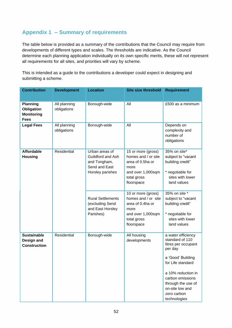
52
Appendix 1 – Summary of requirements
The table below is provided as a summary of the contributions that the Council may require from
developments of different types and scales. The thresholds are indicative. As the Council
determine each planning application individually on its own specific merits, these will not represent
all requirements for all sites, and priorities will vary by scheme.
This is intended as a guide to the contributions a developer could expect in designing and
submitting a scheme.
Contribution Development Location
Site size threshold
Requirement
Planning
Obligation
Monitoring
Fees
All planning
obligations
Borough-wide All £500 as a minimum
Legal Fees All planning
obligations
Borough-wide All Depends on
complexity and
number of
obligations
Affordable
Housing
Residential Urban areas of
Guildford and Ash
and Tongham,
Send and East
Horsley parishes
15 or more (gross)
homes and / or site
area of 0.5ha or
more
and over 1,000sqm
total gross
floorspace
35% on site*
subject to “vacant
building credit”
* negotiable for
sites with lower
land values
Rural Settlements
(excluding Send
and East Horsley
Parishes)
10 or more (gross)
homes and / or site
area of 0.4ha or
more
and over 1,000sqm
total gross
floorspace
35% on site *
subject to “vacant
building credit”
* negotiable for
sites with lower
land values
Sustainable
Design and
Construction
Residential Borough-wide All housing
developments
a water efficiency standard of 110 litres per occupant per day a ‘Good’ Building
for Life standard
a 10% reduction in
carbon emissions
through the use of
on-site low and
zero carbon
technologies

53
Contribution Development Location
Site size threshold
Requirement
Non-residential Borough-wide 1,000sqm or more
(gross) floorspace
BREEAM very
good assessment
rating as a
minimum
A 10% reduction in
carbon emissions
through the use of
on site low and
zero carbon
technologies
For further information refer to the Sustainable Design and Construction SPD 2011,
Updated 2015
Car Clubs Residential Guildford Town
Centre
25 or more (gross)
units
On site parking
provision
Mixed use Guildford Town
Centre
20 or more (gross)
units or 1000 sqm
or more (gross) B1
floorspace
On site parking
provision
Cycle Parking Residential Borough Wide All housing
developments
One cycle space
per unit
Other Refer to Appendix 1 of Guildford Borough Local Plan 2003
Bus Shelters,
Park and Ride
and other
sustainable
transport
contributions
Where a specific need is identified, contributions arising from the development will
be considered on a site by site basis.
Open Space Residential
(developments of
at least 25
homes)
Borough Wide 25 or more (net)
units, or more than
0.4ha
* 1.6ha of formal
playing field space
per 1,000 people
* 0.8ha of children’s
play space per
1,000 people;
* 0.4ha of amenity
space per 1,000
people
Residential
(smaller
developments)
Borough Wide
Between 5* and 25
(net) units
*subject to weight
given in
determinations to
the threshold of
over 10 homes for
tariff-type
contributions in
CLG Written
Ministerial
* 1.6ha of formal
playing field space
per 1,000 people
* 0.8ha of children’s
play space per
1,000 people;
* 0.4ha of amenity
space per 1,000
people
Or
As a financial
contribution

54
Contribution Development Location
Site size threshold
Requirement
Statement of
28/11/14
towards provision
or improvement of
open space in the
area
Commercial
developments
Borough-wide Developments
exceeding 2,500
sqm
Negotiable –
considered on a
site by site basis
Biodiversity Residential Borough-wide Generally
applicable to
proposals of over
10 homes (net)
By negotiation
Commercial Borough-wide Generally
applicable to
proposals
comprising more
than 1,000 sqm of
new (net) or
replacement
floorspace
By negotiation
Special
Protection
Areas
Residential All developments
located between
400m and 5km
from an SPA
Boundary.
Large-scale
developments
between 5km and
7km of an SPA
boundary will be
assessed on an
individual basis, in
liaison with Natural
England.
£3,882.30
Per 1-bedroom
dwelling
£5,451.74
per 2-bedroom
home
£6,966.11 per 3-bedroom home
£8,232.67 per 4-bedroom
home
£9,444.17 Per 5 plus-bedroom home
Note: The SANG tariff will be updated each year on 1 April and will increase in line with the Retail Price Index (RPI) measure of inflation. The SAMM tariff will not increase. The above SPA charge excludes the minimum legal costs (£670), increasing for sites of over 25 homes and monitoring fee (£500) per point in time monitored.
Please refer to the Thames Basin Heaths Special Protection Area Avoidance
Strategy 2017 for further information.
Public Realm
Residential Borough-wide Over 10 homes
(net)
By negotiation
Commercial Borough-wide 1,000sqm (net)
additional
By negotiation

55
Contribution Development Location
Site size threshold
Requirement
floorspace
Public Art Residential
Borough-wide Case by case
basis
On site provision or
contribution
Commercial Borough-wide Case by case
basis
On site provision or
contribution
CCTV Retail Drinking
Establishments
Hot food
takeaway
Cinemas
Amusement
Arcades
Nightclubs
Guildford Town
Centre or where
there is an
identified need
Site by site basis
Negotiable:
On site provision or
contribution
Flood
Mitigation
Residential Borough-wide Case by case
basis
By negotiation
Commercial Borough-wide Case by case
basis
By negotiation
Highways
Where a specific need is identified, contributions towards mitigating harm that would
otherwise arise from the development.
Education :
Early Years /
Primary /
Secondary /
Residential
Borough-wide, in
areas where
Surrey County
Council has
identified that
school expansion
is needed to
accommodate
children from
proposed homes
Over 10 homes
(net)
By negotiation
Sustainable
transport
measures
/
Public
Transport
Non-residential Case by case
basis
By negotiation
Libraries
Residential Borough-wide Case by case
basis
By negotiation

56
Appendix 2 - Glossary
Affordable Housing
Social rented, affordable rented and intermediate housing,
provided to eligible households whose needs are not met by the
market. Eligibility is determined with regard to local incomes and
local house prices. Affordable housing should include provisions
to remain at an affordable price for future eligible households or
for the subsidy to be recycled for alternative affordable housing
provision.
Social rented housing is owned by local authorities and private
registered providers (as defined in section 80 of the Housing and
Regeneration Act 2008), for which guideline target rents are
determined through the national rent regime. It may also be
owned by other persons and provided under equivalent rental
arrangements to the above, as agreed with the local authority or
with the Homes and Communities Agency.
Affordable rented housing is let by local authorities or private
registered providers of social housing to households who are
eligible for social rented housing. Affordable Rent is subject to
rent controls that require a rent of no more than 80% of the local
market rent (including service charges, where applicable).
Intermediate housing is homes for sale and rent provided at a
cost above social rent, but below market levels subject to the
criteria in the Affordable Housing definition above. These can
include shared equity (shared ownership and equity loans), other
low cost homes for sale and intermediate rent, but not affordable
rented housing.
Homes that do not meet the above definition of affordable
housing, such as “low cost market” housing, may not be
considered as affordable housing for planning purposes.
Affordability
Affordability of housing is generally reported using the ratio of
lower quartile house price to lower quartile earnings. This is the
government’s favoured indicator for affordability, as affordability is
most likely to be an issue for people such as first time buyers,
whose wages are lower.
The higher the ratio, the less affordable housing is (it is in effect
how many time a person’s salary would be needed to buy a
home).
Data sources are the Annual Survey of Hours (ASHE) and
Earnings (ONS) and HM Land Registry.
Climate change
adaptation
Adaptations to buildings, places or environments that make
them more resilient to, and potentially benefit from, expected
changes in climate and weather patterns.

57
Climate change
mitigation
Action to reduce the impact of human activity on the climate
system, mainly through reducing greenhouse gas emissions.
Combined cooling
heating and power
(CCHP)
A power plant that generates electricity and useful heating and
cooling simultaneously for distribution through a network
providing power and heat to buildings. The lack of energy lost
means the system is highly efficient. CCHP plants and
distribution networks can work at a number of scales and can
be powered by carbon based fuels, like oil and gas, or
renewable fuels, like wood pellets. CCHP is often referred to
as trigeneration and CCHP networks that serve multiple
buildings may be referred to as district heating and cooling
networks.
Combined heat and
power (CHP)
A power plant that generates electricity and useful heat
simultaneously for distribution through a network providing
power and heat to buildings. The lack of energy lost as heat
results in high efficiency. CHP plants and distribution networks
can work at a number of scales and can be powered by
carbon based fuels, like oil and gas, or renewable fuels, like
wood pellets. CHP is often referred to as cogeneration and
CHP networks that serve multiple buildings may be referred to
as district heating networks.
Community Infrastructure
Levy (CIL)
A tariff system of developer contribution payable on the net
floorspace of most new build developments.
The CIL was introduced by the Planning Act 2008 and
subsequent regulations. The Community Infrastructure Levy
Regulations 2010 (as amended) scale back the existing system of
s106 planning obligations, to limit their use to site mitigation,
provision of affordable housing, and non-infrastructure
contributions.
Conservation Area An area designated as being of special architectural or
historic interest the character or appearance of which it is
desirable to preserve or enhance, designated by the local
planning authority under the Listed Buildings and
Conservation Areas Act 1990.
Designated heritage
asset
A World Heritage Site, Scheduled Monument, Listed
Building, Protected Wreck Site, Registered Park and
Garden, Registered Battlefield or Conservation Area
designated under the relevant legislation.
Development The carrying out of building, engineering, mining or other
operations in, on or under land, or the making of any material
change in the use of any buildings or other land
58
As defined in the Town and County Planning Act 1990 Section
55.
Development Plan Documents that set out the parameters for development in the
borough, having been consulted upon and subject to public
examination in their preparation.
For Guildford borough, the Development Plan comprises South
East Plan Policy NRM6 “Thames Basin Heaths Special Protection
Area”, the saved policies of the Guildford Borough Local Plan
(2003), Surrey Waste Plan (2008), Surrey Minerals Plan Core
Strategy and Primary Aggregates Development Plan Documents
(July 2011), and Aggregates Recycling Joint DPD (2013) . Also,
Burpham Neighbourhood Plan (2016) is part of the development
plan for the Burpham ward.
Section 38(6) of the Planning and Compulsory Purchase Act
2004 requires that planning applications and appeals be
determined in accordance with the Development Plan unless
material considerations indicate otherwise.
Development Plan
Document (DPD)
These are spatial planning documents that are subject to
independent examination and form part of the development plan
for the area (as opposed to Supplementary Planning Documents).
District Heating / Cooling A system that distributes heat from a central location to
residential and commercial buildings, typically through pipes
containing superheated water in a closed system. District heat
is often combined with combined heat and power (CHP) where
both energy and heat are provided from the same facility.
Highways Authority Surrey County Council are the Highways Authority in Surrey
responsible for the management and maintenance of the local
road network. Highways England is the highways authority
responsible for the strategic road network.
Housing Market Area (HMA) The general area within which people most often move
house. These will typically cover the administrative areas of
multiple councils.
Housing Register The Borough Council register of persons who qualify to be
allocated housing accommodation under the Housing Act 1996.
Infrastructure The services, land and buildings required to support
development including highways, sewerage and utilities.
“Infrastructure”, for the purpose of CIL is defined in the CIL
Regulations as including open space, road and transport
facilities, school and other educational facilities, flood defences,

59
sporting and recreational facilities, and medical facilities.
Local Area for Play
(LAP)
A small area of unsupervised open space specifically designated
for young children for play activities close to where they live
Local Equipped Area for
Play (LEAP)
An unsupervised play area equipped for children of early school
age
Local Housing
Allowance (LHA)
LHA is the housing benefit for tenants of privately rented
accommodation. LHA is a flat rate allowance towards rent costs,
calculated based on the circumstances of the tenant (such as
family size) and the broad area they live in.
If a household’s rent is less than the 'Valuation Office
determined' LHA for the type of property, their claim will be
assessed on their rental liability, not the LHA amount. If their
rent is more than the LHA they will normally have to pay the
extra themselves.
Guildford borough is split between two LHA areas, one that
includes the west of the borough, the other covering the majority
of the borough.
Local Plan A plan for development prepared by local planning authorities.
It forms part of the development plan system set out in the
Town and County Planning Act 1990.
Local planning authority The public authority whose duty it is to carry out specific planning
functions for a particular area.
All references to local planning authority apply to the district
council, London borough council, county council, Broads
Authority, National Park Authority and the Greater London
Authority, to the extent appropriate to their responsibilities.
Neighbourhood Area for
Play (NEAP)
An unsupervised site serving a substantial residential area,
equipped mainly for older children but with opportunities for play
for younger children.
Registered providers Registered Providers (RPs) are independent housing
organisations registered with the Homes and Communities
Agency under the Housing Act 1996. Most are housing
associations, but there are also trusts, co-operatives and
companies.
Renewable and low carbon
energy
Includes energy for heating and cooling as well as generating
electricity. Renewable energy covers those energy flows that
occur naturally and repeatedly in the environment – from the
wind, the fall of water, the movement of the oceans, from the sun
and also from biomass and deep geothermal heat. Low carbon

60
technologies are those that can help reduce emissions
(compared to conventional use of fossil fuels).
Rural exception Housing /
Sites
Small sites used for affordable housing in perpetuity where sites
would not normally be used for housing. Rural exception sites
seek to address the needs of the local community by
accommodating households who are either current residents or
have an existing family or employment connection.
Small numbers of market homes may be allowed at the local
authority’s discretion, for example where essential to enable the
delivery of affordable units without grant funding.
Special Protection Area
(SPA)
In March 2005, the government designated areas of heathland
within the Thames Valley as the Thames Basin Heaths Special
Protection Area (TBH SPA) under the EC Birds Directive. The
TBH SPA has been identified as an internationally important
habitat for three rare species of bird - the Dartford warbler,
woodlark and nightjar.
Within Guildford Borough, there are a number of areas included
within the Thames Basin Heaths Special Protection Area. Natural
England believes that recreational use of the heaths arising from
housing developments up to 5km away from a SPA will create
disturbance to rare bird populations. As a result, all housing
development within 5km of a SPA is now subject to stringent tests
and impact assessments.
Statement of Community
Involvement (SCI)
Sets out the standards, that authorities will achieve with regard to
involving local communities in the preparation of local
development documents and development control decisions.
Supplementary Planning
Document (SPD)
These planning documents provide further information and
guidance on the implementation of policies in the development
plan.
Prepared with public consultation, although they do not form part
of the development plan and are not subject to independent
examination.

61
Appendix 3
GUILDFORD BOROUGH COUNCIL
GUIDE FOR APPLICANTS:
PREPARING FLOOD RISK
SEQUENTIAL AND EXCEPTION TESTS
August 2016
Introduction
Why prepare a Sequential Test and / or Exceptions Test ?
The Guildford Context
Sequential Test : Key Requirements
Exception Test
Good and Bad practice in preparing a flood risk sequential test
Summary

62
1.0 Introduction
This guidance has been produced to help applicants (developers, agents and consultants) to
prepare flood risk sequential and exception test assessments to support their planning
applications. By following this guide, comprehensive assessments can be prepared that comply
with the requirements of national and local policy, and meet the Council’s expectations.
2.0 Why prepare a sequential test and exception test?
The purpose of the Sequential Test is to direct development towards areas of lowest flood risk first.
Paragraph 101 of the NPPF insists that “development should not be allocated or permitted if
there are reasonably available sites appropriate for the proposed development in areas with a
low probability of flooding. The Strategic Flood Risk Assessment should form the appropriate basis
for applying this test. A sequential approach should be used in areas known to be at risk from any
form of flooding”, including from rivers and the sea, surface water and critical drainage problems
as notified to the LPA by the Environment Agency. The test should also be applied where the
proposed location of the development would increase flood risk elsewhere. (Emphasis added).
If, following application of the Sequential Test, it is not possible, consistent with wider sustainability
objectives, for the development to be located in zones with a lower probability of flooding, the
Exception Test can be applied if appropriate.
To pass the Exception Test applicants must demonstrate that:
The development provides wider sustainability benefits to the community that outweigh
flood risk, informed by a Strategic Flood Risk Assessment where one has been prepared;
and
The development will be safe for its lifetime taking account the vulnerability of its users,
without increasing flood risk elsewhere, and where possible, will reduce flood risk overall.
This must be evidenced through the submission of a site-specific flood risk assessment.
It is important that in the situation of a flooding event, all occupants of the proposed building have a
flood-free route to escape from the building. The FRA will therefore also need to clearly explain
and demonstrate how safe access and egress to the site will be provided for the Council to assess.
When determining planning applications, LPAs should ensure that flood risk is not increased
elsewhere and only consider development appropriate in areas at risk of flooding where, informed
by a site specific flood risk assessment following the Sequential Test, and if required the Exception
Test, it can be demonstrated that:
within the site the most vulnerable development is located in areas of lowest flood risk
unless there is an overriding reason to prefer a different location; and
development is appropriately flood resilient, including safe access and escape routes where
required, and that any residual risk can be safely managed and it gives priority to the use of
sustainable drainage systems.
In determining applications and whether an Exception Test may be required, the Council will also
have regard to the vulnerability of the proposed land use(s) to flooding and their appropriateness
within the relevant flood risk zone(s) as identified in PPG paragraphs 066 and 067.

63
If development classified within a certain vulnerability classification is considered inappropriate to
the flood zone of the development site, planning permission will generally not be permitted.
Flood Risk Vulnerability Classification
Essential Infrastructure
Essential transport infrastructure (including mass evacuation routes) which has to
cross the area at risk.
Essential utility infrastructure which has to be located in a flood risk area for
operational reasons, including electricity generating power stations and grid and
primary substations; and water treatment works that need to remain operational in
times of flood.
Wind turbines.
Highly Vulnerable
Police and ambulance stations; fire stations and command centres;
telecommunications installations required to be operational during flooding.
Emergency dispersal points.
Basement dwellings.
Caravans, mobile homes and park homes intended for permanent residential use.
Installations requiring hazardous substances consent. (Where there is a
demonstrable need to locate such installations for bulk storage of materials with port
or other similar facilities, or such installations with energy infrastructure or carbon
capture and storage installations, that require coastal or water-side locations, or need
to be located in other high flood risk areas, in these instances the facilities should be
classified as ‘Essential Infrastructure’).
More Vulnerable
Hospitals
Residential institutions such as residential care homes, children’s homes, social
services homes, prisons and hostels.
Buildings used for dwelling houses, student halls of residence, drinking
establishments, nightclubs and hotels.
Non–residential uses for health services, nurseries and educational establishments.
Landfill* and sites used for waste management facilities for hazardous waste.
Sites used for holiday or short-let caravans and camping, subject to a specific
warning and evacuation plan.
Less Vulnerable
Police, ambulance and fire stations which are not required to be operational during
flooding.
Buildings used for shops; financial, professional and other services; restaurants,
cafes and hot food takeaways; offices; general industry, storage and distribution;
non-residential institutions not included in the ‘More Vulnerable’ class; and assembly
and leisure.
Land and buildings used for agriculture and forestry.
Waste treatment (except landfill* and hazardous waste facilities).
Minerals working and processing (except for sand and gravel working).
Water treatment works which do not need to remain operational during times of flood.

64
Sewage treatment works, if adequate measures to control pollution and manage
sewage during flooding events are in place.
Water-Compatible Development
Flood control infrastructure.
Water transmission infrastructure and pumping stations.
Sewage transmission infrastructure and pumping stations.
Sand and gravel working.
Docks, marinas and wharves.
Navigation facilities.
Ministry of Defence’s defence installations.
Ship building, repairing and dismantling, dockside fish processing and refrigeration
and compatible activities requiring a waterside location.
Water-based recreation (excluding sleeping accommodation).
Lifeguard and coastguard stations.
Amenity open space, nature conservation and biodiversity, outdoor sports and
recreation and essential facilities such as changing rooms.
Essential ancillary sleeping or residential accommodation for staff required by uses in
this category, subject to a specific warning and evacuation plan.
Figure 5: Flood risk vulnerability classification
Source: National Planning Practice Guidance 066.
Figure 6: Flood risk vulnerability classification and flood zone compatibility
Source: National Planning Practice Guidance 067.
If unclear which flood risk vulnerability classification should apply, it is recommended that
clarification be sought from the Council.

65
In accordance with the NPPF, a sequential test will not need to be undertaken for the following
forms of development:
applications for individual developments located on sites allocated within post-NPPF
adopted development plans16.
development proposed in Flood Zone 1 (unless a Strategic Flood Risk Assessment or other
up-to-date evidence highlights specific flooding issues now or in the future)
change of use applications (except those involving a change of use to a caravan, camping
or chalet site, or to a mobile home or park home site)
applications for minor development17
The National Planning Policy Framework (NPPF) emphasises that new development should be
planned to avoid increased vulnerability to the impacts arising from climate change. The impacts of
climate change within the flood risk sequential and exception tests should be considered. See the
EA’s best practise guide (February 2016).
Summary:
In considering proposals for non-minor developments or change of use developments proposed
within Flood Zone 2 or Flood Zone 3, the applicant must prove, through the submission of a
Sequential Test, that there are no reasonably available sites appropriate for the proposed
development in areas at lower risk of flooding. Where this is adequately demonstrated, an
Exception Test must also be passed if the Council considers it necessary. The need for such an
assessment will be determined with reference to the proposed use’s flood risk vulnerability
classification and its flood zone compatibility as outlined in the PPG. To pass the Exceptions Test,
applicants must illustrate through the submission of a site-specific flood risk assessment how the
proposed development will be safe over its lifetime to users and demonstrate how the benefits of
the proposed scheme to the local community (ie. in the public interest) will outweigh flood risk.
3.0 The borough context
Guildford borough is generally not subject to severe flooding. However, a significant proportion of
the Guildford town is located within flood zone 2 or 3 and is thus considered to be at medium to
high risk of flooding.
A summary of each flood risk zone, as defined in the PPG, is provided in Figure 7? below:
Flood Zone Definition
Zone 1
Low Probability
Land having a less than 1 in 1,000 annual probability of river or sea flooding.
Zone 2 Land having between a 1 in 100 and 1 in 1,000 annual probability of river
16 Allocated sites in a Local Plan that predates the NPPF are likely to require a sequential test.
17 Minor development means:
- Minor non-residential extensions with a footprint less than 250sqm. - Alterations: development that does not increase the size of buildings e.g. alterations to external appearance. - Householder development: e.g. sheds, garages, games rooms etc. within the curtilage of the existing dwelling in
addition to physical extensions to the existing dwelling itself. This excludes any proposed development that would create a separate dwelling within the curtilage of the existing dwelling e.g. subdivision of houses into flats.
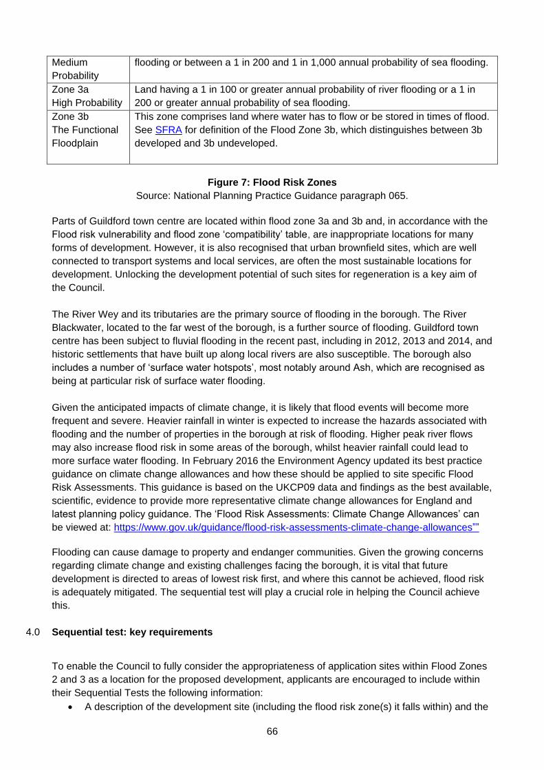
66
Medium
Probability
flooding or between a 1 in 200 and 1 in 1,000 annual probability of sea flooding.
Zone 3a
High Probability
Land having a 1 in 100 or greater annual probability of river flooding or a 1 in
200 or greater annual probability of sea flooding.
Zone 3b
The Functional
Floodplain
This zone comprises land where water has to flow or be stored in times of flood.
See SFRA for definition of the Flood Zone 3b, which distinguishes between 3b
developed and 3b undeveloped.
Figure 7: Flood Risk Zones
Source: National Planning Practice Guidance paragraph 065.
Parts of Guildford town centre are located within flood zone 3a and 3b and, in accordance with the
Flood risk vulnerability and flood zone ‘compatibility’ table, are inappropriate locations for many
forms of development. However, it is also recognised that urban brownfield sites, which are well
connected to transport systems and local services, are often the most sustainable locations for
development. Unlocking the development potential of such sites for regeneration is a key aim of
the Council.
The River Wey and its tributaries are the primary source of flooding in the borough. The River
Blackwater, located to the far west of the borough, is a further source of flooding. Guildford town
centre has been subject to fluvial flooding in the recent past, including in 2012, 2013 and 2014, and
historic settlements that have built up along local rivers are also susceptible. The borough also
includes a number of ‘surface water hotspots’, most notably around Ash, which are recognised as
being at particular risk of surface water flooding.
Given the anticipated impacts of climate change, it is likely that flood events will become more
frequent and severe. Heavier rainfall in winter is expected to increase the hazards associated with
flooding and the number of properties in the borough at risk of flooding. Higher peak river flows
may also increase flood risk in some areas of the borough, whilst heavier rainfall could lead to
more surface water flooding. In February 2016 the Environment Agency updated its best practice
guidance on climate change allowances and how these should be applied to site specific Flood
Risk Assessments. This guidance is based on the UKCP09 data and findings as the best available,
scientific, evidence to provide more representative climate change allowances for England and
latest planning policy guidance. The ‘Flood Risk Assessments: Climate Change Allowances’ can
be viewed at: https://www.gov.uk/guidance/flood-risk-assessments-climate-change-allowances””
Flooding can cause damage to property and endanger communities. Given the growing concerns
regarding climate change and existing challenges facing the borough, it is vital that future
development is directed to areas of lowest risk first, and where this cannot be achieved, flood risk
is adequately mitigated. The sequential test will play a crucial role in helping the Council achieve
this.
4.0 Sequential test: key requirements
To enable the Council to fully consider the appropriateness of application sites within Flood Zones
2 and 3 as a location for the proposed development, applicants are encouraged to include within
their Sequential Tests the following information:
A description of the development site (including the flood risk zone(s) it falls within) and the

67
proposed development
Identification and justification of the extent of the search area
A description and justification of the parameters applied to the search (to ensure all
‘reasonably available sites’ are considered)
A table or schedule identifying reasonably available sites based on up-to-date evidence
An appraisal of the appropriateness of sites which pass the initial sieving exercise
A conclusion highlighting and justifying whether any of the alternative sites identified are
more appropriate for the proposed development.
Description of the development site and proposed development
Applicants should provide a brief description of the application site and its physical context,
including the level of flood risk on the site. This will help ascertain areas at equal and less risk of
flooding than the application site. A site location plan/map should also be included in the
document.
Identifying, confirming and justifying the extent of the search area
Applicants are encouraged to discuss the extent of the search area with the Council before
undertaking the Sequential Test. Determining a suitable search area is vital to ensuring that an
accurate assessment of the number and appropriateness of ‘reasonably available sites’ is made
without overburdening the applicant. National Planning Policy Guidance (PPG) supports this
approach. Paragraph 033 states that:
“for individual planning applications where there has been no sequential testing of the
allocations in the development plan, or where the use of the site being proposed is not in
accordance with the development plan, the area to apply the Sequential Test across will be
defined by local circumstances relating to the catchment area for the type of development
proposed. For some developments this may be clear, for example, the catchment area for a
school. In other cases it may be identified from other Local Plan policies, such as the need for
affordable housing within a town centre, or a specific area identified for regeneration. For
example, where there are large areas in Flood Zones 2 and 3 (medium to high probability of
flooding) and development is needed in those areas to sustain the existing community, sites
outside them are unlikely to provide reasonable alternatives”.
Identify and justify the parameters for ‘reasonably available’ sites
To ensure that the sequential test is relevant to the application proposal, appropriate parameters
should be set. Defining (and justifying) what constitutes a ‘reasonably available’ site is particularly
important in this regard. These should include those sites:
within the agreed area of search; and
of a comparable size to the application site (plus or minus 20% of the application site area
is considered to be an appropriate yardstick);
that can accommodate the requirements of the proposed development; and
that is owned by the applicants, is for sale at a fair market value or is publically owned land
that has been formally declared as surplus and is available for purchase; and
which have not been safeguarded/allocated for another use within a Local Plan

68
Sites are not ‘reasonably available’ if they fail to meet any of the above requirements or have
planning permission for a development that is likely to be implemented.
National Planning Practice Guidance (para 033) emphasises that “when applying the Sequential
Test, a pragmatic approach on the availability of alternatives should be taken. For example, in
considering planning applications for extensions to existing business premises it might be
impractical to suggest that there are more suitable alternative locations for that development
elsewhere. For nationally or regionally important infrastructure the area of search to which the
Sequential Test could be applied will be wider than the local planning authority boundary”.
Identifying alternative sites and their development potential using up-to-date evidence
Once a suitable search area has been agreed, and the parameters of the assessment defined,
applicants should undertake the test using up-to-date information and evidence.
In carrying out the test applicants should refer to the following sources of information:
Sites included with the Council’s latest (published) Land Availability Assessment (LAA)
(apart from discounted sites)
Information included within the latest Guildford Town Centre Masterplan (if appropriate to
the location of the development)
Sites included within the Council’s emerging Local Plan
Windfall sites not allocated within the emerging Local Plan or identified in the LAA. Property
Agent listings may be a valuable source of information in regards to such sites
Planning applications that have been granted permission for similar development in the
study area
It is recommended that details of each site is recorded in table format and, as a minimum, include:
The name and address of the site
The status of the site (i.e. whether it is allocated in the Local Plan, identified in the Land
Availability Assessment, a windfall site etc)
The status of the Local Plan (for instance whether the Council has adopted a post-NPPF
Local Plan, i.e post-March 2012). Sites allocated within an adopted post-NPPF Local Plan
will not need to undergo a sequential test.
An estimate of the site’s development capacity (taking into account the density of the
surrounding area)
A description of any issues that would prevent development and whether these could be
overcome (and if not, a brief justification of why the issue could not be overcome)
The flood risk to the site
Supporting documentation/evidence about the alternative sites identified (for instance the
Local Plan background and evidence base documents)
The table should be used as evidence to sieve out sites which are immediately identifiable as
inappropriate alternatives to the application site. Sites which are not available, not of the required
size and form, in an inappropriate location for such development or within a higher flood risk zone
should not be carried forward. The Council’s Strategic Flood Risk Assessment and other evidence
base documents (including the Surface Water Management Plan) should be used as a starting
point for identifying and comparing flood risk.
Consider the appropriateness of sites which pass the initial sieving exercise in more detail

69
Sites which pass the initial sieving exercise should be considered in greater detail to determine
whether they are more appropriate locations (at lower risk of flooding) for the proposed
development. A detailed appraisal of the flood risk of the alternative sites compared to the
application site should be undertaken; informed by the Council’s Strategic Flood Risk Assessment.
It is recommended that Table 4-3 (sequential test template) of the Council’s Strategic Flood Risk
Assessment 2015 or a suitable equivalent is used to undertake this assessment. The suitability of
the alternative sites (in regards to all other planning matters) to accommodate the proposed
development should also be considered and described in a written statement. Where alternative
sites are considered less appropriate for the proposed development than the application site,
detailed justification must be provided.
Figure 8 : Template table for recording Sequential Test Process
Source: Guildford Borough Council Strategic Flood Risk Assessment Level 1: Final Decision
Support Document, July 2016
Identify whether any of the alternatives are suitable alternatives to the application site.
The document should conclude by restating whether there are any more appropriate sites for the
proposed development in areas at lower risk of flooding.
5.0 Good and bad practice in preparing a flood risk Sequential Test
Good Practice Bad Practice
Engaging with Planning Officers
before undertaking the Sequential
Test to determine an appropriate
search area
Including sites within the same flood
zone and lower flood zones in the
search (if located within the defined
Failing to discuss the search area
with the Council – may result in a
search area which is too small or too
large
Excluding sites in the same flood risk
zone as the application site from the
search18
18 Some application sites may be located in several different flood zones. For such sites, it is important to
compare how the coverage of each flood zone on that site relates to the coverage of flood zones on
alternative sites. Other reasonably available sites may also be predominately located within flood zone 2 or 3
but contain areas of flood zone 1. These sites may therefore be at lower risk of flooding than an application
site located entirely within flood zone 2 or 3 and could therefore be recognised as ‘reasonably available’
sites.

70
search area*)
Describing the methodology,
including the assessment
parameters, used within the
document
Drawing on various sources of up-to-
date evidence in identifying
‘reasonably available’ sites
Identifying ‘reasonably available sites’
in a clear table/schedule
Providing detailed justification of why
alternative sites have been
considered appropriate or
inappropriate locations for the
proposed development
Relying on old/ out-of-date policy and
evidence
Ruling out ‘reasonably available sites’
without justification
If unclear which flood risk vulnerability classification should apply, it is recommended that
clarification is sought from the Council.
6.0 Exception Test
If a development proposal passes the Sequential Test, it may still be subject to the requirement to
meet the Exceptions Test depending on its flood risk classification and flood zone compatibility
(see Figures 1 and 2 for clarification).
The Exception Test should demonstrate that:
The development provides wider sustainability benefits to the community that outweigh
flood risk, informed by a Strategic Flood Risk Assessment where one has been
completed; and
The development will be safe for its lifetime taking account the vulnerability of its users,
without increasing flood risk elsewhere, and where possible, will reduce flood risk
overall. This must include clearly demonstrating that safe access and egress will be
provided to users of the development site.
Applicants are encouraged to demonstrate the benefits of the proposed development scheme
through the submission of a detailed appraisal based upon the Council’s site-specific Sustainability
Appraisal criteria. A written summary of the appraisal should also be included with the submission
documents.
The second requirement must be demonstrated through the submission of a site specific Flood
Risk Assessment (FRA) which satisfies the requirements of the Environment Agency. The PPG
offers detailed guidance for applicants preparing FRAs. To ensure that their submissions are
robust, applicants are recommended to have regard to the advice contained within the PPG. The
technical note to the NPPF states that FRAs should identify and assess the risks of all forms of
flooding to and from the development and demonstrate how these flood risks will be managed so
that the development remains safe throughout its lifetime, taking climate change into account.
Applicants must clearly demonstrate that safe access and egress will be provided to the
development site and are advised to seek specialist advice in this regard.

71
7.0 Summary
This guide is intended to assist applicants to undertake Sequential flood risk and Exception Tests
as part of their planning applications in areas at risk of flooding. It outlines the national planning
policy context relating to considering flood risk of proposed developments, and identifies what
information the Council will expect Flood Risk Sequential Tests to contain. Information is also
provided for applicants where an Exception Test is required to support a planning application.
Applicants are encouraged to consider the contents of this document when preparing Sequential
and Exception tests. Applications that are not able to demonstrate there is no reasonably available
alternative at less risk of flooding are likely to be refused.
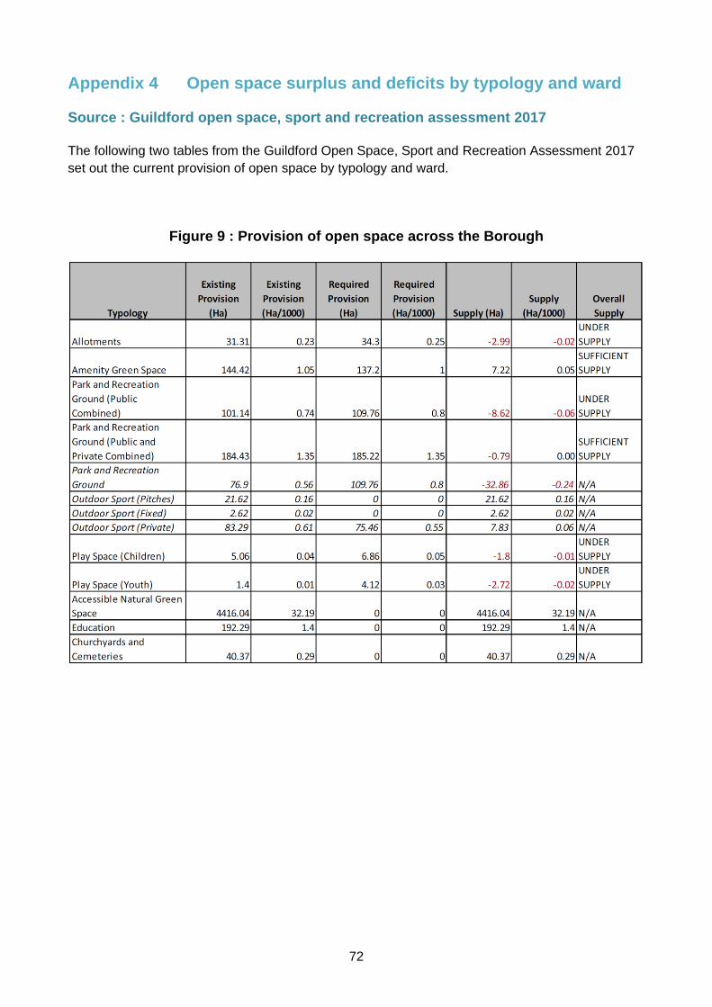
72
Appendix 4 Open space surplus and deficits by typology and ward
Source : Guildford open space, sport and recreation assessment 2017
The following two tables from the Guildford Open Space, Sport and Recreation Assessment 2017
set out the current provision of open space by typology and ward.
Figure 9 : Provision of open space across the Borough

73
Figure 10 : Supply of open space by ward (hectares)

74
Appendix 5 Size and design standards for children’s play spaces
Facility Minimum total space
required including
buffer (sq m)
Minimum size for Activity
Zone
(sq m)
Minimum distance
from activity zone to closest
property boundary
(i.e. buffer)
Maximum walking distance
from new home
in minutes
Maximum walking distance
from home in metres
Characteristics
Local Area
for Play
(LAP)
a small area
of
unsupervised
open space
specifically
designated for
young children
for play
activities close
to where they
live
400 sq m 100 sq m 5m from
activity
zone
1 100 The main characteristics of a LAP are:
1 It caters for children up to 6 years in age.
2 It is within walking time of 1 minute from home.
3 It is positioned beside a pedestrian pathway on a route that is well
used.
4 It occupies a reasonably flat site that is well drained with grass or a
hard surface.
5 It has an activity zone a minimum of 100m2 in area.
6 It contains features that enable children to identify the space as their
own domain, for example, a footprint trail, a mushroom style seat or a
model of an animal or insect.
7 A buffer zone, of 5 metres minimum depth, is provided between the
activity zone and the forward-most part of the nearest dwelling that
faces the LAP. Gable end or other exposed walls should be protected
from use for ball games by, for example, providing a strip of dense
planting or 1 metre minimum depth.
8 The buffer zone includes planting to enable children to experience
natural scent, colour and texture Some individual seats are provided
for parents or carers.
9 It has a 600mm high guard-rail or similar low level fence around the
perimeter (either within or adjacent to areas of planting).
10 It has a barrier to limit the speed of a child entering or leaving the
facility.
11 It has a sign to indicate that the area is solely for use by children, that
adults are not allowed unless accompanied by children and that dogs

75
Facility Minimum total space
required including
buffer (sq m)
Minimum size for Activity
Zone
(sq m)
Minimum distance
from activity zone to closest
property boundary
(i.e. buffer)
Maximum walking distance
from new home
in minutes
Maximum walking distance
from home in metres
Characteristics
should be excluded.
12 It is overlooked from nearby houses.
13 The area of the activity zone contributes to meeting the children’s
playing space part of the Six Acre Standard.
Local
Equipped
Area for Play
(LEAP):
an
unsupervised
play area
equipped for
children of
early school
age
3,600 sq m 400 sq m 20 m from
activity zone
5 400 The main characteristics of a LEAP are:
1 It caters for children of 4-8 years in age.
2 It is within a walking distance of 5 minutes from home.
3 It is positioned beside a pedestrian pathway on a route that is well
used.
4 It occupies a site that is well drained with grass or a hard surface and
features an appropriate impact-absorbing surface beneath and around
the play equipment.
5 It has an activity zone a minimum of 400m2 in area.
6 It contains at least 5 types of play equipment, of which at least two are
individual pieces rather than part of a combination. Each item is
designed to stimulate one of the following:
(i) Balancing, e.g. beams, stepping logs, clatter bridges, or graphic
line elements.
(ii) Rocking, e.g. see-saw or spring animals.
(iii) Climbing or agility, e.g. frames, nets, overhead bars, or angled
climbers.
(iv) Sliding, e.g. traditional slides, straight or angled ‘fire-fighter’s’ poles.
(v) Social play, e.g. sheltered areas or child seating.
Additional items might focus upon rotating, swinging, jumping,
crawling, viewing (e.g. ground graphics), counting or touching (e.g.
sand and water).

76
Facility Minimum total space
required including
buffer (sq m)
Minimum size for Activity
Zone
(sq m)
Minimum distance
from activity zone to closest
property boundary
(i.e. buffer)
Maximum walking distance
from new home
in minutes
Maximum walking distance
from home in metres
Characteristics
7 There is adequate space around the equipment to enable children to
express their general exuberance and play games of ‘tag’ and ‘chase’.
8 It has fencing, if the site is not already adequately enclosed, of at least
1 metre in height around the perimeter of the activity zone with two,
outward-opening and self-closing, pedestrian gates on opposite sides
of the space (to deter entry by dogs and to restrict opportunities for
bullying).
9 It has a barrier to limit the speed of a child entering or leaving the
facility.
10 A buffer zone, not less than 10 metres in depth, is provided between
the edge of the activity zone and the boundary of the nearest property
containing a dwelling. Normally, a minimum of 20 meters should be
provided between the activity zone and the habitable room façade of
the dwelling. Where these minimum distances apply, careful
consideration needs to be given to:
(i) The design of the means of enclosure, planting scheme and/or
other physical features on the boundary of the residential
property, and
(ii) The siting of play equipment within the activity zone (to preclude
opportunities for overlooking nearby gardens and a
consequential loss of privacy for residents).
11 The buffer zone includes planting to enable children to experience
natural scent, colour and texture.
12 Some individual seats are provided for parents or carers.

77
Facility Minimum total space
required including
buffer (sq m)
Minimum size for Activity
Zone
(sq m)
Minimum distance
from activity zone to closest
property boundary
(i.e. buffer)
Maximum walking distance
from new home
in minutes
Maximum walking distance
from home in metres
Characteristics
13 It has a notice to indicate:
(i) That the area is solely for use by children.
(ii) That adults are not allowed unless accompanied by children.
(iii) That dogs should be excluded.
(iv) The name and telephone number of the operator of the facility
to report any incident or damage to the play equipment.
(v) The location of the nearest public telephone.
14 It has a litter bin.
15 The area of the activity zone contributes to meeting the children’s
playing space part of the Six Acre Standard.
Neighbourho
od Area for
Play (NEAP)
an
unsupervised
site serving a
substantial
residential
area,
equipped
mainly for
older children
but with
opportunities
for play for
8,400 sq m 1,000sq m 30m from
activity zone
15 1,000 The main characteristics of a NEAP are:
1 It caters predominantly for older children.
2 It is within a walking time of 15 minutes from home.
3 It is positioned beside a pedestrian pathway on a route that is well
used.
4 It occupies a site that is well drained with both grass and hard surfaced
areas and it feature an appropriate impact-absorbing surface beneath
and around the play equipment.
5 It has an activity zone a minimum of 1000m2 in area that is divided
into two parts; one containing a range of play equipment and the other
provided with a hard surface of at least 465m2 (the minimum area
needed to play five-a-side football).
6 It contains at least 8 types of play equipment comprising:
(i) At least 1 item to stimulate rocking, touch, social or
developmental play among younger children.

78
Facility Minimum total space
required including
buffer (sq m)
Minimum size for Activity
Zone
(sq m)
Minimum distance
from activity zone to closest
property boundary
(i.e. buffer)
Maximum walking distance
from new home
in minutes
Maximum walking distance
from home in metres
Characteristics
younger
children
(ii) At least 2 items to facilitate, sliding, swinging or moderate
climbing.
(iii) At least 5 items, of which at least 3 are individual pieces rather
than in combination, to encourage either more adventurous
climbing, single point swinging, balancing, rotating, or gliding
(e.g. aerial runway).
7 There is adequate space around the equipment to enable children to
express their general exuberance and play games of ‘tag’ and ‘chase’.
8 It has fencing, if the site is not already adequately enclosed, of at least
1 metre in height around the perimeter of the activity zone with two,
outward-opening and self-closing, pedestrian gates on opposite sides
of the space (to deter entry by dogs and to restrict opportunities for
bullying).
9 It has a barrier to limit the speed of a child entering or leaving the
facility.
10 A buffer zone, of 30 metres minimum depth is provided between the
activity zone and the boundary of the nearest property containing a
dwelling. A greater distance may be needed where purpose-built
skateboarding facilities are provided.
11 The buffer zone includes planting to enable children to experience a
part of the ‘natural’ environment.
12 Some individual seats are provided for parents or carers in the vicinity
of the play equipment and other seating is provided within the hard
surfaced games area.
13 It has a notice to indicate:
(i) That the area is solely for use by children.
(ii) That adults are not allowed in the equipped space unless

79
Facility Minimum total space
required including
buffer (sq m)
Minimum size for Activity
Zone
(sq m)
Minimum distance
from activity zone to closest
property boundary
(i.e. buffer)
Maximum walking distance
from new home
in minutes
Maximum walking distance
from home in metres
Characteristics
accompanied by children.
(iii) That dogs should be excluded.
(iv) The name and telephone number of the operator of the facility to
report any incident or damage to the play equipment.
(v) The location of the nearest public telephone.
14 It has litter bins at each access point and in proximity of each group of
seats.
15 It has convenient and secure parking facilities for bicycles.
16 The area of the activity zone contributes to meeting the children’s
playing space part of the Six Acre Standard.

80
Appendix 6 Guildford town centre parking boundary
defined by Guildford Local Plan 2003 Policy M1

81
Appendix 7 Example of calculation of a financial contribution in lieu of
on-site affordable housing provision.
The methodology considers the financial benefit to the developer of not including affordable
housing in the development scheme. This is the difference in gross development value between a
development of 100% market housing and 65% market housing with 35% affordable housing.
Example :
Proposed development of 50 units of assisted living / extra care flats.
Provision of affordable housing is sought at 35%, i.e. 17.5 flats, rounded up to 18 flats.
Flat size Number
of
homes
Floor space
as proposed for the
market homes
Sales value per
square metre
£ / sq m
based on recent
actual market
housing sales
Value
(floor space x
Sales value
£ / sqm
1 bed flat 9 55 5200 2,574, 000
2 bed flat 9 70 5200 3,276,000
TOTAL 5,850,000 A
Value of flats as affordable housing (assuming sale to RP at average 55%
of market value)
NOTE : starter homes will be at 80% of market value
3,217,500 B
Development value without affordable housing minus value of flats for sale
to a Registered Provider
= Additional value to the developer of retaining 18 homes for market sale /
rent rather than them being affordable
2,633,000 A-B
The affordable housing payment in lieu would therefore be £2,633,000

82
Appendix 8 Guidance on waste and recycling storage and collection
(July 2017)
To ensure that recycling and waste material is collected cleanly, safely and efficiently the council
will collect these from wheeled bins only, unless properties are unsuitable for bins or it is
impractical to use bins. It can make this legal requirement under section 46 of the Environmental
Protection Act 1990. The bin storage capacities required are as set out in Section 12 of this SPD.
The following information is therefore provided to assist developers and should be read in
conjunction with Part H of the Building Regulations 2002. Applications for planning permission for
new homes, both houses and flats, should include appropriate provision for the storage and
collection of household waste.
Vehicle Access
In order to ensure that all refuse and recycling collections can take place unimpeded and
without the risk of any damage to the vehicles, paving or other fabric of the sites, developers
must ensure that access roads and driveways meet the following requirements.
Access roads will therefore need to:
Have suitable foundations and surfaces to withstand the maximum weight of the
vehicle (generally 26t GVW, 11.5t axle loading)
Have heavy-duty manhole covers, gully gratings etc.
Be designed to ensure reasonable convenience for the collection vehicle.
Be a minimum of 5 metres wide.
Be arranged for the collection vehicle to continue in a forward direction.
Offer adequate space for turning.
Allow a minimum of 5 metres clearance under any obstruction such as an arch.
Road hatchings at the entrance, to prevent parking at all times
If more than four containers are to be emptied, then the collection vehicle should be able to enter the development to avoid the risk of obstructing traffic. Appropriate measures must be incorporated into road layouts to control unauthorised parking of vehicles that would prevent access by the waste collection vehicles and staff The need for reversing should be eliminated if at all practicable but where it is required this should be minimized and certainly no longer in distance than 12 metres to a point within 5 metres of the storage area. In all such instances the road crossing the footway shall be designed so that the reversing vehicle does not encroach on the footway. The footway should be appropriately radiused to assist the vehicle reversing. Collection vehicles should not generally be expected to reverse into a development from a busy main road.
For tracking purposes, the dimensions of the vehicles currently used in Guildford are 10.435m
long and 2.49m wide. The minimum turning circles are 16.1m (kerb to kerb) and 16.9m
(between walls).

83
Access pathways from the storage area to the collection point (where the vehicle stops) need to:
Be level, unless the gradient falls away from the storage area in which case the
gradient should not be steeper than 1:12.
Be at least 1.5 metres wide.
Be free from kerbs and steps.
Have solid foundations and a smooth continuous impervious surface.
Have shallow ramps where they meet roadways.
Be no more than 5 metres from the point where the collection vehicle will stop.
Houses and Bungalows
Standard Bin Provision
We will supply every suitable property with a 240 ltr wheeled bin for refuse and a 240 ltr wheeled bin for mixed dry recycling as standard. For properties with low occupancy (2 people or less) a 140 ltr wheeled bin for refuse and a 140 ltr wheeled bin for mixed dry recycling will be supplied. Each property will also receive a 23ltr container for the presentation of food waste for
recycling. Space should be provided for these at each property.
Garden Waste Subscription Service
The garden waste service is optional and delivered from a 240 ltr wheeled bin. We would not
require space being provided for this bin, but would advise the provision of access to areas where
an optional third bin could be sited, such as access to a rear garden, without the need to pull a bin
through an inhabited room.
Additional Recycling Bins
We frequently find that properties with 3+ bedrooms request additional recycling bins. The
requests commonly occur a few weeks after residents have moved in and once they have had
a sufficient length of time to understand the quantity of recycling they are producing. We will
provide additional recycling containers free of charge if the existing containers are being
utilized correctly. We would not require space to be provided for an additional recycling
container however, a consideration of where this could be stored should be acknowledged.
Dimensions for wheeled bins are as follows:
The standard issue bin has a capacity of 240 litres and measures;
• Width 585cm
• Depth 740cm
• Height 1100cm
The optional smaller bin has a capacity of 140 litres and measures;
• Width 505cm
• Depth 555cm
• Height 1100cm

84
Bin storage
In general the containers should be stored on a hard, impervious, free-draining surface, in a
position with convenient access to the kitchen door but also where they can be easily moved by
the residents to the kerbside at the front of the property for collection.
Where it is intended for the containers to be permanently stored at the front of the property, a
suitable enclosure should be constructed in an accessible, but inconspicuous position.
Flats and Communal Properties
Bin Provision
Wherever possible and practical, flats and communal properties should receive the same service
as other properties.
In those developments where standard services are not possible or practical, communal wheeled
bins may need to be provided for both refuse and dry mixed recycling. These would also be
emptied fortnightly and therefore sufficient capacity for two weeks of refuse and recycling should
be allowed for (see Section 12 of this SPD).
In addition, we would site 140 ltr wheeled bins for food waste at these properties. This bin
would be emptied weekly. As a guideline a single 140 ltr wheeled bin for food waste will be
allocated between up to 8 flats (Dimensions pf 140 ltr bin available on previous page). Where
food waste services cannot be provided a weekly collection service will be provided.
Bin stores should be no more than 5m from the highway unless suitable access is available for the
vehicle. The collectors will collect, empty and return the communal wheeled bins to the storage
area.
Communal wheeled bins for refuse and dry, mixed recycling have four wheels and are available in
770 ltr and 1100 ltr sizes.
Dimensions of communal wheeled bins are as follows.
1100 litres

85
770 litres
To encourage residents to recycle waste, internal storage areas should be designed into each unit
of a new development. This will enable occupants to segregate their waste into refuse, mixed dry
recycling and food waste, and store it temporarily, until it can be transferred to external bins.
Communal bin storage areas
The storage areas for communal wheeled bins need to:
Be at ground level Within 5 metres of the public highway Allow for both refuse and recycling bins Have a suitable level hard surface Access pathway Dropped kerb Hatchings adjacent to the dropped kerb prohibiting parking
Appropriate measures must be incorporated into any scheme to control unauthorized parking of
vehicles that would prevent access by the waste collection vehicle.
Written Waste Strategy
We expect the developer of any new build or re-development to produce a written waste
strategy for submission to Guildford Borough Council’s planning department. This will be
passed onto operational services for assessment and subsequently feedback will be provided
to the developer. Your waste strategy should demonstrate that careful consideration has been
given to facilitate the collection of waste from the site in line with this guidance document.
Your waste strategy is likely to include the following information:
The proposed bin provision for each property
The proposed bin storage location for each property
The proposed bin presentation location for each property
An explanation or diagram outlining where the refuse vehicle is expected to stop to facilitate
the emptying of bins
A swept path analysis (vehicle tracking) of the refuse vehicle to provide evidence that the

86
planned maneuvers can be successfully completed.
Any other information that will be beneficial to your waste strategy
Purchasing bins
Where new or re-developed homes are being built and require wheeled bins the Council will
require the developer to purchase these wheeled bins. Please contact the council for up to
date bin prices.
The Council requires a suitable notice period from the developer to ensure that the required bins are in stock and to arrange their delivery.
For large-scale developments (6+ communal bins or 20+ 240ltr bins), 4-6 weeks’ notice is requested.
For smaller scale developments, we would expect 3-4 weeks’ notice.
Payment for bins can be accepted over the phone via credit / debit card or we will accept a
payment via purchase order number. Please contact Guildford Borough Council’s customer
service centre to arrange payment and confirm delivery. If you would like to clarify, the bin
quantities required at your development please contact the Recycling and Waste team prior to
placing any orders.
Guildford Borough Council will provide signage for communal bins to indicate the waste that
can be placed in each bin type. Signage will be applied to the bins upon delivery.


