87
Town of Salem Connecticut Plan of Conservation and Development Effective Date June 1, 2012 Salem Planning and Zoning Commission 2012 POCD

Town of Salem Connecticut
Plan of Conservation and Development
Effective Date June 1, 2012
Salem Planning and Zoning Commission
2012
POCD

Town of Salem Plan of Conservation and Development Page 1
SALEM PLANNING AND ZONING COMMISSION
MEMBERS: Richard Amato 2015 (6) David Bingham Secretary 2017 (6) Karen Buckley Chairperson 2013 (6)
Walter Volberg 2013 Ruth Savalle 2013 (4) Vernon Smith 2017 (6) Gary Walter 2015 (6)
ALTERNATES: Gloria Fogarty Alternate 2013 (2) Henryka Green Alternate 2017 (6)
TOWN PLANNER:
Mary Ann Chinatti
PLAN OF CONSERVATION AND DEVELOPMENT SUBCOMMITTEE:
Frank Abetti, POCD Chairperson and former P&ZC Member
Dana Abetti, Economic Development Commission Secretary
Jim Fogarty, Selectperson
Gloria Fogarty, former P&ZC Vice Chairperson
Larry Reitz, former First Selectperson
Linda Schroeder, Conservation Commission Member
Bill Schultz, Resident
Sally Snyder, Inland Wetlands & Conservation Commission Chairperson
Sue Spang, Recreation Commission Chairperson

Town of Salem Plan of Conservation and Development Page 2
Table of Contents
EXECUTIVE SUMMARY
Ch. 1: INTRODUCTION
Authority
Background Changes Since Adoption of the 2002 Plan Survey Results and Town Vision Critical Issues and Opportunities Structure of the Plan Implementation of Recommendations Accountability Monitoring progress
Ch. 2: VISION STATEMENT
Ch. 3: Natural Resources Background Goals, Objectives and Recommendations Ch. 4: Agriculture & Forestry Background Goals, Objectives and Recommendations Ch 5: Historic and Archaeological Resources Background Goals, Objectives and Recommendations Ch 6: Economic Development Background Goals, Objectives and Recommendations Ch 7: Municipal Facilities, Land and Services Background Goals, Objectives and Recommendations Ch 8: Housing Background Goals, Objectives and Recommendations Ch 9: Transportation Background Goals, Objectives and Recommendations Ch 10: Salem Village Center Background Goals, Objectives and Recommendations Ch 11: Regionalism Background Goals, Objectives and Recommendations
Ch. 12: STATUTORY AUTHORITY
Summary of requirements from CGS 8-23

Town of Salem Plan of Conservation and Development Page 3
Acceptance Procedure per CGS 8-23(f)
Consistency with the Conservation and Development Policies Plan for
Connecticut 2005-2010
MAPS
Map 1: Zoning Map
Map 2: Open Space
Map 3: Farmland Soils
Map 4: Land Cover
Map 5: Watershed
Map 6: Ground Water Quality
Map 7: Surface Water Quality
Map 8: Natural Diversity Database Areas
Map 9: Cemeteries
Map 10: Inland Wetlands and Watercourses
Map 11: Flood Zone Areas
Map 12: P.A. 490 & 10 Mill Rate Forest Land
Map 13: Trails - Existing and Proposed
APPENDICES
Appendix 1: Town-wide Survey - Executive Summary
Appendix 2: Checklist of Town Entities Responsible for Implementing the Recommendations
Appendix 3: Connecticut Invasive Plant List, July 2009
Appendix 4: Eightmile River Watershed Management Plan - Summary of Tier 1 and Tier 2 Tools
Appendix 5: Planning and Zoning Regulations - Section 25A - Riparian Corridor Overlay Zone (RCOZ)
Appendix 6: List of Cemeteries
Appendix 7: Recreational Facilities
Appendix 8: Boards, Commissions and Organizations
ASSOCIATED DOCUMENTS AND FURTHER REFERENCES
Municipal Land Use Plan (2010)
Open Space Plan (2007)
Wildlands and Woodlands: A Vision for the New England Landscape (2010)

EXECUTIVE SUMMARY
This Salem Plan of Conservation and Development (which we will refer to as “the PLAN”) is revised andupdated in compliance with Section 8-23 of the Connecticut General Statutes (CSG). The overall purposeof the PLAN is to recommend goals and objectives to guide the Town's decision making concerning theuse of land and other matters affecting the safety, welfare and prosperity of its residents. It is importantto note that while the PLAN is an advisory document only, it should, because of its comprehensive scopeand the broad citizen input it reflects, provide valuable guidance to the decision making process of thevarious Town boards and commissions.
In 2009, the town conducted a town-wide survey. The survey was a collaborative effort byrepresentatives from the Plan of Conservation and Development Committee, the Vision Committee andthe Economic Development Commission (EDC). The purpose of the survey was to obtain the thoughts ofthe townspeople for use in developing the Town Vision, updating the PLAN and updating the EconomicDevelopment Plan.
The values endorsed by Salem residents in the 2009 Survey include:
Sense of community and volunteerism Quality of life (educational, social and recreational) Rural character Environment and natural resources Historic character Economic Strength Housing Options
Critical Issues and Opportunities
In 2002, revisions to the PLAN addressed the following critical issues and opportunities:
Protection of the rural character and agricultural appearance of Salem Provision of adequate and affordable services Diversifying and balancing the property base Assuring availability of housing that is supported by the land and that is suitable for all income
levelsThese issues remain relevant and are addressed in the 2012 PLAN.
Additional areas of focus that are addressed in the 2012 PLAN include:
Protecting water quality Adopting low impact development principles Encouraging energy conservation Fulfilling Salem's commitment to the Eightmile River Watershed Management Plan

Guiding Principles
The revision of Salem’s PLAN was made with the help of three guiding principles; namely, the PLANshould:
1. Reflect the desires and sentiments of the town residents, based on:a. Town-wide surveyb. Vision Statementc. Dialog with various boards and commissions and other town groups
2. Incorporate recent changes that affect the town, for example:a. Acquisition of the Gadbois propertyb. Designation of the Eight Mile River as a “Wild and Scenic River”c. Evolution of how people communicate ( e.g., social media)
3. Demonstrate compatibility with the State Plan of Conservation and Development, and theSoutheastern Connecticut Council of Governments’ 2007 Regional Plan of Conservation andDevelopment, for example:
a. Promote energy conservationb. Provide a network of pedestrian and bicycle pathsc. Encourage low impact development (LID) projectsd. Promote integrated planning on a statewide, regional and local basis
Structure of the PLAN
The PLAN is structured into nine distinct but inter-related topics. Each topic includes one or more goals,which are intended to address the aforementioned critical issues and opportunities.
NATURAL RESOURCES
Goal: Protect Salem’s natural resources for the health of the community and its environment, and topreserve the town’s rural character.
AGRICUTURE and FORESTRY
Goal: Support the State of Connecticut’s goal of long-term, in-state food production at the same timepreserving Salem’s historic agricultural character.Goal: Retain Salem’s working forests for natural resource protection and for the production of localforest products (silviculture).
HISTORIC AND ARCHAEOLOGICAL RESOURCES
Goal: Protect and preserve Salem's historic and archaeological resources.
ECONOMIC DEVELOPMENT
Goal: Promote economic development that is a good fit for the Town.Goal: Take care of existing local businesses.

MUNICIPAL FACILITIES, LAND and SERVICES
Goal: Ensure that Salem's infrastructure, facilities and programs meet the Town's needs.Goal: Develop and implement interim plan for use of the Gadbois property.Goal: Create a network of multi-purpose trails and pedestrian friendly bike lanes to connect active partsof Salem and/or other trail systems.Goal: Improve Town communication capabilities to keep residents involved and informed.Goal: Enhance Salem's "green focus" (defined as striving to be environmentally responsible byconserving energy and using clean renewable energy) to help preserve the environment.
HOUSINGGoal: Encourage a balance of housing, including affordable housing that is tied to the ability of the landto support housing development.Goal: Reduce the minimum housing footprint and/or lot size.
TRANSPORTATIONGoal: The road network in Salem should provide safe and convenient access to residences, businessesand other destinations while preserving the Town's rural character.
SALEM VILLAGE CENTERGoal: Salem should enable the development of a village center.
REGIONALISMGoal: Provide or obtain the best possible Town services and/or necessary goods at the most reasonablecost.
Maps and Appendices
The 2012 Zoning Map and additional supporting maps show the current and recommended land use forthe town, including Open Space, Farmland Soils, Watershed Areas, National Diversity Database Areas,Cemeteries, Inland Wetland and Watercourses, and Existing and Proposed Trails.
The Appendices include a summary of the Town-wide Survey results, the Salem Vision Statement, achecklist of who is responsible for implementing the PLAN recommendations, a summary of therecommended Eightmile River Watershed Management Plan Tier One and Tier Two Tools, a list ofSalem’s Recreational Facilities, and a list of Salem’s Boards and Commissions and selected Organizations.

Town of Salem Plan of Conservation and Development Page 4
Chapter 1: INTRODUCTION
Authority
In compliance with Section 8-23 of the Connecticut General Statutes (CSG), the Salem Planning and Zoning
Commission (P&Z) periodically updates its local Plan of Conservation and Development (which we will refer to
as "the PLAN").
The overall purpose of the PLAN is to recommend goals and objectives to guide the Town's decision making
concerning the use of land and other matters affecting the safety, welfare and prosperity of its residents.
While the PLAN is an advisory document only, it should, because of its comprehensive scope and the broad
citizen input it reflects, provide valuable guidance to the decision making process of the various Town boards
and commissions.
Background
The first PLAN was adopted in 1971, and updated in 1991 and 2002. In 2009, P&Z established a Plan of
Conservation and Development Committee. The Committee initially included two members from P&Z, one
member from the Economic Development Commission, two members from the Inland Wetlands and
Conservation Commission, the Chair of the Recreation Commission, a long time resident and member of the
Historical Society, a current member of the Board of Selectmen, and a former First Selectman as an 'ex officio'
member. The Committee was chaired by a former member of P&Z.
Changes Since Adoption of the 2002 Plan
The economy has experienced a full cycle of boom and bust, with residential housing values falling 30% since
the October 2008 financial crisis.
Notwithstanding these changes, in the past 10 years a great deal of activity has been focused on increasing and
improving Salem's municipal property and quality of life.
The construction of a new Library was completed (2004).
The Town acquired the Gadbois property (2005).
The Recreation Commission constructed a Babe Ruth field (2004) and a full size soccer field (2005). Two tennis
courts facilities and the town's first basketball court were completed (2009), with all courts lighted and on
timers. Phase I of the Salem multi-purpose path was approved (2009), and construction was started (2010).
The Recreation Commission developed a 10-year plan for the Forsyth Recreation Complex.
The town created an Open Space Committee and drafted an Open Space Plan that forms the basis for the
acquisition, preservation and management of strategically located open space (2007).
The Eightmile River was nationally recognized as having six outstanding resource values (ORVs) and was
officially designated as a "Wild and Scenic River" (2009).

Town of Salem Plan of Conservation and Development Page 5
P&Z created a Town Center Committee (TCC), which held an open forum and a "charrette" in 2007 to gather
the townspeople's thoughts about what should be included in the Town Center and where it should be
located. The TCC also drafted regulations for the Town Center zoning district, reflecting the types of uses and
design features desired, and submitted these to P&Z (2008-09).
The town updated its Municipal Land Use Plan, including an inventory of all town-owned land and buildings
(2010).
The town formed a Vision Committee and drafted a Vision Statement (2009-11), reflecting the values voiced by
Salem residents in their responses to a town-wide survey.
Survey Results and Town Vision
In 2009, the town conducted a town-wide survey. The survey was a collaborative effort by representatives
from the Plan of Conservation and Development Committee, the Vision Committee and the Economic
Development Commission (EDC). The purpose of the survey was to obtain the thoughts of the townspeople
for use in developing the Town Vision, updating the PLAN and updating the Economic Development Plan.
The 2009 survey had a sample size of 403 with a statistical accuracy of +/-5%, while the 1999 survey had a
sample size of 429, also with a statistical accuracy (margin of error) of +/-5%. The 2009 survey results are
summarized in Appendix 1: Town-Wide Summary - Executive Summary.
The values endorsed by Salem residents in the 2009 Survey include:
Sense of community and volunteerism
Quality of life (educational, social and recreational)
Rural character
Environment and natural resources
Historic character
Economic Strength
Housing Options The Salem Vision Statement, which incorporates these values, is included in Chapter 2.
Critical Issues and Opportunities
In 2002, revisions to the PLAN addressed the following critical issues and opportunities:
Protection of the rural character and agricultural appearance of Salem
Provision of adequate and affordable services
Diversifying and balancing the property base o Making Salem attractive to businesses compatible with its rural character o Diversifying and balancing the sources of tax revenue o Improving the quality of life in Salem by providing municipal services necessary for the
common good
Assuring availability of housing that is supported by the land and that is suitable for all income levels

Town of Salem Plan of Conservation and Development Page 6
Many of the issues identified in the 2002 PLAN, such as preserving town character and appearance, providing
affordable services, diversifying the tax base, and maintaining housing options, remain critical. Protecting
water quality, adopting low impact development principles, encouraging energy conservation, and fulfilling
Salem's commitment to the Eightmile River Watershed Management Plan have surfaced as additional areas
demanding attention.
The revision of Salem's PLAN takes as its basic premises:
1. Salem residents wish to maintain the quality of life with which they are very satisfied, not only for themselves, but also for future generations.
2. This quality of life is dependent on preserving Salem's natural resources, rural character, and economic strength.
3. Each of the goals, objectives and recommendations set forth in this PLAN is designed to support those values.
Structure of the PLAN
The PLAN is structured into nine clearly distinct but interrelated topics:
1. Natural Resources
2. Agriculture & Forestry
3. Historic and Archaeological Resources
4. Economic Development
5. Municipal Facilities, Land and Services
6. Housing
7. Transportation
8. Village Center
9. Regionalism
The individual topics are structured as follows:
Each topic includes one or more goals
Each goal requires achievement of one or more objectives in order to meet the goal
Each objective requires the execution of one or more recommendations in order for the objective to be achieved
Implementation of Recommendations
The overall purpose of the PLAN is to recommend goals and objectives to guide the Town's decision making
concerning the use of land, and other matters affecting the safety, welfare and prosperity of its residents.
While the PLAN is an advisory document only, its comprehensive scope and the broad citizen input it reflects

Town of Salem Plan of Conservation and Development Page 7
should make it a valuable resource in the decision making process of the various Town boards and
commissions.
Accountability
Each Recommendation of the PLAN indicates which part of Town government, or which private entity, has
responsibility for that item. The task of evaluating how (and whether) the recommendation should be
implemented, then developing and implementing detailed action plans, including obtaining the appropriate
approvals where required, rests with the responsible entity. A complete checklist of recommendations
distributed across the ten Town entities responsible for implementing them is included in Appendix 2.
Monitoring Progress
P&Z will conduct an annual review at its February planning meeting with responsible boards, commissions, and
community groups to review the PLAN and determine the status of the recommendations.
Progress towards implementing the PLAN recommendations will also be included in the Town's Annual Report.
Chapter 2: VISION STATEMENT
Salem is a town poised for the future and shaped by the past. It has an excellent school system, proximity to
employment centers, and residents with a strong sense of community spirit as demonstrated by their
volunteerism and cooperation. Those qualities along with a charm inherited from its agricultural roots and
history give Salem an engaging rural character and make it an inviting place to live.
The goal of the vision statement is to reflect the sentiments, desires, and priorities of Salem residents for
Salem’s leadership in order to inform them and to foster cooperation among the various Boards and
Commissions.
The following is our vision for Salem.
The high quality of life will be maintained by:
Continuing to engage dedicated people for staff and volunteer positions; people who foster cooperation among Salem's citizens and government groups to get things done.
Working to expand the variety of educational, social, recreational and library programs available. Increasing opportunities for people to gather by promoting existing sites, and developing new public
places. Building an extensive system of bikeable, walkable greenway trails to connect open spaces and
neighborhoods.
Salem will work to reduce dependence on residential property taxes by encouraging economic development
that:
Is concentrated in appropriate areas Maintains or enhances the Town's character Promotes attractive building designs incorporating common traditional elements

Town of Salem Plan of Conservation and Development Page 8
Provides conveniences for the community Attracts businesses that draw customers to Salem Balances the economic development with preserving our natural resources
Salem will protect its natural resources by:
Implementing the Eightmile River Watershed Management Plan with Lyme and East Haddam Maintaining open space in accordance with the Town's Open Space Plan Ensuring that regulations adequately protect water supply and quality Sponsoring “educational” events for all age levels to raise awareness
Housing in Salem will:
Be consistent with the town's rural character and quality of life Accommodate our unmet housing needs by permitting a variety of housing types and configurations
that encourage Salem's residents, including senior citizens and young adults, to remain in the community
Salem will retain a town meeting form of government that strives to be responsive, transparent, and efficient.
The selectmen, boards, commissions, and committees will be accessible to our citizens and provide for their
safety, education and recreation. Salem’s government will take advantage of innovation and technology to
contain costs and improve town services, and strive to communicate effectively with its citizens and other
local, state, and federal government groups.
Salem will continue to seek opportunities to partner with surrounding communities to achieve mutual goals in
such areas as education, health, safety, recreation, and to preserve and protect our natural resources.
Our view of Salem's future will focus the community's decisions and actions. This will help us to achieve our
vision for maintaining quality of life, regionalism, housing, government, economic development, and natural
resources.
Chapter 3: NATURAL RESOURCES The Town of Salem is set in remarkable surroundings. Lying between more developed communities, this little
town still has its rural setting, picturesque landscapes, and intact ecosystems. In fact, Salem rests on top of
four regional basin drainage divides: the Eightmile, Yantic, Thames Main Stem, and the Southeast Western
Complex; as well as three major drainage basins - the Connecticut River, the Thames River, and the Southeast
Coast. This geography affords us our potable water supply, clean lakes and streams. Our community also
makes up one third of the municipalities federally recognized for preserving and protecting the Eightmile River
Watershed, a National Wild & Scenic River system. But our extraordinary natural assets don’t stop there. We
also share the highly popular and publicly accessible recreation area, Gardner Lake, with two neighboring
towns. And Salem is home to the incomparable Walden Preserve and other wildlife sanctuaries, as well as
many farms and other valuable open space.

Town of Salem Plan of Conservation and Development Page 9
Salem has exceeded state open space land acquisition and preservation goals, achieving a greater percentage
of open space than most Connecticut towns. We have achieved an outstanding 23% of open space protection
through acquisition by municipal, private, and not-for-profit organizations (e.g. Salem Land Trust) or
conservation easement. Because of this low amount of land development in Salem, the natural hydrologic
cycle of rain water infiltration and groundwater recharge helps to maintain the high water quality of our rivers
and streams, which in turn supports the richness and diversity of our forested habitats.
As indicated in the title, this PLAN not only addresses future development but also conservation. The
conservation of our natural resources will help ensure the physical health of our natural community and the
quality of life in the Town of Salem.
One of the goals of the PLAN is to identify those unique or special resources that exemplify the character of
the Town of Salem. Noting and mapping the locations of these special resources will help to ensure that future
development activities will be sufficiently reviewed to help minimize potential negative impacts to those
resources. Additionally, consideration will be given to establishing a separate Conservation Commission to
identify and update our resource maps. And as the Town of Salem grows and develops, efforts will be made to
ensure that such development will be consistent with modern, Low Impact Development (LID) practices to
further minimize impacts to the environment.
Horse Pond
Another goal is to apply the same protective measures that have already been adopted within the Eightmile
River Watershed throughout the town in order to afford similar resource protections to the town’s other
surface water resources. We also hope to work with neighboring towns to develop innovative and comparable

Town of Salem Plan of Conservation and Development Page 10
land use regulations within the Gardner Lake watershed for its uniform land use management and protection.
These actions, along with implementing modern stormwater management techniques, will help to preserve
our natural resources.
1. Goal: Protect Salem’s natural resources for the health of the community and its environment, and to preserve the town’s rural character.
1.1. Objective: Promote the identification and preservation of Salem's special natural resources (e.g.,
notable ridgelines, unfragmented forest blocks, tree canopies and ancient trees, habitat corridors, open spaces, water resources).
1.1.1. Recommendation: Investigate the feasibility of creating a Conservation Commission that is separate and apart from Salem's combined Inland Wetlands and Conservation Commission.
1.1.2. Recommendation: The Conservation Commission, in addition to maintaining the Natural Resources Inventory (NRI), should develop a process to identify, and highlight in the database, those special natural resources that are considered so unique to Salem's natural landscape and rural character that they warrant special attention.
1.1.3. Recommendation: The Conservation Commission should generate, and periodically update, a map from the database identifying the location of Salem's special natural resources.
1.1.4. Recommendation: Amend regulations to require that all special natural resources (as designated in the database) be shown on plans so that the impact of proposed development on these resources can be evaluated and minimized to the greatest practical extent.
1.2. Objective: Encourage low impact development planning and techniques in order to protect natural
resources. 1.2.1. Recommendation: Develop strategies and tactics to proactively make Salem attractive to low
impact developers; for example, during the site planning and subdivision planning, promote early dialogue to identify potential issues and work together toward mutually beneficial solutions.
1.2.2. Recommendation: Define roles and responsibilities for effective implementation of a proactive development planning process. One critical role is a resource who is professionally trained in planning and who remains current on latest trends in the field of low impact development planning, and who is designated to support the proactive development planning process. Consider the feasibility of this being a regional resource.
1.3. Objective: Protect the natural resource base from the effects of invasive plant species (e.g.,
bittersweet, autumn olive, purple loosestrife, etc.) 1.3.1. Recommendation: Create and periodically update a Municipal list of invasive species using the
latest CT Invasive Plant List (updated Nov 2011--See Appendix 3) to supplement the list in Sec. 22a-381d of the CT State statutes.
1.3.2. Recommendation: Encourage local nurseries to avoid selling invasive plant species on Salem's Municipal list.
1.3.3. Recommendation: Adopt a policy prohibiting the Town of Salem from purchasing or planting invasive species on the Municipal list.
1.4. Objective: Educate town residents on the importance of protecting natural resources, including but
not limited to, the importance of and opportunities for open space preservation, aquifer protection, and proper septic system maintenance.

Town of Salem Plan of Conservation and Development Page 11
1.4.1. Recommendation: Work cooperatively with other area schools and environmental/conservation organizations to develop school curricula that include protecting natural resources.
1.4.2. Recommendation: Develop a list of resources and educational materials that include protecting natural resources and post same on the town website.
1.5. Objective: Protect Salem’s groundwater (including aquifers), surface waters (including lakes and
rivers), and wetlands. 1.5.1. Recommendation: Strengthen the town’s authority to impose fines for Inland Wetlands and
Watercourses violations. Adopt an ordinance that will allow for the enforcement of Connecticut General Statutes Section 22a-42g which provides that any municipality may, by ordinance, levy a fine of not more than $1000 for violations of its Inland Wetlands and Watercourses regulations.
1.5.2. Recommendation: Apply the Eightmile River Watershed Riparian Corridor Overlay Zone to all watersheds and watercourses pending a sufficient trial term and a study of the effected households in the 8 mile watershed.”. (i.e., Niantic, Deep River, Oxoboxo).
1.5.3. Recommendation: Pursue developing a tri-town management plan with the Towns of Montville and Bozrah that would unify and ensure consistency among town land use policies and regulations as they pertain to the protection of the water quality of Gardner Lake.
1.5.4. Recommendation: Consult the CT Department of Energy & Environmental Protection (CTDEEP), the local Connecticut Conservation District, and the USDA Natural Resources Conservation Service for assistance in developing best management practices to address stormwater runoff and agricultural runoff, and in providing public education and outreach.
1.5.5.Recommendation: Develop Low Impact Development policies and guidelines consistent with the EPA’s/CT DEEP’s Small Municipal Separate Storm Sewer Systems (MS4) requirements which satisfy the six minimum measures.
1.5.6.Recommendation: Continue the current policy of town-wide municipal sanitary sewer avoidance.
Horse Pond
1.6. Objective: Ensure the future availability of the aquifer water supply for Salem residents and businesses by identifying the location of aquifers and by developing land use policies and guidance to

Town of Salem Plan of Conservation and Development Page 12
protect these and existing public drinking water supplies from the impacts of development, catastrophe or terrorism.
1.6.1. Recommendation: Identify on a map the most significant aquifer areas. 1.6.2. Recommendation: Educate town residents about the importance of aquifer protection. 1.6.3. Recommendation: Create aquifer protection overlay zones. 1.6.4. Recommendation: Develop and initiate the process for the adoption of an aquifer protection
ordinance guided by the model regulations developed by the CT Department of Energy & Environmental Protection.
1.7. Objective: Fulfill Salem's commitments under the Eightmile River Watershed Management Plan The Eightmile River Watershed Management Plan identified six outstanding resource values and five Tier One Management Tool Recommendations for implementation by local municipalities working with the Eightmile River Wild and Scenic Coordinating Committee, as the most effective means to protect this exceptional natural and cultural resource shared by Salem, Lyme and East Haddam. The six outstanding resource values of the Eightmile River Watershed are: A. Watershed Hydrology B. Water Quality C. Unique Species and Natural Communities D. Distinct Geology E. Watershed Ecosystem F. Cultural Landscape
The five Tier One Management Tool Recommendations identified in the Eightmile River Watershed Plan
are:
1. Riparian Corridor Protection - Recommended Action: Adopt a River Protection Overlay Zone for all
perennial streams and rivers in the Eightmile River Watershed that provides a 50-foot protection area on
small headwater streams and a 100-foot protection area on larger streams.
2. Habitat Fragmentation - Recommended Action: Commit to making protection of important habitat
blocks an open space conservation priority, and be a partner in pursuing federal funding to support such
types of acquisitions.
3. Increases in Impervious Surfaces - Recommended Action: Each community sets a maximum impervious
surface goal of 10% for any local watershed and 4% for the Eightmile River Watershed as a whole. (p. 88)
4. Stormwater Management - Recommended Actions:
(i) Require the 2004 CT DEEP Stormwater Quality Manual be used as guidance for the design,
implementation and maintenance of all new and existing stormwater systems in each community.
(ii) Complete and implement a Stormwater Management Plan for each municipality's stormwater system
as described in the State's General Permit for the Discharge of Stormwater from Small Municipal Separate
Storm Sewer Systems.
(iii) Adopt the University of Massachusetts guidance for watercourse crossings, an approach that is used by
the Army Corps of Engineers (New England Region).
5. Eightmile Watershed Land Protection Program - Recommended Action: Establish an Eightmile River
Watershed Land Protection program that takes a cooperative approach to implementing an open space
conservation strategy for the Watershed.

Town of Salem Plan of Conservation and Development Page 13
The Watershed Management Plan also outlines Tier Two management tool solutions. See Appendix 4 for
further details on the importance of protecting the outstanding resource values of the Eightmile River
Watershed, and a summary of Tier One and Tier Two Management tools.
Some of the Tier 1 and Tier 2 Tools have been implemented, and this has been noted in Appendix 4. For
example, Salem has established a Riparian Corridor Overlay Zone (RCOZ) encompassing all perennial
streams and rivers in the Eightmile River Watershed. See Appendix 5: Planning and Zoning Regulations -
Section 25A - Riparian Corridor Overlay Zone (RCOZ). However, additional tools are recommended to
fulfill Salem's commitments under the Eightmile River Watershed Management Plan. Therefore the PLAN
makes the following Recommendations:
1.7.1. Recommendation: In collaboration with the Eightmile River Wild and Scenic Coordinating
Committee, the Planning and Zoning Commission, the Inland Wetlands Commission and the
Conservation Commission should review and prioritize all Tier 1 and Tier 2 Tools and work to
complete adoption of all prioritized management Recommendations.
1.7.2. Recommendation: the Planning and Zoning Commission, the Inland Wetlands Commission and
the Conservation Commission should evaluate the Eightmile River Watershed management tools
to determine if they could be used in other watersheds in Salem (i.e., Niantic, Deep River,
Oxoboxo).
Chapter 4: AGRICULTURE & FORESTRY
Salem has a long agricultural history that continues, albeit on a smaller scale, to this day. And, as was common
in the rural towns of Connecticut, Salem historically contained small family-owned lumber mills. Town records
show that in 1833 there were 7 sawmills and 4 gristmills in Salem. Although the nature of the agriculture has
changed from dairy and lumber production, there is still land devoted to agriculture and forestry. We now see
more pleasure horses than work horses, and private land owners sustainably timber their forestland, but sell
to commercial lumber companies rather than mill their own. Fortunately, because a portion of the
agricultural land in Salem has been permanently preserved, we have land available now and in the future for a
variety of agricultural purposes, such as vegetable crops, hay, pasture, apiculture [beekeeping], berries or fruit
trees. With land preservation, even as agricultural needs change, the working land will still be there to provide
the soil necessary for human or animal food production and the forests will still provide lumber and firewood.
Quoting from Conservation and Development, Policies Plan for Connecticut, 2005-2010, “Agriculture has
contracted from 80% to 12% of the area of the state during the past 100 years.... Connecticut lost 12.1% of its
farmland (357,154 acres) from 1997 to 2002, the largest percentage of any state, according to the 2002 USDA
Census of Agriculture.” This land became housing developments and shopping centers. There is a need, and
the pressure to develop is strong. Good farmland is an easy type of land to build upon. Crops grow best on
land with good drainage; it is usually flat or gently rolling, and farmers don’t plant where the bedrock is close
to the surface, or in wetlands. So farmland is just the type of land a developer looks for to comply with zoning

Town of Salem Plan of Conservation and Development Page 14
regulations and keep costs down. This sets up a competition for the “best” soils between land for food
sources, timber and natural resource protection, and development.
Encouraging new business or industry is often cited as the way to balance a town’s tax base, to take some of
the burden off the residents’ pocketbooks. But undeveloped land, including farmland, helps balance a town’s
tax base too. Cost of Community Services Studies [American Farmland Trust.org] throughout the United States
have repeatedly shown that farm and forest land cost a town much less in community services than they pay
to the town in taxes. 1
People are again realizing the importance and healthfulness of local food sources. Produce is readily available
and is much fresher when not transported over thousands of fuel-burning miles. As stated in Conservation and
Development, Policies Plan for Connecticut, 2005-2010, “It is the goal of this plan to maintain and support the
viability of the agricultural sector to increase a long-term, in-state food producing capacity.” This is supported
as well in the 2007 Regional Plan of Conservation & Development for Southeastern Connecticut. In the 2009
Town-wide survey, agriculture was mentioned by respondents as one of the types of businesses they would
like to see encouraged in Salem. It is an important part of the rural make-up of the Town, and for 92% of the
survey’s respondents, rural character defines Salem’s character.
The recommendations that follow include actions to help keep agricultural land and healthy soil available and
productive for the needs of the future. Also included are ways to encourage the business of agriculture and
silviculture, which is the practice of managing healthy forests for wood products. In addition, ways are
suggested to promote local Salem products.
2. Goal: Support the State of Connecticut’s goal of long-term, in-state food production at the same time preserving Salem’s historic agricultural character.
2.1. Objective: Encourage the viability of farming in Salem and support new farming opportunities.
2.1.1. Recommendation: P&Z should review the Special Agriculture Floating Zone regulations to be sure that they are supportive of agriculture and compatible with the PLAN.
2.1.2. Recommendation: Encourage farmers to follow best management practices as recommended by the Eastern CT Conservation District/USDA-Natural Resources Conservation Service Center, Norwich.
2.2. Objective: Support the preservation of farmland in Salem.
2.2.1. Recommendation: Inventory existing CT PA 490 Farmland and permanently preserved farmland and update every 10 years as part of the Salem Natural Resource Inventory (NRI).
1 In Connecticut, while the results vary among small towns, these studies have repeatedly shown that these
undeveloped lands cost less than half of the property taxes paid on them, for the community services provided. Residential land repeatedly costs the towns more than they pay in taxes for community services. The most recent study found, completed for the town of Lebanon in 2007 [www.greenvalleyinstitute.org], shows that for every $1.00 paid in property taxes on open space, farm and forest land, these lands used $0.17 in services. In this same study Residential properties cost the town of Lebanon $1.12 in community services for each $1.00 paid in taxes. In the Lebanon study, and this category too varies among towns, Commercial/Industrial lands used $0.16 in services per $1.00 in taxes paid.

Town of Salem Plan of Conservation and Development Page 15
2.2.2. Recommendation: Encourage landowners of large tracts of farmland to take steps to protect them as farmland. Options include the CT PA 490 Farmland program, which provides temporary protection; or agricultural easements (or sale of development rights) which provide permanent preservation as farmland.
2.3. Objective: Encourage outlets in Salem for the sale of regionally and locally grown agricultural
products. 2.3.1. Recommendation: The Economic Development Commission should include farming and
associated activities in the new opportunities that they proactively evaluate as good fits for Salem. This is consistent with the 2007 South Eastern CT Regional PLAN. www.seccog.org/pdfs/RPCOD_ExeSumm.pdf
2.3.2. Recommendation: Support new farming and marketing approaches such as Community Supported Agriculture (CSA), by which customers purchase shares in the year’s crop prior to planting by the farmer.
2.3.3. Recommendation: Evaluate the feasibility and interest for a one day per week regional farmers' market in Salem.
2.3.4. Recommendation: Identify the various types of farming and associated activities presently in Salem, such as, but not limited to, feed stores, vegetable stands, vegetable farms, herb farms, apiaries, hay farms, horse farms (breeding, boarding, training, showing facilities), dairy and beef cattle operations, silviculture, garden centers and nurseries and identify other farming activities that could be encouraged such as vineyards, wineries and orchards.
2.3.5. Recommendation: Continue Town support of a Community Garden Program where residents can have small plots to grow their own food.
Local CSA Farm

Town of Salem Plan of Conservation and Development Page 16
3. Goal: Retain Salem’s working forests for natural resource protection (see PLAN section on Natural Resources) and for the production of local forest products (silviculture).
3.1. Objective: Protect the integrity of Salem’s working forests while harvesting forest products.
3.1.1. Recommendation: Encourage private landowners to have a professional Forester write a long-term Forest Stewardship Plan for their working forests. Foresters can help landowners apply for grants to cover up to 75% of the cost of these plans. www.ecfla.org/articles/fspwhatwhy.htm
“Forest Stewardship Plans lay out strategies for achieving unique landowner objectives and sustaining
forest health and vigor. Actively managed forests provide timber, wildlife habitat, watershed protection,
recreational opportunities and many other benefits for landowners and society. Forest Stewardship Plans
motivate landowners to become more active in planning and managing their forests, greatly increasing the
likelihood that their forests will remain intact, productive and healthy, and that the social, economic and
environmental benefits of these lands will be sustained for future generations.” Quoted from the USDA
Forest Service web page - www.fs.fed.us/spf/coop/programs/loa/fsp.shtml.
3.1.2. Recommendation: The Town should publish information on the Town website and/or through other public notices making landowners aware that commercial logging on all land, including farmland, is an “as of right” activity. However, an “as of right” determination must be made by Salem’s Inland Wetlands and Conservation Commission [IWCC] prior to commencement of the activity if the activity is to take place in a regulated area, i.e. wetlands or upland review area, or if the activity will require installation of wetlands crossings or stumping. Clear-cutting requires a permit with very few exceptions, such as cropland expansion.
3.1.3. Recommendation: Salem should have a Forest Management Plan for its town-owned forest land. 3.1.4. Recommendation: The CT Department of Energy & Environmental protection has been working
on adopting Forestry regulations. It is recommended that Salem’s IWCC adopt these regulations as soon as they are adopted by the State. www.ct.gov/dep/cwp/view.asp?a=2697&q=322794&depNav_GID=1631
Chapter 5: HISTORIC AND ARCHAEOLOGICAL RESOURCES
The Town of Salem was incorporated in 1819 from lands that were formerly part of Montville, Lyme and
Colchester. In the early 18th century settlements spread into a remote area around Gardner Lake, known as
Paugwonk by the Mohegan Indians. Paugwonk was a favorite hunting ground of the Mohegan Tribe until it
was sold to the colonists. Through the years before incorporation, Salem had several names: New Salem,
Salem Parish, The Society of Salem and Paugwonk.
The name, New Salem Parish, was in honor of Colonel Samuel Browne, a wealthy merchant from Salem,
Massachusetts. Colonel Browne, the largest landowner in Salem, CT, had a large population of slaves to work
his plantation. This 9,500-acre plantation was confiscated by the Connecticut General Assembly during the
Revolution and sold off. William Browne, a Tory who inherited the plantation, fled the country to become the
Governor of Bermuda.

Town of Salem Plan of Conservation and Development Page 17
Salem has always been a farming community with small population growth because of the makeup of the land
and today it still maintains its attractive rural character. Because of this, Salem has become a bedroom
community.
SOME NOTABLE PEOPLE AND PLACES IN SALEM
Samuel M. Hopkins (1772 – 1837) was a lawyer and United States Representative for New York.
Salem became widely known upon the founding of Music Vale Seminary by Oramel Whittlesey in 1835. A
piano factory was also established about 2 miles north on Route 85. The seminary burned down and was
rebuilt; however, a second tragedy struck when it burned down again, never to be reopened.
Hiram Bingham III was an explorer and United States Senator, who, in 1911, led an expedition to explore the
“lost city” of Machu Picchu in Peru, and brought back an abundance of valuable artifacts which he deposited at
Yale University and the National Geographic Society. After much negotiation, Yale returned many of the items
to the Peruvian government in 2011.
Fairy Lake Farm, which covered 2,800 acres, was one of the first farms with electricity in rural United States.
Fredrick C. Rawolle, Jr. was an inventor holding a patent used in the oil drilling business. This patent earned
him 50 million dollars, which vanished with the fall of the stock market in 1929. However, between 1917 and
1924, he had completed his land acquisitions and electrified the farm at a cost of one million dollars. At that
time the nearest electrical power was twelve miles away in New London.
A U. S. Postal stamp was issued in 2006 to honor Hiram Bingham IV for his heroic act of rescuing thousands of
Jews from death during World War II. Bingham did all of this as Vice Consul in Marseilles, France. In 2011 The
Simon Wiesenthal Center posthumously awarded him their Medal of Valor.
Hiram Bingham IV Stamp

Town of Salem Plan of Conservation and Development Page 18
Several Salem houses are listed on the National Register of Historic Places: the Woodbridge Farm, Simon
Tiffany House and the Abel Fish House. In 1980, the area around the Salem Town Green, which has not
changed much since 1840, was designated a Historic District and also enrolled on the National Register.
One of goals of the Plan is to highlight this area by erecting signing denoting a historic district north and south
on Route 85.
Another goal is to educate Salem residents about our proud heritage with the cooperation of Town Officials,
the Board of Education, the Library Board, the Historical Society, etc.
4. Goal: Protect and preserve Salem's historic and archaeological resources.
4.1. Objective: Promote the identification and preservation of Salem's special historic and archaeological resources (e.g., important historic structures, historic and archaeological sites, cemeteries, noteworthy stone walls).
4.1.1. Recommendation: The Conservation Commission, in cooperation with the Historical Society, should document, and keep current, a database of all of Salem's historic resources and archaeologically sensitive areas. Additionally, the Conservation Commission should develop a process to identify, and highlight in the database, those special historic and archaeological resources that are considered so important to Salem's cultural heritage that they warrant special attention.
4.1.2. Recommendation: The Conservation Commission should generate, and periodically update, a map from the database identifying the location of Salem's special historic and archaeological resources.
4.1.3. Recommendation: Amend regulations to require that all special historic and archaeological resources (as designated in the database) be shown on plans so that the impact of the proposed development on these resources can be evaluated and minimized to the greatest practical extent.
Wesley Brown Cemetery

Town of Salem Plan of Conservation and Development Page 19
4.2. Objective: Protect and maintain our ancient cemeteries
4.2.1. Recommendation: All existing cemeteries within a proposed subdivision should be deeded to the Town of Salem, an existing cemetery association, a homeowners association, or other party, as deemed appropriate by the P&Z along with a twenty-five (25) foot protective buffer, as measured from stone walls surrounding a cemetery, or from any identified human burial in the absence of walls or other demarcated boundary. See Appendix 6 for a list of Cemeteries.
4.2.2. Recommendation: The town should initiate a regular maintenance program for all cemeteries not under the stewardship of land owners.
Salem has narrow and winding scenic roads running through town, revealing stone walls, barns and open fields, all of which uniquely project Salem’s rural character.
4.3. Objective: Protect our scenic roads.
4.3.1. Recommendation: The Board of Selectmen under Connecticut General Statutes Section 7-149a should delegate the P&Z to designate by ordinance the appropriate candidates as scenic roads in order to preserve our rural character.
The most significant concentration of historic features in Salem is centered around the Salem Green on Route 85.
4.4. Objective: Promote historic district awareness.
4.4.1. Recommendation: The Town should erect signage on Route 85 both north and south of the Salem National Historic District to raise public awareness of this important Town feature.
4.5.Objective: Educate the residents of Salem about our rich archaeological and historic past.
4.5.1. Recommendation: The Conservation Commission, in cooperation with the Historical Society, should generate and circulate educational material that defines, locates and provides the history of historic and archaeological resources in Salem. The Conservation Commission, in cooperation with other organizations in Salem, should sponsor events that dramatize and memorialize significant historic and archeological resources in Salem.
4.5.2. Recommendation: Encourage groups such as the Friends of the Library, Historical Society, Town Officials and Salem School to use the display cases in each facility to display Salem historic memorabilia.
Chapter 6: ECONOMIC DEVELOPMENT
The Town of Salem receives approximately 6.6% of its grand list from commercial and industrial property
taxes, about half of which come from the five largest businesses. The remainder of the grand list revenue
comes from residential and personal property taxes. The majority (79%) of the 403 town-wide survey
respondents said there is too much dependence on residential property taxes, and 85% said it was important
to expand the Town’s commercial tax base as long as expansion is compatible with our community character.

Town of Salem Plan of Conservation and Development Page 20
Salem’s current commercial town center, which primarily contains small shops and restaurants, is at Salem
Four Corners. The State of Connecticut is improving the traffic flow in this area by installing a roundabout
within the next year or two. Other businesses are located throughout the Town of Salem. There is a diverse
group of business types represented in Salem, with no single type of business dominating our Town’s
commercial landscape.
One of the two goals is to promote economic development that is a good fit for the town. This includes
conducting an analysis to better understand what is considered a good fit, taking action to make it easier for
identified business opportunities to come to Salem, and marketing the Town of Salem to targeted types of
businesses.
The second goal is to take care of existing local businesses. One way to do this is to improve the conditions at the current commercial town center, Four Corners. Other ways to take care of existing businesses include launching a buy locally program, and conducting seminars such as small business marketing. 5.Goal: Promote economic development that is a good fit for the Town.
5.1. Objective: Develop methodology and tools to proactively evaluate new Economic Development opportunities for Salem.
5.1.1. Recommendation: Develop methodology and tools to proactively identify and market to industries that are a good fit for Salem. This includes, but is not limited to: collaborating with leadership from the Town’s boards and commissions to assess whether various industries or specific businesses are likely to be a good fit for Salem (using assessment screens); reviewing existing regulations from the perspective of our targeted industries; and implementing a marketing plan to generate specific business opportunities.
5.1.2. Recommendation: Develop and implement a business championing process to make it easier for targeted industries to start doing business in Salem. Once the boards and commissions’ leadership identify a specific, potential business that is likely to be a good fit while also having a positive, bottom line impact (after considering any possible increased expenses or other impact), leaders from the Towns’ boards and commissions should work together to identify and mitigate potential issues.
5.1.3. Recommendation: Define roles and responsibilities for effective implementation of the business championing process. One critical role is a resource who is professionally trained in planning and grant writing, who remains current on latest trends and developments in the field of planning and economic development, and who is designated to support the business championing process. Consider the feasibility of this being a shared, regional resource.
5.2. Objective: Evaluate Town regulations and make recommendations for changes to ensure Salem is
most likely to attract businesses that are determined to be a good fit. 5.2.1. Recommendation: Review Town regulations to identify potential obstacles for community-fit
businesses who may want to come to Salem. For each obstacle, determine whether to recommend a change to regulations. Where regulatory changes are not feasible, incorporate an alert into documentation for prospective businesses (e.g., in an industry-specific tip sheet).
5.2.2. Recommendation: Conduct a high level dry-run simulation to better understand Town processes and regulations from the perspective of prospective, community-fit businesses by role-playing a prospective business contemplating moving to Salem. Implement process improvements or additional regulatory changes identified during the simulation. As in the first Recommendation,

Town of Salem Plan of Conservation and Development Page 21
where process improvements or regulatory changes are not feasible, incorporate an alert into documentation for prospective businesses (e.g., in an industry-specific tip sheet).
5.3. Objective: Proactively attract “good fit” businesses to Salem.
5.3.1. Recommendation: Identify target markets (i.e., specific industries to attract). 5.3.2. Develop and implement a marketing plan. Appropriate marketing activities could include
attending trade shows for designated industries to promote Salem as a good place to do business, and ensuring we are on relevant websites.
6. Goal: Take care of existing local businesses.
6.1. Objective: Rejuvenate Four Corners. 6.1.1. Recommendation: Implement short-term projects such as cosmetic beautification (e.g., using
grant opportunities to plant trees, improve landscaping). 6.1.2.Recommendation: Implement long-term plans such as providing Recommendations for future
economic use. 6.2. Objective: Work with local businesses to identify specific initiatives to help improve and provide
ongoing support for the local business environment. 6.2.1. Recommendation: Work with the local informal business association to identify and implement
initiatives such as a “buy locally” program, 6.2.2. Recommendation: Identify and communicate funding sources available to local businesses, and
continue to provide business-oriented seminars (e.g., marketing techniques).
Getty Granite
Chapter 7: MUNICIPAL FACILITIES, LAND and SERVICES In the past few years a great deal of activity has focused on increasing and improving Salem’s municipal
property. In 2004, the construction of a new, more serviceable, Salem Library was completed next to the Town
Hall. It has become the location of many community activities. In 2005, Salem purchased 141 acres of land
between Norwich Road (Rte. 82) and Forsyth Road for municipal use as needed in the future. In 2010, Salem’s
Municipal Land Use Plan (attached) was updated, and provides a useful catalogue and description of Town
land and buildings, along with Recommendations for their use and care. A Historic Building Study of the Town
House and the old Center School was completed in 2009. In November of 2010, a plan was developed to fund
Town of Salem Plan of Conservation and Development Page 22
major repairs of Salem School in the amount of $6.22 million. This was approved via a referendum in January
2011, and work began in the summer of 2011. Construction of a town pavilion began on the Gadbois property
in the fall of 2011.
Several initiatives in the past decade have focused on expanded and improved recreation opportunities in
Salem. A State grant enabled the Town to build Salem’s first soccer field and a regulation size Babe Ruth
(baseball) Field. The Town funded tennis courts and a basketball court to complete the recreation complex on
Round Hill Road. An inventory of recreational facilities is included in Appendix 7. In 2010, with funding from
another State grant, the construction of a network of multipurpose trails was initiated. The first phase of this
network is a trail beginning off Music Vale Road and continuing north to Round Hill Road linking Salem School,
the Library and Town Hall, and the municipal recreation complex. Also in 2010, Salem hired a program director
to coordinate new and/or expanded recreation programs for Town residents of all ages. Two soccer fields were
constructed on the Forsyth Road section of the Gadbois property. A ten-year plan was also developed and
approved for Recreation Commission structures on a southerly portion (off Forsyth Road) of the 141-acre
parcel purchased by Salem.
The goals of adding bicycle lanes to Town road reconstruction where possible, and using a variety of methods
to continuously inform Salem residents of Town issues and opportunities, are noted in this section of the
PLAN.
7. Goal: Ensure that Salem's infrastructure, facilities and programs meet the Town's needs.
7.1. Objective: Implement Salem's Municipal Land Use Plan (MLUP). 7.1.1. Recommendation: Implement the recommendations of the recently-completed (November
2010) MLUP, addressing the needs of the Salem School, the Salem Free Public Library, and other Town properties. See Associated Document, Municipal Land Use Plan (2010) for a complete list of MLUP Recommendations. MLUP Recommendations specifically addressing land use issues (e.g., Gadbois property, trail system) are included in the scope of the PLAN (Goals 8 and 9).
The Gadbois property should be preserved for its original purpose–to provide for the future needs of the Town of Salem. Any facilities, other than those specified in the original 2005 plan (such as a future safety complex in Area 1 and a school in area 2) should be considered semi-permanent, to be removed when the need for a major municipal project asserts itself.
8. Goal: Develop and implement interim plan for use of the Gabois property.
8.1. Objective: Develop policies and procedures for use of the Gadbois property. 8.1.1. Recommendation: The Board of Selectmen, under the leadership of the First Selectman, should
oversee the use of the property. 8.1.2. Recommendation: Develop and implement rules, policies and procedures for allowed use of the
property, such as farmers markets, art shows, concerts, car shows, etc.; and for the use of the proposed Pavilions on Rte 82 and on Forsyth Rd. Consider and encourage regular uses of the property by clubs, organizations, etc. for exposure of the Town and what it has to offer.
8.2. Objective: Enhance physical infrastructure of the Gadbois Property.
Town of Salem Plan of Conservation and Development Page 23
8.2.1. Recommendation: Implement Salem Recreation Commission 10-year plan for the Forsyth Rd. site, which includes parking lot, pavilion, concession stand with bathroom facilities, and various recreational activities.
8.2.2.Recommendation: Allow non-permanent structures in order to facilitate enjoyment of property for allowed uses, e.g., dog park, frisbee golf, community garden.
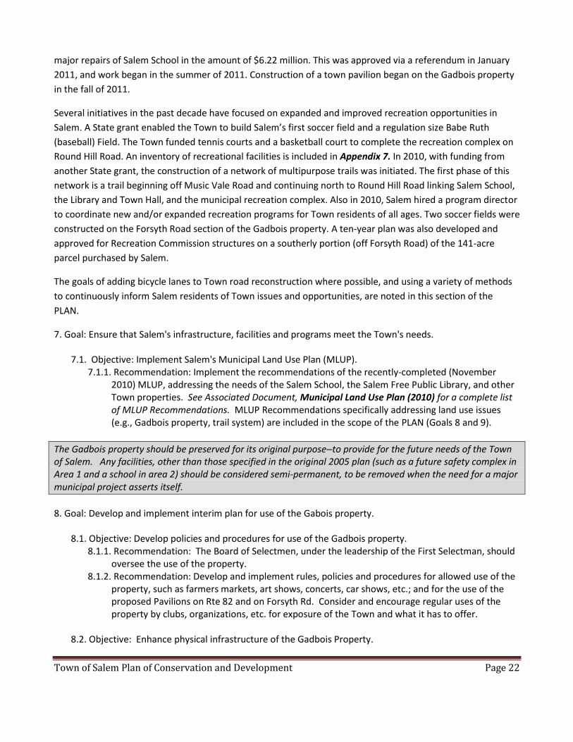
9. Goal: Create a network of multi-purpose trails and pedestrian friendly bike lanes to connect active parts of
Salem and/or other trail systems.
9.1.Objective: Identify and prioritize trails for development 9.1.1. Recommendation: Plan trails connecting major active areas of Salem in accordance with the
Open Space Plan (e.g., School, Town Office Buildings, Library, Recreation Complex, Gadbois Property, Salem Four Corners, Zemko Wildlife Management Area, Gardner Lake).
9.1.2. Recommendation: Explore partnerships with private or public entities (e.g., SLT, TNC) to connect municipal trails to existing or planned trails on private, state, or other public lands.
Salem Multi-Purpose Path, (Harris Brook Trail)
9.2.Objective: Fund prioritized trails.
9.2.1. Recommendation: Pursue grant opportunities for trail planning and construction. 9.2.2. Recommendation: Explore tax incentives for access easements on private property where a trail
connection to Town-owned land or other trails is needed. 9.2.3. Recommendation: Consider using a portion of the “fee in lieu of” funds collected from
subdivisions to be held in account for land purchases or trail construction work. 9.2.4. Recommendation: Consider creating a Memorandum of Understanding (MOU) between the
Town Recreation Committee and a nonprofit entity comprised of volunteers dedicated to the raising of funds for trail maintenance and development.

Town of Salem Plan of Conservation and Development Page 24
9.3. Objective: Review and identify Town roads on which to develop pedestrian-friendly bike lanes. 9.3.1. Recommendation: Solicit input from residents to identify which roads are already used for bike
and pedestrian travel (e.g., Darling Road, White Birch Road, Round Hill Road, Witter Road, Rathbun Hill Road, Buckley Road).
9.3.2. Recommendation: When possible, schedule development of bike lanes to coincide with Public Works road maintenance
9.4. Objective: Educate the public about the Salem Trail System to promote usage.
9.4.1. Recommendation: Print, and have available at various public and private locations, up-to-date maps showing all bike, pedestrian, and hiking trails in Salem.
9.4.2. Recommendation: Post information and map on the Town and School websites, and list trails in state, newspaper, and other media outlets.
In response to the surprisingly large percentage of people answering “don’t know enough to answer the
question,” on multiple questions in the 2009 Town-wide Survey, Salem should improve Town communication
capabilities to keep residents involved and informed.
10. Goal: Improve Town communication capabilities to keep residents involved and informed.
10.1. Objective: Provide opportunities to more effectively inform Town residents about Town issues, upcoming events, and status of various projects and activities throughout Town.
10.1.1. Recommendation: With oversight by the First Selectman’s office, expand use of the existing Town website to provide Town news and information (e.g., upcoming Town events/activities, results of Town elections/referendums, organizations in need of volunteers).
10.1.2. Recommendation: Amend P&Z regulations to allow for construction of a centrally located kiosk (bulletin board) to be used to share information with the public.
10.1.3. Recommendation: P&Z should perform an annual review with accountable entities of the status of PLAN Recommendations.
10.1.4. Recommendation: In each Annual Town Report, publish a list of PLAN Recommendations that were accomplished.
10.1.5. Recommendation: Consider using social media to communicate information about Town events/activities.
10.1.6. Recommendation: Invite and encourage Town residents to enroll in the Town-managed email distribution system which would allow a flow of information from the Town Hall to Salem residents.
11: Goal: Enhance Salem's "green focus" (defined as striving to be environmentally responsible by conserving
energy and using clean renewable energy) to help preserve the environment.
11.1. Objective: Promote sustainable energy use and energy conservation to reduce Salem's carbon
footprint.
11.1.1. Recommendation: Take the Municipal Clean Energy Pledge with Connecticut Clean Energy (to
obtain at least 30 percent of the electricity for all municipal facilities from clean renewable
energy sources by the year 2015), and consider qualifying as a Connecticut Clean Energy

Town of Salem Plan of Conservation and Development Page 25
Community. (Microgrants, marketing toolkits and additional details are available in the “Your
Community” section of www.ctcleanenergy.com).
11.1.2. Recommendation: Consider a campaign to ensure that townspeople know about the
availability of clean energy options for their own residential electricity. If there are Connecticut
Clean Energy incentives (e.g., discounts for municipal solar panels), then consider ensuring the
campaign helps the Town earn the incentives.
11.1.3. Recommendation: Increase energy efficiency of municipal buildings when new
construction/renovations take place.
11.2. Objective: Educate Salem residents on the benefits of going green - for their wallets, for their health,
and, of course, for the health of the planet.
11.2.1. Recommendation: Continue to stress importance of proper hazardous waste disposal, and to
provide information (e.g., on Town website, at recycling center) on how to safely and responsibly
dispose of hazardous items. Develop a list of resources and educational materials to post on
Town website; include information/tips on how to get rid of old paint, electronics, batteries, and
other items not suitable for disposal in trash/recycling containers.
11.2.2: Recommendation: Work cooperatively with other area schools and
environmental/conservation organizations to develop school curricula that stress the
importance of clean energy sources, energy conservation, and proper hazardous waste disposal.
11.2.3. Recommendation: Consider a communication campaign to promote the environmental
benefits of making even small changes to daily life activities, including food choices, reducing
driving time, reusing items, reducing waste, electricity use, etc. This could be through campaigns,
focused on one theme at a time, including inviting speakers to talk at the library, email
campaigns, posters in public places, etc.
Chapter 8: HOUSING Historically, Salem residents have valued the rural character of the Town, with its numerous single-family
homes, its farms and multiple acres of preserved lands. Of 1580 available housing units, 6% (87) are designated
as rental apartments. Lot sizes for the homes range from the smallest of .10 acre (seasonal residential dwelling
near Gardner Lake) to a high of 160 acres. Though the average lot size for homes is 5.24 acres, that number is
misleading, as the mode value for the total number of lots is 1 acre, and the median value is 2 acres. Homes
tend to be mid-level in size, with the average square footage to be about 1900 sq. ft. Apartments average 745
sq. ft in living space.
To date, Salem has been able to exist with neither public water supplies nor public septic systems. Net
Buildable Area Regulations are in place to ensure the adequacy of soils to handle septic drainage issues when
considering new residential construction. Responding to State directives, Salem has begun to address

Town of Salem Plan of Conservation and Development Page 26
stormwater management issues and to explore opportunities to minimize impervious surfaces when
considering new construction projects.
The prosperity and vitality of our community require that affordable housing continue to be available to a
diversified population varied by age, income, work status and preferred size of residence. The challenge is to
encourage more affordable housing opportunities, while ensuring that housing development conforms to
other important community goals including but not limited to:
Preservation of Salem’s rural small-town atmosphere
Managing growth according to the best environmental practices available
Protection of Salem’s environmental assets and natural beauty
Conservation of our agricultural lands
One of the goals of the PLAN is to establish an affordable housing policy initiative to oversee future residential
efforts in Salem, beginning with the identification of a housing “point person”, who:
would be responsible for creating a database to identify existing affordable housing units
would communicate updated knowledge about Affordable Housing State Regulations to appropriate
Town officials
could pursue Federal/State grant programs that would facilitate efforts to balance land use
management with healthy growth opportunities for the Town.
Another of the goals incorporates a number of “Smart Growth Initiatives” in the proposed affordable housing
policy, utilizing the following basic concepts:
Flexibility for mixed land uses
Use of compact building designs
Pathways to connect neighborhoods
Modification of cluster/conservation design subdivision regulations to address density issues
Expanded opportunities for elderly housing through the permitted use of in-law/accessory apartments
12.Goal: Encourage a balance of housing, including affordable housing that is tied to the ability of the land to
support housing development.
12.1. Objective: Develop a proactive, long-range plan to ensure Salem complies with State regulations regarding affordable housing.
12.1.1. Recommendation: Create a database of Salem’s housing stock to identify properties that could qualify as affordable under the State guidelines if and when sold. Information will come from Salem’s Assessor’s data, 2010 Census, etc.
12.1.2. Recommendation: Assign a point person to review current regulations and ensure we remain consistent with State regulations on affordable housing as they may affect Salem and to periodically update appropriate boards and commissions on what qualifies as affordable in Salem.

Town of Salem Plan of Conservation and Development Page 27
12.2. Objective: Encourage affordable housing development. 12.2.1. Recommendation: Amend the zoning and subdivision regulations to allow for density bonuses
or dimensional relief when affordable units are proposed. 12.2.2. Recommendation: Establish a "fast track" championing process that would make it easier for
affordable housing units to be approved in Salem. The process will help expedite the approval process by promoting early dialogue and proactively identifying any potential issues.
13.Goal: Reduce the minimum housing footprint and/or lot size.
13.1. Objective: Review and revise zoning and subdivision regulations to allow more flexibility in housing
opportunities and design choices. 13.1.1. Recommendation: Revise regulations to allow units with square footage requirements of less
than the current 1000 square foot minimum. 13.1.2. Recommendation: Remove from existing regulations the requirement that two-family houses
be located on parcels at least twice the minimum lot size of single-family units in Rural Zones A & B.
13.1.3. Recommendation: Consider adding an option to zoning and subdivision regulations to allow land owners to add accessory apartments to their existing and accessory buildings (where lot size can support this). Accessory apartments can offer alternative living spaces for family members, or they can be rented to other individuals, thus providing an additional income source to owners (especially elderly owners) living on fixed incomes. Current zoning regulations prohibit occupancy of an accessory apartment by other than family members.
13.1.4. Recommendation: Add Mixed Use Development (MXD) Floating zones, thereby permitting a mix of residential densities and/or a mix of residential and non-residential uses.
13.2.Objective: Encourage conservation design subdivisions
13.2.1.Recommendation: Create conservation design zones (regulations should address density, setback, open space requirements, density bonuses, etc.)
13.2.2. Recommendation: Add conservation design options to the sub-division regulations. 13.2.3.Recommendation: Require that a conservation design plan be provided as an alternative option
by all developers proposing subdivisions over a certain size. 13.2.4.Recommendation: Consider zoning and subdivision regulation that would permit a density
bonus for cluster/conservation design subdivisions. 13.2.5.Recommendation: Establish a championing process to expedite the approval process by
promoting early dialogue and proactively identifying any potential issues. Chapter 9: TRANSPORTATION Salem is a sparsely populated suburban community with approximately 4.5 acres per resident. Relatively few
of Salem’s residents work within the boundaries of Salem and hence the majority of residents are dependent
upon transportation to get to and from work. There is, at present, no public transportation or supermarket in
town, so residents are dependent on personal automobiles for both work and major shopping. Therefore,
there is a substantial need for good and well-maintained roads within Salem.

Town of Salem Plan of Conservation and Development Page 28
The town is responsible for over 40 miles of roads that it maintains and plows. To preserve Salem’s rural
character and minimize roadway costs, these roads are mostly narrow and characterized by hills and curves,
with speed limits set at 25 MPH.
The State provides one East/West road through Salem (Route 82) and three North/South roads (Routes 354,
85 and 11), of which only one (Route 85) extends from the northern to the southern border of the town (the
other two serve only the northern half of town). A significant fraction of Salem’s population lives on Route 85
or in cul de sacs off of Route 85. As a result, during peak travel times it is both difficult and dangerous to enter
the Route 85 traffic stream. A roundabout at the intersection of Routes 82 and 85 is planned for completion in
2012. It should improve safety at this dangerous intersection, but it will not reduce projected traffic volumes.
Route 85 is the primary connector between the Hartford region and the New London region. Route 85 is
currently the official emergency evacuation route for the New London/Groton metropolitan area in the event
of a weather, accident or terrorist related emergency.
The recommendations that follow include actions to help preserve the rural character of the community, to
facilitate safe and convenient pedestrian and vehicular circulation within and through Salem, and to complete
Route 11. The completion of Route 11, from its current terminus at Route 82 down to Interstate 95, would
have the effect of separating local and through traffic (through traffic would take Route 11), increase traffic
safety and would provide the means for mass transit bus service from Salem to both New London and
Hartford.
14. Goal: The road network in Salem should provide safe and convenient access to residences, businesses and other destinations while preserving the Town's rural character.
14.1. Objective: Roads should be kept in good condition.
14.1.1.Recommendation: The BOS should periodically update the long range maintenance and improvement plan and schedule for all Town roads.
14.2. Objective: Facilitate pedestrian and vehicular circulation in areas with commercial and municipal activities.
14.2.1. Recommendation: P&Z should require new commercial development to provide pedestrian access to adjacent commercial uses when it is logical that customers will travel between uses.
14.3. Objective: Route 11 and Route 11 Greenway should be completed to alleviate traffic problems along Routes 82 and 85, and to preserve and connect adjacent forest blocks. Completion of Route 11 will also provide an improved emergency evacuation route for natural and terrorist emergencies in the New London/Groton area, and the means for mass transit bus service from Salem to both New London and Hartford.
14.3.1. Recommendation: Continue to apply public pressure to complete Route 11. 14.3.2. Recommendation: Continue to apply public pressure to complete Route 11 Greenway.
14.4.Objective: Existing and future roads should preserve the rural character of the community. 14.4.1. Recommendation: Roadway improvements should not significantly alter the horizontal and
vertical layout of the road or widen the road except where such actions are the only means of addressing a safety issue.
14.4.2. Recommendation: Investigate measures to reduce impervious surfaces and increase infiltration on new roads through a variety of low impact techniques (e.g., use of pervious surfaces, grass median strips, depression in cul de sacs, narrower road widths).

Town of Salem Plan of Conservation and Development Page 29
Chapter 10: SALEM VILLAGE CENTER In 2006, the Planning and Zoning Commission and First Selectman formed a volunteer subcommittee to
develop recommendations for a village center. The subcommittee was asked to answer three questions about
a village center:
1. Where would it be? 2. What would it look like? 3. Would Salem residents like a village center?
The subcommittee, which included a certified planner, held two design charrettes2 to which they invited all
residents of Salem. About 40 to 50 town residents attended each charrette. The subcommittee asked
attendees the questions mentioned above. In general residents have said they would like a village center that
is visually appealing, preserves Salem’s historic character found near the town green, and that offers a place to
gather and meet others.
Salem Herb Farm
The subcommittee synthesized the attendees’ thoughts into design guidelines and proposed regulations, then
submitted the two documents to P&Z.
Examples of suggestions for a future village center included the following:
2 The word charrette refers to a collaborative session in which a group drafts a solution to a design problem. Charrettes take place in many disciplines, including land use planning and urban design. In land use planning, the charrette has become a technique for consulting with all stakeholders in order to integrate diverse attitudes and interests, and promote joint ownership of solutions.

Town of Salem Plan of Conservation and Development Page 30
1. Where would it be?
Attendees did not have strong feelings about the location being in one particular area.
The sub-committee chose to recommend the location most attendees suggested: Rattlesnake Ridge to Music Vale Road, along Route 85. The intent was to allow businesses to develop along this route in a way that would contribute to a village center look and feel, complementing the current town green and National Register Historic District. The attendees liked the idea of the village center developing near municipal and recreational activities.
Over two thirds of Town Wide Survey respondents (69%) said it would be acceptable to allow selective businesses to operate in areas currently designated as residential only.
2. What would it look like? Examples of suggestions include but are not limited to:
Retain the historic look and feel that Salem has near the town green. It would also be visually appealing (including signage) and pedestrian-friendly, with walking paths and pleasant places to sit outside. The majority of Town Wide Survey respondents (82%) said it is acceptable to adopt building appearance standards, as well as adopt regulations that specify permitted uses within the Village Center district (80%).
For mixed-use, multi-story commercial buildings, ensure first floor businesses are businesses that will attract pedestrian activity, for example retail stores and cafes. Residence and professional offices would be permitted on the second floors of commercial buildings.
Slow traffic down on Route 85, the corridor of the Village Center, to increase safety. One way to do this is to give an appearance of the road being more narrow by allowing buildings to be closer to the road than they are today.
3. Would the residents approve?
The charrette attendees said they would approve of a village center if we can help retain our historic look and feel and ensure a visually attractive appearance (including avoiding a strip-mall appearance).
More than half of town-wide survey respondents (60%) said it is important to have a village center; 27% said it is not important.
The village center proposal has not yet been acted on. There are still a number of questions related to the
proposed zone, permitted uses and design standards.
15. Goal: Salem should enable the development of a village center.
15.1. Objective: Ensure actions taken to enable a village center consider the spirit of recommendations
from residents who participated in town charrettes. Examples of recommendations include:
preserving historic character and ensuring visual appeal to provide a pleasant place to gather and
meet others.
15.1.1. Recommendation: P&Z should resolve the pending village center zone determination and
regulations by reviewing and addressing concerns, including mixed use, amount of land required
and design standards.

Town of Salem Plan of Conservation and Development Page 31
Chapter 11: REGIONALISM The last section of the PLAN includes two brief recommendations about sharing costs of services with other
municipalities or agencies in order to obtain savings via economies of scale and/or reductions of administrative
redundancy. A worthwhile idea much in vogue, it is difficult to implement in many situations due to factors
ranging from New England’s history of villages and home rule, to Connecticut’s heavy reliance on property
taxes to fund most municipal services. Nevertheless, efforts must be made to continue to seek the best means
possible to pay for the Town offices and services required. Salem has done so most notably in the contractual
agreement to have Salem students attend secondary school in East Lyme. Other examples include the
agreement for emergency call coverage with other municipalities, and the mutual aid provided by the fire
companies in Salem and nearby towns.
Southeastern Connecticut’s 2007 Regional Plan of Conservation and Development advises that “the essence of
regionalism is that a given population, regardless of town of residence, shares natural and manmade
resources”, and that “the region’s quality of life supersedes home rule practices and municipal boundaries.” At
the same time, this plan notes that the Connecticut tax structure fosters competition among towns for
development and the revenue needed for municipal services. To counter this, some State laws have been
enacted in the past few years to encourage more cooperation and collaboration among towns. Salem, like
most towns, has two municipal bodies, the Board of Education and the Board of Selectmen, chiefly responsible
for its expenditures and contracts. Both have, on occasion, entered into agreements with other towns or
regional agencies for specific services and/or procurements.
16. Goal: Provide or obtain the best possible Town services and/or necessary goods at the most reasonable
cost.
16.1. Objective: Formally adopt the practice of routinely considering collaborations with other municipalities, boards of education, and regional governmental agencies in the process of purchasing services and/or materials for the Salem School District or the Town of Salem General Government, in order to obtain the best value.
16.1.1.Recommendation: The Salem Board of Education should modify policies 3313 to3324 of its Business and Non-Instructional Operations policy section to specify a routine procedure of seeking and considering the benefit of collaborating with other school districts and/or agencies to obtain needed services or goods, before ordering or contracting for same.
16.1.2.Recommendation: The Salem Board of Selectmen should revise the Purchasing Policy for the General Government of Salem to specify a routine procedure of seeking and considering the benefit of collaborating with other towns and/or agencies to obtain needed services or goods, before ordering or contracting for same.

Town of Salem Plan of Conservation and Development Page 32
Chapter 12: STATUTORY AUTHORITY
Summary of requirements from CGS 8-23
Municipalities are required by law to have conservation and development plans. Municipal planning
commissions are required to prepare, or amend, and adopt plans of conservation and development at least
once every 10 years, and to regularly review and maintain the plans.
In preparing the municipal plan, the commission may appoint one or more special committees to develop and
make Recommendations. By statute, there are 10 areas the commission or special committee must consider,
including:
community development action plan of the municipality, if any;
need for affordable housing
need for protection of existing and potential public surface and ground water supplies;
use of cluster development and other development patterns to the extent consistent with soil types, terrain and infrastructure capacity within the municipality;
State Plan of Conservation and Development
Regional Plan of Development
physical, social, economic, and governmental conditions and trends
needs of the municipality including but not limited to human resources, education, health, housing, recreation, social services, public utilities, public protection, transportation and circulation, and cultural and interpersonal communications;
objectives of energy-efficient patterns of development, and the use of solar and other forms of energy and energy conservation
protection and preservation of agriculture
The law also requires the plan to:
be a statement of policies, goals and standards for the physical and economic development of the municipality
provide for a system of principal thoroughfares, parkways, bridges, streets, sidewalks, multipurpose trails, and other public ways as appropriate
be designed to promote, with the greatest efficiency and economy, the coordinated development of the municipality, and the general welfare and prosperity for its people, and identify areas where it is feasible and prudent
recommend the most desirable use of land within the municipality for residential, recreational, commercial, industrial, conservation and other purposes and to include a map showing such proposed land uses
recommend the most desirable density of population in different parts of the municipality
have compact, transit accessible, pedestrian-oriented mixed use development patterns and land reuse
promote such development patterns and land reuse as is consistent with the State's management principles

Town of Salem Plan of Conservation and Development Page 33
Permissive statutory language allows municipal plan Recommendations to address a number of other areas if
desired (e.g., recreation, the general location, relocation and improvement of schools and other public
buildings, plans for open space acquisition and greenways protection and development).
Since 2005, any inconsistencies with the growth management principles contained in the State Conservation
and Development Plan must be noted in the municipal plan, including the principle of integrated planning
across all levels of government to address issues on a local, regional, and state-wide basis.
Acceptance Procedure per CGS 8-23(f)
(f) (1) A plan of conservation and development or any part thereof or amendment thereto prepared by the
commission or any special committee shall be reviewed and may be amended, by the commission prior to
scheduling at least one public hearing.
(2) At least 65 days prior to the public hearing on adoption, the commission shall submit a copy of such plan or
part thereof or amendment thereto for review and comment to the legislative body or, in the case of a
municipality for which the legislative body of the municipality is a town meeting or representative town
meeting, to the board of selectmen. The legislative body or board may hold one or more public hearings on
the plan and must endorse or reject the entire plan, part of the plan, or amendment; it may also submit
comments and recommended changes to the commission.
(3) At least 35 days prior to the public hearing on adoption, the commission shall post the PLAN on the internet
web site of the municipality, if any;
(4) At least 65 days prior to the public hearing on adoption, the commission shall submit a copy of such plan or
part thereof or amendment thereto to the relevant Regional Planning Organization (RPO). The RPO shall
submit an advisory report along with its comments to the commission at or before the hearing. The comments
must include a finding on the consistency of the plan with the Regional Plan of Development and the State
Plan of Conservation and Development and the plans of conservation and development of other municipalities
in the area of operation of the RPO. The commission may revise the plan based on the comments submitted,
although it can also render a decision on the plan without the report of the RPO.
(5) At least 35 days prior to the public hearing on adoption, the commission shall file in the office of the town
clerk a copy of such plan or part thereof or amendment thereto.
(6) The commission shall cause to be published in a newspaper having general circulation in the municipality,
at least twice at intervals of not less than two days, the first not more than 15 days, or less than 10 days, and
the last not less than two days prior to the date of such hearing, notice of the time and place of any such public
hearing. Such notice shall make reference to the filing of such draft plan in the office of the town clerk.
(g)(1) After completion of the public hearing, the commission may revise the plan and may adopt the plan or
part thereof or amendment thereto by single resolution or may, by successive resolutions, adopt parts of the
plan and amendments thereto.

Town of Salem Plan of Conservation and Development Page 34
(2) Any plan, section of a plan or recommendation in the plan that is not endorsed in the report of the
legislative body or, in the case of a municipality for which the legislative body is a town meeting or
representative town meeting, by the board of selectmen, of the municipality may only be adopted by the
commission by a vote of not less than two-thirds of all the members of the commission.
Consistency with the Conservation and Development Policies Plan for Connecticut 2005-2010
Salem's 2011 PLAN has been developed and reviewed with respect to the Regional Plan of Conservation and
Development for Southeastern Connecticut (adopted by Southeastern Connecticut Council of Governments on
Oct. 17, 2007), and the six growth management principles contained in the Conservation and Development
Policies Plan for Connecticut 2005-2010. The following section documents the consistency of the PLAN with
the State's Growth Management principles.
Note: Excerpts from the State's Growth Management principles are highlighted in italics, and are followed by a
summary description of the PLAN recommendations that address them (references to specific PLAN
recommendation are in parentheses).
1. Growth Management Principle # 1: Redevelop and Revitalize Regional Centers and Areas with Existing or Currently Planned Physical Infrastructure
o Provide a broad range of choice among housing types, designs and costs to meet diverse individual family needs for each community in locations convenient to other activities and existing facilities.
o Investigate and develop new design practices and principles that promote sustainable compact urban design and development.
o Utilize greenways to link together residential and recreation areas, schools and community centers, protect existing trail and greenway corridors and encourage new linkages as development occurs.
The Town's PLAN makes recommendations to provide a broader range of housing types (13.1.1-3), encourage
mixed use development (13.1.4), and promote pedestrian activity between active parts of Town (9.1.1-2),
including greenway development (14.3.2).
o Use renewable energy resources, such as solar and photovoltaic systems, hydro, biomass, and wind energy, to the maximum practicable extent.
o Identify efficiency opportunities in each sector and cost effective improvements. o Educate consumers to recognize the life cycle cost saving of energy efficient major purchases.
The Town's PLAN also recommends using renewable energy resources (11.1.1), increasing the energy efficiency of its municipal buildings (11.1.3), and educating consumers to recognize the environmental benefits of energy conservation and other changes to daily life activities (11.1.2; 11.2.2-3).
o Continue to encourage municipalities to develop historic inventory surveys to list homes that are on the State and National Register of Historic Places, and to identify older neighborhoods

Town of Salem Plan of Conservation and Development Page 35
with buildings more than fifty years old that retain architectural integrity and illustrate a period in town history.
o Municipalities should review and enact zoning regulations that are conducive to development of the town center environment.
o Identify and promote cultural and historical attractions.
The Town's PLAN recommends the identification, preservation and promotion of Salem's special historic and
archeological resources (4.1.1-3; 4.4.1; 4.5.1-2)
2. Growth Management Principle # 2: Expand Housing Opportunities and Design Choices To Accommodate a Variety of Household Types and Needs
The Town's PLAN recommends amending land use regulations to encourage the appropriate development of
multi-family (13.1.3), mixed use (13.1.4) and affordable housing (12.2.1-2).
3. Growth Management Principle # 3: Concentrate Development Around Transportation Nodes and Along Major Transportation Corridors to Support the Viability of Transportation Options
o Emphasize clustering of mixed-use, mixed-income development in pedestrian friendly villages to reduce the number of automobile trips, especially in Rural Community Centers where public transportation may not be available.
o Provide a network of pedestrian and bicycle paths and greenways that are safe and provide convenient access to the transit system. Wherever possible, the transit system should try to accommodate bike transport or provide appropriate storage facilities at the station.
o Allow for flexible design standards, context-sensitive design, and traffic calming measures on highways and bridges in Rural Community Centers and Historic Areas when the local desire to slow down traffic, enhance pedestrian safety, and/or preserve community character takes precedence over vehicle throughput.
The Town's PLAN encourages mixed-use development in designated zones (13.1.4); recommends a network of
pedestrian and bicycle paths and greenways (9.1.1-2; 9.2.1-4; 9.3.1-2); and recommends the establishment of
a historic district to slow down traffic on Rte 85 in the village center (4.4.1).
o Complete major transportation projects identified in the Connecticut Master Transportation Plan contingent upon economic feasibility and successful environmental review of benefits and costs, including evaluation of secondary growth impacts induced by the project. Public Act 91-101 requires that major transportation proposals be identified in the Plan of Conservation and Development. Major transportation proposals and projects include:
Route 82/85/11 corridor improvements from Salem to Waterford
The Town's PLAN also strongly supports the completion of Route 11 (14.3.1).
o Incorporate stormwater management techniques in new or reconstructed roadway and bridge projects to provide effective alternatives to diverting collected runoff into water bodies via impervious paved surfaces. Such techniques should address groundwater recharge and

Town of Salem Plan of Conservation and Development Page 36
wetlands impacts associated with potential hazardous materials spills, road salt, removal of vegetated buffers, and erosion and sedimentation.
o Encourage municipalities to implement pavement management programs incorporating natural resource-based stormwater management techniques that reduce the amount of impervious paved surfaces. For example, a system of gravel shoulders and adjacent grassed swales can be substituted for traditional storm sewers, improving filtration of stormwater runoff and protection of watersheds. Encourage municipalities to identify opportunities to retrofit/reduce existing impervious areas.
The Town's PLAN recommends best management practices to address stormwater runoff (1.5.4-5).
4. Growth Management Principle # 4: Conserve and Restore the Natural Environment, Cultural and Historical
Resources, and Traditional Rural Lands o Continued support for state acquisition or state assisted acquisition of open space lands for
natural resource protection to meet the overall statutory goal of preserving 21% of the state’s area, while seeking to define an appropriate resource-based goal for protected acreage;
o Manage public trust lands to ensure their long-term preservation, the viability of their natural ecological processes, and availability to the public.
o Continued development of five-year open space acquisition, recreation, and wildlife development plans as an adequate, comprehensive and balanced schedule for expanding state recreational facilities and for preserving and enhancing management of areas critical for protection of wildlife habitats, water quality, and other natural resources;
o Maintenance and management of critical wildlife habitats, exemplary natural communities, and large forest blocks;
The Town's PLAN recommends the identification and preservation of Salem's most important natural
resources, including watersheds, aquifers, open spaces, wildlife habitats, and large forest blocks, to ensure the
physical health of the natural communities and preserve the quality of life in the Town of Salem (1.12-4; 1.6.1-
4)
o Coordinated expansion of natural resource management programs with other public and private interests concerned with the management of natural, cultural, and historical areas.
The Town's PLAN commits to working with the Eightmile River Wild and Scenic Coordinating Committee in
concert with the Towns of Lyme and East Haddam to review, prioritize and adopt The Eightmile River
Watershed Plan's Tier One Management Tool Recommendations (1.7.1).
o Continued development of trail opportunities for both non-motorized and motorized recreation.
The Town's PLAN recommends a network of pedestrian and bicycle paths and greenways (9.1.1-2; 9.2.1-4;
9.3.1-2)

Town of Salem Plan of Conservation and Development Page 37
o Prime agricultural lands should be maintained for food production to the maximum extent feasible by:
Recognizing prime farmland in regional and municipal plans and regulations and promoting such preservation techniques as the transfer of development rights, use of land trusts and cluster development,
Encourage municipal plans of development that support policies to enhance farm viability and prioritize farmland preservation as an economic development strategy.Label, locally process and cooperatively market locally grown products both in-state and out-of-state, acquire local products in state-run food programs when feasible, and permit local farm retail stands to sell locally grown products
Old Farm Gate
The Town's PLAN supports the preservation of farmland in Salem (2.2.1-2), and the economic viability of farming by encouraging outlets for the sale of regionally and locally grown agricultural products (2.3.1-5). Additionally, the PLAN encourages Town support of the Community Garden Program, where residents can grow their own food.
o Encourage sound stewardship of privately owned forestland through:
education, technical advice and assistance to private landowners in sound management practices;
provision of federal and/or state cost-sharing assistance for forest management where there is a direct public benefit;
provision of tree seedling stock at cost.

Town of Salem Plan of Conservation and Development Page 38
o Assist municipalities in managing such resources as reservoir lands, town forests, and urban street and park trees. Encourage use of licensed arborists, when appropriate, for these activities. Provide specialized assistance to local fire departments in prevention and control of forest fires.
The Town's PLAN encourages stewardship and management plans for privately and Town-owned forest lands
(3.1.1-2; 3.1.3).
o Restore native plant communities where necessary through such methods as eradications or control of invasive plant species.
The Town's PLAN includes several recommendations to control invasive species (1.3.1-3).
o Encourage the protection, restoration and/or enhancement of riparian area resources and waterbodies critical to long-term watershed health.
The Town's PLAN recommends extending the Eightmile River Watershed Plan's Tier One Management Tool
Recommendations to other important watersheds in Salem (1.7.2)
o Continue to identify, interpret, and protect significant archaeological and architectural resources.
o Identify those elements of landscapes and townscapes of special significance or aesthetic noteworthiness and encourage their protection and participate in protection strategies being developed by federal, state, regional, and local interests such as the Quinebaug and Shetucket Rivers Valley National Heritage Corridor.
o Protect significant natural areas, resources and ecological systems in order to protect and enhance the local economy and quality of life;
The Town's PLAN recommends the identification and preservation of Salem's most important natural and
cultural resources, including scenic vistas and landscapes, and historic and archaeological attractions, to
ensure their aesthetic enjoyment by future generations and the continued quality of life in the Town of Salem
(1.1.2-4; 4.1.1-3; 4.4.1; 4.5.1-2).
o Vigorously pursue sewer avoidance programs and limit development to those uses and densities that ensure indefinite functioning of on-lot or small community water supply and waste disposal systems, review zoning regulation and eliminate insufficient lot sizes, assure sufficient oversight of the permitting and maintenance of septic systems to ensure that on-site septic systems function indefinitely, and encourage enactment of local ordinances that require septic tanks to be inspected every three to five years and pumped out as needed;

Town of Salem Plan of Conservation and Development Page 39
The Town’s PLAN strongly recommends a continuation of Salem's current sewer avoidance policy (1.5.6).
5. Growth Management Principle # 5: Protect and Ensure the Integrity of Environmental Assets Critical to Public Health and Safety
o Continue to implement the Aquifer Protection Areas Program to achieve Level A mapping for all existing and potential well fields and to bring into conformance all land uses with state and locally adopted land use regulations. Promote the adoption of model land use regulations and implementation at the local level of aquifer protection programs.
The Town's PLAN recommends the identification of Salem's most important aquifers and the creation of
aquifer protection zones (1.6.1-4)
o As a general density guideline for water supply watersheds, require minimum lot sizes of one dwelling unit per two acres of "buildable” area (excludes wetlands). Consistent with the carrying capacity of the land, encourage cluster-style development to lessen impervious surfaces and avoid development in more sensitive areas.
o Encourage low impact development projects where and when feasible by promoting the integration of site design, planning techniques, and stormwater management practices that conserve natural systems and hydrologic functions on a site.
The Town's PLAN recommends adopting low impact development (LID) policies and guidelines (1.5.4) and best management practices to address stormwater runoff (1.5.5)
o Develop and use renewable energy resources, such as solar (including photovoltaic systems), hydro, wood, and wind energy, to the maximum practicable extent.
o Encourage the use of energy-efficient building materials and techniques for new construction and renovation projects.
The Town's PLAN recommends using renewable energy resources (11.1.1) and increasing the energy efficiency of its municipal buildings when new construction/renovations take place (11.1.3).
o Continue to coordinate area wide one-day household hazardous waste (HHW) collections. Promote consumer education and outreach to encourage the use of safer and less toxic product alternatives.
o Continue education on potential hazards of commonly found toxics and their public health impacts
The Town's PLAN recommends continued education on proper waste disposal, including the development of school curricula (11.2.1-2).
6. Growth Management Principle # 6: Promote Integrated Planning Across All Levels of Government to Address Issues on a Statewide, Regional and Local Basis

Town of Salem Plan of Conservation and Development Page 40
The Regional Plan of Conservation and Development for Southeastern Connecticut (adopted by Southeastern
Connecticut Council of Governments on Oct. 17, 2007) advises that "the essence of regionalism is that a given
population, regardless of town of residence, shares natural and manmade resources."
Salem's Plan recommends collaborating with other towns or regional agencies to obtain needed services or
goods with the greatest efficiency and economy, to obtain the best value and to conserve resources (16.1.1-2).
Music Vale Cemetery

Town of Salem Plan of Conservation and Development Page 41
MAPS
Map 1. Zoning Map

Town of Salem Plan of Conservation and Development Page 42
Map 2. Open Space - "Town of Salem Open Space Parcels"

Town of Salem Plan of Conservation and Development Page 43
Map 3. Farmland Soils
Legend:
Source: NEMO Community Resource Inventory Online, clear.uconn.edu, extracted on October 17, 2011.
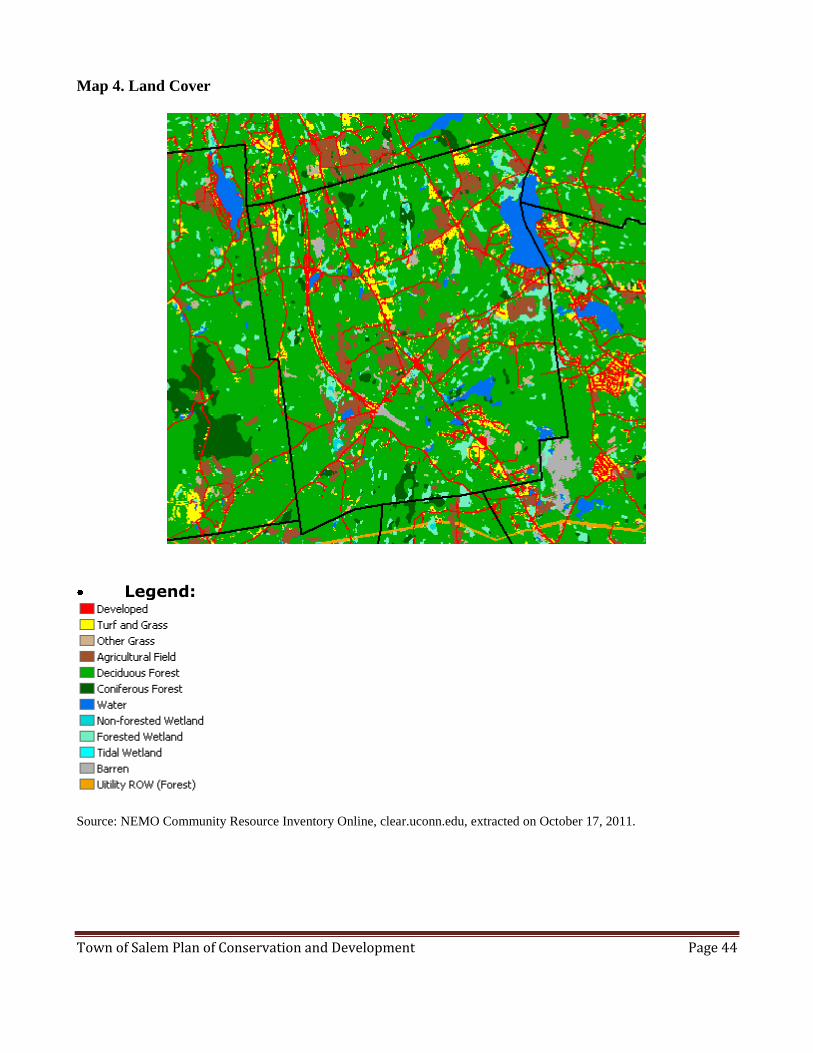
Town of Salem Plan of Conservation and Development Page 44
Map 4. Land Cover
Legend:
Source: NEMO Community Resource Inventory Online, clear.uconn.edu, extracted on October 17, 2011.

Town of Salem Plan of Conservation and Development Page 45
Map 5. Watershed
Legend:
Source: NEMO Community Resource Inventory Online, clear.uconn.edu, extracted on October 17, 2011.

Town of Salem Plan of Conservation and Development Page 46
Map 6. Ground Water Quality
Legend:
Source: NEMO Community Resource Inventory Online, clear.uconn.edu, extracted on October 17, 2011.
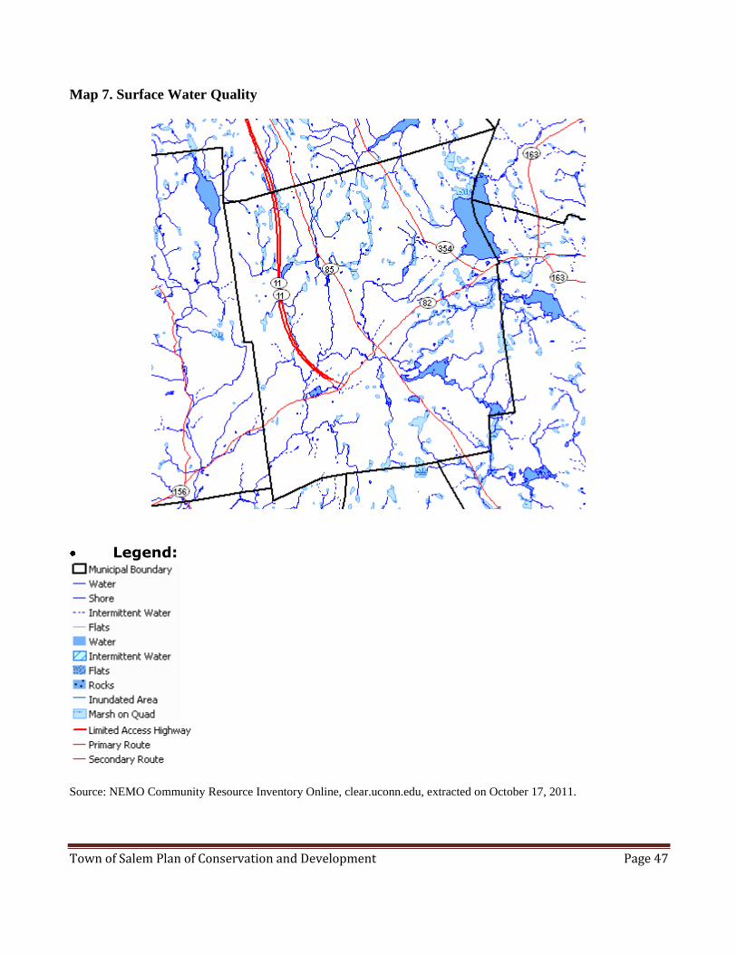
Town of Salem Plan of Conservation and Development Page 47
Map 7. Surface Water Quality
Legend:
Source: NEMO Community Resource Inventory Online, clear.uconn.edu, extracted on October 17, 2011.

Town of Salem Plan of Conservation and Development Page 48
Map 8. Natural Diversity Database Areas
Source: CT DEP

Town of Salem Plan of Conservation and Development Page 49
Map 9. Cemeteries 2011 Update

Town of Salem Plan of Conservation and Development Page 50
Map 10. Inland Wetlands and Watercourses

Town of Salem Plan of Conservation and Development Page 51
Map 11. Flood Zone Areas

Town of Salem Plan of Conservation and Development Page 52
Map 12. P.A. 490 & 10 Mill Rate Forest Land
[Under Development]

Town of Salem Plan of Conservation and Development Page 53
Map 13. Trails-Existing and Proposed

Town of Salem Plan of Conservation and Development Page 54
APPENDICES
Appendix 1: Town-wide Survey - Executive Summary
Survey Background
The townspeople of Salem participated in a town-wide survey from November 11, 2009, through
December 31, 2009. The survey was a collaborative effort by representatives from the Plan of
Conservation and Development Committee (POCD), Vision Committee and the Economic
Development Commission (EDC).
The purpose of the survey was to obtain the thoughts of the townspeople for input into developing the
town vision, updating the Plan of Conservation and Development (POCD), and for Economic
Development planning.
There were 403 taxpayers and voters who took the survey, (366 online, 37 paper), 98% of whom reside
in Salem.
The margin of error is +/- 5% at the 95% confidence level.
Our Community Character
The townspeople who participated in the survey found the following characteristics define our
character (questions C1, C2):
Rural characteristics (92%),
Volunteerism (80%),
Participation in town affairs (78%),
Sense of community (81%), and
History (81%).
Question C3 asked for free-form comments about our community character, “If there are other
elements that you feel contribute to Salem's distinctive community character and that Salem should
cultivate, please describe.”
There were 142 comments that identified the following elements in response to question C3:
20 – Open Space
16 – Small size/location of town
14 – Agriculture - present and past
12 – Quality of school/school community
10 – Small/local business - to be cultivated for convenience and/or tax revenue
9 – Historic buildings or other historic features
9 – Rural character (e.g., Town Center buildings, stone walls)
8 – Lack of commercial footprint
7 – Four Corners - needs to be improved
7 – Natural resources (8-Mile River, forests, fields, clean air, dark skies)
7 – The people who live here (caring/friendly)
7 – Recreational activities
6 – Participation in town events (e.g., Apple Festival)
10 - Other (miscellaneous)

Town of Salem Plan of Conservation and Development Page 55
“Green” Focus: 79% of respondents believe it is important to have a green focus. Elements considered
most important to achieve that focus included (questions C4, C5):
Recycling (92%),
Energy efficient municipal facilities (84%)
Renewable energy sources (79%)
Question C6 asked people for free-form comments on what a “Green” focus means to them, “Please
describe other elements not included above that are necessary for Salem to have a ‘green’ focus.”
There were 109 comments that identified the following elements:
17 – Land preservation/limited development
16 – Only "go green" where it makes sense financially/provides a payback
14 – Recycling (expanded categories, more locations, free pick-up)
9 – Incentives for energy savings
8 – Sustainable energy sources - Town
7 – Walkable/bikeable paths
6 – Education/awareness
5 – Refuse disposal (free pick-up, better enforcement)
4 – Sustainable energy sources - Residential
4 – Pesticide/herbicide avoidance
3 – Energy conservation - Town Facilities
3 – Regulations encouraging "green" focus
3 – Sustainable food sources/farming practices
3 – Complete Rte 11
7 - Other (miscellaneous)
Finance and Education
The majority of respondents said we should neither decrease nor increase our budget spending
(questions FE1, FE3):
Maintain services by maintaining general budget: 77%
Maintain capital expenditures by maintaining the budget: 73%
Question FE2 asked for freeform suggestions, “If you think Salem can increase services without
increasing the budget, please indicate how.”
There were 64 comments that suggested the following strategies: 9 – Regionalize selective services
8 – Increase work process efficiencies
8 – Reduce school administrative costs
8 – Increase volunteerism/donations
6 – Eliminate/reduce selective services
4 – Increase economic development
4 – Pursue grants
4 – Not possible!
3 – Reduce salaries

Town of Salem Plan of Conservation and Development Page 56
3 – Consolidate Fire Departments
2 – Reduce Town energy costs
5 - Other (miscellaneous)
Of respondents who felt they knew enough to respond, the majority said they are satisfied with the
quality of education in the Elementary School (80%), Middle School (78%), and High School (84%).
They also said we should maintain our current quality of education by maintaining the budget
(questions FE5, F6).
Maintain quality of education by maintaining the elementary school education budget (68%)
Maintain quality of education by maintaining the middle school education budget (66%)
Question FE7 asked, “If you think the quality of education can be increased without increasing the
budget, please indicate how.”
There were 105 comments that recommended the following:
32 – Reduce administration /administrators' salaries
10 – More volunteerism
9 – Improve teacher performance (eliminate under-performers, eliminate tenure, improve
hiring/training process)
5 – Increase class size
4 – Reduce/eliminate duplicative staff
3 – Reduce teachers' salaries/renegotiate contracts
2 - Regionalize
2 - Offer early retirement
2 - Charge for supplies/sports/fields trips
20 - Other (miscellaneous)
Additionally, 16 disagreed with the premise that the town can't increase/maintain quality while
reducing the budget.
Government and Infrastructure
Over half of respondents felt all services were important. The most important services were: fire
services (91%), road maintenance 90%), ambulance/EMT (89%), snow removal (86%), police (86%),
Middle/Elementary schools (86%), and the library (82%) (question GIFS3).
Of people who believed they knew enough to comment, the majority were satisfied with most services.
They were most satisfied with services provided by the library (87%), fire services (86%), high school
(84%), snow removal (81%), and ambulance/EMT (81%) (question GIFS4).
Over half of respondents did not know enough to comment on the quality of youth services (excluding
recreation), senior services, health services and visiting nurse (question GIFS4).
Recreation
Over a third (36%) of respondents felt it is a priority or high priority to develop multi-user trails to
connect different areas of town, and to add bike lanes to existing, designated roads (question R1).

Town of Salem Plan of Conservation and Development Page 57
Of those who knew enough to respond, nearly half (47%) believe it is important to increase the number
of programs available for 14 – 20 year olds, and slightly fewer (43%) believe it is important to increase
the number of programs available to younger children (K – 13 years old (Question R4).
Respondents had an opportunity to provide additional thoughts in question R3, “Please describe any
other high priority recreational facilities or activities you would like to see Salem provide.”
84 comments offered the following suggestions:
15 – Trails: hiking/biking
12 – Exercise programs (yoga, fitness, weight)
12 – Swimming (pool, public access to lake)
10 – Community Center
5 – Park
5 – None – enough already!
3 – Dance programs
3 – Open space for events (e.g., Farmers Market)
19 – Other (miscellaneous)
Gadbois Property: Over half of respondents felt the Gadbois property should be used for trails, open-
air public events such as festivals, open space, and farmers markets (question R5).
Question R6 asked for freeform responses to, “What other purpose not included above do you think
Salem should use the Gadbois property for?”
The 91 freeform comments identified the following uses:
26 – Recreation:
Walking/fitness trails
Swimming
Cross county skiing
Multi-purpose
Athletic fields
Dog park
Horse park
22 – Revenue stream
6 – Open air events (fairs, tag sales)
5 – Housing (Senior, ARD)
5 – Hunting
4 – Agriculture
3 – No hunting
3 – Community Center
3 – Village Center
14 – Other (miscellaneous)
Town of Salem Plan of Conservation and Development Page 58
Economic Development
The majority of respondents (85%) said it is important to expand our commercial tax base, presuming
compatibility with our community (question ED2).
To achieve this, over half felt many types of businesses could be encouraged in Salem, primarily
family restaurants, businesses with a green focus, a grocer, a drug store, and agriculture (question
ED4).
Question ED5 gave respondents the opportunity to provide freeform responses to the following
question, “Which other types of business should be encouraged or discouraged?”
84 Comments encouraged the following:
8 – Offices - professional
6 – Entertainment (movie house or theatre)
6 – Grocery store (mainly specialty)
6 – Retail shops - specialty/destination
5 – Coffee shops/cafe
5 – Recreation/tourism focus
3 -- Distribution/warehousing
3 -- Drugstore
3 – Technology focus
3 – Equestrian
3 – Hunting lodge/preserve
3 – Fast Food
3 – Hospitality (B&B, small hotel)
27 – Other (miscellaneous)
22 Comments discouraged the following:
9 – Alcohol/tobacco/tattoos/adult entertainment
5 – Anything that generated pollution (noise, traffic, air/water pollution)
3 – Box stores
5 – Other (miscellaneous)
In addition, 9 comments stated that 4 Corners needed to be improved/cleaned up, and 2
expressed disagreement with the premise that more business could reduce residential taxes.
If we do not expand our commercial tax base, fewer than a third (28%) said it is acceptable to reduce
services and only 24% said it would acceptable to raise taxes at a rate required to support town
expenses (question ED 6).
Question ED7 asked for ideas to raise revenue, “If you indicated it would be acceptable to pursue
other methods of raising revenue, please describe those methods.”
There were 88 comments that proposed the following methods:
8 – Sell Town Resources
8 – Reduce cost (e.g., limit residential development)
8 – Charge to use town assets
6 – More business in general
4 – Seek state resource support
4 – Seek professional help

Town of Salem Plan of Conservation and Development Page 59
If we do expand our commercial tax base, 72% of respondents said it would be acceptable to adopt
design regulations to create a visually attractive area for businesses (question ED 8).
Also, over half of respondents said it would be acceptable to provide short-term tax incentives (64%),
obtain professional assistance to market Salem to attract targeted businesses (61%), and revise zoning
to allow more commercial use and mixed use (62%) (question ED8).
Question ED9 asked, “If the town does expand its commercial base, what other actions not mentioned
above would be acceptable or unacceptable to you?”
There were 64 comments that suggested the following:
6 – Ensure visual appeal
5 – More cooperative P&Z
5 – Improve/clean up 4 Corners
4 – Enforce regulations (e.g., signs)
4 – No development/preserve open space
3 – Develop business around Rte 11
3 – Prevent tax cut incentive risk (i.e., business leaves after tax incentive is over)
3 – Make it difficult for less desirable businesses to come to Salem
31 - Other (miscellaneous)
Housing
Only 31% of respondents said we should increase the choice of housing in our town (e.g., mixed
income, multi-family) (question H2).
However, if Salem were to increase the choice of housing available, the top two types of housing we
should encourage would be Senior Housing (60%), Age-Restricted housing (56%) (question H3).
Village Center
Over half of respondents, 60%, believe it is important to have a village center, while 27% believe it is
not important. Others said they have no opinion or were neutral on this topic. (Question VC1)
The majority of respondents (82%) said it is acceptable to adopt building appearance standards, as well
as adopt regulations that specify permitted uses within the Village Center district (80%) (question
VC4).
Over two thirds of respondents (69%) said it would be acceptable to allow selective businesses to
operate in areas currently designated as residential only (question VC4).
Respondents were able to provide freeform comments in question VC3, “What other elements not
mentioned above should be part of it”?
75 comments suggested the following elements:
6 – Pedestrian/bicycle access (for safety/convenience)
6 – Offices - professional!
5 – Drugstore
4 – Grocery store

Town of Salem Plan of Conservation and Development Page 60
3 – Parking
3 – Recreation (indoor)
3 – Retail shops emphasizing convenience/practical shopping
28 – Other (miscellaneous)
Additionally, 5 comments stressed that there should be no cost to townspeople; 4 stated that 4
Corners needed to be improved/cleaned up, 4 disagreed with proposed location on Rte 85 between
Rattlesnake Ledge and Music Vale Road, and 3 did not feel that a New England Village look was
important.
Natural Resources
The majority of townspeople believe it is important to protect our natural resources (77% - 92%
depending on the resource) (question NR2).
Almost two thirds of respondents (64%) said it would be acceptable to amend zoning regulations to
further protect our natural resources during the site planning and subdivision process, while 16% said
this would be unacceptable (question NR2).
Respondents had the opportunity to provide freeform comments in question NR4, “In acting to
preserve Salem's natural resources, what other actions not mentioned above would be acceptable to
you to?”
46 comments suggested the following actions:
4 – Fund open space (have town buy land, charge developers a per lot fee)
3 – Educate
3 – Complete Rte 11
2 – Benchmark best practices
2 – Cluster/conservation design
2 – Limit commercial development
21 – Other
9 responses stressed the need to balance any preservation efforts with the need for economic
development, and spoke against adding new regulations, or protecting any more land.
Historic and Archeological Resources
At least half of respondents believe it is important to preserve Historic and Archeological resources,
with the most people believing it is important to protect ancient cemeteries (81%), buildings on the
historic register (78%), scenic roads (75%), and visible stone walls (74%) (question HAR2).
Over half of respondents (59%) said it would be acceptable to limit activity near these resources to
protect them (question HAR 3).
Regionalism
Of various areas where we could partner with nearby towns, respondents felt the following were the
most important: Police (85%), High School (85%), Emergency medical Services (84%), and Fire
protection (84%) (question RE1).
Town of Salem Plan of Conservation and Development Page 61
Over two thirds of respondents said they would agree to partner with another town, depending on the
money saved (69%) and amount of control we would share (67%) (question RE2).
Other
Of people who moved to Salem, 59% moved here because of the rural character, 41% said it was
because of the local beauty, and 34% said it was because of the school system (question OTH1).
We asked for other reasons people moved to Salem in question OTH1, “Other, please specify [Why
did you move to Salem?]”
181 comments identified the following reasons:
33 – Family (born here, family here, married Salem resident)
30 – Job/job opportunities (proximity to)
24 – House/property we liked
23 – House/property was affordable
19 – Location (central, good access)
15 – Natural resources/rural character (Lakes, no pollution or sprawl)
12 – School system (primarily High School)
9 – Amount of land available/lot size
6 – Town/community/area we liked
10 – Other (miscellaneous)
Over half of respondents said they do not plan to leave (54%). The top three reasons for staying are:
rural character (72%), beauty of the area (65%), people and sense of community (49%) (question
OTH2).
We asked for other reasons people are staying in Salem in question OTH5, “Other, please specify
reason [Why are you staying in Salem?]”
68 comments identified the following reasons:
18 – Family/roots are here
15 – Like our home/property; feel like we belong here
9 – Location (convenient, central access to recreation/services)
8 – Natural Resources (Gardner Lake, wildlife, night sky)
7 – Job is here
11 - Other (miscellaneous reasons)
Only 16% said they plan to leave. The top reason for leaving is that taxes are increasing too fast (56%),
the next most common reason was that there are not enough local shopping and other conveniences
(28%).
Respondents had the opportunity to provide additional reasons they plan to leave. Following are their
responses to question OTH4, “Other, please specify reason [If you plan to leave Salem, why are you
leaving]”
38 comments identified the following reasons:
12 – Too expensive (local/state taxes, cost of living)
7 – Lack of conveniences/necessities
4 – Job opportunities/transfer

Town of Salem Plan of Conservation and Development Page 62
3 – Climate
2 – Commercial development taking over
2 – Too much work to maintain property
8 – Other (miscellaneous reasons)
Fewer than one third of respondents currently have a child in the Salem school system, elementary,
middle, or high school (29%), while about half (52%) have had a child in the Salem school system
(question DE4 and DE5).
Survey Respondent Demographics
Age group Count (% of total)
No age given 34 (8.3%)
< 34 yrs old 40 (9.9%)
35 - 44 70 (17.4%)
45 - 54 91 (22.6%)
55 - 64 100 (24.8%)
65 - 74 55 (13.6%)
75 - 88 13 (3.2%)
Total 403 (100%)

Town of Salem Plan of Conservation and Development Page 63
Appendix 2: Checklist of Town Entities Responsible for Implementing the Recommendations
POCD Element Proposed Responsibility
Goal Obj Rec Topic/Description BOS P&Z IWCC Town Plnr EDC REC BOF
Public Works Other
Natural Resources
1 1.1 1.1.1
Investigate feasibility of creating separate Conservation Commission X
1 1.1 1.1.2 Identify special Natural Resources in database CC
1 1.1 1.1.3 Create map identifying location of special NRs CC
1 1.1 1.1.4
Require all special NRs be shown on plans so impact can be evaluated and minimized
X
1 1.2 1.2.1
Proactively make Salem attractive to low impact developers Exp.
Expand role
1 1.2 1.2.2 Resource to support proactive dev planning process
Exp. Expand role
1 1.3 1.3.1 Create Municipal list of invasive species CC
1 1.3 1.3.2
Encourage local nurseries to avoid selling invasive species on Municipal list
CC
1 1.3 1.3.3
Adopt policy to prohibit town from purchasing/planting inv species
X X
1 1.4 1.4.1 Develop school curricula re: NR protection SLT
1 1.4 1.4.2 Develop list of resources/education materials for town website CC
1 1.5 1.5.1 Strengthen authority to impose fines for IW violations X
1 1.5 1.5.2 Apply 8-Mile RCOZ to all watersheds and watercourses
X
1 1.5 1.5.3
Develop Tri-town Mgmt Plan to protect Gardner Lake water quality
X
1 1.5 1.5.4
Develop best management practices to address storm water runoff
CC
1 1.5 1.5.5
Develop Low Impact Development policies and guidelines consistent with EPA/DEEP Small Municipal Separate Storm Sewer Systems requirements X X
1 1.5 1.5.6 Continue current policy of municipal sewer avoidance X
1 1.6 1.6.1 Create map identifying most significant aquifer areas
Exp. Expand role
1 1.6 1.6.2 Educate town re: importance of aquifer protection CC
1 1.6 1.6.3 Create aquifer protection overlay zones X
1 1.6 1.6.4
Adopt aquifer protection ordinance guided by CT DEEP model
X
1 1.7 1.7.1 Review and prioritize Tier 1 and Tier 2 tools and work to complete adoption X
1 1.7 1.7.2 Evaluate Eightmile River Watershed Mgmt tools for use in other watersheds X X

Town of Salem Plan of Conservation and Development Page 64
POCD Element Proposed Responsibility
Goal Obj Rec Topic/Description BOS P&Z IWCC Town Plnr EDC REC BOF
Public Works Other
Agriculture
2 2.1 2.1.1 Review Agri Floating Zone regs to ensure support of agriculture X
2 2.1 2.1.2 Encourage farmers to follow USDA best practices CC Exp.
Expand role
2 2.2 2.2.1 Inventory PA490 Farmland and update in NRI CC
2 2.2 2.2.2 Encourage farmers to preserve farmland SLT
2 2.3 2.3.1 Include farming and associated activities in EDC Plan X
2 2.3 2.3.2 Support farming activities such as CSAs X
2 2.3 2.3.3 Evaluate feasibility of weekly farmers’ market X
2 2.3 2.3.4 Identify types of farming activities that should be encouraged X CC2
2 2.3 2.3.5 Continue Town support of Community Garden program X
Forestry
3 3.1 3.1.1 Encourage dev of professional Forest stewardship plan X Exp.
Expand Role
3 3.1 3.1.2 Educate landowners re: commercial logging regs X X
3 3.1 3.1.3 Develop Forest Mgmt plan for town owned forest land X
Need to hire a licensed Forester
3 3.1 3.1.4 Adopt forestry regulations (when completed by CT DEEP) X
Historic and Arch Resources
4 4.1 4.1.1 Identify special Hist &Arch Resources in database CC
4 4.1 4.1.2 Create map identifying location of special H & A Resources CC
4 4.1 4.1.3 Require special H & A Resources to be shown on development plans X
4 4.2 4.2.1 Deed cemeteries within proposed sub-div to Town X X
4 4.2 4.2.2 Initiate regular maintenance plan for cemeteries … X X
4 4.3 4.3.1 Designate appropriate candidates as scenic roads X X
4 4.4 4.4.1 Erect "National Historic District" signage on Rte 85 X
4 4.5 4.5.1 Develop educational materials and sponsor events about H &A Resources X
Historical Society, CC, Library
4 4.5 4.5.2 Display Salem historic memorabilia X
Historical Society, CC, Library

Town of Salem Plan of Conservation and Development Page 65
POCD Element Proposed Responsibility
Goal Obj Rec Topic/Description BOS P&Z IWCC
Town Planner EDC REC BOF
Public Works Other
Economic Development
5 5.1 5.1.1
Develop methodology and tools to evaluate ED opportunities for Salem
X
5 5.1 5.1.2
Develop and implement business championing process for targeted businesses
X Exp. X Expand role
5 5.1 5.1.3
Resource to support business championing process
Exp. Expand role
5 5.2 5.2.1
Review regs to identify potential obstacles for community-fit businesses
Exp. X Expand role
5 5.2 5.2.2
Review Town regs to identify potential obstacles; create tip sheet to facilitate approval process
Exp. X Expand role
5 5.3 5.3.1 Identify target markets (industries/businesses to attract) X
5 5.3 5.3.2
Develop and implement marketing plan to attract desired businesses
X
6 6.1 6.1.1 Implement short term projects to rejuvenate 4 Cors X
6 6.1 6.1.2
Implement long term projects for future economic use of 4 Cors
X
6 6.2 6.2.1
Implement specific initiatives to support local businesses
X
6 6.2 6.2.2
Identify and communicate funding sources available to local business, and continue to provide business-oriented seminars Exp. X
Expand role
Municipal Facilities, Land and Services
7 7.1 7.1.1 Implement MLUP recommendations See MLUP
8 8.1 8.1.1 Establish BOS oversight of Gadbois property X
8 8.1 8.1.2 Develop and implement rules, policies and procedures for use of Gadbois property X
8 8.2 8.2.1 Implement Salem Rec Commission 10-yr plan for Forsyth Rd. site X
8 8.2 8.2.2 Allow non-perm structures to facilitate enjoyment of property X X
9 9.1 9.1.1 Plan trails to connect various active parts of town X SLT
9 9.1 9.1.2 Explore partnerships with private/public entities to connect trails X SLT
9 9.2 9.2.1 Pursue grant opportunities for trail planning/construction Exp. X
Expand role
9 9.2 9.2.2 Explore tax incentives for trail access easements on private land X X
9 9.2 9.2.3 Consider using a portion of "fee in lieu of" funds for trail work X
9 9.2 9.2.4 Consider creating a MOU between Rec Commission and non profit entity to raise funds for trails X
9 9.3 9.3.1 Solicit input to identify candidates for roadside bike paths X
9 9.3 9.3.2 Schedule bike path construction to coincide with Public Works road maintenance X X X X

Town of Salem Plan of Conservation and Development Page 66
POCD Element Proposed Accountability
Goal Obj Rec Topic/Description BOS P&Z IWCC Town
Planner EDC REC BOF Public Works Other
9 9.4 9.4.1 Make available maps with all bike, pedestrian and hiking paths X X
9 9.4 9.4.2 Post trail information and map on Town and School website; and list trails in various other media outlets X
10 10 10.1.
1 Expand use of existing Website to provide Town news and info X
10 10 10.1.
2 Amend regulations to allow for construction of Kiosk (bulletin bd) X
10 10 10.1.
3 Conduct annual meeting to review status of recommendations X
10 10 10.1.
4 In Annual Report, publish status of POCD recommendations X
10 10 10.1.
5 Consider using social media to communicate Town info X
10 10 10.1.
6 Encourage town residents to enroll in town-managed email distribution X
11 11 11.1.
1 Take Municipal clean energy pledge X
11 11 11.1.
2 Consider campaign to ensure townspeople know about availability of clean energy options TBD
11 11 11.1.
3 Increase energy efficiency of municipal buildings when new construction/renovations take place X
11 11 11.2.
1
Continue to stress importance of proper hazardous waste disposal; … develop list of resources and educational materials… X
11 11 11.2.
2
Work cooperatively with area schools and environmental/conservation orgs to develop school curricula CC
11 11 11.2.
3 Consider communicating environmental benefits of making even small changes to daily life activities… TBD

Town of Salem Plan of Conservation and Development Page 67
POCD Element Proposed Accountability
Goal Obj Rec Topic/Description BOS P&Z IWCC Town
Planner EDC REC BOF Public Works Other
Housing
12 12 12.1.1
Create database of housing stock to identify affordable housing
Exp. Expand Role
12 12 12.1.2
Assign point person to review current regs for consistency with State regs on affordable housing; periodically update Boards & Commissions on status X
BOS should assign
12 12 12.2.1
Amend regs to grant density bonus/dimensional relief for afford housing
X
12 12 12.2.2
Establish "fast track" championing process for affordable housing
Exp. Expand Role
13 13 13.1.1
Revise regulations to allow housing units < 1,000 sq ft min
X
13 13 13.1.2
Remove from existing regs the requirement that two-family houses be located on parcels at least twice the minimum lot size of single family units in RA & RB X
13 13 13.1.3
Consider adding an option to Zoning and subdivision regs to allow owners to add on accessory apts to existing buildings X
13 13 13.1.4 Add Mixed Use Development (MXD) Floating zones X
13 13 13.2.1 Create Cluster Overlay zones X
13 13 13.2.2
Add cluster/conservation development options to the sub-division regs
X
13 13 13.2.3
Require that a cluster/conservation design plan be provided as an alternative option for sub-divisions over a certain size X
13 13 13.2.4
Consider a density bonus for cluster/conservation design subdivisions
X
13 13 13.2.5
Establish "fast track" championing process for cluster/conservation subdivisions
Exp. Expand Role
Transportation
14 14 14.1.1
Periodically update long range maintenance and improvement plan for Town roads
X X
14 14 14.2.1
Require new commercial dev to provide pedestrian access…
X
14 14 14.3.1 Apply public pressure to complete Route 11 X TBD
14 14 14.3.2 Apply public pressure to complete Route 11 Greenway X TBD
14 14 14.4.1
Roadway improvements should not significantly alter [rural character] of roads
X
14 14 14.4.2
Investigate measures to reduce impervious surfaces on roads
X
Salem Village Center
15 15 15.1.1 Resolve pending village center zone determination and regulations X
Regionalism
16 16 16.1.1 Modify BOE policies to seek reg'l solution for goods and services BOE
16 16 16.1.2 Modify BOS policies to seek reg'l solution for goods and services X

Town of Salem Plan of Conservation and Development Page 68
Appendix 3: Connecticut Invasive Plant List, October 2011
Connecticut Invasive Plants Council
Statement to accompany list -- January 2004: This is a list of species that have been determined by floristic analysis to be
invasive or potentially invasive in the state of Connecticut, in accordance with PA 03-136. The Invasive Plants Council will
generate a second list recommending restrictions on some of these plants. In developing the second list and particular
restrictions, the Council will recognize the need to balance the detrimental effects of invasive plants with the agricultural
and horticultural value of some of these plants, while still protecting the state's minimally managed habitats.
In May 2004, Public Act 04-203 banned a subset of the January 2004 list, making it illegal to move, sell, purchase,
transplant, cultivate or distribute banned plants. Effective July 1, 2009, Public Act 09-52 removed the ban on Pistia
stratiotes.
Explanation of symbols after Common Name:
(P) indicates Potentially Invasive (all other plants listed are considered Invasive in Connecticut)
* denotes that the species, although shown by scientific evaluation to be invasive, has cultivars that have not been
evaluated for invasive characteristics. Further research may determine whether or not individual cultivars are
potentially invasive. Cultivars are commercially available selections of a plant species that have been bred or
selected for predictable, desirable attributes of horticultural value such as form (dwarf or weeping forms), foliage
(variegated or colorful leaves), or flowering attributes (enhanced flower color or size).
^ indicates species that are not currently known to be naturalized in Connecticut but would likely become invasive
here if they are found to persist in the state without cultivation
@ column indicates growth form or habitat: A = Aquatic & Wetland; G = Grass & Grass-like; H = Herbaceous; S = Shrub;
T = Tree; V = Woody Vine
BAN column indicates prohibited status: Y=banned under CT Gen. Stat. 22a-381d, N/A= not banned
COMMON NAME @ SCIENTIFIC NAME SYNONYMS BAN
American water lotus (P) A Nelumbo lutea (Willd.) Pers. American water lotus Y Amur honeysuckle S Lonicera maackii (Rupr.) Herder Y Amur maple (P) T Acer ginnala L. N/A Autumn olive S Elaeagnus umbellata Thunb. Y Belle honeysuckle S Lonicera x bella Zabel Bell's honeysuckle
(misapplied) Y
Bittersweet nightshade (P) H Solanum dulcamara L. Climbing nightshade Y Black locust* T Robinia pseudo-acacia L. N/A Black swallow-wort H Cynanchum louiseae Kartesz &
Ghandi
Cynanchum nigrum; Vincetoxicum nigrum
Y
Border privet (P) S Ligustrum obtusifolium Sieb. & Zucc.
Y
Brazilian water-weed (P) A Egeria densa Planchon Anacharis; Egeria Y Bristled knotweed H Polygonum caespitosum Blume Persicaria longiseta;
Oriental lady's thumb Y
Brittle water-nymph (P) A Najas minor All. Eutrophic water-nymph Y California privet (P) S Ligustrum ovalifolium Hassk. N/A Canada bluegrass (P) G Poa compressa L. Y Canada thistle (P) H Cirsium arvense (L.) Scop. Y Coltsfoot H Tussilago farfara L. Y Common barberry S Berberis vulgaris L. Y Common buckthorn S Rhamnus cathartica L. Y Common kochia (P) H Bassia scoparia (L.) A.J. Scott Kochia scoparia; Fireweed;
Summer cypress Y
Common reed G Phragmites australis (Cav.) Trin.
ex Steud. Phragmites Y
Common water-hyacinth^ (P)
A Eichhornia crassipes (Mart.) Solms
N/A

Town of Salem Plan of Conservation and Development Page 69
COMMON NAME @ SCIENTIFIC NAME SYNONYMS BAN
Crested late-summer mint (P)
H Elsholtzia ciliata (Thunb.)
Hylander Elsholtzia Y
Crispy-leaved pondweed A Potamogeton crispus L. Curly pondweed or Curly-leaved pondweed
Y
Cup plant (P) H Silphium perfoliatum L. Y Cypress spurge (P) H Euphorbia cyparissias L. Y Dame's rocket H Hesperis matronalis L. Y Drooping brome-grass (P) G Bromus tectorum L. Cheatgrass Y Dwarf honeysuckle^ (P) S Lonicera xylosteum L. European fly-honeysuckle Y Eulalia* (P) G Miscanthus sinensis Andersson Chinese or Japanese
silvergrass N/A
Eurasian watermilfoil A Myriophyllum spicatum L. Y European privet (P) S Ligustrum vulgare L. N/A European waterclover (P) A Marsilea quadrifolia L. Water shamrock Y False indigo (P) S Amorpha fruticosa L. Y Fanwort A Cabomba caroliniana A. Gray Y Fig buttercup H Ranunculus ficaria L. Lesser celandine; Ficaria
verna Y
Flowering rush (P) A Butomus umbellatus L. Y Forget-me-not A Myosotis scorpioides L. True forget-me-not; Water
scorpion-grass Y
Garden heliotrope (P) H Valeriana officinalis L. Valerian Y Garden loosestrife* (P) H Lysimachia vulgaris L. Y Garlic mustard H Alliaria petiolata (M. Bieb.) Cavara
& Grande Y
Giant hogweed (P) H Heracleum mantegazzianum (Sommier & Lavier)
Y
Giant knotweed (P) H Polygonum sachalinense F.
Schmidt ex. Maxim.
Fallopia sachalinense Y
Giant salvinia^ (P) A Salvinia molesta Mitchell Y Glossy buckthorn S Frangula alnus Mill. Rhamnus frangula;
European buckthorn N/A
Goutweed H Aegopodium podagraria L. Y Ground ivy (P) H Glechoma hederacea L. Gill-over-the-ground; Run-
away robin Y
Hairy jointgrass (P) G Arthraxon hispidus (Thunb.) Makino
Small carpgrass Y
Hydrilla A Hydrilla verticillata (L.f.) Royle Y Japanese barberry* S Berberis thunbergii DC. N/A Japanese honeysuckle* V Lonicera japonica Thunb. Y Japanese hops (P) H Humulus japonicus Sieb. &
Zucc. Y
Japanese knotweed H Polygonum cuspidatum Siebold & Zucc.
Fallopia japonica Y
Japanese sedge^ (P) G Carex kobomugi Owhi Y Japanese stilt grass G Microstegium vimineum (Trin.)
A. Camus Y
Jimsonweed (P) H Datura stramonium L. Y Kudzu (P) V Pueraria montana (Lour.) Merr. Pueraria lobata Y Leafy spurge H Euphorbia esula L. Y Mile-a-minute vine H Polygonum perfoliatum L. Persicaria perfoliata Y Moneywort* (P) H Lysimachia nummularia L. Creeping jenny N/A Morrow's honeysuckle S Lonicera morrowii A. Gray Y Multiflora rose S Rosa multiflora Thunb. Y Narrowleaf bittercress H Cardamine impatiensL. Y Norway maple* T Acer platanoides L. N/A Onerow yellowcress (P) A Nasturtium microphyllum (Boenn.
ex. Rchb.) Rorippa microphylla Y
Oriental bittersweet V Celastrus orbiculatus Thunb. Asiatic bittersweet Y Ornamental jewelweed (P) H Impatiens glandulifera Royle Tall impatiens Y Pale swallow-wort H Cynanchum rossicum (Kleo.) Vincetoxicum rossicum Y

Town of Salem Plan of Conservation and Development Page 70
COMMON NAME @ SCIENTIFIC NAME SYNONYMS BAN
Borhidi Parrotfeather (P) A Myriophyllum aquaticum (Vell.)
Verdc. Y
Perennial pepperweed H Lepidium latifolium L. Tall pepperwort Y Pond water-starwort (P) A Callitriche stagnalis Scop. Y Porcelainberry* V Ampelopsis brevipedunculata
(Maxim.) Trautv.
N/A
Princess tree (P) T Paulownia tomentosa (Thunb.)
Siebold & Zucc. ex Steud.
Empress-tree Y
Purple loosestrife A Lythrum salicaria L. Y Ragged robin (P) H Lychnis flos-cuculi L. Y Reed canary grass G Phalaris arundinacea L. N/A Reed mannagrass^ (P) G Glyceria maxima (Hartm.)
Holmb. Tall mannagrass Y
Rugosa rose* (P) S Rosa rugosa Thunb.* Beach, Salt spray, Japanese, or Ramanas Rose
N/A
Russian olive (P) S Elaeagnus angustifolia L. Y Scotch thistle (P) H Onopordum acanthium L. Y Sheep sorrel (P) H Rumex acetosella L. Y Slender snake cotton H Froelichia gracilis (Hook.) Moq. Cottonweed Y Spotted knapweed H Centaurea stoebe (L.) Centaurea biebersteinii;
Centaurea maculosa Y
Star-of-Bethelehem (P) H Ornithogalum umbellatum L. N/A Sycamore maple (P) T Acer pseudoplatanus L. Y Tansy ragwort^ (P) H Senecio jacobaea L. Stinking Willie Y Tatarian honeysuckle (P) S Lonicera tatarica L. Y Tree of heaven T Ailanthus altissima (Mill.)
Swingle Y
Variable-leaf watermilfoil A Myriophyllum heterophyllum Michx.
Y
Water chestnut A Trapa natans L. Y Water lettuce^ (P) A Pistia stratiotes L. N/A Watercress (P) A Nasturtium officinale W.T. Aiton Rorippa nasturtium-
aquaticum Y
White poplar (P) T Populus alba L. Y Wineberry S Rubus phoenicolasius Maxim. Y Winged euonymus* S Euonymus alatus (Thunb.) Sieb. Burning bush N/A Yellow floating heart (P) A Nymphoides peltata (S.G.
Gmel.) Kuntze Y
Yellow iris A Iris pseudacorus L. Yellow flag iris Y
Source: Connecticut Invasive Plant Working Group, University of Connecticut, Copied on November 20, 2011.
http://www.hort.uconn.edu/cipwg/pdfs/CTInvasivePlantList2011-CommonName.pdf

Town of Salem Plan of Conservation and Development Page 71
Appendix 4: Eightmile River Watershed Management Plan - Summary of Tier One and Tier
Two Tools
Note: Status of implementing each recommended Eightmile River Watershed Management
Plan tool in Salem is included (in bold italics) following the recommended action.
Tier One Management Tools
1) Riparian Corridor Protection - Riparian corridor lands, those lands adjacent to rivers and
streams, are the first line of defense for a river system. Maintaining and protecting these areas in a
natural native condition is the most important action that can take place to ensure the long-term quality
of river and watershed resources.
Recommended Action: To protect riparian corridor function adopt a River Protection Overlay
Zone for all perennial streams and rivers in the Eightmile River Watershed that provides a 50 foot
protection area along small headwater streams, and a 100 foot protection area along larger streams.
(Riparian Corridor Overlay Zone regulations consistent with this action were adopted in November
2007- see Appendix 5)
2) Habitat Fragmentation - Habitat size directly effects species distribution, migration and
population size, and is critical for maintaining overall biological diversity and ecosystem functions.
Fragmentation of habitat occurs when a large region of habitat has been split into a collection of
smaller patches. For example, a forest habitat may become fragmented when a road is built across it
splitting it into two smaller disconnected patches. Fragmentation can cause, among other things: a
reduction of total habitat area; vulnerability for species forced to migrate to other habitat patches; the
isolation of populations leading to a decline in population size and quality; and edge effects altering
habitat, species composition, microclimates, and vulnerability to predation.
Recommended Action: Commit to making protection of important habitat blocks an open space
conservation priority, work with partners on identifying voluntary land conservation opportunities, and
be a partner in pursuing federal funding to support such types of acquisitions. (2012 POCD
Recommendations 1.1.2-4)
3) Increases in Impervious Surfaces - Impervious surfaces, including rooftops, parking lots,
and roadways can cause significant impacts to overall water quality and watershed hydrology.
Impervious surfaces block rainfall from infiltrating into the soil, increasing surface runoff and
decreasing groundwater infiltration. Among other things this can lead to reduced groundwater recharge
causing a decreased base flow, in turn potentially causing streams to become intermittent or dry. Water
quality as well can be affected as impervious surfaces increase polluted stormwater runoff impacting
variables such as nutrient levels, temperature, bacteria and heavy metals.
Recommended Action: Each community sets a maximum impervious surface goal of 10% for
any sub-basin within local the watershed and 4% for the Eightmile River Watershed as a whole. In
addition, each community supports working with the Eightmile River Committee to 1) refine modeling
of current and future impervious levels, 2) use the modeling to predict future increases in
imperviousness in each town and 3) adopt appropriate tools to address limiting impervious surface
increases to meet impervious surface goals. (2012 POCD Recommendation 14.4.2)
4) Stormwater Management - Poor stormwater management can affect a host of issues
associated with overall watershed quality including impacts to: overall hydrology; stream channel
morphology; floodplain function; water quality; habitat; and overall ecological function.

Town of Salem Plan of Conservation and Development Page 72
Recommended Action: Three actions have been identified including: (1) Require the design,
implementation and maintenance of all new stormwater systems to be consistent with the 2004 CT
DEEPStormwater Quality Manual; (2) Complete a Stormwater Management Plan for each
municipality’s stormwater system as described in the State’s General Permit for Small Municipal
Stormwater Systems; (3) Adopt The University of Massachusetts guidance for watercourse crossings,
an approach that is promoted by the Army Corps of Engineers (New England Region). (2012 POCD
Recommendation 1.5.4-5)
Tier Two Management Tools
Tier Two Management Tools include the following recommended actions (organized by Implementing
Entity):
Planning and Zoning Commission
Cultural Landscape
Work with ERWSC as lead to create up-to-date map of cultural and archaeologically
significant resource of the Eightmile River Watershed. (2012 POCD Recommendation s 4.1.1-
2)
Adopt the cultural and archaeological features map as a guidance document when reviewing
potential impacts of new developments (2012 POCD Recommendation 4.1.3)
Adopt regulations to perform archaeological reviews associated with new development
activities
Establish local and scenic road programs if not already in place. Identify and pursue
opportunities to add unique local roadways to the town scenic road program. (2012 POCD
Recommendation 4.3.1)
Adopt conservation subdivision design standards if not already in place. (2012 POCD
Recommendation s 13.2.1-4)
Geology
Work with the detailed slope information developed by ERWSC to identify priority areas for
protecting natural topographic features such as ridgelines (2012 POCD Recommendation s
1.1.2-3)
Adopt clear slope limitations in subdivision regulations that will provide for maintaining
natural topographic conditions to the greatest extent feasible.
Adopt gravel extraction regulations that require site restoration conditions to be consistent with
maintaining a natural topographic appearance.
Support ERWSC in the creation of an up-to-date map of exceptional bedrock and glacial
features within each community to be used in land use decision making and open space
planning activities. (2012 POCD Recommendation s 1.1.2- 3)
Implement use of the up-to-date map of exceptional bedrock features developed by ERWSC to
help protect unique geological features during the permitting process.
Modify local regulations to recognize the importance of protecting exceptional bedrock and
glacial features when reviewing applications including gravel extraction and subdivisions.
(2012 POCD Recommendation 1.1.4)

Town of Salem Plan of Conservation and Development Page 73
Water Quality
Support ERWSC in implementing landowner education and outreach initiatives on the
importance of riparian buffers.
Incorporate riparian areas as a priority in open space planning and acquisition activities, as well
as when identifying open space to set aside in new subdivision applications.
If not already in place, establish and implement clear regulations regarding timber management
activities.
Establish landscaping requirements that incorporate riparian area protection.
Implement subdivision regulations that exclude placement of new structures in the riparian
corridor.
Establish suburban lawn and landscape best management recommendations that minimize
fertilizer and pesticide impacts to water quality.
Establish (or update) and implement regulations to minimize non-point source pollution
associated with timber management activities.
Adopt local aquifer protection regulations to protect water quality in groundwater aquifer
systems. (2012 POCD Recommendation 1.6.4)
Establish septic system maintenance regulations.
Establish a Residential Underground Storage Tank Removal Regulation.
Establish and enforce slope limitations for all new construction to minimize potential erosion
and sedimentation issues.
Promote best management practices for agricultural land uses that prevent non-point source
pollution.
Work with Inland Wetlands Commission to consider the potential water quality affects of
activities allowed under the state agricultural exemption and determine potential strategies to
minimize water quality degradation from such impacts.
Watershed Hydrology
If not already implemented, consider implementation of conservation subdivision design
standards or density based zoning requirements to help manage growth in impervious cover.
(2012 POCD Recommendations 13.2.1-4)
Consider implementation of aquifer protection regulations to protect groundwater resources.
(2012 POCD Recommendation 1.6.4)
Support ERWSC in establishing and implementing a capacity to map detailed landcover
information and track changes on a regular basis.
Establish regulations such as maximum building coverage, maximum impervious surface or
minimal landscaped area to manage change in vegetative cover.
Adopt earth extraction regulations that ensure groundwater/surface water interactions are
protected and aquifer storage is sustained so as to maintain natural hydrolic conditions of river,
stream and wetland resources.
Unique Species and Natural Communities
Adopt conservation subdivision design standards to support conservation of known rare species
and communities and important habitat blocks. (2012 POCD Recommendation 1.1.4)

Town of Salem Plan of Conservation and Development Page 74
Implement appropriate regulations that require all landscaping, planting and ground-cover
materials to be a non-invasive species and prohibit all non-native species from being used in
any new activity. (2012 POCD Recommendation 1.3.3)
Local Inland Wetlands Commission
Watershed Hydrology
Regulate all commercial diversions under 50,000 gallons per day.
Water Quality
Work with P&Z Commission to consider the potential water quality affects of activities
allowed under the state agricultural exemption and determine potential strategies to minimize
water quality degradation from such impacts.
Work with P&Z Commission establish suburban lawn and landscape best management
recommendations that minimize fertilizer and pesticide impacts to water quality.
Local Conservation Commission
Unique Species and Natural Communities
Complete natural resource inventory for the community. (2012 POCD Recommendations
1.1.2-3)
Public Works
Water Quality
Implement municipal and state road construction and maintenance standards that protect
riparian buffer functions.
Promote municipal and state road construction and maintenance standards, including salt and
sand practices that minimize non-point source pollution.
Local Historical Societies
Cultural landscape
Identify and pursue opportunities to add significant cultural and archaeological resources to the
National Register of Historical Places, as well as pursue opportunities where appropriate to
establish National or Local Historic Districts. (2012 POCD Recommendation 4.4.1)

Town of Salem Plan of Conservation and Development Page 75
Appendix 5: Planning and Zoning Regulations - Section 25A - Riparian Corridor Overlay Zone
(RCOZ)
SECTION 25A – RIPARIAN CORRIDOR OVERLAY ZONE (RCOZ) (11/01/07)
25A.1 Purpose and Intent
The purpose of the Riparian Corridor Overlay Zone is to protect and enhance the functions and values
of the riparian features of the Eightmile River, as identified in the Eightmile River Wild and Scenic
River Management Study, completed in 2006. These features are a key component of the largely intact
watersheds and natural character of Salem. In order to preserve a fully functioning aquatic system in
the Eightmile River Watershed and to prevent damage to the critical buffer area around its water
bodies, the Riparian Corridor Overlay Zone is hereby established. Any use not specifically listed as
permitted shall be considered prohibited.
Within the Riparian Corridor Overlay Zone, it is intended that there shall be a continuous buffer of
native forest and shrubs around all watercourses consisting of a mix of trees, shrubs and herbaceous
plants native to the region and appropriate to the environment in which they are to be planted or
retained. Protection of a vegetated buffer around watercourses is crucial for public health, safety, and
welfare because the buffer regulates water flow, preserves diversity and abundance of wildlife species
and habitat, protects water quality and maintains important cultural and historic features of the Town.
Specific functions include:
Regulation of water flow:
Promotes water infiltration and groundwater discharge.
Reduces flooding.
Reduces streambed scour.
Preservation of wildlife habitat:
Provides a unique habitat that supports a diverse species assemblage.
Shades, filters, and moderates stream flow, improving habitat for fish and other aquatic organisms.
Provides an effective travel corridor for terrestrial wildlife.
Protection of water quality:
Reduces sedimentation.
Filters out pesticides, heavy metals, and biocontaminants.
Removes excess nutrients that lead to the deterioration of water quality, including nitrogen and
phosphorus, which leads to eutrophication.
Prevents erosion through bank stabilization by vegetation.
Preservation of views:
Provides a screen that protects privacy of riverfront landowners.
Enhances landscape diversity resulting in improved esthetics.
25A.2 RCOZ Defined

Town of Salem Plan of Conservation and Development Page 76
The RCOZ includes all perennial river or streams in the Eightmile River Watershed and the area
landward and horizontal from the stream edge, for a distance of fifty (50) feet for smaller headwater
streams and one hundred (100) feet for larger streams as defined by the map described below. The
Eightmile River Watershed is the land surfaces that drain into the Eightmile River. A stream edge is
the ordinary high water mark, typically defined by vegetation or soil types that are distinct from the
upland area. The proposed overlay zone does not apply to wetlands or vernal pools, which are not
connected by surface flow to streams. The watershed and those streams to which this setback
requirement applies are shown on a map entitled “Town of Salem Riparian Corridor Overlay Map,
dated August 28, 2007, effective November 1, 2007” and filed in the Office of the Salem Town Clerk.
25A.3 Significant Activities within the RCOZ
No land-disturbing activity within the RCOZ established in Section 25A.2 shall be permitted by the
Planning and Zoning Commission, except in conformance with these Regulations. The Planning and
Zoning Commission shall presume that such activity will have a significant adverse impact on the
functions of the required RCOZ unless the Commission finds that there is no reasonably available
alternative with less adverse impact on RCOZ functions, and that the project as proposed will not have
a significant adverse impact on those functions.
25A.4 Standards and Permitted Activities within the RCOZ
25A.4.1 Vegetation Coverage: Within the RCOZ, wherever possible, not less than ninety (90%)
percent of the total surface area shall be covered with live vegetation. Diversity of vegetation and
forest stages is encouraged, including a mix of trees, shrubs and herbaceous vegetation not having
invasive characteristics (as defined by the most recent version of the Connecticut Invasive Plant List
[as authorized by CT Public Act 03-136]). The list can be obtained from the Land Use Office. A
variety of plant types is more effective at capturing a wide range of pollutants than a single vegetation
type.
Vegetation Management: In general, where suitable vegetation existed within the RCOZ before the
effective date of this amendment, vegetation is to be left in a natural state.
25A.4.2 The following activities are permitted as-of-right within the RCOZ:
Mowing and maintenance of lawns, gardens, meadows, fields, and agricultural plantings that legally
pre-existed prior to this regulation; continuation, but not expansion of, pre-existing farm practices.
Removal or pruning of dead, dying, diseased, or invasive plants. Leaving some downed woody debris
is also preferable to provide a greater variety of wildlife habitat unless the spread of plant diseases is a
concern. If removal of healthy trees four (4) inches in diameter or greater at four (4) feet above the
ground is proposed, there shall be a plan by a qualified forester which is subject to approval by the
Commission.
Construction and maintenance of one (1) unpaved meandering footpath per property not more than five
(5) feet in width to provide non-motorized access to the water body.

Town of Salem Plan of Conservation and Development Page 77
Fire prevention activities and emergency operations necessary for public safety and protection of
property.
Surveying and boundary posting, including fences, for the purpose of marking boundary lines, subject
to any other applicable regulations.
State and municipal utility improvements and operations for which activity within the RCOZ is
unavoidable and necessary. This includes activities such as the replacement, rehabilitation or creation
of infrastructure such as sewer, water, power lines, bridges, highway maintenance, and drainage
facilities. Any activity within the Zone may be undertaken only if there is no practical and feasible
alternative for provision of these services, and only if all measures will be taken to minimize any
adverse impacts to natural features and the functions of the watershed. These activities are subject to
all other applicable regulations.
In areas where a diverse natural setback does not exist, landowners are encouraged to create, enhance
or restore native vegetation and soil grades appropriate to the water resource being buffered.
Replanting with native trees or shrubs is encouraged if natural regeneration is not sufficient to restore
vegetative cover. A list of suggested native plants for riparian setbacks can be obtained from the Land
Use Office.
Removal of non-native invasive species and replacement by native vegetation. Invasive plants are
those listed on the most recent version of the Connecticut Invasive Plant List (as authorized by CT
Public Act 03-136). The list can be obtained from the Land Use Office.
Existing Activities: Existing structures or continuing activities that were, such as agriculture that were
legally and actively in existence before the effective date of this regulation.
Granted Permits: The building of new structures, modification of existing structures or commencement
of activities that were granted all applicable permits before the effective date of this regulation.
Septic System Maintenance: If a system has failed, repair/replacement must minimize encroachment
on the RCOZ.
25A.5 Activities Requiring Commission-Issued Zoning Permit
25A.5.1 Activities listed below are allowed only by a Zoning Permit issued by the Planning and
Zoning Commission as described in this regulation:
Forest Management and Conservation Activities:
Commercial activities must be carried out under the supervision of a licensed professional forester,
forest ecologist, or wildlife biologist in accordance with a written forest and/or wildlife management
plan that addresses such issues as the location and construction of logging roads, wetland crossings,
equipment use, forest regeneration and wildlife habitat. The forest management plan should provide
for maintaining a healthy forest understory and succession to a natural wooded or other permitted state
in the RCOZ. Forest harvest practices must leave a full and natural tree canopy over the watercourse.
They shall follow DEEP“best management forestry practices” as detailed in Best Management
Practices Connecticut Field Guide, as may be revised from time to time, for all forestry practices
including stream crossings.
Clearing or maintenance of existing or abandoned woods roads for the purposes of habitat
management, firewood cutting, agricultural or timber access or other access needs under the following
conditions: follow current best management practices for erosion control.
Forest harvest practices must allow for and enhance regeneration of a predominantly woody state. All
activities must account for restoration and enhancement of natural ecosystems and wildlife habitat.

Town of Salem Plan of Conservation and Development Page 78
Leave full and natural tree canopy over the watercourse.
There shall be no removal of more than twenty-five (25%) percent tree canopy within the RCOZ at any
given time, and there shall be no removal of more than twenty-five (25%) percent of standing trees
within any given size category within any one (1) acre area with the exception of wildlife clearings
described in #(1) and #(2) above.
There shall be no activity within twenty-five (25) feet of the high water mark of any watercourse, and
there shall be maintained a seventy-five (75%) percent canopy cover for the RCOZ at all times.
DEP’s Best Management Practices Connecticut Field Guide, shall be followed for all forestry practices
including stream crossings.
All activities shall follow a written plan approved by the Commission.
New or expansion of existing agricultural activities under the following conditions: following current
best management practices for erosion control, fertilizer application and run-off prevention, not
exceeding in size ten (10%) percent of the total area of the portion of the lot that falls within the
RCOZ, providing not less than twenty-five (25) feet of natural and/or undisturbed vegetative buffer
between the agricultural activity and the stream edge.
Clearing of vegetation from recently abandoned agricultural fields for the purpose of agriculture or
non-commercial activities under the following conditions:
No less than twenty-five (25) foot buffer of live native or undisturbed vegetation remains between the
clearing and the watercourse, and
Clearing does not require the cutting of saplings over one (1) in dbh (diameter at 4.5 feet from ground).
Clearing or maintenance of existing or abandoned woods roads for the purposes of habitat
management, non-commercial firewood cutting, agricultural or timber access or other access needs
provided that current best management practices for erosion control are followed.
Building of fences outside a twenty-five (25) foot buffer of a stream. Fences must not block or impair
the movement of wildlife or water within the RCOZ.
Other land-disturbing activities occurring outside of a twenty-five (25) foot buffer of a stream and
resulting in less than one hundred (100) square feet of land-disturbing activity in total and having an
insignificant impact on the purposes of the RCOZ.
Construction and maintenance of more than one (1) unpaved footpath per property not more than five
(5) feet in width to provide non-motorized access to the water body. The construction or maintenance
of footpaths must be done in such a manner that it does not result in erosion or the creation of a
channel of surface runoff.
Stream crossings not requiring structures or excavation of any kind, for the purposes of footpaths and
equestrian trails for the purposes of recreation and non-motorized property access. In general, stream
crossings at grade are discouraged. Within reason, crossings must be implemented at a point in the
stream with a relatively narrow streambed and flat approach from the bank. Reinforcement of the bank
and streamside with areas is encouraged and may be required if conditions warrant. Loose stone and
other materials may not be placed in the stream without a plan from an engineer, hydologist or other

Town of Salem Plan of Conservation and Development Page 79
approved expert. Stream crossings may not block natural connectivity of aquatic or terrestrial life
including, but not limited to, fish passage and may not alter, or cause to be altered, the stream width or
flow type.
25A.5.2 Planning and Zoning Commission Permit Process
Application for Permit: The applicant shall include, at a minimum, a written description of the site,
including slope, current vegetation coverage, current use, and proposed activity, and erosion and
sedimentation control measures, as well as any other relevant features and such additional
documentation as deemed necessary by the Commission.
Application Fee: Each application for a Zoning Permit to be considered by the Commission shall be in
accompanied by a fee payable to the Town of Salem in accordance with the schedule adopted by the
Commission.
Approval of Permit: Application for a Zoning Permit under the RCOZ shall be granted only by the
Salem Planning and Zoning Commission.
25A.5.3 Specific Standards for Zoning Permit in the RCOZ
The Commission shall issue a Zoning Permit only for activities as described above in Section 25A.5.1
which shall have an insignificant impact on the purpose of the RCOZ. The Commission shall instead
require a Special Exception as described in Section 25A.6 if the application proposes excavation, the
building of structures or the installation of any impervious service.
The Commission may require a Special Exception for any of the activities above in Section 25A.5.1 if
the Commission finds that the circumstances of the application (such as soil type or slope, past
disturbance in the area, other recent permits or activities within the same area of the RCOZ or any
other circumstance) warrant a Special Exception application.
25A.6 Activities Permitted by Special Exception
25A.6.1 Activities listed below are allowed only by Special Exception. When the Special Exception
results in disturbing or removal of the vegetative RCOZ, the Commission may require an expansion of
the RCOZ in an alternate location to compensate for the loss of setback area due to the disruption.
Building of new and/or accessory structures, modification of existing structures associated with
lawfully existing single family, multi-family houses or commercial/industrial buildings where the
Planning and Zoning Commission finds that alternatives outside the setback area are not available,
provided that the size and impacts of the proposed structure or use have been minimized, and that the
structure/ use is located as far from the resource as possible. As mitigation, the Commission may
require that the applicant plant or maintain a naturally vegetated buffer of the maximum feasible width
given the size, topography and configuration of the lot.
Structures used for shoreline access, including, but not limited to, docks, boathouses, stairs, may be
built after granting a Special Exception. The Special Exception application must demonstrate that the
construction and installation of the proposed structure does not contribute to significant flow alteration,
channel modification, or create any other deleterious effects on the watercourse.

Town of Salem Plan of Conservation and Development Page 80
Alteration of an existing activity located within a specific portion of the RCOZ that is already altered
such that the RCOZ cannot be provided without the removal of pre-existing structures and/or
pavement, provided that the proposed alteration will not increase adverse impacts on the specific
portion of the overlay area and the applicant can demonstrate to the satisfaction of the Commission that
there exists no feasible construction alternative.
Stream crossings requiring structures or excavation of any kind for the purposes of recreation, property
access, forestry operations, agriculture or other uses. Permanent crossings must follow the
“Massachusetts River and Stream Crossing Standards: Technical Guidelines”. Temporary crossings
must follow the CT DEEP publication “Best Management Practices for water quality while harvesting
forest products 2007 Connecticut Field Guide” Chapter 5 – Stream Crossings. The Commission may
use its discretion as to the requirement of “General” versus “Optimum” standards as defined by the
“Massachusetts River and Stream Crossing Standards” document as a general guide. Stream crossings
may not block natural connectivity of aquatic or terrestrial life including, but not limited to, fish
passage.
25A.6.2 Special Exception Process
Application for permit: The applicant shall submit a site plan, prepared in accordance with Section
11A of these Regulations, and provide documentation demonstrating the need for a Special Exception,
the efforts made to minimize disturbance to the functions of the RCOZ and water resources, or other
documentation that may be reasonably requested by the Commission.
25A.6.3 Specific Standards for Special Exception in RCOZ
When reviewing an application for Special Exception within the RCOZ, in addition to determining
whether the conditions in Section 11.4 Findings of these Regulations have been met, the Commission
shall not grant the requested Special Exception unless the following additional specific conditions have
been met:
The permitted activity is compatible with the purposes of the RCOZ and the Plan of Conservation and
Development;
The activity will have an insignificant impact on the purpose of the RCOZ;
The strict application of the RCOZ Regulations would deny the applicant reasonable use of the
property; and
The relief granted is the minimum necessary and does not conflict with other municipal, state or
federal regulations.
25A.7 Zone District Overlap
The RCOZ overlaps other zones and federal, state or municipality regulated areas and in all cases the
more restrictive regulation will take precedence.

Town of Salem Plan of Conservation and Development Page 81
Appendix 6: List of Cemeteries
Note: Numbers correspond to those on the Salem Cemetery map – See Map 9: Cemeteries 2011
Update.
LTA:Lost to the Ages.
1. Way
2. Deacon Fish
3. Wilcox
4. Old Paugwonk #1
5. Dewolf #1/Old Rathbone
6. Lathrop
7. Old Paugwonk #2 – Church
8. Dewolf #2
9. Fox
10. 9 Stones airport ent. (LTA)
11. Harris
12. Fogers
13. Dolbeare
14. Hilliard
15. Gilbert
16. Miner
17. 1 stone
18. Palmer
19. Turner/Gallup
20. Rogers (LTA)
21. Ranson/Raymond
22. Loomis
23. Bingham
24. Woobdbridge
25. Mosswood Glen Whittlesey
26. Deacon Niles morgan
27. New Salem
28. Cockle Hill
29. Welsey Brown
30. Neton-Ranson

Town of Salem Plan of Conservation and Development Page 82
Appendix 7: Recreational Facilities
Round Hill Road Complex Forsyth Road Complex
1 Babe Ruth Field 2 Full Regulation Soccer Fields
1 Major Little League Field 1 Storage Shed
1 T-Ball Field Benches
1 Skinned Softball Field
1 Full Regulation Soccer Field
2 Tennis Courts with Lights
1 Basketball Court with Lights
1 Age 10 and under playscape
1 Cinder Block Concession Stand with two
Bathrooms and Storage
6 Dugouts with Storage
Assorted Picnic Tables and Benches
Multipurpose Trail
A Multipurpose Trail, approximately one mile long is under construction with approximately
1700 feet of trail, a parking lot and 2 intermittent water crossings completed.
Gadbois Property
1 Pavilion with well, electricity, lighting, & storage shed.
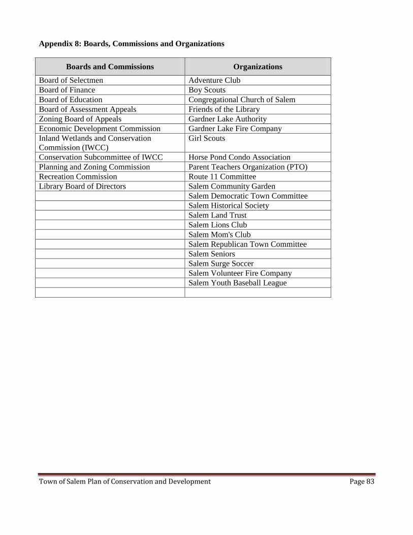
Town of Salem Plan of Conservation and Development Page 83
Appendix 8: Boards, Commissions and Organizations
Boards and Commissions Organizations
Board of Selectmen Adventure Club
Board of Finance Boy Scouts
Board of Education Congregational Church of Salem
Board of Assessment Appeals Friends of the Library
Zoning Board of Appeals Gardner Lake Authority
Economic Development Commission Gardner Lake Fire Company
Inland Wetlands and Conservation
Commission (IWCC)
Girl Scouts
Conservation Subcommittee of IWCC Horse Pond Condo Association
Planning and Zoning Commission Parent Teachers Organization (PTO)
Recreation Commission Route 11 Committee
Library Board of Directors Salem Community Garden
Salem Democratic Town Committee
Salem Historical Society
Salem Land Trust
Salem Lions Club
Salem Mom's Club
Salem Republican Town Committee
Salem Seniors
Salem Surge Soccer
Salem Volunteer Fire Company
Salem Youth Baseball League


![IPS Salem District 2012[1] - DCMSMEdcmsme.gov.in/dips/IPS Salem District 2012[1].pdf3 Brief Industrial Profile of Salem District 1.eneral Characteristics of the District G The Date](https://static.documents.pub/doc/80x56/5ad5b5617f8b9aff228d6b3a/ips-salem-district-20121-salem-district-20121pdf3-brief-industrial-profile.jpg)
