11
© 2012 Bentley Systems, Incorporated. 1 Point Cloud Processing and Large Scalable Terrain Model Extraction Inga Morozoff

�
© 2012 Bentley Systems, Incorporated.
1
Point Cloud Processing and Large Scalable Terrain Model Extraction
Inga Morozoff
�
© 2012 Bentley Systems, Incorporated.
2
Point cloud data is a new data type that’s being driven by the need for accurate 3D as-built information. Point cloud processing is becoming an integral part of infrastructure workflows from planning and design to construction and operations. Bentley is committed supporting point clouds for all phases of an asset’s life cycle throughout the Bentley suite of 3D applications.
This is accomplished with the release of Bentley Descartes V8i (SELECT Series 3) that combines point clouds, in addition to raster imagery, into a single package that’s supported not only in MicroStation but in many 3D applications such as Bentley OpenPlant, Bentley Map Enterprise, Bentley Substation, InRoads, Bentley Navigator and more.
With Bentley Descartes, you’ll be able to work with point-cloud data throughout the entire infrastructure lifecycle.
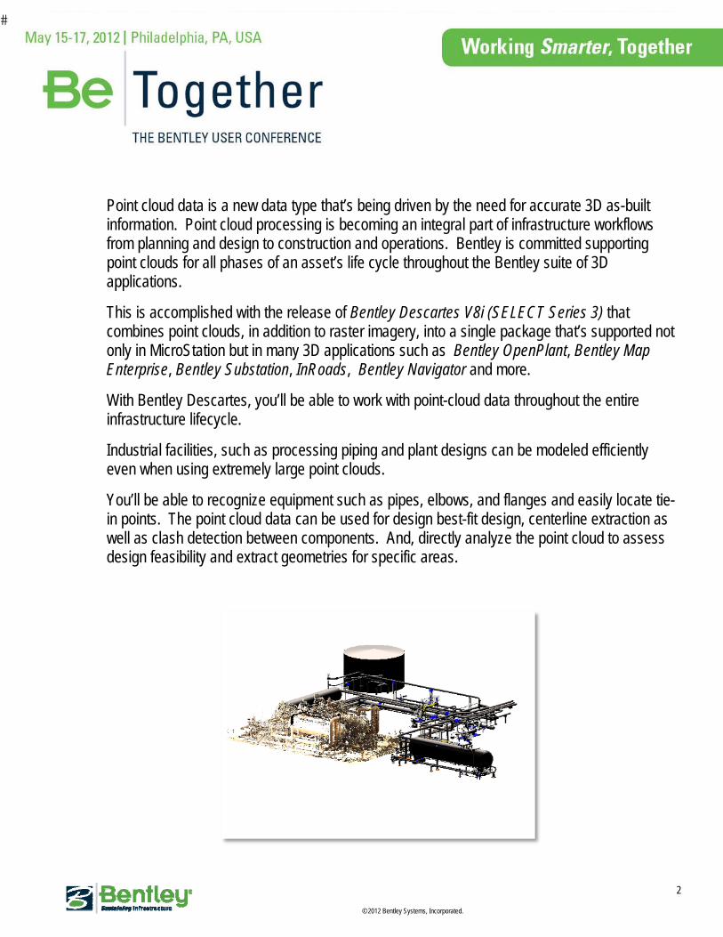
Industrial facilities, such as processing piping and plant designs can be modeled efficiently even when using extremely large point clouds.
You’ll be able to recognize equipment such as pipes, elbows, and flanges and easily locate tie-in points. The point cloud data can be used for design best-fit design, centerline extraction as well as clash detection between components. And, directly analyze the point cloud to assess design feasibility and extract geometries for specific areas.
�
© 2012 Bentley Systems, Incorporated.
3
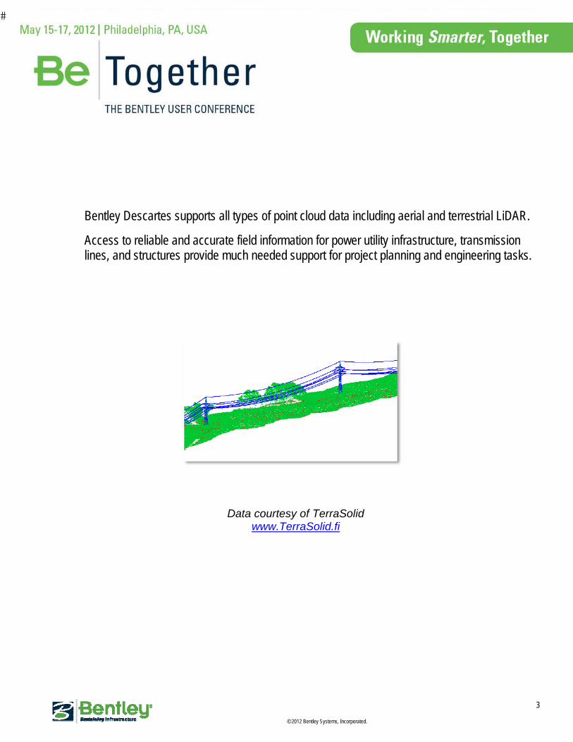
Bentley Descartes supports all types of point cloud data including aerial and terrestrial LiDAR.
Access to reliable and accurate field information for power utility infrastructure, transmission lines, and structures provide much needed support for project planning and engineering tasks.
Data courtesy of TerraSolid www.TerraSolid.fi
�
© 2012 Bentley Systems, Incorporated.
4
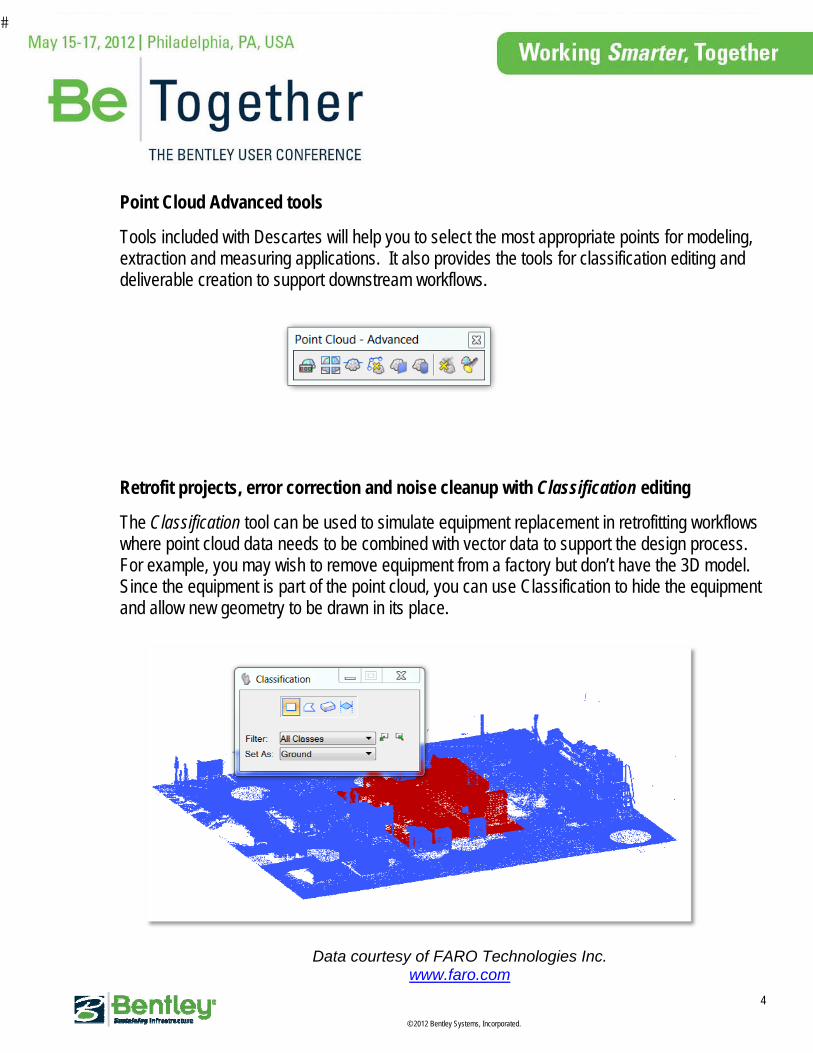
Point Cloud Advanced tools
Tools included with Descartes will help you to select the most appropriate points for modeling, extraction and measuring applications. It also provides the tools for classification editing and deliverable creation to support downstream workflows.
Retrofit projects, error correction and noise cleanup with Classification editing
The Classification tool can be used to simulate equipment replacement in retrofitting workflows where point cloud data needs to be combined with vector data to support the design process. For example, you may wish to remove equipment from a factory but don’t have the 3D model. Since the equipment is part of the point cloud, you can use Classification to hide the equipment and allow new geometry to be drawn in its place.
Data courtesy of FARO Technologies Inc. www.faro.com

�
© 2012 Bentley Systems, Incorporated.
5
Classification can also be used to correct errors introduced by automatic classification software. For example, you may want to extract breaklines to create terrain, but the automatically classified data has errors which negatively impacts the extraction process. In this case, the classification editing tool allows you to edit those mistakes, improve the quality of the classification and generate valid terrain directly from the points.
Data courtesy of HNTB www.HNTB.com
�
© 2012 Bentley Systems, Incorporated.
6
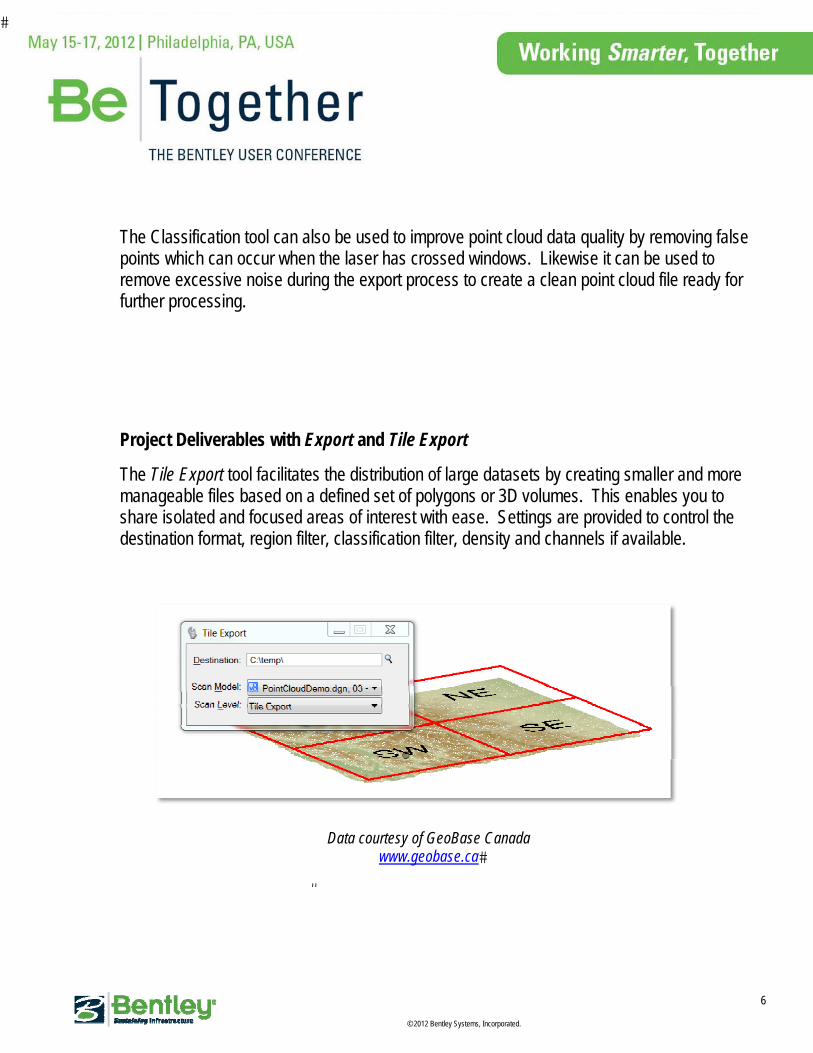
The Classification tool can also be used to improve point cloud data quality by removing false points which can occur when the laser has crossed windows. Likewise it can be used to remove excessive noise during the export process to create a clean point cloud file ready for further processing.
Project Deliverables with Export and Tile Export
The Tile Export tool facilitates the distribution of large datasets by creating smaller and more manageable files based on a defined set of polygons or 3D volumes. This enables you to share isolated and focused areas of interest with ease. Settings are provided to control the destination format, region filter, classification filter, density and channels if available.
Data courtesy of GeoBase Canada www.geobase.ca�
�
�
© 2012 Bentley Systems, Incorporated.
7
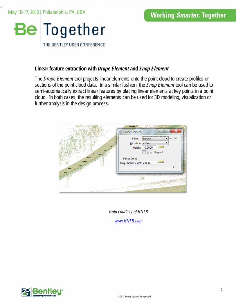
Linear feature extraction with Drape Element and Snap Element
The Drape Element tool projects linear elements onto the point cloud to create profiles or sections of the point cloud data. In a similar fashion, the Snap Element tool can be used to semi-automatically extract linear features by placing linear elements at key points in a point cloud. In both cases, the resulting elements can be used for 3D modeling, visualization or further analysis in the design process.
Data courtesy of HNTB
www.HNTB.com
�
© 2012 Bentley Systems, Incorporated.
8
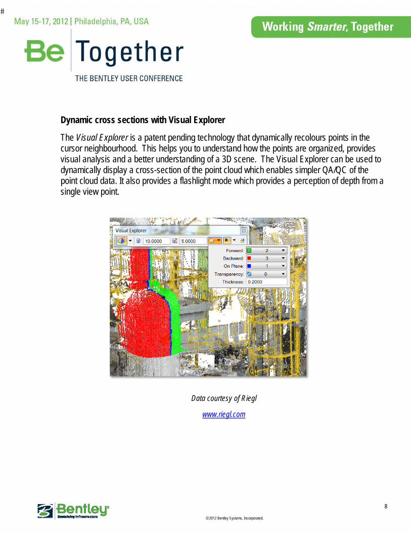
Dynamic cross sections with Visual Explorer
The Visual Explorer is a patent pending technology that dynamically recolours points in the cursor neighbourhood. This helps you to understand how the points are organized, provides visual analysis and a better understanding of a 3D scene. The Visual Explorer can be used to dynamically display a cross-section of the point cloud which enables simpler QA/QC of the point cloud data. It also provides a flashlight mode which provides a perception of depth from a single view point.
Data courtesy of Riegl
www.riegl.com

�
© 2012 Bentley Systems, Incorporated.
9
Advanced Snapping – The Smart Snap tool provided the ability to pick key points such as the lowest, highest, average or median point within a specified search area. Fully integrated with MicroStation AccuSnap, it simplifies modeling with point clouds and enables semi-automatic break line extraction.
Point clouds are, by definition, complex and made of many millions of points. The Smart Snap and Visual Explorer are designed to work together to help you select the most appropriate points for modeling and measuring applications.

�
© 2012 Bentley Systems, Incorporated.
10
Scalable Terrain Model
Modeling with point clouds can now be done at a terrestrial scale. A Scalable Terrain Model (STM) is a revolutionary new technology that enables high-performance display of digital terrain models covering very large areas and containing billions of points.
Scalable terrain model generates a multi-resolution spatial index of all referenced external files such as 3D points and breaklines. This index is then used to compute a surface on-the-fly at the right level of detail based on your viewpoint.
The STM system keeps track of the files that make up an STM and if changes are made to the source files, a utility is provided to send a notification that the STM needs to be regenerated.
Scalable Terrain Model comes with high-resolution draping capabilities allowing the display of imagery on the terrain model with extremely good resolution regardless of the terrain model or image size.
Data courtesy of GeoBase Canada www.geobase.ca�
�

�
© 2012 Bentley Systems, Incorporated.
11


