43
anne zuercher | portfolio 2013 My Architectural Works.
| Date post: | 20-Feb-2016 |
| Category: |
Documents |
| Upload: | anne-zuercher |
| View: | 213 times |
| Download: | 0 times |

anne zuercher | portfolio 2013
MyArchitectural Works.

ANNEZUERCHER
architectural designer


anne m. zuercher | portfolio 2013
MY StoryFrom a rural farm in South Dakota to Southeast Asia and Europe, I have been intrigued by the way people relate to community and the environment. A joy in learning prompts me to relate my individual perceptions to other cultures and the world around me. I find my passion in the relationship of spatial organization and life processes. A liberal-arts architectural education has exposed me to the broad range of design thought. Living overseas helped me look through different lenses to further my understanding of design. Working through college at a local food cooperative provided a unique view of the importance of local economy and the value of sustainability. With a broad range of creative interests, my personal design process focuses on recognizing the unique problems presented by each project, discerning a range of appropriate responses, and finding collaborative solutions.

“Regenerat ive Dwel l ing” The mission of this sustainable development proposal is to design a community continaully adapting to meet the social and economic needs of its residents while preserving the environment’s ability to support it.
“2050. Design ing for the Future” The contemporary vacation creates a situation which positively connects the context of progressive political power to the nature of human existence and our relationship with the environment.
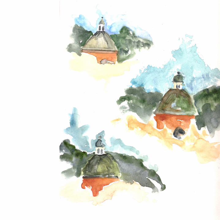
“Skernal ing.” This expanding series of sketches and scribbles - journals and jots, is a compilation of documentation focusing on travel and experience.
“Downtown Rev i ta l iza t ion: Cascade, ID”This planning project focuses on a revitalization and city renewal for Cascade, Idaho. The design focuses on facade restoration, adaptive re-use and infill.
“Repurposing Greyf ie lds” This two week design charrette explores issues of sustainable design through adaptive re-use and creative mixed use housing.
“The Neo Nomad.” This innovative national infrastructure system for the United States creates an improved, healthy and modern way to not just travel, but live.
CHOSENWORKS

THE NEO NOMAD This innovative national infrastructure system for the United States creates an improved, healthy and modern way to not just travel, but live. My thesis project re-thought the relationship of a building to its context; how a building relates and responds to its surroundings - blurring the lines between dwellings and the landscape they inhabit. The nomatic dwelling is pre-fabricated and much smaller than a typical single family American home. Designed to accomodate both modern homelife and experience through travel and constant change, “The Neo Nomad” defines the neo-modern urban lifestyle.


50
40
30
120 110 100 90 80
30
40
50
708090100110120
mexico
canada
50
40
30
120 110 100 90 80
30
40
50
708090100110120
mexico
canada
1962 US Intercity Passenger Rail
US Intercity Passenger Rail
hub city
three times daily
six times daily
at least daily service
less than daily service
improving services
moving towards HSR
awaiting appropriations
actively planning
operating HSR service
Research & Analysis
01 12 mi 2 km
MARCH 2008
MULTI-USE PATHSClosed to motor vehicles
SHARED ROADWAYOn lower tra�c street
BIKE LANESOr wide shoulders, usually on higher tra�c streets
SHARED ROADWAY WITH WIDER OUTSIDE LANEOn moderate and higher tra�c street
DIFFICULT CONNECTIONIn areas with higher speeds and/or volumes, combined with narrow lane widths or other problems for cyclists
SHARED ROADWAY / DIFFICULT CONNECTIONLower tra�c street with sight distance limitations and higher speeds
BIKE ROUTE SIGNS AND MARKINGSThese streets have directional signs and pavement markings to guide cyclists
STEEP HILLSChevron shows uphill direction
MAJOR STREETS
MAX STATIONS
LEGEND
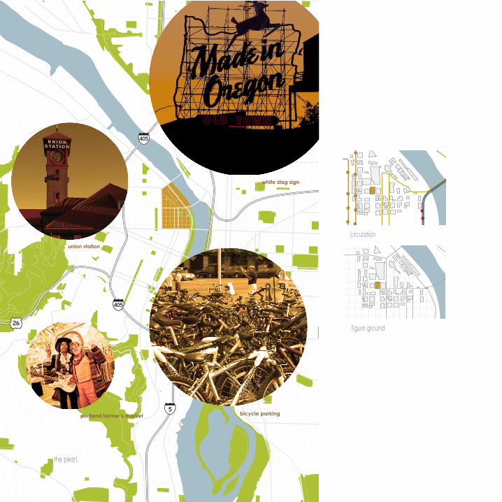
bicycle parking
white stag sign
old town
union station
portland farmer’s market
the pearl.
circulation
figure ground

elevation.front elevation.
Modular andpre-fabricatated Pod


Abstract physical modeling helped to derive a parti organization for the overall structure. Presentation modeling created a realistic representation of my design decision in a futuristic Portland.
Physical Model ing


Quick process sketches and drawings help ask questions about qualities of space and form. These parti diagrams look over structure on the site. The process continues, pushing through questions of realistic and conceptual design challenges.


REGENERATIVE DWELLINGThe mission of this sustainable development proposal is to design a community continaully adapting to meet the social and economic needs of its residents while preserving the environment’s ability to support it. The intention is to design and build economical, equitable and ecologically healthy communities that serve as a model for future design planning.

cluster elevationhand rendering, ink + prismacolor markers

motor businessmultifamily residentialsingle family (9600 sq. feet)agriculturesingle family (7000 sq. feet)suburban residentialduplexfarm/ranch/transitionalcity limitstreets
zoning mapMoscow, Idaho
water drainage
retention pond +constructed wetlands
city limitstreetsirrigation channelsgreenhouse + living machineretention pondbioswalesconstructed wetlands
city limit
grid layout for infrastructure
proposed bus routeexisting bus route
potential bus route
proposed bike and pedestrian pathstreets

a.b.
c.
d.
a. b.c.
d.e.
f.g.
a.b. c. d.
e.f.
g.h.
a. b.c.
d.
e.
f.g.j.
i.h.
a.
b.
c.
d.
f.
a. summer sunb. winter sunc. natural ventilation
cluster sectionAutoCAD software
a. drainage matb. vegetationc. metal roofd. insulatione. headerf. blocking
a. fan and pipeb. chutec. wasted. composte. air inletf. access door
a. strawbaleb. pipingc. wood studsd. corregated metal
a. overflowb. manholec. to pumpd. downspoute. sand filterf. cisterng. drain
a. inletb. max. water levelc. normal leveld. overflow draine. outlet riprapf. anti-seep collarsg. cisternh. draini. forebayj. riprap

cluster floorplansAutoCAD software
This sustainable community, through Palouse Clearwater Environmental Institute, will serve as an example of the great potential for rural sustainable communities. With a mix of residential, commercial, civic and public space, this mixed use development offers availability for live/work environments. A broad variety of housing choices, low income and subsidized housing, private gathering spaces and public pocket parks allow each individual to find just what they are looking for.

Masterplan

2050: DESIGNING FOR THE FUTURE The contemporary vacation creates a situation which positively connects the existing context of a progressive political power to the nature of human existence and our relationship with the environment. This vacation resort, designed for the year 2055, allows for opportunity to strengthen and rejuvenate the senses through programmatic and systematic design strategies.

space allocation
section facing North
public space: atriumvertical circulation and rampnatural light and ventilation
public space:functional and transitional, these areas are placed throughout the structure trigger the sensory experience and create interesting and special, changing spaces. (resturant shown)
private spaces:hotel unitsprivate ownership apartments (2-floor)
service spaces:placed throughout the structure based upon their function, support facilities create healthy, happy environments for workers. (resturant kitchen shown)
circulation
section facing North
vertical circulation core: 3 fire exit staircases
3 elevators
atrium staircases:viewing staircases allow for interaction between floors
circulation ramp: similar to a DNA molecule, the circulation ramp slowly wraps up the vertical cores, creating optimum social interaction and sensory experience.

As a partially direct gain system, passive solar heating is a cost effective means of heating combined with the stack ventilation system. An exterior, self-regulating shading system blocks the structure from direct, south gain. The skylight allows light through the atrium space, down to the social spaces, creating healthy space for workers and visitors.
Environmental Control Systems

heating: in combination with a partially direct gain double skin facade, the atrium space circulates warm air throughout the structure.
cooling: stack effect passive cooling takes advantage of temperature stratification: warm air rises and is replaced with ambient, cooler air.
water catchment systems collect water for potable uses, irrigation, laundry, and passive cooling. Rainwater stored in cisterns provide water sources while reducing stormwater flows. Upcycling water makes sense both economically and environmentally.
systems parti development

section detail, facing west
Detail development

west elevation

RE-PURPOSING GREYFIELDSThis two week design charrette explores issues of sustainable design as they apply to the urban context. An existing parking lot along the Seattle waterfront, under the Alaskan viaduct, the proposed site includes a sustainable urban infill building and urban green space.

8
67
5 Steinbrueck Park
Seattle Central Library
Pike Place Market
Seattle Art Museum 12
1011
9 Alaskan Way Via-duct
Western Avenue
Seattle Aquarium
Pioneer Square
16
1415
13 infill structure site (existing parking lot)
adaptive re-use via-duct on ramp
pocket sculpture park (existing back road)
existing office space (7 stories)
existing mixed-use building (5 stories)17
5
6
7 8
910
11
12
16
14 15
13
17
Seattle is the most populous city in the U.S. state of Washington, located in the Northwestern United States. A coastal city and major seaport, it is located in the western part of the state on an isthmus between Puget Sound and Lake Washington, about one hundred miles south of the Canadian border. Seattle is also a major economic, cultural and educational center in the region.
4
23
1 Elliott Bay
The Space Needle
Lake Union
Ferry Loading Docks
3
2
1
4

19
20
21

21
1920
18 skylight
rooftop garden
water catchment system
viaduct adaptive re-use
The contraverial issue of removing the viaduct will effect the culture of Seattle greatly. Built in 1953, the infrastructure has helped to shape the city, creating one of the most efficient forms of individual moterized traffic in that time. Both fortunatly and unfortunatly, automobile transportation is coming to an end and the U.S. must proactively start to implement new and more innovative infrastructure. Integrating the removal of the viaduct with pedestrian circulation and interactive parks, the connection between the waterfront and Seattle’s commercial district will be renewed.


2322 great views
outdoor gathering space

This planning project focuses on a revitalization and city renewal for Cascade, Idaho. Cascade is an old mining town, population 1000, about 3 hours south of Moscow.
DOWNTOWN REVITALIZATION: CASCADE, IDAHO

A series of studies helped start the research that would determine how to revitalize Cascade in the proper way to help the current residents and future generations. Many structures were out of use due to failure in codes, out of business for lack of services or utilized structures lacking streetscaping, signage and aesthetic interest. Highway 55 runs straight through Cascade, turning into Main Street through the downtown. Highways can really break up downtowns if the town has not been planned. I chose to focus on the six downtown blocks of Cascade as they seem to have the most potential in being the heart of a great community.


proposed southwest elevation
existing southwest elevation
proposed northeast elevation
existing northeast elevation
site analysis
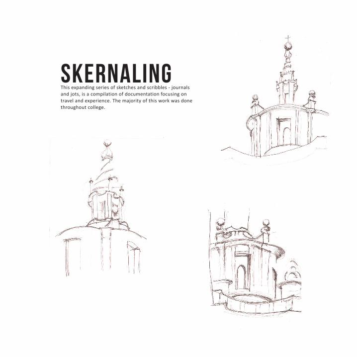
SKERNALINGThis expanding series of sketches and scribbles - journals and jots, is a compilation of documentation focusing on travel and experience. The majority of this work was done throughout college.

Lookout from Capitoline HillRome, Italy
Sant IvoRome, Italy

Dome StudyAssisi, Italy
Sant’Andrea della ValleRome, Italy
City PlanAtrani, Italy


Lookout from Janiculum HillRome, Italy
Santa Maria Della PaceRome, Italy
anne zuercher | portfolio 2013


