22
PORTFOLIO keith jacobi

PORTFOLIO keith jacobi

URBAN PLAZA | 24-27RESIDENTIAL | 28-35
CONSTRUCTION DOCUMENTS | 36-37 NARRATIVE | 38-39
CITY PARK | 16-23 MASTER PLANNED COMMUNITY | 2-15
RESUME | 1
Keith Jacobi
EDUCATION:
P| 405-614-0322 E| [email protected]
• Survey sites• Produce base maps• Produce concept plans• Produce master plans
• Produce concept plans• Produce planting plans• Produce presentation graphics• Produce bid documents
• Design commercial and residential landscapes• Present designs to clients
• Schedule internal and outsourced work• Create schedules• Schedule number of employees for each task• Serve as point of contact with customers
• Flowtest natural gas wells• Operate CO2 removal equipment
• Produce lighting plans• Produce bid documents • Perform take-offs• Redline drawings
• Supervise crew members• Install terrace/rooftop/backyard gardens• Install seasonal displays• Perform maintenance on gardens
• Obtain permits• Maintain corporate campus
• Perform take-offs• Redline drawings• Perform document control
• Fill out daily reports• Train new personnel
SzAFRANSKI-PUgh & ASSOCIATES Tulsa, OK. Jun ‘07 - Feb ‘08Title: Intern
NEwPOINT MANUFACTURINg Orangeburg, SC. Aug ‘08 - Nov ‘10Title: Project ManagerJob description and responsibilities:
NEwPOINT MIDSTREAM wamsutter, wY. Nov ‘10 - Aug ‘12Title: FlowtesterJob description and responsibilities:
ONE SPECIALTy South Lake, TX. May ‘13 - Aug. ‘13Title: InternJob description and responsibilities:
TOwN AND gARDENS New York, NY. Aug ‘14 - Dec ‘15Title: Intern and Crew Member/LeaderJob description and responsibilities:
CLEAN SCAPES Austin, TX. Jan ‘16 - PresentTitle: Landscape Designer/Crew Member Job description and responsibilities:
JACOBI’S LAwN MAINTENANCE Stillwater/Duncan, OK. Mar ‘01 - May ‘07Title: Owner/Operator
AWARDS/MEMbERShIpS:1st PLACE - 2013 PAC (PROFESSIONAL ADvISORY COUNCIL) DESIgN ChARRETTE1st PLACE - 2014 SENIOR CAPSTONE PROJECTMEMBER: STUDENT ASLAFINDINg CENTER CONFERENCE STREET FESTIvAL SUbCOMMITTEE hEAD
Oklahoma State Universityb.S. Landscape Architecture 2014
ExpERIENCE:

MASTER plANNED COMMUNITy
Legacy Point | OKTeam Project
Fine sand loam (444 acres, 73.7% of site)SOIL:
Loam fine sand (117 acres, 19.5% of site)0-5% (337 acres, 56% of site) 100 yr. flood (6 acres, 1% of site)SLOPE: FLOOD:
Fine sandy loam (38 acres, 6.3% of site)>5-15% (204 acres, 34% of site)
Loam (3 acres, .5% of site)>15% (60 acres, 10% of site)
“The Legacy Point concept is the celebration and promotion of traditional rural values within a neo-traditional community. we want to enhance a sense of community and family through creative and simple design. we also want to create a connection to the land by working with it instead of against it. This is the Farmer’s Legacy”. Legacy Point celebrates and promotes traditional rural values within a
neo-traditional community. It enhances a sense of community and family through creative and simple design, and creates a connection to the land by working with the land instead of against it. This is the Farmer’s Legacy.
“Farmer’s Luck”Jason boland & The Stragglers
verse 3:... but down below the surfacea story’s longing to be toldabout cotton fields and bottom landand the home place that was sold...
Market: Out of the 371 neotradi-tional communities in the United States, only one of those commu-nities is located within 100 miles of Lake Eufaula. Oklahoma also has two of the top 30 cities in the United States that are experiencing popula-tion growth.
Legacy Point is a 600 acre neo-traditional master planned community located on the shore of Lake Eufaula in Eastern Oklahoma. The master plan incorporates traditional rural values with simple and creative design to transform a wooded hillside into a neo-traditional community that connects the residents to the land and each other.
The site was once a wooded hillside 5.5 miles away from the Canadian River. when the Canadian River was dammed in 1946 as a means to control flood water, the water level rose to the edge of the project site, creating what is now Lake Eufaula. In the process, many farmers’ cotton fields and bottom land are now underwater.
There is also 230’ of change in elevation on the site with 336 acres being at a 0-5% slope, 204 acres being at a >5-15% slope and 60 acres being at a >15% slope. In addition, the site is densely wooded with a rocky shoreline and loamy soils on the uplands.
There are 14 million people within a three hour drive of the site and only one other existing neo-traditional community within 100 miles. with Oklahoma having two of the top 30 cities being moved into in 2012, a neo-traditional community will be an attractive option for much of those migrants. Lake Eufaula also has 600 miles of shoreline, four miles of which make up part of the site’s boundary.
Taking into account our site visit, client goals, and research of the sur-rounding area, our concept emerged as the celebration and promotion of traditional rural values within a neo-traditional community. we also wanted to enhance a sense of community and family through creative and simple design while creating a connection to the land by working with it instead of against it. This is the Farmer’s Legacy.
• Traditional rural values - Fifety-two acres of agricultural land is integrated throughout the site. A farmer’s market provides a place to sell the locally grown produce.
• Neo-tradtional community - Neo-traditional principles such as a traditional Main Street, mixed use, proper density, multi-ple public spaces, short blocks and five minute walks were incorporated.
• Creative and simple design - Four distinct and understandable neighborhoods make up the community.
• Connection to the land - Streets are laid either parrallel or perpendicular to the slope of the land. This makes the town understandable to those in it and environmentally friendly by reducing the need for re-grading.
(See the full narrative on pg. 32)
keith jacobi 3_________________________________

program:Low density (3 units or less per acre): 451Medium density (4-12 units per acre): 800high density (13 or more unites per acre): 549Total units: 1,800 (273 acres)
land Use:Trails: 10 milesResidential: 273 acresParks: 9 (26 acres)Undisturbed: 233 acresAgriculture: 52 acresMixed-use: 9 acresSchool: 17 acres
Agriculture
Prairie
Parks Bed and Breakfast
School
Low densityUndisturbed Medium density
Mixed-Usehigh density
keith jacobi 5_________________________________
0’ 1000’ 2000’
Main - vehicle
1 Park
3 Parks
2 Parks
Secondary - vehicleTirtiary - vehicleTrails - pedestrian
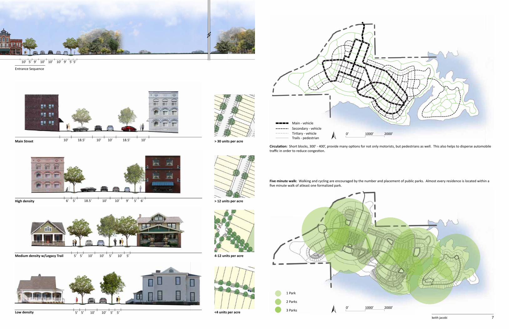
Circulation: Short blocks, 300’ - 400’, provide many options for not only motorists, but pedestrians as well. This also helps to disperse automobile traffic in order to reduce congestion.
Five minute walk: walking and cycling are encouraged by the number and placement of public parks. Almost every residence is located within a five minute walk of atleast one formalized park.
10’
10’10’
10’
10’
10’
10’
10’ 9’
10’
10’
10’ 9’
5’
5’ 5’
5’
5’
5’
10’
6’
5’
5’ 9’
5’
5’ 18.5’
5’
10’
5’
10’
6’
5’
10’
18.5’18.5’
Entrance Sequence
Main Street > 30 units per acre
high density > 12 units per acre
Medium density w/legacy Trail 4-12 units per acre
low density <4 units per acrekeith jacobi 7_________________________________
0’ 1000’ 2000’
0’ 1000’ 2000’

9
12
13
11
10
1
1
6
5
2
31
4
8
7
1. Agriculture 2. Main St. green/Overlook Park3. Main Street4. School5. Farmer’s market6. Legacy Trail7. Legacy Park8. Naturalized park9. Lake Eufaula10. bed and breakfast village11. Swimming area12. boating Square13. boat slips
Neighborhoods and connection: The community is made up of four distinct neighborhoods. The downtown area is laid out in a grid and is the hightes density neighborhood with 13 or more units per acre. It consists of a traditonal mixed-use Main Street with retail on the first story and apartments on the second and third stories. Just up the hill is one of the lowest density neighborhoods with as little as two units per acre. The road layout folllows what little change in elevation there is. A strong connection to the agricultural land and the low density make this neighborhood distinct. The third neighborhood is just down the hill from Main Street. Roads in this neighborhood either run parallel to the contours or perpendicular to the contours. This makes the neighbor-hood very identifiable and easy to understand when in it. Agricultural land is also strongly integrated into this medium density neighborhood of four to twelve units per acre. The fourth neighborhood is located on
the peninsula. This neighborhood is defined by its low density of three unites or less per acre and its strong connection of people to nature and water.
The Legacy Trail provides an attractive alternative to driving with its ded-icated walking/cycling trail and its layout, which allow for easy access to the three main nodes of the community: downtown, the farmer’s market, and the boating square.

9
47
6
8
11
10
12
12 11
87
5
2
1
3
2
1. Main street 2. Mixed-use3. high density residential4. Main Street green5. Splash pad6. berm seating7. Mixed-use8. high density residential9. Overlook park10. Dog park11. Medium density residential12. Community firepit(s)
Main Street Green and Overlook park: The Main Street green offers a vibrant area for people of all ages. Restaurants, retail and apartments flank both ends and trees line both sides to help define the space. Outdoor dining helps create a vibrant atmosphere along with the splash pad and multiple seating options. beverage and snack vendors add to the energy and func-tionality of the space. You experience a very dramatic reveal as you leave the Main Street green and enter Overlook Park. The wide open space with the beautiful Lake Eu-faula views provides for many programmed and unprogrammed recreational opportunities. Evening times are highly anticipated due to the community fire pits designed to promote social interaction. A dog park adds to the diversit of the site making it inviting to many different people for many different uses.both, Main Street green and Overlook Park are located in close proximity to Legacy Trail; a dedicated pedestrian/cycling trail that links the three major elements of the community.

1. Culture center 2. Medium density residential3. Legacy Trail4. Sculpture lawn5. Cooking classes6. winery7. Farm-to-Table events8. Canning facility9. Farmer’s market10. vineyard
Farmer’s Market: with 52 acres of agricultural land intigrated throughout the community, the farmer’s market is a core element in promoting social interation and community identity. In addition to the farmer’s market, there are also canning and cooking facilities. A winery takes advantage of its close proximity to the vineyard. A fourth facility accomodates a variety of events such as Farm-to-Table activities.
The culture center provides a place to display the Legacy Point history. It is also used for a variety of other cultural activities such as dance lessons, art shows and music recitals. A sclupture lawn surrounds the culture center.
All of these ammenities are located directly adjacent to the Legacy Trail in order to promote walking and cycling over vehicular travel. The farmer’s market is also located midway between Main Street and the boating Square. This allows the market to act as a “stepping stone” when walking or cycling from one to the other.
6
7
8
5
9
10
1
4
3
3
2

1. Legacy Park 2. Legacy Trail3. Medium density residential4. high density residential5. Mixed-use6. Yarrow Sculptures7. Mixed-use8. Lakeside Promenade9. Trail to bed and breakfast10. boat trailer parking11. Lake Eufaula
1
2
2
3
6
3
4
4
5
7
811
10
9
Boating Square: A strong connection to Lake Eufaula is created with the boating Square. Mixed-use development fronts the water, creating a vibrant atmosphere. In addition to the mixed-use, short term boat parking attracts people from other lakeside communities to the area to shop, dine, or stay the weekend in the nearby bed and breakfast village. These tourists can park their boat and rent bicycles for the weekend.
The boating Square is also located at the southeastern tip of Legacy Trail; making it easy to walk or cycle to, and easy for people to walk or cycle from.
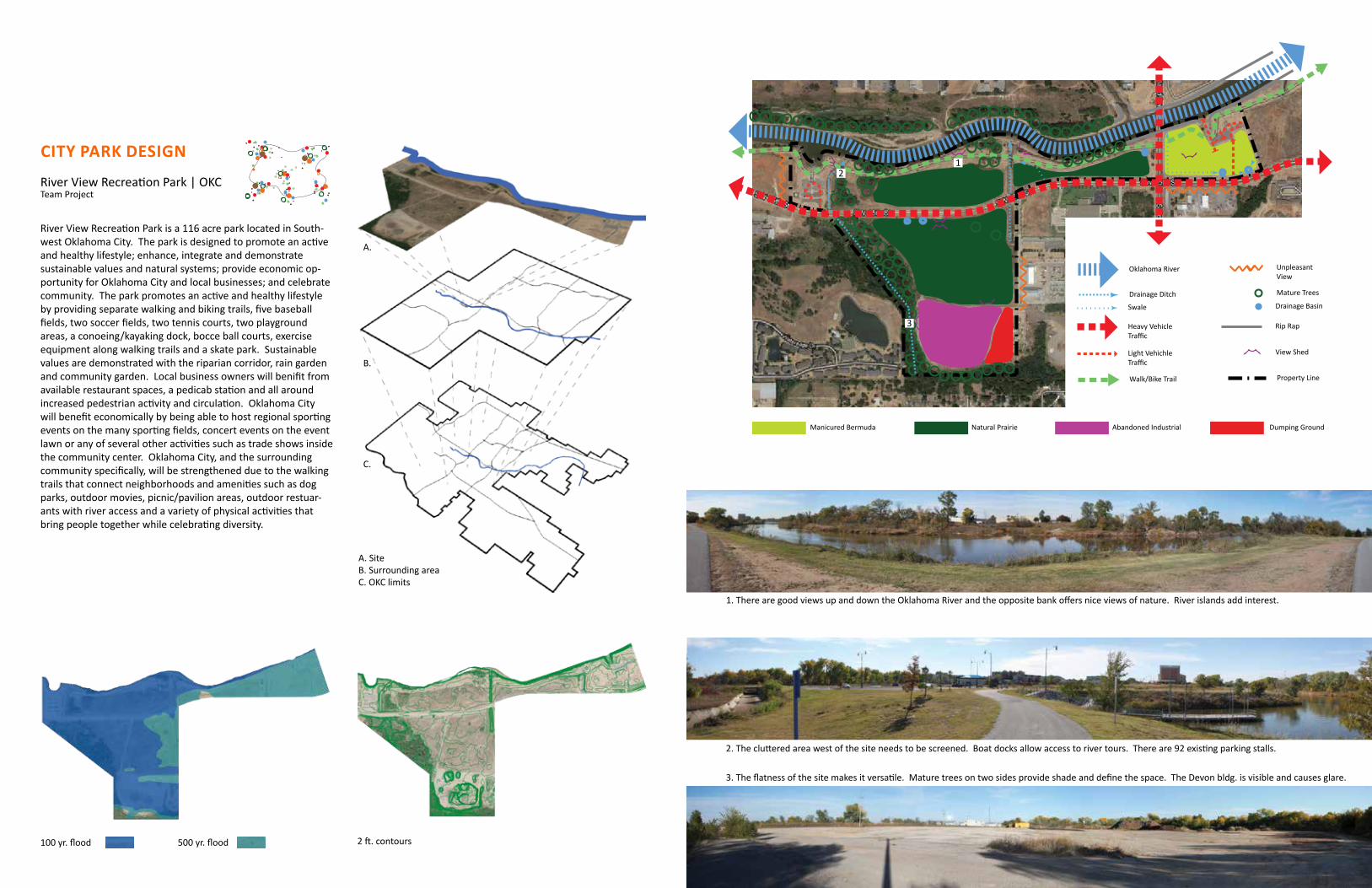
CITy pARk DESIGN
River view Recreation Park | OKCTeam Project
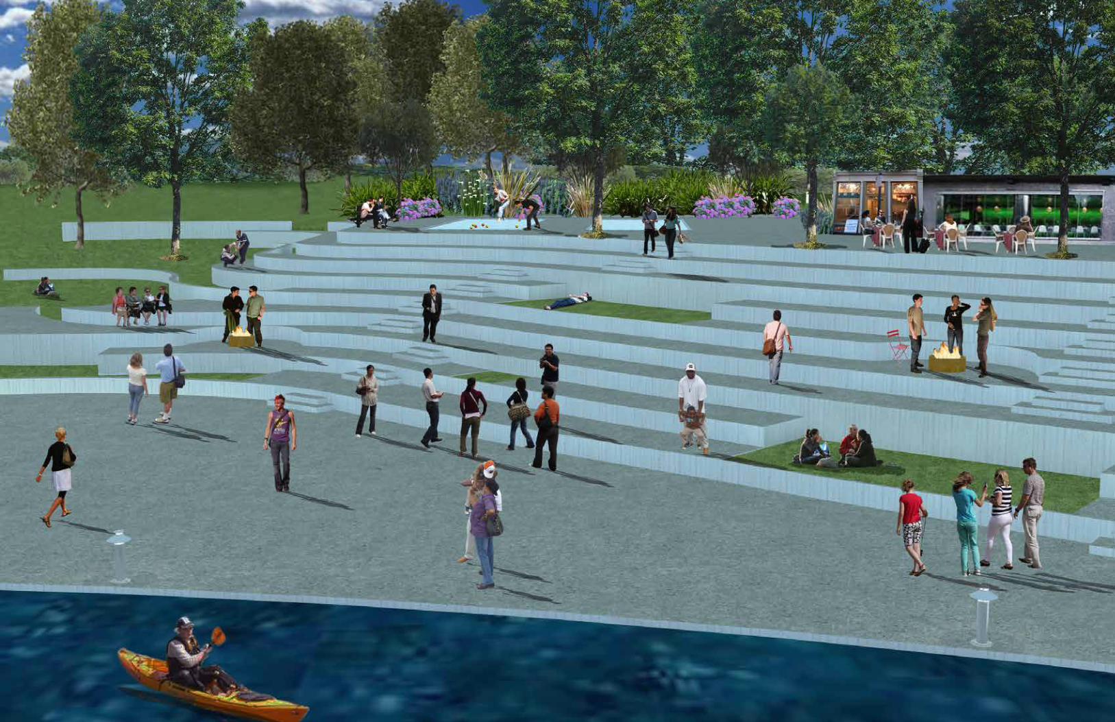
River view Recreation Park is a 116 acre park located in South-west Oklahoma City. The park is designed to promote an active and healthy lifestyle; enhance, integrate and demonstrate sustainable values and natural systems; provide economic op-portunity for Oklahoma City and local businesses; and celebrate community. The park promotes an active and healthy lifestyle by providing separate walking and biking trails, five baseball fields, two soccer fields, two tennis courts, two playground areas, a conoeing/kayaking dock, bocce ball courts, exercise equipment along walking trails and a skate park. Sustainable values are demonstrated with the riparian corridor, rain garden and community garden. Local business owners will benifit from available restaurant spaces, a pedicab station and all around increased pedestrian activity and circulation. Oklahoma City will benefit economically by being able to host regional sporting events on the many sporting fields, concert events on the event lawn or any of several other activities such as trade shows inside the community center. Oklahoma City, and the surrounding community specifically, will be strengthened due to the walking trails that connect neighborhoods and amenities such as dog parks, outdoor movies, picnic/pavilion areas, outdoor restuar-ants with river access and a variety of physical activities that bring people together while celebrating diversity.
Parti
Oklahoma River
Property Line
View Shed
Rip Rap
Drainage Basin
Mature Trees
Unpleasant View
Swale
Walk/Bike Trail
Light Vehichle Traffic
Heavy Vehicle Traffic
Drainage Ditch
Manicured Bermuda Dumping GroundAbandoned IndustrialNatural Prairie
100 yr. flood 500 yr. flood 2 ft. contours
A.
B.
A. Siteb. Surrounding area C. OKC limits
C.
2. The cluttered area west of the site needs to be screened. boat docks allow access to river tours. There are 92 existing parking stalls.
1. There are good views up and down the Oklahoma River and the opposite bank offers nice views of nature. River islands add interest.
3. The flatness of the site makes it versatile. Mature trees on two sides provide shade and define the space. The Devon bldg. is visible and causes glare.
12
3
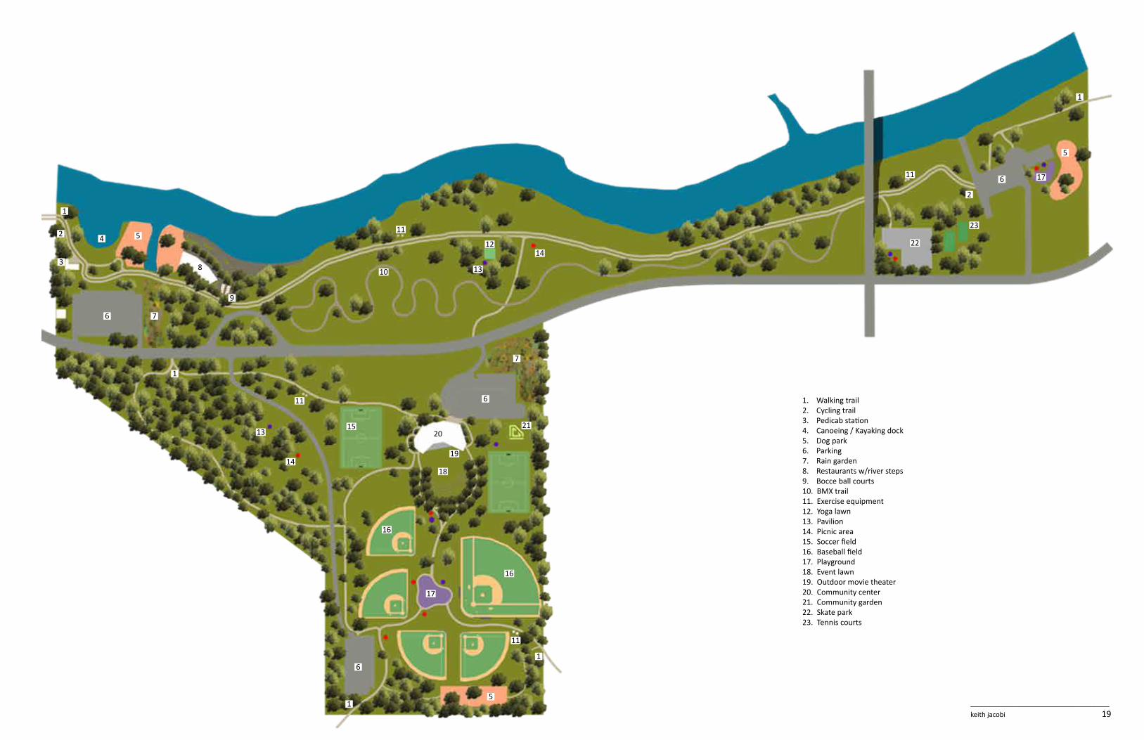
1. walking trail 2. Cycling trail3. Pedicab station4. Canoeing / Kayaking dock5. Dog park6. Parking7. Rain garden8. Restaurants w/river steps9. bocce ball courts10. bMX trail11. Exercise equipment12. Yoga lawn13. Pavilion14. Picnic area15. Soccer field16. baseball field17. Playground18. Event lawn19. Outdoor movie theater20. Community center21. Community garden22. Skate park23. Tennis courts
3
2
1
1
1
1
1
2
4
6
6
6
6
7
5
5
5
7
8
9
12
13
14
2120
18
19
16
17
17
16
15
11
11
11
10
11
13
14
22
23
keith jacobi 19_________________________________

keith jacobi 21_________________________________
Dinner with a view: The restaurants with river views will attract people to the park throughout the day.
AC
B
A
B
C

URbAN plAzA
Deep Ellum | Dallas, TX.
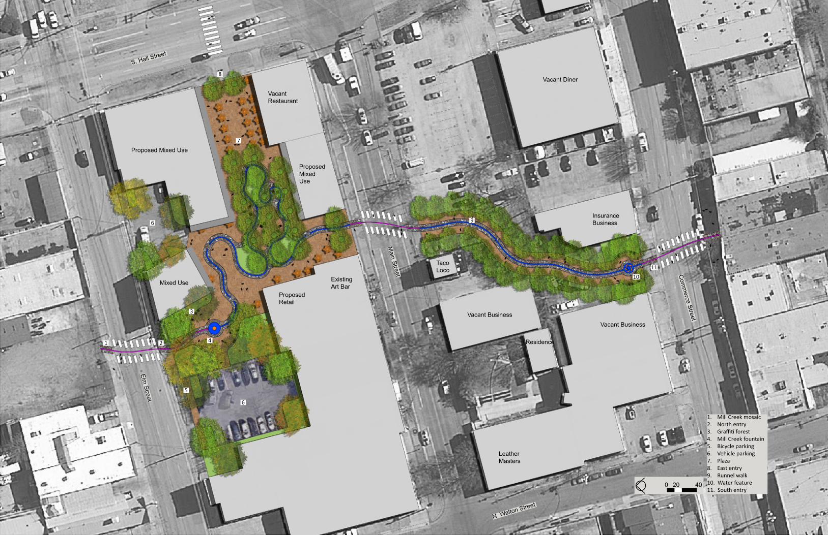
The rich and diverse history of Deep Ellum contributes to its uniqueness and has made it a local favorite for many decades. It’s precisely this history that has made it unlike any other neighborhood in the Dallas area. That is why remembering what was, is so important and the backbone of the Mill Creek Plaza concept. when Mill Creek was diverted to underground culverts, a part of the Deep Ellum history was lost. The Mill Creek Plaza symbolically returns the creek to the surface for everyone to enjoy. A mosaic marking the original location of the creek crosses roads and sidewalks until reaching the fountain at the north entrance where water emerges from underground, symbolizing Mill Creek’s re-emergence. From there, it snakes its way through the plaza before transforming into a mosaic to cross Main Street only to re-emerge just south
of Main. It then makes its way to the north side of Commerce Street where it descends into another water feature and is transformed into a mosaic yet again, which crosses Commerce.
In addition to the water features, plaza users will experience a gradual transformation from an urban setting to a more natural setting as they journey to the center of the plaza.
The changing seasons are celebrated with shade structures that change with the seasons the way deciduous plants do.
An abundance of activities and social possibilities await due to the diverse offerings of residential units, nightlife, restaurants and retail.
Retail: The main plaza will be the hub of a diverse shopping and entertainment experience.
back under ground: The south entry draws people toward the Mill Creek Plaza and contains a water feature that symbolically returns Mill Creek underground.
Nightlife: The inclusion of nightlife opportunities ensures the plaza will be used throughout the day and night.
Ambience: The lighted runnel, which symbolically functions as Mill Creek, adds unique character to the space.
Graffiti forest: Around the Mill Creek fountain is a forest of concrete columns which will be painted by local artists.
Proposed Mixed Use
Proposed Mixed Use
ExistingArt Bar
Proposed Retail
Mixed Use
VacantRestaurant
1 2
3
4
5
6
6
7
9
8
1011
1. Mill Creek mosaic2. North entry3. graffiti forest4. Mill Creek fountain5. bicycle parking6. vehicle parking7. Plaza8. East entry9. Runnel walk10. water feature11. South entry
0 20 40
Elm Street
S. Hall Street
N. Walton Street
Main Street C
omm
erce Street
Residence
LeatherMasters
Vacant BusinessVacant Business
Taco Loco
Vacant Diner
InsuranceBusiness

RESIDENTIAl DESIGNTulsa, Oklahoma
keith jacobi 29_________________________________
The Andersons wanted a contemporary landscape with clean lines. Exposed concrete and stainless steel details give the space the sleek look without being too cold. The eight to nine foot change in elevation and the 17 1/2’ utility easement along the back property line made it a challange to maximize usable space yet offered a unique solution.
The rectilinear pool and lawn are on the upper level while the dining and kitchen areas are on the lower level. The in-pool bar stools allow ease of conversation between swimmers and the guests in the kitchen/dining area.
Outdoor living: The infinity edge pool with a built in fire feature provides a relaxing backdrop for entertaining guests .
4
2
3
5
7
8
96
1. Driveway2. Upper patio3. wet deck4. Infinity edge pool5. In-pool bar stools6. Upper lawn7. Fire feature8. Kitchen area9. Dining area
1

RESIDENTIAl DESIGNSpanish Oaks, Bee Cave, TX.
A simple and structured front yard was the client’s primary wish for the front of this Spanish Oaks residence, while a more formal look was desired for the interior courtyard. A native and adapted plant palette was chosen to give the site a sense of place and to fit in with the sur-rounding neighborhood.
keith jacobi 31_________________________________
Existing Conditions Plant Palette
Front yard: The wax myrtles, Mexican feather grass and purple lantana provide structure to the front yard. The purple lantana directs the eye toward the residence while the wax myrtles and Mexican feather grass help distinguish the more public space from the more private space, creating a sense of entry.
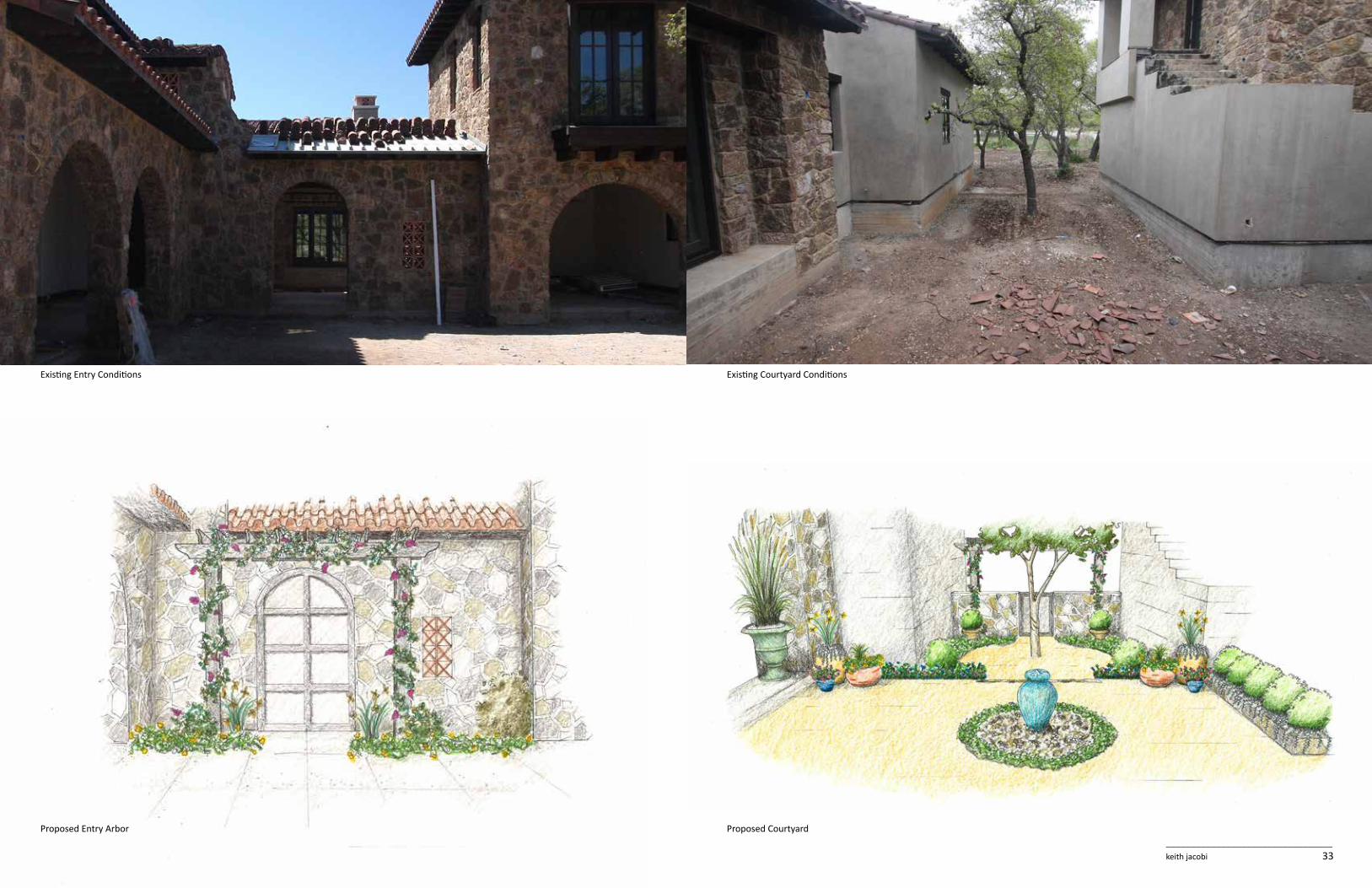
keith jacobi 33_________________________________
Existing Entry Conditions Existing Courtyard Conditions
Proposed CourtyardProposed Entry Arbor

keith jacobi 35_________________________________
Red Yucca
Wax Myrtle
Lawn
Prairie Mix
Softleaf YuccaFig Ivy
Purple Lantana
ExistingTree
Weber Agave
Lawn
Fig Ivy Mexican FeatherGrass
Prairie MIx
Prairie MixLawn
Bicolor IrisEvergreen Wisteria on Arbor
Calylophus
Silver PonyfootDwarf Yaupon Holly
1 Buffalo Grasss & 2 Calylophus
1 Iris and 3 Silver Ponyfoot
1 Pink Skullcap
LindheimerMuhly Grass
Dwarf BluePlumbago
Asian JasmineDwarf Yaupon HollyEvergreen Wisteria
Arbor
Arizona Cypress
Prairie Mix
Boulder
Lindheimer MuhlyGrass

CONSTRUCTION DOCUMENTSStillwater, Oklahoma
keith jacobi 37_________________________________

legacy point project Statement
Legacy Point is a 600 acre neo-traditional master planned community located on the shore of Lake Eufaula in Eastern Oklahoma. The master plan incorporates traditional rural values with simple and creative design to transform a wooded hillside into a neo-traditional community that connects the residents to the land and each other.Project Narrative
Site and Context
The site was once a wooded hillside 5.5 miles away from the Canadian River. when the Canadian River was dammed in 1946 as a means to control flood water, the water level rose to the edge of the project site, creating what is now Lake Eufaula. In the process, many farmers’ cotton fields and bottom land are now underwater.
There is also a significant change in elevation on the site with 336 acres being at a 0-5% slope, 204 acres being at a >5-15% slope and 60 acres being at a >15% slope. In addition, the site is densely wooded with a rocky shoreline and loamy soils on the uplands.
There are 14 million people within a three hour drive of the site and only one other existing neo-traditional community within 100 miles. with Oklahoma having two of the top 30 cities being moved into in 2012, a neo-traditional community is an attractive option for much of those migrants. Lake Eufaula also has 600 miles of shoreline, four miles of which make up part of the site’s boundary.
program
The design proposal is for a master planned neo-traditional community that attracts year round residents, second home-owners, and vacationers. Neo-traditional values were followed for the layout and feel of the community, which includes 1,800 residential units.
Taking into account our site visit, client goals, and research of the surrounding area, our concept emerged as the celebra-tion and promotion of traditional rural values within a neo-traditional community. we also wanted to enhance a sense of community and family through creative and simple design while creating a connection to the land by working with it instead of against it.
Traditional Rural values:Promoting traditional rural values is an important aspect of the plan. This is achieved by the inclusion of 52 acres of agricultural land and a farmer’s market. by laying out the agricultural land in long swaths parallel to the contours, a great number of houses are able to be located adjacent to it. This creates a strong connection between the townspeople and the agriculture, while symbolically bringing back the farm land that was lost when the Canadian River was dammed. Four types of agricultural land are integrated into the site: pasture for cattle grazing, traditional garden crops, orchards, and vineyards. This variety keeps the agricultural land interesting during every season and exposes the townspeople to a wider range of agriculture.
A farmer’s market is also included to help achieve four goals.
• Provide a place where all of the food produced from the agricultural areas is sold to the townspeople and local restaurants. • Teach local children where food comes from by reinforcing the farm-to-table concept. • build a stronger sense of community through community gardening. • Increase food security and decrease energy consumption by growing food locally.
Next to the farmer’s market is a restaurant, canning facility, space for cooking classes, and an open air structure that is used to host farm-to-table events. The location of these amenities is at the near mid-point between Main Street and the boating square. This creates a “stepping stone” for people walking from Main Street to the boating square or from the boating square to Main Street.
Neo-Traditional Community:Traditional Main Street: The main node of the town takes the form of a traditional style main street and town green. This includes retail space on the ground floor and apartments on the second and third stories, which help to define the space. The main street consists of two traffic lanes with 45 degree parking. A robust streetscape also helps define the space while acting as a traffic calming measure.
Mixed Use: In addition to the main street being mixed use, there is a secondary mixed use area, the boating square, located at the water’s edge. This area contains a marina, a bed and breakfast, additional retail space, and residential units. The boating square serves two main functions.
• Provides a necessary amenity for a lakeside community with many boat owners. • Encourages other boat owners from other lakeside communities to visit the community via boat ride.
The boating square contains a restaurant that attracts day vacationers, while the bed and breakfast attracts the weekend vacationers.
Density: The proper density is required to help achieve a strong sense of community while maintaining economic viabil-ity. The two mixed use areas achieve the highest densities with 13 or more units per acre. The next outer ring is made up of four to 12 units per acre. The lowest densities are two to three units per acre. All houses are situated toward the front of each lot to promote interaction between neighbors.
Multiple Public Spaces: The master plan places a high emphasis on public spaces by providing an assortment of public ammenities from woodlands, to open parks, to town greens to a beach area.
Short blocks and Five Minute Walks: blocks range in size from 300’ to 450’. This increases choices for pedestrians, cy-clists and automobile traffic. It also helps to dissipate automobile traffic.
Promoting walking and cycling, instead of driving, is an important aspect of the master plan. Short blocks help do that by providing the pedestrian more options and allowing them to walk to their destination in less time. Ninety-five percent of residents live within a five minute walk of a public park. A designated walking/cycling trail extends from the marina area to a public park on the northwest side of the town. A third tier mixed use area is located near the halfway point between Main Street and the boating square mixed use area. This halfway point acts as a “stepping stone” for people walking from Main Street to the boating square.
Creative and Simple Design:The main entry road into the town provides for a unique experience. The road starts in a densely wooded area and opens onto a grassy meadow. This gives you the first glimpse of the still partially obscured town ahead. As you drive slightly downhill toward Main Street, the town is again out of sight except for what can be seen through the small open-ing in the tree line ahead. Once you emerge from the tree line, the ground levels out in front of you and Main Street is simultaneously revealed, providing for a very dramatic sense of arrival.
The community itself is easily understood by the residence due to its simplicity, yet it maintains the character of the land. Four distinct and easily identifiable neighborhoods exist within the town. The Main Street area is laid out on a grid near the top of the hill and has the highest density. The neighborhood to its northwest sits on top of the hill with its roads following what little change in elevation there is. The neighborhood southeast of Main Street down to the boating square sits on the side of the hill. In this neighborhood, the roads primarily run parallel to the contours or perpendicular to them. while in this neighborhood, residents always know which direction Main Street is by looking at the slope of the land. The fourth neighborhood is on the peninsula. This neighborhood has the lowest density. It is also distinct by its close ties with the lake and wooded areas.
Connection to the Land:In order to preserve the character of the site, it was important that we work with the land instead of against it. This deci-sion led to an organic layout of the town; a layout that follows the terrain as much as possible. Embracing the natural to-pography allowes for some beautiful views out over Lake Eufaula from Overlook Park, which sits near the top of the hill.


