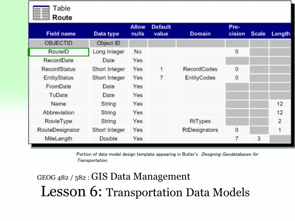
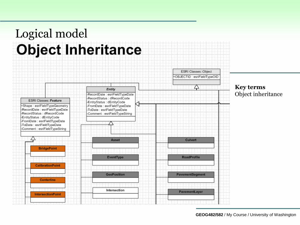
GEOG482/582 / My Course / University of Washington GEOG 482 / 582 : GIS Data Management Lesson 6: Transportation Data Models Portion of data model design template appearing in Butler’s Designing Geodatabases for Transportation.
Transcript
GEOG482/582 / My Course / University of Washington
GEOG 482 / 582 : GIS Data Management
Lesson 6: Transportation Data Models
Portion of data model design template appearing in Butler’s Designing Geodatabases for Transportation.
GEOG482/582 / My Course / University of Washington
Overview
Learning Objective Questions:
1. What transportation data models are suitable for use in
urban-regional applications of GIS?
2. What are some conceptual database design challenges
with regard to transportation databases?
3. What are some of the different application contexts for
transportation databases?
4. How might we compare and contrast transportation data
models?
5. What are some of the Esri approaches to transportation
data models?
Lesson Preview
Learning objective questions act as the lesson outline.
Questions beg answers.
GEOG482/582 / My Course / University of Washington
Urban/Regional Transport Data Models1. What transportation data models are suitable for use in urban-regional applications of GIS?
GEOG482/582 / My Course / University of Washington
2. What are some significant conceptual database design challenges with regard to transportation databases?
Planning and programming treat the concept of a “transportation
project” differently, due to contextual use of information.
Not only is this a problem within each jurisdictional scale,
but it is even more significant across jurisdictional scales as
depicted on the next slide.
Different organizations conceptualize the planning process within
different geographic domains, even though the domains are
overlapping.
Transportation projects can be spatially represented as points,
lines, polygons, or surfaces depending on how an organization
interprets the character of the project.
GEOG482/582 / My Course / University of Washington
Institutional scales motivate differences for databasesImportance of transportation planning topics in relation to geographic and administrative fociSize of lettering in the figure below indicates importance level.
GEOG482/582 / My Course / University of Washington
Database design can be a matter of ‘project abstraction’
‘Project Abstraction’ refers to the level of detail specified for a
particular transportation project.
Long-range plans contain the general project concept, general
impacts.
Programming requires more specifics to fund an improvement
project as part of an improvement package, all of these projects
being in the plan
Implementation requires more detail yet…
social, economic, ecological, and physical impacts are needed to
understand the character of projects
GEOG482/582 / My Course / University of Washington
Transportation planning databases
Transportation projects are conceptual in character
Projects appear as symbols on a planning map
Sketch character of the project is defined
Full character of the projects not defined
Transportation modeling software estimates changes in vehicle
flow
Physical details of the projects are not necessary to estimate
logical flows.
Link and node network
Abstraction of the real network
GEOG482/582 / My Course / University of Washington
Transportation improvement programming databases
Transportation improvement programs require a bit more detail
because funds involved (e.g., $6.4 billion for PSRC 2019-2022 TIP)
Main consideration is funding a package of projects (packaging of
projects, while raising the funds to pay for them, is the idea of
“programming”) NOTE: it is not computer programming
Funding requires specifying more of the details than in plan, from
what start reference marker and ending reference marker on a
highway.
Improvement programming process identifies funds for scoping,
designing and building projects.
Funding is the main concern, but impacts of the implementation are
still important in scoping and designing phases. How will the