66
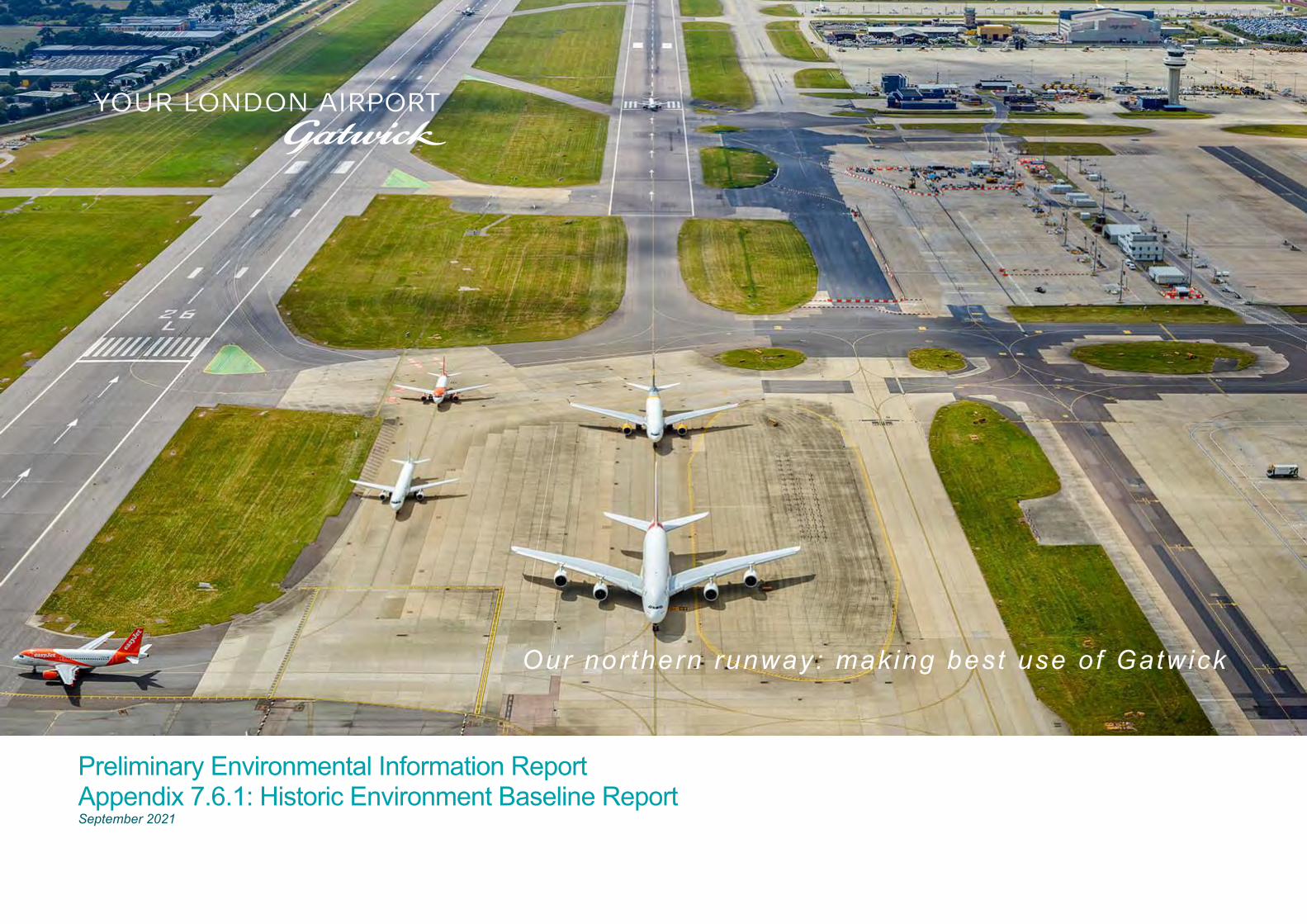
Our northern runway: making best use of Gatwick Preliminary Environmental Information Report Appendix 7.6.1: Historic Environment Baseline Report September 2021
Our northern runway: making best use of Gatwick
Preliminary Environmental Information Report Appendix 7.6.1: Historic Environment Baseline Report September 2021
Preliminary Environmental Information Report: September 2021 Appendix 7.6.1: Historic Environment Baseline Report Page i
Our northern runway: making best use of Gatwick
Table of Contents 1 Introduction 1
2 Legislation, Policy and Guidance 1
3 Geology and Topography 12
4 Historic Landscape 13
5 Designated Heritage Assets 16
6 Archaeological and Historical Background with Assessment of Significance 23
7 References 53
8 Glossary 56
Figures Figure 1.2.1: Designated Heritage Assets within 1 km of the
Project site boundary
Figure 1.2.2: Non-designated Heritage Assets within 1 km of the Project site boundary
Figure 3.1.1: Topography
Figure 3.1.2: Geology
Figure 4.1.1: Ordnance Survey Drawing - 1810
Figure 4.1.2: 1st edition OS 6’’ (to the mile) map – 1874
Figure 4.1.3: 2nd edition OS 6’’ (to the mile) map – 1897
Figure 4.1.4: Historic Landscape Characterisation – Character type (Sussex)
Figure 4.1.5: Historic Landscape Characterisation – Character subtype (Surrey)
Figure 5.2.1: Designated Heritage Assets within 3 km of the Project site boundary and within the ZTV
Figure 5.2.2: Designated Heritage Assets at Charlwood in relation to the ZTV
Figure 5.4.1: Predicted 2032 >1dB Noise Change Footprints – all Designated Heritage Assets
Figure 5.4.2: Predicted 2032 > 1dB Noise Change Footprints – Noise-Sensitive Designated Heritage Assets
Figure 6.3.1: The Gatwick North West Zone Archaeological Results
Figure 6.3.2: The Gatwick North West Zone Archaeological Results - details
Figure 6.3.3: The Pollution Control Lagoon and Flood Storage (Control) Reservoir Archaeological Results
Figure 6.3.4: The Pollution Control Lagoon and Flood Storage (Control) Reservoir Archaeological Results - details
Figure 6.3.5: The Flood Storage (Control) Reservoir Mesolithic Flint Density Plots
Figure 6.3.6: Walkover Observations Plan
Figure 6.3.7: Results of Aerial Photographic Study
Figure 6.3.8: Locations of 2019 Geophysical Survey Areas
Figure 6.3.9: Interpretation of geophysical survey – Area A
Figure 6.3.10: Interpretation of geophysical survey – Areas B, C, D & H
Figure 6.3.11: Interpretation of geophysical survey – Area F
Figure 6.3.12: Interpretation of geophysical survey – Area I
Figure 6.3.13: Predictive Modelling of Zones of Archaeological Potential
Preliminary Environmental Information Report: September 2021 Appendix 7.6.1: Historic Environment Baseline Report Page 1
Our northern runway: making best use of Gatwick
1 Introduction
1.1 General
1.1.1 This document forms Appendix 7.6.1 of the Preliminary Environmental Information Report (PEIR) prepared on behalf of Gatwick Airport Limited (GAL). The PEIR presents the preliminary findings of the Environmental Impact Assessment (EIA) process for the proposal to make best use of Gatwick Airport’s existing runways (referred to within this report as ‘the Project’). The Project proposes alterations to the existing northern runway which, together with the lifting of the current restrictions on its use, would enable dual runway operations. The Project includes the development of a range of infrastructure and facilities which, together with the alterations to the northern runway, would enable the airport passenger and aircraft operations to increase. Further details regarding the components of the Project can be found in Chapter 5: Project Description.
1.1.2 This document provides the Historic Environment Baseline Report for the Project.
1.2 Scope of Study
1.2.1 The report presents the results of combined desk-based assessment and site survey work. The Project site boundary is shown on Figures 1.2.1 and 1.2.2, along with the locations of heritage assets within 1 km of this boundary. Each of the heritage assets has a unique identifying site number, eg Site 1; Site 2 etc; these are taken from the overall historic environment gazetteer which is presented as Annex 1 of this baseline report.
1.2.2 A full description of the proposed elements of the Project is presented within Chapter 5 of the PEIR. Principal components of the Project comprise:
▪ amendments to the existing northern runway including repositioning its centreline 12 metres further north to enable dual runway operations;
▪ reconfiguration of taxiways; ▪ pier and stand alterations (including a proposed new pier); ▪ reconfiguration of other airfield facilities; ▪ extensions to the existing airport terminals (north and south); ▪ provision of additional hotel and office space; ▪ provision of reconfigured car parking, including new car
parks; ▪ surface access (including highways) improvements;
▪ reconfiguration of existing utilities, including surface water, foul drainage and power; and
▪ landscape/ecological planting and environmental mitigation.
1.2.3 This baseline report includes:
▪ a review of relevant legislation, planning policy and guidance;
▪ a review of the geology and topography of the land within the Project site boundary;
▪ a review of the historic landscape character of the land within and adjacent to the Project site boundary;
▪ the collection and mapping of Historic England Archive data for designated heritage assets within a study area extending 3 km beyond the Project site boundary and within the defined Zone of Theoretical Visibility (ZTV);
▪ the identification of significance of designated heritage assets that may be affected by the Project, including an assessment of their settings and how these settings contribute to their significance;
▪ the collection and mapping of Historic England Archive data (with cross referencing to Surrey and West Sussex Historic Environment Records (HERs)), for a study area extending approximately 1 km beyond the Project site boundary;
▪ a discussion of the known archaeological resources within the area surrounding the Project site, including their significance;
▪ a discussion of the known archaeological resources within the Project site, including their significance;
▪ a review of available non-intrusive surveys, including walkovers, aerial photographic assessment, LiDAR assessment and geophysical surveys;
▪ the predictive modelling of areas of high, medium and low archaeological potential within the land required for the Project; and
▪ the compilation of a gazetteer of the sites and finds identified (Annex 1).
1.2.4 This report is divided into the following key historic environment topics:
▪ historic landscape (Section 4); ▪ designated heritage assets (Section 5); and ▪ archaeology (Section 6).
1.2.5 A glossary of terms used within this report is provided in Section 8.
1.3 Assumptions and Limitations
1.3.1 There is a degree of uncertainty attached to the baseline data sources used in this report. This uncertainty includes the following, listed below.
▪ The entries in the Historic England Archive and equivalent county level HERs can be limited because these depend to a great extent on random opportunities for research, fieldwork and discovery.
▪ There is sometimes a lack of dating evidence for sites recorded in the Historic England Archive and equivalent county level HERs.
▪ Documentary sources are rare before the medieval period, and many historic documents are inherently biased. Older primary sources often fail to accurately locate sites and interpretation can be subjective.
▪ The extent of truncation caused by previous development impacts and landscaping works cannot be fully ascertained. In some cases it may be greater than anticipated and in others less than anticipated.
2 Legislation, Policy and Guidance
2.1 Legislation
2.1.1 Statutory protection for archaeological remains is principally enshrined in the Ancient Monuments and Archaeological Areas Act (1979) amended by the National Heritage Acts (1980; 1983; 2002). Nationally important archaeological sites are listed in a Schedule of Monuments and are afforded statutory protection.
2.1.2 The Planning (Listed Buildings and Conservation Areas) Act (1990) and the Town and County Planning Act (1990) provide statutory protection to listed buildings and their settings, and present measures to designate and preserve the character and appearance of Conservation Areas.
2.1.3 Historic Parks and Gardens, and Historic Battlefields, have received recognition under the National Heritage Acts. Such sites are described on Registers maintained by Historic England for the Department for Digital, Culture, Media and Sport (DDCMS), but such designation does not afford statutory protection.
Preliminary Environmental Information Report: September 2021 Appendix 7.6.1: Historic Environment Baseline Report Page 2
Our northern runway: making best use of Gatwick
2.2 Planning Policy
National Planning Policy
2.2.1 As a Nationally Significant Infrastructure Project (NSIP) under the Planning Act 2008, the principal national planning regime for the Project comprises the Airports National Policy Statement (NPS) (Department for Transport, 2018). This NPS sets out the primary policy for decision-making in relation to the proposed new runway at Heathrow Airport, but also states that it ‘will be an important and relevant consideration in respect of applications for new runway capacity and other airport infrastructure in London and the South East of England.’
2.2.2 With regard to the historic environment, the NPS states ‘The construction and operation of airports and associated infrastructure has the potential to result in adverse impacts on the historic environment above and below ground. This could be as a result of the scale, form and function of the development, and the wider impacts it can create in terms of associated infrastructure to connect the airport to existing transport networks, changes in aircraft movement on the ground and in the surrounding airspace, additional noise and light levels, and the need for security and space to ensure the airport’s operation’ (paragraph 5.187).
2.2.3 The NPS goes on to identify that ‘Those elements of the historic environment that hold value to this and future generations because of their historic, archaeological, architectural or artistic interest are called ‘heritage assets’. Heritage assets may be buildings, monuments, sites, places, areas or landscapes, or any combination of these. The sum of the heritage interests that a heritage asset holds is referred to as its significance. Significance derives not only from a heritage asset's physical presence, but also from its setting’ (paragraph 5.189).
2.2.4 Footnote 210 (page 77) explains that ‘Setting of a heritage asset is the surroundings in which an asset is experienced. Its extent is not fixed, and may change as the asset and its surrounding evolve. Elements of a setting may make a positive or negative contribution to the significance of an asset, may affect the ability to appreciate that significance, or may be neutral’.
2.2.5 Categories of designated heritage assets are:
▪ World Heritage Sites; ▪ Scheduled Monuments; ▪ Listed Buildings; ▪ Protected Wreck Sites;
▪ Protected Military Remains; ▪ Registered Parks and Gardens; ▪ Registered Battlefields; and ▪ Conservation Areas.
2.2.6 Non-designated heritage assets of archaeological interest which are demonstrably of equivalent interest to Scheduled Monuments will be subject to any policies that apply to designated heritage assets. For other non-designated heritage assets, the Secretary of State will consider impacts on such asset on the basis of clear evidence that the assets ‘have a significance that merits consideration in that decision’ (paragraph 5.192).
2.2.7 The NPS advises that ‘As part of the environmental statement, the applicant should provide a description of the significance of the heritage assets affected by the proposed development, and the contribution of their setting to that significance. The level of detail should be proportionate to the asset’s importance, and no more than is sufficient to understand the potential impact of the proposal on the significance of the asset’, before going on to state ‘Where a site on which development is proposed includes or has the potential to include heritage assets with archaeological interest, the applicant should include an appropriate desk-based assessment and, where necessary, a field evaluation. The applicant should ensure that the extent of the impact of the proposed development on the significance of any heritage asset can be adequately understood from the application and supporting documents’ (paragraph 5.193).
2.2.8 With regard to decision making, the NPS advises that ‘When considering the impact of a proposed development on the significance of a designated heritage asset, the Secretary of State will give great weight to the asset’s conservation. The more important the asset, the greater the weight should be’ (paragraph 5.200), also ‘Substantial harm to or loss of a Grade II Listed Building or a Grade II Registered Park and Garden should be exceptional. Substantial harm to or loss of designated sites of the highest significance, including World Heritage Sites, Scheduled Monuments, Grade I and II* Listed Buildings, Protected Wreck Sites, Registered Battlefields, and Grade I and II* Registered Parks and Gardens should be wholly exceptional’ (paragraph 5.202).
2.2.9 Importantly, ‘Any harmful impact on the significance of a designated heritage asset should be weighed against the public benefit of development, recognising that the greater the harm to the significance of the heritage asset, the greater the justification will be needed for any loss’ (paragraph 5.203).
2.2.10 The Project also requires works to the trunk road network and therefore consideration will need to be given to the NPS for National Networks (Department for Transport, 2015). The policy regarding historic environment issues is presented in paragraphs 5.120 – 5.142 of the National Networks NPS, with the wording being very similar to that used in the Airports NPS.
2.2.11 The National Planning Policy Framework (NPPF) was published in 2012 and last updated in 2021 (Ministry of Housing, Communities and Local Government, 2021). The NPPF sets out the Government’s planning policies for England and how these are to be applied. It states that planning law requires applications to be determined in accordance with the Development Plan for the relevant area unless material considerations indicate otherwise. Paragraph 2 states the NPPF ‘… is a material consideration in planning decisions’.
2.2.12 Policies regarding the historic environment are set out in Chapter 16 of the NPPF and include the following: ‘In determining applications, local planning authorities should require an applicant to describe the significance of any heritage assets affected, including any contribution made by their setting. The level of detail should be proportionate to the assets’ importance and no more than is sufficient to understand the potential impact of the proposal on their significance’ (paragraph 194).
2.2.13 ‘When considering the impact of a proposed development on the significance of a designated heritage asset, great weight should be given to the asset’s conservation (and the more important the asset, the greater the weight should be). This is irrespective of whether any potential harm amount to substantial harm, total loss or less than substantial harm to its significance’ (paragraph 199).
2.2.14 ‘Any harm to, or loss of, the significance of a designated heritage asset (from its alteration or destruction, or from development within its setting), should require clear and convincing justification. Substantial harm to or loss of:
a) grade II listed buildings, or grade II registered parks or gardens, should be exceptional;
b) assets of the highest significance, notably scheduled monuments, protected wreck sites, registered battlefields, grade I and II* listed buildings, grade I and II* registered parks and gardens, and World Heritage Sites, should be wholly exceptional’ (paragraph 200).
2.2.15 ‘Where a proposed development will lead to substantial harm to (or total loss of significance of) a designated heritage asset, local
Preliminary Environmental Information Report: September 2021 Appendix 7.6.1: Historic Environment Baseline Report Page 3
Our northern runway: making best use of Gatwick
planning authorities should refuse consent, unless it can be demonstrated that the substantial harm or total loss is necessary to achieve substantial public benefits that outweigh that harm or loss, or all of the following apply:
a) the nature of the heritage asset prevents all reasonable uses of the site; and
b) no viable use of the heritage asset itself can be found in the medium term through appropriate marketing that will enable its conservation; and
c) conservation by grant-funding or some form or not for profit, charitable or public ownership is demonstrably not possible; and
d) the harm or loss is outweighed by the benefit of bringing the site back into use.
2.2.16 ‘Where a development proposal will lead to less than substantial harm to the significance of a designated heritage asset, this harm should be weighed against the public benefits of the proposal including, where appropriate, securing its optimum viable use’ (paragraph 202).
2.2.17 ‘The effect of an application on the significance of a non-designated heritage asset should be taken into account in determining the application. In weighing applications that directly or indirectly affect non-designated heritage assets, a balanced judgement will be required having regard to the scale of any harm or loss and the significance of the heritage asset’ (paragraph 203).
Local Planning Policy
2.2.18 The Project is largely located within the county of West Sussex and within the administrative area covered by Crawley Borough Council, but a small part is within the county of Surrey and this includes land within the administrative area of Reigate and Banstead Borough Council and a very small area of land within the administrative area of Mole Valley District Council.
2.2.19 The defined study area for examination of the archaeological baseline situation extends for 1 km from the Project site boundary (Figure 1.2.2). This also takes in land within the administrative areas of Tandridge District (Surrey) and Mid Sussex District (West Sussex).
Crawley Borough Local Plan (2015-2030)
2.2.20 The Crawley Local Plan (2015-2030) was adopted in December 2015. It includes the following historic environment policies which are relevant:
Policy CH12: Heritage Assets
‘All development should ensure that Crawley’s designated and non-designated heritage assets are treated as a finite resource, and that their key features or significance are not lost as a result of development.
Where a development affects a heritage asset or the setting of a heritage asset, a Heritage Impact Assessment will be required. This should describe the significance of any heritage assets affected and the contribution made by their setting, the impact of the development, and any measures adopted to ensure the heritage asset is respected, preserved or enhanced or, for exceptionally significant development, relocated.
If, in exceptional circumstances, a heritage asset is considered to be suitable for loss or replacement, and it has been demonstrated its site is essential to the development’s success, proposals will need to demonstrate how they have recorded the heritage asset:
i. in line with a written scheme of investigation submitted to, and approved by, Crawley Borough Council; or
ii. in the case of standing structures, to a minimum of Historic England recording Level 2, or higher if specified by the council.
Applicants are also required to notify any relevant parties including Historic England and submit their recording to the Historic Environment Record.
Applicants should demonstrate that the benefits of the entire scheme outweigh the loss of the asset and that any replacement scheme is of equal quality in terms of its design.’
Policy CH13: Conservation Areas
‘All development within a Conservation Area should individually or cumulatively result in the preservation or enhancement of the character and appearance of the area.
All development within a Conservation Area should demonstrate, as part of the Heritage Impact Assessment, how the proposal conforms to the relevant Conservation Area Statement and Appraisal, and that consideration has been given to all of the following criteria:
i) respect the protected area and recognise the identifiable, and distinctive, character(s);
ii) respect any historic landscape features which affect the character of the place;
iii) maintain and enhance the area’s landscape value with regards to mature trees, hedges and public green spaces such as grass verges;
iv) respect and enhance the character of lower density developments with spacious landscaped settings. This includes where the landscape dominates the buildings, the significant gaps between the buildings, the set back from the street, as well as any large gardens, mature trees, hedges and green verges; and
v) preserve the area’s architectural quality and scale.
There may be structures within a Conservation Area which are not heritage assets and do not positively contribute to its character or appearance. Therefore, proposals for demolition of these structures will be considered on a case-by-case basis and may not be required to submit a recording to the Historic Environment Record. For such developments early pre-application discussions are encouraged.’
Policy CH15: Listed Buildings and Structures
‘To recognise the value of Listed Buildings (including Listed Structures) within Crawley, the council will ensure that any proposed works to them are consistent with the character, appearance and heritage value of any statutory Listed Building/ Structure, in line with national legislation, policy and guidance.
Any changes must preserve or enhance the design and character of the Listed Building and have regard to its historic significance. A Heritage Impact Assessment is required to be submitted demonstrating how proposals will protect the value of the listed building, its setting and its key features.
Preliminary Environmental Information Report: September 2021 Appendix 7.6.1: Historic Environment Baseline Report Page 4
Our northern runway: making best use of Gatwick
Listed Buildings should be retained and, therefore, the demolition, or part thereof, of a Listed Building will only be acceptable in exceptional circumstances, where:
i. there are clearly defined reasons why the building cannot be retained in its original or a reasonably modified form; and
ii. a significant benefit that cannot have facilitated the retention of the building can be demonstrated.
If demolition is seen to be acceptable, the council will require the building to have been recorded to Historic England Level 4 and submitted to the Historic Environment Record. Any development on the site of a demolished Listed Building must have regard to the original building.’
Policy CH16: Locally Listed Buildings
‘All development will seek to secure the retention of buildings included on the Crawley Borough Local Building List. Development should also maintain features of interest, and respect or preserve the character or setting of the building.
Development proposals affecting Locally Listed Buildings must demonstrate in the Heritage Impact Assessment that proposals take account of the following criteria:
ii) The Historic interest of the building.
iii) The Architectural interest of the building.
iv) The Townscape interest of the building.
v) The Communal value of the building and its surroundings.
Proposals seeking the demolition or partial demolition of a Locally Listed Building may be acceptable if the development proposals:
a) reflect or retain the key features of the original building; and
b) significantly outweigh the merit of retaining the original building with regard to social, economic and environmental benefit to the wider area; and
c) records the building up to Historic England Level 4, unless previously agreed with the Local Planning Authority, and submits that record to the Historic Environment Record in consultation with the Local Authority.
The council will also assess the merit of designating new locally listed buildings in consultation with local residents and will defined the characteristics of the buildings that warrant this level of protection.’
CH17: Historic Parks and Gardens
‘The following sites are designated and shown on the Local Plan Map as Historic Parks and Gardens:
▪ Worth Park ▪ Land South of St Nicholas’ Church ▪ Broadfield Park ▪ Tilgate Park ▪ Goffs Park ▪ Memorial Gardens.
The council will support development, unless it will have a negative impact upon the historic setting and character of the designated Historic Park or Garden.
All development proposals within the boundaries of the Historic Parks and Gardens as identified on the Local Plan Map will be required to demonstrate, through a Heritage Impact Assessment, that the proposals have regard to the designation, its character, key features and the setting of the area and that proposals respect or enhance the area.’
Crawley Borough Local Plan (2021-2037)
2.2.21 The draft Crawley Borough Local Plan 2021-2037 represents the emerging local plan policy. The January 2021 Regulation 19 draft submission document includes the following historic environment policies which are relevant:
Strategic Policy HA1: Heritage Assets
‘Crawley’s designated and non-designated heritage assets include:
▪ Listed Buildings (see also Policy HA4); ▪ Scheduled Monuments (see also Policy HA7); ▪ Non-designated heritage assets of equivalent significance to
scheduled monuments (see also Policy HA7); ▪ Conservation Areas (see also Policy HA2); ▪ Locally Listed Buildings (see also Policy HA5); ▪ Areas of Special Local Character (see also Policy HA3); ▪ Historic Parks and Gardens (see also Policy HA6); ▪ Other non-designated assets with archaeological interest
(see also Policy HA7).
All development should respond to these as a finite resource, providing a distinctive combination of social, economic and environmental benefits. Proposals should ensure that heritage assets’ key features or significance are conserved and enhanced as a result of development.
Where a designated heritage asset is affected by a proposal, great weight will be given to its conservation, while harm to, or loss of, its significance will require justification according to the importance of the asset and the degree of loss or harm, in line with local and national policy.
Proposals affecting the significance of a non-designated heritage asset will be considered according to the scale of any harm or loss, and the asset’s significance, in line with local and national policy.
Where a development affects a heritage asset or the setting of a heritage asset, a Heritage Impact Assessment will be required. This should:
i. for development proposals meeting criteria set out in the council’s Local List of Planning Requirements: include, and be informed by, the findings of a search of the Historic Environment Record (HER) and/or an Archaeological Desk-based Assessment.
ii. in all cases: describe, with reference to relevant sources (such as the National Heritage List for England and Conservation Area Appraisals), the significance of any heritage assets affected and the contribution made by their setting, the impact of the development, and any measures adopted to ensure the heritage asset is respected, preserved or enhanced or, for exceptionally significant development, relocated.
The loss or replacement of a heritage asset may be appropriate in exceptional circumstances, where justified in line with local and national policy on loss or harm, and where it has been demonstrated that:
▪ the site is essential to the development’s success; ▪ the benefits of the entire scheme outweigh the loss of the
asset; and ▪ any replacement scheme makes an equal contribution to
local character and distinctiveness.’
Preliminary Environmental Information Report: September 2021 Appendix 7.6.1: Historic Environment Baseline Report Page 5
Our northern runway: making best use of Gatwick
In cases where a heritage asset is considered to be suitable for loss or replacement, and it has been demonstrated that its site is essential to the development’s success, proposals will be subject to a requirement to record the asset(s) concerned. The scheme of investigation, including the Historic England Recording Level, is to be agreed with the council in advance of its implementation and will reflect the importance and nature of the asset and the impact of the proposal.
Applicants in such cases will also be required to notify any relevant parties including Historic England and submit their recording to the Historic Environment Record.
Regeneration proposals that make sensitive use of heritage assets, particularly where these bring redundant or under used buildings or areas, especially any on Historic England’s At Risk Register, into appropriate use will be encouraged.’
Strategic Policy HA2: Conservation Areas
‘Development within a Conservation Area should individually and cumulatively result in the preservation or enhancement of the character and appearance of the area.
All development within a Conservation Area should conform to the relevant Conservation Area Statement and Appraisal, and be designed according to the following principles:
i) respect the protected area and recognise the identifiable, and distinctive, character(s);
ii) avoid loss of, or harm to, architectural or decorative features or details making a significant contribution to the Area’s significance;
iii) respect any historic landscape features which affect the character of the place;
iv) maintain and enhance the area’s landscape value with regards to mature trees, hedges and public green spaces such as grass verges;
v) respect and enhance the character of lower density developments with spacious landscaped settings. This includes areas of landscape dominating the buildings, the significant gaps between the buildings, the set back from
the street, as well as any large gardens, mature trees, hedges and green verges; and
vi) preserve and enhance the area’s architectural quality and scale.
Conformity with the requirements of this Policy should be demonstrated as part of the Heritage Impact Assessment.
There may be structures within a Conservation Area which are not heritage assets and do not positively contribute to its character or appearance. Therefore, proposals for demolition of these structures will be considered on a case-by-case basis and may not be required to submit a recording to the Historic Environment Record. For such developments, early pre-application discussions are encouraged.’
Strategic Policy HA3: Areas of Special Local Character
‘All development within an Area of Special Local Character (ASLC) should respect or preserve the character of the area and be designed with regard to the area’s existing character and appearance. Proposals should be of an appropriate scale, design and massing, and should not result in significant adverse impact on the locality, its setting and important or valued views.
All development within an ASLC should demonstrate, as part of the Heritage Impact Assessment, how the proposals have regard to the area’s significance as a heritage asset, including its character and appearance.’
Strategic Policy HA4: Listed Buildings and Structures
‘To recognise the value of Listed Buildings (including Listed Structures) within Crawley, the council will ensure that any proposed works to them are consistent with the character, appearance and heritage interest of any statutory Listed Building/Structure, in line with national legislation, policy and guidance.
Any changes must preserve or enhance the design and character of the Listed Building and have regard to its historic and architectural significance. A Heritage Impact Assessment is required to be submitted demonstrating how proposals will protect the significance of the listed building, including its setting and its key features.
Harm to, or loss of, the significance of a Listed Building will require clear and convincing justification, taking account of the grading of the building, and the degree of harm or loss, in line with national policy. Substantial harm to, or total loss of, the significance of a Listed Building will require exceptional justification, including benefits that outweigh the harm or loss, and further demonstration of either:
a) the public and substantial nature of the benefits concerned; or,
b) the absence of an alternative use which averts the loss or harm and is consistent with:
i. the nature of the Listed Building; or ii. medium-term viability; or iii. the extent of potential opportunities for grant-funding, or
not-for-profit ownership.
In cases where substantial loss or harm is justified, the council will require the building to have been recorded according to an agreed scheme of investigation which is proportionate to the importance of the Listed Building and the impact of the proposal. The record shall be submitted to the Historic Environment Record. Any development on the site of a demolished Listed Building must have regard to the character, form and heritage significance of the original building.
Development proposals involving ground works adjacent to or within the curtilage of a Listed Building will also need to respond to the site’s archaeological potential in accordance with Policy HA7.’
Strategic Policy HA5: Locally Listed Buildings
‘All development will seek to secure the retention of Locally Listed Buildings. Development should also maintain features of interest, and respect or preserve the character or setting of the building.
Development proposals affecting a Locally Listed Building must demonstrate in the Heritage Impact Assessment that the proposals take account of its heritage significance, including its setting and any heritage interest falling within the following categories:
i) Age;
Preliminary Environmental Information Report: September 2021 Appendix 7.6.1: Historic Environment Baseline Report Page 6
Our northern runway: making best use of Gatwick
ii) Authenticity;
iii) Aesthetic/Architectural Value;
iv) Historic Value;
v) Social/Communal Value:
vi) Group Value;
vii) Landmark/Townscape Value;
viii) Archaeological interest.
Proposals seeking the demolition or partial demolition of a Locally Listed Building may be acceptable in exceptional circumstances if the development proposals:
a) reflect or retain the key features of the original building; and
b) significantly outweigh the merit of retaining the original building with regard to social, economic and environmental benefit to the wider area.
If demolition is seen to be acceptable, the building must first be recorded according to an agreed scheme of investigation which is proportionate to the importance of the Locally Listed Building and the impact of the proposal. The record must be submitted to the Historic Environment Record in consultation with the Local Authority.’
Strategic Policy HA6: Historic Parks and Gardens
‘The council will support development, unless it will have a negative impact upon the historic setting and character of a designated Historic Park or Garden.
All development proposals within the boundaries of a Historic Parks and Gardens as identified on the Local Plan Map and Local Heritage List will be required to demonstrate through a Heritage Impact Assessment:
a. that the proposals have regard to the asset, its character, heritage significance, key features and setting; and
b. that proposals respect or enhance the area.’
In addressing this policy, developers should also respond to the value these sites have as structural landscaping (Policy CL6); open space (Policy OS1; green infrastructure (Policy GI1); and biodiversity sites (Policy GI3).’
Strategic Policy HA7: Heritage Assets of Archaeological Interest
‘Development proposals in the vicinity of a Scheduled Monument, or any heritage asset with archaeological interest which is demonstrably of equivalent significance (i.e. ‘designated’ archaeological assets), will be expected to preserve or enhance the asset and its setting, including through protection of the asset from disturbance associated with development activity, and through the avoidance of patterns of movement or land use which may cause harm to, or loss of, the significance of an asset over time. Development should identify and pursue opportunities to better reveal the significance of such assets.
Development proposals affecting designated archaeological assets should be supported by a Heritage Impact Assessment demonstrating an understanding of the asset’s significance, and how this has informed compliance with the requirements identified above.
Any harm to, or loss of, the significance of any designated or non-designated heritage asset involved in a development proposal will be considered in line with national and local policy, according to the significance of the asset and the degree of loss or harm.
This consideration will be extended to cover heritage assets which are identified, or whose significance is re-evaluated, during the planning and development processes. In order to facilitate this, applications meeting the following thresholds should be supported by an Archaeological Desk-Based Assessment:
▪ ground works adjacent to or in the curtilage of a Listed Building;
▪ any activity within a Scheduled Monument; ▪ ground works within a Red Archaeological Notification Area; ▪ five or more residential units OR non-residential/mixed use
development of over 0.2 ha within an Amber Archaeological Notification Area;
▪ development outside an Archaeological Notification Area comprising 10 or more new units OR over 0.5 ha of non-residential/mixed use development.
Subject to the findings of a Desk-Based Assessment, the council may require field evaluation and the recording and publication of results. In some cases, the council may require assets to be preserved in situ or excavated.’
Reigate and Banstead Core Strategy 2014
2.2.22 The Reigate and Banstead Borough Core Strategy 2014 was adopted in July 2014. The following policy is relevant:
Policy CS4: Valued Townscapes and the Historic Environment
1. ‘Development will be designed sensitively to respect, conserve, and enhance the historic environment, including heritage assets and their settings. Development proposals that would provide sensitive restoration and re-use for heritage assets at risk will be particularly encouraged.
2. Development will respect, maintain and protect the character of the valued townscapes in the borough, showing consideration for any detailed design guidance that has been produced by the council for specific built-up areas of the borough. Proposals will:
a. Reflect high standards of sustainable construction in line with policy CS11.
b. Be of a high quality design which takes direction from the existing character of the site and reflects local distinctiveness.
c. Be laid out and designed to make the best use of the site and its physical characteristics, whilst minimising the impact on surrounding properties and the environment.
d. Protect and where appropriate enhance existing areas of biodiversity value and the links between them.
Reigate and Banstead Development Management Plan 2018-
2027
2.2.23 The Reigate and Banstead Borough Council Development Management Plan 2018-2027 was adopted in September 2019. The following policy is relevant:
Policy NHE9: Heritage Assets
1. ‘Development will be required to protect, preserve, and where possible enhance, the Borough’s designated and non-designated heritage assets and historic environment including special features, area character or settings of statutory and locally listed buildings.
2. All planning applications that directly or indirectly affect designated or non-designated heritage assets must be supported by a clear understanding of the significance, character and setting of the heritage asset and demonstrate:
a. how this understanding has informed the proposed development
Preliminary Environmental Information Report: September 2021 Appendix 7.6.1: Historic Environment Baseline Report Page 7
Our northern runway: making best use of Gatwick
b. how the proposal would affect the asset’s significance; and
c. any necessary justification proportionate to the importance of the heritage asset and the potential effect of the proposal.
1. In considering planning applications that directly or indirectly affect designated heritage assets, the Council will give great weight to the conservation of the asset, irrespective of the level of harm. Any proposal which would result in harm to or total loss of a designated heritage asset will not be supported unless a clear and convincing justification is provided. In this regard:
a. Substantial harm to, or loss of, Grade II assets will be treated as exceptional and substantial harm to, or loss of, Grade I and II* assets and scheduled monuments will be treated as wholly exceptional.
b. Where substantial harm to, or loss of designated heritage assets would occur as a result of a development proposal, planning permission will be refused unless there are substantial public benefits which would outweigh the harm or loss; or
i. it can be robustly proven that there are no other reasonable and viable uses for the asset in the short or medium term nor any other realistic prospect of conservation; and
ii. the harm or loss would be outweighed by the benefits of redevelopment.
c. Where less than substantial harm to a designated heritage asset would occur as a result of a development proposed, the harm will be weighed against the public benefits of the proposal.
2. Non-designated heritage assets of archaeological interest that are demonstrably of equivalent significance to scheduled monuments will be subjected to the tests in (3) above.
3. In considering proposals that directly or indirectly affect other non-designated heritage assets, the council will give weight to the conservation of the asset and will take a balanced
judgement having regard to the extent of harm or loss and the significance of the asset.
4. All development proposals must be sympathetic to a heritage asset and/or its setting by ensuring the use of appropriate high quality materials, design and detailing (form, scale, layout and massing).
5. Development that would help secure the long term viable use and sustainable future for heritage assets, especially those identified as being at risk of loss and decay, in a manner consistent with its conservation will be supported. Any associated or enabling development should have an acceptable relationship to the heritage asset, and character of the surrounding area.
6. Proposals which retain or, if possible, enhance the setting of heritage assets, including views, public rights of way, trees, and landscape features, including historic public realm features in a manner consistent with its conservation, will be supported.
7. Proposals affecting a Conservation Area must preserve and, where possible enhance the Conservation Area. The quality of the proposal must have particular regard to those elements that make a contribution to the character of the Conservation Area and its setting, and the special architectural or historic interest of the area.
8. Demolition (full or partial) of a building or removal of trees, structures or other landscape features in a Conservation Area, will be permitted only where:
a. A replacement development has been approved; and
b. The loss of the existing building, structure, tree or landscape feature will not detract, or where appropriate enhances, the character or appearance of the Conservation Area. Assessment of the contribution of an existing building must have regard to its character, design and construction, but not its condition.
9. Development within or affecting the setting of a historic park or garden will be required to:
a. Avoid subdivision.
b. Retain or restore features of historic or architectural interest, including trees, other distinctive planting and hard landscaping, and garden features.
c. Where relevant, be accompanied by an appropriate management plan.
10. An archaeological assessment including where appropriate a field evaluation, will be required to inform the determination of planning applications for:
a. Sites which affect, or have the potential to affect, Scheduled Monuments.
b. Sites which affect, or have the potential to affect, areas of Archaeological Importance or High Archaeological Potential.
c. All other development sites exceeding 0.4 ha.
13. Where the policies map, or other research, indicates that remains of archaeological significance are likely to be encountered on a site, the Council will require schemes for the proper investigation of the site to be submitted and agreed. These must incorporate the recording of any evidence, archiving of recovered material and publication of the results of the archaeological works as appropriate, in line with accepted national professional standards.’
2.2.24 There is also a Supplementary Planning Guidance document entitled ‘Planning and Archaeology in the Borough of Reigate and Banstead including a list of archaeological sites’ which was published in November 1993.
Mole Valley Core Strategy
2.2.25 The Mole Valley Core Strategy was adopted in 2009 and contains the following policy that is relevant:
Policy CS 14: Townscape, Urban Design and the Historic Environment
1. ‘All new development must respect and enhance the character of the area in which it is proposed whilst making the best possible use of the land available. This will be assisted through the work on Built-Up Area Character Appraisals.
Preliminary Environmental Information Report: September 2021 Appendix 7.6.1: Historic Environment Baseline Report Page 8
Our northern runway: making best use of Gatwick
2. The Council will resist development of a poor quality of design and will expect to see sufficient detail set out in the Design and Access Statements, where required, to enable planning applications to be properly determined.
3. Development must incorporate appropriate landscaping with particular attention to the use of trees and hedges native to the locality.
4. Areas and sites of historical or architectural importance will be protected and, where appropriate enhanced in accordance with the legislation, national and regional guidance.’
Mole Valley Local Plan 2000
2.2.26 Some of the policies in the Mole Valley Local Plan 2000 (Mole Valley District Council, 2000) have been ‘saved’ and the following are relevant:
Policy ENV23: Respect for Setting
‘Development will normally be permitted where it respects its setting taking into account of the following:
1. the scale, character, bulk, proportions and materials of the surrounding built environment. Developments will not be permitted where it is considered they would constitute over-development of the site by reason of scale, height or bulk or in relation to the boundaries of the site and/or surrounding developments;
2. public views warranting protection. Opportunities will be sought to create attractive new views or vistas;
3. townscape features such as street patterns, familiar landmark buildings, and the space about buildings;
4. the roofscape. Pitched roofs will normally be expected and any plant, machinery or lifts being incorporated within the roof structure;
5. the impact of the development within or conspicuous from the Green Belt on the rural amenities of the Green Belt by reason of its siting, materials or design;
6. the impact on the landscape of the proposed siting and appearance of new agricultural buildings or works or any
other appropriate/exceptional development in the countryside.’
Policy ENV39: Development in Conservation Areas
‘Development in Conservation Areas, or adjacent to and affecting their setting, shall preserve or enhance the character and appearance of the Area. Within this context:
1. developments, including extensions, shall be of a high standard of design and well detailed such as to reflect the local historic character, scale, quality of buildings, settlement form, and materials;
2. features which contribute to local character, including significant spaces, trees, walls and traditional architectural details, shall be retained;
3. the design of spaces between buildings, and their surfacing shall be sensitively treated;
4. significant views into and out of Conservation Areas will be safeguarded. To demonstrate that the above requirements have been satisfied, detailed rather than outline planning applications will normally be expected. The rigorous application of general planning and highway policies may be relaxed where they would be in conflict with the preservation or enhancement of the Area's character or appearance.’
Policy ENV47: Historic Parks and Gardens
‘The Council will seek to ensure that any proposed development within or adjoining a garden included in English Heritage's "Register of Parks and Gardens of Special Historic Interest" and identified on the Proposals Map does not detract from its setting, character, appearance or spatial composition, that unsympathetic subdivision is prevented and that any particular features of architectural or historic interest are protected.
The Council will seek to ensure that wherever possible existing views into and from historic gardens are protected. Where appropriate, opportunities will be sought through conditions or planning agreements to achieve the repair, restoration and management of Parks and Gardens of Special Historic Interest on the Register compiled by English Heritage.’
Policy ENV49: Areas of High Archaeological Potential
‘Where significant development proposals fall within an Area of High Archaeological Potential the developer will be required to provide an initial assessment of the archaeological value of the site preferably before, or otherwise as part of and planning application.
If as a result of that assessment important archaeological remains are considered to exist:
1. the developer may be required to arrange for an archaeological field survey to be carried out before the determination of the planning application; and
2. where important archaeological remains are found to exist and can justifiably be left in situ, provision will be made by planning condition or agreement to minimise or avoid damage to the remains. Alternatively, where there is good reason to believe archaeological remains exist but preservation of known remains in situ is not justified, a planning condition will normally be imposed requiring a programme of archaeological work in accordance with a scheme agreed by the Council to take place before any development commences and the results and any finds should be published and made available for public display.’
Policy ENV50: Unidentified Archaeological Sites
‘Outside Areas of High Archaeological Potential the Council will require that the results of desk-based archaeological assessment are submitted with any development proposals for a site larger than 0.4 ha. If the results of any desk-based assessment are inconclusive, or if they produce evidence of significant archaeological remains, then the numbered paragraphs in Policy ENV49 will be applicable.’
Policy ENV51: Archaeological Discoveries during Development
‘Where archaeological remains are discovered on unidentified archaeological sites and development has already commenced, the co-operation of the developer will be sought to permit access to an investigation of the area.’

Preliminary Environmental Information Report: September 2021 Appendix 7.6.1: Historic Environment Baseline Report Page 9
Our northern runway: making best use of Gatwick
Future Mole Valley 2018-2033
2.2.27 The draft Future Mole Valley Local Plan 2018-2033 represents the emerging local plan policy. The Regulation 18 consultation draft document includes the following historic environment policy:
Policy EN6: Conservation and Enhancement of Heritage Assets
1 ‘There will be a strong presumption in favour of retaining and enhancing heritage assets, both designated and undesignated. Proposals resulting in the alteration, partial or complete loss of a heritage asset or impact on its setting will need to be justified fully and assessed against its significance and the scale of any loss or harm. The weight given to the conservation of heritage assets will be proportional to their significance, the degree of harm caused and any public benefit.
2 Where alteration or loss of a heritage asset in whole or in part is approved, consent will be granted subject to a condition that requires changes to be recorded and those records submitted to the Surrey History Centre as part of the Historic Environment Record for Surrey.’
Tandridge Local Plan 2014-2029
2.2.28 The Tandridge Local Plan Part 2: Detailed Policies 2014-2029 was adopted in 2014 and the following policies may be relevant:
Policy DP20: Heritage Assets
A. ‘There will be a presumption in favour of development proposals which seek to enhance the historic interest, cultural value, architectural character, visual appearance and setting of the District’s heritage assets and historic environment. Accordingly:
1. Only where the public benefits of a proposal significantly outweigh the harm to, or loss of a designated heritage assets or its setting, will exceptional planning consent be granted. These benefits will be proportionate to the significance of the asset and to the level of harm or loss proposed.
2. Where a proposal is likely to result in substantial harm to, or loss of, a designated heritage asset of the highest significance (ie scheduled monuments, grade I and II* listed buildings, and grade I and II* registered parks and
gardens), granting of permission or consent will be wholly exceptional.
B. In all cases the applicant will be expected to demonstrate that:
1. All reasonable efforts have been made to either sustain the existing use, find viable alternative uses, or mitigate the extent of the harm to the asset; and
2. Where relevant the works are the minimum necessary to meet other legislative requirements.
C. With the granting of permission of consent the Council will require that:
1. The works are sympathetic to the heritage asset and/or its setting in terms of quality of design and layout (scale, form, bulk, height, character and features) and materials (colour and texture); and
2. In the case of a Conservation Area, the development conserves or enhances the character of the area and its setting, including protecting any existing views into or out of the area where appropriate.
D. Any proposal which is considered likely to affect a County Site of Archaeological Importance, or an Area of High Potential (AHAP), or is for a site larger than 0.4 hectares located outside of these areas, must be accompanied by an archaeological desk-based assessment. Where the assessment indicates the possibility of significant archaeological remains on the site, or where archaeological deposits are evident below ground or on the surface, further archaeological work will be required. Evidence should be recorded to enhance understanding and where possible material should be preserved in-situ. In cases where the preservation of remains in-situ is not possible, a full archaeological investigation in accordance with a council approved scheme of work will be required; the results of which should be made available for display at the East Surrey Museum or other suitable agreed location.’
Tandridge Emerging Our Local Plan 2033
2.2.29 Emerging local planning policy for Tandridge District is presented in Our Local Plan: 2033, which was submitted for examination in January 2019. The following policy is relevant:
Policy TLP43: Historic Environment
‘To respect the varied historical character and appearance of the District, development proposals will conserve and enhance the character and appearance of designated and non-designated heritage assets, through high-quality sensitive design. These include important archaeology, historic buildings, conservation areas, monuments, street patterns, streetscapes, landscapes, commons, and their settings.
Applicants should make every effort to liaise with the Surrey County Council Conservation Team and Historic England when drawing up proposals at the earliest opportunity to limit the prospect of any objection, in accordance with policies of the wider development plan including DP20 and any updates.
The Council will carry out a review of all conservation areas to ensure the boundaries and consideration remain relevant and up to date. This will be prepared and published as Conservation Area Appraisal documents and Management Plans. Where Neighbourhood Plans undertake reviews as part of their plan-making, the Council will support this.
The Council will support the inclusion of historic environment policies in Neighbourhood Plans, where they are justified.’
Mid Sussex District Plan 2014-2031
2.2.30 The Mid Sussex District Plan 2014-2031 was adopted in 2018 and contains the following policies that are relevant:
DP34: Listed Buildings and Other Heritage Assets
‘…Listed Buildings
Development will be required to protect listed buildings and their settings. This will be achieved by ensuring that:
▪ A thorough understanding of the listed building and its setting has been demonstrated. This will be proportionate to the importance of the building and potential impact of the proposal;
Preliminary Environmental Information Report: September 2021 Appendix 7.6.1: Historic Environment Baseline Report Page 10
Our northern runway: making best use of Gatwick
▪ Alterations or extensions to a listed building respect its historic form, scale, setting, significance and fabric. Proposals for the conversion or change of use of a listed building retain its significance and character whilst ensuring that the building remains in a viable use;
▪ Traditional building materials and construction techniques are normally used. The installation of uPVC windows and doors will not be acceptable;
▪ Satellite antennae, solar panels or other renewable energy installations are not sited in a prominent location, and where possible within the curtilage rather than on the building itself;
▪ Special regard is given to protecting the setting of a listed building;
▪ Where the historic fabric of a building may be affected by alterations or other proposals, the applicant is expected to fund the recording or exploratory opening up of historic fabric.
Other Heritage Assets
Development that retains buildings which are not listed but are of architectural or historic merit, or which make a significant and positive contribution to the street scene will be permitted in reference to their demolition and redevelopment.
The Council will seek to conserve heritage assets in a manner appropriate to their significance, so that they can be enjoyed for their contribution to the character and quality of life of the District. Significance can be defined as the special interest of a heritage asset, which may be archaeological, architectural, artistic or historic.
Proposals affecting such heritage assets will be considered in accordance with the policies in the National Planning Policy Framework (NPPF) and current Government guidance.’
DP35: Conservation Areas
‘Development in a conservation area will be required to conserve or enhance its special character, appearance and the range of activities which contribute to it. This will be achieved by ensuring that:
▪ New buildings and extensions are sensitively designed to reflect the special characteristics of the area in terms of their scale, density, design and through the use of complementary materials;
▪ Open spaces, gardens, landscaping and boundary features that contribute to the special character of the area are protected. Any new landscaping or boundary features are designed to reflect that character;
▪ Traditional shop fronts that are a key feature of the conservation area are protected. Any alterations to shopfronts in a conservation area will only be permitted where they do not result in the loss of a traditional shopfront and the new design is sympathetic to the character of the existing building and street scene in which it is located;
▪ Existing buildings that contribute to the character of the conservation area are protected. Where demolition is permitted, the replacement buildings are of a design that reflect the special characteristics of the area;
▪ Activities such as markets, crafts or other activities which contribute to the special character and appearance of the conservation area are supported;
▪ New pavements, roads and other surfaces reflect the materials and scale of the existing streets and surfaces in the conservation area.’
DP36: Historic Parks and Gardens
‘The character, appearance and setting of a registered park, or park or garden of special local historic interest will be protected. This will be achieved by ensuring that any development within or adjacent to a registered park, or park or garden of local historic interest will only be permitted where it protects and enhances its special features, setting and views into and out of the park or garden.’
Horsham District Planning Framework
2.2.31 The Horsham District Planning Framework was adopted in 2015. The following policy is relevant:
Policy 34: Cultural and Heritage Assets
‘The Council recognises that heritage assets are an irreplaceable resource, and as such the Council will sustain and enhance its historic environment through positive management of development affecting heritage assets. Applications for such development will be required to:
1. Make reference to the significance of the asset, including drawing from research and documentation such as the West Sussex Historic Environment Record;
2. Reflect the current best practice guidance produced by English Heritage and Conservation Area Character Statements;
3. Reinforce the special character of the district's historic environment through appropriate siting, scale, form and design; including the use of traditional materials and techniques;
4. Make a positive contribution to the character and distinctiveness of the area, and ensuring that development in conservation areas is consistent with the special character of those areas;
5. Preserve, and ensure clear legibility of, locally distinctive vernacular building forms and their settings, features, fabric and materials;
6. Secure the viable and sustainable future of heritage assets through continued preservation by uses that are consistent with the significance of the heritage asset;
7. Retain and improves the setting of heritage assets, including views, public rights of way, trees and landscape features, including historic public realm features; and
8. Ensure appropriate archaeological research, investigation, recording and reporting of both above and below-ground archaeology, and retention where required, with any assessment provided as appropriate.’
Draft Horsham District Local Plan 2019-2036
2.2.32 The Draft Horsham District Local Plan 2019-2036 was published for public consultation February – March 2020. The following policy is relevant:
Policy 35 – Heritage Assets and Managing change in the Historic Environment
‘The council recognises thatbheritage assets, both designated and non-designated, and their settings are an irreplaceable resource, and as such the council will preserve and enhance its historic environment through positive management of development affecting heritage assets. Applications for such development will be required to:
Preliminary Environmental Information Report: September 2021 Appendix 7.6.1: Historic Environment Baseline Report Page 11
Our northern runway: making best use of Gatwick
1. Make reference to, and show an understanding of, the significance of the asset, includng drawing from research and documentation such as the West Sussex Historic Environment Record. Proposals to alter or extend Listed Buildings, including curtilage land listed buildings, must be accompanied by a Heritage Statement;
2. Reflect the current best practice guidance produced by Historic England and Conservation Area Characyer Statements;
3. Make a positive contribution to the character and distinctiveness of the area, and ensuring that development in conservation areas is consistent with the special character of those areas;
4. Preserve, and ensure clear legibility of, locally distinctive vernacular building forms and their setting and features including trees, fabrics and materials;
5. Secure the viable and sustainable future of heritage assets through continued preservation by users that are consistent with the significance of the heritage asset. Change of use must be compatible with, and respect, the special architectural or historic interest of the asset and setting; and
6. Ensure appropriate archaeological research, investigation, recording and reporting of both above and below-ground archaeology, and retention where required, and provide assessments as appropriate.
Proposals which would cause substantial harm to, or loss of a heritage asset will not be supported unless it can be demonstrated that the substantial public benefits gained would outweigh the loss of the asset and that any replacement scheme makes an equal contribution to local character and distinctiveness. Applicants must show an understanding of the significance of the heritage asset to be lost, either wholly or in part, and demonstrate how the heritage asset has been recorded’.
2.3 Guidance
2.3.1 The NPPF is supported by the National Planning Practice Guidance (NPPG) (Department of Communities and Local Government, 2014), which was published online on 06 March
2014 and last updated in 2021. The NPPG provides advice on specific issues such as ‘What is ‘significance'’ and ‘What is the setting of a heritage asset and how should it be taken into account?’
2.3.2 The NPPG reiterates that the conservation of heritage assets in a manner appropriate to their significance is a core planning principle, requiring a flexible and thoughtful approach. Furthermore, it highlights that neglect and decay of heritage assets is best addressed through ensuring they remain in active use that is consistent with their conservation. Importantly, the guidance states that if complete, or partial loss of a heritage asset is justified, the aim should then be to capture and record the evidence of the asset's significance and make the interpretation publicly available.
2.3.3 Key elements of the NPPG relate to assessing harm to the significance of heritage assets. An important consideration should be whether the proposed works adversely affect a key element of the heritage asset's special architectural or historic interest. Additionally, it is the degree of harm, rather than the scale of development, that is to be assessed.
2.3.4 The level of 'substantial harm' is considered to be a high bar that may not arise in many cases. Essentially, whether a proposal causes substantial harm will be a judgment for the decision taker, having regard to the circumstances of the case. Importantly, harm may arise from works to the asset or from development within its setting.
2.3.5 In considering any planning application for development, the planning authority will be mindful of the framework set by government policy, in this instance the two NPSs and the NPPF, by current Development Plan Policy and by other material considerations.
2.3.6 The NPPF and NPPG are additionally supported by four Good Practice Advice (GPA) documents published by Historic England: GPA1: The Historic Environment in Local Plans; GPA 2: Managing Significance in Decision-Taking in the Historic Environment (both published March 2015), GPA3: The Setting of Heritage Assets (2nd edition published December 2017) and GPA4: Enabling Development and Heritage Assets (published June 2020).
2.3.7 GPA2: Managing Significance in Decision-Taking in the Historic Environment provides detailed guidance on how the significance of heritage assets can be determined, and how decision-takers
should assess proposals for developments which would affect this significance.
2.3.8 In accordance with the NPPF, GPA2 advises that ‘the information required in support of applications for planning permission and listed building consent should be no more than is necessary to reach an informed decision, and that activities to conserve of investigate the asset needs to be proportionate to the significance of the heritage assets affected and the impact on that significance’ (paragraph 3).
2.3.9 It is explained that ‘The first step for all applicants is to understand the significance of any affected heritage asset and, if relevant, the contribution of its setting to its significance. The significance of a heritage assets is defined as ‘the sum of its archaeological, architectural, historic and artistic interest’ (paragraph 4).
2.3.10 The document goes on to explain (paragraph 6) that a staged approach to assessment and decision-taking would be to:
▪ ‘Understand the significance of the affected assets ▪ Understand the impact of the proposal on that significance ▪ Avoid, minimise and mitigate impact in a way that meets the
objectives of the NPPF ▪ Look for opportunities to better reveal or enhance
significance ▪ Justify any harmful impacts in terms of the sustainable
development objective of conserving significance and the need for change
▪ Offset negative impacts on aspects of significance by enhancing others through recording, disseminating and archiving archaeological and historical interest of the important elements of the heritage assets affected’.
2.3.11 Specifically with regard to the significance of a heritage asset, GPA2 advises that it is important to understand not just the nature of the significance but also the extent and level of significance (paragraphs 8-10).
2.3.12 Further advice on assessing the significance of heritage assets has been recently published by Historic England in their Advice Note 12 Statements of Heritage Significance: Analysing Significance in Heritage Assets (October 2019). This explains how significance should be assessed as part of a staged approach to decision-making.
2.3.13 GPA3: The Setting of Heritage Assets provides detailed guidance on understanding the concept of setting and how it may
Preliminary Environmental Information Report: September 2021 Appendix 7.6.1: Historic Environment Baseline Report Page 12
Our northern runway: making best use of Gatwick
contribute the significance of heritage assets. The document repeats the NPPF definition of setting and goes on to explain that ‘Setting itself is not a heritage designation, although land comprising a setting may itself be designated. Its importance lies on what it contributes to the significance of a heritage asset or to the ability to appreciate that significance‘ (paragraph 9).
2.3.14 The Historic England guidance document (GPA3) makes the following points:
▪ a setting does not have a fixed boundary as it may change; ▪ extensive heritage assets such as landscapes or
townscapes can include many heritage assets and their nested and overlapping settings, as well as having a setting of their own;
▪ the setting of a heritage asset may reflect the character of the wider townscape or landscape in which it is situated, whether fortuitously or by design;
▪ the importance of a setting of a heritage asset is what it contributes to the significance of the asset;
▪ where the significance of a heritage asset has been compromised in the past by unsympathetic development within its setting, consideration still needs to be given as to whether additional change would further detract from (or possibly enhance) the significance of the asset; and
▪ the contribution made by its setting to the significance of a heritage asset does not depend on public access.
2.3.15 The document deals with the issue of setting and proportionate decision taking. It advises a five-stage approach:
1. identify which heritage assets and their settings are affected; 2. assess to what degree these settings make a contribution to
the significance of the heritage asset(s) or allow significance to be appreciated;
3. assess the effects of the proposed development, whether beneficial or harmful, on that significance or on the ability to appreciate it;
4. explore the way to maximise enhancement and avoid or minimise harm; and
5. make and document the decision and monitor outcomes.
2.3.16 Although assessments of changes within the settings of heritage assets can involve non-visual issues such as noise, it is more usually the visual aspects of a development that form the major part of the assessment.
2.3.17 The existence of direct lines of sight between the heritage asset and the proposed development is an important factor in judging
the visual impact of the development. However, it is possible for changes within the setting to occur even when such a relationship does not exist. For example, views towards a listed building from a frequently visited location, such as a park or a public footpath, may be affected by the presence of a larger development, even if the development is not directly visible from the building itself.
2.3.18 A checklist provided in GPA3 (page 11) identifies several factors that may be relevant with regard to understanding the significance of a heritage asset and the contribution made by its setting. A second checklist (page 13) identifies a number of potential aspects of a proposed development which may be relevant in understanding the implications for the significance of heritage assets.
2.3.19 One aspect of the Project which has the potential to cause harm to the significance of heritage assets as a result of change within their setting is that of increased air noise arising from additional aircraft movements and/or changes in airspace use. This is acknowledged in the Airports National Policy Statement (NPS) (Department for Transport, 2018), where potential adverse impacts on the historic environment include those resulting from ‘changes in aircraft movement on the ground and in the surrounding airspace, ….’ (paragraph 5.187).
2.3.20 The Airports NPS goes on to advise that ‘Detailed studies will be required on those heritage assets affected by noise, light and indirect impacts based on the guidance provided in The Setting of Heritage Assets and the Aviation Noise Metric’ (paragraph 5.194).
2.3.21 The first of the two guidance documents referenced in paragraph 5.194 of the Airports NPS is GPA3, which is discussed above in paragraphs 2.3.13 – 2.3.18. The second one is a research report produced for English Heritage that examined the potential for air noise impacts on heritage assets, with regard to both physical effects on the fabric of assets and changes to the settings of assets, and also the potential for air noise impacts on people using the heritage asset. The report concluded that air noise impacts on the physical fabric were unlikely, and went on to propose a methodology for assessing impacts on the significance of heritage assets resulting from changes in air noise (Temple Group and Cotswold Archaeology, 2014).
2.3.22 Some further guidance in this issue is presented within a document published by the Civil Aviation Authority which addresses the regulatory process for changing airspace design (CAP 1616, Civil Aviation Authority, 2021).
2.3.23 Appendix B of CAP 1616 provides information regarding the environmental metrics and assessment requirements with regard to proposals for airspace change. It advises (paragraph B29) that the altitude-based Government priorities mean that above 7,000 ft (feet) the key priority is the reduction of carbon dioxide (CO2) emissions rather than air noise. Although heritage assets are not mentioned specifically, one part of Appendix B deals with ‘tranquillity impacts’ (paragraphs B76-78).
2.3.24 In this baseline report, the contribution that setting makes to the significance of a heritage asset is often described using a five-point scale: Nil; Limited; Reasonable; Strong; Very Strong. The contribution should be taken as positive unless stated otherwise. The terms used in the five-point scale are not taken from any specific guidance and are not further defined within this report; the nature of the contribution is described within the accompanying narrative text.
2.3.25 GPA4 provides advice regarding enabling development, which is defined as development that would not be in compliance with local and/or national policies, and not normally given planning permission, except for the fact that it would secure the future conservation of a heritage asset.
2.3.26 Additional, more detailed guidance on specific aspects of the historic environment is provided in a series of Historic England Advice Notes (HEANs).
2.3.27 If any archaeological fieldwork is undertaken in connection with the Project, all work would be in line with the guidance document Sussex Archaeological Standards 2019, prepared by Chichester District Council, East Sussex County Council and West Sussex County Council, also any appropriate guidance prepared by or on behalf of Surrey County Council.
3 Geology and Topography 3.1.1 The geological and topographical setting of the Project site would
have been a key driver in the choices made by settlers within the landscape and the subsequent longevity of those settlements.
3.1.2 The Project site is low-lying and generally flat at approximately 57 metres to 61 metres above ordnance datum (AOD) (Figure 3.1.1). The wider topographical situation of the Gatwick area can be considered as both part of the north western Low Weald (to the north west of the High Weald) between the South and North Downs, and also as the southern extent of the Thames Valley,
Preliminary Environmental Information Report: September 2021 Appendix 7.6.1: Historic Environment Baseline Report Page 13
Our northern runway: making best use of Gatwick
since its watercourses drain north to the River Thames rather than south to the coast.
3.1.3 The British Geological Survey (BGS Sheet 302, 1972; BGS online 2012) shows the dominant basal geology to be mudstone Weald Clay Formation, laid down in the Cretaceous period (Figure 3.1.2). This varies in thickness from 120 metres to 450 metres and contains bands of ironstone and clay, including a seam to the west of Gatwick and another that runs south from Gatwick in the region of Crawter's Bridge (Framework Archaeology 2001a, page 5).
3.1.4 The Weald Clay Formation is overlain in places by much later superficial deposits, initially River Terrace Deposits of Quaternary date associated with the precursor(s) of the River Thames and its tributaries. The two recorded terraces reflect different depositional events (subsequently eroded) with the earlier furthest from the present course of the rivers.
3.1.5 A north/south aligned band of Head Deposits is present within the central part of the airport. These deposits are formed through periglacial frost action and/or post-glacial outwash.
3.1.6 The location and extent of the more recent natural drainage system is shown by the linear bands of Holocene alluvium (Figure 3.1.2). In the western part of the Project site, the generally east/west aligned Man's Brook feeds into the River Mole which flows to the north east. This watercourse is then joined by the north/south aligned Crawter's Brook and the similarly aligned Gatwick Stream. East of the airport is the Burstow Stream, also aligned north/south.
3.1.7 A wider area of alluvium is recorded within the western area of Gatwick at the confluences of Man's Brook and the River Mole and it has been suggested that this deposit may have formed as a large lagoon or area of marshland (Framework Archaeology 2001a, pages 5-6). A significant thickness of up 2.6 metres of alluvium (presumably deepest within palaeochannels) was recorded in the North West Zone car parking zone development. Peat deposits (with high potential to contain preserved wood and ecofacts) were found in 1998 within two geotechnical test pits associated with the Gatwick North West Zone (ibid, page 6). The two locations corresponded approximately with the former route of the River Mole and indicated thin accumulations (0.1 to 0.2 metres thick) at depths of between 2.6 metres to 2.9 metres below ground level (TPS Consult, 1998, cited by Framework Archaeology, 2001a). The peat has similarly been interpreted as either part of the channel or the marsh/lagoon.
3.1.8 A thin depth of topsoil and an absence of subsoil may be common to much of the pastoral land within the Project site. A topsoil depth of 250-300 mm was recorded by the extensive fieldwork projects in the Gatwick North West Zone and also by small-scale work in the south western area of Gatwick (Framework Archaeology 2001b; 2002a; 2007a). For the North West Zone it was noted that 'the fact that it [the topsoil] was fairly thin and that there was no subsoil below it tends to suggest that the area had not been ploughed continuously over a long period of time' (Framework Archaeology 2001a, page 6).
Table 3.1.1: Summary of 1998 Trial Pits at Gatwick North West Zone (after Framework Archaeology 2001a)
Deposit type
Depth below
ground level
of upper
surface
(metres)
Thickness
(metres) Description
Topsoil 0 0.25 to 0.35
Turf and topsoil (firm brown silty-clay) – found in all trial pits.
Made ground (local)
- 0.3 0.9 Firm brown silty-clay with sand, gravel, clay, cobbles, flint, asphalt and brick/felt, seen in trial pit 6.
Head Deposits
- 0.2 to - 0.35
0.85 to 1.2 A firm mottled grey and orange silty-clay seen in trial pits 2 to 6.
Alluvium - 0.2 to -0.35 1.65 to 2.6 A firm, grey-brown and orange brown silty-clay with black organic staining and woody fragments – seen in trial pits 7 to 9.
Peat - 2.6 to - 2.9
0.1 to 0.2 Black fibrous peat – seen in trial pits 7 and 8.
Weald Clay - 0.25 to - 3.5
A thinly bedded orange-brown, blue, and grey clay – seen in all trial pits.
3.1.9 A summary of the potential for organic preservation for this floodplain zone (ibid), which may be applicable elsewhere within the Project site floodplains, concluded:
'Based on the recorded observations of the evaluation, the stratigraphy [of the flood plain and palaeochannels] can be divided into 3 zones of potential for organic preservation:
▪ Upper zone (up to approximately1 metre below ground level): very low potential
▪ Middle zone (approximately1-2 metres below ground level): low to moderate potential
▪ Lower zone (approximately 2 metres plus, below ground level): high potential'.
4 Historic Landscape 4.1.1 Prior to the reorganisation of local government boundaries in
1974, the land occupied by the airport was wholly within the county of Surrey, predominantly within the parish of Charlwood but with a small part in the eastern area being in the historic parish of Horley. Both of these parishes were due to be transferred into West Sussex as part of the local government reorganisation, but this was opposed locally, and the outcome was that the parish boundaries were redrawn within a specific Act (the Charlwood and Horley Act 1974) allowing the parishes to remain within Surrey whilst the airport was transferred to West Sussex.
4.1.2 The land within the Project site boundary therefore was historically part of the parishes of Charlwood and Horley (both Surrey). A small area of land adjacent to Junction 9 of the M23 motorway is within the parish of Burstow (also Surrey).
4.1.3 The Project site is located in an area which is part of the Weald – an area of south eastern England located between the parallel chalk escarpments of the North and South Downs. The name Weald is of Old English derivation and means ‘forest’, as this was formerly an extensive area of woodland. In the Anglo-Saxon period the area was known as Andredes weald, after Anderida which was the Roman name for Pevensey.
4.1.4 The central part of the Weald is known as the High Weald. The Gatwick area is within the Low Weald, which surrounds the High Weald on its western, northern and southern boundaries. In general the Low Weald is characterised by wide, low-lying clay vales with small woodlands and fields, also a large number of streams and ponds. The historic settlement pattern is one of villages and small towns located on outcrops of harder rocks.
Preliminary Environmental Information Report: September 2021 Appendix 7.6.1: Historic Environment Baseline Report Page 14
Our northern runway: making best use of Gatwick
4.1.5 Although archaeological evidence indicates activity, including settlement, in this part of the Low Weald during the prehistoric and Roman periods (see section below regarding archaeology), the documentary evidence indicates that areas were cleared and used as common pasture which began to lead to permanent occupation from the 10th century AD onwards. By the end of the 13th century there was a mass of smaller holdings (for peasants) along with a few larger cleared areas occupied by local gentry. In the 14th century falling population levels resulted in some abandonment, but other clearances were merged. Any distinct rise in population numbers did not occur until the 16th century.
4.1.6 The resulting historic landscape is one of dispersed farmsteads with small, irregular fields bounded by hedges that are often heavily wooded. Land use has historically fluctuated between arable and pastoral according to the available methods and the needs of society. Newly cleared land was usually set to arable, but depopulation often resulted in a reversion to pasture or rough grazing. Livestock were mainly cattle, although certain areas specialised in sheep farming.
4.1.7 Other activities that helped to create the historic landscape which is still visible today are linked to the exploitation of the woodland for timber and firewood; much of the latter was used in the ironworking industry.
4.1.8 Documentary sources refer to the rights to dig for iron in Charlwood from as early as 1396, but the industry of ironworking in the Weald commenced much earlier than this and reached a peak during the 17th and 18th centuries. With regard to the historic landscape, the need for fuel resulted in the loss of long-standing woodland and the development of coppiced plantations.
4.1.9 One substantial forge was located at Tinsley Green, to the south east of the Project site boundary. At one point in the 17th century the owner of this forge lived at Oldlands Cottage, on the northern side of Radford Road. Close by to here are Forge Wood, Blackcorner Wood and Black Corner at the junction of Radford Road and the B2036 Balcombe Road. This latter place name (Black Corner) may be the result of the use of cinder from the furnaces as consolidation of the road – this was quite common and was necessary because the transport of heavy loads of iron ore and iron was very detrimental to the road surface.
4.1.10 Closer to Charlwood village there are several historic place names that reflect the former extraction of iron ore – these include Mine Croft, Pit Four Acres, Pit Meadow and Pit Croft. Visual inspection here during the walkover for the Gatwick R2
scheme recorded a number of slight depressions that suggest the location of former extraction pits. Historically, the ore was extracted from a fairly shallow vein in this area, after which the land was returned to cultivation.
4.1.11 The 1810 Ordnance Survey Drawing (OSD) shows the pattern of fields, watercourses and settlements in the area around Gatwick in the early 19th century (Figure 4.1.1). In the northern part is the small village of Horley, with the extensive Horley Common to the east and Gatwick Farm to the south west of the village, just within the Project site boundary.
4.1.12 A road extends west from Horley to Povey Cross and meets a north/south aligned route which crosses the River Mole at Kimberham Bridge and extends across the Project area to Lowfield Heath, with Westfield Common further to the west. To the south east of the Project site is Blackcorner (as mentioned above with regard to ironworking), with Pricket’s Wood just to the north.
4.1.13 In the eastern part of the Project site are Rowels Farm and Horley Land Farm, also Horley Land Wood.
4.1.14 Overall the 1810 map shows a landscape of small square or rectangular fields and dispersed farmsteads, with small blocks of woodland and larger areas of common land or heath.
4.1.15 A major change within the historic landscape arrived with the construction of the Brighton-London mainline railway, which opened in 1841 as the London and Brighton Railway and was subsequently incorporated into the London, Brighton and South Coast Railway. This cut through the historic landscape on a north/south alignment and a station was provided at Horley. The 1st edition Ordnance Survey 6’’ (to the mile) map of 1874 shows the railway within the eastern part of the Project site (Figure 4.1.2).
4.1.16 The manor of Gatwick developed around a land holding just to the north west of where the airport’s North Terminal currently stands. Figure 4.1.2 shows that the former Gatwick Farm had been replaced by a large house known as Gatwick, with formal gardens to the south along with a flag tower, engine house and gasometer. To the north is a fish pond adjacent to a drive that leads to a lodge – this building survives and faces onto Povey Cross Road (Site 429).
4.1.17 The 1874 map also shows that a pattern of fields which are mostly not as regular in shape and size as those shown on the map of 1810, although this may in part be the result of the greater
accuracy of mapping in 1874 (compared to the stylised field patterns on the earlier map). The 1874 map shows some areas of Parliamentary-style enclosure, where field boundaries and roads/tracks are very straight, especially in the land west of the railway and within the Project site boundary, also the enclosure of the former Lowfield Heath just to the south of the Project site and the former Westfield Common in the south western corner of the Project site.
4.1.18 One other notable change within the Project site boundary is in the north west part, where the former Whites Common has largely become an area of parkland surrounding a large house, named here as Charlwood Park. At the western edge of the park is the home farm of the estate.
4.1.19 Land to the south east of Gatwick was purchased in 1890 by the Gatwick Race Course Company, who opened a race course in 1891 along with a new station on the adjacent railway. A grandstand was located at the south eastern end of the racecourse (which was aligned north west/south east) and was linked to the railway station by three covered walkways (Figure 4.1.3). During World War One, the Aintree Grand National was postponed and a substitute race was run at Gatwick in 1916, 1917 and 1918.
4.1.20 The 2nd edition of the OS 6’’ (to the mile) map was published in 1897 (Figure 4.1.3). It shows that the parkland at Charlwood Park had been extended south as far as Man’s Brook, with a similar park now surrounding the house at Gatwick.
4.1.21 An airfield was licensed at Gatwick in 1930, although a company called Dominion Aircraft Ltd had based a plane there from November 1928, and there had been a few emergency landings on land adjacent to the racecourse during World War One. The new (grass) runway was adjacent to the racecourse and a small hangar was constructed. Wealthier racegoers could now travel by air to attend race meetings, and the runway was also used by the planes of Imperial Airways when the airfield at Croydon was fogbound, with passengers transferring to the railway at the racecourse station.
4.1.22 Morris Jackaman purchased the airfield in 1933 and acquired a licence for commercial flights in the following year. In 1935 a new railway station (known initially as Tinsley Green Station, then as Gatwick Airport Station) was opened further to the south and the following year the world’s first circular passenger terminal was opened, linked to the new station by a subway approximately 130 yards in length. The terminal had covered walkways that could
Preliminary Environmental Information Report: September 2021 Appendix 7.6.1: Historic Environment Baseline Report Page 15
Our northern runway: making best use of Gatwick
be extended out on small tracks to the parked aircraft in wet weather for enhanced passenger comfort.
4.1.23 British Airways moved to Gatwick in 1936 and operated flights to Paris, Malmo via Amsterdam, Hamburg and Copenhagen, with a route to the Isle of Wight added later the same year. However, the company returned to Croydon in 1937 as a result of problems with the drainage in the landing area and also flooding of the passenger subway.
4.1.24 A flight training school for the Royal Air Force (RAF) was established at the airport in 1937, one of several Elementary and Reserve Flight Training Schools run by civilian operators.
4.1.25 Horse racing ceased at the outbreak of World War Two, and the airfield was requisitioned by the Air Ministry and used by the RAF, with further requisitioning that included part of the racecourse. A new north east/south west aligned runway was established which cut across the southern end of the racecourse.
4.1.26 After the War the airfield was retained under requisition and operated for civilian use. The last meeting at the racecourse was held in 1948, using a shortened course.
4.1.27 In the 1950s Gatwick was substantially expanded to become the newest airport for London and was further enlarged in 1962. The country house known as Gatwick was demolished in 1950. The main runway was probably established as part of a major renovation undertaken in 1956-58 and was progressively extended in 1964, 1970, 1973 and 1998. The northern runway was established in 1985 through conversion of the northern parallel taxiway.
4.1.28 The 1936 airport terminal and subway are still present but are outside the current operational airport – the former is a Grade II* listed building known as The Beehive (see below for more details).
4.1.29 The land within the Project site boundary is predominantly occupied by the operational airport within which very little remains of the preceding historic landscape. However, there are some areas outside the airport which retain elements of their historic character and to some extent that can be shown through examination of the Historic Landscape Characterisation (HLC) that has been undertaken for Sussex and also for Surrey.
4.1.30 HLC is an aspect of more general landscape characterisation that seeks to provide an additional element of ‘time-depth’, allowing the historic evolution of the landscape to be perceived and
understood. For this process, a number of Broad Character Types are identified and then subsequently subdivided into more detailed HLC Types.
4.1.31 Identified HLC Types within Sussex are indicated on Figure 4.1.4. The current airport stands out very clearly, as do the industrial estates and business parks on the northern side of Crawley.
4.1.32 Within the Project site boundary there are small blocks of woodland (east of the railway), most of which are identified as ‘Ancient Semi-natural’ and one as ‘Plantations’. Also to the east of the railway are areas marked as ‘Assart’ (land informally cleared from the woodland) and similar areas are identified within the western edge of the Project site boundary. One other HLC Type found within the land east of the railway is ‘Informal fieldscapes’, although it should be noted that most of the land within this defined HLC Type has subsequently been amended, either for flood relief purposes or used as surface car parks for the airport.
4.1.33 There are areas of ‘Informal fieldscapes’ to the west of Bonnets Lane, on either side of the River Mole and around Rowley Farm. More areas of this HLC Type are shown to the east of the railway but these have subsequently all been amended through recent development including the extended Crawley Sewage Treatment Works (STW). The areas of ‘Informal fieldscapes’ shown to the east of Balcombe Road are still intact.
4.1.34 Beyond the Project site boundary are additional woodland blocks, mostly ‘Ancient Semi-natural’ and ‘Replanted Ancient Semi-natural’ along with a few ‘Plantations’. Larger areas of ‘Informal fieldscapes’ and ‘Assarts’ are also present. Areas of ‘Formal Enclosure (Planned/Private)’ stand out very clearly, with regular field patterns and straight boundaries. This can be seen at Lowfield Heath, where the former heath was inclosed in 1846, also around Fernhill and with land either side of Bonnets Lane. There are also areas of ‘Informal Parkland’ in the vicinity of Charlwood House, Gatwick Manor Inn (Hyders Hall) and Burstow Hall, along with ‘Market Garden/Allotments’.
4.1.35 Overall, this is the pattern typical of the Surrey Weald, with assarts coalescing to form informal fieldscapes and then some areas being formally inclosed. These former assarts can be identified by sinuous field boundaries (due to land take into woodland), wide hedges and their probable association with medieval farms (J. Mills, pers. comm.). The dispersed settlements are gradually encroached upon by ribbon
development along the transport routes whilst some ancient woodland has survived along with more recent plantations.
4.1.36 A small part of the land within the Project site boundary falls within Surrey, for which a separate HLC has been undertaken (Figure 4.1.5). The Surrey land within this area mainly comprises an HLC Subtype described as ‘Medium to large regular fields with wavy boundaries (late medieval to 17th/18th Century enclosure)’. This is informal enclosure of former assarts. There is also a very small part of an area of HLC Subtype ‘Post 1811 and pre-1940 settlement (small-scale)’ close to Povey Cross.
4.1.37 Natural England has subdivided the country into a total of 159 areas and produced character profiles of each area, including their landscape and townscape settings and heritage assets. The National Character Area (NCA) Profile 121 describes the Low Weald as 'a broad low-lying clay vale which largely wraps around the northern, western and southern edges of the High Weald. It is predominantly rural, supporting mainly pastoral farming owing to its heavy clay soils...and has many wooded areas with a high proportion of ancient woodland' (Natural England, 2013).
4.1.38 The document notes the presence of important sites 'many associated with the Wealden iron industry' (ibid, page 3). In the section 'Statements of Environmental Opportunity', SEO 2 is to 'conserve and enhance the distinctive historical aspects of the Low Weald landscape, including its important geological features and sites of heritage interest, particularly those associated with Wealden iron industry, enabling access, continued research, interpretation, understanding and enjoyment of the extensive and nationally significant resources' (ibid, page 4).
4.1.39 The document also notes the occupation from at least the Mesolithic, including use of rock shelters - noting woodland clearance of large areas in some areas in the Bronze Age and Iron Age.
'There is evidence of iron working in the Weald for over 2,000 years. For two periods, during the Roman occupation and in the Tudor and early Stuart era, the Weald was the main iron producing region in Britain. The geology of sands and clays yielded iron ore and the stone and brick to build furnaces. The woodland provided the necessary charcoal fuel for smelting and numerous small streams supplied water power for the bellows and hammers of the forges and furnaces. Many ponds were created in the impervious clay in order to store additional water to supplement natural watercourses. At its peak at the end of the 16th century, the Weald supported around 100 forges and
Preliminary Environmental Information Report: September 2021 Appendix 7.6.1: Historic Environment Baseline Report Page 16
Our northern runway: making best use of Gatwick
furnaces and the iron industry impacted on every aspect of life and the landscape. Large numbers of people were employed in digging ore, cutting wood, charcoal making and transporting raw materials and products. The legacy is still evident in the landscape of surviving hammer and furnace ponds. Grand houses built by wealthy foundry owners and the remains of coppiced woodland which was managed for the production of charcoal...' (ibid, page 10).
4.1.40 In section 9 'Key historic sites and features', in addition to noting the common activity of charcoal burning for iron and glass production, the 'high concentration of pre-1750 farmstead buildings and in the north part of the character area a major concentration of pre 1550 barns' is noted (ibid, page 26).
4.1.41 Natural England also note that in 2010 there were no Registered Battlefields, 21 Registered Parks and Gardens, 85 Scheduled Monuments and 6,066 listed buildings in the Low Weald.
4.1.42 Crawley Borough Council has produced the Crawley Baseline Character Assessment (Crawley Borough Council, 2009). This describes the strategic character areas of the developed sectors of the town and includes the industrial estate of Manor Royal in the town-wide analysis (but not in the detailed review section). The more rural parts of the Borough were excluded from the survey, as was Gatwick Airport.
4.1.43 The Crawley Historic Character Assessment was published in 2008 (Harris, 2008) and forms part of the Sussex Extensive Urban Survey. It identifies the historic urban character of the town through the establishment of Historic Urban Character Areas (HUCAs) and assigns a Historic Environment Value (HEV) to each of these HUCAs. It does not address the rural areas within the Borough, or the airport.
4.1.44 A number of existing farmhouses have been entered on the HER following a ‘Historic Farmlands and Landscape Character in West Sussex’ survey (Forum Heritage Services, 2006). The project represents all farmsteads shown on the 2nd edition OS 25” (to the mile) mapping of 1885 (these can also be seen on the 6’’ mapping presented as Figure 4.1.3).
5 Designated Heritage Assets
5.1 Designated Heritage Assets within the Project Site
5.1.1 There are three designated heritage assets wholly within the Project site (Figure 1.2.1). These comprise the Grade II* listed Charlwood Park Farmhouse (Site 27) in the north western part of the Project area, along with Edgeworth House (Site 133) and Wing House (Site 134) (both listed at Grade II) in the eastern part of the Project site.
5.1.2 Charlwood Park Farmhouse (Site 27) is described as follows in the listing description: ‘Late 15th century open hall house, refaced and re-roofed in the early 17th century when a jettied wing was added to the west and the building adapted into a continuous jetty house. Two storeys and attics. Base of Charlwood stone. Ground floor timber-framed with painted brick infilling and retaining some early 17th century close-studding to the parlour wing at the south end of the ground floor. The first floor is hung with plain and painted tiles and over-sailing on a moulded bressummer. Tiled roof with 17th century brick chimney stack. Four gables, the southernmost are oversailing on moulded brackets, the next, which is modern, surmounting the porch which is jettied on the first floor like the remainder of the front. Original doorcase in porch with chamfered architraves. Interior contains crown post in jettied parlour wing and moulded beams with stop chamfers’.
5.1.3 Charlwood Park Farmhouse lies just outside the current airport perimeter fence and is in use as a nursery school (Bear and Bunny Nursery and Pre-School). All associated farm buildings have been demolished, and the farmhouse has lost its former relationship with the main house of Charlwood Park and the surrounding parkland landscape, which lay within the operational airport and have been wholly lost to later development.
5.1.4 The farmhouse is situated within a garden extending around the western, northern and eastern sides, beyond which is modern surface car-parking for the airport. To the south is an area of landscape planting adjacent to the realigned River Mole, with the Sussex Border Path running alongside the river and passing to the south and east of the farmhouse. There is some air noise from planes taking off and landing, but this is not particularly obtrusive.
5.1.5 The setting of the farmhouse therefore includes some highly detracting elements, notably the operational airport and the associated surface car park. The adjacent setting to the south is
far less visually detracting, but is relatively recent and does not include any elements that are associated with the farmhouse.
5.1.6 Wing House (Site 134) and Edgeworth House (Site 133) are separately listed at Grade II but are conjoined. The listing description for Wing House describes it as a ‘Good quality four-bay, timber-framed former smoke bay hall house now within Gatwick Airport, later restaurant and bar of airport staff social club (to 2006). Attached to north and east of Edgeworth House. Probably mid-16th century. Two storeys. Tiled roof with 2 modern dormers. The rear of the roof has Horsham slabs to lower part. External chimneys to either end, one now enclosed within Edgeworth House. Curved tension braces all round. Front (east) elevation, four bays, timber-framed with brick nogging (some herringbone), on base of Charlwood Stone. One original mullioned window. Three sides of the solar bay at the north end are close studded. Projecting pitched-roofed extension to rear, now largely enclosed, had lagged, formerly external stack. Roof of side purlin and wind brace construction, with some smoke blackening, indicating former smoke bay’.
5.1.7 Edgeworth House (Site 133) is similarly described as an ‘L-plan, four-bay, timber-framed hall house, later restaurant and bar of airport staff social club (to 2006). Attached to south and west of Wing House. Said to date from either the 15th century or c. 1520. Gabled 20th century wing with bay windows to south. Ground floor painted brick. First floor tile hung. Square framing with plaster infill to north gable. Old tiled roof with Horsham Slabs to lower parts, with off-centre stack through ridge. The interior is said to be well-preserved, with exposed beams and open fireplaces. A house is shown on this site on a Christ's Hospital map of Horley of 1602’.
5.1.8 Edgeworth House and Wing House formerly represented two separate elements of a property known as Edgeworth (Figures 4.1.2 and 4.1.3), accessed via a driveway leading east to the B2036 Balcombe Road. This relationship no longer exists, and the two listed buildings are located within an area of surface car parks and modern buildings associated with the operational use of the airport, including the adjacent Marriot Hotel of which the historic buildings now form a part. The setting of the listed buildings makes no contribution to their significance.
5.1.9 One Conservation Area is partially within the Project site boundary. This is the Church Road Conservation Area on the south western edge of Horley (Figure 1.2.1, Site 406). A draft Conservation Area Character Appraisal and Management Proposals (CAMP) document was produced in February 2014 but
Preliminary Environmental Information Report: September 2021 Appendix 7.6.1: Historic Environment Baseline Report Page 17
Our northern runway: making best use of Gatwick
does not appear to have been adopted yet by Reigate and Banstead Borough Council (2014a).
5.1.10 The 2014 CAMP document describes the historical development with the Conservation Area, which is centred on the Grade I listed church (Site 16) and the Grade II listed public house (Ye Olde Six Bells – Site 370), although ‘the river and open setting’ are also described as ‘principal landmarks’. Views towards the church and the public house are identified as ‘key views’.
5.1.11 Pre-Victorian buildings are characterised by peg tile roofs, tile hung elevations, timber frames with painted brick infill and sash or casement windows. A late Victorian phase of development has houses of multistock brief with low pitched roofs in slate.
5.1.12 The Conservation Area extends to the west of the River Mole to take in an area of more open pasture and also a small moated site (Figure 1.2.2, Site 491). However, the western boundary of the Conservation Area does not correspond with any physical boundary on the land, increasing the openness in this direction. The views across this open area include the tower of the Gatwick Holiday Inn, but no elements of the operational airport are visible in views from or across this area.
5.1.13 To the east of the Conservation Area are areas of more recent housing along with the A23 London Road and the busy Longbridge Roundabout at the junction of the A23 and A217 roads. There is some traffic noise from the nearby main roads, but very little noise associated with the airport.
5.2 Designated Heritage Assets within 1 km of the Project Site Boundary
5.2.1 There is a considerable number of designated heritage assets within 1 km of the Project site boundary (Figure 1.2.1). These include two Scheduled Monuments, three Grade I listed buildings, seven Grade II* listed buildings, three Conservation Areas and approximately 77 Grade II listed buildings. Figure 5.2.1 shows these designated heritage assets (and others within 3 km of the Project site boundary) in relation to the ZTV established for the Project.
Scheduled Monuments
5.2.2 One of the Scheduled Monuments is just outside the Project site at Tinsley Green, just to the south of Radford Road and east of the railway line (Site 9). The Scheduled Monument comprises two areas of protection that are separated by a narrow strip of land to the rear of outbuildings associated with a residential
property known as Little Radfords. This monument contains former elements of the dispersed medieval settlement of Tinsley Green, known then as Tyntesle.
5.2.3 Archaeological examination of these remains has included geophysical survey, topographic (earthwork) survey and trial trenches. The work has concluded that this part of the former settlement was occupied from at least the 12th century through into the 18th century. Some of the material recovered was associated with ironworking; the known Tinsley Forge was located approximately 150 metres south east of the Scheduled Monument.
5.2.4 Within the protected area of the Scheduled Monument are earthworks representing a hollow-way aligned roughly north east/south west and flanked by at least three homesteads. Additional rectangular building plots have been recorded from aerial photographs.
5.2.5 The significance of this Scheduled Monument derives from the rarity of partly deserted medieval settlements with associated earthwork remains in this area of the Weald, also from its relationship with the nearby forge.
5.2.6 The current setting of the Scheduled Monument includes the open and fairly rural landscape of pasture and scrub to the south and also the quiet lane of Tinsley Green which has historic buildings on either side, including the Grade II listed Cherry Tree Cottage which is just outside the western boundary of the protected area. At the end of the short lane is the railway, beyond which are industrial units and warehouses within the Manor Royal Business District. To the north is the busy Radford Road, with The Greyhound public house on the southern side of this road. To the north of Radford Road, immediately behind Oldlands Farmhouse, is the Crawley STW. There is noise pollution from the road, and the railway and, to a lesser extent, from the operational airport.
5.2.7 The setting makes a reasonable contribution towards the significance of the Scheduled Monument, particularly its relationship with the historic dwellings on either side of the lane. However, new residential development (Crawley North East Sector) extends almost to the southern edge of the protected area. This development has severed any visual connection between the Scheduled Monument and the site of the former forge and greatly reduced the size of the rural area to the south. The key element of the setting is now firmly represented in the relationships with the buildings on either side of the monument.
5.2.8 The second Scheduled Monument is Thunderfield Castle (Site 7), located approximately 1.7 km north east of the airport. It is the site of a medieval moated manor house to which the name ‘Thunderfield Castle’ has been applied since the 17th century. Earlier sources suggest that the manor here was named as Herewoldsle or Harrowsley. A moat surrounds a central rectangular island; there is a semi-circular extension on the northern side of this inner moat and also an outer moat. Archaeological investigations here confirmed that the site was occupied during the 13th – 15th centuries.
5.2.9 The significance of this protected area derives from the survival of a large extent of apparently undisturbed land within a complex moated site; there is also a considerable amount of documentary material associated with the occupation of the site. The current setting of the Scheduled Monument makes a strong contribution towards its significance; the land in the immediate vicinity is mainly occupied by dispersed houses within small fields and with considerable vegetation in the form of mature trees. There is little noise associated with the existing airport, and no view of any part of the operational airport (other than planes in the air). The ZTV established for the Project indicates that there would be no visibility between this Scheduled Monument and any element of the Project (Figure 5.2.1).
Grade I Listed Buildings
5.2.10 The three Grade I listed buildings within 1 km of the Project site boundary (Figure 1.2.1) are all churches.
5.2.11 The Church of St Bartholomew on Church Road at Horley (Site 16) is of 14th century date, although restored in 1881 and with a south aisle added in 1901. It has a wood-shingled bell turret and spire at the south western end of the north aisle.
5.2.12 The church is experienced as part of the Conservation Area, with important adjacent buildings including Ye Olde Six Bells public house and High House, both of which are adjacent to the church. The immediate setting of the church comprises the churchyard, with the busy A23 road immediately to the east. However, the open land to the west of the churchyard is important as it allows views back towards the church in which the spire is visible above the trees. There is some noise from the adjacent road network, but not much from the airport in terms of ground or airborne noise. No part of the operational airport is visible in views from or across the church.
5.2.13 The Church of St Nicholas in the western part of Charlwood (Site 14) is approximately 1 km west of the Project site boundary. This
Preliminary Environmental Information Report: September 2021 Appendix 7.6.1: Historic Environment Baseline Report Page 18
Our northern runway: making best use of Gatwick
is of Norman origin with surviving elements of late 13th, 14th and 15th century date in the northern part of the current structure, including the central tower which is likely to be of late 13th or 14th century date.
5.2.14 The ZTV established for the Project indicates that there would be no visibility between the church and any element of the Project (Figures 5.2.1 and 5.2.2), and this has been confirmed through site visits. However, there is some airborne noise relating to planes taking off and landing. The principal setting of the church comprises the well-vegetated churchyard, and the adjacent historic buildings are also important.
5.2.15 The Church of St Bartholomew at Burstow (Site 13) is of 12th century date, enlarged and remodelled in the 15th century and restored in 1884-95. There is a tower at the western end of the south aisle which has a weatherboarded lower stage.
5.2.16 The church sits to the east of the airport (and east of the M23 motorway) within a small and well-enclosed churchyard, with extensive vegetation blocking views out in all directions other than to the east. No part of the operational airport is visible in views from or across the church. There is constant traffic noise from the M23 motorway (just 730 metres to the west), but this is overshadowed by the noise of incoming or outgoing planes which pass almost directly over the church.
Grade II* Listed Buildings
5.2.17 Five of the seven Grade II* listed buildings within 1 km of the Project site boundary are to the south of the airport (Figure 1.2.1).
5.2.18 Charlwood House (Site 23) is located on the south side of Charlwood road at Lowfield Heath, immediately south of the operational airport. This is a high-status house of early 17th century date, timber-framed with a close-studded frame, and was formerly called ‘Ticcaradges’ (Harding 1976, page 34). It is situated within a moat that extends around the eastern and northern sides of the house, which was substantially enlarged in the early 20th century with a close-studded extension and is currently in use as a nursery school.
5.2.19 Despite the presence of the airport to the immediate north, Charlwood House retains much of its early 20th century and earlier setting, the main buildings lying at the centre of an Edwardian ‘pocket park’, with mature trees, ranges of farm buildings to the south and a lodge house and driveway to the south east, on Poles Lane. One of the farm buildings (a former barn) is now a separate residential dwelling listed at Grade II
(Site 388). Car parking for the nursery school has caused limited impacts. Prior to the inclosure of Lowfield Heath and the creation of Poles Lane to the east of the house, Charlwood House would have more directly addressed the (now-inclosed) heath.
5.2.20 Gatwick Manor Inn (formerly Hyders Hall and Hydehurst) is located on the eastern side of the A23 London Road (Site 29). This is a high-status open hall house of 15th century date, which now houses a restaurant, bar and conference facilities. The earliest portion comprises the one remaining bay of a timber-framed, two bay open hall house, re-fronted in the 19th century. The remaining part of the hall house was greatly extended c. 1600 with a parallel high-status, two-storey brick range, with stone mullioned windows. Good interior details are known to survive throughout. In the mid-20th century the building was greatly extended with pastiche ‘half-timbered’ extensions, for hotel use. It was formerly moated, and part of the moat still exists on the west side. Just to the north (and forming part of the hotel complex) is a Grade II listed barn (Hyders Barn - Site 333).
5.2.21 The historic buildings that form part of the Gatwick Manor Inn complex retain some elements of their historic setting, principally a section of a historic moat. Their former relationship to the edge of Lowfield Heath (to the west) has been severed by the transformation of the former rural road into the A23 dual carriageway. Their relationship to the still open countryside to the north, east and south has been severed by the complex of more or less pastiche buildings and car parks that have grown up within the hotel complex since the 1950s. A feature of interest within the complex is the crudely reconstructed base of the Jolesfield windmill (1790), re-erected here in 1959. The cap, sweeps and machinery were never reinstated and the mechanical parts are now on display at the relocated Lowfield Heath windmill, near Charlwood.
5.2.22 The ZTV established for the Project indicates that there would be no intervisibility between this Grade II* listed building and any element of the Project (Figure 5.2.1).
5.2.23 The Church of St Michael and All Angels on Church Road at Lowfield Heath (Site 24) was built in 1867 in an early 13th century French Gothic style by the architect William Burgess. It is in undressed local stone with Bath stone dressings, and the fish-scale tiles mentioned in the statutory description have been replaced with a modern tile roof. There is an open-fronted timber narthex with lean-to roof at the west end, and a south west tower with timber spire clad in oak shingles. The west window is a large wheel window with sculptures representing the Four Ages
of Man, St Michael and the Dragon carved over the west doorway. The building is now used by a Seventh Day Adventist congregation.
5.2.24 Whilst it retains its churchyard and relationship to Church Road, the church has otherwise been wholly subsumed into the Gatwick Gate Industrial estate, which itself abuts the perimeter of the operational airport. The remainder of the hamlet of Lowfield Heath, which the church was built to serve, has been entirely removed to make way for modern commercial development.
5.2.25 Rowley Farmhouse is located to the south of the A23 London Road (Site 22). It is a late 16th century central smoke-bay house, with a cross passage behind the smoke bay and a back detached kitchen, greatly enlarged and extended to the west in early 20th century. The house is of historical note as it was once owned by the Culpeper family.
5.2.26 The farmhouse has a commanding position on the top of a small gravel hill. Nearby is a Grade II listed crown post barn (Site 167). Distantly Rowley Farm is surrounded to the north by Gatwick Airport and to the south and east by industrial estates. The house and barn are nevertheless still surrounded by more or less historic farm buildings and a historic farmland estate that separates them from the surrounding modern development. The listed farmhouse still has a well-treed garden to the west. To the east, the listed barn forms part of a wider complex of 18th, 19th and 20th century farm buildings. To the north, close to the A23 London Road, are an Edwardian lodge house and an open-fronted timber byre.
5.2.27 The Beehive (Site 35) is located within a complex of more modern industrial buildings just to the south of the airport. It is a unique historic former combined airport terminal and control tower, now used as offices. The building was constructed in 1934-36, by Hoar, Marlow and Lovett, for Morris Jackaman. It is in reinforced concrete with a steel frame and brick infill. Three storeys in total and circular in plan with concentric circles of rooms and corridors, rising in height to the former control tower at the centre.
5.2.28 From the central corridor passengers arrived and left through six telescopic corridors (no longer surviving) which were extended on rails to the aircraft steps. There is a subterranean tunnel (no longer in use) connecting The Beehive to the site of the previous Gatwick railway station. The Beehive is important not only in the history of British aviation but also in terms of world airport design. It is a rare example of how airport owners and architects
Preliminary Environmental Information Report: September 2021 Appendix 7.6.1: Historic Environment Baseline Report Page 19
Our northern runway: making best use of Gatwick
collaborated to put passenger comfort as a top consideration when designing a terminal building.
5.2.29 As originally built and conceived, The Beehive was an isolated building, surrounded on all sides by open taxiways and hardstandings for docking aircraft. It currently lies outside of the airport perimeter fence, surrounded on all sides by modern built development and roads. The railway station that served it has been demolished and the tunnel that connected the terminal to the station is disused. The Beehive is visually and physically divorced from the airport it once served.
5.2.30 The ZTV established for the Project indicates that there would be no visibility between this Grade II* listed building and any element of the Project (Figure 5.2.1).
5.2.31 The two remaining Grade II* listed buildings within 1 km of the Project site boundary are at Charlwood, to the west of the airport. The Providence Chapel on Chapel Road (Site 36) was erected in 1816 as the ‘Charlwood Union Chapel’ (Non-conformist). It was brought from Horsham where it had been initially built in 1797 as the Guard Room of a military camp used for training of troops to fight in the French Revolutionary War. Following the Battle of Waterloo in 1815 the camp was dismantled and the buildings were sold off. The chapel is single-storey and is in weatherboarded timber on a brick base. The hipped roof is tiled with slate and forms a veranda to the south east elevation which is supported on wooden columns.
5.2.32 The chapel is located on the west side of a narrow unsurfaced lane, with open farmland to the east. No part of the operational airport is visible in views from or across the chapel, and the ZTV established for the Project indicates that this will not change (Figure 5.2.1). There is some noise from planes arriving and departing the airport, but this is not obtrusive.
5.2.33 The Manor House on Norwood Hill Road at Charlwood (Site 33) is a large hall house of 15th or 16th century date. In two storeys it is timber-framed with plaster and red brick infilling, and the parlour wing is close-studded. The kitchen is partly open to the roof and has smoke-blackened crown posts and rafters above (Harding, 1976, page 60).
5.2.34 The house is located within well-vegetated grounds; no part of the operational airport is visible in views from or across the house, and the ZTV established for the Project indicates that this will not change (Figure 5.2.1). There is some noise from planes arriving and departing the airport, but this is not obtrusive.
Conservation Areas
5.2.35 One of the three Conservation Areas within the defined 1 km study area is located close to the Church Road Horley Conservation Area which is described above (Figure 1.2.1). This is the Massets Road Conservation Area to the west of the railway station at Horley (Site 398).
5.2.36 A draft Conservation Area Appraisal (CAA) (Reigate and Banstead Borough Council, 2014b) document was produced in December 2014 but does not appear to have been adopted yet by Reigate and Banstead Borough Council. The document identifies that ‘The special interest of Massets Road Conservation Area is derived from the cohesive groups of Victorian and Edwardian villas. The prominent character of the buildings is Victorian and Edwardian, with some earlier structures’.
5.2.37 The Conservation Area is surrounded on all sides by multi-period development. There is some noise from planes arriving and leaving the airport, but this is not obtrusive. Overall, the setting of the Conservation Area does not make much of a contribution to its significance.
5.2.38 The ZTV for the Project shows that the potential for elements of the Project to be visible from the Conservation Area is limited to a small area at the very western end of the designated area (Figure 5.2.1). Site visits have identified that no part of the operational airport is visible in views from or across this Conservation Area.
5.2.39 A second Conservation Area is located at Burstow, to the east of the airport and east of the M23 motorway (Site 400). This was designated by Tandridge District Council and is quite small, covering the historic core of the settlement including the Grade I listed Church of St Bartholomew (see above), a Grade II listed tomb in the churchyard, and the Grade II listed Burstow Court.
5.2.40 There is a considerable amount of mature vegetation within the Conservation Area, including large trees along the boundaries on all sides. Consequently, there are no views from or across the Conservation Area in which any part of the operational airport is visible.
5.2.41 The surrounding landscape is quite rural, but there is considerable constant traffic noise from the M23 motorway. This is overshadowed at regular intervals by the noise of incoming or outgoing planes which pass directly over the Conservation Area.
5.2.42 Overall, the setting of the Conservation Area makes a reasonable contribution to its significance, due mainly to the rural character of
the surrounding area. However, the noise from motorway traffic and particularly from aircraft are key detracting elements.
5.2.43 The third Conservation Area within 1 km of the Project site boundary is at Charlwood, to the west of the airport (Site 397). This was initially designated by Surrey County Council and subsequently extended by Mole Valley District Council. It includes the area around the Grade I listed Church of St Nicholas (see above) and several other listed buildings within the western part of the settlement, along with areas of open space in the central and northern parts of the village.
5.2.44 A description of the Conservation Area was provided in Appendix 6 of the Mole Valley Local Plan 2000. It identifies the Conservation Area as ‘a large area covering the historic core of the village and peripheral medieval buildings’ before going on to say that ‘The village setting of hedged fields, winding country lanes, field oaks and woodland is important because of the views out from the Conservation Area and the background formed for important buildings such as the Parish Church’.
5.2.45 The description identifies the importance of the approach to the church along The Street (ie from the east) and also the views from the footpaths to the south of the church. Open spaces are also identified as important, with the open land in the northern area described as ‘fields which separate the medieval farmhouses, a reminder of a past settlement form that was more dispersed’.
5.2.46 The Conservation Area is surrounded to the north, west and south by farmland which allows views in towards the designated area. To the east are further developed areas of the village that are not included within the Conservation Area boundary, but which do contain a number of historic buildings. Overall, the setting of the Conservation Area makes a reasonable contribution to its significance.
5.2.47 The ZTV for the Project shows that the potential for elements of the Project to be visible from the Conservation Area is limited to the open areas to the north of the village (Figure 5.2.1). However, the mature vegetation within and around the Conservation Area means that there are actually no locations from which any part of the operational airport is visible in views to and across the Conservation Area. There is some noise from planes landing or departing, but this is not particularly intrusive with regard to the ability to appreciate the character and appearance of the Conservation Area.
Preliminary Environmental Information Report: September 2021 Appendix 7.6.1: Historic Environment Baseline Report Page 20
Our northern runway: making best use of Gatwick
Grade II Listed Buildings
5.2.48 As described above, there are approximately 77 Grade II listed buildings or structures within 1 km of the Project site boundary (Figure 1.2.1). Examination of the ZTV established for the Project indicates than many of these listed buildings have no intervisibility with any built element of the Project (Figure 5.2.1). These examples are not described further within this baseline report unless it is considered that the construction and/or operation of the Project could harm the significance of the listed building though non-visual changes in their settings, eg noise.
5.2.49 The same applies to those Grade II listed buildings which are located wholly within the urban parts of Horley. It has been assumed that for these buildings, their settings are dominated by the surrounding buildings and urban landscape. Any changes in views towards the operational airport are considered unlikely to result in harm to the significance of these listed buildings.
5.2.50 Several Grade II listed buildings within 1 km of the Project site boundary are located to the south of the airport (Figures 1.2.1 and 5.2.1). These include Old Bonnetts Cottage on Bonnetts Lane (Site 341), Knights Acre (formerly St Barbe Cottage – Site 334), Poles Acre Barn (Site 296), Spikemead Farmhouse (Site 156) and Lowfield Hall (Site 388) – all on Poles Lane, along with County Oak Cottage (Site 299).
5.2.51 Close to the southern boundary of the airport is the Lowfield Heath War Memorial (Site 389) which is adjacent to the Grade II* listed Church of St Michael and All Angels (Site 24). The Grade II listed crown post barn at Rowley Farm (Site 167) is located close to the Grade II* listed Rowley Farmhouse (Site 22).
5.2.52 Just outside the Project site boundary in the Tinsley Green area are Oldlands Farmhouse (Site 161), Brookside (Site 157) and Radford Farmhouse (Site 192), all on the north side of Radford Road, and Cherry Tree Cottage on the south side of Tinsley Lane (Site 162).
5.2.53 To the east of the Project site boundary are Teizers Farm House on Antlands Lane (Site 103), and Old Cottage (Site 140) and Lilac Cottage (Site 325), both on Donkey Lane. Burstow Court, just to the north of the Church of St Bartholomew at Burstow, is listed at Grade II (Site 175), as is Broadbridge Farmhouse on Broadbridge Lane (Site 174).
5.2.54 To the north of the M23 motorway spur are Yew Tree Cottage (Site 76) and Inholms Farmhouse (Site 75), both on Haroldslea
Drive, also Fishers Farmhouse (Site 80) and a former barn (now residential - Site 320) on Limes Avenue.
5.2.55 There are several Grade II listed buildings or structures within and adjacent to the Church Lane Conservation Area at Horley. These include the Boer War Memorial Lychgate to the south of the church (Site 390) and several tombs within the churchyard, as well as High House (Site 70), Ye Olde Six Bells public house (Site 370) and a barn to the north of Ye Olde Six Bells (Site 71). Further to the west are Hookwood Manor (Site 281) and Povey Cross House (Site 225).
5.2.56 A number of Grade II listed buildings are located at Charlwood, west of the operational airport. Some of these are outside the Conservation Area, including the farmhouse and associated buildings at Charlwood Place Farm (Sites 290; 251; 252; 270; 271), also the farmhouse and associated buildings at Spicers (Sites 253; 254; 272) and again at Tifters (Sites 275; 246).
5.2.57 Figure 5.2.2 presents a large-scale map of the designated heritage assets at Charlwood in relation to the ZTV prepared for the Project. This detailed image shows clearly how the local vegetation around the properties and within the village screens current and future views towards the operational airport. In the course of several visits, it has not been possible to find any location at Charlwood (inside or outside of the Conservation Area, or adjacent to any listed building) from which any part of the operational airport is visible.
Locally Listed Buildings
5.2.58 Locally listed buildings do not fall within the definition of ‘designated heritage assets’ provided within Annex 2 of the NPPF. However, they are identified by some local authorities and specific local plan policies are often in place which address how these heritage assets should be considered within the planning process.
5.2.59 Figure 1.2.2 shows the locations of locally listed buildings within 1 km of the Project site boundary. A number of these are located within the urban areas of Horley and the built elements of the Project would not represent a change within the settings of these assets. The locally listed buildings are within Reigate and Banstead Borough, Crawley Borough and Tandridge District as these local authorities maintain a local list of historic buildings.
5.2.60 One locally listed building is situated on the north western edge of the Project site boundary. This is Gatwick Manor Lodge on the south side of Povey Cross Road and it represents the only
surviving structure associated with the former country house of Gatwick which replaced the earlier Gatwick Farm. The lodge fronts onto the road and is the only building on this side of the road. To the sides and rear is mature vegetation that provides a thick screen. Beyond the rear garden are the River Mole and the drainage lagoons, whilst to the east is the Travelodge and the Airport Inn.
5.2.61 There are four locally listed buildings on the southern edge of Horley, comprising a granary to the east of Bayhorne Farmhouse (Figure 1.2.2, Site 453), Pear Tree Cottage and a small barn on Haroldslea Drive (Sites 456 and 457) and Haroldslea House (Site 476).
5.2.62 There are several locally listed buildings to the east of the airport. On the west side of the M23 motorway these include Royal Oak House (Figure 1.2.2, Site 426), Touchwood Chapel (Site 428), Poplars (Site 425), Gatwick House (Site 427), No. 1 Pullcotts Farm Cottages (Site 424) and Burstow Hall (Site 410).
5.2.63 To the east of the M23 motorway are Brook Cottage and Brook Farm (Figure 1.2.2, Sites 421 and 422) and also the Rectory and Bartlemy at Burstow (Sites 413 and 414).
5.2.64 South east of the airport are The Cottage in the Wood, The Open Door and the Parsons Pig Public House, all on Balcombe Road (Figure 1.2.2, Sites 409, 433 and 434). Further to the west at Tinsley Green are Newbridge and Zell Cottages (Site 430), Greyhound Cottage (Site 431) and the Greyhound Inn (Site 432). At the very south eastern edge of the 1 km buffer is Rose cottage (Site 435).
5.3 Designated Heritage Assets within 1-3 km of the Project Site
5.3.1 The locations of designated heritage assets within 3 km of the Project site boundary and within the ZTV for the Project are indicated on Figure 5.2.1. The ones within 1 km have been described above.
Scheduled Monuments
5.3.2 There are two Scheduled Monuments within 1-3 km of the Project site boundary which are shown through the ZTV to have potential intervisibility with elements of the Project. One of these is a moated site at Ewhurst Place (Site 2). This is within the developed urban area of Crawley and is not further described here as it is considered that changes within its setting resulting
Preliminary Environmental Information Report: September 2021 Appendix 7.6.1: Historic Environment Baseline Report Page 21
Our northern runway: making best use of Gatwick
from the construction and operation of the Project are unlikely to affect its significance.
5.3.3 The second Scheduled Monument is the moated site at Ifield Court (Site 4). This includes the moat and internal island along with a platform and shallow ditch to the south west. It was formerly the site of the manor house of Ifield Court, replaced by the present house (now a hotel) which is to the east of the moat.
5.3.4 The setting of the Scheduled Monument includes the historic farm buildings to the north and the later house (now hotel) to the east, along with the hotel car park and other elements of the hotel infrastructure. To the south is open land representing the surviving part of the former park which surrounded the moated site, beyond which is the Ifield Village Conservation Area (see below for details of this designated heritage asset).
5.3.5 There is no intervisibility with any element of the operational airfield, and airborne noise from planes is not intrusive. Overall the setting of the Scheduled Monument makes a reasonable contribution to its significance.
Grade II* Listed Buildings
5.3.6 There are three Grade II* listed buildings within 1-3 km of the Project site boundary and within the ZTV (Figure 5.2.1).
5.3.7 One of these is Burstow Lodge to the north of Weatherhill (Site 30). This 15th century hall house sits within a moated platform, with later buildings to the south (outside the moated area) and with a motor-racing circuit (the Smallfield Raceway) immediately to the west. The listed building is enclosed within a screen of mature vegetation and there will not be any intervisibility with any element of the Project.
5.3.8 The second Grade II* listed building is located to the south east, on the eastern side of Smallfield. This is a divided house of 16th century date now known as Crullings and Smallfield Place (Site 21). The principal façade of the house faces to the east (away from the airport) and mature vegetation around the western boundary of the property ensures that will not be any intervisibility with any element of the Project.
5.3.9 The third Grade II* listed building comprises the tennis court and orangery at Crabbet Park (Site 18), to the south east of the airport. The parkland extends for some distance to the north of the tennis court and orangery, but a substantial scree of mature vegetation separates the buildings form the parkland and also prevents any potential intervisibility with the airport.
Conservation Areas
5.3.10 There is one Conservation Area within 1-3 km of the Project site boundary and within the ZTV (Figure 5.2.1). This is the Ifield Village Conservation Area, to the south west of the airport (Site 396).
5.3.11 A Conservation Area Statement was published in February 2018 by Crawley Borough Council and Ifield Village Association (2018). This explains that the area around the parish church was initially designated as a Conservation Area in 1891, and was subsequently extended to the north and east.
5.3.12 The Conservation Area character is summarised as ‘a small, scattered rural settlement, focused upon an historic church and public house. In addition to the contribution made to the area’s historic character by the many fine buildings, a number of other features contribute to its importance, including Ifield Village Green’.
5.3.13 The ZTV for the Project suggests that elements of the Project may be visible from a small area of land in the north western part of the Conservation Area (Figure 5.2.1). This is an area of small enclosed meadows on the eastern side of Ifield Brook. On site visits to these meadows, it has not been possible to find any location from which views across the Conservation Area also include elements of the operational airport.
5.3.14 To the east of the Conservation Area is more recent development in a mixture of architectural styles. To the north west is former parkland associated with the moated site of Ifield Court, whilst to the west and south west are areas of more open farmland. Airborne noise from planes is not intrusive within any part of the Conservation Area. Overall, the setting of the Conservation Area makes a reasonable contribution to its significance.
Grade II Listed Buildings
5.3.15 There are a number of Grade II listed buildings within 1-3 km of the Project site boundary and within the ZTV (Figure 5.2.1). To the south of the airport these include Old Pound Cottage on Rusper Road (Site 116), The Tweed (Site 163) and Newstead Lodge (Site 295), both within the northern part of Ifield Village Conservation Area, and Pear Tree House at Crabbet Park (Site 131).
5.3.16 East of the airport are Stonelands Farmhouse (Site 176), Cherry Gardens (Site 99), Broadbridge Farmhouse (Site 174), Rough
Beech (Site 177), Greenmeads Farmhouse (Site 177) and a barn south west of Burstow Lodge (Site 105).
5.3.17 To the north of the airport there are several Grade II listed buildings in the Hookwood and Norwood Hill areas, with more again to the west around Charlwood.
5.3.18 Close examination of the ZTV at a large-scale indicates that there is no intervisibility between any of the Grade II listed buildings and current elements of the operational airport.
5.4 Designated Heritage Assets within the Study Area for Air Noise Impacts
5.4.1 A separate study area has been defined with regard to the assessment of potential impacts on the significance of designated heritage assets resulting from changes in air noise, ie changes in flight routes and/or in aircraft frequency.
5.4.2 A previous study on behalf of English Heritage concluded that the energy generated by even the loudest aviation noise output is ‘insufficient to affect the structure of even the most at risk structures’ (Temple Group and Cotswold Archaeology, 2014, page 12), although the report did acknowledge that high intensity low frequency air noise could induce perceptible vibrations in components of structures (eg window ‘rattle’).
5.4.3 The same study proposed a methodology for the assessment of impacts on the settings of heritage assets as a result of changes in air noise. This is the guidance referenced in paragraph 5.194 of the Airports NPS (Department for Transport, 2018) and identified above in paragraphs 2.3.20 – 2.3.21.
5.4.4 The initial steps of the methodology involve the establishment of a ‘noise change footprint’ (ie an area within which air noise is likely to change according to certain specified parameters) and then the identification of noise-sensitive heritage assets within the noise change footprint.
5.4.5 In reality there are actually two separate noise change footprints which need to be established: a ‘positive’ one where air noise will be reduced; and a ‘negative’ one where air noise will be increased.
5.4.6 Subsequent elements of the methodology involve asset-specific assessments of the existing and predicted noise environment in order to reach a judgement regarding the potential impact on the significance of each heritage asset and the consequent level of effect.
Preliminary Environmental Information Report: September 2021 Appendix 7.6.1: Historic Environment Baseline Report Page 22
Our northern runway: making best use of Gatwick
5.4.7 In order to establish the noise change footprints, the methodology requires the combination of two separate datasets. The first of these is the contour which shows the areas where there will be a predicted change of 1 decibel (dB) or more in the average summer daytime (Leq 16 hr) noise level (see chapter 14:Noise and Vibration of the PEIR for details).
5.4.8 The second dataset requires the establishment of the contour which shows the areas where there will be a 25% change in what is known as the daytime N60 (or N60 Day, or Number Above) contour. This represents the areas where there will be a predicted 25% change in the number of daytime flights for which the maximum outdoor noise level (Lmax) is likely to exceed 60dB on an average summer day.
5.4.9 Consequently the ‘negative noise change footprint’ is the area where the predicted average summertime Leq 16 hr noise level change will increase by 1dB or more and where there will be a predicted 25% increase in the number of daytime flights for which the maximum outdoor noise level is likely to exceed 60dB. Conversely, the ‘positive noise change footprint’ is the area where the predicted average summertime Leq 16 hr noise level change will decrease by 1dB or more and where there will be a predicted 25% decrease in the number of daytime flights for which the maximum outdoor noise level is likely to exceed 60dB. The two noise change footprints can then be combined in GIS with the locational information for designated heritage assets.
5.4.10 Considering the areas of noise increase first. The guidance requires the noise change footprint for assessing impacts on heritage assets to be the area where the average Leq 16 hr changes by 1dB and the N60 Day increases by at least 25%. By requiring both the Leq 16 hr to increase by 1dB and the N60 Day to increase by at least 25%, the negative noise change footprint for heritage asset assessment is the overlap of the two noise change areas and will be smaller than either of these areas when considered in isolation.
5.4.11 Chapter 14: Noise and Vibration of this PEIR describes the noise modelling that has been done to predict and assess the changes in noise expected from the Project. The noise metrics used for this are as required by the Civil Aviation Authority’s (CAA) CAP1616 guidance (Civil Aviation Authority, 2021) and include Leq 16 hr day, Leq 16 hr night, N65 Day and N60 Night. N60 Day has not been modelled and is not required under CAA guidance. Therefore, in order to follow the guidance provided in the Temple Group report (Temple Group and Cotswold Archaeology, 2014), the negative noise change footprint has been established by
using the 1dB change in Leq 16 hr only. This ensures a conservative assessment since had the N60 Day 25% change also been considered it would have resulted in a smaller noise change footprint.
5.4.12 Considering the areas of noise decrease, the same approach has been applied to ensure a conservative assessment.
5.4.13 Figure 5.4.1 shows the location of all designated heritage assets within the negative noise change footprint (orange tone) and the positive noise change footprint (pale green tone). The negative and positive noise change footprints are based on the predicted noise in 2032 (the year of greatest noise increase due to the Project) measured against the predicted noise in 2032 without the Project (ie. the Do-Nothing scenario). Further information regarding the methodology used to produce the contours for the noise change footprints is provided in Chapter 14 and Appendix 14.9.2 of this PEIR.
5.4.14 The designated heritage assets within the negative and positive noise change footprints include listed buildings, Scheduled Monuments and Conservation Areas. There are no Registered Parks and Gardens within either of the noise change footprints.
5.4.15 The next stage is to identify those heritage assets within the noise change footprints that can be classed as ‘noise-sensitive’. The published methodology (Temple Group and Cotswold Archaeology, 2014) identifies four categories of noise-sensitive heritage assets and provides examples of each type, although these quoted examples should not be seen as definitive lists:
A. When solitude, embedded with quietness, is intrinsic to understanding the form, function, design intentions and rationale for the siting of a heritage asset. Examples include:
- hermitages and retreats; - monastic sites (eg those associated with the Cistercian
Order): - most places of worship; - memorials and graveyards; and - components of designed landscapes.
B. When a non-quiet and specific existing soundscape forms part of the functional understanding of the heritage asset. Examples include:
- working windmills (the grinding machinery and ‘whoosh’ of the sails/blades;
- industrial sites (eg working furnaces and workshops);
- open air theatres; - specific areas within places of worship (eg bell towers and
chanting halls); and - cascades and fountains.
C. When the abandonment of a heritage asset; a monument, building or landscape, in antiquity (or more recently) has created a perceived otherworldly romanticism enabled by the absence of anthropogenic sounds (quietness). Examples include:
- battlefields; and - ruinous remains of former estate houses, amphitheatres,
factories and workshops, collieries and mining landscapes, and deserted medieval villages.
D. When the absence of foreign (modern) sounds allow an asset to be experienced at a very specific point in time that is intrinsic to understanding the asset’s significance. This could be associated with:
- the period of the monument or building’s construction; - a key moment intrinsic to the heritage asset’s story, ie its
association with an important historical individual or event; - an important phase of its redevelopment; and - its abandonment or destruction.
5.4.16 Examination has been undertaken with regard to the designated heritage assets within the negative and positive noise change footprints, ie those indicated on Figure 5.4.1. A total of five designated heritage assets have been identified as potentially falling within one of the four categories of noise-sensitivity as described above. These are shown on Figure 5.4.2 and comprise two Category A and one Category B assets within the negative noise change footprint, and 2 Category A assets within the positive noise change footprint.
5.4.17 The two Category A heritage assets within the negative noise change footprint are both Grade II listed places of worship located within the village of Capel and approximately 7.4 km west of the Project site boundary. One of these is the Church of St John the Baptist (Site 872, NHLE 1378150) whilst the other is a Quaker Meeting House with attached cottage (Site 873, NHLE 1028737).
5.4.18 Table 4.3.1 in Appendix 14.9.2 of this PEIR presents noise information with regard to noise-sensitive buildings including places of worship. For the Church of St John the Baptist at Capel the measured Leq 16 hr day noise level (in 2019) is 53.4dB. Some of this is air noise from aircraft approaching and departing
Preliminary Environmental Information Report: September 2021 Appendix 7.6.1: Historic Environment Baseline Report Page 23
Our northern runway: making best use of Gatwick
Gatwick Airport, but there is also some road noise from the nearby A24. The Leq 16 hr day noise level for the Quaker Meeting House with attached cottage at Capel is assumed to be very similar to the measured noise level at the Church of St John the Baptist.
5.4.19 The Category B heritage asset within the negative noise change footprint is the Grade II listed Lowfield Heath Windmill which has been relocated to a site south west of Charlwood, approximately 1.4 km west of the Project site boundary (Site 332, NHLE 1298883).
5.4.20 In the published methodology (Temple Group and Cotswold Archaeology, 2014), Category B noise-sensitive heritage assets are those where ‘a non-quiet and specific existing soundscape forms part of the functional understanding of the heritage asset’. Working windmills are included in the list of examples of Category B noise-sensitive heritage assets on the basis of noises associated with the grinding of machinery and the movement of the sails.
5.4.21 As a result of the Covid-19 pandemic the Lowfield Heath Windmill has been closed for much of the period throughout which baseline data for the assessment of impacts and effects arising from the Project have been collated. However, a number of open days have been identified for the summer and autumn of 2021 and it is hoped that attendance at one of these will enable a better understanding of the current baseline noise environment for this heritage asset. Table 4.3.1 in Appendix 14.9.2 of this PEIR presents noise information with regard to noise-sensitive buildings. For the Lowfield Heath Windmill the measured Leq 16 hr day noise level (in 2019) is 57.9dB.
5.4.22 The two Category A heritage assets within the positive noise change footprint comprise the Grade II* listed Church of St Michael and All Angels at Lowfield Heath (Site 24, NHLE 1187081) and the adjacent Grade II listed Lowfield Heath War Memorial (Site 389, NHLE 1452793) which is located just within the north west corner of the churchyard. Both of these heritage assets are approximately 150 metres from the Project site boundary.
5.4.23 The Grade II* listed Church of St Michael and All Angels and the adjacent Grade II listed war memorial are the only surviving elements of the former settlement of Lowfield Heath; all other buildings having been demolished as a result of the expansion of Gatwick Airport and related development. The church and war memorial are now surrounded by modern industrial units and are
only 150 metres from the airport perimeter fence. The church is no longer in use by the Church of England, however it is leased to the Horley Seventh-Day Adventist Church and remains an active place of worship.
5.4.24 In the published methodology (Temple Group and Cotswold Archaeology, 2014), Category A noise-sensitive heritage assets are those identified ‘when solitude, embedded with quietness, is intrinsic to understanding the form, function, design intentions and rationale for the siting of a heritage asset’. The current baseline noise environment of these two designated heritage assets reflects their location within an industrial estate and close to the airport, and for both assets it is clear that solitude and embedded quietness do not form part of that baseline.
5.4.25 Table 4.3.1 in Appendix 14.9.2 of this PEIR presents noise information with regard to noise-sensitive buildings including places of worship. For the Church of St Michael and All Angels at Lowfield Heath the measured Leq 16 hr day noise level (in 2019) is 65.6dB. This is very high in comparison with most of the other places of worship (and the other noise-sensitive buildings) listed in Table 4.3.1.
6 Archaeological and Historical Background with Assessment of Significance
6.1 Timescales
Table 6.1.1: Timescales
Timescale Date
Prehistoric
Palaeolithic 900,000 - 12,000 BC Mesolithic 12,000 - 4,000 BC Neolithic 4,000 - 2,500 BC Bronze Age 2,500 – 800 BC Iron Age 800 BC – AD 43
Historic
Roman AD 43 – 410 Saxon/Early Medieval AD 410 – 1066 Medieval AD 1066 – 1530
Timescale Date
Post-Medieval AD 1530 – 1900 Modern AD 1900 - Present
6.2 Introduction
6.2.1 This section relates to non-designated known (or suspected) and also currently unknown archaeological remains within the defined study area and also the wider vicinity of the airport. Scheduled Monuments are addressed in previous sections of this report.
6.2.2 The section opens with a brief description of the Local Planning Authority records of areas of archaeological potential from their respective current Proposals Maps. For West Sussex (Crawley District) these are recorded as Archaeological Notification Areas (ANAs) and the Red and Amber sub-categories reflect a grading of archaeological potential. For Surrey (Mole Valley District and Reigate and Banstead Borough), these are recorded as Areas of High Archaeological Potential (AHAPs) and also County Sites of Archaeological Interest (CSAIs). In all cases, this is a county level of designation used to identify areas that may have particular interest. The ANAs, AHAPs and CSAIs do not, however, indicate the only, or necessarily the most significant, areas of potential archaeological interest.
6.2.3 This is followed by a review of the influence of topography, drainage and geology on archaeological periods of inhabitation of the study area, encompassing the Project site and also the Weald in general.
6.2.4 A tabulation of previous archaeological fieldwork undertaken within the Project area is then followed by a full review of the archaeological database for the defined study area. This has been compiled for the Project from the data held on the West Sussex and Surrey HERs along with the corresponding Historic England Archive. This is supplemented by bibliographical research and involvement with archaeological projects in the vicinity.
6.2.5 The period-based review includes an assessment of the significance of the known archaeological remains and the potential significance of currently unknown archaeological remains.
6.2.6 The definition of the term ‘significance’ for heritage assets is provided in Section 2 above in relation to the Airports NPS. The term ‘significance’ in the context of this baseline report, has a

Preliminary Environmental Information Report: September 2021 Appendix 7.6.1: Historic Environment Baseline Report Page 24
Our northern runway: making best use of Gatwick
different meaning from the ‘significance of effect’ used in the wider EIA context. Significance determined within this appendix is more akin to the term ‘sensitivity’ in EIA terms.
6.2.7 There are no national government guidelines for evaluating the significance of all types of heritage asset. For archaeological remains, DCMS has adopted a series of recommended (ie non-statutory) criteria for use in the determination of national importance when scheduling ancient monuments (DCMS, 2013).
6.2.8 The criteria include period, rarity, documentation, group value, survival/condition, fragility/ vulnerability, diversity and potential, and can be used as a basis for the assessment of the importance of historic remains and archaeological sites. However, the document also states that these criteria 'should not be regarded as definitive; but as indicators which contribute to a wider judgment based on the individual circumstances of a case'.
6.2.9 These criteria can be used as a basis for the assessment of the importance of archaeological remains/heritage assets of national importance. However, the categories of regional and district/ local importance are less clearly established than that of national importance, and implicitly relate to local, district and regional priorities which themselves will be varied within and between regions.
6.2.10 Clearly a degree of professional judgement is necessary, guided by acknowledged standards, designations and priorities. It is also important to understand that buried archaeological remains may not be well-understood at the time of assessment, and can therefore be of uncertain importance.
6.2.11 Table 6.2.1 assists in assessing the significance of archaeological assets.
Table 6.2.1: Factors for Assessing the Significance of Archaeological Assets
Significance /
sensitivity Type of Asset
Very High ▪ World Heritage Sites ▪ Assets of acknowledged international importance ▪ Assets that can contribute significantly to
acknowledged international research objectives High ▪ Scheduled Monuments
▪ Undesignated assets of schedulable quality and importance
Significance /
sensitivity Type of Asset
▪ Assets that can contribute significantly to acknowledged national research objectives
Medium ▪ Designated or undesignated assets that contribute to regional research objectives
Low ▪ Undesignated assets of local importance ▪ Assets compromised by poor preservation and/or
poor survival of contextual associations ▪ Assets of limited importance, but with potential to
contribute to local research objectives Negligible ▪ Assets with very little or no surviving archaeological
interest Unknown ▪ The importance of the asset cannot be ascertained
6.2.12 Initial stages of desk-based analysis were conducted for a previous baseline report compiled in respect of the Gatwick Second Runway (R2) proposals. These included an aerial photographic rectification study (Air Photo Services (APS), 2014) and a LiDAR analysis using Environment Agency data (AOC, 2016). A site walkover was also conducted. The results of all of those pieces of work are summarised within this baseline report, along with the results of further walkovers and geophysical surveys of selected areas within the Project site boundary.
6.3 Baseline
6.3.1 There are no known archaeological assets of Very High or High significance within the Project site boundary. There are two Scheduled Monuments within 1 km of the Project site boundary (Figure 1.2.1); these are discussed in Section 5 above.
Local Authority Areas of Archaeological Potential
West Sussex Archaeological Notification Areas (ANAs)
6.3.2 A total of twelve Red ANAs and one Amber ANA are located within the defined study area, of which four (all of which are Red category) are located within the Project site boundary (Figure 1.2.2, Sites 478 - 490). Those within the Project site boundary are discussed first below.
West Sussex ANAs within the Project Site Boundary
6.3.3 Red category ANA DWS8667 (Site 487) has been recently designated within the north western part of the Project site, in the
area of the Grade II* listed Charlwood Park Farmhouse. The ANA allows for the possibility of Bronze Age remains associated with the River Mole to extend further north from a previously excavated site within the car park zone (see ‘Bronze Age’ section below). The ANA is also associated with the potential for archaeological remains associated with Charlwood Park Farm (Site 27 on Figure 1.2.1). The historical Charlwood Park is now below the North Terminal and the North West Zone car parks (Figure 1.2.2, Site 854).
6.3.4 ANA DWS8661 ‘Roman Occupation, Balcombe Road, Crawley’ (Figure 1.2.2, Site 485) relates to antiquarian evidence for Roman settlement at the former Horley Land Farm (now a surface car park area) to the east of the A23 road/London-Brighton railway, within the eastern area of the Project. This Red category ANA has been fully defined in recent years to encompass a larger area of the Gatwick car park zone than previously and includes the location of the Roman finds themselves (Site 695). Its southern area was formerly a soft landscape area that had been the subject of a geophysical survey (Site 735) and excavation ahead of construction of Gatwick’s ‘Balancing Pond North’ (also known as the Pollution Control Lagoon). Although not yet recorded on the HER, the location of the storage lagoon was subjected to an archaeological open area investigation and an interim plan and text of the key findings have been provided by Network Archaeology. Identified remains included two Iron Age ring-gully features (possible roundhouses), pits and water-holes, a rectilinear field-system and a Late Iron Age urned cremation, along with a concentration of domestic debris, including pottery, bone and iron slag.
6.3.5 Red category ANA DWS8660 (Figure 1.2.2, Site 484) within the south eastern part of the Project site, has been recently designated with regard to a further scatter of Iron Age cremation burials identified by Network Archaeology (see ‘Iron Age’ section below). The southern extent also includes the Radford Farm historic farmstead (Site 585 – see also Figure 4.1.1) and the site of a barn which was built c. AD 1500 (Site 831).
6.3.6 Red category ANA DWS8656, within the south western part of the Project site (Figure 1.2.2, Site 480), refers to the location of Park or Park House Farm (Site 695). A farm is shown here on Rocques' Map of Surrey 1768 and therefore pre-dates that map. It is also shown on the OSD map of 1810 (Figure 4.1.1). The 1842 Tithe Map shows the farm with a series of ditches surrounding the farmhouse. Park Farm was subsequently demolished and when the airport was established there was little
Preliminary Environmental Information Report: September 2021 Appendix 7.6.1: Historic Environment Baseline Report Page 25
Our northern runway: making best use of Gatwick
remaining. A homestead moat appears likely to have been associated with this farm according to the HER.
West Sussex ANAs within the Defined Study Area
6.3.7 Red category ANA DWS8657 (Figure 1.2.2, Site 481) is located immediately to the south of Gatwick and relates to a field associated with a former post-medieval windmill at Lowfield Heath (Sites 694; 852). However, this windmill was dismantled in 1987 and re-erected at Charlwood in 1988-1991. Archaeological traces of former windmills, such as cross-trestle and mill post foundations can sometimes survive. In this case the foundations of the windmill were examined on its removal. The associated Windmill Cottage is also no longer present but some archaeological evidence for this building may have survived.
6.3.8 West of Gatwick, beyond the Project site boundary, an area of possible mine pits has recently been designated as a Red category ANA DWS8666 (Figure 1.2.2, Site 486). These fields contain a series of pit and landscape features which are discussed in the ‘Post-Medieval’ section below (Sites 604-606; 631-633; 640-641). Also included are former field boundaries identified by walkover survey and LiDAR assessment (Sites 604-606).
6.3.9 Red category ANA DWS8655 (Figure 1.2.2, Site 479) to the immediate south of the airport relates to the possible medieval moated site at Charlwood House and also possible archaeological remains in the field to the west. The possible moat is referenced (Site 689), whilst an archaeological watching brief carried out during the construction of a new nursery building at Charlwood House did not identify any associated medieval archaeological remains (Sites 636 and 737) (Wessex Archaeology, 1993b). The field to the west has some evidence of (possible) archaeological crop-marks and soil-marks including a building/hut platform of unknown date (Site 629). LiDAR analysis for the R2 project identified a paleochannel of the River Mole in the western zone of the ANA (Site 610), whilst a cropmark of a building is also located within the central area of the ANA (Site 629).
6.3.10 To the south of the airport, the area around the Grade II* listed Church of St Michaels and All Angels (Figure 1.2.1, Site 24), is also designated as a Red Category ANA, DWS8673 (Figure 1.2.2, Site 489).
6.3.11 The former medieval moated site of Gatwick Manor Inn, within the southern zone of the defined study area is designated as Red category ANA DWS8658 (Figure 1.2.2, Site 482). The ANA is
associated with a series of HER entries (Sites 571, 638-639, 685, 734, 742 and 749 – see ‘Medieval’ section below).
6.3.12 Just clipping the south western area of the defined study area, Red category ANA DWS8516 relates to both the iron ore industry and the medieval moated site at Ifield Court Hotel (Figure 1.2.2, Site 478). The ANA also includes a War Memorial in the grounds of the hotel (Site 688).
6.3.13 The Scheduled Monument at Tinsley Green, to the immediate south of the eastern part of the Project site (Figure 1.2.1, Site 9), is located within the much larger Red category ANA DWS8659 which has been identified for its association with medieval ironworking and settlement (Figure 1.2.2, Site 483).
6.3.14 Finally, Red category ANA DWS8675 (Figure 1.2.2, Site 490) relates to ‘Toovies Farm Medieval Earthworks, Crawley’ within the south eastern party of the defined study area.
6.3.15 The restricted area of Amber category ANA DWS8668 (Figure 1.2.2, Site 488) has been identified around the Grade II* listed building known as The Beehive (Figure 1.2.1, Site 35).
Surrey AHAPs and County Sites of Archaeological Interest
(CSAIs)
Surrey AHAPs within the Project Site Boundary
6.3.16 There is one AHAP partially within the Project site boundary. This is a triangular area of land (now a staff car park) to the north of the A23 road and at the eastern end of Riverside Garden Park (Figure 1.2.2, Site 498). It comprises an area of antiquarian finds including prehistoric flintwork, Late Iron Age cremation burials, and Roman pottery and coins.
Surrey AHAPs and CSAIs within the Defined Study Area
6.3.17 There are two AHAPs within Charlwood at the western end of the defined study area. AHAP MV065 (Figure 1.2.2, Site 493) refers to the historic core of the village, including the 11th century Church of St Nicholas (Figure 1.2.1, Site 14), whilst AHAP MV066 (Figure 1.2.2, Site 494) relates to the core area of Charlwood Green.
6.3.18 Several further AHAPs are located in the northern part of the defined study area. One of these includes a CSAI (Figure 1.2.2, Site 491) within a wider AHAP (Site 492); both relating to a possible moated enclosure at Povey Cross and associated fish ponds which are linked to the River Mole and a wider stock enclosure (Site 554).
6.3.19 Immediately adjacent is a second AHAP (Figure 1.2.2, Site 497) which includes the medieval church and churchyard of the Church of St Bartholomew (Figure 1.2.1, Site 16). There are a number of associated entries on the HER which are discussed further below (Figure 1.2.2, Sites 525, 527, 711 and 849).
6.3.20 Further north is another AHAP (Figure 1.2.2, Site 496), which has been designed to incorporate the medieval manor and possible moated site of Court Lodge Farm and is associated with several HER references (Sites 555, 805; and 848). A fourth AHAP in this area (Site 499) has been identified with regard to a possible moated site at Ringley Oak Cottage.
6.3.21 The importance of the Scheduled Monument of Thunderfield Castle (Figure 1.2.1, Site 7) in the north eastern part of the defined study area is also reflected by its identification as a CSAI (Figure 1.2.2, Site 495). The associated gardens and park (Site 512) and the HER castle description (Site 557) are also associated with the designation.
6.3.22 Finally, there are two closely-spaced Surrey AHAPs at Burstow, to the east of the M23 motorway. A western AHAP (Figure 1.2.2, Site 502) refers to a ‘Medieval Mound at Topnotch, Church Lane, Burstow’ adjacent to a 12th/13th century homestead site and possible glasshouse (Site 507). To the east is a second AHAP (Site 501) relating to a medieval moated site at Burstow Rectory, which is associated with two CSAIs (Sites 500; 503). This complex also includes a 16th century moated manor house at Court Lodge Farm (Site 504), the Church of St Bartholomew (Site 505), a 14th century house and moat (Site 506) and the site of a further medieval moat and homestead and possible glasshouse (Site 507).
Previous Archaeological Work Within and Adjacent to the Project Site Boundary
6.3.23 The following table summarises the archaeological fieldwork that has previously been undertaken within the Project area, including work within the operational airport. The significance of these projects to the understanding of the potential of areas that have not been subject to archaeological investigation will be considered in the period-based assessment below.
Preliminary Environmental Information Report: September 2021 Appendix 7.6.1: Historic Environment Baseline Report Page 26
Our northern runway: making best use of Gatwick
Table 6.3.1: Summary of Archaeological Fieldwork Undertaken Within the Project Area
Event
(locations
shown on
Figure 1.2.2
and Figures
6.3.1 - 6.3.5)
Main Findings References/
sources
Evaluation
trenching and subsequent mitigation of built-out areas - Gatwick North West Zone (Sites 666–669).
Late Bronze Age enclosure and gully-defined roundhouse. Late Bronze Age/Early Iron Age features. Late Bronze Age boundary ditch. Medieval field ditches. Post-medieval field ditches. Desk Based Assessment noted deep alluvium and thin deposits of peat associated with the River Mole valley.
Framework Archaeology, 2001a; 2002a; 2002b. Wells et al, 2005.
Further evaluation stage of North West Zone for Stands.
38 more evaluation trenches investigated to raise percentage to 5%. Identified 5 undated linear features.
Framework Archaeology, 2008.
Evaluation of Gatwick Airport Car Park Z, Perimeter Road South (Sites 670; 671).
Two ditches - both present on the 1839 Tithe Map.
Framework
Archaeology 2001b.
Evaluation and watching brief - Proposed Immigration Removal Centre (Sites 683; 776).
Features associated with former 18th century Oaktree House. Included possible ha ha, pond, brick paths, ditch and tree throw (from evaluation). A 19th / 20th century boundary and modern foundations from watching brief.
Framework Archaeology, 2007a; b.
Evaluation -
Edgeworth Small rubbish pits, dump and ditches of late post-medieval
Framework
Archaeology, 2007c.
Event
(locations
shown on
Figure 1.2.2
and Figures
6.3.1 - 6.3.5)
Main Findings References/
sources
House and Wing House (Sites 779; 780).
date, considered to be insignificant.
Evaluation and excavation at the Pollution Control Lagoon (Sites 485; 735). Evaluation and excavation at Flood Storage (Control) Reservoir scheme construction compound area (Sites 568; 719), also wheel-wash and compound areas (Site 484).
Sites 485; 735 - Late Iron Age ditches of a probable field-system and two Iron Age ring-ditches likely to have surrounded structures. Sites 568;719 - evaluation of 49 trenches for Flood Storage (Control) Reservoir - thick alluvium and ‘numerous palaeo-channels’, Palaeolithic (1) and Mesolithic artefacts, Iron Age, Roman and medieval features with associated landscape. Subsequent mitigation found Late Iron Age urned and unurned cremations, along with a further Iron Age field ditch. Sites 484; 568 - another two possible Iron Age roundhouses, also within an archaeological landscape setting of Iron Age ditches. Site 568 – Mesolithic flint scatter in flood plain of Gatwick Stream (test pit mitigation).
Bartlett Clarke Consultancy, 2011. Network Archaeology, 2012a; 2012b; 2013; 2014. RPS correspondence in 2014 with County Archaeologist and Network Archaeology regarding mitigation results (including Flood Storage Reservoir plan).
Lowfield Heath excavation (Site 852).
Minor investigation of Lowfield Heath Windmill foundations when removed.
Journal of the Sussex Industrial Archaeology Society, 1989 22-23 Sussex
Event
(locations
shown on
Figure 1.2.2
and Figures
6.3.1 - 6.3.5)
Main Findings References/
sources
Industrial History 33. (English Heritage Archive 916235).
Review of Archaeology by Period
6.3.24 This section comprises an overview of the known and potential archaeological resource within the defined study area and the wider vicinity. It is based on the HER data and also the Historic England Archive, along with published and unpublished archaeological reports and more general publications. The section incorporates brief summaries of the general character of the Low Weald and wider South East region with regard to the archaeological context of the defined study area (including the land within the Project site boundary).
6.3.25 For each period, the section ends with a review of the potential for further (as yet) unknown remains to be present, and also an assessment of the significance of such remains (if found to be present). Both the potential (for remains to be present) and the significance (of such remains) are expressed on a three-point scale: low; moderate; and high.
Palaeolithic (c. 900,000 - 12,000 BC)
6.3.26 The complexities of hunter-gatherer occupation of Britain in the Palaeolithic within changing glacial and inter-glacial environments are provided in a publication by Pettit and White (2012). Detailed studies of the Palaeolithic artefactual resource in the south east indicate that the river valleys provide a particularly significant source of material (Wessex Archaeology, 1993a; Wymer, 1999).
Palaeolithic Material within the Project Site Boundary
6.3.27 A single Upper Palaeolithic long blade exhibiting some retouch and use damage was recovered from subsoil during archaeological evaluation at the existing Flood Storage Reservoir (Figure 1.2.2, Sites 568 and 719).
Local and Regional Context
6.3.28 Despite the presence of 1st and 2nd terrace gravels of (cold phase) Pleistocene age associated with the River Mole and its
Preliminary Environmental Information Report: September 2021 Appendix 7.6.1: Historic Environment Baseline Report Page 27
Our northern runway: making best use of Gatwick
tributaries within the western and central and part of the western areas of the Project area, notwithstanding the single find described above there are currently no other sites or finds of this date recorded for the defined study area. Low Weald Clay sites elsewhere have produced sporadic evidence of activity in the Palaeolithic, usually comprising occasional artefacts.
6.3.29 For example, several hand axes loosely recorded ‘from the Crawley area’, are thought to have been derived from terrace gravels, whilst Lower Palaeolithic worked flints and bifaces have been recovered in rolled condition from both the Mole and Wey valleys to the north, and in fresh condition from claylands from to the north of Reigate (CgMs, 1997, page 7; Cotton et al., 2004, page 21; Framework Archaeology 2001a).
6.3.30 Also in Surrey, the North Downs area includes some evidence for Lower and Middle Palaeolithic camps, for example at Lower Kingswood, where flint flakes demonstrating a Levallois component were identified (Cotton et al., 2004, pages 19-21). In the wider region, major Lower and Middle Palaeolithic sites demonstrating some degree of in-situ activity include the internationally significant Lower Palaeolithic chalk cliff site at Boxgrove in West Sussex (Roberts and Parfitt, 1999).
6.3.31 Palaeolithic material in the Thames Valley and Estuary, usually in the form of re-deposited rolled handaxes and other flint artefacts, is relatively common. These regions also include occasional semi in-situ sites, most famously at Swanscombe with its human skull fragments. The Palaeolithic material is usually deposited within terrace gravels associated with the formerly braided channels of the River Thames. Bates (1998) explained that ‘sediment units beneath the floodplains of rivers in southern England typically consist of basal gravels (deposited under cold conditions in braided river channels during the last cold period) and finer grained sands, silts, clays and organic deposits (laid down under temperate conditions on the floodplain of the river during the last 10,000 years’. The latter units, which belong to the Holocene, are discussed below in the appropriate sections for those periods.
6.3.32 The windblown Brickearths of the Devensian (within the Thames Valley and Estuary) and the peri-glacial Head deposits (eg those flanking the Greensand ridge at the base of the Sussex Downs) can also contain Middle and Upper Palaeolithic material. For example, an important concentration of Palaeolithic flintwork is known from the Hayes region of West London, both with terrace gravel and at the contact with the capping Brickearth. Upper Palaeolithic material, including white-patinated flint blades, has
also been found associated with the Cargo Distribution Services site on the southern site of Heathrow Airport (Cotton et al., 2004, page 23).
6.3.33 Probable Neanderthal artefacts of the Mousterian Middle Palaeolithic tradition, such as finely flaked ‘bout coupé’ handaxes have been found from Head deposits and in the Thames Valley. As Weald Clay was deposited well before hominins were present in the area, material of Palaeolithic date in such zones within the Project site boundary could only collect at surface level and/or within erosion events, most notably river channels.
Potential Significance of Areas of Unknown Palaeolithic Activity and/or Palaeo-environmental Remains
6.3.34 There is some potential for the Pleistocene terraces and stream valleys to contain early archaeological material, whilst some material may also be found associated with Head deposits elsewhere. If present, Palaeolithic activity is likely to be represented by sporadic, patinated, worked flint artefacts such as the long blades (noted above), handaxes, scrapers and waste flakes. Such finds where found in isolation within secondary contexts can usually be considered to be of low significance.
6.3.35 There is a low possibility for larger scatters of redeposited artefacts associated with strata containing Pleistocene palaeo-environmental evidence. In this unlikely event such ‘sites’ would be of moderate to high significance, due to their rarity.
6.3.36 The most likely location for Palaeolithic evidence to be present within the Project site boundary is in the gravels associated with former corridors of the River Mole to the north of the northern runway.
Table 6.3.2: Summary of Known Palaeolithic Material within the Project Site Boundary
Palaeolithic
sites or
finds
Location Significance/
sensitivity
value
Potential for currently
unknown sites
1 – Site 568/719 – single blade
Flood Storage (Control) Reservoir
Low Moderate (isolated finds). Low (semi in-situ sites associated with terrace gravel).
Mesolithic (c. 12,000 - 4,000 BC)
6.3.37 Mesolithic hunter-gatherers exploited game and natural resources within the thickly wooded post-glacial forests in the
Weald, with watercourses probably used as route-ways. These activities were based on seasonal mobility cycles, with the activity of small bands sometimes demonstrated by small concentrations of artefacts and animal bone at ‘kill sites’ or campsites. Base camps, where larger groups congregated, tended to be focused on the rivers where resources were more abundant.
Mesolithic Activity within the Project Site Boundary
6.3.38 A single early Mesolithic core was recovered from deposits associated with a palaeochannel of the River Mole in the Gatwick North West Zone (Framework Archaeology, 2001a, page 9) and Mesolithic worked flint finds (possibly early Mesolithic) were recovered during archaeological work conducted by Network Archaeology in between 2012 and 2014 within the Flood Storage (Control) Reservoir area (also known as a flood compensation area to the west of Gatwick Stream) to the east of the airport (Figure 1.2.2, Sites 719 and 568).
6.3.39 The latter comprised an initial collection of 304 worked flints found during evaluation trenching (Network Archaeology, 2012b) and a further 2,080 from a test-pitting exercise targeted on the recovery of worked flints (Network Archaeology, 2014, 'weekly reports'). The evaluation stage material was recovered from many of the 49 trenches across the 11.7 hectares of the Flood Storage (Control) Reservoir site (to the west of the Crawley STW), mainly from alluvium, but also in small quantities from one of the palaeochannels and from tree holes (Site 719). The initial assemblage included two microliths (composite points used as arrows and spears), 19 retouched items, four single platform cores, small blades and waste flakes (ibid). At evaluation stage it was suggested that the flintwork was ‘of possible national significance’ as it comprised exceedingly rare in-situ flint scatters.
6.3.40 The mitigation process (Site 568) comprised two phases of test-pitting within the Gatwick Stream flood plain, with 870 worked flints recovered from phase 1 and 1,190 from phase 2. The composition of this assemblage is yet to be fully reported on but distribution 'heat maps' showing areas of relative concentration are available (Figure 6.3.5).
6.3.41 The flintwork was generally in 'fresh' condition 'indicating that although it may have moved up and down through the various soils on the site, and in and out of features, it had not moved far… This shows that Mesolithic peoples were actively using the landscape…not just passing through it' (Network Archaeology, 2012b, page 52).
Preliminary Environmental Information Report: September 2021 Appendix 7.6.1: Historic Environment Baseline Report Page 28
Our northern runway: making best use of Gatwick
Mesolithic Finds within the Defined Study Area
6.3.42 A Mesolithic worked flint scatter has been investigated at Haroldslea (Horley) in the north eastern part of the defined study area (Site 508, Network Archaeology, 2012a; Archaeology South East (ASE), 2009).
Local and Regional Context
6.3.43 The West Central Weald is an important landscape for understanding the Mesolithic, with its rivers such as the Mole, Adur and Arun and their various tributaries providing Mesolithic people with ‘convenient highways’ containing resources of fish, fowl, beavers and otter (Margetts 2018, page 26). The main source of evidence comprises worked flint scatters representing short-stay camps.
6.3.44 The most significant activity locally (beyond the defined study area) has been uncovered well above the floodplain to the north west of Charlwood, where approximately 15,000 worked flints were recovered from an area only 8 metres by 12 metres in size (Framework Archaeology, 2001a, page 9). Evidence from Charlwood has also included several relatively late Mesolithic pits containing a few scraps of roe deer bone (Cotton et al., 2004, pages 23-24) and thus indicating one of the species hunted locally. A further 'chipping floor' and other worked flints are located at another site at Charlwood (associated with Surrey County Council’s AHAPs).
6.3.45 Fieldwalking studies are one of the most effective methods for locating Mesolithic activity sites within arable areas. Whilst few such studies have been undertaken to date on the West Sussex and Surrey Wealden sites, this type of study has identified further scatters of worked flint to the north west of Charlwood (Framework Archaeology 2001a, page 9) and at Outwood, also in Surrey. These discoveries have reinforced the expectation that 'human groups were active throughout the Mesolithic' in the western Weald (Cotton et al., 2004, page 24).
6.3.46 Characteristic later Mesolithic microliths have recently been found in association with further small worked flint concentrations within a hollow and tree-throw holes at Broadbridge Heath, approximately 11 km to the south west of the Project site (Margetts, 2018). Such finds indicate a low degree of activity, probably directly associated with hunting, fishing and fowling near watercourses.
6.3.47 Very few actual habitation structures are known nationally and the presence of surviving traces within the Project site boundary
must be considered to be unlikely. The most convincing example in southern England was identified in Hampshire; this was an artificial hollow enclosed by stake-holes with a central hearth containing diagnostic flintwork (Wymer, 1977; Bewley, 2003, page 44).
6.3.48 The single, small-scale, flint concentration within the Project site is consistent with such a small temporary hunting encampment within a forested environment. As noted above, much larger-scale Mesolithic flintwork collections, potentially associated with base camps engaged in fishing, are found associated with the sand-mantled terrace gravels of the formerly braided River Thames to the north. Examples include thousands of semi in-situ worked flints sampled at Bronze Age Way (A2016) at Erith (Bennell, 1998) and similarly at a recently investigated Crossrail site at North Woolwich. To the south the highest concentrations of activity have previously been recorded on the West Sussex coastal plain and the South Downs and the lower Greensand ridge to the north (Network Archaeology, 2012a).
Potential Significance of Areas of Unknown Mesolithic Activity
6.3.49 If further evidence of Mesolithic activity is present, it is most likely to be represented by sporadic worked flint artefacts such as waste flakes, small blades and possibility occasional microliths. Such finds where within secondary contexts and in isolation or low-density can be considered to be of low significance. The potential for at least modest semi in-situ concentrations of flintwork has been demonstrated by flints trapped within streamside alluvium at the Flood Storage (Control) Reservoir site (Network Archaeology, 2012b; 2014), by the impressive collections of flintwork and presence of pits north west of Charlwood, and by two possible 'camps' identified on the basis on concentrations of flintwork associated with natural hollows and tree holes at Broadbridge Heath (Margetts, 2018).
6.3.50 There is low to moderate potential (based on regional finds) for large and intensive flint scatters of the type associated with the braided streams of the late Mesolithic River Thames. However, as noted above, there is moderate to high potential for the presence of small-scale temporary camps, particularly within the stream/river corridors within the Project site and associated with broadly contemporary deposits of alluvium (notwithstanding that the large flintwork concentration at Charlwood was found on higher ground, indicating further potential on the adjacent ridges). If present and similar in nature to the examples noted above, such sites are unlikely to exceed moderate significance, although, given the extensive nature of the Project site, there is a slight
possibility that more significant in-situ concentrations might be encountered.
6.3.51 The most important aspects increasing the significance of such scatters is whether they are fully in-situ and/or whether they are associated with preserved organic remains including animal bone, plant macrofossils and pollen. In the case of the Flood Storage (Control) Reservoir site, the material is likely to be only semi in-situ, ie it is unlikely to have been lying exactly where it was dropped/fallen having been subject to post-depositional processes such as washing with flood water, bioturbation and trampling. Although clearly representing a camp site and/or a series of visits to the location, potentially over a long period of time, the lack of associated land-surfaces, animal bone, burnt flint concentrations combined with the dried-out nature of the associated alluvium (equating to poor environmental preservation) are considered to reduce the significance and potential of this site.
6.3.52 The most likely areas within the Project site where Mesolithic material may be encountered comprise river and stream corridors – particularly adjacent to the River Mole and the Gatwick Stream.
Table 6.3.3: Summary of Known Mesolithic Material Within the Project Site Boundary
Mesolithic
sites or finds
Location Significance/
sensitivity value
Potential for
currently
unknown sites
1 - Flint scatter associated with Gatwick Stream (Sites 719; 568; 290)
Flood Storage (Control) Reservoir site north of Radford Road.
Moderate Moderate to high (particularly close to river and stream courses).
Neolithic (c. 4,000 - 2,500 BC)
6.3.53 The first farmers of the Neolithic created forest clearances for the newly domesticated crops and stock. Evidence of settlements is generally restricted to flint scatters within the modern ploughsoil and sometimes to clusters of shallow pits containing artefacts, charcoal and charred cereals indicative of settlement and arable in the vicinity. Buildings remain very rare in southern and central England (examples include White Horse Stone in Kent, four structures on the Thames Gravels at Horton associated with a causewayed enclosure, and another one at Yarnton in Oxfordshire). As in the following prehistoric periods, the chalk subsoils and river terraces proved a focus for settlement and are
Preliminary Environmental Information Report: September 2021 Appendix 7.6.1: Historic Environment Baseline Report Page 29
Our northern runway: making best use of Gatwick
generally proven to be more attractive to Neolithic and Bronze Age farmers than the claylands (although Neolithic settlements are no longer unknown on clay subsoils).
6.3.54 The earlier Neolithic is also characterised by large open arena style monuments known as causewayed enclosures and various forms of long barrow, with henge monuments typical of the later Neolithic. These attest to high degrees of social cohesion and community effort in their construction and use. However, Neolithic archaeology is relatively rarely found in the clay land of the West Central Weald (Margetts 2018).
Neolithic Activity Within the Project Site Boundary
6.3.55 The mitigation for the Flood Storage (Control) Reservoir (Site 568) included topsoil stripping of ‘Area 3’ in 2013. This work lead to the recovery of a small assemblage of worked flints of possible Neolithic date including a polished stone axe.
6.3.56 The preceding evaluation for the Flood Storage (Control) Reservoir (Site 719) included a small number of pits, one of which contained a single sherd of Late Neolithic/Early Bronze Age pottery along with wood and charcoal fragments. ‘The evaluation also found evidence to suggest that wood clearance had taken place on the site at some stage during the later prehistoric period. A number of tree bole features were identified many of which contained charcoal and worked flint which would suggest tree felling’ (Network Archaeology, 2013).
Neolithic Activity within the Defined Study Area
6.3.57 There are currently no definite Neolithic sites of the earliest farmers on the HER within the defined study area, but again some of the non-diagnostic worked flints noted may date to this period. However, a flint blade found at Tinsley Green (CgMs, 1998b) is typical of the period, whilst a diagnostic polished Neolithic flint axe was found to the north west of Gatwick at Charlwood. Axes demonstrate some Neolithic presence in the area, perhaps associated with forest clearance.
Local and Regional Context
6.3.58 As numerous Neolithic axes have been found within river valleys within the Weald it is reasonable to assume some tree clearance was taking place (Gardiner, 1990).
6.3.59 Evidence for clearances of the post-glacial forests by the earliest farmers in the Thames Valley includes 'clearance horizons' associated with the so-called elm decline, approximately dated to c. 3,900-3,500 cal BC (Cotton et al., 2004, page 24), whilst
cultivated cereal grain alongside domesticated and wild animal and marine resources appear in the archaeological record, for example within pits in east Kent at the 'Thanet Earth' 47 hectare excavation site (Rady et al. forthcoming).
6.3.60 The evidence for the earliest phases of the Neolithic period (formative Neolithic), beginning c. 4,100 cal BC and associated with 'Carinated Bowl' pottery, commonly demonstrates that the earliest Neolithic farmers favoured the lighter chalk and gravel geologies, presumably because of ease of tree clearance and their well-drained, light soils suitable for cultivation. The very early sites are generally associated with the Greater Thames Estuary, the closest contact area to the Continent.
6.3.61 The following phase of the period, associated with Plain Bowl pottery, is well-known for its monuments such as the 'ceremonial' causewayed enclosures of the 37th to 36th centuries BC and the contemporary or slightly later 'cursus' linear monuments and mortuary long and oval barrows. These sometimes cluster to comprise 'monumental landscapes' and include the monument-dominated landscapes of Heathrow, with the Stanwell cursus and smaller oval and circular mortuary and/or 'open arena'/hengiform ceremonial monuments (Brown et al., 2006; Cotton et al., 2004, page 25). These complexes required extensive woodland clearance. The transient settlements of the period are generally indicated by the presence of lithic scatters and/or pit clusters, for example as recently excavated at Brighton and Hove Waste Water Treatment Works on the South Downs at Peacehaven (Hart, 2015).
6.3.62 The extent of clearances within the West Central Weald clay zones is less well-known than within the adjacent Downlands and the drift deposits of Thames Valley and the chalk and drift deposits of the Thames Estuary. There are certainly no known local causewayed enclosures or Neolithic barrows, whilst pollen studies tend to indicate that despite some early tree clearance, reforestation tended to follow until renewed clearance in the Bronze Age led to soil exhaustion and creation of heaths (Framework Archaeology, 2001a, page 9).
6.3.63 Nevertheless, as hinted at by axe distribution, some modest activities took place within the clay landscapes, despite being less favourable to early slash-and-burn or swidden style agriculturalists. In addition to small flint scatters in the Surrey (Cotton et al., 2004, page 25) and West Sussex Weald, larger excavations on the Weald Clay at Broadbridge Heath and at Westhawk Farm in Kent (Margetts, 2018; Booth et al., 2008) similarly provide 'background noise' in the form of lithic artefacts,
whilst further afield the Boulder Clays of north west Essex at Priors Green, Takeley near Stansted have produced small clusters of early Neolithic pits containing pottery and worked flint. These pits have been radiocarbon dated to the 38th century cal BC (Germany, Scruby and Masefield, 2015).
Potential Significance of Areas of Unknown Neolithic Activity
6.3.64 Given the wider local context of limited Neolithic activity and an absence of Neolithic features recorded during the extensive archaeological works associated with the airport’s North West Zone, or by the flood attenuation works to the east side of the Brighton-London mainline railway, the potential to encounter Neolithic 'sites' and/or monuments (rather than scattered flintwork) is considered to be low. Should sites be located they are most likely to be represented by Early Neolithic flintwork concentrations showing continuity of mobility patterns with the preceding Mesolithic, possibly pit clusters or even mortuary features. Such sites are most likely to be of moderate significance, if present.
6.3.65 The most likely areas where Neolithic material may be encountered comprise river and stream corridors including:
▪ adjacent to the River Mole/Man’s Brook and areas at Brook Farm/Museum Field; and
▪ adjacent to Gatwick Stream (including Site 484).
Table 6.3.4: Summary of Known Neolithic Material Within the Project Boundary
Neolithic sites and
monuments Location
Significance/
sensitivity
value
Potential for
currently
unknown sites
Site 568 – Neolithic polished axe and flintwork. Site 719 – Pit containing Late Neolithic/Early Bronze Age pot sherd.
Flood Storage (Control) Reservoir site north of Radford Road.
Low Low to moderate
Bronze Age (c. 2,500- 800 BC)
6.3.66 Following the emergence of copper in the archaeological record from around 2,500 BC (the Chalcolithic), and within a couple of hundred years of bronze, society was transformed. This was probably associated with the arrival of newcomers from the
Preliminary Environmental Information Report: September 2021 Appendix 7.6.1: Historic Environment Baseline Report Page 30
Our northern runway: making best use of Gatwick
Continent bringing with them the 'Beaker package' of Beaker pots, barded and tanged arrowheads and other archery equipment such as stone wrist-guards, and copper daggers. The form of burial remained as crouched inhumations but now often within round barrows for a single important individual.
6.3.67 The Middle to Late Bronze Age (c.1500 – 800 BC) provides the first substantial evidence for settlement and farming within the wider area. It is also notable that the emergence of Middle and Late Bronze Age field-systems, representing a further intensification of land clearance for the first permanent farming settlements, are a common phenomenon close to the major rivers such as the Thames and its tributaries (Yates, 2007). However, once again a lower concentration of sites and field-systems tend to be found on the clay geologies of the Central West Weald.
Bronze Age Activity Within the Project Area
6.3.68 The key known Bronze Age settlement site within the Project area relates to archaeological excavation works undertaken in 2001 within the c. 78 hectares. North West Zone (Site 726; Framework Archaeology 2001a; 2002a; 2002b; Wells et al., 2005). Excavation here defined a modest streamside Late Bronze Age settlement engaged in mixed agriculture on the edge of the River Mole floodplain, on the first gravel terrace, to the north east of Brockley Wood (Figures 6.3.1 and 6.3.2).
6.3.69 The site included Late Bronze Age to Early Iron Age date activity, mostly c. 1,000 to 700 BC, and comprised an enclosure ditch around a gully-enclosed roundhouse, with associated pits and post-holes. The pits included two which contained relative concentrations of deliberately deposited pottery. However, only 272 sherds of pottery were recovered in total, probably reflecting the limited scale of occupation. The settlement was located on slightly elevated land at c. 58 metres AOD adjacent to the river floodplain and it is suggested that it may have been only occupied for a short period, perhaps due to climatic factors (Framework Archaeology, 2002a). Nevertheless, a small number of sandy sherds may pre-date the Late Bronze Age period, being 'perhaps of Early or even Middle Bronze Age' date (ibid). Regional summaries (eg Cotton et al., 2004, page 28) regard this settlement in the Weald to be 'something of a rarity' compared to those of the Thames Valley.
6.3.70 Nearby, a large (5 m wide and 2 m deep) north/south aligned ditch, also containing Late Bronze Age pottery, was identified (Site 667; Wells et al., 2005). The full extent of the 136 metre long ditch was uncovered with both terminals excavated. This substantial ditch probably relates to some form of territorial or
estate boundary, hence its scale. The size also implies a significant attachment to place rather than a transient population. Pollen preservation was found to be high within the deeper stratified deposits within the ditch. There is a correspondence between the alignment of the Bronze Age enclosure and the boundary ditch and later phases of enclosure, including a possible droveway and perpendicular medieval ditch (Framework Archaeology, 2002a, Figure 2). This suggests that the Bronze Age features remained as earthworks and affected later field layouts.
6.3.71 With the exception of these sites, the extensive archaeological investigations for the North West Zone by Framework Archaeology found very little else of archaeological interest, indicating both a modest level of Bronze Age activity on the east side of the River Mole and little subsequent activity within the area. Framework Archaeology concluded that the landscape within Gatwick, to the south of the Late Bronze Age settlement and below c. 58 metres AOD, was probably too damp at that time for occupation.
6.3.72 As noted above, the area beyond Gatwick’s North West car parks, around Charlwood Park Farmhouse, has been recently allocated as a West Sussex ANA (Site 487) due to potential for further Bronze Age activity along this largely undeveloped zone of the River Mole.
6.3.73 Some further probable Bronze Age (or possibly Neolithic) flintwork, including arrowheads (Site 540), has been recovered from close to the railway line near the eastern end of Riverside Garden Park (north of the A23 road) and is associated with a Surrey AHAP (Site 498). The location is adjacent to the Gatwick Stream and this is likely to be a primary factor for the associated activity.
Bronze Age Archaeology Within the Defined Study Area
6.3.74 An early Bronze Age barbed and tanged arrowhead was found at Haroldslea in Horley in the north east part of the defined study area (Site 509).
6.3.75 A ritual association with water during this period is potentially demonstrated by a Late Bronze Age sword found to the west of Lowfield Heath, Charlwood (south of Gatwick and outside the Project site boundary (Site 646). The sword was found by workmen in 1952 at a depth of 0.6 - 0.9 metres during canalization of the 'Polesfleet Stream' (the large tributary stream that runs through Langley Green). It appears to have been recovered from an alluvial or peat deposit (John Mills pers.
comm.) and is most likely to have been deliberately deposited in water as a 'votive offering' perhaps as a 'coping mechanism' adopted by a community facing rising water levels during the later stages of the Bronze Age (Cotton et al., 2004, 29). The LiDAR study undertaken for the Gatwick R2 project identified a former paleochannel at the location which would appear to represent the context for this find (Site 609). The specific location at the northern end of the stream close to its connection with the River Mole may have been considered to have symbolic significance but may also be indicative of settlement nearby, perhaps within the triangular area defined by the watercourses.
6.3.76 Bronze Age metalwork is not common in the adjacent areas of Surrey with a 'decorated axe recovered from the Weald Clay at South Nutfield…added to a handful of early metalwork finds from Wealden localities generally…' (Cotton et al., 2004, page 27). The same pattern is applicable to the Low Weald of northern West Sussex, with the most recent addition to the afore-mentioned sword being a small copper alloy axe found residually within a medieval pit at Broadbridge Heath (Margetts 2018).
6.3.77 Deposition of metalwork is also sometimes associated with wooden raised walkway structures or brushwood trackways across wetlands (Cotton et al., 2004, page 30) and the possibility of preserved wood structures associated with alluvium and/or peat cannot be discounted. As well as the famous Flag Fen and Must Farm sites near Peterborough, structures of this sort are known from a number of sites within the Thames marshes and in East Sussex at Shinewater Park, Eastbourne.
6.3.78 Although peat deposits can date from the Neolithic and Bronze Age, climatic conditions (increasing rainfall) and the emergence of more intensive farming, caused increased runoff leading to the formation of alluvial deposits on floodplains. There has been limited work undertaken on the local floodplain and palaeochannels, but an initial study for the Gatwick Stream at the Crawley North East Sector by Martin Bates (1998) discussed the nature of preliminary results from test trenches as follows: 'The evidence collected from the excavation of trenches has indicated that the sediments present beneath the modern ground surface in the site are complex. Sediments types encountered in the survey are typical of those expected to occur beneath the surface of floodplains of rivers in southern England… Archaeological material may exist at any point within the sequences observed. In order to ascertain the archaeological potential of these sediments further investigation of the nature of the buried stratigraphy would be required, as would an age evaluation of the sediments observed’.
Preliminary Environmental Information Report: September 2021 Appendix 7.6.1: Historic Environment Baseline Report Page 31
Our northern runway: making best use of Gatwick
6.3.79 Network Archaeology (2012a, page 18) suggested two possible ring-ditches based on aerial photographic review, east of Rowley Farm and north of Radford Road at Tinsley Green but these were not confirmed by specialist aerial photographic analysis and rectification for the Gatwick R2 project (APS, 2014).
Local and Regional Bronze Age Settlement and Landscape Context
6.3.80 In terms of landscape, the Low Weald has produced very few examples of Early Bronze Age barrows or co-axial field-systems. No definite evidence of either was found at the Gatwick North West Zone or the surrounding area (Wells et al., 2005), the Flood Alleviation Scheme project (Network Archaeology, 2014), the extensive investigations at Horley (ASE, 2009) or at Broadbridge Heath (Margetts, 2018). This suggests both a low density of settlement and that any farming settlements present may have operated on the basis of large, open, common pastures, with very low levels of arable within small 'Celtic fields'.
6.3.81 Evidence for the precise locations of Early Bronze Age settlement sites is scant in the south east of England, with the enclosure at Bishopstone on the South Downs being a rare example of archaeological survival of the period (Drewett et al., 1988). The areas of contemporary habitation may best be illustrated by the distribution of funerary monuments. The West Central Weald generally has a very low concentration of Early Bronze Age funerary monuments (ring-ditch defined barrows around one or more crouched burials) compared with other geological zones, although a few are known in upland areas (Gardiner, 1990).
6.3.82 Much higher concentrations are found on the chalk of the South Downs and coastal Kent, as demonstrated by the following recent large area investigations: eight standard barrows and a pond barrow were excavated in 2007 – 2008 within the 47 hectares excavated at 'Thanet Earth' (Rady et al., forthcoming), whilst two ring-ditch barrows (one of Neolithic date), a Late Neolithic or Early Bronze Age open arena monument and a possible pond barrow were excavated in the 32 hectares investigated at Peacehaven (Hart, 2015). As noted above, the 21 hectares of Perry Oaks (Heathrow) produced a generally earlier range of monuments (Brown et al., 2006).
6.3.83 Some of the most significant levels of Middle and Late Bronze Age occupation in the south east of England were located within the gravel terraces of the Middle and Upper Thames, for example at Heathrow with its complex of rigidly co-axial field-systems (Brown et al., 2006), and the chalklands and Brickearths of the Thames Estuary and east Kent coast. This latter area includes
the 'Thanet Earth' site where extensive, less regular, Early/Middle Bronze Age field-systems were found associated with dispersed settlements across the 47 hectares of excavation (Rady et al., forthcoming). Similar patterns of occupation, often associated with 'Sussex-style' terrace and post-hole defined roundhouses, are found throughout the South Downs, for example at several sites along the route of the A27 Brighton Bypass (Rudling, 2002), whilst at the Peacehaven site near Brighton there were four or five areas of possible small-scale settlement, including pit clusters and one cluster of two to three roundhouses, all set within a 32 hectares+ field-system originating in the Early Bronze Age (Hart, 2015).
6.3.84 Within West Sussex, the Brickearths of the Coastal Plain also appear to have been the most heavily exploited region for occupation and farming, in addition to famously high concentrations of metalwork hoards. An example of settlement was indicated by a pit-complex and associated co-axial field-system of fields and tracks at the Ford Waste Water Treatment Works (Place, 2003). The development of field-systems has been argued to represent an intensification of farming practices associated with increased hierarchy and control of the trade in bronze (Yates, 2007). This development suggests that the areas of highest Bronze Age population were associated with the Thames Valley gravel terraces, the chalk of east Kent (including the islands of Thanet and Grain), the South Downs and the Brickearths of the West Sussex coastal plain, whilst much of the Weald remained a relative backwater.
6.3.85 Although exploitation of claylands was clearly less intensive, in Kent there are emerging instances of Middle-Late Bronze Age farms associated with fields on the Weald Clay. Most significant in this respect are field boundaries investigated at the Ashford sites of Brisley Farm and Westhawk Farm (Stevenson, 2013; Booth et al., 2008). The earliest dated features at Brisley Farm comprised pits containing Middle to Late Bronze Age pottery, one of which was radiocarbon dated to 1,500-1,300 cal BC (at 95 per cent probability). However, in West Sussex traces of managed Bronze Age landscapes on the marginal clay lands are less evident. At Gatwick North West Zone the Bronze Age enclosure with its single boundary feature is suggestive of some form of division (Yates, 2007), especially as some degree of continuity with a drove and field-system seems credible, whilst it is possible that some of the undated field-system ditches associated with the Flood Storage (Control) Reservoir east of the Gatwick Stream might be of Bronze Age date (Network Archaeology, 2012b).
Potential Significance of Areas of Unknown Bronze Age Activity
6.3.86 The presence of a significant Late Bronze Age settlement on the edge of the gravel terrace in the North West Zone suggests the probability of other similar sites in the vicinity, especially as individual families or extended families rarely operated in a social or economic vacuum. The expectation here is for the existence of a wider farming community and additional farmsteads within the general area, particularly in topographical and geological contexts analogous to the known example. The potential for currently unknown sites is therefore moderate to high.
6.3.87 The known site at the North West Zone is rare within the region but can be regarded as typical of gravel valleys associated with Thames tributaries generally, although its moderate significance (though now impacted by car park development) is slightly enhanced by its rare Weald setting. There is moderate to high potential for the alluvium deposits associated with the River Mole and its tributaries to contain further artefacts and Holocene environmental evidence (including pollen, plant macrofossils and insects). Such information may be of low to moderate significance.
6.3.88 As noted above, palaeochannels of general prehistoric date were identified within the River Mole floodplain, to the south of the Project site, through a combination of aerial photographic analysis and LiDAR analysis (Sites 607-610, APS, 2014; AOC, 2016). As noted above, Site 609 equates with the Bronze Age sword find (Site 646), suggesting a Bronze Age date for the former channel. A further palaeochannel was identified adjacent to Crawter’s Brook to the north of Manor Royal and west of Rowley Farm (Site 613). Palaeochannels of prehistoric date, associated with the Gatwick Stream, were physically encountered by evaluation trenching for the aforementioned Flood Storage (Control) Reservoir adjacent to the Crawley STW north of Radford Road (Site 719). Further examples have been plotted south of Radford Road (Sites 603; 615). Due to rising sea levels in the Bronze Age, alluvial overbank flood deposits are commonly found to be of Bronze Age derivation.
6.3.89 The most likely areas within the Project site boundary where Bronze Age material would be encountered comprise areas adjacent to watercourses including:
▪ River Mole corridor including ANA DWS8667 (Site 487); and ▪ Gatwick Stream zone including AHAP RB089 (Site 498).
Preliminary Environmental Information Report: September 2021 Appendix 7.6.1: Historic Environment Baseline Report Page 32
Our northern runway: making best use of Gatwick
Table 6.3.5: Summary of known Bronze Age Material Within the Project site Boundary.
Bronze Age finds,
sites and
monuments
Location
Significance/
sensitivity
value
Potential for
currently
unknown
sites
1 – Sites 487, 666 – 669 (Late Bronze Age settlement and boundary).
Gatwick’s North West Zone.
Moderate (mitigated)
Moderate to high (particularly close to river and stream courses).
2 – Sites 498 and 540 (flintwork).
East end of Riverside Garden Park (north of A23 road).
Moderate
Iron Age (c. 800 BC - AD 43)
6.3.90 This period is associated with the development of iron technology, changing settlement patterns reflecting environmental factors, and increased evidence for warfare reflected by a proliferation in defensive hillforts.
6.3.91 Other than a possible Late Bronze Age/Early Iron Age end to occupation at the Gatwick North West Zone settlement, Iron Age settlement and burial evidence from the Project area north of Tinsley Green includes the evidence from investigations by Network Archaeology for the Flood Storage (Control) Reservoir associated with the Gatwick Stream (Sites 719; 568, Network Archaeology, 2012b; 2014; John Mills pers. comm.), from the adjacent wheel-wash area south east of the Crawley STW that is now associated with an ASA (Site 484) and from the Pollution Control Lagoon site which is incorporated within the southern zone area of a separate ANA to the north east of the water treatment works (Sites 485 and 735, Network Archaeology, 2014).
6.3.92 An AHAP to the north of the airport (Site 498) includes an antiquarian find of a Late Iron Age urned cremation burial which suggests a further area of interest between the railway and Riverside Garden Park.
Iron Age settlement, burial and field-system evidence within the Project site boundary
6.3.93 The 49 trench archaeological evaluation, test pits and open area investigations by Network Archaeology in advance of the construction of the Flood Storage (Control) Reservoir to the south of the Crawley STW (Sites 719 and 568) and evaluation and mitigation of the wheel-wash area and Pollution Control Lagoon, to the south east and north east of the water treatment works respectively (Sites 484, 485 and 735, Network Archaeology, 2014), identified a number of Iron Age round-houses, along with field-system and burial evidence.
6.3.94 The geophysical survey (Site 735) and corresponding excavation for the Pollution Control Lagoon site produced Iron Age settlement and burial evidence that may extend into the Project site. Although the archaeological investigations here are yet to be fully reported on, the results were summarised in pre-report information provided by Network Archaeology in March 2014 and, as indicated above, the area forms the southern extent of a West Sussex ANA (Site 485).
6.3.95 The findings included two Iron Age ring-gully features (these are most likely to represent eaves-drip gullies around round-houses - although one is quite large at 15-20 metres in diameter) and a rectilinear field-system which appears to include double-ditched tracks or drove-ways. There was a concentration of domestic debris including Iron Age pottery, animal bone and a 'notable amount of slag' which could indicate iron-working (David Bonner pers. comm.). Other features included a Late Iron Age urned cremation burial, a number of dispersed pits and probable water-holes for stock. One pit contained a large preserved piece of split timber (ibid). A 'working' plan of the site has been provided by Network Archaeology (Figure 6.3.4) and this indicates that the Iron Age occupation area extends beyond the excavated extent of the lagoon site.
6.3.96 The Flood Storage (Control) Reservoir site to the south of the Crawley STW and north of Radford Road (Site 719), flanked by the Gatwick Stream on its west side, also produced Iron Age archaeological remains from investigation areas comprising the 'site compound' and 'wheel-wash' areas (Network Archaeology, 2014). Initial plans of these areas are produced on Figure 6.3.4. The former included a cemetery of Late Iron Age urned and unurned cremation burials (at least nine are indicated on the plan), along with further Iron Age field or enclosure ditches (Sites 719 and 568).
6.3.97 Another two possible Iron Age round-houses, also within an archaeological landscape setting of Iron Age ditches, including a droveway (some post-dating one of the round-houses) and with a possible enclosure to the south side, were identified by the southern of the three Network Archaeology investigations for the ‘wheel-wash’ area (Network Archaeology, 2014). Again, several cremation burials were identified (Site 484). Collectively, these sites indicate a wide area of Iron Age settlement and burials associated with contemporary agricultural fields along the Gatwick Stream corridor. Notably a thin skim of alluvium was identified below the topsoil and overlay the Iron Age archaeology in parts of these areas.
6.3.98 Similar evidence of Late Iron Age urned cremation burials was found in the southern part of Horley (Site 498), hinting at a further element of ribbon-like, small-scale settlements along the Gatwick Stream corridor. This area is located at the eastern end of Riverside Garden Park, immediately north of the A23 road and west of the railway line and is included as an AHAP that includes Roman artefacts, suggesting some continuity of occupation.
6.3.99 Undated 'cropmark sites’ within the Project area include a putative large (150 metres diameter) 'doubled ditched enclosure' in fields south of Brook Farm (within the Project site boundary) on the west side of Gatwick (Site 628). The colour photograph was from a 1991 aerial photographic survey of West Sussex (photograph number 147 91 209). However, specialist examination of the photograph in 2014 has cast doubt on the validity of the cropmark and it is no longer considered likely to be genuine (APS, 2014 and below).
6.3.100 A further possible 'banjo enclosure' (a circular form of enclosure with a long double-ditched entrance funnel of a type known from the Iron Age) has been suggested at a location to the north of the 'double ditched enclosure' (and outside the Project site boundary). This tentative identification was based on a visual inspection at Brook Farm from the air (Site 635) but again the anomaly is no longer considered to be genuine following specialist study of the photographic evidence (APS, 2014).
Iron Age activity Within the Defined Study Area
6.3.101 There are no further known Iron Age sites or finds within the defined study area.
Local and Regional Iron Age Activity Context
6.3.102 Further afield, investigations by ASE have recently identified further evidence of Iron Age inhabitation of the landscape to the
Preliminary Environmental Information Report: September 2021 Appendix 7.6.1: Historic Environment Baseline Report Page 33
Our northern runway: making best use of Gatwick
north of Gatwick, on the north east side of Horley (ASE, 2009). A total of up to six ring-gullies, or eaves-drip gullies for round-houses of Middle to Late Iron Age date were excavated, all set within ditched enclosures and field-systems. The site was located along the banks of the Burstow Stream and appears to have been very similar in nature to the evidence from the Flood Storage (Control) Reservoir scheme at Gatwick. Only two other Iron Age farmsteads were previously known from the Surrey Weald, including a site at Cranleigh about 10 km to the west-north west of Gatwick (Poulton in Cotton et al., 2004, Figure 4.1).
6.3.103 The Broadbridge Heath (Horsham) excavations in 2012 (Margetts, 2018) identified several areas of Iron Age settlement, including another cluster of round-houses of Middle Iron Age date. Longevity of landscape inhabitation, although following a shift in settlement location closer to the contemporary stream, was evidenced by a Late Iron Age phase comprising low-lying settlement associated with a single round-house and set within a series of ditched stock enclosures. Probably associated mortuary enclosures were located on higher ground to the west and north east (the latter associated with cremation burials).
6.3.104 Collectively these three Western Weald sites (Gatwick, Horley and Broadbridge Heath) contradict previous notions that the Low Weald, apart from Iron Age ironworking sites and some grazing land, was a wooded wilderness throughout prehistory. For example, Poulton (in Cotton et al., 2004, pages 55-6) stated with justification at the time that 'the general lack of positive evidence for Iron Age settlement from trial trench evaluations on either the western greensand or the Weald tends to confirm that the main uses of such areas were for extensive grazing and exploitation of woodland, activities which did not give rise to the type of occupation that leaves much trace for the archaeologist to discover’. However, he also added that 'settlement sites may nevertheless remain to be discovered within this large area, but they will almost certainly be associated with locally favourable topographic conditions’. As an example he cites a site at Cranleigh where the Weald Clay was actually capped by superficial Head deposits on a south-facing slope. The sites mentioned above were on Weald Clay, their advantage being access to local streams.
6.3.105 The Weald was an area of early ironworking. The earliest ironworking of the Iron Age from the western Low Weald is found sporadically to the east and south of the Gatwick area. There is some evidence of significant ironworking at the named sites close to Gatwick, at Horley or Broadbridge Heath and most significantly Late Iron Age to Roman ore roasting furnaces have been
investigated at Southgate, Crawley (CgMs, 1997, page 9). Further ironworking sites at Crawley have been identified at Broadfield and at Goffs Park in Crawley, where a bloomery industrial hearth site included two early examples of cylindrical shaft smelting furnaces, suggesting a more significant scale of production (Network Archaeology, 2012a, page 12). The ironworking on this scale may have been closely linked with the local elites.
6.3.106 The closest hillforts are located in a cluster on the southern edge of the North Downs, some 10.5 km to the north west of Gatwick, at Holmbury, Felday and Anstiebury (ibid, Figure 4.1). The site of the latter hillfort may have been occupied from the Late Bronze Age but appears not to have been fortified until the Late Iron Age. Felday similarly appears to have been constructed in the Late Iron Age. This evidence has been considered to reflect a general Late Iron Age expansion into parts of the Weald. It is therefore possible that these high status defensive and administrative sites may have offered protection and/or extracted taxation from the local modest farming settlements, perhaps in the early phase including the Late Bronze Age to Early Iron Age settlement at Gatwick North West Zone (Wells et al., 2005). In the Late Iron Age the Gatwick area was probably located within the territory of the Atrebates tribe.
6.3.107 Significant recent developments in terms of understanding settlement pattern and density inhabitation in the Weald have also come from the Brisley Farm and Westhawk Farm sites south of Ashford in Kent. These similarly demonstrate that the formerly held views of the heavy clays being not significantly encroached upon due to thick woodland can no longer be sustained. However, there probably remains some truth in the former perception, as Stevenson (2013) indicated that a near absence of prehistoric evidence in the Weald 'is in part due to the more limited extent of excavation, a situation that the recent profusion of developer-led work may rectify, but is also a reflection in trends in the pattern of prehistoric occupation suggestive of a wide-scale socioeconomic collapse at the end of the Bronze Age/early Iron Age’.
6.3.108 By far the most significant period of occupation at Brisley Farm was the Middle to Late Iron Age (c. 100 BC to AD 50). This is probably analogous to the main period of Iron Age activity at Horley, Broadbridge Heath and perhaps also at the Gatwick sites (John Mills pers. comm.). The Brisley Farm settlement included a complex series of ditched enclosures with associated roundhouses and trackways. A small cremation cemetery was also identified around an 'enigmatic circular space'. More
spectacularly, two weapons graves with swords and spears within small square ditched enclosures (probably originally associated with barrow mounds) dated to around the time of the Roman conquest were excavated during the large-scale investigation of Brisley Farm, on the south side of Ashford (Stevenson, 2013).
6.3.109 In south eastern Britain there are several examples of small square barrow enclosures around or associated with burials, but few small circular examples. The most recent are the square ditched enclosures around latest Iron Age weapons inhumation burials found at Brisley Farm on the south side of Ashford in Kent. These are the only examples of enclosed weapons graves of the Iron Age in southern England (ibid, page 177).
6.3.110 Closer to Gatwick, very similar small square barrow enclosures have recently been excavated at Broadbridge Heath, West Sussex, associated with two external cremations (Margetts 2018), as well as from the Channel Tunnel Rail Link at Saltwood, near Folkestone, also associated with similar cremation burials (Riddler and Trevarthen, 2006, page 19).
6.3.111 Stevenson (2013, page 177) noted that the southern square barrows are similar to the well-known square barrows of the 'Arras Culture' of East Yorkshire. These include barrow cemeteries at Garton and Wetwang Slacks in the Yorkshire Wolds (Dent, 1982, page 437). The Arras Culture reflects the otherwise highly unusual British Iron Age practices of cart or vehicle burials and inhumation burials associated with cemeteries of small square barrows (Cunliffe, 2005). These square barrows may suggest Continental influence from northern Gaul where the rite is prevalent.
6.3.112 Despite the recent findings in the south east of England, once again the highest concentrations of Iron Age settlement and associated activities are focused on the River Thames (Poulton in Cotton et al., 2004, Figure 4.1) and coastal zones.
Potential significance of areas of unknown Iron Age activity
6.3.113 The presence of a small-scale Iron Age settlement on the Gatwick Stream corridor, along with the analogous settlements at Horley and Broadbridge Heath (Horsham), underline the extent to which Wealden watercourses influence settlement location. The potential for currently unknown sites within undeveloped parts of the Project site near watercourses is therefore moderate to high. The current sites would have been considered rare within the region had it not been for the recent discovery of the Horley and Broadbridge Heath Iron Age sites and landscapes and can now
Preliminary Environmental Information Report: September 2021 Appendix 7.6.1: Historic Environment Baseline Report Page 34
Our northern runway: making best use of Gatwick
be regarded as typical of riverine zones in the West Weald, with a moderate significance applicable.
The most likely potential construction areas to encounter Iron Age material would comprise:
▪ River Mole corridor including ANA DWS8667 (Site 487); ▪ Gatwick Stream zone including AHAP RB089 (Site 498); ▪ Pentagon Field – adjacent to ANA DWS8661 (Site 485); and ▪ land adjacent to Gatwick Stream zone including ANA
DWS8660 (Site 484).
Table 6.3.6: Summary of Known Iron Age Material Within the Project Site Boundary
Iron Age finds,
sites and
monuments
Location Significance/
sensitivity
value
Potential for
currently
unknown
sites
1 – Site 484 (cremations, possible round-houses and field-system).
Flood Storage (Control) Reservoir compound area and flood control works (north of Radford Road).
Moderate Moderate to High (particularly close to river and stream courses). 2 - Site 485
(occupation). Pollution Control Lagoon site (north of Radford Road).
Moderate
3 – Site 498 (Late Iron Age cremation burials).
East end of Riverside Garden Park (north of A23 road).
Moderate
Roman Period (AD 43 - 410)
6.3.114 The Claudian conquest led to centralised administration and the establishment of towns associated with a proliferation of trades and business-like commerce - supported by an effective road network. This led to further agricultural expansion and minerals exploitation. The area of the Weald is most notable for its Imperial ironworks and for exploitation of timber, although some of the landscape was also occupied and farmed.
Roman Settlement and Landscape Evidence Within the Project Site Boundary
6.3.115 Despite large-scale archaeological investigation for the Gatwick North West Zone and the flood attenuation project adjacent to the Crawley STW, no significant Roman settlement remains have been encountered at these locations.
6.3.116 A potential Roman site within the Project site boundary is referred to as on the West Sussex HER as 'Roman occupation' at Horley Land Farm (Site 696), which is now a Gatwick car park (South Valet Car Park/Self-park South). This identification (an antiquarian find first recorded in 1857) has been based on surface finds of Roman pottery and a coin of AD 138-42 (Faustina). Its potential moderate significance (if surviving below the car park or within adjacent greenfield areas) is highlighted by its inclusion as a Crawley ANA (Site 485).
6.3.117 A second possible settlement is suggested by another antiquarian find of Roman artefacts, including coins and pottery, at a location adjacent to the railway line at the eastern extent of Riverside Garden Park (Site 541). A triangular area (now a staff car park) flanking the west side of the railway is a Crawley AHAP (Site 498). The aforementioned Late Iron Age cremation burial was found from approximately the same location and suggests the possibility of a long-lived occupation at a suitable location adjacent to the Gatwick Steam.
Roman Settlement and Landscape Evidence Within the Defined Study Area
6.3.118 There are no further Roman sites currently recorded within the defined study area, although an archaeological evaluation comprising 30 trenches excavated across three fields in the south eastern part of the defined study area recorded possible Roman boundary/drainage ditches (Peyre, 2011).
Local and Regional Roman Settlement Context
6.3.119 Beyond the defined study area, a fort with surrounding timber buildings was built in the Southgate area of Crawley and early settlement in the vicinity suggests that the military influence stimulated earlier Roman occupation which then rapidly declined (Network Archaeology, 2012a, page 13).
6.3.120 Again, although occupation in the Weald was certainly less intensive than in coastal areas in the south east, such as the West Sussex Coastal Plain, and within the Thames Valley, there is increasing evidence for low levels of rural occupation. In addition to the possible occupation zone at the east side of
Gatwick, areas of Roman farming and settlement, associated with fields and trackways, have also been excavated recently at land to the north east of Horley (ASE, 2009; 2013a; 2013b).
6.3.121 A few other Roman farms are known or suspected within the wider area, including a modest farmstead with attendant enclosures and large 'ranch-like' fields investigated at Broadbridge Heath (ASE, 2013a; 2013b; Margetts, 2018). A distribution map of major Roman sites in the Surrey Weald shows no sites in the Gatwick area (Bird in Cotton et al., 2004, Figure 5.1). However, David Bird has noted the possibility of a few farms in the western Weald including a possible villa, stating that 'at Treveroux south of Limpsfield, pottery indicates an Iron Age/Romano-British occupation site. Further west, in the Outwood area, the results of fieldwalking suggest more occupation sites. More certainly, a site at Wyphurst Road, Cranleigh has produced evidence suggesting a stone-founded structure, possibly a villa...' (ibid, page 71).
6.3.122 To date, no moderate to high status Roman villas have been found within the Gatwick area, perhaps confirming the general impression that the agricultural productivity of the clay lands (though not necessarily its mineral resources and clay for tile/ pottery manufacturing) was generally insufficient to support wealthy estates.
Roman Communications and Industry
6.3.123 There are no major Roman routes known from the defined study area, with the closest being approximately 7 km to the east, leading from Londinium (London) to the south coast (Margary, 1955: Roman Road 150) and Stane Street, the route from Southwark to Chichester via the small town of Ewell, some 10 km to the west (ibid; Roman Road 15). These roads would not have directly affected the local settlement pattern which would have been served by minor tracks, some of which might be traceable archaeologically within the Project site.
6.3.124 In terms of industry, Gatwick is located just beyond the western fringe of the known Iron Age and Roman ironworking area, which covers most of the Weald east of East Grinstead (into East Sussex). The industry was closely associated with the Roman fleet, the Classis Britannica. The possibly peripheral nature of the Gatwick area to this industry may be reflected by an absence of major Roman roads running through the defined study area (Margary, 1965).
6.3.125 There is, however, a cluster of undated bloomery sites c. 8 km to the north east of the Project site (Hodgkinson, 2004, Figure 17.1).
Preliminary Environmental Information Report: September 2021 Appendix 7.6.1: Historic Environment Baseline Report Page 35
Our northern runway: making best use of Gatwick
The closest known Iron Age/Roman iron forging site within Surrey is at Dry-Hill about 15 km to the east (ibid) but the rescue excavations at the Southgate area of Crawley also identified evidence of no fewer than 36 domed and shaft-type Roman furnaces in addition to buildings and surfaces constructed from slag (CgMs, 1997, page 9).
6.3.126 Another local industry comprised ceramic tile manufacture. Several tile kiln sites are known in the Horsham area associated with the River Arun, whilst there was an important Roman tile industry centred at the former Doods Farm site (Reigate) which supplied London and Canterbury (Masefield and Williams, 2003). This latter site is located 10 km to the north of Gatwick and is the closest 'major site' of Roman date (Bird in Cotton et al., 2004, Figure 5.1). The site exploited both clay and sand in manufacturing. It is possible that ceramic tile works could exist within the Project site, although substantial works of the order found at Reigate would not be expected given that the River Mole is relatively slight here, rendering river transportation more problematic, whilst the major Roman roads are somewhat distant.
Potential Significance of Areas of Unknown Roman Activity
6.3.127 The presence of a small-scale Late Iron Age and Roman settlement along the Gatwick Stream corridor and the analogous settlements at Horley (associated with the Burstow Stream) and Broadbridge Heath, Horsham, indicate a high probability that these settlement corridors and those associated with the other watercourses continued to be exploited for modest-scale settlement and farming into the Roman period. The potential for currently unknown sites is therefore moderate to high. The current sites can no longer be seen as unusual in the region, with a moderate level of significance applicable.
6.3.128 The most likely construction areas where Roman material would be encountered comprise:
▪ Gatwick Stream zone including AHAP RB089 (Site 498); ▪ Pentagon Field – adjacent to ANA DWS8661 (Site 485); and ▪ adjacent to Gatwick Stream zone including ANA DWS8660
(Site RPS 484).
Table 6.3.7: Summary of Known Roman Material Within the Project Site Boundary.
Romano-British
settlement sites
Location Significance/
sensitivity
value
Potential for
currently
unknown
sites
1 – Sites 696 and 485 (possible occupation area).
Horley Land Farm, now Gatwick car park east of railway (ASA).
Unknown (possibly moderate)
Moderate to
high (includes landscape and industrial elements).
3 – Sites 541 and 498 (possible occupation).
Land at east end of Riverside Garden Park (AHAP).
Unknown (possibly moderate)
Anglo-Saxon (AD 410 - AD 1066)
6.3.129 Early Germanic settlers of the 5th and 6th century tended to occupy the coastal and downland areas initially. There is still very little known about the Early and Middle Saxon settlement of the Weald (Drewett et al., 1988) and it has been suggested that clearances made in the Iron Age and Roman period reverted to forest (Gardiner, 1990).
6.3.130 Elsewhere in the south east, cemetery sites have been the principal means of identifying Early and Middle Saxon occupation. In Surrey these tend to cluster around the former Roman centres such as Ewell, Mitcham, Beddington and Croydon, well to the north.
6.3.131 Settlement sites are less common but follow a similar distribution (although with a greater focus on the River Thames – see Hines in Cotton et al., 2004, Figure 7.1). These are usually defined by pits and/or sunken-floored buildings, sometimes associated with post-built halls. Recently excavated Anglo-Saxon occupation sites in the West Sussex Weald include an example at Bolnore (Margetts, 2018). Although such settlements remain rare in the Weald, place-name evidence indicates increasing encroachment into the Wealden forest (the Andredsweald - the word weald itself meaning forest and the Andredsweald meaning forest of the port of Anderita, ie Pevensey) for farming. By the Late Saxon period the Weald had been sparsely settled.
6.3.132 The closest manor recorded in the 1086 Domesday survey is at Ifield, to the south west of the defined study area (Open Domesday website, 2019).
Anglo-Saxon Settlement and Landscape Archaeological Evidence Within the Project Site Boundary and the Defined Study Area
6.3.133 A gully traced for about 20 metres at the North West Zone site produced three sherds of Saxon pottery and was suggested as being potentially associated with a nearby settlement (Framework Archaeology, 2001b, page 13).
Local Anglo-Saxon Settlement Context
6.3.134 Notwithstanding the above, there are no other Anglo-Saxon sites or finds noted on the HER/Historic England Archives within the Project site, or the defined study area, and it is possible that the area was largely forested until at least the later Saxon period. The relatively large-scale archaeological excavations at Horley (ASE, 2009; 2013b) and Broadbridge Heath (Margetts, 2018) have failed to identify archaeological evidence for Early-Middle Saxon settlement (although Saxo-Norman occupation was present) and it is therefore possible that such settlement evidence will be similarly elusive within the Project site.
6.3.135 The presence of occupation by at least the Late Saxon period is, however, implicit in the documentary evidence and local place-name evidence, including Gatwick itself. The place-names of most of the principal villages and hamlets within the defined study area reflect clearances in woodland.
6.3.136 The Old English place-name 'Charlwood' emphasizes the largely wooded nature of the area in the Anglo-Saxon period, meaning 'Wood of the freemen or peasants' (ceorl + wudu – Mills, 1998). It was first referred to as Cherlewde by the 12th century. Charlwood's existence in the 7th century is attested by a charter of AD 675 when it was included in lands given to Chertsey Abbey, a grant that was confirmed in AD 967 and again in AD 1062 (Framework Archaeology, 2001, page 12). The present form of the associated roads and settlement foci may have been formed in the Late Saxon period (ibid). Sewell and Lane (1979) mentions the local legend that 'the women of Charlwood utterly routed the remnants of the Danish (Viking) force defeated at the battle of Ockley in AD 851'.
6.3.137 The name 'Rowley', as in Rowley Farm and Rowley Wood within the central southern part of the defined study area, is considered to reflect a 'rough wood or clearing' (ibid) and may therefore
Preliminary Environmental Information Report: September 2021 Appendix 7.6.1: Historic Environment Baseline Report Page 36
Our northern runway: making best use of Gatwick
indicate an Anglo-Saxon date for the lands occupied by the later farm.
6.3.138 Ifield, to the south west of the defined study area, was mentioned as 'Ifelt' in the Domesday Book (1086) with its name meaning 'open land where yew-trees grow' (Mills, 1998). Langley (as in Langley Green) within the south western zone of the defined study area, is a fairly common name meaning 'long wood or clearing' (ibid), whilst Tinsley Green (immediately south of the eastern part of the Project site), although not covered by Mills (ibid), may be similar to Tinsley in Yorkshire which is thought to translate as 'mound of a man called Tynni'.
6.3.139 Horley is probably a reference to 'woodland clearance in a horn-shaped piece of land' with the place name first mentioned in the 12th century (Mills, 1998). Crawley, though first mentioned as Crauleia in 1203, also reflects woodland clearance in the Anglo-Saxon period, its name meaning 'woodland clearing frequented by crows' (ibid). The church at Worth includes some Late Saxon elements, whilst the Crawley area fell within the administrative Rape of Bramber and Lewes.
6.3.140 Further afield, Horsham translates as 'homestead or village where horses are kept' (Mills, 1998). Other place names of Wealden villages including the suffix -hurst or -den may indicate inhabited woodland clearings and areas of pannage respectively, pannage being the practice of driving pigs into woodland for fattening prior to slaughter. There are no den place names within the Project site boundary, but Hydehurst Furze to the west of Rowley Wood on the north side of Manor Royal may indicate an area used as Anglo-Saxon pannage.
6.3.141 The use of the Weald for transhumance grazing associated with parent settlements elsewhere is clearly a possibility for some of the these 'clearances' (Whitney, 1976, illustrates the process for Kent) although some may well have been existing clearances from the later Roman period (eg Late Roman pottery from enclosures at Broadbridge Heath hints at potential continuity of landscape use into the Saxon period). There is currently no information from within the Project site of any such continuity.
6.3.142 Bird (in Cotton et al., 2004, 83) also drew attention to the origins of the place-name 'Thunderfield', located to the north of the eastern end of the Project site. The Old English is translated as 'Thunor's open space' with the suggestion that it might have originated as a sacred grove deep within the Weald. A trackway connecting Earlswood to Horley Common may also have had
origins in the period as a droveway (Network Archaeology, 2012a, page 14).
Potential significance of areas of unknown Anglo-Saxon activity
6.3.143 Early Saxon settlement is not expected within the Project site boundary - this is based on the general impression of a contraction of settlement within this period in the Western Weald and the rarity of archaeological remains of Early and Middle Saxon date within the defined study area. The conclusion is reinforced by the nature of the evidence from other large-scale archaeological investigations at the Crawley North East Zone, Horley and Broadbridge Heath sites. There is low potential to identify Early to Middle Saxon settlements or cemeteries within the Project site but if encountered these would be of moderate to high significance.
6.3.144 The Middle to Late Saxon instigation of settlement at Charlwood is likely to have coincided with the settlement of its hinterland (as shown by place-names) and the emergence of the system of local lanes. There is moderate potential for later Saxon settlement and landscape archaeology (including former routeways) to be encountered and such remains would be between low and moderate significance depending on the forms present (landscape fragments would normally be considered to be of low significance and settlements of moderate significance).
6.3.145 The most likely construction areas where Anglo-Saxon period material would be encountered comprise:
▪ currently greenfield areas proposed for construction.
Table 6.3.8: Summary of Known Anglo-Saxon Material Within the Project Boundary
Anglo-Saxon
sites
Location Significance/
sensitivity
value
Potential for
currently unknown
sites
20 metre length of Saxon ditch.
Gatwick North West Zone.
Low. Low for Early-Middle Saxon (includes landscape and industrial elements). Low to Moderate – Late Saxon.
Medieval (AD 1066 - c. 1530)
6.3.146 By the medieval period the Weald was increasingly densely settled. This appears to have begun with seasonal use of
Wealden pastures as detached elements of manorial holdings on the fringes of the Weald, leading to permanent farmsteads and hamlets - as recently identified at ‘Wickhurst Green’, Broadbridge Heath (Margetts, 2018). The medieval settlement pattern of the Western Weald region is typified by a dispersed arrangement of farming small-holdings, higher status moated sites, hamlets and villages and their associated fields, indicating further encroachment into the forest. The hamlets of up to five dwellings often include the name 'green' as at Langley Green.
6.3.147 The place name 'Horley' possibly means woodland clearing in a horn-shaped piece of land and originates from the 12th century (Mills, 2011) and in 1263 the Abbot of Chertsey acquired lands in Horley and annexed them to his manor of Horley (Malden, 1911).
6.3.148 The Historic England monument description for the Tinsley Green Scheduled Monument (Figure 1.2.1, Site 9) illustrates the nature of settlement at this time stating: 'Medieval dispersed settlements, comprising of hamlets of up to five dwellings or isolated farmsteads were throughout the parish or township. Often occurring in more densely wooded, less intensively farmed areas, or associated with a core of medieval industry, the form and status of the medieval settlements varied enormously. When they survive as earthworks, the most easily distinguishable features of dispersed settlements include roads and tracks, platforms on which stood houses and other buildings such as barns, and the enclosed fields or irregular field systems with which the dwellings were associated. These rural settlements can also be represented by below ground deposits. High status dwellings, such as moated residences or manorial complexes, may have well-defined boundaries and planned gardens. In the western and south-eastern provinces of England, dispersed settlements were the most distinctive aspect of medieval life, and their archaeological remains are one of the most important sources about rural life in the five or more centuries following the Norman Conquest’.
6.3.149 The core of Charlwood has probably changed very little in layout since the medieval period.
Medieval Settlement Within the Project Site Boundary and Immediately Adjacent
6.3.150 Most of the land within the Project site is in West Sussex, but much of this was formerly within the Surrey parishes of Charlwood and Burstow (now neighbourhoods of Crawley) - although these villages themselves remain in Surrey. The village centres lie beyond the Project site boundary but associated hamlets at Lowfield Heath and Fernhill and known and unknown
Preliminary Environmental Information Report: September 2021 Appendix 7.6.1: Historic Environment Baseline Report Page 37
Our northern runway: making best use of Gatwick
farmsteads may contain medieval remains. The important (Scheduled) site of Tinsley Green medieval hamlet is located beyond the southern edge of the Project site boundary (see below and Section 5).
6.3.151 Documentary evidence indicates that the medieval to post-medieval Gatwick House was located adjacent to what is now the North Terminal at Gatwick Airport (Site 680 – see also Figures 4.1.2 and 4.1.3). The location of the fish pond is also recorded (Site 806). The house was mentioned in a will of 1576 and in 1912 was referred to as moated, although the HER notes that there is no moat but rather a fishpond of later date at the now demolished house. The location will have been compromised by the construction of the airport although deeper features such as a moat might partially survive.
6.3.152 There are two ANAs within the southern part of the Project site or immediately to the south that may potentially relate to medieval moated sites. These are the former Park House Farm within the airport boundary (Site 480) and Charlwood House moated site (Site 479) just to the south of the perimeter road.
6.3.153 Red category ASA DWS8656 (Site 480) is within the south western part of the Project site, adjacent to the perimeter road, and references Park or Park House Farm (Site 695). A farm is shown here on Rocques' 1768 Map of Surrey and therefore pre-dates that map (not 1681 as indicated in a desk-based assessment of this location (AOC Archaeology, 2007). This desk-based assessment was produced ahead of the demolition of previously existing buildings at the site for a temporary Customer Care Unit. The 1842 Tithe Map shows the farm with a series of ditches surrounding the farmhouse.
6.3.154 Park Farm was demolished between 1895 and 1919 and when the airport was built little remained here. A homestead moat appears likely to have been associated according to the HER although the assessment noted that 'It is not possible to determine the nature or date of the settlement at Park House Farm through the study of historical sources alone. At this stage there is a low-medium possibility that settlement activity can be traced back to the medieval period' (ibid). Its inclusion as an ANA may also refer to post-medieval iron extraction in the wider vicinity, as the Senior Archaeologist at West Sussex County Council has noted that bell pits, typically associated with iron production, were identified here during geological survey in the 1960s.
6.3.155 The HER also records a possible moat associated with the medieval Charlwood House within Red category ANA DWS8655 (Site 479), just to the south of the airport boundary/ perimeter road. There is an associated stretch of 'ornamental water' on the north and east sides which could represent a survival of part of the homestead moat (Site 689), although the remainder cannot be traced (but might be represented archaeologically). A watching brief during the construction of a new nursery building at Charlwood House did not identify any associated medieval archaeological remains (Wessex Archaeology, 1993b).
6.3.156 The field to the east has some evidence of possible archaeological crop-marks and soil-marks including a potential building/hut platform of unknown date (Site 629). LiDAR analysis for the R2 Project identified a paleochannel of the River Mole in the western zone of the ANA (Site 610).
6.3.157 Red category ANA DWS8657 (Site 481) is located to the south of the airport and relates to a field associated with a former post-medieval windmill at Lowfield Heath (Sites 694 and 852). However, this windmill was dismantled in 1987 and re-erected approximately 3.5 km to the north west at Charlwood in 1988-1991. Archaeological traces of former windmills, such as cross-trestle and mill post foundations, sometimes survive. In this case the foundations of the windmill were examined on its removal. The associated Windmill Cottage (the miller’s house) was demolished in the early 1980s but some archaeological evidence for this building may have survived.
6.3.158 Lowfield Heath was a hamlet of Charlwood within the medieval Hundred of Reigate (Cherlewude in the 13th century; Cherlwude 13th/14th century; Chorlwode 14th century) and is now a neighbourhood of Crawley. Although known of in the Domesday survey (Goldsmith 1987, 122), the heath was not named until the 14th century when it was identified as Lowe Heath after a man called Lowe, with later corruptions as Lovel Heath and Lovell Heath by the 18th (ibid, page 5; Harper, 1906, page 316). However, the location of associated habitations and whether the now relocated 19th century windmill replaced a medieval version in the same area are not known.
6.3.159 The hamlets located within the Project area are likely to have some buried archaeological remains associated with medieval phases.
6.3.160 Tinsley Green, flanking Radford Road which forms the southern extent of the Project, was originally a hamlet in the parish of Worth. The name was first recorded in the 14th century when
Richard de Tyntesle (Richard of Tinsley) was named on a tax return (Gwynne 1990, 50; CgMs 1997, page 10). The Scheduled site at Tinsley Green (Site 9) and surrounding area south of Radford Road is the focus of a lower status hamlet occupied from the 12th century onwards.
6.3.161 The surrounding area was extensively evaluated for the Crawley North East Sector development (Sites 46-61, 755). Remains survive as low earthworks up to 0.5 metres high and include a holloway and flanking house platforms (with a trench excavated though the holloway and one of the house platforms in 1998). The associated buried archaeological remains are described in more detail in Section 5 above. Analysis of aerial photographs taken in 1969 and part excavation in 1998 (Wessex Archaeology, 1998) confirmed its significance as a rare survival of earthworks representing a West Sussex hamlet (largely because other similar sites were later built over).
6.3.162 Both the HER and Scheduled Monument description indicate the possibility that further associated dispersed settlement archaeological remains may survive beyond the Scheduled area, in particular in areas of post-medieval occupation at Tinsley Green and to the north of Radford Road (within the Project site boundary). However, the Network Archaeology evaluation of 49 trenches north of Radford Road (Site 719) found only medieval field-ditches and no further medieval settlement or ironworking evidence that may be associated with the Tinsley Green Scheduled Monument (Network Archaeology, 2012b). Part-excavation of the core area of the monument itself has indicated continuous occupation well into the post-medieval period due to a close symbiotic relationship with the nearby ironworking centre at Forge Farm (see below).
6.3.163 An evaluation in the grounds of the late medieval Grade II listed (15th/16th century) properties of Edgeworth House and Wing House on the west side of the Balcombe Road and within the Project site boundary failed to identify remains earlier than the later post-medieval period (Sites 779 and 780, Framework Archaeology, 2007c).
6.3.164 At the northern extent of the Project site are two further medieval and related Surrey AHAPs. To the north is a Red CSAI within a wider AHAP (Sites 491 and 492), relating to the Povey Cross possible moated enclosure and fish ponds associated with the River Mole and wider stock enclosure (Site 554). The Surrey HER states: ‘On the west bank of the River Mole at Horley Street is a small sub-rectangular moated enclosure, waterfilled and in fair condition. There are remains of a retaining bank around the
Preliminary Environmental Information Report: September 2021 Appendix 7.6.1: Historic Environment Baseline Report Page 38
Our northern runway: making best use of Gatwick
NW and NW sides. The moat was formerly connected with the river from the S corner. The enclosed area is hardly large enough for the smallest homestead, it may have been used for stock’.
6.3.165 The second AHAP (Site 497) includes the medieval church and churchyard of the Church of St Bartholomew. The AHAP is located to the immediate north east of the Project site boundary.
6.3.166 There are a number of associated entries on the HER which are discussed further below (Sites 525, 527, 711 and 849). It should be noted that the southern boundary of the associated Conservation Area at Church Road, Horley (Site 406) extends into the Project site to the north of the Longbridge roundabout and there is some potential for medieval archaeology within this area.
Field Systems
6.3.167 The open-field system around the village of Charlwood comprised six large fields with surrounding common grazing and woodland to the west (Framework Archaeology, 2001a, page 13, citing Sewill and Lane, 1979). A more detailed discussion of the medieval landscape and relatively early enclosure of the much of the common land is contained within Section 4 of this report. The heaths and commons probably originated in this period, including: Westfield Common (north east of the former Park Farm within Gatwick); the extant Lowfield Heath; White Common (formerly at the north west extent of Gatwick); and Horley Common (formerly occupying much of the Fernhill area to the east of the Project site).
6.3.168 The North West Zone archaeological excavation works undertaken in 2001 (Site 666, Framework Archaeology, 2001a; 2002a; 2002b; Wells, 2005) included the identification of medieval field ditches. These confirm the existence of medieval field systems within the landscape in the vicinity of Brook Farm.
6.3.169 The Flood Storage (Control) Reservoir project identified further medieval field boundary ditches and aerial photographs have suggested ridge and furrow earthworks to the east in a field south of Tinslow Farm (Network Archaeology, 2012a). Further hints at elements of medieval landscape elements have been indicated within the walkover survey described below. The remains of a pattern of lost field boundaries (some of which had probably survived until enclosure at around 1840) would be expected to be present.
6.3.170 Medieval field ditches were also encountered within the flood attenuation works evaluation between Radford Road and the Crawley STW in the south eastern area of the Project site (Site 719).
6.3.171 The landscape analysis in Section 4 of this report provides details of the surviving elements of medieval landscape and the process of woodland clearance via assarting.
Medieval Settlement Within the Defined Study Area
6.3.172 The following section is divided into moated sites and possible moated sites, farmsteads, associated farming landscape and hamlets.
Surrey
6.3.173 There are two AHAPs within Charlwood, in the western part of the defined study area. AHAP MV065 (Site 493) refers to the historic core of the village, including the 11th century Church of St Nicholas (Site 14), whilst AHAP MV066 (Site 494) relates to the core area of Charlwood Green. The village core includes a number of surviving medieval sites and buildings, including the 15th century Charlwood Place (just beyond the defined study area). The village shows no sign of deliberate planning and the period at which it was nucleated is unknown (Turner in Cotton et al., 2004, page 133).
6.3.174 Within Horley, to the north of Gatwick, are AHAP RB045 (Site 496), which has been designed to incorporate the 12th century medieval manor and possible moated site of Court Lodge Farm and is associated with several HER references (Sites 555, 805and 848), and AHAP RB97 (Site 499), associated with a possible moated site at Ringley Oak Cottage (Picketts Farm) (Site 545).
6.3.175 The Scheduled Monument of Thunderfield Castle (Site 7) in the north eastern part of the defined study area is also reflected by CSAI RB026 (Site 495). The associated gardens and park (Site 512) and the HER castle description (Site 557) are also associated with the designation.
6.3.176 ‘Ye Olde Six Bells’ public house is located just north west of the Project site and dates from the 15th century – it is within the Church Road (Horley) Conservation Area. A watching brief within the grounds and on the fabric of the building recorded no finds or medieval fabric (Sites 704 and 548).
6.3.177 Finally, there are two closely spaced Surrey AHAPs at Burstow to the east of the M23 motorway. The westernmost AHAP TA109
(Site 502) refers to a ‘Medieval Mound at Topnotch, Church Lane, Burstow’ adjacent to a 12th/13th century homestead site and possible glasshouse (Site 507).
6.3.178 To the east is AHAP TA047 (Site 501) relating to a medieval moated site at Burstow Rectory, which is in turn related to two CSAIs, TA029 and TA135 (Sites 500; 503). This complex also includes a 16th century moated manor house at Court Lodge Farm (Site 504), the Church of St Bartholomew (Sites 505 and 556), a 14th century house and moat (Site 506), and the site of further medieval moat and homestead and possible glasshouse (Site 507).
West Sussex
6.3.179 An ANA at Gatwick Manor Inn to the south of the Project site boundary (Sites 482, 571, 638, 639, 685, 734, 742 and 749) incorporates the former open-hall 15th century and later timber-framed house also known as Hyders and Hydehurst Farm (Site 29 - see Section 5 above for a more detailed description). The HER/English Heritage Archive records that the remaining arm of an original moat around it has been converted for use as an ornamental pond. Although the square-plan layout is suggestive of a large moated establishment, a desk-based study and fieldwork within the grounds undertaken in 1996 concluded that the ornamental ponds on the west side had always been ponds rather than surviving elements of a medieval moat around the structural complex (Thames Valley Archaeological Service (TVAS), 1996).
6.3.180 An evaluation comprising six trial trenches was conducted ahead of construction of the hotel accommodation (Site 734). These were positioned in the central northern, north eastern and south eastern areas of the square plan hotel complex (ibid). No medieval features were noted during the evaluation, or during a subsequent watching brief on the new building footings. However, given the relatively limited distribution of trenches and the late date of the cartographic material used to suggest that there was no moat, the possibility of survival of medieval features and of a moat cannot yet be completely discounted.
6.3.181 The medieval moated site at Ifield Court to the south west of the defined study area is described further in Section 5 above (Site 618). Buried remains of the foundations of the original house and any associated features are likely to be present within the moat, although the wider associated landscapes around such sites may include former satellite settlements (eg estate workers' houses) as well as paddocks for livestock, ponds, tracks and field-boundaries.
Preliminary Environmental Information Report: September 2021 Appendix 7.6.1: Historic Environment Baseline Report Page 39
Our northern runway: making best use of Gatwick
6.3.182 Langley Green, now a neighbourhood of Crawley, is likely, based on its Old English place-name, to have been a medieval hamlet of Ifield. Fernhill Hamlet and its surrounding (former common) landscape was formerly a hamlet of the parish of Burstow in the Tandridge District of Surrey.
Medieval farmsteads within the defined study area
6.3.183 Some of the locations of post-medieval farms within the wider study area, such as Hyder's Farm, Brooklyn Farm, Amberley Farm (Langley Green), Hawthorne Farm, Rowley Farm, Oldlands Farm (Tinsley Green) and Fern Court Farm (Fernhill), might represent continuity from earlier farms with buried medieval archaeological remains.
6.3.184 Given the Saxon origin of the place name Rowley (Rowley Farm – south of the Project site boundary) and the prominent location of the post-medieval farmstead set within an oval landscape block around the hill (including Crawter's Brook to the west), a medieval phase here still seems to be very likely. The historic farmhouse (Sites 586 and 775) and its yards are located within a curvilinear earthwork partially around the western and southern sides (Site 626), all set within a wider oval enclosure incorporating fields to the west and east with possible cultivation remains of ridge and furrow agriculture (Sites 612 and 614). Walkover survey and aerial photographic analysis for the Gatwick R2 project identified a further bank and ditch within the western field (Site 611).
6.3.185 The archaeological investigations at Horley in the wider area have identified elements of medieval landscape, but it is the recent excavations at Broadbridge Heath that provide the most valuable available local evidence for the form of dispersed medieval settlement in the West Weald region (Margetts, 2018). The main site comprised farmstead buildings within ditch-defined farmyards, set within the wider context of contemporary field systems. The principal 11th to 13th century occupation included a large, rectangular, ground beam trench-founded, timber-framed, hall-like structure with two similar but smaller houses and/or barns. A fourth building within a smaller compound some distance apart in the landscape may relate to a subsidiary estate workers' dwelling combined with a barn (byre). The Broadbridge Heath evidence may be replicated within the as yet unknown archaeological record for the 11th to 13th/14th centuries within the Project site boundary, perhaps close to or beneath known later 'historic farmsteads'.
Medieval Field Systems
6.3.186 Several sections of sinuous hedgerow, noted during the 2014 archaeological walkover for the Gatwick R2 project and within the western part of the defined study area, probably relate to the late Anglo-Saxon and medieval fields, whilst patchworks of irregular small pasture fields along the valley of the River Mole in the southern part suggest an area of less fragmented medieval or early post-medieval landscape. The expectation is that buried archaeological manifestations of similar landscapes will exist within areas of later field systems in the Project site.
6.3.187 This was precisely the situation at Broadbridge Heath (Margetts, 2018), where ditched landscapes of the 11th to 13th centuries were partially replaced by late medieval and post-medieval landscapes such that some elements of the medieval landscape could be proven to have continued to the modern era whilst most were overlaid or modified. The thoroughness of the removal of medieval fields depends on the completeness of mid-19th century Parliamentary enclosure.
6.3.188 Other medieval landscape features outside the Project site boundary include an HER entry and associated ANA (Sites 490 and 682) related to a possible medieval earthwork 'pillow mound' (rabbit warren) at Toovies Farm, Crawley which was noted by walkover survey to the west of the M23 motorway (Jepson 1997; CgMs 1998a). Medieval field boundaries containing medieval pottery were identified by a trial trench at Court Lodge School, Horley in the northern zone of the defined study area (Sites 510; 547).
The Medieval Wealden Iron Industry
6.3.189 A principal area of archaeological and historical interest for the Low Weald and of particular interest within the vicinity of Horley and Crawley relates to the ironworking industry. Hodgkinson (2004) provides an exhaustive analysis of ironworking in the Low Weald, much of which is of relevance to the present defined study area. He states: 'although there is very limited evidence for iron working in the early Middle Ages, production does not seem to have developed in the district around Horley until the fourteenth century, when it formed part of a larger area that extended into northern Sussex and south-west Kent. This activity may be regarded as a precursor to the main expansion of iron production based on water power which promoted the Weald to national significance in the sixteenth and seventeenth centuries'.
6.3.190 The first stage of ironworking comprised creation of a bloom of iron via smelting. This usually took place close to the source of
the ore (ibid). The secondary working (at a forge) could take place further away depending on transport constraints and the availability of a water source.
6.3.191 At Tinsley Green this situation is reflected by the growth of the industry in the late 14th century in concert with the technological development of the blast furnace. The raw material to be gleaned from the Weald Clay around Crawley was ideal for iron production and Tinsley Forge (now Forge Farm - Site 643) was one of a number established at this time (Gwynne 1990, 70-1). The initial stage of cast iron production took place at Tilgate with the product transported to Tinsley Green for its reworking into wrought iron using the blast furnace technology (ibid, page 73). The Crawley North East Sector investigations included preliminary evaluation trenching around Forge Farm, Tinsley Green in the form of 34 trial trenches which confirmed the site as a late medieval and post-medieval ironworks (Wessex Archaeology, 1998).
6.3.192 Negative evidence from the area around Oldlands Farmhouse includes a geophysical survey for Network Archaeology which reported that 'a geophysical survey to the north of Radford Road revealed a range of magnetic anomalies, the vast majority of which have been interpreted as being non-archaeological/ natural, recent ground disturbance and buried iron objects. A number of linear anomalies are considered to be buried pipes. In addition, there are a limited number of small anomalies of possible archaeological origin but these do not display any significant concentrations or configurations which might result from any significant concentration of settlement remains (Figure 4). None of the anomalies are sufficiently extensive and varied to suggest the presence of ancient iron-working or other industrial activities' (Bartlett-Clarke, 2011).
6.3.193 In addition to the important medieval to post-medieval forge at Forge Farm (Tinsley Green), a medieval smelting site was located at Thunderfield Castle (Sites 7, 495, 512 and 557), with further possible smelting sites at Ten Acre Wood (Burstow), Burstow Park Farm and Horncourt Wood to the north east (Gwynne, 1990, pages 70-1).
Medieval Communication
6.3.194 The existence of Ifield, Charlwood, Horley, Burstow, Worth and Crawley in the medieval period and the meandering routes such as Charlwood/Ifield Road and Bonnetts Lane in particular suggest an ancient derivation, with various episodes of re-alignment, as suggested based on a walkover observation (Observation 11 - see below).
Preliminary Environmental Information Report: September 2021 Appendix 7.6.1: Historic Environment Baseline Report Page 40
Our northern runway: making best use of Gatwick
Potential Significance of Areas of Unknown Medieval Occupation and Landscape
6.3.195 There is a moderate potential that currently unknown archaeological features, structures or slag concentrations associated with the medieval and later iron industry will be located within the Project site boundary. There is a high potential that former medieval field systems and lanes (or fragments of) and presently unknown occupation sites (farms/hamlets) and agricultural buildings will also be present. The known medieval settlement sites have a high potential to contain medieval archaeological remains. Well-preserved evidence of medieval industry and settlement is likely to be of moderate significance whilst medieval landscape remains are generally considered to be of low significance.
6.3.196 The most likely construction areas to encounter medieval archaeology would comprise:
▪ Currently greenfield proposed construction areas, including Museum Field and land adjacent to Brook Farm, Pentagon Field, Reigate Fields and the land to the south of the water treatments works adjacent to the Gatwick Stream (most likely former field boundaries);
▪ Land adjacent to the ANA for the medieval Park House Farm (Site 480);
▪ Land around Edgeworth/Wing House; and ▪ Land within the northern extent of the Project adjacent to
CSAI MV033/AHAP MV053 (Sites 491 and 492), relating to the Povey Cross possible moated enclosure and fish ponds and AHAP RB056 (Site 497) including the Church of St Bartholomew.
Table 6.3.9: Summary of Known Medieval Material Within and Adjacent to the Project Site Boundary
Medieval settlement
sites (HER/EH
Archives)
Location Significance
(archaeology
only)
Potential for
currently
unknown
sites
1. Park House Farm (Site 480).
South west part of airport.
Moderate (if elements survive).
High
2. Charlwood House moated site (RPS 479).
South of airport. Moderate to
high (if elements survive).
High
Medieval settlement
sites (HER/EH
Archives)
Location Significance
(archaeology
only)
Potential for
currently
unknown
sites
4. Windmill sites, eg possibly at Lowfield Heath at location of the post-medieval mill (RPS 481).
Lowfield Heath.
Moderate (if medieval version was present and elements survive).
Low
5. Historic farmsteads such as Edgeworth/Wing House (Sites 133; 134).
Various. Moderate. High
6. Former landscape elements including field systems and lanes.
Various. Low to moderate.
High
7. Structures, features and finds associated with industry (particularly ironworking).
Currently unknown within Project site boundary (but known immediately adjacent).
Low to moderate (at least) if present and depending on type/ preservation.
High
Post-medieval (AD 1530 - 1900)
6.3.197 The post-medieval period is assessed in terms of historic periods of influence as landscape layers in the sections below. With the exception of the superimposition of Gatwick Airport (Site 304) and the Manor Royal Industrial Estate, the extant surrounding rural landscape has changed very little since the post-medieval period. This section principally considers potentially associated below-ground archaeological remains with only brief contextualisation. The key influences on inhabitation (density of occupation) up to AD 1900 have been the 16th to 17th century expansion of the iron industry, the subsequent Agricultural Revolution and the construction of the Brighton-London mainline railway.
Post-medieval Farmsteads Within the Project Site Boundary
6.3.198 The possible medieval moated sites (discussed in the medieval section above) including at Park House Farm (Site 480), have post-medieval phases. Buried archaeological remains are to be
expected associated with these properties, as demonstrated by the fieldwork trenching and watching brief at Gatwick Manor Inn (TVAS, 1996) which identified a beehive-shaped brick cess pit and a Victorian well or soakaway.
6.3.199 A number of existing farmhouses have been entered on the HER following a 'Historic Farmlands and Landscape Character in West Sussex' survey (the project aimed to represent all farmsteads shown on the Ordnance Survey 2nd edition 25” (to the mile) mapping of 1895); these are further discussed below.
6.3.200 Site 672 relates to Charlwood Park Farm in the north west area of the Project site, as shown on Rocque's 1798 Map of Surrey. The farm complex is to the west of the Project site.
6.3.201 Brook Farm, Crawley (Site 698) is located at the western edge of the Project site.
6.3.202 The site of Larkins Historic Farmstead, Crawley (Sites 573 and 584) was located below the runway in the central eastern area of the airport, with the site of Westfield Farm Historic Farmstead (Site 600) to its west within the central western area of the airport.
6.3.203 The sites of Oaktree Historic Farmhouse, Crawley (Sites 582 and 583) and Hydecroft Historic Farmhouse (Site 570) were located within the southern central part of the Project site.
6.3.204 The site of Heath House Farm Historic Farmstead, Crawley (Sites 563; 564) was also located within the southern central part of the Project site.
6.3.205 The site of High Castle Farm (RPS 565 and 566), nearby unnamed former historic farmhouse (RPS 558 and 559) and the site of Huntsgreen Historic Farmstead, Crawley (RPS 569) were all located in the south eastern area of Gatwick, demonstrating a density of landholdings.
6.3.206 The site of ‘Roles’ Historic Farmhouse (Site 593) was located within the eastern part of the Project site, with the site of Pickett’s Barn historic farmstead, Rusper (Site 590) at the central eastern boundary of the Project site.
6.3.207 It is likely that archaeological remains of these farmsteads, where there is correspondence with the airport’s infrastructure and surfacing, will have been removed during the levelling works and construction.
Preliminary Environmental Information Report: September 2021 Appendix 7.6.1: Historic Environment Baseline Report Page 41
Our northern runway: making best use of Gatwick
Post-medieval farmsteads within the defined study area
6.3.208 Within the Charlwood House ANA (Site 479) is a reference to a tree ring (dendrochronological) assessment for Lowfield Hall off Poles Lane (Site 729) which dated the timber-framed barn to 1604-29 with later extensions.
6.3.209 Gatwick Dairy Farm to the north of the Project site boundary, includes a post-medieval granary (Site 839).
6.3.210 The following are located within the defined study area and may be associated with post-medieval archaeological remains:
▪ Littlepark Farm Historic Farmstead and Birchfield Historic Farmstead, Crawley (Sites 579 and 697) at the western extent of the defined study area;
▪ the sites of Hairbrains Farm (Sites 561 and 562), Hydehurst (Site 571) at Gatwick Manor, the site of a Historic Outfarm north east of Lovell Farm (Site 587), the site of Parkhouse Farm, Rusper (Site 589), Polesacre (Poles Farm) (Site 591) Taskers Farm (Site 597), Amberley Farm (Sites 692 and 693) Rowley Farm (Site 775) and Brooklyn Farm, Rusper (Sites 699 and 700) are all located to the south of the Project site boundary;
▪ the site of Summersvere Historic Farmstead is located at the southern extent of the defined study area (Site 595);
▪ Little Radford Historic Farmstead (Sites 575 and 576), Tinslow Farm Historic Farmstead (Site 598) and Oldlands Farm (Site 584) are located to the south east of the Project site boundary; and
▪ Forge Farm and Toovies Farm Historic Farmhouses (Sites 560 and 599), the site of Little Teizers Historic Farmstead (Site 577), Riverington Farm Historic Farmstead (Site 592), the site of Allen’s Farm outfarm (Sites 690 and 691) and Heathy Ground Farm, Crawley (Sites 673-675) are located in the south eastern and eastern zone of the defined study area.
Post-medieval field-systems and landscape
6.3.211 Many of the field boundaries shown on the 1839 tithe map remain in the present landscape, whilst the straight-sided fields of the grid at Lowfield Heath provide the clearest example of 19th century enclosure of the commons and heaths within the defined study area. In terms of archaeological remains, the previously 'open' heath area may contain traces (ditches and/or holloways) of the tracks depicted on early mapping.
6.3.212 The North West Zone excavation works undertaken in 2001 (Framework Archaeology, 2001b; 2002a; 2002b; Wells, 2005) identified medieval and undated boundaries and a possible drove route that show remarkable continuity of alignment with the Late Bronze Age enclosure ditch and appear to also respect the northern end of the large Late Bronze Age boundary ditch (Site 667). The undated elements correspond with the 1839 tithe map.
6.3.213 It appears therefore that banks associated with Bronze Age landscape elements may have influenced the associated landscape as late as the 19th century. Ditches shown on the 1839 Charlwood Tithe Map were identified as archaeological features by Framework Archaeology within the area for the proposed River Mole diversion corridor (notably this zone was devoid of any earlier archaeology, probably due to its low-lying and damp topography).
6.3.214 Site 670 relates to two linear ditches recorded on the 1839 tithe map and identified during archaeological investigations within Car Park Z at the southern edge of the airport (Framework Archaeology, 2001b).
6.3.215 Although the Wealden forest is long since been cleared, a number of small woods remain or have since been planted within the Project site. These include Brockley Wood within the Gatwick North West Zone, and Horleyland Wood and Upper Pickett's Wood to the east of the railway.
6.3.216 A number of field banks, some of which doubled as possible tracks, were noted during the walkover survey within Upper Pickett's Wood (see below). These indicate survival of post-medieval and possibly earlier plot/field boundaries and are amongst the few earthwork features surviving within the modern landscape within the Project site boundary. Similar features were trenched for the Crawley North East Sector project and 'although none of these could be closely dated, some are considered most likely to be of post-medieval date' (Wessex Archaeology, 1998, page iv). Buried archaeological remains may also be better-preserved within woodland where they have been protected from deep modern ploughing.
6.3.217 LiDAR-identified earthworks of uncertain but probable post-medieval date within the defined study area include a very denuded possible boundary bank/ditch just east of the Project site boundary near Burstow Hall that may indicate the presence of an earlier boundary (Site 621), a field boundary (Site 617) and area of possible ridge and furrow at Rusper in the south west part of the defined study area (Site 618), and field boundaries of
former fields immediately south of the Project site boundary and north of Brooklyn Farm (Site 619). To the west of the airport are former field boundaries identified by LiDAR in 2016 for the Gatwick R2 project (Sites 604 - 606).
Post-medieval Hamlets and Dispersed Settlements (Including Sites of Historic Buildings)
6.3.218 Surviving and former dispersed properties/hamlets are shown on the historic mapping. Examples in the defined study area include Ifield Hall, Stafford House, Ditsworthy, Little Dell, The Cottage in the Wood, Poplars and Burstow Hall, and all of these may be associated with archaeological remains.
6.3.219 Archaeological work has previously taken place within two dispersed hamlet sites within or adjacent to the Project site boundary. Site 716 relates to an evaluation and watching brief to the south of the airport (Perimeter Road South) at the location of the former 18th century Oaktree House (Sites 683 and 776 - Framework Archaeology, 2007a; b). The house had been identified from historical and cartographic research.
6.3.220 Several post-medieval entries on the Surrey HER are located just beyond the northern boundary of the Project site. These relate to structures within the Church Road (Horley) Conservation Area (Sites 406 and 295) including the 17th century ‘High House’ (Site 1017), a 16th century ‘Barn 10 yards north of Ye Olde Six Bells’ (Site 1018), the 1720 tomb of William Barnes (Site 1019) and the 1725 tomb of Samuel Billings (Site 1020).
Post-medieval Windmills
6.3.221 A post-medieval windmill known as Lowfield Heath windmill was formerly located close to the Project site boundary (Sites 112 and 510) before it was dismantled in 1987 and re-erected at Charlwood in Surrey in 1988-1991. When it was moved some archaeological recording was undertaken on its foundations (Site 694). The formerly associated Windmill Cottage (the miller’s house) also no longer survives but may have left archaeological traces (this location is also a Crawley ANA - Site 481). Further information on the windmill is included below and in various summaries:
▪ http://www.ockleywindmill.co.uk/lowfieldheathwindmill.htm; ▪ http://www.charlwoodandhookwood.co.uk/lowfield-heath-
windmill.php; and ▪ http://en.wikipedia.org/wiki/Lowfield_Heath_Windmill
6.3.222 'Windmill Field' (Site 631) to the west of the airport and outside the Project site boundary suggests another former windmill
Preliminary Environmental Information Report: September 2021 Appendix 7.6.1: Historic Environment Baseline Report Page 42
Our northern runway: making best use of Gatwick
location within Charlwood parish, and there is also a (relocated) windmill base in the eastern side of the village.
6.3.223 South of the Project site boundary, an extant windmill at Gatwick Manor Inn is a late 18th century smock mill which was removed from its former home at Littleworth, Partridge Green, and rebuilt in 1959 at Gatwick Manor (Site 685).
Post-medieval industry
6.3.224 Although present in the 14th century, the Wealden iron industry gained major prominence in the 16th and 17th centuries and was accompanied by widespread tree felling for furnace fuel. This process was restricted by royal decree in the late 16th century but since Charlwood was unaffected by the decree it is assumed that the associated ironworks were relatively small-scale (Sewill and Lane, 1979; Framework Archaeology, 2001a, page 15). The ironmasters were ordered to metal their roads in 1584 and such metalling may be evidenced archaeologically within the Project site. The development of ironworking in northern England in the 17th century led to the decline of the Wealden industry.
6.3.225 In terms of associated ore extraction, there are a number of Historic England Archive/HER documentary and field observation references relating to the area to the west of the airport and south of Charlwood.
6.3.226 A post-medieval bloomery site has been suggested at Westfield Place on the basis of documentary evidence (Hodgkinson, 2000). The Westfield Bloomery may have had its origins in the late medieval or early post-medieval period. Associated place-names include 'Pit Croft' just beyond the south west extent of the airport which suggests a former mine (Site 633). The associated ANA DWS8666 (Site 486) also includes possible locations of former post-medieval mine pits suggested by the place-names of 'Pit Meadow' (Site 632) and 'Minepit Close’ (Site 641). Similar examples are known at Ifield (Site 640) and further to the west (Cleere and Crossley, 1995). These locations are commensurate with the presence of Weald Clay which can contain iron ore seams as well as building stone.
6.3.227 As noted above, the Park House Farm ASA (Site 695) may also refer to the iron extraction in the wider vicinity as the former West Sussex County Archaeological Officer has noted that bell pits typically associated with iron production were identified here during geological survey in the 1960s (John Mills pers. comm.). These are circular, near originally vertical-sided mine or pit features, whose sides tend to collapse leaving a bell-shaped
profile. In addition to extraction pits, hammer ponds and watermills were required for ironworking.
6.3.228 Although wrought iron production industry generally declined in the 17th century, at Tinsley Green itself this process remained successful (at Forge Farm) well into the 18th century when it finally closed (Gwynne, 1990, page 89). The place name ‘Black Corner’ on the bend of the B2036 (the Balcombe-Horley road – a former route to London) at the junction with Radford Road, is a reference to the industry. Oldlands Farmhouse is a historic farm of 17th century date located on the north side of Radford Road and adjacent to the Project site boundary; it was built and owned by the ironmaster who owned the forge.
6.3.229 In an archaeological assessment of the Tinsley Green medieval and post-medieval ironworks just to the south of the Project site in the Forge Farm area of Tinsley Green (for the Crawley North East Sector proposals), it was noted that; ‘excavation of comparable Weald sites at Ardingly, Blackwater Green and Chingley suggest that the Forge Farm site will contain the remains of two or three stream races running through the remains of the forge buildings. These could contain in situ water wheels below existing ground level. The hearths tend to leave slight traces due to their insubstantial footings. The hammer and anvil foundations are likely to survive in good condition. Excavated examples have generally been of massive timber construction, which because of their location, in waterlogged alluvial conditions adjacent to streams, tend to be well preserved…’ (CgMs, 1997, page 12).
6.3.230 The preliminary evaluation here (Wessex Archaeology, 1998) confirmed evidence associated with the industry but noted that ‘as the current river was scoured and widened by the water board in the past, the chances of significant remains surviving in this area are thought to be slight. Consequently, it is now not thought that any forge remains warranting preservation in situ will be present on the site. Rather, the truncated and disturbed remains present can be preserved by record through a programme of archaeological field excavation’.
6.3.231 As noted above the geophysical survey and trenching by Network Archaeology around the former ironworks owners’ house at Oldlands Farm did not identify any associated industrial evidence on the north side of Radford Road. Therefore, the main works appear to have been contained to the south of the Project site.
6.3.232 Brick-making industry (possibly associated with the iron industry) is implied by place-names within the Project site boundary,
including ‘Kiln Field’ within the previously investigated North West Zone (Site 634). This field is referred to on the Tithe Apportionment of 1839 and could refer to brick/tile production or lime working. An undated lime kiln comprising a 2-3 metre diameter circular straight-sided pit (presumably with burnt sides and likely to be medieval or post-medieval in date) was found during evaluation work at Tinsley Green south of the Project area (CgMs, 1998b).
6.3.233 Potentially of relevance is a field name of Kiln Field for the land immediately east of the railway and north of the A23 road. However, as the location is next to the railway line it may have supported temporary brick kilns or clamps supplying the construction of the railway.
Post-medieval Communications
6.3.234 The London to Brighton railway was constructed in 1839-40, serving the former Gatwick racecourse by the late 19th century.
6.3.235 The main north-south roads through the area in this period comprised the route between Horley and Worth that ran along the western edge of the former Horley Common (the modern B2036 road) and the former route between Crawley and Reigate that ran through the centre of the Project site along the eastern edge of Lowfield Heath (where it is still represented by a section of the A23 road). These and the other routes between Hookwood and Charlwood along the northern edge of the airport, Lowfield Heath Road though Westfield Common (including an additional lane along its northern edge serving houses), Bonnetts Lane and Charlwood/Ifield Road were probably present well before the post-medieval period.
Potential Significance of Areas of Unknown Post-medieval Occupation and Landscape
6.3.236 There is a moderate potential that currently unknown archaeological features, finds and/or structures associated with the post-medieval ironworking industry will be located within the Project site, perhaps most likely in areas closest to the Westfield Place bloomery and the south western airside zone close to the former Park House Farm complex.
6.3.237 There is a high potential that former post-medieval field systems and lanes (or fragments of) and presently unknown occupation sites (farms/hamlets) and agricultural buildings will be present within the Project site, particularly at locations close to the contemporary road system.
Preliminary Environmental Information Report: September 2021 Appendix 7.6.1: Historic Environment Baseline Report Page 43
Our northern runway: making best use of Gatwick
6.3.238 The known post-medieval settlement sites have a high potential to contain associated archaeological remains of low significance. Well-preserved evidence of early post-medieval industry and settlement is likely to be of moderate significance whilst the post-medieval landscape remains are generally considered to be of low significance.
6.3.239 The most likely construction areas to encounter post-medieval archaeology would comprise:
▪ areas closest to Westfield Place bloomery (ironworking); ▪ Crawter’s Wood near the former Park House Farm
(settlement); and ▪ all other greenfield areas (agricultural features).
Table 6.3.10: Summary of Known Post-medieval Material Within the Project Site Boundary.
Post-medieval
settlement and
industrial sites
(HER/HE Archives)
Location
Significance/
sensitivity value
(archaeology
only)
Potential for
currently
unknown
sites
1. Historic farmsteads such as Charlwood Park Farm, residences at hamlets.
Various.
Low to Moderate (if elements survive).
High
2. Former landscape elements including field-systems and lanes prior to and shown in 1839 - see Sites 669 and 770 in Gatwick North West Zone.
Various. Low to Moderate. High
3. Bloomeries, structures, features and finds associated with industry (particularly ironworking).
Currently unknown within Project site but in known in adjacent areas (Westfield Bloomery).
Low to Moderate (at least) if present and depending on type/ preservation.
High
Modern (AD 1900 - Present)
6.3.240 The post-1900 features associated with the Project site beyond the 1950s airport boundary remain largely intact and more detail is provided within Sections 4 and 5 of this report (where appropriate) and within Annex 1.
6.3.241 The HER and Historic England Archives make particular reference to a Cold War Royal Observer Corps Monitoring Post building (Defence of Britain database) within the south of the airport (Site 681). The building was active 1962 to 1969.
6.3.242 The principal areas of archaeological interest relate to the railway and any buried features associated with the 1930s airport and the Second World War airfield (Site 746). The earliest aerodrome was constructed at Gatwick Farm and the racecourse in 1930, with The Beehive (the former terminal building) constructed in 1936 after a public licence for use as an airport was issued in 1934.
6.3.243 Pre-war airplane crash sites within the defined study area include a Sopwith Gnu of Lloyds Commercial Aircraft Co. which stalled on approach in 1926 and crashed at Horley, to the north of the Project site boundary (Site 516).
6.3.244 There are two Second World War crash sites at Horley and Smallfield in the northern and north eastern parts of the defined study area: a Miles Magister 1 of 19 E&RFTS RAF; and a German Messerschmitt Bf110C-6 (Sites 514 and 515). Anti-aircraft (Kentish Gun Belt) positions were located in the south eastern part of the defined study area (RPS 677 and 678).
6.3.245 A number of war memorials are also recorded on the Surrey HER for Horley and Burstow within the defined study area (Sites 524-531).
6.3.246 There is also a First World War memorial in the grounds of the Grade II* listed Church of St Michael and All Angels at Lowfield Heath, just south of the Project site boundary (Site 688).
6.3.247 Two former cinemas are recorded at Horley (Sites 522 and 523).
6.3.248 The 1950s development of London Gatwick Airport (Site 746) overlay most of the 1930s site, with the former terminal (The Beehive) and its associated tunnel to the railway station being the sole surviving remnants to the south of the current airport boundary. The racecourse station was upgraded to be the Gatwick Airport Station (Site 811).
6.3.249 The modern buried archaeology beyond Gatwick is considered to have low to negligible significance whilst the more significant aspects of modern built heritage associated with the aviation industry are dealt with separately below.
Undated sites
6.3.250 The HER records a 30 metre diameter circular enclosure within the airport (on the north side of the North Terminal). This had an out-turned entrance to the north east, based on aerial photographs (Site 679). The HER also records that site visits indicated the enclosure ditch to be around 3-4 metres wide and 0.4 metres deep. The scale of the enclosure might indicate a large prehistoric barrow, although the entrance to the north east would be atypical.
6.3.251 Other undated cropmark/earthwork sites of possible Iron Age date have been referred to in the Iron Age section above (Site 628).
6.3.252 The LiDAR study for the Gatwick R2 project identified an oval enclosure in woodland within the eastern edge of the Project site (Site 620). The HER records that ‘the enclosure measures 150m North-West/South-East by 80m North-East/South-West, and comprises a ditch and bank c.4m across. A narrow entrance may be present on the South east corner. Although not depicted on the 1st edition Ordnance Survey map, the feature is neatly contained by a modern field, and is likely to be of relatively recent origin’.
6.3.253 A cropmark of a building/hut platform of unknown date (Site 629) is identified just south of the Project site and may be included in the ANA here (Site 479).
6.3.254 Both the North West Zone evaluation and mitigation and the Flood Storage (Control) Reservoir sites (Sites 726 and 719) identified undated linear field system ditches that might date from any period between the Bronze Age and post-medieval periods (Framework Archaeology, 2008; Network Archaeology, 2012b).
Archaeology Walkovers
6.3.255 Site walkovers for archaeological purposes were conducted on 20th February 2014 (for Gatwick R2) and 1st October 2019. Due to access restrictions the walkovers were confined to observations made from public highways and footpaths. The locations of observations are indicated on Figure 6.3.6. The designated heritage assets were visited on separate occasions.
Preliminary Environmental Information Report: September 2021 Appendix 7.6.1: Historic Environment Baseline Report Page 44
Our northern runway: making best use of Gatwick
6.3.256 The 2014 walkover began from the roadside in the vicinity of the former Charlwood Park Farm (Site 27) at the north western edge of the airport. Bronze Age archaeology is known from the vicinity in the north west area of the airport (Site 666) and the area of soft landscape incorporating the former farm and adjacent car-parking are part of an associated ANA for possible further buried remains (Site 487). The land within the Project site boundary comprises car parks of tarmac and chippings. The use of this area for parking has precluded earthwork survival.
6.3.257 Following the road around the northern side of the airport towards Charlwood, a block of fields on the south side associated with Brook Farm (east of Charlwood) is noted as possible medieval in date by the West Sussex HLC (Figure 4.1.4). The land use around the farm, between the road and the airport perimeter, is wholly pasture. Although no earthworks are visible on the surface of the fields from the roadside, the S-curve form of the county boundary hedgerow, to the west of the farm, suggests that this boundary may be of medieval date [walkover observation 1a], although some of the straighter east-west aligned hedged boundaries are almost certainly later subdivisions.
6.3.258 There was a sight line across the fields towards the location of the possible cropmark/soilmark enclosures (Site 628 and a possible enclosure straddling the county boundary and Site 635, a possible banjo enclosure). However, there was no evidence of visible earthworks in these distant views. Brook Farm itself is a ‘historic farmstead’ recorded on the HER. The farm complex is situated across Man’s Brook which is present as a small stream adjacent to the road.
6.3.259 The next stage of walkover followed Lowfield Heath Road southwards from Charlwood. The road passes Charlwood Place Farm (to the east) before crossing Man’s Brook at Spicers Bridge (west of the Gatwick Aviation Museum). The landscape is relatively flat at c. 60 metres AOD adjacent to the stream. The route was followed around the western edge of the airport, passing large arable fields to the west. No earthwork features of possible archaeological interest were visible from the road.
6.3.260 The former location of ‘Homestead Moat’ at Park House Farm (Sites 480, 695 and 715) was viewed from the road and comprises modern airport-related structures, including ground level and raised car parks. As noted above, this area is also a Crawley ASA (Site 286) based on a possible medieval origin for the farm and the potential for associated buried features.
6.3.261 The route proceeded east and north through the woodland and around modern embanked lagoons in the south eastern part of the Project site. A series of banks and double-banked routes were noted [walkover observation 19] including a bank and ditch defining the west side of the wood, perpendicular to the road to the south, whose line curved north east and was mirrored by the boundary of the lagoon. Both this bank and a south west/north east aligned bank connecting to it and extending east, appear to be post-medieval divisions associated with a slightly raised bank-defined route or former boundary progressing approximately north/south through the wood.
6.3.262 No additional sites or features were recorded during the October 2019 walkover, which examined areas that had not been looked at in 2014.
Table 6.3.11:Summary of Walkover Observations
Walkover
Observation
No.
Description
1a 1a = S-curve form of the county boundary hedgerow, to the west of Brook Farm, suggests that this boundary may be of medieval date.
19 A series of linear banks and a double bank of a north/south aligned route noted within and flanking the west side of Upper Pickett’s Wood, north of Tinsley Green. Probably post-medieval.
Summary of Aerial Photographic Study
6.3.263 An archaeological aerial photographic study was commissioned for the purposes of the Gatwick R2 historic environment baseline assessment and is therefore of relevance to the current review. The study included examination of historic photographs held by the Historic England Archive and other sources, including copies held by Gatwick Airport Limited, and comprised specialist interpretation and rectification plotting of crop-marks and soil marks that indicate or may indicate buried archaeological features. Although these cannot be verified and dated without further investigation, the forms of features and groups of landscape features are often characteristic of particular periods and/or activities. The report including sources and detailed results (APS, 2014) is summarised here, with the locations of features identified by the aerial photographic study indicated on Figure 6.3.7.
6.3.264 The following sources were consulted:
▪ Information supplied by Gatwick Airport Limited; ▪ Historic England Archive - air photo enquiry number AP
85431. This enquiry identified 80 separate vertical AP sorties between 1941 and 2001. The archive also holds 55 oblique aerial photographs, taken between 1929 and 2010, and 12 military obliques which were taken in 1941;
▪ Cambridge University Collection of Aerial Photographs (CUCAP) - this collection contains two runs of vertical aerial photographs on the eastern side of the defined study area which were taken in 1972, alongside eight oblique photographs taken between 1948 and 1978. These were consulted as scans supplied by the archive;
▪ West Sussex Record Office - this archive contains some material which is not held at the HE Archive, notably a whole county survey which was undertaken by JAS Air in 1988. This was consulted in the Record Office alongside vertical aerial photographs taken in 1969, 1991 and 1997; and
▪ Online sources including the ortho-rectified mosaics of vertical aerial photographs at Google Earth (earth.google.co.uk) and Bing (www.bing.com/maps).
6.3.265 The following relevant text is taken from the summary within the full specialist report (APS, 2014):
‘S2 The object of this aerial photographic assessment was to provide information on the location and nature of archaeological sites and areas which are visible on aerial photographs, either as buried or upstanding features.
S5 Twenty-one areas of archaeological interest or potential interest were identified. These sites are summarised below ...
S6 The area contains some features which are archaeologically significant. These are:
▪ AP 01 - linear features and boundaries adjacent to a moat and palaeo-channels at Ifield Court medieval moated manor [beyond the southern extent of the defined study area for the Project];
▪ AP 09 and AP 11 - some possible pits of unknown origin which may be associated with undated extraction of iron ore [within the defined study area but south and west of the Project site boundary];
▪ AP 18 - this is an earthwork or natural feature of indeterminate type and date [Site 679 - North Terminal]; and
Preliminary Environmental Information Report: September 2021 Appendix 7.6.1: Historic Environment Baseline Report Page 45
Our northern runway: making best use of Gatwick
▪ AP 19 - was not extant in the 1940s and is a series of former boundaries and enclosures or former buildings which show as marks in grass. The date and type of this site is unknown. [within the defined study area but south of the Project site boundary].
S7 Palaeo-channels have been identified, alongside areas of post-inclosure field boundaries and likely drainage [within the defined study area but south of the Project site boundary].
S8 The area does not contain any definitely identified broad medieval ridge and furrow. Linear features which are residual in the ground are likely to be agricultural drainage or possible remains of post-medieval steam ploughing at Ifield Court (AP 01).
S9 The area has been significantly altered by the expansion of the airport during and since the 1940s.
S10 Sites which have been previously identified as 'enclosures' have been carefully examined at AP 05 [Site 628], 06 [Site 635] and 18 [Site 679]. AP 05 and 06 have not been identified as archaeological features and are natural or agricultural. AP 18 may be archaeological or natural, but its type and date are unknown.
S11 Features identified by Network Archaeology (2012) are summarised in Table 4.12 below [Table 6.3.12and are non-archaeological or part of the recently altered and residual modern landscape.’
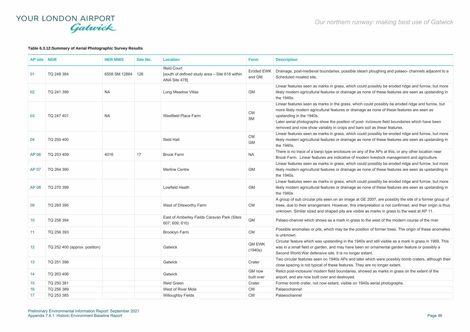
Preliminary Environmental Information Report: September 2021 Appendix 7.6.1: Historic Environment Baseline Report Page 46
Our northern runway: making best use of Gatwick
Table 6.3.12:Summary of Aerial Photographic Survey Results
AP site NGR HER MWS Site No. Location Form Description
01 TQ 248 384 6508 SM 12884 126 Ifield Court [south of defined study area – Site 618 within ANA Site 478]
Eroded EWK and GM
Drainage, post-medieval boundaries, possible steam ploughing and palaeo- channels adjacent to a Scheduled moated site.
02 TQ 241 399 NA Long Meadow Villas GM Linear features seen as marks in grass, which could possibly be eroded ridge and furrow, but more likely modern agricultural features or drainage as none of these features are seen as upstanding in the 1940s.
03 TQ 247 401 NA Westfield Place Farm CM SM
Linear features seen as marks in the grass, which could possibly be eroded ridge and furrow, but more likely modern agricultural features or drainage as none of these features are seen as upstanding in the 1940s. Later aerial photographs show the position of post- inclosure field boundaries which have been removed and now show variably in crops and bare soil as linear features.
04 TQ 250 400 Ifield Hall CM GM
Linear features seen as marks in grass, which could possibly be eroded ridge and furrow, but more likely modern agricultural features or drainage as none of these features are seen as upstanding in the 1940s.
AP 06 TQ 253 409 4016 17 Brook Farm NA There is no trace of a banjo type enclosure on any of the APs at this, or any other location near Brook Farm. Linear features are indicative of modern livestock management and agriculture.
AP 07 TQ 264 390 Merline Centre GM Linear features seen as marks in grass, which could possibly be eroded ridge and furrow, but more likely modern agricultural features or drainage as none of these features are seen as upstanding in the 1940s.
AP 08 TQ 270 399 Lowfield Heath GM Linear features seen as marks in grass, which could possibly be eroded ridge and furrow, but more likely modern agricultural features or drainage as none of these features are seen as upstanding in the 1940s.
09 TQ 260 395 West of Ditsworthy Farm CM A group of sub circular pits seen on an image at GE 2007, are possibly the site of a former group of trees, due to their arrangement. However, this interpretation is not confirmed, and their origin is thus unknown. Similar sized and shaped pits are visible as marks in grass to the west at AP 11.
10 TQ 258 394 East of Amberley Fields Caravan Park (Sites 607; 609; 610)
GM Palaeo-channel which shows as a mark in grass to the west of the modern course of the river.
11 TQ 256 393 Brooklyn Farm CM Possible anomalies or pits, which may be the position of former trees. The origin of these anomalies is unknown.
12 TQ 252 400 (approx. position) Gatwick GM EWK (1940s)
Circular feature which was upstanding in the 1940s and still visible as a mark in grass in 1969. This was in a small field or garden, and may have been an ornamental garden feature or possibly a Second World War defensive site. It is no longer extant.
13 TQ 251 398 Gatwick Crater Two circular features seen on 1940s APs and later which were possibly bomb craters, although their close spacing is not typical of these features. They are no longer extant.
14 TQ 263 406 Gatwick GM now built over
Relict post-inclosure/ modern field boundaries, showed as marks in grass on the extent of the airport, and are now built over and destroyed.
15 TQ 250 381 Ifield Green Crater Former bomb crater, not now extant, visible on 1940s aerial photographs. 16 TQ 256 389 West of River Mole CM Palaeochannel 17 TQ 253 385 Willoughby Fields CM Palaeochannel
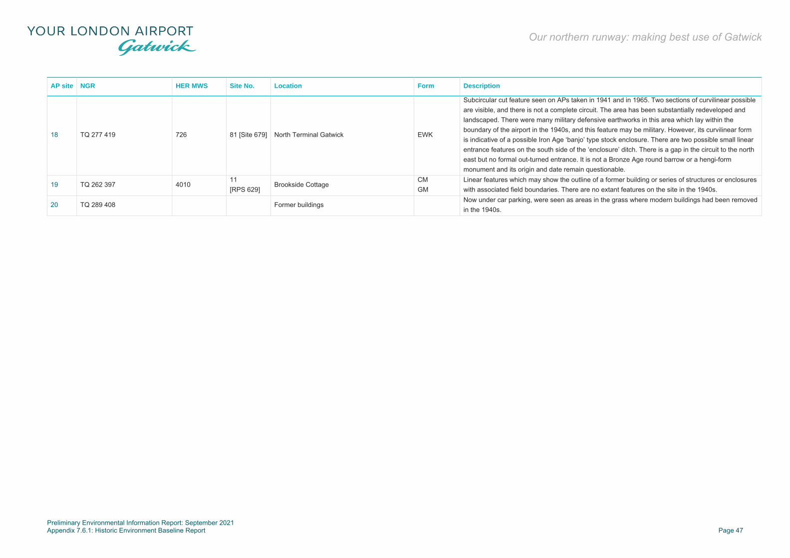
Preliminary Environmental Information Report: September 2021 Appendix 7.6.1: Historic Environment Baseline Report Page 47
Our northern runway: making best use of Gatwick
AP site NGR HER MWS Site No. Location Form Description
18 TQ 277 419 726 81 [Site 679] North Terminal Gatwick EWK
Subcircular cut feature seen on APs taken in 1941 and in 1965. Two sections of curvilinear possible are visible, and there is not a complete circuit. The area has been substantially redeveloped and landscaped. There were many military defensive earthworks in this area which lay within the boundary of the airport in the 1940s, and this feature may be military. However, its curvilinear form is indicative of a possible Iron Age ‘banjo’ type stock enclosure. There are two possible small linear entrance features on the south side of the ‘enclosure’ ditch. There is a gap in the circuit to the north east but no formal out-turned entrance. It is not a Bronze Age round barrow or a hengi-form monument and its origin and date remain questionable.
19 TQ 262 397 4010 11 [RPS 629]
Brookside Cottage CM GM
Linear features which may show the outline of a former building or series of structures or enclosures with associated field boundaries. There are no extant features on the site in the 1940s.
20 TQ 289 408 Former buildings Now under car parking, were seen as areas in the grass where modern buildings had been removed in the 1940s.
Preliminary Environmental Information Report: September 2021 Appendix 7.6.1: Historic Environment Baseline Report Page 48
Our northern runway: making best use of Gatwick
Summary of LiDAR Assessment
6.3.266 AOC Archaeology undertook a LiDAR assessment in 2016 for the much more extensive 7,400 hectares. study area of the Gatwick R2 scheme (AOC, 2016). Their abstract stated:
‘LiDAR data collected by the Environment Agency was manipulated and visualised in conjunction with an assessment of existing HER records in order to identify, characterise and map previously unrecorded features of archaeological interest. Over 200 new features were documented, mostly relating to historic agriculture and land division, but also including several undocumented earthworks, enclosures, mounds and other features likely to be of archaeological importance’.
6.3.267 The LiDAR results have been cross-referenced with the walkover survey results pertinent to the present Project (Figure 6.3.64) as follows:
6.3.268 Walkover observation 1a – ‘S-curve form of the county boundary hedgerow, to the west of the Brook Farm suggests that this boundary may be of medieval date’. The AOC report states: ‘the boundary is visible as a hedgerow within modern fields, located in the vicinity of other relict field boundaries’.
6.3.269 Walkover observation 19 - ‘a series of linear banks and a double bank of a north/south route noted within and flanking the west side of Upper Pickett’s Wood, north of Tinsley Green. Probably post-medieval’. The AOC report states: ‘Field boundaries and drainage…are visible beneath scrub vegetation as a series of banks and ditches’.
6.3.270 The LiDAR results have also been cross-referenced with the aerial photographic evidence (Figure 6.3.7) and the relevant results for the present study are as follows:
6.3.271 AP05 – ‘This site was identified as a possible enclosure. Whilst there are some very faint anomalies in the crop and grass which show across this area, there is nothing on the original scan or print – both were examined to indicate a double ditched circular enclosure.’ The AOC report states: ‘there is no evidence of an enclosure in the LiDAR data’.
6.3.272 AP06 – ‘There is no evidence of an enclosure in the LiDAR data’.
6.3.273 AP08 – ‘Linear features seen as marks in grass, which could possibly be eroded ridge and furrow, but more likely modern agricultural features or drainage as none of these features are seen as upstanding in the 1940s’. The AOC report states: ‘Linear
features are visible in this field, but are probably related to modern cultivation’.
6.3.274 AP12 – ‘Circular feature which was upstanding in the 1940s and still visible as a mark in grass in 1969. This was in a small field or garden, and may have been an ornamental garden feature or possibly a WWII defensive site. It is no longer extant’. The AOC report states: ‘Nothing corresponding to this feature is visible in the LiDAR’.
6.3.275 AP13 – ‘Two circular features seen on 1940s and later APs which were possibly bomb craters, although their close spacing is not typical of these features. They are no longer extant’. The AOC report states: ‘Nothing corresponding to these features is visible in the LiDAR’.
6.3.276 AP14 – ‘Relict post inclosure/modern field boundaries showed as marks in grass on the extent of the airport, and are now built over and destroyed’. The AOC report states ‘Nothing corresponding to these features is visible in the LiDAR’.
6.3.277 AP18 – ‘Sub circular cut feature seen clearly on APs taken in 1941 and in 1965. Two sections of curvilinear possible ditch are visible, but there is not a complete ‘circuit’. The area has been substantially redeveloped and landscaped. There were many military defensive earthworks in this area which lay within the boundary of the Gatwick Racecourse in the 1940s, and this feature may be military. However, its curvilinear form is indicative of a possible IA ‘banjo’ type stock enclosure. There are two apparent small linear ‘entrance’ features on the south side of the ‘enclosure’ ditch. It is not a BA round barrow or a hengi-form monument and its origin and date remain questionable. 104-s APs show some linear ditches which may be antilanding defences. These are no longer extant as the area has been developed at the present North Terminal.’ The AOC report states: ‘Nothing corresponding to these features is visible in the LiDAR’.
6.3.278 AP20 – ‘Former buildings. Now under car parking areas, were seen as areas in the grass where modern buildings had been removed in the 1940s’. The AOC report states: ‘No evidence for this feature is present in the LiDAR data’.
6.3.279 The AOC LiDAR assessment for Gatwick R2 highlighted 15 areas of key archaeological interest within the R2 study area (AOC 2016, Figure 3.1.2). None of these key areas of potential interest are within the Project site boundary.
6.3.280 The LiDAR assessment did identify an oval enclosure in woodland within the eastern edge of the Project site (west of the B2036 Balcombe Road), however this 150 metre by 80 metre enclosure is considered to be likely of likely modern origin (Site 620).
6.3.281 Within the defined study area, potentially the most significant identification from the LiDAR assessment was to the south of Gatwick at Amberly Farm (Site 693 - north of Langley Green) and was described as follows:
‘Banked enclosure at Amberley Farm. A sub-rectangular enclosure, measuring 65m NNE/SSW by 37m WNW/ESE internally is visible immediately S of Amberley Farm historic farmstead. The enclosure is defined by a bank 10m in width, best preserved on the W. The interior of the enclosure is subdivided E/W into two areas, with a break in the dividing ditch. It is possible that a curving ditch on the opposite side of the River Mole, 200m to the NW, is a related feature. The enclosure is likely to represent a former stock and/or settlement-related compound. It appears typical of the Iron Age/Romano-British period although later date is also possible’.
6.3.282 A number of former field boundaries are noted which are in general accordance with the known post-medieval field system and relate to hedge removals, including examples in the vicinity of Brook Farm.
6.3.283 In addition, a series of palaeochannels of the River Mole, Crawter’s Brook and Gatwick Steam, mentioned above within the Bronze Age section, have been identified to the south of the Project site boundary.
6.3.284 The LiDAR also identified a possible medieval motte moat with a slighted mound just to the south west of the defined study area (but labelled as part of Site 618 and within a red ANA). The AOC LiDAR assessment reported the find as follows:
‘Enclosure/ringwork (possible) south of Ifield Court, River Mole (adjacent or within offsetting zone of proposed new woodland creation). A circular ringwork, 42m in diameter is located at the confluence of the River Mole and Ifield Brook. Although ploughed to only c. 0.3m in height, the central mound is defined by a wide circular moat which is interrupted to form a probable entrance on the E. The annular ditch measures 56 m in external diameter and may have been connected to the Mole via a narrow, curving channel located on the W. A drainage channel, probably modern
Preliminary Environmental Information Report: September 2021 Appendix 7.6.1: Historic Environment Baseline Report Page 49
Our northern runway: making best use of Gatwick
in origin, leads from the S side of the ditch. Although a date is difficult to assert, it is possible that the site is a defensive earlier medieval motte, perhaps a precursor to the moated settlement at Ifield Court, 300m to the north. Given the clear evidence for a central mound, other possible explanations include a large prehistoric or later tumulus, or possibly a small domestic moated site. However, prior to intrusive investigation the function and date remains speculative’.
Geophysical Survey Conducted for the Project
Introduction
6.3.285 A programme of geophysical survey (magnetometry) has been conducted at specific locations within the Project site boundary beyond the airfield. The scope and the methodology for this survey programme was set out within a Written Scheme of Investigation (RPS, 2019) and was agreed by the appropriate archaeological advisors to the local planning authorities.
6.3.286 An interim report has been produced that describes the methodologies used and the results of the survey (SUMO, 2019). Greyscale and trace plots were produced for each area of survey.
6.3.287 The interim report describes the anomalies located in each survey area and the potential for such anomalies to be of archaeological interest. The interim report also provides an indication of the confidence rating that can be placed on the results.
6.3.288 The survey areas were identified as Areas A-I (with E and G eventually not used) and their locations are indicated on Figure 6.3.8.
Results
6.3.289 Area A: No features of potential interest were identified by the geophysical survey in this area (Figure 6.3.9). The only anomalies represent former field boundaries known from historical maps (Site 865), along with some evidence of the former presence of ridge and furrow earthworks which are no longer discernible other than as traces picked up by this survey (Site 866).
6.3.290 Area B: Several possible features of archaeological interest were identified, including an apparent sub-rectangular enclosure (Site 861) at the eastern edge of the survey area and extending beyond the survey area (Figure 6.3.10). The linear feature forming the west side of the enclosure is well-defined, and in the
northern part it is mirrored by a parallel feature. This may represent a livestock drove or funnel along the northern side of the enclosure. Another possible enclosure is suggested by a shorter linear anomaly to the south west.
6.3.291 A pattern of north-south aligned anomalies is also present across the survey area. Given their straight form (rather than the S-curve form typical of medieval ridge and furrow) these are likely to represent post-medieval arable practices (Site 866).
6.3.292 Area C: This land to the west of Brook Farm is bordered to the north by Man’s Brook. A meandering linear anomaly just south of the stream (Site 864) may represent a former channel of the stream (Figure 6.3.10). A potential archaeological feature was recorded as a c. 100 metre length of curving ditch within the eastern area of the field (Site 862). This is to the south of the HER reference to a possible banjo enclosure (Site 635) and the anomaly does not suggest this type of enclosure. However, its curvilinear form is suggestive of a later prehistoric date (Bronze Age or Iron Age), most probably used for stock management.
6.3.293 This area also contains a pattern of linear anomalies which are perpendicular to the north/south alignment recorded to the south in Area B, although traces of a separate area of north-south aligned arable features are suggested in the northern part of Area C (Site 866).
6.3.294 The smaller field to the south east was less apparently successful due to magnetic debris interference and no anomalies of potential archaeological interest were noted.
6.3.295 Area D: The survey in this area was also notably less successful due to background magnetic noise, possibly associated with arable soil improvement techniques. However, two possible north/south aligned linear anomalies were noted in the northern field and probably represent former field boundaries (Site 865), whilst a further north west/south east aligned linear anomaly of unknown derivation was noted in the southern field (Figure 6.3.10). The pattern of furrows in these fields (if present) was obscured by the interference.
6.3.296 Area F: This is an area of horse paddocks. The survey of the eastern paddocks did not identify any potential archaeological features of note, although there were several discrete anomalies and three short linear anomalies that were considered to be of uncertain origin (Figure 6.3.11).
6.3.297 The survey of the larger western field has shown a high degree of interference for the majority of its area. This has unfortunately
precluded identification of any archaeological features. The north eastern zone proved more susceptible to magnetometer survey, but the only visible feature was a north east/south west aligned modern service.
6.3.298 Area H: The survey of this area to the north east of Brook Farm identified a cluster of pit-like anomalies over a c. 15 metre diameter area in the centre of the field (Figure 6.3.10). A reasonably well-defined linear feature appears to provide an eastern boundary to this activity, with a potentially similar feature on the western side. If this group of features (Site 863) are contemporary, then they are most likely to be of prehistoric date.
6.3.299 Area I: This area was located to the south east of the Crawley STW including the area of previously known and partially excavated Iron Age archaeology. The survey area was intended to include all four small fields shown on Figure 6.3.12, but it was not possible to survey the north eastern field due to vegetation and tipping.
6.3.300 The south east field was least subject to magnetic disturbance and clearly identified the remnants of the former haul road (two parallel modern ditches) created/operative in 2013/2014 and visible, along with the former construction compound for the Flood Storage (Control) Reservoir on the contemporary Google Earth image.
6.3.301 Magnetic disturbance is greater in the north western area, which is theoretically least disturbed. There is a hint of a north/south aligned linear feature but otherwise it is possible that the interference relates to a thin layer of alluvium known from the investigations by Network Archaeology to cap the geology in that area. The absence of clear archaeological identifications is not considered reliable in this instance. This is because the examined archaeological remains located within the two Network Archaeology excavations for the wheel-wash and construction compound areas clearly extended beyond those areas into the zones of Area I that have not been previously affected.
6.3.302 Overall the geophysical survey has proved successful in its identification of a palaeochannel and also ditches, pits and enclosures of probable archaeological interest in the land at the western end of the Project site (survey Areas B, C, D and H) with few potential features identified in the remaining survey areas.
Truncation
6.3.303 An initial consideration of previous truncation (disturbance through agricultural activities and development) has been
Preliminary Environmental Information Report: September 2021 Appendix 7.6.1: Historic Environment Baseline Report Page 50
Our northern runway: making best use of Gatwick
considered at this stage for the land within the Project site boundary.
6.3.304 Considerable or even total destruction of potential below-ground archaeological deposits as a result of previous development activity is likely throughout the majority of the operational airport. This includes the modified/culverted route of the River Mole through the Gatwick North West Zone and beneath the runways. The initial diversion of the river took it to the north of the North Terminal, whilst more recently it was diverted around the North West Zone (Framework Archaeology, 2001a, Figure 6).
6.3.305 The previously trenched (Framework Archaeology, 2008) greenfield land and the un-trenched Brockley Wood woodland areas of the North West Zone are only plough-disturbed, and there are also partially wooded green strips along the northern side of the perimeter road at the south west edge of the airport where previous disturbance through development activity is likely to be minimal.
6.3.306 The area to the east of the London-Brighton railway is relatively heavily disturbed by the STW, car parks and lakes (the Pollution Control Lagoon and Flood Storage (Control) Reservoir). Horleyland Wood, Upper Pickett's Wood and the agricultural fields on the east side of the B2036 remain relatively undisturbed by modern development.
6.3.307 Much of the remaining agricultural landscape is likely to be undisturbed below the ploughsoil horizon, although ploughing will have removed the majority of archaeological layers leaving mainly negative features cutting into the subsoil or the basal geology.
6.3.308 Archaeological remains with a high degree of legibility may survive relatively well-preserved within the greenfield areas, with partial survival possible beneath properties and commercial facilities beyond the operational boundary of the airport. The main impact in these areas relates to ploughing and drainage. The former tends to remove the upper levels of features and most horizontal surfaces and layers.
Archaeological Potential - Overview
6.3.309 The areas beyond the operational airport boundary, including land within the Project site boundary, have limited information available with which to gauge archaeological potential; this is mainly due to a general absence of previous survey. The Kent, Surrey and Sussex Weald has traditionally been viewed as an area of poor archaeological potential with the exception of the
medieval period, Roman roads and industrial sites. This view, prevalent until the last few years, has now been superseded following a series of recent discoveries including some at the airport itself.
6.3.310 The Wealden Clays are generally unfavourable for arable agriculture (as shown by the predominantly pastoral modern land use). However, where rivers such as the Arun, Adur and Mole and their tributaries cross the West Sussex Weald there is a higher potential for prehistoric and later pastoral farming (particularly where river terrace gravels are present).
6.3.311 Archaeological excavations in 2012-13 of the 46 hectares development at Broadbridge Heath, Horsham, approximately 10 km to the south west of the Project site, has identified the remains of five prehistoric settlements including six round-houses, along with a Roman farm and several medieval settlements including trench foundation buildings. A similar situation is possible at Gatwick where a Late Bronze Age enclosure site and an area of Iron Age and Roman settlement and farming are already known.
6.3.312 The character of the archaeological remains within the Project site boundary is unlikely to be intensive, based on the current state of knowledge. This is largely due to the likely modest scale and short duration of settlements on the Clays, compared to more favourable soils in the Thames Valley, Sussex Coast Plain and the North and South Downs. However, within this general picture some areas of significant and currently unknown activity may be present.
6.3.313 Table 6.3.13 below summarises the key known archaeological sites and areas within the Project site boundary, presented in date order and indicating where mitigation has taken place (if at all). These sites and areas have informed the establishment of the zones of archaeological potential presented as Figure 6.3.13.
Table 6.3.13:Summary of Known Archaeological Material Within the Project Site Boundary
Site Ref Location Nature and date of
archaeology
Significance/
sensitivity value
Site 568 GAL Flood Storage (Control) Reservoir
Mesolithic worked flint scatter and single Palaeolithic worked flint (partial removal).
Medium (but at least partially investigated).
Site Ref Location Nature and date of
archaeology
Significance/
sensitivity value
(Gatwick Stream).
Sites 666; 487
Gatwick North West Zone and Charlwood Park Farm including Holiday Parking.
Late Bronze Age settlement and boundary (previously mitigated). ANA at Charlwood Park Farm based on potential (also medieval potential).
Medium before investigation was conducted, now negligible).
Site 498 AHAP between Riverside Garden Park and railway line.
Prehistoric worked flint, Roman finds and Late Iron Age cremation burial (previously removed).
Unknown remaining presence/absence but likely to be low to medium if present.
Sites 484; 485; 735
GAL Flood Storage (Control) Reservoir and Pollution Control Lagoon (‘New Lagoon’).
Dispersed areas of Iron Age occupation, burials and field systems (previously investigated).
Medium (but at least partially investigated).
Site 485 Former Horleyland Farm (GAL parking east of railway Self Park South and South Valet).
Possible Roman occupation area based on previously removed artefacts (ANA).
Medium if not previously removed by car park construction.
Site 480 Former Park House Farm.
Former (possible) medieval moated site with possible medieval ancestry (now beneath car parks) (ANA).
Medium if not previously removed by car park construction.
Site 861 Geophysical survey Area B.
Possible enclosure and double ditched trackway.
Likely to be low-medium (subject to further investigation).
Preliminary Environmental Information Report: September 2021 Appendix 7.6.1: Historic Environment Baseline Report Page 51
Our northern runway: making best use of Gatwick
Site Ref Location Nature and date of
archaeology
Significance/
sensitivity value
Sites 862; 863
Geophysical survey Areas C and H.
Undated pits and curvilinear features – probably of prehistoric date.
Likely to be low-medium (subject to further investigation).
Site 864 Geophysical survey Area C.
Palaeochannel associated with Man’s Brook.
Low (subject to further investigation).
Site 865 Geophysical survey Areas B-D and H.
Undated potential archaeological features – possibly post-medieval field boundaries.
Likely to be low (subject to further investigation).
Site 866 Geophysical survey Areas B and C.
Undated potential remains of post-medieval agriculture.
Likely to be low (subject to further investigation).
Predictive Modelling
6.3.314 Some predictive modelling is possible on the basis of topography, geology and known or suspected settlement patterns.
6.3.315 The well-known preference for south-facing aspects is a recurrent theme in the identification of prehistoric and later settlement zones. For example, south-facing valley sides are preferred for Bronze Age house platforms terraced into the slopes of the Sussex Downs, although it should be noted this general preference is not to the exclusion of other topographical locations (eg Middle Bronze Age occupation sites at Peacehaven slopes and found on opposing sides of the east-west aligned Upper Piddinghoe Valley (Hart, 2015).
6.3.316 Another key topographical category influencing the activities of both hunter-gatherers and farmers were the floodplain corridors, palaeochannels and floodplain edge terraces adjacent. As noted above, the sediment units themselves date from the Pleistocene onwards, whilst subtle changes in relief on the floodplains and associated terraces have had implications for the siting of ancient settlements.
6.3.317 The Late Bronze Age occupation in the Gatwick North West Zone seems to have been consciously placed at and above the 58 metre AOD contour, avoiding lower-lying areas (Framework Archaeology, 2002b). However, climatic variations have affected water-tables and this localised finding does not permit this to be
taken as an indication that no settlement will be present below 58 metres AOD. The availability of water was clearly of overriding importance for prehistoric settlement in the Weald. Rivers attract settlement for obvious reasons of security of water for human and stock consumption.
6.3.318 Other areas of known prehistoric settlement of the Weald are invariably close to rivers and include the Rivers Arun and Adur near a cluster of Iron Age sites at Broadbridge Heath, Horsham (Margetts, 2018), Burstow Stream at Horley (ASE, 2009) and at Westhawk Farm and Brisley Farm near Ashford in Kent (Booth, et al., 2008; Stevenson, 2013).
6.3.319 The Ashford prehistoric sites (7.44 hectares combined) are situated within the Weald Clay Vale in the upper valley headwaters of the Great Stour river at around 39-45 metres AOD with the East Stour river located to the east. These sites, like those demonstrated at Broadbridge Heath, Horley and Gatwick, were associated with former tributary streams that are now present as silted-up palaeochannels.
6.3.320 Pleistocene Head deposits are formed within periglacial conditions south of the ice-sheets and can produce Palaeolithic artefacts such as handaxes, deposited on the former land-surface during the Middle to Upper Palaeolithic. Artefacts of earlier phases of the Palaeolithic are likely to have been removed from their primary contexts by subsequent freeze-thaw processes.
6.3.321 Alluvium has the potential to seal and mask earlier palaeochannels, which may contain peat and alluvium of archaeological interest. Low-lying, river-bank locations were attractive sites for early Mesolithic camps involved with fishing and fowling and for early farmers of the Neolithic and the Bronze Age. Alluvium can also seal early settlements and field-systems that were sited near to rivers due to their advantages for water provision, fishing and fowling and as early communication route corridors.
6.3.322 Where alluvium is present, its removal may expose relatively well-preserved earlier prehistoric archaeology. During alluvium formation, floodplain locations were less attractive for inhabitation but remained useful for stock-grazing (and hence associated settlement) due to the presence of nutrient-rich pastures kept fertile by the deposition of silts.
6.3.323 The medieval settlement around Gatwick and Crawley is based upon dispersed moated sites, hamlets and villages, some of which survive as modern settlements or as archaeological earthworks. The Broadbridge Heath example has also shown
that other dispersed settlement forms in this area include long houses or byres within farmyard compounds. Therefore, the known moated site locations may not be the only forms of dispersed settlement within the Project site boundary.
6.3.324 Given the location of a major medieval and post-medieval ironworks and forges at Crawley generally, including the forge at Tinsley Green in addition to the Westfield Bloomery, there is some potential for further forge/bloomery sites, dumped concentrations of slag (perhaps used as metalling), hammer ponds and medieval and post-medieval mine pits.
6.3.325 Zones with high archaeological potential comprise:
▪ areas of known or suspected specific locations of medieval and post-medieval inhabitation and industry; and
▪ areas immediately adjacent to previously investigated fragments of significant archaeology.
6.3.326 Zones with medium to high archaeological potential comprise:
▪ topographical ridges and hills, particularly south facing-slopes;
▪ river and stream corridors in including flanking terraces; and ▪ the corridors of medieval and post-medieval lanes.
6.3.327 Zones of low to medium archaeological potential comprise:
▪ areas of Weald Clay distant from watercourses, known lines of communication and sites of known potential.
6.3.328 Therefore, the corridors of the Gatwick Stream, Crawter’s’ Brook and River Mole have a high potential to contain palaeo-environmental deposits of low to medium significance and generally has medium to high potential to contain archaeological remains from the Mesolithic period onwards. The significance of any remains is likely to vary from low to medium/high depending on completeness, rarity and degree of preservation.
6.3.329 The identified zones of archaeological potential are indicated on Figure 6.3.11 and described as follows:
Areas of High Potential
6.3.330 These are areas where it is possible to predict, with reasonable confidence, specific localities likely to contain archaeology of low to medium significance. The predicted sites include Crawley and Horley ANAs/AHAPs comprising:
▪ a Crawley ANA for Iron Age settlement evidence and possible Roman settlement evidence (Sites 485, 696 and
Preliminary Environmental Information Report: September 2021 Appendix 7.6.1: Historic Environment Baseline Report Page 52
Our northern runway: making best use of Gatwick
735) at the former Horleyland Farm, now part of the airport’s eastern car parks and incorporating a pollution control lagoon (also known as ‘New Lagoon’) within its southern area;
▪ the Crawley ANA site at Park House Farm (Sites 480, 695 and 715) for a former homestead moat, now airside within the south west part of the airport;
▪ an area of Iron Age settlement and burial evidence is a Crawley ANA (Site 484), located to the south east side of the Crawley STW. This area was partially investigated to mitigate impacts from a former construction compound and a wheel-wash facility. To the immediate west of the ANA, extensive archaeological trial trenching ahead of an earlier flood attenuation project known as the Flood Storage (Control) Reservoir (between the Gatwick Stream and the railway) located a number of palaeochannels and associated alluvium in addition to a Mesolithic flint scatter (RPS 719 and 568);
▪ the Crawley ANA for Charlwood Park Farm and ‘Holiday Parking’ area, with potential for the extension of the Bronze Age settlement from the known (and investigated) Gatwick North West Zone to the south (Sites 487; 672);
▪ a triangular Horley AHAP zone south of Horley Station and north of the Northern Terminal at the east end of Riverside Park, partially within the Project site boundary (Sites 498, 540 and 541), covers an area of prehistoric flintwork including flint arrowheads, Late Iron Age cremation burials, Roman pottery and Roman coins; and
▪ an area at the northern extent of the Project site immediately adjacent to two Surrey AHAPs, associated with a medieval moated site and the Church of St Bartholomew at Horley (Sites 491, 492, 554, 497, 524, 525, 527, 556 and 711).
6.3.331 Zones of high potential just beyond the Project site boundary include two AHAPs for medieval and post-medieval Charlwood (Sites 493 and 494) and the medieval Charlwood House south of the airport (which has another a Crawley ANA relating to cropmarks located to the west (Site 479). The location of a post-medieval bloomery at Westfield Place (Site 486) at the western extent of the airport perimeter road) may also be considered to have high potential and is covered by an ANA.
Areas of Medium to High Potential
6.3.332 The watercourses and their floodplains are considered to have medium levels of archaeological and palaeo-environmental potential. The River Mole and its tributary streams have influenced prehistoric settlement. Known sites include the small
Late Bronze Age settlement and boundary adjacent to the River Mole in the North West Zone and the Iron Age and Roman occupation adjacent to the Gatwick Stream within the south eastern and eastern areas of the Project site.
6.3.333 The superficial deposits within the Project site boundary are of key interest. Pleistocene Gravel and Head deposits have some potential to contain Palaeolithic material, although these artefacts are rarely 'in-situ', having been re-deposited by fluvial action. In later periods the lighter gravels were well-drained and would be attractive for farming. Islands of gravel within heavy claylands are particularly likely to have been sought out by early settlers due to the relative ease of tree-clearance and ploughing using an ard (in stark contrast to the heavy Wealden Clay).
6.3.334 Holocene alluvium (from overbank flooding) and channel deposits of the River Mole, Man’s Brook, Crawter's Brook and the Gatwick Stream are most likely to date from episodes in the Mesolithic and/or Neolithic and the Early Iron Age onwards (when water tables started to rise).
6.3.335 Impacts within the floodplain areas of watercourses such as the Gatwick Stream may affect waterlogged archaeological remains of prehistoric, Roman and later dates. In addition to the known alignments of the River Mole, Gatwick Stream etc, there may be other silted-up palaeochannels whose locations are presently unknown and whose soft alluvial fills may be locally affected.
6.3.336 The geophysical survey results also suggest a medium to high potential for prehistoric archaeological remains to be present within the fields to the west, south and east of Brook Farm (geophysical survey areas B, C and H, Sites 861-866). These also have high potential for later (probably post-medieval) remains of ridge and furrow and former field boundaries. The association with occupation is yet to be tested through fieldwork but this area between Man’s Brook and the River Mole to the east may have proven attractive. However, the HER suggestion of a large (200 metre diameter) double-ditched circular enclosure (Site 628) and an Iron Age banjo enclosure (Site 635) in these fields is not supported by the subsequent aerial photographic analysis (APS, 2014) and geophysical survey (SUMO, 2019).
6.3.337 Areas of medium to high potential for archaeological remains may include:
▪ the currently wooded zones to the south west of Brockley Wood and within the operational airport (east of geophysical survey Area B);
▪ The eastern area of Riverside Garden Park and geophysical survey area F, which are either side of the Surrey AHAP that includes prehistoric flintwork, Roman coins and Late Iron Age cremation burials (Site 498); and
▪ geophysical survey Area A as it is located just east of a Crawley APA for Roman occupation material and Iron Age settlement (Sites 114 and 283). However, it is possible that the settlement was closer to the Gatwick Stream to the west.
6.3.338 The Weald Clay area has a general potential to produce evidence of ironworking but, in addition to the bloomery site cited above, there are areas of general potential close to Forge Farm at Tinsley Green (although most if not all of the industrial remains may be contained in the area just to the south of the Project site boundary). Bell pits associated with the 'Pit Croft' place-name have been noted beyond the south west extent of the airport. Other place names in this area and associated with ore extraction (outside the Project site boundary) might indicate post-medieval open pit mining that could have had earlier origins.
6.3.339 It can be reasonably predicted that medieval and post-medieval settlement-related archaeological remains will be present (albeit at a low density) within a corridor extending either side of the medieval and post-medieval routes preserved in the modern landscape and re-constructed on the basis of historic maps.
Areas of Low to Medium Potential
6.3.340 Weald Clay was formerly considered to have been actively avoided by prehistoric settlement, but this position can no longer be sustained (Margetts, 2018). The Weald Clay supports predominantly pastoral economies as indicated by the distribution of medieval moated sites and other settlement forms, many of which are known and are included in the areas of high potential described above.
6.3.341 Weald Clay areas also have potential to contain low densities of currently unknown more isolated settlement sites whose precise locations cannot be ascertained at this stage.
6.3.342 There will also be landscape remains and perhaps some further ironworking sites and extraction areas. In particular, the geology includes seams of ore and this resource has been systematically exploited since the Early Iron Age. The Gatwick area is located just beyond most of the known Iron Age and Roman ironworking areas, although one confirmed site is known nearby at Crawley.
6.3.343 The heavily built-over areas of the airport (Site 746) have low potential for survival of archaeology, including remnants of the
Preliminary Environmental Information Report: September 2021 Appendix 7.6.1: Historic Environment Baseline Report Page 53
Our northern runway: making best use of Gatwick
former horse racing track, Charlwood Park, and various historic farmsteads that were previously located within the boundary of the airport.
Areas of Low Archaeological Potential But With Some Potential for Palaeochannels
6.3.344 As described above, in general the watercourses and their floodplains are considered to have medium levels of archaeological and palaeo-environmental potential. However, two areas in the western part of the airport are associated with the former alignment of the River Mole but the overall archaeological potential in these two areas is known to be greatly reduced as a result of previous archaeological investigation and/or known development.
7 References AOC Archaeology (2007) A Desk Based Assessment of Q-park, Gatwick Airport, West Sussex. Unpublished report.
AOC Archaeology (2016) Gatwick Airport R2 Heritage Assessment: LiDAR Analysis. AOC Report 23373, May 2016.
Air Photo Services (APS), 2014, Gatwick Runway 2, Option 3: Assessment of Aerial Photographs for Archaeology, Air Photo Services, March 2014.
Archaeology South-East (ASE) (2009) Excavations in North East Horley, Surrey. A Post-excavation Assessment and Updated Project Design. Unpublished report, Archaeology South East, May 2009.
Archaeology South-East (ASE) (2010) A Post-excavation Assessment and Updated Project Design for Excavations at the Brighton & Hove Waste Water Treatment Works, Lower Hoddern Farm, Peacehaven, East Sussex (Stage 3). Unpublished report, Archaeology South East, December 2010.
Archaeology South-East (ASE) (2013a) Broadbridge Heath, West Sussex: A Post-excavation Assessment and Updated Project Design Report. Unpublished report, Archaeology South East, December 2013.
Archaeology South-East (ASE) (2013b) Final and updated Project Design for Excavations on land at North East Horley, Surrey. Unpublished report, Archaeology South East, July 2013.
Bartlett Clarke Consultancy (2011) Gatwick Airport: Pollution Control Lagoon – Archaeo-geophysical survey. unpublished report.
Bates, M. R. (1998) A Geoarchaeological Evaluation of Trenches from the Crawley North East Sector (W4324) Site Evaluation Works, West Sussex, unpublished report, March 1998.
Bennell, M. (1998) 'Under the road. Archaeological discoveries at Bronze Age Way, Erith'. London: Bexley Borough Council.
Bewley, R. (2003) Prehistoric Settlements. Tempus, Stroud.
Bird, J. and Bird, D. G. (eds) (1987) The Archaeology of Surrey to 1540. Stroud, Tempus.
Booth, P., Bingham, A. and Lawrence, S. (2008) The Roman roadside settlement at Westhawk Farm, Ashford, Kent: excavations 1998-9. Oxford Archaeology Monograph Series, 2.
British Geological Survey (n.d.) Geology of Britain Viewer [online]. Available: http://www.bgs.ac.uk/discoveringGeology/geologyOfBritain/viewer.html [accessed: 29/11/2019].
The British Museum and the Department for Media, Culture and Sport (n.d.) Portable Antiquities Scheme [online]. Available: www.finds.org.uk [accessed: 29/11/2019].Brown, L., Lewis, J. and Smith, A. (2006) Landscape evolution in the Middle Thames Valley. Heathrow Terminal 5 excavations, Vol. 1, Perry Oaks. Framework Archaeology Monograph No. 1.
Civil Aviation Authority (2021) Airspace Design: Guidance on the regulatory process for changing airspace design including community engagement requirements, CAP1616, Civil Aviation Authority, 4th edition, March 2021.
CgMs (1997) An Archaeological Desk Based assessment of land at Crawley, North East Sector Development Site, unpublished report, CgMs Consulting.
CgMs (1998a) An archaeological walkover survey of land at the North East Sector Development Site Crawley, unpublished report, CgMs Consulting.
CgMs (1998b) Description of Historic Buildings at Forge Farm and Toovies Farm, unpublished report, CgMs Consulting.
Chartered Institute for Archaeologists (2014) Standard and Guidance for historic environment desk based assessment 2014, revised 2017.
Chichester District Council, East Sussex County Council and West Sussex County Council (2019) Sussex Archaeological Standards.
Cleere, H. and Crossley, D. (1995) The Iron Industry of the Weald. Leicester University Press.
Cotton, J., Crocker, G. and Graham, A. (2004) Aspects of Archaeology & History in Surrey: towards a research framework for the county. Surrey Archaeological Society, Guildford.
Crawley Borough Council (2015) Crawley 2030: Crawley Borough Local Plan 2015-2030
Crawley Borough Council (2021) Draft Crawley Borough Local Plan 2021-2037
Crawley Borough Council and Ifield Village Association (2018) Ifield Village Conservation Area Statement February 2018 [online] Available at: http://www.crawley.gov.uk/pw/web/int169915
Cunliffe, B. (2005) Iron Age communities in Britain, 4th edn. Routledge.
Dent, J. (1982) ‘Cemeteries and settlement patterns on the Yorkshire Wolds’, Proceedings of the Prehistoric Society 48, 437-57.
Department for Culture, Media and Sport (DCMS) (2013) Scheduled Monuments & nationally important but non-scheduled monuments, Department for Culture, Media and Sport, October 2013.
Department of Communities and Local Government ((2010) PPS5 Planning for the Historic Environment: Historic Environment Planning Practice Guide 2010.
Department for Transport (2015) National Networks National Policy Statement, December 2014.
Department for Transport (2018) Airports National Policy Statement, June 2018.
Domesday Book (n.d.) Domesday Online [online]. Available: http://www.domesdaybook.co.uk/ [accessed: 29/11/2019].
Preliminary Environmental Information Report: September 2021 Appendix 7.6.1: Historic Environment Baseline Report Page 54
Our northern runway: making best use of Gatwick
Drewett, P., Rudling, D. and Gardiner, M. (1988) The Archaeology of the South East to AD1000. Longman.
Forum Heritage Services (2006) Historic Farmsteads and Landscape Character in West Sussex, unpublished report.
Framework Archaeology (2001a) North West Zone Development Phase 2 – Gatwick Airport, Archaeological Desk Based Assessment, unpublished report, ref. 49144.02.
Framework Archaeology (2001b) Gatwick Airport: Car Park Z (West) Archaeological Evaluation Report, unpublished report.
Framework Archaeology (2001c) Gatwick Airport, North West Zone Development Phase 1: Archaeological Evaluation Report, Contractor’s Compound and Aircraft Stands, unpublished report, ref. 92005.02.
Framework Archaeology (2002a) Gatwick Airport, North West Zone Development Public Long-Term Block Car Park, Summary of Archaeological Evaluation and Excavation, unpublished report, ref. 92002.02.
Framework Archaeology (2002b) Gatwick Airport, North West Zone Development Phase 2 – Option 3, Archaeological Evaluation Report, unpublished report, ref. 92003.02.
Framework Archaeology (2007a) Proposed Immigration Removal Centre, Perimeter Road South, Gatwick Airport, West Sussex, unpublished evaluation report ref: 91911.02.
Framework Archaeology (2007b) Proposed Immigration Removal Centre, Perimeter Road South, Gatwick Airport, West Sussex, unpublished watching brief report ref: 91911.03.
Framework Archaeology (2007c) Gatwick Airport: Proposed Hotel, Edgeworth Site, Buckingham Gate, Crawley, West Sussex: Archaeological Evaluation Report, unpublished report.
Framework Archaeology (2008) Gatwick Airport North West Zone Project. Gatwick Airport West Sussex: Archaeological Evaluation Report, unpublished report.
Gardiner, M. (1990) ‘The Archaeology of the Weald – A Survey and a Review’, Sussex Archaeological Collections, 128.
Germany, M., Scruby, A. and Masefield, R. (2015) Excavation of Prehistoric, Roman and Medieval Remains at Priors Green, Takeley, 2006 to 2010. Essex Archaeology and History.
Goldsmith, M. (1987) Crawley and District in Old Picture Postcards. Zaltbommel, European Library.
Gwynne, P. (1990) A History of Crawley. Chichester, Phillimore & Co.
Harper, C. G. (1906) The Brighton Road: Speed, Sport and History on the Classic Highway. London, Chapman & Hall Ltd.
Harding, J. M. (1976) Four Centuries of Charlwood Houses. Charlwood Society.
Hart, D. (2010) A Post-Excavation Assessment and Updated Project Design for Excavations at the Brighton and Hove Wastewater Treatment Works, Lower Hoddern Farm, Peacehaven, East Sussex, Archaeology South East unpublished report.
Hart, D. (2015) Around the Track. Archaeological Excavations at Peacehaven, East Sussex. Spoil Heap Publications. London.
Hawtin, T. and Peyre, L. (2008) An archaeological watching brief at Balcombe Road, Horley, West Sussex, Archaeology South East unpublished report No. 08/182.
Historic England (n.d.) The National Heritage List for England [online]. Available: http://www.historicengland.org.uk/listing/the-list/ [accessed: 29/11/2019].
Historic England (2015a) Historic Environment Good Practice Advice in Planning: 1 The Historic Environment in Local Plans July 2015.
Historic England (2015b) Historic Environment Good Practice Advice in Planning: 2 Managing Significance in Decision-Taking in the Historic Environment July 2015.
Historic England (2016) Great London Archaeological Priority Area Guidelines July 2016.
Historic England (2017a) Conservation Principles, Policies and Guidance for the Sustainable Management of the Historic Environment 2008 (new Consultation Draft 2017).
Historic England (2017b) Historic Environment Good Practice Advice in Planning: 3 The Setting of Heritage Assets December 2017.
Historic England (2019) Statements of Heritage Significance: Analysing Significance in Heritage Assets, Historic England Advice Note 12, October 2019.
Historic England (2020) Historic Environment Good Practice Advice in Planning: 4 Enabling Development and Heritage Assets June 2020.
Hodgkinson, J. S. (2000) ‘A Gazetteer of Medieval Iron-making sites in the Weald’. Wealden Iron, 2nd Series, No. 20.
Hodgkinson, J. S. (2004) 'Iron Production in Surrey' in Cotton et al, 2004.
Horsham District Council (2015) Horsham District Planning Framework (excluding South Downs National Park). November 2015. [Online] Available at: https://beta.horsham.gov.uk/__data/assets/pdf_file/0016/60190/Horsham-District-Planning-Framework-2015.pdf
Horsham District Council (2020) Draft Horsham District Local Plan 2019-2036. Available at: https://strategicplanning.horsham.gov.uk/consult.ti/LocalPlanReview/viewCompoundDoc?docid=10336756
Hughes, F. (2012) The Moat House Ifield Court Farm Hovel – Evaluation of building with supporting documentary information, unpublished report.
Institute of Historical Research (n.d.) British History Online [online]. Available: http://www.british-history.ac.uk/ [accessed: 21/11/2019].
Jepson, B. (1997) Tinsley Green, undergraduate essay in Landscape Conservation Policy and Practice, copy in West Sussex HER.
Kent County Council (n.d.) South East Research Framework [online]. Available: https://www.kent.gov.uk/leisure-and-community/history-and-heritage/south-east-research-framework [accessed: 29/11/2019].
Malden, H.E. (ed.) (1911) A History of the County of Surrey, Volume 3.
Margary, I. D. (1955) Roman Roads in Britain. Phoenix House. London
Margary, I. D. (1965) Roman Ways in the Weald, 3rd revised edition. Phoenix House. London.
Margetts, A. (2013) Broadbridge Heath Post-excavation Assessment Report, unpublished report.
Preliminary Environmental Information Report: September 2021 Appendix 7.6.1: Historic Environment Baseline Report Page 55
Our northern runway: making best use of Gatwick
Margetts, A. (2018) Wealdbaera: excavations at Wickhurst Green, Broadbridge Heath and the landscape of the West Central Weald. Spoilheap Publications.
Masefield, R. and Williams, D. (2003) ‘A Roman Tilery at Reigate’, Surrey Archaeological Collections Vol. 90.
Mid Sussex District Council (2018) Mid Sussex District Plan 2014 – 2031. March 2018. [Online] Available at: https://www.midsussex.gov.uk/media/3406/mid-sussex-district-plan.pdf
Mills, A. D. (1998) Dictionary of English Place Names. Oxford University Press.
Mills, A. D. (2011) Dictionary of English Place Names, revised edition, Oxford University Press.
Ministry of Housing, Communities and Local Government (2014) National Planning Practice Guidance.
Ministry of Housing, Communities and Local Government (2021) National Planning Policy Framework, July 2021.
Mole Valley District Council (2009) Mole Valley Core Strategy 2009 – 2026. October 2009. [Online] Available at: https://www.molevalley.gov.uk/media/pdf/6/s/Core_Strategy_DPD_(Adopted).pdf
Mole Valley District Council (2020) Future Mole Valley 2018-2033: Consultation Draft Local Plan. [Online] Available at: https://molevalley.gov.uk/sites/default/files/2020-05/Future%20Mole%20Valley%20draft%20Local%20Plan%20-%202020%20consultation%20version.pdf
Natural England (2013) Natural Character Area 121: Low Weald.
Network Archaeology (2012a) Gatwick Airport Pollution Control Lagoon: Written Scheme of Investigation for Archaeological Mitigation, unpublished report, March 2012.
Network Archaeology (2012b) Gatwick Upper Mole Flood Storage Reservoir: Archaeological Desk Based Assessment, Field Reconnaissance and Trench Evaluation, unpublished report, November 2012.
Network Archaeology (2013) Gatwick Upper Mole Flood Attenuation Project. Archaeological Mitigation Strategy, unpublished report, March 2012.
Network Archaeology (2014) Gatwick Flood Alleviation Scheme Summary, Interim note with 2013 weekly reports appended.
Ockley Windmill (n.d.) Lowfield Heath Windmill [online]. Available: http://www.ockleywindmill.co.uk/lowfieldheathwindmill.htm [accessed: 29/11/201].
The Parish of Charlwood and Hookwood (n.d.) Lowfield heath Windmill [online]. Available: http://www.charlwoodandhookwood.co.uk/lowfield-heath-windmill.php [accessed: 29/11/2019].
Pettit, P. and White, M. (2012) The British Palaeolithic: Human Societies at the Edge of the Pleistocene World. Routledge, Abingdon.
Peyre, L. (2011) Archaeological evaluation of Land east of London Road, Crawley, West Sussex, Archaeology South East unpublished report No. 11/309.
Place, C. (2003) Excavations at Ford Airfield, Yapton, West Sussex 1999, Heritage Archaeology Report No. 10. Great Dunham.
Rady, J., Holman, J., Masefield, R., Henshaw, R., and Weekes, J. (forthcoming) Archaeological Investigations at ‘Thanet Earth’, Kent, 2007-2012. Canterbury: Canterbury Archaeological Trust Occasional Paper No. 12.
Reigate and Banstead Borough Council (2014a) Horley Conservation Area Character Appraisal - Draft
Reigate and Banstead Borough Council (2014b) Banstead Conservation Area Appraisal. Draft. June 2014.
Reigate and Banstead Borough Council (2014c) Reigate and Banstead Local Plan: Core Strategy, Adopted July 2014. [Online] Available at: http://www.reigate-banstead.gov.uk/info/20380/current_planning_policy/24/core_strategy
Reigate and Banstead Borough Council (2019) Reigate and Banstead Local Plan: Development Management Plan (Adopted September 2019) [Online] Available at: http://www.reigate-banstead.gov.uk/info/20380/current_planning_policy/888/development_management_plan
Riddler, I. and Trevarthen, M. (2006) The prehistoric and Anglo-Saxon funerary landscape at Saltwood Tunnel, Kent. CTRL Integrated Site Report Series.
Roberts, M. and Parfitt, S. A. (1999) Boxgrove: a Middle Pleistocene hominid site at Eartham Quarry, Boxgrove, West Sussex. English Heritage Archaeology Report No. 17.
RPS (2019) Genesis Project, Gatwick Airport, Surrey and West Sussex: Written Scheme of Investigation for a programme of archaeological geophysical survey, July 2019.
Rudling, D. (ed.) (2002) Downland Settlement and Land-use. The Archaeology of the Brighton Bypass. Archetype Publications/English Heritage, London.
Sewill, R. and Lane, E. (1979) The Free Men of Charlwood. Charlwood Society.
Stevenson, J. (2013) Living by the Sword, The archaeology of Brisley Farm, Ashford, Kent. Monograph 6. Spoilheap Publications. Dorchester.
SUMO (2019) Land adjacent to Gatwick Airport: Geophysical Survey Report (interim), SUMO Services, September 2019, unpublished report ref. 15841.
Tandridge District Council (2014) Tandridge Local Plan Part 2: Detailed Policies 2014-2029. July 2014. [Online] Available at: https://www.tandridge.gov.uk/Portals/0/Documents/Planning%20and%20building/Planning%20strategies%20and%20policies/Current%20and%20adopted%20planning%20policies/Detailed%20policies/The-Local-Plan.pdf
Tandridge District Council (2019) Our Local Plan: 2033 (Regulation 22 submission). January 2019. [Online] Available at: https://www.tandridge.gov.uk/Portals/0/Documents/Planning%20and%20building/Planning%20strategies%20and%20policies/Local%20plan/Local%20plan%202033/Examination%20library/MAIN%20DOCUMENTS/MD1-Our-Local-Plan-2033-Submission-2019.pdf
Temple Group and Cotswold Archaeology (2014) Aviation Noise Metric: Research on the Potential Noise Impacts on the Historic Environment by Proposals for Airport Expansion in England, English Heritage Project No. 6865, Final Report, July 2014.
Thames Valley Archaeological Service (TVAS), (1996) Gatwick Manor Hotel, London Road, Crawley: An Archaeological evaluation, watching brief and desktop study for Scottish and Newcastle Retail, Thames Valley Archaeological Services, unpublished report.
Preliminary Environmental Information Report: September 2021 Appendix 7.6.1: Historic Environment Baseline Report Page 56
Our northern runway: making best use of Gatwick
Wells, N. A. Allen, M. J., Carruthers, W. J., Every, R., Mepham, L., Robinson, M., Scaife, R. and Webster, S. (2005) ‘Excavation of a Late Bronze Age enclosure site at Gatwick Airport, 2001’, Sussex Archaeological Collections, 143, 47-69.
Wessex Archaeology (1993a) The southern rivers Palaeolithic project report no. 2, 1992-1993: The South West and south of the Thames. Trust for Wessex Archaeology Ltd & English Heritage.
Wessex Archaeology (1993b) Charlwood House, West Sussex: Archaeological Monitoring of Groundworks, unpublished report.
Wessex Archaeology (1998) Crawley North East Sector Development Site, Report of a Preliminary Evaluation, unpublished report.
Whitney, K. P. (1976) The Jutish Forest: A study of the Weald of Kent from 450 to 1380 AD. The Athlone Press, London.
Wymer, J. J. (1977) Gazetteer of Mesolithic sites in England and Wales. Council for British Archaeology Research Report No. 22.
Wymer, J. J. (1987) ‘The Palaeolithic Period in Surrey’, In Bird & Bird (eds) 1987.
Wymer, J. J. (1999) The Lower Palaeolithic occupation of Britain. Salisbury, Trust for Wessex Archaeology & English Heritage.
Yates, D. T. (2007) Land, Power and Prestige. Bronze Age Field Systems in Southern England. Oxford, Oxbow.
8 Glossary
8.1 Glossary of Terms
Table 8.1.1: Glossary of Terms
Term Description
AHAP Area of High Archaeological Potential Alluvium Unconsolidated material deposited by floodwater ANA Archaeological Notification Area aOD above Ordnance Datum APS Archaeology Project Services Ard Simple light form of plough Assart Land informally cleared from the woodland Banjo enclosure Circular enclosure with long double-ditched entrance
funnel – Iron Age date
Term Description
Barrow More usually round barrow, a circular burial monument of probable Bronze Age date
Beaker period Archaeological Period c. 2,600 – 1,800 BC – the transition from the Neolithic into the Bronze Age
BGS British Geological Survey Bioturbation Disturbance of deposit through biological processes,
eg by root action or animal burrowing Bronze Age Archaeological Period c. 2,500 – 800 BC CAA Conservation Area Appraisal Cal BC Calibrated radiocarbon date within the prehistoric
period CAMP Character Appraisal and Management Proposals Causewayed enclosure
Earthwork enclosure of Early Neolithic date
Chalcolithic Archaeological period usually described as the ‘Copper Age’
Cretaceous Geological Period c. 145 – 66 million years ago Cropmark Possible archaeological feature recorded on aerial
photographs as a differentiated part of a crop in an arable field
CSAI County Sites of Archaeological Interest Cursus monument
Neolithic structure represented by two long parallel ditches
Devensian The most recent glacial period – c. 115,000 – 11,700 BP
Early Bronze Age
Archaeological Period c. 2,500 – 1,500 BC
Early Iron Age Archaeological Period c. 800 – 400 BC Early Neolithic Archaeological Period c. 4,000 – 3,000 BC Early Saxon Historic Period c. AD 410 - 650 Fieldwalking Methodology for archaeological survey comprising
surface artefact collection GPA Good Practice Advice Head deposits Fragmented material which has moved downslope in
a post-glacial environment HEAN Historic England Advice Note Henge monument
Earthwork enclosure of Neolithic date with the ditch positioned outside of the bank
Hengiform monument
Small henge monument
Term Description
HER Historic Environment Record HEV Historic Environment Value Hillfort Hilltop enclosed by earthworks HLC Historic Landscape Characterisation Holocene The current geological epoch – commenced c.
11,700 BP HUCA Historic Urban Character Area Iron Age Archaeological Period c. 800 BC – AD 43 Late Bronze Age Archaeological Period c. 1,100 – 800 BC Late Iron Age Archaeological Period c. 100 BC – AD 43 Late Neolithic Archaeological Period c. 3,000 – 2,500 BC Late Saxon Historic Period c. AD 850 - 1066 LiDAR Light Detection and Ranging Long barrow Chambered tomb of early Neolithic date Lower Palaeolithic
Archaeological Period c. 900,000 – 150,000 BC
Medieval Historic Period AD 1066 - 1530 Mesolithic Archaeological Period c. 12,000 – 4,000 BC Microlith Small piece of worked flint or chert used in
composite tolls such as spear points Middle Bronze Age
Archaeological Period c. 1,500 – 1,100 BC
Middle Iron Age Archaeological Period c. 400 – 100 BC Middle Palaeolithic
Archaeological Period c. 150,000 – 30,000 BC
Middle Saxon Historic Period c. AD 650 - 850 Modern Historic Period AD 1900 - present Mortuary enclosure
Area set aside for burials
Motte Raised earth mound, often topped with a structure Mousterian Lithic industry usually associated in Europe with
Neanderthals NCA National Character Area Neanderthal Extinct species or subspecies of hominin who lived in
Eurasia until around 40,000 BP Neolithic Archaeological Period c. 4,000 – 2,500 BC NPPG National Planning Policy Guidance NPPF National Planning Policy Framework NPS National Policy Statement Palaeochannel Former route of river or stream, now infilled
Preliminary Environmental Information Report: September 2021 Appendix 7.6.1: Historic Environment Baseline Report Page 57
Our northern runway: making best use of Gatwick
Term Description
Palaeolithic Archaeological Period c. 900,000 – 12,000 BC Pleistocene Geological epoch c. 2,580,000 – 11,700 BP Pond barrow Type of round barrow with concave depression
encircled by an earth bank – Bronze Age date Post-medieval Historic Period AD 1530 – 1900 Ring ditch Penannular trench denoting circular monument,
possibly a barrow or round-house Roman Historic Period AD 43 - 410 Saxon / Early Medieval
Historic Period AD 410 - 1066
SCC Surrey County Council SEO Statement of Environmental Opportunity STW Sewage Treatment Works TVAS Thames Valley Archaeological Services Upper Palaeolithic
Archaeological Period c. 30,000 – 12,000 BC
WSCC West Sussex County Council ZTV Zone of Theoretical Visibility
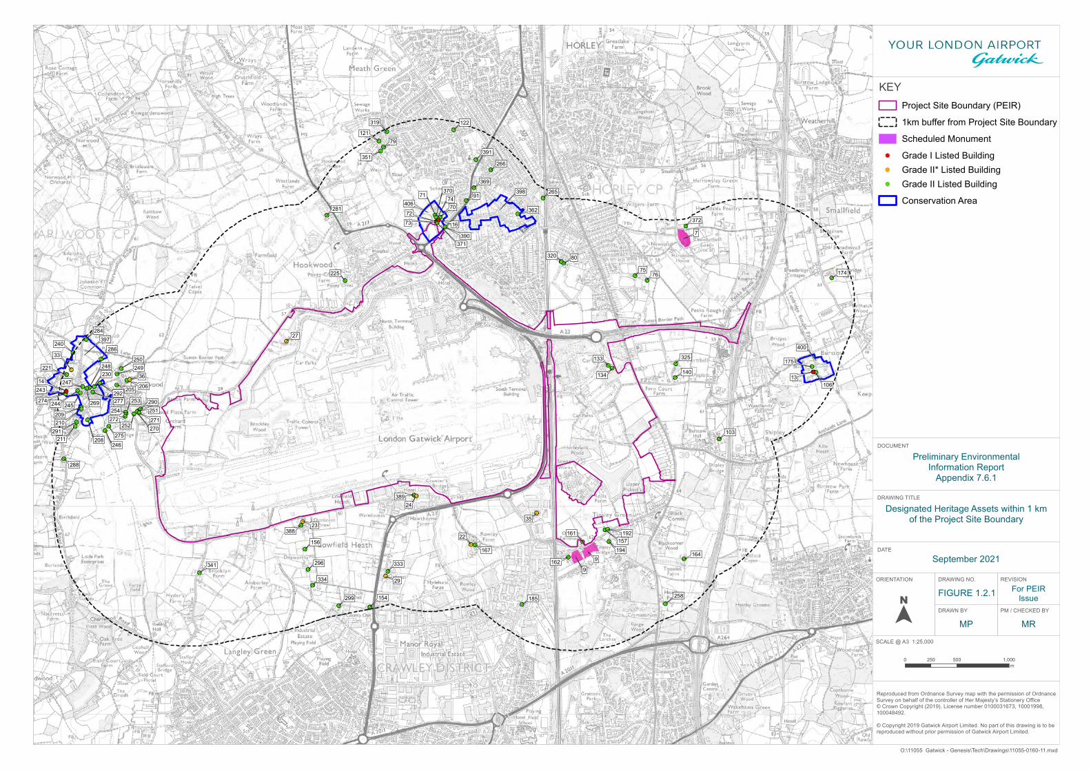
7
9
9
70
71
7273
74
7576
79
80
91
103
106
121
122
133
134
22
23
24
140
27
154
29
156 157161
162164
167
174
13
175
185
192
194
205 206
208
209210
211
33
221
225
230
240
14243
244 245
246
247
248 249250
251
252
253
254
258
265
266
35
269
270271272
274
275
277
281
284
286
288
290
291
36
292
296
299
319
320
325
333
334
341
351
362
369370
16
371
372
388
389
390
391
397
398
400
406
Designated Heritage Assets within 1 kmof the Project Site Boundary
DRAWING TITLE
KEYProject Site Boundary (PEIR)
1km buffer from Project Site Boundary
Scheduled Monument
Grade I Listed BuildingGrade II* Listed BuildingGrade II Listed Building
Conservation Area
DATE
ORIENTATION DRAWING NO. REVISION
FIGURE 1.2.1
DRAWN BY PM / CHECKED BY
Reproduced from Ordnance Survey map with the permission of OrdnanceSurvey on behalf of the controller of Her Majesty’s Stationery Office © Crown Copyright (2019). License number 0100031673, 10001998, 100048492.
© Copyright 2019 Gatwick Airport Limited. No part of this drawing is to be reproduced without prior permission of Gatwick Airport Limited.
0 500 1,000250m
SCALE @ A3 1:25,000
MP MR
DOCUMENT
O:\11055 Gatwick - Genesis\Tech\Drawings\11055-0160-11.mxd
Preliminary EnvironmentalInformation Report
Appendix 7.6.1
For PEIRIssue
September 2021
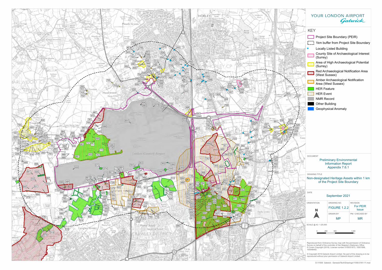
409
410
413
414
421422
424
425
426
427
428
429
430431432
433
434
435
444
445
448449
450
451
453
454 455
456
457
458
461
462463
470
471
472
473
474
475
476
477
478
479
480
481
482
483
484
485
486
487
488
489
490
500
501502
503
491492
493
494
495
496
497
498
499
558
560
561
563 565
567
569
570
571
572
573
575
577
578
579
582583
584
585
586
587588
589
590
591
592
593
594
595
597 598
599
600
601
602
628
629
630
631
632
633
634
635
636
637
638
639
640
641
642
643
644 645
646
648
649
650
651
652
653
654655 656
657
658659
660
661
662663
664 665
666667
668
669
670
671
672
673
674
676
677
678
679680
681
682
684
685
686
687
688689
690
692
694
695
696
698
699
603
613
604
605
606
607
608
609
610
611 615
616
619
621
625 562
564 566
568
574
576
580
581
612
614
617
618
618618
618
620
622
623
624
626
626647
647
675
683
691
693
693
697
700
627
627
627
559
504
505506
507
508509
510
511
512
513
514
515
516
517
518
519520
521
522
523524525
526
527
528
529530
531532
533534
535
536
537
538
539
542
543
544
545
546547
548
549
550
551
552
553
554
555
556557
540541
714
715
729
730
733
734
731
716
717
718
719
720
721722
723
724
725
726
727
735
732
732
732
701
702
703
704
705
706
707
708709
710
711
712
713
812
746
811
788
805
806
808
850
830
743838
851
824
815
857
829
784
745
772
828
836
822
825
781
831
814
818
854
840
839
796
853
795
740
739
800
794
846
849
780
770
747
742
764767
763
776
741
789
768
848
736
755
749
737
793
779
753
775
762797
852
844
757
845
771
786
859
860
866
866
867
871
861
862
864
868
868
868 865869
865
870
863
Non-designated Heritage Assets within 1 kmof the Project Site Boundary
DRAWING TITLE
KEYProject Site Boundary (PEIR)
1km buffer from Project Site Boundary
Locally Listed BuildingCounty Site of Archaeological Interest(Surrey)Area of High Archaeological Potential(Surrey)Red Archaeological Notification Area(West Sussex)Amber Archaeological NotificationArea (West Sussex)HER FeatureHER EventNMR RecordOther BuildingGeophysical Anomaly
DATE
ORIENTATION DRAWING NO. REVISION
FIGURE 1.2.2
DRAWN BY PM / CHECKED BY
Reproduced from Ordnance Survey map with the permission of OrdnanceSurvey on behalf of the controller of Her Majesty’s Stationery Office © Crown Copyright (2019). License number 0100031673, 10001998, 100048492.
© Copyright 2019 Gatwick Airport Limited. No part of this drawing is to be reproduced without prior permission of Gatwick Airport Limited.
0 500 1,000250m
SCALE @ A3 1:25,000
MP MR
DOCUMENT
O:\11055 Gatwick - Genesis\Tech\Drawings\11055-0161-11.mxd
For PEIRIssue
Preliminary EnvironmentalInformation Report
Appendix 7.6.1
September 2021
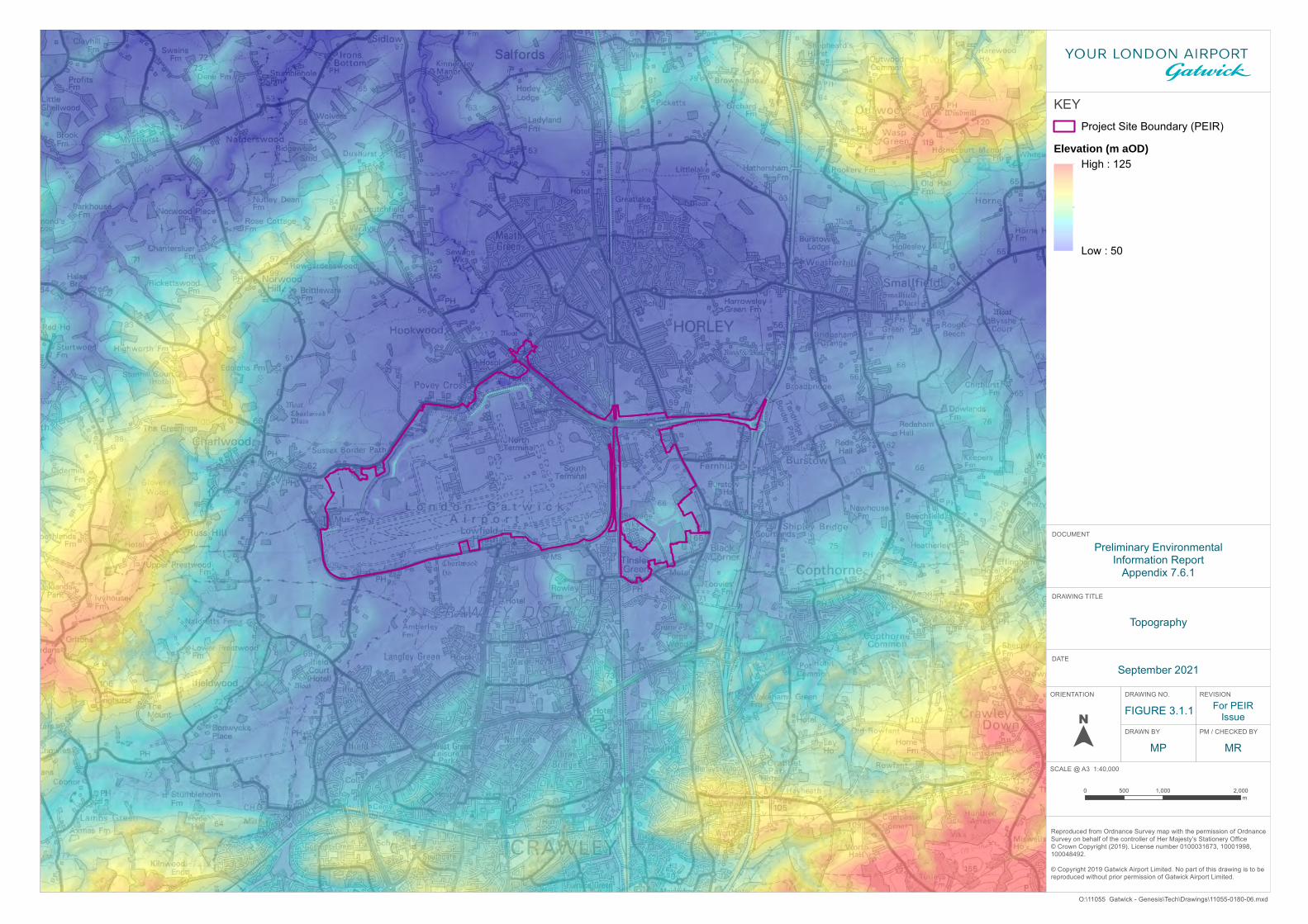
Topography
DRAWING TITLE
KEYProject Site Boundary (PEIR)
Elevation (m aOD)High : 125
Low : 50
DATE
ORIENTATION DRAWING NO. REVISION
FIGURE 3.1.1
DRAWN BY PM / CHECKED BY
Reproduced from Ordnance Survey map with the permission of OrdnanceSurvey on behalf of the controller of Her Majesty’s Stationery Office © Crown Copyright (2019). License number 0100031673, 10001998, 100048492.
© Copyright 2019 Gatwick Airport Limited. No part of this drawing is to be reproduced without prior permission of Gatwick Airport Limited.
0 1,000 2,000500m
SCALE @ A3 1:40,000
MP MR
DOCUMENT
O:\11055 Gatwick - Genesis\Tech\Drawings\11055-0180-06.mxd
For PEIRIssue
Preliminary EnvironmentalInformation Report
Appendix 7.6.1
September 2021
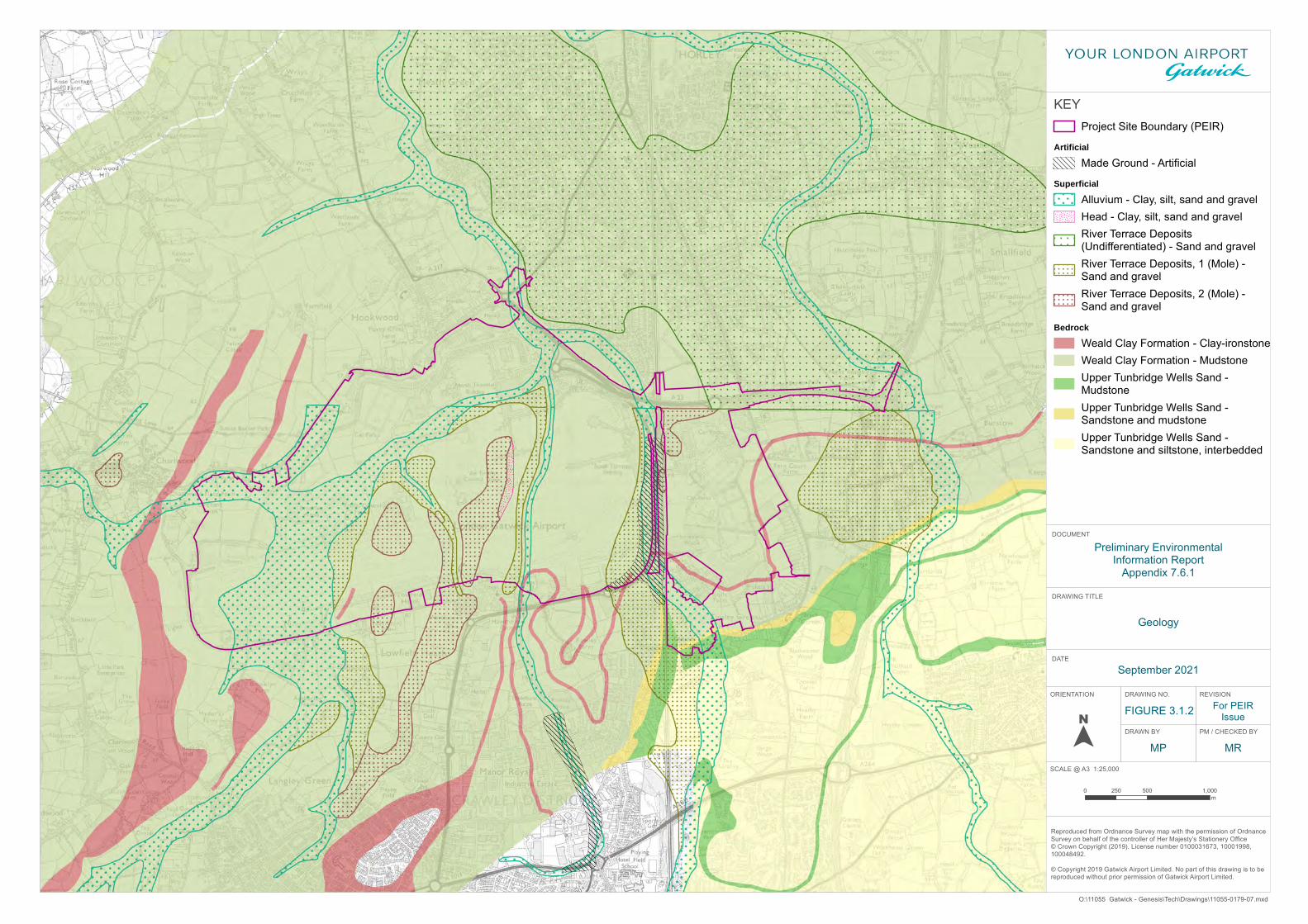
Geology
DRAWING TITLE
KEYProject Site Boundary (PEIR)
ArtificialMade Ground - Artificial
SuperficialAlluvium - Clay, silt, sand and gravelHead - Clay, silt, sand and gravelRiver Terrace Deposits(Undifferentiated) - Sand and gravelRiver Terrace Deposits, 1 (Mole) -Sand and gravelRiver Terrace Deposits, 2 (Mole) -Sand and gravel
BedrockWeald Clay Formation - Clay-ironstoneWeald Clay Formation - MudstoneUpper Tunbridge Wells Sand -MudstoneUpper Tunbridge Wells Sand -Sandstone and mudstoneUpper Tunbridge Wells Sand -Sandstone and siltstone, interbedded
DATE
ORIENTATION DRAWING NO. REVISION
FIGURE 3.1.2
DRAWN BY PM / CHECKED BY
Reproduced from Ordnance Survey map with the permission of OrdnanceSurvey on behalf of the controller of Her Majesty’s Stationery Office © Crown Copyright (2019). License number 0100031673, 10001998, 100048492.
© Copyright 2019 Gatwick Airport Limited. No part of this drawing is to be reproduced without prior permission of Gatwick Airport Limited.
0 500 1,000250m
SCALE @ A3 1:25,000
MP MR
DOCUMENT
O:\11055 Gatwick - Genesis\Tech\Drawings\11055-0179-07.mxd
For PEIRIssue
Preliminary EnvironmentalInformation Report
Appendix 7.6.1
September 2021
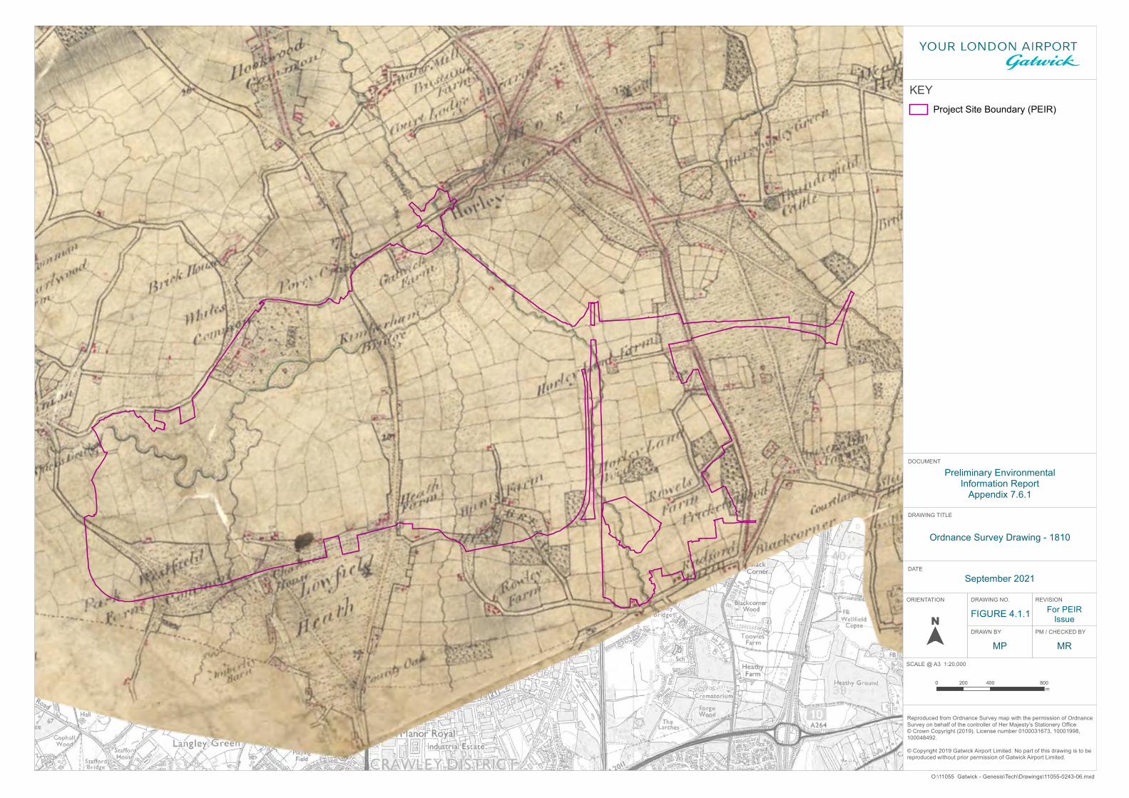
Ordnance Survey Drawing - 1810
DRAWING TITLE
KEYProject Site Boundary (PEIR)
DATE
ORIENTATION DRAWING NO. REVISION
FIGURE 4.1.1
DRAWN BY PM / CHECKED BY
Reproduced from Ordnance Survey map with the permission of OrdnanceSurvey on behalf of the controller of Her Majesty’s Stationery Office © Crown Copyright (2019). License number 0100031673, 10001998, 100048492.
© Copyright 2019 Gatwick Airport Limited. No part of this drawing is to be reproduced without prior permission of Gatwick Airport Limited.
0 400 800200m
SCALE @ A3 1:20,000
MP MR
DOCUMENT
O:\11055 Gatwick - Genesis\Tech\Drawings\11055-0243-06.mxd
For PEIRIssue
Preliminary EnvironmentalInformation Report
Appendix 7.6.1
September 2021
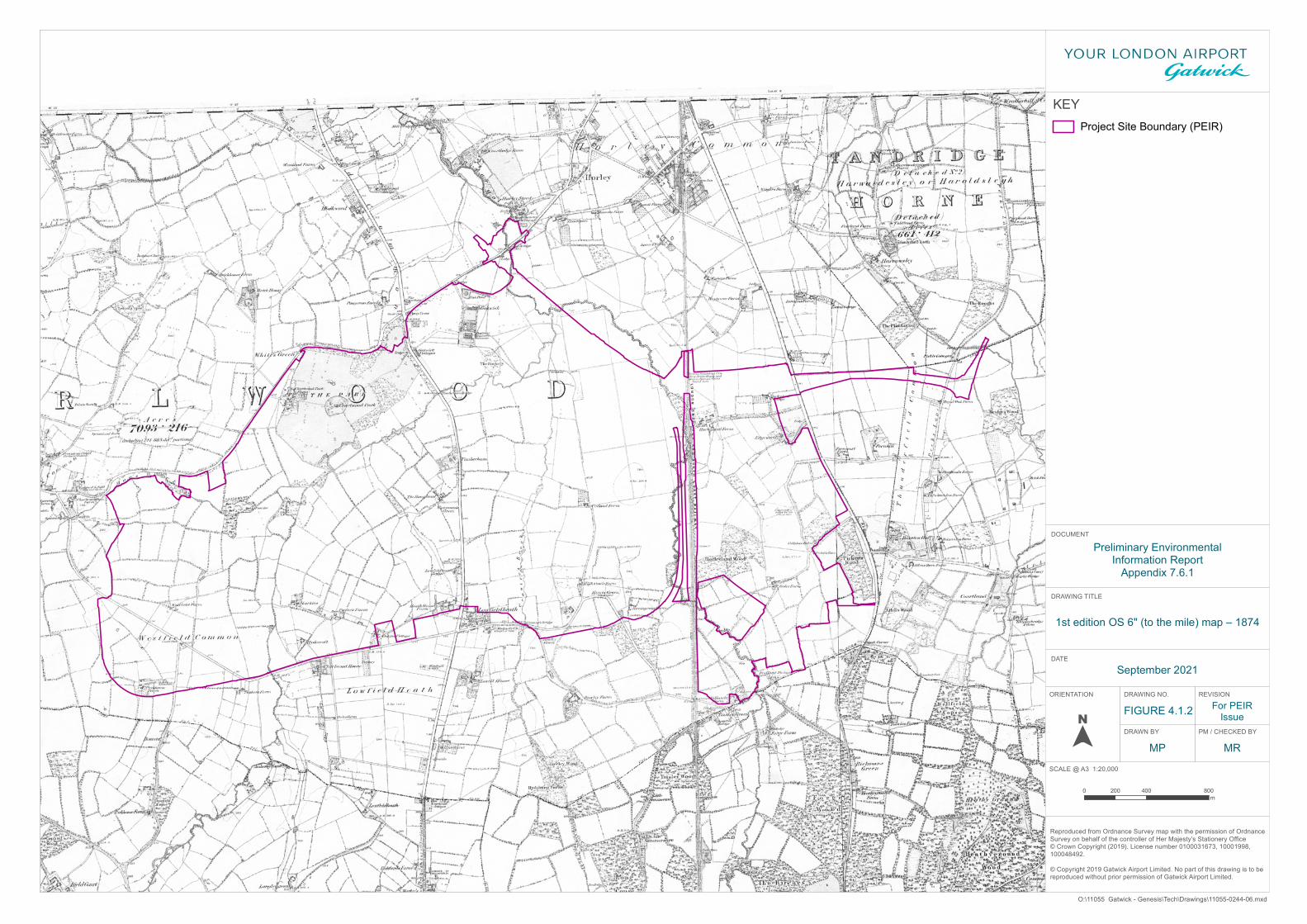
1st edition OS 6" (to the mile) map – 1874
DRAWING TITLE
KEYProject Site Boundary (PEIR)
DATE
ORIENTATION DRAWING NO. REVISION
FIGURE 4.1.2
DRAWN BY PM / CHECKED BY
Reproduced from Ordnance Survey map with the permission of OrdnanceSurvey on behalf of the controller of Her Majesty’s Stationery Office © Crown Copyright (2019). License number 0100031673, 10001998, 100048492.
© Copyright 2019 Gatwick Airport Limited. No part of this drawing is to be reproduced without prior permission of Gatwick Airport Limited.
0 400 800200m
SCALE @ A3 1:20,000
MP MR
DOCUMENT
O:\11055 Gatwick - Genesis\Tech\Drawings\11055-0244-06.mxd
For PEIRIssue
Preliminary EnvironmentalInformation Report
Appendix 7.6.1
September 2021
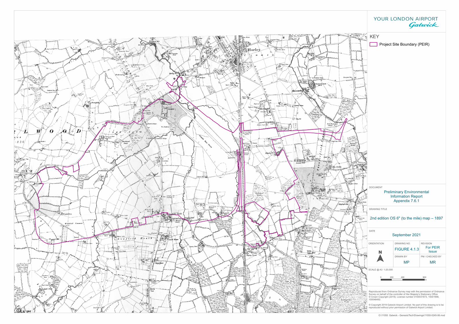
2nd edition OS 6" (to the mile) map – 1897
DRAWING TITLE
KEYProject Site Boundary (PEIR)
DATE
ORIENTATION DRAWING NO. REVISION
FIGURE 4.1.3
DRAWN BY PM / CHECKED BY
Reproduced from Ordnance Survey map with the permission of OrdnanceSurvey on behalf of the controller of Her Majesty’s Stationery Office © Crown Copyright (2019). License number 0100031673, 10001998, 100048492.
© Copyright 2019 Gatwick Airport Limited. No part of this drawing is to be reproduced without prior permission of Gatwick Airport Limited.
0 400 800200m
SCALE @ A3 1:20,000
MP MR
DOCUMENT
O:\11055 Gatwick - Genesis\Tech\Drawings\11055-0245-06.mxd
For PEIRIssue
Preliminary EnvironmentalInformation Report
Appendix 7.6.1
September 2021


