27
| Date post: | 10-Jun-2018 |
| Category: |
Documents |
| Upload: | truongkien |
| View: | 237 times |
| Download: | 0 times |


Presentation of the Passes ("Cols") in the British Isles
Great Britain and the British Isles
The expression "The British Isles" is a geographical and not political expression and covers : • Great Britain (which is made up of England, Scotland and Wales) – this being the
largest island, together with several nearby smaller islands
• The island of Ireland (made up of Northern Ireland and Eire – Southern Ireland)
• Other islands which are more or less autonomous from an administrative point of view
– the Isle of Man, the Channel Islands.
The expression "The United Kingdom" is a contraction of "The United Kingdom of Great
Britain and Northern Ireland".
The breakdown of Great Britain into administrative sub-divisions was, until 1995, similar to
that of the French departements (see Figure N° 1). The administrative reorganisation of 1995
(creation of the "Unitary Authorities" - see Figure N° 2) led to a rather chaotic and incoherent
geographical breakdown. Even the British in everyday language and postal addresses often
use the "counties" prior to 1995.
For this reason we have organised the Great Britain catalogue by "country" (England, Scot-
land and Wales) although the list of passes also shows the "administrative entity" post-1995.
On the other hand Ireland has maintained the old breakdown of counties - which is visually at
least much more coherent – and we have consequently organised the list of Irish passes by
county (see Figure N° 3).
Criteria for the definition of the “cols”
Reminder of Article 2 of the "Rules of the Game"
A pass is eligible to be claimed as part of your total only if it is called : - "pass" or any local, regional or national translation of this term, AND :
- its name is listed on a map (Michelin and IGN for France, or equivalent for other
countries (for example Ordnance Survey for Great Britain, USGS for the USA etc.)
OR
- its name appears on a summit or directional sign
In order to apply this rule systematically and rigorously to the British Isles and to inventory
all the "cols" corresponding to this rule it is necessary to :
1. Define those "names" in the various British languages that are equivalent to "col"
2. Determine the maps that will be used as references
3. List all the "cols shown on the maps
4. If appropriate add any "cols" indicated by a summit or directional sign together with
any other useful information gathered in the field

The "names" - the toponomy of the British Isles
The roots of geographical names are found in the history of a country and its peoples and
often reveal aspects that are forgotten in modern language. Even if the composition of the
peoples has remained stable since 1066 (the invasion of William the Conqueror) the origins of
a certain number of place-names go back to an era prior to this date. English is obviously by
far the most spoken language in the British Isles but Welsh and Gaelic are still officially
recognized and spoken in some parts of Wales and Scotland respectively. "Scots" and
"Scandinavian" have also left their traces in some geographical names. Other languages that
are still spoken or have only become extinct in the 20th
Century - "Cornish" or "Manx" do not
seem to yield any geographical names still listed or any synonyms of "col".
In Ireland are found variously English names, Gaelic names and Gaelic names that have been
anglicized.
The sources that have been used to find and verify the synonyms of "col" are ;
• The Oxford English Dictionary – the reference of the English language – a dictionary of
more than 500000 words in 20 volumes
• The guides to place names originating from other British languages – published by the
Ordnance Survey – the OS (the equivalent of the IGN) – available on the OS website at http://www.ordnancesurvey.co.uk/resources/historical-map-resources/origins-of-placenames.html
o Guide to Gaelic origins of place names in Britain
o Guide to Welsh origins of place names in Britain
o Guide to Scandinavian origins of place names in Britain
o Guide to Scots origins of place names in Britain
• JOYCE, P.W. Irish Local Names Explained
(https://archive.org/details/irishlocalnamese00joyc)
The names and their derivatives that are found in the "cols" that have been validated in this
catalogue are the following:
adwy nf gap, pass aisir nf, aisre aisrean pl passage, pass, path ballagh, balloch (Eng), bealach, bhealach (Gael) nm bealaich pl a roadway, passage, gap, pass; pass, gorge of a mountain, glen, gap barn, barna (Eng), bearna (Gael) n pass or gap in hill or mountain beul nm beòil, bhéal mouth, opening bwlch nm bylchau pl gap, pass cadha, cadh’ nm cadhan pl narrow pass, narrow ravine clwyd nf clwydydd pl hurdle, gate col n a marked depression in the summit-line of a mountain chain, generally affording a pass from one slope to the other. A word belonging to the Romanic dialects of the Alps, which Alpine climbers and geologists have used of other regions diollaid nf, diollaide, diollaidean pl saddle

door, dore an opening, a passage drws nm gap, narrow pass (door) eag nf, eage, eagan pl notch, gap
gap n a break or opening in a range of mountains; a pass or gorge (very common in U.S.).
gate n an entrance into a country through mountains; a mountain-pass. Cf. Gr. πυλη, L. porta hause/hawse, hass, hals, halse n a narrower and lower neck or connecting ridge between two heights or summits; a col; the regular name in the English Lake district and on the Scottish Border. Generally at the head of two stream valleys which descend opposite sides of the hause, forming a pass over the ridge or mountain chain at this point làirig nf làirigean pl learg moor, hill, sloping hill, pass maum (Eng), mám (Gael) n mountain pass mouth the entrance to a haven, valley etc. nick n a gap in a range of hills. pass n a passage, a way or opening by which one passes through a region otherwise obstructed or impassable, or through any natural or artificial barrier. esp. a narrow and difficult or dangerous passage through a mountainous region or over a mountain range; also (less usually) through a forest, marsh, bog, or other impassable ground. In ME. applied to a road or passage in a wood, over a heath, etc., such as was exposed to ambush, robbery, etc.; in its later application prob. an adoption from mod.F. pas. saddle a depression in a hill or line of hills scord (from Old Norse skaro) deep depression or valley between two hills slack n hollow between hills, pass, pit, hole sneck notch, dip in the ground, saddle between hills slap n pass, shallow valley between hills strait passage or channel swyre, swire, sware a gentle depression between two hills uinneag window window opening yet, yett n gate, natural pass between hills
All of these names can correspond to the definition of a "col" but also have other meanings. It
will be noted that "pass" does not necessarily mean "col" in the sense of the Romanic
languages.

In order to be able to validate the "cols" that respect the "Rules of the Game" we have taken
places with not only names found in the list of toponyms above but also corresponding to a
dictionary definition of a geographical "col".
This concept can become subjective according to the topology and lie of the land but is
described by 3 French dictionaries in the following way :
Le Littré : "Terme de géographie. Le point d'une chaîne de montagne où le faîte, faisant une inflexion, offre un passage d'un versant à l'autre, entre les points d'attache de deux contre-forts." Le Larousse : "Dépression d'une crête montagneuse, formant passage." Le Robert : "Dépression formant passage entre deux sommets montagneux"
This definition is quite restrictive and probably more so than the use of "col" in the Romanic
language countries. However, as explained above, the British words "pass", "bealach",
"bwlch", "gap" etc. do not coincide exactly with "col" as understood in the Romanic
languages. It has therefore been necessary, in order to draw a boundary line for this first
"Catalogue of the Passes/Cols in the British Isles" to adopt a deliberately limited definition.
Places that have been excluded for the moment could be considered for future lists – if
additional supporting evidence is provided.
The mountain/hill ranges in Scotland and the Lake District are often crossed by very
pronounced "cols". In the rest of England and most of Wales the undulating terrain of the
hills and mountains of modest height means that the slopes are not so well defined.
The maps used as references
Great Britain has a long tradition of producing detailed maps at different scales and they are
regularly updated. According to some sources Britain is the most extensively mapped country
in the world. In any case the Ordnance Survey (the OS) carries out the same functions as the
French IGN.
Accordingly in Britain the OS maps can be considered the most objective and most reliable
maps.
The maps in the "Landranger" series at a scale of 1 :50000 are the best-selling series and
those most used by cyclists and hikers. All the place names shown on these maps are included
in a database ("The OS Gazetteer") of more than 250000 names that can be consulted on the
Internet at: http://data.gov.uk/dataset/os-50k-gazetteer
We have carried out complete searches of this database by key-word and most of the "cols"
corresponding to the Rules of the Game listed in this catalogue have come from these
searches.
The Map Series Coverage of the Landranger maps is shown in Figure N° 4. This can also be
consulted on the Internet at the Ordnance Survey website ordnancesurvey.co.uk.
The maps in the "Explorer/Outdoors Leisure" series at a scale of 1 :25000 are also very useful
– especially for hikers. The 2017 edition of the catalogue examines all of the additional passes
that can be found on these maps.

Older maps from the 19th
century (the “OS 1st Edition”) can be explored at a scale of 6 inches
to the mile (approx.. 1:10000) at the following sites :
http://maps.nls.uk/geo/find/#
http://maps.osi.ie/publicviewer/#V2
The maps in the "Road Travel Map" series at a scale of 1 :250000 give a good and relatively
detailed overview of Great Britain in 8 maps which are very attractively shaded to show the
contours and relief.
The most detailed 1-volume Atlas is published by Phillips at a scale of 1 :100000 and has
enabled a few more "cols" to be unearthed.
The "Bartholomews" maps at a scale of 1 :125000 published up until about twenty years
were greatly treasured by cyclists but are no longer available except in second-hand
bookshops.
Some summit or directional signs do exist in Great Britain but are rather rare and the cases of
which we are aware are all shown on at least one of the reference maps listed above.
Other more general-purpose maps are at less detailed scales and have not been taken into
account in order to validate the inclusion of a "col" in this catalogue.
All the OS Landranger maps are available at the Vieux Campeur in Paris and all of the OS
series at Stanford’s, 12-14 Long Acre, London WC2, http://www.stanfords.co.uk/
The Michelin maps covering the British Isles in 5 sheets at a scale of 1 :400000 facilitate
planning a journey but do not show more than a handful of "cols" listed in this catalogue.
The internet site "Streetmap", http://www.streetmap.co.uk also enables searches and zooms to
be carried out in the same way as the Ordnance Survey site.
For Ireland the recent publication of the Discovery (for Eire) and Discoverer (for Northern
Ireland) series at a scale of 1 :50000 provides at last a mapping of a quality comparable to the
rest of the British Isles.
The Map Series Coverage of the Discovery/Discoverer maps is shown in Figure N° 6.
"Landranger Grid", "National Grid", and "Irish National Grid" The Ordnance Survey has defined a system of cartesian coordinates for Great Britian
according to a Mercator Grid of 100 km x 100 km squares. These squares are identified by 2
different methods (see Figure N° 4 ) :
• Landranger Grid – 2 alphabetical letters (for example TL)
• National Grid - 1 number for the X coordinate and 1 number for the Y coordinate (or
for the North of Scotland 2 numbers).

Within each square 2 further numbers for the X coordinates (working from left to right) and 2
for the Y coordinates (working from bottom to top) define a smaller 1 km x 1 km square.
Additional numbers enable a place to be identified to the nearest 100m., 10 m., ou 1 m.
For example SJ8759 corresponds to 387000, 359000. SJ876599 corresponds to 387600,
359900. The Landranger Grid coordinates are normally given with 2 letters and 6 numbers (to
the nearest 100 m. – as in this catalogue).
The Landranger maps at 1 : 50000 and the Phillips Atlas at 100000 use the Landranger Grid.
The OS Explorer/Outdoors Leisure at 1 : 25000 and the Road Map series at 1 : 250000 use the
National Grid.
In the same way the "Irish National Grid" divides up all Ireland into 100 km x 100 km squares
identified by 1 letter from A to Z (see Figure N° 7).
The "cols" listed in this catalogue
We have been able to confirm and list in this catalogue 1202 "cols" corresponding to the
criteria (toponym for "col" shown on a reference map) + (geographical "col"):
Road Track / path No path Total
England 31 24 25 80
Scotland 38 146 590 774
Wales 71 77 97 245
Northern Ireland 5 2 1 8
Southern Ireland (Eire) 58 17 20 95
Total 203 266 733 1202
One "col" is bordering on Northern and Southern Ireland – it is counted in the table above
under the heading Northern Ireland. All "cols" are shown graphically on Figure N° 8 (road
"cols" in red, the others in yellow).
The information shown corresponds to the normal Cents Cols format :

For Great Britain
Column Title Description
A Code Country (GB) + Sub-Division (ENG or SCT or WLS)
+ altitude
ENG = England, SCT = Scotland, WLS = Wales
Duplicate references are differentiated by an
additional suffix a, b, ...
B Intitulé Descriptor as synonym for "col"
C Nom Name
D Nom complet Complete name of the "col" as shown on the
reference map
E Alti Altitude of the geographical col as shown on the map
or as estimated from a numeric map with an
altimetric database
F Documents Link to the Cent Cols visualiser which displays the
pass on various interactive maps
G Dept. Admin. Administrative Entity post-1995
H OS Landranger 1 :50000 Map(s) in the Landranger series
I OS Landranger Coord Coordinates of the "Landranger Grid"
J Michelin Cartes 1:400000 Michelin 1:400000 maps
K Michelin Quad Cartes
1 :400000
Quadrant of the Michelin 1:400000 maps
L Accès Road or track/path (R=road, S=path, HS=no path)
M Type Type of road/path 0 = road, 10 = track, 15 = path, 20
= path unknown or inexistant
N Diff Difficulty 0 = tarmac on at least one side 1 = rideable,
2 = easy pushing of the bike, 3 = difficult pushing of
the bike, 35 = road without grading, 40 = bike
needing to be carried, 50 = acrobatic, 99 = not graded
but not necessarily impossible to cross
O Lim Neighbouring country
P/Q National Grid X / Y Coordinates of the "National Grid"
R WGS84 Fuseau Universal Transverse Mercator (UTM) zone
S/T WGS84 UTM x / y UTM x and y coordinates
U/V WGS84 Lon D / Lat D Decimal longitude and latitude coordinates (°)
W/X WGS84 Lon S / Lat S Sexagesimal coordinates (° ' ")
Y Remarques Remarks
Z Sources Reference Document(s) which have enabled the pass
to be validated

For Ireland Column Title Description
A Code Country (IE or GB) + Sub-Division (NIR or Irish
County) + altitude
Duplicate references are differentiated by an
additional suffix a, b, …
CAR : Carlow, CAV : Cavan, COR : Cork,
DON : Donegal, GAL : Galway, KER : Kerry,
KIK : Kilkenny, LEX : Laois, LOU : Louth,
MAY : Mayo, NIR : Northern Ireland, UK,
OFF : Offaly, SLI : Sligo, TIP : Tipperary,
WAT : Waterford, WEX : Wexford, WIC : Wicklow
B Intitulé Descriptor as synonym for "col"
C Nom Name
D Nom complet Complete name of the "col" as shown on the
reference map
E Alti Altitude of the geographical col as shown or
estimated on the map
F Documents Link to the Cent Cols visualiser which displays the
pass on various interactive maps
G OS 1 :50000 Map(s) in the Discovery/Discoverer series
H Irish National Grid Coordinates of the "Irish National Grid"
I OS 1:250000 Map in the "Holiday Map" series
J OS 1:250000 Coord. X X coordinate of the map grid - mm inside the grid
going from left to right
K OS 1:250000 Coord. Y Y coordinate of the map grid - mm inside the grid
going from bottom to top
L Michelin Quad Coordinates of the Michelin Map 712 at a scale of
1:400000: quadrant - mm from left to right - mm
from bottom to top
M Accès Road or track/path (R=road, S=path, HS=no path)
N Type Code for road or track/path type
O Diff Difficulty
P Lim Neighbouring country or county
Q/R Irish NG X / Y Coordinates of the "National Grid"
S WGS84 Fuseau Universal Transverse Mercator (UTM) zone
T/U WGS84 UTM x / y UTM x and y coordinates
V/W WGS84 Lon D / Lat D Decimal longitude and latitude coordinates (°)
X/Y WGS84 Lon S / Lat S Sexagesimal coordinates (° ' ")
Z Remarques Remarks
AA Sources Reference Document(s) which have enabled the pass
to be validated

Tourist information about the British Isles
England is a generally a fairly flat country apart from a range of hills (The Pennines) running
down the spine of the North of this country and the Lake District. Nonetheless there are
numerous small hilly regions (North Yorks Moors, Cheviots, Cotswolds, Exmoor, Dartmoor)
where the climbs, although short usually take the shortest route to the top – with gradients
sometimes steeper than 25%.
Scotland and Wales are mainly made up of hilly and mountainous terrain of moderate altitude
– the highest point of the British Isles being the summit of Ben Nevis (1200 m. - that have to
be climbed however from sea level!).
Ireland is criss-crossed by several small mountain ranges with tops of over 1000 m. – most of
them being in the West with the exception of the Wicklow Mountains near Dublin.
The main and regional roads (A-roads and B-roads) generally have a high flow of motor
traffic. Local roads, especially in Scotland and Wales are often much calmer. In rural Ireland
one sometimes has the impression that one has gone back into another century when the main
form of transport consisted of donkey-carts.
The climate is similar to the North-West of France, except for Scotland above a height of
around 500m. where winter conditions can be quite severe.
Lodging can be found quite easily near those regions that are likely to interest cyclists with a
good network of hotels, inns and youth hostels.
"Cols" listed in this catalogue, passes, bealach, bwlch, gaps... not included as "Cols" and updates The catalogue of "cols" is made of two lists, one for each of the islands Great Britain and
Ireland.
A third list attached gives the name and coordinates of places with a name including Pass,
Bealach, Bwlch, Gap etc. but considered to not be in accordance with the Rules of the Game.
This second list readily identifies places that have been scrutinised but judged not in
conformity with the criteria for inclusion in this list.
These, and other places in the British Isles, could be considered for inclusion in future lists
upon supply by our members of additional evidence such as summit signs, more recent or
more detailed mapping or photos clarifying the geographical situation.
Cover photo : Hardknott Pass (Rob Farrow Creative Commons 2.0)
For any additional information, any forgotten "cols" or any errors that are noticed you
may send a message to [email protected]

Présentation des Cols des Iles Britanniques
La Grande Bretagne et les Iles britanniques
Le terme « Iles Britanniques » est un terme géographique et non pas politique et couvre
• La Grande Bretagne (qui comportent l’Angleterre, l’Ecosse, et le Pays de Galles) – l’île
avec la superficie la plus importante et quelques autres îles à proximité
• L’île de l’Irlande (qui comporte l’Irlande du Nord et l’Irlande du Sud)
• D’autres îles qui ont une gestion administrative plus ou moins autonome (l’Ile de Man,
les Iles Anglo-Normandes).
Le terme « Le Royaume-Uni » est une contraction de « Le Royaume-Uni de la Grande
Bretagne et de l’Irlande du Nord ».
Le découpage administratif de la Grande Bretagne jusqu’en 1995 était similaire aux
départements français (voir Figure N° 1). La réorganisation administrative de 1995 (création
des « Autorités Unitaires » - voir Figure N° 2) a donné un découpage assez chaotique. Les
Britanniques en langage courant et même en adressage des lettres utilisent souvent les
« comtés » d’avant 1995.
Pour cette raison nous avons organisé le catalogue de la Grande Bretagne par « pays »
(l’Angleterre, l’Ecosse, et le Pays de Galles) même si la liste des cols cite aussi le
« département administratif » post-1995.
Par contre l’Irlande a retenu son ancien découpage des comtés – beaucoup plus cohérent – et
nous avons par conséquent organisé la liste des cols irlandais par comté (voir Figure N° 3).
Critères de définition des cols
Rappel de l’article 2 de la règle du jeu Ne sont pris en compte que les cols portant officiellement ce nom :
- figurant sur des cartes (Michelin, I.G.N. ou correspondantes pour les pays étrangers.)
- signalés par un panneau de sommet ou directionnel.
Pour appliquer cette règle aux Iles Britannqiues et recenser tous les cols qui correspondent à
la règle il faut :
1. Définir les « noms » dans les langues britanniques qui équivalent à « col »
2. Déterminer les cartes de références
3. Recenser les cols cités sur les cartes
4. Eventuellement ajouter des cols signalés par un panneau de sommet ou directionnel ou
d’autres informations récoltées sur site

Les « noms » - la toponymie des Iles Britanniques
Les noms géographiques puisent leurs racines dans l’histoire du pays et de ses peuples et
dévoilent souvent des facettes oubliées dans la langue courante. Même si la composition des
peuples est restée stable depuis l’an 1066 (l’intrusion de Guillaume le Conquérant) les
origines d’un certain nombre de lieux remontent à une époque antérieure à cette date.
L’anglais est évidemment de loin la langue la plus parlée dans les Iles Britanniques mais le
gallois et le gaélique sont encore reconnus et parlés dans une partie du Pays de Galles et de
l’Ecosse. Le « Scots » et le « Scandinave » ont aussi laissé leurs traces dans les noms
géographiques. D’autres langues encore parlées ou devenues moribondes dans le 20e siècle –
le « Cornish » ou le « Manx » ne semblent pas avoir donné lieu à des noms géographiques
encore répertoriés ou des homonymes pour « col ».
En Irlande ou trouve soit des noms anglais, soit des noms gaéliques, soit des noms gaéliques
anglicisés.
Les sources utilisées pour trouver et vérifier les homonymes de « col » sont :
• The Oxford English Dictionary – la référence de la langue anglaise – un dictionnaire de
plus de 500000 mots en 20 volumes
• Les guides aux noms des lieux issus des autres langues britanniques – édités par
l’Ordnance Survey – l’OS (l’équivalent à de l’IGN) et disponibles sur le site de l’OS http://www.ordnancesurvey.co.uk/resources/historical-map-resources/origins-of-placenames.html
o Guide to Gaelic origins of place names in Britain
o Guide to Welsh origins of place names in Britain
o Guide to Scandinavian origins of place names in Britain
o Guide to Scots origins of place names in Britain
• JOYCE, P.W. Irish Local Names Explained
(https://archive.org/details/irishlocalnamese00joyc)
Les noms et leurs dérives qui ont donné lieu à des cols confirmés sont les suivants :
adwy nf gap, pass aisir nf, aisre aisrean pl passage, pass, path ballagh, balloch (Eng), bealach, bhealach (Gael) nm bealaich pl a roadway, passage, gap, pass; pass, gorge of a mountain, glen, gap barn, barna (Eng), bearna (Gael) n pass or gap in hill or mountain beul nm beòil, bhéal mouth, opening bwlch nm bylchau pl gap, pass cadha, cadh’ nm cadhan pl narrow pass, narrow ravine clwyd nf clwydydd pl hurdle, gate col n a marked depression in the summit-line of a mountain chain, generally affording a pass from one slope to the other. A word belonging to the Romanic dialects of the Alps, which Alpine climbers and geologists have used of other regions diollaid nf, diollaide, diollaidean pl saddle

door, dore an opening, a passage drws nm gap, narrow pass (door) eag nf, eage, eagan pl notch, gap
gap n a break or opening in a range of mountains; a pass or gorge (very common in U.S.).
gate n an entrance into a country through mountains; a mountain-pass. Cf. Gr. πυλη, L. porta hause/hawse, hass, hals, halse n a narrower and lower neck or connecting ridge between two heights or summits; a col; the regular name in the English Lake district and on the Scottish Border. Generally at the head of two stream valleys which descend opposite sides of the hause, forming a pass over the ridge or mountain chain at this point làirig nf làirigean pl learg moor, hill, sloping hill, pass maum (Eng), mám (Gael) n mountain pass mouth the entrance to a haven, valley etc. nick n a gap in a range of hills. pass n a passage, a way or opening by which one passes through a region otherwise obstructed or impassable, or through any natural or artificial barrier. esp. a narrow and difficult or dangerous passage through a mountainous region or over a mountain range; also (less usually) through a forest, marsh, bog, or other impassable ground. In ME. applied to a road or passage in a wood, over a heath, etc., such as was exposed to ambush, robbery, etc.; in its later application prob. an adoption from mod.F. pas. saddle a depression in a hill or line of hills scord (from Old Norse skaro) deep depression or valley between two hills slack n hollow between hills, pass, pit, hole sneck notch, dip in the ground, saddle between hills slap n pass, shallow valley between hills strait passage or channel swyre, swire, sware a gentle depression between two hills uinneag window window opening yet, yett n gate, natural pass between hills
Tous ces noms peuvent correspondre à la définition d’un col mais ont également d’autres
significations.
Afin de confirmer les cols respectant la Règle du Jeu nous avons pris des endroits portant non
seulement les noms dans cette liste de toponymes mais aussi correspondant à un col
géographique tel que défini par les dictionnaires.

Cette notion peut devenir subjective selon la topologie du terrain mais est décrite par 3
dictionnaires français de la façon suivante :
Le Littré : "Terme de géographie. Le point d'une chaîne de montagne où le faîte, faisant une inflexion, offre un passage d'un versant à l'autre, entre les points d'attache de deux contre-forts." Le Larousse : "Dépression d'une crête montagneuse, formant passage." Le Robert : "Dépression formant passage entre deux sommets montagneux"
Cette définition est assez restrictive et probablement plus limitée que l'utilisation de «col»
dans les pays de langue romaine. Pourtant, comme on a expliqué ci-dessus, les mots
britanniques «pass», «bealach», «bwlch», «gap» etc. ne coïncident pas exactement au mot
«col» tel qu'il est compris et utilisé dans les langues romaines. Donc, il a été necéssaire, afin
de définir une frontière pour cette première «Catalogue des Cols des Iles Britanniques»,
d'adopter une définition délibérément restreinte. On pourrait considérer des endroits exclus à
present pour des listes futures à partir du moment où des preuves supplémentaires seraient
fournies.
Les chaînes de montagnes/collines en Ecosse et dans la Région des Lacs sont souvent
traversées par des « cols » très bien démarqués. Dans le reste de l’Angleterre et dans la
plupart du pays de Galles le relief de moyenne montagne est généralement moins escarpé.
Les cartes de référence
La Grande Bretagne a une longue tradition de cartes détaillées à des échelles différentes et
régulièrement mises à jour. Selon certains la Grande Bretagne est le pays le mieux
cartographié du monde. En tout cas The Ordnance Survey (l’OS) remplit les mêmes fonctions
que l’IGN français.
De ce fait les cartes de l’OS sont considérées comme les cartes les plus fiables et objectives.
Les cartes de la série « Landranger » au 1 :50000e
sont les plus vendues et les plus utilisées
par les cyclistes et par les randonneurs. L’intégralité des noms des lieux cités sur ces cartes est
référencée dans une base de données (« The OS Gazetteer ») de plus de 250000 noms que l’on
peut consulter par Internet sous : http://data.gov.uk/dataset/os-50k-gazetteer
Nous avons fait des recherches intégrales par mot clé de cette base de données et la plupart
des cols listés dans ce catalogue qui correspondent à la définition de la Règle du Jeu émanent
de cette recherche.
Le plan d’assemblage des cartes Landranger est représenté à la Figure N° 4. On peut aussi le
consulter par Internet au site de l’Ordnance Survey ordnancesurvey.co.uk
Les cartes de la série « Explorer/Outdoors Leisure » au 1 :25000e sont aussi très utiles –
surtout pour les randonneurs. L’édition 2017 du catalogue examine tous les cols
supplémentaires que l’on peut trouver sur ces cartes.
On peut trouver des cartes plus vielles du 19e siècle (« OS 1st Edition ») à une échelle de 6
pouces au mile (approx. 1 :10000) sur les sites suivants :

http://maps.nls.uk/geo/find/#
http://maps.osi.ie/publicviewer/#V2
Les cartes de la série « Road Travel Map » au 1 :250000e donnent une vue générale et
relativement bien détaillée de la Grande Bretagne en 8 cartes qui sont coloriées de telle
manière à fournir une bonne impression du relief.
L’Atlas en 1 volume le plus détaillé est édité par « Phillips » au 1 :100000e et a permis de
dénicher quelques cols de plus.
Les cartes « Bartholomews » au 1 :125000e éditées jusqu’à il y a une vingtaine d’années
étaient très prisées par les cyclistes mais ne sont plus disponibles sauf dans les librairies
d’occasion.
Les panneaux de sommet ou directionnels existent en Grande Bretagne mais sont assez rares
et les cas connus pour l’instant figurent tous sur au moins une des cartes de référence ci-
dessus.
Les autres cartes plus généralistes sont à des échelles moins détaillées et ne sont pas prises en
compte pour confirmer l’existence d’un col.
Les cartes OS Landranger sont disponibles au Vieux Campeur à Paris et l’intégralité des
cartes OS à Stanford, 12-14 Long Acre, Londres WC2, http://www.stanfords.co.uk/
Les cartes Michelin qui couvrent les Iles Britanniques en 5 cartes au 1 :400000e permettent de
planifier facilement un voyage mais n’identifient pas plus d’une poignée de cols dans ce
catalogue.
Le site internet « Streetmap » : http://www.streetmap.co.uk permet aussi des recherches et des
zooms de la même façon que le site de l’Ordnance Survey.
Pour l’Irlande la publication récente des séries Discovery (pour l’Irlande du Sud) et
Discoverer (pour l’Irlande du Nord) au 1 :50000e fournit enfin une cartographie d’une qualité
comparable au reste des Iles Britanniques.
Le plan d’assemblage des cartes Discovery/Discoverer est représenté à la Figure N° 6.
« Landranger Grid », « National Grid », et « Irish National Grid » L’Ordnance Survey a défini un système de coordonnées pour la Grande Bretagne selon une
grille mercatorienne de carrés de 100 km x 100 km. Ces carrés sont référencés selon 2
méthodes alternatives (voir Figure N° 4 ) :
• Landranger Grid – 2 lettres alphabétiques (par ex. TL)
• National Grid - 1 chiffre pour la coordonnée X et 1 chiffre pour la coordonnée Y (ou
pour le nord de l’Ecosse 2 chiffres)
A l’intérieur de chaque carré 2 chiffres supplémentaires pour les coordonnées X (allant de
gauche à droite) et 2 pour les coordonnées Y (allant de bas en haut) définissent un plus petit
carré de 1 km x 1 km. Des chiffres supplémentaires permettent d’identifier un endroit à
100m., 10 m., ou 1 m. prés.

A titre d’exemple SJ8759 correspond à 387000, 359000. SJ876599 correspond à 387600,
359900. Les coordonnées Landranger Grid sont habituellement fournies avec 2 lettres et 6
chiffres (100 m. de précision).
Les cartes Landranger au 50000e et l’Atlas Phillips au 100000
e utilisent le Landranger Grid.
Les cartes OS Explorer/Outdoors Leisure au 25000e et les cartes Road Travel Map au 250000
e
utilisent le National Grid.
De façon similaire le « Irish National Grid » découpe toute l’Irlande en carrés de 100 km x
100 km référencés par une lettre de A à Z (voir Figure N° 7).
Les cols retenus dans ce catalogue
Nous avons retenu 1202 cols qui correspondent au critère :
(toponyme de col figurant sur une carte de référence) + (col géographique)
Route Piste / chemin Hors piste Total
Angleterre 31 24 25 80
Ecosse 38 146 590 774
Pays de Galles 71 77 97 245
Irlande du Nord 5 2 1 8
Irlande du Sud (Eire) 58 17 20 95
Total 203 266 733 1202
Un col est limitrophe entre l’Irlande du Nord et l’Irlande du Sud et est compté dans le tableau
ci-dessus sous la rubrique de l’Irlande du Nord. Tous les cols sont représentés graphiquement
à la Figure N° 8 (cols routiers en rouge, les autres en jaune).
Les données fournies correspondent au format habituel des Cents Cols :
Pour la Grande Bretagne
Colonne Intitulé Description
A Code Pays (GB) + nation constitutive (ENG = Angleterre,
SCT = Ecosse, WLS = Pays de Galles) + altitude
Dans le cas de doublons les cols sont différenciés par
un suffixe supplémentaire a, b, …
B Intitulé Intitulé synonyme de col
C Nom Nom propre
D Nom complet Nom tel qu'il apparaît sur la carte de référence
E Alti Altitude du col géographique telle que marquée sur la
carte ou estimée sur une carte numérique avec base
altimétrique
F Documents Lien avec le visualisateur Cent Cols qui affiche le col

sur diverses cartes interactives
G Dept. Admin. Unité administrative post-1995
H OS Landranger 1 :50000 Carte(s) de la série Landranger
I OS Landranger Coord Coordonnées de la grille « Landranger Grid »
J Michelin Cartes 1:400000 Cartes Michelin au 1:400000 e
K Michelin Quad Cartes
1 :400000
Quadrant des cartes Michelin au 1:400000 e
L Accès Route, sentier (R=route, S=sentier, HS=hors sentier)
M Type Type de voie : 0 = route, 10 = piste, 15 = sentier, 20 =
hors piste ou sentier pas connu
N Diff Difficulté : 0 = goudronné sur au moins un versant, 1
= cyclable, 2 = poussage aisé, 3 = poussage difficile,
35 = route non cotée, 40 = portage, 50 = acrobatique,
99 = non côté mais pas obligatoirement
infranchissable
O Lim Pays limitrophe
P/Q National Grid X / Y Coordonnées de la grille « National Grid »
R WGS84 Fuseau Fuseau Universal Transverse Mercator (UTM)
S/T WGS84 UTM x / y Coordonnées UTM x et y
U/V WGS84 Lon D / Lat D Longitude et latitude décimales (°)
W/X WGS84 Lon S / Lat S Longitude et latitude sexagésimales (° ' ")
Y Remarques Remarques
Z Sources Référence des document(s) qui ont servi à la
validation du col

Pour l’Irlande Colonne Intitulé Description
A Code Pays (IE ou GB) + sous-division (NIR ou comté
irlandais) + altitude
Dans le cas de doublons les cols sont différenciés par
un suffixe supplémentaire a, b, …
CAR : Carlow, CAV : Cavan, COR : Cork,
DON : Donegal, GAL : Galway, KER : Kerry,
KIK : Kilkenny, LEX : Laois, LOU : Louth,
MAY : Mayo, NIR : Northern Ireland, UK,
OFF : Offaly, SLI : Sligo, TIP : Tipperary,
WAT : Waterford, WEX : Wexford, WIC : Wicklow
B Intitulé Intitulé synonyme de col
C Nom Nom propre
D Nom complet Nom tel qu'il apparaît sur la carte de référence
E Alti Altitude du col géographique telle que marquée ou
estimée sur la carte
F Documents Lien avec le visualisateur Cent Cols qui affiche le col
sur diverses cartes interactives
G OS 1 :50000 Carte(s) des séries Discovery/Discoverer
H Irish National Grid Coordonnées de la grille « Irish National Grid »
I OS 1:250000 Carte de la série «Holiday Map»
J OS 1:250000 Coord. X Coordonnée X de la grille de la carte - mm à
l’intérieur de la grille allant de gauche à droite
K OS 1:250000 Coord. Y Coordonnée Y de la grille de la carte - mm. à
l’intérieur de la grille allant de bas en haut
L Michelin Quad Coordonnées de la carte Michelin 712 au 1:400000 e :
Quadrant - mm de gauche à droite - mm de bas en
haut
M Accès Route, sentier (R=route, S=sentier, HS=hors sentier)
N Type Type de voie : 0 = route, 10 = piste, 15 = sentier, 20 =
hors piste ou sentier pas connu
O Diff Difficulté : 0 = goudronné sur au moins un versant, 1
= cyclable, 2 = poussage aisé, 3 = poussage difficile,
35 = route non cotée, 40 = portage, 50 = acrobatique,
99 = non côté mais pas obligatoirement
infranchissable
P Lim Pays / comté limitrophe
Q/R Irish NG X / Y Coordonnées de la grille "National Grid"
S WGS84 Fuseau Fuseau Universal Transverse Mercator (UTM)
T/U WGS84 UTM x / y Coordonnées UTM x et y
V/W WGS84 Lon D / Lat D Longitude et latitude décimales (°)
X/Y WGS84 Lon S / Lat S Longitude et latitude sexagésimales (° ' ")
Z Remarques Remarques
AA Sources Référence des document(s) qui ont servi à la
validation du col

Informations touristiques sur les Iles Britanniques L’Angleterre est un pays assez plat dans l’ensemble mis à part une chaîne de collines (Les
Pennines) qui constitue l’épine dorsale du nord de ce pays et la Région des Lacs (The Lake
District). Néanmoins il y a de nombreux petits massifs (North Yorks Moors, Cheviots,
Cotswolds, Exmoor, Dartmoor) où les montées, même courtes prennent souvent le chemin le
plus court jusqu’au sommet – les pentes dépassant parfois les 25%.
L’Ecosse et le Pays de Galles sont pour la plupart constitués de paysages de moyenne
montagne – le sommet des Iles britanniques culminant au Ben Nevis (1200 m. qu’il faut
quand même monter à partir du niveau de la mer).
L’Irlande est entrecoupée par plusieurs petites chaînes de montagnes qui dépassent les 1000m.
d’altitude – surtout dans l’ouest mais aussi à coté de Dublin (les Wicklow Mountains).
Les routes nationales et régionales (A-roads et B-roads) sont en général très encombrées. Les
routes locales, surtout en Ecosse et au Pays des Galles sont plus calmes. En Irlande rurale on a
parfois l’impression de revenir dans un autre siècle ou le transport principal consistait en
charrettes tirées par des ânes.
Le climat est similaire au Nord-Ouest de la France, sauf pour l’Ecosse au-dessus de 500 m.
d’altitude où les conditions d’hiver peuvent être assez rudes.
L’hébergement se trouve assez facilement à proximité des régions susceptibles d’intéresser les
cyclistes dans un réseau d’hôtels, d’auberges et d’auberges de jeunesse.
Listes des cols retenus et non retenus, mises-à-jour Le catalogue des cols retenus est constitué de deux listes, une pour chacune des îles de Grande
Bretagne et d'Irlande.
Une troisième liste donne le nom et les coordonnées d'endroits portant le nom de Pass,
Bealach, Bwlch, Gap etc. mais ne répondant pas à la Règle du Jeu. Cette liste permet
d’identifier facilement des endroits non retenus et donc non inscrits au catalogue officiel des
cols des Iles Britanniques.
Ces endroits des Iles Britanniques et d'autres non cités ici pourraient être considérés pour
inclusion dans des listes futures de «Cols» à partir du moment où nos membres fourniraient
des preuves supplémentaires telles que : des panneaux sommitaux, une cartographie plus
récente ou plus détaillée ou des photos qui clarifieraient la situation géographique...
Photo de couverture : Hardknott Pass (Rob Farrow Creative Commons 2.0)
Pour toute information complémentaire, oubli de cols ou erreurs constatées dans les
listes veuillez envoyer un e-mail à [email protected]

Figure N° 1 : Comtés de la Grande Bretagne avant 1995/ Great Britain counties before 1995

Figure N° 2 : Comtés de la Grande Bretagne après 1995/ Great Britain counties after 1995
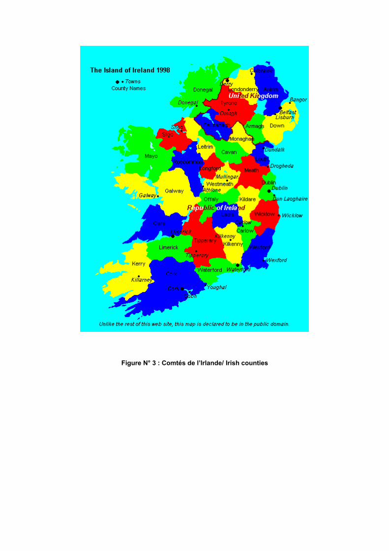
Figure N° 3 : Comtés de l’Irlande/ Irish counties

Figure N° 4 : Plan d’assemblage des cartes Landranger/ Map Coverage of the LandrangerSeries

Figure N° 5 : Landranger Grid/National Grid

Figure N° 6 : Plan d’assemblage des cartes Discovery/Discoverer / Map Coverage of theDiscovery/Discoverer Series

Figure N° 7 : Irish National Grid

Figure No. 8 : Distribution des cols des Îles Britanniques / Distribution of the « Cols » in the British Isles


