43
PRESERVATION ASSESSMENT OF MOUNT CALVARY, MOUNT OLIVE, FISHER’S AND POTTER’S CEMETERIES, CITY OF PORTSMOUTH, VIRGINIA Chicora Research Contribution 533

PRESERVATION ASSESSMENT OF MOUNT CALVARY, MOUNT OLIVE, FISHER’S AND
POTTER’S CEMETERIES, CITY OF PORTSMOUTH, VIRGINIA
Chicora Research Contribution 533

PRESERVATION ASSESSMENT OF MOUNT CALVARY, MOUNT OLIVE, FISHER’S, AND
POTTER’S FIELD CEMETERIES, CITY OF PORTSMOUTH, VIRGINIA
Prepared By:
Michael Trinkley, Ph.D. and
Debi Hacker
Prepared For: Ms. Mae Breckenridge-Haywood
President African American Historical Society of Portsmouth, Inc.
P.O. Box 2468 Portsmouth, Virginia 23702
This report is funded by the City of Portsmouth through the Portsmouth Museum and Fine Arts Commission.
CHICORA RESEARCH CONTRIBUTION 533
Chicora Foundation, Inc. PO Box 8664 Columbia, SC 29202 803-787-6910 www.chicora.org
November 1, 2010
This report is printed on permanent paper ∞

© 2010 by Chicora Foundation, Inc. and the African American Historical Society of Portsmouth, Inc. All rights reserved. No part of this publication may be reproduced, stored in a retrieval system, transmitted, or transcribed in any form or by any means, electronic, mechanical, photocopying, recording, or otherwise without prior permission of Chicora Foundation, Inc. or the African American Historical Society of Portsmouth, Inc. except for brief quotations used in reviews. Full credit must be given to the authors, publisher, and project sponsor.

i
MANAGEMENT SUMMARY This study was funded by a grant from the Portsmouth Museums and Fine Arts Commission to the African American Historical Society of Portsmouth, Inc. The work was conducted by Chicora Foundation in mid- to late October 2010 and involved two-days of on-site inspection. The work examines a complex of four African American cemeteries in south central Portsmouth, Virginia. The cemeteries include Mount Olive with 6.93 acres, known to have been organized by seven individuals representing the Mount Olive Club of Portsmouth in 1879; Mount Calvary, apparently assembled by Samuel Fisher beginning about 1894 and today encompassing 3.05 acres; Fisher’s Cemetery, also created by Samuel Fisher and consisting of 0.58 acres; and a potter’s field that was acquired by Norfolk County in 1882, eventually passing to the City of Portsmouth. The properties are inventoried by the Virginia Department of Historic Resources as the Mount Calvary Cemetery Complex, 124-5125 and has been determined eligible for listing in the National Register of Historic Places. There is no comprehensive historical study of these three properties. This study was not tasked with such an effort – although a detailed historical account is badly needed – and our report simply compiles readily available information. Much of this involves a title search conducted by the City of Portsmouth, although also included is information gathered by Ms. Mae Breckenridge-Haywood and Ms. Christina Carlton, as well as information collected by Chicora during our brief visit. The cemeteries have been essentially abandoned since at least the early 1960s, although deterioration likely began several decades earlier. News accounts document that various
organizations and groups have attempted to clean and restore the cemeteries on multiple occasions, each time meeting with various levels of success. Recently efforts to preserve the cemeteries have received considerable impetus from local volunteer efforts and the City of Portsmouth has begun taking steps to consolidate the essentially abandoned properties under city ownership. The overall condition of the cemeteries has clearly improved dramatically when compared to photographs and accounts from the 1960s through the 1990s. Most of the problems seen at these cemeteries are the result of deferred maintenance – doing too little over too long a period of time. In the case of Mount Olive, the original club members died off and apparently made no provision for sustaining the organization. At Mount Calvary, it seems likely that the cemetery had sold the bulk of its available lots and the Fishers sold the property to another individual who continued to sell plots but provide no maintenance. Eventually that individual “donated” the property to the City of Portsmouth. Exacerbating the decline was the out migration of African American families, as well as changing cultural patterns associated with cemetery maintenance. While the cemeteries have largely been reclaimed from the forest and illegal dumping that resulted when they were no longer being maintained, there remain significant problems affecting the historic fabric. There are a large number of trees that have grown up in the cemetery over the past 50 years that require removal, both for the benefit of monument preservation, the landscape, and also to encourage drying of soils. We recommend the

PRESERVATION ASSESSMENT OF MOUNT CALVARY, MOUNT OLIVE, FISHER’S AND POTTER’S FIELD CEMETERIES
ii
removal of between 30 and 50 trees under 10-inches diameter breast height (dbh) or that are damaged. Drainage in the cemetery is a significant issue. There is no doubt that the property was always low and poorly drained. The construction of I-264 to the north, however, may have altered the natural drainage of the topography and may contribute to the backing of water up in the cemetery. This is resulting in the flooding of graves and creating large areas of standing water. The drainage is a significant public health issue that requires immediate resolution. A drainage study of the cemetery conditions, recommended by the city in 2006, has yet to be accomplished. This is an essential step toward correcting this problem. The cemetery topography exhibits extreme undulations resulting from sunken graves, improper disposal of spoil, and tree displacement. This distracts from the character of the cemetery, creates a significant public hazard, and makes mowing extremely difficult (and costly). The resolution of this problem cannot be accomplished until all of the identifiable graves in the cemetery are mapped. This mapping is a critical recommendation of this study. Once graves are mapped, it will be possible to begin the process of leveling the topography – backfilling graves, filling open vaults, and removing spoil piles. This, in turn, will require reseeding or sodding of different cemetery areas. We recommend that some low maintenance grasses be investigated. The combination of leveling and replanting has the potential to reduce long-term cemetery maintenance issues. There is significant damage to a broad range of the stones in the cemetery. Many have been vandalized over the past 50 years. It is probable that different “cleaning” efforts caused damage. Many other stones have suffered damage from trees. The water-logged condition of the soils has undermined foundations. Once the drainage has been corrected, the identifiable graves mapped, and the topography leveled, it is essential that monument conservation be undertaken. Consequently, we are also recommending a stone-
by-stone assessment of the cemetery in order that the stones be appropriately assessed. The city must make administrative changes in the way the cemetery is operated and the ordinances that govern the property. The cemetery requires caregivers to give careful attention to the Secretary of the Interior’s Standards for Preservation. Most fundamentally, it is critical that the cemetery have a solid, permanent funding base. The requirements of cemetery maintenance do not change based on political vagaries or economic forecasts. In fact, the funding requirements only increase with age. For years the city sought to skirt the issue of maintenance, closing its eyes to its public and ethical responsibilities. In light of the city’s efforts to consolidate the property, we hope that this is changing. We recommend the formation of a friends group to help identify descendants, develop public interpretative programs, provide assistance in cemetery care, and assist in fund raising. Most particularly, this friends group must be a constituency – speaking for those who have no voice and demanding that the city fulfill its obligation to the care and preservation of Mount Calvary, Mount Olive, Fisher’s, and potter’s field. This report evaluates all of the identified needs, classifying them into three broad categories:
• Those issues that are so critical – typically reflecting broad administrative issues, health and safety issues, and issues that if delayed will result in significantly greater costs – that require immediate attention. These actions should be accomplished in 2011.
• Those issues that, while significant and reflecting on-going deterioration and concerns, can be spread over the next 2 to 3 years (i.e., 2012-2014). This allows some budgeting flexibility, but this flexibility should not be misconstrued as a

MANAGEMENT SUMMARY
iii
reason to ignore the seriousness of the issues.
• Finally, those issues that represent on-going maintenance and preservation issues. These costs can be spread over the following three years (i.e., 2015-2017). Like the Second Priority issues, this budgetary flexibility should not be interpreted as allowing these issues to slide since further delay will only increase the cost of necessary actions.
We acknowledge that these goals will be
costly. Nevertheless, the city has deferred responsibility and care for generations – it is now time to ensure that these African American cemeteries are appropriately preserved for future generations.

PRESERVATION ASSESSMENT OF MOUNT CALVARY, MOUNT OLIVE, FISHER’S AND POTTER’S FIELD CEMETERIES
iv

v
TABLE OF CONTENTS
List of Figures vii List of Tables viii Introduction 1 The Project 1 Preservation Fundamentals 3 Administrative and Legal Issues 4 The Cemeteries, Their Setting, and Context 6 Factors Affecting the Landscape Character 9 Recommendations 12 Historic Synopsis 13 Early African American Burial Grounds 13 Mount Olive 14 Mount Calvary 16 Potter’s Field 21 The Cemetery Complex in the Twentieth Century 22 Summary 29 Previous Studies 30 Additional Research 31 Drainage Issues 33 Existing Conditions 33 Analysis 39 Recommendations 41 Road and Pedestrian Issues 43 Access and Circulation 43 Pedestrian Access, Sidewalks and Pathways 44 Universal Access 45 Recommendations 46 Lighting and Security Issues 47 Vandalism 47 Cemetery Lighting 49 Hardening Targets 49 Recommendations 50 Cemetery Fixtures and Furnishings 51 Cemetery Buildings 51 The Boundary Fence 51 Lot Amenities 52 Recommendations 52

vi
Landscape Maintenance 55 Maintenance Operations 55 Trees 57 Shrubbery and Ground Cover 61 Turfgrass Issues 62 Other Landscape Issues 64 Recommendations 65 Other Maintenance Issues 67 Signage 67 Trash 68 Modifications to the Terrain 68 Recommendations 70 Conservation Issues 71 What is Conservation 71 Standard for Conservation Work 71 General Types of Stone Damage 72 Displaced Stones 76 Cleaning of Monuments 77 Cast Stone Monuments 77 Ironwork Conservation 78 Stone-by-Stone Assessment 79 Recommendations 80 Priorities and Funding Levels 81 Recommended Priorities 81 The Role of the City 81 The Role of Volunteers 82 The Role of a Friend’s Group 82 Sources Cited 89 Appendix 1. Resume for Michael Trinkley 91

vii
LIST OF FIGURES
Figure 1. Vicinity of the cemetery complex in the Hampton Roads area 1 2. Vicinity of the cemetery complex in the Prentis Park neighborhood 2 3. Potential severe flooding of the cemetery complex 7 4. Aerial view of the cemeteries 8 5. Panoramic view of Mount Calvary looking west 10 6. View of Mount Olive showing more abundant vegetation 10 7. Palmer Drought Index for Virginia 11 8. Plant Hardiness Zones in the vicinity of Portsmouth 11 9. pH levels of rain in the Portsmouth area 12 10. Chloride levels in the Portsmouth area 12 11. 1889 map of an early African American burial ground 13 12. 1894 city directory ad for Samuel Fisher, Jr. 16 13. Plat of the Fisher “Cemetery Property” in 1909 17 14. Plan of Mount Calvary Cemetery, 1925 19 15. The cemetery complex on the 1945 tax map 20 16. The cemetery complex on the ca. 1950 Sanborn Fire Insurance Map 21 17. Entrance to Mount Calvary in 1974 and 1980 22 18. 1951 and 1963 aerial photographs of the cemetery complex 23 19. Timeline of cemetery developments 29 20. Graves identified through stripping in the potter’s field 31 21. Historic maps of the cemetery complex showing the original drainage 33 22. Prentis Park Drainage Assessment Area 34 23. Water drainage in the cemetery after several days without rain 35 24. Examples of vaults and sunken graves filled with water 36 25. Drainage problems in the cemetery during a heavy rain 37 26. Entrances to the cemetery complex 44 27. Pathway in Mount Calvary 45 28. Vandalized stone 47 29. Street lamp 49 30. Entrance gate showing the loss of letters 51 31. Monumental bench lacked appropriate foundation 52 32. Examples of current maintenance problems 56 33. Dense trees in Mount Olive that require thinning 58 34. Stump left in the cemetery 59 35. Examples of plots or stones damaged by tree growth 60 36. Invasive plants in the cemetery 61 37. Damage to stones from mowing practices 63 38. Undulating topography showing sunken graves 69 39. Sunken graves can be infilled with sand once they have been mapped 69 40. Types of stone damage 73 41. Damaged stones 74 42. Examples of damaged (or lost) vault tops 76 43. Examples of cast stone 78 44. Examples of ironwork in the cemetery complex 79 45. Example of an assessment form 80

viii
LIST OF TABLES Table 1. Secretary of the Interior’s Standards for Preservation 3 2. Known owners of lots in Mount Calvary in 1944 18 3. Trees identified in the cemetery complex 57 4. Comparison of different cleaning techniques 77 5. Prioritization of recommendations 84

1
INTRODUCTION
The Project In December 2009 Ms. Mae Breckenridge-Haywood contacted Chicora Foundation to request information on the assessment of the African American cemetery complex in Portsmouth, Virginia known as Mount Olive, Mount Calvary, Fisher’s, and potter’s field. We provided a proposal for an assessment and by May 2010 learned that only a portion of that assessment was funded by the Portsmouth Museums and Fine Arts Commission through the African American Historical Society of Portsmouth, Inc. Unfortunately, no funding was forthcoming from the City of Portsmouth.
The assessment was conducted on October 5 and 6, 2010 by the authors, Michael Trinkley and Debi Hacker. The work involved two-days in Portsmouth, including time in the cemeteries, meeting with various city officials and
stakeholders, and reviewing readily available historic research (primarily at the Ester Murdaugh Wilson Memorial Room at the Portsmouth Public Library).
Portsmouth is an independent city located in the Hampton Roads metropolitan area of Virginia. While its history can be traced back to a plantation community as early as 1620, Portsmouth wasn’t founded as a town until 1752 when Col. William Crawford, a wealthy merchant and ship owner, dedicated the four corners of High and Court streets for a church, a market, a courthouse, and a jail.
The Virginia Beach-
Norfolk-Newport News, VA-NC Metropolitan Statistical Area, generally called the Hampton Roads metropolitan area, consists of 10 independent cities and seven counties in Virginia and extending into North Carolina. Each city is independent and has the powers and responsibilities of a county, including maintaining courts, schools, and a sheriff, although some do share these responsibilities with an adjoining county.
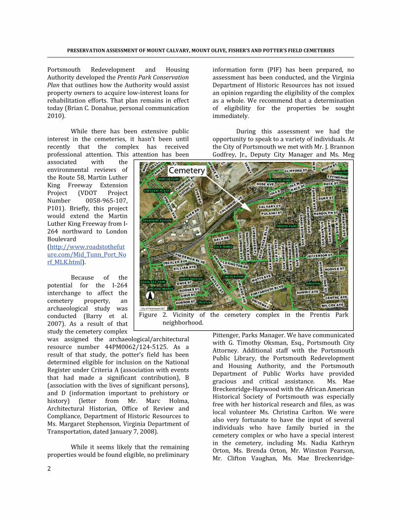
The cemetery complex
is situated in south central Portsmouth in what is known as the Prentis Park neighborhood. This is an urban area of mostly single family housing with mixed renter and owner occupation. It is generally a low income area,
heavily dominated by African Americans. The neighborhood runs from just north of I-264 south to Jefferson Street and from Elm Avenue on the east, westerly to Phillips Avenue. In 1986 the
Figure 1. Vicinity of the cemetery complex in the Hampton Roads
vicinity.
PRESERVATION ASSESSMENT OF MOUNT CALVARY, MOUNT OLIVE, FISHER’S AND POTTER’S FIELD CEMETERIES
2
Portsmouth Redevelopment and Housing Authority developed the Prentis Park Conservation Plan that outlines how the Authority would assist property owners to acquire low-interest loans for rehabilitation efforts. That plan remains in effect today (Brian C. Donahue, personal communication 2010).
While there has been extensive public
interest in the cemeteries, it hasn’t been until recently that the complex has received professional attention. This attention has been associated with the environmental reviews of the Route 58, Martin Luther King Freeway Extension Project (VDOT Project Number 0058-965-107, P101). Briefly, this project would extend the Martin Luther King Freeway from I-264 northward to London Boulevard (http://www.roadstothefuture.com/Mid_Tunn_Port_Norf_MLK.html).
Because of the
potential for the I-264 interchange to affect the cemetery property, an archaeological study was conducted (Barry et al. 2007). As a result of that study the cemetery complex was assigned the archaeological/architectural resource number 44PM0062/124-5125. As a result of that study, the potter’s field has been determined eligible for inclusion on the National Register under Criteria A (association with events that had made a significant contribution), B (association with the lives of significant persons), and D (information important to prehistory or history) (letter from Mr. Marc Holma, Architectural Historian, Office of Review and Compliance, Department of Historic Resources to Ms. Margaret Stephenson, Virginia Department of Transportation, dated January 7, 2008).
While it seems likely that the remaining
properties would be found eligible, no preliminary
information form (PIF) has been prepared, no assessment has been conducted, and the Virginia Department of Historic Resources has not issued an opinion regarding the eligibility of the complex as a whole. We recommend that a determination of eligibility for the properties be sought immediately.
During this assessment we had the opportunity to speak to a variety of individuals. At the City of Portsmouth we met with Mr. J. Brannon Godfrey, Jr., Deputy City Manager and Ms. Meg
Pittenger, Parks Manager. We have communicated with G. Timothy Oksman, Esq., Portsmouth City Attorney. Additional staff with the Portsmouth Public Library, the Portsmouth Redevelopment and Housing Authority, and the Portsmouth Department of Public Works have provided gracious and critical assistance. Ms. Mae Breckenridge-Haywood with the African American Historical Society of Portsmouth was especially free with her historical research and files, as was local volunteer Ms. Christina Carlton. We were also very fortunate to have the input of several individuals who have family buried in the cemetery complex or who have a special interest in the cemetery, including Ms. Nadia Kathryn Orton, Ms. Brenda Orton, Mr. Winston Pearson, Mr. Clifton Vaughan, Ms. Mae Breckenridge-
Figure 2. Vicinity of the cemetery complex in the Prentis Park
neighborhood.

INTRODUCTION
3
Haywood, Ms. Christina Carlton, Ms. Margaret Windley, and Mr. Jim Windley. The meeting was also attended by Ms. Lia Russell, Staff Writer with the Virginian-Pilot. This paper has followed the efforts to preserve these cemeteries since at least the early 1980s. Preservation Fundamentals
Preservation is not an especially difficult concept to grasp, although the key principles are not always clearly articulated. The fundamental concepts are well presented in the Secretary of the Interior’s Standards for Preservation (see Table 1).
This document
reminds us – at least at a general level – of what caregivers need to be thinking about as they begin a cemetery preservation plan. Those responsible for the care of the Mount Calvary, Mount Olive, Fisher’s, and potter’s field cemeteries should be intimately familiar with the eight critical issues it outlines. For example, all other factors being equal, a cemetery should be used as a cemetery – not to walk dogs, not as a playground, not to store equipment, and not as a park. And until the caregivers are able to do what needs to be done, it is their responsibility to make certain that the site is preserved – it must not be allowed to suffer damage under their watch.
Caregivers must work diligently to understand – and retain – the historic character of the cemetery. In other words, they must look at the cemetery with a new vision and ask themselves, “what gives this cemetery its unique, historical character?” Perhaps it is the landscape,
the old and stately trees, the large boxwoods, or the magnificent arborvitae. Perhaps it is the very large proportion of complex monuments, or the exceptional hand-made markers. It may simply be that it is a unique representation of a cemetery type rarely seen in a rapidly developing urban setting. Whatever it is, those undertaking its care and preservation become the guardians responsible for making certain those elements are protected and enhanced (whether they are particularly appealing to the caregivers or not).
Whatever conservation efforts are necessary must be done to the highest professional standards; these conservation efforts must be physically and visually compatible with the original materials; these conservation efforts must not seek to mislead the public into thinking that repairs are original work; and the conservation efforts must be documented for future generations. If the caregivers aren’t conservators, it is their responsibility as the stewards of the property to retain a conservator
Table 1. Secretary of the Interior’s Standards for Preservation
1. A property will be used as it was historically, or be given a new use that maximizes the
retention of distinctive materials, features, spaces, and spatial relationships. Where a treatment and use have not been identified, a property will be protected and, if necessary, stabilized until additional work may be undertaken.
2. The historic character of a property will be retained and preserved. The replacement of
intact or repairable historic materials or alteration of features, spaces, and spatial relationships that characterize a property will be avoided.
3. Each property will be recognized as a physical record of its time, place, and use. Work
needed to stabilize, consolidate, and conserve existing historic materials and features will be physically and visually compatible, identifiable upon close inspection, and properly documented for future research.
4. Changes to a property that have acquired historic significance in their own right will be
retained and preserved. 5. Distinctive materials, features, finishes, and construction techniques or examples of
craftsmanship that characterize a property will be preserved. 6. The existing condition of historic features will be evaluated to determine the appropriate
level of intervention needed. Where the severity of deterioration requires repair or limited replacement of a distinctive feature, the new material will match the old in composition, design, color, and texture.
7. Chemical or physical treatments, if appropriate, will be undertaken using the gentlest
means possible. Treatments that cause damage to historic materials will not be used. 8. Archeological resources will be protected and preserved in place. If such resources must be
disturbed, mitigation measures will be undertaken.

PRESERVATION ASSESSMENT OF MOUNT CALVARY, MOUNT OLIVE, FISHER’S AND POTTER’S FIELD CEMETERIES
4
appropriately trained and subscribing to the Code of Ethics and Standards of Practice of the American Institute for Conservation (AIC).
The Secretary of the Interior reminds
those responsible for the resources that each and every cemetery has evolved and represents different styles and forms. It is the responsibility of care-givers to care for all of these modifications and not seek to create a “Disney-land” version of the cemetery, tearing out features that don’t fit into their concept of what the cemetery “ought” to look like.
Likewise, caregivers are reminded that
there will be designs, monuments, and other features that characterize the cemetery – and the caregivers are responsible for identifying these items and ensuring their preservation. Caregivers must be circumspect in any modifications, ensuring that they are not destroying what they seek to protect.
Before acting, those responsible for
preservation are required as good and careful stewards to explore and evaluate the property, determining exactly what level of intervention – what level of conservation – what level of tree pruning – is actually necessary. And where it is necessary to introduce new materials – perhaps a pathway – into the cemetery, they must do their best to make certain these new elements are not only absolutely necessary, but also match the old elements in composition, design, color, and texture. In other words, if the cemetery has brick pathways, they would be failing as good stewards if they allowed concrete pathways – especially if the only justification was because concrete was less expensive.
Where conservation treatments are
necessary, the Secretary of the Interior tells stewards that they must be the gentlest possible. However phrased – less is more – think smart, not strong – caregivers have an obligation to make certain that no harm comes to the resource while under their care. And again, one of the easiest ways to comply is to make certain that caregivers retain a conservator subscribing to the ethics and standards of the American Institute for Conservation.
Finally, the caregivers must also recognize that the cemetery is not just a collection of monuments and the associated landscape – the cemetery is also an archaeological resource. They must be constantly thinking about how their efforts – whether to repair a monument, put in a parking lot, or resurface a path – will affect the archaeological resources – archaeological resources that are the remains of people buried at the cemetery by their loved ones. These are especially critical issues for the Mount Calvary, Mount Olive, Fisher’s, and potter’s field cemeteries. These cemeteries have been fighting gradual deterioration since at least the early 1960s. Various clean-up efforts have made a substantial difference in the overall appearance of the cemeteries, but the deferred maintenance has created a substantial problem that will not be easily overcome. Original fabric has deteriorated. Even the landscape has been compromised by development activities on surrounding parcels and a lack of careful attention to critical management issues. Our first recommendation, therefore, is that those assuming care for the cemetery, especially the City of Portsmouth (including City Council, the City Manager, and those in the Portsmouth Department of Parks, Recreation & Leisure Services), become thoroughly familiar with the Secretary of the Interior’s Standards for Preservation and reaffirm their responsibility as stewards of this historical resource to ensure that future preservation efforts are consistent with sound preservation principles and practices. These standards must become “talking-points” for all future discussions and decisions made concerning the cemetery. Administrative and Legal Issues This section is not intended to offer legal advice – only to provide recommendations from the perspective of proactive cemetery preservation. After years of a laissez-faire or “hands-off” approach, the City of Portsmouth is finally realizing that the African American cemeteries require direct intervention. The city has

INTRODUCTION
5
acknowledged ownership of the potter’s field, although a recent study reveals that part of this burial ground is on the property of James E. Bazemore, Sr. (Barry et al. 2007). The city is in the process of acquiring ownership of Mount Olive cemetery. It is also opening negotiations for the control of Mount Calvary and Fisher’s. Nevertheless, the city’s tax assessor already shows the city as the owner of record for both Mount Calvary and Mount Olive. We recommend that the City take whatever steps are necessary to acquire ownership of the entire cemetery complex, including Mount Calvary, Mount Olive, Fisher’s, and all portions of the potter’s field. These are appropriate actions and they should be pursued diligently. While we understand they cannot be rushed, we do encourage that they be given a very high priority with the intention to acquire ownership by the end of 2010. First, so much historic fabric has already been lost or compromised, it is crucial that steps be taken immediately to ensure the long-term preservation of these properties. Delay will, without question, result in additional losses.
Second, delay will also further endanger the public since these cemeteries pose significant hazards to the public, including the threat of mosquito-borne diseases, such as dengue fever, eastern equine encephalitis, and West Nile virus (http://www.cdc.gov/ncidod/diseases/list_mosquitoborne.htm). In addition, there are numerous open graves and dangerously unstable monuments.
Third, after decades of delay and tactics
clearly intended to dismiss or ignore the needs of Portsmouth’s African American community, the consolidation, repair, and protection of these historic burial grounds is the appropriate course of action for the city.
Code Changes
We recommend that the Portsmouth City Council change Chapter 9, Article 2, City
Cemeteries of the City Code to reflect the ownership of Potter’s Field, and the acquisition of Mount Olive, Mount Calvary, and Fisher’s. Specifically, changes should be enacted in:
• 9-26(a) amended to read: The burial ground at Glasgow Street and Fort Lane shall be known as "Cedar Grove Cemetery." The burial ground at London Boulevard and Peninsula Avenue shall be known as "Oak Grove Cemetery." The burial grounds adjoining City Park and Clifford Street shall be known as "Olive Branch Cemetery," and "Olive Branch Annex Cemetery. The burial ground at the end of Columbus Avenue shall be known as the “City Potter’s Field.” The burial grounds off Pulaski Street shall be known as the “Mount Calvary, Mount Olive, and Fisher’s Cemetery complex.”
• 9-26(b) amended to read: Cedar Grove
Cemetery, Oak Grove Cemetery, and Olive Branch Cemetery, the City Potter’s Field, and the Mount Calvary, Mount Olive, and Fisher’s Cemetery complex are hereby designated as city cemeteries. For the purposes of this chapter, the term "city cemeteries" shall mean only those cemeteries so designated in this section.
• 9-26(c) added: The City Potter’s Field and the Mount Calvary, Mount Olive, and Fisher’s Cemetery Complex are closed to additional burials and are historic sites commemorating the many contributions of Portsmouth’s African American community. Features in these cemeteries that may be disallowed by other provisions of this section, such as enclosures or seating, do not apply to these properties if the features are present at the time this ordinance is enacted.
• 9-29(a) amended to read: The city shall, in perpetuity, maintain in good order, free from weeds and undergrowth, the city cemetery grounds of Cedar Grove Cemetery, Oak Grove Cemetery, and Olive Branch Cemetery, the City Potter’s Field,

PRESERVATION ASSESSMENT OF MOUNT CALVARY, MOUNT OLIVE, FISHER’S AND POTTER’S FIELD CEMETERIES
6
and the Mount Calvary, Mount Olive, and Fisher’s Cemetery Complex. The city shall also maintain the monuments and stones of said city cemeteries in an upright position so long as the same continue intact.
• 9-58 added: Hours Open. The City Potter’s Field and the Mount Calvary, Mount Olive, and Fisher’s Cemetery Complex shall be open for visitation between sunup and sundown. Anyone in the cemeteries other than during this period shall be deemed trespassing and will subject to arrest and prosecution.
• 9-59 added: Litter. It shall be unlawful for any person to litter, deposit trash or debris, or to dump any material in the City Potter’s Field and the Mount Calvary, Mount Olive, and Fisher’s Cemetery Complex.
• 9-57, Duty of person in charge as to violations of certain sections shall be renumbered 9-60 and amended to read: Whenever it shall come to the knowledge of the person in charge of any city cemetery, or any of his assistants, that any person is about to violate any of the provisions of sections 9-41 through 9-56 9-59, such person shall be by him warned against such violation and, if necessary, shall be notified of such threatened violation. In every case where any such violation has actually occurred, it shall be the duty of the keeper and his assistants to report the same at once. These recommended changes will open
Portsmouth’s African American cemeteries to receive city perpetual care funds. Some may claim this is inappropriate since those buried in these cemeteries did not contribute to these funds initially. We dismiss this argument as not only spurious, but also disingenuous. Portsmouth’s African American citizens were legally excluded because of their skin color from using the cemeteries where perpetual care was offered. Thus, to claim that they made no
contribution into the perpetual care fund is easily dismissed.
In addition, the City of Portsmouth sought to maintain segregation by hiding their whites-only cemeteries under private ownership. This action alone would seem to be so egregious that extending the umbrella of perpetual care funding to the city’s African American burial grounds seems to be an act of the most minimal restitution. The use of these funds will be discussed in a subsequent section of this study. The Cemeteries, Their Setting, and Context
The African American cemetery complex is located in Block Group 4 of Census Tract 2118 in Portsmouth. Fisher’s Cemetery is identified as parcel 123-460 (0.58 acre); Mount Calvary Cemetery is identified as parcel 209-030 (3.05 acre), and Mount Olive Cemetery is identified as parcel 209-020 (6.93 acre). The City Potter’s Field is partially subsumed with Mount Olive Cemetery and partially on the property of James E and Shirley D. Bazemore, Sr. (parcel 208-030).
The 10.7 acre cemetery complex is
roughly a rectangle measuring about 1,500 by 500 feet. The western boundary is Columbus Avenue; the northern boundary includes I-264 and a series of lots; the eastern boundary is Pulaski Street and a private lot; and the southern boundary, marked by a ditch, borders on privately held parcels.
Zoning around the cemetery is primarily
urban residential, with occasional tracts identified as general residential or light industry. The urban residential zoning accommodates a wide range of development, including mixed-use and (neighborhood serving) commercial development.
Far more out of character and
inappropriate are the lots immediately abutting the cemeteries to the south that are zoned for light industry. This zoning is intended for light manufacturing, fabrication, processing, and storage. While subject to standards that hopefully minimize detrimental impacts, such activities should not be allowed to border a cemetery and

INTRODUCTION
7
we recommend that these tracts be rezoned consistent with residential functions.
Topography in the cemeteries
appears to be essentially level, although drainage suggests there is a slight dip northward. Historic maps, such as the 1902 Norfolk topographic sheet and the 1921 Newport News topographic sheet, reveal a major drainage originating in the immediate area of the cemeteries and extending northward. Remnants of this are still seen today in the arms of Scott Creek.
With the construction of I-264 in
the cemetery area in 1967 (extending from US 17 Frederick Blvd. eastward to US 460 ALT (currently VA 141), this natural drainage was interrupted. It is likely that we can attribute many of the current drainage issues to this construction.
Elevations in the cemetery are
estimated to be less than 10 feet above mean sea level (AMSL).
The cemetery consists of Tomotley-Urban land complex soils with slopes under 2%. These soils exhibit 0.7 foot of dark grayish brown (10YR 4/2) fine sandy loam over a light gray (10YR 7/1) fine sandy loam to 0.8 foot. To about 3.3 feet there is light brownish gray (2.5Y 6/2) sandy clay loam. This grades into a light gray fine sandy loam, found to depths of about 5 feet. The soils are considered poorly drained and exhibit a seasonal high water table within a foot of surface (Hammer 2007).
A small portion of the north edge of
Mount Olive Cemetery is situated in the 500 year flood zone, as is the western third of Fisher’s Cemetery, and perhaps a small portion of the northwestern edge of Mount Calvary Cemetery. Additional flooding will be found on the lots to the north, as well as on the north side of I-264.
Of potentially greater consequence is the flooding induced by a hurricane storm surge. A Category 2 hurricane would result in flooding virtually identical to the anticipated 500 year flood. A Category 3 hurricane, however, would result in only small areas of the cemetery complex being untouched – most of the cemetery would be inundated. This would likely cause extensive damage to both graves and the vegetation.
The cemetery is situated in a relatively
poor area of the city. The median household income in the 2000 census was $20,881, compared to the city-wide average of $45,292.
Figure 3. Potential severe flooding of the cemetery complex.
The top map shows the 500 year flood in beige against the green background. The bottom map shows flooding resulting from a Category 3 hurricane in green.

PRESERVATION ASSESSMENT OF MOUNT CALVARY, MOUNT OLIVE, FISHER’S AND POTTER’S FIELD CEMETERIES
8
Fi
gure
4. A
eria
l vie
w o
f the
Mou
nt C
alva
ry, M
ount
Oliv
e, F
ishe
r’s, a
nd C
ity P
otte
r’s C
emet
ery.

INTRODUCTION
9
City-wide about 17.9% of the residents are below the poverty level, while in the cemetery area 37.2% of the residents are below the poverty level. While the unemployment rate for Virginia is 7.0%, in Portsmouth the rate is 9.2% (August 2010, not seasonally adjusted).
City-wide the home ownership rate is about 59%. In the study area it is 46.5%. The median value of these residences is $57,100, considerably lower than the city average of $81,300. Over 53% of the housing units are renter-occupied (compared to a city average of 41.4%). Over a fifth of the neighborhood residents have resided at the same location for 30 years and over half have been at the same address for at least five years, suggesting a fairly stable population. The median age for the area is 33, while city-wide it is slightly older, 35 years. Nevertheless, 33.2% of the population over 5 years old reports a disability, compared to a city-wide average of only 22%.
The community around the cemetery is predominately African American (98.2%), although Portsmouth is 53% African American. Over 45% of those in the census tract have not graduated from high school and less than 3% have graduated from college. In comparison over 75% of Portsmouth residents have graduated from high school and nearly 14% have a college degree.
Some of this data may be dated since the
neighborhood has seen significant rehabilitation over the past decade. For example, in 2006 Habitat for Humanity built 10 homes on in-fill urban lots in the Prentis Park neighborhood in only five days. This represented the first new construction in the area in over 30 years and since that work more than 20 additional homes have followed.
Portsmouth's property crime index is 5,551 per 100,000 (2008 data), much higher than Virginia’s average level of 2,820 per 100,000. Portsmouth has 2.29 officers per 100,000 residents, compared to a Virginia average of 3.38 per 100,000. Eight property crimes have been reported within 0.5 mile of the cemetery property between
August 9 and October 9, 2010. Most are characterized as burglaries without force, larcenies, and vandalism – crimes that are of special concern to cemeteries since they indicate the potential for cemetery-related thefts. The cemetery is today a green and peaceful enclave surrounded by residential development. Unfortunately, the viewshed is affected by I-264 to the north, as well as spoil piles on tracts immediately to the south. Although little can be done to mitigate the visual and noise impact of I-264, the city should ensure that the tracts to the south of the cemetery are not used for light industry, but are rezoned for residential use. In addition, in the near term these properties should have stockpiled spoil and other construction debris removed. The City of Portsmouth should also ensure that any construction associated with the Route 58, Martin Luther King Freeway Extension Project does not adversely affect the viewscape or tranquility of the cemetery. This may necessitate the construction of noise barriers. The city should also carefully ensure that the potential for secondary impacts are controlled through strict zoning and permitting. Major road projects such as this can have very damaging consequences – many not immediately recognizable – to cemetery properties. Factors Affecting the Landscape Character
The cemetery complex is situated on the Outer Coastal Plain of the Atlantic Coastal Plain Physiographic Province of Virginia. This consists of an eastward-thickening wedge of stratified, unconsolidated and semi-consolidated alluvial and marine deposits above a crystalline basement surface. These sediments are composed primarily of gravels, sands, silts, and clays. In the Portsmouth area the depth to the crystalline basement rocks is greater than 2000 feet.
Although this coastal plain province is
generally viewed as flat and featureless it is actually broken into many bays, depressions, and estuaries. As previously discussed, a drainage of Scott Creek originally ran southward through the

PRESERVATION ASSESSMENT OF MOUNT CALVARY, MOUNT OLIVE, FISHER’S AND POTTER’S FIELD CEMETERIES
10
cemetery complex area, providing drainage northward into the Elizabeth River.
The pre-contact vegetation of the Virginia
coastal plain has been extensively altered, so that it is now difficult to determine what natural communities were originally dominant. The contemporary forest consists of successional or silvicultural stands of loblolly pine (Pinus taeda) and secondary pine-hardwood forests that developed after repeated cutting or agricultural abandonment. Mature stands on mesic uplands may be characterized by American beech (Fagus grandifolia), oaks (Quercus spp.), and American holly (Ilex opaca). An excellent publication on the native plants of the Virginia coastal plain is http://www.dcr.virginia.gov/natural_heritage/documents/cp_nat_plants.pdf.
The cemetery today
includes a range of native trees, including sweet gum (Liquidambar styraciflua), pine (Pinus sp.), magnolia (Magnolia grandiflora), oak (Quercus sp.), tulip poplar (Liriodendrom tulipifera), maple (Acer sp.), hackberry (Celtis occidentalis), and sycamore (Plantanus occidentalis). Many of these are especially associated with more hydric soils, especially the sweet gum, hackberry, and sycamore.
The cherry laurel (Prunus caroliniana),
while a native, is more generally found south of
Virginia. It is typically spread by birds and while not classified as an invasive, it is considered an undesirable species by many.
At least one of the trees in the cemetery is a listed as moderately invasive, the mimosa (Albizia julibrissin). This tree was introduced in 1758 from China. It adapts easily to a wide variety of soil conditions and exhibits pale pink powder-puff-like flowers throughout summer months. Unfortunately, it can easily spread by suckers growing from roots.
Shrubs identified in the cemetery include yaupon holly (Ilex vomitoria), which can grow into a small tree; boxwood (Buxus sp.), and yucca (Yucca filamentosa). Yaupon holly can readily seed itself into the landscape, but is not considered an invasive. Boxwood is common in formal cemetery
Figure 5. Panoramic view of Mount Calvary looking west.
Figure 6. View of Mount Olive showing more abundant vegetation.
INTRODUCTION
11
settings, while the yucca is far more common in rural African American burial grounds.
Also present in the cemetery is the
Confederate rose, (Hibiscus mutabilis), an old-fashioned perennial or shrub hibiscus. This plant can also seed itself into the landscape.
Two ground covers are also present and
both are common in cemeteries – English ivy (Hedera helix) and periwinkle (Vinca minor). Both are considered invasive and the English ivy in particular is a significant threat in the cemetery complex, being found in trees where it was blooming at the time of this assessment.
Virginia's climate is classified as humid subtropical. Prevailing winds flow from west to east, although occasional storms track up the coast producing northeasterly winds. These "northeasters", tropical storms, and hurricanes can produce substantial flooding and wind damage.
The average annual temperature is
58.5°F; in winter the average is 41.7°F, with an average minimum of 32°F. In summer, the average temperature is 76.4°F and the average daily maximum temperature is 86.1°F. The urban areas, however, serve to store heat so they can have temperatures 5 to 10°F higher than rural areas.
The total annual precipitation is typically
in excess of 43 inches. Of this, 30.4 inches, or
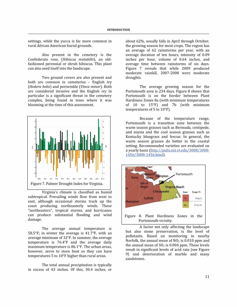
about 62%, usually falls in April through October, the growing season for most crops. The region has an average of 62 rainstorms per year, with an average duration of ten hours, intensity of 0.09 inches per hour, volume of 0.64 inches, and average time between rainstorms of six days. Figure 7 reveals that while 2009 produced moderate rainfall, 2007-2008 were moderate droughts.
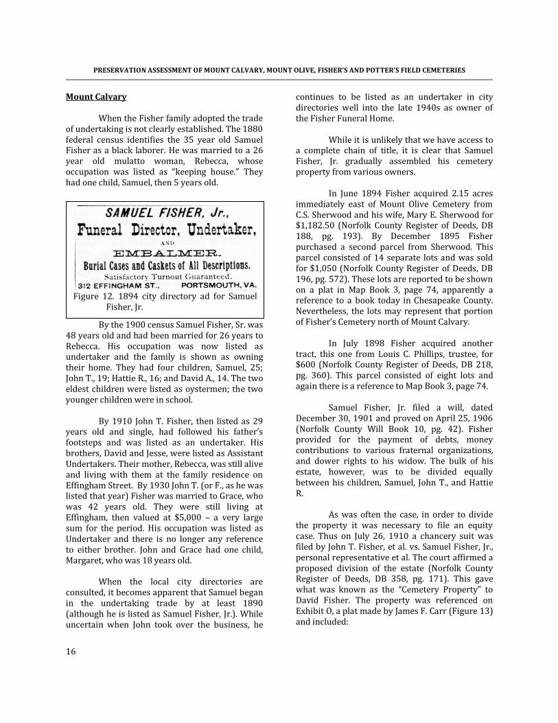
The average growing season for the Portsmouth area is 234 days. Figure 8 shows that Portsmouth is on the border between Plant Hardiness Zones 8a (with minimum temperatures of 10 to 15°F) and 7b (with minimum temperatures of 5 to 10°F).
Because of the temperature range,
Portsmouth is a transition zone between the warm season grasses such as Bermuda, centipede, and zoysia and the cool season grasses such as Kentucky bluegrass and fescue. In general, the warm season grasses do better in the coastal setting. Recommended varieties are evaluated on a yearly basis (http://pubs.ext.vt.edu/3008/3008-1456/3008-1456.html).
A factor not only affecting the landscape but also stone preservation, is the level of pollutants. Based on monitoring in nearby Norfolk, the annual mean of NO2 is 0.010 ppm and the annual mean of SO2 is 0.004 ppm. These levels result in significant levels of acid rain (see Figure 9) and deterioration of marble and many sandstones.
Figure 7. Palmer Drought Index for Virginia.
Figure 8. Plant Hardiness Zones in the
Portsmouth vicinity.

PRESERVATION ASSESSMENT OF MOUNT CALVARY, MOUNT OLIVE, FISHER’S AND POTTER’S FIELD CEMETERIES
12
Figure 10 also reveals that very high chloride levels dominate the Portsmouth area. These can lead to the corrosion of iron. This affects not only iron fences, but also the ferrous
pins that were commonly used in die on base stones. While sea-salt certainly contributes to these levels, they also appear to be related to a variety of man-produced pollutants.
Recommendations The City of Portsmouth should immediately seek a determination of eligibility for the Mount Calvary, Mount Olive, and Fisher’s cemeteries from the Virginia Department of Historic Resources. All decisions regarding modifications, alterations, additions, or other actions affecting Mount Calvary, Mount Olive, Fisher’s Cemetery, and the City Potter’s Field should be carefully evaluated against the Secretary of the Interior’s Standards for Preservation. Special care should be taken to protect all remaining historic fabric and the context.
The City of Portsmouth should expeditiously pursue the acquisition of Mount Calvary, Mount Olive, Fisher’s Cemetery, and all portions of the City Potter’s Field (including those portions on the Bazemore and PRHA tracts). The City of Portsmouth should amend the City Code to reflect their ownership of Mount Calvary, Mount Olive, Fisher’s Cemetery, and the City Potter’s Field, bringing these properties under the protective umbrella of the city code and ensuring that these African American cemeteries achieve the same right to perpetual care funds as other city cemeteries. The City of Portsmouth should rezone parcels south of the cemetery to minimize the impact of light industrial zoning. A far more appropriate zoning designation is urban residential or general residential. In the near term the City of Portsmouth should ensure that spoil and construction debris on the parcels south of the cemetery complex are removed and the viewscape restored.
Figure 9. pH levels of rain in the Virginia and
North Carolina area (pH 7 is neutral).
Figure 10. Chloride levels in the Virginia-North
Carolina area.

13
HISTORIC SYNOPSIS
This assessment was not tasked with conducting historic research on the cemetery complex comprised of Mount Calvary, Mount Olive, Fisher’s, and the City Potter’s Field. Nevertheless, as we began the assessment we realized that there was far more unknown concerning the history of these tracts than was known. Moreover, much of the history is convoluted and poorly documented. As a result, this brief account attempts to place the history in context and identify topics that require additional research. We found it surprisingly difficult to obtain records regarding these cemeteries from the Portsmouth’s City Attorney. Initially records were promised, but then we were subsequently informed that the City Attorney works only for City Council, not the citizens of Portsmouth (and by extension certainly not for an outside consultant). Eventually, through the intercession
of City Manager Brannon Godfrey, at least some materials were released. We remain uncertain what other records the City Attorney may possess, as well as why the acquisition of simple historical documents should prove so difficult. Certainly Portsmouth – as will be shown by this sketchy account – has a long history of seeking to dismiss the complaints of its African American citizens and treating the burial places of blacks and whites very differently. Why city council, in the twenty-first century, should wish to hide its actions with regard to its cemeteries is a mystery. Early African American Burial Grounds It appears that there has not been any professional interest in determining where Portsmouth’s early African American population was buried. In 1850 Portsmouth’s population
included 5,859 whites, 512 free persons of color, and 1,751 enslaved African Americans. The town ranked sixth in Virginia for the number of free persons of color, surpassed only by Petersburg (2,616), Richmond (2,369), Alexandria (1,283), Norfolk (956), and Lynchburg (545). With such a large number of blacks in Portsmouth there had to be burial grounds set apart for their use. The accounts of the City Potter’s Field (reputed to be west of Mount Olive) seem to begin with Portsmouth’s yellow fever epidemic in the summer and fall of 1855. The link between yellow fever and the City Potter’s Field seems to be based on Holladay’s comment that, “a ‘Potter’s Field’ too had been bought for a negro burial-ground . . . . in the southern extremity of the city, and
Figure 11. Map of the City of Norfolk and Vicinity, 1889 showing
the Portlock (Oak Grove) Cemetery and, to the west, an African American cemetery.

PRESERVATION ASSESSMENT OF MOUNT CALVARY, MOUNT OLIVE, FISHER’S AND POTTER’S FIELD CEMETERIES
14
with some additional land still serves the colored people” (Holladay and Burgess 2007:437).
Since it is thought that the “south side of town” probably meant south of Crab Creek (today obliterated by I-264 where it terminates at the Southern Branch of the Elizabeth River), it is possible that this might have referred to the City Potter’s Cemetery west of Mount Olive.
However, the only authoritative account
of the 1855 epidemic is that of the Portsmouth Relief Association (Anonymous 1856). It reports that of the 732 burials it was involved in, only 22 were African American (identified variously as “col’d,” “negro,” and “f n” (for free negro) (Anonymous 1856:194-199). This is not so large a number of African Americans that any special burial ground would have been needed. In addition, this source recounts that all of the lots for the yellow fever burials by the Association were in Oak Grove Cemetery (Anonymous 1856:47). Regardless, there were additional burial grounds specifically for blacks, at least by 1889 when a map illustrates a “Colored Cemetery” about 0.5 mile west of what was then known as the Portlock Cemetery (today Oak Grove). This cemetery was incorporated into Oak Grove at its west central edge by at least the early 1920s. It seems unlikely that any of the African American graves were removed prior to the sale of plots to Portsmouth’s white population. An early news article reports that, “just back of it [Portlock Cemetery] many of our loved ones lie buried, but they have been ploughed over. . . . when the place was sold [to the City of Portsmouth] we could not bury there anymore” (“Colored Notes” by Jeffrey Wilson in Portsmouth Star, August 29, 1924). Another cemetery is identified as a potter’s field in the rear of the Cedar Grove Cemetery Record of Names (beginning on page 123). There a series of 83 names (82 of which are African American) were listed as having died between March 1888 and April 1893. On the upper right hand corner of the page is the notation, “west of Pine Street and south of Clifford Street if extended.” When this location was compared to the 1945 tax books, there was a lot,
still owned by the City of Portsmouth at this location. Presumably this was the city’s potter’s field during the last decades of the nineteenth century. Today the area has been redeveloped and the cemetery no longer survives. Mount Olive A partial title search is available for the Mount Olive Cemetery. We know that on May 5, 1879 the trustees of the Mount Olive Club in Portsmouth purchased unspecified acreage for $350 (Norfolk County Register of Deeds, DB 110, pg. 517). The property was purchased from Dr. Alexander Perry, the heir of Benjamin R. Perry. Benjamin Perry is listed in the 1850 federal census as a 47 year old farmer in the Portsmouth Parish of Norfolk County. At the time he had real estate valued at $8,000 – a sizable sum for the period. His family consisted of his wife and three children, as well as three white laborers. In addition, Perry owned eight African American slaves. By 1870 Perry was shown as 69 in the federal census and was living with his son, Edmund Perry, who was apparently managing the farm. The trustees listed in the deed include seven individuals: Jacob Webb, James Ash, Robert Butt, Daniel Graham, Alexander Gordon, Richard Sylvester, and John Gordon. While the function of the club is not explained in the deed, it may have been formed exclusively to operate the cemetery – such arrangements were not uncommon in the last quarter of the nineteenth century among African Americans. Regardless, we can obtain a fairly clear picture of the trustees themselves using the Portsmouth City Directories and the federal census records.
Jacob Webb is shown in the 1870 census as a 51 year old laborer. In spite of his occupation the census reported that Ash held $600 in real estate, suggesting a considerable accumulation of wealth. His family consisted of Ellen, his wife, and three children, Mary L., Sarah E., and Julia. By 1880 the census reported his occupation as a Drayman living on Back Street. In addition to

HISTORIC SYNOPSIS
15
Ellen, his wife, he listed six children. The 1877 city directory shows no Jacob Webb. The 1880 director identifies him as a driver (the same as a drayman) living on Bart near Dinwiddie.
In the 1870 census James Ash was listed
as a 30 year old shoemaker living with his wife, Mary R. and two children. He listed $800 in real estate and $100 in personal estate. The 1880 census continued to show Ash as a shoemaker, living with Mary R., although by this time he had three children and one, James, Jr. was also a shoemaker. Both the 1877 and 1880 city directories report a James Ash as a shoe maker living on Carroll near Green.
Robert Butt is identified in the 1870
census as a 55 year old mulatto sexton. He was living with his 60 year old wife, Harriet N., as well as a 24 year old lodger. He listed $400 in real estate and an additional $350 in personal wealth. The 1880 census reported Butt as an undertaker living on King Street with a son, a daughter-in-law, and four grandchildren. His son was listed as a laborer and his wife was listed as a servant. Both the 1877 and 1880 city directories show Butt as an undertaker on King near Court.
Daniel Graham is identified in the 1870
census as a 47 year old cooper with $500 in real estate. Living with him was his 35 year old wife Margaret Graham, a mulatto laundress; William Graham, a 20 year old steamboat hand; and 5 year old Lucrece Cross. The 1880 census identifies Graham as a teamster. His wife, Margaret, is still listed as a laundress, while his son is shown as a cook. The city directories identify Graham as living on Carroll and being a laborer.
Alexander Gordon is shown in the 1870
census as a 23 year old black laborer living as a boarder and reporting no real or personal property. He could not be identified in the 1880 census. The city directories for 1877 and 1880 identify him as a laborer. In 1877 he was living at Carroll near Green, and by 1880 was reported at High near Effingham.
Richard Gordon, in the 1870 census, was a 35 year old mulatto cook on a steamboat. His 25 year old mulatto wife, Frances, listed her
occupation as keeping house and there were five children ranging in age from 1 to 10 years. By 1880 his eldest son, 19 year old Richard, was listed as a sailor. Richard Sylvester could not be found in the 1870 census, but the 1880 reported him as a 60 year old shoemaker that was listed as disabled “in the feet.” His 50 year old wife, Emma, “kept house.” The 1877 city directory identifies the firm of Sylvester & Hodges on Middle Street near High. The firm consisted of Richard Sylvester and Joseph Hodges, both shoemakers. The 1880 city directory identifies only one Richard Sylvester, a laborer. While living on the correct street, Carroll, it is uncertain whether this is the same individual. The last trustee, John Gordon, could not be identified in either the 1870 or 1880 census, but is shown in the 1880 city directory as the pastor of the Ebenezer Baptist Church, with his residence on South Street at the corner of Effingham. The trustees of the Mount Olive Club consisted of both blacks and mulattoes; some possessed wealth, others were simple laborers; some were elderly and perhaps looking at the prospects of burial in one of the city’s potter’s fields, while others were relatively young. One was an undertaker, another a pastor of a local church. The group was, in many respects, similar to those who formed the African American Randolph Cemetery in Columbia, South Carolina (Trinkley and Hacker 2007).
The deed for the property reveals that the adjacent property owner to the south was William B. Whitehead while to the east the owner was Cutchins. The boundaries to the east and south were existing ditches and at least a portion of the northern boundary was also a ditch line. These ditches remain in place and continue to represent the boundaries of the cemetery.
The only trees mentioned as boundary markers are poplars – these are typically wetland or riparian trees. Between the ditches and marker trees it is likely that Mount Olive, from the time of the purchase, was considered fairly low and poorly drained.
PRESERVATION ASSESSMENT OF MOUNT CALVARY, MOUNT OLIVE, FISHER’S AND POTTER’S FIELD CEMETERIES
16
Mount Calvary When the Fisher family adopted the trade of undertaking is not clearly established. The 1880 federal census identifies the 35 year old Samuel Fisher as a black laborer. He was married to a 26 year old mulatto woman, Rebecca, whose occupation was listed as “keeping house.” They had one child, Samuel, then 5 years old.
By the 1900 census Samuel Fisher, Sr. was 48 years old and had been married for 26 years to Rebecca. His occupation was now listed as undertaker and the family is shown as owning their home. They had four children, Samuel, 25; John T., 19; Hattie R., 16; and David A., 14. The two eldest children were listed as oystermen; the two younger children were in school. By 1910 John T. Fisher, then listed as 29 years old and single, had followed his father’s footsteps and was listed as an undertaker. His brothers, David and Jesse, were listed as Assistant Undertakers. Their mother, Rebecca, was still alive and living with them at the family residence on Effingham Street. By 1930 John T. (or F., as he was listed that year) Fisher was married to Grace, who was 42 years old. They were still living at Effingham, then valued at $5,000 – a very large sum for the period. His occupation was listed as Undertaker and there is no longer any reference to either brother. John and Grace had one child, Margaret, who was 18 years old. When the local city directories are consulted, it becomes apparent that Samuel began in the undertaking trade by at least 1890 (although he is listed as Samuel Fisher, Jr.). While uncertain when John took over the business, he
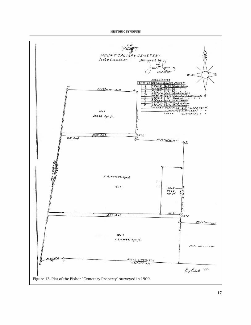
continues to be listed as an undertaker in city directories well into the late 1940s as owner of the Fisher Funeral Home. While it is unlikely that we have access to a complete chain of title, it is clear that Samuel Fisher, Jr. gradually assembled his cemetery property from various owners. In June 1894 Fisher acquired 2.15 acres immediately east of Mount Olive Cemetery from C.S. Sherwood and his wife, Mary E. Sherwood for $1,182.50 (Norfolk County Register of Deeds, DB 188, pg. 193). By December 1895 Fisher purchased a second parcel from Sherwood. This parcel consisted of 14 separate lots and was sold for $1,050 (Norfolk County Register of Deeds, DB 196, pg. 572). These lots are reported to be shown on a plat in Map Book 3, page 74, apparently a reference to a book today in Chesapeake County. Nevertheless, the lots may represent that portion of Fisher’s Cemetery north of Mount Calvary. In July 1898 Fisher acquired another tract, this one from Louis C. Phillips, trustee, for $600 (Norfolk County Register of Deeds, DB 218, pg. 360). This parcel consisted of eight lots and again there is a reference to Map Book 3, page 74. Samuel Fisher, Jr. filed a will, dated December 30, 1901 and proved on April 25, 1906 (Norfolk County Will Book 10, pg. 42). Fisher provided for the payment of debts, money contributions to various fraternal organizations, and dower rights to his widow. The bulk of his estate, however, was to be divided equally between his children, Samuel, John T., and Hattie R. As was often the case, in order to divide the property it was necessary to file an equity case. Thus on July 26, 1910 a chancery suit was filed by John T. Fisher, et al. vs. Samuel Fisher, Jr., personal representative et al. The court affirmed a proposed division of the estate (Norfolk County Register of Deeds, DB 358, pg. 171). This gave what was known as the “Cemetery Property” to David Fisher. The property was referenced on Exhibit O, a plat made by James F. Carr (Figure 13) and included:
Figure 12. 1894 city directory ad for Samuel
Fisher, Jr.
HISTORIC SYNOPSIS
17
Figure 13. Plat of the Fisher “Cemetery Property” surveyed in 1909.
PRESERVATION ASSESSMENT OF MOUNT CALVARY, MOUNT OLIVE, FISHER’S AND POTTER’S FIELD CEMETERIES
18
Parcel No. 1 on said plat, containing 32340 square feet; Parcel No. 2 on said plat, containing 9963 square feet; Parcel No. 3 on said plat, containing One (1) Acre and 14637 square feet, the said three parcels being all the land now enclosed by a fence and known as “Mount Calvary Cemetery”, excepting parcel No. 4 on said plat, which has heretofore been sold off from time to time for burial lots, or graves, and excepting also parcel No. 5 on said plat, being lots numbered 13, 14, 15, 16, and 17 as laid down on the plat of “Sherwood”, in which the estate of Sam’l Fishers Jr., has only an equitable interest as will appear from the report of John W. H. Porter, Commissioner in Chancery, filed in the said cause (Norfolk County Register of Deeds, DB 358, pg. 171).
Subsequently, on August 11, 1910, lots numbered 13, 14, 15, 16, and 17, previously
excluded from the deed, were included by Louis C. Phillips, Trustee (Norfolk County Register of Deeds, DB 358, pg. 183). This gave David Fisher all of “the Cemetery Property.” On January 20, 1911 David Fisher sold his brother, John T. Fisher, “the Cemetery Property” for $1,252 (Norfolk County Register of Deeds, DB 360, pg. 369). We presume that the John T. Fisher Funeral Home continued to sell these plots, just as his father Samuel had done previously.
A second plan of Mount Calvary is available from 1925 (Portsmouth Map Book 1, pg. 65-66; Figure 14). This plan is of particular importance since it reveals much about the cemetery. A formal, planned landscape is evident, with pathways running north-south from named drives. What had been 1st and 2nd Avenue in 1909 were now Maple Drive and Elm Drive. A Willow Drive is also shown connecting Maple and Elm, allowing easy movement through the cemetery. The individual lots are 20 feet square, typically sufficient for six to eight burials, depending on pre-existing vegetation on the lot.
The plan also reveals the
presence of a “Keeper’s Quarters,” just south of the gate on Maple Drive. We know from the city directories that at least for a brief period there was a keeper at the cemetery – so it is likely that this structure did exist.
This plan fails to show
any burials on the northwestern parcel, immediately north of Elm Drive and corresponding to Lot No. 1 on the 1909 plan. This suggests that this area was reserved for individual graves (while the larger portion of the cemetery was sold as more expensive family plots). In addition, between 1909 and 1925 additional land had been acquired east of Lot No. 1.
Breckenridge-Haywood and Walters
recount oral history that suggests about 1938,
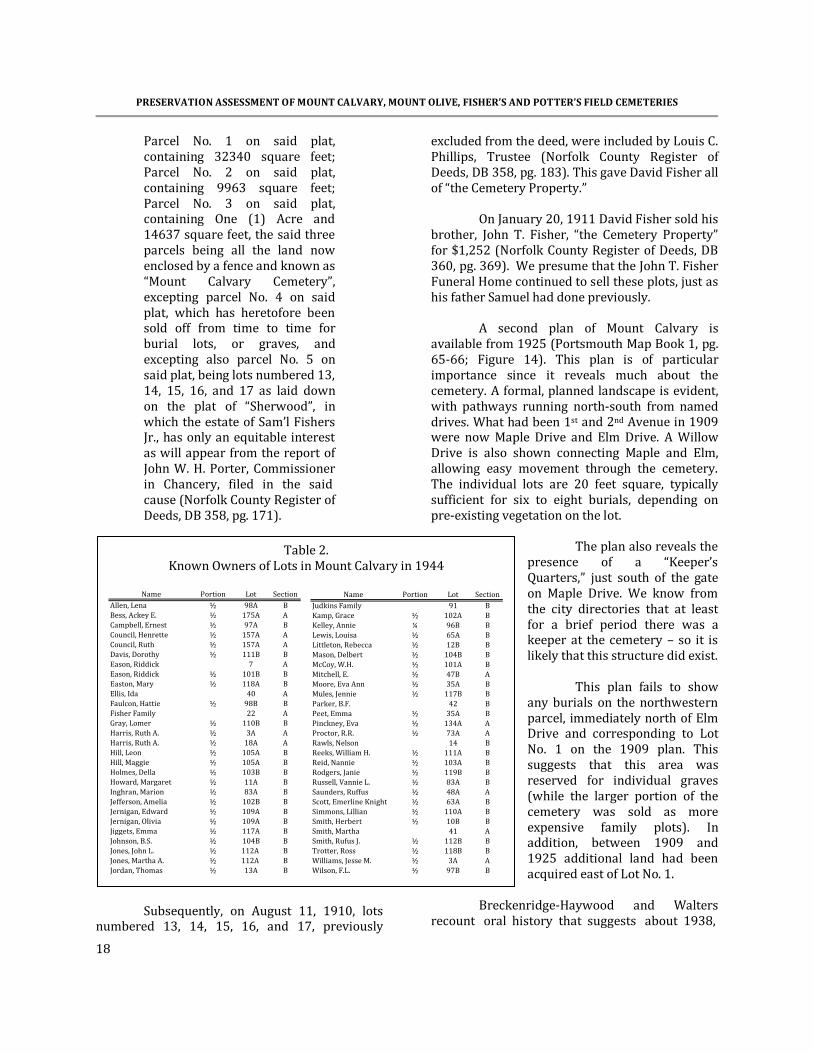
Table 2. Known Owners of Lots in Mount Calvary in 1944
Name Portion Lot Section
Allen, Lena ½ 98A BBess, Ackey E. ½ 175A ACampbell, Ernest ½ 97A BCouncil, Henrette ½ 157A ACouncil, Ruth ½ 157A ADavis, Dorothy ½ 111B BEason, Riddick 7 AEason, Riddick ½ 101B BEaston, Mary ½ 118A BEllis, Ida 40 AFaulcon, Hattie ½ 98B BFisher Family 22 AGray, Lomer ½ 110B BHarris, Ruth A. ½ 3A AHarris, Ruth A. ½ 18A AHill, Leon ½ 105A BHill, Maggie ½ 105A BHolmes, Della ½ 103B BHoward, Margaret ½ 11A BInghran, Marion ½ 83A BJefferson, Amelia ½ 102B BJernigan, Edward ½ 109A BJernigan, Olivia ½ 109A BJiggets, Emma ½ 117A BJohnson, B.S. ½ 104B BJones, John L. ½ 112A BJones, Martha A. ½ 112A BJordan, Thomas ½ 13A B
Name Portion Lot SectionJudkins Family 91 BKamp, Grace ½ 102A BKelley, Annie ¼ 96B BLewis, Louisa ½ 65A BLittleton, Rebecca ½ 12B BMason, Delbert ½ 104B BMcCoy, W.H. ½ 101A BMitchell, E. ½ 47B AMoore, Eva Ann ½ 35A BMules, Jennie ½ 117B BParker, B.F. 42 BPeet, Emma ½ 35A BPinckney, Eva ½ 134A AProctor, R.R. ½ 73A ARawls, Nelson 14 BReeks, William H. ½ 111A BReid, Nannie ½ 103A BRodgers, Janie ½ 119B BRussell, Vannie L. ½ 83A BSaunders, Ruffus ½ 48A AScott, Emerline Knight ½ 63A BSimmons, Lillian ½ 110A BSmith, Herbert ½ 10B BSmith, Martha 41 ASmith, Rufus J. ½ 112B BTrotter, Ross ½ 118B BWilliams, Jesse M. ½ 3A AWilson, F.L. ½ 97B B

HISTORIC SYNOPSIS
19
Figure 14. Plan of Mount Calvary Cemetery in 1925. Section A is shown on the 1909 plan as Nos. 2 and
4. Section B is shown on the 1909 plan as Nos. 3 (the western 75%) and 5 (the eastern 25%). The northwestern extension is shown as No. 1. The northeastern extension was not owned by Fisher in 1909. The source of this additional tract has not been determined and it is likely this portion of the cemetery that remains in the Fisher family.

PRESERVATION ASSESSMENT OF MOUNT CALVARY, MOUNT OLIVE, FISHER’S AND POTTER’S FIELD CEMETERIES
20
The city physician, Dr. Roper, became concerned that the Fishers . . . were inadvertently digging up remains from unmarked graves when conducting new burials. Dr. Roper asked for Mr. Wimbrough, Sr.’s help. Mr. Wimbraugh worked an agreement with the Fishers that in exchange for $1,000, the Fishers would stop burying in the cemetery unless the lot owners had specific deeds and lot locations. This effectively closed the cemetery except for an occasional burial by a Mr. Green who lived nearby (Breckenridge-Haywood and Walters 2002:xiii-xiv).
Although the Portsmouth Health Department claims this would be beyond the scope of their work, the agency has no surviving records from that time period (according to both their records manager and the Library of Virginia). However, in the 1930s the head of the Department was a Dr. Lonsdale J. Roper – which provides some credence. The reference to a “Mr. Green,” is almost certainly Spencer Green, who lived on Sherwood according to the 1936 city director. Green listed his occupation as “gravedigger.” Why, however, he was allowed to continue burials on the property isn’t clear. Finally, the city council minutes for 1938 were reviewed and no mention was found of the burial grounds being closed or of the city paying for cessation of burials. Thus, while there are threads of consistency in the story, it has been impossible to demonstrate that burials were no longer being allowed in the cemetery complex.
In 1944 John T. Fisher, still in the funeral home business, sold “The Cemetery Property” to Carl E. Wimbrough for $3,500 (Portsmouth Register of Deeds, DB 141, pg. 53). This deed includes a list of individuals who had purchased lots in Mount Calvary (Table 2). This list reveals that most purchased only half a lot (probably 4 graves) and one individual purchased only a quarter of a lot (probably two graves). Only seven families purchased an entire lot. With only 28½ lots purchased as of 1944, this couldn’t have been an especially profitable endeavor for the Fishers.
On the other hand, it is likely that there
are numerous individual graves that were sold by the Fisher Funeral Home that aren’t identified in this table. It was not (and still isn’t) uncommon for African American undertakers to have graveyards where they could offer clients inexpensive graves. Unfortunately, without the Samuel and John T. Fisher records it will be impossible to reconstruct the financial or social history of this burial ground.
The 1938 city directory reveals that
Wimbrough was in the burial vault business. His son, Vernon E. Wimbrough, was the bookkeeper for the firm. Why Fisher sought to divest himself of the property is not clear. Nor is it clear if Wimbrough maintained the formal appearance of
Figure 15. The cemetery complex shown on the 1945 Portsmouth Tax
Map.

HISTORIC SYNOPSIS
21
Mount Calvary or began selling off individual plots in order to maximize his profit.
Figure 15 illustrates the cemetery
complex as shown in the 1945 tax maps (Ester Murdaugh Wilson Memorial Room at the Portsmouth Public Library). The map still shows Fisher as owning Mt. Calvary with a taxable value assigned of $1,650 – apparently the city had not yet updated ownership. In pencil, above Mount Calvary and above Brighton Avenue, is “cemetery,” reflecting the extension of Mount Calvary into these areas.
To the west is Mount Olive. No owner is
shown there, perhaps suggesting that by this time the Mount Olive Club had ceased to function and ownership was uncertain. Further to west is a tract of 1 acre, owned by the City of Portsmouth. This is the so-called potter’s field, briefly discussed below.
The ca. 1950 Sanborn Fire Insurance map
(Ester Murdaugh Wilson Memorial Room at the Portsmouth Public Library; Figure 16) is far less precise and it offers relatively little additional information concerning the burial grounds.
In 1953 Wimbrough conveyed the property to the firm Wimbrough and Sons and
that same year Wimbrough and Sons sold the property to Lincoln Memorial Cemetery Corp. (Portsmouth Register of Deeds, DB 260, pg. 75). This was another Wimbrough business; we have not, however, explored its activities.
In 2003, Lincoln Memorial
Cemetery Corp. sold “The Cemetery Property” to the City of Portsmouth for $1. Review of the City Council minutes for the two months preceding this acquisition and the month following provided no mention of the transfer, although the council did go into numerous closed sessions where no minutes were kept. It seems curious that this property was acquired by the city and there was no discussion of the property or its maintenance. Potter’s Field
On April 12, 1882 Norfolk County purchased a one-acre parcel from the Perry family for $115, as well as a right-of-way to the parcel. The property was described as “bounded on the East, on the South by a ditch running a South west course dividing this land from land for the late Wm. B. Whitehead thence North along other land of said Edmond A. Perry thence East along other land or the farm of said Est. Perry to the point of beginning.” This property was “adjoining on the West said Grave Yard Club” – a reference to the Mount Olive Club. No where in the deed does the county reference the intended purpose of the property, although the VDOT work clearly demonstrates that the property was used for burials (Barry et al. 2007). It would obviously be useful to examine Council Council records for the early 1880s to determine more about the early history of the property. It seems likely that the property was intended for the burial of indigents, although it certainly did not date to the 1850s as has been previously claimed. It would also be useful to
Figure 16. Sanborn Fire Insurance Map updated to about 1950
showing the cemetery complex.
PRESERVATION ASSESSMENT OF MOUNT CALVARY, MOUNT OLIVE, FISHER’S AND POTTER’S FIELD CEMETERIES
22
examine the records in more detail to ascertain how the property was transferred from the county to the city. The Cemetery Complex in the Twentieth Century Much of what is known about the cemeteries in the twentieth century comes from newspaper accounts. Unfortunately, none of the Portsmouth papers is thoroughly indexed, so it is likely that this brief review barely scratches the surface of this extraordinary resource. One of the earliest identified accounts is from 1924 when it was reported that,
Colored veterans of the Grand Army of the Republic and of the Spanish and World Wars observed National Memorial Day with a parade this afternoon and a program of exercises at Mt. Calvary cemetery (The Portsmouth Star, May 30, 1924, page 5).
The article goes on to list the organizations involved, including not only military groups, but also a large number of African American groups, including the Knights of Pythias, the Palestine Guard of the Knights Templar, the Pioneer Lodge of the B.P.H. of B., the Arctic Lodge of B.P.O. of Reindeer, the Radio Lodge of F.O.F., the Manhattan Social Club, the Beacon Light Lodge of Elks, and the Sons of Portsmouth. The article also identifies those in charge – perhaps representing officials associated with Mt. Calvary – including George Turner, President; John T. Fisher, acting Secretary; Morse
Shepherd, Director General; Joseph Scott, Assistant; and Professor W. E. Riddick, Treasurer. Just a few months later an article talking about African American life in Portsmouth commented that blacks “now bury at ‘Lincoln’ and ‘Calvary’ or ‘Fisher’s’ and Mount Olive. The city of Portsmouth provides no burial place for our people. All of our burial places are privately owned and the grass and weeds are so high we
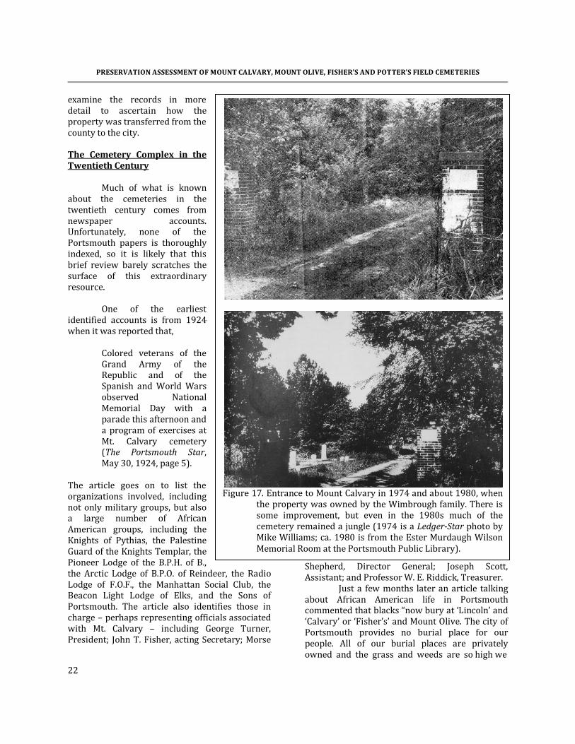
Figure 17. Entrance to Mount Calvary in 1974 and about 1980, when
the property was owned by the Wimbrough family. There is some improvement, but even in the 1980s much of the cemetery remained a jungle (1974 is a Ledger-Star photo by Mike Williams; ca. 1980 is from the Ester Murdaugh Wilson Memorial Room at the Portsmouth Public Library).

HISTORIC SYNOPSIS
23
Figure 18. Changes during mid-century. The top aerial is from February 1951. The bottom is from March
1963. These photos show the increase in cemetery vegetation over 13 years, as well as changes in the surrounding neighborhood. Even as late as 1963, however, drainages can be seen north of the cemetery.

PRESERVATION ASSESSMENT OF MOUNT CALVARY, MOUNT OLIVE, FISHER’S AND POTTER’S FIELD CEMETERIES
24
cannot find the graves scarcely” (Portsmouth Star, August 29, 1924). This article is important since it reveals that Mount Calvary and Fisher’s were used interchangeably by this time. It also points out that even as early as 1924 – in the midst of Jim Crow – Portsmouth’s African American community clearly recognized the disparity in city burial operations. A September 1924 article recounted another event at Mount Olive, noting that 600 people attended (Portsmouth Star, September 9, 1924). This article lists a variety of fraternal organizations and the deceased members buried at Mount Olive – this may provide at least a few names for the countless unmarked burials in the cemetery. It also reveals how active these cemeteries were during the 1920s. Unfortunately we have few additional articles for nearly 50 years. An October 2, 1954 article reveals that by this time the cemetery complex was “wooded” and “unkempt” (“The Honored Dead Find in Hard to ‘Rest in Peace’ in Portsmouth,” New Journal and Guide, October 2, 1954, pg. D19). It goes on to describe “jungle-like growth” and the discovery of human bone on the surface. The article also reveals that at this time the cemetery had a part-time caretaker, Walter Carr, who was paid by different families to maintain some of the plots. Reporting very shallow ground water, Mr. Carr noted that graves couldn’t be dug deeper than 4 feet in the cemetery complex. This article revealed that Carl Wimbrough was the owner. When the paper enquired about conditions, he reportedly said that it was up the the families to maintain their plots. The city manager at the time, I.G. Vans, provided no “satisfactory answer” concerning the condition of the cemetery or why Portsmouth had no city operated burial ground for African Americans.
Later newspaper accounts do explain that in 1960 the City of Portsmouth was faced with a federal court suit demanding integration of the city-owned white cemeteries, Olive Branch, Oak Grove, and Cedar Grove. In order to avoid integration, the city chose to sell the properties to Wimbrough & Sons – a firm owned by Vernon Wimbrough, a commissioner of the Portsmouth Redevelopment and Housing Authority. By this
time the Wimbrough family had owned Mount Calvary for about 17 years.
While the city sold its white-only
cemeteries, it maintained its obligation to provide perpetual care to these white burials. Apparently the Olive Branch Cemetery Corp., to which the cemeteries were sold, was chartered Sept 8, 1960, several days after the city had sold the properties. The city responded to the civil rights suit claiming that it no longer owned the cemeteries in question and the suit was dismissed. We also know that in 1965, perhaps as a result of the earlier desegregation suit, the City of Portsmouth used its Summer Youth Corps to clean up the African American cemetery complex, removing the jungle and hauling away mounds of trash (“Hearing Aimed at Cemeteries,” Ledger-Star, July 2, 1974). At this time, of course, Mount Calvary was owned by the Wimbrough family and it is difficult to understand why the city chose to clean the property of an owner capable of cleaning the tract themselves.
Then, in 1973 we learn that a delegation of African American citizens lead by Mrs. Hilda C. Watson called on the Portsmouth Citizens Advisory Committee (CAC) to obtain their assistance in obtaining maintenance of the cemetery complex (“Condition of Cemeteries for Blacks Under Study, Ledger-Star, June 5, 1973). We can only conclude that the African American community did not realize that the Wimbrough family owned Mount Calvary and could easily have maintained the tract if they had desired to do so. The article went on to note that the road into the cemetery complex was deeply rutted, filled with water, and passable only to pedestrians. Neighbors complained of the condition of the cemeteries. A subsequent article reported that a report was due from the Citizens Advisory Committee (“Cemetery Condition report Due Monday,” Ledger-Star, August 3, 1973), but we have found no follow-up article until October, at which time local African American citizens were reported to be meeting. The article gives a clue concerning the city’s response to the report,

HISTORIC SYNOPSIS
25
noting that “the problem is that the cemeteries were established by undertakers as private operations and the city is not prepared to undertake maintenance” (Blacks Plan Meet on Cemetery Plans, Ledger-Star, October 3, 1973). This is the response of the city for the 50 years that black taxpayers have attempted to obtain parity in cemetery operations. In November 1974 it appeared that something might be done to maintain the cemeteries. An effort was organized by “building contractor Warren L. Holland, Sr.” who used his equipment to open three roads into Mount Calvary, although Mount Olive Cemetery to the west was “largely untouched” (“Overdue Work on Graves Starts,” Virginian Pilot, November 3, 1974). Again, it is difficult to understand why the owner of the property – the Wimbrough Lincoln Memorial Cemetery Corp. – was not required to maintain the cemetery. Regardless, the article explains that Mrs. Hilda Watson was then chair of “a newly established board of trustees.” Others listed include Holland, Winston Pearson, Rev. C.H. Jordan (pastor of Third Baptist), Rev. C. Charles Vache (Trinity Episcopal), Dr. Charles Price, Miss Ruth Mayhall (Wesley Community Center), Bruce M. Watts, Mrs. Hilda Jackson, and Dean Sword. Nothing else is explained about that group, such as its goals or organization. The article also reminded readers that David Corley with CAC “spent months looking into the problem and preparing a report on what might be done.” Holland is also reported to have explained that “it is virtually certain that the tract fenced in by PRHA was once a burial ground for paupers and its use as an equipment yard now is inappropriate.” Nevertheless, this yard continued to be used for equipment storage by PRHA for an additional 30 years (and only recently has the equipment been moved). By December 1974 the newspaper reported that city officials were continuing to “skirt the question of perpetual care.” Then assistant city manager H.M. Myers is quoted as saying, “when you talk about perpetual care for one, you have to talk about it for all. The results
could be far reaching” – a curious comment since the city was still providing perpetual care for the city’s white cemeteries, in spite of having sold the properties to a private firm (“Old Cemeteries Pose Costly New Problems,” Virginia-Pilot, December 1, 1974).
Several requests for funding had been presented to the city for use of a small portion of the $4.5 million in federal community development funds that Portsmouth was allocated. CAC, however, also sidestepped the issue by placing the cemeteries in their Category 4 – proposals with “need and desirability for adoption, but [that] require more staff study or research to consider adequately.” By postponing actions, CAC succeeded in ensuring that none of the funds would be devoted to the African American burial grounds.
Only a few days later it was reported that
the controversy might be ready to boil over. At least one city councilman, Archie Elliott “raised questions about the city’s role in cemetery operation.” City manager Phin Horton was told to gather information and report back (“Cemetery Issue Showdown Coming,” Ledger-Star, December 5, 1974). There is no indication that any study was actually conducted. The next account reports acrimony and the appointment of yet another group to “study” the situation – but no substantive action as the city’s white dominated city council held firm. Councilman James W. Holley III threatened that the city’s black citizens might be forced to return to court to demand that the white only cemeteries be integrated (“Cemetery Care Issue Explodes at Council, Virginia-Pilot, December 18, 1974).
In January 1975 Warren Holland again
reiterated his claim that the pauper’s cemetery was deeded to the city and was the city’s responsibility to restore – there is no indication, however, that the city responded in any fashion. There was also an effort to have the cemeteries “registered by the Virginia Landmarks Commission” – an action that was apparently unsuccessful. It was also revealed that the city had “spent $1.3 million for perpetual care in what amount[ed] to city-owned segregated cemeteries since 1961” (“5 Former City Councilmen Lie in
PRESERVATION ASSESSMENT OF MOUNT CALVARY, MOUNT OLIVE, FISHER’S AND POTTER’S FIELD CEMETERIES
26
Unkept Cemeteries,” Virginian-Pilot, January 7, 1975).
The committee set up by council in mid-
December to study the cemetery situation reported that additional time was needed in mid-February (“Cemetery Probe Needs ‘More Time’,” Ledger-Star, February 12, 1975). The report was again delayed in March (“Report on Cemeteries Delayed,” Ledger-Star, March 11, 1975).
Although newspaper accounts of the April
8, 1975 city council meeting report that the study of the black cemeteries was still not complete, it does reveal that the city council voted to open the city’s segregated cemeteries to African Americans, officially integrating Olive Branch, Oak Grove, and Cedar Grove (“Cemetery Cleanup Voted,” Virginian-Pilot, April 10, 1975; “Grave Issue Ends, Hail Equality Rule,” New Journal and Guide, April 19, 1975, pg. 1). The council also voted “5-2 to direct private agencies to restore three black burial grounds which were closed by the city’s health department in 1964.” What exactly was meant by “private agencies” is not clear and unfortunately we have not identified newspaper articles that address whether any effort was made to clean the cemeteries. The New Journal and Guide actually reported that city council “decreed the city will take the responsibility of maintaining Fisher Hill, Mount Calvary and Mount Olive Cemeteries.”
The next newspaper account we have
found dates from May 1980 and reports that the Mason’s Lebanon Lodge No. 34 was attempting to clean the cemetery complex. A photograph in the article shows the cemetery entirely wooded – suggesting that nothing had been done since the Summer Youth Corps cleaned the property in 1965 (“Fisher’s Hill – Lodge Members Restoring Dignity to 2 Cemeteries,” Currents, May 6, 1980). Shortly thereafter a memorial service was held by the Masons at the cemetery (“Memorial Service Slated at Cemetery,” Currents, May 15, 1980). This memorial service was held again in 1981, although we have not identified anything concerning the condition of the cemeteries at the time (“Memorial Service at Fisher’s Hill,” Currents, May 29, 1981).
In 1985 the city’s involvement with the cemeteries was again an issue, suggesting that after the instructions to clean the cemeteries a decade earlier the issue was dropped. Apparently in 1982 the city attempted to contact owners of the properties; letters were sent to heirs and newspaper ads were run. The maintenance efforts were reported to be spotty and “at this time, the city continues to attempt to get the cemeteries on some regular maintenance schedule” (Black Cemeteries Need to be Maintained,” Currents, February 16, 1985).
It was another year, however, before the
city finally began allocating funds to the cemeteries. Initial bids ranged from $95,000 to $420,000 for the work – far more than city council was willing to pay, so the scope was scaled back and the project was apparently rebid (“Black Cemeteries Will Receive City Cleanup,” Currents, February 27, 1987).
The article also reported that the city had
petitioned the Circuit Court for an order to proceed with the work, with the order being issued in November 1986. The city was required to post a $50,000 bond against damage to monuments.
This is confirmed by the August 28, 1986
city council minutes in which the city manager explained that the Code of Virginia 57-39.1 “provides that the City may petition the Circuit Court to require the owners of private cemeteries to place the same in suitable condition or to allow the petitioner to enter upon the land to place the same in a suitable condition” (http://www.portsmouthva.gov/weblink7CCMinutes/PDF/brdfxozwjb14qhm3oxiyak55/Minutes%2008261986.pdf). It is not clear from the minutes, however, if the Wimbrough’s Lincoln Memorial Cemetery Corp. refused to maintain Mount Calvary or if the city never sought their participation in this effort.
What hasn’t been discussed is that the
city council also included two additional cemeteries in their resolution. One was the Ebony Heights Cemetery, the other was Barclay Cemetery. Ebony Heights is a predominately black neighborhood comprising an 11-block area off

HISTORIC SYNOPSIS
27
Towne Point Road in Churchland. The Barclay Cemetery is next to Cradock Middle School at the intersection of Aylwin Crescent and Abbott Place. The current status or condition of these other cemeteries is unknown.
We also learn from the February 27, 1987
article that the organization founded by Mrs. Hilda C. Watson donated their treasury – $488.56 – to the city. Apparently the group was never successful in generating support or funding for the preservation of the cemeteries.
By June the city had spent $60,000
clearing the first section of the cemetery complex – yet “summer growth is almost overtaking the area again” (“Cooperation Necessary for Care of City’s Neglected Cemeteries,” Currents, June 12, 1987). The city, in spite of decades of ignoring the problem, began pleading for relatives and descendents to take responsibility, “We’ll never be able to keep up with it if citizens don’t come forward to help us” – a plead not heard for the city’s previously white-only cemeteries.
Tom Eaton, Assistant Director of the city’s
Parks and Recreation Department is reported to have claimed a plot plan for Mount Calvary showed 13,092 gravesites, and that “old city records estimate about 6,500 sites in Mount Olive and another 15,000 at Fisher’s Hill and in a potter’s field.”
It is likely that these figures are confused.
For example, the only plan of Mount Calvary we have identified shows 346 lots, most with a standard size of 20 feet square. Assuming 8 burials per plot, this would allow 2,768 burials – not the 13,092 claimed. In addition, Fisher’s Hill, at least by this time, seems to have been applied broadly to include both Mount Calvary and the small cemetery to the north. Thus, it is improbable that the two properties combined would have had the over 28,000 burials claimed.
When allocating space, the general
procedure is to recognize a certain amount is “wasted” on pathways, trees and other plantings, monuments, and so forth. Prior to the advent of private, commercial cemeteries, the average was 58 square feet per grave (Anonymous 1983).
Using this estimate Mount Calvary might have 2,290 plots – about 478 plots less than we have calculated based on maximizing burials.
Thus, the 479,160 square feet (11 acres) might have as many as 8,261 plots. This suggests that either the numbers suggested in the 1987 newspaper article are grossly overstated or else many burials intrude into pre-existing remains.
A 1988 article reported that Mount
Calvary was again “overgrown with weeds and littered with debris” (Cemetery Cleanup Effort Well Ahead of Schedule,” Currents, May 15, 1988). This work, using students from the Clarke Vocations Training Center, was spearheaded by Lonnie Ruffin Tree Service. It is unclear if the work was paid for by the city, but it was likely part of the city’s clean-up efforts. A photograph accompanying the account, however, again shows a densely wooded section of the cemetery complex.
By 1990 the cemeteries were again the
focus of civic events, with a Black History Month event being sponsored by I.C. Norcom High School Association (“Black History Event Set at Cemeteries,” Currents, February 18, 1990).
A June 1990 article claimed that the
three-years of cleaning had been completed at the cemetery complex and that the cemeteries would now be “open to the public from sunup until sundown seven days a week” (“Two Cemeteries Reopen After Three-Year Cleanup,” Portsmouth Review, June 11, 1990).
We find another gap in news coverage
until 1998 when Bettie Jo Matthews, a local genealogist, turned over her survey of graves in the cemetery complex to the African-American Historical Society of Portsmouth (“African American Graves Survey Presented to Historical Society,” Virginian-Pilot, March 20, 1998). Also in 1998 the Minority Police Officers Association signed a Memorandum of Agreement with the City of Portsmouth. The agreement stipulated that the city would cut the grass, enhance lighting, put up a fence, and seek to gain ownership of the complex while the Association

PRESERVATION ASSESSMENT OF MOUNT CALVARY, MOUNT OLIVE, FISHER’S AND POTTER’S FIELD CEMETERIES
28
would “repair broken tombstones . . . set up overturned stones and clean neglected areas” (“Portsmouth Officers Vow to Uncover Black History,” Virginian-Pilot, June 25, 1998; see also “Minority Officers Take Responsibility for City Treasures,” Virginian-Pilot, June 28, 1998). The Association’s president, James E. Lewis claimed, “This is not a one-time thing with us. It will be a long-term commitment and I think we will leave a lasting impression on the city.”
In February 1999 the city announced their plans to erect a $52,000 fence and it is reported that the Association was working in the cemeteries “regularly” (“Portsmouth Pitches in for Restoration of Three Historically Black Cemeteries,” Virginian-Pilot, February 27, 1999). The fence was apparently the approximately 250 feet of modern fencing along Pulaski Street. Nevertheless, with the death of the Association’s president the project was dropped – we have found no indication that any actions were undertaken by the group.
Another gap occurs until the 2001 article
discussing the publication of the book, Inscriptions in Triumph by Mae Breckenridge-Haywood and Dinah Walters (“‘Like Walking Through An African-American History Book’ Portsmouth Cemeteries Open A Window On Past For Historian-Authors,” Virginia Pilot, September 8, 2001).
In 2004 an article appeared that noted
how inexpensive burial plots were in Portsmouth’s city funded cemeteries when compared to nearby communities. The article also reported that the city was spending $140,000 a year maintaining just two of the city’s three cemeteries – calling into question the city’s repeated pleas that it couldn’t maintain Portsmouth’s African American burial grounds (“A Bargain Hunter,” Virginian-Pilot, October 21, 2004).
The next article we have identified is the
July 2008 account of finding an open grave in the cemetery complex. At the time Mike Morris, the Public Works Director, explained that the condition of this one grave is not an anomaly in the cemetery and that other similarly open graves
also exist. The article also reports that at some point the Sheriff’s inmate work crews took over maintenance of the cemetery from the city (“Discovery Underscores Grim Conditions of Historic Portsmouth Cemeteries,” Virginian-Pilot, July 29, 2008).
A number of articles appeared in 2009,
most reiterating the poor condition of the cemeteries. In February the City Attorney’s Office confirmed that the city owns Mount Calvary, while the ownership of Fisher’s just to the north and Mount Olive to the west were not clear. The article also recounts a presentation by Ms. Christina Carlton to City Council in January asking why Mount Calvary – which the city acknowledged they owned – was not being provided the same level of care as the historically white cemeteries. Assistant City Attorney Gene White said he didn’t know the answer to that question. Curiously, City Attorney Timothy Oksman responded that he doubted any prompt action by the city would be unlikely – that, “there will be a cost associated with this type of effort and we’ll have to see what that is and make some hard decisions about whether and when that cost may be affordable.” While the city publically dragged its feet, the article also reported that within hours the Sheriff’s Inmate Crew was again at the cemetery helping to improve conditions (“Historic African American Cemeteries Need Care and Repairs,” Virginian-Pilot, February 8, 2009).
While the City Attorney suggested that
maintenance of the cemeteries might be too costly, the Planning Commission approved rezoning of five parcels adjoining Mount Calvary, allowing them to be used for cemetery plots. Apparently the property owners, John C. Holland, Jr., JoAnn H. Nesson, and Jonnie H. Franklin, expressed an interest in donating the property to the city. The article fails to explain why that donation required rezoning and the property couldn’t be used for greenspace (“City Could Add More Land to Historic Cemetery,” Virginian Pilot, July 22, 2009). Regardless, the property was subsequently donated and is currently owned by the city. Certainly it would be odd if the city wished to create more cemetery space when it claims it can’t adequately and appropriately maintain the cemetery it already owns.

HISTORIC SYNOPSIS
29
In early October 2009 the city announced that it had hired the firm of Stephen Boone & Associates “to survey the perimeter of the entire burial grounds as a preamble to legal proceedings to acquire the long-abandoned Mount Olive and Fisher’s Hill properties” (“Minus Caretaker, Burial Grounds Keep Crumbling,” Virginian-Pilot, October 11, 2009). The article went on to quote the owner of the firm hired as indicating the survey would be completed by mid-October. Curiously, as of October 6, 2010 – a year after it was begun – it is not yet ready to be released (Meg Pittenger, personal communication 2010).
In 2010 Ms. Carlton wondered why it had
taken months for the city to get to the downed trees in the African American cemeteries. In the article City Attorney Timothy Oksman also acknowledged that the city had found the deed “that confirms the city owns the potter’s field” (“Her Relentless Effort to Tidy Their Final Resting Place,” Virginian-Pilot, February 27, 2010).
By October 2010 it appears that the
Fisher family expressed an interest in donating the Fisher’s Cemetery north of Mount Calvary to the city, hoping that unpaid taxes on the property would be forgiven and that they could acquire a tax deduction for the donation (email from Tim
Oksman to Charles Whitehurst, October 1, 2010). The email also references historical records – presumably funeral home records associated with burials at Fisher’s Hill.
Summary The brief timeline of the cemeteries shown in Figure 19 may help to place at least some of these historical events in perspective. We know the least, of course, about the potter’s field. Of the larger cemeteries, Mount Olive is the least well known. It was begun in 1879 and was clearly still an important part of the African American community as late as 1924. Similarly, Mount Calvary, created between 1894-1898, was a thriving enterprise at least as late as 1925 when a plan was produced. It may have been during the depression years of the 1930s that both cemeteries began to see signs of collapse. The 1930s and 1940s were also the period of significant African American migration, leaving the Jim Crow south for better opportunities elsewhere. This may have served to diminish the number of family members able to help maintain family plots.
Figure 19. Timeline of the Mount Calvary, Mount Olive, Fisher’s, and Potter’s Field Cemetery Complex.
Mount Olive Club purchases property
Samuel Fisher begins Mount Calvary
Mount Calvary expanded
Mount Calvary expanded again
Samuel Fisher dies
"The Cemetery Property" given to David Fisher
David Fisher sells the cemetery to John T. Fisher
Plan of Mount Calvary produced
Fisher sells "The Cemetery Property" to Carl E. Wimbrough
Wimbrough sells Mount Calvary to his company
Wimbrough & Sons sells Mount Calvary to Lincoln Cemetery
Memorial Corp.
600 people attend event at Mount Olive
City sells white cemeteries to Wimbough & Sons to prevent
integration
City's Summer Youth Corps clean up cemeteries
CAC and City stall on cemetery efforts
City "studies" black cemeteries
Masons attempt clean-up
Portsmouth integrates cemeteries & pledges cleanup
City begins to clean up cemeteries
Minority Police Offices pledge to clean cemetery
Poor conditions noted by numerous articles
Cemetery assessment conducted by Chicora
1870 1890 1910 1930 1950 1970 1990 2010

PRESERVATION ASSESSMENT OF MOUNT CALVARY, MOUNT OLIVE, FISHER’S AND POTTER’S FIELD CEMETERIES
30
By the 1950s it is likely that neither cemetery was profitable and that maintenance was no longer being provided. It was in the 1960s that the African American community, aware of Portsmouth’s efforts to maintain segregation of cemeteries began to demand their burial places be better cared for. Seeing their taxes spent on white cemeteries they understandably sought parity and demanded that the city provide equal funding to maintain Mount Calvary and Mount Olive. The city spent the next 30 years fighting these efforts using delay tactics, pleading inadequate finances, and simply ignoring requests. It wasn’t until the 1990s that Portsmouth belatedly began efforts to recover and restore the cemetery complex at Pulaski Street. It is clear, however, that old ways die hard. Even today the city lacks a vision for the African American burial grounds. This lack of vision may also represent a lack of will to find the funds and ensure that after decades of Jim Crow, Mount Calvary and Mount Olive receive city support and maintenance. Previous Studies
In 2006 the city’s Department of Parks, Recreation and Leisure Services undertook a 10-year master plan for the city cemeteries, including Mount Calvary, Mount Olive, and Fisher’s. While potter’s field is not included in the title, we can extend the recommendations to include this property as well.
Six projects were identified: improving
drainage, filling sunken graves, establishing roadways, resetting headstones, placing trash cans, and evaluation of signage. For the larger tasks, such as drainage, sunken graves, and roadways, the plan referenced assistance from other departments – yet in no case has this assistance ever been sought. In each of these cases the plan also failed to estimate the associated costs. For the less expensive tasks – trash cans and signage – the plan felt that neither were necessary.
The 10-year plan, while identifying
critical issues within the cemetery complex, failed to take any steps to solve these problems. Today,
the problems remain as critical as when the study was conducted four years ago. The cemetery complex was briefly studied in 2007 as part of the cultural resources study for the VDOT Route 58, Martin Luther King Freeway Extension (Barry et al. 2007). As a result of that study, a Department of Historic Resources Reconnaissance Level Survey form was completed for the cemetery complex (DHR #124-5125). This study generated concern that the proposed highway corridor would impact graves in the potter’s field section of the cemetery. As a result, 32 trenches were mechanically stripped in an effort to identify grave shafts. Twenty-three of these trenches were within the area thought to represent the potter’s field cemetery. At least 13 of these trenches (10, 13, 17, 18, 20, 21, 22, 23, 24, 25, 29, 31, and 32) produced clearly identifiable coffin stains. As a result, it is clear that burials are present on the 1-acre plot purchased in 1882 by Norfolk County.
Perhaps more importantly, this study also
revealed that burials extend off the city-owned property, onto an adjacent tract (208-30) owned by James E. Bazemore, Sr. We have no historical data for this additional tract.
There are at least eight rows of graves on
the potter’s field property. While there is a slight difference in orientations, all run generally southwest-northeast – but they do not follow the property line. At least two of these rows extend northward onto the Bazemore property.
There are at least five additional rows of
graves, having an orientation of approximately south-southwest by north-northeast in the central Bazemore tract. These graves appear distinct from those in the potter’s field, not only in orientation but also in complexity. This suggests that more is going on in this area than we currently understand.
The study assigned the archaeological site
number 44PM0062/124-5125 to the Mt. Olive Potter's Field and Mt. Calvary Cemetery complex. It was determined that the potter’s field is eligible for inclusion on the National Register of Historic

HISTORIC SYNOPSIS
31
Places under Criteria A, B, and D (letter to Ms. Margaret Stephenson, Virginia Department of Transportation from Mr. Marc Holma, Department of Historic Resources, dated January 7, 2008).
Given proximity, similar soil conditions,
and similar temporal periods, we have every reason to believe that the bioarchaeological
remains at Mount Calvary, Mount Olive, and Fisher’s will be identical to those found during this study.
Additional Research Clearly there is much additional historical research to be conducted. Since the city appears reluctant to release records, we recommend that a freedom of information inquiry be filed to compel the release of these documents. They are public records, collected using public funds and we can see no attorney-client privilege. These records should shed light on how the city acquired the so-called potter’s field and how the property was transferred to the Portsmouth Redevelopment and Housing Authority. The records may help explain why – when the city’s 1945 tax map showed the city as the owner of the property – the parcel was allowed to become abandoned and eventually used for equipment storage. The records may also help explain why even today the city has not reclaimed this parcel. Additional title research is needed for the Bazemore tract in an effort to understand the origin and meaning of graves on the parcel.
The records of Norfolk County should be examined to see if the use of the potter’s field can be identified in council minutes or departmental correspondence (some agency had to be responsible for the use of this property).
Figure 20. Graves identified through stripping in potter’s field and the
adjacent Bazemore property (adapted from Barry et al. 2007:Figure 34).

PRESERVATION ASSESSMENT OF MOUNT CALVARY, MOUNT OLIVE, FISHER’S AND POTTER’S FIELD CEMETERIES
32
It is also critical that the title search identify how and when the eastern portion of Fisher’s Cemetery came into the ownership of the Fisher family. Much work is needed to understand how Samuel Fisher and subsequently John T. Fisher used Mount Calvary. Much of this may be possible only if Fisher Funeral Home records – reported by a recent city email to actually exist – are made public and historians have the opportunity to examine them. While we suspect that much of the property was sold as individual grave plots (rather than family plots), this can be confirmed only through records research. Additional research should be directed toward better understanding the function of the Mount Olive Club. Newspaper accounts may help identify the role of the club, officers, and perhaps how the organization sold or otherwise used its property. It will also be useful to understand the relationship between the Wimbrough family and the City of Portsmouth. It seems to be too much of a coincidence that the Wimbrough’s acquire Mount Calvary and hold the land quietly for nearly six decades, allowing the cemetery to slip into a state of abandonment and utter dilapidation. During this time citizens repeatedly cried out for assistance from city, typically to be ignored. Occasionally, however, the city allocated its own resources toward maintenance of the property – rather than demanding that the company which owned other cemeteries and was making a profit from their operation take steps to clean and maintain the African American burial grounds. It also would be intriguing to better understand the circumstances surrounding the sale of Mount Calvary to the city in 2003. While we are uncertain how productive the effort would be, we recommend that the city council minutes be searched for any references to the cemeteries or their owners. There may also be additional newspaper articles, especially for time periods not well covered at the present time.


