54
Preserve America Report Bureau of Land Management October 2017 Historic Preservation Activities for Fiscal Years 2014 – 2016 Desert Training Center features from drone

Preserve America Report
Bureau of Land Management October 2017
Historic Preservation Activities for Fiscal Years 2014 – 2016
Desert Training Center features from drone

Contents
Executive Summary ........................................................................................................................ 1 1. Introduction ................................................................................................................................. 2
The BLM Organization .......................................................................................................... 2
Cultural Heritage Program Overview .................................................................................... 2 Data Management .................................................................................................................. 7 Museum Collections .............................................................................................................. 8
2. Identifying Historic Properties: Inventory and Survey ............................................................... 9 Examples of Identification Efforts ....................................................................................... 10
Partnerships in Identification ............................................................................................... 15 3. Protecting Historic Properties ................................................................................................... 17
Partnerships in Protection .................................................................................................... 17
Training ................................................................................................................................ 25 Planning for Management and Protection ............................................................................ 29
4. Using Historic Properties .......................................................................................................... 34 Community and Tourism ..................................................................................................... 34 Exchanges, Transfers, and Acquisitions .............................................................................. 41 Partnerships in Using Historic Properties ............................................................................ 42
5. Future Plans and Final Thoughts .............................................................................................. 49 Programmatic Highlights ..................................................................................................... 49

List of Tables
Table 1. Summary of Activity on the Public Lands........................................................................ 1 Table 2. Summary of Appropriated Funding for the Cultural Resource Management Program .... 4 Table 3. Performance Metrics for FY 2014-2016 ........................................................................... 4
Table 4. Cultural Program Workload Measures ............................................................................. 4 Table 5. State Program Accomplishments Funded by the Cultural Resources Management
Subactivity ...................................................................................................................................... 5 Table 6. State Program Accomplishments Funded by the National Monuments Subactivity ........ 6 Table 7. BLM Historic Structures and properties with a FRPP number. ....................................... 7
Table 8. Summary of Literature Reviews and Undertakings Requiring Inventory ........................ 9 Table 9. Summary of Acres Inventoried for Cultural Resources .................................................... 9 Table 10. Summary of Sites Identified ......................................................................................... 10
Table 11. NTC Training Courses Offered to BLM Staff. ............................................................. 25 Table 12. National Register Listed Properties .............................................................................. 32

List of Figures
Figure 1. Drone being used to record and monitor sites. .............................................................. 11 Figure 2. Henry Smith Site with stone feature in foreground and prescribed fire in background 11 Figure 3. Aerial imagery of the Henry Smith Site with feature locations. ................................... 12
Figure 4. Desert training center UAS work. ................................................................................. 12 Figure 5. GSENM staff recording site and grazing impacts. ........................................................ 13 Figure 6. Overview of aboriginal trail systems within the Colorado River Corridor. .................. 13 Figure 7. Miller Creek Archaeological District rock shelter. ....................................................... 14 Figure 8. LiDAR Data showing Chacoan Road............................................................................ 15
Figure 9. Trail volunteers conduct field investigations. ............................................................... 16 Figure 10. PIT project investigations. ........................................................................................... 16 Figure 11. Cleveland Mill roof collapse imminent. ...................................................................... 18
Figure 12. Cleveland Mill after stabilization work. ...................................................................... 18 Figure 13. Corps team stabilizing soil erosion.............................................................................. 19 Figure 14. Tule Springs Petroglyph Site. ...................................................................................... 20 Figure 15. Protect the Past sign..................................................................................................... 20 Figure 16. Respect and Protect logo ............................................................................................. 21 Figure 17. Respect and Protect promotional materials (2 posters). .............................................. 23
Figure 18. Respect and Protect promotional materials (social media). ........................................ 23 Figure 19. Archaeology camp badge. ........................................................................................... 24
Figure 20. Gold Butte culture walk with the Nuwu. ..................................................................... 24 Figure 21. 1931 Photograph of the Great Turtle Shield in place. ................................................. 26 Figure 22. Staff photo-document the Great Turtle Shield. ........................................................... 27
Figure 23. The Great Turtle Shield, showing faded red, yellow, and green colors. ..................... 27 Figure 24. Photogrammetric insertion of the Great Turtle Shield back into the vandal hole. ...... 28
Figure 25. Mini-Ball identified during metal detecting training................................................... 29 Figure 26. SHPO, ACHP and BLM sign the DRECP Section 106 PA. ....................................... 30
Figure 27. Owyhee County sensitivity model examples .............................................................. 32 Figure 28. Petroglyph from Tolar site........................................................................................... 33
Figure 29. Ute-Ulay site public celebration of NHPA 50th anniversary. ..................................... 34 Figure 30. Sands of War DVD cover. ........................................................................................... 35 Figure 31. Filming of classroom presentations. ............................................................................ 36 Figure 32. Overview of the Zane Grey Cabin............................................................................... 37 Figure 33. New Fork River Crossing Historic Park. ..................................................................... 38
Figure 34. Partners at the ribbon cutting for the grand opening of the park. ................................ 39 Figure 35. Adams House and surrounding landscape. .................................................................. 40 Figure 36. Turn Point Light Station. ............................................................................................. 40 Figure 37. Patos Light Station. ..................................................................................................... 40
Figure 38. Rael Farm discussion with community attendees. ...................................................... 41 Figure 39. BLM takes title from Norstebon Family. .................................................................... 42 Figure 40. Dedication Day, October 29, 2015. ............................................................................. 42
Figure 41. Canyon Creek Station in the 1870s, with Archibald Daniels. ..................................... 43 Figure 42. North Wall 2016, after reconstruction ......................................................................... 44 Figure 43. Canyon Creek Station, north wall in 2014. ................................................................. 44 Figure 44. Traditional Ecological Knowledge Summit. ............................................................... 44

Figure 45. Student determining size particulates added to the clay. ............................................. 45
Figure 46. Student preparing clay. ................................................................................................ 45 Figure 47. Harvesting Blue Camas with digging sticks. ............................................................... 46
Figure 48. Tribal youth peel bark to make cordage baskets. ........................................................ 46 Figure 49. Building a drying rack. ................................................................................................ 46 Figure 50. Prepared artifact in curation facility. ........................................................................... 48 Figure 51. Staff preparing artifacts for curation. .......................................................................... 48 Figure 52. Artifact from the Anasazi Heritage Center collection on social media. ...................... 48
1
Executive Summary
Section 3(c) of Executive Order 13287 “Preserve America,” signed by President George W. Bush
on March 3, 2003, requires each federal agency with real property management responsibilities to
prepare a progress report every three years by September 30, on identifying, protecting, and using
historic properties in its ownership. The Bureau of Land Management (BLM) prepares these
reports for the Secretary of the Interior and the Advisory Council on Historic Preservation (ACHP).
This report represents BLM’s sixth submission and covers fiscal years (FY) 2014, 2015, and 2016.
The BLM manages more than 245 million acres of public land—the most of any federal agency—
located in 12 western states, including Alaska. The BLM also administers 700 million acres of
subsurface mineral estate throughout the nation. The mission of the BLM is to sustain the health,
diversity, and productivity of America’s public lands for the multiple use, sustained yield and
enjoyment of future generations. The BLM is responsible for managing the public lands for a
variety of uses such as energy development, livestock grazing, recreation, and timber harvesting
while ensuring natural, cultural, and historic resources are maintained for present and future use.
The BLM’s cultural resource management program addresses identification, protection, and use
of historic properties in a manner consistent with the BLM’s multiple-use mission.
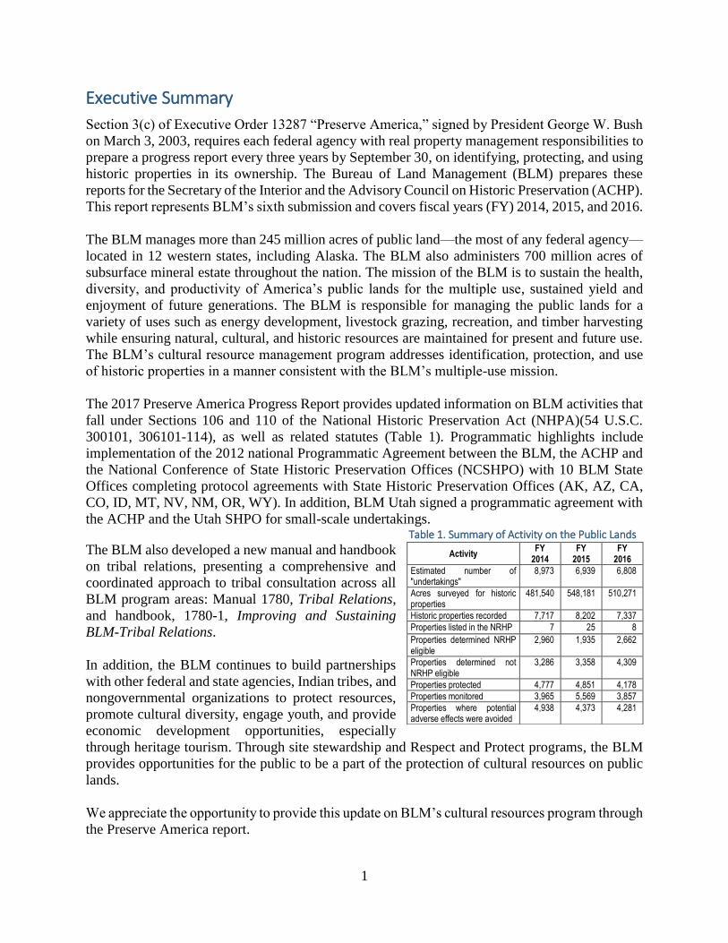
The 2017 Preserve America Progress Report provides updated information on BLM activities that
fall under Sections 106 and 110 of the National Historic Preservation Act (NHPA)(54 U.S.C.
300101, 306101-114), as well as related statutes (Table 1). Programmatic highlights include
implementation of the 2012 national Programmatic Agreement between the BLM, the ACHP and
the National Conference of State Historic Preservation Offices (NCSHPO) with 10 BLM State
Offices completing protocol agreements with State Historic Preservation Offices (AK, AZ, CA,
CO, ID, MT, NV, NM, OR, WY). In addition, BLM Utah signed a programmatic agreement with
the ACHP and the Utah SHPO for small-scale undertakings. Table 1. Summary of Activity on the Public Lands
The BLM also developed a new manual and handbook
on tribal relations, presenting a comprehensive and
coordinated approach to tribal consultation across all
BLM program areas: Manual 1780, Tribal Relations,
and handbook, 1780-1, Improving and Sustaining
BLM-Tribal Relations.
In addition, the BLM continues to build partnerships
with other federal and state agencies, Indian tribes, and
nongovernmental organizations to protect resources,
promote cultural diversity, engage youth, and provide
economic development opportunities, especially
through heritage tourism. Through site stewardship and Respect and Protect programs, the BLM
provides opportunities for the public to be a part of the protection of cultural resources on public
lands.
We appreciate the opportunity to provide this update on BLM’s cultural resources program through
the Preserve America report.
Activity FY
2014 FY
2015 FY
2016
Estimated number of "undertakings"
8,973 6,939 6,808
Acres surveyed for historic properties
481,540 548,181 510,271
Historic properties recorded 7,717 8,202 7,337
Properties listed in the NRHP 7 25 8
Properties determined NRHP eligible
2,960 1,935 2,662
Properties determined not NRHP eligible
3,286 3,358 4,309
Properties protected 4,777 4,851 4,178
Properties monitored 3,965 5,569 3,857
Properties where potential adverse effects were avoided
4,938 4,373 4,281

2
1. Introduction
The BLM 2017 Preserve America presents a “status” update on the bureau’s efforts to inventory,
protect, and use the historic properties on public lands. The report is organized following,
generally, the ACHP Guidelines for Section 3 reports and is designed to be responsive to the
questions and prompts in those guidelines.
The report first provides a general overview of the BLM, the Cultural Program, and resources,
both staffing and budget. The main body of the report is organized into three sections: Identifying
Historic Properties, Protecting Historic Properties and Using Historic Properties. These three
sections include both relevant statistics and case studies from the field that illustrate the scope and
extent of work accomplished on public lands.
The BLM Organization
The BLM is a multiple-use land management agency with the mission “to sustain the health,
productivity, and diversity of America’s public lands for the use and enjoyment of present and
future generations.” BLM is an agency within the U. S. Department of the Interior that was
established in 1946, with the merging of the U.S. Grazing Service with the General Land Office
(GLO). Mandated by the Federal Lands Policy Management Act of 1976 (FLPMA), the BLM
must manage resources on these public lands for a variety of uses, such as energy development,
livestock grazing, recreation, and timber harvesting, while protecting a wide array of natural,
cultural, and historical resources.
Today, the BLM manages 245 million acres, most of which are located in 11 Western states and
Alaska, and 700 million acres of sub-surface mineral estate throughout the nation. BLM is a tiered
organization, with 12 state offices, under which there are district and field offices.
Cultural Heritage Program Overview
The cultural resources managed by the BLM represent all major periods, events, and communities
in the broad sweep of human activity in the western United States over the last 12,000 years. The
BLM manages these resources to benefit the public, ensuring the cultural, educational, aesthetic,
inspirational, and scientific values are preserved, and the recreational and economic benefits are
realized for today’s communities as well as future generations in compliance with Federal laws
and regulations.
The BLM is responsible for the largest, most diverse and scientifically important aggregation of
cultural, historical, and paleontological resources on public lands, as well as the museum
collections and data associated with these heritage resources. The Cultural Program coordinates
conformance with the National Historic Preservation Act, Archaeological Resources Protection
Act (ARPA), Native American Graves Protection and Repatriation Act (NAGPRA),
Paleontological Resources Protection Act (PRPA), among other statutes addressing management
of heritage resources.
FLPMA is BLM’s organic act. It states, “the public lands be managed in a manner that will protect
the quality of scientific, scenic, historical, ecological, environmental, air and atmospheric, water
resource, and archeological values; that, where appropriate, will preserve and protect certain public

3
lands in the natural condition…” This includes the identification and management of cultural
resources. BLM policies specific to cultural resources are provided in the BLM 8100 Manual series
as the primary policy and implementation guidance in response to federal laws, regulations and
orders.
The program provides expertise and capabilities to facilitate compliance with Section 106 of the
NHPA, which requires the BLM to take into account the effects of its actions on historic properties,
and avoid, minimize or mitigate adverse effects. Annually, the BLM reviews an estimated 8,600
land use proposals for energy development, mining, recreation, vegetation restoration, grazing and
other activities for potential effects on properties listed, or eligible for listing on, the National
Register of Historic Places.
The BLM’s national Programmatic Agreement with the ACHP and the NCSHPO is a critical
mechanism for achieving efficiencies in the Section 106 review process. In addition, the tools and
processes developed by the Cultural Resources Management Program streamline the compliance
process, providing flexibility and cost-savings for the bureau and land-users.
Staffing Resources
BLM State Directors, District Managers, and Field Managers are responsible for primary
operational compliance with the NHPA, advised by professional staff. Each of the State Offices
employs a Cultural Program Lead, or Deputy Preservation Officer, with one or more archaeologists
in district and field offices. BLM currently has 212 archaeology positions and approximately 18
vacancies across the program. This is a small number of employees tasked with the management
of cultural resources across 245 million acres of BLM-administered land. With an average ratio of
1.5 million acres of public land per cultural specialist, the focus of the BLM’s management of
cultural resources is directed toward Section 106 compliance review, on-the-ground inventory,
monitoring, and stabilization of archaeological sites and historic properties. Most proactive
cultural resource work is accomplished through cost-share partnerships with state, local, tribal, and
non-profit organizations. Section 106 compliance work includes reviewing the reports associated
with federal undertakings that are tied to applications from various industries (oil and gas, mineral
extraction such as coal and bentonite, and renewable resources such as wind and solar). However,
BLM also conducts work for in-house projects such as water guzzlers for the wildlife program,
range improvements for grazing leases, gathers of wild horses, and maintenance of recreation sites
and campgrounds. Cultural resource management reports are predominantly produced by
archaeological consultants. Over the reporting period BLM received and processed 881 cultural
resource permit applications; most of these are for compliance activities, though some are for
research work. BLM permits in effect averaged 739 for the FY 2014-2016 time period and permits
under which work was actually conducted averaged 448.
The BLM Cultural Resources Program Budget
Funds appropriated to the BLM through the Land Resources Activity, Cultural Resources
Subactivity (L1050), are to support the bureau’s management activities, with the exception of
project-level review, assessment, evaluation and mitigation required for compliance with Section
106 of the NHPA. The benefitting subactivity model employed by the BLM directs that the
program initiating the Federal undertaking fund these compliance activities. Therefore,

4
Appropriations for the BLM Cultural
Resources Management Program for FY
2014-2016 are presented in Table 2. A $1
million increase in FY 2016 returned the
program to the funding level from prior
to the FY 2014 sequester decrease.
The Cultural Resources Management Program helps streamline the NHPA Section 106 compliance
requirements by applying alternative strategies that allow for a more efficient review process for
other BLM programs and land-use proponents. While the benefitting program or the proponent
funds project compliance costs, the innovative tools and alternative processes developed by the
program support the compliance process, providing significant cost-savings and efficiencies.
Support includes the negotiation and implementation of the national programmatic agreement,
agreements with State Historic Preservation Offices, and training personnel on alternative
compliance tools.
Budget Accountability
Through the distribution of funds for Cultural Resources Management activities, including Section
110 activities, the BLM identifies and reviews the budget accomplishments to ensure compliance
with program directives and appropriate funding usage.
The Department of the Interior Strategic Plan for Fiscal Years 2014-2018 tracks protection of
cultural and heritage resources under Mission Area 1: Celebrating and Enhancing America’s Great
Outdoors. The BLM tracks condition of archaeological sites, historic structures and museum
collections to report to three performance goals. Data for the reporting period is provided in Table
3. Table 3. Performance Metrics for FY 2014-2016
Performance Measure FY 2014 FY 2015 FY 2016
% of Archaeological Sites in Good Condition 85%
68,588/80,685 85%
70,000/82,350 86%
77,412/90,259
% of Historic Structures in Good Condition 51%
221/431 51%
225/435 51%
216/425
% Museum Collections in Good Condition 84%
132/158 85%
135/159 87%
144/165
The BLM uses an activity-based system for collecting data on labor and operation costs, through
a combination of the Federal Business Management System (FBMS), which manages financial
data and the Performance Data Management System (PDMS), which manages units of
accomplishment. Each activity conducted in the BLM is assigned a program element code to
record the cost of work activities and outputs. Program elements connect costs to strategic goals,
performance goals, and workload measures. These workload measures are summarized below
(Table 4).
Table 4. Cultural Program Workload Measures
Code Workload Measure Metric
AE Heritage Resources Education and Outreach Number of presentations or
educational products
BC Acres Inventoried for Heritage Resources Number of acres
Table 2. Summary of Appropriated Funding for the Cultural Resource Management Program
Fiscal Year 2014 2015 2016
Enacted Budget $15,131,000 $15,131,000 $16,131,000
5
FD Heritage Resources Intensively Recorded, Evaluated and Studied Number of sites
HF Heritage Resources Stabilized, Managed and Protected Number of sites
KO Historic Structures Managed Number of structures
MY Heritage Resources Monitored Number of sites
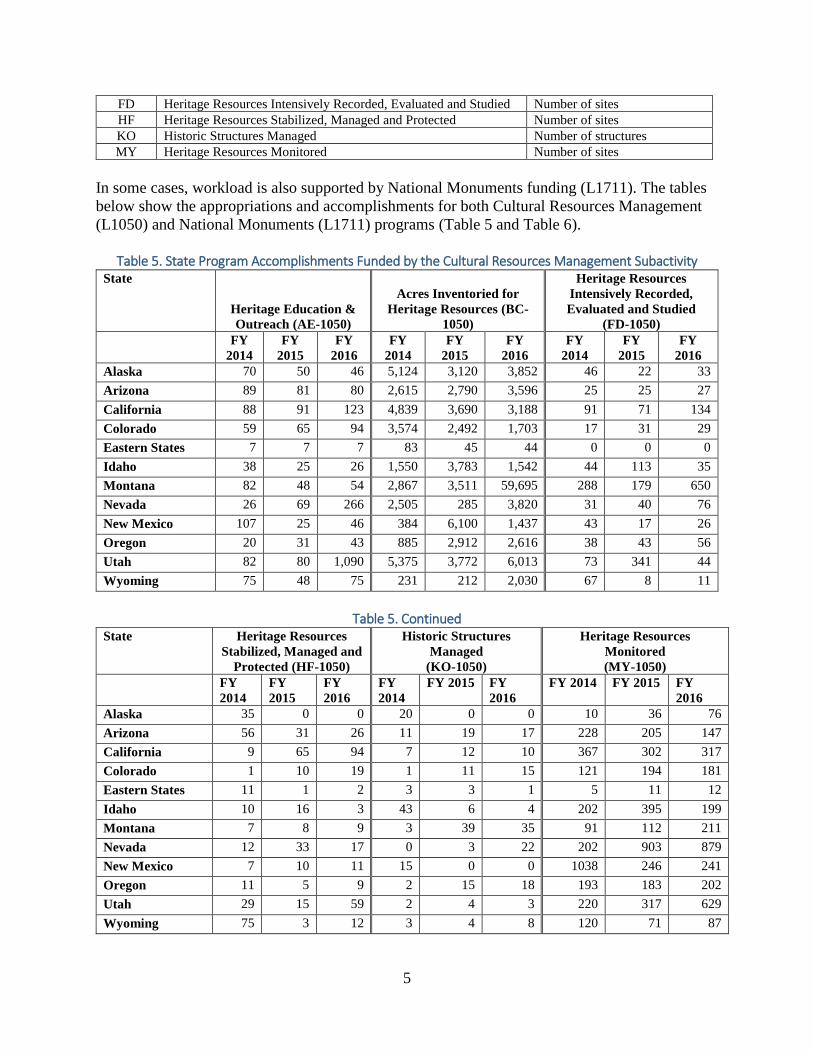
In some cases, workload is also supported by National Monuments funding (L1711). The tables
below show the appropriations and accomplishments for both Cultural Resources Management
(L1050) and National Monuments (L1711) programs (Table 5 and Table 6).
Table 5. State Program Accomplishments Funded by the Cultural Resources Management Subactivity
State
Heritage Education &
Outreach (AE-1050)
Acres Inventoried for
Heritage Resources (BC-
1050)
Heritage Resources
Intensively Recorded,
Evaluated and Studied
(FD-1050)
FY
2014
FY
2015
FY
2016
FY
2014
FY
2015
FY
2016
FY
2014
FY
2015
FY
2016
Alaska 70 50 46 5,124 3,120 3,852 46 22 33
Arizona 89 81 80 2,615 2,790 3,596 25 25 27
California 88 91 123 4,839 3,690 3,188 91 71 134
Colorado 59 65 94 3,574 2,492 1,703 17 31 29
Eastern States 7 7 7 83 45 44 0 0 0
Idaho 38 25 26 1,550 3,783 1,542 44 113 35
Montana 82 48 54 2,867 3,511 59,695 288 179 650
Nevada 26 69 266 2,505 285 3,820 31 40 76
New Mexico 107 25 46 384 6,100 1,437 43 17 26
Oregon 20 31 43 885 2,912 2,616 38 43 56
Utah 82 80 1,090 5,375 3,772 6,013 73 341 44
Wyoming 75 48 75 231 212 2,030 67 8 11
Table 5. Continued
State Heritage Resources
Stabilized, Managed and
Protected (HF-1050)
Historic Structures
Managed
(KO-1050)
Heritage Resources
Monitored
(MY-1050)
FY
2014
FY
2015
FY
2016
FY
2014
FY 2015 FY
2016
FY 2014 FY 2015 FY
2016
Alaska 35 0 0 20 0 0 10 36 76
Arizona 56 31 26 11 19 17 228 205 147
California 9 65 94 7 12 10 367 302 317
Colorado 1 10 19 1 11 15 121 194 181
Eastern States 11 1 2 3 3 1 5 11 12
Idaho 10 16 3 43 6 4 202 395 199
Montana 7 8 9 3 39 35 91 112 211
Nevada 12 33 17 0 3 22 202 903 879
New Mexico 7 10 11 15 0 0 1038 246 241
Oregon 11 5 9 2 15 18 193 183 202
Utah 29 15 59 2 4 3 220 317 629
Wyoming 75 3 12 3 4 8 120 71 87

6
Table 6. State Program Accomplishments Funded by the National Monuments Subactivity
State Heritage Education &
Outreach (AE-1711)
Acres Inventoried for Heritage
Resources (BC-1711)
Heritage Resources Intensively
Recorded, Evaluated and
Studied (FD-1711)
FY
2014
FY
2015
FY
2016
FY 2014 FY 2015 FY 2016 FY 2014 FY 2015 FY 2016
Alaska 0 0 0 650 0 0 7 0 0
Arizona 83 93 108 550 480 150 17 10 7
California 1,463 1,522 1,216 0 150 50 13 10 6
Colorado 428 482 476 460 220 528 22 3 6
Eastern
States 300 2,908 2,808 0 0 0 0 0 0
Idaho 2 6 4 130 190 6,665 0 0 0
Montana 403 202 7,951 0 0 0 0 0 0
Nevada 38 15 31 250 250 208 0 0 0
New
Mexico 27 2 31 10 10 165 0 0 0
Oregon 2 1515 0 0 0 0 0 0
Utah 219 149 209 3,283 3,752 3,455 57 112 36
Wyoming 0 0 0 0 0 0 0 0 0
Table 6. Continued State Heritage Resources
Stabilized, Managed and
Protected (HF-1711)
Historic Structures Managed
(KO-1711)
Heritage Resources Monitored
(MY-1711)
FY
2014
FY
2015
FY
2016
FY 2014 FY 2015 FY 2016 FY 2014 FY 2015 FY 2016
Alaska 0 0 0 0 0 0 0 0 0
Arizona 16 18 19 16 16 18 0 0 0
California 33 40 30 6 7 4 193 209 223
Colorado 5 3 4 0 0 0 65 43 32
Eastern
States 0 2 0 2 3 4 194 95 516
Idaho 0 0 0 0 0 0 15 16 8
Montana 1 0 0 0 0 0 10 9 0
Nevada 1 1 2 0 0 0 8 0 20
New
Mexico 19 0 5 0 0 0 7 7 17
Oregon 3 0 0 1 1 1 19 0 0
Utah 8 7 15 5 8 5 190 155 145
Wyoming 0 0 0 0 0 0 0 0 0
Reporting on Management Activities
The program informs on activities annually under many reports, including the report to Congress
on the federal archaeology program collated by the National Park Service; to the State Historic
Preservation Officers under state protocols; to the ACHP under the national Programmatic
Agreement; to the public lands statistics; to the DOI performance and accountability report; to the
7
museum collections management summary; to the annual interagency report on the National Trails
System; and to the collectible and noncollectible heritage assets portion of the BLM financial
statement. These reports typically contain statistics about inventory, evaluation, data recovery,
permits, law enforcement activities, education and outreach, and tribal consultation. In addition,
other reports discuss BLM’s museum collections; status of trails (changes in length, protection,
monitoring of high potential sites and segments); budget information and changes in BLM’s land
base. The information in these reports typically go to BLM management, as well as to the
Department of the Interior and often, on to Congress or other entities interested in how the federal
government uses its dollars.
Data Management
Cultural Resources Data Coordination and Sharing
The Bureau’s 20 year data sharing partnership with the western State Historic Preservation Offices
continues to make data available to scholars, consultants, other agencies, and tribes. The
partnership includes financial support to SHPOs, as well as technical support between SHPOs and
BLM. The BLM data stewards in each state work with SHPO staff to manage the exchange system,
keeping the flow of GIS shapefiles and other cultural resource information going between offices.
Historic Structures and the Federal Real Property Profile
The Federal Real Property Profile (FRPP) is only used by the cultural program as part of the
historic structures report. The FRPP program is managed by the engineering program. States
complete a table identifying their historic structures (named sites, structures and districts) and
include condition (good, fair, poor, unknown), determinations of eligibility for the National
Register, jurisdictional location, and locational information such as latitude and longitude. The
table below shows the number of historic structures reported by BLM for the years FY 2014-2016
and how many have a FRPP number (Table 7). A structure may be removed from the list for a
variety of reasons which include: a determination that the structure is not historic or that the
structure was lost due to wildfire or other destruction. If a historic structure is located on the public
lands, then it can be added to the list. The BLM continues to identify historic structures and add
them to the list.
Table 7. BLM Historic Structures and properties with a FRPP number.
State Number of Historic Structures # of properties with FRPP
number
FY 2014 FY 2015 FY 2016 FY
2014
FY
2015
FY
2016
Alaska 22 22 22 8 8 8
Arizona 44 44 45 12 12 12
California 53 55 51 22 21 20
Colorado 64 60 60 6 6 6
Eastern States 3 3 3 1 1 1
Idaho 63 63 63 1 1 1
Montana (+SD/ND) 25 25 25 10 10 10
Nevada 31 31 31 11 12 12
New Mexico (+OK, TX, KS) 35 35 35 1 1 1

8
Oregon/Washington 39 39 39 20 20 20
Utah 14 14 12 2 2 2
Wyoming 38 38 39 1 1 1
The BLM complies with Executive Order 13327, “Federal Real Property Asset Management,” by
reporting real property to the FRPP database. The BLM Cultural Resources Program maintains a
list of Historic Structures, which includes historic-period structures on which maintenance dollars
have been spent. This inventory is cross-referenced with the FRPP. Of the 425 historic structures
reported to the Cultural Resources Program in FY 2016, 140 were included in the FRPP. The
BLM Engineering Program provides the criteria for what should be listed in the FRPP. The 141
listings include 1 National Historic Landmark, 44 properties listed on the National Register, 57
properties determined to be eligible for the National Register, five properties determined not to be
eligible, and 34 properties that have not been evaluated.
Museum Collections
The BLM manages more than 10 million artifacts and specimens recovered from significant
cultural and paleontological resources located on public lands. Collections are derived from
research projects and regulatory compliance work for proposed land-use activities, and are
managed in three BLM facilities, five other Federal sites managed by the National Park Service,
and 158 non-federal museum and university repositories. The BLM’s goals for these collections
are to preserve artifacts and specimens for the benefit of future generations, to document them in
order to provide intellectual access and inventory accountability, and to provide opportunities for
researchers and the public to enjoy and use the collections.
Most artifacts and specimens from the public lands are housed in non-federal repositories, a result
of the permitting requirements under the Antiquities Act and ARPA. In general, the BLM does
not maintain internal facilities for managing collections, and instead partners with museums and
universities with the requisite expertise and capacity for managing collections. More than 5
million artifacts have so far been documented in non-federal repositories, and there are likely
upwards of 15 million, based on projections and considering all collections made since 1906 when
the Federal government first started regulating the gathering of objects from Federal lands.
The BLM does maintain three repositories, each unique and developed to provide a specific
regional need. The Anasazi Heritage Center (AHC) in Dolores, Colorado, is a museum of the
Ancestral Puebloan (or Anasazi) Cultural and other Native cultures in the Four Corners region.
The Billings Curation Center is located at the BLM Montana State Office and curates collections
from the region. The National Historic Oregon Trail Interpretive Center (NHOTIC) houses
collections related to the historic Oregon Trail migration story, preservation of the National
Historic Trail, and topics of early settlement and mining, natural history, and the Native American
interface with emigrants and early settlers along the trail route. That facility is located in Baker
City, Oregon.

9
2. Identifying Historic Properties: Inventory and Survey
Through FY 2016, the BLM cumulatively has surveyed more than 25 million acres (approximately
10 percent of BLM surface lands) for historic properties, with an average of 669,967 acres
surveyed annually from FY 2014 through FY 2016. As in previous years, the majority of the
inventory work was funded by land use applicants and performed by one of the more than 739
consultants permitted by the BLM (Table 8, Table 9 & Table 10).
Table 8. Summary of Literature Reviews and Undertakings Requiring Inventory
BLM State Office
Literature Reviews Undertakings with Inventory
FY 2014 FY 2015 FY 2016 FY 2014 FY 2015 FY 2016
Alaska 138 131 140 20 23 18
Arizona 223 266 272 143 144 137
California 666 637 527 285 287 263
Colorado 414 576 455 244 264 233
Eastern States 36 6 0 1 0 0
Idaho 314 274 322 179 130 123
Montana 655 835 433 430 452 211
Nevada 310 349 315 165 156 248
New Mexico 2,363 1,008 1,512 1,678 1,460 1,277
Oregon 515 387 414 192 217 152
Utah 943 304 457 610 389 285
Wyoming 2,396 2,166 1,961 1,294 1,216 923
Total by year 8,973 6,939 6,808 5,241 4,738 3,870
Total for period 22,720 literature reviews 13,849 undertakings with inventory
Table 9. Summary of Acres Inventoried for Cultural Resources
BLM State Office
Acres Inventoried BLM Acres Inventoried non-BLM
FY 2014 FY 2015 FY 2016 FY 2014 FY 2015 FY 2016
Alaska 8,122 9,016 5,977 265 125 4
Arizona 13,477 13,513 15,217 34,091 1,761 3,002
California 62,994 74,177 34,211 10,799 15,855 3,598
Colorado 34,418 31,022 27,447 7,578 3,576 3,562
Eastern States 0 5 0 4 0 0
Idaho 31,379 20,842 78,203 949 6,701 982
Montana 18,773 18,954 24,860 25,200 36,350 7,391
Nevada 63,126 109,367 102,336 3,129 6,800 2,565
New Mexico 41,783 40,754 83,030 33,303 37,568 57,349
Oregon 39,049 53,584 32,694 615 464 0
Utah 104,265 112,502 71,586 18,568 22,825 6,732
Wyoming 64,154 64,445 34,710 50,906 38,202 29,089
Total by year 481,540 54,8181 510,271 185,407 170,227 114,274
Total for period 1,539,992 BLM acres inventoried 469,908 non-BLM acres inventoried

10
Table 10. Summary of Sites Identified
BLM State Office
New Sites Discovered BLM New Sites Discovered Non-BLM
FY 2014 FY 2015 FY 2016 FY 2014 FY 2015 FY 2016
Alaska 135 70 70 7 4 0
Arizona 213 260 181 248 36 93
California 769 1,577 896 391 527 60
Colorado 1,434 1,076 692 279 186 162
Eastern States 3 5 0 0 0 0
Idaho 395 375 1,307 7 35 2
Montana 143 240 199 331 367 38
Nevada 1,079 1,606 1,603 88 90 532
New Mexico 652 478 708 267 260 350
Oregon 335 655 335 77 23 0
Utah 1,713 1,326 775 259 171 66
Wyoming 846 534 571 651 408 245
Total by year 7,717 8,202 7,337 2,605 2,107 1,548
Total for period 23,256 sites discovered on BLM 6,260 sites discovered on non-BLM
The BLM has recorded more than 381,771 cultural properties in surveys on BLM-administered
surface lands through FY 2016.
The BLM recorded and designated 7,557 historic properties during the reporting period (FYs
2014-2016), bringing the total number of historic properties on BLM public lands to 57,291.
During the same period, the BLM added 12 historic properties to the National Register of Historic
Places, containing 204 individual contributing properties. Cultural resources are predominantly
recorded due to activities occurring as a result of Section 106 compliance work. These activities
include applicant-sponsored oil and gas wells and associated infrastructure such as pipelines and
roads, wind turbines, mining activities for coal, bentonite, gravel and other extractive industries,
transmission lines, and telecommunications facilities and arrays. Undertakings are also associated
with in-house projects such as recreation developments like campgrounds, projects associated with
grazing and range management, wildland fire and vegetation management.
BLM states typically require all cultural resources within an area of potential effect to be evaluated
under the criteria of eligibility found within the National Register. However, sometimes sites are
left unevaluated. During the reporting timeframe, approximately 4,746 sites were left unevaluated.
This is an increase of about 577 sites since the 2014 report.
Examples of Identification Efforts
Following are examples of proactive identification projects. These projects were promoted by the
applicable field office that sought funding to produce the project, either through BLM funds or
through partnership opportunities.

11
Unmanned Aerial Systems (UAS)
BLM Nevada coordinated with students and faculty from the University of Nevada Reno (UNR)
archaeology and engineering programs to record and monitor archaeological sites using Unmanned
Aerial Systems (UAS) (Figure 1). The UNR Nevada Advanced Autonomous Systems Innovation
Center (NAASIC) used UAS (drones) to capture high resolution photography of an archaeological
site on public land. The UAS recorded detailed and
overview imagery of areas that contain prehistoric
petroglyphs, rock rings, and other features. This
study will allow UNR and BLM to discover
methods that work well in the field and what
improvements can be made to increase the field
tools available for archaeologists. Products
expected include the creation of three-dimensional
(3D) maps of cultural landscapes and high quality
imagery that can be used to digitally analyze and
measure petroglyphs and archaeological features.
In BLM Montana, prescribed fire
work intersected with the Henry
Smith Site, a large prehistoric
archaeological site in mixed grass
prairie with significantly dense stone
features (Figure 2). Primarily
designed to remove vegetation to
allow for research work, the fire
provided a clear view of an Avonlea
period cultural resource complex.
The site consists of numerous stone
effigies, both anthropomorphic and
zoomorphic, stone cairns, drive lines,
and stone circles across several
hundred acres. The resources were
mapped using an unmanned aerial
vehicle (UAV) that took aerial
imagery and created a 3D map of the
entire site (Figure 3). This was the first time UAV technology has been used for archaeology in
the northern plains. In addition, during the prescribed fire, the Missoula Fire Sciences Laboratory
placed temperature sensors within designated “mock” cultural sites which consisted of both faunal
(bone) and lithic (stone) remains. The instruments gathered data that, after study, will allow BLM
to better determine the grass-fueled fire’s maximum temperature and understand its interaction
with cultural resources.
Figure 1. Drone being used to record and monitor sites.
Figure 2. Henry Smith Site with stone feature in foreground and prescribed fire in background.
12
Driveline
Tepee Rings(unburned)
Tepee Rings(burned)
Effigy?
Vision Quest Site?
Figure 3. Aerial imagery of the Henry Smith Site with feature locations.
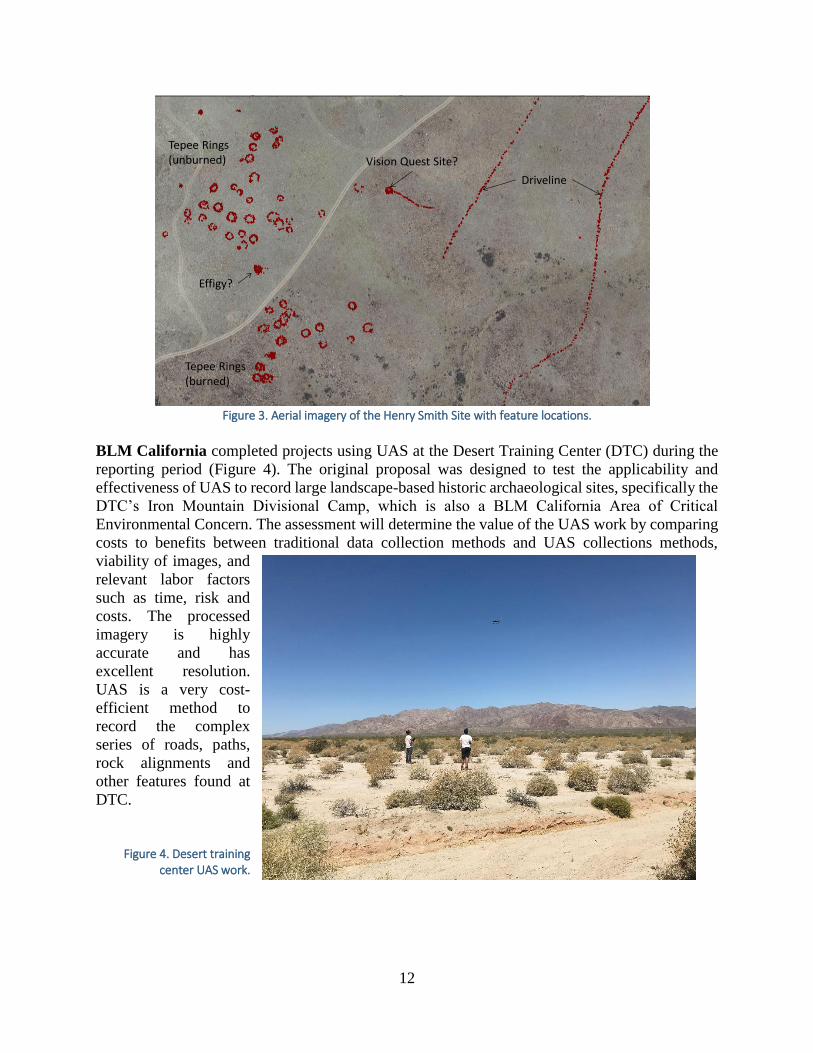
BLM California completed projects using UAS at the Desert Training Center (DTC) during the
reporting period (Figure 4). The original proposal was designed to test the applicability and
effectiveness of UAS to record large landscape-based historic archaeological sites, specifically the
DTC’s Iron Mountain Divisional Camp, which is also a BLM California Area of Critical
Environmental Concern. The assessment will determine the value of the UAS work by comparing
costs to benefits between traditional data collection methods and UAS collections methods,
viability of images, and
relevant labor factors
such as time, risk and
costs. The processed
imagery is highly
accurate and has
excellent resolution.
UAS is a very cost-
efficient method to
record the complex
series of roads, paths,
rock alignments and
other features found at
DTC.
Figure 4. Desert training
center UAS work.

13
Targeted Survey
Identification work continued in the Grand Staircase Escalante National Monument (GSENM) in
BLM Utah and the BLM’s work with the Colorado Plateau Archaeological Alliance.
Archaeologists conducted inventories in grazing allotments lacking cultural resource information,
as well as monitored known archaeological sites for grazing-related impacts. Using site forms with
a “grazing impacts” check box, monitoring activities provided interesting results (Figure 5). While
certain sites and classes of sites do suffer from livestock activities, the majority of monitored sites
show cattle use, but no grazing-related
adverse effects. This finding
underscores the necessity for accuracy
in describing aspects such as impacts to
sites. The Utah site form check box
should not be used to simply indicate
signs of livestock, but for adverse
effects to cultural resources from
livestock. Consultants were informed
of these findings and asked to be more
accurate when describing the nature of
grazing-related impacts. The
photograph to the right shows a BLM
archaeologist and a volunteer recording
an archaeological site on the
Kaiparowits Plateau in GSENM.
BLM Colorado focused on inventory of two aboriginal trail systems within the Colorado River
corridor. These and other trails are historically significant to today’s living descendants of the Ute
people and the professional and public communities that value the study of Ute heritage and early
western Colorado history.
Figure 6. Overview of aboriginal trail systems within the Colorado River Corridor.
Centrally located in the Ute Indian Tribes aboriginal territory, the two selected trail segments are
part of the Sawatch Mountains system (Pisgah Mountain Section) and White River Plateau system
(Dotsero Section) (Figure 6). A total of 2500 acres were included in a reconnaissance survey for
cultural resources. Overall, 33 sites and 71 isolated finds were identified and documented during
Figure 5. GSENM staff recording site and grazing impacts.

14
the project. Sites located within the Pisgah Mountain Section of the trail are associated with springs
and exhibit diagnostics from the Early Archaic (ca.5500-3750 BC) and possible Foothill-Mountain
complex (ca.9500-700 BC), which indicated this trail was used for a long period of time. Newly
recorded sites indicated an Early Numic and Protohistoric/ Historic Ute occupation of the area
from artifacts such as diagnostic Desert side-notched and Cottonwood Triangular points and a
Leaf-shape knife; a campsite with gun parts and Euroamerican tent poles associated with a metal
lance point and other Ute artifacts; four brush game blinds associated with game trails, and several
other sites with the configuration of Numic camps. The Dotsero Section proved less productive
based on a low number of sites and isolates and a lack of diagnostic artifacts. The low site density
may be attributed to the lack of springs in the immediate vicinity and to the high relief of the
terrain. The photograph above provides a panoramic overview of the Pisgah study area looking
south toward Pisgah Mountain.
Photogrammetry
In partnership with Colorado State University (CSU), BLM Colorado’s White River Field Office
hosted a 12 day archeological field school in the Miller Creek Archeological District. The project
provided teaching, training, and research opportunities for undergraduate and graduate
students and faculty from CSU. Approximately 24 students from CSU carried out minor systematic
testing of a Fremont era pit structure and a previously looted rock shelter to locate intact buried
cultural deposits (Figure 7). Students also learned photogrammetric (3-D) mapping at several of
the better preserved corn storage granaries. Photogrammetric mapping will create 3-D models of
features that can be used for public interpretation, condition assessment, and volumetric research
on granary size. Lastly, students were able to participate in Class III survey to look for previously
undocumented cultural resources alongside BLM archaeologists. Above is a photograph of a
Fremont granary in Skull Creek rock shelter.
Figure 7. Miller Creek Archaeological District rock shelter.

15
Light Detection and Ranging (LiDAR)
BLM New Mexico Farmington Field Office archaeologists continue to be technical advisors with
the BLM National Operations Center (NOC) regarding LiDAR acquisition efforts in the field
office. Farmington Field Office requested additional funds through the unfunded needs request at
midyear in 2016 and obtained additional funding from planning. The field office worked with the
NOC to complete a Scope of Work for LiDAR acquisition for planning and cultural resources. The
task order was issued for Geospatial Technical Data Support Services. Data acquisition for 1,486
square miles of coverage to identity prehistoric Chaco roads is expected to be completed by the
end of September 2016. The photograph below shows a one meter resolution hillshade derived
QL2 LiDAR acquisition, displaying a Chacoan Road in the Aztec Ruins National Monument Area
(Figure 8). This image is similar to what BLM will obtain through the contract.
Partnerships in Identification
BLM works with a multitude of partners, including other federal agencies, state agencies, tribes,
local governments and private organizations, in complying with both Section 106 and Section 110
of the NHPA, as well as other laws and regulations. Through these partnerships, BLM assets
(dollars and time) are combined with other funding, allowing investment into programs that are
effective, sustainable and enduring.
Figure 8. LiDAR Data showing Chacoan Road.

16
Public
The BLM Nevada Black Rock Field Office
hosted almost 30 volunteers from Trails
West and the Oregon and California Trails
Association for a weekend project at
Massacre Ranch. Using sniffer dogs, BLM
investigated two possible emigrant trail
burial sites (with negative results), a site
form for a buried emigrant wagon was
updated, and three segments of the
Applegate Trail were confirmed as original
trail traces (Figure 9). The photograph at
right shows the volunteers on-site. Figure 9. Trail volunteers conduct field investigations.
In BLM Wyoming, the Buffalo Field Office hosted its seventh Passport in Time (PIT) project.
Several volunteers documented impacts from a range improvement water pipeline constructed
through a buried unevaluated prehistoric site. The original range improvement project was a
Section 106 foreclosure and the site was discovered after the pipeline was constructed. After
consultation with the Wyoming State Historic
Preservation Office, BLM utilized PIT
volunteers to excavate shovel tests and 1x1
meter units in order to make a determination
of eligibility and document any damage the
pipeline caused to portions of the site (Figure
10). As a result of the fieldwork, the site was
determined not eligible to the NRHP. After
one week spent in the field, an additional
week was spent in the lab while PIT
volunteers prepared recovered artifacts for
curation. The photograph (at right) shows the
volunteers conducting test excavations at the
site within the Welch Ranch Management
Area.
Tribal Partnerships
BLM Montana continued its partnership with Chief Dull Knife College and the Northern
Cheyenne Tribe on an Ecoregional Ethnographic Assessment. The effort has focused on
developing a process to identify, document, evaluate, and map places of traditional religious or
cultural significance to the tribe, to identify culturally important plant and animal species and their
associated ecosystems that are critical for the maintenance of Northern Cheyenne cultures and
traditions and to assess the potential effects of identified change agents upon resources important
and significant to the tribe. The project focuses on Elders’ stories, memories and their language,
which provides a narrative about the important places on the landscape including heritage sites,
features, plants, animals, and birds. The emphasis is also on their aboriginal territory where BLM
Figure 10. PIT project investigations.

17
has partial jurisdiction. All of this information is being placed into a geospatial database that will
provide important data to the college, tribal members, and BLM. The tribe benefits by capturing
this legacy data for present and future generations. BLM benefits by gaining a better understanding
of the tribe’s significant resources and by being able to make more informed land management
decisions. BLM plans to begin work with the Crow and Yankton Sioux Tribes on similar projects.
Several BLM states are involved in collaborative efforts with tribes to train and participate in both
stewardship and Section 106 projects. In BLM Nevada, an active tribal monitoring program was
created with the Te-Moak Tribe of Shoshone Indians of Nevada and the constituent bands. This
“landscape” approach emphasizes the tribal monitor’s ability to react to a variety of issues
identified by the tribal community, in order to continue their cultural lifeways on aboriginal
territories currently managed by the BLM District. Over 20 participants have graduated from the
program since 2014 and are now working for their respective communities monitoring projects on
public and private land.
3. Protecting Historic Properties
BLM’s cultural resources management program strives to protect heritage resources from natural
or human-caused impacts or deterioration so that their values can be fully realized over time. The
program assesses potential vulnerabilities of heritage resources and develops strategies to avoid,
minimize, and mitigate potential adverse impacts from various sources. This includes monitoring
heritage resources to assess condition and trends with regard to natural and human caused impacts.
Once identified, BLM implements the appropriate physical or administrative conservation
measures.
In FY 2014, the BLM placed some type of protection measure on 4,777 cultural properties. This
number rose slightly to 4,851 in 2015, primarily due to an increase in on-the-ground monitoring,
and then declined to 4,178 in 2016. From FY 2014 through FY 2016, the BLM completed 547 new
signs, 254 new gates or fences, 347 stabilization actions, and 634 maintenance activities. The BLM
assigned an additional 4,399 properties some form of administrative protection, such as closure,
withdrawal from mineral leasing, or designation as an area of critical environmental concern
(ACEC).
Partnerships in Protection
Almost every BLM state has a site stewardship program of some kind. Some states like Arizona
and California have been working with volunteer stewards for decades, while others are building
their base program. Steward volunteers are trained in field and recording techniques such as
pedestrian inventory strategies and intensive site recordation. They record new sites and monitor
previously discovered sites, providing important support for Section 110 responsibilities.
BLM law enforcement rangers also add to the cultural program’s monitoring and protection
efforts. Rangers from one BLM state completed 732 patrol checks of cultural (and paleontological)
sites in 2016. That number averages to 2 per day throughout the year.

18
State Partnerships
As part of the state protocol, BLM Oregon has joined in partnership with the Oregon State Historic
Preservation Office to permit the use of the Oregon Cultural Resource Information System
(OCRIS). This program, through a custom agency interface for the ORSHPO, will be used as the
consultative vehicle for Section 106 and Section 110 processes and documentation. The OCRIS
will now allow for the exchange of data both seamlessly and digitally between the two agencies.
During 2015 and 2016 there were several OCRIS training sessions offered for internal and external
users as well as consultation and coordination with the National Operations Center (NOC) for
OCRIS servers, configuration, and deployment strategies.
Public Partnerships
BLM California worked on emergency
stabilization of the historic Cleveland
Mill in 2014. The site dates to the early
1870s and was used continuously until
1980. While it has undergone many
alterations, the mill possesses several
characteristics that make it eligible for
listing on the National Register. The
structure contains the original ore bins,
conveyer belts, Pelton wheel,
amalgamating tables, ball mill, and table
separator. Prior to beginning the
stabilization, BLM removed 13 flatbed
truckloads of modern trash and debris
from the site. During site
documentation it was discovered that two foundation walls and the entire south side of the structure
had failed, putting the mill at immediate risk. Using in-kind materials, BLM was able to prevent
the loss of the mill structure and related
features (Figure 11 and Figure 12). The
majority of the stabilization work was
accomplished using skilled volunteer labor
and interns from the Student Conservation
Association. Post-stabilization, the site will
be interpreted for the public and nominated
to the NRHP.
Figure 11. Cleveland Mill roof collapse imminent.
Figure 12. Cleveland Mill after stabilization work.
19
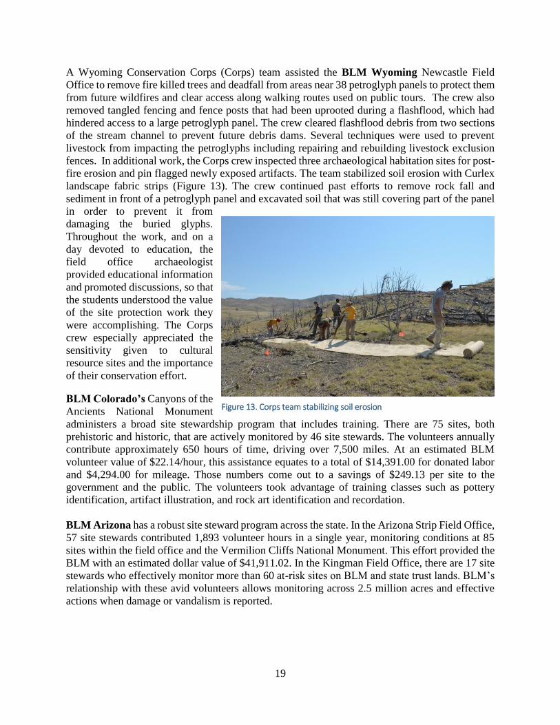
A Wyoming Conservation Corps (Corps) team assisted the BLM Wyoming Newcastle Field
Office to remove fire killed trees and deadfall from areas near 38 petroglyph panels to protect them
from future wildfires and clear access along walking routes used on public tours. The crew also
removed tangled fencing and fence posts that had been uprooted during a flashflood, which had
hindered access to a large petroglyph panel. The crew cleared flashflood debris from two sections
of the stream channel to prevent future debris dams. Several techniques were used to prevent
livestock from impacting the petroglyphs including repairing and rebuilding livestock exclusion
fences. In additional work, the Corps crew inspected three archaeological habitation sites for post-
fire erosion and pin flagged newly exposed artifacts. The team stabilized soil erosion with Curlex
landscape fabric strips (Figure 13). The crew continued past efforts to remove rock fall and
sediment in front of a petroglyph panel and excavated soil that was still covering part of the panel
in order to prevent it from
damaging the buried glyphs.
Throughout the work, and on a
day devoted to education, the
field office archaeologist
provided educational information
and promoted discussions, so that
the students understood the value
of the site protection work they
were accomplishing. The Corps
crew especially appreciated the
sensitivity given to cultural
resource sites and the importance
of their conservation effort.
BLM Colorado’s Canyons of the
Ancients National Monument
administers a broad site stewardship program that includes training. There are 75 sites, both
prehistoric and historic, that are actively monitored by 46 site stewards. The volunteers annually
contribute approximately 650 hours of time, driving over 7,500 miles. At an estimated BLM
volunteer value of $22.14/hour, this assistance equates to a total of $14,391.00 for donated labor
and $4,294.00 for mileage. Those numbers come out to a savings of $249.13 per site to the
government and the public. The volunteers took advantage of training classes such as pottery
identification, artifact illustration, and rock art identification and recordation.
BLM Arizona has a robust site steward program across the state. In the Arizona Strip Field Office,
57 site stewards contributed 1,893 volunteer hours in a single year, monitoring conditions at 85
sites within the field office and the Vermilion Cliffs National Monument. This effort provided the
BLM with an estimated dollar value of $41,911.02. In the Kingman Field Office, there are 17 site
stewards who effectively monitor more than 60 at-risk sites on BLM and state trust lands. BLM’s
relationship with these avid volunteers allows monitoring across 2.5 million acres and effective
actions when damage or vandalism is reported.
Figure 13. Corps team stabilizing soil erosion

20
The BLM Arizona Yuma Field Office actively monitors approximately 30 cultural resource
sites a year. Monitoring is focused on sites where protection efforts are being evaluated. In
particular, two sites just outside of the Yuma Proving Ground are targeted, the Tule Springs
Petroglyph Site (Figure 14) and the
Tule Springs Cabin Site. The sites
are jointly managed with the Yuma
Proving Ground and are extremely
remote, accessible only through the
Proving Ground itself. Despite the
difficult access, the sites are
favorites of the recreating public and
get a lot of visitation during the
winter season. Photographs are taken
each year in order to better assess the
protection needs of each site and
compare changing site conditions to
the baseline documentation. The BLM Montana Site Stewardship Program completed training sessions for new site stewards
each year of the reporting period. In April 2016, the Montana Archaeological Society recognized
the stewardship program with its Conservation Archaeology Award for outstanding efforts in
engaging and training public volunteers in the systematic monitoring and reporting of
archaeological sites on public lands.
BLM New Mexico supports the State Historic Preservation Office’s SiteWatch program. In 2014
BLM’s engineering, cultural and law enforcement programs came together with SiteWatch
volunteers to construct a fence line barrier and install signs to deter off-road vehicle travel, illegal
dumping and vandalism in the vicinity of Hill Top Pueblo. The volunteers monitor critical
archaeological and historical sites, identify looting and other sources of deterioration, install anti-
looting/anti-vandalism signs, and record unreported sites in unexplored areas. In one year, over
5,000 hours of service were donated.
BLM California Central Coast Field Office staff and volunteers from the local community used
traditional building methods and materials to begin stabilization and restoration of the Moccetini
Cheese Barn. Early work addressed immediate life, property, safety issues and subsequent years
will finish stabilization; account for any dairy-related equipment in the barn for possible restoration
or display; and begin long-term restoration of the barn.
When large acreages of vegetation burn in close proximity to
highly populated urban areas, cultural resources can be placed at a
higher risk from unauthorized collection or looting. BLM Idaho
found an opportunity to educate public land users on the
significance of preserving America’s history by placing 12
“Protect America’s Past” signs at highly visible and popular
recreation areas that were burned in the 2015 Soda Fire (Figure
15). These signs include information on the importance of leaving
artifacts in place, about cultural resource laws, and emphasizing stewardship.
Figure 14. Tule Springs Petroglyph Site.
Figure 15. Protect the Past sign.

21
Multi-Agency Initiatives
Since the early 20th century, Utah has had a long and well-documented history of archaeological,
paleontological, and other natural resources being looted and vandalized on federal, state, and
tribal lands. Unfortunately, these issues have continued to the present day, and numerous incidents
on BLM-administered public lands have recently received national and international media
attention. In order to educate the public about the consequences of these behaviors and promote
more responsible outdoor ethics, BLM Utah and Tread Lightly! initiated a partnership to develop
and implement a statewide public awareness campaign called “Respect and Protect,” to engage the
public in the stewardship of our nation’s priceless cultural and natural heritage.
Early data gathered about the project shows that 2 Native American tribes, 7 federal agencies, 10
state government agencies, 2 county governments, 11 universities and colleges, 9 museums, 22
non-profit organizations, 21 private sector businesses, and 38 individuals participated in an online
survey and/or regional stakeholder meetings to identify key issues and messages the public
awareness campaign should emphasize. The logo below was developed out of this effort (Figure
16).
Figure 16. Respect and Protect logo
The online survey was taken by 212 individuals, highlighting that the looting of archaeological
and paleontological resources that occurs for financial gain or personal use demonstrates a clear
lack of respect for Native American cultures and/or America’s collective cultural and natural
history. Other looting, such as taking home an arrowhead, potsherd, or small fossil, demonstrates
a lack of knowledge about laws prohibiting these behaviors and/or a lack of understanding about
the relevance of archaeological resources to contemporary Native American communities.
The intentional vandalism of archaeological, paleontological, and other natural resources
demonstrates a clear lack of respect for Native American cultures and/or America’s collective
cultural and natural history. The unintentional vandalism of archaeological, paleontological, and
natural resources due to uninformed behaviors and/or poor outdoor ethics demonstrates the need
for consistent messaging promoting responsible outdoor recreation etiquette. There is a need to
expand and enhance stewardship and education opportunities for the public to more actively
protect these resources and educate Utah residents and visitors about the consequences of these
behaviors. There is a need for law enforcement efforts to deter and prevent these illegal behaviors
and hold individuals responsible.

22
The ultimate goal of the Respect and Protect public awareness program is to eliminate the looting
and vandalism of archaeological, paleontological, and natural resources. Beginning in Utah,
another primary goal of the program is to expand the partnership with Native American tribes,
local, state, and federal agencies, museums, non-profit organizations, and private sector business
that are interested in supporting the campaign’s goals. Expanding the partnership into other BLM
states will amplify the key messages and ensure these messages are consistently communicated
across the west, regardless of jurisdiction.
Key messages heard from the stakeholders included the following:
The number of archaeological, paleontological, and other natural resources that have been
looted or vandalized in Utah is unacceptable. It is up to us as stewards of our nation’s cultural
and natural heritage to work together to eliminate this illegal behavior. There are a wide variety of
volunteer opportunities available to protect archaeological, paleontological, and natural resources,
as well as numerous organizations and initiatives that can provide educational services about these
resources in your local community.
Archaeological and paleontological sites should be enjoyed respectfully. The public can
minimize their impacts by leaving artifacts and fossils in place, not entering or sitting on structures,
using existing trails, and not touching rock art. Members of the public who find archaeological or
paleontological resources that are exposed or in danger of being damaged should leave the objects
in place and contact the appropriate authorities. An archaeologist or paleontologist will visit the
location, professionally document at-risk resources, and ensure they are appropriately protected.
Archaeological resources found on Utah’s public lands are still culturally and religiously
significant to many Native American communities today. The looting and vandalism of these
resources have real and personal consequences to these Americans, and these behaviors represent
blatant disrespect of native cultures.
The looting and vandalism of archaeological and paleontological resources represent an
irreplaceable loss of important scientific data that could have expanded our understanding of
America’s cultural and natural history.
The looting and vandalism of archaeological and paleontological resources from federal,
state, and tribal lands is against the law. Members of the public who witness these behaviors
taking place and/or suspect that such incidents have occurred should contact the appropriate
authorities. These authorities will investigate these incidents and prosecute individuals
participating in these behaviors to the maximum extent allowable by law.
As more BLM State Offices and other partners join this effort, these key messages may be
customized to fit the need of the offices, agencies and partners. See the posters below that were
created for this outreach program (Figure 17 and Figure 18). Information on the program will be
dispersed through BLM’s websites, social media, online and print media marketing, media
engagement (i.e. press releases), outdoor billboards, and brand awareness efforts. BLM will be
monitoring and tracking the success of the program annually by the number of public service
announcements, social media posts, volunteer projects and events, number of advertisements,
visitors to the website, number of facilities who display the information, number of individuals
who saw the campaign and the number of individuals who report looting and vandalism incidents
to the 1-800 tip hotline promoted through campaign materials.

23
Figure 17. Respect and Protect promotional materials (2 posters).
Figure 18. Respect and Protect promotional materials (social media). This one was used in a social media post to promote Respect and Protect. Although not directly stated, it shows how visitors should respect pictographs by not touching them and only taking photographs.

24
Additionally, a new partnership
began in 2016 between BLM Utah,
the U. S. Forest Service, Edge of the
Cedars State Park, BLM’s Project
Archaeology and Southern Utah
University developed and conducted
a three day archaeology camp for
Girl Scouts and tribal youth over
Memorial Day weekend. The camp
was set on the Manti-La Sal
National Forest, instruction was
given at Edge of the Cedars, and
field excursions were on BLM lands
on Cedar Mesa. Eighteen girls (ages
10-16) and four leaders from the
Moab and Bluff areas attended the
camp. Several of the scouts
represented the Navajo Nation. A
special archaeology and camp patch
was created and all of the girls
received these as an award for
completion of the Project
Archaeology curriculum
requirements (Figure 19).
Tribal
In the Gold Butte area of BLM Nevada, the agency has actively begun to reengage in this
archaeological wonderland and in 2016 joined with the Southern Paiute People and the Friends of
Gold Butte for a Culture Walk (Figure 20). The site stewardship program began monitoring anew
and reported that, during the two year
absence there, little damage has been done to
the petroglyph panels or habitation sites in
the Gold Butte area. BLM Nevada is
working on a Historic Properties Treatment
Plan to protect and interpret the most visible
public sites. Increasing visitation to the area
will require an active plan to protect the
resources, as well as to give the public
information about the deep history of the
area.
Figure 19. Archaeology camp badge.
Figure 20. Gold Butte culture walk with the Nuwu.

25
Training
BLM National Training Center and ACHP
Our staff have access to various training opportunities from BLM’s National Training Center
(NTC) in Phoenix, Arizona. The Washington Office provides financial assistance to NTC to offer
expense-paid, in-person training for specific cases, such as for the Fundamentals of the Cultural
Program, which is intended for new BLM archaeologists. Funding for training can be an issue and
those decisions are based on management priorities. NTC also offers courses through the
Knowledge Resource Center or DOI Learn, and distance learning is promoted as a useful
alternative. The following courses were offered during the reporting period, FY2014-2016 (Table
11).
Table 11. NTC Training Courses Offered to BLM Staff.
Course Name FY 2014 FY 2015 FY 2016 Total
ARPA 38 36 25 99
ARPA Damage Assessment 24 32 Not offered 56
Fundamentals for Managing the Cultural Heritage
Program
40 Not offered 42 82
Effective Tribal Consultation Not
available
Not available 17 17
Tribal Consultation* 1 5 2 8
Tribal Consultation for Managers* 3 1 3 7
History of the Relationship between US Government
and Tribes*
23 20 57 100
Working with Alaska Native Tribes and Entities* 6 7 10 23
Fundamentals for Managing the Cultural Heritage
Program – self-study*
Not
available
Not available 5 5
Managing Cultural Resources with other Land Uses* 6 18 15 39
Overview of Cultural Resource Protection Law* 1 1 3 5
Cultural Heritage Program: A Course for Managers* Not
available
13 17 30
Managing Historic Period Mining Resources* Not
available
Not available 16 16
Programmatic Agreement for Solar Energy Projects* 1 2 1 4
BLM’s National Programmatic Agreement and State
Protocols*
28 24 15 67
BLM NAGPRA Workshop Not offered 17 Not offered 17
Managing Museum Property Not offered 5 BLM & 1
partner staff**
1 BLM & 4
partner staff**
11
Curating Natural History Collections Not offered 1 BLM 1 BLM & 4
partner staff**
6
Total 171 176 228 575
* Designates online courses **BLM pays for staff from partner curatorial facilities to attend.
In addition, based on the agreement that BLM has with the ACHP and the agency liaison position,
the ACHP has offered 4 free courses per year for BLM employees in 2015 and 2016. Participation
ranged from 40-50 people from BLM offices across the west for such classes as “Meeting the
Reasonable and Good Faith Identification Standard in Section 106 Review,” “Innovative
Approaches to Section 106 Mitigation,” “Defining the Area of Potential Effects,” “Cultural

26
Landscapes: Identification and Effects Assessment,” and “Managing Confidential Information and
Section 304.” In addition, several individual BLM states have hosted the ACHP’s liaison to the
BLM, in teaching both the basic Section 106 training and the advanced course on agreement
documents.
BLM Field Office Training Opportunities
BLM Wyoming hosted geospatial experts from the BLM’s National Operations Center who
provided training in the field at Castle Gardens Rock Art Site, and at the Wyoming State Museum
(WSM). The 3-day field training in 2014 showed BLM archaeologists and Northern Arapaho tribal
members how to document rock art using high-resolution stereo photographs.
After processing the field photographs to create a series of digital 3D models of the rock faces, in
2016 the photogrammetry specialists documented the Great Turtle Shield that is curated at the
WSM. The petroglyph was hacked out of the sandstone cliff and stolen in 1940. The new images
have “replaced” the Great Turtle Shield back in the cliff wall, showing us what it might look like
had it been left in place (Figure 21, Figure 22, Figure 23, and Figure 24). Attendees at the second
training included staff from BLM, SHPO and the State Museum.
Figure 21. 1931 Photograph of the Great Turtle Shield in place.

27
Figure 22. Staff photo-document the Great Turtle Shield.
Figure 23. The Great Turtle Shield, showing faded red, yellow, and green colors.

28
Figure 24. Photogrammetric insertion of the Great Turtle Shield back into the vandal hole.
The BLM Oregon Roseburg Field Office cultural program helped organize and host a Resource
Advisor/Resource Advisor Fireline (READ/REAF) Training in 2016. Class instructors came from
the Confederated Tribes of Grand Ronde and the National Park Service. There were 46 attendees
including tribal and federal agency representatives from the BLM and U.S. Forest Service. The
class curriculum included general READ/REAF training, along with sections that specifically
focused on cultural resources. This training was especially helpful since wildland fire is an annual
occurrence across the west.
In 2016, the BLM Wyoming Buffalo Field Office hosted an Advanced Metal Detecting for the
Archaeologist training. This course attracted more than 20 BLM, SHPO, private archaeological
consultants and avocational archaeologists. The training took place at the Crazy Woman
Battlefield in Johnson County. The Crazy Woman Battle is a little known skirmish fought on July
20, 1866, near the Bozeman Trail crossing of Crazy Woman Creek. The battle was between the
U.S. Army and most likely Sioux and/or Northern Cheyenne warriors. The fight was one of the
earliest in the Powder River Basin in the early stages of what is often referred to as “Red Cloud’s
War.” The battle site is listed on the National Register of Historic Places and has a few BLM
interpretive signs; however, no physical remains of the battle have been located to date.
The metal detecting effort was the first step in an ongoing research project to identify the battle
site location. In the photograph below, a Wyoming SHPO archaeologist shows off a 1860s era
mini-ball found during the metal detecting training at the battlefield (Figure 25).
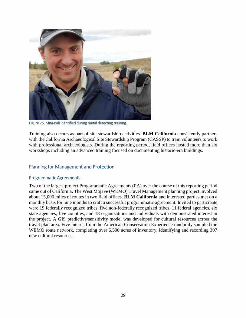
29
Figure 25. Mini-Ball identified during metal detecting training.
Training also occurs as part of site stewardship activities. BLM California consistently partners
with the California Archaeological Site Stewardship Program (CASSP) to train volunteers to work
with professional archaeologists. During the reporting period, field offices hosted more than six
workshops including an advanced training focused on documenting historic-era buildings.
Planning for Management and Protection
Programmatic Agreements
Two of the largest project Programmatic Agreements (PA) over the course of this reporting period
came out of California. The West Mojave (WEMO) Travel Management planning project involved
about 15,000 miles of routes in two field offices. BLM California and interested parties met on a
monthly basis for nine months to craft a successful programmatic agreement. Invited to participate
were 19 federally recognized tribes, five non-federally recognized tribes, 11 federal agencies, six
state agencies, five counties, and 18 organizations and individuals with demonstrated interest in
the project. A GIS predictive/sensitivity model was developed for cultural resources across the
travel plan area. Five interns from the American Conservation Experience randomly sampled the
WEMO route network, completing over 5,500 acres of inventory, identifying and recording 307
new cultural resources.

30
The Desert Renewable Environmental Conservation Plan (DRECP) Programmatic Agreement
(PA) among BLM California, California Office of Historic Preservation, and the Advisory
Council on Historic Preservation was executed on February 5, 2016 (Figure 26). The DRECP will
direct possible siting for future utility scale renewable energy projects on BLM-administered lands
in the southern California deserts. The PA is the result of BLM’s consideration of input obtained
from invitation, consultation, and outreach with 45 federally recognized tribes, seven tribal
organizations, 89 federal, state, and local agencies, 42 academic institutions/museums/historical
societies, 29 industry representatives, 72 other organizations, and five individuals. Four working
group meetings were held in 2015 and between 30 and 40 people attended each meeting, either in
person or by phone. Key aspects of the PA include cultural resource sensitivity analyses intended
to inform siting decisions and to
start project specific discussions
early between consulting
parties; a scientific peer review
process; a cultural resources
training program; and a regional
compensatory mitigation
program addressing cumulative
impacts. Concurring Parties that
have signed the PA include
seven federally recognized
tribes, one tribal organization,
nine agencies, four academic
institutions, museums, and
historical societies, three
industry representatives, seven
other organizations, and one
individual.
BLM New Mexico’s successful Permian Basin Programmatic Agreement (PBPA) was extended
for another ten years. Signatories and other interested parties met in May 2015 to discuss the future
of the PBPA. Attendees included representatives from the oil and gas industry, the ACHP, the
Mescalero Apache Tribe, the NM SHPO, New Mexico Archaeological Council, BLM, and
environmental compliance companies. Over 15 successful products have come from the mitigation
agreement including a book on plant utilization in southeastern New Mexico; a report on
evaluating the Transect Recording Unit method of site recordation; a report evaluating 500
radiocarbon dated sites in the area and an experimental project using Light Detecting and Ranging
(Lidar) remote sensing in three areas to locate rock ring-middens. In 2016 the PBPA was
recognized as a Section 106 Success Story by the Advisory Council on Historic Preservation.
Management and Protection Plans
Mission Santa Ana de Cuiquiburitac, established in 1797, was one of several missions begun by
Spanish Franciscan friars in the late 1700s and remained in operation until the 1820s. It served as
a satellite hub for the Spanish Colonial Mission System. Mission Santa Ana de Cuiquiburitac is
listed on the National Register of Historic Places and recently conditions at the site were described
Figure 26. SHPO, ACHP and BLM sign the DRECP Section 106 PA.

31
as threatened. Within the past several years, the Ironwood Forest National Monument in the BLM
Arizona Tucson Field Office has experienced increasing amounts of illegal human smuggling as
well as drug trafficking, increases in border patrol vehicular traffic, and severe soil erosion on the
nearby playa. With the recent completion of a Cultural Resource Management Activity site plan,
protection measures have been identified that will aid the BLM with its preservation efforts,
including physical barriers in the form of large boulders being placed strategically around the
perimeter of the standing structural remains of the historic mission and soil and erosion control
measures within the site.
A new national monument, the Organ Mountains – Desert Peaks National Monument, was
designated in 2014, encompassing 550,000 acres in the BLM New Mexico Las Cruces Field
Office. A wide range of cultural resources and historic events occur or have occurred within the
new monument boundaries including Paleo-Indian artifacts, pit-house and surface pueblo
habitation sites of the Mimbres Mogollon and Jornada Mogollon Peoples, Native American and
historic rock art, segments of the Mormon Battalion, Southern Overland, and Butterfield Trails,
the first Civil War engagements in New Mexico and World War II bombing targets. A resource
management plan is currently under production; the cultural resource component will form a major
responsibility within the plan.
The BLM Alaska’s Glennallen Field Office began consultation efforts with two Southeast
Alaskan tribes for the helicopter assisted recreation portion of the Haines Block amendment to the
Ring of Fire Resource Management Plan. The use of helicopters for recreation has been a
controversial issue for the Haines community, including with the area’s two federally recognized
tribes. Consultation efforts will continue as the plan amendment proceeds.
During the reporting period, travel management planning was a high priority for the BLM. In BLM
Arizona, the Yuma Field Office signed the La Posa Travel Management Plan and the Yuma Field
Office continued the planning process for the Imperial Hills Travel Management Plan. A marked
increase in OHV traffic in recent years is threatening important archaeological features along the
Colorado River. The field office plans to develop a public outreach program to educate the public
about cultural resources, place interpretive signs through the area, monitor routes that have 100’
pull-off areas, use existing information for best management practices and re-route OHV trails to
avoid sensitive sites.
The BLM Montana Miles City Resource Management Plan (RMP) was released in June 2015.
The RMP combines two older RMPS into one. Cultural and paleontological highlights include the
designation of new and expanded cultural and paleontological Areas of Critical Environmental
Concern (ACEC), use of setting consideration zones to assist in dealing with visual (indirect)
impacts to sites types such a historic battlefields, historic trails, and sensitive Native American site
types such as medicine wheels. The ACECs to be expanded are the Battle Butte (from 121 to 320
acres) and the Reynold’s Battlefield (324 acres to 922 acres). New cultural ACECs include the
Cedar Creek Battlefield, Long Medicine Wheel, and Walstein Reservoir. The Walstein Reservoir
ACEC includes the Paleo Indian-aged Mill Iron Site (24CT30). New paleontological ACECs
include the Flat Creek ACEC and the Powderville ACEC. Although primarily designated for
cultural reasons, both the Long Medicine Wheel and Walstein Reservoir ACECs also contain
paleontological resources.

32
A presentation on The Owyhee County Model: Fine Tuning Landscape Level Modeling was given
at the Great Basin Anthropological Conference in 2016. BLM Idaho has been working on this
model for eight years and published a model for the Owyhee Land Exchange. Archaeological
predictive models are only as good as the data they are constructed from. Modeling is necessarily
iterative, requiring continual testing and reevaluation. As new or improved data and methods are
obtained, they should be incorporated into the model for refinement. While serving the purpose of
addressing the land exchange it was recognized that the model over-represented the high sensitivity
zone. The new model is framed on a simple decision tree hierarchy, allowing addition of new
branches, pruning of existing branches, and sensitivity model recalculation using map algebra and
cell statistics (Figure 27). The paper discussed revisions to the original model applying more robust
landscape level and site data, as well as cost distance analyses to more accurately reflect sensitivity
zones.
Figure 27. Owyhee County sensitivity model examples
National Register Listings
During the reporting period, the BLM nominated and listed 12 properties to the National Register
of Historic Places (Table 12). These 12 listings, identified below, had a total of 204 contributing
properties.
Table 12. National Register Listed Properties
Year State Property Name # of Contributing
Properties
FY 2014 Colorado Painted Hand Pueblo 1
Montana Judith Landing boundary increase 1
Oregon Paisley Five Mile Point Caves 1
Utah Nine Mile Canyon Multiple Property 101
Wyoming Powder Wash Archaeological District 29
La Barge Bluffs Petroglyphs 1

33
Tolar Petroglyph Site 1
Eden-Farson Site 1
FY 2015 California Luiseno Ancestral Origin Landscape 28
Colorado Sound Democrat Mill and Mine and Silver Queen Mine 18
FY 2016 Montana Ervin Homestead/ Gist Ranch Historic District 19
Oregon Zane Grey Cabin 3
The Tolar Petroglyph site listed in 2014 is a small property administrated by BLM Wyoming.
The site is located in the southwestern part of the state and consists of 32 rock art panels
extending for more than 150 meters on a large sandstone outcrop. The site contains a distinctive
collection of Protohistoric and Historic petroglyphs created by Native American groups
inhabiting or traveling through the area (Figure 28). The artistic styles and motifs at Tolar are
characteristic of Shoshone and Comanche, but may also be related to Arapaho, Ute and
Athapaskan-speakers such as the Navajo. Exceptional illustrations of Ceremonial and Biographic
traditions, the extremely fine craftsmanship of subjects, the distinctive representations (turtle,
large-headed anthropomorphs and stick narrative) all highlight Criterion C eligibility. Tolar was
also listed under Criterion D because it has the potential to yield more information to the
understanding of Rocky Mountain, Great Basin, and Plains culture, symbolism and historic
migration.
Figure 28. Petroglyph from Tolar site.

34
4. Using Historic Properties
BLM visitor data for FY15 indicated 3,412,888 visits to cultural sites; in FY16, that number
increased almost a quarter-million to 3,637,818. Unfortunately, the economic contribution is not
separated by viewing cultural sites, but is simply tied to multiple recreational activities on public
land. Still the number is large, from over $162 million dollars to over $186 million dollars. Local
economies are impacted due to employment or job numbers, as well as taxes to state and local
governments, not to mention the dollars provided previously for recreation.
Although cultural resources are not typically found within town or city centers, our offices often
are and serve as gateways to public land venues. Certainly local communities are part of all
resource management and planning efforts, and economic development and environmental justice
are found in RMPs. Stakeholders are invited to scoping meetings for environmental documents, as
well as for planning efforts affecting field offices and districts.
Community and Tourism
Stewardship of heritage resources is an important part of BLM’s cultural program goals. By
protecting the characteristics, attributes, and values of significant resources, BLM meets legal and
regulatory obligations as well as maintains properties in the public interest. Partner organizations
and the public assist BLM by participating in scoping meetings and public events and informing
the agency about what resources are important to them.
Events
BLM Colorado and Hinsdale County worked together to organize a celebration event for the
50th anniversary of the National Historic Preservation Act. The event (Figure 29) at the Ute-Ulay
Mine and Milling Complex on the Alpine Loop featured tours of several mill buildings which
are usually closed to the
public. Approximately 85
people attended, taking in an
awards ceremony presenting
Elizabeth Francisco and
Grant Houston with the
Heritage Heroes Awards, as
well as a town barbeque.
The Ute-Ulay complex was
featured on the 2016 History
Colorado Archaeology
Month poster and is listed on
the 2015 Colorado Most
Endangered Places List.
Plans are to nominate the
complex to the National
Register of Historic Places
in the future.
Figure 29. Ute-Ulay site public celebration of NHPA 50th anniversary.

35
Media
BLM California developed a documentary film titled Sands of War as a mitigation product for
the McCoy Solar Energy Project. Sands of War is a 30 minute-long, high-definition, professional
documentary developed specifically for television airing (Figure 30). The documentary covers
the development of the World War II (WWII)
Desert Training Center/California- Arizona
Maneuver Area (DTC/C-AMA) in the
California deserts.
The DTC/C-AMA was developed by General
George S. Patton, Jr. to prepare US troops for
battle in North Africa during WWII. The
facility covered approximately 18,000 square
miles of the deserts of California, Arizona, and
Nevada, and was in operation for 2 years, from
1942-1944. The DTC/C-AMA played a pivotal
role in training more than 1 million troops for
desert warfare tactics in true war-like
conditions. The project included interviews
with 14 veterans who actually trained at the
facility during its period of operation. All
interviews were recorded using high-definition
video and were transcribed. All interviews are archived at the Library of Congress Veteran’s
History Project and are publically available online. All interviews are also archived at the
California Desert District library. The documentary relies on interviews with veterans, historic
photos, and historic video from the Department of the Army to recount the story of the DTC/C-
AMA, and is narrated by Peter Coyote. A 30-second trailer is available online at
https://vimeo.com/142180354. Sands of War aired nationally on PBS (on Memorial Day
weekend) reaching an estimated 140,000,000 viewers.
In 2015, the BLM Idaho’s Public Affairs office re-established the popular Mackay Mine Hill
Virtual Tour based on requests from the Challis and Mackay Chambers of Commerce and
economic development groups. The National Archives’ software, “The Wayback Machine” was
used to retrieve the URLs allowing access once again.
http://web.archive.org/web/20090510110451/http://www.blm.gov/heritage/adventures/menu/ID_
virtualtour_files/white_knobVT.html
Figure 30. Sands of War DVD cover.

36
The TERRA Kotzebue project is a multi-year Section 106 project for the BLM Alaska Anchorage
District. It involves building broadband repeaters in several locations in western Alaska. An
inadvertent discovery of a significant site found while trenching for a fiber-optic cable required
development of a Memorandum of Agreement (MOA) to mitigate the adverse effects to the site.
Several excellent educational products came
out of this MOA, including a website detailing
the discovery:
http://www.kotzebueartifacts.info/. The
website includes information about prehistoric
Kotzebue, the site and the artifacts discovered.
It also includes photos and a video of the
classroom presentation and public open house
conducted by the project proponent, General
Communication Inc. (GCI) (Figure 31). The
site is located on private land of the
Kikiktagruk Inupiat Corporation, an Alaska
Native Corporation.
Social media is a part of every BLM state, as well as the national office. Facebook posts are
standard practice as part of a state’s archaeology month celebration. Interns and volunteers provide
blogs for Tumblr. The previous Director had a Twitter handle and often tweeted about engaging
in recreation on the public lands. Many of BLM’s 65 visitor centers provide daily activities on
social media. These centers are staffed by federal employees as well as volunteers from friends
groups and other supportive associations. Below are a few examples of online support for cultural
resources.
Tumblr is another outlet for BLM news. One BLM archaeologist is a blogger who regularly
submits posts. In one post she shared a letter she wrote in 6th grade to her future self, stating that
her goal was to become either an archaeologist or a paleontologist. She then shared her path to
achieving that goal and becoming an archaeologist for BLM Idaho. During Women’s History
Month she did a post on the 9 women who are BLM archaeologists in Idaho. For Idaho
Archaeology and Historic Preservation Month she worked with other BLM archaeologists to share
research from the Owl Cave site. Finally, one post was also done for American Guide week and
was picked up by The American Guide Blog. This post was on the Pioneer Historic Byway and
three sites found on BLM lands, the Last Chance Canal, Sheep Rock (on the Oregon California
National Historic Trail), and Formation Springs.
If Twitter is your thing, then BLM can also accommodate that interest. One BLM New Mexico
archaeologist often uploads stories on Facebook and tweets on Twitter. Her research on the
historic Magdalena Stock Driveway and the 80th anniversary of Civilian Conservation Corps
Camp DG-42-N were featured on both platforms, as well as regular newspapers like the
Albuquerque Journal.
Figure 31. Filming of classroom presentations.

37
Volunteers from Project Remembrance provided numerous hours in 2015 to relocate the 1943
crash sites of two B-24 bombers; one in Laidlaw Park and the other near Sid Lake. Workers were
able to relocate the Sid Lake crash and helped document the site for the BLM Idaho Shoshone
Field Office. Later, BLM officials and volunteers returned to create a video about the site. It was
posted online on several BLM social media sites on Veterans’ Day 2015 and has had numerous
views since: https://www.youtube.com/watch?v=xF5yjKo8t44&feature=youtu.be .
Re-Use
In BLM Oregon, the historic Zane Grey Cabin at Winkle Bar has been officially listed in the
National Register of Historic Places (Figure 32). This honor is intended to provide recognition of
the site's significance and to encourage its continued preservation.
The historic cabin is located at Winkle Bar, one of the most unique sites along the world-famous
Rogue Wild and Scenic River. This spot--and the entire Rogue River--was popularized by the
western novelist and angler Zane Grey, who fell in love with and wrote about the pristine
wilderness and abundant fishing opportunities on the river.
In 1925, Grey launched an expedition down the Rogue River from Grants Pass to Gold Beach
Oregon with nine other adventurers in seven wooden boats. Of the places Grey encountered on the
trip, Winkle Bar proved to be the most influential. In 1926 he purchased the mining claim there
and had this now-famous cabin built. In Tales of Freshwater Fishing, Grey described his new
acquisition:
"The rushing river at this point makes a deep bend round a long oval bar, with rocky
banks and high level terraces above, and both wooded and open land. Here it flows
through a lonely valley set down amid the lofty green mountain slopes. A
government forest trail winds out some twenty miles to the nearest settlement. Far
indeed it is across the dark Oregon peaks to railroad or automobile road!"
Figure 32. Overview of the Zane Grey Cabin.

38
It was here, and along other portions of the Rogue River, that Grey was inspired to write such
books as Rogue River Feud, Shooting the Rogue, and Tales of Freshwater Fishing. Grey's prose
drew visitors by the thousands, and helped make the Rogue River a premiere destination for world
class steelhead fishing, recreation, and wildlife viewing.
In 2008, the BLM purchased the property to help preserve its unique historic values. In 2012, the
BLM began the process of documenting the site's historic significance for designation to the
National Register of Historic Places. With funding and volunteer support from the Farley Tyas
Foundation, considerable work was done to the property and to the cabin itself so that visitors can
safely experience the scenery and history of Grey's era.
Today, visitors to the site at Winkle Bar will notice that the shake roof, windows, and log walls of
the cabin have been repaired. This was done with careful attention to the historic details and
construction techniques of the period of significance--1926. Visitors can also see the remains of a
well-weathered wooden boat, thought to be one of the original vessels from Grey's first journey
down the river in 1925. Visitors will also find a recently-installed interpretive display at Winkle
Bar entitled "The Country Gentleman," commemorating his time on the Rogue River.
With this official designation, the Zane Grey cabin will be better protected for the public to visit
and appreciate for generations to come.
Figure 33. New Fork River Crossing Historic Park.
A new 100-acre historical park was developed at the New Fork River crossing of the Lander Road,
which is a branch of the California National Historic Trail in Wyoming (Figure 33). Using the
NHPA Section 106 process, the BLM Wyoming Pinedale Field Office worked with the Wyoming

39
State Historic Preservation Office, the Advisory Council on Historic Preservation (ACHP), the
National Park Service, the Sublette County Historical Society (SCHS), the Alliance for Historic
Wyoming, the Oregon California Trails Association and the Lander Trail Foundation, along with
SWEPI L.P., and Ultra Resources Inc., to complete a PA to mitigate adverse impacts to the road’s
setting from the adjacent Pinedale Anticline natural gas field. The BLM and those same historic
preservation partners also worked with PacifiCorp to complete a memorandum of agreement to
resolve impacts from a transmission line that spanned the same area. Both agreements funded the
purchase and donation of 82 acres of riverfront property to the SCHS. A subsequent purchase by
the SCHS expanded the park to 100 acres.
The New Fork River Crossing Historical Park celebrates the Lander Road river crossing and the
river island where tens of thousands of emigrants watered, rested and refitted. The park now offers
interpretive signs, almost a mile of fishing access, walking trails, picnic areas and other day-use
activities to visitors. Including the initial Section 106 participants, almost 30 federal, state and
local government agencies, non-profits and corporations, and many private citizens, played a role
in the acquisition and development of the New Fork River Crossing Historical Park. It is a
testimony to what vision, cooperation and partnerships can do. The grand opening celebration of
the new park was held Saturday, June 21, 2014, and recognized the contributions of many partners
( Figure 34). This effort was chosen by the ACHP as one of their Section 106 success stories.
Figure 34. Partners at the ribbon cutting for the grand opening of the park.
The BLM California’s Arcata Field Office in California worked with the Table Bluff Reservation
Wiyot to allow the tribe to salvage two downed redwood logs. The logs were lying next to a
parking area near a trailhead. The tribe plans to make traditional dugout canoes and planks for
traditional buildings from the logs.

40
Volunteer docents continued
to provide educational public
tours of the restored 1860s era
Adams House and adjacent
farmstead in the BLM Utah’s
Red Cliffs National
Conservation Area near St.
George, Utah (Figure 35).
This opportunity allows the
house to open for public
visitation on 8 days each
month. These docents provide
information to visitors about
the history of the Adams
house, the 19th century
Mormon community of
Harrisburg, UT, and the
restoration work for the Adams house completed by BLM.
Volunteers keep up maintenance on the Adams House historic vegetable garden which was re-
established through an Eagle Scout project. Each year volunteers re-seed historically planted crops
such as watermelons, beans and corn, and conduct work to improve the garden’s condition using
techniques such as establishing raised beds and installing wire mesh to counter rodent infestation.
The BLM administered lands in the San Juan Islands of northwest Washington State were
designated a National Monument during the last administration. These lands include two
lighthouses (Turn Point Light Station and Patos Light Station), numerous archaeological sites,
and areas of traditional use by Native American Tribes (Figure 36 and Figure 37). BLM
Oregon/Washington is working with Turn Point Lighthouse Preservation Society and other
partners to address safety findings related to the
occurrence of lead paint and other issues, as well as
working to rehabilitate the Fog Signal Building and
Figure 37. Patos Light Station. Figure 36. Turn Point Light Station.
Figure 35. Adams House and surrounding landscape.

41
the Keeper’s Quarters. A small “museum” is staffed by volunteers at the Turn Point Light
Station. In addition, BLM is working with partner Keepers of the Patos Light to maintain the
Patos lighthouse and offer informational tours of the facilities. A small historical display is
contained in the lighthouse and is staffed by volunteers during the summer.
Exchanges, Transfers, and Acquisitions
BLM does not typically transfer historic properties out of ownership. If land parcels are identified
for sale or exchange and it is discovered that these parcels contain historic properties, they are
dropped from consideration. We also do not contract the management of historic properties to an
outside entity. Occasionally BLM obtains parcels of land through purchase using the Land and
Water Conservation Fund. For instance, in 2014 BLM New Mexico conducted intensive
pedestrian inventory on two recently acquired parcels of ~336 acres within the Yellow Jacket
Canyon archaeological landscape.
Several years ago BLM New Mexico’s Taos Field Office (TFO) acquired a late 19th and 20th
century historic Hispanic farm located within the La Cienega Area of Critical Environmental
Concern (ACEC). Recently, TFO began planning efforts for the Rael Farm that included hosting
a landscape charrette designed to capture ideas and sentiments from the interested public regarding
the BLM’s plans for future management and use of the farm property. The results of the charrette
are being compiled into a report that will help guide the development of a site-specific management
and use plan for the property. The farm is located in the Santa Fe River canyon and includes the
Rael House, a 100-plus year old standing adobe structure, 300-year-old acequia ditch and water
rights, 100-plus year old heritage fruit trees, heritage grape orchard, and small agricultural fields.
The property also contains additional archaeological remains associated with the Archaic, Pueblo,
Spanish Colonial, Mexican Republic, and U.S. Territorial periods. TFO has contracted for a
historic structure assessment for the Rael House. Treatment recommendations made in the
assessment will be carried out under a contract since not all BLM offices have in-house expertise
for such resources. Plan development is considering the farm as an interpretive, educational, and
research destination and also as a potential working farm and heritage plant/seed bank facility
(Figure 38).
Figure 38. Rael Farm discussion with community attendees.

42
Partnerships in Using Historic Properties
Multi-Agency Partnerships
On October 22, 2015, the Stanley and
Mildred Norstebon Family Trust donated a
1 acre parcel holding the Canyon Creek
Station to BLM Idaho to manage the site in
perpetuity for its historic values. In a
ceremony on site October 29, state director
Timothy Murphy received the title from the
Norstebon family (Figure 39). Many
partners were involved in making the
donation possible, including the Norstebon
Family, BLM, Idaho Heritage Trust (IHT)
the Idaho Oregon-California Trails
Association (IOCTA) and the National Park
Service (NPS) (Figure 40).
In 1873, the Archibald Daniel family migrated west to Idaho and homesteaded a 160-acre parcel
at Canyon Creek. The historic Canyon Creek Station, located in Elmore County, was built by the
Archibald Daniel family in 1874. The structure sits in a lava rock canyon and is constructed from
hand forged 13-18” thick basalt lava rock walls with horse hair mortar. The stage stop itself
provided shelter and meals for the last travelers of the Oregon Trail, but before that Canyon Creek
was an important stopping point along the trail for weary travelers needing water and feed.
Figure 40. Dedication Day, October 29, 2015.
Figure 39. BLM takes title from Norstebon Family.

43
Canyon Creek Station provided valuable services to travelers on the Oregon Trail, Kelton Freight
Road and the Overland Stage route (Figure 41). It provided fresh horses for the mail, and fresh
fruit, vegetables, meats and cool water in the sparse desert, along with sweet grass for travelers’
livestock.
The Daniels family operated the stage stop until the stage line ceased with the completion of the
Oregon Shortline Railroad in 1884. The station was a working farm and home until December
1976 at which time a fire heavily damaged the structure, leaving only the rock walls in place.
In recent years, the family commenced efforts to preserve the station by eliminating fire hazards
such as brush and weeds in the vicinity of the stage station. Two IHT grants were secured and
initial planning began on stabilization and restoration at the site. These funds were significantly
enhanced by funding from IOCTA. The family’s goal was to restore the stage stop to its original
state, but they soon recognized that community involvement would be necessary to realize this
dream. To that end, and through commitment and vision, the family worked with the IHT to reach
out to the BLM on the possibility of gifting the site to the BLM for management in perpetuity.
Even though no BLM lands lie adjacent to the property, the significance of the site and the potential
for a long-term partnership with the Norstebon family, IHT, IOCTA, NPS and the community was
recognized. BLM determined to pursue acquisition of the parcel containing the Canyon Creek
Station. Currently BLM is partnering with NPS to develop a long-term management and
interpretive plan for the site. The BLM will continue stabilization and restoration efforts based on
plans and drawings created by IHT historical architect Frederick Walters. Initial masonry work
stabilized and reconstructed the gable ends and the north wall of the structure. Future work includes
stabilization and reconstruction of the south wall and roof.
Figure 41. Canyon Creek Station in the 1870s, with Archibald Daniels.

44
Canyon Creek Station is enjoyed and valued as being only one of two remaining stage stops on
the Oregon Trail, Kelton Road and Overland Stage system. It remains a valuable piece of the fabric
of Idaho’s history of early travelers, freighters and stage service (Figure 42 and Figure 43). The
Station is recognized in the NPS comprehensive plan for the Oregon Trail as a high potential site
for its importance to convey and interpret early historic
travel in the region and along the Oregon Trail. The site
is eligible for listing on the National Register of
Historic Places. Its location on a county road provides
access conducive for interpretation and public use.
Outreach and Education
In 2016, BLM California and Nevada coordinated with the Nevada Bureau of Indian Affairs,
the Nevada Indian Commission, the Inyo and Humboldt-Toiyabe National Forests, the Nevada
branch of the U.S. Fish and Wildlife Service, and the Tubape-Numu traditional use advocates for
a Traditional Ecological Knowledge Summit (Figure 44). The summit was intended to broaden
the perspectives on proposed Federal actions related to sagebrush steppe habitat restoration, with
the hope that a more expansive dialogue would incorporate traditional practices into land
management actions. Approximately
200 people attended the summit.
Tribal members, tribal leaders, land
management specialists and
managers came from throughout
Nevada and eastern California.
Highlights included a Native youth
panel discussion that revealed an
intellectually vibrant, up-and-coming
generation dedicated to keeping
cultural traditions flourishing and
protecting indigenous plants and
Figure 44. Traditional Ecological Knowledge Summit.
Figure 43. Canyon Creek Station, north wall in 2014. Figure 42. North Wall 2016, after reconstruction
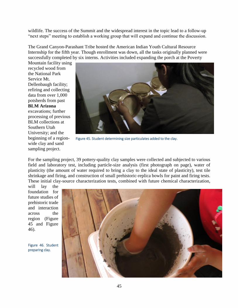
45
wildlife. The success of the Summit and the widespread interest in the topic lead to a follow-up
“next steps” meeting to establish a working group that will expand and continue the discussion.
The Grand Canyon-Parashant Tribe hosted the American Indian Youth Cultural Resource
Internship for the fifth year. Though enrollment was down, all the tasks originally planned were
successfully completed by six interns. Activities included expanding the porch at the Poverty
Mountain facility using
recycled wood from
the National Park
Service Mt.
Dellenbaugh facility;
refiring and collecting
data from over 1,000
potsherds from past
BLM Arizona excavations; further
processing of previous
BLM collections at
Southern Utah
University; and the
beginning of a region-
wide clay and sand
sampling project.
For the sampling project, 39 pottery-quality clay samples were collected and subjected to various
field and laboratory test, including particle-size analysis (first photograph on page), water of
plasticity (the amount of water required to bring a clay to the ideal state of plasticity), test tile
shrinkage and firing, and construction of small prehistoric-replica bowls for paint and firing tests.
These initial clay-source characterization tests, combined with future chemical characterization,
will lay the
foundation for
future studies of
prehistoric trade
and interaction
across the
region (Figure
45 and Figure
46).
Figure 46. Student preparing clay.
Figure 45. Student determining size particulates added to the clay.

46
BLM Montana and U.S. Forest Service collaborate to host the “Bridging the Divide” Tribal Field
Camp with youth and elders from the Shoshone-Bannock Tribe. Each year has a different theme,
but the field camp provides an opportunity for tribal students to be in an outdoor classroom with
hands-on learning experiences. They
work with tribal elders to learn about
the natural and cultural landscapes, as
well as traditional skills. Over the years,
the students have studied tipi
construction, cedar bark bags, digging
sticks, harvesting and use of the
bitterroot plant, and outdoor cooking.
The federal employees also provide
information about employment
opportunities and management
practices with the hydrology, cultural
resources, soils, wildlife, fuels
improvements and forestry programs
(Figure 47, Figure 48, and Figure 49).
Figure 47. Harvesting Blue Camas with digging sticks.
Figure 48. Tribal youth peel bark to make cordage baskets. Figure 49. Building a drying rack.

47
In addition to supporting the national programs Hands on the Land and Take it Outside!, as well
as Project Archaeology, the BLM’s signature educational program, BLM field offices engaged in
a wide variety of heritage educational opportunities for people of all ages. BLM archaeologists
gave classroom presentations, on-site activities, tours, and also hosted collegiate field schools,
researchers, and interns. In rural areas BLM scientists served as valued role models, acting as
judges for science fairs and advising students attending career days.
BLM archaeologists reported contacting 114,192 persons in venues such as community events, on
or off site presentations, and other “in person” activities. They contacted 46,913 youth in
classrooms, youth groups, and science fairs, and 921 college students.
BLM’s national office began a Heritage Heroes program, recognizing staff, volunteers and
organizations that assist in the BLM mission. In 2016, BLM acknowledged 12 honorees, such as
the Rio Puerco Field Office Rock Art Team, a group of volunteers for BLM New Mexico who
meet every Tuesday to record rock art on the public lands. The team also produces research reports
and provide a bridge between BLM and the public. The hero’s story is conveyed both within BLM
and through local public media and they are presented with a plaque in a formal setting.
Museum Collections
BLM Montana’s Billings Curation Center (BCC) worked with volunteers from the Pompey’s
Pillar Historical Association and the Pompey’s Pillar National Monument, to add an extensive
archival collection and digitize hundreds of photographs. The curation facility also added two
significant collections of donated prehistoric projectile points and other rare tools, and an archive
of a collection of rock art tracings made in the Pryor Mountains of Southern Montana. Research,
documentation, and artifacts made by the University of Montana from the Rosebud Battlefield
were also added to the collection. Billings Curation Center also contracted to digitize all the
photographic media within its’ accessioned collections. More than 17,000 images related to
cultural resources work conducted in Montana, North Dakota and South Dakota were identified
and scanned. All of the now preserved images will be made available to the public through the
Montana State Office website.
In BLM Oregon, the National Historic Oregon Trail Interpretive Center (NHOTIC) replaced
several exhibit mounts, reorganized a portion of their collection storage; updated and corrected
issues with catalog records for the Flagstaff Mine and Rabbit Mine collections; and initiated
transition of records to the DOI ICMS system. Finally, the center hosted staff training in collections
care and mount making, as shown in the photographs below (Figure 50 and Figure 51).

48
Figure 51. Staff preparing artifacts for curation.
The Anasazi Heritage Center, in BLM Colorado, regularly develops social media posts
highlighting artifacts from the Anasazi Heritage Center collections (Figure 52). These artifact
highlights are posted weekly to the BLM Canyons of the Ancients National Monument and
Anasazi Heritage Center Facebook page.
Figure 52. Artifact from the Anasazi Heritage Center collection on social media.
BLM California’s Ukiah Field Office promoted the use of museum collections in their public
education work. BLM archaeologists presented the prehistory and history of the region to 300
elementary and middle-school children at the Mendocino County museum. Archaeological
stations were created using artifacts, graphics, and maps depicting the human use and occupation
in the area. By the time the children were finished they had a clear understanding that archaeology
is the study of past people through their material culture. Linking prehistoric and historic events
such as the Paleo-Indian migration into the Americas, the gold rush, and World Wars to nearby
sites provided examples of how history is relevant to all. Students were encouraged to explore their
Figure 50. Prepared artifact in curation facility.

49
family’s own interrelationship with past events by documenting their grandparent’s stories,
fostering the concept of protecting heritage resources that are more personally relevant.
5. Future Plans and Final Thoughts
Programmatic Highlights
In the previous Preserve America report, the Bureau identified that it had completed work on the
national Programmatic Agreement with the ACHP and the NCSHPO. During the reporting years
2014-2015, all BLM states completed updated state protocols with their individual State Historic
Preservation Offices. Managers and archaeologists in every state became familiar with their new
protocols through training. In some states, work continues on appendices for specific efficiencies
such as standard areas of potential effect and discovery plans, as well as addressing particular
program areas like mineral management, grazing and travel management planning. The Bureau
continues to see the national PA as an important tool for programmatically accomplishing Section
106 efficiencies to address administrative priorities.
The BLM’s new manual and handbook on tribal relations (Manual 1780, Tribal Relations, and
handbook, 1780-1, Improving and Sustaining BLM-Tribal Relations) replaces the cultural
program’s Manual 8120, Tribal Consultation under Cultural Resources, and handbook H-8120-
1, Guidelines for Conducting Tribal Consultation. These new documents are in part a response to
tribal requests made during past listening sessions and to address the Department of the Interior’s
Secretarial Orders 3342, 3335 and 3317. The guidance also accomplishes this administration’s
priority of fostering a “shared conservation stewardship” with local, state and tribal governments.
BLM leadership continues to encourage the field to develop ongoing partnerships with tribes
across all BLM programs. The handbook addresses compensation, one of the more contentious
issues across the west, and gives managers discretion for compensation with some guidance for
implementation and decision-making. Training on the manual and handbook is currently being
developed on a national level. Some states have already begun in-house training, using existing
staff and local expertise. BLM’s National Training Center is creating tribal vignettes to showcase
successful BLM-tribal partnerships and enhance the training experience.
As BLM strives to accommodate the streamlined project review for energy and infrastructure
development that is a priority of the new administration, several new options for progress are
found. A thorough review and update of the 8100 series manuals will allow BLM to incorporate
updates to policies and guidance, providing the opportunity to restructure the program. One of the
biggest challenges to streamlining work processes is the lack of standardized datasets for planning
purposes. BLM is making steps to address that critical issue with the National Heritage Solution
Pilot that provides resource and investigation spatial data in a standard format across the western
states. The new manuals will also improve efficiencies and “get America back to work” by
updating permitting practices, setting standards for new technologies (Geographic Information
Systems and Global Positioning Systems) and allowing the acceptance of electronic forms versus
the previous manual’s reliance on paper files, maps , and report submissions. Finally, as the Bureau
continues to stay current on efficient practices for Section 106 compliance, several states are
working with their State Historic Preservation Officers to update program-specific guidance on
such topics as standard areas of potential effects and developing mitigation tools with consulting
parties. The future looks good!


