31


Proceedings of the
Participatory 3-D Modelling Exercise held in Pu Mat National Park,
Nghe An, Vietnam
November 16-26, 2001
Nghe An Vietnam
By Giacomo Rambaldi and Le Van Lanh
A joint cooperation projec t between ASEAN and the European U nion
ASEAN Regional Centre for Biodiversity Conservation

i
Table of Contents 1 ABSTRACT............................................................................................................... 1
1.1 Objectives of the Mission in Vietnam: ............................................................... 1 1.2 P3DM Location Map .......................................................................................... 1 1.3 Reference Material ............................................................................................ 1 1.4 P3DM Training Exercise (Fact Sheet)............................................................... 2 1.5 Training Outreach.............................................................................................. 3 1.6 Trainers and Resource Speakers...................................................................... 4
2 INTRODUCTORY AND ANCILLARY ACTIVITIES................................................. 5 2.1 Production of an Educational Video on Participatory 3-D Modelling ................ 5 2.2 Introductory Presentations Delivered at the Opening Ceremony ..................... 5 2.3 Summary of the Orientation on P3DM and Follow-up Q&A Session ............... 6 2.4 Field Visits.......................................................................................................... 6 2.5 Orientation Activities .......................................................................................... 6 2.6 The Closing Ceremony ...................................................................................... 7
3 THE P3DM EXERCISE............................................................................................. 7 3.1 Assembling the Blank Model ............................................................................. 7 3.2 Transposing Cognit ive Maps ............................................................................. 8 3.3 Transferring Data from/to the 3D Model.......................................................... 10 3.4 Data Extraction ................................................................................................ 11 3.5 Extraction of Data using Digital Photography ................................................. 11
3.5.1 Background .............................................................................................. 11 3.5.2 Implementation Details ............................................................................. 12
4 GROUP DYNAMICS............................................................................................... 14 5 COST BREAKDOWN AND FLOW OF ACTIVITIES............................................. 15 6 COURSE EVALUATION........................................................................................ 17
List of tables Table 1 Features identif ied by the Informants and used as map key (legend) 9 Table 2 Cost breakdown – Pu Mat 3-D Modelling Exercise 15
List of Annexes Annex 1 List of participants 18 Annex 2 3D Model Summary Sheet 21 Annex 3 List of key informants 23 Annex 4 Updated List of Supplies (with October/November 2001 units costs) 24

ii
List of Acronyms ARCBC ASEAN Regional Centre for Biodiversity Conservation ASEAN Association of South-East Asian Nations
CEN Conservation Education Netw ork CETD Center for Environment, Tourism and Development CRES Center for Resources and Environmental Studies DENR Department of Environment and Natural Resources
EU European Union EC European Commission
FPD Forest Protection Department FPE Foundation for the Philippine Environment GEF Global Environment Facility GIS Geographic Information Systems
IUCN The World Conservation Union M&E Monitoring and Evaluation NEA National Environment Agency
NBRU National Biodiversity Reference Unit NCCST National Centre for Natural Science and Technology
NGO Non-Governmental Organizations PA RC Protected Areas Resources Conservation (PA RC) Project PAWB Protected Areas and Wildlife Bureau P3DM Participatory 3-D Modelling SFNC Social Forestry and Nature Conservation Project
VNPPA Vietnam National Parks and Protected Areas Association WWF World Wide Fund for Nature

iii
Summary of Activities
Date Activities
Thursday, November 15, 2001
• Arrival of Participants from the Philippines and from places outside Hanoi. Gathering at Baoson Hotel.
Friday, November 16, 2001
• 7:30 reporting of all participants at the Baoson Hotel and travel to Pu Mat Nature Reserve.
Saturday, November 17, 2001
• Registration of Participants and distribution of training kits. Introduction to ARCBC and to SFNC.
• Opening remarks by Mr. Hoang Hoa Que, Director of Pu Mat National Park.
• Introduction to the SFNC Project by Mr. Dinh Van Cuong, National Co-director of the Social Forestry and Nature Conservation (SFNC).
• Presentation of ARCBC by Mr. Norman Ramirez (ARCBC). • Introduction of the training exercise by Mr. Le Van Lanh, Secretary
General of Vietnam National Parks and Protected Areas Association (VNPPA).
• Orientation on Participatory 3-D Modeling (technical and organizational aspects) by Mr. Giacomo Rambaldi.
Sunday, November 18, 2001
• Presentation of the reserve. Field visit (morning). • Orientation on Participatory 3-D Modeling (technical and
organizational aspects).
Monday, November 19, 2001
• P3DM Exercise – Orientation of Participants (students) and Trainees - Manufacturing of the blank model.
Tuesday, November 20, 2001
• P3DM Exercise - Manufacturing of the blank model.
Wednesday, November 21, 2001
• P3DM Exercise - Manufacturing of the blank model.
Thursday, November 22, 2001
• P3DM Exercise - Orientation of Participants (key informants) and Trainees - Transposing mental maps by representatives from the Ethnic Minority Groups living inside the park and in the buffer zone.
Friday, November 23, 2001
• P3DM Exercise - Transposing mental maps. Presentation of Attendance Certificates to key informants (1st group).
Saturday, November 24, 2001
• P3DM Exercise – Transposing mental maps.
Sunday, November 25, 2001
• P3DM Exercise – Transposing mental maps by villagers (2nd group). Presentation of Attendance Certificates to villagers (2nd group). Started placing reference grid. Oriented trainees on the matter.
• P3DM Exercise - Orientation of Trainees - Extracting Information. • Facilitated Participants’ Asse ssment of the Training.
Monday, November 26, 2001
• Visit to the Core Area of the National Park. • Afternoon: Closing ceremony and presentation of Training

iv
Date Activities
2001 Certificates to the trainees. • Evening: Public Closing Ceremony.
Tuesday, November 27, 2001
• Travel to Hanoi. • Met NBRU Coordinator at NEA and delivered de-briefing on Pu Mat
activity. • Visited the EU Delegation. Met Mr. Franklin (Desk officer) and
delivered de-briefing on Pu Mat activity. Wednesday, November 28, 2001
• Departure from Hanoi: participants from the Philippines and from locations outside Hanoi.

1
1 ABSTRACT 1.1 Objectives of the Mission in Vietnam:
• Facilitate a Participatory 3-D Modelling Exercise at Pu Mat National Park and train participants from different Vietnamese and Philippine institutions.
• Update the list of inputs needed for conducting a P3DM exercise in Vietnam. • Analyse the cost involved in the conduct of the exercise (w ithout training
component) and determine reference parameters.
1.2 P3DM Location Map Eastern portion of the Pu Mat National Park, Nghe An Province, Vietnam
1.3 Reference Material All trainees w ere supplied w ith Training Kits containing the follow ing:
• Complete list of participants (Vietnamese and English); • Training Programme (Vietnamese and English); • One copy of the Manual on Participatory 3-D Modelling for NRM; • ARCBC’s Brochure (w ebsite); • “Quick Reference Guide” (1:10:000 and 1:5000), plastic laminated; • “Directional North Arrow”, plastic laminated; • Printout of Pow erPoint Presentation: “ Introduction to P3DM”; • Profile of the Pu Mat Nature Reserve; • Paper: Participatory 3-D Modelling: Bridging the Gap betw een Communities
and GIS Technology; • Paper: Extraction of Information from 3-D Models; • Supply List (English and Vietnamese); • Paper: What 3-D Mapmakers should know about Corrugated Carton Board; • Sample base map w ith matching transparent plastic sheet; • Samples of push and map pins. • Kits of numbers and letters to be used for referencing,

2
1.4 P3DM Training Exercise (Fact Sheet)
Key Reference Data Organizing Institutions
National Environment Agency (NEA), Vietnam National Protected Areas Association (VNPPA), Social Forestry and Nature Conservation of Nghe An Project (SFNC) and ASEAN Regional Centre for Biodiversity Conservation (ARCBC).
Sponsors Social Forestry and Nature Conservation (SFNC) of Nghe An Project, ASEAN Regional Centre for Biodiversity Conservation (ARCBC).
Funding Agencies
Ministry of Agriculture and Rural Development (MARD), Department of Environment and Natural Resources (DENR) on behalf of ASEAN, and European Commission (EC)
Duration of the actual exercise (inclusive travel): 12 days
Venue Pu Mat National Park Office, Con Cuong, Nghe An Province, Vietnam.
Dates November 15-28, 2001 (inclusive travel and other training related activities)
Duration of the actual 3-D modeling exercise November 18-25, 2001
Duration of the exercise including preparatory work: 3.5 months (scattered inputs)
Participants
Village informants (details in Annex 3) 76 Students and teachers (Lower Secondary School of Con Cuong District)
30
Trainees Various institutions/projects/NGOs 27 Pu Mat National Park staff 6 SFNC Project staff 10 Translators 3 Number of trainers/facil itators 5
The model (for additional information see Annex 2)
Horizontal scale: 1:10,000 Vertical scale: 1:7,500 Contour interval: 20 m Final size of the model: two units 1.4mx 2.5m 2.8 m x 2.5 m Area covered (on the ground) 70,000 ha (700 sq. km) Province: Nghe An Districts: Con Cuong and Anh Son Communes Mon Son, Luc Da, Yen Khe, Chau
Khe, Chi Khe and Tam Hop Currency Equivalent (as of November 2001) Currency Unit – Dong (D)
D1.00 = $0.00006 $1.00 = D15,000
Cost of information generated (physical 3D and digital formats) at 1:10,000 scale
4.16 $/sq. km or 0.04 $/hectare

3
1.5 Training Outreach A number of institutions, projects and NGOs attended the training. Contact details are found in Annex 1 and at the follow ing Internet address http://www.arcbc.org.ph/training/vietnam/vnm_p3dm_participants.htm :
Trainees • Government Agencies ! Forest Protection Department (FPD) ! National Environment Agency (NEA) ! Protected Areas and Wildlife Bureau (PAWB) (PHL)
• National Parks ! Bach Ma National Park ! Ba Be National Park ! Cuc Phuong National Park ! Tam Dao National Park ! Pu Mat National Park
• Non-Government Organizations (NGOs) ! Vietnam National Protected Areas Association (VNPPA) ! Conservation Education Netw ork (CEN) ! Center for Environment, Tourism and Development (CETD) ! Foundation for the Philippine Environment (FPE), PHL
• Projects ! GTZ-funded Song Da Social Forestry Project ! GEF/UNDP funded Protected Areas Resources Conservation (PARC) Project ! EU-funded SFNC project: 10 staff
• Academe ! Hanoi University of Sciences, Faculty of Biology ! Hanoi University of Sciences, Faculty of Geography ! National Centre for Natural Science and Technology (NCCST), Geographic
Institute ! Hanoi National Economic University, Faculty of Economy and Municipal
Environmental Management ! Center for Resources and Environmental Studies (CRES) ! Institute of Water Resource Planning ! Human Geography Research Center
• Key informants ! Representatives from Ethnic Minority Groups (Thai and Dan Lai and Kinh
Peoples) from the Commune of Monson, including the villages of Khe Bong, Co Phat, Con, Thai Son, Xieng, Lang Yen, Bac Son, Cua Rao, Lang Cang, Nam Son, Tann Son, Khe Lo and Thai Hoa.

4
1.6 Trainers and Resource Speakers
Sessions Resource Speakers (listed in chronological order)
Presentation of ARCBC structures and functions
Mr. Norman Emmanuel Ramirez, Training Expert II at the ASEAN Regional Center for Biodiversity Conservation (ARCBC)
Facilitation Techniques and Participatory 3-D Modeling
Mr. Giacomo Rambaldi, Information Communication Advisor, ASEAN Regional Centre for Biodiversity Conservation (ARCBC)
Preparation of colours Mr. Pham Luc, Painter, Development & Mutual Aid Centre for Economic and National Culture Hanoi, Vietnam
Transposition of data from the base map onto the 3-D model (e.g. Protected Area Boundary)
Mr. Fernando Ramirez, Area Coordinator – Luzon, Foundation for the Philippine Environment, Philippines
GIS applications including extraction of the information from the 3-D model and on-screen digitizing
Ms. Jasmin Callosa-Tarr, ASEAN GIS Specialist, ASEAN Regional Centre for Biodiversity Conservation (ARCBC)
5
2 INTRODUCTORY AND ANCILLARY ACTIVITIES
2.1 Production of an Educational Video on Participatory 3-D Modelling With the objective of providing addit ional information on the 3-D modelling technique, the ARCBC project management decided to produce an educational video. During the preparatory activities, which were done ahead of the Pu Mat exercise, ARCBC and SFNC agreed on sharing the cost of production: SFNC shouldered the cost for hiring the NGHEAN Broadcasting and Television Station to f ilm the exercise. ARCBC w ill now take care of composing and edit ing the 3-hour video containing 307 scenes. The video (25 minutes) w ill be produced in English and Vietnamese and w ill serve as a Companion CD to the 2nd edition of the P3DM manual and be an integral part of the information media devised by ARCBC for disseminating the technique.
2.2 Introductory Presentations Delivered at the Opening Ceremony1 Mr. Hoang Hoa Que, Director of Pu Mat National Park gave the opening speech of the training course.
Mr. Dinh Van Cuong, National Co-Director of the Social Forestry and Nature Conservation (SFNC) Project in Nghe Anh Province introduced the development and activities of the project since its establishment. He shared that the Government has been involved in the project activit ies at different levels including ministerial, provincial, district and local. The project has four main components, w hich are (i) highland agriculture; (ii) nature conservation; (iii) forestry development and (iv) training, monitoring and evaluating.
The project site harbors three forest enterprises located in (i) Anh Son, (ii) Tuong Duong and (iii) Con Cuong. The enterprises are active participants in project implementation particularly in the sector of agro-forestry. Their presence also represents a source of income for residents in the area. Different minority groups including Tay Phoong, Man Thanh, Dan Lai, Kho Mu, H’Mong, Thai and Kinh Peoples inhabit the project area. The total population of approximately 10,000 resides in 16 communes and 110 villages. The Pu Mat National Park encompasses portions of three districts, namely of Anh Son, Tuong Duong and Con Cuong in Nghe Anh Province. The core zone covers 91,113 ha and the buffer zone approximately 86,000 ha.
Mr. Le Van Lanh, Secretary General of the Vietnam National Parks and Protected Areas Association (VNPPA), introduced the subject of the training exercise - Participatory 3-Dimensional Modeling (P3DM) - and explained that the method has been successfully applied in the Philippines and Thailand in the context of protected area management and land use planning. Mr Lanh recalled the recent proclamation of Pu Mat as a National Park and the importance for Pu Mat to host this f irst major P3DM exercise.
Mr. Hoang Hoa Que introduced the participants to the history and development of Pu Mat National Park. He explained that the park is managed by a Management Board and through three operative sections including (i) Administration, (ii) Science and International Cooperation and (iii) Forest Protection. The latter runs seven forest protection stations located at the periphery of the core zone. The park employs a total of sixty-two permanent staff.
He further expanded on the diversity and rarity of species found in the park, on its beautiful landscape and suggested possible developments in the ecotourism sector.
1 Section prepared by Mr. Le van Lanh

6
He also described the cultural signif icance of the area due to the various ethnic minorities still maintaining their tradit ions. Mr. Norman Emmanuel Ramirez, Training Expert II at the ASEA N Regional Center for Biodiversity Conservation (ARCBC), delivered a Pow erPoint presentation describing the activities of ARCBC.
2.3 Summary of the Orientation on P3DM and Follow-up Q&A Session Mr. Giacomo Rambaldi, ARCBC Information, Communication and Technology Specialist emphasized the contribution of VNPPA, NEA, SFNC and Pu Mat National Park in organizing the training course. He also introduced the general concepts of P3DM and its applications in the context of natural resources management. A Question and Answ er session follow ed:
Mr. Andrew Johns, SFNC's Consultant, informed the participants that the SFNC w as in the process of interpreting a set of satellite images covering the entire project area. He questioned the usefulness of conducting a similar exercise through community mapping.
Mr. Rambaldi answ ered that the outputs of the tw o exercises would yield information which may be comparable, but the objectives are totally different. Community mapping focuses on experiential learning and leads to increased aw areness of all participants. Thus it w ould bring people – having different cultural and educational backgrounds - together and lead to a change in perspective on “whose know ledge counts” and “w ho decides on w hat is important”. This is not the case in a satellite interpretation process, which is usually done in isolation and far from the community, and w here scientists or technicians f ilter w hat they see through their own perspective. Mr. Rambaldi also stressed that satellite images do not show “values” attached by people to resources, nor features which are hidden to the satellite eye. He further emphasized that during the training course the trainees should learn how to interact w ith local community members and pay due respect to their know ledge.
One participant questioned the “quality” of the spatial data that villagers could produce because of their general low level of literacy. Mr. Rambaldi explained that villagers usually know the ins-and-outs of the environment they depend on and that the method (i.e. P3DM) w ould facilitate the collation of very accurate, scaled and geo-referenced data, all based exclusively on the cognitive (mental) maps of the participants. He further elaborated on the fact that P3DM is a multi-disciplinary exercise requiring the collaboration of people (acting as facilitators) having different backgrounds like community w ork, environment and cartography.
2.4 Field Visits
The project organized tw o f ield visits. The f irst one took place on 18 November 2001 and allow ed the trainees to familiarize themselves w ith the land use and vegetation cover in the buffer zone of the park. The visit included a 200-ha plot of Lagerstroemia calyculata in Quang Thing Village, Tam Binh Commune, Tuong Duong District, the Tow n of Hoa Binh and Cay Me Village. The second visit occurred on November 26 2001. Participants w ere led into the core zone up to the Kem Waterfall, a location w ell displayed on the 3-D model.
2.5 Orientation Activities On 18 November 2001, Mr. Rambaldi delivered a Pow erPoint presentation describing all preparatory activities leading to the actual P3DM exercise. He focused in particular on procurement, preparation of base maps and logistics.

7
In the Question and Answ er session that follow ed, Mr. Rambaldi expanded on the relationship betw een the selected scales (horizontal and vertical), the contour intervals and the procurement of some inputs like carton board.
Thereafter the trainees started assembling the maps and gluing these on the base tables. Landmarks like mountain or hilltops w ere identif ied and marked.
2.6 The Closing Ceremony On 25 November 2001, the closing ceremony w as held at the Park museum and w as attended by SFNC Project Co-director Mr. Andrew Weir, VNPPA President Dr. Nguyen Duc Khang, the park authorities, trainers, trainees, and a representative from the local farmers’ community. Mr. Chom summarized the f low of events of the training course activities, the outputs, the course evaluation produced by the trainees and praised the Pu Mat National Park for their efforts in organizing the event. He further recommended that the SFNC Project allocate funds for the completion of the model.
Mr. Giacomo Rambaldi praised the commitment and interest show n by all participants and highlighted the eff icient cooperation among A RCBC, NEA, V NPPA, SFNC and Pu Mat National Park in organizing the event.
Mr. Andrew Weir highly appreciated the successful result of the 3-D modeling exercise. He emphasized that the process proved to be effective in “bringing people together” and inducing collaboration among different stakeholders in the management of resources in Pu Mat National Park.
Mr. Nguyen Duc Khang acknow ledged the contribution of all organizations and expressed his wish to replicate the exercise in other National Parks in Vietnam.
A representative of the trainees, Mr. Tao (Cuc Phuong National Park), elaborated on how similar models made for other protected areas could be fruitfully utilized to improve the eff iciency of protected area management, particularly in protection and law enforcement.
The farmers’ representative expressed his satisfaction on the opportunity given to local people to participate in the exercise. He acknow ledged the usefulness of the model in gaining a comprehensive perspective of land and forest and in managing the resources in the areas they live in. He said he w ould inform his community of what all farmers had done in the course.
Mr. Hoang Hoa Que, Director of Pu Mat National Park, acknow ledged the support provided by ARCBC, NEA, V NPPA and SFNC project to build the model. He expressed his hope to continue receiving SFNC's assistance in completing the exercise. At the end of the ceremony Mr. Andrew Weir, Nguyen Duc Khang and Giacomo Rambaldi distributed certif icates to all part icipants.
During the training course, all activit ies w ere video recorded by Nghe An Television. In the evening the park organized a concert to mark the success of the training course and celebrate Vietnam Forestry Day.
3 THE P3DM EXERCISE
3.1 Assembling the Blank Model On 19 November 2001, after an init ial orientation on the forthcoming activit ies, the trainees, supported by park and SFNC staff, students and teachers from local schools, ventured into the various phases of the exercise including (i) assembling a large

8
carbon paper and f ixing it below the base map; and (ii) hammering nails2 through the tables to identify the selected landmarks. Trainees split in several w orking groups, each one assigned to a portion of the model made out of tw o units measuring 2.5-m by 1.4-m each. The groups consisted of (i) those tracing the contours on 3-mm thick carton board, (ii) those cutting out the single contour layers and (iii) those gluing and pasting the layers one on top of the other paying attention to properly locate them (using different landmarks including the reference nails).
On 20 November 2001 trainees continued their w ork. Mr. Le Van Lanh oriented a second batch of students and teachers on the activity, w ho later took part in tracing contours, assembling the model and consolidating the various layers w ith the use of crepe paper.
While w orking, the participants proposed some innovations (see box), all of which proved to contribute to the quality of the job. The blank relief models (tw o units) were completed in the evening.
The second resource person, Mr. Pham Luc (Artist), prepared a vast array of colors to serve as coding means for the transposing phase. Each color had to match an existing color-coded yarn. Mr. Pham Luc prepared several color tables for his forthcoming lecture. Mr. Rambaldi facilitated a recap of the entire process, discussed the various phases of the construction of the tw o models, and solicited observations made and lessons learned by the participants. In a follow -up focus group discussion, the park rangers and some SFNC project staff expressed their doubts about the capability of villagers (key informants) to locate features on the models. This w as based on the assumption that the relatively low literacy of the informants w ould prevent them from internalizing (decoding) the model, thus from locating and displaying data. Mr. Rambaldi facilitated the discussion and recalled the attention of the audience to the fact that they themselves were able to pinpoint several features on the blank relief models. “Why shouldn’t residents in the area be capable of doing the same?“ Mr. Rambaldi advised the trainees to be prepared to step dow n from the teaching pulpit, become careful listeners, and to accept the existence of a variety of perspectives for every single item. “You will be surprised by how much villagers know about their territory. Don’t w orry, it will be a great opportunity for all of us to learn”, he concluded.
3.2 Transposing Cognitive Maps On 21 November 2001, the f irst group of villagers reported to the venue early in the morning. With the assistance of local interpreters, Mr. Rambaldi w elcomed the informants and delivered an orientation on the forthcoming activit ies and the process of transposing cognitive maps on the relief models by using colour-coded yarns, paint 2 Note: the more nails (landmarks) are inserted, the more precisely geo-referenced the model will be.
Box 1 Introduction of additional tools • Coping saw (for cutting contour lay ers). • Binder clips (f or joining base map, carbon
paper and carton board sheet). • Pliers and hammer. • Plumb line weight.
Box 2 Lesson learned In rev iewing the exercise the participants recalled the importance of the f ollowing:
• Correct and complete procurement of supplies.
• Properly prepared base map, including many elev ation labels to facilitate tracing.
• Correct positioning of the contour lay ers making regular use of reference marks (e.g. nails).

9
and pins. Participants w ere invited to review the draft legend (map key) and to suggest changes or integrations 3. Without encountering any diff iculty, the farmers were able to locate themselves vis-à-vis the model and started - w ith great enthusiasm – to locate watercourses, name peaks, outline roads and trails and pinpoint the location of their villages and homes. The facilitators managed to assist the informants in processing and displaying their know ledge (mental maps) in an organized and logical manner 4. Once the participants had suff iciently assimilated the model landscape they started identifying land cover and use through colour-coded yarns. During the w ork, the tw o tables w ere regularly combined to check w hether the information displayed w ould match on the edges of the tw o halves of the model. During the entire morning of the follow ing day the f irst group of informants continued transposing the mental maps on the models. In the early afternoon, Artist Pham Luc delivered a presentation on how to prepare colors using color pow der. Thereafter the local farmers w ent ahead w ith the exercise. Animated discussions among informants led to the identif ication of the single polygons (land use and cover) and to the subsequent application of the corresponding color-coded paints. The key informants identif ied the follow ing:
Table 1 Features identified by the Informants and used as map key (legend)
Features
Polygons (paints) Bamboo forest Limes tone karst (rock) Reforestation area Conifer forest Mixed broadleaves and conifer forest Resettlement area Crops on terraces Mixed tree & bamboo forest Shifting culti vation Crops (seasonal) other than rice Orchard Stone fi eld Evergreen broadleaves forest Paddy fiel d Sugarcane Forest over limes tone Planted bamboo forest Tea pl antation Grassland Produc tion F orest Points (pins) Border Police Stati on Health Station Scientific Research Poi nt Cave Household (single) Sport playing fiel d Commune People’s Committee HQs Households ( 10) Docking site on river Market Extensi on Station Pagoda or Temple
Sighting places 5 of wild animals: Saola ( deer) Elephant, Bear, Gayal, Tiger and Monkey.
Ranger Stations Place of historical interest Tree Nurser y Graveyard (cemeter y) School Waterfall Lines/ polygons ( yarns) Bridge National boundar y Trail/foot path Buffer zone boundary Nature Par k boundary Rough Road Water Course Farmers also provided information on sightings of w ildlife6 species. Consistency in the use of color-coded pins emerged as a clear necessity for displaying data (see Box). Once the land cover and vegetation w ere displayed by the use of colour paints, the informants w ere assisted in locating point features like households, social infrastructure and others. The outlining of trails (footpaths) follow ed, developing the f irst ever trail map of the area. 3 By the end of the exercise the initial legend had expanded substantially to include a series of features, defined by the villagers themselves. NOTE: The complete model displays a total of 55 different features including lines, polygons and points. 4 Displayed data have to be properly coded so later users can decode, interpret and understand these by using the map key (legend). 5 Sensitive information (will not be displayed in public). 6 This information concerns some rare endangered species and has to be considered “sensitive”.

10
In the afternoon, the second group of key informants joined the exercise. Informants from the tw o groups were show n a slide show of the entire exercise including the construction of the model and the w ork done by the f irst group. A farmer from the f irst group w as given the f loor to introduce the second group to the forthcoming task. In the SFNC project context this event had a great signif icance, since it was the f irst time for a simple villager to speak in front of a relatively large audience and to act as resource person. He proudly introduced the output of the w ork done by the f irst 36 informants and introduced the newcomers to the details of the forthcoming activity. Once his presentation w as completed, the organizers gave attendance certif icates to the informants of the f irst group.
The tw o groups spent some time w orking together to validate the information already displayed on the relief model. Thereafter the f irst group left and the remaining 36 informants took over. Benefiting from the acquired experience the trainees continued the facilitat ion of the exercise jointly w ith the resource persons. The tw o model units w ere regularly combined to check if the displayed information matched. Once completed on 24 November, the relief model w as brought outside the museum to take group pictures7. All participants (key informants and trainees) were given Attendance or Training Certif icates by the organizers. A farmer from the second group w as requested to deliver a speech during the closing ceremony on 26 November 2001. Mr. Rambaldi invited all participants to use the model – to be stored at the Pu Mat National Park museum – to discuss issues related to the territory. The Director of the park informed the villagers that they w ould have access to the model whenever they liked and w ere w elcome to come and update it.
3.3 Transferring Data from/to the 3D Model On 25 November, Mr. Rambaldi oriented the trainees on the follow-up activity, namely on how to transfer data betw een model and base map and vice versa. This process is done by using a scaled gr id placed at a desired interval, usually corresponding to 10 cm (1 km on the ground) for models done at 1:10,000 scale.
Interestingly, a heated discussion8 emerged on how to measure intervals w hile placing the grid (see Box 4). After reaching a consensus, the grid w as placed on top of the model.
Mr. Fernando Ramirez, an experienced 3D mapmaker, explained the details of the process of transposing data (Core and Buffer Zone Boundaries) from the base map onto the model.
7 All key informants were given a copy of the group picture and a certificate of attendance. 8 All learning acquired during the exercise will be incorporated in the second edition of the Manual on Participatory 3-D Modeling.
Box 3 Consistency, a key requirement White flat head pins were used to inscribe the name of the species and to locate a sighting. Some trainees started using blue flat pins to do the same process. “Why use a blue pin? Is there any difference between an elephant when symbolized by a white or blue pin? If no difference exists, then be consistent in using white pins!”
Box 4 Path for marking interv als
CorrectIncorrect

11
Box 5 Lessons learned in transferring data Problem: Incorrect placement of some layers while assembling the model caused the ultimate displacement of features at higher elev ations (e.g. mountain peak).
• One cause f or this has been the running out of ref erence marks (reference nails) while assembling the model once higher elevations were reached. This problem was solv ed in some areas of the models by using side guides. A def initive solution to this problem could be the procurement of nails or steel bars that are suff iciently long to serve as reference ev en f or higher elev ations. In other words, a nail, which is 15 cm long, will serve (if working at a 1:7,500 scale) as a ref erence for gradients of 1000 meters or less, depending on the thickness of the base table. Theref ore f or gradients of 2000, meters the procurement should include thin steel bars to be cut at the desired length to be progressiv ely hammered through the table and serv e as guidance up to the top of the mountain.
• A second reason f or the displacement has been – according to SFNC project staff – the small scale used for digitizing the boundary line. This originated, according to the GIS OIC, f rom some discrepancies in combining the data sets (contour map produced at 1:10,000 and boundary outlining composed at a smaller scale).
• A third reason for the displacement lies in the placement of the grid, which adheres to the relief of the model (error already anticipated by the f acilitators). It was suggested that a wooden frame be constructed to allow the grid to be placed horizontally abov e the model and to later use a plumb line weight to transfer the coordinates f rom the base map to the model.
The activity yielded some interesting f indings (see Box 5) based on discrepancies that emerged during the process. In some cases the boundary – w hich w as supposed to run along the mountain ridge – turned out to be displaced by 100-200 meters (1-2 cm on the 1:10,000 scale model). The main purpose of the activity w as to train part icipants in transferring data from the base map to the model and vice versa, using simple tools like a matching grid referenced by the use of letters and numbers placed on the X and Y axes.
3.4 Data Extraction On 25 November 2001, Ms. Jasmin Callosa-Tarr delivered a presentation on how to extract data from the model by using:
• Transparent plastic sheets superimposed on the existing grid; and
• An innovative technique based on high definition digital photography.
The latter represents a substantial improvement in extracting and processing data from a 3-D model into a digital environment. The exercise deserves some detailed description.
3.5 Extraction of Data using Digital Photography
3.5.1 Background The technique used in the past, w hich makes use of transparent plastic sheets, generates numerous errors due to the fact that the plastic sheets are not placed on a plane surface, but adhere to the grid w hich follow s to a major extent the relief of the model. Attempts made in placing the grid above the model on a plane surface by using Plexiglas or a w ooden frame, and later on extracting the information by the combined use of a laser pen f ixed together w ith color-coded markers, proved to be tedious and damaged the eyes of those involved in data extraction.
Digital photography combined w ith on-screen digitizing w as therefore identif ied as a possible w ay forward. The technique has been successfully tested during the P3DM exercise in Pu Mat.

12
3.5.2 Implementation Details To reduce radial9 and relief10 displacements, Parallel Camera Movement shooting11 is recommended. This technique involves moving the camera at a set distance from an object, such as the 3-D Model, to capture it in sections.
A high-resolution digital camera (Pow erShot G2 in our case) is placed on a tripod. The 3-D model is t ilted vertically at a 4-meter distance. Lines perpendicular to the model’s horizontal plane are draw n on the f loor at 40 cm intervals. A reference line is draw n at the end of the orthogonal lines to serve as guide in moving the camera from one position to the follow ing one.
The focal length setting is adjusted to capture an area of approximately 40 cm x 50 cm. The camera is set to the maximum resolution (e.g. 2272 x 1704 pixels) and compression capacity. This setting w ill provide high quality images of approximately 2 MB each. The number of images that can be stored on the Compact Flashcard (CF card) depends on its storage capacity. A standard CF-32M card can contain up to 14 images shot at these high quality
settings. To cover the entire area of a model measuring 2.5 x 1.2 meters it is necessary to shoot at least 24 pictures. Intermediate dow nloads to a separate storage device may therefore be necessary.
The camera is posit ioned by the use of a plumb line exactly above the intersection of the orthogonal and the reference lines. The height of the camera above ground is chosen and has to be constant throughout the f irst passage. 9 Radial displacement is characteristic of vertical photographs where the only place on a photograph where there is no distortion is the photographic center. Distortion then increases radially outward from the center in proportion to the distance from the center. 10 Relief displacement is characteristic of vertical photography where objects in the photograph appear relatively larger then other objects because they are closer to the camera due to a higher elevation. 11 A second technique is called “Panning”. This technique, typically used to shoot sceneries, involves the camera remaining in one spot and being panned up or down or left to right to shoot the desired images.
3D m
odel
Mov
emen
t of t
he D
igita
l Cam
era Pictures
4 meters

13
Once all images are taken and safely stored on a computer, they are merged by the use of appropriate software. One application bundled w ith the Canon Pow erShot G2 Camera is PhotoStitch©. This application merges images in horizontal or vertical sequences or stitches together images that have been shot in sections like in the case of a 3-D model. PhotoStitch produces seamless images, employing a variety of merging techniques to achieve high-quality results. It automatically compensates for differences in brightness and color arising from variations in exposure values.
The f irst step is to open the images selected for merging in PhotoStitch and arrange them into the correct sequential order. The second step is to choose the merge settings depending on the adopted shooting technique
After clicking the [Start] button images are merged one pair at a time.
The process is completed in a matter of seconds and the results are visible on the screen.
After clicking the [Save] button a “Save As dialog box” w ill lead the user to the [Crop]
option w hich allow s for
view ing a rectangular selection of the image and for cropping uneven edges.
The image(s) are now in raster12 image format ready for digital extraction, correction and geo-referencing. This requires their conversion to vector13 format through onscreen digitizing or heads-up digit izing.
12 A raster image file is generally defined to be a rectangular array of regularly sampled values, known as pixels. Each pixel (picture element) has one or more numbers associated with it, generally specifying a colour, which the pixel should be displayed in. 13 Vector Images are generated through a sequence of commands or mathematical statements that place lines and shapes in a given two-dimensional or three-dimensional space. In physics, a vector is a representation of both a quantity and a direction. In vector graphics, the file is created and saved as a sequence of vector statements. At some point, a vector image is converted into a raster graphics image, which maps bits directly to a display space (and is sometimes called a bitmap). The vector image can be converted to a raster image file prior to its display so that it can be ported between systems.

14
This technique is now becoming the most popular means of creating GIS spatially organized data as opposed to tablet digitizing. On-screen digit izing captures data from digital images or scanned maps by using the mouse instead of the cursor. This allow s for creating map layers by adding labels during tracing. While the features are still manually traced, on-screen digitizing grants - provided images are scanned or taken at high resolution - a higher level of accuracy because the operator can use the zoom facility.
On-screen digitizing allow s for editing features w hen enough information is available from the image.
4 GROUP DYNAMICS Careful attention w as paid to group dynamics during the exercise. The trainees, coming from different institutions, easily became familiar w ith one another and generally w orked as a team. The diverse educational background of the group (including cartographers, GIS technicians, biologists, socials scientists and park management staff) positively contributed to the outcome of the exercise. In fact, any P3DM exercise is meant to be facilitated by a mult i-disciplinary group including at least 3 disciplines: cartography/GIS, community w ork and environment.
The management of the Pu Mat National Park sent 10 staff to attend the training. Interestingly – before staring the actual exercise - most of them expressed some doubts about the capacity of the villagers to fruitfully relate to the 3-D model and to compose its landscape based simply on cognit ive maps.
Questions on “how can w e correct their errors” surfaced during tw o focus group discussions, organised in anticipation of the arrival of the key informants. The meetings w ere held to prepare the park staff to accepting different perspectives and the fact that there is more than one locus of know ledge.
“Do’s and Don’ts” of facilitation w ere discussed enhancing the importance of “broadening the perspective” or “enhancing analytical skills” of key informants, rather than “correcting their mistakes”. The “Inverted Map” exercise was done to encourage the acceptance of
existing diverse frame of minds, and the necessity of “thinking outside the box”.
After being oriented on the mechanics of the 3-D modelling exercise and on the use of the coding means, key informants quickly familiarized themselves w ith the topography of the model, and pinpointed the location of their houses and other landmarks. In learning by doing and through concrete sensorial experiences they rapidly internalized the area represented by the model. The use of the Quick Reference Scale 1:10,000 (an innovative tool) proved to be extremely useful in the process. By sharing this experiential learning process, the park staff rapidly appreciated how familiar and spatially conscious community members w ere.
The villagers took the lead in generating data and the park staff acted w ith increasing skills as facilitator.
Question: How do you feel? Why?

15
It is w orth recalling that the park management drafted the initial map key (legend) and that at the beginning of the activity key informants w ere invited to review it and suggest changes or integrations and improved definitions. By the end of the exercise the initial legend had expanded to a total of 55 features (lines, polygons and points) a number of which were added by the villagers themselves. Some of the items listed on the draft legend w ere removed. Most importantly the villagers w orked on improving the definitions of the various features to assure their better understanding by all those participating Interpersonal dynamics, f inal w orkshop assessments and the closing remarks made by the trainees, all clearly indicate that the park and SFNC project staffs f inally valued collective community know ledge as a valid and substantial asset to be considered as a key component for the management of the park and its buffer zones.
In addition to this, the exercise was the f irst occasion for most key informants to visit the Protected Area Office Compound, w hich is located at a considerable distance from the park. Some participants had to travel for tw o days to reach the venue. It w as the f irst time for them to be “actors on the scene” and play the role of “resource persons”. All these human interaction dynamics are likely to represent stepping-stones for improved relationships and mutual trust betw een park/project staff and communities residing w ithin the core area and buffer zone. As Mr. Andrew Weir (EU Co-director, SFNC) spelled out in his closing remarks, “Participatory 3-D Modelling has proven to be – among others - an eff icient means for bringing people together”.
5 COST BREAKDOWN AND FLOW OF ACTIVITIES The table below summarizes the costs involved in the conduct of the exercise without the training component. The facilitation cost has not been computed because it varies depending on the resource persons involved. In any case one exercise involving 70-100 key informants needs a team of at least three facilitators, having complementary backgrounds (Community w ork, Environment and Cartography/GIS). Table 2 Cost breakdown – Pu Mat 3-D Modelling Exercise
Cost Item (P3DM exercise, Pu Mat National Park, Nghe An, Vietnam) 70,000 ha at 1:10,000 scale - Year 2001
P3DM exercise
(USD)
Supplies (including preparation of base maps: editing and attributing only) 1,090.00 Laptop and Digital Camera (high resolution)14 Transport, 2-day accommodation, food and pocket money for key informants (76 villagers) 800.00 Three days of food for students and teachers (30): 100.00 Interpreters (2) English-Vietnamese and Vietnamese-Thai 500.00 Facilitation (not included) Preparatory activities (procurement, preparation of logistics, meetings, community organizing, etc.)15 On-screen digitizing and printing of thematic maps (10-14 working days) 400
TOTAL 2,490.00 14 Element of cost not included in the computation because the item is already available as a "Project asset”. 15 Element of cost not included in the computation because the activity was conducted by the Project staff (recurrent cost) as part of routine activities.

16
Based on this calculation the information generated in both physical (3-D) and digital formats for a total area of 700 sq. km at 1:10,000 scale cost – in a Vietnam environment - USD 4.16 USD/km2 or USD 0.04/hectare.
The Figure below portrays the sequencing and timing of the main activities. This pattern has been recurrent in organizing and conducting similar exercises in the Philippines.
Figure 1 Flow Diagram –Main Activ ities Month Activity (scattered inputs)
1 2 3 4 5 Planning and local consultations with stakeholders Clearances from local authorities (if necessary) Community mobilization Procurement of inputs (including base maps) Organization of logistics Conduct of the exercise including extraction of data Digitizing of data Feedback to stakeholders Legend
Scattered i nputs Continuous inputs

17
6 COURSE EVALUATION At the end of the exercise the trainees w ere asked to evaluate the course and make their recommendations for improving the technique. The box below summar ises the individual comments.
Box 4 Trainees' Comments • The training course has been successfully completed; there were many interesting
discussions. I prefer the participatory way information was supplied the most. • This is a perfect and systematic training course, with good organization, accommodation and
f ood. At the end of the course, trainees and local communities learned the method of manuf acturing 3D model, and they understand that this is a good activ ity to conserve natural resources.
• Well-prepared representation and good f acilities. • Good organization, Thank you for the v aluable inf ormation and detailed methods provided by
the organizers for the trainees. • Clear instructions; trainees benefited f rom the method of manufacturing the 3D model and
getting important inf ormation from the participants. The documents of the training kits should be translated into Vietnamese.
• There should be a larger base table in order to have enough space for the title and legend. • The P3D modelling training course is very helpful and should be replicated in other protected
areas. • Good content, but organization should be better. • The coordinates should be positioned more accurately. • There hav e been many errors in extracting inf ormation and manuf acturing the model. • There is a need to clarify which members of the community should take part in prov iding
inf ormation. • How can we verify the information provided by the participants? • In manufacturing the P3D model, all participants should be caref ul to limit errors. • Why can’t we put the nails f or grid lines prior to preparing the table? • Should we use markers for drawing small lines on the model? • To av oid errors that may occur and to save time, there should be a special method f or
cutting. • The base map has to hav e higher accuracy. • All digital methods should be f ully practiced. • Carton needs to be replaced by another material that doesn’t change its shape. There must
be an edge around the model table. • The implementation is clear and simple. The course needs more discussion about the
accuracy of the supplied information, how to reduce the errors. Can crepe paper be replaced by another type?
• The pins symbolizing animals should be miniatures of the same. • There should be a workshop on extracting inf ormation f rom the community prior to carry ing
out the activ ity. • There should be standards for colour coding to be applied to other models. • Inf ormation and status of each grid square should be carefully checked to properly complete
the model and update into the digital map. • The legend should be prepared with the participation of the communities. • The land use map should be added. • More GIS and software training courses are needed. • The reproduction of the terrain by the use of carton sheets creates “terraces” which could
mislead the interpretation. • There is a need to use a frame to allow the grid lines to form a planimetric plane.

18
Annex 1 List of participants List of trainees from various institutions
Mr. Le Doan Anh Director of Ranger Station, Bach Ma National Park Phu Loc, Thua Thien, Hue, Vietnam Tel.: +84 (054)871234-871258 Fax: +84 (054) 871329-871299 E-mail: [email protected] Internet: www.bachma.vnn.vn
Mr. Dang Tran Cuong Officer Human Geography Research Center 27 Tran Xuan Soan Hanoi, Vietnam Tel.: +84 (04) 9342081
Mr. Nguyen Ngoc Dien Ranger Forest Protection Department of Lai Chau Dien Bien Town- Lai Chau Tel.: +84 (023) 825086 Fax.: +84 (04) 8214765
Mr. Le Anh Dung Researcher Institute for Water Resource Planning 162 Tran Quang Khai, Hoan Kiem, Hanoi, Vietnam Tel.: +84 (04) 9342915
Mr. Thach Mai Hoang Lecturer Faculty of Biology Hanoi University of Science 334, Nguyen Trai, Thanh Xuan, Hanoi Tel.: +84 (04) 858434/ 04 8582331 E-mail: [email protected]
Mr. Nguyen Van Hoa Researcher Geographic Institute, National Center for Natural Science and Technology (NCNST) Hoang Quoc Viet Cau Giay, Hanoi Tel.: +84 (04) 756340(54) Fax: +84 (04) 8 361192
Mr. Trieu Hai Deputy Director of Management Boad FAO project in Hanh Bo Quang Ninh, Vietnam Tel.: +84 (033) 858215 Fax: +84 (033) 858215 E-mail: [email protected]
Mr. Nguyen Quang Hong Lecturer Faculty of Economy and Municipal Environmental Management Hanoi National Economic University Hanoi, Vietnam Tel.: +84 (04) 8540376 Fax: +84 (04) 8696523
Mr. Nguyen Duc Khanh Researcher Center for Resources and Environmental Study (CRES) 19, Le Thanh Tong Street Hanoi, Vietnam Tel.: +84 (04) 8262932/091 +84 (04) 3341174 Fax: +84 (04) 8262/932 Email: [email protected]
Mr. Pham Vam Nam Technical Officer Ba Be National Park Bac Kan, Vietnam Tel.: +84 (0281)-94014/26 Fax: +84 (0281)-94011
Mr. Christian Villum Sloth Forestry Specialist Food and Agriculture Organization 3 Nguyen Gia Thieu, Hanoi, Vietnam Tel.: +84 (04) 9424208 Email: [email protected] Email: [email protected]
Mr. Tran Trong Anh Tuan Officer, Nature Conservation Division National Environment Agency (NEA) MOSTE 67, Nguyen Du, Hanoi, Vietnam Tel.: +84 (04) 8223191 Fax: +84 (04) 8223189 E-mail: [email protected]

19
Mr. Hoang Duc Thach Farmer Na Khieng, Khang Ninh, Ba Be Bac Kan, Vietnam
Mr. Luu Canh Trung Officer Tam Dao National Park Tam Duong; Vinh Phuc, Vietnam Tel.: +84 (0211) 853257 Fax: +84 (0211) 853104
Mr. Tran Manh Tao Deputy Director of Ranger Station, Cuc Phuong National Park Nho Quan Ninh Binh, Vietnam Tel.: +84 (030) 848010 Fax: +84 (030) 848008
Mr. Bui Quang Thanh Faculty of Geography Hanoi University of Science 334, Nguyen Trai, Thanh Xuan, Hanoi, Vietnam Tel.: +84 (04) 8581420 Fax: +84 (04) 8583061
Ms. Dau Thi Le Hieu Officer Conservation Education Network-CEN 114, Hoang Quoc Viet St., Cau Giay, Hanoi, Vietnam Tel.: +84 (04) 7 560 233 E-mail: [email protected]
Mr. Phung Dinh Toan Song Da Forestry Project 1A, Nguyen Cong Tru Hanoi, Vietnam Tel.: +84 (04) 8214768/71 Fax: +84 (04) 8214765 E-mail: [email protected] [email protected]
Mr. Dang Cong Viet Ranger, Cat Tien National Park Tan Phu, Dong Nai, Vietnam Tel.: +84 (061) 791228 Fax: +84 (061) 791227
Ms. Dau Thi Le Hieu Officer/Translator Center for Environment, Tourism and Development (CETD) 114 Hoang Quoc Viet St. Cau Giay, Hanoi, Vietnam Tel.: +84 (04) 7 560 233 E-mail: [email protected]
List of Trainees from Pu Mat National Park Mr. Lu Van Chom Acting Head of Scientific Division
Mr. Le Xuan Linh Forest Protection Division
Mrs. Vi Thi Ngan Officer of Scientific Division
Mr. Nguyen Quoc Minh Officer of Forest Protection Division
Mr. Nguyen Van Sinh Officer of Scientific Division
Mr. Tran Ngoc Anh Officer of Forest Protection Division
Mr. Lam Ngoc Ha Officer of Forest Protection Division
Mr. Dang Van Lieu Officer of Forest Protection Division
Mr. Le Anh Tuan Officer of Administration Division
Mr.Nguyen Van Quang Officer of Forest Protection Division
Contact address: Con Cuong, Nghe An, Viet Nam Tel.: +84 (038) 873395 Fax.: +84 (038) 873290

20
List of Trainees from SFNC Project
Mr. Mguyen Minh Thang Forstry Expert
Mr. Ho Sy Phuong GIS Expert
Mr. Le Dai Thang GIS Expert
Mr. Nguyen Van Luan Environmental Expert
Mr. Nguyen Thai Tu Cuong Officer
Ms. Phan Thi Thuy Monitor
Contact address: 52 Le Hong Phong Vinh, Nghe An, Viet Nam Tel:. +84 (038) 832064 Fax:. +84 (038) 832015 Email: [email protected]
Resource Persons (Trainers)
Mr. Giacomo Rambaldi Information Communication Advisor (P3DM Specialist) ASEAN Regional Centre for Biodiversity Conservation (ARCBC) Quezon City Annex P.O. Box 1614 QC CPO, 1156 Quezon City, Philippines Tel.: (+63.2) 926.91.63; 925.84.06/7 Fax: (+63.2) 925.84.08 Email: [email protected] Internet: www.iapad.org
Ms. Jasmin Callosa-Tarr ASEAN GIS Specialist ASEAN Regional Centre for Biodiversity Conservation (ARCBC) Quezon City Annex P.O. Box 1614 QC CPO, 1156 Quezon City, Philippines Tel.: (+63.2) 926.91.63; 925.84.06/7 Fax: (+63.2) 925.84.08 Email: [email protected] Internet: www.arcbc.org.ph
Mr. Pham Luc Painter Development & Mutual Aid Centre for Economic and National Culture 189 B. Thay Son-Dong Da Hanoi, Vietnam Email: [email protected] Internet: www.come.to/phamluc
Mr. Norman Emmanuel C. Ramirez Training Specialist II ASEAN Regional Centre for Biodiversity Conservation (ARCBC) 3/F ERDB Bldg., Forestry Campus UP Los Baños, College 4031 Laguna, Philippines Tel.: (+63.49) 536.28.65; 536.16.59 Fax: (+63.49) 536.13.73/536.28.65 Email: [email protected] Internet: www.arcbc.org.ph
Mr. Fernando Ramirez Area Coordinator - Luzon Foundation for the Philippine Environment 77 Matahimik St. Teachers' Vil lage 1101 Quezon City, Philippines Tel.: (+63.2) 927.21.86; 927.94.03; 926.96.29 Fax: (+63.2) 922.30.22 Email: [email protected] [email protected]
Ms. Rosita P. Parina Ecosystems Management Specialist II Protected Areas and Wildlife Bureau Ninoy Aquino Parks and Wildlife Nature Center, Quezon Avenue, Diliman 1101 Quezon City, Philippines Tel.: (+63.2) 927.60.31; Fax: (+63.2) 927.01.09 Email: [email protected] Internet: www.pawb.org.ph
Mr. Le Van Lanh Secretary General Vietnam National Parks and Protected Areas Association (VNPPA) 114 Hoang Quoc Viet St. Cau Giay, Hanoi, Vietnam Tel.: +84 (04) 7560 233 E-mail: [email protected]

21
Annex 2 3D Model Summary Sheet
Participatory 3D Model - Data Input Form Description
Title of Model Participatory 3-D Model of the Pu Mat National Park and its Buffer Zone (eastern portion)
Project/Programme f ramework Social Forestry and Nature Conservation (SFNC) Project in Nghe An Province (ALA/VIE/94/24).
Country Vietnam Prov ince(s) Nghe An Districts Con Cuong and Anh Son
Primary Objectives of the Exercise
Improve relationships and foster reciprocating respect between National Park staff and local communities. Induce a paradigm shift on “Who Knows” and “Whose Knowledge Counts”; provide stakeholders with a comprehensive, user-friendly research, planning and management instrument.
Secondary Objectives of the Exercise Enhance stakeholders’ awareness on the spatial distribution of various issue s related to resource use and tenure.
Background
The wider objective of SFNC is to reduce the destruction and degradation of forest resources in the Pu Mat Nature Reserve area, including its buffer zone. The project aims to improve the living standard of the people in the area and thereby reduce the need for unsustainable usage of the forest resources in the Pu Mat National Park. Some 160 Dan Lai households live within the core zone and are subject of an on-going resettlement initiative.
Method Participatory 3-D Modeling and GIS. Date November 16-27, 2001
Results
Park and project staffs have realized the deep knowledge of community members of the environment they are living in. The 3-D model resulting from the collation of cognitive maps of 76 key informants displays the following: 23 different land use and covers; 23 different point form information; 9 different types of l inear data. High-resolution images were taken and are ready for on-screen digitizing. The SFNC project plans to complete the model of the entire protected area, including its buffer zones involving local residents.
Stakeholders and key inf ormants
Men and women (few) from ethnic minority groups (Dan Lai, Thai and Kinh Peoples) from the following Communes: Mon Son, Luc Da, Yen Khe, Chau Khe, Chi Khe and Tam Hop and protected area staff.
Local Organization (contact person,address, e-mail and URL)
Social Forestry and Nature Conservation in Nghe An Province [email protected]
National Organization (contact person, address, e-mail and URL)
National Environment Agency (NEA) and Vietnam National Parks and Protected Areas Association. Contact Person Mr. Le Van Lanh: [email protected]
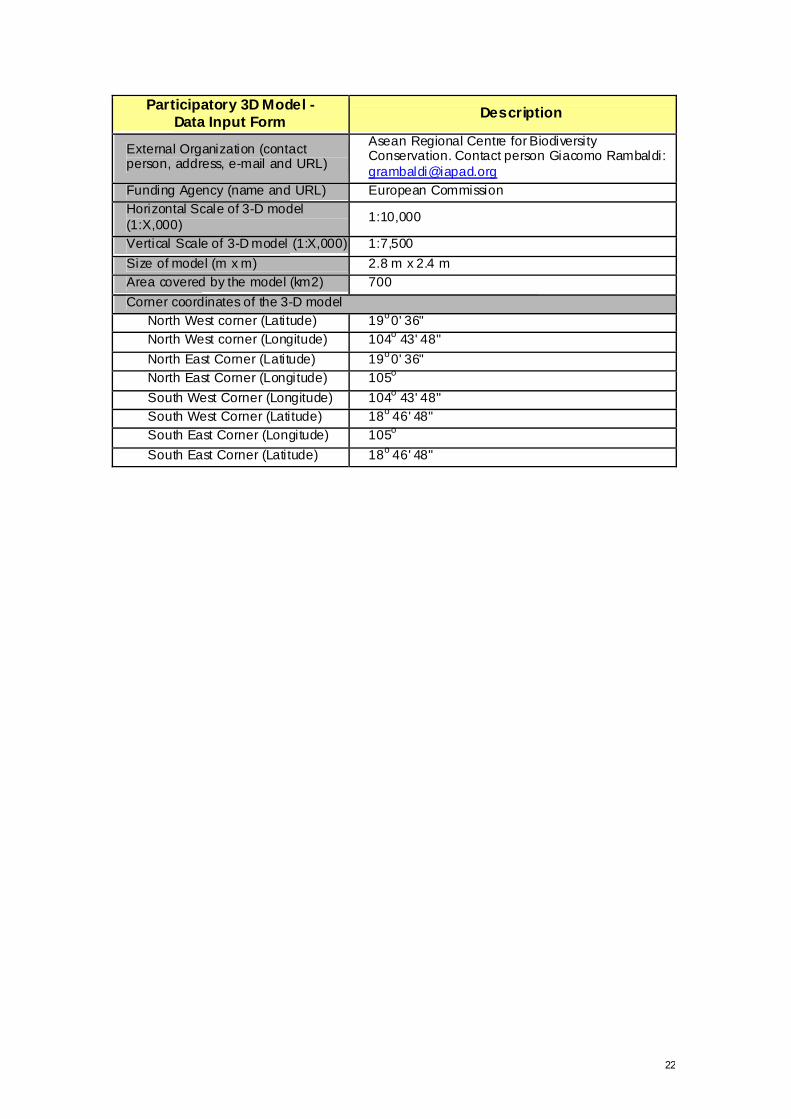
22
Participatory 3D Model - Data Input Form Description
External Organization (contact person, address, e-mail and URL)
Asean Regional Centre for Biodiversity Conservation. Contact person Giacomo Rambaldi: [email protected]
Funding Agency (name and URL) European Commission Horizontal Scale of 3-D model (1:X,000) 1:10,000
Vertical Scale of 3-D model (1:X,000) 1:7,500 Size of model (m x m) 2.8 m x 2.4 m Area covered by the model (km2) 700 Corner coordinates of the 3-D model
North West corner (Latitude) 19o 0' 36" North West corner (Longitude) 104o 43' 48" North East Corner (Latitude) 19o 0' 36" North East Corner (Longitude) 105o South West Corner (Longitude) 104o 43' 48" South West Corner (Latitude) 18o 46' 48" South East Corner (Longitude) 105o South East Corner (Latitude) 18o 46' 48"

23
Annex 3 List of key informants
Name/Commune Village Name/Commune Village Mon Son Commune Luc Da Commune
Vi Van Cuong Thai Son Lo Van Cuong Luc Son
Vi Van Hai Thai Son Ngan Van Doan Yen Hoa Lo Van Doan Thai Son Ngan Van Diep Xang Luong Thanh Phong Thai Son Ngan Van Thang Moi
La Quang Vinh Co Phat La Van Te Moi La Van Linh Co Phat La Thanh Mau Tan Hop La Van Ky Co Phat Lo Van Hiep Met Le Van Bao Khe Bong Nguy en Canh Ty Commune's guard force
La Van Hong Khe Bong Yen Khe Commune La Van Hanh Khe Bong Phay Van Bay Trung Huong Le Van Viet Con Lo Thi Khuy en Trung Huong
La Van Dinh Con Quang Van Binh Trung Chinh Vi Van Thanh Xieng Lo Van Thuan Trung Chinh Vi Van La Xieng Phan Sy Trung Cay Thi
Ha Van Ty Xieng Chau Khe Commune Vi Van Hoa Lang Yen Le Anh Lan Trung Yen Vi Van Hoa Lang Yen Vi Quang Vinh Bu Lo Van Hoi Bac Son Le Duc Manh Bu
Lo Van Dan Bac Son Le Duc Canh Bu Vi Van Vinh Bac Son Vi Thanh Ban Bu Ngo Dang Tien Cua Rao Lo Van Minh Na
Le Huu Hung Cua Rao Vi Van Hieng Na Dau Trong Quy Cua Rao Lo Quy et Thang Na Ha Van Bang Lang Cang Luong Van Minh Diem
Luong Van Tinh Lang Cang Vi Van Thang Diem Vi Van Long Lang Cang Vi Van Dong Diem Ha Van Viet Commune PC staff Chi Khe Commune Phan Van Nam Commune PC staff Vi Van Duyen Chan Nan
Ha Van Quan Nam Son Ngan Thanh Chien Chan Nan Ha Van Thuan Nam Son Vi Van Pan Son Khe Ha Van Thang Nam Son Vi Van Tien Lien Dinh
Ngan Van Tho Thai Son Lo Duong Lap Lien Dinh Ngan Van Hinh Thai Son Vi Van Mai Lien Dinh Ha Van Can Thai Son Tam Hop Commune
Ngan Van Quyet Khe Lo Vieng Van Nam Phong Vi Thi Hoe Khe Lo Lo Van Hong Phong Ngan Van Tan Khe Lo Vieng Van Do Phong Vi Viet Mien Thai Hoa Vieng Van Thien Xop Nam
Lo Van Mao Thai Hoa Lu Van Son Xop Nam
Lo Van Ha Thai Hoa Nguy en Trong Do Anh Son Forest Enteprise

24
Annex 4 Updated List of Supplies (with October/Nov ember 2001 units costs)16
QTY Unit of measure Article Specif ication Dong
Unit Cost estimate (USD)
Cost estimate (USD)
150 Sheet
Single-wall corrugated carton (1.4m x 2.5m) sheets. Inner and outer liner 175 g/m2, B flute 175 g/m2 19,500 1.30 195.00
1 Set
Editing and attributing contour lines (700 sq km, 1:10,000 scale; 20 m contour interv al) 5,000,000 333.33 333.33
4 pc Plotting base map on A0 paper (2 copies each) 400,000 26.67 106.67
24 Kg Office Glue (water based) 18,000 1.20 28.80 18 pcs Scissors (small) 4,000 0.27 4.80 10 pcs Scissors (for hair cutting) 8,000 0.53 5.33 2 Box Carbon paper (hand writing) 40,000 2.67 5.33
40 Rims Crepe paper (white) 7,500 0.50 20.00 3 pcs Blade cutter 6,500 0.43 1.30
20 Box Blades f or abov e cutters 7,000 0.47 9.33
2 Unit Base table (1.4m x 2.5m x 0.6m) ply wood (1/4") with reinforcements 400,000 26.67 53.33
4 pcs Painting brush # 0 4,000 0.27 1.07 20 pcs Painting Brush # 2 1,000 0.07 1.33 20 pcs Painting Brush # 7 1,500 0.10 2.00 20 pcs Painting Brush # 12 3,000 0.20 4.00 20 pcs Painting Brush # 10 2,000 0.13 2.67 2 pcs Brush 63,5 mm 4,000 0.27 0.53
20 pcs Brush 25 mm 1,000 0.07 1.33 50 pcs Plastic jars (1 litre capacity ) 1,500 0.10 5.00 10 pcs Plastic jar (3 litre capacity) 5,000 0.33 3.33 8 pcs Bucket (1 litre capacity ) 3,000 0.20 1.60 1 pcs Bucket (10 litre) 7,000 0.47 0.47
0.5 Kg Powder Colour (red) 100,000 6.67 3.33 2 Kg Powder Colour (y ellow-lemon) 35,000 2.33 4.67 1 Kg Powder Colour (y ellow-orange) 35,000 2.33 2.33 1 Kg Powder Colour (blue) 35,000 2.33 2.33 3 Kg Powder Colour (white) 15,000 1.00 3.00 1 Kg Powder Colour (black) 15,000 1.00 1.00 4 Kg Powder Colour (green) 35,000 2.33 9.33 1 Kg Powder Colour (brown) 15,000 1.00 1.00 1 Kg Powder Colour (light brown) 15,000 1.00 1.00 4 Kg Glue powder 40,000 2.67 10.67 2 Lit Alcohol 10,000 0.67 1.33 1 pc Hand mixer 50,000 3.33 3.33
40 pc Weights (….) 0.00 0.00 8 pc Plastic-laminated Reference Scale Chart 5,000 0.33 2.67 4 Box (100 pc)Push Pins (white) 15,000 1.00 4.00
2 Box (100 pc)Push Pins (y ellow, blue, black, green, red) 15,000 1.00 2.00
2Bag (1000 pc)
Map pins (13 mm long; 4 mm head; white) 75,000 5.00 10.00
1Bag (1000 pc)
Map pins (13 mm long; 4 mm head; y ellow, blue, black, red, v iolet, white, orange) 75,000 5.00 5.00
0Bag (1000 pc)
Map pins (13 mm long; 6 mm head, white) 105,000 7.00 0.00
1 Bag (100 pc)Push Pins (f lat head; white) 75,000 5.00 5.00 16 Exchange rate 15,000 Dong/USD. Units costs are applicable to Vietnam Setting, Hanoi in Particular

25
QTY Unit of measure Article Specif ication Dong
Unit Cost estimate (USD)
Cost estimate (USD)
1 Bag (100 pc)Map pins (13 mm long; 10 mm head; white) 75,000 5.00 5.00
4 Bag (50 pc) Map pins (13 mm long; 10 mm head; y ellow, red, green, blue) 33,500 2.23 8.93
1 Kg Hand-knitting yarn no. 8; 18 colours 60,000 4.00 4.00 4 Rolls Film Kodak ASA 200 (36P) 36,000 2.40 9.60 1 pc Stapler 29,000 1.93 1.93 1 Box Staple wire #35 2,000 0.13 0.13 3 pcs Scotch tape (2') 5,000 0.33 1.00 3 pcs Packing tape (2’) 5,000 0.33 1.00
10 pcs Masking tape (2") 14,000 0.93 9.33 1 Roll Cotton y arn (f ine); yellow 12,000 0.80 0.80 6 pc Colour marker, black, blue and red 20,000 1.33 8.00
36 pcs Pencil mongol # 2 2,500 0.17 6.00 1 pcs Pencil sharpener 65,000 4.33 4.33 5 Box Dressmaker pins 10,000 0.67 3.33
200 pcs Attendance certif icates 1,000 0.07 13.33 1 pcs Labels (stratacolor paper) 25,000 1.67 1.67 2 pcs Scaled ruler 125,000 8.33 16.67 3 pcs Measuring tape (3 meter long) 15,000 1.00 3.00 1 pc Banner 480,000 32.00 32.00 1 No. Laminated plate (legend) 2,000 0.13 0.13 1 No. Laminated plate (commemorativ e) 2,000 0.13 0.13 8 No. Laminated north arrow 2,000 0.13 1.07 4 Series Numbers (1 to 35) Font 72 0.00 0.00 4 Series Letters (Alphabet) Font 72 0.00 0.00 1 No. Logbook 24,000 1.60 1.60 1 No. Compass 20,000 1.33 1.33 1 Kg Nails (5") 8,000 0.53 0.53 1 Kg Nails (2.5") 8,000 0.53 0.53 1 Kg Nails (0.5") 10,000 0.67 0.67 2 Set Ov erhead projection markers (six colours) 70,000 4.67 9.33 1 Bag Cotton (absorbent) 5,000 0.33 0.33
50 m Transparent plastic sheet (1.2 m wide) 7,500 0.50 25.00 1 pc Hammer 9,000 0.60 0.60 1 pc Pliers 20,000 1.33 1.33 4 pc Coping saw 200,000 13.33 53.33 5 pc Blade f or coping saw (wood) 5,000 0.33 1.67 5 pc Blade f or coping saw (steel) 5,000 0.33 1.67
24 pc Double clip (25 mm) 1,000 0.07 1.60 2 pc Plumb line weight 10,000 0.67 1.33
TOTAL 1,090.83


