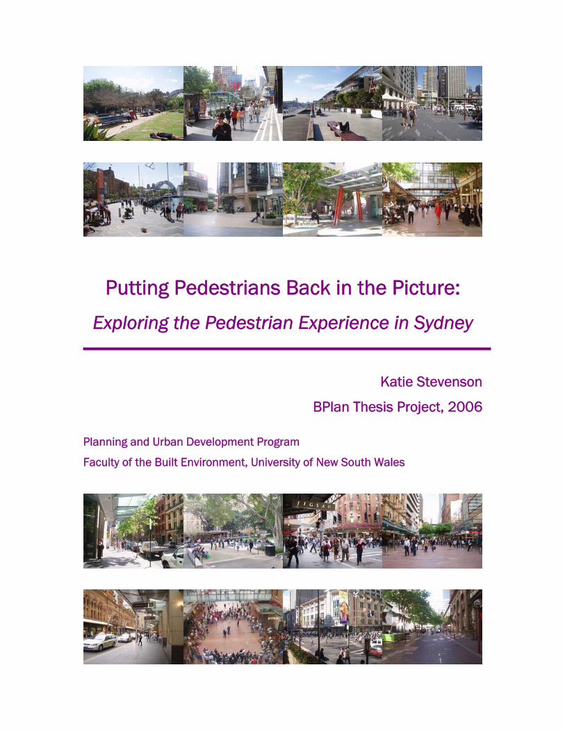
Putting Pedestrians Back in the Picture: Exploring the Pedestrian Experience in Sydney Katie Stevenson BPlan Thesis Project, 2006 Planning and Urban Development Program Faculty of the Built Environment, University of New South Wales
Transcript
Putting Pedestrians Back in the Picture:
Exploring the Pedestrian Experience in Sydney
Katie Stevenson
BPlan Thesis Project, 2006
Planning and Urban Development Program
Faculty of the Built Environment, University of New South Wales
ABSTRACT
Pedestrians have gradually been pushed further out of the focus of urban planning in city centres, in favour of ever increasing infrastructure for private vehicles. Not only has this severely impacted the nature of street life in cities, but it has also resulted in degradation of the environmental, social, economic and visual qualities of these unique environments. The tide has now begun to turn, and Sydney like many other cities across the globe are now turning to the tremendous achievements of cities such as Copenhagen, Barcelona and London for inspiration. These cities have transformed the character of the pedestrian realm with tremendous success, resulting in higher levels of pedestrian activity than ever before. Accessibility, opportunities for social interaction, safety, user comfort, maintenance and aesthetic considerations are the most influential factors in improving the quality of the public domain, and must be the central concerns in the planning of urban streetscapes and public spaces. Today, Sydney’s public realm is heavily utilised and offers a wide range of opportunities for human interaction. Nevertheless, remains a need to reduce the dominance of vehicular traffic in the city, and to place greater emphasis on the experiential characteristics in the public domain as it stands today and into the future.
CONTENTS
Part 1 INTRODUCTION 2
1.1 Introduction 2 1.2 Background to the need to plan for pedestrians 2 1.3 Research Statement, Objectives & Hypothesis 5 1.4 Structure of this Study 6
Part 2 SETTING THE SCENE 8
2.1 Introduction 8 2.2 The need for better pedestrian environments 8 2.3 The theoretical approaches 11 2.4 What makes a good pedestrian environment 17 2.5 Considerations for creating good pedestrian environments 19
3.3.1 Introduction to Sydney 25 3.3.2 Study Area 26 3.3.3 Case Studies of Urban Spaces 28 3.3.4 Sydney’s Public Domain 28 3.3.5 Places for Recreation 29 3.3.6 Built form Controls 31 3.3.7 Attractiveness and Amenity 35 3.3.8 City Districts and Attractions 36 3.3.9 Transportation and Accessibility 37 3.3.10 Accessibility for People with Disabilities 40 3.3.11 Safety and Security 42
3.4 Walkability 43 3.4.1 Methodology for a Study of Walkability 43 3.4.2 Pedestrian Gate Count Survey Results 45 3.4.3 Hierarchy of Pedestrian Volumes 47 3.5 Useability 50 3.5.1 Introduction 50 3.5.2 Methodology for Assessing Useability of Public Spaces 50 3.5.3 Results of the Case Studies 51 Pitt Street Mall 52 Martin Place 60 Circular Quay 67
Part 4 QUALITY OF SYDNEY’S PUBLIC SPACE 73
4.1 Introduction 73 4.2 The Theoretical Approaches 73 4.3 What Makes A Good Pedestrian Environment? 76
To my wonderful family for always being there for me and for your incredible support
throughout this thesis project and this year. Mum, Dad and Sarah, your love and support
mean the world to me and I can’t thank you enough for always helping me to reach my
goals. Mum, a special thanks for being my alarm clock, organiser, chef, proof-reader and
survey sidekick - I would be a mess without you. Beth, Lucinda, Mike, and Caitlin, thanks for
keeping me sane and entertained these past few months, and for always putting a smile on
my face, and to all of the uni gang for so many good times and wonderful experiences over
these past five years. Finally, a big thank you to Stephen McMahon for your helpful advice
throughout this project, and to Susan Thompson for all your support and encouragement
throughout this year.
PART 1
PLANNING FOR PEDESTRIANS
1. PLANNING FOR PEDESTRIANS 2.
2
1.1 Introduction
This thesis will present an analysis and discussion of the quality of the pedestrian
environment in Sydney in 2006. The analysis is placed in the context of the need to
improve pedestrian amenity and the social activities which occur in Sydney and other
cities across the globe. Pedestrian safety, growing environmental concerns and the
appeal of vibrant and active city centres, all call for the need to improve the quality of
city centres to encourage pedestrian activity downtown. As Australia’s only global city
(ABS, 2006), it is important that the environment in the heart of the city of Sydney is
lively, safe and appealing for people using the space for recreation or to simply move
about the CBD.
This study will examine the nature of Sydney’s pedestrian network as a whole,
exploring the varied patterns of usage between the different streets and precincts
within the CBD, and identifying the strengths and weaknesses of the existing
network. In addition, the study will also closely investigate the nature of human
activity in four key public spaces within the city centre, namely Circular Quay, Pitt
Street Mall, Martin Place and the King Street Wharf. These sites which are spread
throughout the CBD area, each have distinctive characteristics and patterns of
usage, and provide an accurate insight into the internal operations of urban spaces
within the heart of Sydney.
1.2 Background to the need to plan for pedestrians
The western world’s dependence on the automobile since the 1930’s has led to the
well-documented degradation of public life in civic spaces, the loss of open spaces
and reduced pedestrian accessibility. This is particularly the case in city centres,
many of which are choked with traffic congestion, polluted and frequently desolate
outside the working week. This presents a range of safety concerns, environmental
problems and reductions in the quality, vibrancy and usability of these important city
spaces. Sydney is no exception to this and these are the challenges which are facing
1. PLANNING FOR PEDESTRIANS 2.
3
those who plan for the future of urban streetscapes in the city centre. Like other
cities in Australia and around the world, it is crucial that the public realm in Sydney
supports and encourages maximum pedestrian activity throughout the city centre.
Car Dependence:
In Australia and elsewhere in the developed world, private vehicles are the most
widely used means of transportation. Sydney has been plagued by public
transportation crises in recent years. Regular strike action by government bus
operators, inefficient rail services and increasing traffic congestion on the cities
roads during peak periods means that it is not always easy or convenient to travel by
public transportation. Coupled with the sheer convenience and privacy offered by the
private motor vehicle, many Sydneysiders choose to travel to and from their
workplaces and other daily activities by car. In the case of the Sydney CBD, limited
and expensive car parking facilities do go some way to limiting the number of people
who choose to travel by car instead of public transportation. In order for public
transport modes to be most effective, it is vital that they are an economical, reliable,
comfortable and a convenient means of linking destinations (Kenworthy and Laube,
1999). These are certainly issues that require improvement in the case of Sydney.
Despite the parking limitations in the city centre, the streets in the heart of the city
are routinely choked with private traffic as well as taxi and bus services.
Conflict between cars and pedestrians:
The streets of today’s city centres are a hub of activity, crowded with people in cars,
on buses and on foot. This vibrant mix is confined to share limited space within a
compact network of streets, laneways and plazas. The streets are frequently crowded
with traffic and footpath space can be stretched forcing people to step onto
roadways. In this complex environment, pedestrian safety can be at risk, not only as
people commonly cross busy streets illegally, but also as foot traffic is forced onto
roadways and into conflict with cars, buses and bicycles. This is evidenced by
1. PLANNING FOR PEDESTRIANS 2.
4
frightening statistics which highlight the hazards for pedestrians in Sydney and other
cities.
City centres uninhabited outside office hours:
The traditional nature of the Central Business District has led to the creation of
downtown urban environments which are disproportionately balanced in the
provision of retail and commercial floor space, and with very little provision of
residential housing in the city centre. This means that the city centre is full of life and
activity during the working week, but desolate outside of office hours. This
discourages commercial activity which operates beyond traditional hours from
locating in these environments due to lack of patronage, and presents personal
safety concerns for the few people who do use the centre during the evenings and
weekends.
Decline of social life in public spaces and death of the traditional ‘street’:
As city centres such as Sydney have grown increasingly busy, valuable footpath space
has become a premium, forcing out the recreational and community activity which
were once common. Street vendors, entertainers, community markets and passive
informal recreation activities such as games of cards or chess between strangers are
forced out of the urban environment and formally relocated into parks and squares
on the fringe of the city and out of the way and indeed out of sight of the majority of
people who ‘use’ the city.
Policies promoting walking and discourage car use:
With environmental and public safety concerns, the obesity and diabetes epidemics
of our modern western societies under constant media focus, a range of international
governments have formulated policies specifically aimed at promoting physical
activity, increasing security in public areas and even limiting or altogether prohibiting
vehicular traffic from city centres. Such policies as well as the initiatives of lobby
groups such as the ‘car free days’ held internationally are drawing increasing
1. PLANNING FOR PEDESTRIANS 2.
5
attention to these important issues, which have direct implications for the nature,
quality and use of space in the CBD. For these reasons, research of this kind into the
character, useability and walkability of city centres such as Sydney is important and
highly topical.
1.3 Research Statement, Objectives & Hypothesis:
This research project will attempt a comprehensive examination of the strengths,
weaknesses and opportunities present for pedestrians in the streets and public
spaces of Sydney in 2006.
This study aims to analyse the role of three key public spaces within the context of
the wider city centre pedestrian system. We will examine the characteristics of these
pedestrian networks and spaces, explore the theories by which these systems may
be assessed and ultimately draw conclusions as to how the city’s pedestrian spaces
function today and how they may be improved in the future.
The study seeks to investigate and resolve the following central question:
How does Sydney rate in terms of pedestrian amenity, particularly in regards to the
walkability and usability of urban public space, and how can it be improved in the
future?
In order to examine the various interrelated issues which are associated with this
question, there are a range of objectives for the study. These objectives are:
• To assess the quality of pedestrian amenity in Sydney against the key theories
and methodologies for urban assessment
1. PLANNING FOR PEDESTRIANS 2.
6
• Assess the walkability and usability of the CBD pedestrian network as a whole
and in the three key public spaces.
• Determine which urban theories are the most relevant to an assessment of
urban space amenity for pedestrians and apply these criteria to an analysis of
Sydney
• Determine what lessons can be learnt from the scholarly literature and how
these concepts may be applied in Sydney to improve the quality of the public
domain.
The study’s underlying hypothesis is that the public spaces and pedestrian
movement systems in Sydney are well patronised, but are primarily used as
thoroughfares. There is limited opportunity for informal recreational activity in the
urban spaces of the CBD at the present time and there is significant variation in
levels of human traffic, the use of public spaces and the types of activities that occur
within them.
1.4 Structure of this Study:
Chapter 1 – This chapter provides a brief introduction to pedestrian planning and
provides the context for the study of Sydney’s pedestrian environment.
Chapter 2 – This chapter explores the theoretical concepts which emerge from a
review of the scholarly literature relating to the analysis of pedestrian
environments. We will particularly focus upon leaders in this field of
urban research, including Jane Jacobs, Kevin Lynch, Jan Gehl and Jon
Lang amongst others.
Chapter 3 – This chapter provides the results of a detailed analysis of the Sydney
pedestrian network. It provides a profile of the urban network of the
1. PLANNING FOR PEDESTRIANS 2.
7
city, before providing data on the results of a practical investigation of
walkability and useability of the streets and public spaces.
Chapter 4 – This chapter explores the relationships between the theoretical
concepts which were raised in chapter two, and the findings of the
pedestrian analysis of Sydney.
Chapter 5 – In this chapter a host of recommendations are offered for the future
improvement of Sydney’s pedestrian environment. These practical
actions promote improvements in the walkability of the Sydney CBD
and the usability of the street network and the cities public spaces.
This chapter also details a range of conclusions on the research
process undertaken and the analysis of Sydney’s pedestrian
environment which has been provided.
PART 2
SETTING THE SCENE
2. SETTING THE SCENE 3.
8
2.1 Introduction
The purpose of this contextual review is to gain an understanding of the existing
wealth of knowledge which currently exists related to the field of pedestrian planning.
By examining the scholarly context for this field of research, we will determine what
information and research into this field is already available. In addition the literary
study will also identify issues and concepts which have not yet been adequately
explored in the literature to date and which are in need of future research. The
theoretical insights gained as a result of this process will be applied later in this
research project to analyse the character, use and quality of the public realm in
Sydney at present.
2.2 The need for better pedestrian environments
Many urban philosophers have sought to investigate and theorise about what
characteristics contribute to a good or even an ideal environment for pedestrians.
The issue has been approached from a range of perspectives, including economic,
social, environmental, transport-oriented and purely design focused viewpoints. In
turn, there are many reputable researchers who have concentrated specifically on
the functioning and improvement of pedestrian spaces and networks. Many of these
authors have attempted to illustrate the principles which they attribute to having the
most critical role to play in the creation of high-quality pedestrian environments.
Their work has contributed substantially to the knowledge base which has developed
in the past 30-40 years (Gehl and Gemzøe, 2003). They have each attempted to
explain, to varying degrees, the role of the various human, societal, environmental
and physical factors which influence the people who use the public domain and
precisely how they do so. The underlying aim of these influential hallmark studies has
been to contribute to the design of more successful and pleasant public spaces –
whether through the creation of entirely new environments, or the improvement of
existing spaces.
2. SETTING THE SCENE 3.
9
It is impossible to discuss improving the quality and character of the urban
environment in city districts without making some reference to the issues which have
contributed to its degradation. Traditionally, city centres served an important
community function and were the concentration of commercial and business trade
and the central focus of community pride and identity (Gehl and Gemzøe, 1996). The
advent of the popular automobile has played a critical role in the demise of this
traditional character in urban centres throughout the world, but particularly in
westernised countries in Europe, Australia and North America. Urban space which
was once devoted to community congregation, green space and outdoor market
places, rapidly began to disappear, replaced by ever expanding lanes of traffic and
parking areas. This phenomenon has been discussed by numerous authors including
Gehl and Gemzøe (2003) and Jon Lang (1994), who credit the rise of the motor car
as the single most detrimental factor to the development of community oriented and
alluring city centres.
Another consequence of the rise of the automobile has been the segregation of land
uses and activities within city centres. The popularity of this private motorised
transportation meant that activities no longer needed to be located close by and
easily accessible by foot and as a result, many activities were gradually pushed
further away from the urban core. The dispersal of activities across widening
distances has created modern urban environments which no longer contain the rich
mix of vibrant retail uses, community activities and commercial concentrations.
Increasingly, cities such as Sydney cater predominantly to the needs of tourists, large
department stores and commercial offices.
There are no longer the community activities and social atmosphere that once
existed in the largely pedestrian streets of the inner city before the private vehicle
boom began in the 1960’s (Jacobs, 1993). Once thriving commercial centres are now
oversaturated with office development, at the expense of struggling retail uses and
with the almost complete absence of residential accommodation within the inner city
2. SETTING THE SCENE 3.
10
area. Clare Cooper Marcus and Carolyn Francis (1998) explain how these trends
have resulted in traditional community activities have been pushed into private
spaces such as suburban shopping malls and underground arcades. They describe
the damage that this approach has caused to the urban public realm which has
resulted from these processes, noting that ‘what remains are scattered, unconnected
urban plazas used predominately by one segment of the population (office workers),
and only on weekdays during the lunch hour.’ (Cooper Marcus and Francis, 1998).
This sentiment is echoed by the President of Project for Public Spaces, American
Fred Kent who places the blame on the design professionals who have allowed this
climate to develop. He makes an interesting observation about modern urban
centres, commenting that “We’ve narrowed the experiences that people can have.
It’s an atrocity, and the design professionals don’t even know they do it! (Gurwitt,
2005). The rationalisation of the disconnected structure of the urban realm of cities,
together with the desire for revitalisation of economic activity within city centres has
become a major focus of urban planning in recent years. This dual focus (while
explained here from a largely American perspective) has been the catalyst for the
range of pedestrian schemes which have become popular experiments in cities
across the world, from Asia to Europe and North America.
To date, a range of pedestrian schemes have been tried and tested, in the quest for
an urban environment and community focus to rival the squares and plazas of many
medieval European cities (Lang, 1994). Europe has long been considered the model
upon which modern city centres should be based, due to the effectiveness with which
their design combines high quality architecture, community interaction and
commercial trade. This traditional medieval urban structure lends itself well to a
compact and interesting walking environment for pedestrians, which functions well at
a human scale and provides opportunities for social interaction and passing retail
trade (Lynch, 1984).
2. SETTING THE SCENE 3.
11
2.3 The Theoretical Approaches
The scholarly writers discussed below have become the most prominent experts in
the field of planning for pedestrian amenity. Their texts contain some of the most
comprehensive assessments and analytical first principles for urban realm
improvement which have emerged in the discipline thus far.
Jan Gehl and Lars Gemzøe – Places for Public Life and Social Interaction
Danish Architects Jan Gehl and Lars Gemzøe best explain the evolution of today’s
renewed interest in the quality of the urban realm which has developed markedly
since the 1980’s (Gehl and Gemzøe, 2003). They quite rightly argue that in 2006
urban planners are no longer simply interested in planning for transportation and
commercial prosperity. Rather, they have been alerted to the social benefits that can
be gained for the community when the focus is placed on people, and on the
development of ‘public life’ or the social integration which epitomised the cities of
yesteryear.
Effective planning is essential for improving pedestrian safety, creating an
environment which encourages pedestrian activity and improving the social image of
the city itself (Brambilla and Longo, 1977). These two authors have listed six primary
human actions which account for activity in public spaces – namely, walking,
standing, sitting, lying, running and playing. Brambilla and Longo (1977) divide these
actions into ‘necessary’ and ‘optional’ activities. Gehl (1987) however has refined
this concept to distinguish three types of outdoor activities. He describes ‘necessary
activities’ which occur irrespective of the quality of the public domain and include
basic errands, ‘optional’ activities such as lingering which occur only where the urban
realm allows and is of a nature that people choose to be there, and finally he adds
‘social activities’ which are spontaneous actions requiring the presence of other
people to share the space such as people watching and conversation. In successful
urban spaces, these optional and social activities are abundant and as such should
2. SETTING THE SCENE 3.
12
be a key objective of urban design. He stresses that the wider the range of activities
a space enables, the better the quality of that environment.
Gehl and his celebrated Copenhagen-based Architectural firm Gehl Architects have
undertaken numerous analyses of pedestrian environments in a range of cities
across the globe. He and his consultants specialise in making assessments of urban
quality and produce strategic recommendations for local authorities which
consequently have resulted in significant improvements in the human use and
quality of the public realm in these cities. Cities in which Gehl has influenced and
enhanced pedestrian amenity include Stockholm in Sweden, London in England,
Wellington in New Zealand, Zurich in Switzerland. Gehl has also undertaken
pedestrian analysis studies in several Australian capital cities including Perth,
Adelaide and Melbourne, which has particularly seen marked improvement in the
quality of its public domain since Gehl’s project commenced there in 1994.
In general, the ultimate success of any pedestrian scheme is dependant upon the
unique combination of the local social and economic climate, existing and future built
context and the specific nature of its design and implementation (Brambilla 1977
and Childs, 2004). Jan Gehl and Lars Gemzøe (2004) particularly stress the
importance of a gradual and deliberate staged approach to the implementation of
changes of any significant magnitude in an established city context. By their very
nature, humans are fearful of change and any suggestion of major modification to
the way a place or system presently functions is likely to be met with opposition of
the unfamiliar. In order to overcome this resistance, plans to rationalise the city
structure or movement system in a particular area or across an entire centre should
be well coordinated and introduced over a lengthy period. As Gehl and Gemzøe
(2003) explain, this allows residents to become familiar with the changes in small
increments, and as a result, benefits can be realised as improvements are slowly
made, building community support for the project as it develops. This approach was
applied in the highly successful pedestrianisation scheme for Copenhagen. Over the
2. SETTING THE SCENE 3.
13
course of 45 years, the city has substantially reduced car use in and surrounding the
urban core while making significant improvements in the amount and quality of the
public domain, with what has evolved into massive community support for such
public initiatives. Copenhagen has truly become an internationally recognised model
for urban domain improvement.
While the tide has begun to turn and the focus is shifting (Gehl 2003) from our
aesthetic and functional preoccupations of traditional planning approaches, the
response to a human and social focus has been insufficient as yet. There is however
much to learn from the successful transformations which are evolving in landmark
cities such as Barcelona, London, Portland and Curitiba, Brazil which will shape
future action elsewhere.
Jane Jacobs - Diverse Urban Environments
A key catalyst for this change was the influential book The Death and Life of Great
American Cities written by Jane Jacobs. Since its 1961 release, this text has
revolutionised the planning fraternity with its criticism of traditional planning theory
and practice. Since then, numerous other urban researchers including William H.
Whyte, Kevin Lynch and Jon Lang have built upon concepts first expressed by Jane
Jacobs, and attempted to bring the focus of urban planning back to the role that the
physical environment can play in the lives of people and their society.
Jane Jacobs was particularly interested in understanding the physical actions by city
designers which support and contribute to economic and social vitality, and which
activities are detrimental. She argues that diversity of land uses is the most critical
factor in this regard, and also highlights the need for the full range of uses in an
urban environment (or part there of) to complement and support each other. In order
to achieve this, Jacobs argues that four elements are necessary. These are short
blocks, a mixture of built form types, concentration of diverse populations and
districts which serve more than simply one primary function (such as the dining
2. SETTING THE SCENE 3.
14
district). She repeats the theme that cities play an important social purpose as ‘a
meeting place of strangers’ and builds upon the concept of people attracting people
and generating further social activity. She emphasises that these social
considerations should be a focus and objective of physical planning in an urban
context, but stresses that it is inappropriate to dictate behaviour and that the role of
designers is to provide environments which can accommodate a wide-range of
human activities. Safety is another major focus of Jacobs work. She identifies three
fundamental qualities which are required for a safe environment. These include
passive surveillance, active footpaths and clear delineation of public and private
areas within the urban environment.
Jon Lang - Qualities for Attractiveness and Functionality
Jon Lang is another North American researcher whose interest in the quality of the
public domain stemmed from his aversion to the struggling central business districts
which characterised urban environments across the United States. His valuable
textbook Urban Design: The American Experience (1994) is a powerful analysis of
the evolution of traditional city planning approaches in the United States, but more
importantly, it is a discussion of the key challenges which urban planners face and
advice for their attempts to rectify these problems in the future. His work is useful as
an overview of the historical development of traditional planning approaches and for
his discussions of the consequences of a range of historical theories such as the
Garden Cities Movement and rationalist theory.
In analysing the urban environment, Lang (1994) is interested in human activity
within the public domain, and distinguishes between two types of behaviour settings
– places and links - both of which offer very different opportunities for activity based
upon their different functions in the urban system. Similarly, he also provides a
discussion of the various types of pedestrian linkages which exist in an urban
context, based on their appropriateness in terms of their location, users and function.
His most valuable contribution in respect to planning for human use of the public
2. SETTING THE SCENE 3.
15
domain is his designation of the four basic elements of the physical environment.
These factors which are the spatial character, furnishings, enclosing character and
illumination are the four elements which Lang argues set the character of a given
space, and provide the setting for human interaction in space. Careful consideration
of all four of these elements can produce places which are appropriate for their
intended use and surrounding built and natural context, and which are ultimately well
liked and patronised.
Kevin Lynch - The Legibility and Public Image of the City
Kevin Lynch is another author who has contributed a great deal to the field of urban
design, particularly in terms of the design of environments which contribute positively
to the lives of the citizens of a city. His seminal texts The Image of the City (1960)
and Good City Form (1984) provide some fundamental first principles of urban
design within city contexts, and have formed the foundation of much of the work of
his successors including Allan Jacobs (1993) and Cooper Marcus and Francis (1998).
Lynch is particularly interested in the visual form of cities, and in the coordination of
built form and the public domain at this city scale. His particularly directs his
attention towards people. He believes ‘the people and their activities are as
important as the stationary physical parts’ of the city, and as such he investigates the
character of American cities, specifically Los Angeles, Boston and Jersey City, though
a study of how residents and visitors to these cities experience the urban
environment. In particular, he focuses upon the importance of legibility (the logical
and navigable structure of the urban pattern) and the ‘public image’ of the city
environment projects which gives its identity in the experience of its inhabitants. He
identifies five elements which contribute to this city image (1960) – namely, paths,
landmarks, edges, nodes and districts – which have become fundamental concepts
in urban design. In addition he also proposes five key performance dimensions by
which urban form can be assessed. These dimensions are vitality (how the vital
requirements of human users are supported by the environment), sense (the mental
legibility of streets and spaces), fit (the appropriateness and adaptability of the urban
2. SETTING THE SCENE 3.
16
form), access (the ease of movement) and control (the regulation and management
of the environment). He also highlights the importance of justice and efficiency in
regards to how these performance dimensions are achieved.
Allan Jacobs – Characteristics of Great Streets
One commentator who has provided the most thorough and realistic criteria for the
creation of good urban spaces to date is Allan Jacobs. His influential text ‘Great
Streets’ (1993), offers a comprehensive list of criteria for what he terms ‘great
streets’. Like the majority of researchers in this discipline, he focuses upon the
physical and designable elements which give identity to a space and contribute to its
‘greatness’ or lack thereof. In this text, Jacobs also identifies a range of different
‘street’ types (which include plazas and pedestrian only spaces) from medieval
streets and historical districts to sizable boulevards to contemporary shared traffic
zones and pedestrian malls, and makes valuable comparisons using international
case studies of each.
The criteria Jacobs (1993) sets out is wide ranging and includes the full range of
issues discussed by the other leading authors, despite his biased focus upon
aesthetic quality and human interaction. Essentially, this criteria strive for public
environments which are accessible, pleasant, comfortable, safe, encourage social
interaction, are memorable and have local meaning for the community. Throughout
his text, Jacobs stresses the important role of streets for adding a social experience
in individual’s lives and the important role that designers have to play in shaping
their use. He notes ‘there is magic to great streets. We are attracted to the best of
them not because we have to go there but because we want to be there’ (Jacobs
1993: XX). His emphasis on this ‘magic’ ingredient is a major element which
distinguishes Allan Jacobs from other authors in this research field. In addition,
Jacobs also devotes particular attention to the role of the local context (particularly in
regards to surrounding street and block patterns and their functions) in shaping
meaning and use for a particular street or space.
2. SETTING THE SCENE 3.
17
Clare Cooper Marcus and Carolyn Francis – Guidelines for Public Space Design
Carolyn Francis and Clare Cooper Marcus are two prominent American writers from
the renowned Planning Department at the University of California at Berkeley in the
United States. In their instructive 1998 text People Places, the authors express their
dismay at the state of existing public spaces in urban contexts throughout North
America. To remedy the poor design quality of public spaces, the inadequate
coordination of the public domain in many downtown areas and the underutilisation
of public spaces, Francis and Cooper Marcus provide practical strategies for the
resolution of these concerns. Through the designation of seven categories of urban
space based on scale and function, the authors have suggested design guidelines
which accommodate the social needs of users within these varied types of urban
spaces. Their fundamental objectives are to create environments which are equitably
accessible, respond to the needs of their patrons and which have meaning within
their societal context, although they acknowledge that local strategies must be
respond to their local physical and socio-economic context. The key themes which
are evident throughout their work include physical aspects such as boundaries,
circulation and subspaces as well as the importance of specific functional elements
such as public art, vegetation, seating and signage within the public domain. Other
issues which are highlighted throughout People Places include microclimate, the
need for visual complexity in the creation of pleasant environments and the
importance of maintenance to sustain the quality of public areas in the long term.
2.4 What makes a good pedestrian environment?
One common theme throughout the literature is the importance of social activity as a
primary attraction in the city centre. Jan Gehl (1987) and William H Whyte (1980)
stress the importance of a vibrant social atmosphere for creating usable urban
spaces which people enjoy and importantly, are well utilised. These authors go so far
as to argue that providing appropriate settings for social engagement is more
2. SETTING THE SCENE 3.
18
important that physical form and design, and is in fact the single most vital factor in
the creation of a high quality urban environment for both the use of urban space and
the creation of a functional city-wide pedestrian network. However, we can not
dismiss the importance and contribution of a good urban design. It is an unfortunate
reality however, that these social considerations have not been given sufficient
attention in existing research as well as in practice, as Brambilla and Longo (1977)
explain “Designers often concentrate on refining the formal architectural components
of public spaces without understanding how people use the space and what makes a
place successful”, he goes on to note that the physical ‘frame’ is important, but it is
only this, a border for the human activity which should be the prime focus. While the
tide has begun to turn and the focus is shifting (Gehl 2003) from our aesthetic and
functional preoccupations of traditional planning approaches, the response to a
human and social focus has been insufficient as yet. There is however much to learn
from the successful transformations which are evolving in cities such as Barcelona,
London, Portland and Curitiba, Brazil which will shape future action elsewhere.
To date, most of the literature approaches the issue of urban design for human
interaction and enjoyment from a functional perspective, led by authors such as
Kevin Lynch and more recently, Carolyn Francis and Clare Cooper Marcus. That is,
the writers typically present advice and design guidelines which can be applied
directly to urban environments to resolve specific issues and improve the quality of a
place for the people who use it. This section presents a discussion of the dominant
themes and criteria which emerge from an analysis of the existing scholarly literature
on the subject.
It is pertinent to discuss the various types of ‘pedestrian environments’ which have
emerged from the literature and from practical experimentation. Cooper Marcus and
Francis (1998) have categorised these environments into seven specific types of
public spaces, according to their scale, function within the surrounding urban context
and the nature of their human occupation. In fact, all of the urban researchers
2. SETTING THE SCENE 3.
19
mentioned above discuss the various ‘types’ of different urban spaces to varying
degrees of detail. Consequentially, the following primary categories of urban spaces
materialize:
• Pedestrian Malls
• Skywalks and Internal or Underground Arcades
• Shared Spaces
• Pedestrian Plazas and Town Squares
• Urban Parks and Gardens
A recurrent theme in the literary discourse is the critical importance of physical
elements in creating an urban realm which supports human use and interaction. This
focus upon the physical is approached from a range of angles within the literature.
Some writers such as Kevin Lynch (1984) and Mark Childs (2004) place particular
emphasis upon the physical structure and form of urban places and have sought to
refine the objectives and design criteria that others before them have produced for
this very purpose. What has resulted is a complex range of design guidelines which
contribute to the creation of good streets and plazas for the people who use them.
2.5 Key considerations in the creation of good pedestrian environments:
The following represents a list of the key considerations in urban design for human
activity in city centres such as Sydney. These six criteria will form the basis for an
evaluation of the public domain in Sydney which forms the basis of this thesis
project.
Accessibility
- Equity of access to all activities, people and places within the urban centre
- Consideration of access for the most vulnerable groups within the population
– children, the elderly and people with disabilities
2. SETTING THE SCENE 3.
20
- Reliable and convenient access between places by public transportation
modes and by foot
- Logical navigation should be possible throughout the urban centre, supported
by way finding mechanisms such as signage, landmarks and a legible street
network.
Encouraging human interaction
- The public domain should make human interaction, both passive (such as
conversation) and active (such as playing a game) possible.
- The public domain including both streets and spaces should be designed so
that human activity and socialisation is not hindered by means such as
excessive noise, poor seating design or cluttered footpaths.
- Street and plaza furnishings should support and enable a wide variety of uses.
Safety
- Public streets and urban spaces should be well lit and should avoid hidden
corners which enable antisocial behaviour to occur undetected.
- Streets and squares should be active at most times of the day – including day
and night and weekdays and weekends so that there is constant human
activity and supervision of the public realm.
- Police and or security guards should perform regular patrols to monitor space
and discourage inappropriate behaviour such as harassment or vandalism
- Concepts of both ‘perceived’ safety and ‘actual’ safety should be considered
by designers and local authorities during the design and the ongoing
implementation phases of any urban activity in public spaces. Even when
locations are free from crime, they may still feel unpleasant or dangerous to
users.
2. SETTING THE SCENE 3.
21
- Ongoing maintenance of urban space should ensure that damage to
furnishings floor surfaces is repaired instantly to prevent accidents.
Comfort
- The design of the urban domain should be responsive to the local climate and
environmental constraints such as topography to create an environment
which is attractive and comfortable to users. Trees should be provided to
provide shade in hot climates, or deciduous trees may be used to provide
additional sunlight in the winter months where necessary. This is particularly
important in locations with extreme weather conditions such as wind, heat or
cold where special measures (such as temperature controlled glass ‘rooms’
rather than open bus shelters in cities prone to snowy and windy conditions)
- Furnishings should maximise comfort and usability for people within a space.
Seating should be appropriately located (able to receive an appropriate level
of solar access) and should be comfortable, particularly for the elderly to use
to rest. Ledges, steps and bollards can also be used to provide additional
informal seating in peak periods, as a place to lean and to rest goods upon.
Responsibility and Maintenance
- Places must be monitored and maintained in an acceptable condition for the
life of the space. Vandalism and graffiti must be repaired as soon as is
practical and damage to steps, manholes and floor surfaces must also be
fixed to maintain the appearance of the space and most importantly for the
safety of users.
- There should be a clear understanding between the relevant parties over who
is responsible for basis services such as garbage collection and security
services.
2. SETTING THE SCENE 3.
22
Aesthetics and visual complexity
- Attractive urban environments must be diverse in the type of land use
activities they contain (and therefore the type of users and human activities)
and the character of the built form. The visual environment should be varied
and contain a rich mix of architectural elements, while maintaining some
common elements which tie the street scene together and provide some local
identity for the area.
- The public domain should be designed to retain or create vistas and view
corridors wherever possible. Access to views of important or attractive
features in the local built and natural landscape provide a unique character
and tie the urban realm into the context of the unique environment in which it
is set.
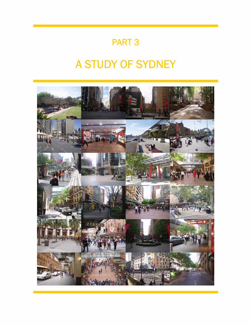
PART 3
A STUDY OF SYDNEY
3. A STUDY OF SYDNEY 4.
23
3.1 Introduction
This investigation of the quality of the urban environment in Sydney is based upon a
practical study of the City. This field study was conducted over several days in
September and October 2006. The aim was to gain an accurate snapshot of the
extent to which people currently use urban spaces in Sydney and how they do so, and
also to assess the internal accessibility of the City. This chapter details the findings of
this study in an effort to evaluate the quality of the public domain for pedestrians.
This detailed study of Sydney considers the City’s streets and public spaces against
the criteria which emerged from the theories discussed previously in chapter two. The
practical survey also seeks to specifically investigate the central themes of this thesis
project - the useability and walkability of the public domain. These issues are
important indicators of how the urban realm is currently being used in Sydney, and
also highlight shortcomings in the design of urban spaces and the street network that
would benefit from future improvements.
Urban environments which are attractive to pedestrians encourage increased
patronage of urban spaces and make it an attractive option for people to walk in the
city – not merely out of necessity, but for enjoyment. This also adds to the liveliness
and vibrancy of the city centre, as more people and a wider range of human activities
contribute to and strengthen the unique character of the city.
3.2 Chapter Structure
This chapter will present the results of the field study in logical order, looking first at
the city network as a whole, before focusing more closely at some specific urban
sites.
The first part of the chapter provides a snapshot of Sydney. It addresses a range of
issues which contribute to the city structure, activities, appearance and accessibility
of the city. All of these issues play a critical role in shaping the nature and character
3. A STUDY OF SYDNEY 4.
24
of the urban realm for the people who use it. The topics which are covered in this
section include the physical structure of the urban fabric, development controls
which apply to the land, traffic and transportation matters, City attractions and
activities, accessibility for the disabled as well as heritage items, city furnishings and
public safety.
The second section deals with the issue of the walkability of the city street network.
The results of a pedestrian survey exercise which was undertaken as part of this
study are outlined. This data presents a summary of how pedestrians currently move
throughout the city of Sydney, highlighting which areas are most heavily exploited and
which sections of the city are presently underutilised.
Finally, the third section of this chapter investigates the useability of Sydney’s public
spaces. The results of three detailed case studies of different types of urban spaces
are detailed, showing how these spaces are currently used. Specifically, it looks at
their level of use and how this varies across the day, the range of activities which
occur within these spaces, and their physical design and how this contributes to their
character and attractiveness to users.
This data leads into an analysis of the findings of the study which will be discussed in
chapter four. In this chapter, Sydney will be assessed in terms of its fulfilment of the
criteria for pedestrian amenity that were outlined in chapter two.
3. A STUDY OF SYDNEY 3.3 SYDNEY SNAPSHOT
25
3.3.1 Introduction to Sydney
The Greater Metropolitan Region of Sydney covers a vast area, officially from the
NSW Central Coast in the north to the Illawarra in the South and as far west as the
Blue Mountains. This entire region is now home to approximately 4.2 million people.
In contrast, the Sydney Central Business District (CBD) covers only a small area of
land on picturesque Sydney Harbour. It is set on the site of Governor Phillip’s original
penal settlement on Port Jackson (Sydney Harbour) when Australia was colonised in
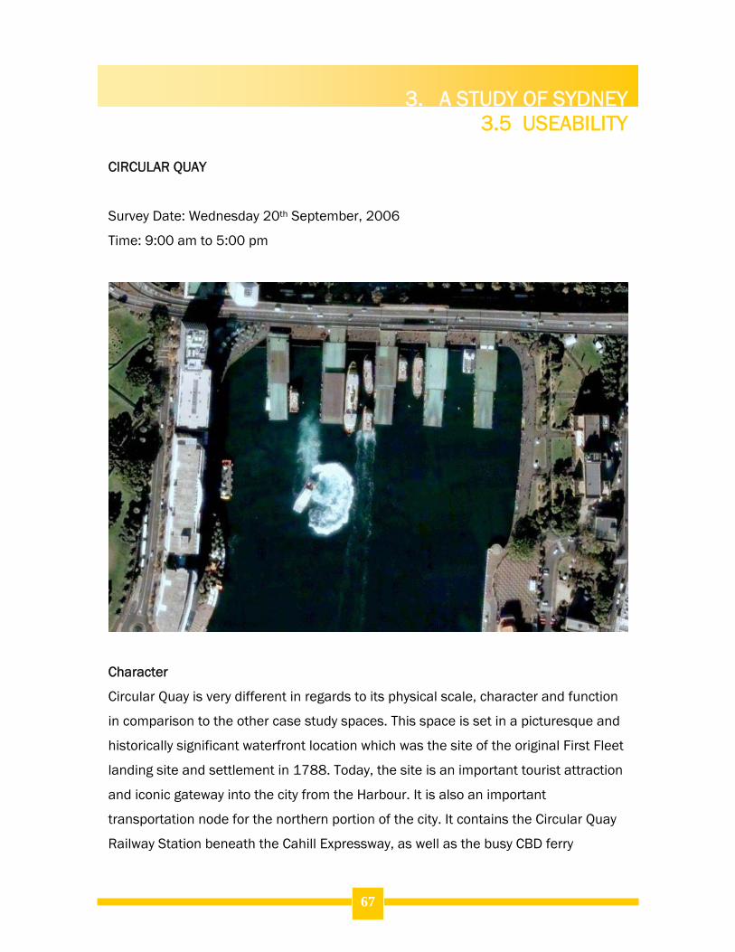
1788. In fact, the actual landing site of the First Fleet is now occupied by Circular
Quay, the City’s premier harbour side attraction, and a site which is a major focus of
this study of Sydney.
The image below depicts the City in its local context, highlighting the site of the CBD
and historical settlement and the various waterfront localities which surround Central
Sydney.
Sydney is Australia’s only global city. It is the largest CBD in the nation, succeeded
immediately by Melbourne, which is its closest rival in terms of geographic and
population size, as well as its function within the national trade and commercial
sectors. With such a critical role, and as the birthplace of the nation, Sydney has
great commercial and cultural significance for all Australians which should be
reflected in its urban form. It should be a place for the people – residents, visitors,
workers and tourists alike.
3. A STUDY OF SYDNEY 3.3 SYDNEY SNAPSHOT
26
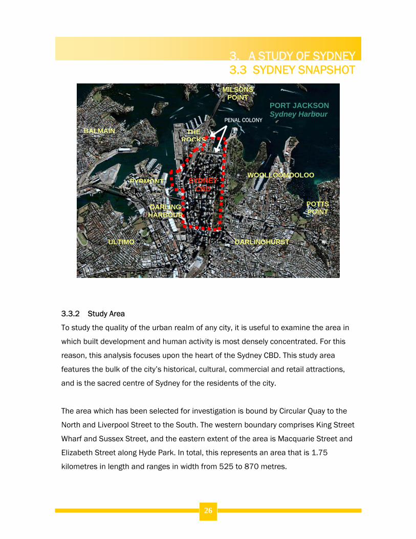
3.3.2 Study Area
To study the quality of the urban realm of any city, it is useful to examine the area in
which built development and human activity is most densely concentrated. For this
reason, this analysis focuses upon the heart of the Sydney CBD. This study area
features the bulk of the city’s historical, cultural, commercial and retail attractions,
and is the sacred centre of Sydney for the residents of the city.
The area which has been selected for investigation is bound by Circular Quay to the
North and Liverpool Street to the South. The western boundary comprises King Street
Wharf and Sussex Street, and the eastern extent of the area is Macquarie Street and
Elizabeth Street along Hyde Park. In total, this represents an area that is 1.75
kilometres in length and ranges in width from 525 to 870 metres.
POTTS POINT
PORT JACKSON Sydney Harbour
PYRMONT
DARLING HARBOUR
DARLINGHURST
THE ROCKS
WOOLLOOMOOLOO
BALMAIN
ULTIMO
MILSONS POINT
SYDNEY CBD
PENAL COLONY
3. A STUDY OF SYDNEY 3.3 SYDNEY SNAPSHOT
27
The images below depict the study area from an aerial perspective, visually indicating
the nature and density of the urban form, while the second map illustrates the street
pattern of the city. This map also identifies the location of parks and public spaces
within the street network. The three areas marked in black are the locations which
are explored as case studies to examine the usability of public spaces.
LEGEND Study Area
LEGEND Streets and Laneways
Plazas
Street Blocks
Parks and Green Spaces
3. A STUDY OF SYDNEY 3.3 SYDNEY SNAPSHOT
28
3.3.3 Case Studies of Urban Spaces
In order to gain an understanding of the complexities in the way urban spaces
function in Sydney today, three sites were identified for closer examination. These
sites were used to examine the level of usage of the public domain and to discover
the nature of activities that take place in these spaces on a given day.
The three sites which were selected are Martin Place, Pitt Street Mall and Circular
Quay. These locations represent the three most significant public spaces in the city,
followed by Hyde Park and King Street Wharf. It is interesting to study them together
as they each play a unique role in the urban system of the City, serving very different
functions between them. This enables comparisons and contrasts to be drawn
between them, and also allows a wide scope for this investigation across spaces
which serve important tourist, retail and accessibility functions within the City,
resulting in diverse activities and users of the space.
3.3.4 Sydney’s Public Domain
The public domain of the City comprises its streets and laneways, plazas and public
spaces, parks, malls and internal arcades. Sydney exhibits a mix of each of these
forms of public space. Due to the nature of arcades as spaces confined within
privately owned buildings, these sites are inaccessible at times (outside of business
hours), and have different management rules which can affect their operation and
who uses the space. For this reason, for the scale and scope of this particular study,
internal malls have not been considered for their impacts upon pedestrian amenity.
Rather, this study focuses upon the publicly accessible streets and public spaces in
the outdoor environment of the City. It is in these areas that accessibility should be at
its peak, and that make the greatest contribution to the look and feel of the city
atmosphere for the people who use it.
The following diagram illustrates the public domain of the city of Sydney today.
3. A STUDY OF SYDNEY 3.3 SYDNEY SNAPSHOT
29
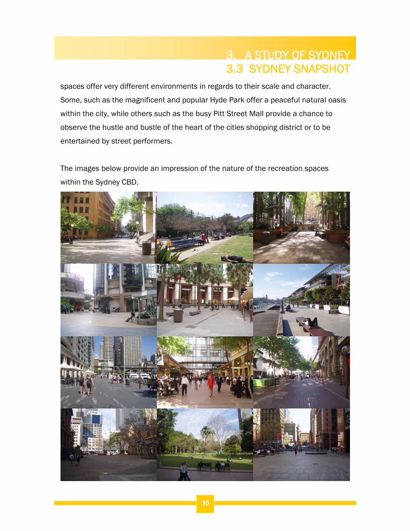
3.3.5 Places for Recreation
The image above highlights the location of the various recreation spaces within
Sydney’s CBD. These spaces can be logically divided into two categories – parks and
urban plazas. These sites add visual interest to the city streetscape, and provide
places for people to relax, play and interact with others while enjoying the urban
outdoor environment.
These two types of spaces offer very different options for users in terms of their
physical surroundings, and the types of activities they are likely to encounter and
have the opportunity to participate in while there. Across the city, these various public
LEGEND Streets and Laneways Parks and Green Spaces Urban Plazas Street Blocks
3. A STUDY OF SYDNEY 3.3 SYDNEY SNAPSHOT
30
spaces offer very different environments in regards to their scale and character.
Some, such as the magnificent and popular Hyde Park offer a peaceful natural oasis
within the city, while others such as the busy Pitt Street Mall provide a chance to
observe the hustle and bustle of the heart of the cities shopping district or to be
entertained by street performers.
The images below provide an impression of the nature of the recreation spaces
within the Sydney CBD.
3. A STUDY OF SYDNEY 3.3 SYDNEY SNAPSHOT
31
3.3.6 Built Form Controls
Sydney is governed by the City of Sydney municipal government. The council is the
primary body responsible for the management of the city and for regulating urban
development within the CBD and its surrounds. The bulk of the study area is within
the coverage of the Sydney Local Environmental Plan 2005 (Sydney LEP 2005) which
is administered by the City of Sydney.
The remaining land consists of the northern tip of the study area, north of Grosvenor
Street and west of George Street. This land is immediately adjacent to the historic
district of The Rocks, which is owned and managed by the Sydney Harbour Foreshore
Authority (SHFA). The planning control structure in this area is unique and features
standards based on discrete street blocks rather than a typical zoning or height
structure for the entire locality. These development standards are specified within
the Sydney Cove Redevelopment Administration Scheme (SCRA Scheme) for which
SHFA is the consent authority. The document outlines only building heights, types of
permissible activities and building envelopes, with exclusive controls for each street
block. Due to these unique circumstances and the relative isolation of this portion of
the study area from the surrounding street scene, the maps below outline the
development standards for the remainder of the study area, excluding the few streets
which fall under the SCRA Scheme.
Sydney LEP 2005 contains the relevant development controls for the Central Sydney
area by which new development proposals are assessed (excluding development
within The Rocks). These controls shape the bulk, scale, character and function of
the urban form. As such, they also play a significant role in shaping the quality of the
urban realm through such aspects as the height of buildings and resultant
overshadowing, land use activity location and the level of activity of street frontages,
the visual amenity of the urban landscape and traffic generation and the interruption
of the footpath by parking garage entrances.
3. A STUDY OF SYDNEY 3.3 SYDNEY SNAPSHOT
32
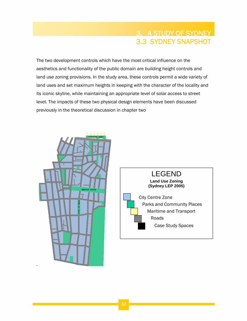
The two development controls which have the most critical influence on the
aesthetics and functionality of the public domain are building height controls and
land use zoning provisions. In the study area, these controls permit a wide variety of
land uses and set maximum heights in keeping with the character of the locality and
its iconic skyline, while maintaining an appropriate level of solar access to street
level. The impacts of these two physical design elements have been discussed
previously in the theoretical discussion in chapter two
.
City Centre Zone
Parks and Community Places
Maritime and Transport
Roads
Case Study Spaces
LEGEND
Land Use Zoning (Sydney LEP 2005)
3. A STUDY OF SYDNEY 3.3 SYDNEY SNAPSHOT
33
Zoning:
The majority of urban land within the CBD is zoned ‘City Centre’ under Sydney LEP
2005. Under this zoning, any type of development is permissible, subject to
compliance with the objectives of the zone. These objectives relate to such matters
as promoting a wide range of uses, regulating development impacts on solar access,
ventilation and wind levels, promoting active frontages and ground floor retail activity
in appropriate locations and maintaining the unique built character of the city.
It is worth noting that the land within the area between King, Elizabeth, Market and
George Streets is given special importance under the plan. In this area, ground floor
retail uses are mandated, acknowledging the important commercial function of the
area.
Building Height:
The map below illustrates the building height controls for Central Sydney specified in
Sydney LEP 2005. It indicates that there is significant variation in the standards
which apply across the various areas of the City. In fact, the maximum permissible
heights vary from 16 metres along the land fronting King Street Wharf to a maximum
of 235 metres in two areas adjacent to George and Pitt Streets. The greatest building
heights are concentrated along the primary road which transects the City, George
Street and in the northern portion of the study area. These controls not only affect
the City skyline, but also influence the feeling of city streets through solar access to
streets and urban spaces, wind tunnelling and the maintenance of view corridors.
These controls also stipulate sun access planes which provide additional protection
for specific community places throughout the eastern portion of the City. The spaces
which are protected by these controls are Hyde Park, Martin Place, Pitt Street Mall
and the Domain parklands, east of the study area. These planes prohibit
development beyond specific levels which will result in overshadowing of these sites.
3. A STUDY OF SYDNEY 3.3 SYDNEY SNAPSHOT
34
235 m maximum
150 m maximum
130m maximum
110m
80m
60m
55m
46m
35m
26m
23.5m
16m
Existing height to be maintained No additional overshadowing Public Space Sun access planes B1/B2 Hyde Park North C Hyde Park West E Martin Place F1/F2 Pitt Street Mall G The Domain 45m under sun access plane 55m under sun access plane Existing height under sun access plane
LEGEND BUILDING HEIGHT CONTROLS
3. A STUDY OF SYDNEY 3.3 SYDNEY SNAPSHOT
35
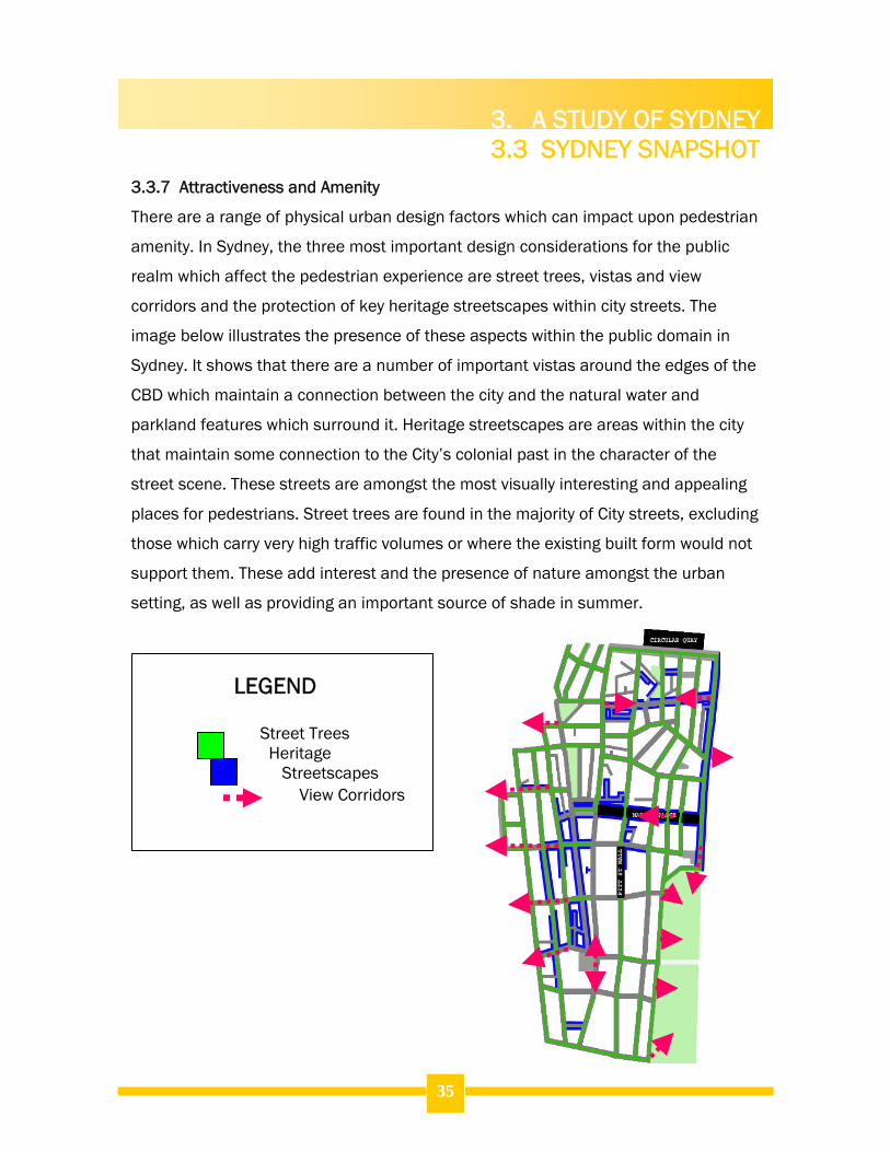
3.3.7 Attractiveness and Amenity
There are a range of physical urban design factors which can impact upon pedestrian
amenity. In Sydney, the three most important design considerations for the public
realm which affect the pedestrian experience are street trees, vistas and view
corridors and the protection of key heritage streetscapes within city streets. The
image below illustrates the presence of these aspects within the public domain in
Sydney. It shows that there are a number of important vistas around the edges of the
CBD which maintain a connection between the city and the natural water and
parkland features which surround it. Heritage streetscapes are areas within the city
that maintain some connection to the City’s colonial past in the character of the
street scene. These streets are amongst the most visually interesting and appealing
places for pedestrians. Street trees are found in the majority of City streets, excluding
those which carry very high traffic volumes or where the existing built form would not
support them. These add interest and the presence of nature amongst the urban
setting, as well as providing an important source of shade in summer.
Street Trees Heritage Streetscapes View Corridors
LEGEND
3. A STUDY OF SYDNEY 3.3 SYDNEY SNAPSHOT
36
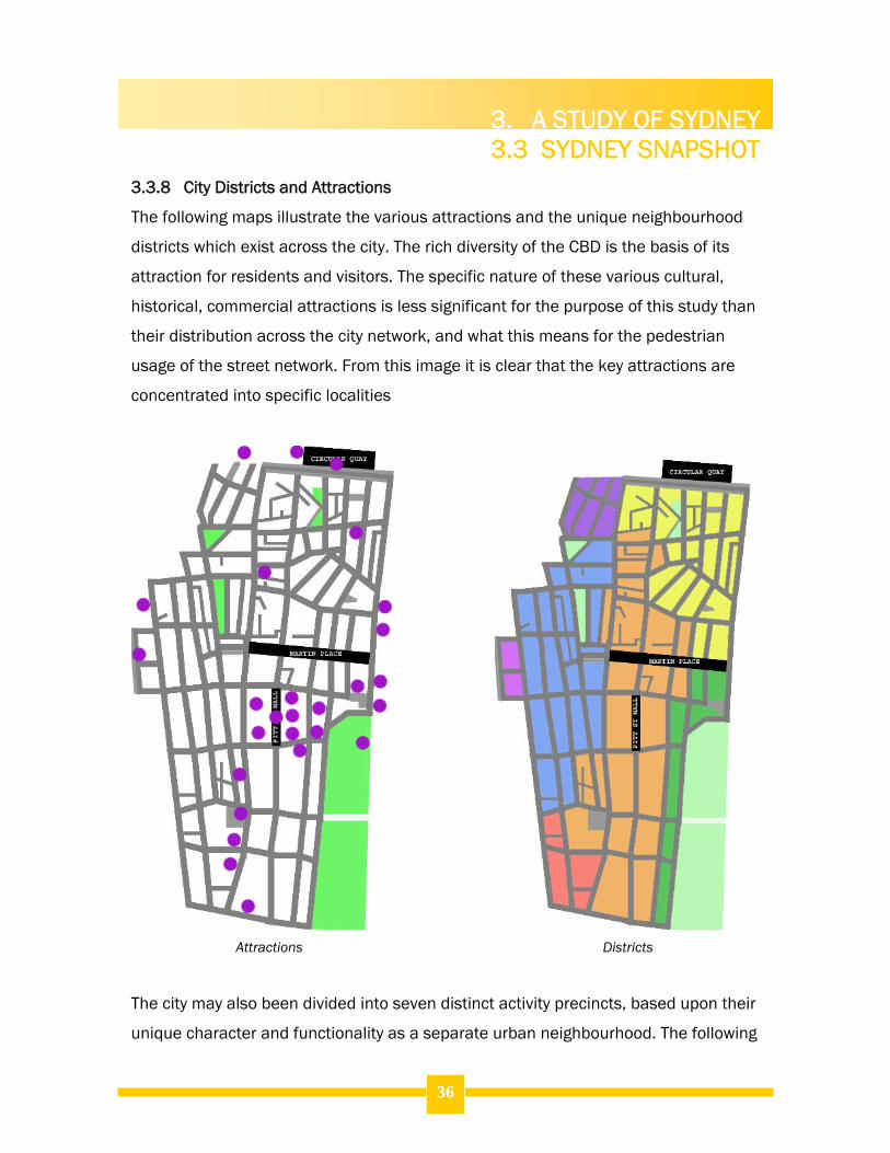
3.3.8 City Districts and Attractions
The following maps illustrate the various attractions and the unique neighbourhood
districts which exist across the city. The rich diversity of the CBD is the basis of its
attraction for residents and visitors. The specific nature of these various cultural,
historical, commercial attractions is less significant for the purpose of this study than
their distribution across the city network, and what this means for the pedestrian
usage of the street network. From this image it is clear that the key attractions are
concentrated into specific localities
Attractions Districts
The city may also been divided into seven distinct activity precincts, based upon their
unique character and functionality as a separate urban neighbourhood. The following
3. A STUDY OF SYDNEY 3.3 SYDNEY SNAPSHOT
37
images illustrate the location and spatial relationships between these various city
precincts. While some, such as the Hyde Park precinct are predominately based on
commonalities in their visual appearance and the close proximity of the street blocks,
others such as the George Street precinct are based on their function, in this case as
a shopping and entertainment hub.
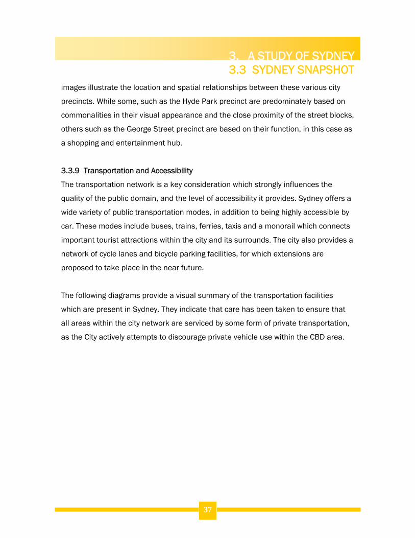
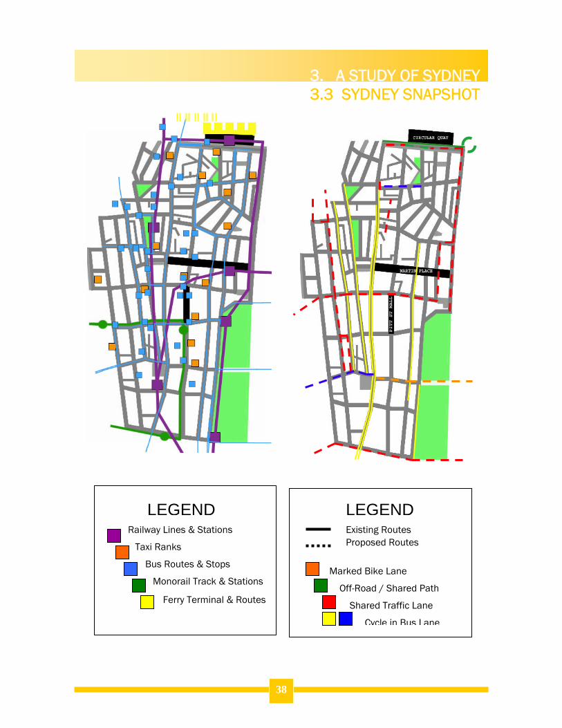
3.3.9 Transportation and Accessibility
The transportation network is a key consideration which strongly influences the
quality of the public domain, and the level of accessibility it provides. Sydney offers a
wide variety of public transportation modes, in addition to being highly accessible by
car. These modes include buses, trains, ferries, taxis and a monorail which connects
important tourist attractions within the city and its surrounds. The city also provides a
network of cycle lanes and bicycle parking facilities, for which extensions are
proposed to take place in the near future.
The following diagrams provide a visual summary of the transportation facilities
which are present in Sydney. They indicate that care has been taken to ensure that
all areas within the city network are serviced by some form of private transportation,
as the City actively attempts to discourage private vehicle use within the CBD area.
3. A STUDY OF SYDNEY 3.3 SYDNEY SNAPSHOT
38
Marked Bike Lane
Off-Road / Shared Path
Shared Traffic Lane
Cycle in Bus Lane
LEGEND LEGEND Railway Lines & Stations
Taxi Ranks
Bus Routes & Stops
Monorail Track & Stations
Ferry Terminal & Routes
Existing Routes Proposed Routes
3. A STUDY OF SYDNEY 3.3 SYDNEY SNAPSHOT
39
Public Car Parking Stations
Public Motorcycle Parking
Streets and Laneways
Plazas
Street Blocks
Parks
LEGEND LEGEND Two-way Streets
One-Way Streets
CBD Entry Points
Direction of Travel
3. A STUDY OF SYDNEY 3.3 SYDNEY SNAPSHOT
40
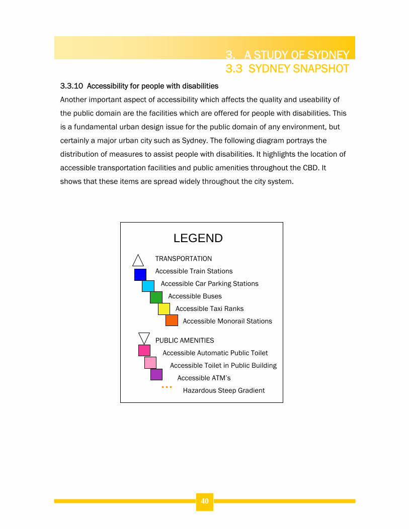
3.3.10 Accessibility for people with disabilities
Another important aspect of accessibility which affects the quality and useability of
the public domain are the facilities which are offered for people with disabilities. This
is a fundamental urban design issue for the public domain of any environment, but
certainly a major urban city such as Sydney. The following diagram portrays the
distribution of measures to assist people with disabilities. It highlights the location of
accessible transportation facilities and public amenities throughout the CBD. It
shows that these items are spread widely throughout the city system.
TRANSPORTATION
Accessible Train Stations
Accessible Car Parking Stations
Accessible Buses
Accessible Taxi Ranks
Accessible Monorail Stations
PUBLIC AMENITIES
Accessible Automatic Public Toilet
Accessible Toilet in Public Building
Accessible ATM’s
Hazardous Steep Gradient
LEGEND
3. A STUDY OF SYDNEY 3.3 SYDNEY SNAPSHOT
41
3. A STUDY OF SYDNEY 3.3 SYDNEY SNAPSHOT
42
3.3.11 Safety and Security
Safety measures are an important element in the design of the public domain in an
urban environment such as Sydney. The CBD area is divided into two Police Local
Area Commands – The Rocks and the Central City Command. Between these two
commands indicated on the diagram below, the study area contains three police
stations – two command centres and a small ‘shopfront’ station on Bathurst Street.
The police are heavily supported by the presence of CCTV cameras which are located
throughout the city in some of the most troublesome locations, particularly around
late trading entertainment establishments in and around George Street. Other safety
measures throughout the city include information kiosks which also serve important
surveillance and monitoring functions in key public areas and telephones within bus
stops which can be used to dial 000 in an emergency.
LEGEND CCTV Locations (existing) CCTV Locations (proposed) Police Stations Bus Shelter Telephones City Information Kiosks Hospital The Rocks Police LAC City Central Police LAC Case Study Spaces
3. A STUDY OF SYDNEY 3.4 WALKABILITY
4.
43
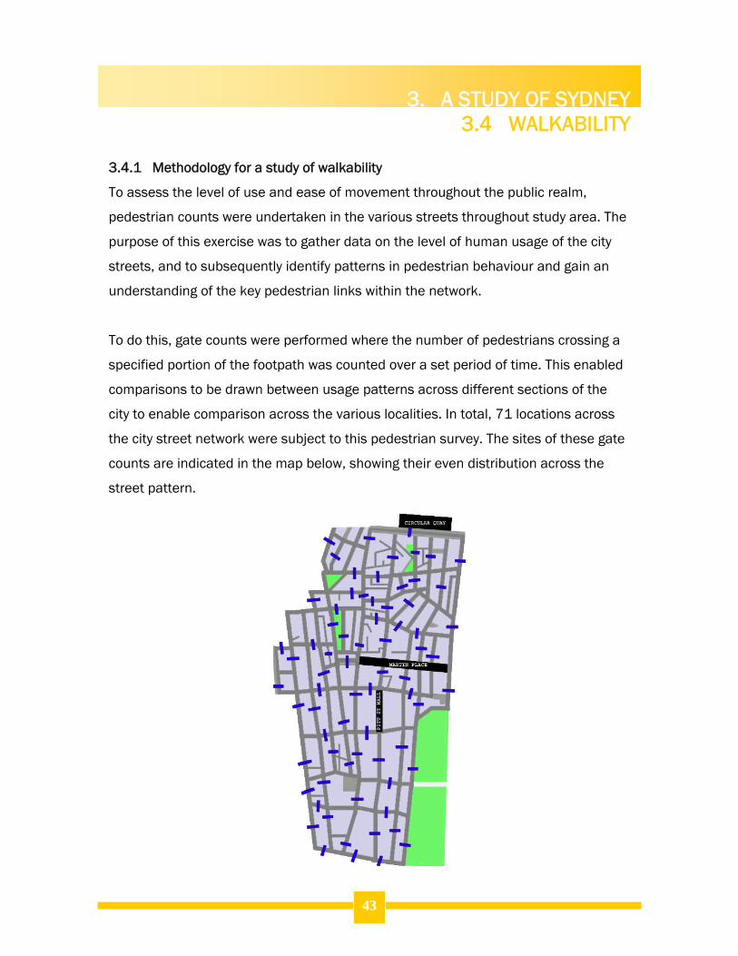
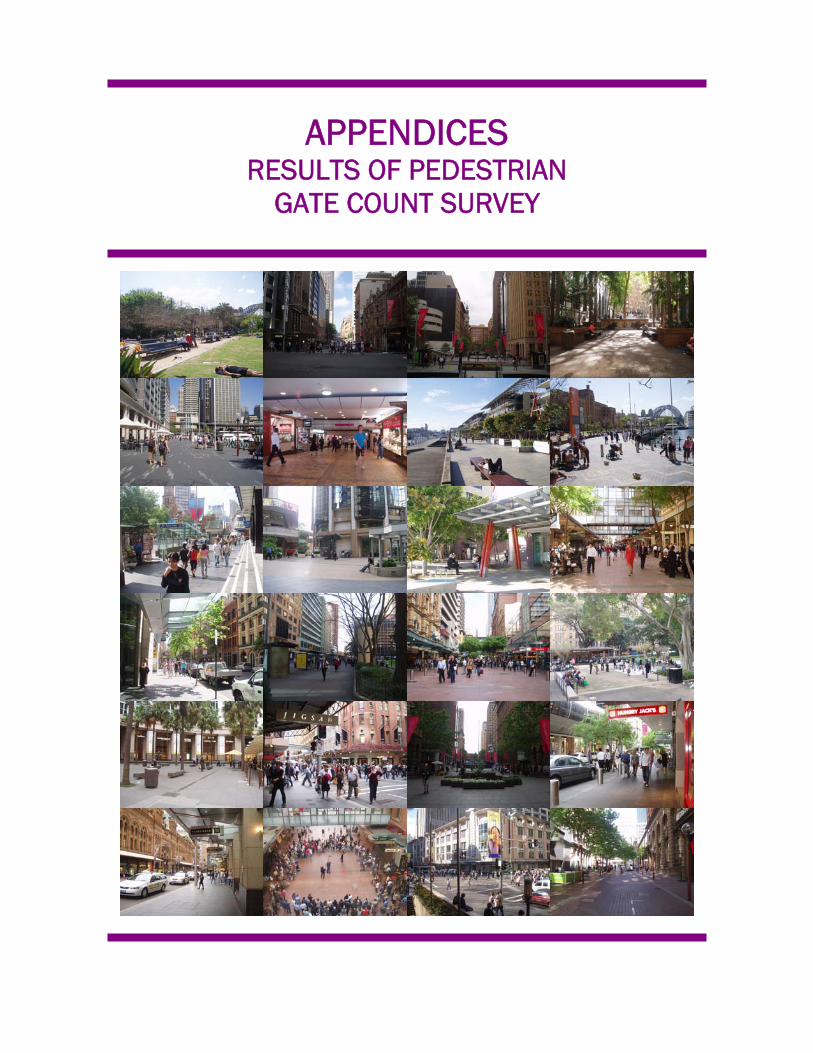
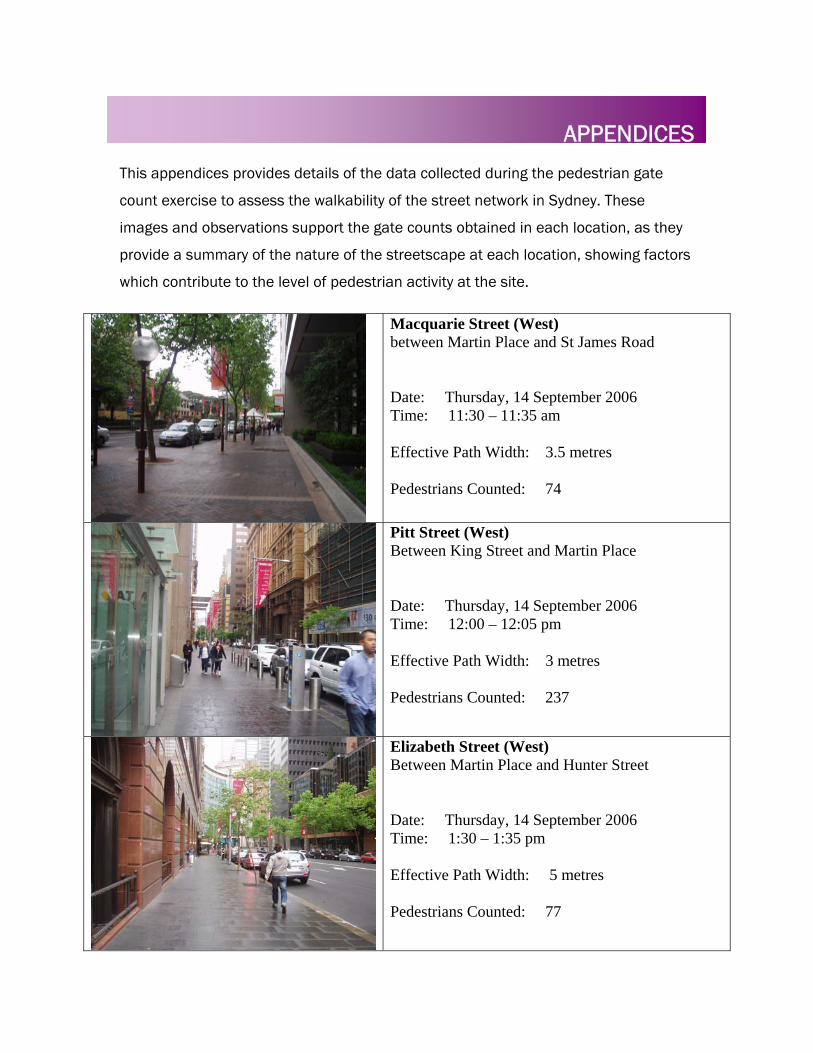
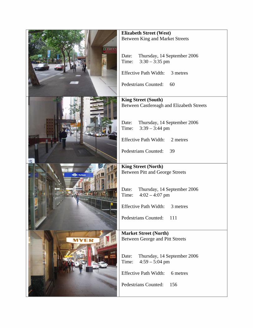
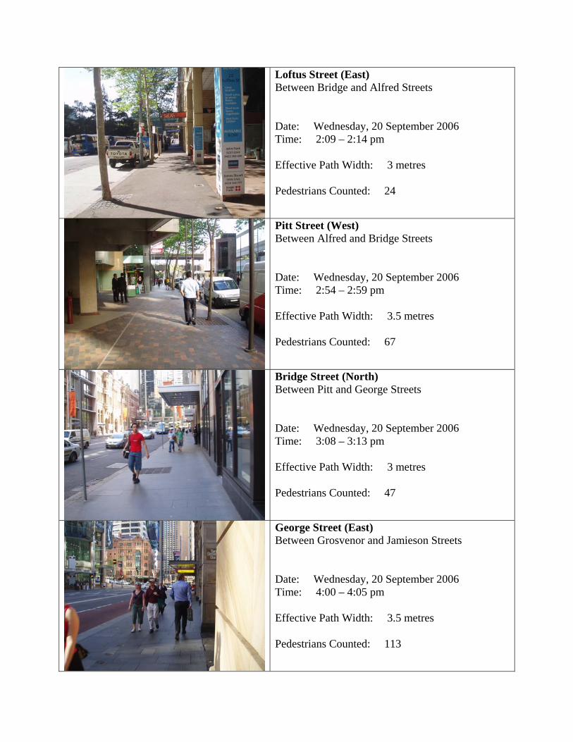
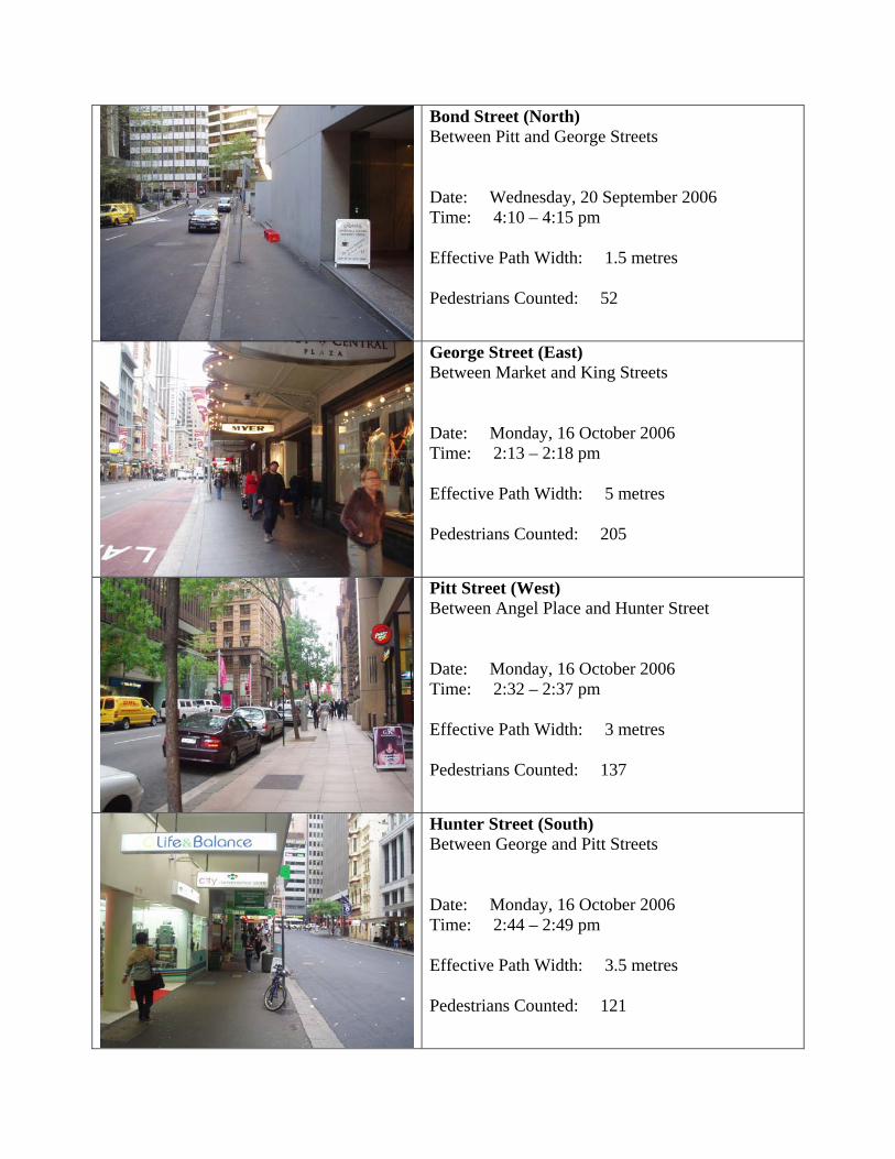
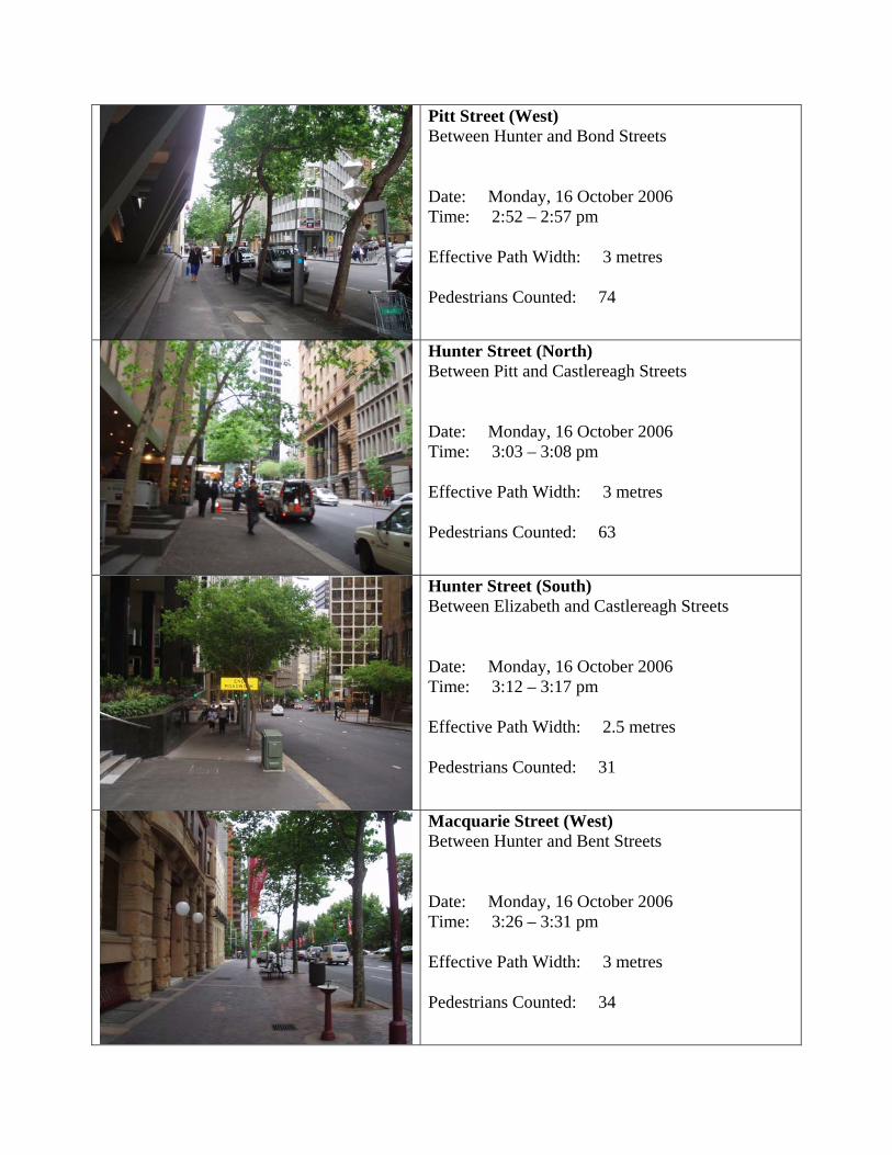
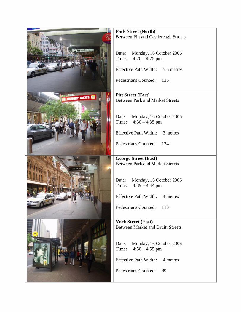
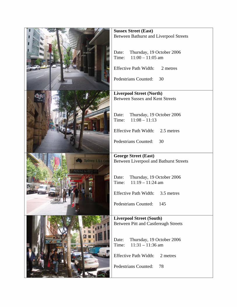
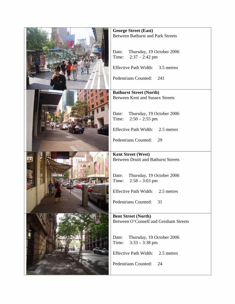
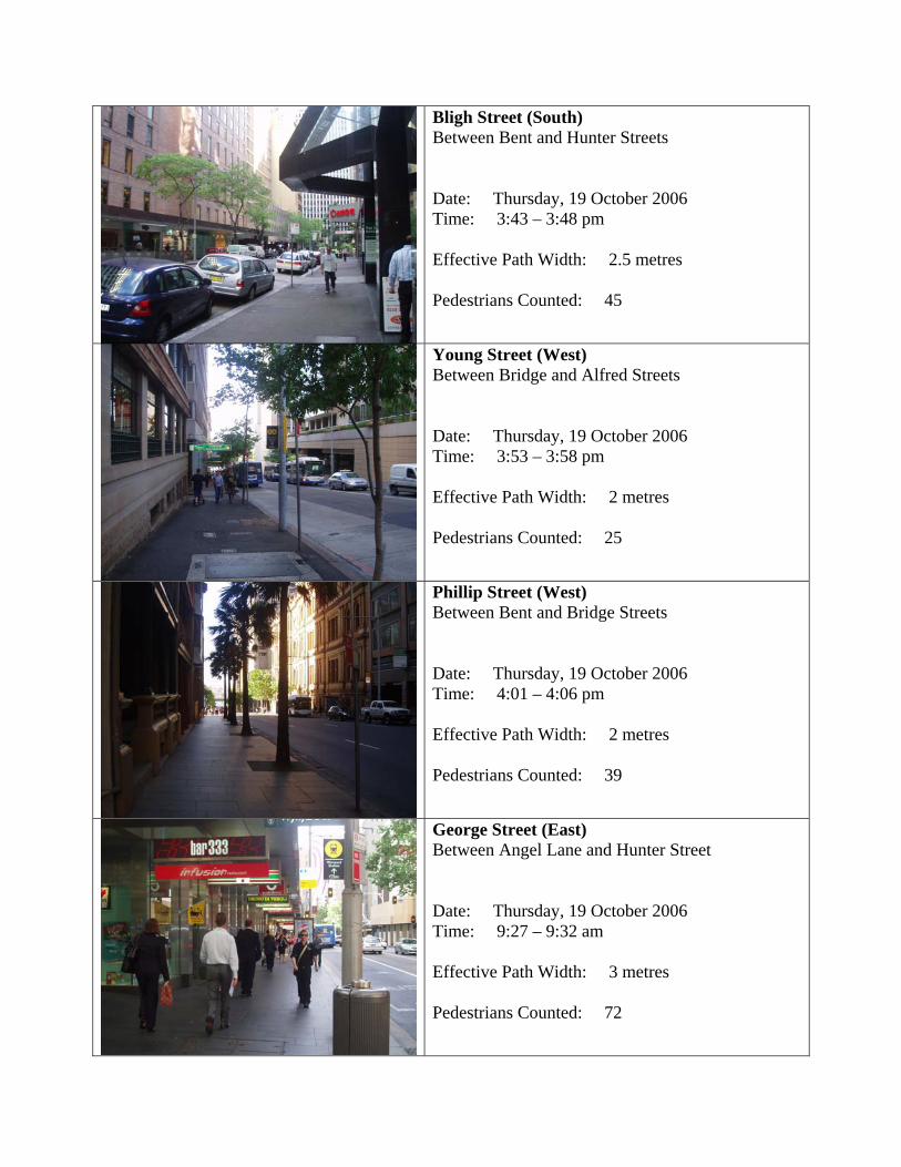
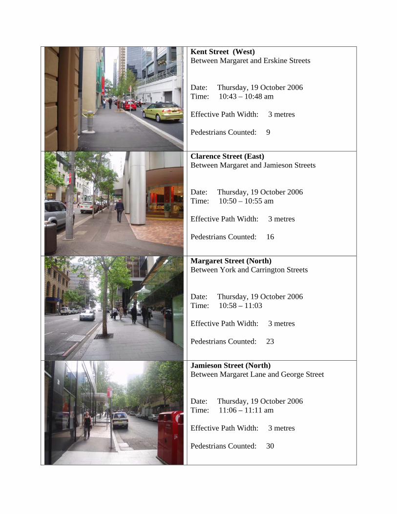
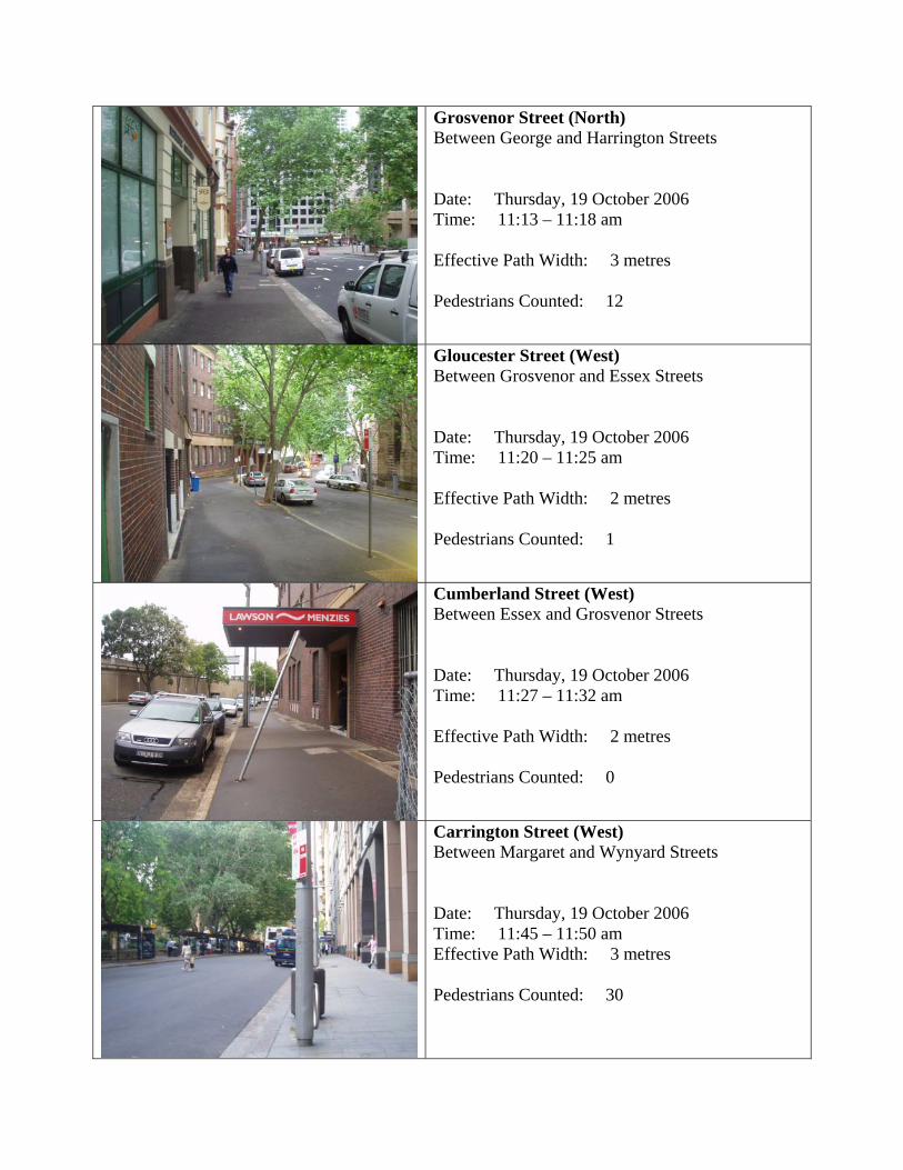
3.4.1 Methodology for a study of walkability
To assess the level of use and ease of movement throughout the public realm,
pedestrian counts were undertaken in the various streets throughout study area. The
purpose of this exercise was to gather data on the level of human usage of the city
streets, and to subsequently identify patterns in pedestrian behaviour and gain an
understanding of the key pedestrian links within the network.
To do this, gate counts were performed where the number of pedestrians crossing a
specified portion of the footpath was counted over a set period of time. This enabled
comparisons to be drawn between usage patterns across different sections of the
city to enable comparison across the various localities. In total, 71 locations across
the city street network were subject to this pedestrian survey. The sites of these gate
counts are indicated in the map below, showing their even distribution across the
street pattern.
3. A STUDY OF SYDNEY 3.4 WALKABILITY
4.
44
Due to practical limitations associated with the available time to perform this study
and the single researcher conducting the survey, it was decided to perform these
gate counts over a five minute period. This interval was considered sufficient to gain
an accurate measure of the level of pedestrian use of the space, and while a longer
time frame may have been more reliable and would enable these counts to be
converted to give a measure of the number of users per hour, it was considered
unnecessary under the given circumstances to extend this time frame. In measuring
all sites for a consistent period, reliable comparisons may be made, indicating
differences and patters in the level of use of Sydney’s inner city streets, providing an
accurate snapshot of human behaviour across the city street network.
Furthermore, to maximize the reliability of these gate count results for comparison
across the city network the timing of these studies was deliberately coordinated. Due
to time and other limitations in terms of the sole researcher undertaking this field
study, it was not possible to perform these pedestrian counts simultaneously or even
in a single day. Instead, it was decided to set parameters for these studies so that
they may be performed on multiple days while preserving the consistency and
reliability of the data for comparison. Weekdays best represent a ‘typical’ day in the
city centre and there are numerous and marked differences in the level and type of
usage of pedestrian areas as well as the nature of the people using the space. For
this reason, Mondays to Thursdays were identified as the most suitable time to
perform these pedestrian counts to produce reliable and comparable results.
Similarly, the timing of the gate counts was also a carefully considered factor. It was
decided that the counts should be taken between the hours of 8am and 12pm in the
morning session and between 2pm and 6pm in the evening. Any measurements
between the hours of 12 noon and 2pm would be misleading, as they would be
heavily influenced by the concentrated lunchtime rush of local office workers which
would skew the volume of pedestrian traffic recorded. This notion was supported by
3. A STUDY OF SYDNEY 3.4 WALKABILITY
4.
45
Gehl (1996) who also identified these timeframes as the most suitable periods for an
accurate indication of ‘ordinary’ behaviour.
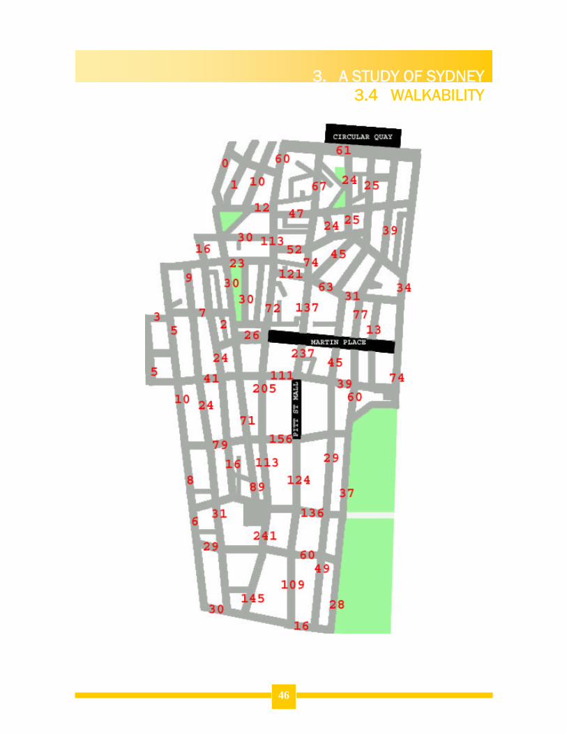
3.4.2 Pedestrian Gate Count Survey Results
The gate count survey produced interesting results in terms of illustrating key
pedestrian linkages and underutilised sections within the city street pattern. The
diagram below depicts the number of pedestrians which were observed at the gate
count points during the five minute survey period. This shows that areas with the
highest volumes of pedestrian traffic tended to be situated within the central portion
of the city, while streets on the periphery of the street network were observed to
contain fewer pedestrian movements. The highest pedestrian count was taken on
George Street opposite the Town Hall, while Cumberland Street in the north-western
corner of the study area produced the lowest reading, with no pedestrian movement
observed during the survey period.
3. A STUDY OF SYDNEY 3.4 WALKABILITY
4.
46
3. A STUDY OF SYDNEY 3.4 WALKABILITY
4.
47
3.4.3 Hierarchy of Pedestrian Volumes
For clearer comparisons to be drawn, these raw figures from each count location
were converted into a measurement of pedestrians per minute. This data allowed for
traffic volumes to be grouped into six discrete categories based upon the level of
pedestrian traffic flow. These categories are defined as follows:
Pedestrian Traffic Category
Measure of Pedestrian Activity
Locations within Category
Very High Activity
40-50 pedestrians per minute
3 (4%)
High Activity
30-40 pedestrians per minute
2 (3%)
Medium-High Activity
20-30 pedestrians per minute
14 (20%)
Medium-Low Activity
10-20 pedestrians per minute
9 (13%)
Low Activity
1-10 pedestrians per minute
39 (55%)
No Traffic Activity
0 pedestrians per minute
4 (6%)
These traffic volume observations have been visually represented in the diagram
below. The image illustrates the spatial location of streets with different levels of
traffic volume, and shows how these streets each relate to those around them. The
result is a depiction of the pedestrian movement patterns across the city-wide street
network as they exist on a typical weekday.
3. A STUDY OF SYDNEY 3.4 WALKABILITY
4.
48
This information allows the areas with the greatest traffic volumes to be identified,
and these are indicated in the diagram below. These areas represent the heart of the
public domain and human activity in Sydney today. An understanding of this activity
pattern is important, as it highlights the strengths of the existing system and
indicates which portions of the city carry small traffic volumes. The next step is to
analyse this data and determine the reasons why these activity levels are as they are,
and whether they are appropriate given their local context and function within the
overall urban network.
LEGEND 40-50 pedestrians per minute
30-40 pedestrians per minute
20-30 pedestrians per minute
10-20 pedestrians per minute
1-10 pedestrians per minute
0 pedestrians per minute
Case Study Spaces
3. A STUDY OF SYDNEY 3.4 WALKABILITY
4.
49
LEGEND
Very High Volume Routes
High Volume Routes
High Activity Areas
3. A STUDY OF SYDNEY 3.5 USEABILITY
4.
50
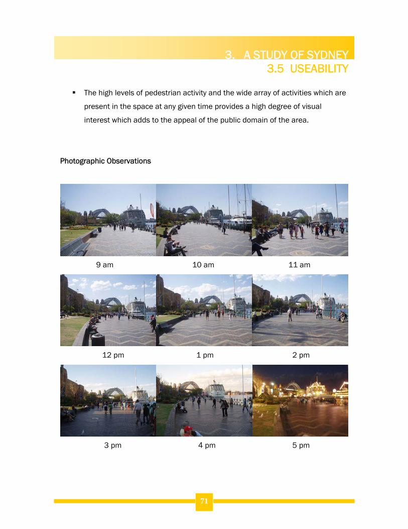
3.5.1 Introduction
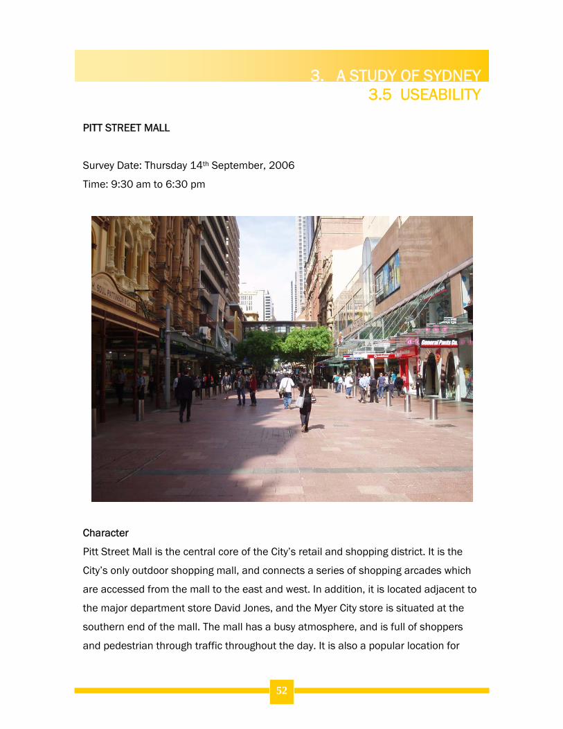
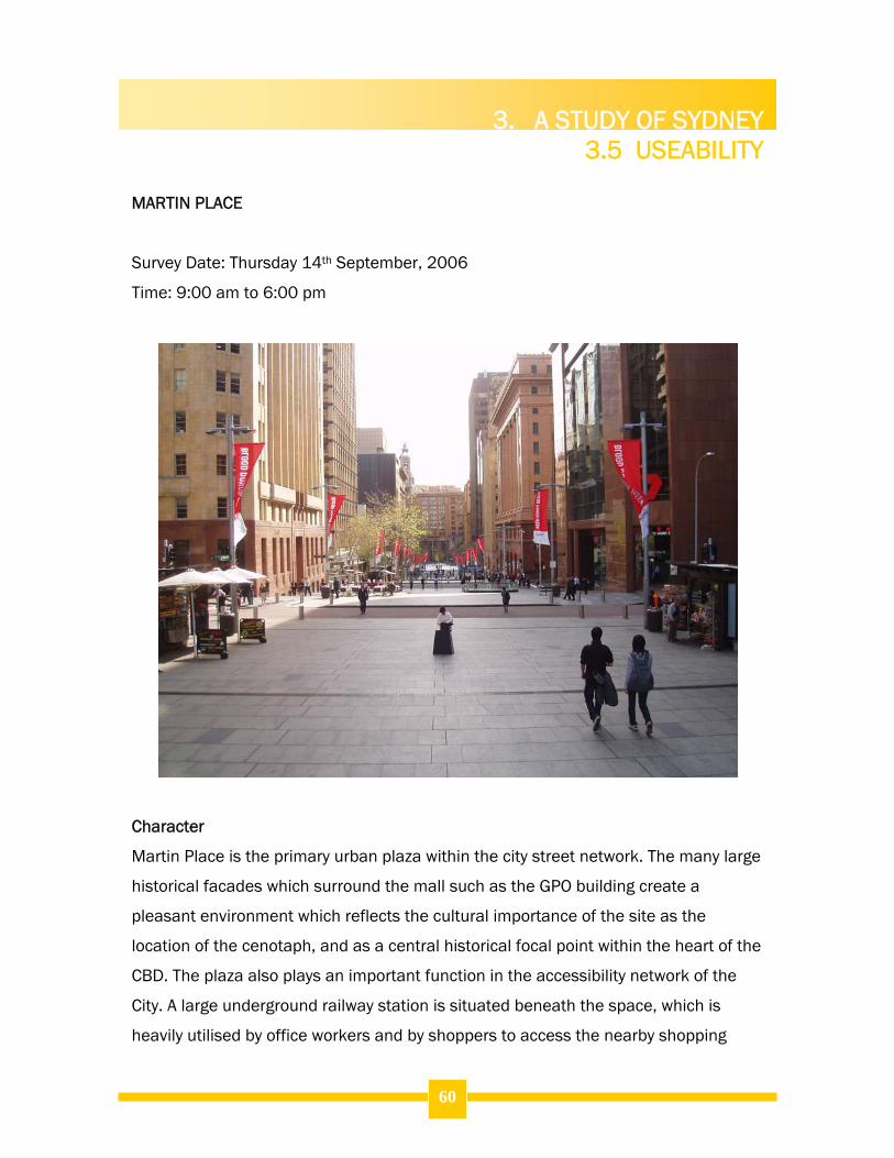
The three sites which were studied in detail to examine their usability are Pitt Street
Mall, Martin Place and Circular Quay. These three sites vary significantly in terms of
their physical appearance, the types of users of the space, and in the function that
they fulfil within the wider urban system. In addition, they are also distributed
throughout the City area and as such give a reliable indication of the activities which
presently occur in a range of different spaces across the CBD area.
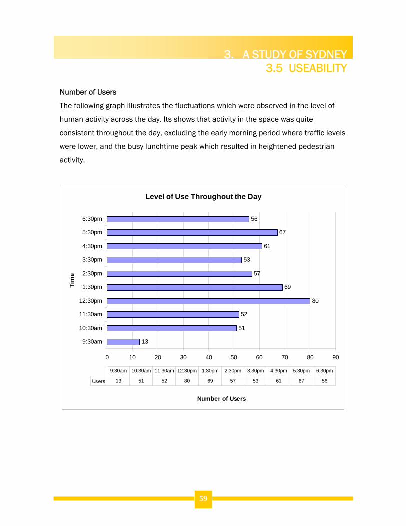
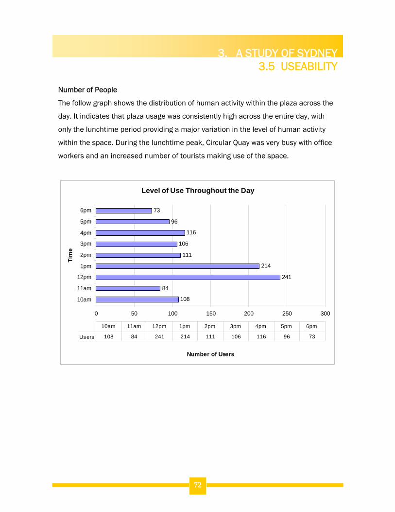
Two specific aspects have been studied in terms of the degree of usability which is
evident in these three urban spaces. The first is the level of usage in terms of the
number of people who are observed within the space on an hourly basis, and how
this fluctuates throughout the day. The second aspect which is investigated is the
types of activities which are occurring in these spaces across the day. Together,
these two factors give a clear indication of what is occurring in these spaces and how
they fare in terms of useability. The underlying principle of this is that the more
people and the wider the range of activities in a space, the higher the space performs
in regards to the useability of the site.
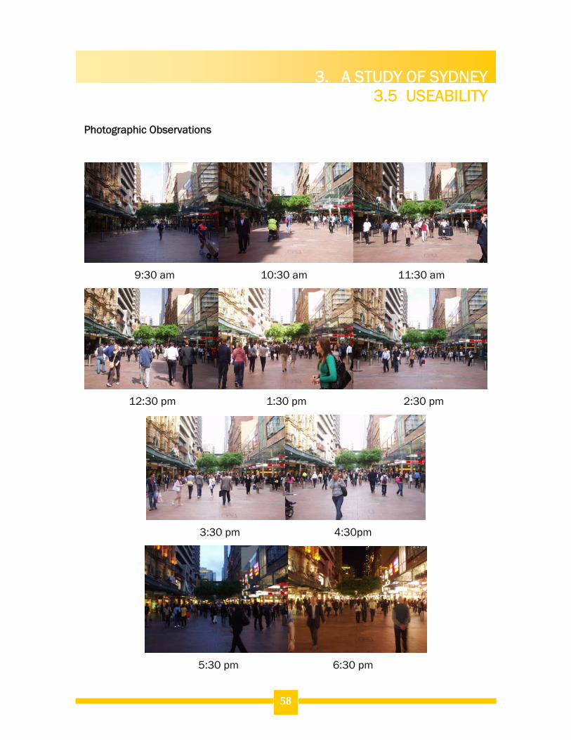
3.5.2 Methodology for assessing useability of public spaces
In addition to this city-wide pedestrian count exercise, a series of in-depth case
studies were also conducted for several specific urban spaces within the centre.
Three communal spaces were selected for a detailed examination of patterns in
human behaviour which occur in Sydney’s public spaces. Three study sites that were
selected for close inspection were Martin Place, Circular Quay and Pitt Street Mall.
These three sites were chosen as they exhibit marked differences in their scale and
function within the urban fabric, and due to their distribution throughout the city
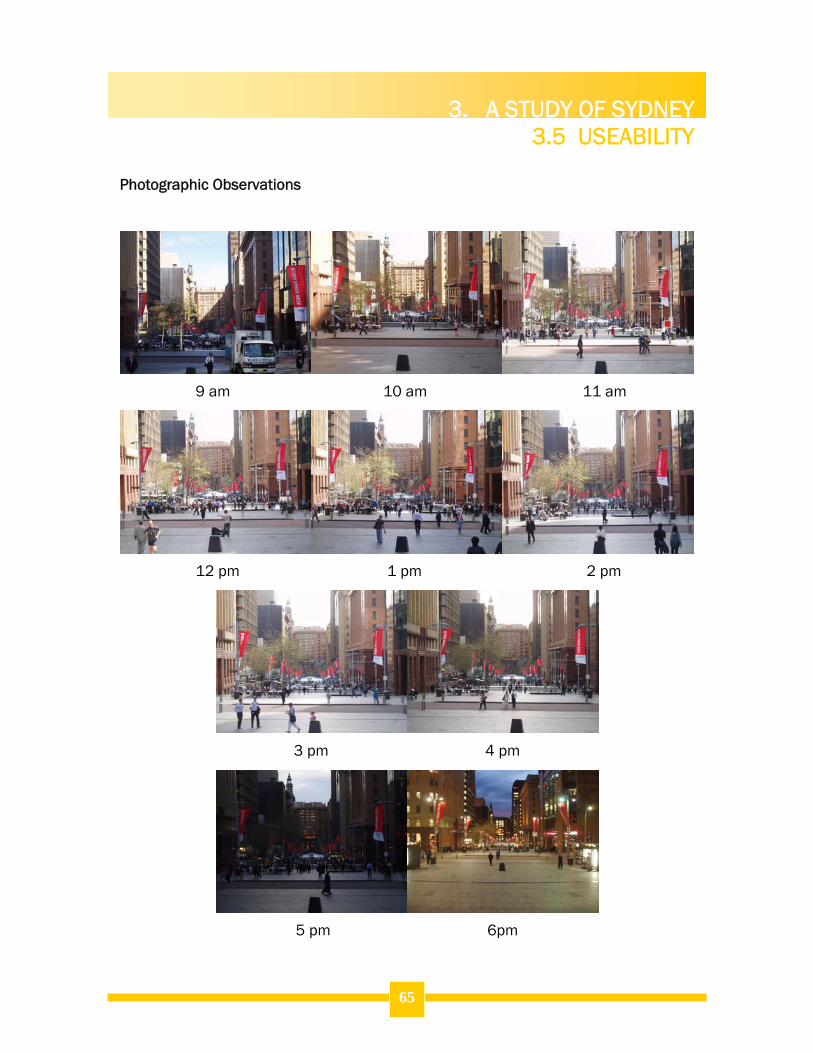
centre. The observations were conducted at hourly intervals across the day to gain an
understanding of how the activity within these spaces changes over time.
3. A STUDY OF SYDNEY 3.5 USEABILITY
4.
51
Photographic records at set locations were taken enabling visual comparisons to be
made between the different times of the day. In addition, detailed observation notes
were recorded, explaining the types of users, activities and traffic flows were present
in the space.
3.5.3 Results of the Case Studies
The following is the results obtained from a study of the key case study sites.
3. A STUDY OF SYDNEY 3.5 USEABILITY
4.
52
PITT STREET MALL
Survey Date: Thursday 14th September, 2006
Time: 9:30 am to 6:30 pm
Character
Pitt Street Mall is the central core of the City’s retail and shopping district. It is the
City’s only outdoor shopping mall, and connects a series of shopping arcades which
are accessed from the mall to the east and west. In addition, it is located adjacent to
the major department store David Jones, and the Myer City store is situated at the
southern end of the mall. The mall has a busy atmosphere, and is full of shoppers
and pedestrian through traffic throughout the day. It is also a popular location for
3. A STUDY OF SYDNEY 3.5 USEABILITY
4.
53
buskers and street performers which contribute to the lively and fun atmosphere of
the space. There are a large number of trees planted throughout the mall which
create a visually attractive scene, complementing the mix of heritage buildings and
more modern built form, while providing a pleasant connection to the natural
environment.
Observations
Accessibility:
The mall is well located within the city street network. It is situated in the heart
of the retail district, and is located in an ideal location between several key
intersections of major routes within the city, resulting in a high level of
accessibility from all directions within the CBD.
The footpath areas on the streets surrounding the mall are widened to cater
to increased pedestrian traffic movement towards the mall. This creates a
pleasant pedestrian experience when entering and exiting the space, and
helps to minimise pedestrian conflicts during peak traffic periods.
Additional access to the mall is provided via the five internal arcades located
within the buildings fronting Pitt Street Mall. The Strand arcade, Mid City
Centre, Skygarden, Centrepoint and the Imperial Arcade offer ground floor
access into the mall for shoppers. This assists in distributing the high
pedestrian traffic generated by city workers and shoppers and visitors to a
significant extent, as many shoppers are attracted to the arcades while
workers predominantly utilise the street network.
In addition, two raised pedestrian walkways connect the first floors of the
Myer Department Store and Centrepoint, further reducing the pressure of high
pedestrian volumes at street level.
The mall is flat and evenly surfaced. It contains no kerbs or impediments to
safe and convenient movement by wheelchairs or for people whose mobility is
3. A STUDY OF SYDNEY 3.5 USEABILITY
4.
54
impeded. Several pedestrians on crutches and in wheelchairs were observed
using the space throughout the day without difficulty.
The mall is situated in a convenient central location which affords it a high
level of accessibility from public transportation. There are six bus stops
located immediately surrounding the block containing the mall. In addition,
there are two heavily utilised cab ranks located at either end of the plaza, and
the mall is within easy walking distance from both Martin Place and St James
Railway Stations.
Human Interaction:
The amount of seating and its location is the major weakness of this space.
Despite the high traffic volumes in this mall, only 16 benches are provided
which was seen to be inadequate, as seating was in high demand during most
of the day, and was a critical problem during the lunchtime peak.
The arrangement of seating was also problematic. Seats were inappropriately
designed in pairs facing away from each other, separated by street trees
which provided much needed shade. The arrangement of these seats made it
difficult for people to talk to each other as they could only sit beside and not
opposite one another. It was also inappropriate for groups of people, who
were observed to either separate into two smaller groups and sit facing either
direction on the benches, or some people stood opposite while others sat.
This presents a fundamental flaw in the design of the space which
discourages socialisation.
Due to the function of the space as a shopping mall, there is a large amount
of ambient noise within the mall. This noise is a combination of noise from
people talking to each other or on mobile telephones as they move about the
space, traffic noise from the busy streets at either end of the mall. The
greatest noise generators however are from street performers and from music
emanating from the many store frontages along the mall. These two sources
3. A STUDY OF SYDNEY 3.5 USEABILITY
4.
55
of noise create conflict which was found to be quite unpleasant in certain
sections of the mall at various times of the day.
The installation of bollards throughout the site is the most significant and
valuable feature in influencing movement and behaviour within the mall. The
bollards segregate the space into three sections or ‘lanes’ of foot traffic to
minimise conflict from shoppers window shopping on the major pathways
adjacent to the shop fronts, from through traffic, and people stopping to watch
the street entertainment. In addition, these bollards also provide additional
informal seating and places to lean or rest goods upon. The bollards also
serve as meeting points for people, or locations to pause to greet others out of
the stream of traffic.
Safety:
Pitt Street Mall exhibits a high level of perceived safety. This is in a large part
due to the high levels of human activity which are present in the mall
throughout the day. While traffic volumes varied throughout the day, the mall
was constantly occupied by people, and activity within the shop entrances
also contributes to this feeling of security due to the constant passive
surveillance of the site.
The physical structure of the space is very open, allowing good levels of
visibility throughout all portions of the mall. There are no ‘invisible’ locations
within the mall where people could lurk, and pedestrians moving throughout
the mall are visible to others as they move throughout the entire length of the
mall.
No damage to the mall furnishings were present on the study day, to threaten
user safety. The mall was in good working order, implying a high degree of
maintenance and management of the space.
Lighting was found to be an issue in the evening. There were too few lights
throughout the mall, and those that were there were too dim to be effective.
3. A STUDY OF SYDNEY 3.5 USEABILITY
4.
56
The illuminated signage and internal lighting of the stores surrounding the
mall provided the primary source of illumination in the evening.
City Rangers were observed to patrol and monitor activity within the mall
throughout the duration of the day. These City of Sydney rangers performed
an important security presence in the site, which was supported by police
patrols which occurred several times throughout the day.
Comfort:
The mall offers a pleasant pedestrian experience for users. It is flat and open
which minimises conflict with pedestrians and furnishings, and makes
movement through the space easy.
Street trees and awnings provide effective shading of the most heavily utilised
parts of the mall. This is important as the open mall area would be very hot
during summer, but the open central portion of the site provides an option for
people to walk in the sunlight, which is particularly valuable during winter. The
deciduous trees also assist in maximising solar access in winter, while
providing summer shade of the seats and walkways.
The choice of seating is comfortable and attractive within the space, however
as previously discussed, its arrangement discourages human interaction.
The bollards throughout the space provide a valuable place to rest or sit in
this busy space where seating is insufficient. While they would be unsuitable
for long periods of sitting, they are a suitable height and width to make short
term sitting and leaning a comfortable experience.
Responsibility and Maintenance:
The mall is well maintained. There was no graffiti or evidence of vandalism to
be found, indicating that the area is well managed and maintained.
Litter was not a problem in the mall at any stage of the day. Garbage bins
were emptied in the morning, and Council maintenance staff conducted
3. A STUDY OF SYDNEY 3.5 USEABILITY
4.
57
several cleanups during the day, particularly in the lunchtime and afternoon
periods to collect litter.
The security services on the site were conducted by Council’s City Rangers
and by police officers throughout the day. In addition, security guards
monitored the entrances to several of the shopping arcades.
Aesthetics:
The street scene of the mall is very attractive, and features a mix of modern
development styles such as the Mid City Centre, and historical developments
such as the heritage streetscape items in the north-eastern portion of the
mall.
There is little diversity in the land use activities in this space as they are all
retail uses at ground level, in accordance with the provisions of the LEP which
respects the function of the site as the core of the City’s shopping district.
The design and sporadic location of the street furniture within the space
complements the attractive and complex mix of the built form of the buildings
surrounding the space. The open design of the plaza area and the appropriate
scale of the surrounding buildings create a comfortable feeling of limited
enclosure and contribute to the visual amenity of the space.
3. A STUDY OF SYDNEY 3.5 USEABILITY
4.
58
Photographic Observations
9:30 am 10:30 am 11:30 am
12:30 pm 1:30 pm 2:30 pm
3:30 pm 4:30pm
5:30 pm 6:30 pm
3. A STUDY OF SYDNEY 3.5 USEABILITY
4.
59
Number of Users
The following graph illustrates the fluctuations which were observed in the level of
human activity across the day. Its shows that activity in the space was quite
consistent throughout the day, excluding the early morning period where traffic levels
were lower, and the busy lunchtime peak which resulted in heightened pedestrian
Martin Place is the primary urban plaza within the city street network. The many large
historical facades which surround the mall such as the GPO building create a
pleasant environment which reflects the cultural importance of the site as the
location of the cenotaph, and as a central historical focal point within the heart of the
CBD. The plaza also plays an important function in the accessibility network of the
City. A large underground railway station is situated beneath the space, which is
heavily utilised by office workers and by shoppers to access the nearby shopping
3. A STUDY OF SYDNEY 3.5 USEABILITY
4.
61
district which immediately adjoins Martin Place to the South. There is limited
vegetation within the site, however the tree plantings throughout the site contribute
to a visually attractive urban environment, and work to soften what is entirely a hard
surface area bordered by large and imposing buildings. The historical developments
which abut Martin Place offer limited opportunity for active frontages seen elsewhere
throughout the city streets and spaces. In addition, the types of uses are upscale
stores which have limited patronage by the majority of the people who visit the
space. There are several exceptions to this however, with a small number of café’s
and bars scattered throughout the mall, with one café providing popular outdoor
dining facilities. The other major activity in the area is the Mid City Centre which is a
popular attraction, particularly in the lunchtime peak, and the Channel Seven
television studio. The studio adds visual interest and vitality to the plaza especially in
the morning when pedestrians pause in front of it to watch and participate in the live
broadcast, and sometimes, live plaza concerts. Martin Place is a busy urban
environment which is evidently most popular with local office workers and provides
connections between various key pedestrian routes within the City.
Observations
Accessibility:
Martin Place is highly accessible for both pedestrians and from public
transportation. There are six bus stops situated within one block of the streets
which transect the plaza, in addition to Martin Place Railway Station which lies
beneath the space. There are also two cab ranks located within metres of the
plaza to the east. Finally, four car parking garages are located in the streets
immediately surrounding Martin Place.
The site is marginally accessible for people with impaired mobility such as the
elderly, people with young children in prams, and the physically disabled.
While there are no stairs impeding access through the major pedestrian
routes through the space, the steep gradient of the site makes movement
3. A STUDY OF SYDNEY 3.5 USEABILITY
4.
62
difficult for people with mobility challenges. The physical design has
responded to the local topography as best it can, however the natural features
of the area make it less than ideal for disabled accessibility.
The plaza is located in the most legible portion of the City street network. In
this area the historical structure of the urban fabric has resulted in a neat grid
pattern of wide roadways which assists pedestrian navigation. Additionally,
there are a number of large and distinctive buildings within this space which
are effective landmarks, and signage throughout the city helps to highlight the
location of the plaza from other parts of the City.
Human Interaction:
The design of Martin Place encourages and supports socialisation and a wide
range of human activities. There is a large amount of open plaza space which
enables spontaneous children’s games or room for joggers to move easily
through the space for instance.
There is a large amount of potential for informal seating on ledges, steps and
plantar boxes throughout the space. These areas were heavily used
throughout the day, often by groups of people who benefited from the
flexibility these items offer to arrange themselves across stairs as they please.
The space offers a pleasant environment for human interaction. There are no
externalities such as noise levels to impede social activity within the space.
Safety:
Martin Place experiences high volumes of pedestrian traffic at all times of the
day. This enables a high degree of passive surveillance and visible activity
within the space which assists in maintaining an atmosphere of security
within the space, and with providing some supervision of the public domain to
actually minimise vandalism and antisocial behaviour.
3. A STUDY OF SYDNEY 3.5 USEABILITY
4.
63
There were a small number of repairs being undertaken on floor surfaces and
seating within the plaza. These items were marked with appropriate security
devices in an effort to protect pedestrians from the hazards.
The space is well lit at night, and provides an environment that is well
patronised and feels safe in the evening. There are no portions of the plaza
which are dark or particularly uninviting in the evening. This matter is assisted
by a number of sites, most notably bars and the restaurants and bars within
the GPO building which are active in the evenings and ensure that there is a
visible human presence in the space at night.
Comfort:
The benches and other furnishings within Martin Place and appropriately
located and comfortable for users.
There are a very large number of design elements throughout the plaza area
which provide opportunities for informal seating. This was found to be the
primary human behaviour within the space, and was even more popular than
the formal bench seating throughout the space.
The location and orientation of the space within the urban fabric means that
solar access to the site is highly varied across the length of the space
throughout the day. People were found to move about the space in response
to the availability of sunlight, with the highest concentration of users situated
in positions where sunlight was available.
The space suffers from a significant amount of wind tunnelling, which makes
it physically uncomfortable at times.
Responsibility and Maintenance:
The site is well maintained by the City of Sydney Council. Several litter patrols
were conducted throughout the day, to remove litter discarded by patrons,
particularly following the lunchtime rush.
3. A STUDY OF SYDNEY 3.5 USEABILITY
4.
64
The channel seven studios perform an important surveillance function within
the eastern portion of the site. Private security guards were seen to undertake
regular patrols of the areas immediately adjacent to the studio, as well as
providing a constant surveillance presence within the space.
Regular police and City Ranger patrols were observed throughout the day, but
this was particularly obvious and necessary in the afternoon and evening
periods.
Aesthetics:
Martin Place has a unique historical character, which is created by the various
large historically significant building facades which abut the plaza area. These
characteristics of the built form create visual interest and provide a visible
linkage between the current urban context and use of the space, at its past as
a key functional icon within the City.
The site contains a diverse range of land use activities within the built form
adjacent to the public domain. These activities include television studios, bars
and restaurants, retail stores and office buildings. The result is an interesting
environment which attracts a variety of users who come to frequent these
various locations.
3. A STUDY OF SYDNEY 3.5 USEABILITY
4.
65
Photographic Observations
9 am 10 am 11 am
12 pm 1 pm 2 pm
3 pm 4 pm
5 pm 6pm
3. A STUDY OF SYDNEY 3.5 USEABILITY
4.
66
Number of People
The level of usage of the space was observed on an hourly basis throughout the day.
The graph below depicts the patterns in the occupation of the space across the
workday. They demonstrate a trend for Martin Place to be used most heavily during
times when local office workers are out of the office. More specifically, it shows that
occupation of the space is greatest during the lunchtime period between 12 and
2pm. The space is also busiest at 9am as office workers are leaving the Railway
Station or cutting through the plaza on their way to work, and between 5 and 6pm
when a similar pattern is evident. They show the space is well used throughout the
day.
Level of Use Throughout the Day
72
41
42
146
174
71
88
75
125
95
0 50 100 150 200
9am
10am
11am
12pm
1pm
2pm
3pm
4pm
5pm
6pm
Tim
e
Number of Users
Users 72 41 42 146 174 71 88 75 125 95
9am 10am 11am 12pm 1pm 2pm 3pm 4pm 5pm 6pm
3. A STUDY OF SYDNEY 3.5 USEABILITY
4.
67
CIRCULAR QUAY
Survey Date: Wednesday 20th September, 2006
Time: 9:00 am to 5:00 pm
Character
Circular Quay is very different in regards to its physical scale, character and function
in comparison to the other case study spaces. This space is set in a picturesque and
historically significant waterfront location which was the site of the original First Fleet
landing site and settlement in 1788. Today, the site is an important tourist attraction
and iconic gateway into the city from the Harbour. It is also an important
transportation node for the northern portion of the city. It contains the Circular Quay
Railway Station beneath the Cahill Expressway, as well as the busy CBD ferry
3. A STUDY OF SYDNEY 3.5 USEABILITY
4.
68
terminal. The site effectively combines these competing functions, while creating a
pleasant environment which is comfortable for pedestrians and balances the modern
built form with its natural landscape. Circular Quay may effectively be divided into
three areas which operate both as a whole coordinated plaza environment, and as
three discrete spaces.
The eastern portion of the site contains a plaza and colonnade area that is closely
connected to the mixed use buildings along this upper portion of Macquarie Street,
and provides a critical linkage between Circular Quay and the nearby Sydney Opera
House. This area has great views of the Opera House, Harbour Bridge and the CBD
skyline, and is characterised by the many alfresco cafes which line the pedestrian
thoroughfare
The central portion of the plaza which runs adjacent to Alfred Street has an entirely
different character. It is primarily associated with the ferry terminal, and is a popular
location for busking and street performances which add to the vibrancy of the space.
Finally, the western area of Circular Quay has a character which is in stark contrast to
the previous areas of the plaza. This area also has magnificent iconic views of the
Harbour, Opera House and Harbour Bridge, but is interesting as it combines a wide
plaza area with seating overlooking the waterfront, with an expansive grassed
parkland area set around the Museum of Contemporary Art. This is a very attractive
environment from a visual perspective, but it is as much the wide variety of human
activity that creates this attraction as the built form.
Circular Quay is an attractive site, which operates well as a pedestrian environment
and effectively balances the various important and contrasting functions it plays in
the City network.
3. A STUDY OF SYDNEY 3.5 USEABILITY
4.
69
Observations
Accessibility:
Circular Quay performs a vital accessibility function for the CBD area. It
contains the primary city ferry terminal, as well as a major railway station and
an important bus terminal and major taxi rank.
Movement throughout the space is safe and convenient. The land itself is
entirely flat in this area, and there are no physical obstacles to free movement
throughout the space. The plaza itself is wide and well-surfaces, providing a
safe thoroughfare which discourages pedestrian conflict despite the high
patronage of the area by tourists, city visitors, local workers and commuters.
Circular Quay caters exceptionally well to the needs of disabled people. The
flat and well maintained surface is suitable for comfortable movement of
wheelchairs throughout the site, and its popularity for vulnerable populations
is evidenced by the substantial number of elderly and disabled people that
were witnessed within the space.
Human Interaction:
The urban furnishings throughout the space such as benches, ledges and
bollards as well as the large open plaza and park areas provide extensive
opportunities for human activity and socialisation.
A wide range of activities were observed throughout the various areas of the
public domain. These included ball games in the parkland areas, street
performances in the
Safety:
Circular Quay is a safe and attractive urban environment which is well
illuminated and occupied during the evening period, due to the types of land
use activities such as restaurants which are present within the space.
3. A STUDY OF SYDNEY 3.5 USEABILITY
4.
70
The plaza features an open design, which provides no impediment to safe
movement throughout the key plaza thoroughfares within the space.
Several police patrols were observed throughout the day. This security
presence discourages common tourist-oriented crimes which occur in tourist
attractions such as this, such as pick-pocketing and petty theft.
Comfort:
The physical features and plaza furnishings throughout the site are
appropriately located to take advantages of views, and to encourage human
interaction.
The space is fairly noisy due to the sounds emanating from the Ferry Terminal,
Railway Station and the Cahill Expressway. This noise is not so significant to
impede human interaction by making conversation difficult, but rather this
ambient noise contributes to the lively atmosphere of the space.
Responsibility and Maintenance:
The plaza is maintained by a combined effort between the City of Sydney and
Sydney Ferries. These agencies share responsibility for the general upkeep of
the site, and ensure that damage to the urban area is reported and repaired
by Council maintenance staff in a timely fashion.
Aesthetics:
Circular Quay is a highly attractive waterfront environment, which operates as
a major showpiece and icon of the City. The built form surrounding the space
effectively complements the natural setting, and contributes positively to the
pedestrian experience.
The choice of urban furnishings are appropriate to offer a high urban amenity
and functionality, while maintaining a minimalist look so as to not detract
from the many landmark features of the surrounding environment.
3. A STUDY OF SYDNEY 3.5 USEABILITY
4.
71
The high levels of pedestrian activity and the wide array of activities which are
present in the space at any given time provides a high degree of visual
interest which adds to the appeal of the public domain of the area.
Photographic Observations
9 am 10 am 11 am
12 pm 1 pm 2 pm
3 pm 4 pm 5 pm
3. A STUDY OF SYDNEY 3.5 USEABILITY
4.
72
Number of People
The follow graph shows the distribution of human activity within the plaza across the
day. It indicates that plaza usage was consistently high across the entire day, with
only the lunchtime period providing a major variation in the level of human activity
within the space. During the lunchtime peak, Circular Quay was very busy with office
workers and an increased number of tourists making use of the space.
Level of Use Throughout the Day
108
84
241
214
111
106
116
96
73
0 50 100 150 200 250 300
10am
11am
12pm
1pm
2pm
3pm
4pm
5pm
6pm
Tim
e
Number of Users
Users 108 84 241 214 111 106 116 96 73
10am 11am 12pm 1pm 2pm 3pm 4pm 5pm 6pm
PART 4
THE QUALITY OF SYDNEY’S PUBLIC SPACES
4. QUALITY OF SYDNEY’S PUBLIC DOMAIN 5.
73
4.1 Introduction
The practical survey of the Sydney’s urban realm has provided a valuable insight into
how this urban system operates, and the nature of the pedestrian experiences it
offers. However, in order to determine how effectively it meets the central objectives
for the design of urban environments it is important to explore the relationship
between the urban form and the major theoretical concepts and design
considerations.
4.2 The Theoretical Approaches
To evaluate how well Sydney performs against the various theoretical approaches in
the field of urban design for pedestrian amenity, it is useful to re-examine the
theoretical approaches that were introduced in part two to determine how well
Sydney’s urban realm meets these various criteria.
Jan Gehl and Lars Gemzøe – Places for Public Life and Social Interaction
Urban researchers Gehl and Gemzøe make valuable recommendations regarding the
human use of urban environments which are relevant for Sydney. Gehl’s philosophy
regarding the three types of outdoor activities (Gehl: 1987) was tested and found to
be pertinent in Sydney’s public domain. As Gehl suggests, the locations with the
greatest variety of human activities were the most pleasant environments. In these
spaces, the most appealing activities witnessed were those involving spontaneous
human interaction, or as Gehl defines them ‘social activities’. For instance, the
people watching or participating in street performances, or groups gathered in
conversation were major focal points within Pitt Street Mall in the afternoon period,
and at these times when such activities were frequent the space was most
appealing.
Jane Jacobs - Diverse Urban Environments
Jane Jacobs applies a broader focus, concentrating on the physical elements of the
city structure which produce socially and economically diverse environments. She
4. QUALITY OF SYDNEY’S PUBLIC DOMAIN 5.
74
stresses the importance of diverse and deliberate land use patterns to achieve this
aim, noting that short city blocks, mixed population concentrations, multifunctional
urban districts and a mixed urban form assist in this endeavour (Jacobs, 2000).
Sydney certainly exhibits the latter two characteristics, however it is lacking in a
substantial diverse resident population, and displays a rectangular street grid which
produces lengthy north-south running frontages. These two factors do detract
somewhat from the quality of the urban realm, as they contribute to public spaces
being fairly empty beyond office hours in many areas, while long distances between
intersections on north-south streets result in some underutilised mid-block locations
on peripheral streets such as Sussex Street.
Jon Lang – Qualities for Attractiveness and Functionality
Lang outlines several key elements of the built form of urban environments which
influence their attractiveness and functionality for pedestrians, by which Sydney may
be assessed (Lang, 1994). Sydney displays a unique spatial character which
delineates local urban districts, while maintaining a consistent overall integrity
throughout the built form. The coordination of streetscape furniture and planting and
consistency in entry level building facades, and bulk and scale contribute to this
overarching character and create an appropriate feeling of spatial enclosure in the
public domain from surrounding built development. Finally, the furnishing and
illumination of Sydney’s streets and communal spaces also contribute significantly to
the quality of the urban environment and to the behaviour of pedestrians within it.
Areas which are well lit and provide appropriate amenities such as seating, tables or
ledges are well utilised by pedestrians, in contrast to spaces which are dark and
appear unsafe or where there is no opportunity to pause in an area due to a lack of
street furniture.
Kevin Lynch – The Legibility and Public Image of the City
Lynch also concentrates upon the role of the built form in shaping human behaviour
and the overall appeal of the urban environment. He discusses the importance of
4. QUALITY OF SYDNEY’S PUBLIC DOMAIN 5.
75
legibility, or navigability of the urban fabric in creating a pleasant pedestrian
experience (Lynch, 1960). The various way finding mechanisms such as signage
throughout the CBD and the consistent grid pattern which characterises the street
pattern of the city mean that Sydney satisfies Lynch’s legibility criteria quite well.
Furthermore, laneways and internal pedestrian arcades within buildings throughout
the city make the city a place which is walkable and easy to navigate for pedestrians.
Sydney also meets Lynch’s objectives for a positive public image of the city, with the
various urban landmarks and key public spaces and city districts contributing to a
pleasant impression of the city for residents and visitors alike.
Allan Jacobs – Characteristics of Great Streets
Allan Jacobs is particularly interested in the physical qualities of great urban streets.
He outlines a range of criteria which contribute to a high quality public domain. These
include issues of accessibility, physical comfort, attractiveness, security, cultural
significance and the memorability of the place (Jacobs, 1993). On the whole, Sydney
performs well when assessed against this range of design considerations. The City is
certainly a memorable urban environment, with its own unique local identity which is
internationally recognisable and renowned, and evokes pride from all Australians. It
is also an environment which is physically safe, comfortable and attractive for its
users and as the results of the field study have shown, it is a walkable environment
that is highly accessible for al segments of the community.
Clare Cooper Marcus and Carolyn Francis – Guidelines for Public Space Design
Francis and Cooper Marcus have stipulates a range of practical strategies for the
design of urban spaces which are appealing and responsive to user needs (Cooper
Marcus and Francis, 1998). They also emphasise the importance of equitable ease
of access throughout the public domain and the impact of a strong local meaning in
the creation of a pleasant and well used urban setting. They particularly emphasise
that urban designers must anticipate and acknowledge the needs and desires of the
users of urban spaces for the ultimate success of any public domain strategy. It is
4. QUALITY OF SYDNEY’S PUBLIC DOMAIN 5.
76
evident that this aspect has been considered in the design of Circular Quay in
particular, which features a range of built settings within the space including
parklands, modern colonnades, waterfront seating and a wide variety of options for
informal seating on bollards, ledges and retaining walls. These elements contribute
to an appealing physical setting that supports an extensive variety of human
activities.
2.4 What makes a good pedestrian environment?
In addition to an assessment against the relevant scholarly literature, it is also useful
to examine the quality of Sydney’s public domain in reference to the six principle
characteristics of good pedestrian environments which were prescribed in part two,
and by which the three case study spaces were assessed.
Accessibility
This study of Sydney has shown it to be a highly accessible environment, for both
pedestrians, vehicles and for members of the community with mobility difficulties.
There are a variety of transportation facilities and basic public amenities which are
distributed throughout the city area that specifically cater to the needs of this group,
which includes the elderly and the disabled. The city area features a wide variety of
public transportation modes which can be accessed from many locations throughout
the CBD area, including buses, taxis, trains and monorail modes. The city structure
also exhibits a large degree of legibility within the physical arrangement of the city
blocks, street networks and pedestrian paths which make way finding simple.
Encouraging human interaction
The city of Sydney displays an urban environment which enables human activity and
interaction in streets and public spaces. The study highlighted the wide range of
activities which occur in communal spaces throughout the city. These activities are
facilitated by the configuration of the urban realm which provide the space and
amenities (such as formal and informal seating facilities) to support such human
4. QUALITY OF SYDNEY’S PUBLIC DOMAIN 5.
77
activity. In the streets throughout the city the design and location of street furnishings
such as benches, bollards and bus shelters provide opportunities for people to
conveniently rest or interact with one another, without impeding the pedestrian flow.
Safety
On the whole, the city represents an environment which is safe for pedestrians as
they use public spaces or move about the city. The city council provides regular
ranger patrols throughout some of the most heavily trafficked and troublesome city
locations, to support the local police and provide a visible security presence within
the public domain. Naturally, the perception of pedestrian safety is strongest in the
most heavily utilised streets and spaces within the city such as George and Pitt
Streets due to the high degree of passive surveillance afforded by the level of activity
on and around the street. In peripheral areas of the CBD where less human and
vehicular traffic is present, the public domain can feel quite empty and unappealing
as there is a lack of indirect supervision and assistance in an emergency. Streets
such as Bent Street and portions of Sussex Street display these qualities, however on
the whole, the city can be considered safe in the context of its urban function as city
centre of a global scale.
Comfort
The public domain in Sydney is comfortable for pedestrians and caters well to local
environmental factors. Comfortable and practical street furnishings are appropriately
located throughout the public domain. Extensive street tree planting strategies in the
majority of city streets provide effective shade from the harsh summer sun, while the
deciduous species enable additional solar access to footpath areas during winter,
creating a pleasant pedestrian experience in response to the City’s environmental
constraints. The major weakness of the city network for pedestrian comfort is related
to the topography of the natural landscape. The land falls towards the western
shoreline throughout the CBD area, however it is most pronounced south of Kent
Street where it becomes quite strenuous to walk uphill for any distance. This is an
4. QUALITY OF SYDNEY’S PUBLIC DOMAIN 5.
78
environmental constraint which has been managed by internal arcades in several
locations in Kent, Clarence and York Streets which provide welcome relief by way of
escalators and lifts, which is a particularly important consideration for the physically
impaired who find it difficult to navigate this western portion of the city.
Responsibility and Maintenance
Sydney CBD is well maintained by the City of Sydney Council, and the various private
enterprises which help to maintain the interface between the public and private
domain. Garbage collection and footpath, park and plaza maintenance are
coordinated by the local Council. The city is notably clean in comparison to other
large cities such as San Francisco and Berlin, and obvious care is taken in Sydney to
regularly remove litter and repair vandalism and graffiti in public areas. The majority
of graffiti that is evident throughout the city is on private land and outside Councils
control.
Aesthetics and visual complexity
Sydney is a very attractive City which affords visitors a pleasant visual experience.
This is true in terms of the high quality of the built form, which features a range of
development styles from modern feature buildings, to historical buildings and
streetscapes reflecting the City’s colonial origins. The wide array of activities on offer
throughout the centre also contributes to this vibrant and dynamic urban
environment that is a constant hub of activity. The most striking aesthetic feature of
the urban realm however is the connection to the natural landscape and surrounding
urban environment that is offered by the large number of view corridors throughout
the CBD. These vistas highlight important landmark buildings and linkages between
the city and its surrounding harbour side landscape and provide pleasant relief from
the urban form of the city buildings.
PART 5
RECOMMENDATIONS AND CONCLUSIONS
5. RECOMMENDATIONS AND CONCLUSIONS
6.
79
5.1 Introduction
Sydney provides a high quality urban environment and an enjoyable and convenient
pedestrian experience. However, the public domain is not without some
shortcomings, which could benefit from strategies for improvement of these features
of the urban realm. This chapter outlines several key recommendations for Sydney,
and provides an evaluation of this research process and the findings that have
resulted.
5.2 Accessibility Recommendations
Improved and expanded cycle routes should be provided within the city area
to encourage this mode of transportation. This includes the provision of
change room and shower facilities and appropriate bicycle storage facilities.
The proposed expansion to the cycle network goes some way to achieving this
aim, however further improvements are needed.
External lifts for wheelchairs should be provided and clearly signposted at
least two locations to facilitate improved access between York and Sussex
Streets where the local topography is steep and discourages disabled access.
5.3 Human Interaction Recommendations
Movable furnishings should be provided within the major public spaces
throughout the city. Cushions and chairs should be rented by the Council at
the information kiosks for a deposit which is refunded when the furniture is
returned. This would increase the flexibility of the urban realm by enabling
users to define their own arrangement of the space, enhancing the
opportunities for spontaneous socialisation. Set areas in which such
furnishings may be permitted would avoid the disruption of key traffic flows
through the public spaces.
More benches for formal seating should be provided on the quieter streets in
the outer areas of the CBD. These streets often appear quite open, but
5. RECOMMENDATIONS AND CONCLUSIONS
6.
80
provide no amenities for pedestrians to rest or to stop and watch the activities
taking place in the environment around them.
5.4 Safety Recommendations
There is a need to provide barriers on some dangerous sections of key traffic
routes throughout the city such as George, Pitt and Elizabeth Streets. A high
degree of jaywalking presently occurs in this area, presenting serious safety
concerns. Physical barriers would discourage this illegal behaviour.
Greater illumination is required in the laneways throughout the city centre, as
well as in some streets in the periphery of the CBD such as Gloucester and
Cumberland Streets.
Greater distribution of evening activities should be encouraged throughout the
centre. This serves the dual function of reducing the security issues
associated with high concentrations of entertainment venues, such as is the
case on George Street, and also helps to activate areas throughout the city
which are presently only active during the day.
5.5 Comfort Recommendations
The provision of ledges or bollards around building facades should be
encouraged in new developments where it is appropriate. This provides
greater opportunities to rest or to enjoy a coffee break.
Awnings should be mandatory in new development to enhance the pedestrian
experience and provide protection from sunshine and rain. These awnings
should preferably be made of glass where this is appropriate in the local built
context as this allows solar penetration of the street while maintaining
protection from the elements.
5.6 Responsibility and Maintenance Recommendations
The City of Sydney should implement a formal policy which compels property
owners within Central Sydney to maintain a particular standard of physical
5. RECOMMENDATIONS AND CONCLUSIONS
6.
81
maintenance and to ensure that vandalism and graffiti in the public/private
interface is remedied in a timely fashion.
The use of graffiti resistant paints should be mandated in Council policy to
discourage graffiti and assist in its fast removal. This should apply to private
and public areas to the buildings themselves, as well as any street
furnishings.
The City ranger patrols should be expanded, both in terms of the patrol routes
and the number of rangers. This would enhance the security presence in the
public domain.
5.7 Aesthetic Recommendations
Paving strategies should be extended to cover all streets within Sydney’s
street network to facilitate greater consistency in the appearance of the city’s
streets.
Visual corridors should be retained and protected. These locations should be
identified by local signage to create a network of lookout points throughout
the urban fabric to highlight this valuable quality of the public realm.
Laneways throughout the urban area should be given particular attention.
These locations are generally poorly maintained and would benefit
significantly from the creation of paved shared zones, encouraging safe and
enjoyable human movement throughout these important linkages while
improving their visual amenity substantially. The laneways of Melbourne
provide an ideal template for the options available to beautify and activate
these spaces.
5. RECOMMENDATIONS AND CONCLUSIONS
6.
82
5.8 Conclusions
The aim of this research project has been to examine the public domain of the
Sydney CBD. It has explored the strengths and weaknesses of the urban system, and
identified a range of opportunities for improvements which will enhance the
experience of pedestrians in the city’s streets and public spaces.
There is a wide array of literature and theoretical perspectives relating to the field of
pedestrian planning. These conceptual approaches were discussed in detail in
chapter two, and illustrate the central themes which are most critical in the creation
of successful pedestrian environments. The work of leading theorists such as Jan
Gehl and Lars Gemzøe, Allan Jacobs, Clare Cooper Marcus and Carolyn Francis, Kevin
Lynch, Jon Lang and Jane Jacobs has provided invaluable direction for the
improvement of existing urban areas, and the creation of thriving new urban spaces.
A successful environment is defined as one that is easily walkable and useable by
pedestrians. This is the fundamental criteria upon which Sydney has been examined
throughout this research project.
Six key considerations have been emphasised as the primary factors which
contribute to a high quality public domain. These are:
• Accessibility – equity and convenience of movement between places
• Human Interaction – opportunity for a wide range of social activities
• Safety – a secure, well supervised and non-threatening environment
• Comfort – appropriate physical features which are enjoyable to use
• Responsibility and Maintenance – effective management of the public domain
• Aesthetics – a visually attractive street scene and appealing design elements
These fundamental issues have provided the foundation for an investigation of the
design and use of Sydney’s streets and public spaces. Pedestrian counts and
methodical observations of the urban domain provided invaluable insights into the
nature of human behaviour in Sydney today. This study indicated that Sydney’s urban
5. RECOMMENDATIONS AND CONCLUSIONS
6.
83
spaces are well used at present, and do in fact support and variety of human
behaviours on a daily basis. It showed that Sydney’s streets and squares are
comfortable and convenient to move around by foot, and respond well to the existing
environmental and built form constraints such as the hot and humid climate, local
topography and overshadowing of the urban realm by historical buildings.
In the future, there are several practical strategies which have been identified to
enhance the quality and character of the city’s public domain. These functional
suggestions relate specifically to the six guidelines for good pedestrian environments,
and their application will result in an improved experience of Sydney for pedestrians.
The public realm in Sydney is more heavily utilised and functional than was originally
anticipated. This research project has shown that Sydney provides a high quality
urban environment to rival other major cities in Australia and throughout the world.
BIBLIOGRAPHY
BIBLIOGRAPHY
84
Babbie, Earl. 2001. The Practice of Social Research. Wadsworth Thomson Learning:
Belmont, United States of America. Bertuglia, C.S, Clarke, G.P and Wilson, A.G (eds). 1994. Modelling the City: Performance,
policy and planning. Routledge: London, England. Brambilla, Roberto and Longo, Gianni. 1977. For Pedestrians Only: Planning, Design and
Management of Traffic-Free Zones. Whitney Library of Design: New York, United States of America.
Charrette Centre Inc. [www.streetsections.com]. 10 August 2006. Childs, Mark C. 2004. Squares: A public place design guide for urbanists. University of
New Mexico Press: Albuquerque, United States of America. City of Sydney. 2000. Sydney – Planning for the ‘Living City’. City of Sydney: Sydney,
Australia. City of Sydney. 2001. Central Sydney Development Control Plan 1996. City of Sydney:
Sydney, Australia. City of Sydney. 2005. Sydney Local Environmental Plan 2005. City of Sydney: Sydney,
Australia. City of Sydney. 2006. City of Sydney Draft Heritage Development Control Plan 2006. City
of Sydney: Sydney, Australia. Colquhoun, Ian. 2004. Designing Out Crime: Creating Safe and Sustainable
Communities. Architectural Press: Oxford, United Kingdom. Connolly, Phillip. 2004. Second Opinion: London’s Public Spaces. Regeneration and
Renewal, August 2004, 9-10. Cooper Marcus, Clare and Francis, Carolyn. 1998. People Places: Design Guidelines for
Urban Open Space. John Wiley & Sons Inc.: New York, United States of America. Council of the City of Sydney. 1980. 1980 City of Sydney Strategic Plan. Council of the
City of Sydney: Sydney, Australia. Davison, Graeme. 2001. The European city in Australia. Journal of Urban History,
v27(no.6), 779-793. Gehl Architects. 2004. City to Waterfront: Public Spaces and Public Life Study.
Wellington City Council: Wellington: New Zealand.
BIBLIOGRAPHY
85
Gehl Architects. 2004. Places for People: Melbourne 2004. City of Melbourne: Melbourne, Australia.
Gehl Architects. 2004. Towards a fine City for People: Public Spaces and Public Life –
London 2004. Transport for London and the Central London Partnership: London, England.
Gehl Architects.2002. Public Spaces and Public Life – City of Adelaide 2002. Adelaide
City Council: Adelaide, Australia. Gehl, Jan and Gemzøe, Lars. 2003. New City Spaces. Danish Architectural Press:
Copenhagen, Denmark. Gehl, Jan and Gemzøe, Lars. 2004. Public Spaces Public Life: Copenhagen. Danish
Architectural Press and the Royal Danish Academy of Fine Arts, School of Architecture Publishers: Copenhagen, Denmark.
Gehl, Jan. 1987. Life Between Buildings: Using public space. Van Nostrand Reinhold:
New York, United States of America. Gehl, Jan. 1994. Public Spaces and Public Life in Perth. Western Australia Department of
Planning and Urban Development: Perth, Australia. Gurwitt, Rob. 2005. Pride of Place. Governing, v18(no.7), 32-38. Hamilton-Baillie, Ben. 2004. Shared Space – A Revolution in Street Design. Paper
delivered at the 9th Annual Quality Streetscapes Conference, London, 27 April 2004. Hebbert, Michael. 1993. The city of London walkway experiment. Journal of the
American Planning Association, v59(no.4), 433-450. Hess, Paul and Moudon, Anne Vernez and Snyder, Mary Catherine and Stanilov, Kiril.
1999. Site Design and Pedestrian Travel. Transportation Research Record, v1674, 9-19.
Isaacs, Raymond. 2000. The Urban Picturesque: An Aesthetic Experience of Urban
Pedestrian Places. Journal of Urban Design, v5(No.2), 145-180. Jacobs, Allan. 1993. Great Streets. M.I.T Press: Massachusetts, United States of
America. Jacobs, Jane. 2000. The Death and Life of Great American Cities. Pimlico: London,
England. Kenworthy, Jeffrey and Laube, Felix. 1999. Patterns of automobile dependence in cities:
an international overview of key physical and economic dimensions with some implications for urban policy. Transportation Research Part A, v33, 691-723.
BIBLIOGRAPHY
86
Knox, Paul. 1995. Urban Social Geography: An Introduction. Longman Scientific and
Technical: Essex, England. Kwon, Y, Morichi, S, Yai, T. 1998. Analysis of Pedestrian Behavior and Planning
Guidelines with Mixed Traffic for Narrow Urban Streets. Transportation Research Record, v1636, 116-123.
Lang, Jon. 1994. Urban Design: The American Experience. Van Nostrand Reinhold: New
York, United States of America. Lo, S.M, Yiu, C.Y, Lo, Alan. 2003. An analysis of attributes affecting urban open space
design and their environmental implications. Management of Environmental Quality: An International Journal, v14(No.5), 604-614.
Low, Setha. 1996. Spatializing Culture: The Social Production and Social Construction of
Public Space in Costa Rica. American Ethnologist, v23(no.4), 861-879. Lynch, Kevin. 1960. The Image of the City. M.I.T Press: Massachusetts, United States of
America. Lynch, Kevin. 1984. Good City Form. M.I.T Press: Massachusetts, United States of
America. Maher, Ken. 2006. City Talks: What Makes Cities Great?. Speech delivered at the City
Talks lecture series, City of Sydney Council and the Sydney Morning Herald. Sydney, Tuesday 20 June 2006. (podcast [http://www.cityofsydney.nsw.gov.au/podcasts/]. 1 August 2006).
Monheim, Rolf. 1998. Methodological aspects of surveying the volume, structure,
activities and perceptions of city centre visitors. GeoJournal, v45, 273-287. MSJ Keys Young Planners. 1974. The City of Sydney Pedestrian Network – Action Plan
No 6. Council of the City of Sydney: Sydney, Australia. Newman, Peter. 1996. Reducing automobile dependence. Environment and
Urbanization, v8(no.1),67-92. NSW Government. 2006. Metropolitan Strategy. NSW Government: Sydney, Australia. Owen, Neville and Humpel, Nancy and Leslie, Eva and Bauman, Adrian and Sallis, James.
2004. Understanding Environmental Influences on Walking: Review and Research Agenda. American Journal of Preventive Medicine, v27(no.1), 67-76.
Peponis, John and Ross, Catherine and Rashid, Mahbub. 1997. The structure of urban
space, movement and co-presence: The case of Atlanta. Geoforum, v28(no.3-4), 341-358.
BIBLIOGRAPHY
87
Porta, Sergio. 1999. The community and public spaces: ecological thinking, mobility and
social life in the open spaces of the city of the future. Futures, v31, 437-456. Project for Public Spaces (PPS). [http://www.pps.org] Robertson, Kent. 1993. Pedestrianization Strategies for Downtown Planners. Journal of
the American Planning Association, v59(no.3), 361-369. Sarkar, Sheila. 2003. Qualitative Evaluation of Comfort Needs in Urban Walkways in
Major Activity Centers. Transportation Quarterly, v57(no. 4), 39-59. Schneider, Richard and Kitchen, Ted. 2002. Planning for Crime Prevention: A
Transatlantic Perspective. Routledge: London, England. Sydney City Council. 1995. Sydney Spaces: 29 concepts for the city’s streets, squares
and parks. Sydney City Council: Sydney, Australia. Talen, Emily. 2002. Pedestrian Access as a Measure of Urban Quality. Planning Practice
and Research, v17(no3), 257-278. The Urban Development Institute of Australia NSW. 2006. UDIA Metro Metrics - Essential
Sydney: Benchmarking our city. UDIA NSW: Sydney, Australia. Thull, Jean-Paul and Mersch, Marc. 2005. Accessibility and attractiveness – key features
towards central city revitalization – a case study of Christchurch, New Zealand. Journal of the Eastern Asia Society for Transportation Studies, v6, 4066-4081.
Transport for London. 2004. Making London A Walkable City: The walking plan for
London. Transport for London: London, England. Transport for London. 2005. Improving Walkability: Good practice guidance on improving
pedestrian conditions as part of development opportunities. Transport for London: London, England.
Tversky, Barbara. 2003. Structures of Mental Spaces: How People Think About Space.
Environment and Behavior,v35, No 1, 66-80. Urban Systems Corporation. 1971. City of Sydney Strategic Plan – Action Plan No. 3:
Wynyard Pedestrian Network. The Council of the City of Sydney: Sydney, Australia. Urban Systems Corporation. 1974. City of Sydney Strategic Plan: The 1974-77
Statement of Objectives, Policies and Action Priorities. The Council of the City of Sydney: Sydney, Australia.
Webber, G.P. 1988. The Design of Sydney: Three Decades of Change in the City Centre.
The Law Book Company Limited: Sydney, Australia.
BIBLIOGRAPHY
88
Whyte, William H. 1980. The Social Life of Small Urban Spaces. The Conservation
Foundation: Washington D.C: United States of America. Whyte, William H. 1988. City: Rediscovering the Centre. Doubleday: New York, United
States of America. Woodman, Ellis. 2005. Just how wonderful is Copenhagen?. Building Design, July 2005,
9-11.
APPENDICES RESULTS OF PEDESTRIAN
GATE COUNT SURVEY
APPENDICES
This appendices provides details of the data collected during the pedestrian gate
count exercise to assess the walkability of the street network in Sydney. These
images and observations support the gate counts obtained in each location, as they
provide a summary of the nature of the streetscape at each location, showing factors
which contribute to the level of pedestrian activity at the site.
Macquarie Street (West) between Martin Place and St James Road Date: Thursday, 14 September 2006 Time: 11:30 – 11:35 am Effective Path Width: 3.5 metres Pedestrians Counted: 74 Pitt Street (West) Between King Street and Martin Place Date: Thursday, 14 September 2006 Time: 12:00 – 12:05 pm Effective Path Width: 3 metres Pedestrians Counted: 237
Elizabeth Street (West) Between Martin Place and Hunter Street Date: Thursday, 14 September 2006 Time: 1:30 – 1:35 pm Effective Path Width: 5 metres Pedestrians Counted: 77
Elizabeth Street (West) Between King and Market Streets Date: Thursday, 14 September 2006 Time: 3:30 – 3:35 pm Effective Path Width: 3 metres Pedestrians Counted: 60
King Street (South) Between Castlereagh and Elizabeth Streets Date: Thursday, 14 September 2006 Time: 3:39 – 3:44 pm Effective Path Width: 2 metres Pedestrians Counted: 39
King Street (North) Between Pitt and George Streets Date: Thursday, 14 September 2006 Time: 4:02 – 4:07 pm Effective Path Width: 3 metres Pedestrians Counted: 111
Market Street (North) Between George and Pitt Streets Date: Thursday, 14 September 2006 Time: 4:59 – 5:04 pm Effective Path Width: 6 metres Pedestrians Counted: 156
Alfred Street (South) Between Loftus and Pitt Streets Date: Wednesday, 20 September 2006 Time: 11:05 – 11:10 am Effective Path Width: 20 metres Pedestrians Counted: 61
George Street (West) Between Essex and Alfred Streets Date: Wednesday, 20 September 2006 Time: 11:46 – 11:51 am Effective Path Width: 4 metres Pedestrians Counted: 60
Harrington Street (East) Between Essex and Grosvenor Streets Date: Wednesday, 20 September 2006 Time: 11:57 – 12:02 pm Effective Path Width: 3 metres Pedestrians Counted: 10
Loftus Street (West) Between Bridge and Spring Streets Date: Wednesday, 20 September 2006 Time: 2:00 – 2:05 pm Effective Path Width: 3 metres Pedestrians Counted: 25
Loftus Street (East) Between Bridge and Alfred Streets Date: Wednesday, 20 September 2006 Time: 2:09 – 2:14 pm Effective Path Width: 3 metres Pedestrians Counted: 24
Pitt Street (West) Between Alfred and Bridge Streets Date: Wednesday, 20 September 2006 Time: 2:54 – 2:59 pm Effective Path Width: 3.5 metres Pedestrians Counted: 67
Bridge Street (North) Between Pitt and George Streets Date: Wednesday, 20 September 2006 Time: 3:08 – 3:13 pm Effective Path Width: 3 metres Pedestrians Counted: 47
George Street (East) Between Grosvenor and Jamieson Streets Date: Wednesday, 20 September 2006 Time: 4:00 – 4:05 pm Effective Path Width: 3.5 metres Pedestrians Counted: 113
Bond Street (North) Between Pitt and George Streets Date: Wednesday, 20 September 2006 Time: 4:10 – 4:15 pm Effective Path Width: 1.5 metres Pedestrians Counted: 52
George Street (East) Between Market and King Streets Date: Monday, 16 October 2006 Time: 2:13 – 2:18 pm Effective Path Width: 5 metres Pedestrians Counted: 205
Pitt Street (West) Between Angel Place and Hunter Street Date: Monday, 16 October 2006 Time: 2:32 – 2:37 pm Effective Path Width: 3 metres Pedestrians Counted: 137
Hunter Street (South) Between George and Pitt Streets Date: Monday, 16 October 2006 Time: 2:44 – 2:49 pm Effective Path Width: 3.5 metres Pedestrians Counted: 121
Pitt Street (West) Between Hunter and Bond Streets Date: Monday, 16 October 2006 Time: 2:52 – 2:57 pm Effective Path Width: 3 metres Pedestrians Counted: 74
Hunter Street (North) Between Pitt and Castlereagh Streets Date: Monday, 16 October 2006 Time: 3:03 – 3:08 pm Effective Path Width: 3 metres Pedestrians Counted: 63
Hunter Street (South) Between Elizabeth and Castlereagh Streets Date: Monday, 16 October 2006 Time: 3:12 – 3:17 pm Effective Path Width: 2.5 metres Pedestrians Counted: 31
Macquarie Street (West) Between Hunter and Bent Streets Date: Monday, 16 October 2006 Time: 3:26 – 3:31 pm Effective Path Width: 3 metres Pedestrians Counted: 34
Phillip Street (East) Between Hunter and King Streets Date: Monday, 16 October 2006 Time: 3:35 – 3:40 pm Effective Path Width: 3 metres Pedestrians Counted: 13
Castlereagh Street (West) Between King Street and Martin Place Date: Monday, 16 October 2006 Time: 3:49 – 3:54 pm Effective Path Width: 3 metres Pedestrians Counted: 45
Castlereagh Street (East) Between Market and Park Streets Date: Monday, 16 October 2006 Time: 4:00 – 4:05 pm Effective Path Width: 3 metres Pedestrians Counted: 29
Elizabeth Street (West) Between Market and Park Streets Date: Monday, 16 October 2006 Time: 4:10 – 4:15 pm Effective Path Width: 3.5 metres Pedestrians Counted: 37
Park Street (North) Between Pitt and Castlereagh Streets Date: Monday, 16 October 2006 Time: 4:20 – 4:25 pm Effective Path Width: 5.5 metres Pedestrians Counted: 136
Pitt Street (East) Between Park and Market Streets Date: Monday, 16 October 2006 Time: 4:30 – 4:35 pm Effective Path Width: 3 metres Pedestrians Counted: 124
George Street (East) Between Park and Market Streets Date: Monday, 16 October 2006 Time: 4:39 – 4:44 pm Effective Path Width: 4 metres Pedestrians Counted: 113
York Street (East) Between Market and Druitt Streets Date: Monday, 16 October 2006 Time: 4:50 – 4:55 pm Effective Path Width: 4 metres Pedestrians Counted: 89
Clarence Street (West) Between Market and Druitt Streets Date: Monday, 16 October 2006 Time: 4:57 – 5:02 pm Effective Path Width: 2 metres Pedestrians Counted: 16
York Street (East) Between Market and King Streets Date: Thursday, 19 October 2006 Time: 9:31 – 9:36 am Effective Path Width: 3 metres Pedestrians Counted: 71
Market Street (South) Between Clarence and Kent Streets Date: Thursday, 19 October 2006 Time: 9:44 – 9:49 am Effective Path Width: 6.5 metres Pedestrians Counted: 79
Kent Street (West) Between Market and King Streets Date: Thursday, 19 October 2006 Time: 9:56 – 10:01 am Effective Path Width: 2.5 metres Pedestrians Counted: 24
King Street (North) Between Clarence and Kent Streets Date: Thursday, 19 October 2006 Time: 10:04 – 10:09 am Effective Path Width: 2.5 metres Pedestrians Counted: 41
Sussex Street (East) Between King and Market Streets Date: Thursday, 19 October 2006 Time: 10:12 – 10:17 am Effective Path Width: 3 metres Pedestrians Counted: 10
Sussex Street (West) Between Market and Druitt Streets Date: Thursday, 19 October 2006 Time: 10:37 – 10:42 am Effective Path Width: 3 metres Pedestrians Counted: 8
Sussex Street (West) Between Druitt and Bathurst Streets Date: Thursday, 19 October 2006 Time: 10:49 – 10:54 am Effective Path Width: 2.5 metres Pedestrians Counted: 6
Sussex Street (East) Between Bathurst and Liverpool Streets Date: Thursday, 19 October 2006 Time: 11:00 – 11:05 am Effective Path Width: 2 metres Pedestrians Counted: 30
Liverpool Street (North) Between Sussex and Kent Streets Date: Thursday, 19 October 2006 Time: 11:08 – 11:13 Effective Path Width: 2.5 metres Pedestrians Counted: 30
George Street (East) Between Liverpool and Bathurst Streets Date: Thursday, 19 October 2006 Time: 11:19 – 11:24 am Effective Path Width: 3.5 metres Pedestrians Counted: 145
Liverpool Street (South) Between Pitt and Castlereagh Streets Date: Thursday, 19 October 2006 Time: 11:31 – 11:36 am Effective Path Width: 2 metres Pedestrians Counted: 78
Castlereagh Street (West) Between Liverpool and Bathurst Streets Date: Thursday, 19 October 2006 Time: 11:41 – 11:46 am Effective Path Width: 2 metres Pedestrians Counted: 49
Bathurst Street (South) Between Castlereagh and Pitt Streets Date: Thursday, 19 October 2006 Time: 11:49 – 11:54 am Effective Path Width: 2.5 metres Pedestrians Counted: 60
Elizabeth Street (West) Between Park and Bathurst Streets Date: Thursday, 19 October 2006 Time: 2:17 – 2:22 pm Effective Path Width: 3.5 metres Pedestrians Counted: 28
Pitt Street (West) Between Bathurst and Liverpool Streets Date: Thursday, 19 October 2006 Time: 2:26 – 2:31 pm Effective Path Width: 3 metres Pedestrians Counted: 109
George Street (East) Between Bathurst and Park Streets Date: Thursday, 19 October 2006 Time: 2:37 – 2:42 pm Effective Path Width: 3.5 metres Pedestrians Counted: 241
Bathurst Street (North) Between Kent and Sussex Streets Date: Thursday, 19 October 2006 Time: 2:50 – 2:55 pm Effective Path Width: 2.5 metres Pedestrians Counted: 29
Kent Street (West) Between Druitt and Bathurst Streets Date: Thursday, 19 October 2006 Time: 2:58 – 3:03 pm Effective Path Width: 2.5 metres Pedestrians Counted: 31
Bent Street (North) Between O’Connell and Gresham Streets Date: Thursday, 19 October 2006 Time: 3:33 – 3:38 pm Effective Path Width: 2.5 metres Pedestrians Counted: 24
Bligh Street (South) Between Bent and Hunter Streets Date: Thursday, 19 October 2006 Time: 3:43 – 3:48 pm Effective Path Width: 2.5 metres Pedestrians Counted: 45
Young Street (West) Between Bridge and Alfred Streets Date: Thursday, 19 October 2006 Time: 3:53 – 3:58 pm Effective Path Width: 2 metres Pedestrians Counted: 25
Phillip Street (West) Between Bent and Bridge Streets Date: Thursday, 19 October 2006 Time: 4:01 – 4:06 pm Effective Path Width: 2 metres Pedestrians Counted: 39
George Street (East) Between Angel Lane and Hunter Street Date: Thursday, 19 October 2006 Time: 9:27 – 9:32 am Effective Path Width: 3 metres Pedestrians Counted: 72
Barrack Street (East) Between George and York Streets Date: Thursday, 19 October 2006 Time: 9:35 – 9:40 am Effective Path Width: 3 metres Pedestrians Counted: 26
Erskine Street (North) Between Kent and Clarence Streets Date: Thursday, 19 October 2006 Time: 9:47 – 9:52 am Effective Path Width: 2 metres Pedestrians Counted: 7
Sussex Street (West) Between Erskine and King Streets Date: Thursday, 19 October 2006 Time: 9:55 – 10:00 am Effective Path Width: 3 metres Pedestrians Counted: 5
Erskine Street (North) Between Sussex and Lime Streets Date: Thursday, 19 October 2006 Time: 10:04 – 10:09 am Effective Path Width: 3 metres Pedestrians Counted: 3
Lime Street (East) Between Erskine and Cuthbert Streets Date: Thursday, 19 October 2006 Time: 10:10 – 10:15 am Effective Path Width: 2 metres Pedestrians Counted: 5
Clarence Street (West) Between Erskine and King Streets Date: Thursday, 19 October 2006 Time: 10:22 – 10:27 am Effective Path Width: 3 metres Pedestrians Counted: 24
York Lane (West) Between Barrack and Erskine Streets Date: Thursday, 19 October 2006 Time: 10:28 – 10:33 am Effective Path Width: 0.5 metre Pedestrians Counted: 2
York Street (East) Between Erskine and Margaret Streets Date: Thursday, 19 October 2006 Time: 10:35 – 10:40 am Effective Path Width: 3 metres Pedestrians Counted: 30
Kent Street (West) Between Margaret and Erskine Streets Date: Thursday, 19 October 2006 Time: 10:43 – 10:48 am Effective Path Width: 3 metres Pedestrians Counted: 9
Clarence Street (East) Between Margaret and Jamieson Streets Date: Thursday, 19 October 2006 Time: 10:50 – 10:55 am Effective Path Width: 3 metres Pedestrians Counted: 16
Margaret Street (North) Between York and Carrington Streets Date: Thursday, 19 October 2006 Time: 10:58 – 11:03 Effective Path Width: 3 metres Pedestrians Counted: 23
Jamieson Street (North) Between Margaret Lane and George Street Date: Thursday, 19 October 2006 Time: 11:06 – 11:11 am Effective Path Width: 3 metres Pedestrians Counted: 30
Grosvenor Street (North) Between George and Harrington Streets Date: Thursday, 19 October 2006 Time: 11:13 – 11:18 am Effective Path Width: 3 metres Pedestrians Counted: 12
Gloucester Street (West) Between Grosvenor and Essex Streets Date: Thursday, 19 October 2006 Time: 11:20 – 11:25 am Effective Path Width: 2 metres Pedestrians Counted: 1
Cumberland Street (West) Between Essex and Grosvenor Streets Date: Thursday, 19 October 2006 Time: 11:27 – 11:32 am Effective Path Width: 2 metres Pedestrians Counted: 0
Carrington Street (West) Between Margaret and Wynyard Streets Date: Thursday, 19 October 2006 Time: 11:45 – 11:50 am Effective Path Width: 3 metres Pedestrians Counted: 30