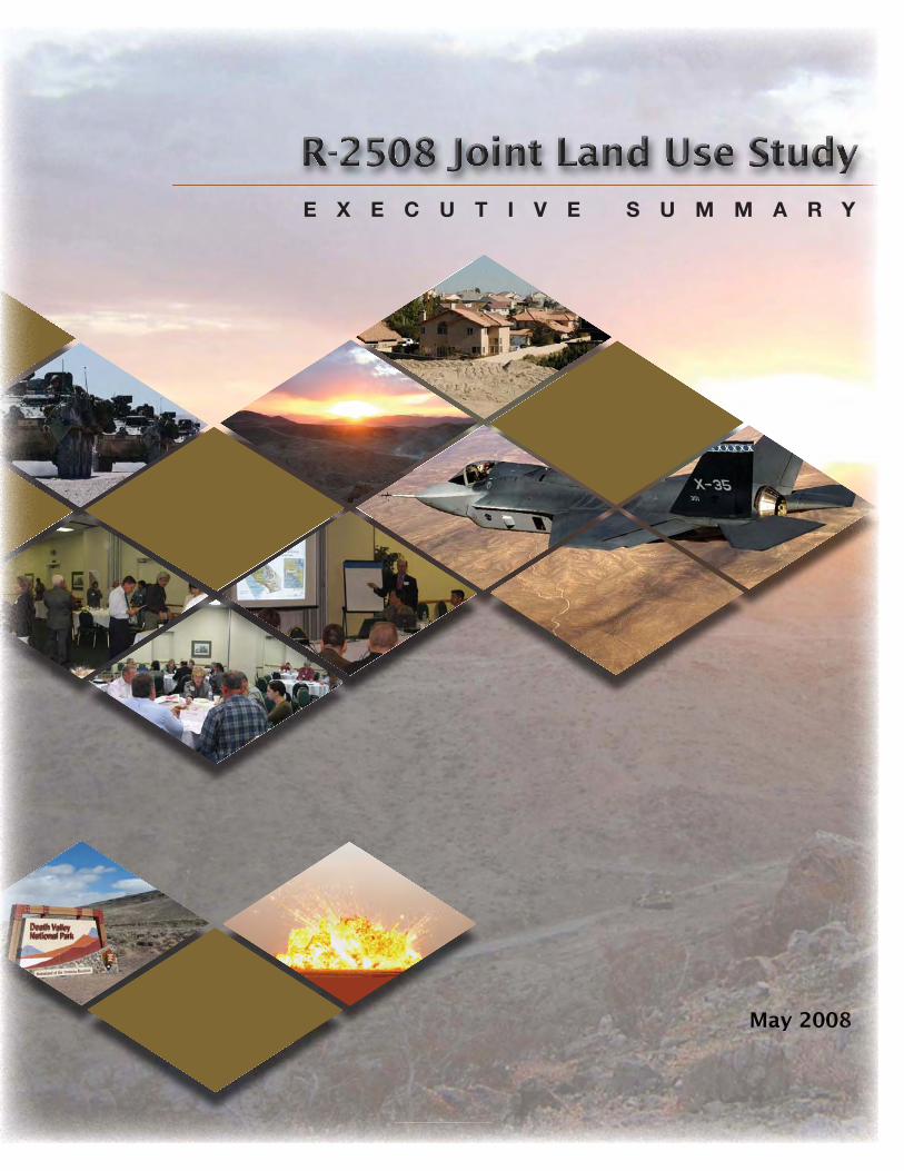
M M M M M M M M M M M M M M M M M Ma a a a a a a a a a ay y y y y y y y y 2 2 2 2 2 2 2 20 0 0 0 0 0 0 00 0 0 0 0 0 0 0 0 0 0 0 0 0 08 8 8 8 8 8 8 8 8 8 8 8 8 8 8 8 8 8 8 8 8 8 8 8 8 8 8 8 8 8 8 8 8 8 8 8 8 8 8 8 8 8 8 8 8 8 E X E C U T I V E S U M M A R Y
Th e overall goal of a JLUS is to reduce potential confl icts while accommodating growth, sustaining the economic health of the region, and protecting public health and safety. Like all JLUS programs, the R-2508 JLUS has three primary objectives.
1) UnderstandingConvene community, agency, and military representatives to study the issues in an open forum, taking into consideration both community and military viewpoints and needs. Th is includes public outreach and input.
2) CollaborationEncourage cooperative land use and resource planning between the military and surrounding communities so that future community growth and development are compatible with the training and operational missions in the R-2508 Complex while at the same time seeking ways to reduce operational impacts on adjacent lands.
3) ActionsProvide a set of tools, activities, and procedures from which local jurisdictions, agencies, and the military can select, and then use to implement the recommendations developed during the JLUS process. Th e actions proposed include both operational measures to mitigate military impacts and local government and agency approaches to reduce impacts on R-2508 Complex operations.
The R-2508 Complex includes three mil i tary Installations:
Naval Air Weapons Station (NAWS) China Lake • Edwards Air Force Base (AFB)• Fort Irwin / National Training Center (NTC)•
Th e R-2508 Complex provides the largest single area of Special Use Airspace (SUA) over land in the United States, covering a land area of 20,000 square miles. Th e R-2508 Complex consists of restricted areas (R-2508, R-2502N, R-2502E, R-2505, R-2506, R-2515, and R-2524), 10 Military Operations Areas (MOA), Air Traffi c Control Assigned Airspace (ATCAA) areas, Controlled Firing Areas (CFAs), and other special airspace such as, the CORDS Road, the Precision Impact Range Area, the Black Mountain Supersonic Corridor, the North Hypersonic Corridor, the South Hypersonic Corridor, and the Airfi eld Approach and Departure Corridors.
A Joint Land Use Study ( JLUS) is a collaborative planning effort between active military installations, surrounding counties and cities, and other aff ected agencies. Th e JLUS
process is funded by a grant from the Department of Defense Offi ce of Economic Adjustment (OEA).
The OEA is funding the preparation of two JLUSs in California. Given the large areas covered by these studies and the number of jurisdictions and agencies involved, the California JLUS program is being managed by the Governor’s Offi ce of Planning and Research (OPR). Th e two geographic study areas included in the California JLUS program are referred to as the R-2508 JLUS and the Beale JLUS.
The R-2508 JLUS is designed to address a study area comprised of all lands beneath the R-2508 Complex or in the vicinity of the three participating installations. Within the R-2508 JLUS study area are portions of Inyo, Kern, Los Angeles, San Bernardino, and Tulare counties, and the cities of California City, Ridgecrest, and Tehachapi. A large portion of the 20,000-square-mile study area is managed by
federal agencies, including U.S. National Parks (26.8%), Bureau of Land Management (BLM) (24.6%), military (17.4%), and U.S. National Forests (13.0%).
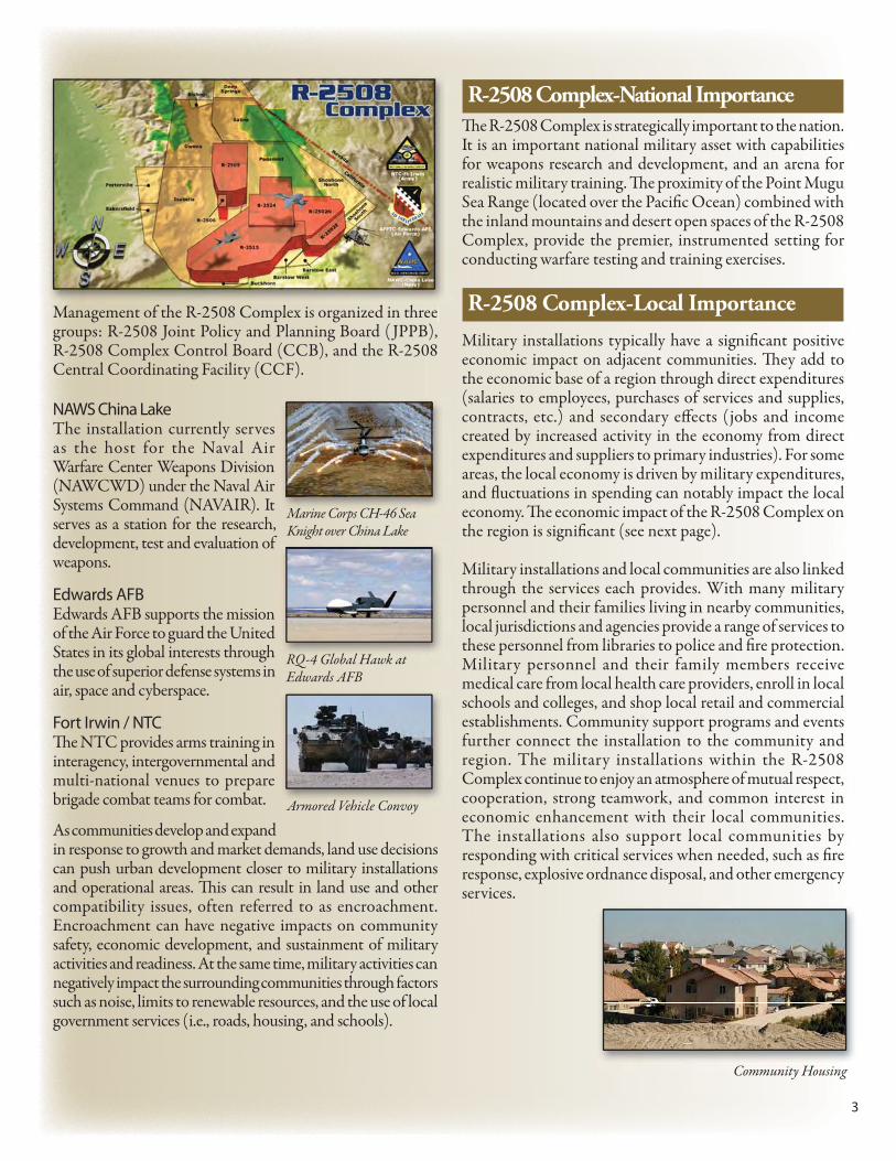
Management of the R-2508 Complex is organized in three groups: R-2508 Joint Policy and Planning Board ( JPPB), R-2508 Complex Control Board (CCB), and the R-2508 Central Coordinating Facility (CCF).
NAWS China Lake The installation currently serves as the host for the Naval Air Warfare Center Weapons Division (NAWCWD) under the Naval Air Systems Command (NAVAIR). It serves as a station for the research, development, test and evaluation of weapons.
Edwards AFB Edwards AFB supports the mission of the Air Force to guard the United States in its global interests through the use of superior defense systems in air, space and cyberspace.
Fort Irwin / NTC Th e NTC provides arms training in interagency, intergovernmental and multi-national venues to prepare brigade combat teams for combat.
As communities develop and expand in response to growth and market demands, land use decisions can push urban development closer to military installations and operational areas. Th is can result in land use and other compatibility issues, often referred to as encroachment. Encroachment can have negative impacts on community safety, economic development, and sustainment of military activities and readiness. At the same time, military activities can negatively impact the surrounding communities through factors such as noise, limits to renewable resources, and the use of local government services (i.e., roads, housing, and schools).
Th e R-2508 Complex is strategically important to the nation. It is an important national military asset with capabilities for weapons research and development, and an arena for realistic military training. Th e proximity of the Point Mugu Sea Range (located over the Pacifi c Ocean) combined with the inland mountains and desert open spaces of the R-2508 Complex, provide the premier, instrumented setting for conducting warfare testing and training exercises.
Military installations typically have a signifi cant positive economic impact on adjacent communities. Th ey add to the economic base of a region through direct expenditures (salaries to employees, purchases of services and supplies, contracts, etc.) and secondary eff ects (jobs and income created by increased activity in the economy from direct expenditures and suppliers to primary industries). For some areas, the local economy is driven by military expenditures, and fl uctuations in spending can notably impact the local economy. Th e economic impact of the R-2508 Complex on the region is signifi cant (see next page).
Military installations and local communities are also linked through the services each provides. With many military personnel and their families living in nearby communities, local jurisdictions and agencies provide a range of services to these personnel from libraries to police and fi re protection. Military personnel and their family members receive medical care from local health care providers, enroll in local schools and colleges, and shop local retail and commercial establishments. Community support programs and events further connect the installation to the community and region. The military installations within the R-2508 Complex continue to enjoy an atmosphere of mutual respect, cooperation, strong teamwork, and common interest in economic enhancement with their local communities. The installations also support local communities by responding with critical services when needed, such as fi re response, explosive ordnance disposal, and other emergency services.
R-2508 Complex-National Importance
R-2508 Complex-Local Importance
Marine Corps CH-46 Sea Knight over China Lake
Armored Vehicle Convoy
RQ-4 Global Hawk at Edwards AFB
Community Housing
MMMMMMMMMMM t f tth R 2508 CC ll i i d i tth
4
China Lake In 2007, China Lake was the largest employer in the Indian Wells Valley, providing jobs for 767 military personnel, 3,388 civilian employees, and over 2,400 contractor staff . Th e annual payroll at China Lake was $432 million. Over 91 percent of the total payroll was to civilians. Annual contract expenditures totaled $531 million.
Edwards AFB In Fiscal Year 2006 (FY06), the base employed 11,111 persons including 3,209 military personnel and 7,902 civilians and contractor personnel. Th e installation had an economic impact of $1.4 billion in FY06. Th is fi gure includes $536 million in payroll, $267 million in contract expenditures, and $575 million in indirect jobs created for almost 12,000 local residents.
Fort Irwin / NTC As reported for November 2007, the installation employed 5,170 active duty, Reserve, and National Guard military and 3,469 civilians. Depending on training cycles and unit composition, rotational units training at the NTC can add another 4,000 to 5,000 people to the total installation population. Fort Irwin / NTC is the top employer in the Barstow area and the third highest employer in San Bernardino County. Civilian payroll is estimated at $27.6 million and military payroll is about $86.8 million. Fort Irwin awards an estimated $241 million in contracts annually, which employs approximately 12,000 contractors.
Cities, counties, Native American tribal governments, state and federal agencies and military installations within the region of the R-2508 Complex have been actively engaged and proactive in local and regional encroachment / compatible land use management for many years. Th rough the JLUS
process, they will continue to partner to ensure that future community growth and development are compatible with the training and operational missions of the installations. Th ese partners will also continue to seek ways to reduce the operational impacts of military installations on adjacent land.
Th e goal of the R-2508 JLUS is to protect the viability of current and future missions in the R-2508 Complex while at the same time accommodating growth, sustaining the economic health of the region, and protecting public health and safety.
Th e R-2508 JLUS is not an adopted plan, but rather, a recommended set of compatibility guidelines that can be implemented by local jurisdictions, Native American tribal governments, agencies and organizations to guide their future compatibility eff orts. While the strategies in the JLUS are not mandatory obligations, they were developed with representatives of the stakeholders involved, thereby providing a set of strategies designed to meet local needs.
Following completion of the R-2508 JLUS, local jurisdictions, agencies and organizations can work towards implementation of the strategies that apply to them. For instance, local jurisdictions can use the strategies to guide future general plan and zoning updates. Edwards AFB, China Lake and Fort Irwin / NTC can use the JLUS to guide their eff orts in compatibility planning as well. It is through the future actions of the stakeholders involved that the JLUS strategies will become a reality.
Th e following is a brief overview of the organization of the R-2508 JLUS.
1. Introduction Section 1 provides an introduction and context for the R-2508 JLUS. It describes the goals and objectives used to guide development of the JLUS, who was involved in developing the JLUS, public outreach methods, and the organization of the study.
2. Study Area Profi le In developing a JLUS, a good understanding of the installations, military training areas, and local jurisdictions within the study area is necessary. Th is section provides an overview of the R-2508 Complex’s history, descriptions of the primary installations that use the Complex, a look at the current missions and military units located at those installations, the economic impact of the installations on the region, and a discussion of future missions. An overview of the region’s growth potential and a profi le of each of the counties and cities within the study area, including population, housing, and employment statistics are also provided.
R-2508 JLUS Summary
R-2508 JLUS
Partnerships
CCttrffeiintthaacllR-2508 JLUS Committee
meeting
5
3. Existing Plans, Studies and Programs Th is section provides an overview of currently available and relevant plans, programs, and studies, which are used to address compatibility issues in the study area. Th is includes technical studies, as well as local general plans and zoning ordinances.
4. Recommendations The final section of the JLUS provides a toolbox of strategies to address the compatibility issues identifi ed. Th e recommended strategies have been developed cooperatively with representatives from local jurisdictions, participating
military installations, Native American tribal governments, state and federal agencies, local organizations, and interested individuals and landowners. As a result of a collaborative planning process, the recommendations in this section represent a true consensus plan: a realistic, coordinated approach to compatibility planning developed with the support of the stakeholders involved.
5. Acronyms A listing, with defi nitions, of the acronyms used in the JLUS.
6
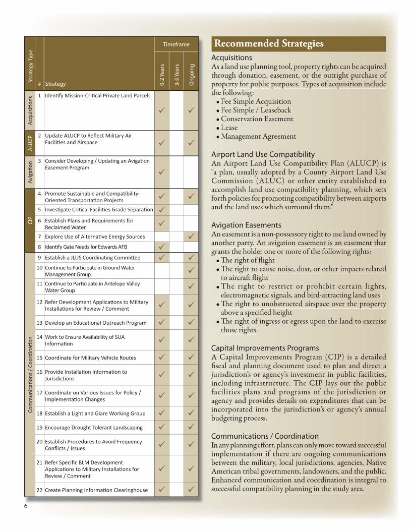
Acquisitions As a land use planning tool, property rights can be acquired through donation, easement, or the outright purchase of property for public purposes. Types of acquisition include the following:
Airport Land Use Compatibility An Airport Land Use Compatibility Plan (ALUCP) is "a plan, usually adopted by a County Airport Land Use Commission (ALUC) or other entity established to accomplish land use compatibility planning, which sets forth policies for promoting compatibility between airports and the land uses which surround them."
Avigation Easements An easement is a non-possessory right to use land owned by another party. An avigation easement is an easement that grants the holder one or more of the following rights:
Th e right of fl ight • Th e right to cause noise, dust, or other impacts related • to aircraft fl ight The right to restrict or prohibit certain lights, • electromagnetic signals, and bird-attracting land uses Th e right to unobstructed airspace over the property • above a specifi ed height Th e right of ingress or egress upon the land to exercise • those rights.
Capital Improvements ProgramsA Capital Improvements Program (CIP) is a detailed fi scal and planning document used to plan and direct a jurisdiction’s or agency’s investment in public facilities, including infrastructure. The CIP lays out the public facilities plans and programs of the jurisdiction or agency and provides details on expenditures that can be incorporated into the jurisdiction’s or agency’s annual budgeting process.
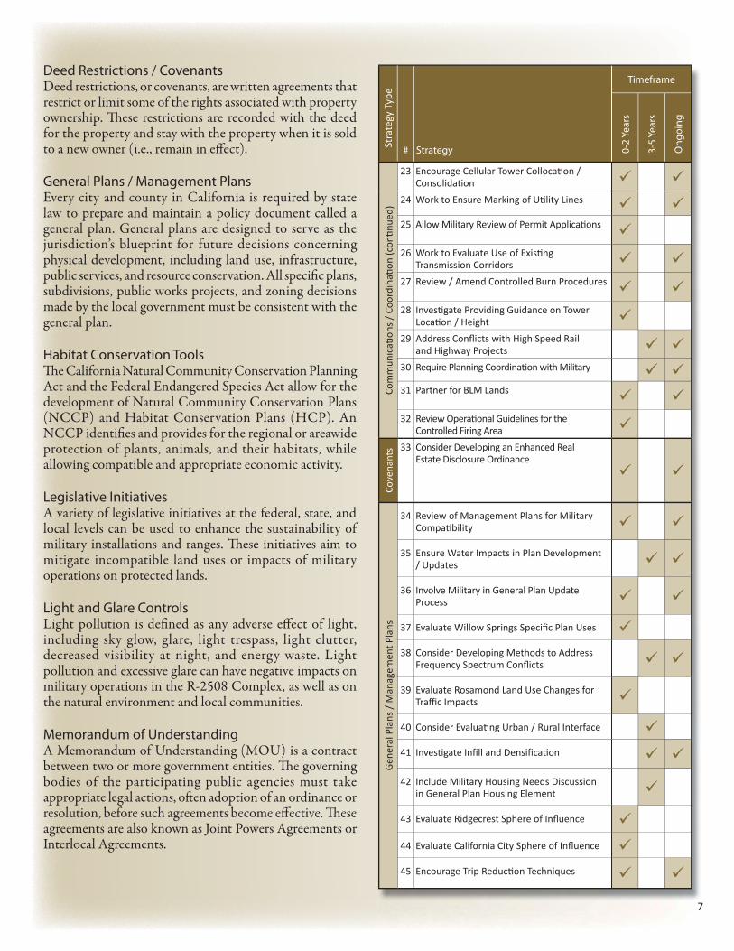
Communications / CoordinationIn any planning eff ort, plans can only move toward successful implementation if there are ongoing communications between the military, local jurisdictions, agencies, Native American tribal governments, landowners, and the public. Enhanced communication and coordination is integral to successful compatibility planning in the study area.
6
AcqAs athropropthe
F•F•C•L•M•
AirpAn "a pComaccofortand
AvigAn anogran
Th•Th•tT•eTh•aTh•t
CapA Cfi scajuriinclfaciagenincobud
ComIn animpbetwAmEnhsucc
Timeframe
# Strategy 0-2
Year
s
3-5
Year
s
Ong
oing
Acq
uisiti o
ns
1 Identi fy Mission-Criti cal Private Land Parcels
ALU
CP
2 Update ALUCP to Refl ect Military Air Faciliti es and Airspace
Avig
ati o
n 3 Consider Developing / Updati ng an Avigati on Easement Program
CIP
4 Promote Sustainable and Compati bility-Oriented Transportati on Projects
5 Investi gate Criti cal Faciliti es Grade Separati on
6 Establish Plans and Requirements for Reclaimed Water
7 Explore Use of Alternati ve Energy Sources
8 Identi fy Gate Needs for Edwards AFB
Com
mun
icati
ons
/ C
oord
inati
on
9 Establish a JLUS Coordinati ng Committ ee
10 Conti nue to Parti cipate in Ground Water Management Group
11 Conti nue to Parti cipate in Antelope Valley Water Group
12 Refer Development Applicati ons to Military Installati ons for Review / Comment
13 Develop an Educati onal Outreach Program
14 Work to Ensure Availability of SUA Informati on
15 Coordinate for Military Vehicle Routes
16 Provide Installati on Informati on to Jurisdicti ons
17 Coordinate on Various Issues for Policy / Implementati on Changes
18 Establish a Light and Glare Working Group
19 Encourage Drought Tolerant Landscaping
20 Establish Procedures to Avoid Frequency Confl icts / Issues
21 Refer Specifi c BLM Development Applicati ons to Military Installati ons for Review / Comment
22 Create Planning Informati on Clearinghouse
Recommended StrategiesSt
rate
gy T
ype
7
Deed Restrictions / CovenantsDeed restrictions, or covenants, are written agreements that restrict or limit some of the rights associated with property ownership. Th ese restrictions are recorded with the deed for the property and stay with the property when it is sold to a new owner (i.e., remain in eff ect).
General Plans / Management PlansEvery city and county in California is required by state law to prepare and maintain a policy document called a general plan. General plans are designed to serve as the jurisdiction’s blueprint for future decisions concerning physical development, including land use, infrastructure, public services, and resource conservation. All specifi c plans, subdivisions, public works projects, and zoning decisions made by the local government must be consistent with the general plan.
Habitat Conservation ToolsTh e California Natural Community Conservation Planning Act and the Federal Endangered Species Act allow for the development of Natural Community Conservation Plans (NCCP) and Habitat Conservation Plans (HCP). An NCCP identifi es and provides for the regional or areawide protection of plants, animals, and their habitats, while allowing compatible and appropriate economic activity.
Legislative InitiativesA variety of legislative initiatives at the federal, state, and local levels can be used to enhance the sustainability of military installations and ranges. Th ese initiatives aim to mitigate incompatible land uses or impacts of military operations on protected lands.
Light and Glare ControlsLight pollution is defi ned as any adverse eff ect of light, including sky glow, glare, light trespass, light clutter, decreased visibility at night, and energy waste. Light pollution and excessive glare can have negative impacts on military operations in the R-2508 Complex, as well as on the natural environment and local communities.
Memorandum of UnderstandingA Memorandum of Understanding (MOU) is a contract between two or more government entities. Th e governing bodies of the participating public agencies must take appropriate legal actions, oft en adoption of an ordinance or resolution, before such agreements become eff ective. Th ese agreements are also known as Joint Powers Agreements or Interlocal Agreements.
7
Timeframe
# Strategy 0-2
Year
s
3-5
Year
s
Ong
oing
Com
mun
icati
ons
/ C
oord
inati
on
(con
ti nue
d)
23 Encourage Cellular Tower Collocati on / Consolidati on
24 Work to Ensure Marking of Uti lity Lines
25 Allow Military Review of Permit Applicati ons
26 Work to Evaluate Use of Existi ng Transmission Corridors
27 Review / Amend Controlled Burn Procedures
28 Investi gate Providing Guidance on Tower Locati on / Height
29 Address Confl icts with High Speed Rail and Highway Projects
30 Require Planning Coordinati on with Military
31 Partner for BLM Lands
32 Review Operati onal Guidelines for the Controlled Firing Area
Cove
nant
s 33 Consider Developing an Enhanced Real Estate Disclosure Ordinance
Gen
eral
Pla
ns /
Man
agem
ent P
lans
34 Review of Management Plans for Military Compati bility
35 Ensure Water Impacts in Plan Development / Updates
36 Involve Military in General Plan Update Process
37 Evaluate Willow Springs Specifi c Plan Uses
38 Consider Developing Methods to Address Frequency Spectrum Confl icts
39 Evaluate Rosamond Land Use Changes for Traffi c Impacts
40 Consider Evaluati ng Urban / Rural Interface
41 Investi gate Infi ll and Densifi cati on
42 Include Military Housing Needs Discussion in General Plan Housing Element
43 Evaluate Ridgecrest Sphere of Infl uence
44 Evaluate California City Sphere of Infl uence
45 Encourage Trip Reducti on Techniques
Stra
tegy
Typ
e
8
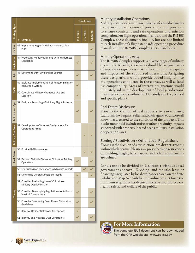
Military Installation OperationsMilitary installations maintain numerous formal documents to aid in standardization of procedures and processes to ensure consistent and safe operations and mission completion. For fl ight operations in and around the R-2508 Complex, these documents include, but are not limited to each installation’s fl ight standards operating procedure manuals and the R-2508 Complex Users Handbook.
Military Operations AreaTh e R-2508 Complex supports a diverse range of military operations. As such, these areas should be assigned areas of interest designations that reflect the unique aspects and impacts of the supported operations. Assigning these designations would provide added insights into the operations conducted in these areas, as well as land use compatibility. Areas of interest designations would ultimately aid in the development of local jurisdictions’ planning documents within the JLUS study area (i.e., general and specifi c plans).
Real Estate DisclosurePrior to the transfer of real property to a new owner, California law requires sellers and their agents to disclose all known facts related to the condition of the property. Th is disclosure should include noise or other proximity impacts associated with property located near a military installation or operations area.
Zoning / Subdivision / Other Local RegulationsZoning is the division of a jurisdiction into districts (zones) within which permissible uses are prescribed and restrictions on building height, bulk, layout, and other requirements are defi ned.
Land cannot be divided in California without local government approval. Dividing land for sale, lease or fi nancing is regulated by local ordinances based on the State Subdivision Map Act. Subdivision ordinances set forth the minimum requirements deemed necessary to protect the health, safety, and welfare of the public.
8
MiliMilito ato ecomComto eaman
MiliTh e operof inandthesthe use ultimplanand
ReaPrioCaliknowdisclassoor op
ZonZonwithon bare d
Langovefi nanSubdminheal
Timeframe
# Strategy 0-2
Year
s
3-5
Year
s
Ong
oing
Hab
itat 46 Implement Regional Habitat Conservati on
Plan
Legi
slati
ve 47 Protecti ng Military Missions with Wilderness
Legislati on
Ligh
t 48 Determine Dark Sky Funding Sources
MO
U
49 Evaluate Implementati on of Military Emission Reducti on System
50 Coordinate Military Ordnance Use and Locati on
Mili
tary
Inst
Ops 51 Evaluate Rerouti ng of Military Flight Patt erns
Mili
tary
Ops
Are
a 52 Develop Area of Interest Designati ons for Operati ons Areas
Real
Est
ate
53 Provide UXO Informati on
54 Develop / Modify Disclosure Noti ces for Military Operati ons
Zoni
ng
55 Use Subdivision Regulati ons to Minimize Impacts
56 Determine Density Limitati ons Needs
57 Consider Evaluati ng Use of China Lake Military Overlay District
58 Consider Developing Regulati ons to Address Verti cal Obstructi ons
59 Consider Developing Solar Power Generati on Guidelines
60 Remove Residenti al Tower Exempti ons
61 Identi fy and Miti gate Dust Constraints
Stra
tegy
Typ
e
For More InformationThe complete JLUS document can be downloaded from the OPR website at: www.opr.ca.gov