66
Wessex Archaeology January 2009 Ref: 68733 Archaeological Evaluation and Assessment of Results Radcot Oxfordshire
| Date post: | 30-May-2018 |
| Category: |
Documents |
| Upload: | wessex-archaeology |
| View: | 226 times |
| Download: | 0 times |
8/14/2019 Radcot, Oxfordshire
http://slidepdf.com/reader/full/radcot-oxfordshire 1/65
Wessex Archaeology
January 2009
Ref: 68733
Archaeological Evaluation and Assessment of Results
RadcotOxfordshire
8/14/2019 Radcot, Oxfordshire
http://slidepdf.com/reader/full/radcot-oxfordshire 2/65
Radcot, Oxfordshire
Archaeological Evaluation and Assessment of Results
Prepared on behalf of Videotext Communications Ltd
49 Goldhawk Road
LONDONSW1 8QP
ByWessex ArchaeologyPortway HouseOld Sarum Park
SALISBURYWiltshireSP4 6EB
Report reference: 68733.01
January 2009
© Wessex Archaeology Limited 2009, all rights reserved Wessex Archaeology Limited is a Registered Charity No. 287786
8/14/2019 Radcot, Oxfordshire
http://slidepdf.com/reader/full/radcot-oxfordshire 3/65
i
Radcot, Oxfordshire
Archaeological Evaluation and Assessment of Results
Contents
Summary Acknowledgements
1 BACKGROUND...................................................................................................11.1 Introduction...............................................................................................11.2 Site Location, Topography and Geology................................................11.3 Archaeological and Historical Background ...........................................1
Prehistoric to Romano-British.....................................................................1Saxon ........................................................................................................2
Medieval .....................................................................................................2 Post-Medieval.............................................................................................4
1.4 Previous Archaeological Work................................................................4Geophysical Survey....................................................................................4 Archaeological Evaluation ..........................................................................4
2 AIMS AND OBJECTIVES ...................................................................................53 METHODS...........................................................................................................5
3.1 Geophysical Survey .................................................................................53.2 Evaluation Trenches ................................................................................5
4 RESULTS ............................................................................................................64.1 Introduction...............................................................................................64.2 Geophysical Survey .................................................................................6
Gradiometer Survey ( Figure 2A ) ...............................................................6 Ground Penetrating Radar ( Figure 2B ) .....................................................7 Resistance Survey ( Figure 2C )..................................................................7 Conclusions ................................................................................................7
4.3 Evaluation Trenches ................................................................................84.4 ‘The Garrison’ ...........................................................................................8
Site-Wide Stratigraphy................................................................................8 Trench 1 ( Figures 3 & 4 ) ...........................................................................8 Trench 2 ( Figure 5 ) ....................................................................................9Trench 3 ( Figure 6 ) ..................................................................................11Trench 4 ( Figure 7 ) ..................................................................................11Trench 5 ( Figure 8 ) ..................................................................................12 Trench 7 ( Figure 9 ) ..................................................................................12
4.5 South of ‘The Garrison’..........................................................................13Trench 6 ( Figure 10 ) ................................................................................13
5 FINDS................................................................................................................135.2 Pottery .....................................................................................................135.3 Ceramic Building Material (CBM)..........................................................165.4 Clay Pipe .................................................................................................175.5 Stone........................................................................................................175.6 Glass........................................................................................................175.7 Metalwork................................................................................................17
Copper Alloy .............................................................................................17
Lead/Lead alloy ........................................................................................18 Iron ......................................................................................................18
8/14/2019 Radcot, Oxfordshire
http://slidepdf.com/reader/full/radcot-oxfordshire 4/65
8/14/2019 Radcot, Oxfordshire
http://slidepdf.com/reader/full/radcot-oxfordshire 5/65
iii
Figure 9: Trench 7: plan, section and photographsPlate 11: Trench 7 from the north
Figure 10: Trench 6: plan, sections and photographsPlate 12: Trench 6 from the south-westPlate 13: North-west facing section
Figure 11: 2007 geophysical and topographical surveysFront Cover: Aerial photograph of the Site from the south-eastBack Cover: (top) Trench 1 under excavation
(middle) Aerial view of Trench 1(bottom) Aerial view of the Site from the south
8/14/2019 Radcot, Oxfordshire
http://slidepdf.com/reader/full/radcot-oxfordshire 6/65
iv
Radcot, Oxfordshire
Archaeological Evaluation and Assessment of Results
Summary
In May 2008 an archaeological evaluation was undertaken by Channel 4’s ‘TimeTeam’ at a site known locally as ‘The Garrison’, in Radcot, Oxfordshire to investigatethe remains of Queen Matilda’s moated castle complex of the 12 th century AnarchyPeriod and a 17th century Civil War Royalist enclosure.
The layout of the medieval castle complex and later Civil War earthworks had beenpreviously investigated in a geophysical survey undertaken by Abingdon Archaeological Geophysics, which revealed the castle keep and associated ancillarybuildings, as well as the line of a large defensive ditch. A small evaluation trench wassubsequently dug across part of the keep by John Blair of Oxford University.
The evaluation by Time Team added to the information gathered previously byrevealing the north-eastern corner of the keep and also the supporting pier for thefirst floor of the castle within the interior. The remains of the heavily robbedgatehouse and main access road into the castle complex and the northern moat wereidentified, as well as a heavily robbed structure interpreted as a chapel. The remainsof a medieval ancillary building were also revealed. These structures post-dateddeposits containing 11th/12th century pottery, consistent with an early post-conquestconstruction date, which could link it with Hugh of Buckland, the local major landowner around the turn of the 12th century. Possible evidence of the subsequent
strengthening of the keep was observed, perhaps associated with Matilda'sfortification of the castle during the Anarchy Period of the mid 12th century.
The abandonment of the castle complex was dated to the late 13th/early 14th century,and there was a clear hiatus in the pottery sequence from that date until the 16 th
century, which fits with the later occupation of the Site by the de Besilles family.
In the mid 17th century a ‘minor Royalist fort’ was constructed that involved therefortification of the eastern half of the medieval moated complex by the excavationof a large ditch which split the moated site in two. The 17 th century defensive ditchwas shown to surround an earthen bastion for the placing of cannon.
Several late Romano-British ditches, possibly field boundaries, were also identified,as well as a low level of residual later prehistoric material, suggesting activity on or close to the Site.
The route of the medieval road from Faringdon to Witney, which apparently ranthrough the site, was also investigated, but no trace of the road was found.
The evaluation has contributed useful evidence that confirms and augments our knowledge of the construction, layout and date range of the castle complex atRadcot, and also of the Civil War earthworks on the same site. The results warrantfurther dissemination through a short publication article, to be submitted toOxoniensia.
8/14/2019 Radcot, Oxfordshire
http://slidepdf.com/reader/full/radcot-oxfordshire 7/65
v
Radcot, Oxfordshire
Archaeological Evaluation and Assessment of Results
Acknowledgements
This programme of post-excavation and assessment work was commissioned andfunded by Videotext Communications Ltd, and Wessex Archaeology would like tothank the staff at Videotext, and in particular Michael Douglas (Series Editor), JaneHammond (Production Manager), Ben Knappett (Assistant Producer), Louise Ord(Researcher) and Joanna Gatcum (Production Coordinator) for their considerablehelp during the recording and post-excavation work.
The geophysical survey was undertaken by John Gater, Emma Wood and Jimmy Adcock of GSB Prospection. The field survey was undertaken by Henry Chapman,University of Birmingham. The excavation strategy was devised by Mick Aston,University of Bristol. The on-site recording was co-ordinated by Steve Thompson withon-site finds processing by Megan Stoakley, both of Wessex Archaeology.
The excavations were undertaken by Time Team’s retained archaeologists, PhilHarding (Wessex Archaeology), Brigid Gallagher, Ian Powlesland, Raksha Dave,Kerry Ely, Tracey Smith and Matt Williams assisted by Jack Crennell, Kasia Witczak,Manne Högström, Matt Adams, Chris Pole and Jane Harrison.
The archive was collated and all post-excavation assessment and analysisundertaken by Wessex Archaeology. This report was compiled by Steve Thompson
with specialist reports prepared by Lorraine Mepham (finds), Jessica Grimm (animalbone), Nicholas Cooke (jeton) and Ruth Pelling (environmental). The illustrationswere prepared by Kenneth Lymer. The post-excavation project was managed onbehalf of Wessex Archaeology by Lorraine Mepham
The work benefited from discussion on-site with Mick Aston, Phil Harding, John Blair of Queens College, Oxford, medieval castle specialist Richard K Morriss and Roger Ainslie of Abingdon Archaeological Geophysics.
Finally thanks are extended to Tom Freeman and family for allowing access to theSite.
8/14/2019 Radcot, Oxfordshire
http://slidepdf.com/reader/full/radcot-oxfordshire 8/65
1
Radcot, Oxfordshire
Archaeological Evaluation and Assessment of Results
1 BACKGROUND
1.1 Introduction
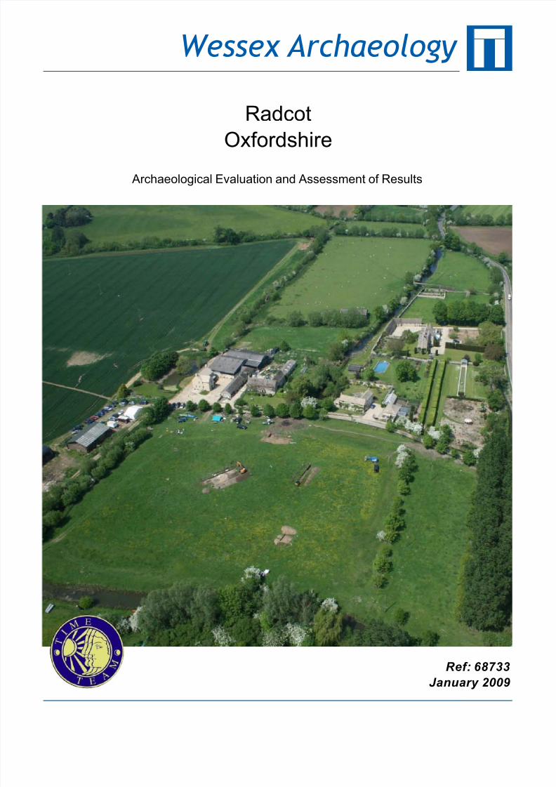
1.1.1 Wessex Archaeology was commissioned by Videotext Communications Ltdto undertake a programme of archaeological recording and post-excavationwork on an archaeological evaluation undertaken by Channel 4’s ‘TimeTeam’ in Radcot in Oxfordshire (hereafter the ‘Site’) (Figure 1).
1.1.2 This report documents the results of archaeological survey and evaluationundertaken by Time Team, and presents an assessment of the results of these works.
1.2 Site Location, Topography and Geology
1.2.1 Radcot is approximately 5km north of Faringdon and approximately 14.5kmsouth of Witney along the current A4095, in the district of West Oxfordshireand in the parish of Grafton and Radcot. The evaluation involved theinvestigation of an area known locally as ‘The Garrison’, centred on NGR428467 199650, and lying on the north bank of the River Thames.
1.2.2 The Site comprises a rectangular parcel of land measuring approximately146m by 120m with substantial visible earthworks, and is located at a heightof approximately 69m above Ordnance Datum (aOD) The Site is currentlyunder pasture and is used for animal grazing.
1.2.3 The Site includes a large moated area surrounded by infilled ditches, withthe earthworks clearest on the northern and eastern sides of the enclosure.The internal area within the moat is divided into two clear areas and theeastern half is considerably higher than the western, with a further series of earthworks enclosing the eastern half.
1.2.4 The underlying geology is alluvial silt overlying river gravels (IGS Sheet 253)
1.3 Archaeological and Historical BackgroundPrehistoric to Romano-British
1.3.1 The National Monuments Record (NMR) identifies a number of prehistoricsites considered of national importance and so designated as Scheduled Ancient Monuments (SAMs) within a 5km radius of Radcot, including theNeolithic causewayed enclosure west of Rushey Weir (NMR 35543, NGR432107 200058) and the Neolithic long mortuary enclosure and Bronze Agebarrow south of Rushey Weir (NMR 35544, NGR 432307 199905)
1.3.2 A number of stray prehistoric finds have been recovered from aroundRadcot, including a Neolithic axe head from Radcot Bridge, recorded in the
Oxfordshire Historic Environment Record (OHER) as Sites and MonumentsRecord (SMR) No. 3103-MOX9798, NGR 428550 199400).
8/14/2019 Radcot, Oxfordshire
http://slidepdf.com/reader/full/radcot-oxfordshire 9/65
2
1.3.3 Later prehistoric sites include a number of Late Iron Age settlements, suchas the substantial defensive earthworks of the Burroway Enclosure (NMR12006, NGR 430893 103377), and the settlement 500m south-west of BlackBourton (NMR OX157, NGR 427767 203480). About 1km south of LeazeFarm is a settlement spanning the end of the Iron Age and beginning of the
Romano-British period (NMR 13807, NGR 423852 198513;www.magic.gov.uk).
1.3.4 Other Romano-British sites include the settlement south-west of Clanfield(SMR No. 1405-MOX2098, NGR 427700 200600) and the ribbon settlementat Camden Farm (SMR No. 15694-MOX9883, NGR 427900 198700).
Saxon
1.3.5 Finds recorded in the OHER from the post Romano-British period include alate Anglo-Saxon spear head from Grafton Lock (SMR No.377-MOX9800,NGR 427300 199300).
Medieval
1.3.6 The following information is taken from the Project Design (VideotextCommunications, 2008) with reference to a suggested chronology for theSite supplied by Professor John Blair of Queens College Oxford.
Ælfsige of Faringdon (c. 1070-1100)
1.3.7 Ælfsige emerges from the Domesday Book as the leading local Englishsurvivor of the Norman Conquest: a modest figure in 1066, he had by 1086amassed substantial estates both south of the Thames (Faringdon,Littleworth, Barcot) and north (Langford). Ælfsige almost certainly built thesplendid late 11th century church, with contemporary sculpture, that survivesat Langford (Blair 1994). It seems certain that his Domesday estate of
Rocote (which doubled in value between 1066 and 1086), usuallymisidentified as Rycote near Thame, was in fact Radcot, and that it formed acrossing-point between his properties on the two sides of the river.
1.3.8 The road from Black Bourton to Faringdon via Clanfield and Radcot isstraight, clearly artificial, and was evidently laid out to connect Burford withFaringdon while bypassing the earlier communications node and crossing atBampton. It is possible that Ælfsige constructed it. This would have mirrored,on a smaller scale, Robert d'Oilly's construction of the great stone causewayover the Thames at Oxford at around the same time.
Hugh of Buckland (c . 1100-20)
1.3.9 Ælfsige of Faringdon's land-complex seems to have been broken up andredistributed by the Crown after his death. The main lay magnate in north-west Berkshire in Henry I's time was Hugh of Buckland, and the later manorial history of Radcot shows that the de Besilles family, who held it inthe 13th century, inherited it from one of the de Buckland heiresses. Theyalso held the nearby manor of Barcot, which had been Ælfsige's in 1086,and which was said in the late 12 th century to belong to the `barony of Buckland' .
1.3.10 It is a reasonable inference that Radcot reverted to the Crown in the 1090sor 1100s, and was given to Hugh of Buckland by William II or Henry I. It issuggested that at this time the castle complex at Radcot was constructed,
possibly to control the route between Witney and Faringdon, as the complexclearly straddles the original alignment.
8/14/2019 Radcot, Oxfordshire
http://slidepdf.com/reader/full/radcot-oxfordshire 10/65
3
Fortification by Matilda (1142)
1.3.11 The Gesta Stephani , the contemporary chronicle of the civil war of Stephen's reign, says that in 1142 Matilda fortified castles at Woodstock,Radcot, Cirencester and Bampton, and that the Radcot castle, `sosurrounded by water and marsh as to be inaccessible' , shortly afterwards
surrendered to Stephen. This presumably refers to ‘The Garrison’ site, andthe existing castle complex constructed by Hugh of Buckland.
Remodelling by the de Besilles family? (c . 1250-1300)
1.3.12 In c .1250-70, Radcot passed by inheritance to the Somerset knightly familyof de Besilles, who apparently maintained a residence there and werepossibly responsible for the demolition of the castle keep in the later 13 th
century (see below).
1.3.13 It is recorded that a three-storey chamber-block was standing a century later (see below), suggesting the possibility that Matthew de Bessilles (d.1295)demolished the Norman keep and replaced it with a more comfortable and
up-to-date tower-house. However, it is unclear if the tower house stoodwithin the Garrison enclosure, or just outside its north edge on the site of thepresent Radcot Bridge Farm, located just to the north of the Site.
Dereliction after the Black Death (1379)
1.3.14 The survey accompanying an inquisition post mortem of 1379 indicates astate of extreme dereliction in both the manorial site and the adjoiningvillage, but shows that some buildings still stood: a chapel, threesuperimposed chambers under one roof, a barn, and a dovecote Thestructure described as `three chambers' may be a tower-house.
The battle for Radcot Bridge (1387)
1.3.15 Richard II, on coming to the throne, removed much of the control from theestablished nobles; these disaffected nobles formed a group known as theLords Appellant. Richard turned to his favourites such as Robert de Vere,9th Earl of Oxford and Michael de la Pole, Earl of Suffolk for counsel, anunpopular move. In 1386 Parliament, under pressure from the Lords Appellant, demanded that Richard remove his unpopular counsellors, whichRichard refused. Richard was facing revolt amongst the strongly armedBarons, and at this time of private armies the Barons could muster moretroops than the King. Lord de Vere was sent by the King to raise troops inthe Midlands and the Welsh borders and to return to London. To counter this, the Duke of Gloucester was sent to block de Vere’s route back toLondon and to force him south to face Lord Arundel, who was holding theroad from Burford to Witney and Newbridge, and the future King Henry IV,Lord Derby, who held Radcot Bridge. The defeat of the King’s army atRadcot would eventually lead to Richard’s imprisonment and the subsequentexecution of many of his unpopular counsellors in 1388(http://en.wikipedia.org/wiki/Richard_II_of_England; Pocock, 1966).
'Strong pile' to 'mansion place' (c .1530)
1.3.16 In the 1530s John Leland wrote of Radcot 'where hathe bene a strong pile,and now a mansion place' (Toulmin Smith, 1964). It seems most likely thatthe `strong pile' was the tower-house mentioned in 1379, and that the`mansion place' was the present Radcot House.
1.3.17 To the north of the Garrison and Radcot House are the remains of ashrunken medieval village situated on either side of the main northern
8/14/2019 Radcot, Oxfordshire
http://slidepdf.com/reader/full/radcot-oxfordshire 11/65
4
approach to the castle complex (SMR No 1084-MOX9780). It is possible thatthe village was deserted following the movement away from the Garrison tothe site of the present Radcot House, and the clearing of land around thenew house for gardens and parkland.
Post-Medieval
1.3.18 The Site gets its name ‘The Garrison’ from the 17th Century Civil War actionwhich took place around Radcot Bridge and Faringdon, and the eventualestablishment of a Royalist garrison at Radcot House in 1645. Toynbee(1946, 49) describes the site as ‘a minor Royalist fort’ whose main role wasto keep open the lines of communication on the road to Faringdon.
1.4 Previous Archaeological Work
Geophysical Survey
1.4.1 No archaeological work had been undertaken within the Site until 2007 whena magnetometer survey was carried out by Abingdon Archaeological
Geophysics (Figure 11A). The survey revealed a number of structures andfeatures, including a large square building with a central structure interpretedas the castle keep, located just west of centre within the Site. In the south-east corner a three-celled structure interpreted as a chapel was observed,as well as a number of possible ancillary buildings. These structures wereinterpreted as belonging to the phase of activity associated with Hugh of Buckland c .1100-1120.
1.4.2 Aligned approximately north-south and running roughly centrally through theSite was a large anomaly that dog-legged to the west before continuing tothe north and then dog-legging back to the east. This feature was interpretedas a large defensive ditch associated with the eastern enclosure within the
moated site, and clearly followed the base of the western earthwork of theeastern enclosure, with the dog-leg creating a bulwark at the north-westcorner. It was suggested that this eastern enclosure was associated with the17th century Civil War activity which gave rise to the Site name ‘TheGarrison’, and that it represents the ‘minor Royalist fort’ referred to byToynbee (1946, 49).
Archaeological Evaluation
1.4.3 The only intrusive archaeological work undertaken on the Site to date was asingle evaluation trench excavated by Professor John Blair of The Queen'sCollege, Oxford, and Roger Ainslie of Abingdon Archaeological Geophysics,with members of the Abingdon Archaeological Society. The trench was 5m
long by 2 m wide, aligned east-west, and aimed to investigate the westernwall of the large square structure identified in the geophysical survey as thecastle keep.
1.4.4 The evaluation report (Blair 2007) has not been published and is presentedin Appendix 2 in its entirety. The trench will be referred to as Trench Blair 1within the remainder of this report (see Figure 1).
1.4.5 Trench Blair 1 revealed the heavily robbed south-western corner of thekeep, which was recorded as 3.7m wide and a maximum of 0.40m thick. Itwas butted on the external side by repeated gravel deposits, interpreted as ametalled surface. Overlying the metalled surface and butting the exterior of
the keep was a dump of mortared ashlar blocks which was interpreted aspossible evidence of the fortification of the base of Hugh of Buckland’s tower
8/14/2019 Radcot, Oxfordshire
http://slidepdf.com/reader/full/radcot-oxfordshire 12/65
5
by Matilda in 1142. Evidence of other such strengthening deposits aroundkeeps has been observed, for example, at Mount House, Witney, some 14.5km to the north (Videotext Communications 2008, 3).
2 AIMS AND OBJECTIVES
2.1.1 A project design for the work was compiled (Videotext Communications2008), providing full details of the research aims and methods. A brief summary is provided here.
2.1.2 The aim of the project was to characterise the nature and date of the Siteand place it within its historical, geographical and archaeological context. Of particular priority was the establishment and refinement of the chronologyand phasing of the Site.
3 METHODS
3.1 Geophysical Survey
3.1.1 Prior to the excavation of evaluation trenches, a geophysical survey wascarried out across the Site by GSB Prospection Ltd, using a combination of resistance and magnetic survey, to enhance the results of the Abingdon Archaeological Geophysics survey of 2007. The survey grid was set out byDr Henry Chapman and tied in to the Ordnance Survey grid using a Trimblereal time differential GPS system.
3.1.2 Two instruments were used to collect magnetic data; Bartington Grad 601-2
and Foerster Ferex 4.032; the latter giving a greater resolution.
3.2 Evaluation Trenches
3.2.1 Seven trenches of varying sizes were excavated, their locations determinedin order to investigate and to clarify geophysical anomalies and investigatestanding earthworks (Figure 1).
3.2.2 The trenches were excavated using a combination of machine and handdigging. All machine trenches were excavated under constantarchaeological supervision and ceased at the identification of significantarchaeological remains, or at natural geology if this was encountered first.
When machine excavation had ceased all trenches were cleaned by handand archaeological deposits investigated.
3.2.3 At various stages during excavation the deposits were scanned by a metaldetector and signals marked in order to facilitate investigation. Theexcavated spoil was scanned by metal detector.
3.2.4 All archaeological deposits were recorded using Wessex Archaeology’s proforma record sheets with a unique numbering system for individual contexts.Trenches were located using a Trimble Real Time Differential GPS surveysystem. All archaeological features and deposits were planned at a scale of 1:20 with sections drawn at 1:10. All principal strata and features were
related to the Ordnance Survey datum.
8/14/2019 Radcot, Oxfordshire
http://slidepdf.com/reader/full/radcot-oxfordshire 13/65
6
3.2.5 A full photographic record of the investigations and individual features wasmaintained, utilising digital images. The photographic record illustrated boththe detail and general context of the archaeology revealed and the Site as awhole.
3.2.6 At the completion of the work, all trenches were reinstated using theexcavated soil.
3.2.7 A unique site code (RAD 08) was issued prior to the commencement of works. The work was carried out on the 13th – 16th May 2008. The archiveand all artefacts were subsequently transported to the offices of Wessex Archaeology in Salisbury where they were processed and assessed for thisreport.
4 RESULTS
4.1 Introduction
4.1.1 Details of individual excavated contexts and features, the full geophysicalreport (GSB 2008), the summary of the landscape and earthwork survey anddetails of artefactual and environmental assessments, are retained in thearchive. Details of the excavated sequences can be found in Appendix 1.
4.2 Geophysical Survey
4.2.1 Conditions for survey were good as the ground cover consisted of shortpasture with no obstructions.
Gradiometer Survey ( Figure 2A )
4.2.2 The magnetic data clearly show the footprint of the castle keep (1); the wallfoundations are visible as strong negative anomalies; this compares withboth the resistance and GPR surveys. An interior wall and a central pillar can also be seen within the structure. A number of anomalies can also beseen to the north; these may represent structures attached to the building.Some of these features also correspond to the GPR data.
4.2.3 Further wall foundations can be seen at (2) and (3) to the east of the keep.These are thought to be buildings associated with the Garrison. Anomalies(2) represent a possible chapel and correspond with (H) in the GPR data.Foundations surrounding (3) proved to be of a more domestic nature when
excavated; one of the buildings was thought to be a kitchen. Anomalieswithin the wall foundations may indicate demolition spread or areas of burning.
4.2.4 A curvilinear trend (4) to the west of the Garrison is difficult to interpretarchaeologically. It may be contemporary with the keep, perhapsrepresenting garden features; it could, however, be of either an earlier or later date.
4.2.5 Running through the data on a north-south alignment is the Civil War ditch(5). This feature is also seen in the resistance data.
4.2.6 Anomaly (6) lies on a differing alignment to the other features in the data; itmay be a ditch pre-dating the castle, but this interpretation is tentative.
8/14/2019 Radcot, Oxfordshire
http://slidepdf.com/reader/full/radcot-oxfordshire 14/65
7
4.2.7 Other negative responses may have an archaeological origin although somemay simply be topographic effects. The ditch surrounding the main site canbe seen as a negative anomaly. There are very few anomalies of a ferrousnature throughout the data, perhaps indicating that metal detectorists havebeen active; some however are located with the ditches and are likely to be
modern material.Ground Penetrating Radar ( Figure 2B )
4.2.8 The footings of the tower are the dominant feature of this dataset. Clear breaks can be seen in the wall lines at (A) and, owing to the sharply definededges, these are thought to be doorways rather than robbing of constructionmaterial. To a depth of around 1m a central division (B) is apparent, splittingthe floorplan of the keep roughly in half. Excavation confirmed the linear anomaly to be of a relatively superficial construction overlying a far moresubstantial deposit of stone, presumably to support the upper floor.
4.2.9 Immediately adjacent to the keep is a broad area of increase response (D),
within which there are numerous high amplitude anomalies. Despite hints of rectilinearity, it is not possible to define individual structures or a layout;while it is assumed that this zone has structure within it, it has not beenpossible to differentiate potential demolition spread from in situ remains. Anexception to this is rectilinear anomaly (E). This closely flanks the castlewalls on two sides but it is not clear whether it is remnants of an earlier structure or some form of out-building.
4.2.10 Structure (F) is relatively clear and looks to be an ancillary buildingassociated with the keep. It appears to have been truncated by the later CivilWar ditch (G), as there is no obvious end wall to the south-east. It ispossible that this has simply been robbed out.
4.2.11 Numerous high amplitude anomalies and trends east of, and on a sharedrectilinear alignment to the keep are thought to be earlier manorial structureswhich the Civil War ditch may also have truncated. In this region thebuildings are poorly defined, with the exception of (H) and (I). It waspostulated that the former may be a chapel, possibly with an apsidal eastend. The latter structure (I) is thought to have had a more domestic function,given that excavations revealed a hearth.
Resistance Survey ( Figure 2C )
4.2.12 Time permitted only a small section of the site to be investigated by theresistance survey. The high resistance anomaly (a) is part of the castle
keep. A small area of high resistance to the north is likely to be anassociated building, as seen in the other techniques.
4.2.13 Anomalies (b) are again consistent with the other surveys and show thechapel and domestic buildings; they are, however not as clearly defined asin the magnetic or radar data.
4.2.14 A band of low resistance (c) on a north-south alignment is that of the CivilWar ditch.
Conclusions
4.2.15 Past geophysical work had already demonstrated that magnetometry
worked well at Radcot. The present project confirmed these earlier findings,and provided a clear picture of the Garrison and surrounding buildings.
8/14/2019 Radcot, Oxfordshire
http://slidepdf.com/reader/full/radcot-oxfordshire 15/65
8
4.2.16 Of the three geophysical techniques the GPR produced the most strikingresults (details of the time-slices and 3-D animations form part of the projectarchive).
4.3 Evaluation Trenches
Introduction
4.3.1 Trenches 1, 2, 3, 4, 5 and 7 were excavated within the moated area knownas ‘The Garrison’ while Trench 6 was excavated some 70m south-east of the enclosure within an area of woodland adjacent to the River Thames. Theresults of the evaluation will be presented by area.
4.4 ‘The Garrison’
Site-Wide Stratigraphy
4.4.1 Each trench excavated within ‘The Garrison’ revealed the same upper deposits which were removed by machine. This included on average 0.22m
of turf and topsoil which sealed a pea grit-rich deposit (on average 0.28mthick). The pea grit deposits sealed stratified in situ archaeology. Potteryrecovered from these overlying deposits included a mixture of Romano-British, medieval and post-medieval pottery.
Trench 1 ( Figures 3 & 4 )
4.4.2 Trench 1 was sited on the north-east corner of the keep as identified in thegeophysical survey, and also on the roughly north-south aligned ditch at thepoint where it dog-legged to the west.
4.4.3 The earliest recorded deposits in Trench 1 were revealed in two sondages,one excavated against the northern side of the northern keep wall (Group
137), and one located within the interior of the keep structure, on the southside of (Group 137) at the junction with the eastern wall of the keep (Group136).
4.4.4 Two natural alluvial deposits (128) and (129) were observed in Sondage 1,and these were overlain in turn by buried ground surface/old agriculturaldeposits (127) and (122/123) (Figure 4, section 107). In Sondage 2 deposit(126) was observed, identical to (122/123). These deposits were interpretedas the Norman ground surface. Deposit (127) was possibly a pre-Normanground surface – it contained only Romano-British pottery - with overlyingdeposit (122/123) possibly representing up-cast material from the excavationof the moat surrounding the castle enclosure, mounded into the interior,
although this is unclear. Pottery recovered from (122/123) included residualRomano-British and late Saxon sherds as well as 11th and 12th centurywares.
4.4.5 To the north of the keep structure, ground surface (122/123) had beenreworked by trampling, resulting in the development of deposit (117),probably during the construction of the keep (Figure 4, section 107 & Plate4). This deposit also contained 11 th/12th century pottery.
4.4.6 The first construction in Trench 1 was the large footings trench (118) for thenorth-east corner of the keep. This trench cut (117) and (126) to amaximum depth of 0.90m. The foundation for the two walls (Group 136) and
(Group 137) comprised a thick slurry of limestone mortar with limestoneblocks, which had been poured into (118). Above this was (110), a single
8/14/2019 Radcot, Oxfordshire
http://slidepdf.com/reader/full/radcot-oxfordshire 16/65
9
basal course of limestone blocks overlain in turn by (105), the core materialof the two keep walls. No facing stones of the keep structure remained - theyhad been removed, presumably to be reused elsewhere, leaving only thevery base of the core material (105) (Figure 3, Plate 1).
4.4.7 Incorporated into the eastern wall of the keep was drain (Group 140),composed of drain walls (133) and (134) and capping stones (135).
4.4.8 Contemporary with the construction of the keep walls was pier base (131)(Figure 3, Plate 2). This had been identified in the geophysical survey as asquare structure positioned centrally within the keep, and would originallyhave held a stone pillar supporting a large horizontal timber bridging beam(principal floor joist) on which the floor joists and floor boards of an upper storey would have rested.
4.4.9 A second phase of construction within the keep was observed butting pier base (131). The geophysical survey had identified that on both sides of
(131) was a roughly east-west addition which separated the ground floor intotwo rooms. The eastern addition was recorded as (132), a dry-stone wall of pitched limestone blocks (Figure 3, Plate 2); the western addition was notrevealed in the trench. The function of this additional wall is unclear. It mayhave been added as further support for the floor joists of the upper storey, or to divide the ground floor.
4.4.10 On the outside of the keep on the north-east side, deposit (121), overlying(117) and butting wall (Group 136), was interpreted as a deliberatedmetalled surface used during the occupation of the castle.
4.4.11 There then followed a large scale systematic dismantling of the keep and the
removal of mortar from stonework in order to reuse the material. A number of mortar dumps were observed: (116) and (120) outside the building and(108) overlying the remains of the robbed walls (105, (110) and (114).Deposits (116) and (108) contained 11th-12th century pottery. Thesedemolition deposits were in turn overlain by accumulation deposits (115),(107), (106) and (109). The post-demolition accumulation deposits containedpottery ranging in date from the 13th to 16th centuries.
4.4.12 These post-demolition deposits were then reworked through bioturbationand probable agricultural activity, giving rise to a large overlying depositrecorded as (102/103/104/111); this contained a mix of pottery includingRomano-British, medieval and post-medieval sherds.
4.4.13 In the north-east corner of Trench 1 a large ditch (112) cut (111); the ditchwas aligned east-west and could be seen to turn back on a north-southalignment. It was recorded to a maximum depth of 1.75m and wasinterpreted as part of the Civil War defensive enclosure. The earliest fill(125), a gleyed clay accumulation at the base of the ditch, contained apewter goblet dating to the second half of the 17 th century and a musket ball.When the ditch had almost completely filled in, a stabilisation layer (138)formed (Figure 4, section 105 & Plate 3).
Trench 2 ( Figure 5 )
4.4.14 Trench 2 was positioned on the northern limit of the moated site to
investigate evidence for a possible gatehouse and access road into thecastle complex. As was clear from the cartographic evidence, the original
8/14/2019 Radcot, Oxfordshire
http://slidepdf.com/reader/full/radcot-oxfordshire 17/65
10
line of the road between Witney and Faringdon passed through the Site (seeFigure 1).
4.4.15 The earliest structures observed within Trench 2 were the parallel walls of the gatehouse (212) and (213), associated road surfaces and the northerndefensive ditch of the castle complex (203). It was not observed which wasconstructed first.
4.4.16 The gatehouse walls were constructed of unworked limestone blocks withinlime mortar, identical in construction to the keep walls in Trench 1. Bothwalls had been heavily robbed and no facing stones remained. Possiblyassociated with wall (212) was a large post-hole (208). It was unclear if thiscut (212) or was actually an integral part of the gatehouse structure; itcontained early medieval (11th/12th century) pottery. The distance betweenwalls (212) and (213) was 3.8m. The road between was formed of multiplehorizontal layers of gravel recorded as (210), (217), (218), (219), (220),(221) and (222) (Figure 5, section). Layer (210) contained 11th/12th century
pottery. Following the abandonment of the castle complex, the roadway wassealed by a collapse deposits (223) and (224).
4.4.17 The northern defensive ditch (203) was not, in fact, fully observed withinTrench 2 due to the narrow constraints of the latter. However, the nature of the deposits within Trench 2 and the upstanding earthworks indicate theditch’s existence. The ditch was identified through the backfill material withinthe feature (Figure 5, section). The earliest backfill recorded was (202),possibly part of the slow silting up of the feature during the lifetime of thecastle enclosure, a mix of eroded topsoil material and material derived fromthe feature edges, which contained only residual Romano-British pottery.This was sealed by two large rubble-rich deposits (204) and (232). Deposit
(204) contained 11th
/12th
century pottery, and was interpreted as thecollapse of the surrounding curtain wall of the castle (Figure 5, Plates 5 &6). The nature of the deposit, the extent of the robbing in Trench 1, and thewalls of the gatehouse all combine to indicate the systematic dismantling of the structure. Overlying (204) and (232) was (231), a thick layer of decayedmortar, further evidence of the deliberate cleaning of mortar from re-usedstonework. This was subsequently overlain by a thick organic deposit (230),probably material ploughed in following the total abandonment of the castlecomplex.
4.4.18 During the demolition of the curtain wall and the infilling of the northerndefensive ditch, the gatehouse walls were also robbed – wall (213) by
robber trench (214) and wall (212) by robber trench (211) (Figure 5,section). No datable material was recovered from the robber trenches andso it is unclear when this demolition phase occurred.
4.4.19 At the eastern end of Trench 2, ditch (225) cut the backfill of robber trench(211). The ditch contained three fills, (226), (227) and (228), but was notfully investigated (Figure 5, section).
4.4.20 A large north-south ditch (206) represented the final phase of activity withTrench 2. This was interpreted as the continuation of ditch (112) identified inTrench 1 as part of the 17 th century Civil War defences. Ditch (206) cutthrough the backfill of robber trench (214) (Figure 5, section). The ditch
was filled by a series of deposits recorded as (216), (233), (234) and (207),which contained early medieval pottery and residual Romano-British sherds.
8/14/2019 Radcot, Oxfordshire
http://slidepdf.com/reader/full/radcot-oxfordshire 18/65
11
Trench 3 ( Figure 6 )
4.4.21 Trench 3 was positioned to investigate the three-celled structure identified inthe geophysical survey and interpreted as a possible chapel.
4.4.22 The natural alluvium (326) was revealed within a small sondage on the
northern edge of the trench (Figure 6, Plates 7 & 8), and this had been cutthrough by a ditch (325) which containing three small and abraded later prehistoric (probably Iron Age) sherds of pottery, the only dating evidence.The ditch was not fully investigated; it was sealed beneath an early medieval(11th/12th century) buried ground surface/plough soil (306/323). A lateprehistoric date is possible for the ditch, but it remains ambiguous.
4.4.23 The buried soil (306/323) was cut through by a possible ditch (307) whichcontained 11th-12th century pottery, again not fully investigated; it was sealedby buried ground surface/plough soil (322).
4.4.24 The only identifiable remains of the possible chapel were two stone-lined
drains (318) and (321/337), of which the latter contained 11 th-12th centurypottery; and a series of floor surfaces, repairs and make-up layers: (334),(333), (332), (331), (329) and (330) (Figure 6, section). The earliest floor layer (334) overlay infilled ditch (307), and both drains cut buried groundsurface/plough soil (322). Deposits (327) and (328) may also have beenassociated with the chapel; both contained 11 th-12th century pottery but werenot investigated further.
4.4.25 The floor layers were overlain by a mortar dump (304), and the drains bylayers (314) and (313). Pottery recovered from these overlying depositsdated to the 11th/12th century. These layers were all cut through by (308), alarge-scale robbing event. It is considered that this was the robber trench for
the removal of the walls of the possible chapel. A possible later phase of robbing is represented by cut (312).
Trench 4 ( Figure 7 )
4.4.26 Trench 4 was located across the northern east-west earthwork interpretedas part of the 17th century Civil War fort.
4.4.27 The earliest deposit observed within Trench 4 was (416), a possible 17th
century buried ground surface.
4.4.28 Excavation revealed that the earthwork comprised two parallel revetmentwalls approximately 4m apart, the interior infilled with deliberately depositedlayers of material (Figure 7, Plate 9). The northern revetment (Group 420)consisted of an upper and lower limestone block wall, (408) and (409)respectively. Pottery recovered from within (408) dated to the 16th/17th
century, confirming the Civil War construction date. (408) was overlain bydeposits (405), (406) and (417), and these were sealed by (409) to createthe revetment. The southern revetment (Group (421) comprised lower stonestructure (418), overlain by deposit (407) and subsequently sealed by wall(410). The two revetments contained bank make-up deposit (411).
4.4.29 The abandonment of the Site as a defensive structure can be seen from aseries of erosion deposits, possibly a result of ploughing; these include(415), (414) and (413), which overlay (410) and sealed (416).
8/14/2019 Radcot, Oxfordshire
http://slidepdf.com/reader/full/radcot-oxfordshire 19/65
12
Trench 5 ( Figure 8 )
4.4.30 Trench 5 investigated one of the potential ancillary buildings identified fromthe geophysical survey.
4.4.31 Buried ground surface/old cultivation layer (504/509/511), containing
11th
/12th
century pottery, was cut by (519) for the construction of a largegravel raft (518). At about the same time, foundation trenches (513) and(507) were excavated and walls (505) and (506) constructed. Pottery fromthe footing trenches is of 11th/12th century date.
4.4.32 The building formed of walls (505) and (506) and wall remnant (513) wasbuilt upon gravel raft (518) and gravel foundations (508) (Figure 8, Plate10).
4.4.33 A doorway was observed between wall remnant (513) and (520), the latter being a possible setting for a vertical jamb at the end of robbed wall (506). Another north-south wall (510) potentially butted on to the south side of wall
(505). This was constructed in foundation trench (514), on top of gravelfoundation material (515). The construction technique is the same as thatused for walls (505) and (506) and all three walls are likely to becontemporary.
4.4.34 This structure had not been as heavily robbed for masonry as the keep andthe possible chapel. This may have been because it was constructed frominferior material, which could suggest a use as an ancillary building. Wall(505) had, however, been partially robbed, as evidenced by (517).
Trench 7 ( Figure 9 )
4.4.35 Trench 7 aimed to investigate a series of geophysical anomalies which
appeared to be on a different alignment to the features of the 11 th/12th
century moated site and the 17th century Civil War enclosure.
4.4.36 The natural river gravels (716) and natural alluvium (715) were cut by twolate Romano-British ditches; (707) and (709), both of which contained 3rd to4th century AD pottery (Figure 9, section). Ditch (709) appeared to havebeen cut, when backfilled, by post-hole (711). A later ditch (705) also cut(715); this contained 11th/12th century pottery. The function of these featuresis unclear, but the fact that the backfills comprised natural infilling depositsimplies that they were possibly agricultural boundaries.
4.4.37 A possible subsoil or old ground surface/plough soil layer (703) sealed allthese features and may have accumulated following the abandonment of thecastle complex. It was cut by ditch (713), which was on a different alignmentto the Romano-British features and to the castle structures. It contained11th/12th century pottery, but it is possible this was residual and that theditch relates to later activity within the Site, possibly Civil War or later.
8/14/2019 Radcot, Oxfordshire
http://slidepdf.com/reader/full/radcot-oxfordshire 20/65
13
4.5 South of ‘The Garrison’
Trench 6 ( Figure 10 )
4.5.1 Trench 6 was located south of the main moated site, in an attempt to locatethe original line of the road between Faringdon and Witney which passed
through the Site and which can still be seen as an avenue passing throughthe grounds of Radcot House to the north of ‘The Garrison’ (see Figure 1).Due to the density of trees in this area, however, the trench position had tobe altered from its originally planned location, and the road was not located.
4.5.2 Under the topsoil was a modern layer of redeposited gravels (602), overlyinga buried ground surface (603). This in turn overlay a thick layer of natural,river-borne alluvium (604) and natural blue grey clay (605) (Figure 10,section, Plates 12 & 13). No archaeology was revealed.
5 FINDS
Introduction
5.1.1 Finds were recovered from all six of the trenches excavated across ‘TheGarrison’ site; no finds were recovered from Trench 6, excavated to thesouth-east of the main site. Most of the finds came from Trench 1,excavated across the north-east corner of the keep, while the other fivetrenches produced relatively small quantities of material.
5.1.2 The assemblage ranges in date from prehistoric to post-medieval, althoughthe majority is of either Romano-British or medieval date. Only pottery andanimal bone were recovered in any quantity; other material types are muchmore sparsely represented.
5.1.3 All finds have been quantified by material type within each context, andtotals by material type and by trench are presented in Table 1. Subsequentto quantification, all finds have been at least visually scanned in order togain an overall idea of the range of types present, their condition, and their potential date range. Spot dates have been recorded for selected materialtypes as appropriate (pottery, metalwork). All finds data are currently held onan Access database, which forms part of the project archive.
5.1.4 This section presents an overview of the finds assemblage, on which isbased an assessment of the potential of this assemblage to contribute to anunderstanding of the site in its local and regional context, with particular reference to the construction and development of the early medieval castle,and to the Civil War activity on the site.
5.2 Pottery
5.2.1 The pottery assemblage includes material of prehistoric, Romano-British,Late Saxon, medieval and post-medieval date. The condition varies;prehistoric sherds (which all appear to be residual) are small and quiteheavily abraded, as are many of the Romano-British sherds (likewise largelyresidual). Medieval and post-medieval material is better preserved, withlower levels of abrasion.
5.2.2 The whole assemblage has been recorded in some detail, following thestandard Wessex Archaeology system for pottery recording (Morris 1994),
8/14/2019 Radcot, Oxfordshire
http://slidepdf.com/reader/full/radcot-oxfordshire 21/65
14
utilising where possible the local Oxfordshire type series for post-Romanwares (Mellor 1994), and following nationally recommended nomenclaturefor post-Roman vessel forms (MPRG 1998). Details of surface treatmentand decoration have also been recorded. Totals by ware type are presentedin Table 2.
Prehistoric
5.2.3 A small number of sherds (23) have been identified as prehistoric, althoughmany of these are undiagnostic and have been dated solely on the groundsof fabric type. Fabrics comprise flint-tempered, calcareous (limestone-tempered and shelly) and sandy wares. Diagnostic sherds appear to deriveexclusively from carinated forms, either bowls or jars, with impressed or incised decoration on or above carinations/shoulders. These forms point to aprobable date within the Late Bronze Age or Early Iron Age, although someof the undiagnostic sherds could equally well fall later in the Iron Age.
5.2.4 Prehistoric sherds were spread between Trenches 1, 3, 4, 5 and 7, although
most came from Trench 3 (16 sherds). In most cases these sherds appear to be residual in later contexts (Romano-British and post-Roman). However,one context in Trench 3 could be of later prehistoric date – ditch (325)produced only three abraded body sherds of later prehistoric pottery (twolimestone-tempered and one sandy ware).
Romano-British
5.2.5 The Romano-British assemblage (398 sherds) is dominated bycoarsewares, including greywares and oxidised wares, many of which arelikely to derive from the local Oxfordshire production centre. Also recognisedwas Black Burnished ware (BB1) from south Dorset. Coarseware vesselforms are mostly everted rim jars, with a few bowls and dishes (bead rim,
carinated and straight-sided ‘dog dishes’). Alongside these are a handful of finewares: Oxfordshire whitewares and colour-coated wares (dishes, bowlsand mortaria), and imported samian (one form 33 cup). The range of waresand vessel forms is sufficient to suggest a date range spanning the periodfrom at least the 2nd to the 4th century AD, with the possibility of some later 1st century material.
5.2.6 Romano-British material occurred in most trenches, the largest quantitycoming from Trench 1 (229 out of the total of 398 sherds), but in most casesappears to represent residual sherds in later (medieval or post-medieval)contexts. A few contexts, however, do appear to contain in situ Romano-British sherds; these include alluvial layer (128) and buried ground surface
(127) in Trench 1. Sherds from (127) are probably 3rd or 4th century AD indate. In addition, ditches (707) and (709) in Trench 7 can be dated as late3rd or 4th century AD.
Late Saxon and Medieval
5.2.7 One major regional tradition dominates this chronological group, with other local and regional wares occurring in smaller quantities. The date range runsfrom Late Saxon (10th/11th century) through at least to the late 13 th century.
Fabrics and forms
5.2.8 Two sherds were identified as Late Saxon; both are in the shelly St Neot’s-type ware (Oxfordshire fabric OXR), although none are diagnostic. St
Neot’s-type ware has a potential date range of 10th to 11th century in
8/14/2019 Radcot, Oxfordshire
http://slidepdf.com/reader/full/radcot-oxfordshire 22/65
15
Oxfordshire (Mellor 1994, 57). Both sherds were residual, occurring withlater, medieval pottery.
5.2.9 Predominant amongst the early medieval wares are sherds of ‘EastWiltshire’ or ‘Kennet Valley-type’ wares (OXAQ). In the Oxfordshire typeseries the two main types that make up this tradition, flint-tempered andchalk-/flint-tempered, are not separately defined, but have been shownelsewhere to have slightly different, although overlapping, date ranges, theflint-tempered wares appearing first by at least the 11th century,subsequently augmented by and then superseded by the chalk-/flint-tempered wares by the end of the 13 th century (Vince 1997, 64-5). Thischronological differentiation is of interest at Radcot, since the two types havediffering distributions across the site. The flint-tempered wares arepredominant in Trenches 5 and 7, while the chalk-/flint-tempered wares arelargely confined to Trench 1 (quantities are too small in other trenches tomake any comment). Vessel forms in OXAQ are nearly all jars, withcharacteristically thickened and flattened rims, sometimes finger-impressed
(Vince 1997, figs. 31-3). One finger-impressed or ‘dimpled’ shoulder wasobserved (Mellor 1994, fig. 41, no. 1). Mellor recognised at least three sizesof jar (1994, 102), although there is more likely to be a continuous spectrumof sizes rather than distinct, standardised size groups (see Mepham 2000,55-6). Rims at Radcot range in diameter from 160mm to 340mm, with onelarge outlier at 460mm (35 measurable examples altogether). There are alsotwo bowls with out-turned rims, one with curvilinear combing on the exterior surface (Mellor 1994, fig. 42, no. 5).
5.2.10 Alongside the flint-tempered Kennet Valley-type wares in Trenches 5 and 7are sherds of the local calcareous gravel-tempered tradition (OXAC), whichhas a wide date range of late 10th to early 13th century. Characteristic forms
seen here include rounded or straight-sided jars with everted rims, generallythickened, and frequently finger impressed (Mellor 1994, figs. 10-11); thereare also two dish/bowl forms, and a strap handle from a pitcher.
5.2.11 The visual distinction between the local calcareous gravel-tempered waresand Minety-type wares from north-east Wiltshire (OXBB) is hard to maintainon fabric grounds alone; both contain oolitic limestone. The Minety-typewares, however, tend to be slightly better made, and include glazed vessels(which are not present in OXAC). Sherds of OXBB occurred most commonlyalongside the chalk-/flint-tempered Kennet Valley-type wares, particularly inTrench 1. Minety-type wares, then, appear to have been supplying the bulkof the earlier medieval tablewares – glazed tripod pitchers, frequently with
linear or curvilinear incised or combed decoration; handles are slashed or stabbed. There are also jars, generally with externally bevelled or triangular-profile rims (Mellor 1994, fig. 38, nos. 2-3), and one bowl. OXBB has a widepotential date range, from the mid 12 th century throughout the medievalperiod.
5.2.12 Sandy wares are not very commonly represented; most of those seen hereare likely to be Abingdon ware (OXAG), some glazed. Diagnostic formscomprise two jars and a dish; one body sherd has applied rouletted stripsand almost certainly derives from a decorated jug. Abingdon ware is datedas late 11th to at least the early 14th century (Mellor 1994, 79-80).
5.2.13 Later finewares appear to be almost exclusively supplied by the Brill-Boarstall industry (OXAM/OXAW); sherds derive from glazed jugs, many
8/14/2019 Radcot, Oxfordshire
http://slidepdf.com/reader/full/radcot-oxfordshire 23/65
16
with complex applied and slipped decoration, sometimes in vibrantpolychrome designs. These can be relatively closely dated to the 13 th
century, and were confined to Trench 1.
5.2.14 One other regional ware was recognised; this is a visibly micaceouscoarseware which is comparable to wares found across north and westWiltshire, with a potential source in the Warminster area (Smith 1997). Onlybody sherds were found here. These micaceous ‘West Wiltshire’ wares havea wide chronology, spanning the medieval period.
5.2.15 Finally, a single sherd of imported Saintonge ware is of interest. This camefrom revetment wall (409) within the Civil Ware earthwork in Trench 4. It is asmall body sherd with monochrome green glaze. Green-glazed Saintongewares are generally dated as late 13th or early 14th century, but areuncommon finds outside the major ports. Inland, their occurrence is usuallyconfined to ‘high status’ sites, e.g. manorial, religious or castles.
Distribution
5.2.16 Just over three-quarters of the Late Saxon/medieval assemblage (77% bysherd count) came from Trench 1, with a further 15% from Trench 5; other trenches produced only small quantities.
5.2.17 Within Trench 1 large groups came from (102), (106), (109), all later layers(post-demolition and reworked deposits) sealing underlying structures. Onthe basis of the wares present, these deposits can be dated no later than13th century, although there are clearly residual Romano-British wares andpossibly some earlier medieval wares as well. However, no pottery whichcould be definitively dated as 13th century came from pre-demolition layers,so while occupation on this part of the site appears to have extended to this
date, there are no features or structures which can be tied to this period.
5.2.18 Medieval activity elsewhere on the site seems to have been largely confinedto the 11th/12th century; the only group of any size came from Trench 5,associated with an ancillary building.
Post-Medieval
5.2.19 Post-medieval pottery consists largely of coarse redwares, with singlesherds of Raeren (late 15th/16th century) and Cologne/Frechen stonewares(late 16th/17th century), and two sherds of tinglazed earthenware (17 th/early18th century). Most sherds came from upper layers in Trench 1 (post-demolition and reworked demolition deposits); no pottery came from
deposits associated with the Civil War activity.
5.3 Ceramic Building Material (CBM)
5.3.1 Only very small quantities of CBM were recovered. At least two pieces areRomano-British (one tegula from layer (702) and one box flue tile from layer (102)). Other brick fragments (topsoil in Trenches 2 and 3, old groundsurface (511)) are also likely to be Romano-British. One tile fragment fromCivil War defensive ditch (112) is medieval or early post-medieval. Other fragments are undiagnostic.
8/14/2019 Radcot, Oxfordshire
http://slidepdf.com/reader/full/radcot-oxfordshire 24/65
17
5.4 Clay Pipe
5.4.1 The clay pipe consists almost entirely of plain stem fragments; one bowlfragment from Trench 5 (topsoil) is probably of early 17 th century date.
5.5 Stone
5.5.1 The stone includes one identifiable object – a small part of a rotaryquernstone in imported lava stone, from Trench 1 (layer 127). Lava quernswere imported into this country from the Continent from the Roman periodthrough to the early medieval period. This example was associated withRomano-British pottery.
5.6 Glass
5.6.1 The seven pieces of glass recovered (all topsoil finds) are all window glass,of late medieval or early post-medieval type. Oxidation has reduced all
pieces to an almost totally opaque condition. The single piece from Trench 5(topsoil) shows a grozed edge, as do two of the pieces from Trench 3(topsoil). One diamond-shaped quarry is identifiable amongst the group fromTrench 3; this is in a slightly thinner glass than the other pieces, and iscertainly of post-medieval date. Two pieces from Trench 3 are painted,although the pieces are too small, and the glass too opaque, to discern anyoverall decorative schemes.
5.7 Metalwork
Copper Alloy
5.7.1 A single copper alloy jeton was recovered from the topsoil of Trench 3.
Although it is both worn and corroded, this ‘rose/orb’ issue was almostcertainly struck at Nuremberg in the first half of the 16 th century. Jetons werereckoning counters used in medieval accounting and mathematicalcalculations.
5.7.2 They were used in conjunction with checkerboards or cloths in order torecord values and sums of money. Specialist tokens for this purpose wereproduced from the late 13th century onwards, and they were in widespreaduse from the 14th century until the late 17th century, when they were maderedundant by the increasing spread of Arabic numerals. Nuremberg tookover from Tournai as the main European centre for jeton manufacture in the16th century. Jetons are common finds on high status medieval sites, and
the presence of one at Radcot Castle probably indicates that some form of accounting or book-keeping was taking place.
5.7.3 A copper alloy horse harness pendant from topsoil in Trench 1 is medieval;these objects are traditionally dated to the late 13th or 14th century, althoughtheir origins may lie as early as the 12 th century (Griffiths 1986; 1995). Thisexample comprises a small cinquefoil suspended within a cinquefoil framewith a suspension loop above, a less common form of pendant.
5.7.4 Apart from a post-medieval button and a modern cartridge case (both topsoilfinds), other objects are not closely datable; they comprise three sheetfragments, thin wire, and a fragment from the rim of a small cast bell.
8/14/2019 Radcot, Oxfordshire
http://slidepdf.com/reader/full/radcot-oxfordshire 25/65
18
Lead/Lead alloy
5.7.5 Eight, possibly nine musket balls make up the majority of the lead objects;two show impact marks. Most were topsoil finds in Trenches 1, 2 and 3(none from the Civil War earthwork in Trench 4), with one from the Civil War ditch (112) in Trench 1. There are also two repair plugs, possibly from
vessels, and a few pieces of waste.
5.7.6 Of most interest in this category, however, is a complete pewter goblet, alsofrom ditch (112). The goblet, although now squashed and distorted,originally had a round funnel bowl and slightly elongated inverted baluster knop, with a height of about 150mm. The style is early 17th century (compareglass examples, e.g. Willmott 2002, fig. 58) which would fit with theprovenance.
Iron
5.7.7 The ironwork consists largely of nails, amongst which are several ‘fiddle-key’nails of the type used to attach medieval horseshoes (Clark 1995, fig. 64);
the latter were topsoil finds in Trenches 1 and 4. Two horseshoes of lobate,medieval type were also identified (Clark 1995, fig. 62); these have a daterange of late 11th to 13th century. Both came from Trench 4, one from topsoiland one from the southern revetment of the Civil War earthwork. A thirdhorseshoe fragment from Trench 4 topsoil is of uncertain form; there is alsoa possible ox shoe fragment from Trench 2 topsoil. One more transport-related item may be represented by a large ovoid ring, possibly a harnessfitting, from the Civil War ditch (112).
5.7.8 Other identifiable iron objects include further structural items (U-staples,figure-eight-shaped hasp), but many fragments are either unidentifiable, or comprise undiagnostic sheet, plate or rod fragments.
5.8 Animal Bone
Introduction
5.8.1 The faunal assemblage consists of 1636 hand collected mammal, bird andfish bone fragments. Conjoining fragments that were demonstrably from thesame bone were counted as one bone in order to minimise distortion, andtherefore specimen counts (NISP) given here may differ from the absoluteraw fragment counts in Table 1. No fragments were recorded as ‘mediummammal’ or ‘large mammal’; these were instead consigned to theunidentified category. On the basis of associated pottery, the material ismainly medieval in date with small residual quantities of material possiblydating to the Iron Age and Roman period.
Condition and preservation
5.8.2 The overall condition of the bones is good with a few contexts in fair condition (Table 3). Marks left by scavengers or butchery tools were clearlyvisible. The presence of canid gnawing marks indicates that bone waste wasaccessible or fed to dogs. This means that the assemblage could be biasedtowards the larger bones of larger animals. The butchery marks show that atleast part of the material consists of butchery and kitchen waste. Burntfragments might derive from burning waste or cooking practices.
Species proportions
5.8.3 The assemblage is dominated by cattle, followed by sheep/goat and pig(Table 4). Small proportions of pig and fish as well as a large proportion of
8/14/2019 Radcot, Oxfordshire
http://slidepdf.com/reader/full/radcot-oxfordshire 26/65
19
poultry (chicken, goose and pigeon) complemented the diet. Although notpresent in the bone material, gnawing marks made by dogs indicate their presence on the site. It is likely that dogs had a different status than theother domesticates and were thus not disposed of together with food waste.This does not seem to hold true for cats as their bones were found in
contexts (102) and (126).5.8.4 Besides the remains of the usual domesticates, the assemblage contained
the remains of fallow deer, hedgehog, rabbit, rat, wild boar, heron, smallpasserine, a species of wader, wild duck and cod. As some of the pigremains were rather larger or belonged to animals of advanced age (for instance a sow mandible from post-demolition context (109) with a very wornM3), it is likely that they derived from wild boar instead. The deer remainsare thought to belong to fallow deer rather than red deer based upon thecharacteristics published by Lister (1996). The presence of fallow deer andwild boar as well as the wild bird species indicates hunting and fowlingactivities. The fallow deer might have been hunted in a deer park.
5.8.5 The tibia of a rat found in ground surface (122) is not surprising as thesescavengers were and are very common in or near human dwellings. Thetibia does not exhibit morphological characteristics to distinguish betweenblack or brown rat (Wolff et al. 1980, 175). Given the medieval date of thematerial, black rat is more likely. Although the rabbit bone might be intrusivedue to the burrowing nature of these animals, its colour and preservationsuggests the bone was found in its original context. Currently, the date of theintroduction of rabbits to Britain is under debate with possible finds fromRoman contexts being analysed.
Population characteristics
5.8.6 Quite a high proportion of bones identified to species can inform on the ageat death of the animal (22.3%) and an equally large proportion can inform onphenotype (13.7%). The presence of foetal/neonate sheep remains inground surface (122) and Trench 5 topsoil might either indicate the slaughter of a pregnant sheep or the keeping of sheep on the site. The remains of juvenile chickens were found in several contexts in Trenches 2, 3, 4 and 5.Post-hole (208) contained the maxilla of a juvenile horse. This could indicatehorse-breeding in the castle.
5.8.7 Four complete bones could be used to determine the height at the withers of cattle and sheep. Two cattle metatarsi measured 196mm and 220mm, givingheights at the withers of c. 1.07m and 1.20m respectively (von den Driesch
& Boessneck 1974). Two sheep metacarpi measured 108mm and 122mm,giving heights at the withers of c . 0.53m and 0.60m respectively (Teichert1975). These are normal values for the medieval period.
5.8.8 Five bones displayed signs of pathological change. A cattle metatarsusshowed the beginning signs of spavin on the proximal articulation of themetatarsus. Another cattle first phalanx showed osteophytes along itsproximal articulation. Both conditions might be the result of stress due totraction. The other three pathologies are the result of trauma. Particularlygood examples are a broken and healed sheep metatarsal and a fracturedcattle rib. The fact that the fracture had healed completely, with only slightdisplacement and shortening of the bone, indicates that the mishap probably
happened at a young age. Trauma of this kind was obviously not a reason toslaughter the animal. Rib fractures are a common sight in cattle and occur
8/14/2019 Radcot, Oxfordshire
http://slidepdf.com/reader/full/radcot-oxfordshire 27/65
20
when they slip or trip over something and fall, when they butt each other or in the case of a cow, during mating. The remaining pathology occurred in abird foot - the first phalanx shows excessive deposits of new bone, which isindicative of an inflammation.
Butchery
5.8.9 Butchery marks were seen on quite a proportion of bones. Most of them areclear heavy chops involved in portioning ribs, scapulae and pelves. Fineknife cuts were seen mainly on the ribs and feet. They indicate the skinningof the carcass and the filleting of the meat. The assemblages were notcharacterised by any particular type of waste, rather by elements from allparts of the skeleton. It thus seems that complete carcasses were processedat the site.
Consumption
5.8.10 The fact that some bones showed discrete scorching marks shows that meatcuts were roasted over open fire. Only bone sticking out of the meat would
get burnt.5.8.11 The cod vertebrae could have come from stockfish. These dried (unsalted)
preserved cod were (and are) produced in Scotland and Scandinavia.
5.8.12 Although hedgehog, heron and small passerines no longer feature on our tables, all three can be and were eaten in the past. Hedgehogs can begutted and subsequently covered by clay before being roasted in an oven or heated pit. Small birds of all sorts were commonly netted in the autumn. Thebirds would have fattened themselves on the berries available and thesewould improve the taste of the meat. The taste of a heron was probably notvery pleasant, given that they eat fish and amphibians. However, their
stuffed appearance on a dinner table could have been quite spectacular.
5.9 Marine Shell
5.9.1 The marine shell consists entirely of oyster. Both right and left valves arerepresented, i.e. representing both preparation and consumption waste.Only small quantities were recovered.
5.10 Other Finds
5.10.1 Other finds comprise very small quantities of burnt, unworked flint, fired clay,and slag; none of this material is datable.
5.11 Potential and further recommendations
5.11.1 This finds assemblage is of moderate size, containing significant quantitiesof pottery and animal bone; other material types occurred in small quantitiesonly. Datable finds (from pottery, CBM, clay pipes, token, metalwork) haveprovided the chronological framework for the site, indicating a significantearly medieval presence on the site, with some evidence for Roman andpost-medieval (particularly 17th century) activity, and a very low-levelbackground scatter of later prehistoric finds.
5.11.2 The medieval group has the most potential for an understanding of the site.
As well as chronological information, there is evidence for lifestyle andtherefore a possible reflection of site status – a number of transport-related
8/14/2019 Radcot, Oxfordshire
http://slidepdf.com/reader/full/radcot-oxfordshire 28/65
21
items (horseshoes and horseshoe nails; harness fitting), and glazedfineware pottery, including one import. Structural evidence (CBM, nails,staples, hasp, possibly window glass) is extremely limited.
5.11.3 From the 17th century, and therefore probably relating to the Civil War activity on the site, come a small number of datable items – a pewter goblet,at least one clay pipe, a small amount of pottery, and a small number of musket balls.
5.11.4 No further analysis is recommended for the finds assemblage; the larger categories (pottery and animal bone) have already been recorded in somedetail, and all categories fulfil a minimum archive requirement. Any proposedpublication could utilise the information gathered as part of this assessmentstage.
6 PALAEO-ENVIRONMENTAL SUMMARY
6.1 Introduction
6.1.1 Four bulk samples were taken, all from Trench 1, three from features andburnt deposits within and around the keep (contexts (109), (117), (122)), andone from the basal fill (125) of the Civil War ditch (112). The samples wereprocessed for the extraction of charred or waterlogged plant remains inorder to provide information relating to the economy of the site, the nature of the various deposits and the local vegetation and environment.
6.2 Methods
6.2.1 Bulk samples were processed by standard flotation methods; the flotretained on a 0.5 mm mesh, residues fractionated into 5.6 mm, 2mm and1mm fractions and dried. The coarse fractions (>5.6 mm) were sorted,weighed and discarded. Flots were scanned under a x10 – x40 stereo-binocular microscope and the presence of charred and waterlogged remainsquantified (Tables 5 & 6). Identifications of dominant or important taxa followthe nomenclature of Stace (1997). Three flots were found to be charred andwere dominated by cereal grain with some charcoal. Where large numbersof cereal grains were present they were not counted but species presencewas noted and an approximate total calculated. Chaff and weed seeds wereextracted, identified and counted. The sample from the Civil War ditch (112)was found to be waterlogged. Waterlogged material was scanned and
species presence was noted.
6.3 Results and discussion
Charred samples from the keep
6.3.1 The three deposits from the keep construction and demolition layersproduced broadly similar deposits, all being grain rich with few weed seedsor chaff (see Table 5). The grain in all three samples was dominated byshort rounded grains of Triticum aestivum/turgidum (bread/rivet wheat).Occasional grain of Hordeum vulgare and Avena sp. were noted but mayrepresent little more than contaminants of the wheat grain. Only a smallquantity of chaff and weed seeds were present in the samples which are
likely to represent contaminants of the grain and suggest that the grainentered the site in a fully processed state ready for storage, consumption or
8/14/2019 Radcot, Oxfordshire
http://slidepdf.com/reader/full/radcot-oxfordshire 29/65
22
milling. The assemblages may derive from spoilt grain deliberately burnt dueto fungal or insect infestation possible, although there is no evidence for this. Alternatively they may represent grain accidentally burnt during storage or during roasting prior to milling.
6.3.2 This range of cereals is fairly typical of the medieval period (Greig 1991) andthe bread or rivet wheat is likely to derive from grain intended for flour andhuman consumption. Unusual for this period, however, are occasional glumebases of Triticum spelta (spelt wheat) or more poorly preserved T.spelta/dicoccum (spelt/emmer) present in the early medieval ground surface(122) cut by the keep foundation. It is possible that they derive from earlier (Iron Age or Roman) deposits disturbed during the construction of thefoundation trench. The pulses present include a possible Pisum sativum(pea) and Vicia sativa subsp. sativa (cultivated fodder vetch). This is anearly find of cultivated vetch. Documentary records for its cultivation existfrom the mid 14th century onwards (Campbell 1983, 32). The division of cultivated and wild vetch is difficult given the potential overlap in seed size
(Stace 2001), particularly in early medieval deposits, which is likely to haveresulted in few early archaeobotanical finds. Cultivated examples have beenidentified from the first half of the 12th century AD at West Cotton,Northamptonshire (Campbell 1994) and it is likely that it was introduced justbefore or after the Norman Conquest.
6.3.3 The small number of weed seeds provides some indication of cultivationconditions and processing information. Several of the seeds present arelarge, being of comparable size to the cereal grain, such as Agrostemmagithago (corn cockle) or Lolium temulentum (rye grass), or from seed heads,such as Anthemis cotula (stinking mayweed). Such seeds might remain withthe grain following threshing and winnowing and would either be tolerated
impurities, being milled with the grain, or would be picked out by hand prior to milling. Lolium temulentum is frequently infected with a fungus whichmakes the seed poisonous to humans and livestock (Terrell 1968, 31;Nesbitt 2006, 14, 54). Agrostemma githago is also poisonous, although bothspecies seem to have been common contaminants in medieval grainassemblages. The majority of weeds represented are commonlyencountered in corn fields or disturbed habitats in or around settlement sitesand cultivated gardens. The presence of wet ground species such as Carex sp. (sedges) and Eleocharis palustris (common spikerush)type in associatedwith cereal assemblages suggest the cultivation of wetter parts of fields.
6.3.4 Charcoal was present in all three samples, although in small proportions
compared to the grain. The taxon present appears to consist mainly of Quercus sp. (oak).
The Civil War Ditch
6.3.5 A 21 litre sample of deposit was processed from the base of the 17th centurycivil war ditch. The deposit was found to be waterlogged, but was dominatedby large roots and twigs (see Table 6). A limited range of seeds wasidentified. Species identified are typical of dry grassland, such asRanunculus bulbosus (bulbous buttercup) and Prunella vulgaris (selfheal),damp, marshy grassland such as Lychnis flos-cuculi (ragged-robin),Eleocharis palustris (common spikerush) and Carex sp. (sedges), or disturbed habitats and waste ground (Urtica dioica, U. urens, Chenopodium
album, Fallopia convolvulus etc). The economic species identified werecharred and consisted of weed seeds or one wild grass seed
8/14/2019 Radcot, Oxfordshire
http://slidepdf.com/reader/full/radcot-oxfordshire 30/65
23
(Festuca/Lolium type), likely to be present as a contaminant of the cerealgrains. Free-threshing Triticum sp. (wheat), Avena sp. (oats) and Hordeumvulgare (barley) were identified.
6.4 Conclusions
6.4.1 The bulk samples from Radcot Castle have produced a charred assemblagetypical of many small medieval sites in which cereal grain forms thedominant component. Free-threshing wheat was by far the most numerousspecies represented by grain, with barley and oats present as minor components. These two minor cereals may represent little more thancontamination of the wheat crop. The proportion is not necessarily anindication of the relative significance of the various cereals but may reflecttheir relative uses. If wheat was used as the principal bread grain it is morelikely to have entered the site and become charred than the barley and oatsif they were used primarily as fodder crops. A further potential fodder crop iscultivated vetch although the identification of these sub-species was
tentative.6.4.2 The presence of spelt wheat suggests prehistoric or Iron Age activity had
taken place in the vicinity of the Site.
6.4.3 The range of cereals utilised in the Civil War period is likely to have beenlittle changed from the medieval period.
7 DISCUSSION
7.1 Prehistoric
7.1.1 Later prehistoric activity in the vicinity of the Site is suggested by thepresence of a number of sherds of pottery, ranging in date from the LateBronze Age to Early Iron Age, from Trenches 1, 3 and 5, and spelt wheatfrom environmental samples from Trench 1. Much of this material appears tohave been residual, although three abraded sherds of probable Iron Agedate are the only dating evidence from ditch (325) in Trench 3.
7.2 Romano-British
7.2.1 Romano-British features observed within Trench 7 appear to be part of wider landscape of Romano-British settlement and activity which includes a
number of sites viewed as nationally important and which have beendesignated as Scheduled Ancient Monuments (see Section 1.4).
7.2.2 The ditches in Trench 7 had been allowed to silt up naturally, rather thanbeing deliberately backfilled. The high levels of abrasion seen amongst theceramic finds of this date suggest that this material was incorporated in ditchfills during manuring, rather than representing primary refuse deposits. Theevidence combines to suggest that the function of the ditches is likely tohave been as field boundaries, perhaps on the periphery of a settlement.
7.3 Hugh of Buckland’s Castle
7.3.1 It was suggested by Blair that the square keep was constructed by Hugh of Buckland (c . 1100-1120) to control the road between Witney and Faringdon,
8/14/2019 Radcot, Oxfordshire
http://slidepdf.com/reader/full/radcot-oxfordshire 31/65
24
possibly on instruction from William II or Henry I (Videotext Communications2008, 3). Blair's single trench was located on the western side of the keep,while Trench 1 investigated the north-eastern corner and part of the interior.
7.3.2 Dating evidence, however, although consistent with a construction date earlyin the post-conquest period, does not permit a definitive link with Hugh of Buckland. The foundation trenches were excavated through the possible oldground surface (122/123), which contained pottery ranging in date fromRomano-British to 11th/12th century.
7.3.3 Only the wall foundations of the keep survived for the most part, the majorityof the upper stonework having been removed and reused. Foundationconstruction was seen to be similar in both Trench Blair 1 and Trench 1 -yellow mortar and rubble forming a footing on which the walls were built.There is a major discrepancy between the depth of the foundationsobserved in Trench Blair 1 (0.40m) and that in Trench 1 (1.04m), probablydue to the depth of underlying natural alluvium; both exposed footings were
laid on top of this river-borne material.7.3.4 No evidence of a main entrance to the keep was identified, either from the
geophysics or from trenching, and it is possible that, as with many earlymedieval keeps, access was through a first floor doorway. No evidence of astairway or fore-building leading to the entrance was, however, identified.Only a small number of keeps from this period have ground floor mainentrances, including Appleby, Cumbria, and Colchester, Essex (Allen andHiller 2002, 206).
7.3.5 The keep was surrounded by a metalled surface, possibly laid downfollowing the initial construction of the keep to provide a dry working
platform; the pre-Norman ground surface had clearly been heavily reworkedby trampling. The metalled surface continued in use throughout the lifetimeof the keep.
7.3.6 Within the interior of the keep the remains of a stone pier base were partiallyexposed. This would have held a stone pillar supporting a large horizontaltimber bridging beam on which the floor joists and floor boards of an upper storey would have been placed. Similar central supporting piers are known,for example, from Witney Mount House, Oxfordshire and Richmond Castle,Yorkshire (Allen and Hiller 2002, 207, fig 7.1).
7.3.7 The gatehouse and the main access into the castle enclosure, as well as the
remains of the demolished curtain wall, were also identified. The castle wasclearly intended to control movement along the main Witney to Faringdonroad, and it seems that the road passed directly through the Site, althoughno evidence for this road was recovered by the evaluation.
7.3.8 The northern gatehouse had been heavily robbed, but was built of the samestone as the keep. The roadway into the castle complex was made up of several gravel layers, and was recorded as 3.8m wide or 12.5ft. Thisappears to be a not untypical width for a castle approach; the entrancethrough the early 12th century gatehouse at Old Sarum, Wiltshire, for example, is 3.5m wide, while the 13th century entrance at CarisbrookeCastle, Isle of Wight, measured c . 3.3m wide (Young 2000, fig. 16).
8/14/2019 Radcot, Oxfordshire
http://slidepdf.com/reader/full/radcot-oxfordshire 32/65
25
7.3.9 Evidence for the defences of the medieval castle could be seen in the largedeposit of collapsed stonework seen in Trench 2, slumping into the partiallysilted up ditch/moat surrounding the enclosure. The stonework wasinterpreted as the material from the surrounding curtain wall. The remains of the partially backfilled ditch are still visible as an earthwork, although no
evidence of in situ curtain wall material was observed.7.3.10 Investigation into the other buildings within the castle enclosure revealed the
possible chapel and ancillary structures. It was clear from the evidence inTrench 3 that the possible chapel, seen as a three-celled structure on thegeophysical survey, had been heavily robbed. Two drains were located,presumably draining away from the building, but no definitive evidence for the building's function was found.
7.3.11 Trench 5 uncovered a building of roughly shaped stonework upon a gravelraft, also subject to a certain degree of robbing. Again, no specific functionfor the building was identified, although its inferior construction technique
perhaps indicates use as kitchen, storage or servant accommodation.7.4 Anarchy Period
7.4.1 A major research aim of the evaluation had been to investigate the roleRadcot castle played in the unrest of the Anarchy Period of the mid 12 th
century. The Gesta Stephani , the contemporary chronicle, states thatMatilda fortified a castle at Radcot, which shortly afterwards surrendered toStephen.
7.4.2 No clear evidence of Anarchy Period activity was identified on Site, althoughsome unusual additions to the keep structure may belong to the episode of
Matilda's fortification. In Trench Blair 1, ‘a dump of rubble, randomly arranged but including well-faced ashlar blocks with diagonal tooling,bonded in bright-yellow mortar’ overlay a metalled surface and was packedagainst the footing of the keep wall. What initially appeared to be demolitionmaterial was interpreted as ad hoc reinforcing of the base of the keep (seeAppendix 2). Diagonal tooling is characteristic of 12th century work (Allenand Hiller 2002, 202), implying that this material had been removed fromrelatively new structures, presumably elsewhere within the castle complex. A similar strengthening deposit at the base of a tower can be seen, for example, at Mount House, Witney, where, following the insertion of a centralpier at ground level in the Solar Tower (rendering the basement uselessexcept for storage), the tower was surrounded by a large earthen bank
(Allen and Hiller 2002, 216).
7.4.3 In Trench 1 the addition of structure (132), an unmortared, pitched, dry-stone wall, to the central pier (131) may also have been associated with thisperiod of fortification. The evidence is not clear, however, beyondhighlighting (131) as apparently representing an ad hoc construction, and itmay simply have served as further strengthening for the first floor.
7.5 Demolition of the Castle Complex
7.5.1 Radcot Castle was systematically demolished, with most of the stoneworkbeing removed for reuse, although whether this occurred as a single episode
or took many years to complete is unclear. Post-demolition accumulationdeposits and deliberate infilling deposits were observed sealing the remains
8/14/2019 Radcot, Oxfordshire
http://slidepdf.com/reader/full/radcot-oxfordshire 33/65
26
of the dismantled keep in both Trench Blair 1 and Trench 1. Potteryrecovered from the post-demolition deposits ranged in date from Late Saxonto 13th century
7.5.2 No definitive date for the demolition of the gatehouse and the keep wasdetermined, but there was clear hiatus in the pottery assemblage across thewhole Site after the 13th century, lasting at least until the 16 th, perhaps the17th century. This potentially fits with the suggested abandonment of thecastle during the ownership of the de Besilles family in the late 13th and early14th century. It is clear, however, that the curtain wall had disappeared bythe mid 17th century, as its original line was cut through by the defences of the Royalist fort.
7.5.3 The demolition of the structures in Trenches 3 and 5 is likely to haveoccurred at a similar time to the keep and gatehouse; again, no pottery later than the 12th/13th century was recovered.
7.6 Civil War Activity
7.6.1 The remains of the ‘minor Royalist fort’ are still visible as earthworks withinthe Site, and it is clear how the existing earthworks of the medieval castleenclosure were reworked in the 17th century. It also appears that by the mid17th century the road between Faringdon and Witney had been realigned tofollow its current course, since the original route would have taken it straightthrough the Civil War enclosure.
7.6.2 The medieval castle enclosure was divided in half, the eastern half retainedas the Civil War fort; the division was marked by the construction of a newdefensive ditch. The ditch is aligned roughly north-south with a series of
dog-legs at its northern end, which surround an earthen bastion; the latter feature is clearly visible in the topographical data (Figure 11B). Similar earthen bastions are known from many Civil War sites, both Royalist andParliamentarian, including Donnington Castle near Newbury, Berkshire, theRoyalist ‘star fort’ which surrounds a 14th century castle (Harrington 1992,figs. 4, 5, 26, 27). The setting of new defences in the foot-prints of pre-existing structures was not untypical either, as seen from Donnington Castleand Hawton, near Newark, Nottinghamshire (Harrington 1992, 42-3, fig 29).
7.6.3 The Civil War ditch, as seen in Trench 2, cut through the line of the curtainwall of the original medieval defences and it is likely that much of the originalcastle ditch had been backfilled by this time. The topographic data (which
has had slight vertical exaggeration applied to make the earthworks clearer)show that the defensive banks were reformed (Figure 11B). The northerneast-west bank was seen in Trench 4 to be a large earthen bank revetted onboth sides by stone walls. On the northern, eastern and southern sides theoriginal medieval defences were re-established.
7.7 The Road from Faringdon to Witney
7.7.1 It has been suggested that the original early medieval enclosure wasestablished to control the movement along the road between Faringdon andWitney where Radcot Bridge crosses the River Thames, possibly oninstruction from William II or Henry I (Videotext Communication 2008, 3).
The original alignment of the road can still be traced to the north of ‘TheGarrison’, on the eastern side of Radcot House, beside a small stream.
8/14/2019 Radcot, Oxfordshire
http://slidepdf.com/reader/full/radcot-oxfordshire 34/65
27
7.7.2 The route had presumably been altered by the mid 17th century (see above),although the new route was not documented until Rocque’s map of 1761,which shows the new road curving around the Site to the east.
7.7.3 An attempt was made to locate the old road in Trench 6 but, as this waswithin a fairly densely wooded area, the trench could not be placed on theexact line of the road. No trace of the road was identified here.
8 RECOMMENDATIONS
8.1.1 The evaluation has contributed useful evidence that confirms and augmentsour knowledge of the construction, layout and date range of the castlecomplex at Radcot, and also of the Civil War earthworks on the same site.The results warrant further dissemination through a publication article for Oxoniensia.
8.1.2 This article, which will be prepared by Professor John Blair in consultationwith Wessex Archaeology, will summarise the results of the Time Teamevaluation, and incorporate details of the 2007 evaluation. Finds andenvironmental information will be incorporated into the text, although nofurther detailed analysis is considered necessary for the material from theTime team evaluation.
9 ARCHIVE
9.1.1 The excavated material and archive, including plans, photographs andwritten records, are currently held at the Wessex Archaeology offices under
the project code 68733 and site code RAD 08. It is intended that the archiveshould ultimately be deposited with the Oxfordshire County MuseumsService, under the Accession Code OXCMS: 2008.51.
8/14/2019 Radcot, Oxfordshire
http://slidepdf.com/reader/full/radcot-oxfordshire 35/65
28
10 REFERENCES
Allen Brown, R., 1976, English Castles, Batsford (3rd ed)
Allen, T. and Hiller, J., 2002, The Excavation of the Medieval Manor House of theBishops of Winchester at Mount House, Witney, Oxfordshire, 1984-92 ,Oxford Archaeology
Blair, J., 1994, Anglo-Saxon Oxfordshire, Stroud: Sutton
Blair, J., 2007, Excavation at `The Garrison', Radcot, 29-30 September 2007 , unpub.evaluation report
Campbell, B.M.S., 1983, ‘Agricultural progress in medieval England: some evidencefrom eastern Norfolk’, Economic History Review 36, 24-46
Campbell, G., 1994, ‘The preliminary archaeobotanical results from Anglo-SaxonWest Cotton and Raunds’ in J. Rackham, Environment and Economy in Anglo-Saxon England , York: Counc. Brit. Arcchaeol. Res. Rep. 89, 65-82
Clark, J. (ed.), 1995, The Medieval Horse and its Equipment c.1150-c.1450 , MedievalFinds from Excavations in London 5, Museum of London/HMSO
Driesch, A. von den and Boessneck, J., 1974, ‘Kritische Anmerkungen zur Widerristhöhenberechnung aus Längenmaßen vor- und frühgeschichtlicher Tierknochen’, Säugetierkundliche Mitteilungen 22, 325-48
Greig J., 1991, ‘The British Isles’ in W. van Zeist, K. Wasylikowa, K-E. Behre (eds),
Progress in Old World Palaeoethnobotany , Rotterdam, 229-334
Griffiths, N., 1986, ‘Horse harness pendants’, Finds Research Group 700-1700,Datasheet 5
Griffiths, N., 1995, ‘Harness pendants and associated fittings’ in Cherry, J., TheMedieval Horse and Its Equipment c. 1150 – c. 1450 , Museum of London:Medieval Finds From Excavations in London 5, 61-71
GSB Prospection Ltd., 2008, Geophysical Survey Report Radcot, Oxfordshire.unpub. rep. for Videotext Communications
Harrington, P., 1992, Archaeology of the English Civil War , Princes Risborough,Shire Books
Lister, A., 1996, ‘The morphological distinction between bones and teeth of fallowdeer (Dama dama) and red deer (Cervus elaphus)’, International J.Osteoarcheol. 6, 119-43
Mellor, M., 1994, 'A synthesis of middle and late Saxon, medieval and early post-medieval pottery in the Oxford Region', Oxoniensia 59, 17-217
Mepham, L., 2000, ‘Enborne Street and Wheatlands Lane: medieval pottery’ in Allen,M.J., et al . (Technical Reports supporting Birbeck, V., Archaeological Investigations on the A34 Newbury Bypass, Berkshire/Hampshire, 1991-7 ),Salisbury: Wessex Archaeology, 52-66
8/14/2019 Radcot, Oxfordshire
http://slidepdf.com/reader/full/radcot-oxfordshire 36/65
29
Morris, E.L., 1994, The Analysis of Pottery , Salisbury: Wessex ArchaeologyGuideline 4
MPRG 1998, A Guide to the Classification of Medieval Ceramic Forms, Medieval
Pottery Research Group Occas. Paper 1Nesbitt, 2006 Identification Guide for Near Eastern Grass Seeds, London:
Institute of Archaeology
Pocock, E.A., 1966, Radcot and its Bridge
Stace, C., 1997, New Flora of the British Isles, Cambridge: Cambridge UniversityPress (2nd ed.)
Teichert, M., 1975, ‘Osteometrische Untersuchungen zur Berechnung der Widerristhöhe bei Schafen’ in A.T. Clason (ed.), Archaeozoological studies, Amsterdam: North-Holland/American Elsevier, 51-69
Terrell, E.E., 1968, A taxonomic revision of the genus Lolium, Technical Bulletin1392, Washington DC: United States Department of Agriculture
Toulmin-Smith, L., 1964 (ed), Leland’s Itinerary – England and Wales
Toynbee, M.R., 1949, ‘Radcot Bridge and Newbridge’, Oxoniensia 14, 46-9
Videotext Communications, 2008, Proposed Archaeological Evaluation Radcot,Oxfordshire NGR SU 284 996, unpub. project design
Vince, A.G., 1997, ‘Excavations at Nos. 143-5 Bartholomew Street, 1979’ in Vince, A.G., Lobb, S.J., Richards, J.C. and Mepham, L., Excavations in Newbury 1979-1990 , Wessex Archaeol Mono 13, Salisbury, 7-85
Willmott, H., 2002, Early Post-Medieval Vessel Glass in England c.1500-1670 ,Counc.Brit. Archaeol. Res. Rep. 132
Wolff, P., Herzig-Straschil, B. & Bauer, K., 1980, ‘Rattus rattus (Linné 1758) undRattus norvegicus (Berkenhout 1769) in Österreich und derenUnterscheidung an Schädel und postcranialem Skelett’, Mitteilungen Abteilung Zoologisches Landesmuseum Joanneum 9(3), 141-88
Young. C. J., 2000, Excavations at Carisbrooke Castle, Isle of Wight, 1921-1996.Wessex Archaeology Report No. 18.
Internet Sources
http://en.wikipedia.org/wiki/Richard_II_of_England Richard II
www.magic.gov.uk Scheduled Monument Data
8/14/2019 Radcot, Oxfordshire
http://slidepdf.com/reader/full/radcot-oxfordshire 37/65
30
Table 1: Finds totals by material type and by trench (number / weight ingrammes)
Material Tr 1 Tr 2 Tr 3 Tr 4 Tr 5 Tr 7 TOTAL
Pottery
Prehistoric Romano-BritishMedieval
Post-Medieval
1281/21,555
1/10 229/2340 1015/18107
36/1098
58/657
-26/276 31/3291/52
51/508
16/7914/20317/1844/42
55/1124
2/95/57 36/758 12/300
238/3057
3/2421/144202/268912/200
117/908
1/5 103/800 13/103
-
1800/27,809
23/127 398/3820 1314/22,170
65/1692
CBM 4/227 1/223 2/135 - 2/280 1/131 10/996
Fired Clay 5/102 - - - - - 5/102
Clay Pipe 2/8 1/1 5/15 1/3 3/10 - 12/37
Stone 8/3198 - - - - 1/710 9/3908
Burnt Flint 3/13 - 1/11 - - - 4/24
Glass - - 6/33 - 1/1 - 7/34
Slag 1/10 - - - - - 1/10
Metalwork (no.)
Copper Alloy IronLead/Lead alloy
106
5 87 14
14
2 10 2
40
1318
23
2 18 3
8
-6 2
14
-131
205
10 165 30
Animal Bone 1000/17,951 97/1086 139/916 79/1443 349/5766 24/358 1688/27,520
Shell 26/208 5/23 2/23 1/1 4/187 1/76 39/518
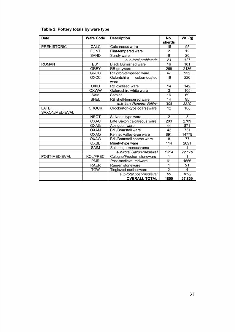
8/14/2019 Radcot, Oxfordshire
http://slidepdf.com/reader/full/radcot-oxfordshire 38/65
31
Table 2: Pottery totals by ware type
Date Ware Code Description No.sherds
Wt. (g)
PREHISTORIC CALC Calcareous ware 15 95FLINT Flint-tempered ware 2 12
SAND Sandy ware 6 20sub-total prehistoric 23 127
ROMAN BB1 Black Burnished ware 16 101GREY RB greyware 269 2136GROG RB grog-tempered ware 47 952OXCC Oxfordshire colour-coated
ware19 220
OXID RB oxidised ware 14 142OXWW Oxfordshire white ware 3 105
SAM Samian 16 69SHEL RB shell-tempered ware 14 95
sub-total Romano-British 398 3820
LATESAXON/MEDIEVAL CROCK Crockerton-type coarseware 12 108
NEOT St Neots type ware 2 3OXAC Late Saxon calcareous ware 200 2709OXAG Abingdon ware 44 871OXAM Brill/Boarstall ware 42 731OXAQ Kennet Valley-type ware 891 14779OXAW Brill/Boarstall coarse ware 8 77OXBB Minety-type ware 114 2891SAIM Saintonge monochrome 1 1
sub-total Saxon/medieval 1314 22,170
POST-MEDIEVAL KOL/FREC Cologne/Frechen stoneware 1 1PMR Post-medieval redware 61 1666
RAER Raeren stoneware 1 21TGW Tinglazed earthenware 2 4
sub-total post-medieval 65 1692
OVERALL TOTAL 1800 27,809
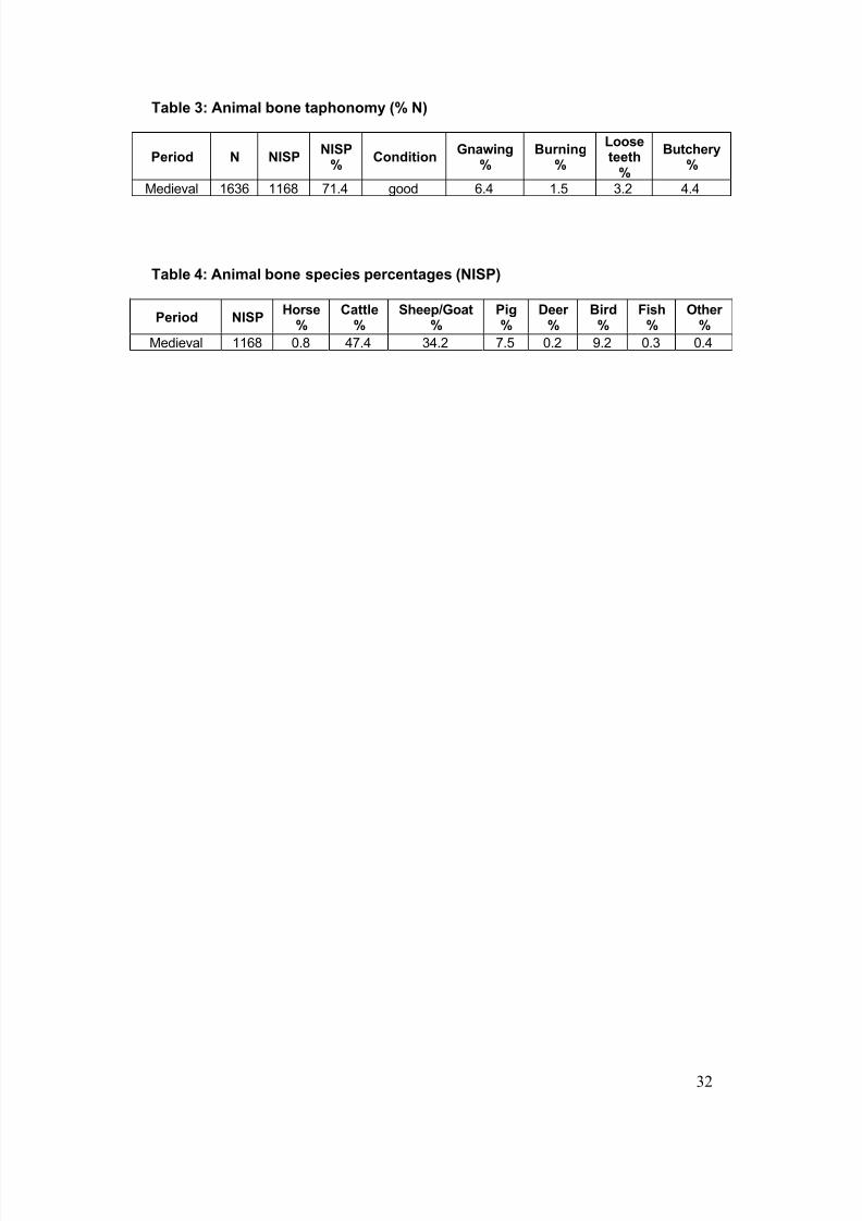
8/14/2019 Radcot, Oxfordshire
http://slidepdf.com/reader/full/radcot-oxfordshire 39/65
32
Table 3: Animal bone taphonomy (% N)
Period N NISPNISP
%Condition
Gnawing%
Burning%
Looseteeth
%
Butchery%
Medieval 1636 1168 71.4 good 6.4 1.5 3.2 4.4
Table 4: Animal bone species percentages (NISP)
Period NISPHorse
%Cattle
%Sheep/Goat
%Pig%
Deer %
Bird%
Fish%
Other %
Medieval 1168 0.8 47.4 34.2 7.5 0.2 9.2 0.3 0.4
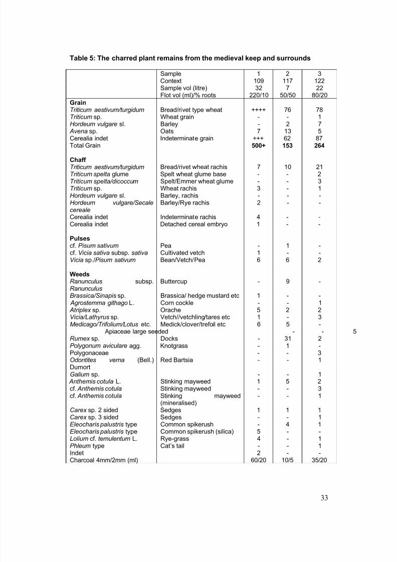
8/14/2019 Radcot, Oxfordshire
http://slidepdf.com/reader/full/radcot-oxfordshire 40/65
33
Table 5: The charred plant remains from the medieval keep and surrounds
Sample 1 2 3Context 109 117 122Sample vol (litre) 32 7 22Flot vol (ml)/% roots 220/10 50/50 80/20
Grain Triticum aestivum/turgidum Bread/rivet type wheat ++++ 76 78Triticum sp. Wheat grain - - 1Hordeum vulgare sl. Barley - 2 7 Avena sp. Oats 7 13 5Cerealia indet Indeterminate grain +++ 62 87Total Grain 500+ 153 264
Chaff Triticum aestivum/turgidum Bread/rivet wheat rachis 7 10 21Triticum spelta glume Spelt wheat glume base - - 2Triticum spelta/dicoccum Spelt/Emmer wheat glume - - 3Triticum sp. Wheat rachis 3 - 1Hordeum vulgare sl. Barley, rachis - - -Hordeum vulgare/Secalecereale
Barley/Rye rachis 2 - -
Cerealia indet Indeterminate rachis 4 - -Cerealia indet Detached cereal embryo 1 - -
Pulses cf. Pisum sativum Pea - 1 -cf. Vicia sativa subsp. sativa Cultivated vetch 1 - -Vicia sp./Pisum sativum Bean/Vetch/Pea 6 6 2
WeedsRanunculus subsp.Ranunculus
Buttercup - 9 -
Brassica/Sinapis sp. Brassica/ hedge mustard etc 1 - - Agrostemma githago L. Corn cockle - - 1 Atriplex sp. Orache 5 2 2Vicia/Lathyrus sp. Vetch//vetchling/tares etc 1 - 3Medicago/Trifolium/Lotus etc. Medick/clover/trefoil etc 6 5 - Apiaceae large seeded - - 5Rumex sp. Docks - 31 2Polygonum aviculare agg. Knotgrass - 1 -Polygonaceae - - 3Odontites verna (Bell.)
Dumort
Red Bartsia - - 1
Galium sp. - - 1 Anthemis cotula L. Stinking mayweed 1 5 2cf. Anthemis cotula Stinking mayweed - - 3cf. Anthemis cotula Stinking mayweed
(mineralised)- - 1
Carex sp. 2 sided Sedges 1 1 1Carex sp. 3 sided Sedges - - 1Eleocharis palustris type Common spikerush - 4 1Eleocharis palustris type Common spikerush (silica) 5 - -Lolium cf. temulentum L. Rye-grass 4 - 1Phleum type Cat’s tail - - 1Indet 2 - -
Charcoal 4mm/2mm (ml) 60/20 10/5 35/20
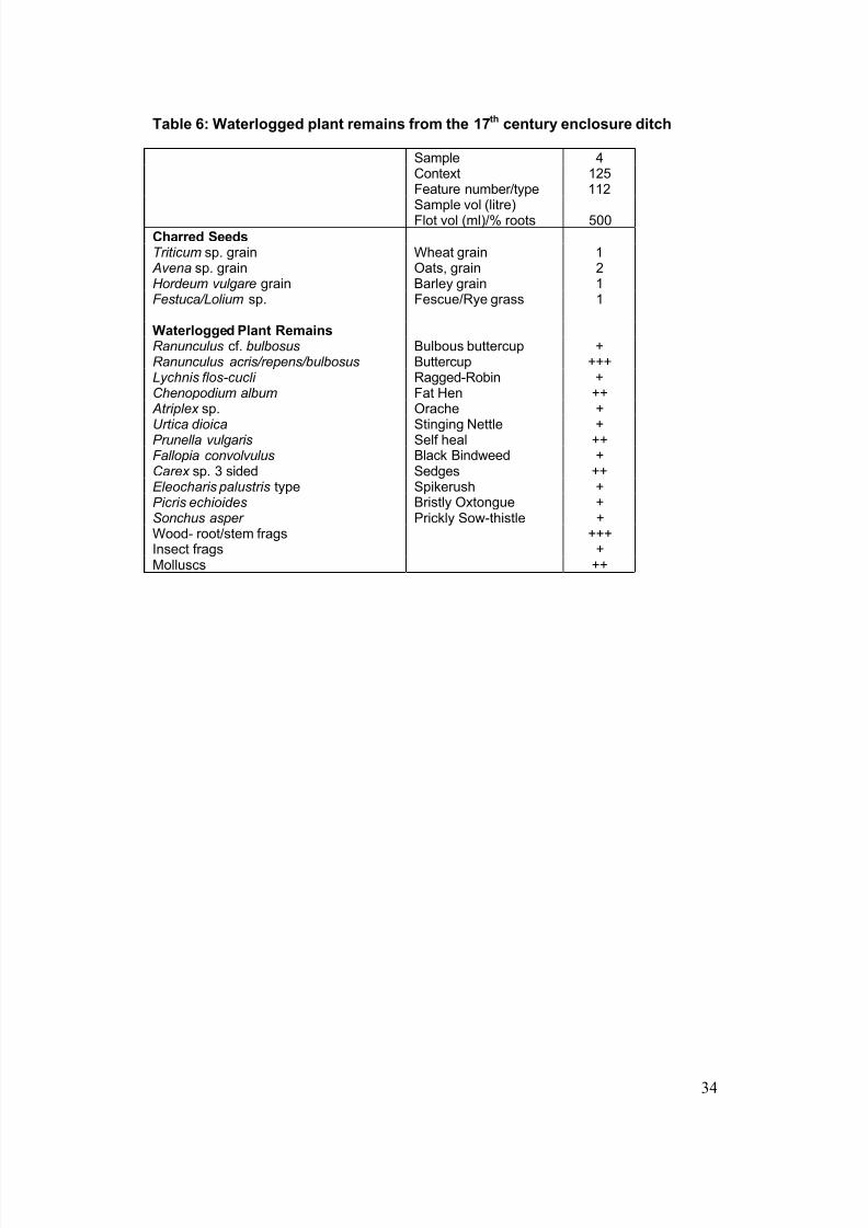
8/14/2019 Radcot, Oxfordshire
http://slidepdf.com/reader/full/radcot-oxfordshire 41/65
34
Table 6: Waterlogged plant remains from the 17th century enclosure ditch
Sample 4Context 125Feature number/type 112
Sample vol (litre)Flot vol (ml)/% roots 500
Charred SeedsTriticum sp. grain Wheat grain 1 Avena sp. grain Oats, grain 2Hordeum vulgare grain Barley grain 1Festuca/Lolium sp. Fescue/Rye grass 1
Waterlogged Plant RemainsRanunculus cf. bulbosus Bulbous buttercup +Ranunculus acris/repens/bulbosus Buttercup +++Lychnis flos-cucli Ragged-Robin +Chenopodium album Fat Hen ++ Atriplex sp. Orache +Urtica dioica Stinging Nettle +Prunella vulgaris Self heal ++Fallopia convolvulus Black Bindweed +Carex sp. 3 sided Sedges ++Eleocharis palustris type Spikerush +Picris echioides Bristly Oxtongue +Sonchus asper Prickly Sow-thistle +Wood- root/stem frags +++Insect frags +Molluscs ++
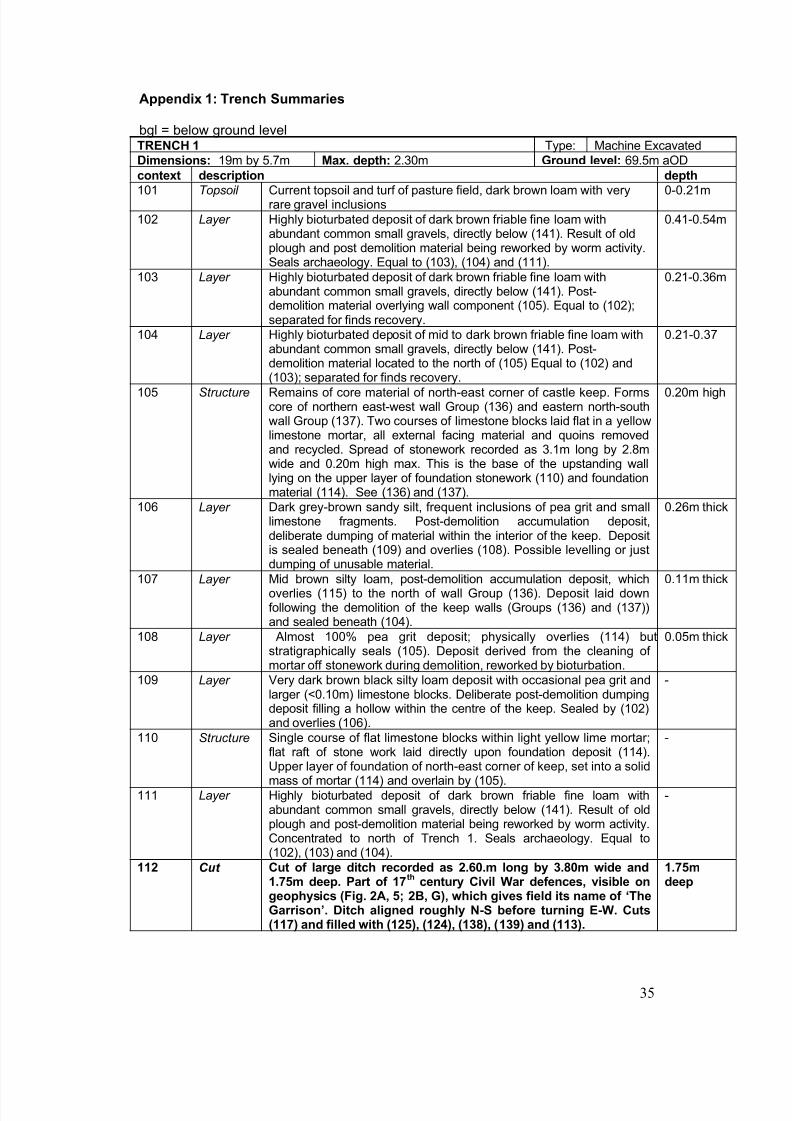
8/14/2019 Radcot, Oxfordshire
http://slidepdf.com/reader/full/radcot-oxfordshire 42/65
35
Appendix 1: Trench Summaries
bgl = below ground levelTRENCH 1 Type: Machine ExcavatedDimensions: 19m by 5.7m Max. depth: 2.30m Ground level: 69.5m aODcontext description depth
101 Topsoil Current topsoil and turf of pasture field, dark brown loam with veryrare gravel inclusions
0-0.21m
102 Layer Highly bioturbated deposit of dark brown friable fine loam withabundant common small gravels, directly below (141). Result of oldplough and post demolition material being reworked by worm activity.Seals archaeology. Equal to (103), (104) and (111).
0.41-0.54m
103 Layer Highly bioturbated deposit of dark brown friable fine loam withabundant common small gravels, directly below (141). Post-demolition material overlying wall component (105). Equal to (102);separated for finds recovery.
0.21-0.36m
104 Layer Highly bioturbated deposit of mid to dark brown friable fine loam withabundant common small gravels, directly below (141). Post-
demolition material located to the north of (105) Equal to (102) and(103); separated for finds recovery.
0.21-0.37
105 Structure Remains of core material of north-east corner of castle keep. Formscore of northern east-west wall Group (136) and eastern north-southwall Group (137). Two courses of limestone blocks laid flat in a yellowlimestone mortar, all external facing material and quoins removedand recycled. Spread of stonework recorded as 3.1m long by 2.8mwide and 0.20m high max. This is the base of the upstanding walllying on the upper layer of foundation stonework (110) and foundationmaterial (114). See (136) and (137).
0.20m high
106 Layer Dark grey-brown sandy silt, frequent inclusions of pea grit and smalllimestone fragments. Post-demolition accumulation deposit,deliberate dumping of material within the interior of the keep. Deposit
is sealed beneath (109) and overlies (108). Possible levelling or justdumping of unusable material.
0.26m thick
107 Layer Mid brown silty loam, post-demolition accumulation deposit, whichoverlies (115) to the north of wall Group (136). Deposit laid downfollowing the demolition of the keep walls (Groups (136) and (137))and sealed beneath (104).
0.11m thick
108 Layer Almost 100% pea grit deposit; physically overlies (114) butstratigraphically seals (105). Deposit derived from the cleaning of mortar off stonework during demolition, reworked by bioturbation.
0.05m thick
109 Layer Very dark brown black silty loam deposit with occasional pea grit andlarger (<0.10m) limestone blocks. Deliberate post-demolition dumpingdeposit filling a hollow within the centre of the keep. Sealed by (102)and overlies (106).
-
110 Structure Single course of flat limestone blocks within light yellow lime mortar;flat raft of stone work laid directly upon foundation deposit (114).Upper layer of foundation of north-east corner of keep, set into a solidmass of mortar (114) and overlain by (105).
-
111 Layer Highly bioturbated deposit of dark brown friable fine loam withabundant common small gravels, directly below (141). Result of oldplough and post-demolition material being reworked by worm activity.Concentrated to north of Trench 1. Seals archaeology. Equal to(102), (103) and (104).
-
112 Cut Cut of large ditch recorded as 2.60.m long by 3.80m wide and1.75m deep. Part of 17
thcentury Civil War defences, visible on
geophysics (Fig. 2A, 5; 2B, G), which gives field its name of ‘TheGarrison’. Ditch aligned roughly N-S before turning E-W. Cuts
(117) and filled with (125), (124), (138), (139) and (113).
1.75mdeep
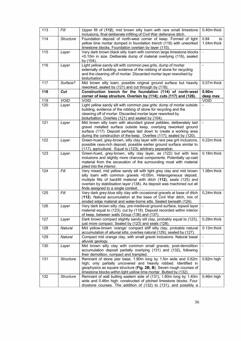
8/14/2019 Radcot, Oxfordshire
http://slidepdf.com/reader/full/radcot-oxfordshire 43/65
36
113 Fill Upper fill of (112), mid brown silty loam with rare small limestoneinclusions, final deliberate infilling of Civil War defensive ditch.
0.40m thick
114 Structure Foundation deposit of north-west corner of keep. Formed of lightyellow lime mortar dumped in foundation trench (118) with unworkedlimestone blocks. Foundation overlain by layer (110).
0.84 to1.04m thick
115 Layer Very dark brown black silty loam with common large limestone blocks
<0.10m in size. Deliberate dump of material overlying (116), sealedby (104).
-
116 Layer Light yellow sandy silt with common pea grits, dump of mortar externally of building, evidence of the robbing of stone for recyclingand the cleaning off of mortar. Discarded mortar layer reworked bybioturbation.
-
117 Surface? Mid brown silty loam, possible original ground surface but heavilyreworked, sealed by (121) and cut through by (118).
0.07m thick
118 Cut Construction trench for the foundation (114) of north-westcorner of keep structure. Overlain by (114); cuts (117) and (126).
0.90mdeep max
119 VOID VOID VOID120 Layer Light yellow sandy silt with common pea grits; dump of mortar outside
building, evidence of the robbing of stone for recycling and thecleaning off of mortar. Discarded mortar layer reworked bybioturbation. Overlies (121) and sealed by (104).
-
121 Layer Mid brown silty loam with abundant gravel pebbles; deliberately laidgravel metalled surface outside keep, overlying reworked groundsurface (117). Deposit perhaps laid down to create a working areaduring the construction of the keep. Overlies (117); sealed by (120).
-
122 Layer Green-hued, grey-brown, silty clay layer with rare pea grit inclusions,possible cess-rich deposit, possible earlier ground surface similar to(117), agricultural. Equal to (123); arbitrary separation.
0.22m thick
123 Layer Green-hued, grey-brown, silty clay layer, as (122) but with lessinclusions and slightly more charcoal components. Potentially up-castmaterial from the excavation of the surrounding moat with materialpiled into the interior.
0.18m thick
124 Fill Very mixed, mid yellow sandy silt with light grey clay and mid brownsilty loam with common gravels <0.05m. Heterogeneous deposit,multiple fills of backfill material with ditch (112), seals (125) andoverlain by stabilisation layer (138). As deposit was machined out allfinds assigned to a single context.
1.06m thick
125 Fill Very dark grey-blue silty clay with occasional gravels at base of ditch(112). Natural accumulation at the base of Civil War ditch, mix of eroded edge material and water-borne silts. Sealed beneath (124).
0.24m thick
126 Layer Very dark brown silty clay, pre-medieval ground surface, topsoil layer material equal to (123), cut by (118). Deposit recorded within interior of keep, between walls Group (136) and (137).
-
127 Layer Dark brown compact slightly sandy silt clay, probably equal to (123),
just more compact. Sealed by (123) and seals (128).
0.29m thick
128 Natural Mid yellow-brown ‘orange’ compact stiff silty clay, probable naturalaccumulation of alluvial silts; overlies natural (129); sealed by (127).
0.13m thick
129 Natural Compact mid orange clay, with small gravel inclusions. Natural basalalluvial geology.
-
130 Layer Mid brown silty clay with common small gravels, post-demolitionaccumulation deposit partially overlying (131) and (132), followingtheir demolition, compact and trampled.
-
131 Structure Remnant of stone pier base, 1.90m long by 1.5m wide and 0.62mhigh; only partially uncovered and heavily robbed. Identified ingeophysics as square structure (Fig. 2B, B). Seven rough courses of limestone blocks within light yellow lime mortar. Butted by (132).
0.62m high
132 Structure Remnant of wall butting eastern side of (131), 1.80m long by 1.40m
wide and 0.46m high; constructed of pitched limestone blocks. Four drystone courses. The addition of (132) to (131), and possibly a
0.46m high
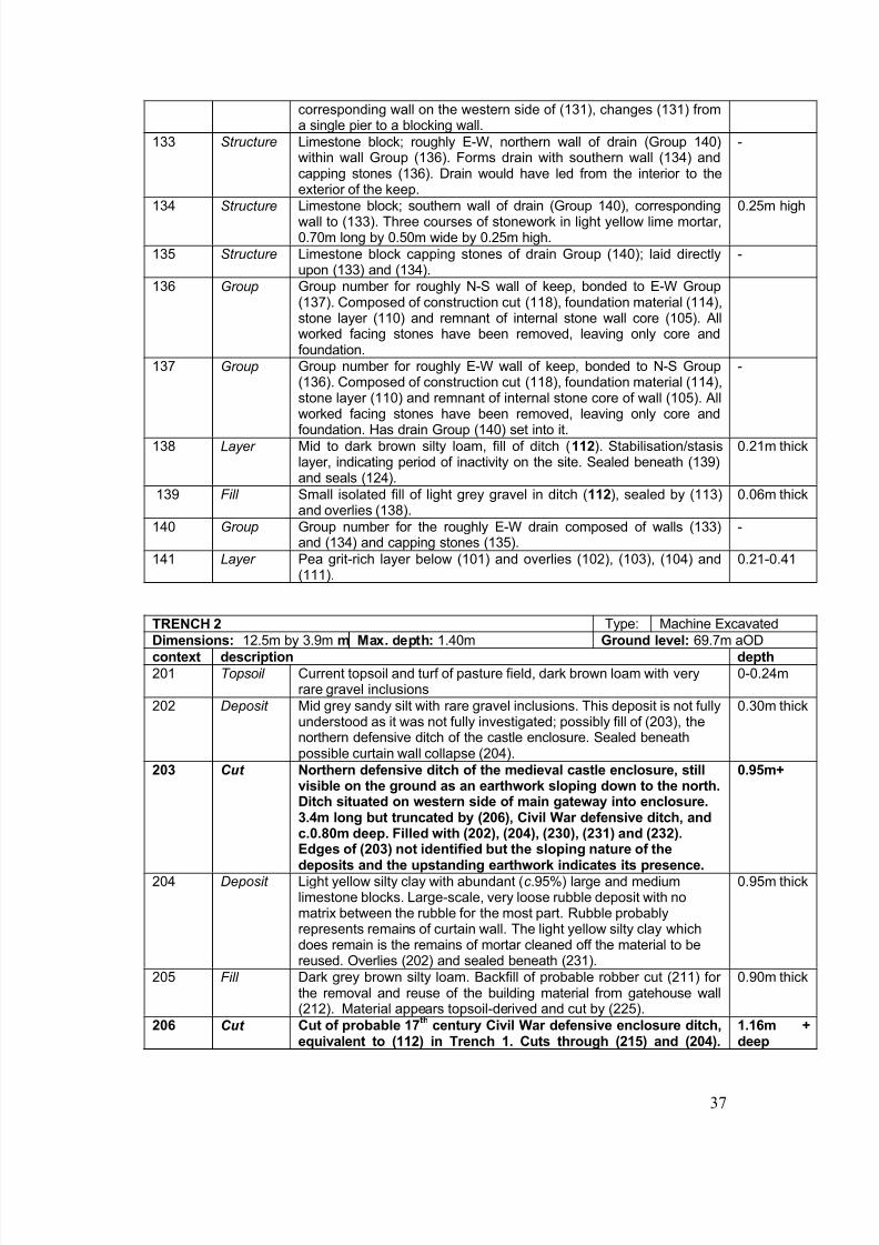
8/14/2019 Radcot, Oxfordshire
http://slidepdf.com/reader/full/radcot-oxfordshire 44/65
37
corresponding wall on the western side of (131), changes (131) froma single pier to a blocking wall.
133 Structure Limestone block; roughly E-W, northern wall of drain (Group 140)within wall Group (136). Forms drain with southern wall (134) andcapping stones (136). Drain would have led from the interior to theexterior of the keep.
-
134 Structure Limestone block; southern wall of drain (Group 140), correspondingwall to (133). Three courses of stonework in light yellow lime mortar,0.70m long by 0.50m wide by 0.25m high.
0.25m high
135 Structure Limestone block capping stones of drain Group (140); laid directlyupon (133) and (134).
-
136 Group Group number for roughly N-S wall of keep, bonded to E-W Group(137). Composed of construction cut (118), foundation material (114),stone layer (110) and remnant of internal stone wall core (105). Allworked facing stones have been removed, leaving only core andfoundation.
137 Group Group number for roughly E-W wall of keep, bonded to N-S Group(136). Composed of construction cut (118), foundation material (114),stone layer (110) and remnant of internal stone core of wall (105). All
worked facing stones have been removed, leaving only core andfoundation. Has drain Group (140) set into it.
-
138 Layer Mid to dark brown silty loam, fill of ditch (112). Stabilisation/stasislayer, indicating period of inactivity on the site. Sealed beneath (139)and seals (124).
0.21m thick
139 Fill Small isolated fill of light grey gravel in ditch (112), sealed by (113)and overlies (138).
0.06m thick
140 Group Group number for the roughly E-W drain composed of walls (133)and (134) and capping stones (135).
-
141 Layer Pea grit-rich layer below (101) and overlies (102), (103), (104) and(111).
0.21-0.41
TRENCH 2 Type: Machine ExcavatedDimensions: 12.5m by 3.9m m Max. depth: 1.40m Ground level: 69.7m aODcontext description depth
201 Topsoil Current topsoil and turf of pasture field, dark brown loam with veryrare gravel inclusions
0-0.24m
202 Deposit Mid grey sandy silt with rare gravel inclusions. This deposit is not fullyunderstood as it was not fully investigated; possibly fill of (203), thenorthern defensive ditch of the castle enclosure. Sealed beneathpossible curtain wall collapse (204).
0.30m thick
203 Cut Northern defensive ditch of the medieval castle enclosure, stillvisible on the ground as an earthwork sloping down to the north.Ditch situated on western side of main gateway into enclosure.
3.4m long but truncated by (206), Civil War defensive ditch, andc.0.80m deep. Filled with (202), (204), (230), (231) and (232).Edges of (203) not identified but the sloping nature of thedeposits and the upstanding earthwork indicates its presence.
0.95m+
204 Deposit Light yellow silty clay with abundant (c .95%) large and mediumlimestone blocks. Large-scale, very loose rubble deposit with nomatrix between the rubble for the most part. Rubble probablyrepresents remains of curtain wall. The light yellow silty clay whichdoes remain is the remains of mortar cleaned off the material to bereused. Overlies (202) and sealed beneath (231).
0.95m thick
205 Fill Dark grey brown silty loam. Backfill of probable robber cut (211) for the removal and reuse of the building material from gatehouse wall(212). Material appears topsoil-derived and cut by (225).
0.90m thick
206 Cut Cut of probable 17th
century Civil War defensive enclosure ditch,equivalent to (112) in Trench 1. Cuts through (215) and (204).
1.16m +deep
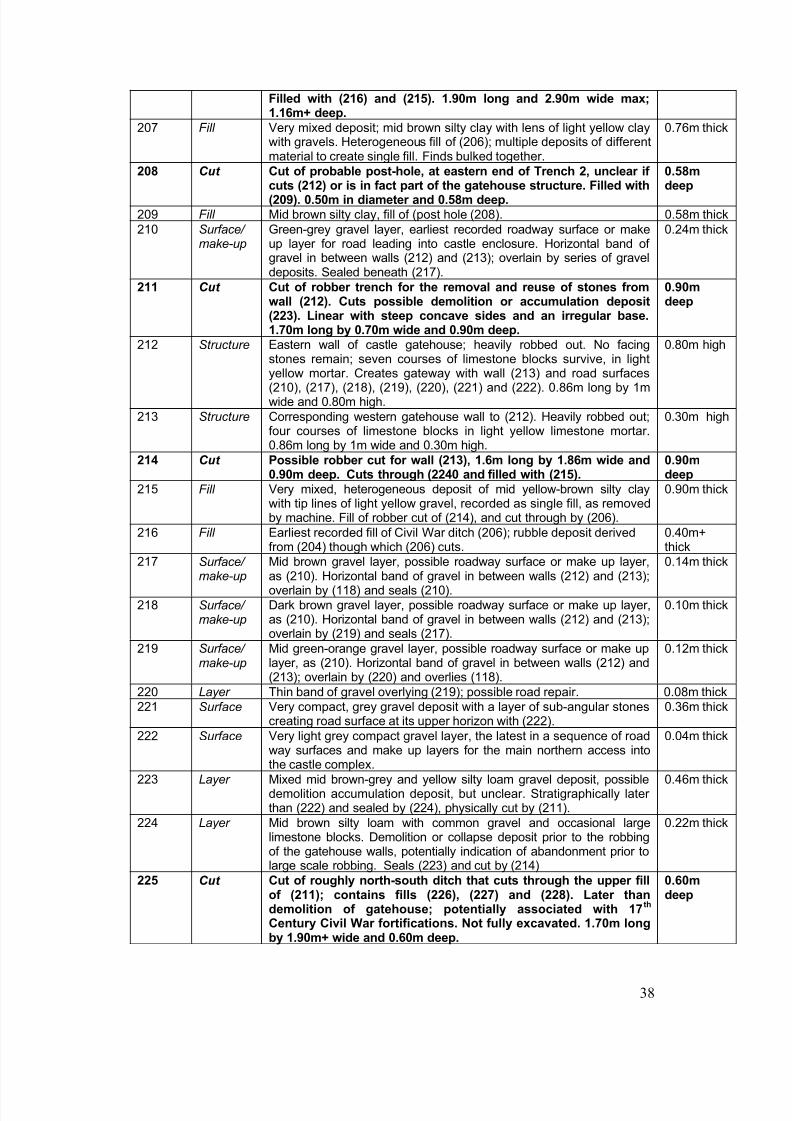
8/14/2019 Radcot, Oxfordshire
http://slidepdf.com/reader/full/radcot-oxfordshire 45/65
38
Filled with (216) and (215). 1.90m long and 2.90m wide max;1.16m+ deep.
207 Fill Very mixed deposit; mid brown silty clay with lens of light yellow claywith gravels. Heterogeneous fill of (206); multiple deposits of differentmaterial to create single fill. Finds bulked together.
0.76m thick
208 Cut Cut of probable post-hole, at eastern end of Trench 2, unclear if
cuts (212) or is in fact part of the gatehouse structure. Filled with(209). 0.50m in diameter and 0.58m deep.
0.58m
deep
209 Fill Mid brown silty clay, fill of (post hole (208). 0.58m thick210 Surface/
make-upGreen-grey gravel layer, earliest recorded roadway surface or makeup layer for road leading into castle enclosure. Horizontal band of gravel in between walls (212) and (213); overlain by series of graveldeposits. Sealed beneath (217).
0.24m thick
211 Cut Cut of robber trench for the removal and reuse of stones fromwall (212). Cuts possible demolition or accumulation deposit(223). Linear with steep concave sides and an irregular base.1.70m long by 0.70m wide and 0.90m deep.
0.90mdeep
212 Structure Eastern wall of castle gatehouse; heavily robbed out. No facingstones remain; seven courses of limestone blocks survive, in lightyellow mortar. Creates gateway with wall (213) and road surfaces(210), (217), (218), (219), (220), (221) and (222). 0.86m long by 1mwide and 0.80m high.
0.80m high
213 Structure Corresponding western gatehouse wall to (212). Heavily robbed out;four courses of limestone blocks in light yellow limestone mortar.0.86m long by 1m wide and 0.30m high.
0.30m high
214 Cut Possible robber cut for wall (213), 1.6m long by 1.86m wide and0.90m deep. Cuts through (2240 and filled with (215).
0.90mdeep
215 Fill Very mixed, heterogeneous deposit of mid yellow-brown silty claywith tip lines of light yellow gravel, recorded as single fill, as removedby machine. Fill of robber cut of (214), and cut through by (206).
0.90m thick
216 Fill Earliest recorded fill of Civil War ditch (206); rubble deposit derivedfrom (204) though which (206) cuts.
0.40m+thick
217 Surface/ make-up
Mid brown gravel layer, possible roadway surface or make up layer,as (210). Horizontal band of gravel in between walls (212) and (213);overlain by (118) and seals (210).
0.14m thick
218 Surface/ make-up
Dark brown gravel layer, possible roadway surface or make up layer,as (210). Horizontal band of gravel in between walls (212) and (213);overlain by (219) and seals (217).
0.10m thick
219 Surface/ make-up
Mid green-orange gravel layer, possible roadway surface or make uplayer, as (210). Horizontal band of gravel in between walls (212) and(213); overlain by (220) and overlies (118).
0.12m thick
220 Layer Thin band of gravel overlying (219); possible road repair. 0.08m thick221 Surface Very compact, grey gravel deposit with a layer of sub-angular stones
creating road surface at its upper horizon with (222).0.36m thick
222 Surface Very light grey compact gravel layer, the latest in a sequence of roadway surfaces and make up layers for the main northern access intothe castle complex.
0.04m thick
223 Layer Mixed mid brown-grey and yellow silty loam gravel deposit, possibledemolition accumulation deposit, but unclear. Stratigraphically later than (222) and sealed by (224), physically cut by (211).
0.46m thick
224 Layer Mid brown silty loam with common gravel and occasional largelimestone blocks. Demolition or collapse deposit prior to the robbingof the gatehouse walls, potentially indication of abandonment prior tolarge scale robbing. Seals (223) and cut by (214)
0.22m thick
225 Cut Cut of roughly north-south ditch that cuts through the upper fillof (211); contains fills (226), (227) and (228). Later thandemolition of gatehouse; potentially associated with 17
th
Century Civil War fortifications. Not fully excavated. 1.70m longby 1.90m+ wide and 0.60m deep.
0.60mdeep
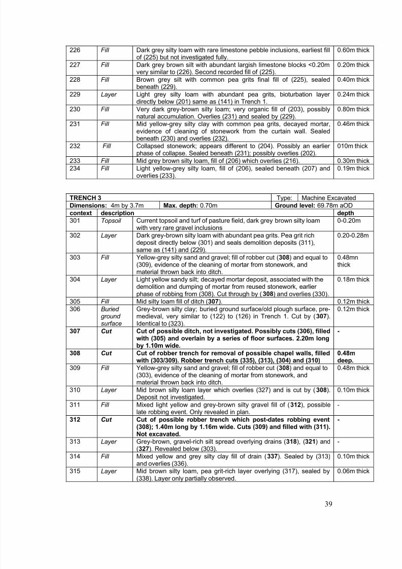
8/14/2019 Radcot, Oxfordshire
http://slidepdf.com/reader/full/radcot-oxfordshire 46/65
39
226 Fill Dark grey silty loam with rare limestone pebble inclusions, earliest fillof (225) but not investigated fully.
0.60m thick
227 Fill Dark grey brown silt with abundant largish limestone blocks <0.20mvery similar to (226). Second recorded fill of (225).
0.20m thick
228 Fill Brown grey silt with common pea grits final fill of (225), sealedbeneath (229).
0.40m thick
229 Layer Light grey silty loam with abundant pea grits, bioturbation layer directly below (201) same as (141) in Trench 1.
0.24m thick
230 Fill Very dark grey-brown silty loam; very organic fill of (203), possiblynatural accumulation. Overlies (231) and sealed by (229).
0.80m thick
231 Fill Mid yellow-grey silty clay with common pea grits, decayed mortar,evidence of cleaning of stonework from the curtain wall. Sealedbeneath (230) and overlies (232).
0.46m thick
232 Fill Collapsed stonework; appears different to (204). Possibly an earlier phase of collapse. Sealed beneath (231); possibly overlies (202).
010m thick
233 Fill Mid grey brown silty loam, fill of (206) which overlies (216). 0.30m thick234 Fill Light yellow-grey silty loam, fill of (206), sealed beneath (207) and
overlies (233).0.19m thick
TRENCH 3 Type: Machine ExcavatedDimensions: 4m by 3.7m Max. depth: 0.70m Ground level: 69.78m aODcontext description depth
301 Topsoil Current topsoil and turf of pasture field, dark grey brown silty loamwith very rare gravel inclusions
0-0.20m
302 Layer Dark grey-brown silty loam with abundant pea grits. Pea grit richdeposit directly below (301) and seals demolition deposits (311),same as (141) and (229).
0.20-0.28m
303 Fill Yellow-grey silty sand and gravel; fill of robber cut (308) and equal to(309), evidence of the cleaning of mortar from stonework, andmaterial thrown back into ditch.
0.48mnthick
304 Layer Light yellow sandy silt; decayed mortar deposit, associated with thedemolition and dumping of mortar from reused stonework, earlier phase of robbing from (308). Cut through by (308) and overlies (330).
0.18m thick
305 Fill Mid silty loam fill of ditch (307). 0.12m thick306 Buried
ground surface
Grey-brown silty clay; buried ground surface/old plough surface, pre-medieval, very similar to (122) to (126) in Trench 1. Cut by (307).Identical to (323).
0.12m thick
307 Cut Cut of possible ditch, not investigated. Possibly cuts (306), filledwith (305) and overlain by a series of floor surfaces. 2.20m longby 1.10m wide.
-
308 Cut Cut of robber trench for removal of possible chapel walls, filledwith (303/309). Robber trench cuts (335), (313), (304) and (310)
0.48mdeep.
309 Fill Yellow-grey silty sand and gravel; fill of robber cut (308) and equal to
(303), evidence of the cleaning of mortar from stonework, andmaterial thrown back into ditch.
0.48m thick
310 Layer Mid brown silty loam layer which overlies (327) and is cut by (308).Deposit not investigated.
0.10m thick
311 Fill Mixed light yellow and grey-brown silty gravel fill of (312), possiblelate robbing event. Only revealed in plan.
-
312 Cut Cut of possible robber trench which post-dates robbing event(308); 1.40m long by 1.16m wide. Cuts (309) and filled with (311).Not excavated.
-
313 Layer Grey-brown, gravel-rich silt spread overlying drains (318), (321) and(327). Revealed below (303).
-
314 Fill Mixed yellow and grey silty clay fill of drain (337). Sealed by (313)and overlies (336).
0.10m thick
315 Layer Mid brown silty loam, pea grit-rich layer overlying (317), sealed by(338). Layer only partially observed.
0.06m thick
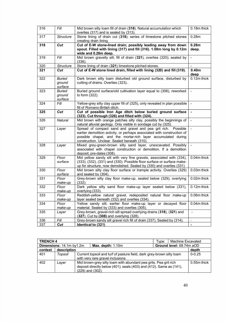
8/14/2019 Radcot, Oxfordshire
http://slidepdf.com/reader/full/radcot-oxfordshire 47/65
40
316 Fill Mid brown silty loam fill of drain (318). Natural accumulation whichoverlies (317) and is sealed by (313).
0.18m thick
317 Structure Stone lining of drain cut (318); series of limestone pitched stonescreating drain lining.
0.28m
318 Cut Cut of E-W stone-lined drain; possibly leading away from downspout. Filled with lining (317) and fill (316). 1.08m long by 0.12m
wide and 0.28m deep.
0.28mdeep.
319 Fill Mid brown gravelly silt, fill of drain (321), overlies (320); sealed by(336).
-
320 Structure Stone lining of drain (321) limestone pitched stones. -321 Cut Cut of E-W stone lined drain, filled with lining (320) and fill (319). 0.40m
deep
322 Buried ground surface
Dark brown silty loam disturbed old ground surface, disturbed bycutting of drains. Overlies (323)..
0.12m thick
323 Buried ground surface
Buried ground surface/old cultivation layer equal to (306), reworkedto form (322).
-
324 Fill Yellow-grey silty clay upper fill of (325), only revealed in plan possiblefill of Romano-British ditch.
-
325 Cut Cut of possible Iron Age ditch below buried ground surface(323). Cut through (326) and filled with (324).
-
326 Natural Mid brown with orange patches silty clay, possibly the beginnings of natural alluvial geology. Only visible in sondage cut by (325).
-
327 Layer Spread of compact sand and gravel and pea grit rich. Possibleearlier demolition activity, or perhaps associated with construction of possible chapel, and the mortar-rich layer accumulated duringconstruction. Unclear. Sealed beneath (310).
-
328 Layer Mixed grey-green-brown silty sand layer, unexcavated. Possiblyassociated with chapel construction or demolition. If a demolitiondeposit, pre-dates (308).
-
329 Floor surface Mid yellow sandy silt with very fine gravels, associated with (334),(333), (332), (331) and (330). Possible floor surface or surface make-up for structure, now demolished. Sealed by (330) and overlies (331).
0.04m thick
330 Floor surface
Mid brown silty clay floor surface or trample activity. Overlies (329)and sealed by (304).
0.03m thick
331 Floor make-up
Grey-brown silty clay floor make-up, sealed below (329), overlying(332).
0.02m thick
332 Floor make-up
Dark yellow silty sand floor make-up layer sealed below (331),overlying (333).
0.12m thick
333 Floor make-up
Reddish-yellow natural gravel, redeposited natural floor make-uplayer sealed beneath (332) and overlies (334).
0.06m thick
334 Floor make-up
Yellow sandy silt; earlier floor make-up layer or decayed floor material. Sealed by (333) and overlies (305).
0.04m thick
335 Layer Grey-brown, gravel-rich silt spread overlying drains (318), (321) and(327). Cut by (308) and overlying (328).
-
336 Fill Grey-brown sandy silt gravel rich fill of drain (337). Sealed by (314). -337 Cut Identical to (321) -
TRENCH 4 Type: Machine ExcavatedDimensions: 14.1m by1.2m Max. depth: 1.10m Ground level: 69.74m aODcontext description depth
401 Topsoil Current topsoil and turf of pasture field, dark grey-brown silty loamwith very rare gravel inclusions
0-0.25
402 Layer Mid brown-grey silty loam with abundant pea grits. Pea grit richdeposit directly below (401); seals (403) and (412). Same as (141),(229) and (302).
0.55m thick
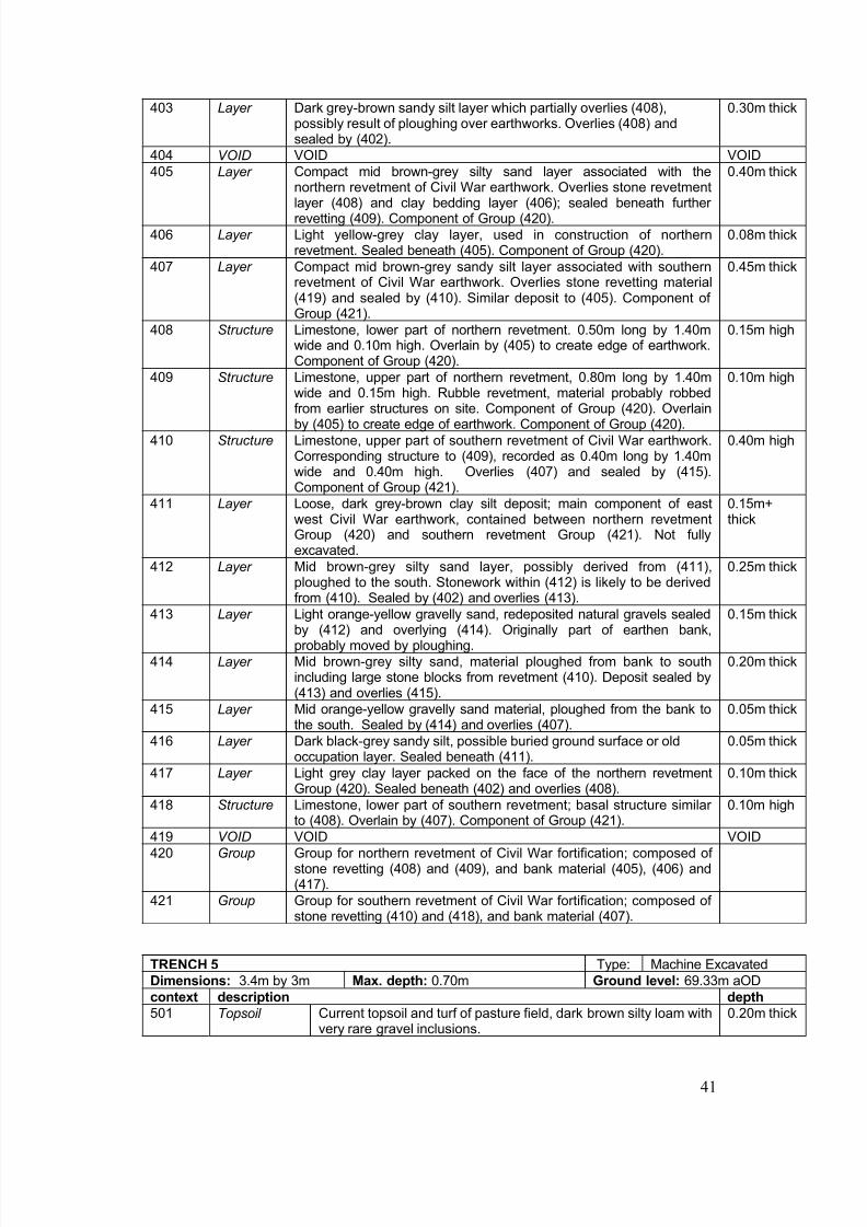
8/14/2019 Radcot, Oxfordshire
http://slidepdf.com/reader/full/radcot-oxfordshire 48/65
41
403 Layer Dark grey-brown sandy silt layer which partially overlies (408),possibly result of ploughing over earthworks. Overlies (408) andsealed by (402).
0.30m thick
404 VOID VOID VOID405 Layer Compact mid brown-grey silty sand layer associated with the
northern revetment of Civil War earthwork. Overlies stone revetment
layer (408) and clay bedding layer (406); sealed beneath further revetting (409). Component of Group (420).
0.40m thick
406 Layer Light yellow-grey clay layer, used in construction of northernrevetment. Sealed beneath (405). Component of Group (420).
0.08m thick
407 Layer Compact mid brown-grey sandy silt layer associated with southernrevetment of Civil War earthwork. Overlies stone revetting material(419) and sealed by (410). Similar deposit to (405). Component of Group (421).
0.45m thick
408 Structure Limestone, lower part of northern revetment. 0.50m long by 1.40mwide and 0.10m high. Overlain by (405) to create edge of earthwork.Component of Group (420).
0.15m high
409 Structure Limestone, upper part of northern revetment, 0.80m long by 1.40mwide and 0.15m high. Rubble revetment, material probably robbedfrom earlier structures on site. Component of Group (420). Overlainby (405) to create edge of earthwork. Component of Group (420).
0.10m high
410 Structure Limestone, upper part of southern revetment of Civil War earthwork.Corresponding structure to (409), recorded as 0.40m long by 1.40mwide and 0.40m high. Overlies (407) and sealed by (415).Component of Group (421).
0.40m high
411 Layer Loose, dark grey-brown clay silt deposit; main component of eastwest Civil War earthwork, contained between northern revetmentGroup (420) and southern revetment Group (421). Not fullyexcavated.
0.15m+thick
412 Layer Mid brown-grey silty sand layer, possibly derived from (411),ploughed to the south. Stonework within (412) is likely to be derivedfrom (410). Sealed by (402) and overlies (413).
0.25m thick
413 Layer Light orange-yellow gravelly sand, redeposited natural gravels sealedby (412) and overlying (414). Originally part of earthen bank,probably moved by ploughing.
0.15m thick
414 Layer Mid brown-grey silty sand, material ploughed from bank to southincluding large stone blocks from revetment (410). Deposit sealed by(413) and overlies (415).
0.20m thick
415 Layer Mid orange-yellow gravelly sand material, ploughed from the bank tothe south. Sealed by (414) and overlies (407).
0.05m thick
416 Layer Dark black-grey sandy silt, possible buried ground surface or oldoccupation layer. Sealed beneath (411).
0.05m thick
417 Layer Light grey clay layer packed on the face of the northern revetmentGroup (420). Sealed beneath (402) and overlies (408).
0.10m thick
418 Structure Limestone, lower part of southern revetment; basal structure similar to (408). Overlain by (407). Component of Group (421). 0.10m high
419 VOID VOID VOID420 Group Group for northern revetment of Civil War fortification; composed of
stone revetting (408) and (409), and bank material (405), (406) and(417).
421 Group Group for southern revetment of Civil War fortification; composed of stone revetting (410) and (418), and bank material (407).
TRENCH 5 Type: Machine ExcavatedDimensions: 3.4m by 3m Max. depth: 0.70m Ground level: 69.33m aODcontext description depth
501 Topsoil Current topsoil and turf of pasture field, dark brown silty loam withvery rare gravel inclusions.
0.20m thick
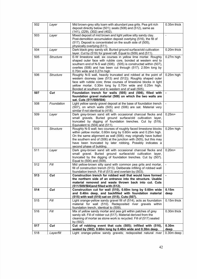
8/14/2019 Radcot, Oxfordshire
http://slidepdf.com/reader/full/radcot-oxfordshire 49/65
42
502 Layer Mid brown-grey silty loam with abundant pea grits. Pea grit richdeposit directly below (501); seals (508) and (512), same as(141), (229), (302) and (402).
0.35m thick
503 Layer Mixed deposit of mid brown and light yellow silty sandy clay.Post-demolition accumulation deposit overlying (516), the fill of (517). Deposit is concentrated on the south side of (505),
physically overlying (511).
-
504 Layer Dark black grey sandy silt. Buried ground surface/old cultivationlayer. Cut by (519) for gravel raft. Equal to (509) and (511).
0.20m thick
505 Structure E-W limestone wall; six courses in yellow lime mortar. Roughlyshaped outer face with rubble core, bonded at western end tosouthern end of N-S wall (506). (505) is constructed within (507),overlies (508) and has been cut through (517). 2.50m long by0.70m wide and 0.27m high
0.27m high
506 Structure Roughly N-S wall, heavily truncated and robbed at the point of western doorway (see (513) and (512)). Roughly shaped outer face with rubble core; three courses of limestone blocks in lightyellow mortar. 0.30m long by 0.70m wide and 0.25m high.Bonded at southern end to western end of wall (505).
0.25m high
507 Cut Foundation trench for walls (505) and (506), filled withfoundation gravel material (508) on which the two walls aresat. Cuts (511/509/504)
-
508 Foundation Light yellow sandy gravel deposit at the base of foundation trench(507), on which walls (505) and (506) are sat. Material verysimilar if not identical to (418).
-
509 Layer Dark grey-brown sand silt with occasional charcoal flecks andsmall gravels. Buried ground surface/old cultivation layer,truncated by digging of foundation trenches. Cut by (519).Equivalent to (504) and (511).
0.25m+
510 Structure Roughly N-S wall; two courses of roughly faced limestone blockswithin yellow mortar, 0.60m long by 0.60m wide and 0.25m high.On the same alignment as wall (506); may originally have buttedthe southern end of (506) at the junction with (505), but this mayhave been truncated by later robbing. Possibly indicates asecond phase of building.
0.25m high
511 Layer Dark grey-brown sand silt with occasional charcoal flecks andsmall gravel. Buried ground surface/old cultivation layer,truncated by the digging of foundation trenches. Cut by (507).Equal to (504) and (509).
0.20m+
512 Fill Mid yellow-brown silty sand with common pea grits and mortar,fill of construction trench (513). Deliberate infilling of robbed wallfoundation trench. Fill of (513) and overlain by (503).
-
513 Cut Construction trench for robbed wall that would have formedthe northern side of an entrance into the structure. Usable
material removed and waste thrown back into cut. Cuts(511/509/504)and filled with (512).
-
514 Cut Construction cut for wall (510), 0.60m long by 0.60m wideand 0.40m deep, and backfilled with foundation material(515) with wall (510) sat on (515). Cuts (507).
0.15mdeep
515 Fill Light orange-yellow sandy gravel fill of (514), acts as foundationmaterial for wall (510). Redeposited river gravels withinfoundation trench, identical to (509).
0.15m thick
516 Fill Mix of yellow sandy mortar and pea grit within patches of greysandy silt. Fill of robber cut (517). Material derived from thecleaning of mortar as stone work is recycled. Fill of (517) sealedby (502).
0.30m thick
517 Cut Cut of robbing event that cuts (505); infilled with (516),
sealed by (502). 0.60m long by 0.40m wide and 0.30m deep.
0.30m
deep518 Layer/fill Light orange-yellow sandy gravels; redeposited natural river 0.30m deep
8/14/2019 Radcot, Oxfordshire
http://slidepdf.com/reader/full/radcot-oxfordshire 50/65
43
gravels within construction cut (519), to create a solid raft onwhich the structure could be built. 2.80m long by 2.40m wide by0.30m deep; associated with foundation trenches (507) and (513)and therefore equivalent to (515) and (508).
519 Cut Cut for gravel raft (518), contemporary with foundationtrenches (507) and (513).
0.30mdeep
520 Cut Cut of unknown feature at the northern end of partiallyrobbed wall (506). Semi-circular, 0.20m long by 0.70m wideand 0.20m deep and filled with (521), it is the possible settingfor a vertical jamb-stone for the western entrance.
0.20mdeep
521 Fill Dark brown grey fill of door jamb-stone hole (520). 0.20m thick
TRENCH 6 Type: Machine ExcavatedDimensions: 13m by 1.7`m Max. depth: 2m Ground level: 68.63 m aODcontext description depth
601 Topsoil Very organic, leaf litter rich, very dark brown-black silty loam, currentground surface.
0-0.20
602 Layer Light yellow gravel, deliberate modern dump of redeposited naturalriver gravels; creation of made ground, possibly area of hardstanding.
0.20-0.49
603 Buried ground surface
Very dark grey-brown silty loam original ground surface layer, heavilybioturbated and root-rich, sealed beneath (602); overlies (604).
0.49-0.66
604 Layer Mid yellow-brown, slightly grey patches, river-borne silty clay, naturalaccumulation.
0.66-1.47
605 Natural Blue-grey clay; gleyed, river-borne material, natural accumulation. 1.47-2m+
TRENCH 7 Type: Machine ExcavatedDimensions: 7.5m by 1.4m Max. depth: 1.6m Ground level: 69.19 m aOD
context description depth701 Topsoil Current topsoil and turf of pasture field, dark brown silty loam with
very rare gravel inclusions.0.24m thick
702 Layer Mid brown-grey silty loam with abundant pea grits. Pea grit richdeposit directly below (701) and seals (712), same as (141), (229),(302), (402) and (502).
0.10m thick
703 Subsoil Dark blackish-brown silty sand, subsoil layer sealing Romano-Britishdeposits (704), (708) and (706); cut by medieval feature (713).
0.34m thick
704 Fill Mid to dark grey-brown, friable sandy silt; single fill of ditch (705). Appears derived from erosion of feature edges and surroundingtopsoil. Natural silting.
0.29m thick
705 Cut Cut of roughly E-W ditch that cuts through (715), filled with(704). 1.50m long by 1.80m wide and 0.29m deep, roughly linear
but with undulating sides due to the soft nature of the natural,slightly concave sides and concave base. Romano-British.
0.29mdeep
706 Fill Dark grey-brown, friable sandy silt; single fill of ditch (707).Homogenous deposit, repeated depositions of similar material givingrise to single deposit. Natural accumulation derived from erosion of the feature edges and the surrounding topsoil. Sealed by (703), andphysically cut through by later ditch (713).
0.98m thick
707 Cut Cut of roughly E-W ditch that cuts (715), filled with (706). 1.50mlong by 2.64m wide and 0.98m deep, roughly linear with steepstraight sides and a flat base. Romano-British.
0.98mdeep
708 Fill Mid yellow-grey-brown, friable silt; single fill of gully (709), naturalaccumulation, erosion of the feature edges and surrounding topsoil.Stratigraphically cut by post hole (711).
0.24m thick
709 Cut Cut of roughly E-W, slightly curving gully that cuts (715), filledwith (709), and cut through by post-hole (711). 1.50m long by
0.24mdeep
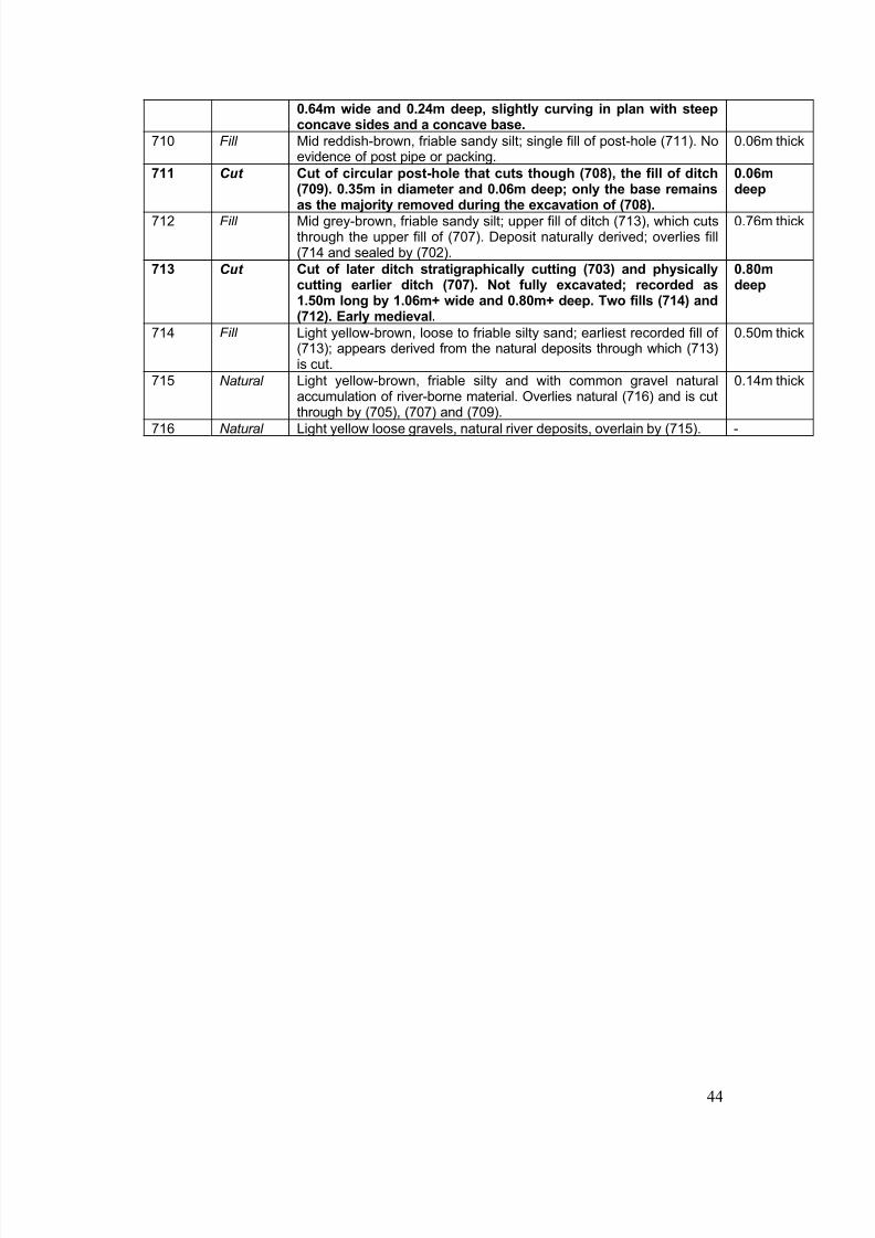
8/14/2019 Radcot, Oxfordshire
http://slidepdf.com/reader/full/radcot-oxfordshire 51/65
44
0.64m wide and 0.24m deep, slightly curving in plan with steepconcave sides and a concave base.
710 Fill Mid reddish-brown, friable sandy silt; single fill of post-hole (711). Noevidence of post pipe or packing.
0.06m thick
711 Cut Cut of circular post-hole that cuts though (708), the fill of ditch(709). 0.35m in diameter and 0.06m deep; only the base remains
as the majority removed during the excavation of (708).
0.06mdeep
712 Fill Mid grey-brown, friable sandy silt; upper fill of ditch (713), which cutsthrough the upper fill of (707). Deposit naturally derived; overlies fill(714 and sealed by (702).
0.76m thick
713 Cut Cut of later ditch stratigraphically cutting (703) and physicallycutting earlier ditch (707). Not fully excavated; recorded as1.50m long by 1.06m+ wide and 0.80m+ deep. Two fills (714) and(712). Early medieval.
0.80mdeep
714 Fill Light yellow-brown, loose to friable silty sand; earliest recorded fill of (713); appears derived from the natural deposits through which (713)is cut.
0.50m thick
715 Natural Light yellow-brown, friable silty and with common gravel naturalaccumulation of river-borne material. Overlies natural (716) and is cutthrough by (705), (707) and (709).
0.14m thick
716 Natural Light yellow loose gravels, natural river deposits, overlain by (715). -
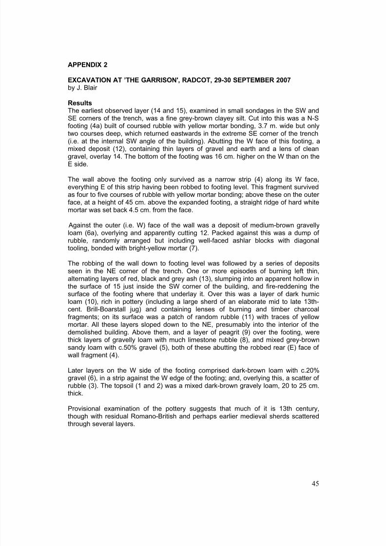
8/14/2019 Radcot, Oxfordshire
http://slidepdf.com/reader/full/radcot-oxfordshire 52/65
45
APPENDIX 2
EXCAVATION AT ’THE GARRISON', RADCOT, 29-30 SEPTEMBER 2007
by J. Blair
ResultsThe earliest observed layer (14 and 15), examined in small sondages in the SW andSE corners of the trench, was a fine grey-brown clayey silt. Cut into this was a N-Sfooting (4a) built of coursed rubble with yellow mortar bonding, 3.7 m. wide but onlytwo courses deep, which returned eastwards in the extreme SE corner of the trench(i.e. at the internal SW angle of the building). Abutting the W face of this footing, amixed deposit (12), containing thin layers of gravel and earth and a lens of cleangravel, overlay 14. The bottom of the footing was 16 cm. higher on the W than on theE side.
The wall above the footing only survived as a narrow strip (4) along its W face,everything E of this strip having been robbed to footing level. This fragment survivedas four to five courses of rubble with yellow mortar bonding; above these on the outer face, at a height of 45 cm. above the expanded footing, a straight ridge of hard whitemortar was set back 4.5 cm. from the face.
Against the outer (i.e. W) face of the wall was a deposit of medium-brown gravellyloam (6a), overlying and apparently cutting 12. Packed against this was a dump of rubble, randomly arranged but including well-faced ashlar blocks with diagonaltooling, bonded with bright-yellow mortar (7).
The robbing of the wall down to footing level was followed by a series of deposits
seen in the NE corner of the trench. One or more episodes of burning left thin,alternating layers of red, black and grey ash (13), slumping into an apparent hollow inthe surface of 15 just inside the SW corner of the building, and fire-reddening thesurface of the footing where that underlay it. Over this was a layer of dark humicloam (10), rich in pottery (including a large sherd of an elaborate mid to late 13th-cent. Brill-Boarstall jug) and containing lenses of burning and timber charcoalfragments; on its surface was a patch of random rubble (11) with traces of yellowmortar. All these layers sloped down to the NE, presumably into the interior of thedemolished building. Above them, and a layer of peagrit (9) over the footing, werethick layers of gravelly loam with much limestone rubble (8), and mixed grey-brownsandy loam with c.50% gravel (5), both of these abutting the robbed rear (E) face of wall fragment (4).
Later layers on the W side of the footing comprised dark-brown loam with c.20%gravel (6), in a strip against the W edge of the footing; and, overlying this, a scatter of rubble (3). The topsoil (1 and 2) was a mixed dark-brown gravely loam, 20 to 25 cm.thick.
Provisional examination of the pottery suggests that much of it is 13th century,though with residual Romano-British and perhaps earlier medieval sherds scatteredthrough several layers.
8/14/2019 Radcot, Oxfordshire
http://slidepdf.com/reader/full/radcot-oxfordshire 53/65
46
InterpretationThe underlying grey-brown silt (14 and 15) is probably a natural alluvial deposit onthe surface of the gravel terrace. The massively wide footing laid on it evidently reliedon breadth rather than depth: the wall itself came almost to the outer edge of thefooting, but the position of its inner face is unknown and it could have been
somewhat narrower. The thin line of white mortar on the surface of 4 probably marksthe face of rendering on higher courses that were slightly set-back, and may thusindicate the ground-level at the time of building. If the ashlar blocks re-used in themortared rubble-dump (7) come from this building, it had high-quality dressed quoins.Layer 12, against the outer face at footing level, should probably be understood as aconstruction deposit.
This rubble-dump is puzzling because, although it comprises tumbled buildingmaterial, it was copiously mortared in situ and therefore cannot be interpreted as astraightforward demolition deposit. Perhaps, therefore, it should be seen as adeliberate but very ad hoc strengthening of the base of the tower, involving thedemolition of high-quality structures that were probably not very old (in which case
the events of 1142 come to mind).
The burning episode(s) seen in the NE corner of the trench presumably occurred justafter the demolition of the tower, since they overlay not only the footing but also thesurface of the underlying silt in this corner of the building, which must have been leftexposed by the recent removal of flooring. Thereafter, the pottery-rich layer 10 hasthe character of a midden, and implies that the interior of the tower (which, assuggested by the survival of the outer wall-face (4), was probably still visible atground-level) was used for dumping rubbish. The 13th-century jug fragments in (10),in conjunction with the mainly 13th-century pottery in (8) and (5), indicate the likelydate of the demolition of the tower.
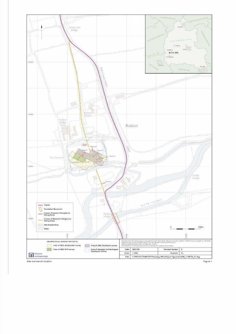
8/14/2019 Radcot, Oxfordshire
http://slidepdf.com/reader/full/radcot-oxfordshire 54/65
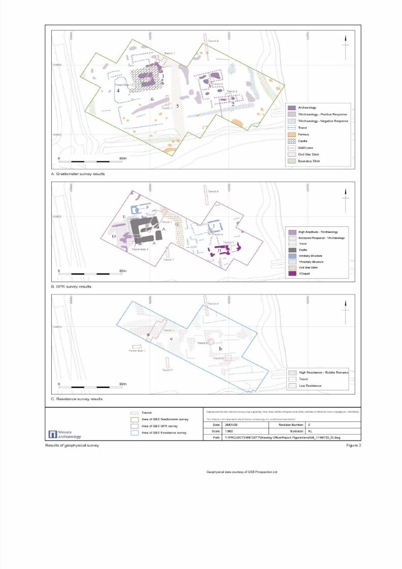
8/14/2019 Radcot, Oxfordshire
http://slidepdf.com/reader/full/radcot-oxfordshire 55/65
Geophysical data courtesy of GSB Prospection Ltd
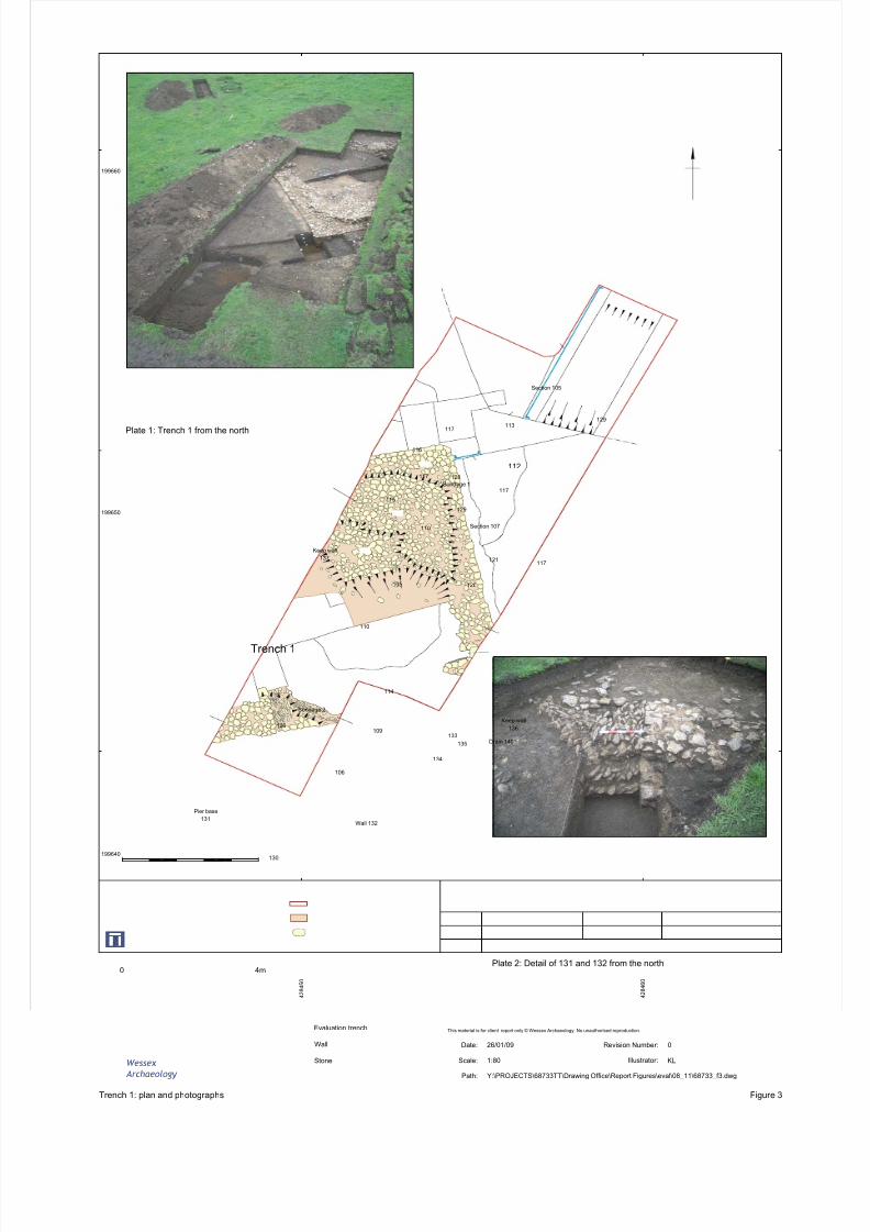
8/14/2019 Radcot, Oxfordshire
http://slidepdf.com/reader/full/radcot-oxfordshire 56/65
Wessex
Archaeology
Trench 1: plan and photographs Figure 3
This material is for client report only © Wessex Archaeology. No unauthorised reproduction.
Path: Y:\PROJECTS\68733TT\Drawing Office\Report Figures\eval\08_11\68733_f3.dwg
Scale: 1:80
Date: 26/01/09 Revision Number: 0
Illustrator: KL
Evaluation trench
Wall
Stone
129113
117
116
112
117
128
Sondage 1
129
117
115
121117
120
110
105
110
114
126
Sondage 2
109133
135
134
106
130
Plate 1: Trench 1 from the north
Plate 2: Detail of 131 and 132 from the north
Trench 1
199640
199650
199660
4 2 8 4 5 0
4 2 8 4 6 0
Section 107
4m0
Keep wall
137
Keep wall
136
Section 105
Drain 140
Wall 132
Pier base131
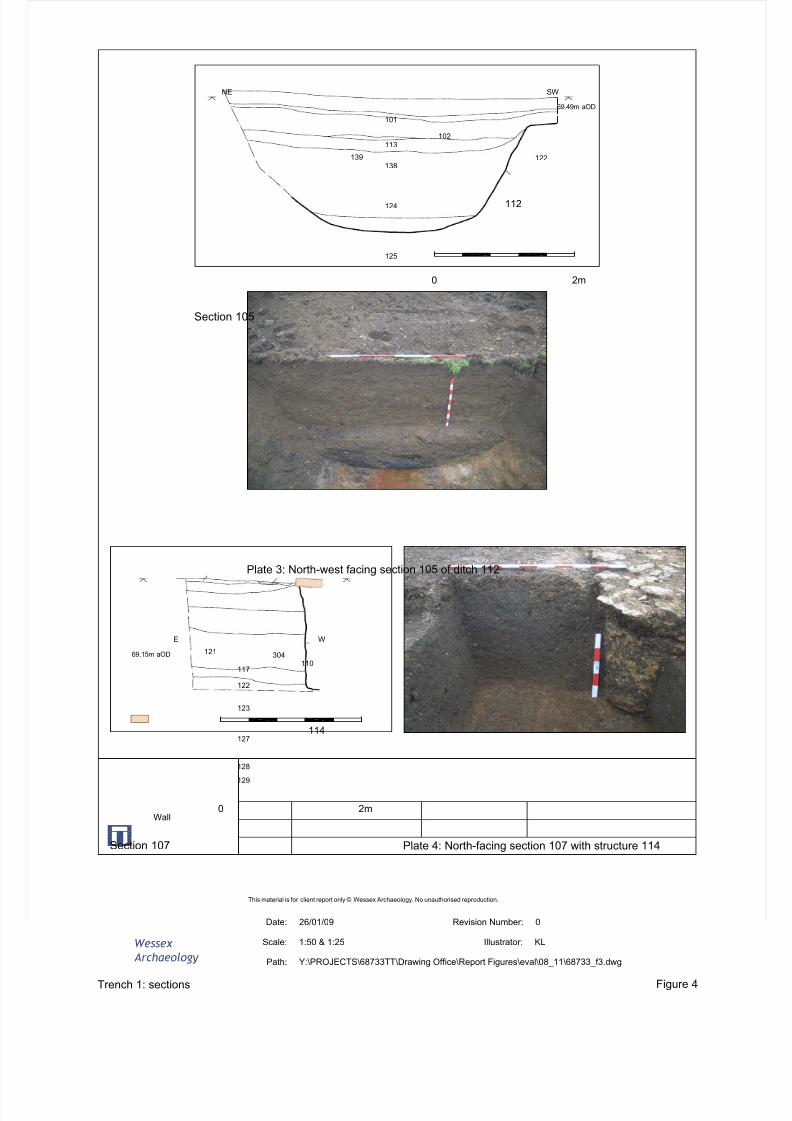
8/14/2019 Radcot, Oxfordshire
http://slidepdf.com/reader/full/radcot-oxfordshire 57/65
Wessex
Archaeology
This material is for client report only © Wessex Archaeology. No unauthorised reproduction.
Trench 1: sections Figure 4
Path: Y:\PROJECTS\68733TT\Drawing Office\Report Figures\eval\08_11\68733_f3.dwg
Scale: 1:50 & 1:25
Date: 26/01/09 Revision Number: 0
Illustrator: KL
2m0
2m0
Section 107
69.15m aOD 121 304110
117
122
123
127
128
129
114
E W
Section 105
Plate 3: North-west facing section 105 of ditch 112
Plate 4: North-facing section 107 with structure 114
101
NE SW
102113
138
124
125
139 122
112
69.49m aOD
Wall
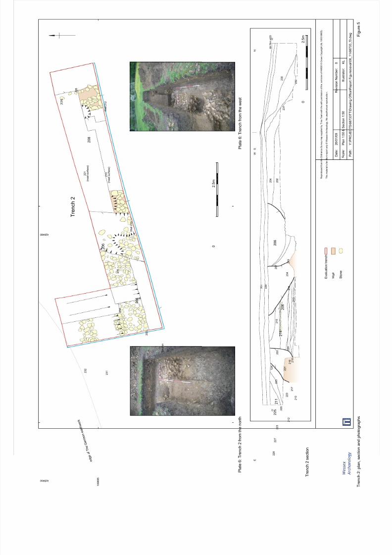
8/14/2019 Radcot, Oxfordshire
http://slidepdf.com/reader/full/radcot-oxfordshire 58/65
W e s s e x
A r c h a e o l o g y
T r e n c h 2 : p l a n , s e
c t i o n a n d p h o t o g r a p h s
F i g u r e 5
R e p r o d u c e d f r o m t h e O r d n a n c e S u r v e y m a p s u p p l i e d b y T i m e T e a m w i t h t h e w i t h p e r m i s s i o n o f t h e c o n t r o l l e r o f H M S O © C r o w n C o p y r i g h t ( A L 1 0 0 0 1 8 6 6 5 ) .
T h i s m a t e r i a l i s f o r c l i e n t r e p o r t o n l y © W e s s e x A r c h a e o l o g y . N o u n a u t h o r i s e d r e p r o d u c t i o n .
P a t h :
Y : \ P R O J E C T S \ 6 8 7 3 3 T T \ D r a w i n g O f f i c e
\ R e p o r t F i g u r e s \ e v a l \ 0 8_
1 1 \ 6 8 7 3 3_
f 3 . d w g
S c a l e :
P l a n 1 : 5 0 & S e c t i o n 1 : 5 0
D a t e :
2 6 / 0 1 / 0 9
R e v i s i o n N u m b e r :
0
I l l u s t r a t o r :
K L
P l a t e 6 : T
r e n c h 2 f r o m t h e n o r t h
P l a t e 6 : T r e n c h f r o m t h e w e s t
E v a l u a t i o n t r e n c h
W a l l
S t o n e
e d g e
o f T h e G a r r i s o n e a r t h w o r k
2 3 2
2 3 1
2 0 4
2 0 2
2 0 4
2 1 6
2 1 0
2 2 1
2 2 6
2 0 8
2 0 6
2 0 6
2 2 5
T r e n c h 2
S e c t i o n
2 0 1
2 2 9
2 0 7
2 1 6
2 3 4
2 3 3
2 1 3
2 1 5
2 0 6
2 0 6
2 0 4
2 0 2
2 3 1
2 3 0
2 3 2
2 2 8
2 2 7
2 2 6
2 0 5
2 1 1
2 1 4
2 2 5
2 1 2
1 2 4
2 2 3
2 2 2
2 2 1
2 2 0
2 2 0
2 1 9 2 1 8
2 1 7
2 1 0
W
S
N
E
6 9 . 7 6 m a O D
1 9 9 6 8 5
4 2 8 4 6 0
4 2 8 4 5 0
2 . 5 m
0
2 . 5 m
0
T r e n c h 2 s e
c t i o n
W a l l 2 1 3
( r o a d s u r f a c e )
( r o a d s u r f a c e )
W a l l 2 1 2
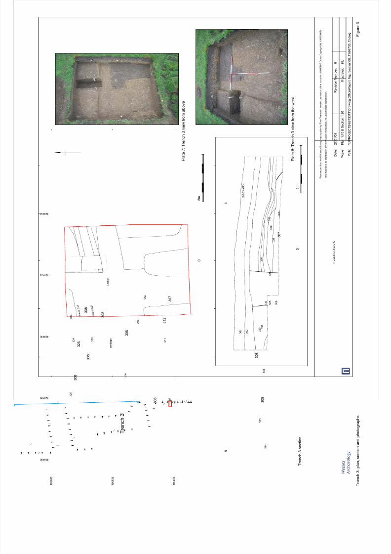
8/14/2019 Radcot, Oxfordshire
http://slidepdf.com/reader/full/radcot-oxfordshire 59/65
W e s s e x
A r c h a e o l o g y
T r e n c h 3 : p l a n , s e
c t i o n a n d p h o t o g r a p h s
F i g u r e 6
R e p r o d u c e d f r o m t h e O r d n a n c e S u r v e y m a p s u p p l i e d b y T i m e T e a m w i t h t h e w i t h p e r m i s s i o n o f t h e c o n t r o l l e r o f H M S O © C r o w n C o p y r i g h t ( A L 1 0 0 0 1 8 6 6 5 ) .
T h i s m a t e r i a l i s f o r c l i e n t r e p o r t o n l y © W e s s e x A r c h a e o l o g y . N o u n a u t h o r i s e d r e p r o d u c t i o n .
P a t h :
Y : \ P R O J E C T S \ 6 8 7 3 3 T T \ D r a w i n g O f f i c e
\ R e p o r t F i g u r e s \ e v a l \ 0 8_
1 1 \ 6 8 7 3 3_
f 3 . d w g
S c a l e :
P l a n 1 : 4 0 & S e c t i o n 1 : 2 0
D a t e :
2 7 / 0 1 / 0 9
R e v i s i o n N u m b e r :
0
I l l u s t r a t o r :
K L
P l a t e 7 : T r e n c h 3 v i e w f r o m a b o v e
E v a l u t i o n t r e n c h
T r e n c h 3
6 9 . 5 2 m a O D
1 9 9 6 2 6
4 2 8 4 9 6
P l a t e 8 : T r e n c h 3 v i e w f r o m t h e w e s t
T r e n c h 3 s e c t i o n
3 0 1
3 0 2
3 0 4
3 1 3
3 1 4
3 0 3
3 3 0
3 2 9
3 3 4
3 0 5
3 0 7
3 0 6
3 0 5
3 3 3
3 3 2
3 3 1
3 2 9
3 0 8
3 0 8
N
S
1 m
0
S e c t i o n
2 m
0
3 0 8
3 2 8
3 0 8
3 0 8
3 0 8
3 2 7
3 1 4
3 2 4
3 2 6
3 0 8
3 2 5
l i n e
o f 3 1 8
l i n e o
f 3 2 1
3 3 8
3 0 7
3 1 2
3 0 9
3 1 1
3 0 5
3 0 6
1 9 9 6 2 6
1 9 9 6 3 0
4 2 8 4 9 8
4 2 8 4 3 0
4 2 8 4 3 2
4 2 8 4 3 4
s o n d a g e
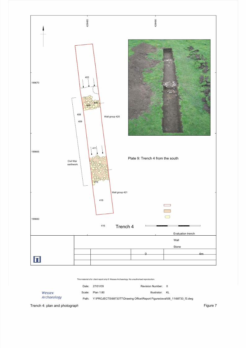
8/14/2019 Radcot, Oxfordshire
http://slidepdf.com/reader/full/radcot-oxfordshire 60/65
Wessex
Archaeology
This material is for client report only © Wessex Archaeology. No unauthorised reproduction.
Trench 4: plan and photograph Figure 7
Path: Y:\PROJECTS\68733TT\Drawing Office\Report Figures\eval\08_11\68733_f3.dwg
Scale: Plan 1:80
Date: 27/01/09 Revision Number: 0
Illustrator: KL
Plate 9: Trench 4 from the south
4m0
Evaluation trench
Wall
Stone
403
405406
408
409
411
410
418
416 Trench 4
4 2 8 4 8 5
199670
4 2 8 4 9 0
199660
199665
Wall group 421
Wall group 420
Civil War
earthwork
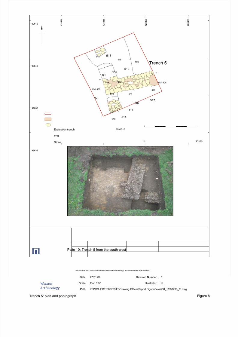
8/14/2019 Radcot, Oxfordshire
http://slidepdf.com/reader/full/radcot-oxfordshire 61/65
Wessex
Archaeology
This material is for client report only © Wessex Archaeology. No unauthorised reproduction.
Trench 5: plan and photograph Figure 8
Path: Y:\PROJECTS\68733TT\Drawing Office\Report Figures\eval\08_11\68733_f3.dwg
Scale: Plan 1:50
Date: 27/01/09 Revision Number: 0
Illustrator: KL
2.5m0
Evaluation trench
Wall
Stone
4 2 8 4 9 0
199640
Plate 10: Trench 5 from the south-west
199638
199636
199642 4 2 8 4 8 8
4 2 8 4 8 8
4 2 8 4 9 0
512
521
518509
508
505
504
516
511515
510
506
514
507517
507
520519
513
Trench 5
Wall 510
Wall 505
Wall 506
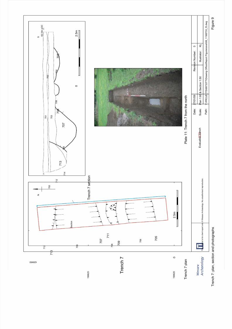
8/14/2019 Radcot, Oxfordshire
http://slidepdf.com/reader/full/radcot-oxfordshire 62/65
W e s s e x
A r c h a e o l o g y
T r e n c h 7 : p
l a n , s e c t i o n a n d p h o t o g r a p h s
T h i s m a t e r i a l i s f o r c l i e n t r e p o r t o n l y © W e s s e x A r c h a e o l o g y . N o u n a u t h o r i s e d r e p r o d u c t i o n .
F i g u r e 9
P a t h :
Y : \ P R O J E C T S \ 6 8 7 3 3 T T \ D r a w i n g O f f i c e \ R e p o r t F i g u r e s \ e v a l \ 0 8_
1 1 \ 6 8 7 3 3_
f 3 . d w g
S c a l e :
P l a n 1 : 6 0 & S e c t i o n 1 : 5 0
D a t e :
2 7 / 0 1 / 0 9
R e v i s i o n N u m b e r :
0
I l l u s t r a t o r :
K L
P l a t e 1 1 : T r e n c h 7 f r o m t
h e n o r t h
6 9 . 1 8 m a O D
N
T r e n c h
7 p l a n
T r e n c h 7 s e c t i o n
S e c t i o n
S
7 0 1
7 0 3
7 0 2
7 0 2
7 1 2
7 0 6
7 1 4
7 0 8
7 0 4
7 1 3
7 0 7
7 0 9
7 0 5
2 . 5 m
0
T r
e n c h 7
7 1 2
7 0 6
7 0 8
7 0 6
7 1 3
7 0 7
7 1 1
7 0 9
7 0 5
4 2 8 4 6 0
1 9 9 6 2 5
0
2 . 5 m
1 9 9 6 2 0
E v a l u a t i o n t r e n c h
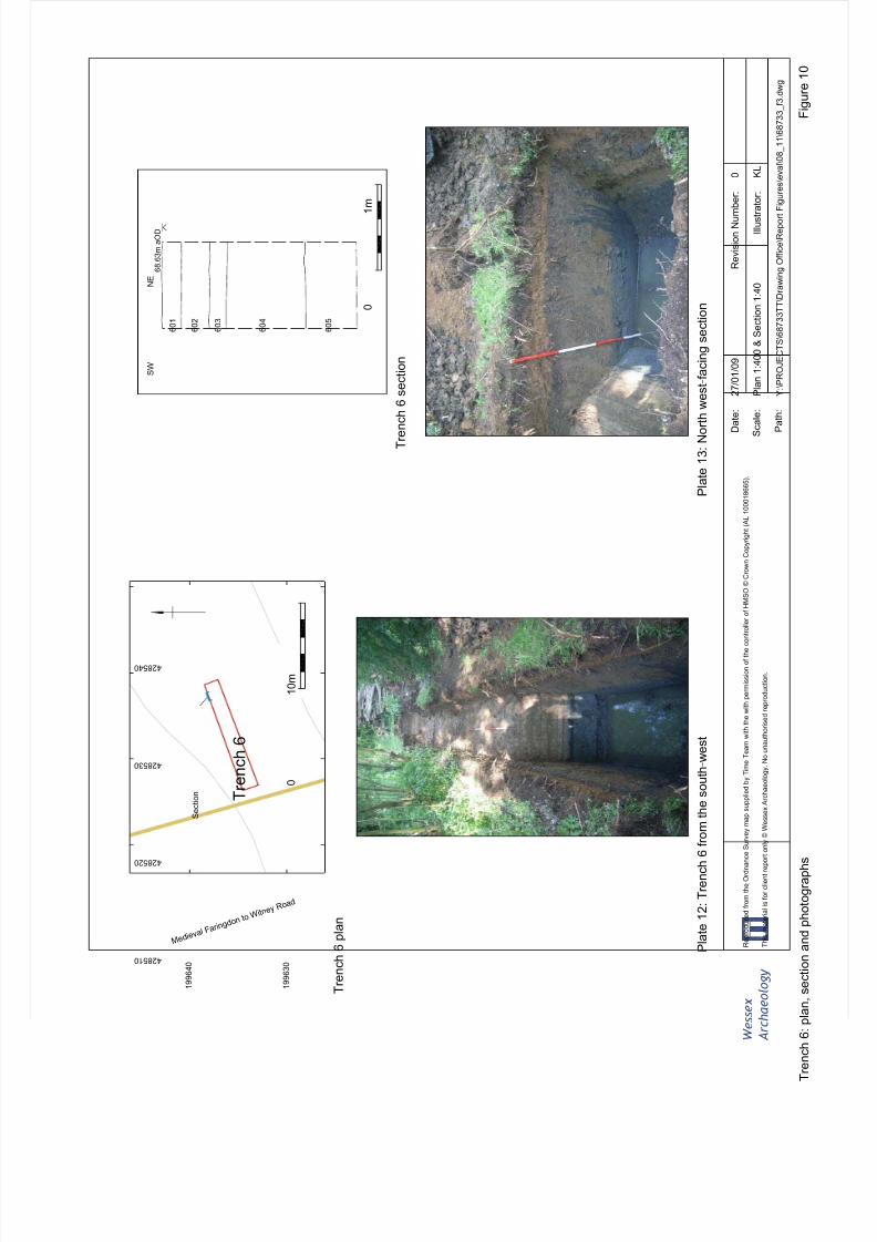
8/14/2019 Radcot, Oxfordshire
http://slidepdf.com/reader/full/radcot-oxfordshire 63/65
W e s s e x
A r c h a e o l o g y
R e p r o d u c e d f r o m t h e O r d n a n c e S u r v e y m a p s u p p l i e d b y T i m e T e a m w i t h t h e w i t h p e r m i s s i o n o f t h e c o n t r o l l e r o f H M S O © C r o w n C o p y r i g h t ( A L 1 0 0 0 1 8 6 6 5 ) .
T r e n c h 6 : p
l a n , s e c t i o n a n d p h o t o g r a p h s
T h i s m a t e r i a l i s f o r c l i e n t r e p o r t o n l y © W e s s e x A r c h a e o l o g y . N o u n a u t h o r i s e d r e p r o d u c t i o n .
F i g u r e 1 0
P a t h :
Y : \ P R O J E C T S \ 6 8 7 3 3 T T \ D r a w i n g O f f i c e \ R e p o r t F i g u r e s \ e v a l \ 0 8_
1 1 \ 6 8 7 3 3_
f 3 . d w g
S c a l e :
P l a n 1 : 4 0 0 & S e c t i o n 1 : 4 0
D a t e :
2 7 / 0 1 / 0 9
R e v i s i o n N u m b e r :
0
I l l u s t r a t o r :
K L
P l a t e 1 2 : T r e n c h 6 f r o m t
h e s o u t h - w e s t
P l a t e 1 3 : N o r t h w
e s t - f a c i n g s e c t i o n
S
e c t i o n T
r e n c h 6
M e d i e v a
l F a r i n g d
o n t o W i t n
e y R o a d
T r e n c h 6 p l a n
T r e n c h 6 s e c t i o n
1 9 9 6 3 0
4 2 8 5 1 0
1 9 9 6 4 0
4 2 8 5 2 0
4 2 8 5 3 0
4 2 8 5 4 0
0
1 0 m
6 0 1
6 0 2
6 0 3
6 0 4
6 0 5
6 8 . 6 3 m a O D
S W
N E
0
1 m
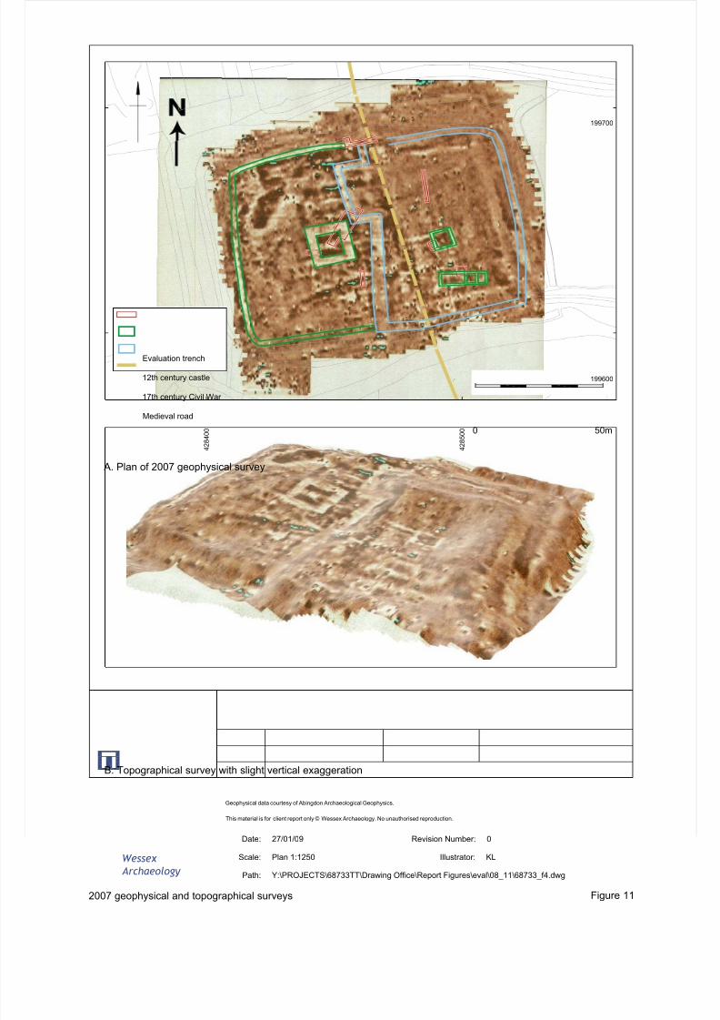
8/14/2019 Radcot, Oxfordshire
http://slidepdf.com/reader/full/radcot-oxfordshire 64/65
Wessex
Archaeology
This material is for client report only © Wessex Archaeology. No unauthorised reproduction.
2007 geophysical and topographical surveys Figure 11
Path: Y:\PROJECTS\68733TT\Drawing Office\Report Figures\eval\08_11\68733_f4.dwg
Scale: Plan 1:1250
Date: 27/01/09 Revision Number: 0
Illustrator: KL
199600
199700
4 2 8 5 0 0
4 2 8 4 0 0 0 50m
Evaluation trench
12th century castle
17th century Civil War
Medieval road
Geophysical data courtesy of Abingdon Archaeological Geophysics.
A. Plan of 2007 geophysical survey
B. Topographical survey with slight vertical exaggeration
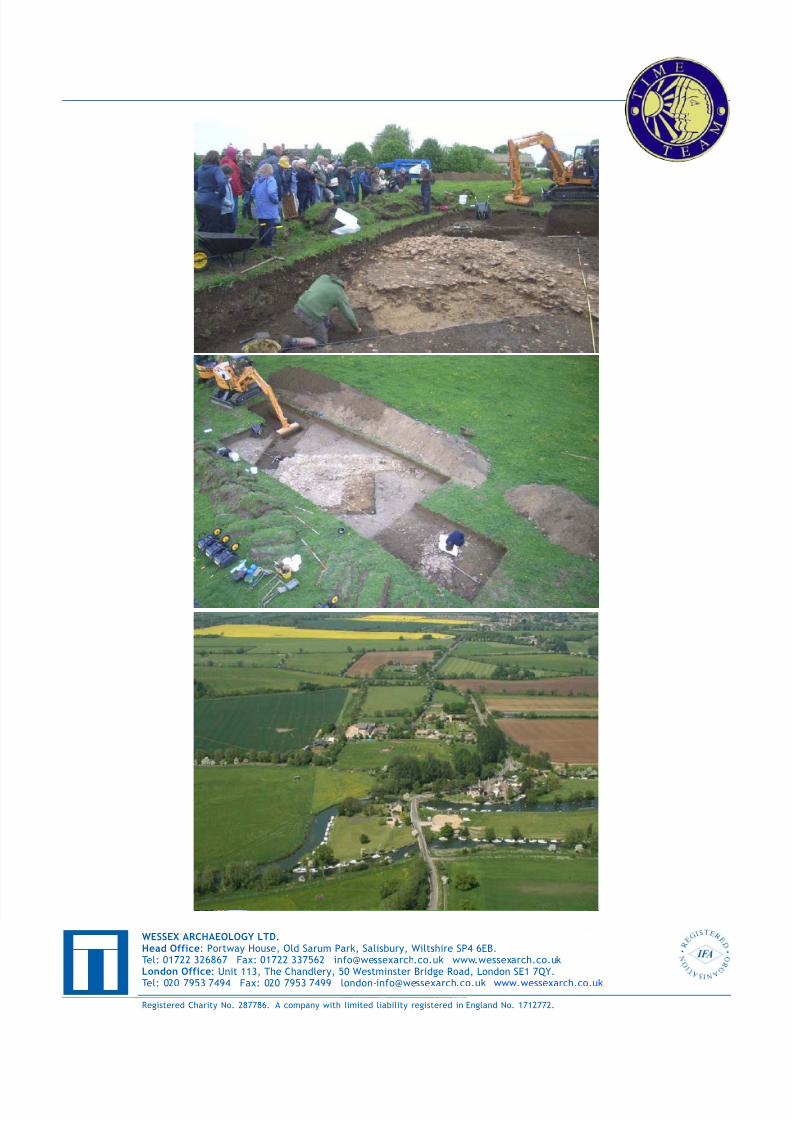
8/14/2019 Radcot, Oxfordshire
http://slidepdf.com/reader/full/radcot-oxfordshire 65/65


