Railway Development in Hong Kong MTRC Tseung Kwan O Line Construction of the Stations of the New Line Formation of the land required for construction of Yau Tong Station. A 1.2 km drill- and-blast tunnel, known as the Sai Tso Wan Tunnel, was formed at the background of the photo to link the existing Lam Tin Station to the new station at Yau Tong. The station trough at its formation level before commencement of construction work on the partially-buried station structure.
Transcript
Railway Development in Hong Kong
MTRC Tseung Kwan O Line
Construction of the Stations of the New Line
Formation of the land required for construction of Yau Tong Station. A 1.2 km drill-
and-blast tunnel, known as the Sai Tso Wan Tunnel, was formed at the background
of the photo to link the existing Lam Tin Station to the new station at Yau Tong.
The station trough at its formation level before
commencement of construction work on the
partially-buried station structure.
Construction of Yau Tong Station in mid-2000. Immediately after leaving
the station, the rail line cuts into the Black Hill Tunnel, formed by the
drill-and-blast method. The background of the photo shows the entrance
of the tunnel.
The station structure
gradually took shape in
mid-2001. The upper level
of the approach tunnel
coming from the Kwun
Tong Line entering into the
station platform can still be
seen. The new buildings
on the hillside are public
housing which forms part
of the redevelopment
scheme at Yau Tong.
An aerial view of Yau Tong Station showing the overall
condition of the nearby Yau Tong Bay. Besides serving as
an interchange station between the MTRC's Kwun Tong and
Tseung Kwan O Lines, the station also serves as a centre
point for the redeveloping district of Yau Tong.
Formation of the required land to contain Tiu Keng
Leng Station and its nearby development as part of
the land extension to Tseung Kwan O New Town.
The portal of the Black Hill Tunnel, situated less than 100 m east of Tiu
Keng Leng Station.
The underground portion of Tiu Keng Leng Station rising from the rock trough, as seen in late 1999. The lower right
corner of this photo shows the approach tunnel to the Black Hill Tunnel.
The connecting tunnel between Tiu Keng
Leng Station (in the foreground) and Tseung
Kwan O Station, constructed in a cut-and-
cover arrangement with sides lined with
diaphragm walls or soldier pile walls as
supports during the excavation process.
External view of Tseung Kwan O Station. The station concourse is at ground level while the main
structure accommodating the station platforms is buried underground.
Layout of the Hang Hau Station site in mid-2000. On the left side of the site was the main structure
of the station with the underground portion used as station platforms constructed using the bottom-
up method. The right side was a public transport interchange constructed in a bottom-up
arrangement.
An external view of Yau Tong Station with the public housing estates in the neighbourhood being
completed for occupation in early 2003.
Land previously used as a bus
terminus being cleared in mid-1999
for construction of Hang Hau Station.
Yau Tong Station and the newly redeveloped neighbourhood as seen from Yau Tong Bay.
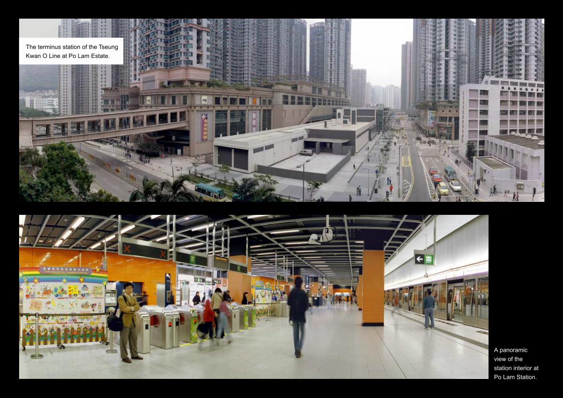
The terminus station of the Tseung
Kwan O Line at Po Lam Estate.
A panoramic
view of the
station interior at
Po Lam Station.
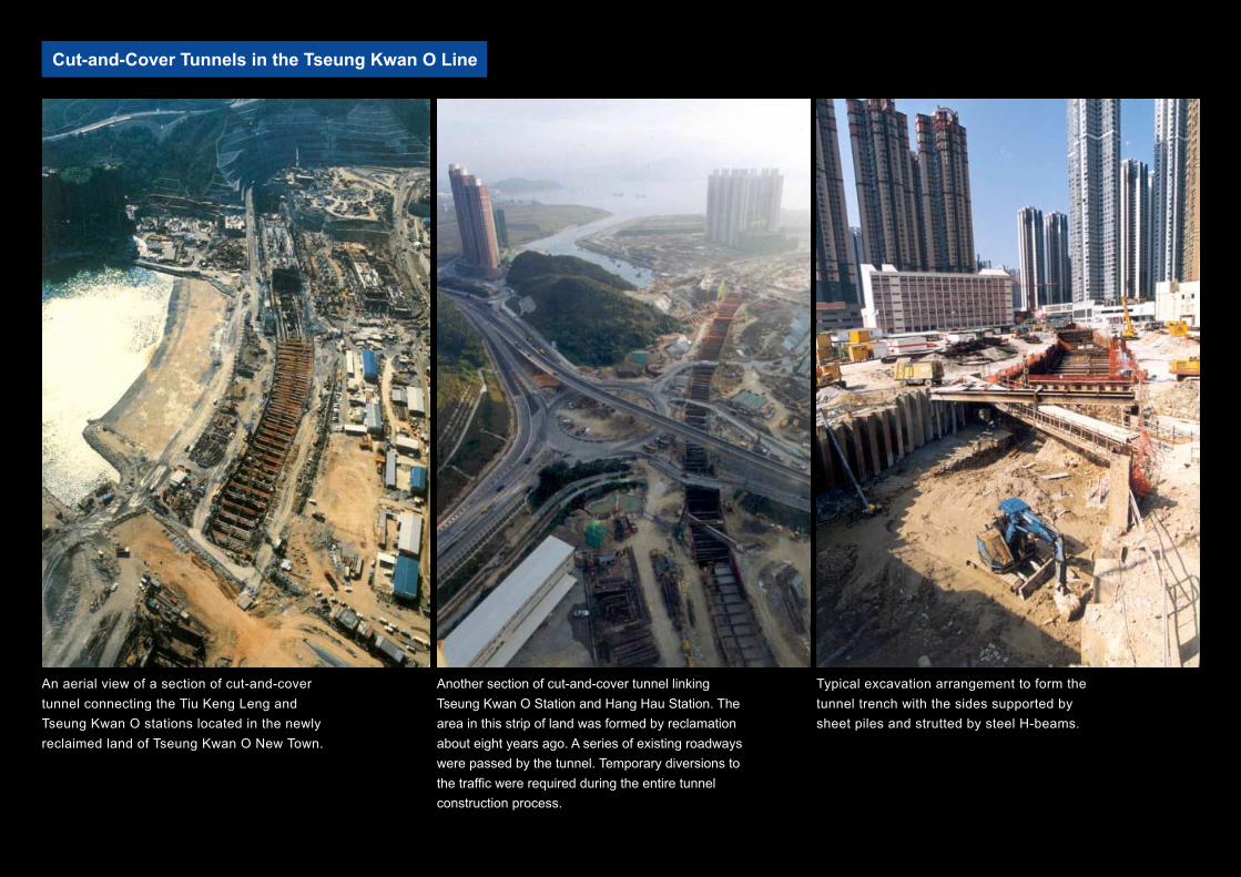
Cut-and-Cover Tunnels in the Tseung Kwan O Line
An aerial view of a section of cut-and-cover
tunnel connecting the Tiu Keng Leng and
Tseung Kwan O stations located in the newly
reclaimed land of Tseung Kwan O New Town.
Another section of cut-and-cover tunnel linking
Tseung Kwan O Station and Hang Hau Station. The
area in this strip of land was formed by reclamation
about eight years ago. A series of existing roadways
were passed by the tunnel. Temporary diversions to
the traffic were required during the entire tunnel
construction process.
Typical excavation arrangement to form the
tunnel trench with the sides supported by
sheet piles and strutted by steel H-beams.
A section of cut-and-cover tunnel passing a flyover at the junction of Wan Po Road and Chiu
Shun Road. A temporary steel deck was erected, as seen on the far side of the flyover, as a
diversion arrangement during the tunnel excavation.
Typical excavation support used in the Tseung Kwan O Line project with the insertion of the
modulated steel strut frame.
Forming the tunnel tube inside the excavated trench in phases using simple large-panel
formwork.
A section of the cut-and-cover tunnel located within 20 m of the temporary seawall. The
construction here was further complicated by the positioning of a storm water outfall.
Temporary diversions were provided not only for the existing roadway but also to the storm
water drain in the form of a two-cell culvert box.
Aerial view showing the splitting of the
rail line eastward from the main line to
form the tunnel overrun and the
linking section into the 2.2 km Pak
Shing Kok tunnel towards the depot.
Tunnel formwork for forming the
twin-tube tunnel section constructed
in the cut-and-cover method. Under
this arrangement, the tunnel section
was cast in two stages with the base
plate placed first and the vertical
walls and the top slab following.
Drill-and-Blast Tunnelling in the Tseung Kwan O Line
The tunnel portal of the Sai Tso Wan Tunnel located in Yau Tong. The tunnel
tubes were arranged in double-layer positions to meet the interchange
arrangement of Yau Tong Station.
The tunnel interior with
waterproofing membrane in
position before final placing of
the tunnel lining.
Reinforcing steel bars
being erected ready for
forming the tunnel lining
using the travelling
formwork as shown.
Final touch-up to rail tracks,
power and signalling systems
inside the tunnel tube.
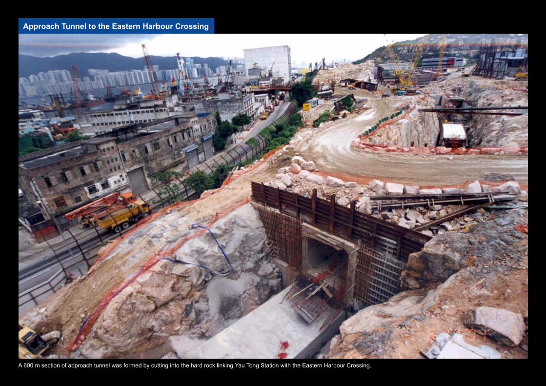
Approach Tunnel to the Eastern Harbour Crossing
A 600 m section of approach tunnel was formed by cutting into the hard rock linking Yau Tong Station with the Eastern Harbour Crossing.
Excavation and temporary traffic
arrangements at the tunnel
approach at the entrance to the
Eastern Harbour Crossing.
The final tunnel section
cutting through the south
end spur of Sai Tso Wan Hill
before joining the Eastern
Harbour Crossing approach.
Constructing the tunnel tubes in the formed rock level of the tunnel using
large-panel gang forms. After leaving the Eastern Harbour Crossing, the
tunnel tubes ascend at different levels to meet the interchange platforms for
the harbour crossing line and the Tiu Keng Leng route, which are located in
a double-layer position.
Detail of a tunnel
tube section at the
approach to Yau
Tong Station.
A section of the
approach tunnel heading
to the Eastern Harbour
Crossing with a steel
deck erected on the
ground level serving as
a temporary two-lane
traffic route during the
construction period.
The end section of the
approach tunnel close to
the tunnel wall of the
Eastern Harbour Crossing
before the break through.
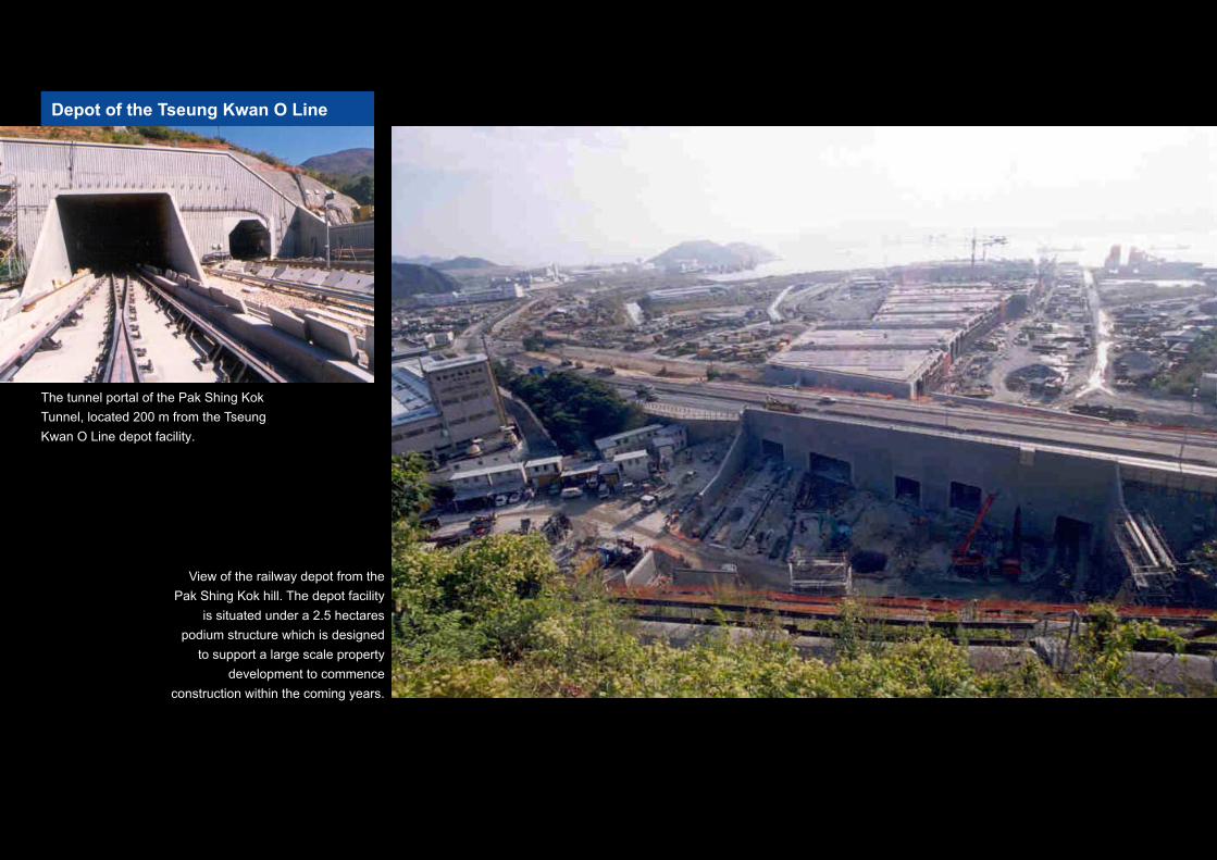
Depot of the Tseung Kwan O Line
The tunnel portal of the Pak Shing Kok
Tunnel, located 200 m from the Tseung
Kwan O Line depot facility.
View of the railway depot from the
Pak Shing Kok hill. The depot facility
is situated under a 2.5 hectares
podium structure which is designed
to support a large scale property
development to commence
construction within the coming years.
A view of the service lanes inside the depot within the podium structure.