44
MSaR SiTeS iN aUSTRia
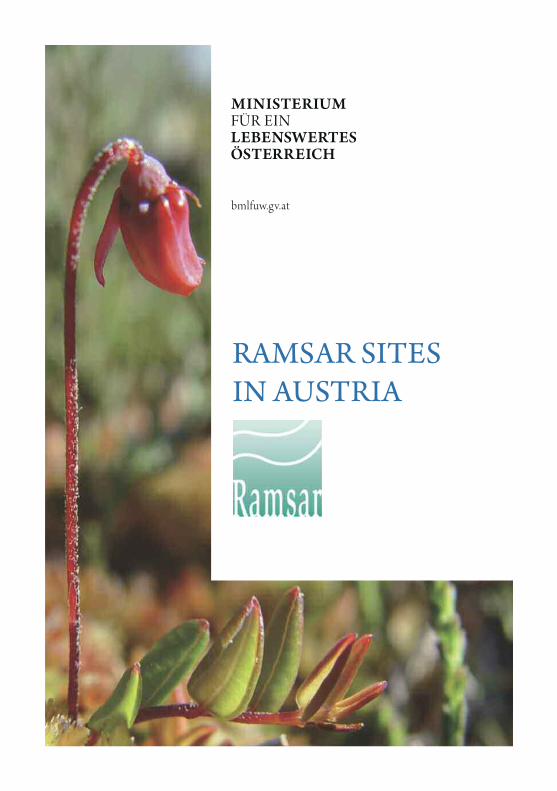
Ramsar sites in austria

IMPRInt
Published by:FEDERAL MINISTRY OF AGRICULTURE, FORESTRY, ENVIRONMENT ANDWATER MANAGEMENTStubenring 1, 1010 Wien
Overall coordination: DI Dr. Gerhard Schwach, Abteilung I/8Author and graphic implementation: DI Heinz WiesbauerTranslation: Mag. D. Magdalena SorgerPhoto credits p. 3: BMLFUW/Alexander Haiden
Print: Zentrale Kopierstelle des BMLFUW, UW-Nr. 907. Printed according to the Guideline “Printed Products” at the Austrian Eco-label.
All rights reserved.
Vienna, October 2014
PREFACE
austria’s magnificent natural and cul-tural landscape bears a rich potential forbiodiversity and recreation as well aseconomic power. to preserve this poten-tial for future generations, it is our re-sponsibility to manage this landscape inan environmentally friendly and re-source-conserving way and, as a result,protect certain areas. Wetlands, such asstreams, creeks, riparian forests, lakes,mires and wet meadows are important inthis regard as it is the availability ofwater that often makes a habitat attrac-tive for countless animal and plantspecies – as well as humans.
until only a few centuries ago, wetlandshad been considered undesirable land-scapes useful only if drained. Conse-quently, drainage, stream regulation andpeat excavation have changed this coun-
try dramatically. today, we know thatwetlands not only enrich biodiversitybut also play important roles in our dailylives, such as flood protection, securingpotable water reserves and storing CO2which is important for the climate.
as part of the ramsar Convention,signed by 168 states around the world,contracting parties designate certainwetlands as “ramsar sites” and agree tomaintain and preserve the ecological prop-erties of these sites through “wise use”.
this brochure provides an overview ofall 23 ramsar sites that have been desig-nated since austria joined the Conven-tion. these, and all other importantaustrian wetland sites, represent a vitalcontribution to conserving the biodiver-sity of our country.
– 3 –
Yours anDrÄ ruPPreCHter Federal minister of agriculture, Forestry, environment and Water management
– 4 –
TABLE OF CONTENTS
5 History and goals of the ramsar Convention
9 austrian ramsar sites
10 Overview map13 autertal – st. Lorenz raised Bog (Carinthia) 14 mires of the Bayerische Wildalm and Wildalmfilz (tyrol, Germany) 15 Donau-march-Thaya-auen (Lower austria, slovakia, Czech republic) 16 Güssing Fish Ponds (Burgenland) 17 Hörfeld mire (Carinthia, styria) 18 Lafnitztal (Burgenland, styria) 19 mires and Lakes of Keutschach-schiefling (Carinthia) 20 mires of the nassköhr (styria) 21 mires of the Pass Thurn (salzburg) 22 mires of the sauerfelder Forest (salzburg) 23 mires of the schwarzenberg (salzburg) 24 mires of the Überling (salzburg)25 national Park Kalkalpen (upper austria) 26 neusiedler see – seewinkel – Waasen (Burgenland, Hungary) 27 upper Drava river (Carinthia) 28 Pürgschachen mire (styria) 29 rhine Delta at Lake Constance (Vorarlberg) 30 rotmoos in the Fuscher Valley (salzburg) 31 sablatnig mire (Carinthia) 32 Lower inn reservoirs (upper austria, Germany) 33 Lower Lobau (Vienna) 34 Waldviertler Ponds, Peat Bogs and Floodplains (Lower austria) 35 Wilder Kaiser (tyrol)
36 ramsar – a testimony for nature conservation and tourism
37 Protection of marshes through the austrian Federal Forestry
38 Wording of ramsar Convention
41 addresses

HIstoRy and Goals of tHe RaMsaR ConventIon
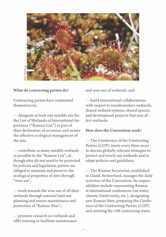
tHe RaMsaR Conven-tIon Is an InteRnatIonaltReaty that provides the frameworkfor national action and international co-operation for the conservation and wiseuse of wetlands and their resources. itwas adopted in the iranian city of ram-sar by the Caspian sea in 1971 and hasbeen signed by 168 countries. the basiccondition for participation is to desig-nate internationally important wetlandsas “ramsar sites”.
ramsar sites now cover all geographicregions of the planet and the list of con-tracting states increases every year dueto the importance of ramsar’s mission:Wetland conservation is crucial to en-suring sustainable access to freshwater! the Convention has progressedfrom prioritizing the conservation ofwater- and shorebirds to now protectingentire habitats. this process lead to ex-tending the convention’s goals to match
some of the goals of the Convention onBiological Diversity (protection – sus-tainable use – equitable sharing of bene-fits). the Convention seeks to establishmanagement plans, ecological moni -toring and collaborations with other regional and global conventions and in-stitutions. another important aim is toinclude local communities through pub-lic outreach.
What is the Ramsar Conventionabout?
the Convention’s mission is “the con-servation and wise use of all wetlandsthrough local, regional and national ac-tions and international cooperation, as acontribution towards achieving sustain-able development throughout theworld”.
the Convention uses a broad definitionof the types of wetlands covered in its mission, including swamps andmarshes, lakes and rivers, wet grasslandsand peatlands, oases, estuaries, deltas
– 5 –
Hei
nz W
iesb
auer

and tidal flats, near-shore marine areas,mangroves and coral reefs, and human-made sites such as fish ponds, rice pad-dies, reservoirs, and salt pans.
Why wetlands?
Wetlands provide fundamental ecologi-cal services and are regulators of waterregimes. Wetlands not only secure ouraccess to fresh potable water and play animportant role in flood control, theyalso act as carbon sinks and are criticalfor climate protection.
Wetlands are sources of biodiversity atall levels. they harbour genetically di-verse populations and contain an overallhigh diversity of species and habitats.Wetlands also provide a resource for tra-ditional land use, scientific research, cul-tural diversity and human recreation.
the encroachment and subsequent lossof wetlands often leads to irreparabledamage to the environment includingimportant ecosystem services. already
damaged wetlands need to be restoredand intact wetlands need to be con-served by ensuring their wise use.
“Wise use” Concept
“Wise use” is defined by the ramsarConvention as a use that benefitsmankind while simultaneously con -serving the properties and ecosystemservices of natural habitats.
Wise use of wetlands is defined as “themaintenance of their ecological charac-ter, achieved through the implementa-tion of ecosystem approaches, withinthe context of sustainable development”for current and future generations.
the “wise use” concept relates to con-servation and sustainable use of wet-lands and their resources for the benefitof humankind. this includes the man-agement of wetlands through restoringriver banks and constructing water re-tention measures in drained peatlands.
– 6 –
Hei
nz W
iesb
auer
What do contracting parties do?
Contracting parties have committedthemselves to:
--- designate at least one suitable site forthe List of Wetlands of international im-portance (“ramsar List”) as part oftheir declaration of accession and ensurethe effective ecological management ofthe site;
--- contribute as many suitable wetlandsas possible to the “ramsar List”; al-though sites do not need to be protectedby policies and legislation, parties areobliged to maintain and preserve theecological properties of sites through“wise use”;
--- work towards the wise use of all theirwetlands through national land-useplanning and ensure maintenance andprotection of “ramsar sites”;
--- promote research on wetlands andoffer training to facilitate maintenance
and wise use of wetlands; and
--- build international collaborationswith respect to transboundary wetlands,shared wetland systems, shared species,and development projects that may af-fect wetlands.
How does the Convention work?
--- the Conference of the ContractingParties (COP) meets every three yearsto discuss globally relevant strategies toprotect and wisely use wetlands and toadopt policies and guidelines.
--- the ramsar secretariat, establishedin Gland, switzerland, manages the dailyactivities of the Convention. its respon-sibilities include representing ramsar at international conferences (on water,climate, biodiversity, etc.), designatingnew ramsar sites, preparing the Confer-ence of the Contracting Parties (COP)and assisting the 168 contracting states.
– 7 –
Hei
nz W
iesb
auer

--- in austria, the implementation of theramsar Convention falls on the federalprovinces (nature conservation) and the Federal ministry of agriculture,Forestry, environment and Water man-agement (water management, environ-mental education and internationalnature conservation). at annual meet-ings of the “national ramsar Com -mittee”, federal and provincial repre-sentatives collaborate with nGOs like the Chamber of agriculture and theaustrian Federal Forestry aG (ÖBf, www.bundesforste.at).
--- Project-based funding for wetlandprotection and management in austriacomes from federal and provincial budg-ets as well as european funding pro-grammes like LiFe, interreG, etZ,rural Development and Leader.
Globally, about 2200 wetlands with atotal area of two million square kilo-metres have been designated “Ramsarsites” – this is 25 times the size of aus-tria!
– 8 –
Hei
nz W
iesb
auer
austRIan RaMsaR sItes
ramsar sites reflect the diver-sity of wetlands in austria. they encom-pass marshes, wet grasslands, salt pans,riparian forests, streams, lakes andhuman-made habitats like ponds andreservoirs.
to date, austria has designated 23 ram-sar sites. marshlands are the prevailinghabitat type among these localities. al-most two thirds of all sites (15) are dif-ferent types of marshes distributedacross the provinces salzburg (5),Carinthia (4), tyrol (2), styria (2),Lower austria (1) and upper austria(1). some of these sites cover vast areasand include other habitat types likekarst and tufa springs or alpine wood-and grassland communities.
riparian landscapes also form a signifi-cant share (30 %) of ramsar sites inaustria. these sites are located at theDanube river east of Vienna, themorava river, the Lafnitz river, the
upper Drava river, the Lower inn riverand the rhine delta at Lake Constance.
among all ramsar sites, neusiedler see– seewinkel has special status. the goalat this largest austrian ramsar site is toconserve the steppe lake with its Pan-nonian alkaline ponds, wet grasslandsand steppes.
the ramsar List of internationally im-portant Wetlands also includes “second-hand habitats” like Güssing Fishpondsand Lower inn reservoirs.
– 9 –
eric
h W
eiga
nd

– 10 –
list of austrian Ramsar sites with page referencesautertal – st. Lorenz raised Bog (Carinthia): p. 13mires of the Bayerische Wildalm-Wildalmfilz (tyrol): p. 14Donau-march-Thaya-auen (Lower austria): p. 15Güssing Fish Ponds (Burgenland): p. 16Hörfeld mire (Carinthia, styria): p. 17Lafnitztal (styria, Burgenland): p. 18mires and Lakes of Keutschach-schiefling (Carinthia): p. 19 mires of the nassköhr (styria): p. 20mires of the Pass Thurn (salzburg): p. 21mires of the sauerfelder Wald (salzburg): p. 22 mires of the schwarzenberg (salzburg): p. 23
Kar
teng
rund
lage
Lan
d ti
rol

– 11 –
mires of the Überling (salzburg): p. 24national Park Kalkalpen (upper austria): p. 25 neusiedler see – seewinkel – Waasen (Burgenland): p. 26upper Drava river (Carinthia): p 27Pürgschachen mire (styria): p 28 rhine Delta at Lake Constance (Vorarlberg): p. 29 rotmoos in the Fuscher Valley (salzburg): p. 30 sablatnig mire (Carinthia): p. 31 Lower inn reservoirs (upper austria): p. 32 Lower Lobau (Vienna): p. 33 Waldviertel Ponds, Peat Bogs and Floodplains (Lower austria): p. 34Wilder Kaiser (tyrol): p. 35
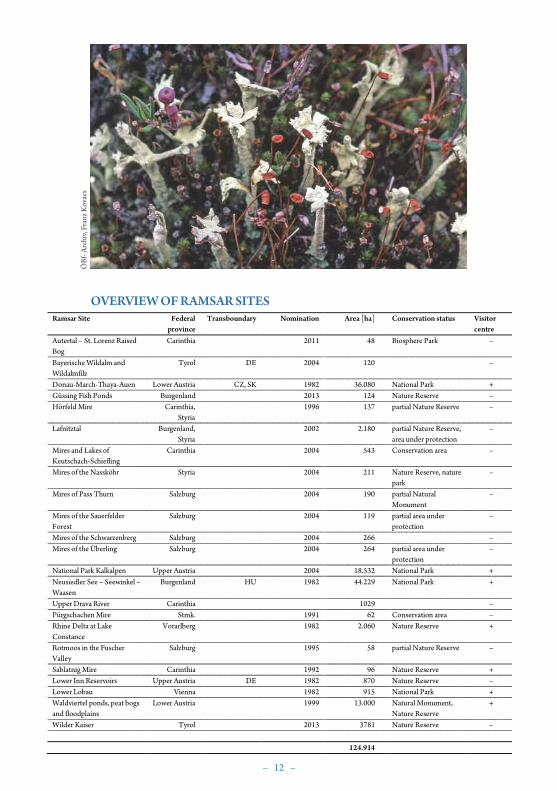
oveRvIeW of RaMsaR sItes
– 12 –
Ramsar Site Federalprovince
Transboundary Nomination Area [ha] Conservation status Visitorcentre
Autertal – St. Lorenz RaisedBog
Carinthia 2011 48 Biosphere Park –
Bayerische Wildalm andWildalmfilz
Tyrol DE 2004 120 –
Donau-March-Thaya-Auen Lower Austria CZ, SK 1982 36.080 National Park +Güssing Fish Ponds Burgenland 2013 124 Nature Reserve –Hörfeld Mire Carinthia,
Styria1996 137 partial Nature Reserve –
Lafnitztal Burgenland,Styria
2002 2.180 partial Nature Reserve,area under protection
–
Mires and Lakes ofKeutschach-Schiefling
Carinthia 2004 543 Conservation area –
Mires of the Nassköhr Styria 2004 211 Nature Reserve, naturepark
–
Mires of Pass Thurn Salzburg 2004 190 partial NaturalMonument
–
Mires of the SauerfelderForest
Salzburg 2004 119 partial area underprotection
–
Mires of the Schwarzenberg Salzburg 2004 266 –Mires of the Überling Salzburg 2004 264 partial area under
protection–
National Park Kalkalpen Upper Austria 2004 18.532 National Park +Neusiedler See – Seewinkel –Waasen
Burgenland HU 1982 44.229 National Park +
Upper Drava River Carinthia 1029 –Pürgschachen Mire Stmk. 1991 62 Conservation area –Rhine Delta at LakeConstance
Vorarlberg 1982 2.060 Nature Reserve +
Rotmoos in the FuscherValley
Salzburg 1995 58 partial Nature Reserve –
Sablatnig Mire Carinthia 1992 96 Nature Reserve +Lower Inn Reservoirs Upper Austria DE 1982 870 Nature Reserve –Lower Lobau Vienna 1982 915 National Park +Waldviertel ponds, peat bogsand floodplains
Lower Austria 1999 13.000 Natural Monument,Nature Reserve
+
Wilder Kaiser Tyrol 2013 3781 Nature Reserve –
124.914
ÖBf
- arc
hiv,
Fran
z Kov
acs
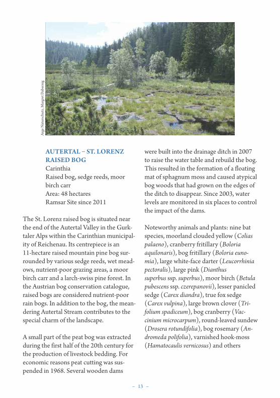
auteRtal – st. loRenzRaIsed BoGCarinthiaraised bog, sedge reeds, moorbirch carrarea: 48 hectares ramsar site since 2011
the st. Lorenz raised bog is situated nearthe end of the autertal Valley in the Gurk-taler alps within the Carinthian municipal-ity of reichenau. its centrepiece is an11-hectare raised mountain pine bog sur-rounded by various sedge reeds, wet mead-ows, nutrient-poor grazing areas, a moorbirch carr and a larch-swiss pine forest. inthe austrian bog conservation catalogue,raised bogs are considered nutrient-poorrain bogs. in addition to the bog, the mean-dering autertal stream contributes to thespecial charm of the landscape.
a small part of the peat bog was extractedduring the first half of the 20th century forthe production of livestock bedding. Foreconomic reasons peat cutting was sus-pended in 1968. several wooden dams
were built into the drainage ditch in 2007to raise the water table and rebuild the bog.this resulted in the formation of a floatingmat of sphagnum moss and caused atypicalbog woods that had grown on the edges ofthe ditch to disappear. since 2003, waterlevels are monitored in six places to controlthe impact of the dams.
noteworthy animals and plants: nine batspecies, moorland clouded yellow (Coliaspalaeno), cranberry fritillary (Boloriaaquilonaris), bog fritillary (Boloria euno-mia), large white-face darter (Leucorrhiniapectoralis), large pink (Dianthussuperbus ssp. superbus), moor birch (Betulapubescens ssp. czerepanovii), lesser panicledsedge (Carex diandra), true fox sedge(Carex vulpina), large brown clover (Tri-folium spadiceum), bog cranberry (Vac-cinium microcarpum), round-leaved sundew(Drosera rotundifolia), bog rosemary (An-dromeda polifolia), varnished hook-moss(Hamatocaulis vernicosus) and others
– 13 –
arg
e nat
ursc
hutz
, mar
gret
Dab
erni
g

MIRes of tHe BayeRIsCHeWIldalM and WIldalMfIlz tyrol, Germany (Bavaria)Bog complex with different miretypesarea: 133 hectares ramsar site since 2004
the mires of the Bayrische Wildalm are lo-cated at the border of tyrol and Bavarianear Lake achen at ca. 1430 metres abovesea level. the part of this bilateral ramsarsite that is located in austria is managed bythe austrian Federal Forestry aG.
the local microclimate, a terrain featuringshallow pits and basins, and traditionalland cultivation all led to the formation of adiverse mosaic of different mire types,alpine pastures and mountain forests.Karstic zones usually contain dry habitatsbecause water drains quickly through thegaps and clefts in the carbonated rock. atBayrische Wildalm, water-retaining layersof clay and marl allowed the formation ofmires. the bog complex is located in a so-called polje, a karst depression surrounded
by mountain slopes, and is pervaded byhollows and smaller depressions. theraised bog mostly consists of peat mosses,dwarf shrubs and dwarf pines that have ac-crued to form a rich peat layer.
a meandering stream flows into the dolinewhere the water drains into an under-ground sinkhole. a large fen has developedin places where seepage water or streamwater collect or where the groundwatertable is particularly high.
noteworthy animals and plants: eurasianpygmy owl, alpine salamander, bogbean(Menyanthes trifoliata), brown gentian (Gen-tiana pannonica), lesser butterfly-orchid (Pla-tanthera bifolia), broad-leaved marsh orchid(Dactylhoriza majalis), common cottongrass(Eriophorum angustifolium), sheathed cot-tonsedge (Eriophorum vaginatum), round-leaved sundew (Drosera rotundifolia),spoonleaf sundew (Drosera intermedia), bottle sedge (Carex rostrata), mud sedge(Carex limosa), pod grass (Scheuchzeriapalustris), marsh club moss (Lycopodiella in-undata) and others
– 14 –
Ger
t-mic
hael
ste
iner
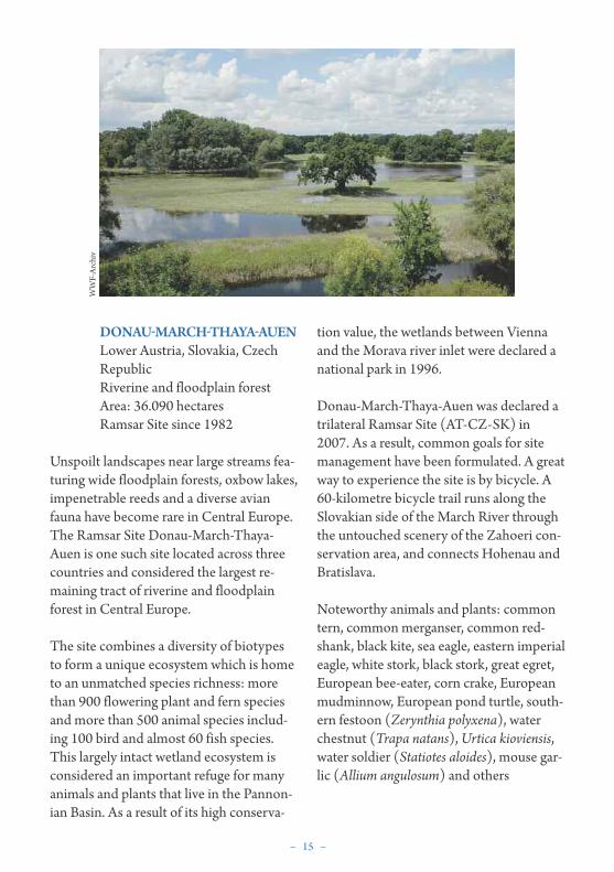
donau-MaRCH-tHaya-auen Lower austria, slovakia, Czechrepublicriverine and floodplain forestarea: 36.090 hectaresramsar site since 1982
unspoilt landscapes near large streams fea-turing wide floodplain forests, oxbow lakes,impenetrable reeds and a diverse avianfauna have become rare in Central europe.the ramsar site Donau-march-thaya-auen is one such site located across threecountries and considered the largest re-maining tract of riverine and floodplainforest in Central europe.
the site combines a diversity of biotypesto form a unique ecosystem which is hometo an unmatched species richness: morethan 900 flowering plant and fern speciesand more than 500 animal species includ-ing 100 bird and almost 60 fish species.this largely intact wetland ecosystem isconsidered an important refuge for manyanimals and plants that live in the Pannon-ian Basin. as a result of its high conserva-
tion value, the wetlands between Viennaand the morava river inlet were declared anational park in 1996.
Donau-march-thaya-auen was declared atrilateral ramsar site (at-CZ-sK) in2007. as a result, common goals for sitemanagement have been formulated. a greatway to experience the site is by bicycle. a60-kilometre bicycle trail runs along theslovakian side of the march river throughthe untouched scenery of the Zahoeri con-servation area, and connects Hohenau andBratislava.
noteworthy animals and plants: commontern, common merganser, common red-shank, black kite, sea eagle, eastern imperialeagle, white stork, black stork, great egret,european bee-eater, corn crake, europeanmudminnow, european pond turtle, south-ern festoon (Zerynthia polyxena), waterchestnut (Trapa natans), Urtica kioviensis,water soldier (Statiotes aloides), mouse gar-lic (Allium angulosum) and others
– 15 –
WW
F-a
rchi
v

GüssInG fIsH PondsBurgenlandPond landscape, marshes andfloodplainsarea: 148 hectares ramsar site since 2013
several man-made fish ponds located onthe outskirts of the picturesque town ofGüssing are the centrepiece of this wetland.the ramsar site comprises one large andthree smaller ponds separated by dams.the landscape is shaped by the vast alluvialplains of the ponds, the marshes aroundZickenbach Creek and remnant copses ofalluvial forest.
the ponds are home to many critically en-dangered animals. they are of nationalsignificance as breeding grounds for sev-eral species of waterfowl. For instance,two globally threatened bird species, theferruginous duck and the sea eagle, areregularly encountered here. this wetlandis one of the most important waterfowlresting areas during their migration be-tween the Danube river/morava river/
Lake neusiedl area and the adriatic sea.Güssing Fish Ponds are of great signifi-cance due to their large size and old age asthe bank structures have naturally grownover centuries.
noteworthy animals and plants: ferrugi-nous duck, sea eagle, little bittern, waterchestnut (Trapa natans), yellow day-lily(Hemerocallis lilioasphodelus), marsh gen-tian (Gentiana pneumonanthe) and others
– 16 –
Chr
istia
n H
olle
r

HöRfeld MIReCarinthia, styria Fen complex with riverine forestsand carrs, tall forb communitiesand damp meadowsarea: 137 hectaresramsar site since 1996
the extremely diverse fauna and flora andthe renowned “Kelchtöpfe” (deep waterholes that never freeze over) continue todraw people to the Hörfeld mire. the mireis fed by the steirerbach stream and theHörfeldbach stream which meanderthrough the valley. Partly inaccessiblemarshes, riverine forests, carrs, tall forbcommunities and damp meadows form amosaic of landscapes.
the Hörfeld mire was formed during thelast ice age when a branch of the murGlacier carved out the valley basin. Fol-lowing the ice age, the basin filled upwith meltwater to form a lake. Over thecourse of several millennia, the lakeeventually silted up to form the mosaicof water holes, floating grass mats, reed
beds and small forests that shape thelandscape today.
the combination of meadows used for tra-ditional agriculture and unspoilt naturallandscape played an important role in fos-tering high species richness in the area.meadow cultivation in late summer is animportant factor in sustaining this diver-sity. Without regular mowing, the area be-comes fallow and a few select speciesoutcompete the majority of wetland-spe-cific plants.
noteworthy animals and plants: whinchat,water rail, common snipe (overwintering),common rosefinch, common minnow, yel-low-bellied toad, bog fritillary (Boloria eu-nomia), marsh helleborine (Epipactispalustris), sundew species (Drosera spp.),bottle sedge (Carex rostrata), buckbean(Menyanthes trifoliata) and others
– 17 –
arg
e nat
ursc
hutz
, Kla
us K
rain
er
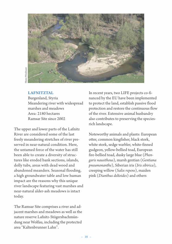
lafnItztalBurgenland, styriameandering river with widespreadmarshes and meadows area: 2180 hectaresramsar site since 2002
the upper and lower parts of the Lafnitzriver are considered some of the lastfreely meandering stretches of river pre-served in near-natural condition. Here,the untamed force of the water has stillbeen able to create a diversity of struc-tures like eroded bank sections, islands,dolly tubs, areas with dead wood andabandoned meanders. seasonal flooding,a high groundwater table and low humanimpact are the reasons why this uniqueriver landscape featuring vast marshes andnear-natural alder-ash meadows is intacttoday.
the ramsar site comprises a river and ad-jacent marshes and meadows as well as thenature reserve Lafnitz-stögersbachmün-dung near Wolfau, including the protectedarea “Kaltenbrunner Lahn”.
in recent years, two LiFe projects co-fi-nanced by the eu have been implementedto protect the land, establish passive floodprotection and restore the continuous flowof the river. extensive animal husbandryalso contributes to preserving the species-rich landscape.
noteworthy animals and plants: europeanotter, common kingfisher, black stork,white stork, sedge warbler, white-finnedgudgeon, yellow-bellied toad, europeanfire-bellied toad, dusky large blue (Phen-garis nausithous), marsh gentian (Gentianapneumonanthe), siberian iris (Iris sibirica),creeping willow (Salix repens), maidenpink (Dianthus deltoides) and others
– 18 –
Hei
nz W
iesb
auer

MIRes and lakes ofkeutsCHaCH-sCHIeflInGCarinthiamires and lakes with carrs,marshes, sedge reeds, moor grass-lands and reed beds area: 543 hectares ramsar site since 2006
the ramsar site, which is part of the ca.2500-hectare conservation area Keutscha -cher seental, is located in a valley betweenLake Wörthersee and the sattnitz mountainrange in the municipalities of Keutschachand schiefling. numerous lakes, such asKeutschacher see, Hafnersee, rauscheleseeand Bassgeigensee that have formed throughseveral moraine walls during the glacial icemelting, are characteristic for this area. inaddition, several ponds contribute to theaquatic landscape. the landscape mosaicconsists of meadows, carrs, water bodieswith water lilies, reed and sedge communi-ties, fens, moor grasslands, damp meadowsand elements of a raised bog. about 6000-year-old pile dwellings in LakeKeutschach, part of a unesCO World
Heritage site, are another highlight of thesite. in recent years, ramsar associationsin both Keutschach and schiefling havebuilt several nature observation facilities(nature discovery trail, observation tower,etc.) and have implemented measures toprotect the meadows. these meadows pro-vide habitat for the largest population ofthe dusky large blue (Phengaris nausithous)in Carinthia.
noteworthy animals and plants: europeanotter, Daubenton’s bat, whinchat, littlegrebe, eurasian golden oriole, italiancrested newt, european tree frog, yellow-bellied toad, dusky large blue (Phengarisnausithous), scarce large blue (Phengaristeleius), fen orchid (Liparis loeselii), marshhelleborine (Epipactis palustris), englishsundew (Drosera angelica), lesser bladder-wort (Utricularia minor) and others
– 19 –
arg
e nat
ursc
hutz
, Kla
us K
rain
er

MIRes of tHe nassköHRstyriamire complex with raised moun-tain pine bogs and fensarea: 211 hectaresramsar site since 2004
Consisting of 23 mires, nassköhr is thebiggest mire complex east of the northernLimestone alps. it is located in northernstyria, about three kilometres northeast ofneuberg a. d. mürz near the schneealpe.the limestone bedrock is covered with alayer of impermeable shale and the absenceof aboveground runoffs allow water reten-tion. this has been the prerequisite for theformation of a mosaic of bogs, transitionalmires and fens over the course of thou-sands of years.
the mire complex is situated in a karst- depression and comprises about 211hectares, 31 of which are pure swamp. themost important areas from a conservationperspective are two raised mountain pinebogs: Capellarowiese (3,5 hectares) andZerbenwiese (13 hectares). Like in many
other mires, there are still traces of pastland use at nassköhr: Overgrazing and peatcutting have left some areas significantlydamaged. as part of a mire protection ini-tiative, the austrian Federal Forestry hasbuilt 120 wooden dams at Capellarowieseand Zerbenwiese to revitalize the mires.the goal was to raise the water table andstabilize the hydrology.
noteworthy animals and plants: lesserhorseshoe bat, northern goshawk, eurasiansparrowhawk, eurasian pygmy owl, largepink (Dianthus superbus), ivan’s paddle(Drosera x obovata), marsh club moss (Lycopodiella inundata), slender sedge(Carex lasiocarpa), flea sedge (Carex puli-caris), traunstein’s Dactylorhiza (Dacty-lorhiza traunsteineri), bog cranberry(Vaccinium microcarpum), pod grass(Scheuchzeria palustris) and others
– 20 –
ÖBf
-arc
hiv,
Ger
ald
Plat
tner

MIRes of tHe Pass tHuRnsalzburgmire complex featuring peatlandsat various stages ranging fromspring fens to raised bogs area: 190 hectaresramsar site since 2004
the raised bog complex is located north ofthe municipality of mittersill at 1200 me-tres above sea level.
a botanical gem of international impor-tance is the Wasenmoos. this site is notonly home to all native carnivorous plantslike sundew, butterwort and bladderwort,it also features rarities like silver birch,moor birch and dwarf birch.
there are several drainage ditches withinthe mires from former peat cutting. in2002, the austrian Federal Forestry imple-mented several restoration measures toconvert all formerly exploited areas in themire back to natural peatlands. the projectalso included the installation of an observa-tion deck and a themed nature trail. the
trail features interesting facts about theflora and fauna, the history of peat cuttingand the restoration process of the mires.
noteworthy plants: black grouse, westerncapercaillie, hazel grouse, felwort (Swertiaperennis), dwarf birch (Betula nana), marshclub moss (Lycopodiella inundata), round-leaved sundew (Drosera rotundifolia), bogcranberry (Vaccinium oxycoccus), bog rose-mary (Andromeda polifolia), dioecioussedge (Carex dioica), dotted sedge (Carexpunctata), bog sedge (Carex paupercula),mud sedge (Carex limosa), slender sedge(Carex lasiocarpa), sheathed sedge (Carexvaginata), brown bog-rush (Schoenus fer-rugineus) and others
– 21 –
ÖBf
-arc
hiv

MIRes of tHe saueR-feldeR foRestsalzburgmountain pine bogs, flush fens,transitional miresarea: 119 hectaresramsar site since 2004
the ramsar site is located east of tams -weg in the “niedere tauern” mountainrange and managed by the austrian FederalForestry aG.
the mire complex is located between 1480and 1720 metres above sea level toweringover mica-schist and glacier moraines. thesite comprises eleven single mires, such asmesotrophic percolating mires, flush fens,oligtrophic rain bogs, transitional miresand mountain pine bogs.
the mires of the sauerfelder Wald areperfectly preserved. not even grazing hasdamaged the mires in the past; they re-main in their natural condition. today,human use of the mires is limited tohunting.
the prevailing mountain pine-spruce-peat-moss communities are a special highlightof the mires. such communities are ex-tremely rare in the alps and only known tooccur in a few other places.
noteworthy plants and animals: blackgrouse, western capercaillie, hazel grouse,felwort (Swertia perennis), dwarf birch (Be-tula nana), marsh club moss (Lyco podiellainundata), round-leaved sundew (Droserarotundifolia), bog cranberry (Vacciniumoxycoccus), bog rosemary (Andromeda po-lifolia), few-flowered bog sedge (Carex pau-ciflora), bog sedge (Carex paupercula),dioecious sedge (Carex dioica), thread rush(Juncus filiformis), cleft bog moss (Sphag-num riparium) and others
– 22 –
ÖBf
-arc
hiv

MIRes of tHesCHWaRzenBeRGsalzburgmire complex with rain bogs,raised mountain pine bogs andspring fens area: 267 hectaresramsar site since 2004
the ramsar site is located on the plateauof schwarzenberg mountain in the munici-palities of tamsweg, unternberg and ramingstein. the site is managed by theaus trian Federal Forestry aG.
the subalpine continental climate athigher elevations of schwarzenberg moun-tain, siliceous decalcified bedrock andglacially impacted landforms have pro-vided favourable conditions for the forma-tion of an alpine mire complex. theramsar site comprises several peatlands:saumoos, sattelmoos, moor bei der Bayer-hütte, Kohstattmöser moore, seemoos andseveral mires at Obernock. the differentmire types here are nutrient-poor rainbogs, raised mountain pine bogs and
spring fens. the boundaries of the site ex-tend to the perimeter of the mire complex.noteworthy plants and animals: blackgrouse, western capercaillie, eurasianpygmy owl, black woodpecker, eurasianwoodcock, bog rosemary (Andromeda po-lifolia), dwarf birch (Betula nana), podgrass (Scheuchzeria palustris), mud sedge(Carex limosa), few-flowered bog sedge(Carex pauciflora), bog sedge (Carex pauci-flora), round-leaved sundew (Drosera ro-tundifolia), bog cranberries (Vacciniumoxycoccos, Vaccinium microcarpum), bogbillberry (Vaccinium uliginosum), buckbean(Menyanthes trifoliate), several sphagnumspecies and others
– 23 –
ÖBf
-arc
hiv

MIRes of tHe üBeRlInGsalzburgmire complex with terrestrializa-tion mires and flush fensarea: 265 hectaresramsar site since 2004
the ramsar site is located in the munici-pality of tamsweg and managed by theaustrian Federal Forestry which imple-mented extensive restoration measures in2000.
after the First World War, Überlingmooswas drained completely and converted topasture land. Grazing caused the peat soilto thicken which had a lasting impact onthe vegetation. in addition, there is a net-work of drainage ditches throughout thesite.
as part of the first step of the restorationefforts, the austrian Federal Forestry pro-hibited grazing in the most damaged partsof the mires southeast of Überlinghütte byplacing a fence around an eight-hectare-area. in a second step, the forestry erected
several dams to raise the water table. thedamaged peat meadows are now starting toreturn to their original state and are be-coming a full-fledged mire again.
noteworthy plants: felwort (Swertia peren-nis), dwarf birch (Betula nana), chickweedwintergreen (Trientalis europaea), marshclub moss (Lycopodiella inundata), sundewspecies (Drosera spp.), bog cranberries(Vaccinium oxycoccos, Vaccinium micro-carpum), bog rosemary (Andromeda polifo-lia), few-flowered bog sedge (Carexpauciflora), bog sedge (Carex pauciflora),dioecious sedge (Carex dioica), mud sedge(Carex limosa) and others
– 24 –
Ger
t-mic
hael
ste
iner
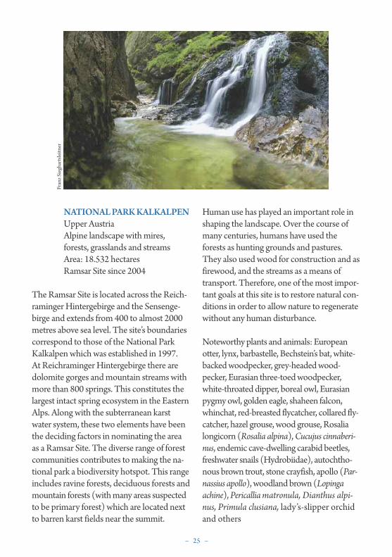
natIonal PaRk kalkalPenupper austriaalpine landscape with mires,forests, grasslands and streams area: 18.532 hectaresramsar site since 2004
the ramsar site is located across the reich -raminger Hintergebirge and the sensenge-birge and extends from 400 to almost 2000metres above sea level. the site’s boundariescorrespond to those of the national ParkKalkalpen which was established in 1997.at reichraminger Hintergebirge there aredolomite gorges and mountain streams withmore than 800 springs. this constitutes thelargest intact spring ecosystem in the easternalps. along with the subterranean karstwater system, these two elements have beenthe deciding factors in nominating the areaas a ramsar site. the diverse range of forestcommunities contributes to making the na-tional park a biodiversity hotspot. this rangeincludes ravine forests, deciduous forests andmountain forests (with many areas suspectedto be primary forest) which are located nextto barren karst fields near the summit.
Human use has played an important role inshaping the landscape. Over the course ofmany centuries, humans have used theforests as hunting grounds and pastures.they also used wood for construction and asfirewood, and the streams as a means oftransport. therefore, one of the most impor-tant goals at this site is to restore natural con-ditions in order to allow nature to regeneratewithout any human disturbance.
noteworthy plants and animals: europeanotter, lynx, barbastelle, Bechstein’s bat, white-backed woodpecker, grey-headed wood-pecker, eurasian three-toed woodpecker,white-throated dipper, boreal owl, eurasianpygmy owl, golden eagle, shaheen falcon,whinchat, red-breasted flycatcher, collared fly-catcher, hazel grouse, wood grouse, rosalialongicorn (Rosalia alpina), Cucujus cinnaberi-nus, endemic cave-dwelling carabid beetles,freshwater snails (Hydrobiidae), autochtho-nous brown trout, stone crayfish, apollo (Par-nassius apollo), woodland brown (Lopingaachine), Pericallia matronula, Dianthus alpi-nus, Primula clusiana, lady’s-slipper orchidand others
– 25 –
Fran
z sie
ghar
tsle
itner

neusIedleR see –seeWInkel – WaasenBurgenland, Hungarysteppe lake, reed belt, saltmarshes, steppesarea: 44.229 hectares ramsar site since 1982
Lake neusiedl, located at the Hungarianborder, is the westernmost steppe lake inCentral europe. together with seewinkel itforms a unique landscape harbouring manyrare animal and plant species.
the 44.000-hectare site neusiedler see –seewinkel – Waasen is austria’s largestramsar site. the prevalent features are: a widespread bog called the Hanság, over630 alkaline waters in seewinkel and an extensive reed belt around Lake neusiedl.a large portion of the site is part of the –national Park neusiedler see – seewinkel. Despite numerous alterations to the land-scape through human use, we still find amosaic of wetland habitats and xeric grass-lands with nutrient-rich black earth anddesert-like soda lime locations. many
coastal plants like glassworts (Salicorniaspp.), sea arrowgrasses (Triglochin mar-itima) and akali grasses (Puccinellia spp.)have been able to settle here in the middleof the continent.
since 1988, the site has been listed as aconservation area of the european net-work of Biogenetic reserves. in 2001, Lakeneusiedl’s cultural landscape has been des-ignated a transboundary (at-Hu) WorldHeritage site by unesCO. as part of aceremonial act in eisenstadt in 2009, theexisting ramsar sites were declared the“transboundary ramsar site neusiedlersee – seewinkel – Waasen” (at-Hu).
noteworthy plants and animals: eurasianspoonbill, ferruginous duck, great egret,eurasian bittern, pygmy cormorant, piedavocet, snowy plover, Danube crestednewt, european fire-bellied toad, sea aster(Tripolium pannonicum), siberian worm-wood (Artemisia laciniata), blue iris (Irisspuria), glasswort (Salicornia prostrata),Camphorosma annua, Dwarf plantain(Plantago tenuiflora) and others
– 26 –
and
reas
ran
ner

uPPeR dRava RIveRCarinthiaWide network of rivers with inneralpine grey alder alluvial forests area: 1029 hectares ramsar site since 2014
the ramsar site upper Drava river cor-responds to the natura-2000 site withthe same name. it extends from the bor-der of east tyrol to the outflow of the Paternion Hydroelectric Power Plant.thanks to extensive restoration meas-ures, the 70-kilometre stream is nowhome to many rare and endangered ani-mal and plant species.
regulatory measures, which have been ineffect since the second half of the 19th cen-tury, have reduced the former biodiversityof the river. therefore, a water supervisionconcept has been developed and was usedas the basis for two LiFe projects. as partof these projects, extensive restorationmeasures to improve water habitats andcounteract species loss have been imple-mented.
another important goal has been to en-large the river banks as part of extensiveriver widening measures which have alsoimproved flood control in the area. Furthergoals are the creation of new alluvial forestswith backwaters, the reintroduction ofhighly endangered or regionally extinct animal and plant species and the imple-mentation of other species conservationmeasures. measures to stabilize the Dravariverbed have also been implemented.
noteworthy plants and animals: italiancrested newt, yellow-bellied toad, euro-pean otter, common sandpiper, little ringedplover, Danube salmon (Hucho hucho),German tamarisk (Myricaria germanica),dwarf bulrush (Typha minima) and others
– 27 –
rev
ital-a
rchi
v

PüRGsCHaCHen MIRestyriamire complex with raised moun-tain pine bogs and fensarea: 62 hectaresramsar site since 1991
the Pürgschachen mire is located in theenns Valley between Liezen and admontnear the village of ardning. it is consideredone of the few mostly undisturbed mires instyria and has gained significance due to itslarge size.
the mire has formed in the basin of a post-glacial lake. Over thousands of years, thepeat layer has become an impressive sixmetres thick. at the surface, mire-specificspecies such as sphagnum mosses, round-leaved sundew (Drosera rotundifolia), bogcranberry (Vaccinium xycoccos), sheathedcottonsedge (Eriophorum vaginatum) andwhite beak-sedge (Rhynchospora alba) areprospering. the central part of the ram-sar site consists of a raised mountain pine bog surrounded by fens and forestbelts.
as part of a LiFe project, valuable sectionsof the area have been protected throughpurchasing, leasing or exchanging land anddamaging features like drainage ditches andspruce monocultures have been removed.the conserved fens and damp meadowssupport a high species richness and giverare bird species like the corn crake a placeto live.
noteworthy plants and animals: com-mon shrew, corn crake, white-spottedbluethroat, moorland clouded yellow (Colias palaeno), white-faced darter (Leucorrhinia dubia), small cranberry moss (Sphagnum rubellum), bog rosemary(Andromeda polifolia), white-beak sedge(Rhynchospora alba) and others
– 28 –
Her
fried
mar
ek
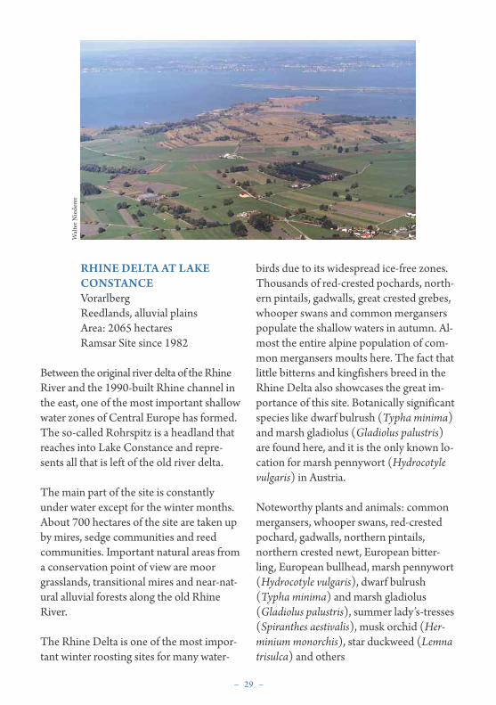
RHIne delta at lakeConstanCe Vorarlbergreedlands, alluvial plainsarea: 2065 hectaresramsar site since 1982
Between the original river delta of the rhineriver and the 1990-built rhine channel inthe east, one of the most important shallowwater zones of Central europe has formed.the so-called rohrspitz is a headland thatreaches into Lake Constance and repre-sents all that is left of the old river delta.
the main part of the site is constantlyunder water except for the winter months.about 700 hectares of the site are taken upby mires, sedge communities and reedcommunities. important natural areas froma conservation point of view are moorgrasslands, transitional mires and near-nat-ural alluvial forests along the old rhineriver.
the rhine Delta is one of the most impor-tant winter roosting sites for many water-
birds due to its widespread ice-free zones.thousands of red-crested pochards, north-ern pintails, gadwalls, great crested grebes,whooper swans and common merganserspopulate the shallow waters in autumn. al-most the entire alpine population of com-mon mergansers moults here. the fact thatlittle bitterns and kingfishers breed in therhine Delta also showcases the great im-portance of this site. Botanically significantspecies like dwarf bulrush (Typha minima)and marsh gladiolus (Gladiolus palustris)are found here, and it is the only known lo-cation for marsh pennywort (Hydrocotylevulgaris) in austria.
noteworthy plants and animals: commonmergansers, whooper swans, red-crestedpochard, gadwalls, northern pintails,northern crested newt, european bitter-ling, european bullhead, marsh pennywort(Hydrocotyle vulgaris), dwarf bulrush(Typha minima) and marsh gladiolus(Gladiolus palustris), summer lady’s-tresses(Spiranthes aestivalis), musk orchid (Her-minium monorchis), star duckweed (Lemnatrisulca) and others
– 29 –
Wal
ter n
iede
rer

RotMoos In tHefusCHeR valleysalzburgCalcareous fen area: 58 hectaresramsar site since 1995
the rotmoos is located between roaringwaterfalls and steeply rising mountainchains of the Glockner massif near the endof the Fuscher Valley at 1300 metres abovesea level. While the mountain range “Hohetauern” is almost exclusively made up ofsilicate rock, rootmos is a calcareous fen.the fen’s substrate consists of calcareousrock from surrounding areas.
the Fuscher ache, a tributary of the riversalzach, flows through the valley basin andthe fen landscape. the meandering streamsare lined with gray alders, bright fields ofyellow mountain saxifrage (Saxifragaaizoides), bottle (Carex rostrate) and cottonsedge (Eriophorum spp.) communities, andorchid-rich meadows. the name “rot-moos” (transl.: red Fen) is most likely due
to iron (iii) oxide-hydroxide which de-posits at slow-flowing parts of the Fuscherache and gives the water curious colourcombinations. the great abundance of or-chids including the Western marsh orchid(Dactylorhiza majalis) which blooms bythe thousands in early summer is the rea-son the inner Fuscher Valley is also calledthe “valley of orchids”.
noteworthy plants and animals: whinchat,northern wheatear, common sandpiper,european bullhead, clouded apollo (Par-nassius mnemosyne), ruddy highflyer (Hy-driomena ruberata), shepherd’s fritillary(Boloria pales), marsh lousewort (Pedicu-laris palustris), western marsh orchid(Dactylorhiza majalis), marsh helleborine(Epipactis palustris), Davall's sedge (Carexdavalliana) and others
– 30 –
Her
man
n H
inte
rsto
isser

saBlatnIG MIRe Carinthiamire complex with spring fens anda flush fenarea: 96 hectaresramsar site since 1992
the sablatnig mire is located in southeast-ern Carinthia, only 25 kilometres from Kla-genfurt. the mire complex formed when alarge post-glacial lake silted up. it consistsof large spring fens and a flush fen. reedbeds, large sedge swamps, tall forb commu-nities, damp meadows, small sedge reeds,black alder carrs and other wetland habitatsare characteristic of this site.
the mire is one of the most important birdsanctuaries in Carinthia. more than 170bird species have been recorded in recentyears. starting from the “tomarkeusche”, asmall visitor centre, the best way to explorethe mire is by using a pair of binoculars.Various water plant communities featuringwater lilies and water knotweed (Persicariaamphibia) are visible from the river banks,while in the open waters of the sablatnig
pond great crested grebes, little grebes andtufted ducks can be observed. an educa-tional nature trail explains the features ofthis idyllic landscape to visitors.
noteworthy plants and animals: eurasianbittern, common pochard, common snipe,western yellow wagtail, yellow-bellied toad,moor frog, thick shelled river mussel (Uniocrassus), lesser bladderwort (Utriculariaminor), marsh gentian (Gentiana pneumo-nanthe), round-leaved sundew (Drosera ro-tundifolia), fen orchid (Liparis loeselii),marsh helleborine (Epipactis palustris),early marsh orchid (Dactylorhiza incar-nata) and others
– 31 –
am
t der
Kär
ntne
r Lan
desr
egie
rung

loWeR Inn ReseRvoIRsupper austria, Bavariamarshlands and alluvial plains area: 870 hectaresramsar site since 1982
more than 70 years ago the inn river be-tween Braunau and schärding at the aus-trian-German border was dammed tosupport a hydroelectric power plant. Overthe course of several decades, extensivefine sediment deposits have formed in theshallow water zones of the reservoir.
the conservation area extends over 25kilometres and consists of four reservoirswhich are among the most important restand overwintering locations for waterbirdsin Central europe. the most importantsections on the austrian side are Hage-nauer Bay, mühlheimer banks, a large is-land and the reichersberger floodplains. aremarkable feature is a breeding populationof black-crowned night herons comprising30 to 50 breeding pairs in the last few years.the great importance of this transbound-ary site for the bird fauna has been a con-
tributing factor to the designation of thearea as a ramsar site. at times, as much asone-fourth of all waterbirds from austriaand Bavaria are concentrated in this area.the Lower inn river has been a natureconservation area since 1978 and has nowbeen awarded the title “european naturereserve”.
noteworthy plants and animals: little bittern, black-crowned night heron,mediterranean gull, common kingfisher,bluethroat, eurasian penduline tit, red-crested pochard, gadwall, flowering rush (Butomus umbellatus), spikerush(Eleocharis acicularis), mare’s tail (Hippuris vulgaris) and others
– 32 –
Jose
f eisn
er

loWeR loBauViennaalluvial floodplains with forests,marshes and gravel ridges(“Heißländen”)area: 915 hectaresramsar site since 1982
the Danube-auen between Vienna andHainburg is one of the largest continuousareas of alluvial forest in Central europe.the ramsar site Lower Lobau, locatedwithin the Vienna metropolis, comprisesabout two thirds of this forest. the site isan internationally recognized biosphere reserve and part of the national ParkDanube-auen established in 1997. thelargest portion of these precious flood-plains is located behind a flood embank-ment that was erected in the 1970s. sincethen, the oxbow lakes have been largely cutoff from the river dynamics which trans-formed the flooded forest into an alluvialforest. this transformation also caused theforest to slowly shift from softwoods tohardwoods. Only the southeastern area isstill a near-natural willow-poplar alluvial
forest since it is periodically flooded by re-treating flood waters. nevertheless, theLower Lobau harbours considerablespecies richness and abundance due to themix of wet, damp and xeric habitats.“Heißländen” are a special feature of theLower Lobau. these are high stacks ofgravel which resemble savannahs and pro-vide a stark contrast to the alluvial forests.the lack of flooding allows xerothermicconditions and has promoted the develop-ment of xeric bushes like hawthorn andcommon sea-buckthorn and dry grasslandswith numerous orchid species.
noteworthy plants and animals: little bit-tern, black kite, european weatherfish,Danube crested newt, yellow-bellied toad,eurasian fire-bellied toad, european pondturtle, water solider (Tratoides aloides), bugorchid (Orchis coriophora), early spider or-chid (Ophrys sphegodes), lizard orchid (Hi-mantoglossum hircinum) and others
– 33 –
nor
bert
sen
dor
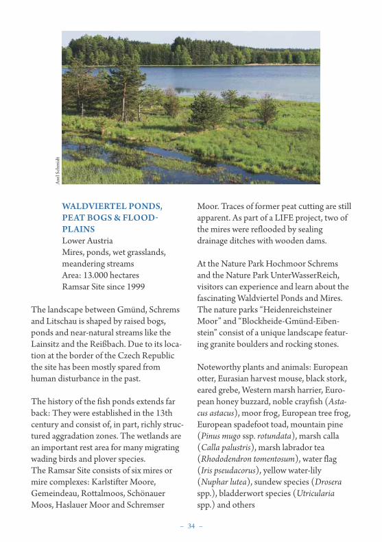
WaldvIeRtel Ponds,Peat BoGs & flood-PlaInsLower austriamires, ponds, wet grasslands, meandering streamsarea: 13.000 hectaresramsar site since 1999
the landscape between Gmünd, schremsand Litschau is shaped by raised bogs,ponds and near-natural streams like theLainsitz and the reißbach. Due to its loca-tion at the border of the Czech republicthe site has been mostly spared fromhuman disturbance in the past.
the history of the fish ponds extends farback: they were established in the 13thcentury and consist of, in part, richly struc-tured aggradation zones. the wetlands arean important rest area for many migratingwading birds and plover species. the ramsar site consists of six mires ormire complexes: Karlstifter moore,Gemeindeau, rottalmoos, schönauermoos, Haslauer moor and schremser
moor. traces of former peat cutting are stillapparent. as part of a LiFe project, two ofthe mires were reflooded by sealingdrainage ditches with wooden dams.
at the nature Park Hochmoor schremsand the nature Park unterWasserreich,visitors can experience and learn about thefascinating Waldviertel Ponds and mires.the nature parks “Heidenreichsteinermoor” and “Blockheide-Gmünd-eiben-stein” consist of a unique landscape featur-ing granite boulders and rocking stones.
noteworthy plants and animals: europeanotter, eurasian harvest mouse, black stork,eared grebe, Western marsh harrier, euro-pean honey buzzard, noble crayfish (Asta-cus astacus), moor frog, european tree frog,european spadefoot toad, mountain pine(Pinus mugo ssp. rotundata), marsh calla(Calla palustris), marsh labrador tea(Rhododendron tomentosum), water flag(Iris pseudacorus), yellow water-lily(Nuphar lutea), sundew species (Droseraspp.), bladderwort species (Utriculariaspp.) and others
– 34 –
axe
l sch
mid
t

WIldeR kaIseR tyrolalpine landscape with mires,forests and meadowsarea: 3781 hectaresramsar site since 2013
the karst area of the Kaiser mountains isshaped by Wetterstein limestone which fea-tures bizarre rock formations and steep cliffs.
Long before humans started to take an in-terest in this area, the mighty mountainswere inhabited by prehistoric animals.thousands of bones in the tischhoferCave prove the existence of cave bears,cave hyenas, cave lions and reindeers fromthe ice age. rather inconspicuous but no less impressive are the animals livingthere today like the green earthworm Al-lolobophora smaragdina.
at the southern slope of the Kaiser moun-tains there are near-natural spruce-fir-beech forests with several mires (e.g.,Hüttlmoos, Windwehenmoos, stein-bichlwaldmoor and many smaller mires).
the goal of an austrian-Bavarian inter-reG restoration project initiated by the re-gional tourist board and implementedbetween 2005 and 2007, was to convert themire back to its natural state and to elimi-nate damage caused by drainage. severalbarriers were installed within the drainageditches to raise the water table and to stim-ulate regeneration. the project receivedstate, federal and eu funding as well asfunding from the austrian Federal ForestryaG.
noteworthy plants and animals: commoneuropean viper, fire salamander, northerncrested newt, yellow-bellied toad, golden-ringed dragonfly (Cordulegaster boltonii),round-leaved sundew (Drosera rotundifo-lia), english sundew (Drosera angelica),marsh violet (Viola palustris), marsh calla(Calla palustris), common cottonsedge(Eriophorum angustifolium), cottonsedge(Eriophorum latifolium), sheathed cot-tonsedge (Eriophorum vaginatum) and others
– 35 –
Otto
Lei
ner
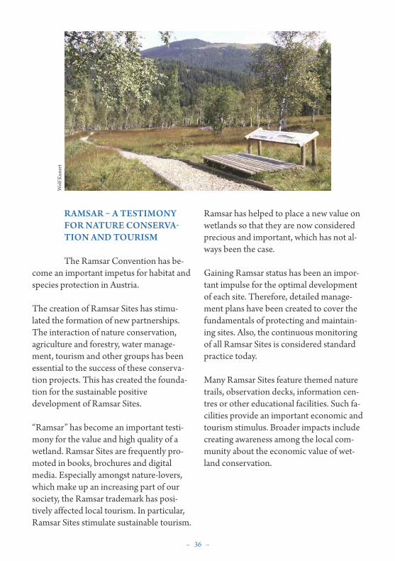
RaMsaR – a testIMony foR natuRe ConseRva-tIon and touRIsM
the ramsar Convention has be-come an important impetus for habitat andspecies protection in austria.
the creation of ramsar sites has stimu-lated the formation of new partnerships.the interaction of nature conservation,agriculture and forestry, water manage-ment, tourism and other groups has beenessential to the success of these conserva-tion projects. this has created the founda-tion for the sustainable positivedevelopment of ramsar sites.
“ramsar” has become an important testi-mony for the value and high quality of awetland. ramsar sites are frequently pro-moted in books, brochures and digitalmedia. especially amongst nature-lovers,which make up an increasing part of oursociety, the ramsar trademark has posi-tively affected local tourism. in particular,ramsar sites stimulate sustainable tourism.
ramsar has helped to place a new value onwetlands so that they are now consideredprecious and important, which has not al-ways been the case.
Gaining ramsar status has been an impor-tant impulse for the optimal developmentof each site. therefore, detailed manage-ment plans have been created to cover thefundamentals of protecting and maintain-ing sites. also, the continuous monitoringof all ramsar sites is considered standardpractice today.
many ramsar sites feature themed naturetrails, observation decks, information cen-tres or other educational facilities. such fa-cilities provide an important economic andtourism stimulus. Broader impacts includecreating awareness among the local com-munity about the economic value of wet-land conservation.
– 36 –
Wol
f Kun
ert

PRoteCtIon of MaRsHes tHRouGH tHe austRIan fedeRal foRestRy
the austrian Federal Forestry(Österreichische Bundesforste aG,www.bundesforste.at) is the largestlandowner in the country and has givenrise to many important initiatives andmeasures for marsh and wetland conserva-tion in the past.
marshes are among the most endangeredhabitats in the world. their use as a sourceof fuel can be traced back to the Bronzeage. Changes to these landscapes throughhuman activities had been self-evident andaccepted over the course of centuries.Lastly, a fundamental rethinking processstarted and the importance of marsh con-servation was realized. On the occasion ofthe 1993 “year of the wetlands” designatedby the Federal ministry of agriculture,Forestry, environment and Water manage-ment, the Federal Forestry decided to placeall their marshes under protection. at pres-ent, the ÖBf owns 474 marshes covering an
area of about 1700 hectares, 70 percent ofwhich are in near-natural condition.
as part of the WWF campaign “Lass sieleben” (transl.: “Let them live”) ÖBf andWWF signed a cooperation agreement on“active marsh conservation”. according tothe agreement, marshes that have suffereddamage through drainage, peat excavation,grazing and reforestation should be activelyrestored. the ambitious program for marshprotection started in 2000 in Überling-moos in the municipality of tamswegwhere the mire was restored through wa-terlogging.
in addition to ramsar sites, ÖBf marshprotection projects also pertain to manymarshes of national and international im-portance. For instance, the focus of restora-tion and revitalisation efforts in 2012 wasplaced on upper austria (salzkammergut).
– 37 –
ÖBf
-arc
hiv
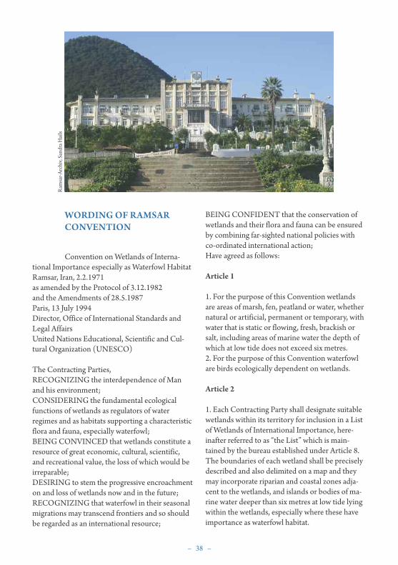
WoRdInG of RaMsaRConventIon
Convention on Wetlands of interna-tional importance especially as Waterfowl Habitatramsar, iran, 2.2.1971as amended by the Protocol of 3.12.1982and the amendments of 28.5.1987Paris, 13 July 1994Director, Office of international standards andLegal affairsunited nations educational, scientific and Cul-tural Organization (unesCO)
the Contracting Parties,reCOGniZinG the interdependence of manand his environment;COnsiDerinG the fundamental ecologicalfunctions of wetlands as regulators of waterregimes and as habitats supporting a characteristicflora and fauna, especially waterfowl;BeinG COnVinCeD that wetlands constitute aresource of great economic, cultural, scientific,and recreational value, the loss of which would beirreparable;DesirinG to stem the progressive encroachmenton and loss of wetlands now and in the future;reCOGniZinG that waterfowl in their seasonalmigrations may transcend frontiers and so shouldbe regarded as an international resource;
BeinG COnFiDent that the conservation ofwetlands and their flora and fauna can be ensuredby combining far-sighted national policies withco-ordinated international action;Have agreed as follows:
article 1
1. For the purpose of this Convention wetlandsare areas of marsh, fen, peatland or water, whethernatural or artificial, permanent or temporary, withwater that is static or flowing, fresh, brackish orsalt, including areas of marine water the depth ofwhich at low tide does not exceed six metres.2. For the purpose of this Convention waterfowlare birds ecologically dependent on wetlands.
article 2
1. each Contracting Party shall designate suitablewetlands within its territory for inclusion in a Listof Wetlands of international importance, here-inafter referred to as “the List” which is main-tained by the bureau established under article 8.the boundaries of each wetland shall be preciselydescribed and also delimited on a map and theymay incorporate riparian and coastal zones adja-cent to the wetlands, and islands or bodies of ma-rine water deeper than six metres at low tide lyingwithin the wetlands, especially where these haveimportance as waterfowl habitat.
– 38 –
ram
sar-a
rchi
v, sa
ndra
Hai
ls
2. Wetlands should be selected for the List on ac-count of their international significance in termsof ecology, botany, zoology, limnology or hydrol-ogy. in the first instance wetlands of internationalimportance to waterfowl at any season should beincluded.
3. the inclusion of a wetland in the List does notprejudice the exclusive sovereign rights of theContracting Party in whose territory the wetlandis situated.
4. each Contracting Party shall designate at leastone wetland to be included in the List when sign-ing this Convention or when depositing its instru-ment of ratification or accession, as provided inarticle 9.
5. any Contracting Party shall have the right toadd to the List further wetlands situated within itsterritory, to extend the boundaries of those wet-lands already included by it in the List, or, becauseof its urgent national interests, to delete or restrictthe boundaries of wetlands already included by itin the List and shall, at the earliest possible time,inform the organization or government responsi-ble for the continuing bureau duties specified inarticle 8 of any such changes.
6. each Contracting Party shall consider its inter-national responsibilities for the conservation,management and wise use of migratory stocks ofwaterfowl, both when designating entries for theList and when exercising its right to change entriesin the List relating to wetlands within its territory.
article 3
1. the Contracting Parties shall formulate and im-plement their planning so as to promote the con-servation of the wetlands included in the List, andas far as possible the wise use of wetlands in theirterritory.
2. each Contracting Party shall arrange to be in-formed at the earliest possible time if the ecologi-cal character of any wetland in its territory andincluded in the List has changed, is changing or is
likely to change as the result of technological de-velopments, pollution or other human interfer-ence. information on such changes shall be passedwithout delay to the organization or governmentresponsible for the continuing bureau duties spec-ified in article 8.
article 4
1. each Contracting Party shall promote the con-servation of wetlands and waterfowl by establish-ing nature reserves on wetlands, whether they areincluded in the List or not, and provide adequatelyfor their wardening.
2. Where a Contracting Party in its urgent nationalinterest, deletes or restricts the boundaries of awetland included in the List, it should as far aspossible compensate for any loss of wetland re-sources, and in particular it should create addi-tional nature reserves for waterfowl and for theprotection, either in the same area or elsewhere, ofan adequate portion of the original habitat.
3. the Contracting Parties shall encourage re-search and the exchange of data and publicationsregarding wetlands and their flora and fauna.
4. the Contracting Parties shall endeavourthrough management to increase waterfowl popu-lations on appropriate wetlands.
5. the Contracting Parties shall promote thetraining of personnel competent in the fields ofwetland research, management and wardening.
article 5
1. the Contracting Parties shall consult with eachother about implementing obligations arisingfrom the Convention especially in the case of awetland extending over the territories of morethan one Contracting Party or where a water sys-tem is shared by Contracting Parties. they shall atthe same time endeavour to coordinate and sup-port present and future policies and regulationsconcerning the conservation of wetlands and theirflora and fauna.
– 39 –

article 6
1. there shall be established a Conference of theContracting Parties to review and promote the im-plementation of this Convention. the Bureau re-ferred to in article 8, paragraph 1, shall conveneordinary meetings of the Conference of the Con-tracting Parties at intervals of not more than threeyears, unless the Conference decides otherwise,and extraordinary meetings at the written requestsof at least one third of the Contracting Parties.each ordinary meeting of the Conference of theContracting Parties shall determine the time andvenue of the next ordinary meeting.
2. the Conference of the Contracting Parties shallbe competent: a) to discuss the implementation of this Conven-tion;b) to discuss additions to and changes in the List;c) to consider information regarding changes inthe ecological character of wetlands included inthe List provided in accordance with paragraph 2of article 3;d) to make general or specific recommendationsto the Contracting Parties regarding the conserva-tion, management and wise use of wetlands andtheir flora and fauna;e) to request relevant international bodies to pre-pare reports and statistics on matters which are es-sentially international in character affectingwetlands;f) to adopt other recommendations, or resolu-tions, to promote the functioning of this Conven-tion.
3. the Contracting Parties shall ensure that thoseresponsible at all levels for wetlands managementshall be informed of, and take into consideration,recommendations of such Conferences concern-ing the conservation, management and wise use ofwetlands and their flora and fauna.
4. the Conference of the Contracting Parties shalladopt rules of procedure for each of its meetings.5. the Conference of the Contracting Parties shallestablish and keep under review the financial regu-lations of this Convention. at each of its ordinary
meetings, it shall adopt the budget for the next fi-nancial period by a two-third majority of Con-tracting Parties present and voting.
6. each Contracting Party shall contribute to thebudget according to a scale of contributionsadopted by unanimity of the Contracting Partiespresent and voting at a meeting of the ordinaryConference of the Contracting Parties.
article 7
1. the representatives of the Contracting Partiesat such Conferences should include persons whoare experts on wetlands or waterfowl by reason ofknowledge and experience gained in scientific, ad-ministrative or other appropriate capacities.
2. each of the Contracting Parties represented at aConference shall have one vote, recommenda-tions, resolutions and decisions being adopted bya simple majority of the Contracting Parties pres-ent and voting, unless otherwise provided for inthis Convention.
articles 8 to 12 refer to the organization of theramsar secretariat and other contractual aspects.see www.ramsar.org for details.
– 40 –

addResses
federal Ministry of agriculture, forestry,environment and Water Managementwww.bmlfuw.gv.at www.ramsar.at
Ramsarwww.ramsar.org
umweltbundesamtwww.umweltbundesamt.at
federal provinces
Burgenlandwww.burgenland.at Carinthiawww.ktn.gv.at Lower austriawww.noe.gv.atupper austriawww.land-oberoesterreich.gv.at salzburgwww.salzburg.gv.atstyriawww.verwaltung.steiermark.at
tyrolwww.tirol.gv.at Vorarlbergwww.vorarlberg.at Viennawww.wien.gv.at
Ramsar site Partners
austrian Federal Forestry aGwww.bundesforste.at
austrian League for nature Conservationnaturschutzbund.at
naturefriends internationalwww.nfi.at www.naturatrails.at
WWFwww.wwf.at
BirdLifewww.birdlife.at
– 41 –
ÖBf
-arc
hiv,
Wol
fgan
g si
mlin
ger

Information centres relating to Ramsarsites
Burgenland
information centre national Parkneusiedler see – seewinkel www.nationalpark-neusiedlersee-seewinkel.at
ramsar Centre neusiedler seewww.haus-am-kellerplatz.at
Carinthia
tomarkeusche – sablatnigmoorwww.sablatnigmoor.at
Lower austria
national Park Centre Donau-auen in Orthwww.donauauen.at
Castle marcheggwww.schloss.marchegg.at
nature Park Hochmoor – unterwasser-reich schremswww.unterwasserreich.at
upper austria
information Centre Kalkalpen national Park Centre in mollnwww.kalkalpen.at
Vorarlberg
rhine Delta at Lake Constance www.rheindelta.org
Vienna
“nationalparkhaus wien-lobau”www.donauen.at
– 42 –
sonj
a ede
r

– 43 –
loCatIons of RaMsaR sItes WItH PaGe RefeRenCesPage
list of austrian Ramsar sites
13au
tert
al –
st.
Lore
nz r
aise
d Bo
g (C
arin
thia)
14m
ires o
f the
Bay
erisc
he W
ildal
m-W
ildal
mfil
z (ty
rol)
15D
onau
-mar
ch-Th
aya-
auen
(Low
er a
ustr
ia)16
Güs
sing
Fish
Pon
ds (B
urge
nlan
d)17
Hör
feld
mire
(Car
inth
ia, s
tyria
)18
Lafn
itzta
l (st
yria
, Bur
genl
and)
19m
ires a
nd L
akes
of K
euts
chac
h-sc
hiefl
ing
(Car
inth
ia)20
mire
s of t
he n
assk
öhr (
styr
ia)21
mire
s of t
he P
ass Th
urn
(sal
zbur
g)22
mire
s of t
he s
auer
feld
er W
ald
(sal
zbur
g)23
mire
s of t
he s
chw
arze
nber
g (s
alzb
urg)
24m
ires o
f the
Übe
rling
(sal
zbur
g)
Page
list of austrian Ramsar sites
25n
atio
nal P
ark
Kal
kalp
en (u
pper
aus
tria)
26
neu
siedl
er s
ee –
see
win
kel (
Burg
enla
nd)
27u
pper
Dra
va r
iver
(Car
inth
ia)28
Pürg
scha
chen
mire
(sty
ria)
29r
hine
Del
ta at
Lak
e Con
stan
ce (V
orar
lber
g)30
rot
moo
s in
the F
usch
er V
alle
y (s
alzb
urg)
31sa
blat
nig
mire
(Car
inth
ia)32
Low
er in
n r
eser
voirs
(upp
er a
ustr
ia)33
Low
er L
obau
(Vie
nna)
34W
aldvi
erte
l Pon
ds, P
eat B
ogs a
nd F
lood
plain
s (Lo
wer a
ustri
a)35
Wild
er K
aiser
(tyr
ol)

bmlfuw.gv.at


