57
Reactive Monitoring Mission to the City of Potosí, Plurinational State of Bolivia (C420) MISSION REPORT 11-14 December 2013 / 23-30 January 2014

Reactive Monitoring Mission to the City of Potosí,
Plurinational State of Bolivia (C420)
MISSION REPORT
11-14 December 2013 / 23-30 January 2014

TABLE OF CONTENTS
ACKNOWLEDGMENTS ............................................................................................................... 1
EXECUTIVE SUMMARY .............................................................................................................. 2
BACKGROUND TO THE MISSION ................................................................................................ 4
1. ASSESSMENT OF CONSERVATION ISSUES ............................................................................... 6
1.a Current conditions at the Cerro Rico Mountain ........................................................................ 6
1.b Situation of the road of access to the peak of the Cerro Rico ................................................ 15
1.c Appropriateness of further operations foreseen for interventions at the summit of the Cerro Rico ................................................................................................................................................ 16
1.d Current conditions at the City of Potosí .................................................................................. 17
2. EVALUATION OF THE PROGRESS IN SECURING OPERATIONAL MANAGEMENT AGREEMENTS FOR THE PROPERTY ................................................................................................................ 19
2.a Evaluate the progress made in securing operational management arrangements for the property, with clear decision-making mechanisms and adequate resourcing, human, technical and financial. ................................................................................................................................. 20
2.b Assess the existing management tools for the property and the provisions regarding conservation and rehabilitation works, as well as proposals for public use and plans for risk management ................................................................................................................................. 20
3. PROGRESS IN THE ESTABLISHMENT OF THE BUFFER ZONE FOR THE PROPERTY ..................... 23
3.a Assess progress made in the establishment of the property’s buffer zone ............................ 23
3.b Assess progress made in the establishment of related regulatory measures to control and regulate further development ...................................................................................................... 24
4. PROGRESS MADE IN THE IMPLEMENTATION OF THE RECOMMENDATIONS OF THE WORLD HERITAGE COMMITTEE ........................................................................................................... 25
5. ASCERTAINED AND POTENTIAL DANGERS TO THE PROPERTY’S OUTSTANDING UNIVERSAL VALUE .................................................................................................................................... 25
6. CONCLUSIONS AND RECOMMENDATIONS ........................................................................... 26
6.a On the collapse of the peak of the Cerro Rico and situation of emergency caused by the intense rains .................................................................................................................................. 26
6.b On the transfer and relocation of miners that work at 4,400................................................. 27
6.c On the lagoons of Kari Kari ...................................................................................................... 27
6.d On the historic city and the Ribera de los Ingenios riverside ................................................. 27
6.e On the integral management of the site ................................................................................. 28
7. ANNEXES ............................................................................................................................ 31
Annex 1: Mission Team ................................................................................................................. 31
Annex 2: Terms of reference for the Reactive Monitoring Mission to the City of Potosí, Plurinational State of Bolivia (C420) ............................................................................................. 31
Annex 3. Itinerary and programme of the Mission ....................................................................... 33

Annex 4: Decisions of the World Heritage Committee ................................................................. 36
Annex 5. Participants in the various meetings: ............................................................................. 37
Annex 6. Planned and on-going construction projects on the top of Cerro Rico del Potosí ........ 38
Annex 7. Maps ............................................................................................................................... 39
Annex 8. Photographs .................................................................................................................. 44

1
ACKNOWLEDGMENTS
The members of the mission wish to express their deep gratitude to the Ministerio
de Culturas y Turismo del Estado Pluricultural de Bolivia as well as their staff, for
the extraordinary hospitality and cooperation extended during the visit. The
cooperation of the Heritage Directorate, through its Director, Mr. Marcos Michel
López and Silvia Saavedra, Focal Point to UNESCO, was also greatly appreciated.
The mission is very thankful also to Félix Gonzáles Bernal, Governor, Regional
Autonomous Government of Potosí; Lic. Oswaldo Cruz, Departamental Secretariat
of Tourism and Culture; Ing. Víctor Hugo Llanos, Mining and Metallurgy Ministry of
Bolivia; Ing. Carlos Colque Benítez, Regional Managemenr, Mining Corporation of
Bolivia (COMIBOL); Ing. Ángel Quintanilla, Manager of Q & Q, responsible for
consolidation works at the peak of Cerro Rico and Francisco Poma, Architectural
Heritage Unit of the Municipality of the City of Potosí, for his continuous presence
and friendly cooperation on behalf of the State Party.
Finally, thanks should go to the individuals met during the mission who contributed
their wisdom and helped in understanding the complex reality of City of Potosí.
2
EXECUTIVE SUMMARY
Main findings of the mission:
The Supreme Decree 27787, issued on October 8, 2004, was not amended to
impose a moratorium on all mining activity above 4,400 m. in order to guarantee
the preservation of the Cerro Rico. The Ministry of Mining and Metallurgy has
intervened a drafts Law Exploitation and Preservation Law of Cerro Rico is
foreseen to be approved by May 2014.
The State Party has worked on addressing the instability and risk of collapse of the
Cerro Rico, however it is urgent to define an updated timeframe that includes work
for recent subsidence and the review of options for stabilization measures.
Scientific studies for Cerro Rico have been undertaken and have contributed to
defining the Sinking Stabilization Project at the Peak of Cerro Rico.
There are currently no adequate management arrangements in place for the
property. Several interventions are foreseen although these are not clearly
articulated in a management or conservation strategy.
Recommendations to the State Party:
Stabilisation of the collapse at the summit of Cerro Rico
- Re-evaluate the stabilization project that was under implementation and currently
halted before the conditions of instability are further modified and exacerbated by
on-going rainy season.
- Consider the current situation of high risk of collapse in five areas of the summit
of the Cerro Rico, identified in the technical studies that can affect miners working
in difficult safety conditions above 4,400 m, as a humanitarian emergency.
Improvement of the characteristics of the Historical City and Ribera de los
Ingenios
- Provide visual unity to pavements and sidewalks and recover, where possible,
historic materials and construction systems.
- Generate specific projects to improve the urban image based on the traditional
architectural style of Potosí, by integrating new and non-harmonious buildings
through basic modification actions on facades.
- Promote the removal of overhead wires and cables, replacing them by hidden
underground wiring.
- Develop a program for the rearrangement of vehicular traffic and promote the
pedestrian use.
3
Conservation system of the Kari Kari Lagoon
- Identify alternate locations for the relocation of miners so that the Kari Kari –
Jayaquila zone is preserved.
Update and enforcement of legislative and regulatory measures
- Formulate and adopt a set of legal and regulatory measures to ensure the
protection of the property, especially regarding the implementation of the
Exploitation and Preservation Law of Cerro Rico.
Integrate the management of the property
- Formulate an Integrated Management Plan that encompasses all attributes that
convey the Outstanding Universal Value of the property. Because of its large
diversity, it is desirable to establish thematic components that share conservation
and development issues for the definition of programmes and actions. The
following six components are proposed: architecture, urbanism, archaeology, rural
setting, environmental setting, and immaterial elements. Each of these
components should have their specific diagnosis, management actions and
monitoring.
To be meaningful, the Integrated Management Plan should be developed under a
process with active community engagement, considering the role of local
inhabitants in the development of the property and practices retained that
contribute to the preservation of authenticity and integrity of the property.
The mission concluded that in light of:
The urgent situation of the Cerro Rico;
The imminent risk of sinking at Cerro Rico`s summit and the threat that this
poses to the Outstanding Universal Value of the property;
The lack of current effectives management mechanisms to ensure the
sustained conservation and protection of the property;
The need to assist and support the efforts of the State Part in the
development and implementation of adequate measures;
That the property is faced with considerable ascertained and potential threats and
meets the conditions for inscription on the List of World Heritage in Danger. This
action will support the development and implementation of adequate management
mechanisms to enhance the effective conservation and management of the City of
Potosí and its territorial features. It will also garner the necessary support to
address the significant risk of collapse of the summit of Cerro Rico.
4
BACKGROUND TO THE MISSION
The World Heritage property
According to the description of the city of Potosí: "In the 16th century, this area was
regarded as the world’s largest industrial complex. The extraction of silver ore
relied on a series of hydraulic mills. The site consists of the industrial monuments
of the Cerro Rico, where water is provided by an intricate system of aqueducts and
artificial lakes; the colonial town with the Casa de la Moneda; the Church of San
Lorenzo; several patrician houses; and the barrios mitayos, the areas where the
workers lived."1
The nomination file included a territorial scale that includes a group of diverse and
varied components interconnected and interdependent as the Cerro Rico and its
mines, the artificial lagoons system of Kari Kari, the urban area of the mining
settlement, the Ribera de los Ingenios, the indigenous neighbourhoods and the
buildings of high architectural value that under the heritage categories recently
integrated in the Operational Guidelines for the Implementation of the World
Heritage Convention could be considered as a Productive Cultural Landscape.
Inscription of the property on the World Heritage List
The City of Potosí was inscribed on the World Heritage List in 1987 under the
criteria (ii) (iv) (vi):
Criterion II. The "imperial city'' of Potosí, such as it became following the visit of Francisco de Toledo in 1572, exerted lasting influence on the development of architecture and monumental arts in the central region of the Andes by spreading the forms of a baroque style incorporating Indian influences. Criterion IV. Potosí is the one example par excellence of a major silver mine in modern times. The industrial infrastructure comprised 22 lagunas or reservoirs, from which a forced flow of water produced the hydraulic power to activate the 140 ingenios or mills to grind silver ore. The ground ore was then amalgamated with mercury in refractory earthen kilns called huayras or guayras. It was then molded into bars and stamped with the mark of the Royal Mint. From the mine to the Royal Mint (reconstructed in 1759), the whole production chain is conserved, along with the dams, aqueducts, milling centres and kilns. The social context is equally well represented: the Spanish zone, with its monuments, and the very poor native zone are separated by an artificial river.
1ICOMOS evaluation, 1987.

5
Criterion VI. Potosí is directly and tangibly associated with an event of outstanding
universal significance: the economic change brought about in the 16th century by
the flood of Spanish currency resulting from the massive import of precious metals
in Seville. The decline of the silver mines of Erzgebirge and the monetary crisis
and inflation whose causes were analysed by Jean Bodin in 1568, were, insofar as
Europe is concerned, the most obvious effects of the mining operation of the Cerro
de Potosí. However, the appearance of a new network of trade relations with Lima,
and later with Buenos Aires, was of immense consequence for the Andean zone
and the whole South American continent. For an inexhaustible market where
goods were bought on a cash basis, Potosí, in the 17th and 18th centuries,
became one of the invisible pivots of world trade.
Background to the mission
The main objective of the mission was to evaluate the current state of conservation
of the City of Potosí, in accordance to Decision 37 COM 7B.91 of the World
Heritage Committee (Phnom Penh, 2013). Terms of reference and mission
itineraries are included in the annexes.

6
1. ASSESSMENT OF CONSERVATION ISSUES
The City of Potosí presents diverse levels of conservation according to the social
and economic dynamics of each of its components. The property has a territorial
scale formed by a wide group of diverse and varied components interconnected
and interdependent as the Cerro Rico and its mines, the system of artificial lagoons
of Kari Kari, the urban area of the mining settlement, the Ribera de los Ingenios,
the indigenous neighbourhoods or the immovable property of architectural value.
Each component presents diverse problems of conservation in terms of
authenticity and integrity that have not been holistically addressed through
management arrangements or a coherent conservation strategy but rather treated
in an isolated way.
The reactive monitoring mission assessed the current state of conservation of the
Heritage Site City of Potosí according to the following aspects:
1.a Current conditions at the Cerro Rico Mountain
After September 16, 2013 the sinking and settlings caused by the fragmentation
and disintegration of stony materials at the summit of the Cerro Rico of Potosí -
generated by the permanent extraction of minerals at the summit, became more
evident. Unstable conditions were further exacerbated due to the intense rains in
the region.
According to the information provided, it is considered that in spite of the
continuous extraction of minerals for almost five centuries the upper part of the
Cerro Rico is the most rich in silver, zinc, lead and tin, so there is an interest from
the mining cooperatives to continue exploiting it.
As of January of 2014 numerous mining cooperatives continue extracting minerals,
activities that further weaken the internal structure of the Cerro Rico. Mining even
continues at the five areas of high risk of collapse that have been identified in the
technical studies developed by the Ministry of Mining and Metallurgy.
A very relevant aspect that should be taken in consideration is the risk loss of
human life due to the potential risk of collapse. Since the internal structure of the
upper part of the Cerro Rico is severely weakened due to continuous exploitation,
there is a significant risk that miners could die from collapses inside the tunnels, as
it has already occurred.

7
Recently, COMIBOL has performed a physical inventory of the Mining
Cooperatives that are operating at a height of 4,400 and it identified 38
corporations where approximately 1,500 miners work. More than 15,000 mining
workers carry out activities presently Cerro Rico. Given that mining activity at the
summit of the Cerro Rico has not been controlled, irregular exploitation is favoured
through works in mines and the exit of mineral in "volquetas" or trucks through the
roads that provide access to the summit.
According to available information, the authorized mining cooperatives hire
external workers in an estimated relation of 30%of cooperative members and 70%
of "free" miners, generating labour insecurity, faulty implementation of standards
and safety protocols as well as low wages in an outline of economic and social
inequity.
The following summary, produced by COMIBOL, represents the cooperatives
active at the highest elevations of Cerro Rico:
RESUMEN DE COOPERATIVAS MINERAS QUE EXPLOTAN SOBRE LA COTA 4400 m.s.n.m.
1 COOPERATIVA MINERA UNIFICADA POTOSÍ LTDA. 9
2 COOPERATIVA MINERA 9 DE ABRIL LTDA. 4
3 COOPERATIVA MINERA 10 DE NOVIEMBRE LTDA. 4
4 COOPERATIVA MINERA VILLA IMPERIAL LTDA, 4
5 COOPERATIVA MINERA 23 DE MARZO LTDA. 1
6 COOPERATIVA MINERA 21 DE DICIEMBRE LTDA. 1
7 COOPERATIVA MINERA SALVADORA LTDA. 2
8 COOPERATIVA MINERA PROGRESO LTDA. 1
9 COOPERATIVA MINERA CKACHAS LTDA. 2
10 COOPERATIVA MINERA CENTRASL MIXTO LTDA. 2
11 COOPERATIVA MINERA ROSARIO LTDA. 1
12 COOPERATIVA MINERA SAN CRISTOBAL LTDA. 1
13 COOPERATIVA MINERA COMPOTOSÍ LTDA. 1
14 COOPERATIVA MINERA ENCARNACIÓN LTDA. 1
15 COOPERATIVA MINERA 1° DE ABRIL LTDA. 1
16 COOPERATIVA MINERA ESPERANZA LTDA. 1
17 CADEMIN - CAMARA DEPARTAMENTAL DE MINERÍA. 2
TOTAL COOPERATIVAS MINERAS. 38

8
1.a.1 Status of the development of a comprehensive strategy for its stabilization
and monitoring
Actions undertaken by the Bolivian State to mitigate the sinking of the
summit of the Cerro Rico
As a response to the consecutive recommendations of the World Heritage
Committee (Decisions 37 COM 7B.91, 36 COM 7B.96, 35 COM 7B.120, 20 COM
VIID.60/61 and19COM VII.C.2.33/34), in the last years the State Party has been
structuring a strategy and implemented actions to mitigate the effects of the
continuous exploitation of the Cerro Rico, particularly after the sinking of its summit
in the year 2011.
Although there have been no modifications in the legal order contained in the
article 6° of the Supreme Decree 27787 dated October of 2004, which establishes
a moratorium on all exploitation, extraction and other mining interventions between
the heights of 4,400 m. and 4,700 m., these legal provisions have not been
enforced and as noted mining has continued. As a result of the collapse of the
summit, recent efforts to stabilize the hole left by the haulage of materials toward
the interior have been undertaken.
According to the information provided by the Ministry of Mining and Metallurgy and
the COMIBOL, the following actions have been developed (See complete
document in Annex PDF, c.1):
Before the collapses and subsidence occurred in the Cerro Rico de Potosí,
in 16 September 2010 the National Act for the establishment of the
Committee for the preservation of the CERRO RICO, comprising 12
institutions, was adopted.
In January 17, 2011 the top of the Cerro Rico presented a collapse in an
area of 17 x 14 m. with depth of 34 meters.
Under the recommendation of the Inter-agency Committee, between 2010
and 2011, different studies were carried out to support proposals for
stabilization and preservation of the morphology of the Hill. These include:
Geotechnical study - Carried out by the consultant ECOINGENIERIA, which
concluded its first phase in September 2010 at a cost of 607.077 Bs. and
recommended that topographic details and a geophysical study were carried
out.
Topographic survey - for execution by contract with the consultant SGT
Ldta. that concluded on January 20 2011 at a cost of 666000 Bs, mapping
623 pitheads and around 130 collapses.
9
Geophysical Study - Executed by the consulting company GECOH
Exploration Bolivia at a cost of 675,000 Bs, concluded on 01 August 2011.
Data integration - Run by SERGEOTECMIN and presented on August 31,
2011.
From May 23 to 27 of 2011, a Reactive Monitoring Mission was carried out and it
evaluated the preservation of the Cerro Rico of Potosí with specialists in geology,
geophysical engineering, structural geology and mining engineering. The mission
outlined the following emergency measures:
Consolidate and cover the cavity at the top of the Cerro Rico.
Complete the second phase of the Geotechnical study, including
geophysical information in order to have a model of the distribution of
cavities in the interior of the Hill.
Avoid the works and mining activities in the places where subsidence has
been detected as a preventive measure.
Continue the work of mining outside the areas of risk, as it continues with
the filling of the cavities.
Elaborate Topographic studies and monitoring of the movements of the
Cerro Rico, at intervals of one month, during the next six months.
Organize a technical reunion in early 2012 to evaluate the studies and the
results of the monitoring and preparation of new measures. 2
Based on these recommendations, technical studies were carried out on behalf of
the Ministry of Mining and Metallurgy and of the Corporación Minera de Bolivia
(Bolivia Mining Corporation), COMIBOL that allowed for the identification of five
areas of high risk of collapse at the upper part of the Cerro Rico (See map d.1 in
Annexes). The overall conclusion is that the whole of the summit has a moderate
risk of complete collapse.
Following the recommendations of the World Heritage Committee in 2011 (35COM
7B.120) and in 2012 (36COM 7B.96), the Plurinational State of Bolivia began
several actions to revert the process of deterioration of the summit of the Cerro
Rico. According to the information provided by the Ministry of Mining and
Metallurgy, the following activities have been implemented:
Rehabilitation of the San Luis mine; beginning of works on April 17, 2012 by
the company VERSA-COVERSUR at a cost of 103.659,90 Bs. Implemented
items: 1. Rehabilitation and strengthening of 120 m 2 Gallery-future system
of marqueo with pinchotas 7, 60 m.
2Idem.
10
First opening of the road; executed by SEDECA - POTOSÍ, at a cost of
296.056,04 Bs, to open the platform from San Luis to a height of 4730 m, a
length of 450 m construction April 17, 2012. Conclusion of work 30 October
2012.
Second: Expansion of the road; executed by the company Q & Q with work
order. Length of 450 m. up to 4730 m.
Third: Opening of the road; executed by the Manquiri mining company from
the 4730 level until 4768 m/s/n/m at the rim of the sinking, a length of 170
m.
Delimitation of the risk areas in the Cerro Rico of Potosí: Surface
delimitation was carried out by the Inter-Agency Committee for the
preservation of the Cerro Rico, adopted at the meeting of 02 October 2012.
Socialization of areas of risk and the "Stabilization of the sinking in the peak"
project; socialization was developed in coordination between the COMIBOL
and the technical office of the Ministry of Mining and Metallurgy with the
mining cooperatives, City Council, communication media and others. 3
One of the most significant actions to revert the collapse of the summit is the
Project for the stabilization of the sinking of the summit developed by the company
Q&Q under the public process promoted by the Inter-institutional Committee for the
Preservation of the Cerro Rico of Potosí, on November 5 of 2012.
Taking in consideration the previous technical studies, the project outlined the
filling of the hole with Lightweight Concrete Type H60 C/ADI, Reinforced Concrete
Type “TO” H=0,35 M. and Lightweight Concrete Type H30; the construction of a
"Dome" of reinforced concrete in the shape of arch that allowed for the sealing the
sinking. The project had almost been completed until the suspension of the works
due to the increase of subsidence detected in December 9 of 2013. According to
the project, the dome was to provide support through a grid structure formed by
vertical columns and horizontal beams of reinforced concrete to fill the remains of
the depression and to replicate the morphology of the summit of the Cerro Rico.
(See Map d.2 in Annexes) This part of the project has not still been developed.
The Management Report 2013 - Project of Stabilization of the Sinking of the Peak
of the Cerro Rico of Potosí 0306-OTP/2013, elaborated by the Mining Corporation
of Bolivia, COMIBOL exposes problems derived from the pumping of lightweight
concrete. These include the variation in the conditions of stability at the beginning
of the work and the increase of the subsidence and sinking caused by the
extraction of minerals, which jeopardised the stabilization works:
3Op. Cit.
11
The pumping of lightweight concrete H-60 began on 01/29/13 with a volume
of 6 m3 to the sinking. There were troubles with the capacity of the bomb
related to the 68 meters gradient and pipe’s slanted length distance of 145
meters. Technically it is impossible to continue from this point of pumping so
it was necessary to improve the 450 meters of the road built with
embankments to the second platform of pumping. On Monday 25/02/13 a
hole in the base of the sinking, with a volume of 450 m3, was detected.
To continue developing the project of stabilization of the sinking of the Peak
it is necessary to give a technical solution to this event. […] From the
second pumping station at 4730 m.a.s.l., the pumping is restarted on
20/03/13 with a volume of 9 m3 of lightweight concrete H 60 to the sinking.
On Monday 15/04/13 a collapse in the south perimeter of the sinking, with
1.50 m high escarpment, vertical and slanted displacement of the loose
load, occurred. It is impossible to enter to the hole given the high risk to the
life of the operators “those wise see the danger and go away, stubborn
continue ahead and suffer damages”. In spite of this warning, a technical
decision was made to strengthen the hole with synthetic material (tires),
which were introduced to the hole on the 292 m3 of lightweight concrete
stuffed to the base of the hole.
The Manquiri Mining Company, at request of the Regional Management,
previous technical-legal justification, on May 12, 13,14 and 15 of 2013 built
180 meters on the road for circulation of high tonnage trucks until the south
curb of the sinking. This road solves problems of distance and
communication with the casting of the lightweight concrete, transportation of
equipment and materials, direct control of the process. […] After the
technical justifications to stabilize the hole, during May 28, 29, 30 and 31 of
2013 this collapse was strengthened with synthetic material (tires). On
Wednesday June 5 of 2013, the neck of the hole was blocked with 5 mm
iron profiles in U, with a weight of 1300.00 kilos. The Corporación Minera de
Bolivia provided the material. Starting from this date the casting of the
lightweight concrete H 60, placing the metallic reinforcement in the concrete
lightweight with iron meshes of structural reinforcement each 0.30 meters of
height, continued. On June 25 and 26 of 2013 the metallic coffer in the base
of the crater to reinforce the neck of the sinking was built and in parallel
concrete to the supports of this structural arch was poured.
At the beginning of October, cracking of different magnitude occurred in the
contours of the structure of lightweight concrete H 60, which control the
pumping of concrete to these holes. […] This situation is due to gravity and
the additional casted volume, and risks the stability of the project. […]

12
On11/19/13 the casting with coffer to build the stepped dome that will serve
as support for the second structural dome of reinforcement began. In this
process, vertical cracking and slanted toward the bank of the loose load in
the south side of the sinking occurred. […] On Monday 12/30/13 the Work
Supervisors measured and evaluated the vertical settling and slanted
displacement of the loose load through the slanted plane. Entering by the
SW side one can arrive to where reinforcements were placed with tires and
the structural reinforcement profiles. The casted volume of 292 m3 in
vacuum remains stable, but hung as a structural overhanging, the tires
move in direction of the slanted plane dragged by the loose load of oxide
mineral with silver content. The structural profiles remain stable supported
by firm rock. The ¾” steel wires placed on the loose load, on which the
lightweight concrete was casted, structurally work, but structural fatigue due
to the presence of small fissures is observed. […] In summary the problem
is serious, directly affecting the global investment of the project of
Stabilization of the Sinking of the Peak of the Cerro Rico of Potosí. 4
The structure and the rigid fill of lightweight concrete show structural problems and
of stability caused by the effect of "suction" of stony materials and sands toward
the core of the mountain, generated by the extraction of minerals by some mining
cooperatives with licenses of exploitation at 4,400 height, still operating in the old
mines.
The process of disintegration of the materials of the upper cone continues because
the chambers and interior tunnels are collapsing since the extraction of materials
rich in silver continues on the upper part of the Cerro Rico.
The emergency situation caused by the intense rain season
The deterioration has worsened due to the recent and intense rains of January of
2014 that generated subsidence calculated by the COMIBOL to be 3.5 cm per day.
The cumulative sinking has generated a variable hollow close to 2.00 meters under
the filling structure, what has generated irregular fractures and settlings in the
works performed to the moment (See Map d.3--- in Annexes).
At the time of the mission, stabilization works had been suspended. In the
Management Report 2013 - Project of Stabilization of the Sinking of the Peak of
the Cerro Rico of Potosí 0306-OTP/2013 elaborated by the Corporación Minera de
4COMIBOL, Informe Gestión 2013- Proyecto de Estabilización del Hundimiento de la Cúspide del Cerro Rico de Potosí0306– OTP/201.Ciudad de Potosí, 2013.
13
Bolivia, COMIBOL (See complete document in Annex PDF, c.2) the problem is
exposed:
These gradual and dynamic settlings are due to the irresponsible extraction
of mineral oxide in works located below the sinking and in the whole Area of
High Risk of the Peak of the Cerro Rico of Potosí. Structurally they
jeopardise the development of the project that had had a positive evolution.
Due to these records, the Supervision decides to paralyze the works of the
project starting from 09/12/13 while the Technical Office Pailaviri, in charge
of solving the underground works of exploitation in the area of High Risk of
the Peak of the Cerro Rico of Potosí. […] structural fatigue is observed by
the presence of small fissures. […] In summary the problem is serious, with
direct responsible [The mineral extraction at the height 4,400 masl. by the
Mining Cooperatives with concessions in force] of affecting the global
investment of the project of Stabilization of the Sinking of the Peak of the
Cerro Rico of Potosí. 5
The current situation of high risk of collapse in the five areas of the summit of the
Cerro Rico identified in the technical studies can affect the miners that work under
precarious conditions at 4,400 m.a.s.l. This may be considered as an emergency of
humanitarian character. In the meetings held with representatives of the Ministry of
Mining and Metallurgy and of the Corporación Minera de Bolivia, COMIBOL no
tentative date to restart works was mentioned. Structural conditions foreseen in the
Project of Stabilization of the Sinking of the Peak of the Cerro Rico of Potosí have
been substantially modified due to the recent and intense rains and because the
process of transfer and relocation of miners that work at 4,400 m.a.s.l. to other
areas has not been formalized.
1.a.2 Confirmation of the enforcement of the moratorium on all exploration,
extraction and any other interventions under and above ground between altitudes
4400m and 4700m set forth in Article 6 of Supreme Decree 27787 of October 2004
Supreme Decree 27787 of October 2004 legally established a moratorium
prohibiting the exploration, extraction and other interventions between the altitudes
4,400 and 4,700 masl. Seemingly this legal instrument was not enforced since,
according to the available information, COMIBOL has continued granting licenses
for exploitation to mining cooperatives until recent times. It therefore had no
5COMIBOL, Informe Gestión 2013- Proyecto de Estabilización del Hundimiento de la Cúspide del Cerro Rico de Potosí0306– OTP/201.Ciudad de Potosí, 2013.

14
practical effect in preventing collapses and subsidence, which has increased since
2011.
As preliminary part of the relocation process, an inspection to the mines inside the
five areas of risk identified is being developed. The Ministry of Mining and
Metallurgy, the Departmental Autonomous Government of Potosí, the Corporación
Minera de Bolivia, the FEDECOMIN and the Departmental Assembly of Potosí are
participating in the assessment.
According to the information provided to the Mission, there is an inspection
timeframe in process according to the following schedule:
Jueves 23 de enero. Mina Esperanza y Mina Copacabana.
Viernes 24 de enero. Mina Moropoto.
Sábado 25 de enero. Mina Bolívar.
Lunes 27 de enero. Mina Santa Barbará.
Martes 28 de enero. Mina San José.
Miércoles 29 de enero. Mina Carrasco.
Jueves 30 de enero. Mina Caracoles.6
It was pointed out that the process of mobilization of mining cooperatives toward
other areas began with the removal of workers of the Moropoto Mine located at the
4,511 height to work in the Triunfadora Mine located in the height 4,324.
In the medium term, a transfer to the mines Triunfadora located in the Cerro Rico;
the mining Concession Don Pablo of Chillcani, Area of Kari Kari - Jayaquila and in
the Mining District of Colavi with the mines Fátima, La Esperanza, La Unión,
Carnavalito, María Antonieta, Muralla, Demasías Nueva Esperanza, Dolores,
Demasías Clarita A., Madre e Hijo, Buena Esperanza, La Negra and Complemento
are being considered. All those located in rural areas around the site.7
In the long term, relocation is planned through the Project of Rehabilitation and
drainage of the Cuadro Bolívar, the Project for treatment of wastewater and the
Project of Recorte Pailaviri 2 (See complete document in Annex PDF, c.3).
According to the interviews held on January 27 of 2014 with the Governor of the
Regional Autonomous Government of Potosí, Félix Gonzáles Bernal and with the
representatives of the mining sector, the program for the relocation of mining
cooperatives is recently being implemented and offering as incentive for the
transfer of workers to other mining areas in the Cerro Rico or in the suburbs,
6Ministerio de Minería y Metalurgia de Bolivia, Preservación del Cerro Rico del Potosí, Power Point presentado a la Misión de Monitoreo Reactivo ICOMOS, 26 de enero de 2014.
7 COMIBOL, Posibles áreas para reubicación minas de Cooperativas Mineras sobre la cota 4,400 msnm, documento sin fecha.
15
facilities for equipment and arrangement of mines and the improvement of the
working conditions.
In the meeting with the mining sector, precise dates were not set for each one of
the actions foreseen for the transfer and relocation of miners to other areas. Only
actions for the medium and Iong term have been identified, without a precise
timeframe for implementation.
1.b Situation of the road of access to the peak of the Cerro Rico
The road that leads to the peak is part of the project for the stabilization of the
summit developed by the Plurinational State of Bolivia through the Ministry of
Mining and Metallurgy and the COMIBOL in order to reach the summit and take
materials and workers active in the on going works. The road is being used not
only for this purpose but also by mining operations that have continued beyond the
4,400m altitude
1.b.1 Works carried out for the construction of the road to the top of Cerro Rico
Mountain
The road to the summit was begun in April of 2012 to facilitate the access of
materials, equipment and workers to the summit of the Cerro Rico for stabilization
works. It has been developed in three working stages:
First opening of the road; executed by SEDECA - POTOSÍ, at a cost of
296.056,04 Bs, by opening the platform from San Luis to a height of 4730
m/s/n/m, a length of 450 m construction April 17, 2012. Conclusion of work
30 October 2012.
Second: Expansion of the road; executed by the company Q & Q with work
order. Length of 450 m. up to 4730 m.a.s.l.
Third: Opening of the road; executed by the Manquiri mining company from
the 4730 level until 4768 m.a.s.l. at the rim of the sinking, with a length of
170 m.8
In the case of the reutilized segments or the road, the rolling platform was widened
and materials were consolidated with heavy machinery and building stone
contention walls until the area where the upper side of the sinking area is reached.
8Ministerio de Minería y Metalurgia de Bolivia, Preservación del Cerro Rico del Potosí, Power Point presentado a la Misión de Monitoreo Reactivo ICOMOS, 27 de enero de 2014.

16
1.b.2 Measures currently in place measures to ensure that access is limited to
priority emergency works
To control the access to the peak of the Cerro Rico surveillance tolls were built to
restrict the passage of vehicles unaware to the stabilization work. During the
mission visits, there were no personnel at the checkpoint.
Given that at present around 38 mining cooperatives continue working at 4,400
under concessions of the COMIBOL in force, the control of the road to the summit
for activities exclusive of the stabilization project is not effective. Around 1,500
workers, equipment, transport vehicles carrying mineral to the Manquirí Mining of
Canadian origin or toward the multiple complexes established in its skirts to
process the load circulate on a daily basis. At night a considerable number of
mineral from the upper part of the Cerro Rico are removed without strict controls or
quantification of extracted volumes, a situation that has exacerbated the sinking
process and structural instability of the summit.
The representatives of COMIBOL indicated in the meeting of January 27, 2014 that
the control in the surveillance toll is effective and it would be good in the future to
control the access to the peak and the exit of material. On the final destination of
the road to the summit, it was mentioned that it could be considered for tourist
activities.
1.c Appropriateness of further operations foreseen for interventions at the summit
of the Cerro Rico
In the meetings held with the mining sector the need to begin a process of
evaluation of the results obtained by the Project of Stabilization, at present
suspended and still in process of execution, was outlined. This would be important
before intense rains worsened the conditions of stability of the peak. The results
from the evaluation could identify an alternative plan or technical solutions to
effectively current conditions of disintegration and settling of the intervened area. It
was pointed out that it would be opportune to explore other alternatives with less
rigid materials than lightweight concrete and more adaptable to the changing
conditions of the sinking process that constantly modifies the internal morphology
of the hole.
In a preliminary way, the Secretary of Tourism and Culture of the Government of
Potosí identified as a possible alternative, the possibility to make a simple and
gradual filling with waste material already processed by the mining companies,
which could be adapted to the deformations of the internal cavity to recover the
historic morphology of the summit. The transfer of the processed material to the
17
summit could be negotiated as collaboration between mining cooperatives and
private mining companies to mitigate the effect of the exploitation of the peak.
1.d Current conditions at the City of Potosí
Although a significant part of the historic city of Potosí is in a good state, at present
time there are problems common to the Historic Centres in Latin America,
generally marked by the lack of resources to undertake works of conservation,
restoration and maintenance of the urban and architectural structure as well as the
presence of some actions to adapt to the new urban functions that are not properly
integrated to the typological characteristics of the traditional physiognomy of the
population of Potosí, with a strong presence of constructions of the Spanish
colonial period.
Potosí has a long history of construction of public buildings such as churches,
convents, institutional or industrial that through the years for their artistic and
historical values have constituted important part of what today is considered
heritage. The architecture of Potosí promoted the formation and regional diffusion
of the Andean Mestizo Baroque, in which the models contributed by the master
builders and religious of European origin were reinterpreted and adapted in a
creative way to the sensibility and indigenous manpower producing an urban and
architectural identity of a marked mestizo character.
In general, the residence architecture shows a homogeneous urban image with
stone foundations, solid walls of adobe or stone, vertical openings following a
regular rhythm in doors and windows, thick frames in doors or windows richly
ornamented in the most outstanding houses, cornices with different solutions on
windows and doors; simple finials on walls; wooden and tile roofs and a rich variety
of wooden and glass balconies that act as protection against the climate.
New constructions, with formal functionalist or "modern" codes built since the
second decade of the 20th century, affect, although not in an irreversible way, the
traditional urban image, and erode the original atmosphere of the historic town.
Another aspect that was noted in the current physiognomy of Potosí is the varied
pavement in streets and sidewalks. In general they consist of asphalt pavements
on the rolling surface of the streets to facilitate the vehicular traffic that sometimes
cover the stone pavement placed previously. Other streets and avenues have
hydraulic concrete pavements. In other streets concrete paving with an hexagonal
design has been placed. Some sections still maintain stone paving. In the mainly
tourist area, pedestrian areas have been proposed with stone pavements and mud
brick, seeking to recover the town's historic atmosphere.

18
The sidewalks in general show a cement finish and in the central part some have
coloured pressed cement tiles.
Concerning the urban space, posts and cables affect the visual qualities of the
property as they chaotically cross to satisfy the demand of electricity and
communication networks for buildings and housings. Another element that affects
the urban physiognomy is the graffiti that appears in the facades of historic
buildings or housings.
1.d.1 State of conservation of the Ribera de los Ingenios riverside
The Mining complexes established in both riverbanks of the Ribera de Nuestro
Señor de la Veracruz inside the urban structure of the City of Potosí show at
present time some alterations in their original structure, that while not affecting
significantly the heritage value of the group, do not allow for its appropriate
perception as fundamental part of the development of the mining cultural
landscape of Potosí.
The numerous vestiges of the mining facilities, of high value to understand the
evolution of the site, are now immerse, with significant exceptions, among
productive constructions recently built as part of the updating process of the very
complexes of metal processing or among housings built in recent times without
attention to the historic ensemble or the urban physiognomy and traditional
typology of the city.
1.d.2 State of other attributes that convey the Outstanding Universal Value of the
property
Together with the Cerro Rico and its mines, the historic city, the Ribera de los
Ingenios riverside, the well preserved group of Lagoons of Kari Kari, and the
estates of architectural value dispersed in the territory comprised, are essential
attributes to understand the development and historical evolution of Potosí and to
convey the Outstanding Universal Value of the property.
The complex of 32 artificial lagoons established among the narrow canyons of the
hill of Kari Kari began in the 16thcentury to supply water to the city of Potosí and to
the mining facilities established in the Ribera de los Ingenios riverside. This
hydraulic complex continues to be essential for the development and the well being
of the city inhabitants since it still supplies water to the population, covering almost
50% of the necessities of the city:
These constituted a group of smaller lagoons that fed other bigger lagoons
from which, through canals, a single water course was obtained that, taking
19
advantage of the stressed slope of the topography, allowed for the location
of complexes, installed successively, from the foot of the lagoons to beyond
the city.9
The most important lagoons are those of San Sebastian, San Ildefonso, and San
Pablo, followed by those of San Fernando, Masoni, JatunTio, Juchuy Huacani,
Jatun Huacani and San José in the high part of the Kari Kari hill. The two lagoons
of San Sebastian and the lagoons of San Ildefonso and San Pablo are included in
the boundaries of the property as per the nomination dossier of 1987 and as an
ensemble they are incorporated in the proposal of Buffer zone recently submitted
for the consideration of the World Heritage Committee. (See Map d.4 in Annexes).
The area where the lagoons are located does not show recent interventions that
affect the landscape and the historic setting. The integrity of dams, aqueducts and
water troughs is well preserved as well as the authenticity of the natural landscape.
According to archaeologists, the area around the lagoons still maintains
archaeological vestiges of prehispanic origin like Inca paths.
To preserve the authenticity and integrity of the setting of the artificial lagoons, it is
convenient to outline another alternative for the relocation of miners that work at
the height 4,400 to other areas since the mining exploitation scheduled in Kari Kari
- Jayaquila would affect the natural and cultural landscape of this part of the
property. The Heritage Direction of the Ministry of Cultures outlined this proposal in
the meeting with the mining sector in Potosí and with the Organ of Emergency in
La Paz.
2. EVALUATION OF THE PROGRESS IN SECURING OPERATIONAL MANAGEMENT AGREEMENTS FOR THE PROPERTY
No information or documentation was provided to the mission regarding the
integral management of the World Heritage property. However, significant efforts of
from different sectors are being made to face the complex issues to address. The
responsibility for the management and follow-up of each component of the site
relies on different instances of the National, or Municipal Governments that have
reached different levels of operative management and achievements.
9Querejazu, Pedro, Potosí. Un campamento minero en torno a un cerro de plata, en El oro y la plata de las Indias en la época de los Austrias. Fundación ICO, Madrid, 1999. P. 168.
20
2.a Evaluate the progress made in securing operational management
arrangements for the property, with clear decision-making mechanisms and
adequate resourcing, human, technical and financial.
To address the sinking of the peak, the Bolivian State began the Project of
Stabilization of the Sinking of the Peak of the Cerro Rico of Potosí in 2012 with
State human and financial resources.
Due to the worsening of the sinking of the summit of the Cerro Rico due to the
intense rains, both the Inter-institutional Committee for the Preservation of the
Cerro Rico and the Emergency Entity have had multiple meetings to establish
agreements between to face the problem. Some of their recent agreements are the
suspension of the Project of Stabilization of the Sinking of the Peak of the Cerro
Rico of Potosí until the removal of the mining cooperatives that continue operating
at 4,400 masl is formalised and the emergent activation of the miners' Relocation
Program to other areas is implemented.
The historic city has a Master Plan of Rehabilitation of the Historic Centre of the
City of Potosí that developed between 1991 and 2009. For the Ribera de los
Ingenios riverside, an Inventory of Mining Complexes of the Ribera de Nuestro
Señor de Veracruz of the City of Potosí was undertaken as part of a Master Plan of
the Ribera de los Ingenios Mineros of Potosí published in 2010. Both documents
constitute important planning tools to control the evolution of these components of
high heritage value to the property but unfortunately the preservation of the OUV
for which this singular mining complex was inscribed in the World Heritage List is
not part of its objectives or strategies.
2.b Assess the existing management tools for the property and the provisions
regarding conservation and rehabilitation works, as well as proposals for public use
and plans for risk management
The mining exploitation of the Cerro Rico of Potosí is assisted primarily by the
Ministry of Mining and Metallurgy through the Corporación Minera de Bolivia,
COMIBOL. This entity is in charge of authorizing the mining exploitation to private
mining companies and mining cooperatives by means of concessions.
The Inter-institutional Committee for the Preservation of the Cerro Rico, created in
2007 and constituted by 12 institutions related with the mining extraction and
academic entities, manage the problem of the sinking and subsidence at the
summit of the Cerro Rico. The Committee is formed by the following institutions:
Ministry of Mining, Ministry of Cultures, Departmental Autonomous Government of
Potosí, Municipal Autonomous Government of Potosí, COMIBOL, Tomas Frías
Autonomous University, Federation of Mining Cooperatives, COMCIPO and
21
SERGIOPTECMIN. Its primary objective is the stabilization of the summit of the
Cerro Rico and the creation of Inter-institutional agreements for the gradual
removal of the miners that work at 4,400 m.
The Emergency entity was created at national level to optimize the coordination of
institutional efforts to assist the emergency caused by the sinking of the Cerro
Rico. The Ministry of Mining, the Ministry of Cultures and the COMIBOL constitute
it.
Both entities play an important role in addressing the complex situation of the
Cerro Rico but their framework for action does not integrate other components of
the property such as the historic city, the Ribera de los Ingenios riverside or the
complex of the lagoons of Kari Kari.
The mission notes that the Direction of Heritage of the Ministry of Cultures
proposed the possibility to begin a process of Declaration of Emergency of
humanitarian character on behalf of the Bolivian Government in order to face the
challenge of stabilizing the peak, to limit with urgent character the extraction of
minerals at 4,400m as well as to speed up the process of miners' relocation to
other areas of exploitation.
The management of the lagoons complex of Kari Kari corresponds to the
environmental institution and the urban development and the preservation of the
historic city of Potosí concerns mainly to the municipal administration. Therefore
these important attributes of the property are separately managed.
To promote improvements to the historic city of Potosí, since 1990 programs of
international cooperation to recovery the traditional urban image, the rehabilitation
of heritage estates or the orderly growth of the site have been carried out. The
work developed between 1991 and 2009 with the support and collaboration of
different organisms like the Embassy of Spain in Bolivia, the Technical Office of
Spanish Cooperation, the Prefecture of the Department of Potosí and the Municipal
Government of Potosí, should be underscored. As a result the Master Plan of
Rehabilitation of the Historic Centre of the City of Potosí was formulated an
partially implemented. A Technical Office, that became a Civil Association, was
created to follow up on the Plan of Rehabilitation of the Historic Areas of Potosí
AC-PRAHP. Through the continuous operation of the Technical Office, significant
contributions of the Spanish Cooperation were channelled to integrate policies and
resources aimed to the preservation of the valuable built heritage of Potosí.
Through the PRAHP, interventions in 18 estates of high urban significance were
implemented in Potosí and five more projects were started. The Master Plan
integrates regulations and policies for the urban regulation and several projects to
develop in five programs: Coordination between institutions for the conservation of
22
the cultural heritage; Urban integral treatment of service networks, traffic and
roadways, public spaces and urban image; Conservation and rehabilitation of the
architectural heritage; Rehabilitation of housings in historic areas to improve the
conditions of habitability and Awareness raising, socializing and consent of the
Master Plan.
A significant effort to identify the elements of heritage value of the city is the
inventory of immovable property in the Historic Centre developed in 1993, which
establishes the conservation categories. The Royal Embassy of the Netherlands -
Governance Fund together with the Spanish Agency of International Cooperation,
the Departmental Administration of Potosí and the Municipal Government, financed
it. In this inventory the categories of protection of estates and the adequate levels
of use and extent for interventions for each of the constructions inside the
protection perimeter were established. (See Map d.5 in Annexes).
The aid granted by the Spanish Agency of International Cooperation for the
property ended in the year 2009. Since then, resources have significantly
decreased for the preservation of the historic city and initiatives to recover
gradually the valuable urban heritage - architectural preserved in the city are
limited.
In recent years, the Honourable Municipal Government of Potosí through its
Architectural Heritage Unit has taken back the process, allocating some resources
to continue the restoration of emblematic buildings like the Cathedral and with pilot
works of improvement of pavements and urban image in specific areas of the
Historic Centre. Due to the comprehensible lack of resources of the municipality, it
has not been possible to give permanent continuity to the Master Plan of
Rehabilitation of the Historic Centre of the City of Potosí.
In addition to the Master Plan of Rehabilitation of the Historic Centre of the City of
Potosí, a meticulous Inventory of Mining Complexes of the riverside Ribera de
Nuestro Señor de la Veracruz of the City of Potosí was developed with support of
the Junta de Andalusia as part of a specific Master Plan for that important historic
area that attests the industrial mining development in Potosí since the
16thcentury.10 In this document, a detailed revision of the vestiges of industrial
archaeology that have remained in the two riversides of the river and of the system
of aqueducts that comes from the lagoons complex of Kari Kari is made.
Architectural and photographic surveys of the remains of mining complexes and an
interpretation of their original operation are presented. 55 complexes distributed in
10AC-PRAHP, Inventario de Ingenios Mineros de la Ribera de Nuestro Señor de la Veracruz de la Ciudad de Potosí, Oficina Técnica del Plan de Rehabilitación de las Áreas Históricas de Potosí. 2010.
23
the riverside Ribera de Nuestro Señor de la Veracruz, at present integrated to the
urban area of Potosí, from the lagoons of San Sebastian to the low part of the city,
were identified. At the national level, there is a minimal structure for the follow-up of
the Bolivian sites inscribed on the World Heritage List, which complicate the
institutional management of the site like as an integral ensemble.
3. PROGRESS IN THE ESTABLISHMENT OF THE BUFFER ZONE FOR THE PROPERTY
In the proposal of Buffer zone recently submitted to consideration of the World
Heritage Committee the expansion of the limits of the site toward the south part of
the Cerro Rico toward the recent growth of the urban area that surrounds the
historic city of Potosí and toward the hill and lagoons of Kari Kari integrating the
two lagoons of San Sebastian and the lagoons of San Ildefonso and San Pablo are
considered.
3.a Assess progress made in the establishment of the property’s buffer zone
The mission notes that there are only sector plans and programs without an
apparent link or common objective to support the boundaries of the property and
the buffer zone in what refers to a zoning and regulation of land use focused to the
preservation of the Outstanding Universal Value (OUV) of the site as a whole.
In the information presented, no documentation could be found to supports
progress to formally define the Buffer zone; there is a unity of common criteria
established between the three government levels for the management of the World
Heritage site as an unit. A dispersion of objectives, development strategies, and
public policies between the different authorities responsible for the management of
the different components of the site is perceived. The distinctive elements of the
site (mines of the Cerro Rico, System of water collection of the artificial lagoons of
Kari Kari, historic city of Potosí and indigenous neighbourhoods, Ribera de los
Ingenios riverside, buildings of architectural value or intangible heritage associated
to the Cerro Rico) are managed as separated elements with scarce linkages to
each other.
In some cases, the dispersion of objectives between instances that act inside the
wide territory of the inscribed property and the proposed buffer zone generates
some divergences in the performance policies in the diverse components of the
property. This is illustrated by the strategy for the relocation and mobility of the
miners and mining cooperatives working today at 4,400 of height planned to exploit

24
some deposits in the area of Kari Kari, where the complex of the artificial lagoons
that historically have supplied water to the population of Potosí are located. This
area, managed by environmental authorities, is one of the few that maintain
entirely its original characteristics and a safe ecosystem. If the necessary miners'
relocation program is carried out without modifications, it could potentially affect the
heritage value of the area and, therefore the integrity of the site.
3.b Assess progress made in the establishment of related regulatory measures to
control and regulate further development
It is necessary to point out that the efforts have been focused in solving the
challenge of stabilizing the summit of the Cerro Rico. Therefore no significant
progress has been made in the establishment of regulatory measures for the rest
of the components of the World Heritage property.
For the Cerro Rico, the project of the Law of Exploitation and Preservation of the
Cerro Rico of Potosí considers giving national priority to the preservation of its
geomorphologic structure because it constitutes a patriotic symbol of the national
shield. The title II intends to establish measures and actions for the preservation of
the mountain defining areas of geological risk, prohibitions and permissible
activities. It outlines the creation of the Centre of Scientific Investigation "Sumaj
Orcko 2; requirements for the elaboration of projects and financing measures; it
proposes activities of preservation and restoration of the gradient of the Cerro
Rico.11
The title III establishes the rules for the exploration, exploitation both in the surface
and underground as well as measures of conservation of the environment in the
Cerro Rico of Potosí. The title IV defines the institutional obligations of the official
institutions as of the mining operators and the title V gives legal base to the
National Committee for the Preservation of the Cerro Rico.
The following stages for the socializing and approval of the Law project are
proposed:
1. Delivery of the Law project to all the institutions for its analysis.
2. Meeting of the Inter-institutional Committee to receive suggestions and
joint analysis of each article.
3. Implementation of recommendations to the project.
4. Approval of the Law project.
11 Ministerio de Minería y Metalurgia, Proyecto de "Ley de Explotación y Preservación del Cerro Rico de Potosí". La Paz, Bolivia, documento sin fecha.

25
5. Submission to the Ministry of Mining and Metallurgy for enforcement. 12
The enactment and implementation of this Law project would allow establishing
legal bases to control and to regulate the future development of the Cerro Rico. No
indication of potential timeframes to finalise the process and adoption of the Law
was given.
4. PROGRESS MADE IN THE IMPLEMENTATION OF THE RECOMMENDATIONS OF THE WORLD HERITAGE COMMITTEE
Concerning the exam of the progresses achieved in the implementation of the
recommendations made by the World Heritage Committee in its 35th, 36th and
37th sessions (Decisions: 37 COM 7B.91, 36 COM 7B.96, 35 COM 7B.120, 20
COM VIID.60/61) as well as those made by the joint mission of the WHC/ICOMOS
2011, progress has been made to mitigate the effects of the collapse of the Cerro
Rico and a strategy is in consideration to stop mining above 4,400m.
The implementation of the Project of Stabilization of the Sinking of the Peak of the
Cerro Rico of Potosí, the elaboration of the Geotechnical Study, the Topographical
Study, the Geophysical study and the Integration of data that the intervention in
process or the initiative of Law of Exploitation and Preservation of the Cerro Rico of
Potosí illustrate commitment to implement recommendations. However, the
complexity of the problem caused by the exploitation of minerals, the
unforeseeable effects of the settling of the peak surpasses the on-going
stabilization project.
In spite of the interest manifested by the Plurinational State of Bolivia to control the
effects of the collapse of the summit of the Cerro Rico the complex situation
seriously jeopardises the feasibility of the on-going stabilization project and
continue to pose a risk to the lives of miners.
5. ASCERTAINED AND POTENTIAL DANGERS TO THE PROPERTY’S OUTSTANDING UNIVERSAL VALUE
Given the aforementioned aspects, the mission considers that there are
ascertained and potential threats to the property and that it meets the conditions for
inscribing it on the List of World Heritage in Danger, in accordance with paragraphs
177-182 of the Operational Guidelines for the Implementation of the World
Heritage Convention. The mission notes that the property is faced with specific and 12Ministerio de Minería y Metalurgia de Bolivia, Preservación del Cerro Rico del Potosí, Power Point presentado a la Misión de Monitoreo Reactivo ICOMOS, 27 de enero de 2014.

26
proven imminent danger, due to "i) serious deterioration of materials" and "ii)
serious deterioration of structures" of the summit of the Cerro Rico as well as a
potential danger which could have deleterious effects on its inherent characteristics
due to "ii) lack of conservation policy " of integral character that considers all the
components of the site or due to "vi) threatening impacts of climatic, geological or
other environmental factors."
As it is indicated in the paragraph 181, "… the threats and/or their detrimental
impacts on the integrity of the property may be corrected."
6. CONCLUSIONS AND RECOMMENDATIONS
The mission recognises the considerable efforts of the State Party in addressing
the collapse and subsidence of the summit of Cerro Rico .
Due to the complexity and current conservation issues at the property, it is
recommended that the institutional framework at different levels be strengthened to
ensure the adequate protection of the property. This entails increasing technical
staff and allocating resources to sustain conservation and protection actions.
Augmenting the mandate of the Emergency Entity and of the Inter-institutional
Committee for the Preservation of the Cerro Rico to address all components of the
property would also be desirable. Regarding management arrangements, it is
recommended to create a Management Unit to coordinate efforts between the
institutions that act on the territory and to develop and implement an Integral
Management Plan.
6.a On the collapse of the peak of the Cerro Rico and situation of emergency
caused by the intense rains
The current high risk situation of collapse in the five areas of the peak of the Cerro
Rico identified in the technical studies that, potentially could affect the miners that
work under precarious safety conditions at 4,400masl, could indeed be considered
as an emergency of humanitarian character. This would allow exploring
alternatives that, without affecting the precarious economy of that segment of
population of Potosí, could favour the stability of the Cerro Rico and addressing
this threat to the property.
The state of emergency of the summit of the Cerro Rico should be an opportunity
to stimulate an improvement of the safety labour conditions and the conditions of
life of the independent miners that work for the mining cooperatives. The current
outline of mining exploitation of the Cerro Rico responds historically to the
economic dynamics inherited from the period of the Spanish colony that has

27
allowed the permanence of inequitable working conditions for a sector of the
community.
6.b On the transfer and relocation of miners that work at 4,400
Concerning the relocation process, the mission recommends that alternative
locations to the area of Kari Kari be identified. The area maintains a high-level of
authenticity and integrity from the historical point of view as a cultural and natural
landscape and appropriate measures should be implemented for its protection.
The potential relocating of miners to other rural regions should consider that the
miner's narrow and ancestral relationship with the Cerro Rico constitutes a
significant feature of the local identity from the social and anthropological point of
view. Beyond the economic aspects of daily subsistence, according to the
anthropologists and archaeologists consulted during the mission, the work of the
miners of Potosí is immersed in a complex ancestral cosmogony with the interior of
the Cerro Rico and with the underground deities materialized in the image of the
"Uncle" to whom they request permission to work in the mines and make offerings.
This situation should be taken in consideration so that the process of transfer to
other mines outside the Cerro can have a permanent and successful character.
Potential risk of social explosion or resistance to the change needs to be
considered and informed by adequate sociological and anthropological studies.
Given the predictable resistance to the migration on behalf of the independent
workers and mining cooperatives, ready to manifest openly their demands, the
offering outlined by the Government and the COMIBOL of facilitating better working
conditions, endowment of equipment and personnel safety measures or labour
safety should be operative and functional.
6.c On the lagoons of Kari Kari
Due to the quick expansion of the urban area of the city of Potosí in recent years, it
is necessary to define urban development strategies to regulate the growth -
chaotic to a certain extent- of the new settlements that are being built between the
metallurgical plants and the hillsides that give access to the hydraulic complex of
Kari Kari.
6.d On the historic city and the Ribera de los Ingenios riverside
To date, the historic city and the Ribera de los Ingenios show some impacts in their
urban structure that, without affecting significantly the heritage value of the group,
can be addressed through conservation and enhancement actions. It is

28
recommended to reconsider the guidelines and regulations established in the
Master Plan of Rehabilitation of the Historic Centre of the City of Potosí and the
documents generated by the Technical Office of the Rehabilitation Plan of the
Historic Areas of Potosí AC-PRAHP. These guidelines need to be adapted to the
new requirements of the city and methodologies of Management Plans and to the
regulation requirements of the Honourable Municipal Government of Potosí and
the Government of Potosí so that they become legal instruments that guarantee
the protection of the property.
To improve the physiognomy of the historic city it is recommended to implement
actions to improve and standardize pavements and sidewalks and recover
materials and historic constructive systems as much as possible. Specific projects
to improve the urban image based on the traditional architectural typology of Potosí
should be developed. New constructions and the discordant constructions need to
be better integrated through basic modifications to facades. In addition, overhead
power lines and posts should be removed and underground wiring implemented.
Finally, a vehicular traffic strategy needs to be developed to gradually reduce
vehicular traffic in favour of the pedestrian use.
6.e On the integral management of the site
For the management and preservation of Outstanding Universal Value of property,
it is recommended to elaborate, to the short term, an integral Management Plan
with objectives, policies, strategies, actions, programs and projects that consider
the property in its territorial scale and as a whole. Management provisions need to
be made for all components (Cerro Rico and its mines, System of artificial lagoons
of Kari Kari, historic urban areas of the mining settlement, Ribera de los Ingenios
riverside, indigenous Neighbourhoods, Buildings of high architectural value and
new residence and industrial developments), as an interrelated and interdependent
group and not -as it happens to date- as isolated elements with independent
management outlines. It is suggested that for the formulation of the integral Plan
Management, the most recent methodologies and experiences of Management
Plans in World Heritage properties are reviewed. Approaches for territorial
management and/or productive cultural landscapes could also be considered.
Considering the City of Potosí as a productive cultural landscape that embraces a
territorial scale with multiple components of diverse characteristics would allow to
better face the challenge of management as a single site and not as the sum of
different parts relatively separated and independent as it happens today.
Although this could entail a higher degree of complexity because it involves a large
number of components, in the long term the benefits in terms of sustaining the

29
OUV of the property would be considerable. This approach should necessarily
include, not only the physical setting that constitutes it, but also the population that
inhabits it dynamically. Therefore it should consider both the tangible as the
intangible heritage that support the property and the continuity of its importance.
The preservation of architecture, urbanism, historic infrastructure would be as
important as the conservation and promotion of social organization forms based on
the ancestral tradition.
Since the management plan should establish general preservation policies of
general character that assist the diverse problems of each of its punctual elements,
it is recommended to identify generic strategies and action lines that articulate and
configure actions for each of the six components defined according to the
typological groupings identified in territory that comprises the property.
For the management of the site, six sections have been identified that seek to
articulate similar components and identify common conservation and management
strategies:
Management of Architectural heritage: formed by the group of constitutive
elements of the hydraulic complex such as water tanks, cisterns, sources,
arcades, springs. In addition, it integrates historic buildings in towns, both
vernacular and monumental, as well as haciendas, homesteads or
edifications dispersed in the rural area.
Management of Urban heritage: refers to the urban setting and historic
layout as entity of social and identity and the architecture manifestations of
the different towns.
Management of Archaeological heritage: composed by areas, elements and
remains of ancient human settlements.
Management of Rural Heritage: composed by traditional cultivation, historic
paths system, territorial infrastructure such as bridges, dams, railroad lines,
ditches, etc.
Management of Environmental heritage: refers to geographical enclave,
flora, fauna, geomorphology and water resources. Includes natural
landscapes or settings.
Management of Intangible heritage: formed by cultural traditions associated
to the property as well as their promotion. It integrates customs, traditions,
gastronomy, regional identity, etc. celebrations, festivities, legends, etc.
The management plan requires establishing the diagnosis and the proposals for
the administration and the management of the property through the detailed
analysis of its components or constituent attributes besides defining the
management indicators.

30
In what refers to address preservation and management issues at the property, the
plan should consider the inclusion of elements such as objectives, policies,
intervention criteria, criteria of presentation to the public and interpretation,
regulation, inter-institutional agreement, etc. Given the characteristics clearly
differentiated between each component, specific management actions and
conservation provisions will need to be identified for each thematic group.
The fundamental objective of the elaboration and implementation of a Management
Plan for a site with the characteristics of the City of Potosí, which covers a vast
territory, should not only to adequately address heritage conservation but also to
contribute to the improvement of the quality of life of those who inhabit the territory.
Management and conservation objectives should strengthen the sense of
belonging and identity for its inhabitants and boost the creation of employments
and economic growth opportunities based on the preservation of its cultural values.
The Management Plan should also be a tool for organization and
intergovernmental coordination to facilitate the sustainable conservation and
development of the territory. Provisions made should also harmonise existing legal
instruments and competent bodies to ensure that OUV and conditions of
authenticity and integrity of each of the attributes of the property are maintained.
31
7. ANNEXES
Annex 1: Mission Team
Cesar Moreno-Triana, WHC
Luis Ignacio Gómez Arriola, ICOMOS
Annex 2: Terms of reference for the Reactive Monitoring Mission to the City
of Potosí, Plurinational State of Bolivia (C420)
In accordance to Decision 37 COM 7B.91 from the World Heritage Committee (Phnom Penh, 2013), the reactive monitoring mission shall, in collaboration with national authorities, as well as relevant regional and local authorities and other involved stakeholders, undertake the following tasks: 1. Assess the current state of conservation of the World Heritage property with particular focus on:
a. Current conditions at the Cerro Rico Mountain, the status of the development of a comprehensive strategy for its stabilization and monitoring, the timeframe necessary for completion of the pending studies and the implementation of recommendations in the four high-risk areas identified, and confirmation of the enforcement of the moratorium on all exploration, extraction and any other interventions under and above ground between altitudes 4400m and 4700m set forth in Article 6 of Supreme Decree 27787 of October 2004;
b. Works carried out for the construction of the road to the top of Cerro Rico Mountain and measures currently in place measures to ensure that access is limited to priority emergency works;
c. Appropriateness of further operations foreseen for interventions at the summit of the Cerro Rico;
d. Current conditions at the City of Potosí and state of other attributes that convey the Outstanding Universal Value of the property.
2. Evaluate the progress made in securing operational management arrangements for the property, with clear decision-making mechanisms and adequate resourcing, human, technical and financial. Assess the existing management tools for the property and the provisions regarding conservation and rehabilitation works, as well as proposals for public use and plans for risk management. 3. Assess progress made in the establishment of the property’s buffer zone and related regulatory measures to control and regulate further development,
4. Review progress made in the implementation of the recommendations made by the World Heritage Committee at its 35th, 36th and 37th sessions as well as those made by 2011 joint WHC/ICOMOS Mission,
32
5. Based on the Statement of Outstanding Universal Value adopted by the 37th session of the World Heritage Committee at its 37th session (Phnom Penh, 2013), and consistent with the Operational Guidelines (paragraph 177-182), the mission shall analyse whether there are ascertained or potential dangers to the property and whether the requirements and criteria for the possible inscription of the property on the List of World Heritage in Danger are met; 6. On the basis of the findings of the mission, prepare practical recommendations and identify appropriate lines of actions related to the property’s conservation and development including necessary measures for the implementation of the Management Plan, to be presented to the Government of Bolivia and to the World Heritage Committee;
7. Prepare a joint mission report in English or French, for review by the World Heritage Committee at its 38th session (Qatar, 2014). The report should follow the attached format and should be submitted to the UNESCO World Heritage Centre and ICOMOS Headquarters for review in hard copy and an electronic version
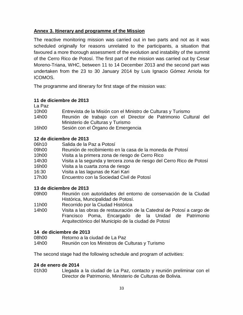
33
Annex 3. Itinerary and programme of the Mission
The reactive monitoring mission was carried out in two parts and not as it was
scheduled originally for reasons unrelated to the participants, a situation that
favoured a more thorough assessment of the evolution and instability of the summit
of the Cerro Rico de Potosí. The first part of the mission was carried out by Cesar
Moreno-Triana, WHC, between 11 to 14 December 2013 and the second part was
undertaken from the 23 to 30 January 2014 by Luis Ignacio Gómez Arriola for
ICOMOS.
The programme and itinerary for first stage of the mission was:
11 de diciembre de 2013 La Paz 10h00 Entrevista de la Misión con el Ministro de Culturas y Turismo 14h00 Reunión de trabajo con el Director de Patrimonio Cultural del
Ministerio de Culturas y Turismo 16h00 Sesión con el Órgano de Emergencia 12 de diciembre de 2013 06h10 Salida de la Paz a Potosí 09h00 Reunión de recibimiento en la casa de la moneda de Potosí 10h00 Visita a la primera zona de riesgo de Cerro Rico 14h30 Visita a la segunda y tercera zona de riesgo del Cerro Rico de Potosí 16h00 Visita a la cuarta zona de riesgo 16:30 Visita a las lagunas de Kari Kari 17h30 Encuentro con la Sociedad Civil de Potosí 13 de diciembre de 2013 09h00 Reunión con autoridades del entorno de conservación de la Ciudad Histórica, Muncipalidad de Potosí. 11h00 Recorrido por la Ciudad Histórica 14h00 Visita a las obras de restauración de la Catedral de Potosí a cargo de
Francisco Poma, Encargado de la Unidad de Patrimonio Arquitectónico del Municipio de la ciudad de Potosí
14 de diciembre de 2013 08h00 Retorno a la ciudad de La Paz 14h00 Reunión con los Ministros de Culturas y Turismo The second stage had the following schedule and program of activities: 24 de enero de 2014 01h30 Llegada a la ciudad de La Paz, contacto y reunión preliminar con el
Director de Patrimonio, Ministerio de Culturas de Bolivia.

34
25 de enero de 2014 06h:00 Salida por avión cancelada a la ciudad de Potosí por mal tiempo
(lluvia ininterrumpida) 18h00 Salida alternativa por avión a la ciudad de Sucre cancelada por mal
tiempo (lluvia ininterrumpida) 26 de enero de 2014 9h00 Salida por avión a la ciudad de Sucre para viajar a Potosí por
carretera.Traslado interrumpido por bloqueo de Cooperativas Mineras en la población de Betanzos, aproximadamente a la mitad del recorrido.
2h00 Llegada a la ciudad de Potosí. Recorrido por la ciudad. 27 de enero de 2014 09h00 Visita al Cerro Rico encaminada a observar las condiciones laborales
y de seguridad, poniendo énfasis en el sector entre la cima, hasta la cota 4.400. Se visitan y revisa el estado de conservación e intervenciones en el Cerro Rico en las zonas de la cima, sector de relleno, camino y plataformas.
12h30 Visita a las Lagunas de represamiento de aguas del Kari Kari 13:30 Reunión con el Gobernador del Gobierno Autónomo Regional de
Potosí Félix Gonzáles Bernal para revisar la problemática de hundimiento y asentamientos recientes de la cima del Cerro Rico.
15h00 Visita a las obras de restauración de la Catedral de Potosí a cargo de Francisco Poma, Encargado de la Unidad de Patrimonio Arquitectónico del Municipio de la ciudad de Potosí
16h00 Reunión Informativa sobre el estado general del Cerro Rico y de la Ciudad Histórica.Reunión con autoridades del entorno minero metalúrgico para la evaluación de los estudios científicos del Cerro Rico, documentos técnicos de los proyectos implementados en la cima. Esta misma visita presentaría la nueva propuesta de reglamentación de la actividad minera. Participan: Ministerio de Minería y Metalurgia, Ministerio de Trabajo y Previsión Social, Ministerio de Culturas y Turismo, Corporación Minera de Bolivia, Gobierno Autónomo Departamental de Potosí, Gobierno Autónomo Municipal de Potosí y empresa Q&Q.
18h00 Recorrido por el Ingenio Minero de Dolores y por la ciudad histórica para evaluar las acciones implementadas para la conservación de la ciudad.
28 de enero de 2014 09h00 Retorno emergente a La Paz desde Potosí por posibilidad de
cancelación de vuelos por lluvia. 16h00 Reunión con Punto Focal boliviano para UNESCO y con el Director
de Patrimonio, Ministerio de Culturas de Bolivia.
35
29 de enero de 2014 15h30 Reunión con el Órgano de Emergencia Participan: Ministerio de
Minería y Metalurgia, Ministerio de la Presidencia, Ministerio de Medio Ambiente y Aguas, Ministerio de Relaciones Exteriores y Ministerio de Culturas y Turismo.

36
Annex 4: Decisions of the World Heritage Committee
Decisión: 37 COM 7B.91
The World Heritage Committee,
1. Having examined Document WHC-13/37.COM/7B.Add,
2. Recalling Decision 36 COM 7B.96, adopted at its 36th session (Saint-
Petersburg, 2012),
3. Takes note of the information submitted by the State Party and regrets that
insufficient details were provided to comprehensively assess the current
factors affecting the property;
4. Reiterates its requests the State Party to:
a) Clarify whether Article 6 of Supreme Decree 27787 of October 2004 has
been modified and if the moratorium on all exploration, extraction and
any other interventions under and above ground between altitudes
4400m and 4700m is currently enforced,
b) Provide further details on the scope and extent of operations foreseen
for interventions at the summit of the Cerro Rico,
c) Finalise the scientific studies for Cerro Rico and develop a
comprehensive strategy for its stabilization and monitoring,
d) Provide details on the current arrangements for the management
system for the property, including information on provisions and
timeframes for conservation and rehabilitation works, proposals for
public use and plans for risk management;
5. Requests the State Party to invite an ICOMOS reactive monitoring mission
during 2013 to assess the current state of conservation of the property and to
evaluate whether there are ascertained or potential dangers to the
Outstanding Universal Value of the property would warrant inscription of the
property on the List of World Heritage in Danger;
6. Also requests the State Party to submit to the World Heritage Centre, by 1
February 2014, an updated report on the state of conservation of the
property and the implementation of the above, for examination by the World
Heritage Committee at its 38th session in 2014.
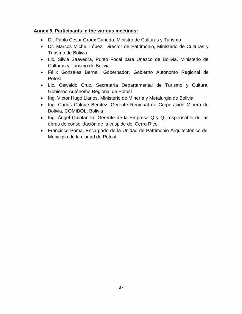
37
Annex 5. Participants in the various meetings:
Dr. Pablo Cesar Groux Canedo, Ministro de Culturas y Turismo
Dr. Marcos Michel López, Director de Patrimonio, Ministerio de Culturas y
Turismo de Bolivia
Lic. Silvia Saavedra, Punto Focal para Unesco de Bolivia, Ministerio de
Culturas y Turismo de Bolivia
Félix Gonzáles Bernal, Gobernador, Gobierno Autónomo Regional de
Potosí
Lic. Oswaldo Cruz, Secretaría Departamental de Turismo y Cultura,
Gobierno Autónomo Regional de Potosí
Ing. Víctor Hugo Llanos, Ministerio de Minería y Metalurgia de Bolivia
Ing. Carlos Colque Benítez, Gerente Regional de Corporación Minera de
Bolivia, COMIBOL, Bolivia
Ing. Ángel Quintanilla, Gerente de la Empresa Q y Q, responsable de las
obras de consolidación de la cúspide del Cerro Rico
Francisco Poma, Encargado de la Unidad de Patrimonio Arquitectónico del
Municipio de la ciudad de Potosí
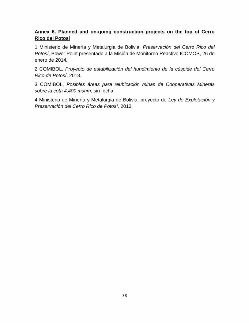
38
Annex 6. Planned and on-going construction projects on the top of Cerro
Rico del Potosí
1 Ministerio de Minería y Metalurgia de Bolivia, Preservación del Cerro Rico del
Potosí, Power Point presentado a la Misión de Monitoreo Reactivo ICOMOS, 26 de
enero de 2014.
2 COMIBOL, Proyecto de estabilización del hundimiento de la cúspide del Cerro
Rico de Potosí, 2013.
3 COMIBOL, Posibles áreas para reubicación minas de Cooperativas Mineras
sobre la cota 4,400 msnm, sin fecha.
4 Ministerio de Minería y Metalurgia de Bolivia, proyecto de Ley de Explotación y
Preservación del Cerro Rico de Potosí, 2013.
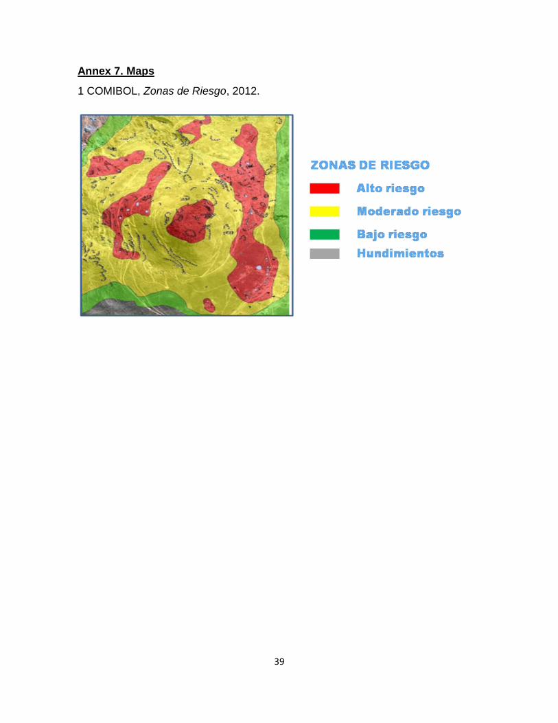
39
Annex 7. Maps
1 COMIBOL, Zonas de Riesgo, 2012.

40
2 COMIBOL. Proyecto relleno de la cúspide del Cerro Rico.
P L ANO DE MENSURA
P ROY ECT O REL L ENO CUSPIDE
12
3
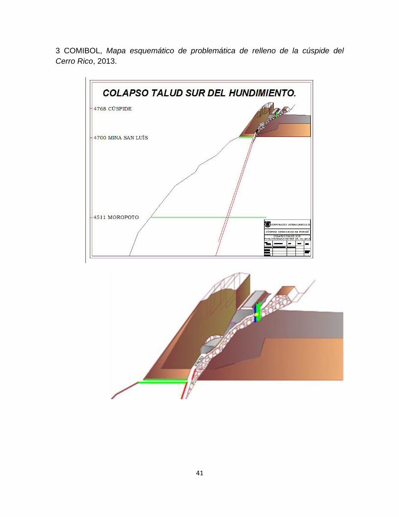
41
3 COMIBOL, Mapa esquemático de problemática de relleno de la cúspide del
Cerro Rico, 2013.

42
4 Estado Plurinacional de Bolivia, Inscribed Heritage Area (UNESCO) Buffer Zone,
2012.
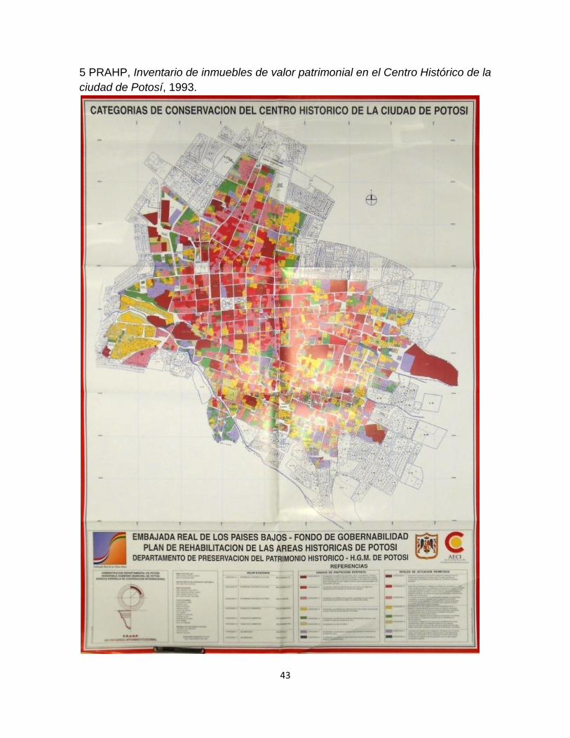
43
5 PRAHP, Inventario de inmuebles de valor patrimonial en el Centro Histórico de la
ciudad de Potosí, 1993.

44
Annex 8. Photographs
General aspect of the World Heritage site of the historic City of Potosí. Google Earth image, 2014.
View of the city of Potosí, Cerro Rico and Kari Kari lagoons complex. Google Earth image, 2014.

45
Engraving from 16th century that shows the landscape of the site.
The current image of cultural landscape of Potosí is relatively preserved in its overall image.
The city of Potosí from Cerro Rico. Appearance of the beginning of the collapse of
the peak of the Cerro Rico in 2011. Photo Empresa Q & Q.
Inspection of the sinking. Photo Empresa Q & Q.
Revision of the collapse. Photo Empresa Q & Q.
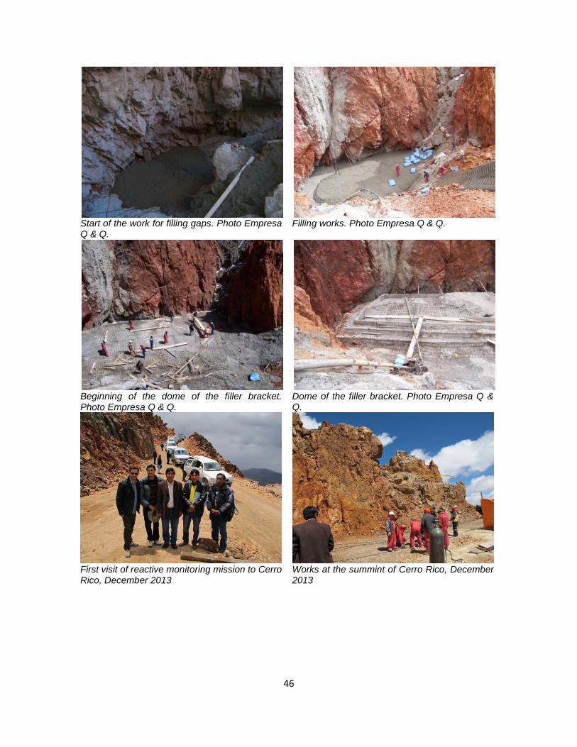
46
Start of the work for filling gaps. Photo Empresa Q & Q.
Filling works. Photo Empresa Q & Q.
Beginning of the dome of the filler bracket. Photo Empresa Q & Q.
First visit of reactive monitoring mission to Cerro Rico, December 2013
Dome of the filler bracket. Photo Empresa Q & Q.
Works at the summint of Cerro Rico, December 2013
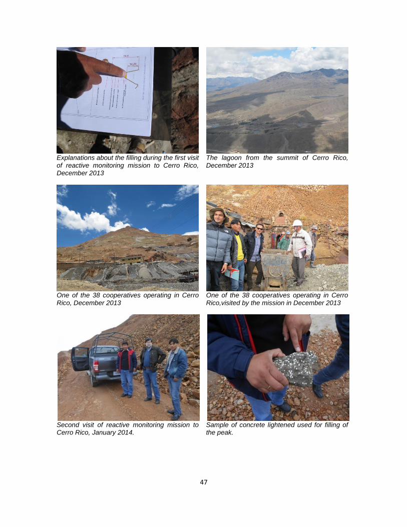
47
Explanations about the filling during the first visit of reactive monitoring mission to Cerro Rico, December 2013
One of the 38 cooperatives operating in Cerro Rico, December 2013
The lagoon from the summit of Cerro Rico, December 2013
One of the 38 cooperatives operating in Cerro Rico,visited by the mission in December 2013
Second visit of reactive monitoring mission to Cerro Rico, January 2014.
Sample of concrete lightened used for filling of the peak.

48
Fracture of the filling structure caused by the recent collapses in the Cerro Rico caused by the extraction of mineral and heavy rainfall.
Collapse of the structure of filling.
Inner aspect of the cavity under the filling of concrete lightened.
Separation of the filling of light concrete and the inside of the sinking.
Inspection visit of COMIBOL to site. Visit of evaluation of the damage at the top of
the Cerro Rico.
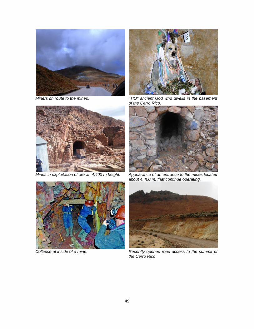
49
Miners on route to the mines. "TIO" ancient God who dwells in the basement of the Cerro Rico.
Mines in exploitation of ore at 4,400 m height. Appearance of an entrance to the mines located
about 4,400 m. that continue operating.
Collapse at inside of a mine.
Recently opened road access to the summit of the Cerro Rico

50
Panorama of the landscape around Kari Kari lagoons.
One of the colonial dams still in use.
Artificial Kari Kari lagoons complex that maintains its authenticity and integrity.
A water box that controls the flow of the fluid into the city of Potosí.
Water pipe in the Kari Kari hydraulic complex.
Appearance of new buildings without regulation of urban image in the accesses to the complex of lagoons.

51
Landscape of the site, December 2013
Cables affecting the visual qualities of the City of Potosí, December 2013
Properly maintained public space in Potosí, December 2013
Varied pavement and graffiti in the city center of Potosí, December 2013
Traditional residence architecture with stone foundations and solid walls of adobe, December 2013
Wooden and glass balcony that acts as protection against the climate, December 2013

52
Mint of Potosí, one of the restored historic buildings.
Water box in Potosí, newly restored but without current use.
One of the alleys intervened to pavements and traditional appearance.
Rehabilitation works at a plaza in Potosí.
Completion of the restoration work of the Potosí Cathedral.
Nocturnal illumination at emblematic buildings of the city.
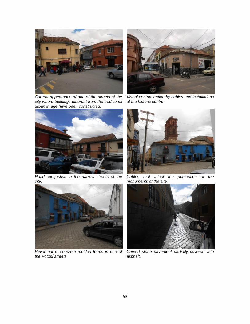
53
Current appearance of one of the streets of the city where buildings different from the traditional urban image have been constructed.
Visual contamination by cables and installations at the historic centre.
Road congestion in the narrow streets of the city.
Cables that affect the perception of the monuments of the site.
Pavement of concrete molded forms in one of the Potosí streets.
Carved stone pavement partially covered with asphalt.

54
Panorama of the Ribera de los Ingenios that retains its historical image.
Historic water channel that still feeds some mining installations from the Kari Kari lagoons.
Historical mining machinery preserved in some mining installations.
Room for the historic benefit of metals still in use.
The uncontrolled inclusion of new architecture without consideration of the traditional building types of Potosí can affect the authenticity and integrity of the site.
New construction without clear regulations for the conservation of the traditional urban image is affecting the Ribera de los Ingenios.


