86
EPA/ROD/R2006020001437 2006 EPA Superfund Record of Decision: NAVAL WEAPONS STATION EARLE (SITE A) EPA ID: NJ0170022172 OU 06 COLTS NECK, NJ 08/15/2006

EPA/ROD/R20060200014372006
EPA Superfund
Record of Decision:
NAVAL WEAPONS STATION EARLE (SITE A) EPA ID: NJ0170022172 OU 06COLTS NECK, NJ08/15/2006

UNITED STATES ENVIRONMENTAL PROTECTION AGENCY REGION 2
290 BROADWAY NEW YORK, NY 10007-1866
AUG 15 2006
Captain W. J. Robertson Commanding Officer Naval Weapons Station Earle Code 043 201 Highway 34 South Colts Neck, New Jersey 07722-501 4
Re: Transmittal of Signed Record of Decision for Sites 3 and 10 (Operable Unit 6) at NavalWeapons Station Earle
Dear Captain W. J. Robertson:
Enclosed is a copy of the signed Record of Decision for Sites 3 and 10 (Operable Unit 6)at Naval Weapons Station (NWS) Earle, Colts Neck, New Jersey. Based on our review of NWSEarle's Investigation Report and Feasibility Study, the U. S. Environmental Protection Agency(EPA) concurs with the Record of Decision.
The Record of Decision calls for the following action at the facility:
Site 3 - Landfill Southwest of "F" Group (Operable Unit 6): limited removal ofprotruding landfill contents, additional soil cover, grading and vegetation will be placed over thelandfill to reduce infiltration, promote drainage, limit erosion, and preclude potential contactwith the landfill contents. Land use controls will be implemented including establishment of aClassification Exception Area. Long-term groundwater monitoring will be conducted to assesscontaminant status and potential threats to human health and the environment. A cable-typefence will be erected around the site.
Site 10 - Scrap Metal Landfill (Operable Unit 6): A RCRA-type cap will be placedover the landfill to prevent potential human and animal contact with landfill materials and reduceinfiltration of surface water. Land use controls will be implemented including establishment of aClassification Exception Area. Long-term groundwater monitoring will be conducted to assesscontaminant status and potential threats to human health and the environment. A cable-typefence will be erected around the site.
This decision document addresses only the above sites. Other areas of concern eitherhave already been addressed through removal actions or will be addressed in future Records ofDecision.

If you have any questions regarding the subject of this letter, please contact me or haveyour staff contact Jessica Mollin, EPA Project Manager, at (212) 637-3921.
cc: B. Venner, NJDEP F. LaGreca, E. Helms, Navy-Earle L. Jargowsky, RAB Chair

RECORD OF DECISION OPERABLE UNIT 6 (OU 6)
Sites 3 and 10
NAVAL WEAPONS STATION EARLE Colts Neck, New Jersey
Naval Facilities Engineering Command Mid-Atlantic
Contract Number N62472-03-D-0057 Contract Task Order 033
August 2006
RECORD OF DECISION NAVAL WEAPONS STATION EARLE
OPERABLE UNIT 6
TABLE OF CONTENTS
PART I - DECLARATION
SECTION PAGE
I. SITE NAME AND LOCATION I-1 II. STATEMENT OF BASIS AND PURPOSE I-1III. ASSESSMENT OF THE SITE I-2IV. DESCRIPTION OF THE SELECTED REMEDY I-2V. STATUTORY DETERMINATION I-5
PART II - DECISION SUMMARY
I. SITE NAME, LOCATION AND DESCRIPTION II-1II. SITE HISTORY AND ENFORCEMENT ACTIVITY II-4III. HIGHLIGHTS OF COMMUNITY PARTICIPATION II-7IV. SCOPE AND ROLE OF OPERABLE UNIT5 II-7V. SUMMARY OF SITE CHARACTERISTICS II-8 VI. SUMMARY OF SITE RISKS II-28 VII. REMEDIAL ACTION OBJECTIVES II-32VIII. DESCRIPTION OF REMEDIAL ACTION ALTERNATIVES II-32IX. SUMMARY OF COMPARATIVE ANALYSIS OF ALTERNATIVES II-38X. THE SELECTED REMEDY II-53XI. STATUTORY DETERMINATIONS II-64XII. DOCUMENTATION OF SIGNIFICANT CHANGES II-69
PART III - RESPONSIVENESS SUMMARY
I. OVERVIEW III-1II. BACKGROUND ON COMMUNITY INVOLVEMENT III-1III. SUMMARY OF MAJOR QUESTIONS AND COMMENTS III-2
APPENDICESA NJDEP Concurrence Letter B Terms Used in the Record of DecisionC Attendance List, May 10, 2001 Public MeetingD Public Comments and Government Response
L/DOCUMENTS/NAVY/2128/18254 i CTO-843

RECORD OF DECISION NAVAL WEAPONS STATION EARLE
OPERABLE UNIT 6
TABLE OF CONTENTS (continued)
TABLES
TABLE
1 Site 3 - Occurrence and Distribution of Inorganics in Surface Soils II-182 Site 3 - Occurrence and Distribution of Inorganics in Sediment II-193 Site 3 - Occurrence and Distribution of Organics in Sediment II-204 Site 3 - Occurrence and Distribution of Inorganics in Groundwater II-215 Site 3 - Occurrence and Distribution of Organics in Groundwater II-226 Site 10 - Occurrence and Distribution of Inorganics in Groundwater II-267 Site 3 - Screening of Remedial Alternatives II-338 Site 10 - Screening of Remedial Alternatives II-349 Site 3 - Comparative Analysis of Remedial Action Alternatives II-4010 Site 10 - Comparative Analysis of Remedial Action Alternatives II-49
FIGURES
FIGURE
1 Regional Site Map II-22 Mainside Site Location II-33 Site 3 - Landfill Southwest of "F' Group II-54 Site 10 - Scrap Metal Landfill II-65 Site 3 - Groundwater Contour Map (August 7, 1995) II-126 Site 10 - Groundwater Contour Map (August 7, 1995) II-137 Site 10 - Groundwater Contour Map (October 17, 1995) II-148 Site 3 - Concentrations Exceeding Reference Criteria II-239 Site 10 Concentrations Exceeding Reference Criteria II-2710 Site 3 - Alternative 2 Plan View II-5511 Site 3 - Conceptual Cover System Design Site 3 II-5612 Site 3 - Estimated Soil and Groundwater Land Use Control Limits II-5813 Site 10 - Alternative 3 Plan View II-6014 Site 10 - Conceptual Cover System Design II-6115 Site 10 - Estimated Soil and Groundwater Land Use Control Limits II-63
L/DOCUMENTS/NAVY/2128/18254 ii CTO-843

RECORD OF DECISION NAVAL WEAPONS STATION EARLE
OPERABLE UNIT 6
PART I - DECLARATION
I. SITE NAME AND LOCATION
Naval Weapons Station Earle Colts Neck, Monmouth County, New Jersey ID Number: NJ0170022172 Operable Unit 6 - Landfill Southwest of "F " Group (Site 3) and Scrap Metal Landfill (Site 10)
II. STATEMENT OF BAS1S AND PURPOSE
This Record of Decision (ROD) presents the remedial action alternative selected for Operable Unit6 (OU 6) to address soi1 and groundwater contamination at the Naval Weapons Station (NWS) EarleSite, located in Colts Neck, New Jersey OU 6 includes the landfill southwest of "F " group (Site 3)and the scrap metal landfill (Site 10), that have been grouped together as OU 6 based on their similarpotential effect on human and/or environmental receptors.
This remedial action decision is in accordance with the Comprehensive Environmental Response,Compensation, and Liability Act of 1980 as amended (CERCLA) and the National Oil andHazardous Substances Pollution Contingency Plan (NCP). This decision document explains thefactual and legal basis for selecting the remedial action and is based on the Administrative Recordfor OU 6. Remedial Investigation/Feasibility Studies (RI/FS) reports and other information used inthe remedy selection process are part of the Administrative Record file for OU 6, which is availableat the Monmouth County Library, Eastern Branch, Route 35, Shrewsbury, New Jersey.
The New Jersey Department of Environmental Protection (NJDEP) has commented on the selectedremedy and concurs, NJDEP comments have been incorporated into this ROD. A review of thepublic response to the Proposed Plan is included in the Responsiveness Summary (Part III) of thisdecision document The state concurrence letter is included in Appendix A. Terms used in the RODare presented in Appendix B.
III. ASSESSMENT OF THE SITE
Pursuant to duly delegated authority, I hereby determine, pursuant to Section 106 of CERCLA, 42U. S.C. § 9606, that actual or threatened releases of hazardous substances from OU 6, as discussedin Section VI (Summary of Site Risks) of this ROD, if not addressed by implementing the remedialaction selected in this ROD, may present an imminent and substantial endangerment to publichealth, welfare, or the environment.
L/DOCUMENTS/NAVY/2128/18254 I-1 CTO-843

IV. DESCRIPTION OF THE SELECTED REMEDY
The Department of the Navy (Navy) and the United States Environmental Protection Agency (EPA),in consultation with NJDEP, have selected the following remedies for OU 6, Sites 3 and 10. Theremedies address cover/capping of each landfill, institutional controls, and long-term groundwatermonitoring. The selected remedies for Sites 3 and 10 include the following major components:
Site 3
1. Limited removal of protruding landfill contents, additional soil cover, grading, andvegetation will be placed over the former landfill to reduce infiltration, promote drainage,limit erosion, and preclude potential contact with the landfill contents.
2. Land use controls (LUCs) will be implemented by the Navy according to the documententitled "Principles and Procedures for Specifying, Monitoring and Enforcement of LandUse Controls and other Post-ROD actions" as agreed between EPA and the Department ofDefense (DoD). A Remedial Design (RD) for LUCs will be incorporated into the BaseMaster Plan to limit future uses of the site to prevent disturbance of the landfill cover systemor direct contact with contaminated media such as landfill contents and groundwater use.Activities to be prohibited will include digging into or disturbing the landfill cover orcontents of the landfill, residential development on the site. and use of untreated groundwaterfrom the aquifer beneath the site for purposes other than environmental monitoring andtesting without Navy approval until groundwater is found to meet the New Jerseygroundwater quality standards (GWQS) and EPA Safe Drinking Water Act (SDWA)maximum contaminant levels (MCLs). A Classification Exception Area (CEA) pursuant toNew Jersey Administrative Code (N.J.A.C) 79-6 will be established to provide the stateofficial notice that the constituent standards will not be met for a specified duration and toensure that use of the groundwater in the affected area is prohibited until two consecutivesampling events result in no groundwater contaminant concentrations in excess of GWQS.The Navy is responsible for implementing, maintaining, reporting on, and enforcing the landuse controls described in the ROD in accordance with the RD for LUG. Land use controlswill be maintained until the concentrations of hazardous substances in the soil andgroundwater are at such levels to allow for unrestricted use and exposure.
The LUC objectives are: a) Maintain the integrity of any current or future remedial or monitoring system such
as monitoring wells, fencing, signage and the landfill cover; b) Except for environmental monitoring, prevent access or use of untreated groundwater
until cleanup levels are met; c) Prohibit the development and use of property for residential housing, elementary and
secondary schools, child care facilities and playgrounds; and d) Prohibit excessive vehicular traffic and digging into or disturbing the landfill cover
or contents of the landfill.
These objectives will be implemented through mechanisms, such as the RD for LUC amended tothe Base Master Plan, fencing and signage at the landfill cover, 30 years of operations andmaintenance (O&M) and annual status reporting for the cover, establishment of theNJDEP-compliant CEA and conduct of a site review every five years.
L/DOCUMENTS/NAVY/2128/18254 I-2 CTO-843
3. A cable-type fence with locking gates and appropriate warning signs will be erected aroundthe landfill to limit access to the site, to preclude excessive vehicular traffic, to restricthuman contact with contaminated landfill materials, and to protect the integrity of the soilcover.
4. Long-term periodic groundwater monitoring will be conducted to assess contaminant statusand potential threats to human health and the environment. Since wastes will be left in place,site conditions and risks will be reviewed every five years.
Site 10
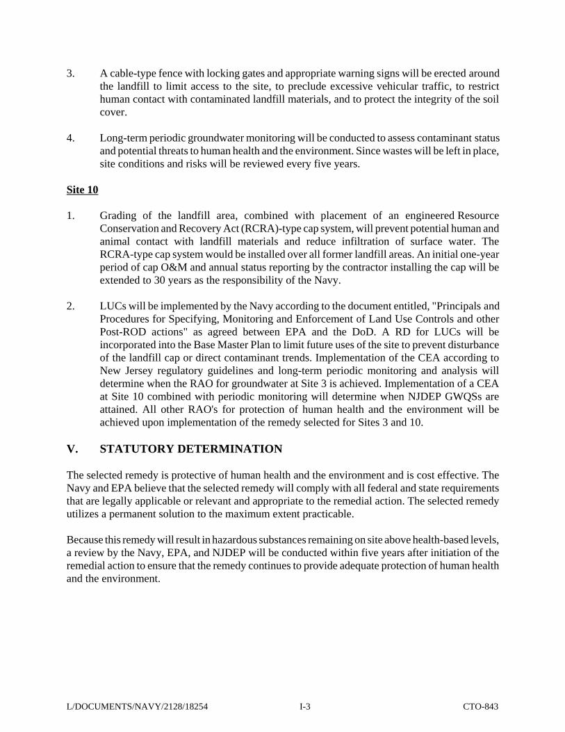
1. Grading of the landfill area, combined with placement of an engineered ResourceConservation and Recovery Act (RCRA)-type cap system, will prevent potential human andanimal contact with landfill materials and reduce infiltration of surface water. TheRCRA-type cap system would be installed over all former landfill areas. An initial one-yearperiod of cap O&M and annual status reporting by the contractor installing the cap will beextended to 30 years as the responsibility of the Navy.
2. LUCs will be implemented by the Navy according to the document entitled, "Principals andProcedures for Specifying, Monitoring and Enforcement of Land Use Controls and otherPost-ROD actions" as agreed between EPA and the DoD. A RD for LUCs will beincorporated into the Base Master Plan to limit future uses of the site to prevent disturbanceof the landfill cap or direct contaminant trends. Implementation of the CEA according toNew Jersey regulatory guidelines and long-term periodic monitoring and analysis willdetermine when the RAO for groundwater at Site 3 is achieved. Implementation of a CEAat Site 10 combined with periodic monitoring will determine when NJDEP GWQSs areattained. All other RAO's for protection of human health and the environment will beachieved upon implementation of the remedy selected for Sites 3 and 10.
V. STATUTORY DETERMINATION
The selected remedy is protective of human health and the environment and is cost effective. TheNavy and EPA believe that the selected remedy will comply with all federal and state requirementsthat are legally applicable or relevant and appropriate to the remedial action. The selected remedyutilizes a permanent solution to the maximum extent practicable.
Because this remedy will result in hazardous substances remaining on site above health-based levels,a review by the Navy, EPA, and NJDEP will be conducted within five years after initiation of theremedial action to ensure that the remedy continues to provide adequate protection of human healthand the environment.
L/DOCUMENTS/NAVY/2128/18254 I-3 CTO-843
L/DOCUMENTS/NAVY/2128/18254 I-4 CTO-843

RECORD OF DECISION NAVAL WEAPONS STATION EARLE OPERABLE UNIT 8 (SITES 3 AND 10)
PART II - DECISION SUMMARY
1. SITE NAME, LOCATION, AND DESCRIPTION
A. General
NWS Earle is located in Monmouth County, New Jersey, approximately 47 miles south of NewYork City. The station consists of two areas, the 10,248-acre Main Base (Mainside area), locatedinland, and the 706-acre Waterfront area, located on the Sandy Hook Bay (Figure 1). The two areasare connected by a Navy-controlled right-of-way. The facility was commissioned in 1943, and itsprimary mission is to supply ammunition to the naval fleet. An estimated 2,500 people either workor live at NWS Earle.
The Mainside area is located approximately 10 miles inland from the Atlantic Ocean in Colts Neck,Howell and Wall Township, and Tinton Falls Borough. The combined population of thesemunicipalities is approximately 100,000 people. The surrounding area includes agricultural land,vacant land, and low-density housing. The Mainside area consists of a large, undeveloped portionassociated with ordnance operations, production, and storage; this portion is encumbered byexplosive safety quantity distance arcs. Other land use in the Mainside area consists of residences,offices, workshops, warehouses, recreational space, open space, and undeveloped land. TheWaterfront area is located adjacent to Sandy Hook Bay in Middletown Township, which has apopulation of approximately 68,200 people. The Mainside and Waterfront areas are connected bya narrow strip of land that serves as a government-controlled right-of-way containing a road andrailroad.
OU 6 consists of two former landfills located in the Mainside area: the landfill southwest of "F"group (Site 3) and the scrap metal landfill (Site 10) (Figure 2). Site 3 is located in Howell Townshipand Site 10 is located in Colts Neck Township. The OU 6 sites were grouped together based onsimilarities of potential for contaminants to migrate to human and/or environmental receptors. Abrief description of each of these sites follows.
B. Site 3: Landfill Southwest of "F" Group
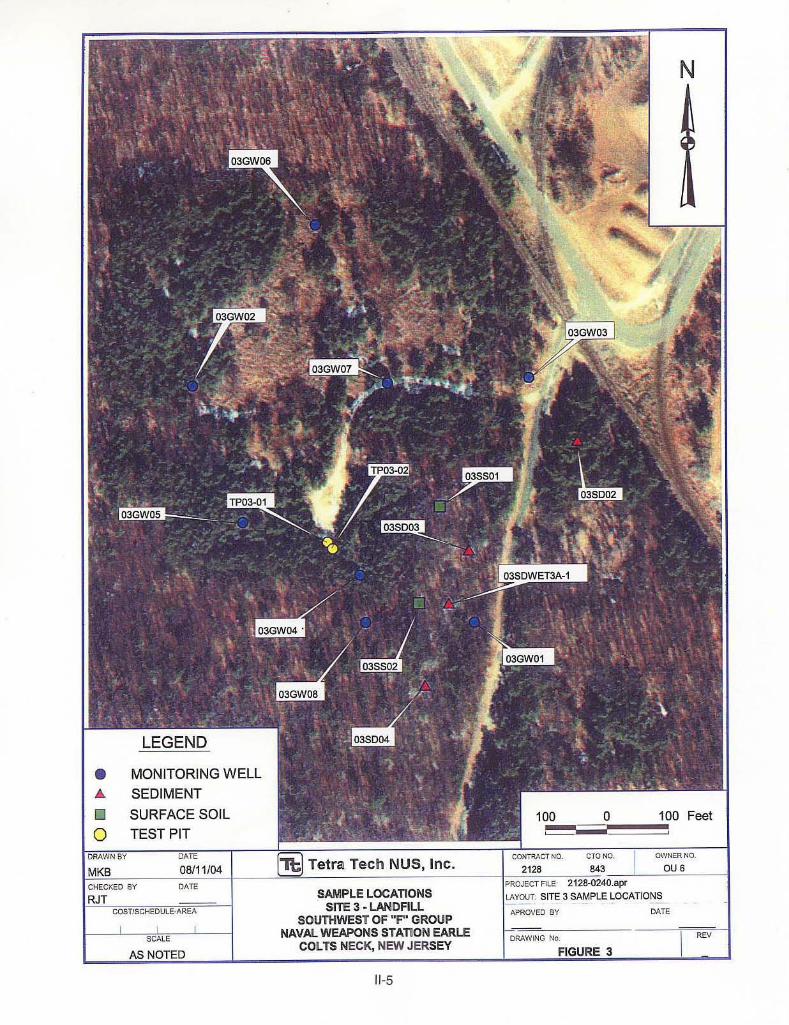
The landfill southwest of "F" group (Figure 3) is a 5-acre site that was used from 1960 to 1968 forthe disposal of domestic and industrial wastes. Typical thickness of fill material ranges from about2 to4 feet. Industrial wastes reportedly disposed at Site 3 consisted of paints and paint thinners,solvents, varnishes, shellac, acids, alcohols, caustics, pesticide containers and rinse water, wood, andsmall amounts of asbestos. A thin layer of sandy soil was placed to cover the landfill contents.
C. Site 10: Scrap Metal Landfill
The scrap metal landfill (Figure 4) is a 2-acre site that was used from 1953 to 1965 for the disposal
L/DOCUMENTS/NAVY/2128/18254 II-1 CTO-843


of demilitarized munitions and spent munitions cases. There is no known evidence that any liveammunition is interred at the site. Only certified-inert (i.e., no energetic potential remaining)materials were reported to have been disposed here. An estimated 65,000 cubic yards, whichincludes cover material, were disposed at the site. The disposed material consisted primarily ofaluminum and steel containers. Spent grit and paint chips from the ammunition re-work operationswere also buried. The landfill was primarily covered with a very thin covering of sandy soil.
II. SITE HISTORY AND ENFORCEMENT ACTIVITY
Potential hazardous substance releases at NWS Earle were addressed in an Initial Assessment Study(IAS) in 1982, a Site Inspection Study (SI) in 1986, and a Phase I Remedial Investigation (RI) in1993. These were preliminary investigations to determine the number of sources, compile historiesof waste-handling and disposal practices at the sites, and acquire data on the types of contaminantspresent and potential human health and/or environmental receptors. The RI investigation at Sites 3and 10 included the installation and sampling of monitoring wells, collection of soil, surface water,and sediment samples, and excavation of test pits to observe wastes and sample subsurface soils.
In 1990, NWS Earle was placed on the National Priorities List (NPL), which is a list of sites whereuncontrolled hazardous substance releases may potentially present serious threats to human healthand the environment. The sites at NWS Earle were then addressed by Phase II RI activities todetermine the nature and extent of contamination at these sites. Activities included installation andsampling of groundwater monitoring wells, surface water and sediment sampling, and surface andsubsurface soil sampling.
The Phase II RI was initiated in 1995 and completed in July 1996, when the final RI Report wasreleased. An addendum remedial investigation, consisting of additional surface soil samples fromthe southeastern face of the Site 3 landfill and sediment samples from the drainage pathwaysoutheast of Site 3 were obtained in 1996 to determine if the landfill could be the source ofcontamination seen in one sediment sample taken from the wetlands area south of Site3 previously.
Results from the final RI and Addendum RI report, including human health and ecological riskassessment, were used as the basis for performing a feasibility study (FS) of potential remedialalternatives. Based on the alternatives development from the feasibility study, the Navy and EPA,in consultation with NJDEP, prepared the Proposed Remedial Action Plan (Proposed Plan). TheProposed Plan is the basis for the selected remedial alternatives presented in this ROD. The RI, FS,Proposed Plan, and community input are discussed h this ROD.
There is a substantial gap between the public comment period (April 23, 2001 to May 23, 2001) forthe Proposed Plan and submission of the final ROD (June 2005) due to policy negotiations betweenDoD and EPA regarding the approach to ensuring implementation of land use controls.
III. HIGHLIGHTS OF COMMUNITY PARTICIPATION
The documents that the Navy and EPA used to develop, evaluate, and select a remedial alternativefor OU 6 have been maintained in the official Administrative Record repository at the MonmouthCounty Library (Eastern Branch), Route 35, Shrewsbury, New Jersey.
The Feasibility Study Report, Proposed Plan, and other documents related to OU 6 were released
L/DOCUMENTS/NAVY/2128/18254 II-4 CTO-843


to the public in September 2000. The notice of availability of these documents was published in theAsbury Park Press on May 5,6, and 7,2001. A public comment period was held from April 23,2001to May 23, 2001.
A public meeting was held during the public comment period on May 10, 2001. At this meeting.representatives from the Navy and EPA were available to answer questions about OU 6 and theremedial alternatives under consideration. The results of the public comment period are included inthe Responsiveness Summary, which is included in Part Ill of this ROD.
IV. SCOPE AND ROLE OF RESPONSE ACTION FOR OPERABLE UNIT 5
The Navy completed an RI, FS, and Proposed Plan for OU 6, addressing contamination associatedwith Sites 3 and 10 at NWS Earle. These studies showed that groundwater and/or soils in the areasof the former landfills had been contaminated with metals and some organic compounds such assemivolatile compounds and pesticides. The final remedial action to address site contamination ateach landfill is described in this document.
V. SUMMARY OF SITE CHARACTERISTICS
A. General
NWS Earle is located in the coastal lowlands of Monmouth County, New Jersey, within the AtlanticCoastal Plain Physiographic Province. The Mainside area, which includes OU 6, lies in the outerCoastal Plain, approximately 10 miles inland from the Atlantic Ocean. The Mainside area isrelatively flat, with elevations ranging from approximately 100 to 300 feet above mean sea level.The most significant topographic relief within the Mainside area is Hominy Hills, a northeast-southwest-trending g roup of low hills located near the center of the station. The New Jersey CoastalPlain is a seaward-dipping wedge of unconsolidated Cretaceous to Quaternary sediments that weredeposited on a pre-Cretaceous basement-bedrock complex. The Coastal Plain sediments areprimarily composed of clay, silt, sand, and gravel and were deposited in continental, coastal, andmarine environments. The sediments generally strike northeast-southwest and dip to the southeastat a rate of 10 to 60 feet per mile. The approximate thickness of these sediments beneath NWS Earleis 900 feet. The pre-Cretaceous complex consists mainly of Precambrian and lower Paleozoiccrystalline rocks and metamorphic schists and gneisses. The Cretaceous to Miocene Coastal PlainFormations are either exposed at the surface or subcrop in a banded pattern that roughly parallelsthe shoreline. The outcrop pattern is caused by the erosion truncation of the dipping sedimentarywedge. Where these formations are not exposed, they are covered by essentially flat-lying post-Miocene surficial deposits.
The rivers and streams draining NWS Earle ultimately discharge to the Atlantic Ocean, which isapproximately 9 or 10 miles east of the Mainside area. There are six different watersheds thatoriginate on the Mainside Area. The headwaters and drainage basins of three major Coastal Plainrivers (Swimming, Manasquan, and Shark) originate on the Mainside area. The northern ha# of theMainside is in the drainage basin of the Swimming River, and tributaries include Mine Brook,Hockhockson Brook, and Pine Brook. The southwestern portion of the Mainside drains to theManasquan River via either Marsh Bog Brook or Mingamahone Brook. The southeastern corner ofthe Mainside drains to the Shark River. Both the Swimming River and the Shark River supply waterto reservoirs used for public water supplies.
L/DOCUMENTS/NAVY/2128/18254 II-7 CTO-843

Groundwater classification areas were established under NJDEP Water Technical ProgramsGroundwater Quality Standards in N.J.A.C. 7:9-6. The Mainside area is located in the Class Il-A:Groundwater Supporting Potable Water Supply area. Class II-A includes those areas wheregroundwater is an existing source of potable water with conventional water supply treatment or isa potential source of potable water. In this part of New Jersey, in general, the deeper aquifers areoften used for public water supplies and the shallower aquifers may be used for private home ownerwell domestic supplies.
OU 6 is situated in the recharge area of the Kirkwood-Cohansey aquifer system. The Kirkwood-Cohansey aquifer system is a source of water in Monmouth County and is composed of the generallyunconfined sediments of the Cohansey Sand and Kirkwood Formation. The Kirkwood-Cohanseyaquifer system has been reported in previous investigations as being used for residential wells in theMainside area. Along the coast, this aquifer system is underlain by thick diatomaceous clay beds ofthe Kirkwood Formation.
All facilities located in the Mainside Administration area are connected to a public water supply(New Jersey American Water Company). Water for the public supply network comes from surfacewater intakes, reservoirs, and deep wells. No public water supply wells or surface water intakes arelocated on the NWS Earle facility. A combination of private wells and public water supply from theNew Jersey American Water Company serves businesses and residences in areas surrounding theMainside facilities. There are a number of private wells located within a 1-mile radius of NWS Earleand several within the NWS Earle boundaries. Although the majority of the off-Base wells are usedfor potable supplies, none is near enough to either OU 6 site to possibly be impacted. On-Base wells(located at remote building locations) are not used for potable water supply.
There is a rich diversity of ecological systems and habitats at NWS Earle. Knieskern's beaked-rush(Rynchosorra knieskernii), a sedge species on the federal endangered list, has been seen on thestation, and some species on the New Jersey endangered list, such as the swamp pink (Heloniasbullata), may be present. An osprey has visited Mainside and may nest in another area at NWSEarle. The Mingamahone Brook supports bog turtles downstream of the Mainside area and providesan appropriate habitat for them at the Mainside area.
B. Surface Water Hydrology
1. Site 3
Site 3 is characterized as an open area surrounded by woodlands. The site is moderately vegetatedwith grasses and scrub pines. There are several scarred areas with no vegetation in the northeasternportion of the site. The ground surface is relatively flat, with ground elevations varying between 115and 125 feet above mean sea level (MSL). Wetlands are located southeast of the site. Groundwaterflow is generally to the southeast toward the wetland, based on groundwater-level measurements.
2. Site 10
Site 10 is an open area surrounded by wetlands. The site is accessed via a dirt road from the southand is bordered by railroad tracks to the southeast, a wetland to the north, and a drainage ditch tothe east. The site is vegetated with grasses and pines, except for the access road and an open area(vehicle turn-around area) in the middle where no vegetation exists. The ground surface is relatively
L/DOCUMENTS/NAVY/2128/18254 II-8 CTO-843
flat, with an average elevation approximately 11 0 feet above MSL. The groundwater flow directionis to the northwest, north, and northeast based on measured groundwater levels.
C. Geology
1. Site 3
Regional mapping places Site 3 within the outcrop area of the Kirkwwd Formation. The KirkwoodFormation ranges between 60 and 100 feet in thickness. The lithology of the sediments encounteredin the on-site borings generally agrees with the published description of the Kirkwood andVincentown Formations. In general, the borings encountered white and yellowish-brown, very fine-to fine-grained sand with minor silt and clay layers, dark gray silt and clay (probably representativeof the Kirkwood Formation) and glauconitic, medium- to coarse-grained sand (probablyrepresentative of the Vincentown Formation).
Based upon the boring log descriptions, wells MW3-02 through MW3-07 penetrated the KirkwoodFormation and well MW3-01 penetrated the Kirkwood and Vincentown Formations.
2. Site 10
Regional mapping places Site 10 within the outcrop area of the Kirkwood Formation: uppercolluvium may be present at the site. The Kirkwwd Formation ranges between 60 and 100 feet inthickness. The upper colluvium has a maximum thickness of 10 feet. The lithology of the soilsencountered in the on-site borings generally agrees with the published descriptions of the uppercolluvium and the Kirkwood and Vincentown Formations. The on-site borings were no greater than27.5 feet deep.
Based upon the boring log descriptions, wells MW10-05 and MW10-07 penetrated the uppercolluvium, Kirkwood Formation, and Vincentown Formation, and wells MW10-01 throughMW10-04 and MWl0-06 penetrated the Kirkwwd and Vincentown Formations.
D. Hydrogeology
1. Site 3
Groundwater in the Kirkwood and Vincentown aquifer beneath the site occurs under unconfinedconditions, and the formations are interpreted to be hydraulically connected. Static-water-levelmeasurements and water-table elevations were recorded in August and October 1995. Agroundwater contour map is presented in Figure 5. The direction of shallow groundwater flow in theaquifer, as indicated by the August groundwater elevations, is toward the southeast. An adequaterepresentative sample of water levels could not be obtained in October because most of the wellswere dry. There appears to be a significant seasonal variation in groundwater flow direction. Thehydraulic conductivities calculated for MW3-03 and MW3-06, both of which are screened in theKirkwood Formation, are 7.16 x 10⁻⁴ cm/sec (2.03 ft/day) and 5.50 x 10⁻⁴ cm/sec (1.56 ft/day),respectively.
L/DOCUMENTS/NAVY/2128/18254 II-9 CTO-843


2. Site 10
Groundwater in the upper colluvium, Kirkwood and Vincentown aquifer beneath the site occursunder unconfined conditions, and the formations are interpreted to be hydraulically interconnected.Groundwater contour maps are presented in Figure 6 (August 1995) and Figure 7 (October 1995).The direction of shallow groundwater flow in the aquifer is toward the northwest, north, andnortheast. There does not appear to be a significant seasonal variation in groundwater flow direction.The hydraulic conductivities calculated for MW10-04 (Kirkwood and Vincentown Formation),MW10-05 (upper colluvium, Kirkwood Formation, and Vincentown Formation), and MW10-07(upper colluvium, Kirkwood Formation, and Vincentown Formation) are 2.54 x 10⁻⁴ cm/sec (0.72ft/day). 6.99 x l0-4 cm/sec (1.98 ft/day), and 1.75 x 10⁻³ cm/sec (4.97 ft/day), respectively.
E. Nature and Extent of Contamination
1. Site 3
a. IAS and SI Results
The 1983 IAS consisted of interviews and on-site observations. Based on the potential forgroundwater impacts to the Kirkwood Aquifer, the site was recommended for further investigation.
A confirmation study in 1986 (now known as a site investigation) included the installation andsampling of three monitoring wells, MW3-01 through MW3-03. Groundwater samples were foundto have a relatively low pH, but no compounds were found at concentrations above regulatory limitsat Mat time. No other Site 3 media were sampled in the confirmation study.
b. Phase I Remedial Investigation
The Navy conducted Phase I RI activities in 1993 at NWS Earle. During the RI/FS, seven test pitswere excavated to obtain a physical description of the waste materials and surrounding soils, andfour additional monitoring wells were installed at Site 3 to monitor groundwater quality. Tworepresentative samples of soil in contact with the waste were taken from the test pits to obtain arepresentative characterization of the status of soils in the area.
Based on visual inspection of test pit excavations, the landfill contains typical municipal waste. Thetwo soil samples collected from the test pits were analyzed for Target Compound List (TCL)organics and Target Analyte List (TAL) inorganics and total petroleum hydrocarbons (TPH). Threesemivolatile compounds, fluoranthene, pyrene, and bis(2-ethylhexyl) phthalate, were detected atconcentrations below the method detection limit Barium was detected at a concentration of 1,320mg/kg, TPH was detected at a concentration of 110 mg/kg, and trace levels of pesticides wereencountered in one sample. Barium was the only compound detected at a concentration aboveNJDEP Residential Soil Cleanup Criteria (700 mg/kg). It should also be noted that the duplicatesample (in reference to the high barium concentration sample) had a concentration of only 307mg/kg of barium. The 1993 RI analytical data did not meet validation criteria and was only usedquantitatively in the risk assessment.
Groundwater from all seven wells was collected and analyzed for full TCWAL analytes. Laterrounds of groundwater samples were analyzed for volatile organic compounds (VOCs), drinking
L/DOCUMENTS/NAVY/2128/18254 II-13 CTO-843

water metals, and inorganic landfill indicator parameters at a limited number of wells.
In groundwater samples, an elevated level of arsenic (0.37 ppm) was found in one downgradientwell MW3-01. This high level of arsenic in groundwater was not reproduced in later samplingevents. The elevated reading was obtained from an unfiltered sample. While turbidity was notrecorded during the first sampling round, analysis of a highly turbid sample could yield artificiallyhigh levels of metals due to suspended solids. Given the low recovery from wells at this site and thefine silty sand in the subsurface soils, it is reasonable to assume the high reading for arsenic in thefirst sampling round could have been due to a turbid sample. Turbidity readings from subsequentsampling rounds at Site 3 were as high as 1240 turbidity units versus the primary drinking waterstandard of 1-5 turbidity units. Since subsequent sampling events in all media (includinggroundwater) at Site 3 encountered arsenic at levels near or below the corresponding backgroundarsenic concentration for that medium, this high arsenic reading was not used for the risk assessmentcalculations. Sediment was the only media where background concentrations for arsenic exceededthe regulatory levels.
Elevated levels of VOCs and semivolatile organic compounds (SVOCs) were found in some wells,particularly monitoring well MW3-04 with acetone (970 µg/L) and xylene (470 µg/L). WellsMW304 and MW3-05 had low levels of several pesticide compounds.
Monitoring wells downgradient of the landfill contained higher levels of the landfill indicatorparameters [chemical oxygen demand (COD) (235 to 1,960 mg/l), and sulfate (64.9 to 74.6 mg/l)]than were found in the upgradient well (COD, 96.8 mg/l; sulfate, 14.3). Subsequent analysis in thefinal RI Report concluded that, although this former landfill has some impact on shallowgroundwater quality, the water percolating through the landfill is not indicative of a concentratedleachate that would be in itself an ecological or human health risk.
c. Phase II Remedial Investigation
Between May and October 1995, the Navy conducted the following field investigation activities:
• Soil gas survey and analysis at 25 locations. • Excavation of two test pits. • Drilling and installation of one shallow permanent monitoring well. • Sampling and analysis of groundwater from monitoring wells. • Measurement of static water levels in monitoring wells. • Sampling and analysis of one surface soil in the wetlands southeast of the landfill
(03SDW ET3A-1).
Tables 1 through 5 compare the results of background samples to samples collected at Site 3.
Concentrations of most metals in site-related sediment samples were similar to the range associatedwith background samples. Antimony was found in sediment sample (03SDWET3A-1) at a lowconcentration (1.3 mg/kg) near the instrument detection limit but was not detected in the backgroundsamples. Polycyclic aromatic hydrocarbons (PAHs), including benz(a) anthracene, benzo(a) pyrene,chrysene, dibenz(a, h) anthracene, indeno(l, 2,3-cd) pyrene, fluoranthene, fluorene, and pyrene, weredetected in O3SDWETSA-1 at concentrations two to three times above background concentrations.4-4'-DDT was detected in sediment samples at concentrations ranging from 3 to 4 µg/kg; however,
L/DOCUMENTS/NAVY/2128/18254 II-14 CTO-843

TABLE 1 OCCURRENCE AND DISTRIBUTION OF INORGANICS IN SURFACE SOILS AT SITE 3
NWS EARLE, COLTS NECK, NEW JERSEY (mms)
' - Selected as a COPC
" - Upper Tolerance Limit = UK is the concentration that is Estimated to contain a designated portkx~ (85%) of all possible sample m e a s u m .
"' - Backgmund samples are as follows: BGSB0100, BGSBOXK) (AND A DUPLICATE. DUP-4). BGSBWOO, 86580400.
BACKGROUND"' SITE-RELATED
I I I I I

TABLE 2 OCCURRENCE AND DISTRIBUTION OF INORGANICS IN SEDIMENT AT SITE 3
NWS EARLE, COLTS NECK, NEW JERSEY
I
BACKGROUND"' SITE-RELATED
I I I I I I I I I
' - Selected as a COPC
'̂ - Upper Tolerance Umil= Lm is the mncenlrah that Ls estinated to -in a dasignated piix~ (95%) of all possible sample IneasurementS.
"' - Background samples are as Mbw. BGSWI ,ffiSD02,BGSM)4 through BGSW7.

TABLE 3 ~
OCCURRENCE AND DISTRIBUTION OF ORGANICS IN SEDIMENT AT SITE 3 NWS EARLE, COLTS NECK, NEW JERSEY
' - Selected as a COPC.
" - Badrgmcd samples are as fdlom: BGSW1,ffiSWZ.BGStWl thrwgh BGSW7.

TABLE 4 OCCURRENCE AND DlSTRlBUnON OF INORGANICS IN GROUNDWATER AT SITE 3
NWS EARLE, COLTS NECK, NEW JERSEY (udl)
2 X AVERAGE C O N C E m n O N
' - Selected as a W P C
** - Upper Tolerance Urnit

TABLE 5 OCCURRENCE AND DISTRIBUTION OF ORGANICS IN GROUNDWATER AT SITE 3
NWS EARLE, COLTS NECK, NEW JERSEY (usn)
' - Selected as a COPC.
" - Backgmurd samples are astollows: MN4-94. BGMW-02, BGMW-01, MW26-03, MW3-06. MW5W MWSM. MW1401, MW143, MW5-08. MW11-03


background concentrations as high as 19 µg/kg were detected. Alpha-BHC and heptachlor epoxidewere detected in sample O3SDWET3A-1 at 0.082 µg/kg and 2.2 µg/kg, respectively. With theexception of beryllium, the site-related samples also showed the presence of all the metals found inbackground, in addition to arsenic and thallium. The highest concentrations of metals in Site 3groundwater samples were detected in the sample collected at 03 GW 01. This well and one other(03 GW 03) required sample filtering in the field. The filtered sample from the downgradientlocation, 03 GW 01, exhibited fairly high aluminum levels (5,520 µg/L) and also displayedconcentrations greater than background ranges for antimony and cadmium. Other metals, such asiron, zinc, and barium, were present at considerably lower levels in the filtered sample. Arsenic waspresent in the unfiltered sample at the slightly elevated level of 0.0151 ppm in the unfiltered samplebut at only 0.0045 ppm in the filtered sample. Sample 03 GW 05, collected from a well cross-gradient from the landfill, displayed an elevated level of manganese, and sample 03 GW 06 (anupgradient location) exhibited thallium at a low level. VOCs detected above the GWQS in MW3-04in 1991 could not be replicated. Neither MW3-04 nor the newly Installed MW3-08 yielded sufficientwater to obtain a sample. While a soil gas survey in the vicinity of MW3-04 showed some evidenceof volatile organics, subsequent test pitting, targeted toward the highest soil gas readings, did notfind any significant source of these contaminants. 2-Butanone (5 µg/L) and gamma-chlordane(0.0081 µg/L) were each detected in one groundwater sample collected at Site 3. Neither of thesecompounds was detected in background groundwater samples.
Figure 8 shows sample locations and concentrations of compounds that exceed Applicable orRelevant and Appropriate Requirements (ARARs) and other guidance to be considered (TBC).
2. Site 10
a. IAS and SI Results
An IAS in 1983 consisting of a document search, interviews, and on-site observations concluded thatmaterials present in the landfill were inert or not leaching due to the moderate range of pH valuesin the environment. Erosion of the very thin cover material was noted, along with the exposedcorroded shell casings.
During the 1993 SI, three monitoring wells were installed, and surface water and groundwatersamples were analyzed. Methylene chloride (possible laboratory artifact) was detected at MW10-01,MW10-02, and MW10-03. One metal and one semivolatile compound were detected in surfacewater samples.
b. Phase I Remedial Investigation
During the 1993 RI, four test pits were excavated and four monitoring wells were installed. Onesample from Test Pit 1 was analyzed for TCL/TAL analytes and TPH. Waste was encountered intwo of the four test pits. A layer of decomposed natural organic material (i.e., leaf, root, and organicsilty matter) was encountered in all four test pits at a level between 3.5 and 5.5 feet. The wasteconsisted of metallic debris, such as rusted shell casings, at a level of 0 to2 feet below the landfillsurface. The cover material was thin to nonexistent. No sustained organic vapor readings weredetected in any of the test pits. Two organics (possibly laboratory contaminants) and a low level ofTPH were detected. Groundwater samples were collected from all seven wells and analyzed forTCL/TAL analytes. VOCs, drinking water metals, and landfill parameters. Elevated levels of metals
L/DOCUMENTS/NAVY/2128/18254 II-21 CTO-843

were detected in several wells. Results of landfill parameters showed no distinction betweendowngradient wells and the upgradient wells. VOCs were detected, although these compounds areconsistent with contamination by common laboratory artifacts. Additionally, three surface water andsediment samples were collected and analyzed for TCL/TAL analytes. The sediment samples werealso analyzed for TPH and VOCs. Low levels of SVOCs and inorganics were detected in thesediment samples. It was considered likely that the SVOCs were associated with runoff from theadjacent railroad bed. Several VOCs typically associated with laboratory contaminants weredetected in surface water samples. Metals concentrations were relatively low, and no polychlorinatedbiphenyl (PCB) or pesticide compounds were detected. For the surface water samples, low levelsof VOCs and metals were detected.
Phase I RI data is generally suspect because of possible field and/or laboratory deficiencies. Dataquality deficiencies could potentially have arisen as the result of insufficient quality controlmeasures taken to avoid contaminating the field-collected sample with equipment decontaminationsolutions or solvents either in the field, or in the laboratory. Therefore, Phase I data was used forplanning Phase II RI field efforts but was not used in the calculation of site risks.
c. Phase II Remedial Investigation
Seven site-related groundwater samples (10 GW 01 through 10 GW 07) were collected at Site 10.Table 6 compares the results of background groundwater sample inorganic compound concentrationsto samples collected at Site 10. Figure 9 shows sample locations and concentrations of compoundsthat exceed ARARs and TBCs.
Inorganics Concentrations of most metals in Site 10 groundwater were within the range of background results;arsenic (4.7 µg/L in 10 GW 05), silver (1.5 µg/L in 10 GW 05), and thallium (3.7 µg/L in l0GW 04)were found in addition to the metals found in background samples. Iron was detected at an elevatedconcentration in 10 GW 04 (16,000 mg/L).
Organics Sampling for organics was not conducted during the Phase II Remedial Investigation. Whileorganics, primarily acetone, were detected in several samples during the Phase I RI, it was alsofound in the equipment and trip blanks. Acetone was used in both the field and laboratory equipmentdecontamination processes. Since all the test pits found only metallic debris (consistent with thereported use of the site), the organics found in Phase I were attributed to poor laboratory or fielddecontamination procedures.
Miscellaneous Parameters Miscellaneous parameter analyses of seven groundwater samples at Site 10 consisted of ammonia,biochemical oxygen demand (BOD), COD, chlorides, nitrates, sulfates, total organic carbon (TOC),phosphates, and turbidity. The landfill is on a topographically high area; therefore, all monitoringwells are hydraulically downgradient of the landfill. TOC concentrations were greater thanbackground levels, except in MW10-02. Ammonium and COD levels were above background levelsIn MW10-05, MW10-06, and MW10-07. Concentrations of sulfate exceeding background levelswere detected in MW10-01 and MW10-07. BOD concentrations above background were detectedin MW10-04 and MW10-05. Maximum detected concentrations were generally consistent betweenthe RI activities over the years. Indicator parameter results are below the range associated with
L/DOCUMENTS/NAVY/2128/18254 II-22 CTO-843

TABLE 6 OCCURRENCE AND DISTRIBUTION OF INORGANICS IN GROUNDWATER AT SITE 10
NWS EARLE, COLTS NECK, NEW JERSEY
Note: Selected COPCs are indicated in boldface type. - lndicated COPCs eliminated based on amended risk assessment
ND - Indicated Not Detected

concentrated landfill leachate.
In summary, results of investigations at Site 10 indicate that aluminum, iron and manganese werefound at concentrations above the corresponding GWQS.
VI. SUMMARY OF SITE RISKS
As part of he Phase II RI, a human health risk assessment and an ecological risk assessment wereperformed for OU 6. A four-step process was used for assessing site-related human health risks fora reasonable maximum exposure scenario: Hazard Identification identifies the contaminants ofconcern at the site based on several factors such as toxicity, frequency of occurrence, andconcentration. Exposure Assessment estimates the magnitude of actual and/or potential humanexposures, the frequency and duration of these exposures, and the pathways (e.g., ingestingcontaminated well water) by which humans are potentially exposed. Toxicity Assessmentdetermines the types of adverse health affects associated with chemical exposures and therelationship between the magnitude of exposure (dose) and severity of adverse effects (response).Risk Characterization summarizes and combines outputs of the exposure and toxicity assessmentsto provide a quantitative assessment of site-related risks.
A. Human Health Risks
The human health risk assessment estimated the potential risks to human health posed by exposureto contaminated groundwater, surface water and sediment, and surface and subsurface soils at thesites. To assess these risks, the exposure scenarios listed below were assumed:
• Ingestion of groundwater as a drinking water source. • Inhalation of contaminants in groundwater (i.e., volatile compounds emitted during
showering). • Dermal exposure to contaminants in groundwater (i.e., showering, hand washing,
bathing). • Dermal contact from contaminated soils. • Inhalation or incidental ingestion of contaminants in soil (e.g., fugitive dusts). • Incidental ingestion of surface water and sediment. • Dermal contact with contaminated surface water or sediment.
Following EPA risk assessment guidance, these scenarios were applied to various site usecategories, including future industrial, residential, and recreational receptors although reasonablyanticipated land use would be limited to the future maintenance worker to periodically cut the grassand inspect the fencing and landfill cover/cap integrity. NWS Earle is not expected to be includedin Base closure or realignment in the foreseeable future, so the only anticipated land use at this timewill be maintenance of the cover/cap and fencing to protect the landfill cap.
Potential human health risks were categorized as carcinogenic or noncarcinogenic. A hypotheticalcarcinogenic risk increase from exposure should ideally fall below a risk range of 1 x 10⁻⁶ (anincrease of one case of cancer for one million people exposed) to 1 x l0-4 (an increase of one caseof cancer per 10,000 people exposed).
L/DOCUMENTS/NAVY/2128/18254 II-25 CTO-843

Noncarcinogenic risks were estimated using Hazard Indices (HI), where an HI exceeding one is considered an unacceptable health risk.
In addition, results were compared to applicable federal and/or state standards such as MCLs fordrinking water, GWQS, or other published lists of reference values.
A baseline human health risk assessment was conducted for the OU 6 site. Results of this assessmentare discussed in the following paragraphs.
1. Site 3
The potential receptors considered for this site were future industrial, residential, and recreationalreceptors. The reasonable maximum exposure (RME) scenario cancer risks associated with futureresidential and future industrial exposure scenarios did not exceed the upper end of the conservativeEPA guidance target risk range.
The RME estimates for noncarcinogenic HIs associated with future residential (groundwater)exposure scenario exceeded 1.0, the cutoff point below which adverse noncarcinogenic effects arenot expected to occur. Arsenic is the chemical of potential concern (COPC) that exceeded 1.0 forthis exposure scenario. In addition, central tendency exposure (CTE) scenario risk estimates forfuture residential exposure to groundwater yielded an HI greater than 1.0; the affected target organis the skin.
Lead groundwater concentrations at the site were below the EPA action level for public watersupplies and are not expected to be associated with a significant increase in blood-lead levels basedon the results of the IEUBK Lead Model (v. 0.99).
2. Site 10
Groundwater was sampled at Site 10. The potential receptors considered for this site were futureindustrial and residential receptors of groundwater. The cancer risk associated with the futureresidential (groundwater) exposure scenario was approximately 7 x 10⁻⁵, within the conservativeEPA guideline target acceptable risk range. The cancer risk associated with the future industrial(groundwater) exposure scenario was within the mid-range of the target acceptable risk range. Thenoncarcinogenic HIs associated with the future industrial and future residential (groundwater)exposure scenarios were below 1.0, the cutoff point below which adverse effects are not expectedto occur. Lead groundwater concentrations at the site were below the EPA action level for publicwater supplies and are not expected to be associated with significant increases in blood-lead levelsbased on the results of he IEUBK Lead Model (v. 0.99).
Human health risk assessment calculations did not include data from field sampling prior to the 1995RI. Therefore, only groundwater scenarios were considered in the risk assessment for Site 10.Conclusions from previous investigations indicated that Site 10 surface water a sediment pathwayswere not contributing a significant human health risk to potential receptors. One surface soil samplecollected f rom a test pit showed high metals concentrations (Weston, 1993). Site 10 was a disposalarea for shell casings and exposed corroded shell casings were observed during the fieldinvestigations. It should be noted that samples collected from surface soil would almost certainlyshow high metals concentrations due to the demilitarized metal shell casings interred near thesurface. L/DOCUMENTS/NAVY/2128/18254 II-26 CTO-843
B. Ecological Risks
The ecological risk assessment estimates the risk posed to ecological receptors, such as aquatic andterrestrial biota, from contamination at the NWS Earle sites. A summary of the results of theecological risk assessment for the OU 6 site is presented below.
1. Site 3
Site 3 is a former landfill that received a variety of wastes in the 1960s. The former landfill area iscovered with brush and small trees, although a few bare areas with exposed debris are present. Asmall forested wetland is located directly southeast of the former landfill, and runoff from most ofthe landfill flows toward the wetland.
Some metals and several PAHs were detected in wetland sediments during 1995 RI samplingactivities. Most of these contaminants exceeded screening values used in the 1995 RI ecological riskassessment and were, therefore, retained as compounds of concern (COCs). The COCs were eithernot detected or were detected at relatively low concentrations in groundwater, suggesting thatcontaminants may be migrating from the former landfill to the wetlands via overland runoff/erosion.In landfill surface soil samples collected at the landfill toe, concentrations of contaminants that weresediment COCs were relatively low. Concentrations of these COCs were also relatively low in 1995RI groundwater samples.
The assessment endpoint chosen for Site 3 was the protection of individuals Inhabiting the wetlandarea. For the reasons discussed above, the RI concluded that impacts to the wetlands appear to beminor and potential ecological risks to wetland receptors appear to be insignificant. Therefore, noremedial action based on potential risks to ecological receptors or additional ecological study isrecommended at Site 3.
2. Site 10
Site 10 is a relatively small upland area consisting of grasses and small pines, with an open area inthe middle. The open area mostly consists of the dirt road that leads into the site and areas ofexposed debris where soils have eroded. A railroad bed is located 50 feet southeast of the landfill.A drainage ditch is located adjacent to the railroad tracks. The ditch runs northeastward along theeastern side of the tracks and bends and flows to the northwest approximately 300 feet northeast ofthe site. The ditch converges with a branch of Hockhockson Brook about 500 feet northwest of thesite, so the site is located within the Hockhockson Brook Watershed. Site 10 is mostly surroundedby forested wetlands that are primarily dominated by red maple. The ditch provides limited aquatichabitat, and the surrounding upland and wetland areas provide excellent habitat, primarily forterrestrial receptors. Several species of mammals, such as white-tailed deer, red fox, and gray fox,are expected to utilize these areas, as are most avian species that inhabit forested areas on the base.No sensitive habitats, other than the wetlands, and no threatened or endangered species are knownto occur in the area.
The area is surrounded by a forested wetland and some upland areas that contain no surface water.These areas are probably utilized by a variety of wildlife found on the base. Runoff from the site isto the east to a drainage ditch that connects with a branch of Hockhockson Brook northwest of thesite. Groundwater flow at the site is generally northward, making groundwater to surface water
L/DOCUMENTS/NAVY/2128/18254 II-27 CTO-843

discharge to the drainage ditch possible. Aquatic migration pathways and exposure routes are themain concern for Site 10.
No contaminants were detected in surface water that were not found at comparable concentrationsin blanks. In sediments, only antimony exceed the most conservative ecotox thresholds (ET), butantimony’s Hazard Quotient (HQ) value was indicative of low potential risk. Aluminum andvanadium were conservatively retained as final COPCs in sediments since no ETs were available,but both were present at concentrations lower than in the upstream sample.
Some elevated levels of metals were found in 1993 RI/FS groundwater samples, including lead,chromium, arsenic, and cadmium. In 1995 RI groundwater samples, no organics were detected andmost metals were within the range of background values. No metals detected in groundwater werepresent at elevated levels in drainage ditch sediments, suggesting the absence of groundwaterdischarge. In addition, the low levels of organics in drainage ditch sediments are more likelyattributable to the railroad bed than the landfill.
For these reasons, potential risks to ecological receptors at Site 10 and contaminant contributionsto the Hockhockson Brook Watershed appear insignificant, and further study or remediation at thesite based on ecological concerns is considered unwarranted. However, since cover material haseroded heavily, an additional cover could be placed on the landfill to prevent any further erosion andrunoff and may expedite ecological succession and increase vegetation cover on the landfill.
VII. REMEDIAL ACTION OBJECTIVES (RAOs)
The overall objective for the remedy at OW 6 Sites 3 and 10 is to protect human health and theenvironment.
The RAO at Site 3 to protect human health is to prevent human exposure to landfilled material andto metal contamination in groundwater in the area immediately downgradient of the former landfill.The RD for LUGS includes restrictions to prohibit digging into or disturbing the cover system orcontents of the landfill, residential development at the site, or use of groundwater from beneath thesite, other than for environmental monitoring and testing without Navy approval. The RAO forprotection of the environment is to prevent potential contact with landfill contents and minimizecontaminant migration into the adjacent wetlands.
The RAO at Site 10 to protect human health is to prevent human exposure to landfilled material. TheRD for LUCs includes restrictions to prohibit digging into or disturbing the cover system or contentsof the landfill, residential development at the site, or use of groundwater from beneath the site, otherMan for environmental monitoring and testing without Navy approval. The RAO for protection ofthe environment Is to prevent potential contact with landfill contents.
VIII. DESCRIPTION OF REMEDIAL ACTION ALTERNATIVES
The purpose of the alternative development and screening process is to assemble an appropriaterange of possible remedial options to achieve the RAOs identified for the sites. In this process,technically feasible technologies are combined to form remedial alternatives that provide varyinglevels of risk reduction that comply with federal (EPA) and state (NJDEP) guidelines for siteremediation.
L/DOCUMENTS/NAVY/2128/18254 II-28 CTO-843


TABLE 8 SITE 10 - SCREENING OF REMEDIAL ALTERNATIVES
OU-6 FEASIBILITY STUDY NWS EARLE, COLTS NECK, NEW JERSEY
not reduce potential for human exposure to landfill materials. Does not reduce contaminant migration in the environment. No reduction in toxicity, . . mobility, or volume of contaminants. ,
Llmlted Action : Provldes little added protection of 1 Readilv implementable. No technical (Institutional controls human health through fencing and or adminisirative difficulties. and access institutional controls. Does not reduce restrictions) contaminant migration to the
environment. No reduction in toxicitv, / mobility, or volume of contaminants.. 1
Coverina and ' Protects human health and the 1 Readilv imolementable. No techn~cal
reduction of toxicity or volume of
COST
Capital: none O&M: none
Capital: low O&M: low
Capital: moderate O&M: moderate
alternative in accordance with NCP. Retained.
Relative to Alt. 1, provides minimal additional protectiveness for additional cost. Eliminated.

Engineering technologies capable of eliminating the unacceptable risks associated with exposureto landfill contents or to groundwater were identified, and those alternatives determined to best meetRAOs alter screening were evaluated in detail. Tables 7 and 8 present the considered alternativesand the results of preliminary screening.
A. Detailed Summary of Alternatives
Summaries of the remedial alternatives developed for OU 6 Sites 3 and 10 are presented in thefollowing sections.
1. Site 3 Remedial Alternatives
a. Alternative 1: No Action
The no-action alternative is required by the NCP to be used as a baseline to which other alternativesmay be compared. No remedial actions would be taken to protect human health or the environment.The purpose of this alternative is to evaluate the overall human health and environmental protectionprovided by the site in its present state. No measures would be implemented to remove or containthe suspected contaminant source (the landfill), to prevent potential human exposure to sitegroundwater, or to mitigate contaminant migration in the environment. Periodic reviews of siteconditions, typically every five years, and long-term monitoring of groundwater would be conductedunder this alternative.
b. Alternative 2: Limited Action
This alternative was developed as an option that relies on access restrictions and institutionalcontrols to limit exposure to contaminants. This alternative does not employ treatment orcontainment to address site contamination.
Alternative 2 relies on containment and institutional controls to achieve RAOs. After limitedremoval of protruding landfill materials, scarred or bare areas would receive additional soil cover,regrading. and revegetation to prevent potential human and animal contact with contaminants in thelandfill materials. The perimeter of the landfill would be fenced and warning signs would be postedto limit access to the covered area.
Access restrictions would be placed to limit future uses of the site that may result in disturbance ofthe soil cover or direct contact with contaminated media. Future construction in or over the areawould be prohibited unless effective measures were taken to ensure an equal level of protectionprovided by the soil cover could be maintained during and after construction. A CEA pursuant toN.J.A.C 7:9-6 would be established to prohibit the use of untreated groundwater as drinking water.NJDEP administers the CEA program to ensure that groundwater that temporarily does not meetGWQS guidelines is not inadvertently used for a potable water source. Long-term, periodicmonitoring and five-year reviews would assess contaminant status and potential threats to humanhealth and the environment.
c. Alternative 3: Capping, Institutional Controls, and Long-Term Monitoring
Alternative 3 relies on containment and institutional controls to achieve RAOs. A low-permeability
L/DOCUMENTS/NAVY/2128/18254 II-31 CTO-843

cover system would be used to prevent potential human and animal contact with contaminants in thelandfill materials, limit contaminant leaching to groundwater, and minimize contaminant migrationvia surface runoff and erosion. The perimeter of the landfill would be fenced and warning signswould be posted to limit access to the covered area. Access restrictions would be placed to limitfuture uses of the site that may result in disturbance of the soil cover or direct contact withcontaminated media and to prohibit the use of untreated groundwater as drinking water. Over time,as a result of reduced leaching of contaminants from the landfill, groundwater contamination isexpected to gradually decrease by chemical and physical mechanisms. A CEA pursuant to N.J.A.C.7:9-6 would be established to prohibit the use of untreated groundwater as drinking water.Long-term, periodic monitoring and five-year reviews would assess contaminant status and potentialthreats to human health and the environment.
2. Site 10 Remedial Alternatlves
a. Alternative 1: No Actlon
The no-action alternative was developed as a baseline to which other alternatives may be compared,as required by the NCP. No remedial actions would be taken to protect human health or theenvironment. The purpose of this alternative is to evaluate the overall human health andenvironmental protection provided by the site in its present state. No measures would beimplemented to remove or contain the suspecied contaminant source (the landfill), to preventpotential human exposure to site groundwater, or to mitigate contaminant migration in theenvironment.
b. Alternative 2: Limited Action
Alternative 2, Limited Action, consisting of institutional controls and access restrictions, provideslittle additional protectiveness to human health and the environment through fencing andinstitutional controls. This atternative would not impede the migration of landfill contents to theenvironment. This alternative was not retained.
c. Alternative 3: Capping, lnstitutlonal Controls, and Long-Term Monitoring
Alternative 3 relies on containment and institutional controls to achieve RAOs. A cover systemwould be installed over the area of former active landfill operations to prevent potential human andanimal contact with the landfill contents, reduce contaminant leaching to groundwater, and minimizecontaminant migration via surface runoff and erosion. Active treatment is not employed to addresssite contamination. Over time, the contaminants in groundwater will likely gradually decreasenaturally through physical, biological, and chemical processes. Contaminant concentrations ingroundwater will also decrease as a result of reduced infiltration of precipitation throughcontaminated landfill materials.
Under Alternative 3, an engineered low-permeability cover system that meets RCRA criteria formunicipal solid waste landfills (40 CFR 258.60), the New Jersey regulations for closure ofnonhazardous solid waste specified in N.J.A.C. 7:26-2A, and guidance provided in the NJDEP,Bureau of Landfill and Recycling Management, Division of Solid and Hazardous Waste's "TechnicalManual for Sanitary Landfill Permits and Approvals" will be installed. The cover system, consistingof a base layer (to provide puncture protection for the barrier layer above), a low permeability
L/DOCUMENTS/NAVY/2128/18254 II-32 CTO-843

membrane barrier layer (minimum 30 mil HDPE membrane or equivalent clay layer), a drainagelayer to prevent the accumulation of water above the low permeability layer, and a vegetated toplayer of soil to protect the underlying layers from mechanical damage would be installed to preventpotential human and animal contact with landfill materials. The cover system would limitcontaminant leaching to groundwater and minimize contaminant migration via surface runoff anderosion. The cover system would be installed over the former landfill area of the site. Drainage andtop layers would have a minimum combined thickness of 24-inches. Access restrictions, includingfencing, would be enacted to limit future uses of the site that may result in disturbance of the coveror direct contact with contaminated media.
After construction of the cover and installation of the fencing elements of Alternative 3, accessrestrictions would significantly limit the future activities that could result in intrusion into andpossible damage of the cover and accidental exposure to the landfill wastes. Restricted activitieswould include excavation, excessive vehicular traffic, and use of untreated groundwater for drinkingwater. An initial one-year period of cap O&M and annual status reporting by the contractorinstalling the cover system will be extended for 30 years as the responsibility of the Navy.
Land use restrictions and controls would be incorporated into the Base Master Plan to restrict thefuture use of Site 10 groundwater until natural processes have reduced contaminant concentrationsto acceptable levels. Use of untreated Site 10 groundwater for drinking water would be prohibited.Because site groundwater does not meet GWQS, a CEA pursuant to N.J.A.C. 7:9-6 would beestablished. The CEA would provide the state official notice that the constituent standards will notbe met for a specified duration and ensure that use of groundwater in the affected area is suspendeduntil standards are achieved.
Long-term, periodic groundwater monitoring would be conducted to assess contaminant status andpotential threats to human health and the environment. Since wastes would be left in place, siteconditions and risks would be reviewed every five years.
Note: Details of this proposed alternative vary slightly from the Alternative 3 presented in the FS(vegetative cover system versus a proposed asphalt cap); however, the overall protection of humanhealth and the environment remains equivalent.
IX. SUMMARY AND COMPARATIVE ANALYSIS OF ALTERNATIVES
The remedial action alternatives described in Section VIII were evaluated using the followingcriteria, established by the NCP:
Threshold Criteria: Statutory requirements that each alternative must satisfy in order to be eligiblefor selection.
1. Overall protection of human health and the environment - draws on the assessmentsconducted under other evaluation criteria and considers how the alternative addresses siterisks through treatment, engineering, or institutional controls.
2. Compliance with ARARs - evaluates the ability of an alternative to meet ARARs establishedthrough federal and state statutes and/or provides the basis for invoking a waiver.
L/DOCUMENTS/NAVY/2128/18254 II-33 CTO-843
Primary Balancing Criteria: Technical criteria upon which the detailed analysis is primarily based.
3. Long-term effectiveness and permanence - evaluates the ability of an alternative to providelong-term protection of human health and the environment and the magnitude of residual riskposed by untreated wastes or treatment residuals.
4. Reduction of mobility, toxicity, or volume through treatment - evaluates an alternative'sability to reduce risks through treatment technology.
5. Short-term effectiveness - addresses the cleanup timeframe and any adverse impacts posedby the alternative during the construction and implementation phase, until cleanup goals areachieved.
6. Implementability - evaluates technical feasibility, administrative feasibility, and availabilityof services and the material required to implement the alternative.
7. Cost - includes an evaluation of capital costs and annual O&M costs.
Modifying Criteria: Criteria considered throughout the development of the preferred remedialalternative and formally assessed after the public comment period, which may modify the preferredalternative.
8. Agency acceptance - indicates EPA's and the state's response to the alternatives in terms oftechnical and administrative issues and concerns.
9. Community acceptance - evaluates the issues and concerns the public may have regardingthe alternatives.
The remedial alternatives were compared to one another based on the nine selection criteria, toidentify differences among the alternatives and discuss how site contaminant threats are addressed.
A. Site 3
Based on the initial screening of remedial alternatives, Alternatives 1, 2, and 3 were retained forfurther consideration. A detailed review of Alternatives 1, 2, and 3 is included in this section andsummarized in Table 9.
1. Overall Protection of Human Health and the Environment
Because no actions are conducted, Alternative 1 would not reduce human health or ecological riskand would not reduce contaminant migration to the environment. Because no actions would be takenunder Alternative 1 to contain contaminants or prevent deterioration of the landfill surface, healthrisks and adverse impacts to the environment would be expected to remain the same or increase overtime.
Alternative 2 is protective of human health and the environment. The institutional controls wouldreduce human health risks posed by contact with landfill contents and would provide assurance thatuntreated contaminated groundwater is not used as a potable water source in the future. This would
L/DOCUMENTS/NAVY/2128/18254 II-34 CTO-843

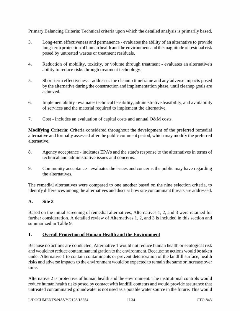
TABLE 9 SITE 3 - COMPARATIVE ANALYSIS OF REMEDIAL ACTION ALTERNATIVES
OU 6 FEASIBILITY STUDY NWS EARLE, COLTS NECK. NEW JERSEY
CRITERION: ALTERNATIVE 1: NO ACTION
ALTERNATIVE 2: LIMITED ACTION, COVER,GRADING, INSTITUTIONAL
CONTROLS, AND LONG-TERMMONITORING
ALTERNATIVE 3: CAPPING, INSTITUTIONAL
CONTROLS, AND LONG-TERMMONITORING
Overall Protection of Human Health and the Environment
Prevent HumanExposure toContaminated Soilsand LandfilledMaterials
No action would be taken to preventhuman exposure to contaminated soilsand landfilled materials. Existing riskswould remain. Continued deterioration ofthe landfill surface would expose morecontaminated soils and landfilledmaterials and result in increased directexposure risks.
Fencing with warning signs would reducethe potential for direct contact withcontaminated soils and landfilled materials.Limited removal of protruding landfillcontents, additional soil cover, andrevegetation of scarred areas would inhibitcontact with landfill contents.
Cover system would prevent direct contactwith contaminated soils and landfilledmaterials.
Prevent HumanExposure to MetalContaminants inGroundwater
No action would be taken to preventhuman exposure to contaminatedgroundwater. Non-carcinogenic risksexceeding EPA's target risk range wouldremain. No actions would be taken toreduce contaminant leaching togroundwater. No institutional controlswould be implemented to prohibit use ofuntreated groundwater.
Institutional controls would minimizepotential exposure to site groundwater byprohibiting its use. In time, a gradualreduction of contaminants in groundwaterdue to decreased infiltration and continueddissipation/dilution would occur.
Institutional controls would minimizepotential exposure to site groundwater byprohibiting its use. The cover system wouldreduce leaching of contaminants togroundwater. In time, contaminantconcentrations would decrease due todissipation and dilution.
MinimizeContaminantMigration
No actions would be taken to reducecontaminant leaching to groundwater.Contaminants would continue to leachinto groundwater and migrate.
Additional soil cover, grading andrevegetation would help to reducemigration of contaminants by surface waterand wind erosion and would reducecontaminant leaching to groundwater.However, contaminants may continue toleach into groundwater and migrate.
A cover system would reduce leaching ofcontaminants to groundwater and wouldreduce migration of contaminants to theenvironment by surface water and winderosion.
II-35
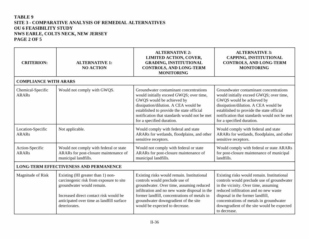
TABLE 9 SITE 3 - COMPARATIVE ANALYSIS OF REMEDIAL ALTERNATIVES OU 6 FEASIBILITY STUDY NWS EARLE, COLTS NECK, NEW JERSEY PAGE 2 OF 5
CRITERION: ALTERNATIVE 1: NO ACTION
ALTERNATIVE 2: LIMITED ACTION, COVER,GRADING, INSTITUTIONAL
CONTROLS, AND LONG-TERMMONITORING
ALTERNATIVE 3: CAPPING, INSTITUTIONAL
CONTROLS, AND LONG-TERMMONITORING
COMPLIANCE WITH ARARS
Chemical-SpecificARARs
Would not comply with GWQS. Groundwater contaminant concentrationswould initially exceed GWQS; over time,GWQS would be achieved bydissipation/dilution. A CEA would beestablished to provide the state officialnotification that standards would not be metfor a specified duration.
Groundwater contaminant concentrationswould initially exceed GWQS; over time,GWQS would be achieved bydissipation/dilution. A CEA would beestablished to provide the state officialnotification that standards would not be metfor a specified duration.
Location-SpecificARARs
Not applicable. Would comply with federal and stateARARs for wetlands, floodplains, and othersensitive receptors.
Would comply with federal and stateARARs for wetlands, floodplains, and othersensitive receptors.
Action-SpecificARARs
Would not comply with federal or stateARARs for post-closure maintenance ofmunicipal landfills.
Would not comply with federal or stateARARs for post-closure maintenance ofmunicipal landfills.
Would comply with federal or state ARARsfor post-closure maintenance of municipallandfills.
LONG-TERM EFFECTIVENESS AND PERMANENCE
Magnitude of Risk Existing (HI greater than 1) non-carcinogenic risk from exposure to sitegroundwater would remain.
Increased direct contact risk would beanticipated over time as landfill surfacedeteriorates.
Existing risks would remain. Institutionalcontrols would preclude use ofgroundwater. Over time, assuming reducedinfiltration and no new waste disposal in theformer landfill, concentrations of metals ingroundwater downgradient of the sitewould be expected to decrease.
Existing risks would remain. Institutionalcontrols would preclude use of groundwaterin the vicinity. Over time, assumingreduced infiltration and no new wastedisposal in the former landfill,concentrations of metals in groundwaterdowngradient of the site would be expectedto decrease.
II-36
TABLE 9 SITE 3 - COMPARATIVE ANALYSIS OF REMEDIAL ALTERNATIVES OU 6 FEASIBILITY STUDY NWS EARLE, COLTS NECK, NEW JERSEY PAGE 3 OF 5
CRITERION: ALTERNATIVE 1: NO ACTION
ALTERNATIVE 2: LIMITED ACTION, COVER, GRADING,
INSTITUTIONAL CONTROLS, ANDLONG-TERM MONITORING
ALTERNATIVE 3: CAPPING, INSTITUTIONAL
CONTROLS, AND LONG-TERMMONITORING
Adequacy andReliability ofControls
No now controls would beimplemented. Existing site featuresprovide limited controls.
If implemented and enforced, institutionalcontrols could prevent damage to the cover,intrusion into contaminated materials, and useof contaminated groundwater.
If properly maintained, the cap system wouldbe reliable for preventing exposure andreducing contaminant migration to theenvironment. If implemented and enforced.institutional controls could prevent damage tothe cap, intrusion into contaminated materialsand the use of contaminated groundwater.
Need for 5-YearReview
Review would be required since soiland groundwater contaminantswould be left in place.
Same as Alternative 1. Same as Alternative 1.
SHORT-TERM EFFECTIVENESS
CommunityProtection
No risk to community is anticipated. No significant risk to community isanticipated. Engineering controls would beused during implementation to mitigate risks.
No significant risk to community isanticipated. Engineering controls would beused during implementation to mitigate risks.
Worker Protection No risk to workers is anticipated ifproper personal protectiveequipment (PPE) is used duringlong-term monitoring.
No risk to workers is anticipated if proper PPEis used during fence installation and long-termmonitoring.
No significant risk to workers is anticipated ifproper PPE is used during remediation andlong-term monitoring.
EnvironmentalImpacts
No adverse impacts to theenvironment are anticipated.
No adverse impacts to the environment areanticipated.
No significant impacts to the environment areanticipated. Engineering controls would beused during implementation to mitigate risks.
Time Until Action isComplete
Not applicable Approximately one-year to cover and grade thelandfill and to institute CEA.
Approximately 1.5 years to install the cap andinstitute CEA.
II-37

TABLE 9 SITE 3 - COMPARATIVE ANALYSIS OF REMEDIAL ALTERNATIVES OU 6 FEASIBILITY STUDY NWS EARLE, COLTS NECK, NEW JERSEY PAGE 4 OF 5
CRITERION: ALTERNATIVE 1: NO ACTION
ALTERNATIVE 2: LIMITED ACTION, COVER, GRADING,
INSTITUTIONAL CONTROLS, ANDLONG-TERM MONITORING
ALTERNATIVE 3: CAPPING, INSTITUTIONAL
CONTROLS, AND LONG-TERMMONITORING
IMPLEMENTABILITY
Ability to Constructand Operate
No construction or operation would beinvolved.
No difficulties are anticipated. Fencing,limited removal/off-station disposal, soil coverplacement, grading, and revegetation arereadily implementable technologies.
No difficulties are anticipated. Cappingis a readily implementable technology.
Ease of Doing MoreAction if needed
Additional actions would be easilyimplemented if required.
Additional actions would be easilyimplemented if required.
If additional actions are warranted, thecover system may need to be opened to access contaminated materials.
Ability to MonitorEffectiveness
Monitoring would provide assessment ofpotential exposures, contaminantpresence, migration, or changes in siteconditions.
Same as Alternative 1 Same as Alternative 1
Ability to ObtainApprovals andCoordinate withOther Agencies
Coordination for 5-year reviews may berequired and would be obtainable.
Coordination for 5-year reviews may berequired and would be obtainable.Coordination with the state would be requiredto establish a CEA and would be obtainable.
Coordination for 5-year reviews may berequired and would be obtainable.Coordination with the state would berequired to establish a CEA and wouldbe obtainable.
Availability ofEquipment,Specialists, andMaterials
Personnel and equipment would beavailable for implementation and long-term monitoring and 5-year reviews.
Equipment and personnel are available toinstall fencing and perform long-termmaintenance, monitoring and five-yearreviews.
Equipment and personnel are availableto construct cap and perform long-termmaintenance, monitoring and five-yearreviews.
Availability ofTechnology
Not required. Common construction techniques andmaterials would be required for construction.
Common construction techniques andmaterials would be required forconstruction.
II-38

TABLE 9 SITE 3 - COMPARATIVE ANALYSIS OF REMEDIAL ALTERNATIVES OU 6 FEASIBILITY STUDY NWS EARLE, COLTS NECK, NEW JERSEY PAGE 5 OF 5
CRITERION: ALTERNATIVE 1: NO ACTION
ALTERNATIVE 2: LIMITED ACTION, COVER, GRADING,
INSTITUTIONAL CONTROLS, ANDLONG-TERM MONITORING
ALTERNATIVE 3: CAPPING, INSTITUTIONAL
CONTROLS, AND LONG-TERMMONITORING
COST
Capital Cost $41,400 $627,600 $4,962,100
First-Year AnnualO&M Cost
$17, 500 $17,500 $20,400
Five-Year Reviews $15,000 $15,000 $15,500
Present Worth Cost* $291,000 $878,000 $5,249,000* Present-worth cost is based on discount rate of 7 %.
II-39
significantly reduce the human health risks by eliminating potential exposure to contaminatedgroundwater.
Alternative 3 is most protective of human health and the environment. The soil cover system wouldreduce human health and ecological risks posed by contact with landfill contents and would reduceinfiltration through landfill materials and leaching of contaminants to groundwater, thereby reducingcontaminant migration into the environment. Routine maintenance of the landfill cover would ensureits long-term protectiveness. Institutional controls would provide assurance that untreatedcontaminated groundwater is not used as a potable water source in the future.
2. Compliance with ARARs
Because Alternative 1 does not include any remedial actions, it would not comply with state andfederal ARARs pertaining to post-closure of municipal landfills [40 CFR 258.60 and 258.61 andN.J.A.C. 7:26-2A.9]. Alternative 2 would comply with some of these requirements. Alternative 3would comply with these requirements since a cover system would be installed and a long-termmaintenance and repair program would be implemented.
All three alternatives would comply with federal and state long-term monitoring requirementsthrough periodic monitoring and evaluation of groundwater, surface water, and sediments.
Alternative 1 would not comply with state ARARs for attainment of GWQS (N.J.A.C. 7:9-61).Alternatives 2 and 3 would comply by seeking a temporary exemption (CEA) from theserequirements until the GWQS are achieved.
3. Long-term Effectiveness and Permanence
Alternatives 2 and 3 offer substantial long-term protection of human health and the environment.Under Alternative 1, risks would remain the same or increase over time as the landfill surface erodesbecause no additional actions would be taken to contain wastes and limit deterioration of the landfillsurface. Potential future users of site groundwater may be at risk under Alternative 1 because it lacksinstitutional controls that would prohibit use of untreated contaminated groundwater.
Alternative 2 would reduce human risks due to ingestion of site groundwater by reducing thepotential for exposure. Long-term risks due to ingestion of site groundwater would be reduced byimplementation of institutional controls to prohibit use of untreated, contaminated groundwater.Regrading and revegetation would slightly reduce infiltration of rainwater through the fill material.
Alternative 3 would reduce human and ecological risks due to direct exposure to landfill contentsby eliminating the potential for exposure. Long-term risks due to ingestion of site groundwaterwould be mitigated by significantly reducing contaminant leaching into groundwater and byimplementing institutional controls to prohibit use of untreated contaminated groundwater.
4. Reduction of Toxicity, Mobility or Volume through Treatment
Because none of the alternatives include treatment, they would not reduce the toxicity, mobility, orvolume through treatment. Alternative 3 would reduce the mobility of landfill contaminants bysignificantly reducing precipitation infiltration.
L/DOCUMENTS/NAVY/2128/18254 II-40 CTO-843
5. Short-Term Effectiveness
The short-term effectiveness of the three alternatives would be similar since the use of appropriateengineering controls and PPE is expected to minimize adverse impacts to station residents andpersonnel, the local community, and workers during implementation.
Long-term monitoring, which would provide little opportunity for short-term impact, is the onlyon-site action proposed under Alternative 1.
Alternatives 2 and 3 would present a greater opportunity for short-term impact due to soil gradingand installation of fencing. Alternative 3 would present an even greater opportunity for short-termimpact due to installation of the soil cover system.
Impacts to the environment are not anticipated under Alternative 1 since minimal activities wouldbe conducted. Impacts to the environment would be minimized under Alternative 2 and 3 by use oferosion and stormwater control measures during site work.
Alternative 1 would not achieve any of the RAOs. Alternative 2 would achieve some of the RAOswithin approximately one-year, which would be the time to perform limited removal of protrudinglandfill contents, place, grade, and revegetate additional soil cover, install the fencing, andimplement the CEA. Alternative 3 would achieve all RAOs within approximately 1.5 years, whichwould be the time to design and install the proposed cover and to implement the CEA.
6. Implementability
Alternative 1 is the most easily implemented since the only activities proposed are long-termmonitoring and 5-year reviews. Alternative 2 would be more difficult to implement since it wouldinvolve removal of protruding landfill contents, placement, grading, and revegetation of additionalsoil cover, installation of fencing, and implementation of the CEA; however, no difficulties areanticipated, since common installation techniques are required and materials are available fromseveral vendors. Alternative 3 would be most difficult to implement since it involves theconstruction of an enhanced cover system over several acres of land; however, no difficulties areanticipated, since common construction techniques are required and cover materials are availablefrom several vendors.
CEA implementation issues under Alternatives 2 and 3, such as submission of CEA documentationand periodic CEA reporting to regulatory agencies are not expected to present any difficulty sincethe Navy has significant experience complying with these requirements at other NWS EarleInstallation Restoration (IR) program and underground storage tank sites.
If additional actions are warranted, they could be easily implemented under Alternatives 1 and 2.Additional actions could be implemented under Alternative 3; however, opening the cover systemwould be required to access landfill contents.
7. Cost
The present-worth cost associated with each alternative is provided below for comparison.Alternative 1, no action, would be the least expensive to implement and Alternative 3 would be the
L/DOCUMENTS/NAVY/2128/18254 II-41 CTO-843
most expensive to implement.
Alternative 1 $291,000 Alternative 2 $878,000 Alternative 3 $5,249,000
8. Agency Acceptance
NJDEP has had the opportunity to review and comment on all the documents in the AdministrativeRecord and has had the opportunity to comment on the draft ROD. Comments received frm theNJDEP have been incorporated into the ROD.
9. Community Acceptance
The community has had the opportunity to review and comment on documents in the AdministrativeRecord, to participate in regularly scheduled Restoration Advisory Board (RAE) meetings convenedto encourage community involvement, and attend a public meeting held to provide the communityan opportunity to learn about the Proposed Plan. The community has not indicated objections to thealternatives selected in this ROD. Part III, Responsiveness Summary, of this ROD presents anoverview of community involvement and input to the selected alternative.
B. Site 10
Based on the initial screening of remedial alternatives, Alternatives 1 and 3 were retained for furtherconsideration. A detailed review of Alternatives 1 and 3 is included in this section and summarizedin Table 10.
1. Overall Protection of Human Health and the Environment
Only Alternative 3 would be protective of human health and the environment. Because no actionsare conducted, Alternative 1 would not reduce human health or ecological risk and would not reducecontaminant migration to the environment. Health risks and adverse impacts to the environment areexpected to remain the same or increase over time.
Alternative 3 is most protective of human health and the environment. The cover system wouldreduce human health and ecological risks posed by contact with landfill contents and impactedsediments or surface soil. The cover system would reduce infiltration through landfill materials andleaching of contaminants to groundwater, thereby reducing contaminant migration in to theenvironment. Routine maintenance of the landfill cover system would ensure its long-termprotectiveness. Institutional controls would provide assurance that untreated contaminatedgroundwater is not used as a potable water source in the future.
2. Compliance with ARARs
Because Alternative 1 does not include any remedial actions, it would not comply with state andfederal ARARs pertaining to post-closure of municipal or demolition debris landfills (40 CFR258.60 and 258.61 and N.J.A.C. 7:26-2A.9).
L/DOCUMENTS/NAVY/2128/18254 II-42 CTO-843
Alternative 3 would comply with these requirements since a vegetative cover system would beinstalled and a long-term maintenance and repair program would be implemented, consistent withwhat would typically be required for a demolition debris landfill.
3. Long-term Effectiveness and Permanence
Alternative 3 is the only alternative that offers long-term protection of human health and theenvironment. Because no additional actions would be taken under Alternative 1 to contain wastesand limit deterioration of the landfill surface, risks would increase over time as the landfill surfaceerodes.
Potential future users of the site may be at risk under Alternative 1 because it lacks features to limitcontact with landfill contents. Alternative 3 would reduce human and ecological risks due to directexposure to landfill contents by eliminating the potential for exposure. Long-term risks due toingestion of site groundwater would decrease by reducing contaminant leaching into groundwater.
4. Reduction of Toxicity, Mobility or Volume through Treatment
Because neither of the alternatives includes treatment, neither would reduce the toxicity, mobility,or volume through treatment. Alternative 3 would reduce the mobility of landfill contaminants byreducing precipitation infiltration into the landfill and protecting against surface transport of landfillcontents.
5. Short-Term Effectiveness
The short-term effectiveness of the two alternatives would be similar since the use of appropriateengineering controls and PPE is expected to minimize adverse impacts to station residents andpersonnel, the local community, and workers during implementation. There is no on-site actionproposed under Alternative 1. Alternative 3 would present a greater opportunity for short-termimpact due to site preparation, grading, and construction of the cover system.
Impacts to the environment are not anticipated under Alternative 1 since no activities would beimplemented. Implementation of erosion and stormwater control measures during vegetative coverconstruction under Alternative 3 would minimize impacts to the environment.
Alternative 1 would not achieve any of the RAOs. Alternative 3 will prevent exposure to the landfillcontents within approximately one-year once the vegetative cover is installed and the CEA isimplemented. The risk of exposure due to ingestion of site groundwater will not be completelyeliminated until cleanup levels (i.e., MCLs) are reached by dispersion. Once the vegetative coveris in place, however, precipitation infiltration Into the landfill and the subsequent leaching of landfillmaterials into the groundwater will be minimized. Implementation of the CEA will formally prohibitgroundwater usage until monitoring determines that cleanup levels have been reached.
6. Implementability
Each of the alternatives could be implemented. Alternative 1 is easily implemented since noactivities are proposed. Alternative 3 would be more difficult to implement since it involves theconstruction of a vegetative cover system over several acres of land; however, no difficulties are
L/DOCUMENTS/NAVY/2128/18254 II-43 CTO-843

TABLE 10 SITE 10 - COMPARATIVE ANALYSIS OF REMEDIAL ACTION ALTERNATIVES
OU 6 FEASIBILITY STUDY NWS EARLE, COLTS NECK. NEW JERSEY
CRITERION: ALTERNATIVE 1:
NO ACTION
ALTERNATIVE 3: CAPPING, INSTITUTIONAL CONTROLS, AND
NATURAL ATTENUATION
Overall Protection of Human Health and the Environment
Prevent Human Exposure toLandfill Materials
No action would be taken to prevent human exposure tocontaminated soils and landfilled materials. Existing riskswould remain. Continued deterioration of the landfillsurface, particularly the edge of the landfill, would exposemore landfilled materials and result in increased directexposure risks.
New cover system over the landfill would prevent directcontact with contaminated materials. Risks would be reducedby installing the new low-permeability cover and maintainingthe new cover.
COMPLIANCE WITH ARARS
Location-specific ARARs No action would be taken that would impact wetlands orother sensitive receptors. Site 10 is not in a 100-yearfloodplain.
The alternative would comply with federal and state ARARsfor wetlands, floodplains, and other sensitive receptors.
Action-specific ARARs This alternative would not comply with federal or stateARARs for post-closure maintenance of municipal landfills.
This alternative would comply with federal and state ARARsfor closure and post-closure maintenance of construction/demolition debris landfills.
LONG-TERM EFFECTIVENESS AND PERMANENCE
Magnitude of Residual Risk Increased risk would be anticipated over time as landfillsurface deteriorates, especially along edge of landfill.
Installation of new cover, maintenance of the new cover, andimplementation of access restrictions to prevent intrusion intolandfilled materials would reduce direct exposure risks.
Adequacy and Reliability ofControls
No now controls would be implemented. Existing sitefeatures provide limited controls.
If properly maintained, the cover system would be reliable forpreventing exposure and reducing contaminant migration tothe environment. If implemented and enforced, institutionalcontrols could prevent damage to the cover, and intrusion intolandfilled materials.
Need for 5-Year Review Review would be required since soil and groundwatercontaminants would be left in place.
Same as Alternative 1.
II-44

TABLE 10 SITE 10 - COMPARATIVE ANALYSIS OF REMEDIAL ALTERNATIVES OU 6 FEASIBILITY STUDY NWS EARLE, COLTS NECK, NEW JERSEY PAGE 2 OF 3
CRITERION: ALTERNATIVE 1:
NO ACTION
ALTERNATIVE 3: CAPPING, INSTITUTIONAL CONTROLS, AND
NATURAL ATTENUATION
SHORT-TERM EFFECTIVENESS
Community Protection No risk to community is anticipated. No significant risk to community is anticipated. Engineeringcontrols would be used during implementation to mitigaterisks.
Worker Protection No risk to workers is anticipated. No significant risk to workers is anticipated if proper PPE isused during cover construction.
Environmental Impacts No adverse impacts to the environment are anticipated. No significant impacts to the environment are anticipated.Engineering controls would be used during implementation tomitigate risks.
Time Until Action is Complete Not applicable Approximately 1.5 years to install the cap and institute CEA.
IMPLEMENTABILITY
Ability to Construct andOperate
No construction or operation is be involved. No difficulties are anticipated. Low permeability cover systemis a readily implementable technology.
Ease of Doing More Action ifneeded
Additional actions would be easily implemented if required. If additional actions are warranted, the cover system may needto be opened to access contaminated materials.
Ability to Obtain Approvalsand Coordinate with OtherAgencies
Not applicable. Coordination with the State would be required to establish aCEA and would be obtainable.
Availability of Equipment,Specialists, and Materials
Not applicable. Ample availability of equipment and personnel to constructcover system and perform long-term maintenance.
Availability of Technology Not required. Common construction techniques and materials required forcover system construction.
II-45
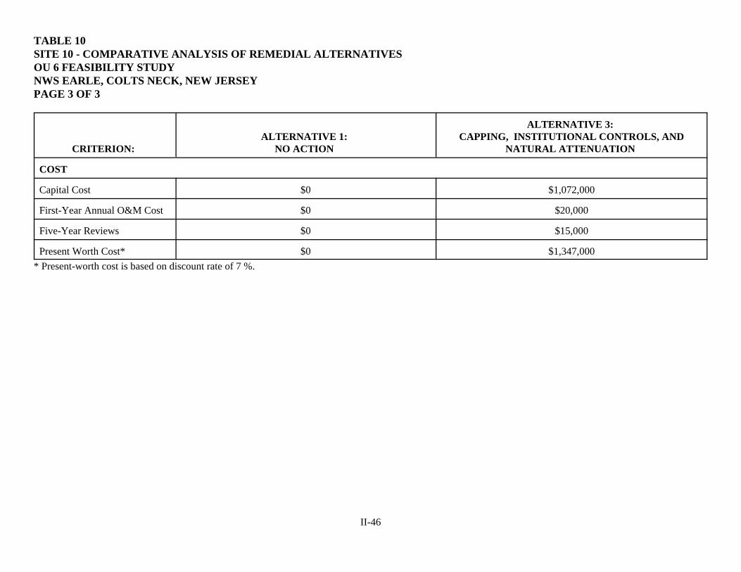
TABLE 10 SITE 10 - COMPARATIVE ANALYSIS OF REMEDIAL ALTERNATIVES OU 6 FEASIBILITY STUDY NWS EARLE, COLTS NECK, NEW JERSEY PAGE 3 OF 3
CRITERION: ALTERNATIVE 1:
NO ACTION
ALTERNATIVE 3: CAPPING, INSTITUTIONAL CONTROLS, AND
NATURAL ATTENUATION
COST
Capital Cost $0 $1,072,000
First-Year Annual O&M Cost $0 $20,000
Five-Year Reviews $0 $15,000
Present Worth Cost* $0 $1,347,000* Present-worth cost is based on discount rate of 7 %.
II-46

anticipated, because vegetative covers are a commonly applied technology involving conventionalconstruction methods and cover materials are available from several vendors.
If additional actions are warranted, they could be easily implemented under Alternative 1. UnderAlternative 3, additional actions could be easily implemented; however, the cover system wouldhave to be opened to access landfill contents.
7. Cost
The present-worth cost associated with each alternative is provided below for comparison.Alternative 1, no action, would be the least expensive to implement and Alternative 3 would be themost expensive to implement.
Alternative 1 $0 Alternative 3 $1,347,000
8. Agency Acceptance
NJDEP has had the opportunity to review and comment on all the documents in the AdministrativeRecord and has had the opportunity to comment on the draft ROD. Comments received from NJDEPhave been incorporated into this ROD.
9. Community Acceptance
The community has had the opportunity to review and comment on documents in the AdministrativeRecord, to participate in regularly scheduled RAE meetings convened to encourage communityinvolvement, and to attend a public meeting held to provide the community with an opportunity tolearn about the Proposed Plan. The community has not indicated objections to the alternativesselected in this ROD. Part Ill, Responsiveness Summary, of this ROD presents an overview ofcommunity involvement and input to the selected alternative.
X. THE SELECTED REMEDY
A. Site 3
The Navy, with EPA and NJDEP, has selected Alternative 2 - Limited Action, Cover, Grading,Institutional Controls, and Long-Term Monitoring - as its preferred alternative. The range oftechnologies in Alternative 2 is appropriate for the protection of human health and the environmentat this remote former landfill.
Alternative 2 relies on containment, access restrictions, and institutional controls to limit exposuresto site risks.
The site has not been used for many years and is moderately vegetated with grasses and pine trees.Any exposed debris and the remnants of a former skeet range will be removed and additional soilcover material will be placed to grade the site to encourage runoff. Clearing and grubbing of thevegetative growth may be necessary in parts of the site to prepare for soil cover placement. Wherepossible, the additional cover and grading will be placed around the existing trees.
L/DOCUMENTS/NAVY/2128/18254 II-47 CTO-843

Grading of the landfill area will be completed without removal of healthy trees where possible.Compaction of the soils and landfill materials will be performed as needed. The appropriate slopesfor the cover (to facilitate drainage) will be determined as part of the soil cover system design. Thefinal surface slope of landfill soil cover should have a slope of between three percent (3V:l00H) andfive percent (5V:l00H) to ensure slope stability, control erosion, and allow compaction, seeding, andvegetation of the cover materials. The final slope will also promote precipitation runoff whileinhibiting erosion or infiltration.
A cable-type fence with appropriate warning signs will be erected around the landfill to limit accessto the site, to preclude excessive vehicular traffic, to restrict human contact with contaminatedlandfill materials, and to protect the integrity of the soil cover. Figure 10 presents a plan view of theAlternative 2 conceptual design. Figure 11 presents a cross-section view of the cover systemconceptual design.
Long-term periodic groundwater monitoring will be conducted to assess contaminant status andpotential threats to human health and the environment. Since wastes will be left in place, siteconditions and risks will be reviewed every five years.
Under Alternative 2, access restrictions will be enacted to limit future use of the landfill property.Restrictions will be placed on future activities that could result in increased human exposure tocontaminated landfill materials or increased erosion and contaminant migration. Restricted activitieswill include excavation, excessive vehicular traffic (off-road vehicles and dirt bikes), and use ofuntreated groundwater for drinking water.
The Navy has prepared a RD for LUCs containing the LUC implementation actions that has beensubmitted to the EPA for review and concurrence. The final RD for LUC at OU 6 that includesincorporation of EPA comments has been submitted to EPA concurrently with the final ROD. Afterconstruction of the cover, land use control restrictions would prohibit digging into or disturbing theexisting cover or contents of the landfill, prohibit residential development on the site, prohibit useof the aquifer groundwater beneath the site other than for environmental monitoring and testing untilthe groundwater meets GWQS. Figure 10 shows the area of the proposed cap and fence. The areaproposed for the LUCs will include the area within the fence protecting the cap (Figure 12). The RDfor LUCs will be amended to the NWS Earle Master Plan. The Navy will be responsible formaintaining LUCs and monitoring site status.
The Navy is responsible for implementing, maintaining, reporting on, and enforcing the land usecontrols. Land use controls will be maintained until the concentration of hazardous substances inthe soil and groundwater are at such levels to allow for unrestricted use and exposure.
The LUC objectives are:
a) Maintain the integrity of any current or future remedial or monitoring system suchas monitoring wells, fencing, signage and the landfill cover;
b) Except for environmental monitoring, prevent access or use of untreated groundwateruntil cleanup levels are met;
c) Prohibit the development and use of property for residential housing, elementary andsecondary schools, child care facilities and playgrounds; and
L/DOCUMENTS/NAVY/2128/18254 II-48 CTO-843


d) Prohibit excessive vehicular traffic and digging into or disturbing the landfill coveror contents of the landfill.
These objectives will be implemented through mechanisms, such as the RD for LUC amended tothe Base Master Plan, fencing and signage at the landfill cap, 30 years of O&M and annual statusreporting for the cap, establishment of the NJDEP-compliant CEA and conduct of a site reviewevery live years.
Because site groundwater does not meet GWQS, a CEA pursuant to N.J.A.C 7:9-6 will beestablished to provide the state with official notice that the constituent standards will not be met fora specified duration and to ensure that use of groundwater in the affected area is prohibited (Figure12). Refer to the RD for LUC implementation actions, since these details may need to be adjustedperiodically based on site conditions and other factors.
B. Site 10
The Navy, with EPA and NJDEP, has selected Alternative 3 - Capping and Institutional Controls- as its selection of the preferred alternative. The range of technologies included in Alternative 3offer the maximum of protection to human health and the environment of all the alternatives, andis appropriate for the protection of human health and the environment at this former Waste-metalsdisposal area. Significant groundwater contamination has not been found, and although technicallynot required, the Navy chose to implement a more protective low-permeability cover at Site 10 forthe following reasons:
Site 10 is in close proximity to extensive wetlands and a stream. It is also bordered by anactive rail line. The proposed cover system can be installed without impact to the wetlandsor stream or encroachment onto the rail line. A soil cover would need to extend furtherbeyond the filled area to be effective and would have some impact on one or more of thesefeatures.
The military nature of the landfilled materials at site 10 warrants a higher level of protection.While all evidence suggests only inert demilitarized items were placed in this landfill, a moreconservative remedy is justified.
The incremental cost difference for the low-permeability cover versus a soil cover at a sitethis small (2 acres) is relatively small for the increased level of protection achieved.
A vegetative cover would be placed over an impermeable landfill cap over the entire former landfillarea. Figure 13 shows a plan view of the preferred alternative landfill cap. Alternative 3 relies oncontainment and institutional controls to limit exposure to landfill contents. Grading of the landfillarea, combined with placement of a low-permeability vegetative cover system, will prevent potentialhuman and animal contact with landfill materials and reduce infiltration of precipitation through thelandfill contents. Access restrictions will be enacted to limit future uses of the site that may resultin disturbance of the cover or direct contact with landfill materials. Figure 14 presents a crosssectional view of the conceptual design of the cover.
A topographic survey of the site will be performed to collect accurate elevation and contour data foruse in the cover system design.
L/DOCUMENTS/NAVY/2128/18254 II-51 CTO-843


The site has not been used for many years and is moderately vegetated with grasses and pine trees.Clearing and grubbing of the vegetative growth will be necessary to prepare the site for soil coveringand grading. Temporary silt fences or staked hay bales will be required to minimize erosion effectswhile the site is covered and graded.
Compaction of the soils and landfill materials will be performed as needed. The appropriate slopesfor the soil cover (to facilitate drainage) will be determined as part of the cover system design.
The graded and vegetated cover system will be designed to prevent human and animal exposuresto landfill material and to prevent migration of contaminants by wind and surface runoff.
A cable-type fence with appropriate warning signs will be erected around the landfill to limit accessto the site, to preclude excessive vehicular traffic, to restrict human contact with contaminatedlandfill materials, and to protect the integrity of the cover.
The Navy has prepared a RD for LUCs containing the LUC implementation actions that has beensubmitted to the EPA for review and concurrence. The final RD for LUC at OU 6 that includesincorporation of EPA comments has been submitted to EPA concurrently with the final ROD. Afterconstruction of the cover, land use control restrictions would prohibit digging into or disturbing theexisting cover or contents of the landfill, prohibit residential development on the site, and prohibituse of the untreated groundwater aquifer beneath the site other than for environmental monitoringand testing until the groundwater meets GWQS. Figure 15 shows the area of the proposed cap andfence. The area proposed for the LUCs will include the area within the fence. Restricted activitieswould include excavation, excessive vehicular traffic, and use of untreated groundwater for drinkingwater. The RD for LUCs will be amended to the NWS Earle Master Plan. The Navy will beresponsible for maintaining LUCs and monitoring site status.
The Navy is responsible for implementing, maintaining, reporting on, and enforcing the land usecontrols. Land use controls will be maintained until the concentration of hazardous substances inthe soil and groundwater are at such levels to allow for unrestricted use and exposure.
The LUC objectives are:
a) Maintain the integrity of any current or future remedial or monitoring system suchas monitoring wells, fencing, signage and the landfill cap;
b) Except for environmental monitoring, prevent access or use of untreated groundwateruntil cleanup levels are met;
c) Prohibit the development and use of property for residential housing, elementary andsecondary schools, child care facilities and playgrounds; and
d) Prohibit excessive vehicular traffic and digging into or disturbing the landfill coveror contents of the landfill.
These objectives will be implemented through mechanisms, such as the RD for LUC amended tothe Base Master Plan, fencing and signage at the landfill cap, 30 years of O&M and annual statusreporting for the cap, establishment of the NJDEP-compliant CEA and conduct of a site reviewevery five years.
L/DOCUMENTS/NAVY/2128/18254 II-55 CTO-843

Because site groundwater does not meet GWQS, a CEA pursuant to N.J.A.C 7:9-6 would beestablished (Figure 15). The CEA would provide the state official notice that the constituentstandards will not be met for a specified duration and to ensure that use of groundwater in theaffected area is suspended until standards are achieved.
Long-term periodic monitoring would be conducted to assess contaminant status and potentialthreats to human health and the environment. In addition to the existing wells, sentinel wells wouldbe installed north of the site pursuant to CEA guidelines. Since wastes would be left in place, siteconditions and risks would be reviewed every five years. Refer to the RD for LUC implementationactions, since these details may need to be adjusted periodically based on site conditions and otherfactors.
XI. STATUTORY DETERMINATIONS
The remedy selected for OU 6 satisfies the remedy selection requirements of CERCLA and the NCP.The remedy is expected to be protective of human health and the environment, complies withARARs, and is cost effective. The following sections discuss how the selected remedial actionaddresses these statutory requirements.
A. Protection of Human Health and the Environment
1. Site 3
Alternative 2 will provide overall protection of human health and the environment by preventingdirect exposure to contaminated landfill materials, reducing contaminant migration from the landfillinto the environment, and instituting restrictions on use of site groundwater.
Although the potential health risks from direct exposure to landfill contaminants were not quantifiedin the RI, it is conservatively assumed that direct exposure to landfilled materials may pose healthrisks to humans and animals. These risks will be reduced by installation of access restrictions andwarning signs. The additional soil cover and vegetation will also limit contaminant migration to theenvironment by surface runoff and wind erosion.
Alternative 2 will reduce the risks posed by future use of site groundwater. The human health riskassessment concluded that site groundwater poses non-carcinogenic risks exceeding EPA's targetrisk range under a future residential exposure to groundwater scenario. Placing additional soil coverand grading to promote runoff will reduce infiltration of precipitation into the landfill, therebyreducing contaminant leaching from the landfill materials to the underlying groundwater andfacilitating natural attenuation of groundwater contamination. Reducing leaching of contaminantsfrom the landfill into the underlying groundwater will eventually result in a decrease of groundwatercontaminant concentrations to acceptable levels (GWQS), reducing the long-term risk posed byfuture use of site groundwater. Implementation of access restrictions and establishment of the siteas a groundwater CEA will provide interim protection by prohibiting use of the aquifer until GWQSare achieved.
Fencing/warning signs and access restrictions will provide additional long-term protection bylimiting access to the covered area and restricting activities that could damage or intrude into thecover and contaminated media.
L/DOCUMENTS/NAVY/2128/18254 II-57 CTO-843

The long-term periodic monitoring program will allow the responsible agency to monitor the qualityof groundwater leaving the site, assess potential impacts to downgradient receptors, and determinewhether additional remedial actions are necessary.
Use of engineering controls to minimize generation of fugitive dusts and vapors and proper use ofPPE by site workers will effectively minimize short-term risks to the local community and workersposed by implementation of this alternative.
The Navy has prepared a RD for LUCs containing the LUC implementation actions that has beensubmitted to the EPA for review and concurrence.
The Navy is responsible for implementing, inspecting, reporting, and enforcing the LUCs describedin this ROD in accordance with the LUC Remedial Design. Although the Navy retains ultimateresponsibility for the performance of these obligations, the Navy may arrange, by contract orotherwise, for another party(ies) to carry them out. Should any LUC remedy fail, the Navy willensure that appropriate actions are taken to reestablish the remedy’s protectiveness and may initiatelegal action to either compel action by a third party(ies) and/or to recover the Navy's costs forremedying any discovered LUC violation(s).
2. Site 10
Alternative 3 will provide overall protection of human health and the environment by preventingdirect exposure to contaminated landfill materials, reducing contaminant migration from the landfillinto the environment, and instituting restrictions on use of site groundwater.
Although the potential health risks from direct exposure to landfill contaminants were not quantifiedin the RI, it is conservatively assumed that direct exposure to landfilled materials may pose healthrisks to humans and animals. Direct exposure risks will be reduced by installation of an enhancedvegetative cover system over the entire landfill. Because the properly maintained cover system willeffectively eliminate the direct exposure pathway, the direct contact risks will be eliminated byimplementation of Alternative 3. The cover system will also prevent further erosion d the landfillsurface and preclude contaminant migration to the environment by surface runoff or wind erosion.
Alternative 3 will protect against future use of site groundwater. The human health risk assessmentconcluded that site groundwater does not pose carcinogenic or non-carcinogenic risks exceedingEPA's target risk range, but regulators desire to further ensure protectiveness against groundwateruse. Capping the landfill with a low-permeability cover system will reduce infiltration ofprecipitation into the landfill, thereby adding an additional measure of protection against leachingof landfill contents into groundwater. Implementation of access restrictions and establishment of thesite as a groundwater CEA will provide interim protection by prohibiting use of the aquifer untilGWQS and MCLs are confirmed.
Access restrictions will also provide additional long-term protection by limiting access to the cappedarea and restricting activities that could damage or intrude into the cover system and landfillcontents.
The long-term monitoring program will allow the responsible agency to monitor the quality ofgroundwater leaving the site, assess potential impacts to downgradient receptors, and determine
L/DOCUMENTS/NAVY/2128/18254 II-58 CTO-843

whether additional remedial actions are necessary.
Use of engineering controls to minimize generation of fugitive dusts and vapors and proper use ofPPE by site workers will effectively minimize short-term risks to the local community and workersposed by implementation of this alternative.
The Navy has prepared a RD for LUCs containing the LUC implementation actions that has beensubmitted to the EPA for review and concurrence.
The Navy is responsible for implementing, inspecting, reporting, and enforcing the LUCs describedin this ROD in accordance with the LUC RD. Although the Navy retains ultimate responsibility forthe performance of these obligations, the Navy may arrange, by contract or otherwise, for anotherparty(ies) to carry them out. Should any LUC remedy fail, the Navy will ensure that appropriateactions are taken to reestablish the remedy’s protectiveness and may initiate legal action to eithercompel action by a third party(ies) and/or to recover the Navy’s costs for remedying any discoveredLUC violation(s).
B. Compliance With and Attainment of ARARS
The selected remedy for OU 6 will comply with all applicable or relevant and appropriatechemical-specific, location-specific, and action-specific ARARs. The following discussion providesa synopsis of the detailed evaluation of the remedial alternatives in the FS for Sites 3 and 10 (OU6) (Tetra Tech NUS, September 2000).
1. Chemical-specific ARARs
Federal and state chemical specific ARARs presented in the FS included MCLs and GWQS.
a. Site 3
Because Alternative 2 does not include active treatment of groundwater, initially the groundwaterbeneath Site 3 will not meet the constituent concentrations specified in the GWQS [N.J.A.C. 7:9-6].
However, additional cover and grading d the landfill proposed under Alternative 2 will reducemigration of contaminants into groundwater, facilitating natural attenuation of contaminants andultimately resulting in attainment of MCLs and GWQS. Alternative 2 includes a provision to seeka temporary exemption (CEA) from these requirements until the GWQS are achieved throughnatural attenuation. The CEA will be established to provide the state official notice that theconstituent standards will not be met for a limited duration and to ensure that consumption of theuntreated groundwater is prohibited.
b. Site 10
Because Alternative 3 does not include active treatment of groundwater, initially the groundwaterbeneath Site 10 will not meet the constituent concentrations specified in the GWQS [N.J.A.C. 7:9-6].
Installation of an engineered cap over the landfill proposed under Alternative 3 will reducemigration of contaminants into groundwater, facilitating natural attenuation of contaminants and
L/DOCUMENTS/NAVY/2128/18254 II-59 CTO-843

ultimately resulting in attainment of MCLs and GWQS. Alternative 3 includes a provision to seeka temporary exemption (CEA) frm these requirements until the GWQS are achieved through naturalattenuation. The CEA will be established to provide the state official notice that the constituentstandards will not be met for a limited duration and to ensure that consumption of the untreatedgroundwater is prohibited.
2. Location-specific ARARs
The potential effects of the proposed remediation on wetlands, floodplains, water bodies, and othersensitive receptors will be identified during the design of Alternative 2 (Site 3) and Alternative 3(Site 10). and all necessary measures will be taken to comply with the location-specific federal andstate ARARs identified in the FS. It is expected that remedial design for both sites will easilycomply with these ARARs.
3. Action-specific ARARs
a. Site 3
The addition of soil and grading of the improved landfill cover and long-term monitoring andmaintenance plan proposed under Alternative 2 will comply with federal and state municipal landfillclosure and post-closure regulations [40 CFR 258.60 & 258.61 and N.J.A.C. 7:26-2A.9].
b. Site 10
The low-permeability landfill cap and long-term monitoring and maintenance plan proposed underAlternative 3 will comply with federal and state municipal landfill closure and post-closureregulations [40 CFR 258.60 & 258.61 and N.J.A.C. 7:26-2A.9].
4. To Be Considered (TBC) Standards
Office of Solid Waste and Emergency Response (OSWER) Directive 9355.0-62FS "Application ofthe CERCLA Municipal Landfill Presumptive Remedy to Military Landfills" (April 1996) andOSWER Directive 9355.0-49FS "Presumptive Remedy for CERCLA Municipal Landfill Sites"(September 1993) were considered during the development of remedial alternatives for OU 6.
C. Cost-Effectiveness
The Navy and EPA have determined that the selected remedy for OU 6 is cost effective in that itmitigates the risks posed by the site-related contaminants, meets all other requirements of CERCLA,and affords overall effectiveness proportionate to the cost. The estimated costs for the selectedremedy for OU 6 are summarized below.
1. Site 3
The capital costs for Alternative 2 total $627,600. The average annual O&M costs are $17,500, andfive-year reviews cost $15,500 per event. Over a 30year period, the net present-worth cost is$878,000 (at a seven percent discount rate).
L/DOCUMENTS/NAVY/2128/18254 II-60 CTO-843
2. Site 10
The capital costs for Alternative 3 total $1,072,000. The average annual O&M costs are $20,000,and five-year reviews cost $15,000 per event. Over a 30-year period, the net present-worth cost is$1,347,000 (at a seven percent discount rate).
D. Utilization of Permanent Solutions and Alternative Treatment Technologies to theMaximum Extent Practicable
The Navy and EPA have determined that the selected remedy represents the maximum extent towhich permanent solutions and treatment technologies can be utilized in a cost-effective manner atOU 6.
E. Preference for Treatment as a Principal Element
The Navy and EPA have determined that the selected remedy represents the maximum extent towhich permanent solutions and treatment technologies can be utilized in a cost-effective manner atOU 6.
XII. DOCUMENTATION OF SIGNIFICANT CHANGES
No significant changes from the Proposed Plan appear in this ROD.
L/DOCUMENTS/NAVY/2128/18254 II-61 CTO-843

RECORD OF DECISION NAVAL WEAPONS STATION EARLE OPERABLE UNIT 6 (SITES 3 AND 10)
PART III - RESPONSIVENESS SUMMARY
The purpose of this Responsiveness Summary is to review public response to the Proposed Plan forOU 6. It also documents the consideration of comments during the decision-making process andprovides answers to any comments raised during the public comment period.
The Responsiveness Summary for OU 6 is divided into the following sections:
• Overview - This section briefly describes the remedial alternative recommended in theProposed Plan and any impacts on the Proposed Plan due to public comment.
• Background on Community Involvement - This section describes community relationsactivities conducted with respect to the area of concern. .
• Summary of Major Questions and Comments - This section summarizes verbal andwritten comments received during the public meeting and the public comment period.
I. OVERVIEW
This Responsiveness Summary addresses public response to the Proposed Plan. The Proposed Planand other supporting information are maintained for public review in the Administrative Record filefor OU 6, which is maintained at the Monmouth County Library (Eastern Branch) in Shrewsbury.New Jersey.
II. BACKGROUND ON COMMUNITY INVOLVEMENT
This section provides a brief history of community participation in the investigation and interimremedial planning activities conducted for OU 6. Throughout the investigation period, EPA andNJDEP reviewed work plans and reports and provided comments and recommendations, which wereincorporated into appropriate documents. A Technical Review Committee (TRC), consisting ofrepresentatives from the Navy, EPA, the NJDEP, the Monmouth County Health Department, andother agencies and local groups surrounding NWS Earle, was formed. The TRC later wastransformed into the Restoration Advisory Board (RAB) to include community members, as wellas the original officials from the TRC. The RAB has been holding periodic meetings to maintainopen lines of communication with the community and to inform all parties of current activities.
On May 5, 6, and 7, 2001, a newspaper notification inviting public comment on the Proposed Planappeared in the Asbury Park Press. The public notice summarized the Proposed Plan and thepreferred alternative. The announcement also identified the time and location of the public meetingand specified a public comment period as well as the address to which written comments could besent. Public comments were accepted from April 23,2001 to May 23, 2001. The newspapernotification identified the Monmouth County Library -Eastern Branch, Route 35, Shrewsbury, New
L/DOCUMENTS/NAVY/2128/18254 III-1 CTO-843

Jersey as the location of the Administrative Record.
The public meeting was held on May 10, 2001 from 7:30 p.m. to 9:00 p. m. at the Howell TownshipMunicipal Building, main meeting room, 251 Preventorium Road. Howell. New Jersey. At thismeeting, representatives from the Navy and EPA were available to answer questions concerning OU6 and the preferred alternatives. The complete attendance list is included in Appendix C.
III. SUMMARY OF MAJOR QUESTIONS AND COMMENTS
A. Written Comments
During the public comment period from April 23 to May 23, 2001, no written comments werereceived from the public pertaining to OU 6. No new comments were received from NJDEP or EPA.
B. Public Meeting Comments
Questions or comments concerning OU 6 received from the public at the May 10, 2001 publicmeeting are presented with the government responsiveness summary in Appendix D.
L/DOCUMENTS/NAVY/2128/18254 III-2 CTO-843

APPENDIX A
NJDEP's CONCURRENCE LETTER

Acting Gwemm
Captain Claude B. Shaw Captain, U.S Navy Commanding OEcer Naval Weapons StationEarle HeadquartersBuilding, C-1 201 Highway 34 South Colts Neck, NJ 07722
Wdliarn I. Muszynski, P.E., Acting Regionai Administrator U S EnvironmentalProtection Agency - Region I1 290 Broadway New York, NY 10007
Dear Captain Shaw and Mr. Muszynski:
Re: Draft Record of Decision OperableUnit 6 (Sites 3 and 10) Naval Weapons Station Earle Colts Neck Twp., Monmouth Co.
Robrn C. Shim. 11. Commissioner
The New Jersey Department of Environmental Protection (Department) has reviewed the Record of Decision(R0D) for Operable Unit 6 (Sites 3 and 10). prepared by Tetra Tech NWS, Inc., on behalf of Naval Weapons Earle, dated July 2001.
The Department concurs with the Navy's and EPA's chosen remedial alternative for these Sites as follows:
. ~
Site 3: Capping ~vit!~ Institutiand Contrab and Long Term Monitoring. This includes a soil cap with proper grade for drainage purposes and to inhibit water infiltration Institutional controls include property usz restrictions, fencing and warning signs. Long Term Groundwater monitoring will be in place to assess effavenessof landfill cap installation.
Site 10: Capping with InstitutionalControls and Long Term Monitoring: This includes a capping system with an impermeable layer to minimize exposure of landfill contaminants to the environment and to prevent water infiltration. Institutional controls include property use restrictions, fencing and warning signs. Long Term Groundwater monitoring will be in place to assess of landfill cap instdlation.

New Jersey appreciates the importance of the Record of Decision in the cleanup process and will continue to take all reawnable steps to ensure that the State's commitmentin this area &re met.
Sincerely,
Site RemediationProgram
c: JessicaMullin, BPA Greg Goepfert, NWS Earle Lester Jargowsky, Monmouth Co. Health Dept. John Kolicius, Naval Facilities Engineering Command B N C ~ Vemer, Chief

APPENDIX B
TERMS USED IN THE RECORD OF DECISION
Appendix B TERMS USED IN THE RECORD OF DECISION
Applicable or Relevant and Appropriate Requirements (ARARs): The federal and staterequirements with which a selected remedy must comply. These requirements may vary among sitesand remedial activities.
Administrative Record: An official compilation of site-related documents, data, reports, and otherinformation that are considered important to the status of and decisions made relative to a Superfundsite. The public has access to this material.
Carcinogenic: A type of risk resulting from exposure to chemicals that may cause cancer in one ormore organs.
Comprehensive Environmental Response, Compensation, and Liability Act (CERCLA): Afederal law passed in 1980 and modified in 1986 by the Superfund Amendments andReauthorization Act (SARA). The Act created a trust fund, known as Superfund, to investigate andclean up abandoned or uncontrolled hazardous substance facilities.
Feasibility Study (FS): Report identifying and evaluating alternatives for addressing thecontamination present at a site or group of sites.
Groundwater Quality Standards (GWQS): New Jersey-promulgated groundwater qualityrequirements, N.J.A.C. 7:9-6.
Hazard Index (HI): The sum of chemical-specific Hazard Quotients. A Hazard Index of greaterthan 1 is associated with an increased level of concern about adverse non-cancer health effects.
Hazard Quotient (HQ): A comparison of the level of exposure to a substance in contact with thebody per unit time to a chemical-specific Reference Dose to evaluate potential non-cancer healtheffects. Exceedence of a Hazard Quotient of 1 is associated with an increased level of concern aboutadverse non-cancer health effects.
Initial Assessment Study (IAS): Preliminary investigation usually consisting of review of availabledata and information on a site, interviews, and a non-sampling site visit to observe areas of potentialwaste disposal and migration pathways.
Land Disposal Restrictions (LDRs): A set of EPA-prescribed limit concentrations with associatedtreatment standards regulating disposal in landfills.
Maximum Contaminant Level (MCL): EPA-published (promulgated as law) maximumconcentration level for compounds found in water in a public water supply system.
Noncarcinogenic: A type of risk resulting from the exposure to chemicals that may cause systemichuman health effects.
National Contingency Plan (NCP): The basis for the nationwide environmental restorationprogram known as Superfund; administered by EPA under the direction of the U.S. Congress.

National Priorities List (NPL): EPA's list of the nation's top priority hazardous substance disposalfacilities that may be eligible to receive federal money for response under CERCLA.
Presumptive Remedy: Preferred technologies for common categories of sites based on historicalpatterns of remedy selection and EPA's scientific and engineering evaluation of performance dataon technology implementation. Presumptive remedies ensure the consistent selection of remedialactions.
Record of Decision (ROD): A legal document that describes the remedy selected for a Superfundfacility, why the remedial actions were chosen and others not, how much they are expected to cost,and how the public responded.
Remedial Action Objective (RAO): An objective selected in the FS against which all potentialremedial actions are judged.
Remedial Investigation (RI): Study that determines the nature and extent of contamination at a site.
Site Inspection (SI): Sampling investigation with the goal of identifying potential sources ofcontamination, types of contaminants, and potential migration of contaminants. The SI generally isconducted prior to the RI.
Semivolatile Organic Compounds (SVOCs): Organic chemicals [e.g., phthalates or polycyclicaromatic hydrocarbons (PAHs)] that do not readily evaporate under atmospheric conditions.
Target Compound List/Target Analyte List (TCL/TAL): List of routine organic compounds (TCL)or metals (TAL) included in the EPA Contract Laboratory Program.

APPENDIX C
ATTENDANCE LIST MAY 10,2001 PUBLIC MEETING

ATTENDANCE LIST MAY 10,2001
RESTORATION ADVISORY BOARD MEETING
NAME ORGANIZATION Stanley Marsiniak Howell Township Environmental CommissionMichael Hammer Howell Township Environmental CommissionSteve Taylor Manasquan Watershed Management GroupDon Smith Vice-Chair, Howell Township Environmental CommissionJanet Coakley Chairman, Howell Township Environmental CommissionSteven Meyer Board of Adjustment, Howell TownshipCarl Meyer CommunityMerwin Kinkade RAB MemberLester Jargowsky Monmouth County Health DepartmentMary Lanko RAB MemberCarol Reed CommunityNancy Eldridge NWS Earle, Public Affairs OfficerGus Hermanni NWS Earle, Environmental DirectorCaptain Shaw NWS Earle, Commanding OfficerGreg Goepfert NWS EarleLt. Ian Wexler NWS Earle, Base AttorneyJessica Mollin EPABob Marcolina NJDEP Mike Heffron Foster Wheeler Environmental Corp., Consultant John Kolicius Navy, Remedial Project ManagerRuss Turner Tetra Tech NUS, Consultant

APPENDIX D
RESPONSE TO QUESTIONS AND COMMENTS FROM THE
PUBLIC MEETING HELD ON MAY 10,2001
RESPONSIVENESS SUMMARY OU 6 ROD (Sites 3 and 10)
NAVAL WEAPONS STATION EARLE COLTS NECK, NEW JERSEY
I. Reply to Comments on the Site 3 Proposed Plan
1. Comment from Mr. Michael Hammer, Howell Township Environmental Commission: How bigis the landfill area and how deep is it? Is there a water table in the area of the contaminants?
Response: The entire area of the Site 3 former landfill site is approximately 5 acres. Typicalthickness of fill material ranges from about 2 to 4 feet.
Measurements of groundwater level obtained from Site 3 monitoring wells indicate that thewater table is below the contents of the landfill. The water table has not been observed to riseinto the waste placed at Site 3.
2. Comment from Mr. Stanley Marsiniak, Howell Township Environmental Commission: Doesthe stream (water from the Site 3 area) travel to different watersheds? When you look at it, itappears to be the headwaters. I would like to see more about different watersheds going indifferent directions, not only into the Manasquan.
Response: There are six different watersheds that originate on the Mainside Area. Surface waterleaving the Site 3 area enters the Manasquan watershed only.
As part of the remedial investigation finished in 1995, the Navy looked at all the watersheds onthe base, and at the sites that would potentially be impacting that watershed. The Navyperformed sampling and analysis of surface water and sediments at every stream leaving theBase. No impact to surface water was found in any stream at the fence line leaving the Base.
In addition, where there was potential for contaminant transport via surface water from any site,samples were obtained upstream and downstream of the site. The results of sampling ofsediments or surface waters were evaluated for each site. At Site 3, the site-specific humanhealth risk assessment concluded there is no present or future scenario with carcinogenic riskabove the target acceptable range (1.0 E-04 to 1.0 E-06) associated with the site media that wereinvestigated. Noncarcinogenic risks were below 1 (the level below which no adverse non-cancerrisk is anticipated) for the drainage area sediment (there was no surface water) exposurescenario.
II. Reply to Comments on the Site 10 Proposed Plan
3. Comment from Mr. Steve Taylor, Manasquan Watershed Management Group: Which waydoes groundwater flow at this site? Which wells are downgradient of the others (on the slide)?
Response: Groundwater flow is generally toward the north and northeast toward theHockhockson watershed.
L/DOCUMENTS/NAVY/2128/18254 D-1 CTO-843

4. Comment from Mr. Michael Hammer, Howell Township Environmental Commission: Whosets the standard for your decision? Is it NJDEP, EPA, Navy or other U.S. Government body? Isthis a public hearing? Are these the most serious sites?
Response: The process being followed is part of the Superfund program administered by EPA.The Navy is the lead government agency, but EPA Region II, with assistance from NJDEP,makes comments and helps shape the effort. In addition, the public is invited to participatethrough the Department of Defense (DoD) restoration advisory board (RAB) initiative.
This public meeting is being held to invite general public input into the process of selecting aremedy for OU-6. Sites 3 and 10. After all public and regulatory agency concerns are addressed,the Naval Weapons Station Earle Commanding Officer and the EPA Region II Administratorwill sign a Record of Decision (ROD), which will include an explanation of the remedy for thesites.
Sites 3 and 10 are not the most serious sites in the Installation Restoration (IR) Program at NWSEarle. Various other sites are in the process of remediation or have completed remediation. Sites4 and 5 (OU-1) were considered the most critical sites on the base. Remediation at Sites 4 and 5was completed several years ago. Those two sites were capped and are now in a long-termmonitoring status. Working with EPA and the state, the Navy establishes a hierarchy of whatsites can be processed at what time.
5. Comment from Mr. Don Smith and Janet Coakley, Howell Township EnvironmentalCommission: How extensive was the investigation as to what metals were buried in the Site 10landfill? Was mercury tested? Were compounds other than metals in groundwater investigated?
Response: An analysis for metals in the landfill (the landfill contents) was not performed. Directobservation confirmed facility records indicating that spent metal munitions casings wereinterred here. The concern was to determine if the metals were migrating from the waste site ingroundwater or other media. A complete suite of regulated metals, including mercury, as well asorganic compounds (such as solvents and pesticides), were investigated during earlier studies.The Proposed Plan addresses metals only because these compounds are the only chemicals ofpotential concern.
6. Comment from Mr. Steven Meyer, Board of Adjustment Howell Township: Considering thesize of the site, would it be feasible to remove the contaminants, or is it something where you canremove the shell casings and eliminate the problem, or have all the contaminants alreadyleached from them? Would (removal) and possible metals recycling off site be cheaper than thelong term monitoring?
Response: The metals appear to be stable where they are. No real indication that significantmetal leachate can be entering the groundwater has been observed. The Navy feels that, with theaddition of an impermeable layer, the remedy will be that much more protective of groundwater.To remove the soil and metals from the entire landfill for disposal or processing would beexpensive. Additionally, due to the military nature of these items, some on-site demilitarizationmay be required before off-site disposal could be considered. Partial or complete removaloptions were considered in the Feasibility Study but were not selected for the preferred remedybecause of the high cost, as well as the potential for public resistance.
L/DOCUMENTS/NAVY/2128/18254 D-2 CTO-843

7. Comment from Mr. Stanley Marsiniak, Howell Township Environmental Commission: Whathappens with ammunition coming for demilitarization today? What happens to other materialsoffloaded from ships?
Response: The United States Army has been assigned as the DoD lead agency for disposal of allconventional ammunition. Any conventional ordnance goes back to the Army for finaldisposition. The Army has contracts in the U.S. and overseas to demilitarize ordnance andproperly deal with the by-products.
Other ship-generated wastes materials received at NWS Earle are disposed at appropriate off-sitefacilities through appropriately licensed disposal contractors.
8. Comment from Mr. Merwin Kinkade, RAB Member: It may be worthwhile to point out that thetechnique the Navy is proposing here is not new and is widely used and accepted. Landfill coversystems have been used on other operable und remedies on Base.
Response: There are two other IR sites, Sites 4 and 5 (OU-1), on NWS Earle where thistechnology has been applied to approximately nine and one half acres of former landfill.
9. Comment from Mr. Steve Taylor, Manasquan Watershed Management Group: How were thelandfills originally formed? Were there excavations that were filled and covered, or werenatural depressions filled and soil placed on top? When will the final decision be made to accept(or revise) these proposed alternatives?
Response: It appears that, in both cases, no initial excavation was made. It appears that materialswere dumped into natural depressions or ravines. Soil was later placed on top, and the landfillwas extended over some time period in this way.
The open comment period for the Proposed Plan extends to May 23. The Navy invites writtencomment in the period. A copy of the Proposed Plan is available in the Library or can beobtained at this meeting from Greg Goepfert. The next step will be to prepare the responsivenesssummary and meet with EPA to decide if all concerns have been adequately addressed. Weexpect the process to take approximately 30 to 45 days.
With that schedule in mind, the Navy is hopeful that construction of the remedy can begin asearly as the end of August. Funding has been assured for this work.
10. Comment from Mr. Michael Hammer, Howell Township Environmental Commission: Howwere these sites picked, from the 29 sites at NWS Earle? Are these the only sites that were pickedso far?
Response: The sites were identified back in 1983 after an extensive study was performed.Twenty-nine sites were identified this way. Since that time, about five additional sites have beenfound to require further study. The total number of sites identified then is about 35. Of thosesites, the Navy has put in place remedial actions or completed remedial action on about 62percent of the sites. About 20 of the sites have been completed.
L/DOCUMENTS/NAVY/2128/18254 D-3 CTO-843

In general, the worst sites were processed first, but some sites of concern, namely Site 13, whichis a former industrial-type landfill, remain. By the end of this year, the Navy hopes to be aboutthree-quarters through the program.
The bulk of the investigative stage was completed in 1995. Investigations are underway now forany sites identified later than 1995.
11. Comment from Mr. Lester Jargowsky, Monmouth County Health Department, and Mr.Mervin Kinkade , RAB Member: Suggested that a hand vote of RAB members present be taken insupport of the Proposed Plan for OU-6 as defined in the report presented.
Moved that the RAB accept and support the proposed alternatives for Sites 3 and 10. (All RABmembers present concurred, none abstained from voting. That the motion was carried, was notedin the meeting minutes for the record).
Response: No response.
L/DOCUMENTS/NAVY/2128/18254 D-4 CTO-843


