Redevelopment of Staggered Intersection at Seven Hills Square,
Aurangabad
Varsha Ahuja1, Sumedh Mhaske2
1Student, Dept. of Civil Engineering, VJTI College, Mumbai-400-019 2Assistant professor, Dept. of Civil Engineering, VJTI College, Mumbaip400-019
---------------------------------------------------------------------***----------------------------------------------------------------------Abstract - The study aims at redevelopment of major conflict points on urban road network i.e. intersections. It also includes enhancing the workability of conventional intersections by redeveloping it as contemporary intersections depending on traffic volume for a desired location. The methodology includes site selection, collection and evaluation of the data accurately as to reduce the heavy left hand traffic. Thereby, the determination of design components to reduce traffic congestion and pedestrian safety is considered as the equitable objective of the research. The factors such as the land required for redevelopment, the activities involved and the costing are to be determined so as to derive the best alternative possible for an economical construction of at-grade junctions. To increase the travelling speed of vehicles at intersections thereby maintaining the environmental pollution under prescribed limits, the specifications under the Indian Road Congress manual SP 41 are considered. This study provides recommendations to traffic engineers on the conditions under which intersections perform better and thus, should be considered as design alternatives depending upon the time and cost measures.
Stimulating economic growth and development of road infrastructure in regions falling behind in economic growth is the objective of many countries. It is an inverted U-shaped dependency relationship between civilization and economic growth. The road network in India is responsible for the transportation of commercial goods so as to meet the increasing demand of the growing population. Due to this the historical development of road infrastructure indicated that countries that are more efficient generally have better road networks, thus promoting agriculture, trading industries and accounts sector. The Intersections or at grade junctions are defined as the “planned points of conflict in any roadway system”. The intersection represents a matrix situation for number of lane pavements intersecting to navigate the continuous traffic flow thereby reducing the travel time. With the increasing population the amount of vehicular traffic volume increases thereby leading to significant swell of axle load conditions on intersections. In order to reduce the traffic volume the need for conversion of conventional intersections to designed intersections has risen.
1.1 SCOPE OF STUDY
The scope of the study aims at the drafting of the suitable junction type for a stimulated road network.Also, determination of the different design components as per the Indian Road Congress SP 41-1994 to accumulate fewer spot delays and number of stops so as to reduce the waiting time period for the traffic flow. The adopted intersection design should be responsible for providing vehicular and pedestrian safety which is the linguistic objective of any intersection reducing travel time and the redevelopment costs.
1.2 METHODOLOGY
I. Preliminary survey- This stage involves the study and analysis of previous research done regarding the design and development of intersections, the cost effective measures applied and the on-site applications along with finding out the desired study area and defining desired goals and objectives.
II. Data collection-The data collection involves collection of various kind of information to form the basis of the task to be done, the conflicts data, traffic flow data, various road maps showing intersections.
III. Analysis of data- Analysing the data collected and finding out effective solution in terms of redesign, also finding out components.
IV. Designing the alternative options and selection of any one type of intersection amongst the alternatives.
V. Finding out the execution activities and the costs involved.
2. SITE SELECTION
Aurangabad is an ancient city and a major city in the Indian state of Maharashtra. It is considered to be the historical and industrial site of Maharashtra located on the banks of the Kham River. The study area is located in the North Central province and is bound by 19 ° 53'0 "N Latitude and 75 ° 20'00" at Longitude and a total land area of 135.752 Km. The city has 52 historic gates, but only 13 survive at some point.
International Research Journal of Engineering and Technology (IRJET) e-ISSN: 2395-0056
Volume: 08 Issue: 07 | July 2021 www.irjet.net p-ISSN: 2395-0072
Many developing cities have a lot of traffic problems with increasing traffic, with the intersection of Seven Hill Square, part of Aurangabad city, located in the Marathwada district of Maharashtra, the road problem is caused by long waits and unruly traffic. The seven-hill flyover, built about a decade ago to reduce traffic on the busy Jalna Road, is considered a part of city life and separates the city into old and new.
As in past few decades, city has undergone rapid growth, increasing traffic day by day, it is impossible to control by traffic police manually, although signals are provided, the traffic congestion is not reduced effectively. In order to reduce the traffic congestion as well as to improve the aesthetic view at the said intersection, we suggest designing an unconventional type of intersection keeping in view the need of minimizing stopping points and the conditions favoring continuous flow and rotary intersections.
At the intersection there are four roads,
Namely-
1. Gajanan Maharaj Mandir Road (Garkheda parisar)
2. Central Naka Road (MGM Hospital Road)
3. Aurangabad - Jalna Highway (NHA-753 A) towards old city
4. Aurangabad - Jalna Highway (NHA-753 A) towards airport
The first two are major district roads with 9m carriage way and the Aurangabad Jalna road is a National Highway with 12m lane width.
The roads are controlled with traffic signals of 120 sec allowance during peak hours.
Fig-2: Seven Hills Square Aurangabad
2.1 DATA COLLECTION AND ANALYSIS
To gather information, we did research in the morning, afternoon and evening, on a few days a week, namely Monday, Wednesday, Friday, Saturday, and Sunday, so that we could cover cars on weekdays and weekends. The data says traffic volume is high on Friday i.e., survey 3 in the morning; we suggest that it may be advisable to process this data for road reconstruction details.
Chart-1 : Survey Graph –Seven Hill, Aurangabad
The above data states that traffic volume is high on Friday i.e., the 3rd survey in the early hours of the morning, considering that it would be advisable to process this data for the purpose of road reconstruction.
Table -1: Data collected in peak hour
The above data states that traffic volume is high on Friday i.e., the 3rd survey in the early hours of the morning, considering that it would be advisable to process this data for the purpose of road reconstruction.
Research data 3 collected in the morning (9 AM to 1 PM) is displayed.
International Research Journal of Engineering and Technology (IRJET) e-ISSN: 2395-0056
Volume: 08 Issue: 07 | July 2021 www.irjet.net p-ISSN: 2395-0072
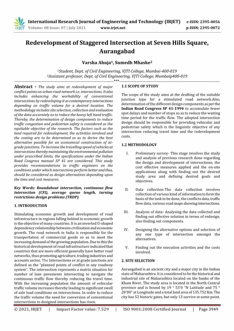
Conflicts occur in the organization due to excessive intrusion into the intersection, traffic entering through routes facing violations of traffic signals and traffic laws.
Many ways with one leg are shown in the figure below
Fig 3: Conflict points at the Intersection
From the data collected, it is evident that the volume of traffic varies from day to day, the highest volume of traffic is between the peak hours of the morning from 9am to 1pm, and rises to 3800 PCU per hour.
Depending on the current traffic conditions, future demand may be met.
Street state and locations are identified by Google Earth.
Fig 4- Google maps- location tracing
1. Central Naka Road (MGM Hospital Road) – Leg A
2. Gajanan Maharaj Mandir Road (Garkheda parisar)- Leg B
3. Airport to old Aurangabad (NHA-753 A) –Leg C
4. City to Airport and MIDC Area –Leg D
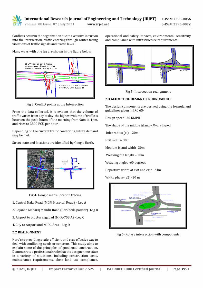
2.2 REALIGNMENT
Here's to providing a safe, efficient, and cost-effective way to deal with conflicting needs or concerns. This study aims to explain some of the principles of good road construction. Demonstrate a professional trade that the designer must face in a variety of situations, including construction costs, maintenance requirements, close land use compliance,
operational and safety impacts, environmental sensitivity and compliance with infrastructure requirements.
Fig 5- Intersection realignment
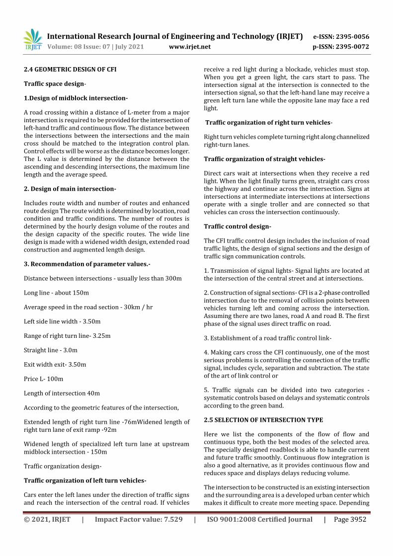
2.3 GEOMETRIC DESIGN OF ROUNDABOUT
The design components are derived using the formula and guidelines given in IRC 65-
Design speed- 30 KMPH
The shape of the middle island – Oval shaped
Inlet radius (ei) – 20m
Exit radius- 30m
Medium island width -30m
Weaving the length – 30m
Weaving angles -60 degrees
Departure width at exit and exit - 24m
Width phase (e2) -20 m
Fig 6- Rotary intersection with components
International Research Journal of Engineering and Technology (IRJET) e-ISSN: 2395-0056
Volume: 08 Issue: 07 | July 2021 www.irjet.net p-ISSN: 2395-0072
A road crossing within a distance of L-meter from a major intersection is required to be provided for the intersection of left-hand traffic and continuous flow. The distance between the intersections between the intersections and the main cross should be matched to the integration control plan. Control effects will be worse as the distance becomes longer. The L value is determined by the distance between the ascending and descending intersections, the maximum line length and the average speed.
2. Design of main intersection-
Includes route width and number of routes and enhanced route design The route width is determined by location, road condition and traffic conditions. The number of routes is determined by the hourly design volume of the routes and the design capacity of the specific routes. The wide line design is made with a widened width design, extended road construction and augmented length design.
3. Recommendation of parameter values.-
Distance between intersections - usually less than 300m
Long line - about 150m
Average speed in the road section - 30km / hr
Left side line width - 3.50m
Range of right turn line- 3.25m
Straight line - 3.0m
Exit width exit- 3.50m
Price L- 100m
Length of intersection 40m
According to the geometric features of the intersection,
Extended length of right turn line -76mWidened length of right turn lane of exit ramp -92m
Widened length of specialized left turn lane at upstream midblock intersection - 150m
Traffic organization design-
Traffic organization of left turn vehicles-
Cars enter the left lanes under the direction of traffic signs and reach the intersection of the central road. If vehicles
receive a red light during a blockade, vehicles must stop. When you get a green light, the cars start to pass. The intersection signal at the intersection is connected to the intersection signal, so that the left-hand lane may receive a green left turn lane while the opposite lane may face a red light.
Traffic organization of right turn vehicles-
Right turn vehicles complete turning right along channelized right-turn lanes.
Traffic organization of straight vehicles-
Direct cars wait at intersections when they receive a red light. When the light finally turns green, straight cars cross the highway and continue across the intersection. Signs at intersections at intermediate intersections at intersections operate with a single troller and are connected so that vehicles can cross the intersection continuously.
Traffic control design-
The CFI traffic control design includes the inclusion of road traffic lights, the design of signal sections and the design of traffic sign communication controls.
1. Transmission of signal lights- Signal lights are located at the intersection of the central street and at intersections.
2. Construction of signal sections- CFI is a 2-phase controlled intersection due to the removal of collision points between vehicles turning left and coming across the intersection. Assuming there are two lanes, road A and road B. The first phase of the signal uses direct traffic on road.
3. Establishment of a road traffic control link-
4. Making cars cross the CFI continuously, one of the most serious problems is controlling the connection of the traffic signal, includes cycle, separation and subtraction. The state of the art of link control or
5. Traffic signals can be divided into two categories - systematic controls based on delays and systematic controls according to the green band.
2.5 SELECTION OF INTERSECTION TYPE
Here we list the components of the flow of flow and continuous type, both the best modes of the selected area. The specially designed roadblock is able to handle current and future traffic smoothly. Continuous flow integration is also a good alternative, as it provides continuous flow and reduces space and displays delays reducing volume.
The intersection to be constructed is an existing intersection and the surrounding area is a developed urban center which makes it difficult to create more meeting space. Depending
International Research Journal of Engineering and Technology (IRJET) e-ISSN: 2395-0056
Volume: 08 Issue: 07 | July 2021 www.irjet.net p-ISSN: 2395-0072
on the site conditions selecting a simple intersection type to build on the existing intersection is required.
So when considering land that needs to change intersections to increase traffic volume and smoothness, traffic congestion is a good solution to apply to a selected area.
Here the road designed for rotation has a capacity of 4100 PCU / hr and the maxi-mum for the required capacity is 3600 PCU / hr. We can therefore conclude that a structured cycle can effectively control the current flow of traffic, and in the near future a small increase in traffic flow can also be effectively controlled. If the roundabout is provided traffic congestion will be reduced and half the traffic at intersections will be reduced.
2.6 COST ANALYSIS
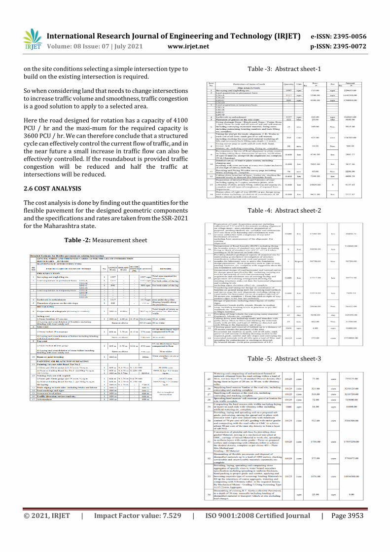
The cost analysis is done by finding out the quantities for the flexible pavement for the designed geometric components and the specifications and rates are taken from the SSR-2021 for the Maharashtra state.
Table -2: Measurement sheet
Table -3: Abstract sheet-1
Table -4: Abstract sheet-2
Table -5: Abstract sheet-3
International Research Journal of Engineering and Technology (IRJET) e-ISSN: 2395-0056
Volume: 08 Issue: 07 | July 2021 www.irjet.net p-ISSN: 2395-0072
The project cost for the intersection redevelopment for length 608m at the selected location is rupees 994,32610.00 i.e. Nine crore ninety four lakhs thirty two thousands six hundred and ten only. The rates are taken from the SSR 2021 for the Maharashtra state As per the present situation at the selected location the intersection is under major conflict points, as the arterial roads are passing through the National Highway under a flyover, the staggered shape of present intersection is leading to many wrong side turns and traffic entering through opposite sides.
In the current development plan of the Aurangabad city, many modifications are suggested for major highways. Intersections are also a major part of an urban road network
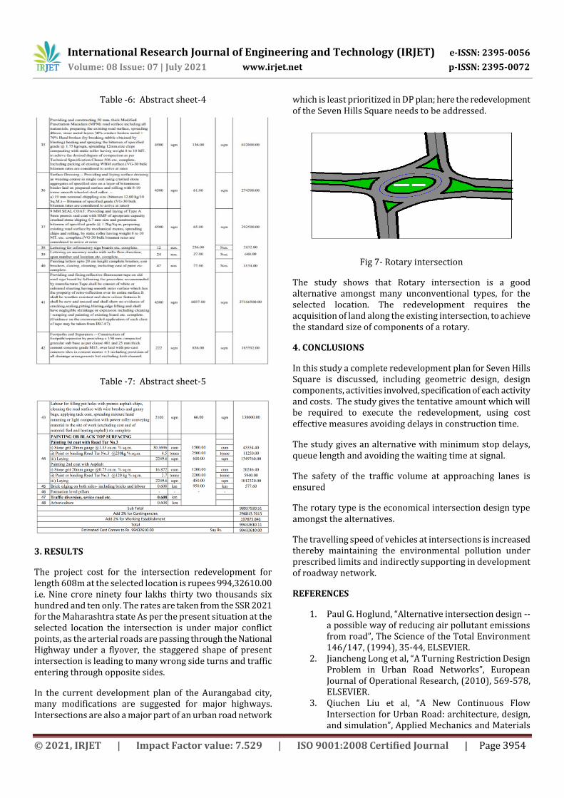
which is least prioritized in DP plan; here the redevelopment of the Seven Hills Square needs to be addressed.
Fig 7- Rotary intersection
The study shows that Rotary intersection is a good alternative amongst many unconventional types, for the selected location. The redevelopment requires the acquisition of land along the existing intersection, to achieve the standard size of components of a rotary.
4. CONCLUSIONS
In this study a complete redevelopment plan for Seven Hills Square is discussed, including geometric design, design components, activities involved, specification of each activity and costs. The study gives the tentative amount which will be required to execute the redevelopment, using cost effective measures avoiding delays in construction time.
The study gives an alternative with minimum stop delays, queue length and avoiding the waiting time at signal.
The safety of the traffic volume at approaching lanes is ensured
The rotary type is the economical intersection design type amongst the alternatives.
The travelling speed of vehicles at intersections is increased thereby maintaining the environmental pollution under prescribed limits and indirectly supporting in development of roadway network.
REFERENCES
1. Paul G. Hoglund, “Alternative intersection design -- a possible way of reducing air pollutant emissions from road”, The Science of the Total Environment 146/147, (1994), 35-44, ELSEVIER.
2. Jiancheng Long et al, “A Turning Restriction Design Problem in Urban Road Networks”, European Journal of Operational Research, (2010), 569-578, ELSEVIER.
3. Qiuchen Liu et al, “A New Continuous Flow Intersection for Urban Road: architecture, design, and simulation”, Applied Mechanics and Materials
International Research Journal of Engineering and Technology (IRJET) e-ISSN: 2395-0056
Volume: 08 Issue: 07 | July 2021 www.irjet.net p-ISSN: 2395-0072
Vols. 209-211, (2012), 677-682, Taylor & Francis. 4. Giuseppe Cantisani et al, “The Integrated Design of
Urban Road Intersections: A Case-Study”, (2015), 722-728, ASCE.
5. Avijit Maji et al, “Performance-based Intersection Layout under a Flyover for Heterogeneous Traffic”, Journal of Modern Transport, (2015), 119–129, SPRINGER.
6. Minh Tam Vu et al, “Methods for Designing Signalized Double-Intersections with Mixed Traffic in Vietnam”, Procedia Engineering 142, (2016), 131 – 138, ELSEVIER.
7. Jonathan D. Reid and Joseph E. Hummer, “Travel Time Comparisons between Seven Unconventional Arterial Intersection Designs”, Transportation Research Record 1751, (2017), 01-2957, SCOPUS.
8. Sandeep B. Rajurkar et al, “Design of Roundabout at Charkop Market”, Journal of Transport Geography, (2018), 123-129, Taylor & Francis.