1520 IEEE TRANSACTIONS ON GEOSCIENCE AND REMOTE SENSING, VOL. 40, NO. 7, JULY 2002 Regional Aerosol Retrieval Results From MISR John V. Martonchik, Associate Member, IEEE, David J. Diner, Associate Member, IEEE, Kathleen A. Crean, and Michael A. Bull Abstract—Examples of aerosol retrieval results, derived from the Multi-angle Imaging SpectroRadiometer (MISR) on the Earth Observation Science (EOS) Terra platform, are shown and the performance of the retrieval algorithms are discussed, following the first 18 months of operational data processing. A number of algorithm modifications were implemented, based on an analysis of aerosol retrieval results during this period, and these changes are described. Two cloud-screening algorithms, the angle-to-angle smoothness and angle-to-angle correlation tests, which were used in the preprocessing phase of the analyses are also described. The aerosol retrieval examples cover a wide variety of conditions, both over land and water. Particular aerosol types include dust clouds, forest fire and volcanic plumes, and localized dense haze. Finally, some ideas are discussed for additional improvement of the MISR aerosol data product, based on the experience gained in analyzing multiangle data and the associated geophysical products. Index Terms—Aerosol, algorithms, remote sensing. I. INTRODUCTION T HE Multi-angle Imaging SpectroRadiometer (MISR) on the Earth Observation Science (EOS) Terra platform has been operational since late February 2000. The instrument’s typical data collection mode is to observe the earth globally at nine different view zenith angles, ranging from 70 forward to 70 aftward along the spacecraft track, in four spectral bands (446, 558, 672, and 866 nm) and with a crosstrack ground spa- tial resolution of 275 m–1.1 km and a swathwidth of 400 km [1]. After these 36 channels of imaging data are radiometrically calibrated, georectified, and averaged to a uniform resolution of 1.1 km, they then are analyzed to determine aerosol properties over both land and ocean at a resolution of 17.6 km 17.6 km. All routine operational processing of MISR data and subsequent product archiving is carried out at the NASA Langley Atmo- spheric Science Data Center (ASDC). The aerosol retrieval methodologies being used with MISR data have been described by Martonchik et al. [2] and are summarized in Fig. 1. Implementation of both the land (Het- erogeneous Land) and ocean (Dark Water) aerosol retrieval algorithms require a predetermined set of aerosol models and their associated radiative atmospheric parameters, in particular the atmospheric path radiance and, over water, the upward transmittance of surface-reflected radiance. These parameters have been calculated for selected aerosol types with monomodal particle size distributions and are stored as a function of angular Manuscript received October 7, 2001; revised April 22, 2002. The research described in this paper was carried out at the Jet Propulsion Laboratory, Cali- fornia Institute of Technology, under a contract with the National Aeronautics and Space Administration. The authors are with the Jet Propulsion Laboratory, California Institute of Technology, Pasadena, CA 91109 USA (e-mail: [email protected]). Publisher Item Identifier 10.1109/TGRS.2002.801142. geometry and aerosol amount in various lookup tables as part of the Simulated MISR Ancillary Radiative Transfer (SMART) dataset [2]. Mixtures of two or three aerosol types produce a wide variety of aerosol models described by bimodal or trimodal size distributions [2], and these mixture models are the ones used by the MISR aerosol retrieval algorithms. The necessary radiative atmospheric parameters for these mixture models are created from the aerosol data during the actual retrieval process, using a modified linear mixing theory [3]. This strategy provides a large set of aerosol models for use in the retrieval analysis while keeping the SMART dataset at a manageable size. In this paper, we describe the current state of the MISR Heterogeneous Land and Dark Water aerosol retrieval algo- rithms, emphasizing the rationale for several modifications of the algorithms that have been made during the relatively short period since MISR achieved operational status. Then, aerosol retrieval results are shown over both land and ocean for a variety of aerosol conditions, ranging from background aerosols and concentrated fogs to dust clouds, wildfire, and volcanic plumes. Finally, we discuss the need for and the direction of future modifications to the MISR aerosol retrieval process, starting with the selection of the aerosol types in the SMART dataset and following through to the criteria which define the basic operation of the algorithms. This need for ongoing change is a response to our ongoing assessment of the quality of the MISR aerosol retrieval results and our increased understanding and appreciation of the informational content of multiangle imagery. II. ALGORITHM MODIFICATIONS A few important changes have been made to some of the operational aspects of the MISR aerosol retrieval algorithms, which were originally described in [2]. First and foremost is the deletion of the Dense Dark Vegetation (DDV) Algorithm as an operational aerosol retrieval algorithm at the Langley ASDC. Its purpose was to be another option, along side the Heterogeneous Land Algorithm outlined in Fig. 1, for performing a retrieval over land when dense, dark vegetation was present. As such, its applicability in any geographic area was limited in extent, unlike the Heterogeneous Land Algorithm which requires only a reasonable amount of scene contrast within the aerosol retrieval region. In fact, results from the current Heterogeneous Land Algorithm have demonstrated that it works well over DDV regions, making unnecessary the need for an alternative DDV-specific algorithm. The Heterogeneous Land Algorithm has been modified some- what from the original operational version available at launch U.S. government work not protected by U.S. copyright.
Transcript
1520 IEEE TRANSACTIONS ON GEOSCIENCE AND REMOTE SENSING, VOL. 40, NO. 7, JULY 2002
Regional Aerosol Retrieval Results From MISRJohn V. Martonchik, Associate Member, IEEE, David J. Diner, Associate Member, IEEE, Kathleen A. Crean, and
Michael A. Bull
Abstract—Examples of aerosol retrieval results, derived fromthe Multi-angle Imaging SpectroRadiometer (MISR) on the EarthObservation Science (EOS) Terra platform, are shown and theperformance of the retrieval algorithms are discussed, followingthe first 18 months of operational data processing. A number ofalgorithm modifications were implemented, based on an analysisof aerosol retrieval results during this period, and these changesare described. Two cloud-screening algorithms, the angle-to-anglesmoothness and angle-to-angle correlation tests, which were usedin the preprocessing phase of the analyses are also described. Theaerosol retrieval examples cover a wide variety of conditions, bothover land and water. Particular aerosol types include dust clouds,forest fire and volcanic plumes, and localized dense haze. Finally,some ideas are discussed for additional improvement of the MISRaerosol data product, based on the experience gained in analyzingmultiangle data and the associated geophysical products.
Index Terms—Aerosol, algorithms, remote sensing.
I. INTRODUCTION
T HE Multi-angle Imaging SpectroRadiometer (MISR) onthe Earth Observation Science (EOS) Terra platform has
been operational since late February 2000. The instrument’stypical data collection mode is to observe the earth globally atnine different view zenith angles, ranging from 70forward to70 aftward along the spacecraft track, in four spectral bands(446, 558, 672, and 866 nm) and with a crosstrack ground spa-tial resolution of 275 m–1.1 km and a swathwidth of 400 km[1]. After these 36 channels of imaging data are radiometricallycalibrated, georectified, and averaged to a uniform resolution of1.1 km, they then are analyzed to determine aerosol propertiesover both land and ocean at a resolution of 17.6 km17.6 km.All routine operational processing of MISR data and subsequentproduct archiving is carried out at the NASA Langley Atmo-spheric Science Data Center (ASDC).
The aerosol retrieval methodologies being used with MISRdata have been described by Martonchiket al. [2] and aresummarized in Fig. 1. Implementation of both the land (Het-erogeneous Land) and ocean (Dark Water) aerosol retrievalalgorithms require a predetermined set of aerosol models andtheir associated radiative atmospheric parameters, in particularthe atmospheric path radiance and, over water, the upwardtransmittance of surface-reflected radiance. These parametershave been calculated for selected aerosol types with monomodalparticle size distributions and are stored as a function of angular
Manuscript received October 7, 2001; revised April 22, 2002. The researchdescribed in this paper was carried out at the Jet Propulsion Laboratory, Cali-fornia Institute of Technology, under a contract with the National Aeronauticsand Space Administration.
The authors are with the Jet Propulsion Laboratory, California Institute ofTechnology, Pasadena, CA 91109 USA (e-mail: [email protected]).
geometry and aerosol amount in various lookup tables as partof the Simulated MISR Ancillary Radiative Transfer (SMART)dataset [2]. Mixtures of two or three aerosol types producea wide variety of aerosol models described by bimodal ortrimodal size distributions [2], and these mixture models arethe ones used by the MISR aerosol retrieval algorithms. Thenecessary radiative atmospheric parameters for these mixturemodels are created from the aerosol data during the actualretrieval process, using a modified linear mixing theory [3].This strategy provides a large set of aerosol models for usein the retrieval analysis while keeping the SMART dataset ata manageable size.
In this paper, we describe the current state of the MISRHeterogeneous Land and Dark Water aerosol retrieval algo-rithms, emphasizing the rationale for several modificationsof the algorithms that have been made during the relativelyshort period since MISR achieved operational status. Then,aerosol retrieval results are shown over both land and oceanfor a variety of aerosol conditions, ranging from backgroundaerosols and concentrated fogs to dust clouds, wildfire, andvolcanic plumes. Finally, we discuss the need for and thedirection of future modifications to the MISR aerosol retrievalprocess, starting with the selection of the aerosol types in theSMART dataset and following through to the criteria whichdefine the basic operation of the algorithms. This need forongoing change is a response to our ongoing assessment of thequality of the MISR aerosol retrieval results and our increasedunderstanding and appreciation of the informational contentof multiangle imagery.
II. A LGORITHM MODIFICATIONS
A few important changes have been made to some of theoperational aspects of the MISR aerosol retrieval algorithms,which were originally described in [2]. First and foremost isthe deletion of the Dense Dark Vegetation (DDV) Algorithmas an operational aerosol retrieval algorithm at the LangleyASDC. Its purpose was to be another option, along sidethe Heterogeneous Land Algorithm outlined in Fig. 1, forperforming a retrieval over land when dense, dark vegetationwas present. As such, its applicability in any geographic areawas limited in extent, unlike the Heterogeneous Land Algorithmwhich requires only a reasonable amount of scene contrastwithin the aerosol retrieval region. In fact, results from thecurrent Heterogeneous Land Algorithm have demonstrated thatit works well over DDV regions, making unnecessary the needfor an alternative DDV-specific algorithm.
The Heterogeneous Land Algorithm has been modified some-what from the original operational version available at launch
U.S. government work not protected by U.S. copyright.
MARTONCHIK et al.: REGIONAL AEROSOL RETRIEVAL RESULTS FROM MISR 1521
Fig. 1. Schematics of MISR Heterogeneous Land aerosol retrieval algorithm (top) and Dark Water aerosol retrieval algorithm (bottom).
time. This original version, described in [2], used the averageof the MISR radiances over the 1616 1.1-km pixels in the17.6 km 17.6 km region of interest to construct the 99 ele-ment scatter matrix
(1)
Here is the MISR radiance at pixel location, withinthe region, is the average radiance of the 1616pixels within the region, and are indices which designate aparticular MISR camera view, and the summation is over the256 pixels within the region. In (1) and subsequent expressions,the explicit dependence on wavelength of radiance is not shownfor brevity. The subtraction process expressed in (1) removescompletely any effect of the atmospheric path radiance (anadditive term in the expression describing ), assumingthat the atmosphere is laterally homogeneous within the region.Then the eigenvectors and eigenvalues of matrixare usedto express that component of the MISR radiances which is di-rectly and diffusely transmitted from the surface. The retrievalalgorithm has been modified by redefining the scatter matrix
, whereby the camera-dependent average radiances
were replaced with the camera-dependent radiances ofthe pixel which is darkest in the nadir view camera, i.e.,
(2)
This modification was driven by the fact that the MISR radi-ances can be expressed as
(3)
where is either when (1) is used orwhen (2) is used, are the associated eigenvectors, andare the expansion coefficients. The Heterogeneous Land Algo-rithm uses the region-averaged MISR radiances,
(4)
where is the atmospheric path radiance andis the surface-leaving radiance contribution to . The
1522 IEEE TRANSACTIONS ON GEOSCIENCE AND REMOTE SENSING, VOL. 40, NO. 7, JULY 2002
region-averaged MISR radiances on the left side of the equationis compared, via least squares, to the expression on the right sidewhich is composed of , the atmospheric path radiancefor a particular aerosol model, and an eigenvector expansionwith best fit coefficients . All aerosol models that producea quality of fit within a specified threshold are consideredto be a successful retrieval. Note that is subsumedinto the expansion term, under the assumption that it canbe adequately represented by the eigenvectors. From lookingat numerous examples of aerosol retrievals and comparingresults obtained using (1) with those using (2), it was clearthat selecting the dark pixel radiances as the bias radiances, i.e.,(2), resulted in a greater quantity of successful retrievals. Thisis explained by the fact that, in general, fewer eigenvectors areneeded in the expansion in (4) when thanwhen , making the algorithm inherentlymore sensitive. Also, since is smaller when it isassociated with the darkest pixel rather than the average pixel,the accuracy of its representation in the expansion in (4) isless important.
Another modification applied to both the HeterogeneousLand and the Dark Water Algorithm is a redefinition of thevarious tests used to find the best fitting aerosol models.The original expressions (absolute, spectral, geometric,and maximum deviation) for the Dark Water Algorithm [2]used variances, which were based on absolute radiometricuncertainties of the MISR instrument. However, this wasdetermined to be too restrictive, since the limited number ofaerosol models used in the analyses did not have the necessaryflexibility to fit the measurements to that required accuracy.The Heterogeneous Land Algorithm had a similar problemwith the variance in its expression. Here, the variance was afunction of the sum of eigenvalues of those eigenvectors whichare ignored in the expansion of (4) [2]. This eigenvalue sum canbe considered a noise factor, but again its use as the varianceproved to be too restrictive in the retrieval process. Thus, a newvariance criterion, applicable to both the Dark Water Algorithmand the Heterogeneous Land Algorithm, was selected whichmakes use of only the MISR measurements. Simply stated, theuncertainty for any of the expressions now is aconstant fraction of the particular measurement (e.g., radiancesor ratios of radiances) being fitted. The constant fraction is aconfigurable parameter currently set at 0.05. This modificationto the algorithms has resulted in a substantial increase in thenumber of successful retrievals both over land and ocean,compared to the initial retrieval success rate immediately afterlaunch.
Finally, some effort was made to fill in regional “holes” wherethe aerosol retrieval attempts were unsuccessful. This procedureis especially important over land, since no subsequent surfaceretrieval can be performed in a region lacking an adequatecharacterization of the overlying atmosphere. Therefore, asimple scheme was implemented whereby the unsuccessfulregion was assigned a default optical depth equal to the averageoptical depth of all successful retrievals in a domain nearbythe domain containing the unsuccessful region. A domain is
a standard MISR unit of area, defined as a 44 array ofregions (70.6 km 70.6 km), in which all aerosol and surfaceretrieval are performed before moving to the next domain. Undermany conditions aerosol characteristics will vary little betweenadjacent domains, so this approximate (default) characterizationof the atmosphere in a failed region will allow a reasonablyaccurate surface properties retrieval to be performed. However,the default fill procedure as currently implemented, allows thepossibility of propagating a particular default optical depth intoregions quite far from the domain where the default optical depthoriginated, a deficiency to be corrected in the next softwareupgrade. The status of the aerosol retrieval (successful, default,or no retrieval) for each region is archived in the MISR aerosolproduct.
For more information on the MISR aerosol re-trieval algorithms, documentation can be found athttp://eospso.gsfc.nasa.gov/atbd/misrtables.html.
III. CLOUD SCREENING
Before any aerosol retrievals are performed using MISRdata, the imagery is first put through a cloud-screening process.This process identifies all areas in a scene that are considerednot suitable for an aerosol/surface retrieval. Currently, two testsare performed including a radiance angle-to-angle smoothnessevaluation and an image angle-to-angle correlation. Each is usedwith Level 1B2 MISR data, i.e., multiangle imagery that hasbeen radiometrically calibrated, coregistered, and geolocatedto the terrain or ocean surface. As such, if there are any cloudsoccurring within a scene, they will appear to be misregisteredbecause of parallax. Since these two tests are designed todetect any such misregistrations, they provide some measureof cloud screening.
A. Radiance Angle-to-Angle Smoothness Evaluation
This is a test to insure that the MISR measurements for each1.1-km subregion are “smooth” as a function of camera angle.If a particular pixel location in the imagery is contaminated byclouds, different camera views of that pixel will not see the samecloud element, most likely causing a nonsmooth appearanceof the angular signature of the radiances associated with thatpixel location. For each spectral band this test is performedtwice, once used with the forward plus nadir camera dataset(five angles) and then with the aftward plus nadir cameradataset (five angles). Failure of the smoothness test for eitherdataset in any band causes that subregion to be eliminatedfrom the aerosol retrieval process.
The measurements of each of the two datasets are fitted toa polynomial with one less degree of freedom than the numberof cameras. Thus, the full complement of five cameras (four aft-ward or four forward view plus nadir view) in a dataset would befitted by a cubic polynomial. Over water, the use of less than fivecameras frequently occurs due to glitter, and if fewer than fourcameras are used, this test is not performed. For each dataset thesmoothness test parameter is calculated as
(5)
MARTONCHIK et al.: REGIONAL AEROSOL RETRIEVAL RESULTS FROM MISR 1523
Fig. 2. Dust storm over the Canary Islands on February 29, 2000. Swath segments (path 208, orbit 1065) shown (left to right) are: true-color TOA nadir view,TOA 70 aftward view, nadir camera retrieval applicability mask (see text for details), retrieved aerosol optical depth (558 nm), best fit aerosol model.
where are the MISR measurements at pixel location,, are the corresponding least squares polynomial fits,
is the acceptable goodness of fit defined to be equalto , and is the number of usable camera views.Failure of the smoothness test occurs when is greaterthan a specified limit. Nonperformance of the test, due to aninsufficient number of cameras, results in an automatic passingof the test.
B. Image Angle-to-Angle Correlation
The angle-to-angle correlation test is designed to detect fea-tures, which result in poor correlation of the radiance spatialdistribution from one view angle to another, e.g., a cloud withina subregion. This test makes use of the MISR 275-m radiancedata, routinely available in the red band for all camera views,and producing a 4 4 array of radiances for each 1.1-km sub-region. A poor correlation results in that subregion being elim-inated from the aerosol retrieval process.
The first step is to generate a camera-averaged “template”4 4 image from the 275 m red band data
(6)
where , are the indices of the 4 4 array, designates a par-ticular camera view, and is the total number of camerasused. The correlation is then computed between the 44 sub-region image of each camera to the template image. For eachcamera, the variance and covariance are calculated as follows:
(7)
where the angle brackets indicate a spatial average, computedover the 4 4 array of pixels.
Then, the square of the normalized cross correlation is calcu-lated as
(8)
Note that the sign of the covariance between the two windowsis preserved in (8). If there is a high correlation between the ra-diance distribution of cameraand the template, will take onvalues close to 1. Anticorrelation results in negative values of
. The criterion for accepting a camera in the aerosol retrievalsis that the value of must exceed a threshold value .This threshold value is currently set to 0.25 based on experi-ence using in-flight data. If the test fails for any camera, theentire subregion is eliminated from the retrieval process. Notethat if the denominator of (8) is zero or close enough to zero tocause a computational problem (this can occur if the radiancedistributions are uniform), the correlation test is considered tobe passed for those affected cameras.
IV. RETRIEVAL EXAMPLES
MISR aerosol retrievals are routinely performed at theLangley ASDC, encountering a wide variety of atmosphericsituations. Here, a selected number of retrieval cases arepresented (software version 2.1.3), illustrating some of thesevaried aerosol conditions and also introducing various elementsof the MISR aerosol standard product. These retrieval case ex-amples typically have an areal expanse covering the full widthof the MISR swath (about 400 km east–west) and extendingnorth–south about 1400 km along the orbital path, a size largeenough to display the atmospheric features of interest.
1524 IEEE TRANSACTIONS ON GEOSCIENCE AND REMOTE SENSING, VOL. 40, NO. 7, JULY 2002
A. Dust Storm Over the Canary Islands
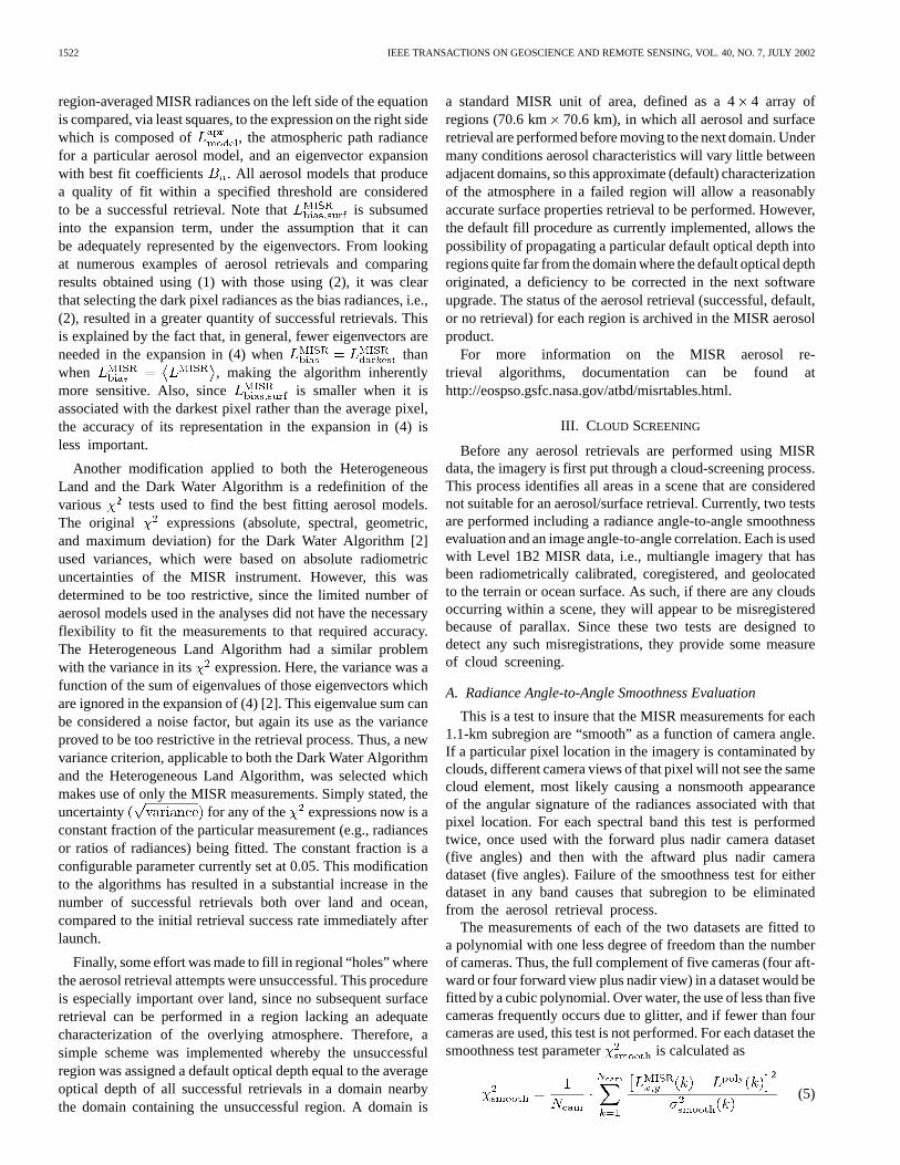
When MISR observed the Canary Islands on February 29,2000 (path 208, orbit 1065), a large dust cloud, sweeping offthe northwestern African coast, was engulfing the islands andsurrounding area. Fig. 2 shows true-color (red, green, blue bandcomposite) swath segments for the nadir viewing (far left) and70 aftward viewing (left) cameras, illustrating the consider-able increase in dust cloud brightness at large view angles ascompared to nadir. This phenomenon is typically encountered inMISR imagery, a consequence of the larger aerosol path lengthobserved with increasing view angle.
The middle-swath segment shows the nadir camera retrievalapplicability mask, designating which pixels are suitablefor use in the retrieval process. Computed for each camera,this mask incorporates the failure results generated by theangle-to-angle smoothness test (orange pixels) and correlationtest (yellow pixels), along with the failure results from a glittertest (blue pixels) and a topographic complexity/missing datatest (red pixels). Note that the individual islands, displayedin red in the middle of the swath segment, are classified asbeing topographically complex and are not used in an aerosolretrieval. Only the black pixels in the mask are deemed usable.Comparison of this mask with the corresponding imagery onthe left indicates that the various screening tests employed inthe preprocessing step of the analysis, have done a reasonablejob in detecting the spatially variable condensate cloud regionswhile passing the more spatially uniform dust cloud regions,which are suitable for an aerosol retrieval.
The next swath segment on the right side of Fig. 2 showsthe retrieved aerosol optical depth at 558 nm (MISR greenband), with values ranging from 0.2 to 2.0. The noticeablesquare elements in the optical depth map are a manifestation ofthe 17.6 km 17.6 km resolution criterion, employed by theretrieval algorithm. Those areas colored black indicate that noaerosol retrieval results are available, either because the multi-camera retrieval applicability masks excluded them or becausethe retrieval was unsuccessful at finding an aerosol model thatsatisfied the criteria. Note that there are successful retrievalsin areas of the swath segment where the mask indicates thatclouds appear to be present. This is especially apparent on thefar right of the swath segment toward the middle, where a bandof clouds crosses the image. Recalling that the mask is gener-ated at 1.1-km resolution while the retrieval is performed on ascale of 17.6 km, the Dark Water aerosol retrieval algorithm(see Fig. 1) will search for any available 1.1-km pixels whichpass the cloud-screening tests out of the 256 pixels containedwithin the region of the retrieval. If only one good pixel ispresent, it will be used in the retrieval process and the resultsapplied to the entire 17.6 km 17.6 km region. This criterionof “just a single clear pixel between the clouds” seems not tobe unreasonable when using the Dark Water Algorithm, sincethere appears to be no effect from clouds in the resulting opticaldepth map. Likewise, the nadir camera retrieval applicabilitymask shows significant glitter effects in the lower right sideof the swath segment, making the nadir camera unusable.However, there are other MISR cameras where glitter is not a
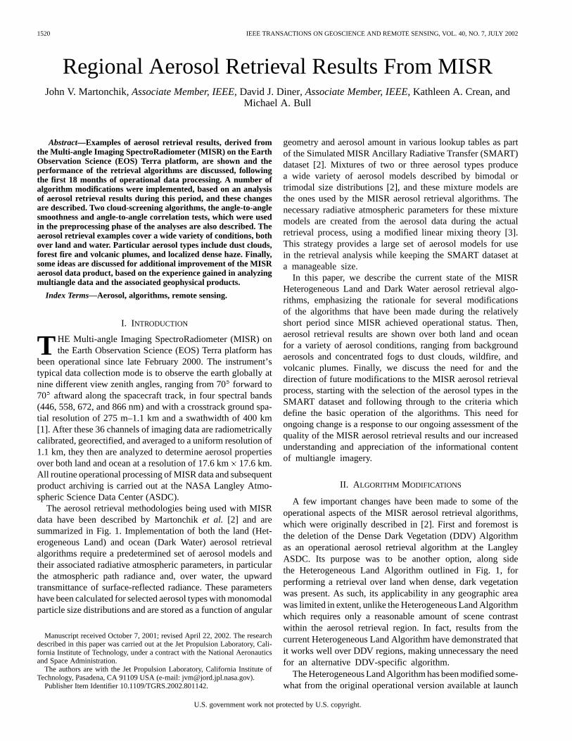
Fig. 3. MISR band 4 equivalent reflectance versus camera view angle foran ocean location off the coast of southern Africa on August 27, 2000. Alsoshown are results from four aerosol models assuming a surface windspeedof 3.4 m/s. The scattering angles of the observations range from 166(thebackward scattering view at�46 ) to 61 (the forward scattering view at 70).
problem in this region, allowing a successful aerosol retrievalto be performed as indicated in the optical depth map.
Finally, the swath segment on the far right of the figureindicates the type of aerosol which best fitted the MISRmeasurements. The 49 aerosol models used in the MISRoperational retrievals over ocean are grouped under three broadcategories: clean, industrial, and dusty maritime. The 14 modelsclassified as clean maritime are mixtures composed of variousamounts of three basic particle types, namely accumulationmode sulfate/nitrate particles and accumulation and coarsemode sea salt particles. The 12 industrial maritime models aresimilar to the clean models but with black carbon replacingthe coarse mode sea salt. The third group, dusty maritime, canbe split into two subgroups of dusty aerosol models. The 18models in the first subgroup are similar to the clean maritimemodels but with high-altitude medium-size dust replacing thecoarse sea salt. The five models in the remaining subgroup arecomposed only of dust particles, namely low-altitude mediumand large dust particles and high-altitude medium-size dustparticles. In the aerosol type map of Fig. 2, the three categoriesof aerosol models can be identified, but the dusty maritimemodels clearly dominate the scene. Over ocean, the MISRinstrument is quite sensitive to nonspherical particles suchas dust [4], so it is encouraging that, under obviously dustyconditions, the dust-based models are the best fitting models.
B. Aerosol Retrieval off the Coast of South Africa
The success of MISR aerosol retrievals over ocean has provento be very sensitive to the selected aerosol models being em-ployed. In particular, for MISR the particle shape and size dis-tribution are the most important aspects describing an aerosolmodel; sensitivity to the refractive index is much lower [5].Fig. 3 shows an example of MISR measurements at the ninecamera view angles in the near-infrared band (866 nm) for acloud-free location about 50 km off the southern coast of South
MARTONCHIK et al.: REGIONAL AEROSOL RETRIEVAL RESULTS FROM MISR 1525
Fig. 4. Dust clouds over the Red Sea. Swath segments shown (left to right) March 25, 2001 (path 170, orbit 6742) are: true-color TOA nadir view, TOA 70forward view, retrieved aerosol optical depth (558 nm), June 29, 2001 (path 170, orbit 8140) true-color TOA nadir view, TOA 70forward view, retrieved aerosoloptical depth (558 nm).
Africa on August 27, 2000 (path 172, orbit 3684). This partic-ular case is interesting in that all 49 ocean aerosol models usedin the MISR operational retrieval process were unsuccessful infitting these data. This is not an isolated case, but is represen-tative of a fairly large number of situations encountered aroundthe globe where MISR ocean aerosol retrievals failed to find asuccessful model within the preestablished lookup dataset.
Also shown in the figure are three examples (fine parti-cles, sulfate/sea salt mixture, coarse sea salt) of efforts to fitthe measurements using different types of aerosol models,characterized mainly by their particle size. The fine particlesand coarse sea salt particles are described by monomodal lognormal size distributions with similar widths but having vastlydifferent effective radii [6], 0.003 m for the fine particlesand 17 m for the coarse sea salt. The bimodal sulfate/sea saltmixture (one of the MISR clean maritime models) is composedof 80% sulfate/nitrate (0.3-m effective radius) and 20% seasalt (1.20 m), as measured by optical depth at 558 nm, andrepresenting a medium particle size model between the fineparticle and coarse sea salt. All models required a small opticaldepth ( 0.075 at 558 nm) for their best fit of the measurements,but each shows large deviations from the measurements at largeforward viewing angles (positive view zenith angle in Fig. 3).Normalizing all results to the nadir view, there is a systematictrend of the smallest particles to undershoot the measurementsand the largest particles to overshoot them. Note that themeasurements for the 46and 60 forward view cameras arecontaminated by glint, while the most forward viewing cameraat 70 is not. The data from these two glint-contaminated cam-eras would not normally be used in the MISR retrieval, but it isinstructive to note that these measurements could be modeledusing the Cox–Munk theory [7] with surface windspeed as aparameter to be determined.
The last curve in the figure (labeled the GISS bimodal model)represents an aerosol model, recently derived from aircraft pho-topolarimeter measurements off the coast of Monterey, CA [8].Interestingly, this model best fits the MISR measurements forthis southern Africa oceanic case study. It is composed of fine(water soluble) and coarse (sea salt) mode particles with ef-fective radii of 0.1 and 1.0 m, respectively, and with a mix-ture ratio such that the fine mode contributes about 60% ofthe optical depth at 558 nm. None of the current MISR mar-itime aerosol models has a component composed of particlesas small as the fine mode of the GISS (Goddard Institute forSpace Studies) model. Indeed, the smallest effective radius inthe SMART dataset is 0.21m, a condition which is believedto account for the inability to adequately fit the measurementsin many cases. However, it is by looking at failures in the oceanretrievals, such as illustrated in Fig. 3, that reveal deficienciesin the current algorithm and its associated aerosol dataset andpoint the way to improvements required to resolve them.
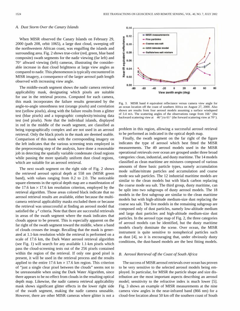
C. Dust Clouds Over the Red Sea
Fig. 4 shows swath segments of a portion of the Middle Eastwith Saudi Arabia at the top of the images, Sudan, Eritrea, andEthiopia toward the bottom, and the Red Sea cutting throughthe center. The first three swath segments on the left side of thefigure used measurements taken on March 25, 2001 (path 170,orbit 6742), displaying the true-color nadir view, 70forwardview, and retrieved optical depth, respectively. The second setof three swath segments on the right of the figure has identicalcharacteristics as the first, but used measurements taken on June29, 2001 (path 170, orbit 8140), three months later. Like the Ca-nary Island scene, the 70view images for both dates accentuatethe dust clouds over the water, as compared with their nadir view
1526 IEEE TRANSACTIONS ON GEOSCIENCE AND REMOTE SENSING, VOL. 40, NO. 7, JULY 2002
Fig. 5. Wildfires in Montana on August 14, 2000. Swath segments (path 40, orbit 3501) shown (left to right) are: true-color TOA nadir view, TOA 70forwardview, Langley ASDC-retrieved aerosol optical depth (558 nm), JPL-retrieved aerosol optical depth (558 nm).
counterparts. An exception appears to be the greater brightnessof the water at the far right of the swath segment of the Marchnadir image, but this effect is due mainly to glint, whereas the70 image is essentially glint-free. In general, the June imageslook hazier than the March ones, both over land and water, inmost areas, and the optical depth maps for both dates bear outthis observation.
The best fitting aerosol models for both dates are the dustymaritime variety over the water and dusty continental overland. The MISR dusty continental aerosol group is composedmainly of mixtures of sulfate/nitrate particles, and medium-and coarse-size dust, but only a single dust model from thisgroup (75% sulfate/nitrate and 25% medium-size dust byoptical depth at 558 nm) was available when these particularretrievals were performed. Additional available MISR aerosolmodels over land included the clean continental and industrialcontinental groups, both composed of sulfate/nitrate particlesmixed with varying amounts of black carbon. However, it wasthe singular dust model that was predominately selected as thebest fit in the retrieval process.
It is interesting to note that the optical depth continuity isvery good going from land, across the water, and back over landagain, even though two quite different retrieval algorithms andtwo distinct groups of aerosol models were used, depending onthe type of underlying surface. Another interesting feature tonote is the isolated region of large optical depth in the upperfar right of the March optical depth map. Although a compar-ison of the nadir images for the March and June dates indicateslittle or no difference at this location, the 70view March image
clearly shows a distinctly brighter area there than the 70viewJune image, indicating a pronounced dust cloud. This is a goodexample of how extreme off-nadir imagery can intensify atmo-spheric features, which are not obvious in a standard nadir viewand the ability of the Heterogeneous Land Algorithm to detectand analyze them.
D. Wildfires in Montana
There were numerous incidents of wildfires in the westernpart of the United States during the summer of 2000. On Au-gust 14, 2000 (path 40, orbit 3501) MISR observed a number ofwildfire smoke plumes in the Salmon River area of Idaho and ex-tending across the Bitterroot Mountain range into southwesternMontana. True-color swath segments for this region in the nadirand 70 forward views are shown in Fig. 5. The light color areasare plains and valleys with minimal green vegetation whereasthe darker areas are more vegetated mountainous terrain (notburn scar areas, which are on a much smaller scale in these im-ages). As expected, the smoke plumes from the various fires aremuch more obvious in the 70view image. Also displayed aretwo versions of the retrieved aerosol optical depth. The one onthe left shows results from the Heterogeneous Land Algorithmwhich is scheduled to run at the Langley ASDC through the endof 2001. A few smoke plume optical depths are apparent butmuch of the mountainous terrain was designated as being too to-pographically complex or having too little contrast to attempt aretrieval, and these regions (including regions with unsuccessfulretrievals) are displayed as black in the map.
MARTONCHIK et al.: REGIONAL AEROSOL RETRIEVAL RESULTS FROM MISR 1527
Fig. 6. Haze in central California on January 3, 2001. Swath segments (path 42, orbit 5569) shown (left to right) are: true-color TOA 70forward view, TOAnadir view, TOA 70 aftward view, retrieved aerosol optical depth (558 nm).
The optical depth map on the right in Fig. 5 shows resultsfrom a modified version of the algorithm (run at the MISRScience Computing Facility at the Jet Propulsion Laboratory)whereby threshold conditions, as to when a retrieval is at-tempted over complex topographic terrain or terrain with littlecontrast, have been eased. A considerable increase in coverageof retrieved optical depth was achieved, showing additionalsmoke plume optical depths as well as optical depths for thesurrounding terrain, and with no obvious detrimental effects.It can now be seen that moderate aerosol amounts (displayedas green) are mainly at the lower elevations, i.e., the SnakeRiver valley at the bottom of the map and the Great Plainsarea in the upper half, whereas the blue areas, indicatingless aerosol amount, are concentrated mainly at much higherelevations in more mountainous terrain. The adjustment ofconfigurable parameters in the retrieval algorithms to increasetheir success rates is an ongoing task, which can only be donethrough considerable scrutiny and analysis of the operationalprocessing product results.
E. Haze in Central California
A localized area of haze, situated within the San JoaquinValley of central California, was detected by MISR on January
3, 2001 (path 42, orbit 5569). The three swath segments onthe left side of Fig. 6 are true-color images for views at 70forward, nadir, and 70aftward, illustrating the large extent ofthe hazy area and the spatial contrast differences between thethree images. In the nadir view, only an optically thick centraltongue of fog is visible (probably the notorious “Tule” fogcommon to this area), whereas the 70images, especially theforward view, show haze filling the whole valley. The retrievedaerosol optical depth map on the right in Fig. 6 covers a largeregion of the ocean, south of the Santa Barbara–Los Angelescoastline, extending northwards into central Nevada. Thereis a high degree of uniformity of a relatively small aerosoloptical depth over the ocean, across the coastline, and into thecontinental interior. The Los Angeles basin at the far right onthe coast shows little sign of aerosol buildup at this particulartime of day (late morning). Within the San Joaquin Valley theturbidity was found to be considerably greater than that ofthe surrounding terrain. The retrieved optical depths, however,were obtained without consideration of a fog model, which hasmuch larger particles than the sulfate/nitrate models actuallyused. Thus it is expected that the retrieved optical depths in theValley may be somewhat biased on the low side. The opticaldepths obtained for the tongue of fog are unreliable, since
1528 IEEE TRANSACTIONS ON GEOSCIENCE AND REMOTE SENSING, VOL. 40, NO. 7, JULY 2002
Fig. 7. Mount Etna eruption on July 22, 2001. Swath segments (path 187, orbit 8476) shown (left to right) are: true-color TOA 70forward view, mean-retrievedaerosol optical depth (558 nm), best-fit-retrieved aerosol optical depth (558 nm), cloud/plume heights (km).
the multiangle images indicate that it is optically thick to adegree that no surface contrast can be discerned (a conditionneeded by the Heterogeneous Land Algorithm).
A noticeable lack of retrieval success is apparent in a largearea of the ocean (black regions in map), even though the multi-angle images on the left display no evidence of cloud contamina-tion. This kind of occurrence, where all 49 ocean aerosol modelshave failed under clear sky conditions, has been observed ona number of occasions in various parts of the world’s oceans.As explained in Section III-B, this failure is believed to be di-rectly attributable to an inadequate choice of aerosol modelswith small effective radii, coupled with the high sensitivity ofthe MISR instrument over ocean to particle size. A similar sizedregion of no retrievals is also apparent on land over the SierraNevada mountain range. Here, however, retrievals were not at-tempted for the most part, due to the complex nature of the ter-rain.
F. Mount Etna Eruption
On July 22, 2001 (path 187, orbit 8476) MISR observed alarge volcanic plume emanating from Mount Etna in Sicily. Ascan be seen in the 70forward view true-color image on theleft in Fig. 7, the plume is well over 300 km long, extendingbeyond the eastern edge of the swath segment. Two maps ofretrieved optical depth are displayed in the central part of thefigure. The one on the left shows the averaged results using onlysuccessful retrievals, i.e., those which satisfied the varioustests used to find the best fitting aerosol models, and the oneon the right showing the results for the best fitting model only,whether or not it passed the tests. This second version of themap essentially permits complete coverage of optical depth ina swath segment (except for detected clouds and unusable ter-rain), but with reduced accuracy. Thus, for instance, all the un-successful retrievals (colored black) in the large patch of clearsky ocean in the upper right of the right-side map have beenfilled with the optical depths of the best fitting, but test-failed,
models. This relaxing of standards is no substitute for havingbetter aerosol models, but it does illustrate the fact that evennonoptimum models can provide optical depth determinationsthat are within an acceptable range of uncertainty [5], as evi-denced by a comparison of the two maps.
Optical depth retrievals along the plume length are compro-mised somewhat by the fact that the Dark Water Algorithmsearches for and uses only the minimum radiance pixelswithin the 16 pixel 16 pixel aerosol retrieval region (seeSection IV-A). Thus, a region with a plume partially filling itwill tend to produce an optical depth for the least contaminatedpixel, which will not be representative of the plume itself. Infact, if the visibly discernible plume width is less than thedimension of the region (17.6 km), the retrieval process canmiss the core of the plume entirely. For the Mount Etna plumein Fig. 7, this has likely led to an underestimate of its opticaldepth, the exception being that part far away from the volcanowhich is wide enough to accommodate up to three retrievalregions.
The map on the far right in Fig. 7 shows the heights of theterrain, clouds and plume, derived from the MISR stereo imageprocessing [9]. It shows the plume near the volcanic vent to beat an altitude of about 5000 m above sea level, decreasing some-what with distance from the vent, and with clouds in the scenebeing considerably lower. These high altitudes indicate that thisparticular eruption was quite powerful. Plume/cloud height in-formation is routinely provided as part of the MISR standardproducts, generated and archived at the Langley ASDC.
V. DISCUSSION
The examples described in Section IV indicate that a signifi-cant degree of success has been achieved in using MISR datato retrieve aerosol properties. Much of this success is due tofact that data from all nine view angles are routinely used, al-lowing observations of air masses up to three times that of nadir.
MARTONCHIK et al.: REGIONAL AEROSOL RETRIEVAL RESULTS FROM MISR 1529
Even when scattered clouds are present in the images, the ex-treme-off-nadir cameras (60and 70 view angles) can usuallysee a sufficient fraction of clear surface within those 17.6-kmregions, which are clear in the nadir camera.
An important element in quantitatively gauging that successis through a rigorous validation effort, by which an independentcharacterization of the atmosphere is achieved, principallythrough intensive field campaigns which can provide in-formation in situ on aerosol properties, and ground-basedmeasurements made simultaneously with the space-basedobservations. In fact, such measurements are routinely madeby a large number of sunphotometers strategically placed aboutthe globe, and the bulk of which are associated with AERONET[10], a network of automated CIMEL radiometers coordinatedby the NASA Goddard Space Flight Center. During the SA-FARI 2000 dry-season field campaign in southern Africa, alarge number of AERONET sunphotometers were in operationin the region, allowing a comparison of their derived aerosoloptical depths with those retrieved using MISR [11]. Thisparticular study showed very good agreement between the twosets of results, even though all the retrieval locations weresituated on land. This initial validation effort has been veryencouraging, but it is only the start of a larger, ongoing effort,designed to utilize the results from all AERONET sites aroundthe globe.
None of the examples of retrieved optical depth described inthis paper, however, had any available ground-based aerosol in-formation with which to make a comparison. Instead, they werechosen to elucidate the ability of the current operational retrievalprocess to handle a variety of aerosol phenomena. As such, theyrepresent a part of a larger, ongoing qualitative study of theMISR aerosol product, which is also an important aspect of theoverall validation effort, supplementing the quantitative groundtruth comparisons. The aerosol products in these examples havea maturity level, which is classified as “beta,” implying thatthe associated retrieval algorithms still need to undergo exten-sive testing and evaluation. As some of these examples clearlydemonstrate, modifications to the retrieval algorithms need tobe implemented to improve both the quality and quantity of theaerosol products.
One of the more obvious conclusions, resulting from an on-going assessment of the MISR aerosol product, is the need forbetter aerosol models, particularly when performing retrievalsover water. The model improvements can be accomplished byhaving available a wider range of particle sizes and mixture ra-tios. The size distributions of tropospheric sulfate/nitrate aerosolparticles in the SMART dataset to date have effective radii of0.21, 0.27, 0.32, and 0.64m, a range too restrictive for manysituations encountered in nature. The absence of any size dis-tributions with effective radii significantly smaller than 0.2mwas a critical factor in the failures of the retrieval process overocean, which were noted in some of the examples described inthe previous section. Sea salt particles in the SMART dataset,however, were able to provide the needed size distributions witheffective radii which are larger than 0.6m. The next genera-tion of the SMART dataset will be restructured to include addi-tional size distributions of these smaller aerosol particles, downto 0.03 m in effective radius, without significantly increasingthe size of the dataset.
The concept of how aerosol models are formulated can alsobe modified to accommodate a wider variety of aerosol condi-tions. Currently, a dataset of predetermined mixing ratios areused to construct the two- or three-component aerosol modelsused in the retrievals [2], [12]. For the Dark Water Algorithm,however, these mixing ratios could be determined as part of thedata/model fitting process using a least squares analysis. For thenext processing upgrade, aerosol model modifications will belimited to the addition of the new models in the SMART dataset,while retaining the current concept of predetermined mixingratios. These new models will certainly provide better fits tothe observations, allowing more information to be gleaned fromMISR data over ocean than is currently obtainable. If, after a pe-riod of analyzing the ensuing results, it is determined that someadditional modeling finesse is justified, then the least squaresdetermination of the mixing ratios will be included as part ofthe retrieval algorithm.
Some effort has also been made to improve the reliability ofthe Heterogeneous Land Algorithm. Modifications already im-plemented were described in Section II. Ideas for further im-provement center on providing constraints to the retrievals byemploying the concept that the angular signature of the direc-tional reflectance of at least some surface types is spectrallyinvariant in certain wavelength regions. This is an idea devel-oped in various forms by Flowerdew and Haigh [13], Veefkindet al. [14], and Northet al. [15] and used in their analyses ofdata from the Along Track Scanning Radiometer 2 (ATSR-2),a two-view angle instrument. The Heterogeneous Land Algo-rithm in its current version assumes no relationships of any kindto connect information in different spectral bands. If, however,the idea of spectral invariance (or some other type of reliablerelationship) for surface directional reflectances can be vali-dated, then that constraint would certainly be implemented. Arecently initiated comparison study of retrieved surface spec-tral directional reflectances, particularly for those places wherethe atmospheric properties are independently determined fromground-based measurements, will determine exactly what, ifany, surface reflectance properties can be exploited by MISRfor improved aerosol retrievals. If such improvements can beachieved, then it is expected that aerosol retrievals at consider-ably higher spatial resolution than 17.6 km will be feasible.
A major factor governing the success of aerosol retrievals isthe issue of cloud screening. The only detection means currentlyused in operational processing is the implementation of theangle-to-angle smoothness and correlation algorithms describedinSection III.Astudyof theexamplesofaerosol retrievalsshownin the Figs. 2–7 shows that these algorithms together do a verygood job of cloud detection, but careful scrutiny shows that theyare not fully able to screen out all cloud activity. On the otherhand, we do not want to classify volcanic and wildfire plumesas clouds. Therefore, an additional approach is currently beingdeveloped, whereby the smoothness and correlation algorithmsare to be supplemented by the Stereoscopically Derived CloudMask (SDCM) [9] and the Radiometric Camera-by-CameraCloudMask(RCCM) [16].TheSDCMcategorizescloudactivitybased on height discrimination whereas the RCCM does soby using radiance thresholds. Agreement by the two masksthat a particular pixel at a particular camera view is cloudcontaminated, classifies that pixel as being Optically Thick
1530 IEEE TRANSACTIONS ON GEOSCIENCE AND REMOTE SENSING, VOL. 40, NO. 7, JULY 2002
Atmosphere (OTA). Many OTA pixels will be comprised ofcloud, but others will include thick plumes over land or ocean.As such, if there are a sufficient number of these OTA pixelsin a given aerosol retrieval region, a retrieval will be attemptedby assuming that the surface reflectance for these OTA pixelscontributes a negligible amount to the measured radiances.Thus, the OTA Algorithm will be used as an alternative to theDark Water Algorithm and the Heterogeneous Land Algorithm.This strategy will allow thick plumes to be more accuratelyanalyzed, without regard to surface contrast requirements forland or minimum radiance constraints for ocean. For trulycloudy areas, this new retrieval process is expected to fail dueto the inability of the aerosol models to match the spectral andangular reflectance signatures of large droplet clouds and thuswould only serve to help validate that particular atmosphericcondition.
Finally, the optical depth fill scheme described in Section II,used when the retrieval attempt in a region was unsuccessful, hasbeen substantially modified. The default optical depth as the av-erage optical depth from a nearby domain has been replaced bythe optical depth of the best fitting model from a nearby region.The fill procedure is now structured such that the default opticaldepth of a particular region can never be propagated throughmore than three adjacent unsuccessful retrieval regions and usu-ally only once. For those cases where an unsuccessful retrievalregion is adjacent to regions also with unsuccessful retrievals,that region is not prescribed any type of default retrieval resultand no surface retrieval is performed.
The next generation of the SMART dataset with the inclu-sion of new aerosol size distributions, the OTA Algorithm asa supplementary aerosol retrieval algorithm, and the improveddefault optical depth fill procedure algorithm were all imple-mented at the Langley ASDC in April 2002 (software version2.2). Issues such as the use of spectral surface reflectance con-straints in the Heterogeneous Land Algorithm and the need fora least squares determination of the aerosol type mixing ratioswill be resolved during the course of 2002 and any additionalalgorithm upgrades in these areas should be implemented by theend of that year.
VI. SUMMARY
Since the instrument cover first opened 18 months ago, MISRaerosol retrievals have been routinely performed at the LangleyASDC. Initial analysis of the aerosols products immediately ledto some changes in the retrieval algorithms to improve boththe quality and the quantity of results. Retrieval examples forvarious types of aerosol conditions, both over land and water,showed that in general the results are satisfactory, but that addi-tional algorithm and aerosol model improvements are also nec-essary. More variety in the aerosol particle size, especially foreffective radii below 0.2 m is required and will soon be imple-mented. However, substantial algorithm improvements, such asadding constraints to the aerosol retrieval process over land, willneed more time to fully understand what is necessary and thento implement it. Given the relatively short time that MISR hasbeen in orbit, considerable success has already been achieved inretrieving aerosol properties and it is expected that much morewill be accomplished in the near future.
ACKNOWLEDGMENT
A number of individuals at the Jet Propulsion Laboratoryhave worked diligently to create the Level 2 aerosol retrievalsoftware for use at the Langley ASDC. In particular we want tothank D. McDonald, R. Monarrez, D. Nelson, and S. Paradise.We also want to thank the Langley ASDC for their expeditiousdelivery of the processed MISR data and R. Kahn for manyhelpful discussions and his careful reading of the manuscript.
REFERENCES
[1] D. J. Diner, J. C. Beckert, T. H. Reilly, C. J. Bruegge, J. E. Conel, R.A. Kahn, J. V. Martonchik, T. P. Ackerman, R. Davies, S. A. W. Gerstl,H. R. Gordon, J.-P. Muller, R. B. Myneni, P. J. Sellers, B. Pinty, and M.M. Verstraete, “Multi-angle imaging spectroradiometer (MISR) instru-ment description and experiment overview,”IEEE Trans. Geosci. Re-mote Sensing, vol. 36, pp. 1072–1087, July 1998.
[2] J. V. Martonchik, D. J. Diner, R. A. Kahn, T. P. Ackerman, M. M. Ver-straete, B. Pinty, and H. R. Gordon, “Techniques for the retrieval ofaerosol properties over land and ocean using multiangle imaging,”IEEETrans. Geosci. Remote Sensing, vol. 36, pp. 1212–1227, July 1998.
[3] W. A. Abdou, J. V. Martonchik, R. A. Kahn, R. A. West, and D. J. Diner,“A modified linear mixing method for calculating atmospheric path radi-ances of aerosol mixtures,”J. Geophys. Res., vol. 102, pp. 16833–16888,1997.
[4] R. Kahn, R. West, D. McDonald, B. Rheingans, and M. I. Mishchenko,“Sensitivity of multiangle remote sensing observations to aerosolsphericity,”J. Geophys. Res., vol. 102, pp. 16861–16870, 1997.
[5] R. Kahn, P. Banerjee, D. McDonald, and D. J. Diner, “Sensitivity of mul-tiangle imaging to aerosol optical depth and to pure-particle size dis-tribution and composition over ocean,”J. Geophys. Res, vol. 103, pp.32195–32213, 1998.
[6] J. E. Hansen and L. D. Travis, “Light scattering in planetary atmo-spheres,”Space Sci. Rev, vol. 16, pp. 527–610, 1974.
[7] C. Cox and W. Munk, “Statistics of the sea surface derived from Sunglitter,” J. Mar. Res., vol. 13, pp. 198–227, 1954.
[8] J. Chowdhary, B. Cairns, M. Mishchenko, and L. Travis, “Retrievalof aerosol properties over the ocean using multispectral and multi-angle photopolarimetric measurements from the research scanningpolarimeter,”Geophys. Res. Lett, vol. 28, pp. 243–246, 2001.
[9] D. J. Diner, R. Davies, L. DiGirolamo, A. Horvath, C. Moroney, J.-PMuller, S. R. Paradise, D. Wenkert, and J. Zong, “Level 2 cloud detec-tion and classification algorithm theoretical basis,” Jet Propulsion Lab.,Pasadena, CA, JPL Tech. Doc. D-11399, 1999.
[10] B. N. Holben, T. F. Eck, I. Slutsker, D. Tanre, J. B. Buis, A. Setzer,E. Vermote, J. A. Reagan, Y. J. Kaufman, T. Nakajima, F. Lavenu, I.Jankowiak, and A. Smirnov, “AERONET—A federated instrument net-work and data archive for aerosol characterization,”Remote Sens. Env-iron., vol. 66, pp. 1–16, 1998.
[11] D. J. Diner, W. A. Abdou, C. J. Bruegge, J. E. Conel, K. A. Crean, B. J.Gaitley, M. C. Helmlinger, R. A. Kahn, J. V. Martonchik, S. H. Pilorz,and B. N. Holben, “MISR aerosol optical depth retrievals over southernAfrica during the SAFARI-2000 dry season campaign,”Geophys. Res.Lett., vol. 28, pp. 3127–3130, 2001.
[12] D. J. Diner, W. A. Abdou, H. R. Gordon, R. A. Kahn, Y. Knyazikhin, J.V. Martonchik, S. McMuldroch, R. Myneni, and R. A. West, “Level 2ancillary products and datasets algorithm theoretical basis,” Jet Propul-sion Lab., Pasadena, CA, JPL Tech. Doc. D-13402, 1998.
[13] R. J. Flowerdew and J. D. Haigh, “Retrieval of aerosol optical thicknessover land using the ATSR-2 dual look radiometer,”Geophys. Res. Lett.,vol. 23, pp. 351–354, 1996.
[14] J. P. Veefkind, G. de Leeuw, and P. A. Durkee, “Retrieval of aerosoloptical depth over land using two-angle view satellite radiometry duringTARFOX,” Geophys. Res. Lett., vol. 25, pp. 3135–3138, 1998.
[15] P. R. J. North, S. A. Briggs, E. Plummer, and J. J. Settle, “Retrieval ofland surface bidirectional reflectance and aerosol opacity from ATSR-2multiangle imagery,”IEEE Trans. Geosci. Remote Sensing, vol. 37, pp.526–537, Jan. 1999.
[16] D. J. Diner, L. Di Girolamo, and E. E. Clothiaux, “Level 1 cloud de-tection algorithm theoretical basis,” Jet Propulsion Lab., Pasadena, CA,JPL Tech. Doc. D-13397, 1997.
MARTONCHIK et al.: REGIONAL AEROSOL RETRIEVAL RESULTS FROM MISR 1531
John V. Martonchik (A’01) received the B.S. degreein physics from Case Institute of Technology, Cleve-land, OH, in 1964 and the Ph.D. degree in astronomyfrom the University of Texas, Austin, in 1974.
He is currently a Research Scientist at the JetPropulsion Laboratory (JPL), Pasadena, CA, and hasbeen with JPL since 1972. His experiences includetelescopic and spacecraft observations of planetaryatmospheres, laboratory and theoretical studies ofthe optical properties of gaseous, liquid, and solidmaterials, and development and implementation of
1-D and 3-D radiative transfer and line-by-line spectroscopy algorithms forstudies of planetary atmospheres and earth tropospheric remote sensing. Hehas been a Co-Investigator in several NASA programs and is the AlgorithmScientist for aerosol and surface retrievals on MISR.
David J. Diner (A’01) received the B.S. degree inphysics (with honors) from the State University ofNew York at Stony Brook in 1973 and the M.S.and Ph.D. degrees in planetary science from theCalifornia Institute of Technology, Pasadena, in1977 and 1978, respectively.
He has been with the Jet Propulsion Laboratory,Pasadena, since 1981. He is currently a PrincipalMember of the Technical Staff and Leader of theMulti-angle Imaging Science Element in the Earthand Space Sciences Division. He has been involved
in numerous NASA planetary and Earth remote-sensing investigations, and isPrincipal Investigator of the MISR experiment and its airborne counterpart,AirMISR.
Kathleen A. Crean received the A.B. degree inphysics from Occidental College, Los Angeles, CA,in 1990 and and the M.S.E. degree in aerospaceengineering from the University of Texas, Austin, in1994.
She has been a Member of the Technical Staff atthe Jet Propulsion Laboratory, Pasadena, CA, since1994, working as a Software Engineer on the MISRProject.
Michael A. Bull received the B.S. degree (withhonors) in computer science from the Universityof Maryland, College Park, in 1992 and the M.S.degree in computer science from the University ofCalifornia, Los Angeles, in 1994.
He is currently providing software developmentsupport for MISR in the areas of geometric calibra-tion and registration, and aerosol science algorithms.He has been with the Jet Propulsion Laboratory,Pasadena, CA, since 1996, working as a member ofthe software development team for the Multi-angle