60
Remote Sensing and Data Collection for Oil Spill Response in Canada RDIMS# 14969867 Presented by: Louis Armstrong Chief - Intelligence, Surveillance and Reconnaissance Transport Canada 1

Remote Sensing and Data Collectionfor Oil Spill Response in Canada
RDIMS# 14969867
Presented by: Louis ArmstrongChief - Intelligence, Surveillance and ReconnaissanceTransport Canada
1

2
Aircraft Services Directorate (ASD) Overview
• Federal Government internal aviation service provider since 1936
• 44 Aircraft, 325 Staff, 15 Bases across Canada
• Considered as an Air Operator just like all other commercial operators in Canada
• Under Canadian Aviation Regulations, Aircraft Services Directorate is considered as an:
• Air Operator Certificate (AOC)
• Approved Maintenance Organization (AMO)
• Approved Engineering Organization (AEO)
• Approved Training Organization (ATO) maintenance)

1968 Pollution patrols commenced over the Great Lakes & St. Lawrence Seaway
1991 NASP created by CCG and expanded to East and West Coasts
2003 NASP transferred to TC from CCG
2005 Arctic patrols began in partnership with ECCC
2006 - 2008 Aircraft outfitted with MSS6000 – ATL, C&A, BC
2009Dash-7
modernization completed
Arctic patrols commenced with new remote sensing
equipment
2018 NASP transferred from Marine Safety & Security to Aircraft Services
National Aerial Surveillance Program (NASP)

4
NASP Goals
• Prevention of pollution from ships
• Protection of the marine environment from the adverse effects of shipping
• Protection of the North Atlantic Right Whale

5
Program Resources
3 DEDICATED TC Aircraft• 3 teams that cover Canada’s 3 Oceans• ~ 50 People across Canada
+ Access to 5 Contracted Private Industry aircraft

The Surveillance Challenge
6Canada’s North vs Europe

CESSNA C550 CITATION II (6)
KING AIR C-90A (5)
DASH 7 (1)
DASH-8 (2)
BELL 407 (3)
BELL 206 B, JET RANGER (1)
BELL 429 (15)
BELL 412EPI (7)
CL 601/604 CHALLENGER (4)

WORLD MAP
8

• Accidental or intentional discharges of oil
• Protection of the North Atlantic Right Whale
• Steady increase in commercial shipping
• The prevention of oiled wildlife
• Identification of vessels and their activity in marine protected areas
• Marine Domain Awareness
• Ensure public confidence in Canada’s Transportation System
Operational Mandate
9

2018-2019 NASP Flight Coverage(as of January 31st, 2019)
10

2018-2019 NASP Flight Coverage(as of January 31st, 2019)
11

Integrated Satellite Tracking of Pollution Program (ISTOP)
• The NASP works closely with ECCC’s ISTOP program.
• ISTOP serves as a marine pollution early warning system. It uses SAR sensors on multiple satellites to monitor and detect surface hydrocarbons in Canadian waters.
• ISTOP monitors extensive marine areas and helps direct aircraft to locations of potential pollution incidents in near real time, allowing the NASP crews to confirm and investigate the incident.
• ISTOP patrols are used to investigate possible oil-slicks and possible
polluters.

2018-2019 NASP Flight Coverage(as of January 31st, 2019)
13

14
Range: 1,300 nautical miles
Endurance: 6.5 hours
Crew: 2 Pilots
2-3 Surveillance Officers
2 Aircraft Maintenance Engineers
Weight: 34,500 pounds
Length: 73 feet
Wingspan: 85 feet
Patrol speed: 200 knots
Max altitude: 25,000 feet

15
NASP Surveillance System

16
Comprised of six components/sensors:
• Side Looking Airborne Radar (SLAR) – anomaly detection
• Electro-optical Infrared Camera System (EO/IR) – source identification
• Infrared / Ultraviolet Line Scanner (IR/UV) – oil analysis
• Digital Still & Video Camera Systems – evidence support
• Automatic Identification System (AIS) – evidence support
• Satellite Communication System – communication to the ground
Maritime Surveillance System (MSS6000)

Side Looking Airborne Radar (SLAR)
• Primary sensor for anomaly and target detection• Active sensor• Insensitive to weather and light conditions • Sensitive to wind conditions – 5 to 25 knots• Resolution: 60m x 60 m• X-Band Radar
17

SLAR - Range
Blind Zone 2x Altitude
18
Effective Pollution range - sea clutter (0 ~ 15 nm per side)
SLAR total range 90 nm (45 nm per side)

19

20

• Target Identification and Analysis • Covert and Overt Operations• Great Evidence Collection • Laser Illuminator can read
ship names and IMO # at night without any auxiliary lighting
Electro Optical Infrared (EO/IR) Camera
Sensors include:• Electro-optical Wide Camera• Electro-optical Narrow Camera• Infrared Camera• Laser Illuminator

Electro-Optical Camera
22

GPS Annotated Data:
• Date: 2007-01-29
• Time: 16:09:03
• Latitude: N44°58.40
• Longitude: W066°24.31
• Altitude: 590 ft
• Heading: 46.2°
• Mission #: TC950_015
• Image # : 0024
Digital Still & Video Camera Systems
23

24
Digital Still & Video Camera Systems

25
Distinctive rainbow colours Colours become more terra-cotta and turquoise as thickness increases
Great Tool for Pollution Documentation
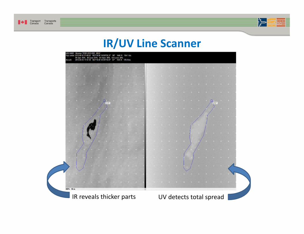
UV detects total spread
IR/UV Line Scanner
IR reveals thicker parts

28
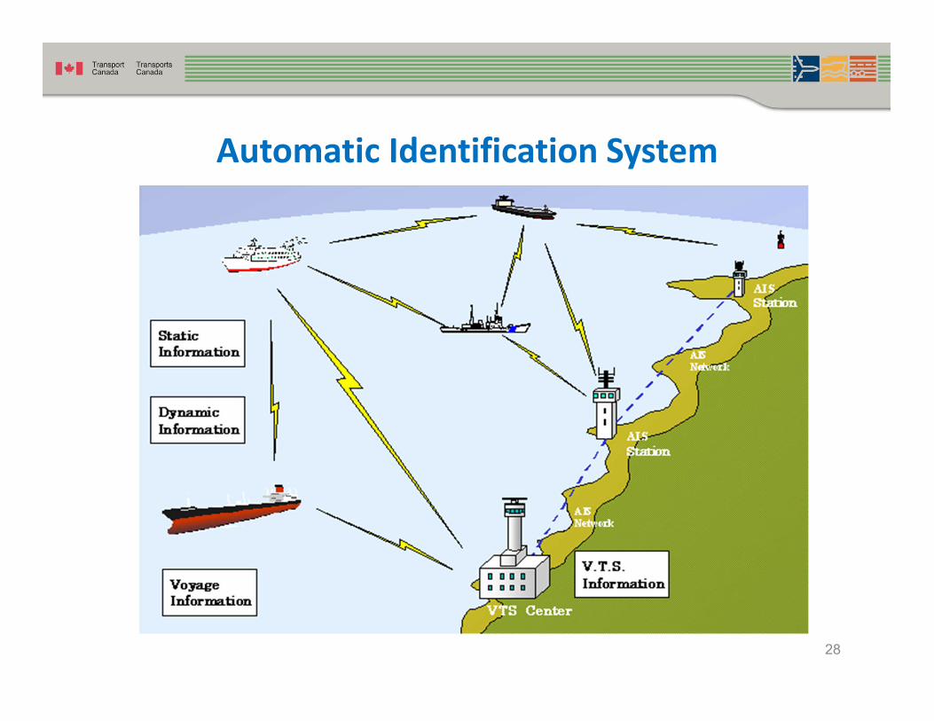
Automatic Identification System

Satellite Communication System

Video Streaming
• Password Protected • Situational awareness for senior
management and Incident Command Post staff
• Available to select TC and • OGD staff• Expensive
Stream only when required

NASP’s Role in Response to an Incident
• Determine and rapidly relay incident size and extent
• Map / quantify the spill
• Provide aerial support to response crews by vectoring to combatable oil
• Provide situational awareness to the incident command team and other government departments

32
Notable Oil Pollution Incidents
• 2010 – Deepwater Horizon Spill
• 2013 – Lac Mégantic Train Derailment
• 2015 – M/V Marathassa
• 2016 – Husky North Saskatchewan River Spill
• 2016 – Nathan E. Stewart Tug Grounding
• 2018 – Manolis L Bulk Oil Removal
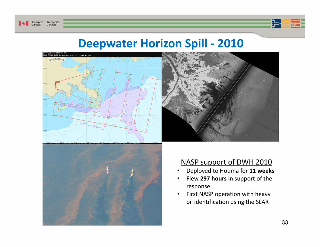
NASP support of DWH 2010• Deployed to Houma for 11 weeks• Flew 297 hours in support of the
response• First NASP operation with heavy
oil identification using the SLAR
Deepwater Horizon Spill - 2010
33

Lac Mégantic Train Derailment - 2013
34

M/V Marathassa - 2015
35

Husky Pipeline Spill - North Saskatchewan River 2016
36
IR/UV scanning was attempted, but due to the nature of the area, was deemed ineffective.
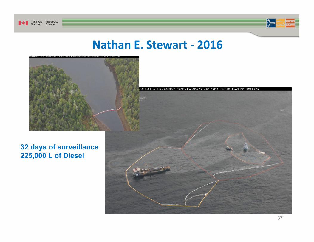
Nathan E. Stewart - 2016
37
32 days of surveillance225,000 L of Diesel

Manolis L Operation – 2016/2018
38

Manolis L Operation
39

Manolis L Operation
40

41
Research and Development - Spothawk
42
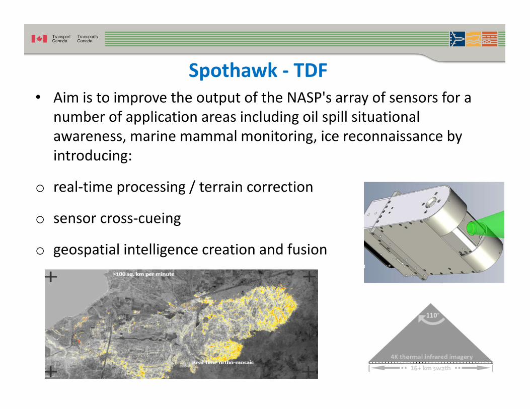
Spothawk - TDF• Aim is to improve the output of the NASP's array of sensors for a
number of application areas including oil spill situational awareness, marine mammal monitoring, ice reconnaissance by introducing:
o real-time processing / terrain correction
o sensor cross-cueing
o geospatial intelligence creation and fusion
relay

43
Spothawk

44
Spothawk

45
RPAS Operations - Transport Canada
• Dedicated project team
• Working on operationalizing the RPAS concept to support NASP Operations in the future
• Have conducted sea trials, land trials, and BVLOS testing.
• Operations continuing in 2019 to support the North Atlantic Right Whale Initiative
• End State – MALE RPAS augmenting the NASP

46
RPAS - Sea Based Tests
• Schiebel Camcopter S‐100 with the Wescam MX‐10
• Successfully tested for BVLOS operations aboard the CCGS George R. Pearkes
• Tested off the East Coast of Canada in participation with the Canadian Coast Guard

47
RPAS - Land Based Tests
• TC has used the RPAS SeaHunter for two years
• In cooperation with University of Alaska Fairbanks and Griffon
Aerospace
• The SeaHunter is a proven
design with a robust airframe
• A low cost surrogate for larger,
more complex UAVs
• Large and flexible payload
capacity

48
RPAS - Land Based Tests
• 46 flight hours BVLOS without incident
• Flights in cloud, snow, night, sub-zero temperatures (-35 C)
• Maximum range flown - 80 NM
• Maximum altitude attained - 15,000 MSL
• Maximum useable endurance - 8 hours
• Flight under ATC control in mixed use airspace
• Fully automatic takeoff and landings
• Streamed real-time payload video and ship traffic data
• Validated ice detection and avoidance capabilities

49
RPAS - Seahunter
• SeaHunter Specifications:
• Twin-150cc fuel-injected
engines
• Steerable nose gear
• Piccolo Autopilot
• Electro-Optical, Infrared
sensors
• Easily deployed with a low
logistics footprint

50
RPAS - North Atlantic Right Whale Monitoring
• August 2018 - Flew total distance of 2,984 nm -Beyond Visual Line of Sight (BVLOS) using satellite communications links
• Flew in high density traffic zone under a NOTAM 5.1 exemption and under air traffic control
• First time in Canada that RPAS integrated with regular air traffic at commercial, controlled airport under Air Traffic Control
• Successfully identified NARW - validated by Marine Mammal Observers on site
• Artificial Intelligence (AI) software demonstrated that it can filter and identify whale related images
• RPAS collection methodology potentially more capable of species identification at higher wind speeds (above 15kts) that manned aircraft

51
Future Initiatives
• Acquiring a Remotely-Piloted Aircraft System
• Building a NASP Complex in the Arctic
• Acquiring a Fourth Surveillance Aircraft
• Upgrading to MX15 HDi

52
Examples of Recent High Profile Incidents
The NASP has provided surveillance for the following events:
• 2010 – Deepwater Horizon Spill (assistance to the US Coast Guard during spill in Gulf of Mexico)
• 2013 – Lac Mégantic Train Derailment (provided top-cover surveillance to senior government
officials and first responders)
• 2014 – RCMP Moncton Shooting (located assailant)
• 2016 – Fort McMurray Wildfire (provided support to provincial government and first responders)
• 2017 – BC Wildfires Eastern Ontario and Quebec Floods (provided support situational
awareness to government officials)
• 2017 – RCMP Public Safety event – Nunavut (delivered intelligence and surveillance to law
enforcement officials)
• Current support to the North Atlantic Right Whale Initiative on Canada’s East Coast (performing surveillance activities and providing data to various government departments)

• Transport Canada has a zero tolerance policy for illegal discharges
and we are committed to protecting the marine environment.
• Investing in new technology development and infrastructure will
prepare the NASP for future system upgrades and operations.
• RPAS will augment the NASP’s fixed wing assets in the coming
years.
Conclusion
53

Surveillance Of Sea Surface Activities in Canada
The surveillance of surface activities is done by various Federal Government Departments including:
• Transport Canada• Department of Fisheries and Oceans • Department of National Defence
Transport Canada through the National Aerial Surveillance Program (NASP) works collaboratively with other departments to minimize duplication during maritime patrols.

NASP Goals
The main goals of the NASP are to:
• prevent pollution from ships;• protect the marine environment; • position Canada to be a world leader in aerial marine surveillance;• strengthen Canada’s marine security by enhancing marine domain
awareness;• support environmentally-friendly economic development; • support the North Atlantic Right Whale (NARW) Initiative; • provide situational awareness to the Government of Canada during
environmental incidents (Government Operations Centre); and• support safe and efficient transportation of shipping in ice infested waters.

NASP Objectives
The main objectives of the NASP are to:• enforce the pollution prevention regulations while acting as a
deterrent to potential polluters;• provide situational awareness during emergencies;• provide program support to other government departments (OGDs)
requiring intelligence, surveillance and reconnaissance data;• provide ice reconnaissance support so ships can navigate safely
through ice infested waters economically; • identify and report NARW sightings in the Dynamic Shipping Zone; • enhance maritime domain awareness so the Government of Canada
can manage maritime activities or respond to threats / events within Canada’s maritime domain

NASP Priorities
The main priorities of the NASP are:
• Search and Assist • Emergency response (recovery mission/floods/national emergency)• Urgent Tasking requiring immediate action / response (examples)
o Pollution incident or event reported through TC Sitceno Reported anomaly from satellites through the Integrated Satellite
Tracking of Pollution)o Maritime Security evento Ice related emergency (i.e ship stuck in ice)
• Daily routine pollution prevention patrols – always have a primary mission and secondary mission
• Non-Urgent Taskings - Special requests by clients / other agencies (i.e. pictures of harbours & ports, etc

Planning for NASP Routine Operations
The primary objective of the NASP is to act as a deterrent to potential polluters through the enforcement of Canada’s marine pollution prevention regulations effected under the CSA2001 and MARPOL 73/78.
Routine patrols are primarily conducted to overfly commercial vessels that are underway for visual inspection as well as by means of remote sensing equipment for compliance with the pollution prevention regulations:
The planning of these daily routine operations is an in-depth process that relies on daily intelligence products such as:
• ISTOP reports of potential anomalies• Satellite AIS reports on vessel traffic• Vessel of interest reports from the MSOCs (Vessels Entering Eastern
Canada (VEEC) or Vessels Entering Western Canada (VEWC)• De-confliction with DND or DFO• Weather over the local area

Planning for NASP Routine Operations (Cont’d)
• Prior to each flight the Regional NASP Manager or mission lead reviews all available products to plan the most efficient flight track.
• The flight track is sent to many Government Departments via a predetermined distribution list for situational awareness.
• Occasionally, an event will happen which requires an urgent tasking of the NASP aircraft and the asset is rerouted in flight.
• Most often, the flight is conducted as planned without deviation from the plan.
It should be noted that an overriding requirement during all NASP missions is the acquisition of security related information in support of the protection of the
Canadian public.


