39
Remote Sensing Applications in Agricultural Statistics at China NBS Yu Xinhua Department of Rural Surveys, National Bureau of Statistics(NBS)

Remote Sensing Applications in Agricultural Statistics at China NBS
Yu Xinhua Department of Rural Surveys, National
Bureau of Statistics(NBS)

Outline
Introduction
Remote Sensing Measurement
Area Frame Survey
Challenges & Development
Software & IT Infrastructure

The new requirements of agricultural statistics in 21th century. Provide relevant data for policy making to ensure national food security.
• Food security has the highest priority for the development of modern agriculture.
• Agricultural statistics are vital information for grain development strategy. • The international situation, the rapid development and profound change of agriculture
and rural area in China brings up the new requirement.
Meet the data gap for modern agricultural development.
• Grain Production Counties Development Strategy has implemented, which requires to set up statistical monitoring and evaluation system.
• The strategy of developing facility-based agriculture and standardizing horticulture production was set up, which requires corresponding statistics.
• The innovation of agricultural technology integration, mechanizing and informatization, new survey tools should be applied for these new farming.
• To enhance the agricultural production with social services supporting, agricultural statistics should be service-oriented, providing more relevant information to producers.
To meet the needs of multi-dimension services.
• Markets needs timely, accurate, transparent information.
• Large and small area statistics are all needed.
• The data are needed for all major crops, include commodity crops and minor crops.
• Information for food quality, its production and marketing are all needed.

The new requirements of agricultural statistics in 21th century.
New situation
New goals
New requirements
• Food security • Agriculture modernization • Service-oriental
• More information • Advanced vehicles • Reliable data • Better services
• Data collection capacity • Data processing capacity • Data analytical capacity • Data delivery capacity
Can the traditional agriculture statistical system meet the new requirements of 21th
Century?
New goals

Traditional agricultural statistics become unadapted
• The merging of sample survey and complete reporting.
• Does the sample designed for province population meet the needs of county and prefecture level?
• How to adapt the rapid change of farming structure?
Survey schemes
• Mobility of sample farmers.
• Rapid change of Land tenure.
• Impact of sample farmer’s subjectivity.
Counting units
• Mainly traditional tool, such as self-report, compass and rope.
• Cannot efficiently deal with estimation under disaster or other rapid change
• Lack of necessary supervision and management.
Survey tools
Traditional agricultural statistics cannot meet the new requirements well.
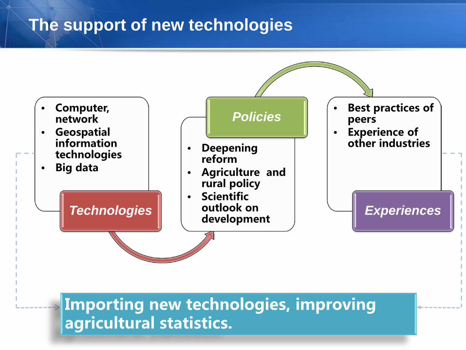
The support of new technologies
• Computer, network
• Geospatial information technologies
• Big data
Technologies
• Deepening reform
• Agriculture and rural policy
• Scientific outlook on development
Policies • Best practices of
peers • Experience of
other industries
Experiences
Importing new technologies, improving agricultural statistics.
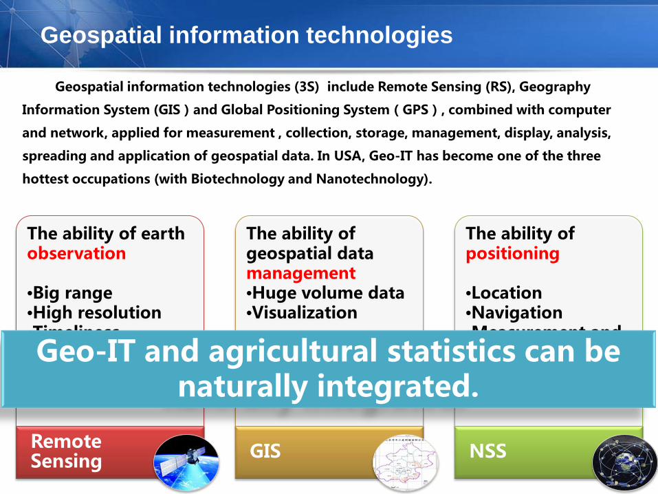
Geospatial information technologies
The ability of earth observation •Big range •High resolution •Timeliness •Can be revisited
Remote Sensing
The ability of geospatial data management •Huge volume data •Visualization
•Spatial analysis •Geo-reference basis
GIS
The ability of positioning •Location •Navigation •Measurement and mapping •all-weather
NSS
Geo-IT and agricultural statistics can be naturally integrated.
Geospatial information technologies (3S) include Remote Sensing (RS), Geography
Information System (GIS)and Global Positioning System(GPS), combined with computer
and network, applied for measurement , collection, storage, management, display, analysis,
spreading and application of geospatial data. In USA, Geo-IT has become one of the three
hottest occupations (with Biotechnology and Nanotechnology).

中国农业统计遥感发展历程
Operation phase
4
Pilot phase
3
Research phase
2
Starting phase
1 • 863 project -- The research of norm and application of
remote sensing for agricultural surveys 2003年
• Industry project -- Satellite-based supporting platform for agricultural surveys 2012年
• Earth observation project -- Pilot of high resolution remote sensing for statistical surveys 2011年
• Industry project -- Data source pilot of remote sensing for agricultural surveys 2009年
• 863 project -- The research of key technologies for statistical surveys 2006年
• Xinjiang cotton remote sensing measurement 2010年 • Crop area remote sensing measurement pilot 2009年
• Crop area frame survey 2009年
Technical Maturity Pilot Implementation

The research of key technologies for operational implementation of agricultural statistical remote sensing
National research project to produce of key technologies
Crop remote sensing identification methodology.
Using geo-spatial technology to build area sampling frame for agricultural
surveys. …
Using pilot to promote the transformation of research results of key
technologies
Crop area remote sensing measurement pilot will improve crop identification
methods with the terrain characters and imagery availability for different
regions, and develop methodology operational for specific region. …
Use demonstration application to break through the nexus of operational
application of key technologies
Crop area frame sampling survey will integrate the geo-spatial frame
building, geospatial sampling, and other new technology. …
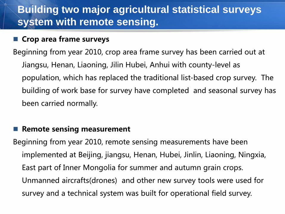
Building two major agricultural statistical surveys system with remote sensing. Crop area frame surveys
Beginning from year 2010, crop area frame survey has been carried out at
Jiangsu, Henan, Liaoning, Jilin Hubei, Anhui with county-level as
population, which has replaced the traditional list-based crop survey. The
building of work base for survey have completed and seasonal survey has
been carried normally.
Remote sensing measurement
Beginning from year 2010, remote sensing measurements have been
implemented at Beijing, jiangsu, Henan, Hubei, Jinlin, Liaoning, Ningxia,
East part of Inner Mongolia for summer and autumn grain crops.
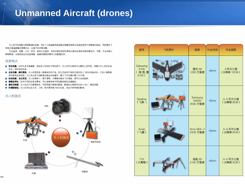
Unmanned aircrafts(drones) and other new survey tools were used for
survey and a technical system was built for operational field survey.
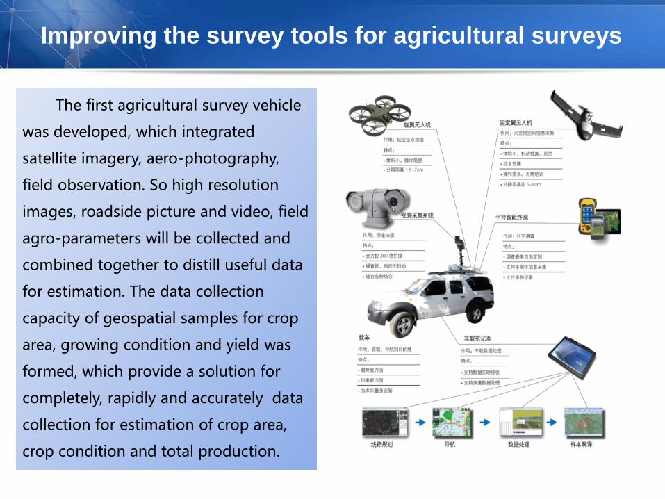
Improving the survey tools for agricultural surveys
The first agricultural survey vehicle
was developed, which integrated
satellite imagery, aero-photography,
field observation. So high resolution
images, roadside picture and video, field
agro-parameters will be collected and
combined together to distill useful data
for estimation. The data collection
capacity of geospatial samples for crop
area, growing condition and yield was
formed, which provide a solution for
completely, rapidly and accurately data
collection for estimation of crop area,
crop condition and total production.

Outline
Introduction
Remote Sensing Measurement
Area Frame Survey
Challenges & Development
Software & IT Infrastructure
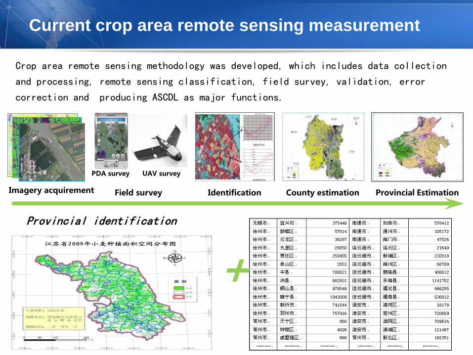
Current crop area remote sensing measurement
Crop area remote sensing methodology was developed, which includes data collection
and processing, remote sensing classification, field survey, validation, error
correction and producing ASCDL as major functions.
Imagery acquirement Identification Field survey
PDA survey UAV survey
County estimation Provincial Estimation
+ Provincial identification

Technical procedures

Remote sensing identification
Based on the current multi-phase remote sensing data, land cover ( arable land
included) were extracted and crop identification were made and finally ASCDL was
produced.
ASCDL
County-level knowledge base for identification
Agricultural statistical land cover data layer
Crop data layers
Error analytical layers
Description of county-level products.
Production flow of ASCDL

Field survey and sample interpretation (1)
For the selected field sample, with the support of region office, UAV field survey
was carried and aero-photography was captured and crop plots were delineated.
Field work photos
UAV photo mosaic
Vectorization of sample land

Field survey and sample interpretation (2)
• Photo Captures by RPV or Mobile Devices(Tablets, smartphones)
• Area measurement by photos
Randomly Determined
Lots of data to be
measured
Convenient Tools


Results of remote sensing identification

Outline
Introduction
Remote Sensing Measurement
Area Frame Survey
Challenges & Development
Software & IT Infrastructure

Start point
Area frame was built with 2nd
agricultural census data and 2nd land
use census data. cropland segments
were created as sampling unit and
enough segments were sampled to
meet the precision requirement.
Several direct interviews of segment
planting were carried by interviewer to
estimate the crop area. According to the
harvest season of crops, certain
planting plots was selected for crop-
cutting and then the yield of specific
crop was collected and estimated.
Finally, the crop production was
estimated.
List frame Geospatial frame
Traditional sampling methodology
Geospatial sampling methodology
Traditional tools, such as ropes.
Modern survey tools. PDA&GPS.
Lack of data quality evaluation & supervision
Spatial analysis, repeatable, supervised
Subjective survey transits to objective survey
Frame Sample
Tools Quality
Traditional crops survey
Crop area frame survey
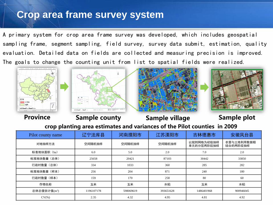
Crop area frame survey system
A primary system for crop area frame survey was developed, which includes geospatial
sampling frame, segment sampling, field survey, survey data submit, estimation, quality
evaluation. Detailed data on fields are collected and measuring precision is improved.
The goals to change the counting unit from list to spatial fields were realized.
Province Sample county Sample plot Sample village crop planting area estimates and variances of the Pilot counties in 2009
Pilot county name 辽宁法库县 河南濮阳市 江苏溧阳市 吉林德惠市 安徽凤台县
对地抽样方法 空间随机抽样 空间随机抽样 空间随机抽样 以规则网格为初级抽样单元的分层两阶段抽样
农普与土地利用数据相结合的两阶段抽样
标准地块面积(ha) 6.0 5.0 2.0 7.0 2.0
标准地块数量(总体) 25658 20421 87103 30442 33850
行政村数量(总体) 334 1033 360 285 282
标准地块数量(样本) 256 204 871 240 180
行政村数量(样本) 159 170 258 80 60
作物名称 玉米 玉米 水稻 玉米 水稻
总体总值估计值(m2) 1196107178 598069619 393651628 1486401968 900946045
CV(%) 2.35 4.32 4.95 4.81 4.92
Developing of sampling frame
Cultivated land updating By visual interpretation or change detection with current satellite imagery, the
cultivated land polygons from the 2nd land use census data were updated for more
accurate, complete cover and no missing.
Identification of major crops Using remote sensing images to identifying major crops to acquire more ancillary
information. Depending the situation of data acquirement, change detection and
unsupervised classification method are used for identification of target crops.
Sampling units construction Division with administrative area : The cultivated land polygons are divided with
administrative boundaries and the identification results was summed up by crops
for each administrative area.
Division with grid delineation : Land polygons were split into grid blocks of same size,
and the identification results was summed up by crops for each block.
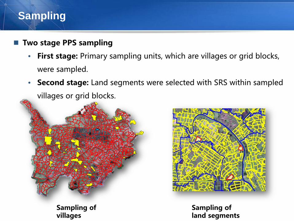
Sampling
Two stage PPS sampling
• First stage: Primary sampling units, which are villages or grid blocks,
were sampled.
• Second stage: Land segments were selected with SRS within sampled
villages or grid blocks.
Sampling of villages
Sampling of land segments

Field work package
• Field maps suites:Hardcopy image of sampling villages, vector
maps, maps of sampling segments.
• GPS task package : GPS devices are needed for area measurement
of the screening survey. All the task base data and forms are
packed into task package and loaded into GPS.
Field maps
GPS task package
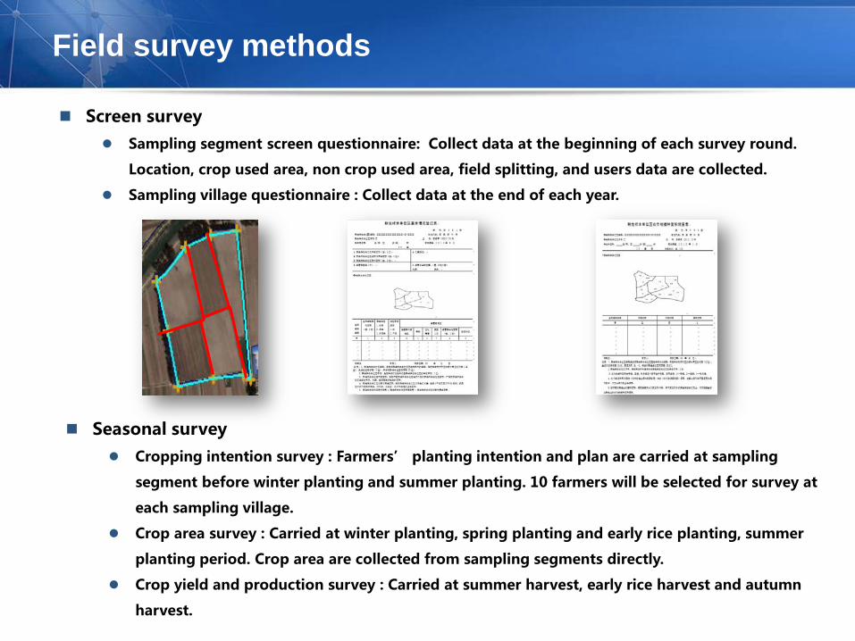
Field survey methods
Screen survey Sampling segment screen questionnaire: Collect data at the beginning of each survey round.
Location, crop used area, non crop used area, field splitting, and users data are collected.
Sampling village questionnaire : Collect data at the end of each year.
Seasonal survey Cropping intention survey : Farmers’ planting intention and plan are carried at sampling
segment before winter planting and summer planting. 10 farmers will be selected for survey at
each sampling village.
Crop area survey : Carried at winter planting, spring planting and early rice planting, summer
planting period. Crop area are collected from sampling segments directly.
Crop yield and production survey : Carried at summer harvest, early rice harvest and autumn
harvest.
Outline
Introduction
Remote Sensing Measurement
Area Frame Survey
Challenges & Development
Software & IT Infrastructure

Integrated service platform for agricultural rapid survey.
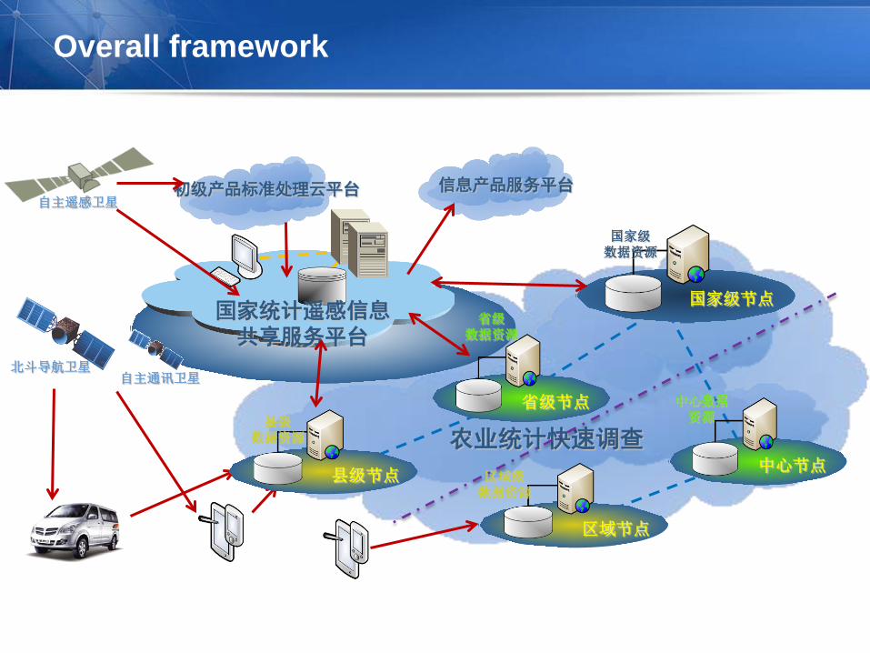
Overall framework
农业统计快速调查
自主遥感卫星
北斗导航卫星
省级 数据资源
省级节点
国家级 数据资源
国家级节点
县级 数据资源
县级节点
中心数据资源
中心节点 区域级
数据资源
区域节点
国家统计遥感信息 共享服务平台
初级产品标准处理云平台 信息产品服务平台
自主通讯卫星
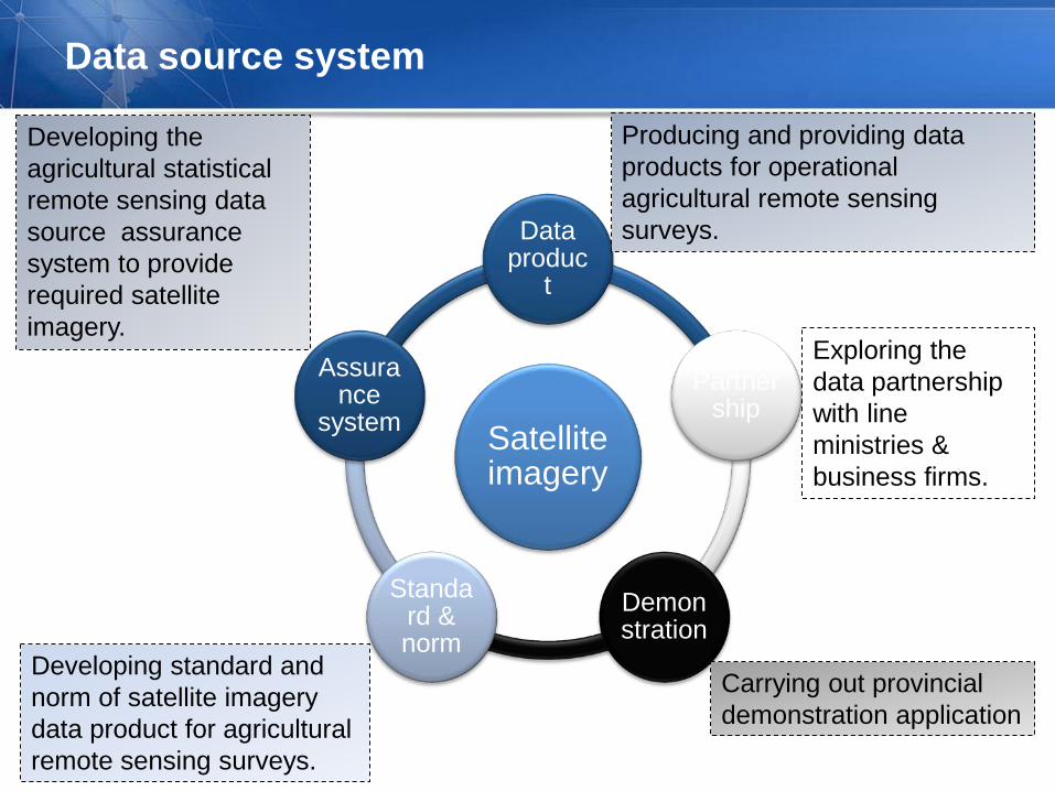
Data source system
Satellite imagery
Data produc
t
Partnership
Demonstration
Standard & norm
Assurance
system
Producing and providing data products for operational agricultural remote sensing surveys.
Developing the agricultural statistical remote sensing data source assurance system to provide required satellite imagery.
Developing standard and norm of satellite imagery data product for agricultural remote sensing surveys.
Exploring the data partnership with line ministries & business firms.
Carrying out provincial demonstration application

Agricultural remote sensing survey infrastructure
Data source assurance system
• Satellite imagery : High Resolution Satellite series, Resource Satellite series,
Environmental Satellite series …
• Partnership
Line ministries : ministry of land resource, National Bureau of Mapping and
Geo-information, National Geo-information Center…
Business firms : Oriental Roadnear, PeaceMap, China Science Geo-do…
Geo-spatial base data framework construction
• Completely covered satellite imagery : Multi-phase medium and high resolution
satellite imagery, completely covered the major provinces of grain production.
• Level by level base geography data : Based on 2nd land use census data, build
up provincial, county-level, village-level, and plot-level base geography dataset.
• Other data types : Geo-referenced statistics, meteorology data, phenology data,
hydrology data…

Statistical remote sensing data sharing and service system
It will realize the transformation of agricultural statistics to plane or three-
dimensional distribution form at spatial and regional level, which will improve the
display methods and means of agricultural statistics , promote the standardization
of statistical information, and enhance the ability of analysis, exploration and
forecasting to agricultural statistics.
Process
Management
Collection
Distribution

Crop production survey vehicle
Unmanned Aircraft (drones)

Mobile data collection devices
GPS(Windows Mobile)
Smartphone(Explorer)
PAD(Android)

Outline
Introduction
Remote Sensing Measurement
Area Frame Survey
Challenges & Development
Software & IT Infrastructure

Challenges
Challenges from the complexity of farming in China
Complexity of farming structure in China : Lots of crop types, region difference, Non-scale farming,
multiple crop rotation, intercropping and interplanting.
Fragmented landscape in most regions : Except the northeast, the size of crop plots are very small.
Complex terrain : There are cropping in all kinds of landscape type, plain, hill, or mountainous area
Largely impacted by market, the farming structure change rapidly
Following impact of the social and economical development, arable land changes very rapidly.
Challenges from remote sensing technologies
Time phase requirement : Because the crop planting is strongly seasonal, suitable satellite imagery
must be acquired at specific period.
Cloud and rain weather : Because of the constraint of cloud/rain weather and satellite passing period,
the data availability is very limited for large scale crop area remote sensing.
Identification accuracy : At complex situation, the accuracy of remote sensing identification must be
researched to improve substantially.
Challenges from operational implementation
Cost : It includes the infrastructure, purchase and process of imagery, geo-spatial framework, purchase
of survey tools. If it were applied at national wide, bulks of fund are required.
Worklord : For the timeliness, huge volume satellite imagery must be processed in short time, and field
work finished rapidly. The workload is huge. More manpower and resource are needed.

Future development
Remote sensing data
Base geographic data
Statistical data
Social and economic data
Data basis Agricultural statistical OneMap
Data source assurance system
Estimation Spatial sampling
Small area estimation
Model estimation
Self-contained methodology
Survey means
Integrated survey technologies to capture from space, air, fields
New system Evaluation Available Data Operational application
Fully operational application
Climate data
Improvement of technical ability, efficiency, data quality and services

Thanks for your attention!


