+ All Categories
Home > Documents > Report 2018-35 - Mulock Station Area Secondary Plan ... Department/Mulock GO Station... · From:...

Report 2018-35 - Mulock Station Area Secondary Plan ... Department/Mulock GO Station... · From:...

Date post: 19-Jun-2019
Category:
Upload: vandieu
View: 214 times
Download: 0 times
Share this document with a friend
16
Town of Newmarket 395 Mulock Drive P.O. Box 328, Newmarket, Ontario, L3Y 4X7 Email: [email protected] | Website: newmarket.ca | Phone: 905-895-5193 Mulock Station Area Secondary Plan – Update and Density Page 1 of 5 Mulock Station Area Secondary Plan - Update and Density Staff Report Report Number: 2018-35 Department(s): Planning & Building Services Author(s): Adrian Cammaert Meeting Date: June 11, 2018 Recommendations 1. That the Report entitled Mulock Station Area Secondary Plan – Update and Density be received; and, 2. THAT Council authorize the submission of this Report, as well as the Density Technical Memorandum regarding Transit-Supportive Density Testing, dated May 30, 2018, included as Attachment 1 to this Report, to Metrolinx; and, 3. That Staff be authorized and directed to do all things necessary to give effect to this resolution. Purpose The purpose of this Report is to twofold: (i) to provide a general update on the status of this project, and (ii) provide information regarding the density levels that will be analyzed through the Secondary Plan process, to assist Metrolinx in their business case review of the Mulock GO Station. Background As Council is aware, the Mulock GO Station was announced by the province in June, 2017. Council subsequently committed to implementing a transit supportive planning regime around the station. The completion of this Secondary Plan will fulfill this commitment as it will, among other objectives, determine the highest and best long-term land uses and densities around the station. Mulock Station has been progressing through Metrolinx’s business case review process. Both this Report and the Density Technical Memorandum (Attachment 1) will be beneficial for Metrolinx in their continued assessment of the feasibility of the Mulock GO Station as it progresses through the business case review process.
Transcript

Town of Newmarket 395 Mulock Drive P.O. Box 328, Newmarket, Ontario, L3Y 4X7

Email: [email protected] | Website: newmarket.ca | Phone: 905-895-5193

Mulock Station Area Secondary Plan – Update and Density

Page 1 of 5

Mulock Station Area Secondary Plan - Update and Density Staff Report

Report Number: 2018-35

Department(s): Planning & Building Services

Author(s): Adrian Cammaert

Meeting Date: June 11, 2018

Recommendations

1. That the Report entitled Mulock Station Area Secondary Plan – Update and Density be received; and,

2. THAT Council authorize the submission of this Report, as well as the Density Technical Memorandum regarding Transit-Supportive Density Testing, dated May 30, 2018, included as Attachment 1 to this Report, to Metrolinx; and,

3. That Staff be authorized and directed to do all things necessary to give effect to this resolution.

Purpose

The purpose of this Report is to twofold: (i) to provide a general update on the status of this project, and (ii) provide information regarding the density levels that will be analyzed through the Secondary Plan process, to assist Metrolinx in their business case review of the Mulock GO Station.

Background

As Council is aware, the Mulock GO Station was announced by the province in June, 2017. Council subsequently committed to implementing a transit supportive planning regime around the station. The completion of this Secondary Plan will fulfill this commitment as it will, among other objectives, determine the highest and best long-term land uses and densities around the station.

Mulock Station has been progressing through Metrolinx’s business case review process. Both this Report and the Density Technical Memorandum (Attachment 1) will be beneficial for Metrolinx in their continued assessment of the feasibility of the Mulock GO Station as it progresses through the business case review process.

Mulock Station Area Secondary Plan – Update and Density Page 2 of 5

Discussion

General Update

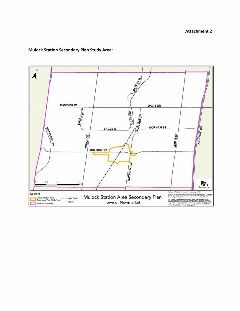
As a reminder, the Mulock Station Area Secondary Plan will present a long-term redevelopment vision of the lands surrounding the future Mulock GO Station site as shown on Attachment 2. The Secondary Plan will facilitate transit-oriented design, including land uses, densities and a future road network to facilitate this vision. The consulting team for this project was selected, being comprised of SvN Architects + Planners Inc., Dillon Consulting Limited, and N. Barry Lyon Consultants Limited; with SvN acting as lead consultant. SvN has notable experience relative to GO Stations and transit-focused planning studies, including Kipling Mobility Hub and Station Redevelopment, Smart Track / GO RER Planning, Eglinton Connects in Toronto, and Dundas Connects in Mississauga. In addition, SvN is familiar with the general planning context of Newmarket through their work preparing the Urban Centres Secondary Plan.

The project is progressing through Phase 1, as shown on the Project Schedule included as Attachment 3. The project was formally commenced on May 16 through the project start-up meeting. Since that time, the project team has completed a site visit, reviewed available background information, has begun preparation of the consultation program, has begun the Issues & Opportunities Analysis and associated mapping.

As an early deliverable of the project the attached Density Technical Memorandum has also been prepared, which is the focus of this Report, as discussed below.

Density Technical Memorandum – Density Analysis

The attached Technical Memorandum explores the issue of density for the Study area. The concept of “base density” is discussed, being a minimum level of density that will provide a starting point from which additional density can be tested through the Secondary Plan process. This additional density, regardless of degree, will benefit the station by providing the framework to enable transit-oriented development to occur.

The Technical Memorandum identifies 150 people and jobs per hectare to be the base density, and provides technical rationale for this opinion.

As discussed in the Technical Memorandum, the Growth Plan defines “Major Transit Station Areas” (MTSAs) and where they are located on a “Priority Transit Corridor”, they are required to be planned for a minimum density of 150 people and jobs per hectare. Being a station for higher-order transit located within a settlement area, the Mulock GO Station will meet the Growth Plan’s definition of a MTSA once it’s constructed, however, it would not be located on a Priority Transit Corridor because on the Barrie rail line, the Priority Transit Corridor currently only extends as far north as the Aurora GO Station.

Notwithstanding the above, there is rationale for the Mulock GO Station MTSA to be planned as though it was on a Priority Transit Corridor. The Mulock GO Station area is

Mulock Station Area Secondary Plan – Update and Density Page 3 of 5

book-ended by MTSAs on Priority Transit Corridors to the north (Davis Dr. vivaNext Rapidway station at Davis & Main St) and to the south (Aurora GO Station). In addition, the Priority Transit Corridor may be extended farther north in the future, as Metrolinx rolls-out enhanced service levels across the Barrie line.

It should be noted that Town Planning staff are working with Regional staff to define the areas and densities for all of the Town’s MTSAs, including vivaStations, and through this

process are proposing the 150 people and jobs per hectare minimum density for the Mulock GO Station.

Given the above, it is logical to build-in the 150 people and jobs per hectare minimum density at this time through the Secondary Plan process. However it is important to note that this is a preliminary opinion, and all formal planning opinions will be provided following completion of the Secondary Plan process.

While the results of the Secondary Plan cannot be presumed, this Density Technical Memorandum provides a significant level of support for additional density throughout the Secondary Plan Study Area, at a level of at least 150 people and jobs per hectare, which is the minimum for a GO rail station MTSA on a Priority Transit Corridor.

Support for the Mulock GO Station In April, 2018, Metrolinx released the Concept Plan for the Mulock Station. Since that time, the concept has been introduced at numerous public engagement sessions including: an Open House hosted by Metrolinx (April 5), the Newmarket Home & Lifestyle Show (April 8) and a Community Open House (April 19). Each of these events were very well attended.

The Mulock Station was featured at each of these events where informal discussions were had with numerous residents. Overall, there was a high degree of community support expressed for the station. Residents cited increased connections to other parts of the GTA, additional commuting options and the mitigating effects it would likely have on neighbouring Aurora GO Station as the main points of support.

Mulock Station Area Secondary Plan – Update and Density Page 4 of 5

Business Plan and Strategic Plan Linkages

Living Well:

Focusing on traffic and growth management strategies and plans.

Well-Planned & Connected:

Planning and managing growth through long-term plans and strategies, supported by short-term action plans.

Working with all levels of government to create transportation and transit linkages that support and enhance Newmarket as an Urban Growth Centre.

Consultation

No consultation has been undertaken specifically for this Report, however a consultation program for the Mulock Station Area Secondary Plan is being prepared and will be initiated in subsequent phases of the project.

As noted above, an Open House regarding the station design was held by Metrolinx on April 5 at Town Hall attended by approximately 125 people.

Human Resource Considerations

None.

Budget Impact

None.

Attachments

Attachment 1 – Density Technical Memorandum, dated May 30, 2018

Attachment 2 – Study limits of the Mulock Station Area Secondary Plan

Attachment 3 – Project Schedule for the Mulock Station Area Secondary Plan

Memo To: Adrian Cammaert, Senior Planner, Policy, Planning and Building Services, Town of

Newmarket

From: Shonda Wang, MCIP RPP, Lead, Urban Design, SvN Architects + Planners Alex Heath, Associate/Senior Planner, SvN Architects + Planners

Date: May 30, 2018

Re: Mulock Station Area Secondary Plan Transit-Supportive Density Testing

This memo provides an overview of the Mulock Station Area Secondary Plan Study (“the

Study”) context, goals and process, SvN’s experience planning for transit-supportive station

areas, and the anticipated approach to density testing that will be employed in the Study.

It is our opinion that assuming a density of 150 people and jobs combined per hectare within

the study area as a base condition for testing through the Study is reasonable and appropriate.

Furthermore, it is our opinion that this base density can be utilized as a minimum target and

density threshold and densities exceeding this baseline will be explored through the Study.

This opinion is based on four factors:

(1) Our prior experience planning for transit-supportive intensification in station areas with

similar contexts where it was demonstrated that minimum density targets / transit-supportive

densities and uses could be attained;

(2) Our understanding of the overarching growth and intensification policy context within the

Greater Golden Horseshoe, York Region and the Town of Newmarket;

(3) Key differences between the study area and land use permissions considered in Metrolinx’s

Initial Business Case and which will be considered through the Study; and,

(4) A capacity-based approach to testing redevelopment and density that is informed by

policies, best practices and market considerations related to transit-supportive land use, built

form and density.

Secondary Plan Context, Goals, and Process

The proposed Mulock GO station (“the proposed station”) is one of seventeen new GO stations

(including six SmartTrack stations) being contemplated by Metrolinx as part of its Regional

Express Rail (RER) program. We understand that an Initial Business Case (IBC) and Preliminary

Design Business Case (PDBC) have been completed for the proposed station, along with a

feasibility and options analysis and preliminary station design concept. Furthermore, Metrolinx

Attachment 1

is currently moving towards the decision gate between the preliminary design and design and

procurement preparation stages within its overall stage-gate process.

The IBC found that there is limited opportunity for further growth and intensification and

limited demand for industrial or major office uses within 800 metres of the station site,

impacting the overall strategic case for the proposed station. Furthermore, while the results of

the PDBC showed a decrease in costs in comparison with the IBC, it also showed a decrease in

benefits and that in whole, the benefits would be negative due to network impacts.

We understand that Metrolinx is continuing its assessment of the costs and benefits of the

proposed station, including consideration of the benefits that could be attained from a revised

planning regime that would encourage growth, intensification, and transit trip-generating land

uses. Towards this end, Metrolinx requested that the Town of Newmarket commit to

implementing a transit supportive planning regime around the station. To fulfill this

commitment the Town has commenced the Mulock Station Area Secondary Plan Study through

which the highest and best long-term land uses for the area will be determined and to ensure

that all future densities are consistent with provincial density requirements. The Study will

result in a proposed amendment to the Town’s Official Plan to formally implement a transit-

supportive planning regime around the station site.

The boundaries of the Study have also been set to include parcels outside of 500 metres of the

station site but that have a direct connection to the station site and/or other identified growth

areas within the Town that likely have the potential for infill and intensification over time.

Following on Council direction, the Study will contemplate potential changes to land use to

permit residential uses within mixed use developments on lands where only employment uses

are permitted today. Lastly, the Study will assume a minimum density target of 150 people and

jobs combined per hectare within its boundaries, consistent with the Growth Plan for the

Greater Golden Horseshoe, 2017 (“the Growth Plan”) target for Major Transit Station Areas

(“MTSAs”) on Priority Transit Corridors served by the GO Transit rail network.

The Study will be completed within seventeen months with a number of key milestones

occurring within the first eight months. A preliminary development concept will be completed

by the end of August 2018, with testing and evaluation of this concept completed by

September 2018. Through these two milestones, opportunities for transit-supportive growth

and intensification within the station area will be evaluated and confirmed. Technical reports in

support of this preliminary development concept will be completed by November 2018. A draft

Secondary Plan Concept and Policy Summary Document detailing potential Official Plan policy

and schedule changes will be completed by December 2018. The framework for a transit-

supportive planning regime will be identified and detailed through this Study milestone. Each of

these milestones will also serve as staff-to-staff touchpoints with emerging Study results being

shared between the Town of Newmarket and Metrolinx.

Planning for Transit-Supportive Station Areas

SvN Architects + Planners has worked in almost all the major transit corridors within the

Greater Toronto Area. Our mobility practice supports transit-oriented intensification by helping

unlock opportunities for growth such as housing, community amenities, complete streets and a

rich public realm. We have demonstrated experience successfully developing corridor plans

and station area plans of similar magnitude and scope to the Mulock Station Area Secondary

Plan study. Through our work with both the public and private sectors, we understand how to

develop station area plans that are visionary, defensible and balance public sector objectives

with market requirements.

Our recent transit station area planning work includes advisement for: SmartTrack/GO Station

Area Planning, Kipling Mobility Hub, Eglinton West Station Area, Danforth GO/Main Street TTC

Station Area, Grimsby GO Station Area, and the Niagara GO Station Area. Furthermore, we have

undertaken station area planning as part of corridor-wide studies, including the

EglintonConnects Planning Study and Dundas Connects Transportation Master Plan. Amongst

these projects, two are of particular relevance to the Mulock Station Area Secondary Plan study

in terms of context and intensification potential.

Guidance for SmartTrack/GO Station Area Planning, City of Toronto

SvN has recently completed a project for the City of Toronto that provide a preliminary

assessment of the station areas associated with six proposed SmartTrack/GO stations. This

preliminary assessment included a review of existing conditions, an analysis of issues and

opportunities, and an analysis of redevelopment capacity within the station area assuming land

use designations remained fixed.

Two of the six proposed stations feature station areas with very similar contexts in terms of the

overall street and block network, local surface transit networks, existing uses and land use

designations. Similar to the Mulock station area, both the Finch-Kennedy and Lawrence-

Kennedy station areas were developed in in the 1970s and 1980s in a vehicle-oriented manner

and largely consist of low density, ground-oriented commercial, industrial and light-industrial

land uses with adjacent low density, low-rise, stable residential neighbourhoods. The land use

designations within the Finch-Kennedy and Lawrence-Kennedy station areas are largely

reflective of these existing uses, with very few sites designated for a mix of uses at a transit-

supportive level of density.

Scans of the local real estate markets revealed that while opportunities for transit-supportive

intensification in the near term were relatively low (particularly with regard to higher-density

employment uses), there was an opportunity for the station areas to become more attractive

over time with the introduction of a new SmartTrack/GO station and through the initiation of

comprehensive planning studies that would explore improvements to the transportation

network, active transportation, public realm and intensification opportunities within all land use

designations.

A soft site analysis was undertaken to identify parcels within the station area that had

redevelopment potential based on existing land use permissions. Potential redevelopment

yields were then assigned to these soft sites based on existing land use permissions and

development activity within the broader station area context. In both cases, it was

demonstrated that from a redevelopment capacity perspective, both station areas could

achieve the minimum MTSA density target of 150 people and jobs combined per hectare for

stations served by the GO Transit rail network.

Dundas Connects Transportation Master Plan, City of Mississauga

SvN is in the process of completing a land use and transportation master plan for the 17

kilometre long Dundas Street corridor in Mississauga. This corridor-wide master plan assessed

opportunities for transit-supportive intensification along the entirety of the corridor and at a

greater level of intensity within seven focus areas. These seven focus areas were identified by

the intersection of one or more existing or planned higher order transit corridors and/or

collections of large parcels within the context of a discontinuous street and block pattern. The

land use and transportation master plan recommends the implementation of a Bus Rapid

Transit route along the Dundas Street corridor and changes to land use designations to permit

higher density mixed use development.

Two of the seven focus areas feature a similar context to the Mulock station area. As with the

two SmartTrack/GO station areas cited previously, the Dixie Focus Area and Etobicoke Creek

Focus Area are primarily vehicle-oriented in their pattern of streets, blocks and streetscapes,

are predominated by commercial and light industrial uses, and do not permit non-employment

uses under current land use designations.

Framework plans were developed for these focus areas proposing new streets and blocks and

identifying potential redevelopment sites and proposed land uses. A set of built form criteria

were developed and used to generate 3D massing models demonstrating the potential future

build out of the focus areas over three planning horizons (2031, 2041, 2051 and beyond). These

3D massing models were used to generate overall development yields which in turn were used

to calculate the redevelopment capacity of these focus areas. Through this modelling, it was

demonstrated that transit-supportive densities could be achieved by permitting a mix of uses

including residential uses and permitting higher density development in a more compact, urban

form.

Anticipated Approach to Testing Density

The Growth Plan defines an MTSA as the area including and around any existing or planned

higher order transit station or stop within a settlement area, generally being the area within an

approximate 500 metre radius of the station or stop representing a 10-minute walk. Once built,

the area around the proposed station would meet the definition of an MTSA. The Growth Plan

further states that all MTSAs will be planned and designed to be transit-supportive and to

achieve multimodal access to stations and connections to nearby major trip generators.

Furthermore, within all MTSAs, development will be supported by planning for a diverse mix of

uses to support existing and planned transit service levels and by prohibiting land uses and

built form that would adversely affect the achievement of transit-supportive densities.

The Growth Plan also contains minimum density targets for MTSAs that are located on Priority

Transit Corridors. The minimum density target for MTSAs on Priority Transit Corridors that are

served by the GO Transit rail network is 150 people and jobs combined per hectare. While the

portion of the Barrie GO corridor that the proposed station is on is not currently identified as a

Priority Transit Corridor, this designation does extend to the GO station immediately south of

the proposed station (Aurora GO station) and may be extended northward in the future.

Second, the Newmarket GO station immediately north of the proposed station is an MTSA

located on the Davis Drive vivaNEXt BRT Priority Transit Corridor. Third, the under-

construction vivaNext BRT route on Yonge Street is identified as a Priority Transit Corridor and

this corridor is both connected to the proposed station by Mulock Drive and by the parcels on

the south side of Mulock Drive, which are within the Secondary Plan study area. We understand

that the Town of Newmarket is working with York Region to define MTSAs and set minimum

density targets throughout the municipality and will be proposing that the Mulock station area

be designated as such. These factors suggest that the Mulock station area be planned to

achieve the minimum density target of 150 people and jobs combined per hectare such that the

ultimate planning regime that is established through the Study is flexible and can respond to

future growth and expansion of higher order rapid transit within the region.

The testing of growth and intensification potential within the station area will differ in three

main respects from that undertaken in Metrolinx’s IBC. First, whereas the IBC examined an area

within 800 metres of the station site, the Study will also examine an area that includes all

parcels on the south side of Mulock Drive between the hydro corridor to the east of Yonge

Street and Cane Parkway. This will expand the station area to encompass parcels that have a

direct frequent transit connection to the station site and the number of soft sites within the

broader station area. Second, whereas the IBC assumed the persistence of existing land use

designations, the Study will examine the potential for a mix of uses including residential uses

on lands currently designated for employment uses only. This will expand both the number of

soft sites within the station area and the potential uses that could be contained within

redevelopment over the long term. Third, whereas the IBC calculated future station area

density based on the application of projections from the Ministry of Transportation Greater

Golden Horseshoe Model, the Study will calculate future station area density based on the

redevelopment capacity of the study area.

The redevelopment capacity of the study area will be determined through a three part process.

First, the potential for land use designation changes to permit a mix of uses including

residential uses will be contemplated based on an analysis of opportunities and constraints.

Second, all parcels within the study area will be examined for their potential as soft sites over

the short, medium and long term based on physical, policy and market factors (including taking

into account recent development activity which includes approved and under review

applications for human service agencies and medical services / offices – see attached pictures).

Third, potential uses and development yields for all soft sites will be determined based on

policy and market factors. Fourth, assumptions on area per unit, people per unit and area per

employee (consistent with local and regional growth management studies and varying by

residential and employment type) will be applied to these potential uses and yields, generating

a redevelopment capacity by soft site. Fifth, the redevelopment capacity of each soft site will

be totalled and used to determine the potential people and jobs combined per hectare within

the entirety of the study area.

Density Summary Statement

Based on the above methodology and parameters, it is our opinion that assuming a base

density of 150 people and jobs combined per hectare within the study area is reasonable and

appropriate. Furthermore, this base density will be utilized as a minimum target and density

thresholds above this base will be explored through the Study.

Should you have any questions or comments on the information and analysis provided in this

memo, please do not hesitate to contact the undersigned.

With Regards,

Shonda Wang, MCIP RPP Lead, Urban Design SvN Architects + Planners Cc Alex Heath, Associate/Senior Planner SvN Architects + Planners

New medical services/offices use under construction at 536 Mulock Drive (north east corner of Mulock Drive and Bayview Avenue)

New human services agency use (Community Living Central York) under renovation at 575 Penrose Street (north west of Mulock Drive and Bayview Avenue)

Proposed medical services/office/retail use at 507 Mulock Drive (northwest of Mulock Drive and Bayview Avenue)

Attachment 2  


Mulock Station Secondary Plan Study Area: 


Del

iver

able

Pro

gres

s

Tow

n Re

view

of D

raft

Del

iver

bale

Del

iver

able

Com

plet

ion;

Dra

ft/

Fina

l Sub

mis

sion

Mee

ting/

Con

fere

nce

Cal

l with

City

Tea

m

LWG

/ Pub

lic M

eetin

g

Task

No.

Task

Nam

e7

1421

284

1118

252

916

2330

613

2027

310

1724

18

1522

295

1219

263

1017

2431

714

2128

411

1825

411

1825

18

1522

296

1320

273

1017

241

815

2229

512

1926

29

1623

307

1421

281.0

Phas

e 1:

Proj

ect S

tart

Up

And

Bac

kgro

und

Info

rmat

ion

Reve

iw1.1

Reg

ular

Cor

resp

onde

nce

with

Tow

n Pr

ojec

t M

anag

er1.2

Ong

oing

pro

ject

man

agem

ent

1.3Pr

ojec

t T

eam

Mee

ting

1 -

Proj

ect

Star

t-U

p1.4

Prep

are

Dra

ft a

nd F

inal

Det

aile

d W

ork

Plan

1.5

Prep

are

Publ

ic C

onsu

ltatio

n Pr

ogra

m1.6

Und

erta

ke S

ite V

isit

1.7R

evie

w B

ackg

roun

d In

form

atio

n an

d Pr

epar

e M

appi

ng o

f Exi

stin

g C

ondi

tions

1.8Pr

epar

e Is

sues

and

Opp

orun

ities

Ana

lysi

s2.

0Ph

ase

2: P

ublic

Not

ifica

tion

and

Tec

hnic

al R

epor

t Pre

para

tion

2.1

Prep

are

Dra

ft V

isio

n St

atem

ent.

Gui

ding

Prin

cipl

es a

nd E

valu

atio

n C

riter

ia2.

2Pr

epar

e Pr

ojec

t N

otifi

catio

n2.

3La

ndow

ner

Wor

king

Gro

up 1

- V

isio

ning

Ses

sion

2.4

Prep

are

Fina

l Vis

ion

Stat

emen

t, G

uidi

ng P

rinci

ples

and

Eva

luat

ion

Crit

eria

2.5

Prep

are

Prel

imin

ary

Dev

elop

men

t C

once

pt2.

5.1

Shar

e Pr

elim

imar

y D

evel

opm

ent

Con

cept

with

Met

rolin

x2.

6T

est

and

Eval

uate

Pre

limin

ary

Dev

elop

men

t C

once

pt2.

6.1

Shar

e T

estin

g an

d Ev

alua

tion

of P

relim

inar

y D

evel

opm

ent

Con

cept

with

Met

rolin

x2.

7Pr

epar

e D

raft

and

Fin

al T

echn

ical

Rep

orts

3.0

Phas

e 3:

Pre

para

tion

of th

e D

raft

Sec

onda

ry C

once

pt P

lan

and

Polic

y Su

mm

ary

Doc

umen

t3.

1Pr

epar

e D

raft

Sec

onda

ry P

lan

Con

cept

3.2

Prep

are

Dra

ft P

olic

y Su

mm

ary

Doc

umen

t3.

3Pr

ojec

t T

eam

Mee

ting

2 -

Dra

ft S

econ

dary

Pla

n C

once

pt a

nd P

olic

y Su

mm

ary

Doc

umen

t3.

3.1

Shar

e D

raft

Sec

onda

ry P

lan

Con

cept

and

Pol

icy

Sum

mar

y D

ocum

ent

with

Met

rolin

x3.

4Pu

blic

Mee

ting

1 -

Dra

ft S

econ

dary

Pla

n C

once

pt a

nd P

olic

y Su

mm

ary

Doc

umen

t3.

5R

efin

e D

raft

Sec

onda

ry P

lan

Con

cept

and

Pol

icy

Sum

mar

y D

ocum

ent

4.0

Phas

e 4:

Cou

ncil

Ori

enta

tion

4.1

Proj

ect

Tea

m M

eetin

g 3

- R

efin

ed D

raft

Sec

onda

ry P

lan

Con

cept

and

Pol

icy

Sum

mar

y D

ocum

ent

4.2

Pres

ent

Ref

ined

Dra

ft S

econ

dary

Con

cept

Pla

n an

d Po

licy

Sum

mar

y to

Com

mitt

ee o

f the

Who

le /

Cou

ncil

Wor

ksho

p5.

0Ph

ase

5: P

repa

ratio

n of

the

Dra

ft M

uloc

k St

atio

n A

rea

Seco

ndar

y Pl

an5.

1Pr

epar

e D

raft

Mul

ock

Stat

ion

Are

a Se

cond

ary

Plan

5.2

Rev

ise

Dra

ft M

uloc

k St

atio

n A

rea

Seco

ndar

y Pl

an b

ased

on

Proj

ect

Tea

m R

evie

w5.

2.1

Shar

e D

raft

Mul

ock

Stat

ion

Are

a Se

cond

ary

Plan

with

Met

rolin

x5.

3Pu

blic

Mee

ting

2 -

Dra

ft M

uloc

k St

atio

n A

rea

Seco

ndar

y Pl

an6.

0Ph

ase

6: F

inal

Rec

omm

enda

tion

and

draf

t Off

icia

l Pla

n A

men

dmen

t6.

1R

efin

e an

d Fi

naliz

e D

raft

Mul

ock

Stat

ion

Are

a Se

cond

ary

Plan

6.2

Pres

ent

final

Dra

ft M

uloc

k St

atio

n A

rea

Seco

ndar

y Pl

an a

t St

atut

ory

Publ

ic M

eetin

g6.

3Fi

naliz

e al

l Del

iver

able

s

Sept

embe

rO

ctob

er20

1820

19Ja

nuar

yAp

rilM

ayJu

lyAu

gust

Oct

ober

Nov

embe

rD

ecem

ber

Febr

uary

Mar

chJu

neJu

ly

Aug

ust

Sep

tem

ber

New

mar

ket M

uloc

k G

O S

ched

ule

REV

ISED

W/O

OPT

ION

AL

MEE

TIN

GS

16/0

5/20

18

May

June

Attachment 3

acammaert
Typewritten Text
acammaert
Typewritten Text
acammaert
Typewritten Text
acammaert
Typewritten Text
acammaert
Typewritten Text
acammaert
Typewritten Text
acammaert
Typewritten Text
acammaert
Typewritten Text
acammaert
Typewritten Text
acammaert
Typewritten Text
acammaert
Typewritten Text
acammaert
Typewritten Text
acammaert
Typewritten Text

Recommended