11
0 INTERNATIONAL INSTITUTE OF SEISMOLOGY AND EARTHQUAKE ENGINEERING (IISEE) REPORT OF STUDY TRIP (TOHOKU) 14 – 18 November 2011 Prepared by: Dwi Hartanto T course (Indonesia)
| Date post: | 16-Mar-2019 |
| Category: |
Documents |
| Upload: | hoanghuong |
| View: | 214 times |
| Download: | 0 times |

0
INTERNATIONAL INSTITUTE OF SEISMOLOGY AND
EARTHQUAKE ENGINEERING (IISEE)
REPORT OF STUDY TRIP
(TOHOKU) 14 – 18 November 2011
Prepared by: Dwi Hartanto
T course
(Indonesia)

1
Volcanic ash
(915)
Layer deposit
jogan
earthquake
(869)
Layer deposit
jogan
earthquake
(869)
DAY 1: NOVEMBER 14, 2011
On March 11, 2011, a giant earthquake struck in Japan followed by tsunami. The earthquake
and tsunami caused many casualties in Japan, approximately 20,000 people died or missing. The
purpose of the study trip in Tohoku-Sanriku is to know the current conditions of Miyagi Prefecture
and Iwate Prefecture after hit by the tsunami, to learn real condition when tsunami struck in Japan,
and to learn how tsunami warning system worked when tsunami came to Miyagi Prefecture and
Iwate Prefecture. First, we visited Tohuku University where we saw the Faculty of Civil
Engginering building damaged at the second floor.
Next, we visited Arahama beach which is located in Miyagi Prefecture, Tohuku, with
coordinate: 38.042 N, 140.905 E. Dr. Daisuke Sugawara(Disaster Control Research Center
(DCRC)), specialist in geology and paleotsunami, guided us to explain tsunami hit on Arahama
beach.
In Arahama we found deposit tsunami from the Jogan Earthquake in 869, the sediment can be
traced up 4 km from the coastline.
Figure 1. Damage in Faculty of Civil Engginering.
Figure 2. Layer deposit from Jogan
Earthquake with thickness 3 cm.
Figure 3. Layer deposit from Jogan
Earthquake using drill hand method (auger).

2
The sediment deposit from Jogan tsunami with thicknesses approximately 3 cm, upper the layer it’s
volcanic ash (915), below the layer we found another deposit from the previous tsunami. In figure
3 we find the similar deposit from the jogan tsunami.The sample data were taken at 2.7 km from the
coastline by using a drill hand (auger). I asked Dr.Sugawara how to estimate the time the Jogan
earthquake occured. He said, distribution of sample data and dating molusca or any sediment on
Jogan sediment layer we can estimate time of occurence the tsunami, of course the result maybe any
residual error, to minimilize the error we can compare from the historical records.
In Arahama approximately 200 – 300 people died due to the tsunami on march 2011, we
found an elementary school building still standing. Only 1 student died in the elementary school.
The sirens we found were broken near the coastline.
Subsidence in Arahama was 30 cm. After the tsunami on March 11, 2011, local governments
now prohibit to construct a building or a house near the beach in Arahama.
Figure 4. Elementary school building
still standing in Arahama beach.
Figure 5. Siren has broken, near
coastline.

3
DAY 2: NOVEMBER 15, 2011
The first place we visited was Matsushima in Miyagi prefecture which is one of the 3 most
beautiful places in Japan. The other two places are Amanohashidate in Kyoto prefecture and
Itsukushima in Hiroshima prefecture. Matsushima consists of many tiny islands (shima) of some
260 and it is covered with pines (matsu). The size of the tsunami hit the coastline in Matsushima
was not too big, because Matsushima was sorrounded by many islands. Tsunami hight in
Matsushima was about 2-3 m with inudation around 250 m from the coastline or near the Zuiganji
Temple (38.372178 N, 141.059597 E). The victims of the tsunami evacuated to the Zuiganji temple.
The second place we visited was Ishinomaki ( 38.42 N, 141.3 E) known as the large fish
market. We found a manga museum and a replica of the statue of liberty there (Figure 3). Tsunami
hight in Ishinomaki was about 10 m, and the total number of confirmed dead were 3000 in
Ishinomaki. Subsidence in Ishinomaki was about 0.78 m. Okawa Elementary school in Ishinomaki
was completely destroyed and 75 of 108 students and 10 of 13 teachers and staff were killed. The
teachers and students evacuating from the school
were killed when tsunami crossing a nearby river
bridge. One teacher and 3 students were saved
since they went up to the hill. According to the
story of a teacher in the classroom, they did not
immediately evacuate. Since a tsunami warning
said that tsunami hight would be only 3 m, the
teacher still stayed in the school. After she knew
that the tsunami was more than 3 m, they
evacuated by going up the hill. From here we
learn the lesson that when there is a tsunami
warning, we should evaquate quickly and we
must know whether the area around us is safe and
evacuation is needed or not.
Figure 1. Matsushima sorrounded by
many islands.
Figure 2. Some little damaged but still visible on the
beach of Matsushima.
Figure 3. Replica of the statue of liberty
still standing after hit by tsunami.

4
The last place we visited was Onagawa (38.44 N, 141.45 E). Tsunami hight in Onagawa was
approximately 20 m with inudation about 1 km. Over 1,000 people died or missing in Onagawa.
Most people evacuated to Onagawa Hospital (Figure 5).
Near Onagawa, we found a region far from the coast line at which the tsunami reached.
Tsunami reached this place due to the overflow of the river (Figure 6). Inudation of tsunami was
affected by topography of the region. In this region we saw a municipal house which will be used as
the Onagawa Tsunami Memorial Museum (Figure 7).
Figure 4. Situation at Onagawa Town
November 15, 2011.
Figure 6. Tsunami follows the flow of the river. Figure 7. Municipal house.
Figure 5. Onagawa hospital is used for
evacuation building.
5
DAY 3: NOVEMBER 16, 2011
Minami Sanriku (38.68 N, 141.45 E) is a town with large fish market with population about
18.000. Mr. Kazuma Goto, one of the survivors of the tsunami, gave us an explaination about the
time the tsunami hit the Minami Sanriku. After the Chili tsunami hit Japan, Minami Sanriku built
the break water (sea wall) with hight around 5 m. Now the break water was broken after the tsunami
on March 11, 2011. The shake of Earthquake on March 11, 2011 was about 6 minute with intensity
6 (jma intensity). I asked Mr. Kazuma Goto how the tsunami hit Minami Sanriku 9 times in March
11, 2011. He said, like a stone dropped into water, the first wave was large, followed by other
waves. He gave us advice that “we should make friends with nature and neighbors around us. Now
the town of Minami Sanriku almost dissapear with 2,188 people missing or died”.
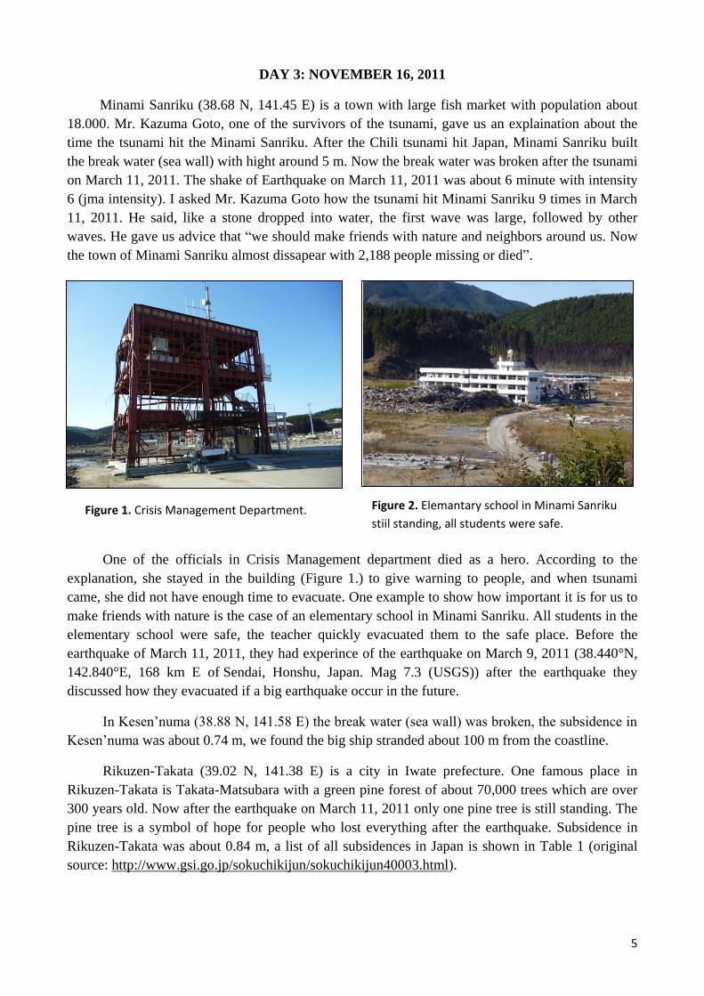
One of the officials in Crisis Management department died as a hero. According to the
explanation, she stayed in the building (Figure 1.) to give warning to people, and when tsunami
came, she did not have enough time to evacuate. One example to show how important it is for us to
make friends with nature is the case of an elementary school in Minami Sanriku. All students in the
elementary school were safe, the teacher quickly evacuated them to the safe place. Before the
earthquake of March 11, 2011, they had experince of the earthquake on March 9, 2011 (38.440°N,
142.840°E, 168 km E of Sendai, Honshu, Japan. Mag 7.3 (USGS)) after the earthquake they
discussed how they evacuated if a big earthquake occur in the future.
In Kesen’numa (38.88 N, 141.58 E) the break water (sea wall) was broken, the subsidence in
Kesen’numa was about 0.74 m, we found the big ship stranded about 100 m from the coastline.
Rikuzen-Takata (39.02 N, 141.38 E) is a city in Iwate prefecture. One famous place in
Rikuzen-Takata is Takata-Matsubara with a green pine forest of about 70,000 trees which are over
300 years old. Now after the earthquake on March 11, 2011 only one pine tree is still standing. The
pine tree is a symbol of hope for people who lost everything after the earthquake. Subsidence in
Rikuzen-Takata was about 0.84 m, a list of all subsidences in Japan is shown in Table 1 (original
source: http://www.gsi.go.jp/sokuchikijun/sokuchikijun40003.html).
Figure 1. Crisis Management Department. Figure 2. Elemantary school in Minami Sanriku
stiil standing, all students were safe.

6
The last place we visited was Ofunato (39.07 N, 141.72 E). Ofunato is a coastal city in Iwate
Prefecture with population approximately 42,000. Tsunami on March 11, 2011 caused heavy
damage in Ofunato,
tsunami hight was around
23.5 m with inudation
about 3 km. Subsidence in
Ofunato was about 0.73 m.
In Ofunato, we found old
monument for Showa
sanriku tsunami hit and
disappeared by tsunami on
March 11, 2011, but
another old monument for
Meiji sanriku tsunami still
standing.
No City Subsidence (meter)
1 Miyako, Iwate 0.5 m
2 Yamada, Iwate 0.53 m
3 Otsuchi, Iwate 0.35 m
4 Kamaishi, Iwate 0.66 m
5 Ofunato, Iwate 0.73 m
6 Rikuzentakata, Iwate 0.84 m
7 Kesennuma, Miyagi 0.74 m
8 Minamisanriku, Miyagi 0.69 m
9 Oshika Peninsula, Miyagi 1.2 m
10 Ishinomaki, Miyagi 0.78 m
11 Higashimatsushima, Miyagi 0.43 m
12 Iwanuma, Miyagi 0.47 m
13 Soma, Fukushima 0.29 m
Figure 4. Pine tree symbol of hope. Figure 3. Break water in Kesen’numa was broken.
Table 1. Subsidence around Japan.
Figure 5. Old monument of Showa
tsunami disappear.
Figure 6. Old Monument of
Meiji tsunami still standing.

7
DAY 4: NOVEMBER 17, 2011
On the Day 4, the first place we visited was Kamaishi (39.27 N, 141.88 E). The break water in
Kamaishi was the deepest in the world with 1,950 m long and 63 m in depth. After the earthquake
on March 11, 2011 the break water was broken, but the break water succeeded in reducing the
power of the tsunami. Mr Kawai from MLIT (Ministry of land, Infrastructure, Transport, and
Tourism) explained the break water can reduce the run up until 50% and make additional time for
evacuation about 6 minutes. I asked Mr Kawai if the break water will be rebuilt in the future. He
said, yes, and the target to rebuild the break water is 5 year. The target is very short, bacause the
community need mental readiness to prepare tsunami in the future.
Approximately 2,000 people died or missing in
Kamaishi port. Subsidence in Kamaishi was about 0.66 m.
In Kamaishi about 2,900 students as well as Kamaishi East
Junior High School survived. The teachers and students very
quickly responded and evacuated to the higher place. The
students had a learning and participated in tsunami drills
guided by the disaster prevention education program to
learn how to escape from an earthquake and tsunami.
The next place we visited was Aneyoshi, Miyako. In
Aneyoshi we visited a memorial statue of the great tsunami.
The statue told us “Remember the calamity of the great
tsunamis. Do not build any houses below this point”.
Tsunami on March 11, 2011 did not reach at this point (the
memorial statue) but run up in this place was highest about
40 m.
Figure 1. Break water on Kamaishi port was
broken after the earthquake on March 11,
2011.
Figure 2. Kamaishi East Junior High School
after the earthquake March 11, 2011.
Figure 3. Memorial statue of great
tsunami.

8
Then, we visited Miyako (39.64 N, 141.96 E). Tsunami hight on Miyako city was about 2–3
m, the sea wall reduced the power of tsunami. Figure 5 shows the situation of Miyako city right
now which was cleaned very quickly.
The final destination we visited was Jodogahama (beach of heaven), a beautiful beach in
Japan. We saw the monuments of Showa tsunami and Chili tsunami. The damage by the Tsunami
on March 11, 2011 was not so much in Jodogohama.
Figure 4. Run up at Aneyoshi about 40 m.
Figure 5. Situation at Miyako City November 17, 2011.

9
DAY 5: NOVEMBER 18, 2011
Taro (39.734 N, 141.968 E) is a town in Miyako city in Iwate prefecture. Taro had break
water and 4 seawalls with hight of 10 m from sealevel, but after the earthquake and tsunami on
March 11, 2011, break water was broken and the east part of the seawall was broken as well
We can compare the situation of Taro town before March 2011 (Figure 1) and after March
2011 (Figure 2).
The east part of taro town was totaly broken, of course because the seawall in east part broken,
compare than the west part. West part of Taro town we found tsunami high about 4.5 m, and in
east part we found tsunami high about 12 m. Actually in Taro town the highest tsunami is around 20
m. Subsidence in Taro (Miyako area) is about 0.5 m.
Figure 1. Taro before March 2011 (picture from Dr. Yushiro Fujii).
Figure 2. Situation of Taro on November 18, 2011 .
Figure 3. Tsunami hight in west part of Taro town, 4.5 m.
Figure 4. Tsunami hight in east part of Taro town (Taro Hotel), 12 m.
5 m
5 m
Water mark of
tsunami high Tsunami high up
to Third floor
East part of Seawall
East part
of seawall
5 m

10
In Taro town we visited the sign of Meiji Sanriku Tsunami (1896) about 15 m, and Showa
Sanriku Tsunami (1933) about 10 m. The tsunami on March 11, 2011 was bigger than Meiji and
Showa by about 20 m. The final place of Tohuku-Sanriku trip we visited was Koborinai Fishing
Port (Miyako), in this place tsunami hight was about 37.9 m (Tsuji et al., 2011).
From this trip, we concluded that condition of the cities in Miyagi Prefecture and Iwate
Prefecture now are better than March 11, 2011. The streets, electricity and water networks were
repaired. In real condition if tsunami will hit around us we must know the safe area for evacuation
and we must quickly evacuate if we see or hear tsunami warning. Tsunami early warning system
has been running well, warning message, sirens, evacuation routes, break water, sea wall etc. have
worked well to reduce casualties. In the future we should be able to improve the quality of tsunami
early warning system.
Meiji (1896) 15 m
Showa (1933) 10 m
5 m
Figure 5. Tsunami sign on the stone. Figure 6. Koborinai Fishing Port, tsunami run up in this place about 37.9 m.
Roadblock broken
struck by tsunami


