Creek Restoration and Stewardship: A Management Plan for Whitewater Ranch Adrian Robins, Ben Handy, Celina Stilphen, Jesse Lynch, Jordan Grace, Noe Contreras, Solveig Noll A Restoration and Management Plan Compiled by the University of Oregon’s Environmental Leadership Program: Sustainable Farms Team June 2014
Transcript
Creek Restoration and Stewardship: A Management Plan for Whitewater Ranch
Adrian Robins, Ben Handy, Celina Stilphen, Jesse Lynch, Jordan Grace, Noe Contreras, Solveig Noll
A Restoration and Management Plan Compiled by the University of Oregon’s Environmental Leadership Program: Sustainable Farms Team
2.0 Site History and Current Conditions ......................................................................................... 6 2.1 Site History ............................................................................................................................ 6 2.2 Current and Future Management ........................................................................................... 8 2.3 Physical Characteristics ......................................................................................................... 8 2.4 Biological Characteristics .................................................................................................... 10
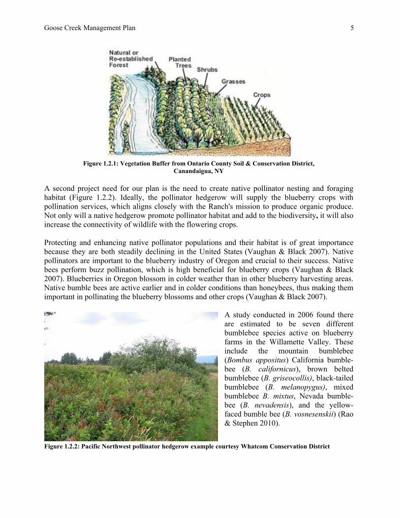
1.0 Introduction and Background 1.1 Introduction Whitewater Ranch, a sustainably-managed Christmas tree farm diversified with forestry and blueberry plantings, is located on the McKenzie River in Leaburg, Oregon. The Ranch stretches along five miles of the McKenzie, making it the largely privately-owned riverfront property on the river. Whitewater’s owners and managers feel a strong sense of responsibility to their downstream neighbors (including those in the city of Eugene, who get their drinking water from the McKenzie) and to future generations (S. Mital, Eugene Water and Electric Board Commission, pers. comm.). Whitewater’s owners and managers feel a great sense of responsibility to their downstream neighbors, future generations, and the environment. The Ranch has earned a Socially & Environmentally Responsible Farm certification (SERF) and is a member of the Coalition of Environmentally Conscious Growers (CECG) for its Christmas tree-growing practices. Both of these certificates require management practices that consider and integrate ecological principles. CECG elements of focus include riparian and wetland management, soil and water conservation, nutrient management, site selection, pest management, hygiene, biodiversity, and consumer education (CECG). Currently, the Ranch is in its final year of seeking organic certification for its blueberries. Thus, Whitewater strives to be sustainable—socially, environmentally, and economically. The purpose of this management plan is to outline a procedure that will improve Goose Creek’s ecological health and natural functions. Goose Creek consists of fertile soil, thriving plants and several fish populations, but over time has been altered by previous management practices. Our recommended approach involves planting a riparian buffer, which will shade the creek and improve aquatic habitat for fish and other species. We have also planned a native hedgerow, which will attract native pollinators on which the blueberry crop relies. If implemented, this restoration plan will result in a healthier agricultural ecosystem and a more sustainable Whitewater Ranch. 1.2 Project Need Goose Creek possesses strong potential as a restoration site. In its current condition, Goose Creek may be supplying inputs such as thermal energy, excess nutrients, and sediments to the McKenzie River. We recommend planting a riparian buffer, a linear band of native vegetation that lies adjacent to an aquatic environment that aims to improve water quality, creek complexity, and organic material in the ecosystem (Figures 1.2.1). Riparian buffers also reduce stream bank erosion, lower water temperature, and provide habitat for aquatic and terrestrial species (Withrow-Robinson et al. 2011).
Goose Creek Management Plan
5
Figure 1.2.1: Vegetation Buffer from Ontario County Soil & Conservation District,
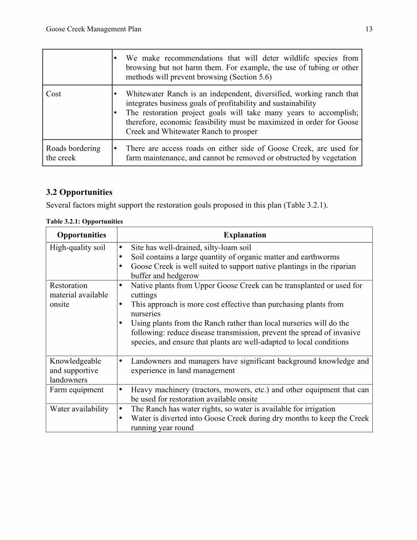
Canandaigua, NY A second project need for our plan is the need to create native pollinator nesting and foraging habitat (Figure 1.2.2). Ideally, the pollinator hedgerow will supply the blueberry crops with pollination services, which aligns closely with the Ranch's mission to produce organic produce. Not only will a native hedgerow promote pollinator habitat and add to the biodiversity, it will also increase the connectivity of wildlife with the flowering crops. Protecting and enhancing native pollinator populations and their habitat is of great importance because they are both steadily declining in the United States (Vaughan & Black 2007). Native pollinators are important to the blueberry industry of Oregon and crucial to their success. Native bees perform buzz pollination, which is high beneficial for blueberry crops (Vaughan & Black 2007). Blueberries in Oregon blossom in colder weather than in other blueberry harvesting areas. Native bumble bees are active earlier and in colder conditions than honeybees, thus making them important in pollinating the blueberry blossoms and other crops (Vaughan & Black 2007).
A study conducted in 2006 found there are estimated to be seven different bumblebee species active on blueberry farms in the Willamette Valley. These include the mountain bumblebee (Bombus appositus) California bumble- bee (B. californicus), brown belted bumblebee (B. griseocollis), black-tailed bumblebee (B. melanopygus), mixed bumblebee B. mixtus, Nevada bumble- bee (B. nevadensis), and the yellow-faced bumble bee (B. vosnesenskii) (Rao & Stephen 2010).
Figure 1.2.2: Pacific Northwest pollinator hedgerow example courtesy Whatcom Conservation District
Goose Creek Management Plan
6
2.0 Site History and Current Conditions 2.1 Site Location and Management History Whitewater Ranch is located 25 miles east of Eugene, in the foothills of the Cascade mountain range, and near the small town of Leaburg (Figure 2.1.1). The land use practices of previous owners left lasting negative impacts that have motivated the current owners to restore and improve the land over the years. In the early 20th century, before 1936, the creek was splash dammed for logging. To do this, the owners diverted the creek around the buildings at the center of the Ranch, into a McKenzie River flood channel where it now flows. In the 1950s, the land was used for logging and cattle grazing (L. Zastoupil, Whitewater Ranch, pers. comm.). These land use practices have left little visible changes on the landscape, at least since 1936, when the first aerial photos were taken of the Ranch (Figure 2.1.1).
Figure 2.1.1: Whitewater Ranch in 1936 (left) and 2013 (right)
Goose Creek Management Plan
7
Figure 2.1.2: A Brief History of Goose Creek (Celina Stilphen 2014) Cattle grazing under the Hawn family and various owners following led to had adverse impacts on the vegetation, soil, and water quality of Goose Creek and the Ranch (Figure 2.1.2). The previous owners also grew corn and added lime to the fields, which raised the soil acidity. In the 1970s and 80s, a new owner acquired the property and attempted to build a condo complex and golf course. Lane County denied his request and before the owner sold the land, he logged extensively (J. Russell, Whitewater Ranch, pers. comm.). The Haake family purchased the Ranch in 1984 to use for Christmas tree farming. Today, the Haake’s daughter, Jane, and her husband, Jim, own the Ranch. They have strived to improve the ecological conditions of Whitewater Ranch by pursuing sustainable farming practices and enhancing wildlife and agricultural cohesion as a result of its position along the McKenzie River. Jim Russell and Lorin Zastoupil, who has a background in forestry, use their knowledge to harvest timber and grow crops sustainably. In the mid 2000s the Ranch’s owners and managers attempted to grow olive trees, which recently failed due to inclement weather. The plastic mulching used for the olive fields are an option for mulching the pollinator hedgerow and riparian buffer, indicated in this report. There is a small pond at the center of the Ranch that used to be stocked with fish by the previous owners. Since then, cutthroat trout have populated the pond. In addition to these changes
Goose Creek Management Plan
8
Zastoupil believes native fish populations in Goose Creek and its tributaries have improved significantly over time. They bought water rights from Cougar Dam in the 1990s, which they have used to keep Goose Creek flowing year round, benefiting plant and animal life that depends on the creek (L. Zastoupil, Whitewater Ranch, pers. comm.). 2.2 Current and Future Management Lorin Zastoupil and Jim Russell are seeking to transition their primary crop at the Ranch from Christmas trees to blueberries. Since the Ranch is strongly focused on sustainable practices, they began the process of obtaining organic certification in 2005 for their blueberries, and have tried to reduce use of pesticides on the property over time (L. Zastoupil Whitewater Ranch, pers. comm.). They will be planting more blueberries on the south side of the restoration site, which will make our recommendations for increasing pollinators and discouraging Spotted Wing Drosophila (Drosophila suzukii) colonization especially relevant. The Ranch is also leasing seven acres to an outside farm (Organic Redneck) for the planting of row crops. Zastoupil also plans on removing Christmas tree stumps along Lower Goose Creek, which would create more useable land for restoration plantings (L. Zastoupil, Whitewater Ranch, pers. comm.). 2.3 Physical Characteristics
Figure 2.3.1: Lower Goose Creek facing East from the McKenzie River (Solveig Noll 2014) Before it was diverted, Goose Creek ran closer to the current tree line. The old channel has become a wetland environment populated by sedges and other wetland vegetation. Today, Goose Creek runs in a former McKenzie River flood channel. Goose Creek’s current channel flows northeast from the hills, bends to the west, and then flows through the center of the Ranch. The restoration area consists of a highly channelized Lower Goose Creek,
lying between topographically flat agricultural fields (Figure 2.3.2). The stream is contained in a fairly narrow channel and its banks steepen as it feeds the McKenzie River, which runs north of the Ranch. Goose Creek’s headwaters originate in the mountains, coming from numerous small tributaries in the forest. The creek enters the Ranch down a steep descent and passes through several culverts on the way down to the McKenzie River. The increased stream velocity has caused a smoothing of boulders, and resulting in a sloped, rolling current. For reference we divided the creek into two separate sections: Upper Goose Creek and Lower Goose Creek. Upper Goose Creek begins where the water flows into the Ranch, at the upper-most culvert by the tree line. It flows through the Ranch, the pond, and along the road, ending at the beginning of the blueberry fields, at another culvert. Lower Goose Creek stretches 1030 m from that culvert to the McKenzie River. The restoration site targeted by this plan is the first 160 m of Lower Goose Creek, referred to as the
Goose Creek Management Plan
9
Phase I restoration area (Figure 2.3.2). The part we are focusing on are the first 160 m, but the total possible restoration on Lower Goose Creek is 1000 m, which is bound by two culverts. (Figure 2.3.2).
Figure 2.3.2: 160m restoration site (yellow), 1000m possible restoration area (red), 1030m Lower Goose Creek (blue) - (Google Earth) Goose Creek’s headwaters originate in the mountains, coming from numerous small tributaries in the forest. The creek enters the Ranch down a steep descent and passes through several culverts on the way down to the McKenzie River. The increased stream velocity has caused a smoothing of boulders, and resulting in a sloped, rolling current. For reference we divided the creek into two separate sections: Upper Goose Creek and Lower Goose Creek. Upper Goose Creek begins where the water flows into the Ranch, at the upper-most culvert by the tree line. It flows through the Ranch, the pond, and along the road, ending at the beginning of the blueberry fields, at another culvert. Lower Goose Creek stretches 1030 m from that culvert to the McKenzie River. The restoration site targeted by this plan is the first 160 m of Lower Goose Creek, referred to as the Phase I restoration area (Figure 2.3.2). There is 1000 m of possible restoration area on Lower Goose Creek, which is divided into five sections for each phase of restoration (Figure 2.3.3). Goose Creek flows year round, with strong, high-volume flows in the winter and low flows in the summer. After a particularly heavy winter rain, the creek can overflow, flooding the area between Upper and Lower Goose Creek. In summer, water is diverted from the McKenzie River to keep the water flowing and the aquatic organisms alive (J. Russell Whitewater Ranch, pers. comm.). The depth of the stream varies significantly. Upper Goose Creek is fast-moving and relatively shallow, ranging in depth from a few inches to approximately one foot. In Lower Goose Creek, velocity is significantly lower. Water depth varies by several feet in short stretches, ranging from
Goose Creek Management Plan
10
approximately 1-2 meters. The beginning of the restoration site consists of a gravelly base. Further downstream the creek bottom is silty and covered in plant debris. The width of the creek changes based on water velocity and vegetation encroachment. Stream surveys illustrate the meander of Goose Creek. The longitudinal profiles are used to see the changing of the stream bottom. Over time the longitudinal and cross sections can be used to measure and compare the change in the stream movement and flow. To see cross sections of the restoration site and the longitudinal profile (see Appendix 1.0). The banks along Lower Goose Creek are over 10 m wide in sections, as measured from the creek to the roads. Slope varies down the creek and can be moderate to steep. In general, the bank is steeper on the south side than on the north side, and it becomes increasingly steeper as it approaches the water’s edge. The bank is bordered on both sides by fully operational access roads. Our soil survey revealed that the soil has a well-drained silty loam texture, brown color, and high moisture content. According to the Natural Resource Conservation Service (NRCS), the Ranch consists of Jimbo silt loam, which is well drained, has no frequency of flooding, and is "prime farmland" (NRCS 2013). It is easily worked and hospitable to many plants. There are also many worms present in the soil near Goose Creek, though other soil organisms were not visible. The soil has a pH level of 5.4-5.6 (L. Zastoupil, Whitewater Ranch, pers. comm.). These combined characteristics indicate that the soil has good water retention and infiltration, as well as moderate cation exchange capacity. Hence, Goose Creek's soil is well suited to most riparian plants.
2.4 Biological Characteristics
Vegetation Goose Creek's dominant vegetation has changed throughout the history of the property. This is primarily due to the creek’s diversion from its old channel and the change in surrounding land use. The riparian bench along Upper Goose Creek is made up of a heavy overstory and flowering shrubs. Its complexity is shown in its many native trees, plants, shrubs, and flowers. Some of the common plants found in this section are Big Leaf Maple (Acer macrophyllum), Western Hemlock (Tsuga heterophylla), Oregon Grape (Berberis aquifolium), Western Sword Fern (Polystichum munitum), and Vine Maple (Acer circinatum). There are also a few remnant Pacific Ninebark (Physocarpus capitatus), Oregon Ash (Fraxinus latifolia), and Willow trees (Salix spp.).
Figure 2.4.1 Lower Goose Creek – Start of Phase I restoration area facing Northwest (Sustainable Farms 2014)
In Lower Goose Creek there is much less plant diversity. Invasive Reed Canarygrass (Phalaris arundinacea) dominates as the primary riparian vegetation. Germination of Reed Canarygrass occurs immediately following the ripening of its seeds. There is no known dormancy period of this species (Lavergne & Molofsky 2004). It grows rapidly, has a high tolerance to ecological
Goose Creek Management Plan
11
change, and performs well in high temperature and sunlight. These characteristics, along with its flexible environmental tolerances, make it a top competitor with native plants. Reed Canarygrass has the potential to entirely take over riparian ecosystems (Lavergne & Molofksy 2004). Along with Reed Canarygrass, the invasive Himalayan Blackberry (Rubus bifrons) is also extensive throughout Lower Goose Creek. Although not as prominent as the Reed Canarygrass, blackberry bushes are common along the south bank of the creek. Himalayan Blackberry is tolerant of a wide range of soil conditions and ecological variables (Caplan & Yeakley 2006). It also competes with native plants for important nutrients and space. These characteristics, in addition to its ability to grow quickly, make it a difficult species to manage (Caplan & Yeakley 2006). Fish and Wildlife We documented twenty-three Red-sided Shiners (Cyprinella lutrensis), seventeen Sculpin (Cottus spp.), nine Dace (Leuciscus leuciscus), and a single Cutthroat Trout (Oncorhynchus clarki). Along with the fish, we found crawfish (family Cambaridae), Pacific Treefrogs (Pseudacris regilla), and snails (Gastropoda) as well as macroinvertebrates such as stoneflies (Plecoptera) and caddisflies (Trichoptera).
Several species of wildlife other than fish and pollinators are present on the Ranch, such as elk, deer, Osprey, Red-tailed hawks, Bald Eagles, Turkey vultures, American robins, and swallows at Whitewater. Elk can be seen in small or large groups. They spend most of their time in the forest, but regularly come onto the flat farmland. Elk paths can be found throughout the woods and in Goose Creek itself. They use the roads by the blueberries as a passageway. Through observation and interviewing the site manager Lorin Zastoupil, it seems the deer on the property
behave similarly to the elk. The major difference in their behavior is that the deer use the Reed Canarygrass and blackberries as a place to hide and rest. Evidence of beavers has been noted near Goose Creek. Our team has not directly observed beavers, but we have seen their impact on trees along the creek. A few trees located in the creek have teeth marks and at least one tree has been downed by beavers. Large numbers of swallows are also present in the more channelized section of lower Goose Creek. This channelization funnels the insects, and swallows use the waterway as a feeding ground. 3.0 Constraints and Opportunities 3.1 Constraints We considered eight major constraints when creating our restoration management plan (Table 3.1.1).
Figure 2.4.2: Cutthroat Trout in Lower Goose Creek (Celina Stilphen 2014)
Goose Creek Management Plan
12
Table 3.1.1: Constraints Constraints Explanation
Presence of invasive plant species
• Reed Canarygrass and Himalayan Blackberry species out-compete native plants and promote a monoculture
• To create a native hedgerow and riparian buffer, these two species will have to be controlled and greatly reduced, if not eradicated
• These species will need to be managed over time to ensure the success of riparian plantings
Limited pesticide-use
• Goose Creek is surrounded by organic crops to the north and south • Herbicides are not prohibited for restoration, but they should be used
in a very limited and careful manner (Vaughan 2007).
Restoration plantings cannot shade crops
• The crop fields to the north and south constrain the height of trees that we can prescribe in our riparian buffer
Spotted Wing Drosophila, (Drosophila suzukii)
• Spotted Wing Drosophila (SWD) is an invasive fly that targets soft-skinned and soft-fleshed berries, and has been found in the Willamette Valley
• Soft-skinned and -fleshed berries are susceptible to SWD because when ripe, they are the perfect environment for the insect to lay its eggs (Timmeren & Isaacs 2013)
• Once eggs are laid in the berries, the crop is contaminated and thus ruined
• Blueberries are very susceptible berries to SWD colonization (T. La Gorce 2011)
• We were limited in the plants we could prescribe for restoration • Some of the plants commonly used for restoration that could
potentially attract SWD are Red Elderberry (Sambucus racemosa), Salmonberry (Rubus spectabilis), Twinberry (Lonicera involucrata), and any other shrub or tree producing soft skinned fruit
• The presence of SWD provides another reason to control the Himalayan Blackberry on the stream bank; if the blackberry is allowed to proliferate, it could attract and become a reservoir for SWD.
Steepness of the left bank of Lower Goose Creek
• The steepness of the bank will make it more difficult to remove the Himalayan Blackberry bushes there and will also constrain what tree and shrub species we prescribe on the bank
• The plants will have to be able to effectively grow on a steeper slope and help stabilize the soil to prevent erosion into the creek
• An alternative to finding plants that grow on a steep slope would be to partially re-shape that side of the creek
Wildlife at Whitewater Ranch
• The landowner, Jim Russell, wants to make sure no recommendations will negatively affect the beaver(s) in Goose Creek
Goose Creek Management Plan
13
• We make recommendations that will deter wildlife species from browsing but not harm them. For example, the use of tubing or other methods will prevent browsing (Section 5.6)
Cost • Whitewater Ranch is an independent, diversified, working ranch that integrates business goals of profitability and sustainability
• The restoration project goals will take many years to accomplish; therefore, economic feasibility must be maximized in order for Goose Creek and Whitewater Ranch to prosper
Roads bordering the creek
• There are access roads on either side of Goose Creek, are used for farm maintenance, and cannot be removed or obstructed by vegetation
3.2 Opportunities
Several factors might support the restoration goals proposed in this plan (Table 3.2.1). Table 3.2.1: Opportunities
Opportunities Explanation High-quality soil • Site has well-drained, silty-loam soil
• Soil contains a large quantity of organic matter and earthworms • Goose Creek is well suited to support native plantings in the riparian
buffer and hedgerow Restoration material available onsite
• Native plants from Upper Goose Creek can be transplanted or used for cuttings
• This approach is more cost effective than purchasing plants from nurseries
• Using plants from the Ranch rather than local nurseries will do the following: reduce disease transmission, prevent the spread of invasive species, and ensure that plants are well-adapted to local conditions
Knowledgeable and supportive landowners
• Landowners and managers have significant background knowledge and experience in land management
Farm equipment • Heavy machinery (tractors, mowers, etc.) and other equipment that can be used for restoration available onsite
Water availability • The Ranch has water rights, so water is available for irrigation • Water is diverted into Goose Creek during dry months to keep the Creek
running year round
Goose Creek Management Plan
14
4.0 Vision, Goals, Objectives, and Actions 4.1 Plan Vision, Desired Future Conditions, and Approach
Figure 4.1.1: Upper Goose Creek, Whitewater Ranch (Solveig Noll 2014) The restoration of Goose Creek is intended to be a long-term project. Phase I of the planting plan is designed for replication in spatial phases of Lower Goose Creek. The planting plan for Phase I of restoration, as outlined in this report, consists of a detailed plan of the riparian buffer and hedgerow. Aspects of the plan include species selection, plant materials, planting design, site preparation, planting methods, and plant establishment and maintenance. The objective is to provide enough information and detail, promoting seamless implementation of these designs by future environmental stewards. Phase I will be implemented over the next year or more, involving planting, active maintenance, and monitoring. Phase replication of site preparation techniques and maintenance may take over ten years.
Figure 4.1.2 Trout Creek: a reference site for ecological inspiration (Jordan Grace 2014)
By the end of the entire restoration project, Lower Goose Creek will be transformed. There will be a riparian buffer on the south and north side of the creek, where native shrubs and medium-height trees will provide shade (thereby suppressing Reed Canarygrass and Himalayan Blackberry with the aid of site preparation and maintenance methods), stabilize the banks, and provide habitat for terrestrial and aquatic organisms. To the south bank beyond the buffer there will be a pollinator hedgerow of flowering shrubs providing a source of nectar, pollen, and shelter for native pollinators. Future conditions for Phase I restoration area will be a healthy riparian area that will enhance shade, native wildlife habitat, pollination, and the natural beauty of Whitewater Ranch.
We used several methods to achieve our objectives: analyze the history of the property, assess the current conditions of the site, collect baseline data, identify constraints and opportunities, and design a planting plan for Phase I of restoration. These methods included: studying historic conditions and aerial photos, mapping the study and reference sites, collecting hydrologic and topographic data, and taking inventory of native fish and pollinator species. We interviewed Lorin Zastoupil and Jim Russell to compile a detailed timeline of Whitewater Ranch. Through these interviews, we learned about the history of site ownership, the location and manipulation of Goose Creek in recent history, and the farming and logging practices of the last fifty years. To assess the current conditions of the site, our team collected data on soil quality, inventoried plant and fish species, and mapped the topography of the stream. The results of these actions served as our baseline data for the site’s conditions. One of our first actions was analyzing historical aerial photos and discussing the history of the ranch with owners and employees of the farm, who helped in identifying key moments and practices that have contributed to our understanding of Goose Creek’s ecological history. This information about past land uses gave our team the context and background knowledge needed to develop a restoration and future management plan. Our team mapped the stream components in terms of general wildlife activity, trees, shrubs, flowers, and grasses. Our team surveyed Goose and Trout Creek to obtain an understanding of the targeted restoration area and nearby reference sites. This involved the identification, cataloging and use of GPS to mark various types of vegetation throughout the study site (Lower Goose Creek) and reference site (Trout Creek and Upper Goose Creek). Reference sites contain desired elements that should be replicated in restoration areas. We collected soil data from several locations along Lower Goose Creek. A quality guide was used to evaluate it by color, tilth, drainage, earthworm presence, organic matter, and other factors to categorize type and evaluate quality.
Goose Creek Management Plan
16
Our team performed an electrofish survey within the Phase I restoration area, with the help of our technical advisor, Shannon Richardson of Oregon Department of Fish and Wildlife (ODFW). The electrofish survey presented us with a representation of aquatic species composition within the stream. The sampling period lasted four hours, and resulted in the documentation of four different Oregon native freshwater fish species.
Figure 4.2.2 Electrofishing in Lower Goose Creek (Peg Boulay 2014) Lastly, we documented photo points of the Phase I restoration site to initiate monitoring changes in vegetation. Photo points are a simple and effective method of monitoring changes during a restoration project timeline. We recommend that future restoration actions involve repeatedly taking photo points over time at the previously established locations (Appendix 5.0).
4.3 Goals, Objectives, Actions
Table 4.3: Goals, Objectives, and Actions
Goals Objectives and Actions
Goal 1: Restore native riparian vegetation, which will increase shade and enhance in-stream habitat.
Objectives: ● Achieve 50-75% cover of native vegetation within 5
years. ● Increase shading cover to 50-75% of the water
surface area in 10 years. ● Increase riparian diversity to at least 9 shrub and
short-statured tree species. Actions:
● Implement recommended Phase 1 Planting Plan. (Reference Figure 5.3.2 for planting design, Table 5.1.2 for specific/suitable species, and Table 5.5.2 for best materials for each species.). Assess and plan plantings for other sections of creek.
Goose Creek Management Plan
17
Goal 2: Provide fish and aquatic wildlife habitat through increased stream complexity and manage habitat for benefit of fish and beavers.
Objective: ● Increase the availability of various habitat elements
to support native wildlife populations. Actions: ● Evaluate potential aquatic habitat enhancement such
as boulder or wood placement within the stream. ● Assess beaver and western pond turtle activity and
identify potential actions to manage historic beaver dam(s).
Goal 3: Provide connectivity for fish and wildlife
Objective: ● Emphasize cohesion among aquatic zone, riparian
buffer planting design, and pollinator hedgerow planting design.
Action: ● Re-establish ecosystem corridors through planting a
1) riparian buffer and 2) hedgerow design. The arrangement and spacing of both planting designs will provide wildlife corridors in the form of mulch pathways for small animals and enhance existing shelter in the form of trees and shrubs.
● Evaluate culverts for effective fish passage
Goal 4: Provide native pollinator habitat
Objectives: ● Ensure at least 1 species of native plant is flowering
from late March – late October ● Increase pollinator habitat along Goose Creek by at
least 75%. Actions:
● Implement pollinator hedgerow design plan (Table 5.1.1 and Figure 5.3.1 a, b, and c). This involves identifying native plants preferred by current pollinators that maximize bloom time throughout the year.
● Monitor pollinator use of hedgerow and blueberry crops to evaluate effectiveness of hedgerow. (Section 5.7.1).
Goose Creek Management Plan
18
Goal 5: Collect additional information to inform future actions
Objectives: ● Recommend additional data collection such as water
quality, aquatic macroinvertebrates, or more fish monitoring
Actions: ● Conduct water quality surveys, aquatic
macroinvertebrates surveys, and electrofish sampling.
Goal 6: Ensure survival of plantings within the hedgerow and riparian buffer
Objective: ● Ensure at least 80% survival rate within 2 years
Actions: ● Evaluate survival rates and establishment of shrubs
and trees using pollinator and vegetation surveys. ● Execute an effective and efficient monitoring
protocol (Section 6.0) ● Implement maintenance methods for vegetation to
enhance survival
5.0 Conservation Goals and Tasks: Planting a Pollinator Hedgerow & Riparian Buffer The Phase I Planting Plan is divided into four separate zones on the south bank and three zones on the north bank of Lower Goose Creek. The design consists of a riparian buffer and hedgerow along the first 160 m of Lower Goose Creek. The riparian buffer will make up the first three zones and the native hedgerow will make up the fourth zone on the south bank.
Figure 5.1.1: Planting zones spatially oriented along Lower Goose Creek. Blue indicates the native hedgerow and red indicates the riparian buffer.
Goose Creek Management Plan
19
5.1 Species Selection Hedgerow Plant species need to be suited for specific microsite conditions along different parts of the creek. Hedgerow species were carefully selected after analyzing Goose Creek’s environmental conditions and site opportunities and constraints, while considering recommendations from Bruce Newhouse of Salix Associates and ELP Co-Director, Peg Boulay. These plants were selected based on their ability to enhance native pollinator habitat, their bloom time coordination with the lifecycle of pollinating species, and their availability (onsite or from native plant nurseries nearby).
Riparian Buffer Zone one will be classified as a wetland and will have water loving plant species. Zone two is the transitional zone between the wetland and upland zone. This zone will be the biggest and include tree and shrubs that like a moist environment. The third zone will be the upland zone and have tree and shrub species that like well drained dry soil (Appendix 1).
Table 5.1: Species Selection and Zone Assignment Chart (King County, Seattle, WA 2014).
Riparian Plants Planting Zone Characteristics
Slough Sedge (Carex obnupta)
Zone 1 (Wetland)
Thrives in wet conditions, exists on site. Grass.
Cattails (Typha latifolia)
Zone 1 (Wetland)
Exists on site; provides nesting habitat for pollinators; thrives in completely saturated areas. Grass.
Douglas Spirea (Spiraea
douglasii)
Zone 2 (Transition)
Highly competitive (good for keeping out blackberry, need to make sure it doesn’t completely dominate other selected
species); attracts native pollinators. Shrub.
Oregon Ash (Fraxinus latifolia)
Zone 2 (Transition)
High flood tolerance, already found on Lower Goose Creek. Tree.
Willow (Salix spp.)
Zone 2 (Transition)
Provides substantial shading for the creek due to its branch/leaf structure. Good for pollinators and bank
stabilization. Tree.
Red-osier Dogwood
(Cornus sericea)
Zone 2 (Transition)
Present on-site, high flood tolerance, present on Lower Goose Creek. Shrub.
Goose Creek Management Plan
20
Pacific Ninebark (Physocarpus
capitatus)
Zone 2 (Transition)
Present on Lower Goose Creek. Shrub.
Red Alder (Alnus rubra)
Zone 2 (Transition)
Grows rapidly. Tree.
Vine Maple (Acer
circinatum)
Zone 2 (Transition)
Prefers some shade and should be planted near existing trees so as to provide necessary shade. Tree.
Oregon Oak (Quercus garryana)
Zone 3 (Upland)
Grows slowly, valuable to wildlife. Tree.
Mock Orange (Philadelphus
lewisii)
Zone 3 (Upland)
Contributes to biodiversity. Shrub.
Oceanspray (Holodiscus
discolor)
Zone 3 (Upland)
Contributes to biodiversity. Shrub.
Hedgerow Plants
Planting Zone Characteristics
Tall Oregon Grape (Berberis
aquifolium)
Zone 4 (Hedgerow)
Handles shade and moisture. Blooms in Spring.
Red Flowering Currant (Ribes sanguineum)
Zone 4 (Hedgerow)
Likes sun. Blooms in Spring.
Bleeding Heart (Dicentra formosa)
Zone 4 (Hedgerow)
Prefers shade. Blooms in Spring and Summer.
Nootka Rose (Rosa nutkana)
Zone 4 (Hedgerow)
Likes sun. Tolerates moist and dry soil. Blooms in Spring and Summer.
Goose Creek Management Plan
21
Rosy Checkermallow
(Sidalcea virgata)
Zone 4 (Hedgerow)
Prefers sun and moist soil. Blooms in late Spring.
Bigleaf Lupine (Lupinus
polyphyllus)
Zone 4 (Hedgerow)
Likes moisture and sun. Blooms in later Summer.
Yarrow (Achillea
millefolium)
Zone 4 (Hedgerow)
Full sun. Blooms in Spring and Summer.
Goldenrod (Solidago
canadensis)
Zone 4 (Hedgerow)
Full to partial sun and well-drained soil. Flowers in late Summer and early fall.
Douglas aster (Symphyotrichum
subspicatum)
Zone 4 (Hedgerow)
Dry to moist soil, sun to partial shade. Blooms in early Fall.
5.2 Plant Materials and Planting Methods Overview All of the materials that are going to be gathered must be from nearby locations, preferably from the Ranch or the closest nursery possible. The materials should be in the form of bare root, container, transplants, or cutting. Material selections should be made after considering cost, success survival, and the technical skill required for planting (Table 5.2). Bare root stock is a viable option for this project, with its advantages including lower costs, ease of transportation, and availability. However, bare root’s disadvantages are its narrow planting window and the need for skilled labor as a result of stock sensitivity. Therefore, the bare root stock of hardwoods and some shrubs are not going to be planted in large quantities (Withrow-Robinson et al. 2011). Container stock provides a longer planting window, requires simple planting methods, lower potential for plant damage, and an increased survival of plants in periods of drought. The disadvantages are the relatively high cost and the potential of introducing unwanted weeds
(Withrow-Robinson et al. 2011). Container stock would be a great choice for most of the hedgerow materials because it provides the plants with an established root system that will help them compete against the abundant Reed Canarygrass on the site.
Goose Creek Management Plan
22
Hedgerow All the plant material for the native hedgerow will be container plugs or pots. The only two species that have another planting option are Red-flowering Currant and Oregon Grape. Red-Flowering Currant can be planted in a container or as a root cutting. Oregon Grape can be planted in a container or as a bare root. It is recommended for this project to use plugs, specifically "Styro-10s," because they cost less than pots and are less labor-intensive. Styro-10s can be planted as early as fall and as late as spring. They also require less skill when planting, which is optimal if students or other volunteers conduct the planting (Withrow-Robinson et al. 2011). The main disadvantage of plugs is their high cost. If the cost is too high for the project when Phase I begins, there are three options. Firstly, the owners and restorationists can pick the least expensive of the three options provided in Figure 5.3.1 a and b, or can create their own option from the information provided. Secondly, if bare root stock is available for the hedgerow plants, those can be used for some or all of the plantings, keeping in mind that they will have a lower success rate. Thirdly, the hedgerow can be implemented in phases--for example, 80 of the 160 m of hedgerow could be planted the first year, and the plan could be revisited when sufficient funds are available. Riparian Buffer Plantings should happen after the site has been adequately prepared and weeds have been treated, which may take six or more months of mulching during the growing season. Planting will have to be done during the dormant season, from around November to early March. While planting, it is important to consider the needs that different planting methods require. For example, the growing season is shorter for container stock, than for bare root. Plants in the riparian section will largely be taken from cuttings. Other options are available, but will need to be purchased. The materials not found onsite should be acquired from native plant nurseries surrounding the Ranch. It is recommended that arrangements be made months in advance to ensure stock will be available for implementation. Cutting stock can be taken from plants onsite, making this a convenient and low cost way to get plants that are well adapted to the area. Cuttings are tolerant of moisture and flooding and tend to grow quickly. One drawback of cuttings is that they are vulnerable to competition with weeds, so nearby weeds will need to be closely managed. Cuttings are drought sensitive and may need to be watered in the summer (Withrow-Robinson et al. 2011). Hardwood cuttings should be collected in the winter or fall after the leaves have fallen, or in early spring at the latest if they have not yet budded (Luna et al. 2006). It can be challenging to identify plants under these conditions. Cuttings are genetic clones of their parents, so it is important to select healthy, non-diseased parent plants. Each plant should be examined carefully. Cuttings should be taken from young shoots of the plant (Luna et al. 2006). Collected cuttings should be refrigerated until planting. Cuttings should be planted after the last frost (Luna et al. 2006).
Goose Creek Management Plan
23
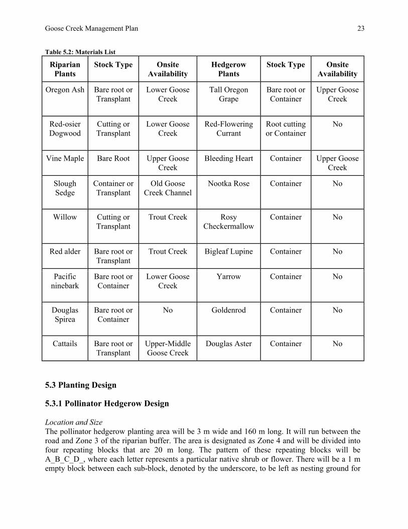
Table 5.2: Materials List Riparian
Plants Stock Type Onsite
Availability Hedgerow
Plants Stock Type Onsite
Availability
Oregon Ash
Bare root or Transplant
Lower Goose Creek
Tall Oregon Grape
Bare root or Container
Upper Goose Creek
Red-osier Dogwood
Cutting or Transplant
Lower Goose Creek
Red-Flowering Currant
Root cutting or Container
No
Vine Maple
Bare Root Upper Goose Creek
Bleeding Heart
Container Upper Goose Creek
Slough Sedge
Container or Transplant
Old Goose Creek Channel
Nootka Rose
Container No
Willow
Cutting or Transplant
Trout Creek Rosy Checkermallow
Container No
Red alder
Bare root or Transplant
Trout Creek Bigleaf Lupine Container No
Pacific ninebark
Bare root or Container
Lower Goose Creek
Yarrow
Container No
Douglas Spirea
Bare root or Container
No Goldenrod
Container No
Cattails
Bare root or Transplant
Upper-Middle Goose Creek
Douglas Aster Container No
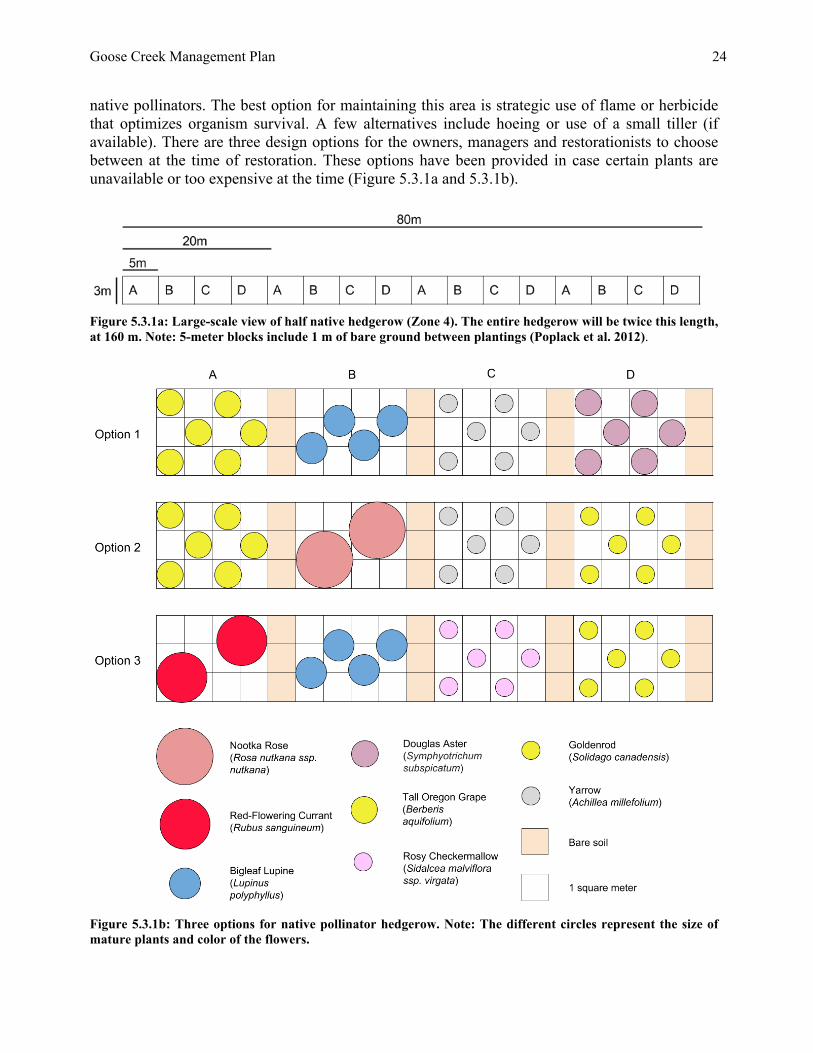
5.3 Planting Design 5.3.1 Pollinator Hedgerow Design Location and Size The pollinator hedgerow planting area will be 3 m wide and 160 m long. It will run between the road and Zone 3 of the riparian buffer. The area is designated as Zone 4 and will be divided into four repeating blocks that are 20 m long. The pattern of these repeating blocks will be A_B_C_D_, where each letter represents a particular native shrub or flower. There will be a 1 m empty block between each sub-block, denoted by the underscore, to be left as nesting ground for
Goose Creek Management Plan
24
native pollinators. The best option for maintaining this area is strategic use of flame or herbicide that optimizes organism survival. A few alternatives include hoeing or use of a small tiller (if available). There are three design options for the owners, managers and restorationists to choose between at the time of restoration. These options have been provided in case certain plants are unavailable or too expensive at the time (Figure 5.3.1a and 5.3.1b).
Figure 5.3.1a: Large-scale view of half native hedgerow (Zone 4). The entire hedgerow will be twice this length, at 160 m. Note: 5-meter blocks include 1 m of bare ground between plantings (Poplack et al. 2012).
Figure 5.3.1b: Three options for native pollinator hedgerow. Note: The different circles represent the size of mature plants and color of the flowers.
Goose Creek Management Plan
25
To provide this habitat there will be a 1 meter-wide empty block between each sub-block, or letter, of plants. The empty space will be provided as native pollinator nesting ground and will consist of bare soil, as bare soil is optimal for ground-nesting pollinators (Poplack et al. 2012). The plants in the hedgerow should be arranged in a scattered z-formation to best mimic natural species composition (Figure 5.3.1b). An alternative planting arrangement would be to plant in rows, which makes it easier to maintain but is not as closely resemble natural composition. Weeding may be required on these plots to keep them bare, however this will require maintenance by the Ranch workers. Herbicides may be a viable alternative, as herbicides have no known direct impact on pollinator health (Vaughan et al. 2007). We further recommend placement of a large soil pile at the end of the Phase I restoration area to supplement bare soil nesting habitat. As for solitary wood or cavity nesting pollinators, bee boxes should be placed on the poles of the fence located along the left side of the creek. Pollinators whose habitat includes pithy stems will find use in the cattails in the riparian buffer plan. Once implemented, the hedgerow can be expanded beyond the 160 m restoration site, extending up to 1000 m along Lower Goose Creek (see Figure 5.3.1c). If one of the options in Figure 5.3.1b is chosen for the 160 m stretch, another could be chosen for the next 160 m, and so on. We recommend that the hedgerow only extend as far as agricultural fields do, so that optimal levels of crop pollination per meter of hedgerow occur.
Figure 5.3.1c: Suggested Restoration Phases by Year.
Goose Creek Management Plan
26
5.3.2 Riparian Buffer Design Location and Size The riparian buffer will be located on both sides of Lower Goose Creek within the Phase I restoration area, and will eventually be repeated in 5 phases total. The buffer is designed to be repeatable in different phases using the same or similar design plan (Figure 5.3.1). The Phase I buffer will be 6-9 m wide. On the right (north) bank, there will be two zones (Zone 1 and 2), stretching from the creek to the road. On the left (south) bank, there will be three riparian zones (Zone 1, 2, and 3), and the hedgerow in Zone 4. Zone 1 is the zone nearest the creek, consisting of saturated to semi-saturated, silty loam soil. Zone 2 is the transitional zone and will experience some periodic flooding during wet-weather seasons. Zone 3 will be the upmost zone and include shrubs and trees. The width of each zone will fluctuate due to highly variable bank-full levels and topography. Arrangement and Spacing of Plantings The plants will be arranged in slightly curved, parallel rows to allow for easy mowing and weeding, while allowing for a design that resembles a natural riparian habitat. To ensure high survival rates and effective ecosystem function, each plant will have specific spacing requirements. Due to the constraint of shading the blueberries fields, we are targeting a shrub-scrub community, which consists of more shrubs than trees. In this community, trees are planted approximately 3-5 m apart, and 3-5 shrubs are planted in between each tree, with a spacing of approximately 1 m between plants (Guillozet et al. 2014). The final planting design will need to be done in the field due to microclimate considerations, such as subtle changes in topography. However, we recommended an example planting design based on the environmental surveys we conducted and then strategically implemented into the zones due to their specific biological requirements. Zone 1: Slough Sedge and Cattail Zone 2: Douglas Spirea, Oregon Ash, Willow, Red-osier Dogwood, Vine Maple, Red Alder and Pacific Ninebark Zone 3: Oregon Oak, Mock Orange and Oceanspray (the latter 3 species might be possible on the north side of the creek).
Goose Creek Management Plan
27
Figure 5.3.2: Riparian buffer example. The circles are different sizes to indicate the different plant species and do not correspond to plant size. 5.4 Site Preparation The purpose of site preparation is to ensure the success and survival of plantings by reducing competition from other species. The primary objective is the control and removal of invasive species that are present on the restoration site, primarily Himalayan Blackberry and Reed Canarygrass. Temperature, soil moisture, and light are all environmental controls that influence Reed Canarygrass (Evenstad 2009). Canopy coverage and access to light affect the Himalayan Blackberry (Caplan & Yeakley 2006). Eventually, increased shade from mature riparian plantings can help control blackberry growth. It is important to combine control methods because one specific method will not completely mitigate the spread of these invasive species. It is also important to use different control methods for the two species. For both species, phase one will include mowing and weeding the restoration
Goose Creek Management Plan
28
area to prepare for the second phase. Mowing and weeding helps make site preparation more manageable. Mowing will be applicable to the hedgerow section of the restoration project. This area is more level terrain that is suitable for a mower. Weeding and cutting will be used in the riparian buffer section due to the steepness of the slope and the wetness of the area. For Reed Canarygrass, cutting the species when it is flowering is the best option. It takes advantage of low available carbohydrate reserves in the rhizome system (Evenstad 2009). This will reduce the likelihood of proliferation. For Himalayan Blackberry, mowing and hand cutting will control it until phase two can occur. The second phase of site preparation varies depending on the species. For Reed Canarygrass, the second phase of site preparation will include using black polypropylene tarps. This is the most cost effective and efficient control for two reasons. First, it will block the sunlight and effectively kill the Reed Canarygrass. Secondly, the Ranch has left over tarp from the south agricultural fields. This left over tarp can be staked down and used as material for the plastic mats. However, the tarps are smaller than ideal and will need to be overlaid over one another. The best time of the year to do it will be following mowing of the species. Studies have found that plastic tarping effectively reduced regrowth in Reed Canarygrass in the following months after plastic removal
(Evenstad 2009). It is important to mow prior to tarping because the plants must be cut shorter than four inches for it to effectively work (Evenstad 2009). For Himalayan Blackberry, the second phase of site preparation will involve digging out its roots to completely eradicate it. This will either be done by a bulldozer that the Ranch has on site, and/or by hand cutting and digging on steeper slopes where bulldozing is not possible. The two primary methods we will avoid using is herbicide and tilling. Herbicide is most effective in the short-term management of weeds and invasive species. Even though it is effective, we do not recommend it for two main reasons. Firstly, the organic fields that surround Goose Creek might be affected by pesticide use. Secondly, our site is right next to a waterway and we do not want pesticides entering and contaminating the water where they can harm aquatic organisms. Using tilling as a site preparation method is also not advised. Both Reed Canarygrass and Himalayan Blackberry are opportunists and thrive in disturbed environments. We do not want to disturb the site by tilling and create more control problems. Also, the wet soil and steep banks limit our ability to till. 5.5 Plant Establishment and Adaptive Management Riparian plantings generally require at least five years of maintenance (especially removing competing vegetation) to reach “free to grow” status. Extensive irrigation for the riparian buffer should not be necessary, as each plant species is native to the natural rainfall in the McKenzie Watershed and get their water supply from the adjacent waterbody (Poplack et al. 2012). However, during the summer following planting, some irrigation may be helpful to increase the plant’s survival rate. The relatively straight rows of the riparian buffer zones will allow easy access for weed-wacking as occasional maintenance. The first year is the most important for a plant’s survival, and weeds must be controlled carefully during this period. Ongoing weed control should be considered for up to 4-6 years or until the plantings are large enough to shade out surrounding plants (Withrow-Robinson et al. 2011).
Goose Creek Management Plan
29
The most important factor in seedling survival is the control of competing weeds. We recommend using weed mats and weed whacking as the primary measures to control plant competition. After weed mats, further weed whacking will be needed to allow plantings to achieve “free-to-grow” status, when they will be able to survive without weed management (Section 5.4). The establishment and maintenance of our riparian plants has to be cost effective and easy to maintain. The best way to do this is by combining many different methods to create the best possible maintenance plan. The four major methods we will use are browse protection, densely planting, maintenance of bare areas, and mulching. First, browse protection will be crucial to the successful growth of the trees we plant as part of the riparian buffer. The most effective option would be to put wire cages around the seedlings until they reach 1.5m or taller (Kochenderfer & Ford 2008). The survival rate from their study shows that tree saplings had the highest survival rate to 1.5m or taller than any other browse protection method. However, it is important that we do not rely solely on wire cages for sapling survival. This is due to the high cost of installing and maintaining them. Deer, elk, and beaver are a potential threat to plantings. If evidence of damage occurs, one potential solution is wrapping the tree trunk in plastic plant tubing or cages. Mice and voles can damage plantings. They can be managed by keeping vegetation around the planting short to reduce their cover (Withrow-Robinson et al. 2011). Beavers on site should not be disturbed. Care should be taken during all restoration actions not to interfere with existing beaver habitat, and is a concern that should be kept in mind when conducting future restoration efforts. There are also Western Pond Turtles on the site, and similar care should be taken not to disturb or disrupt them when conducting restoration efforts. Both of these scenarios will need to be managed on a case-by-case basis. Secondly, to counter the cost and still promote sapling survival, we will plant them densely in the restoration area. This way we guarantee that some saplings will survive, even if browsing occurs. Thirdly, maintenance of bare areas will be crucial to the mitigation of the invasive species. Bare soil conditions contribute to the spread of reed canary grass (Evenstad 2009). The bare soil in the hedgerow will be acceptable because we want to promote pollinator nesting and any other location in the restoration site will need vegetation cover. It will be important to establish native plant cover early on in the restoration project to help promote native vegetation and limit the invasive species influence. Also, to use the weed whacker to keep the Reed Canarygrass to during the growing season. The fourth method of maintenance will be the application of mulch in 1 m to 2 m circles surrounding plant saplings (National Association of Conservation Districts 1998). This application of mulch will serve three main functions. Firstly, it will help the sapling survive and give it a buffer zone. Secondly, the mulch will protect the soil from erosion (National Association of Conservation Districts 1998). This is important since we will need the bank of Goose Creek to be stabilized while the sapling's root system develops. This will keep sediment out of the creek and keep the creek channelized. Thirdly, the application of mulch will prevent weeds from growing due to lack of sunlight being received by the surrounding soil (National Association of Conservation Districts 1998). It will be important to change the mulch surrounding the saplings three to four times a year to prevent weeds from occurring. The mulching would be more effective on the upland/hedgerow plantings than closer to the stream because mulching will not help much with Reed Canarygrass.
Goose Creek Management Plan
30
When managing plant establishment, adaptive management will be an important factor. This is the process of adjusting restoration efforts based on changing site conditions and variables. Sites undergoing restoration need to be monitored closely for any problems or changes that must be adapted to. There are a number of factors that should be monitored as this restoration effort progresses. Irrigation is probably not necessary due to the proximity of the stream, but it could be helpful in the summer. Plants should be monitored and irrigation applied as necessary. Irrigation would be most beneficial during the first year, and possibly not needed after that (Withrow-Robinson et al. 2011). Currently the plan calls for mats used on the olive tree crops to be recycled for use in site preparation. If these cannot be reused then new mats must be purchased ($0.75-$1/mat). If Reed Canarygrass and Blackberry interfere with the planting plan, future ELP teams or on-site labor provided by Whitewater Ranch may need to reintroduce weed mats for weed control at a later point. Risk of flooding is high in Goose Creek. In the case that high waters damage individual plants, we recommend replanting with similar species. If similar species are not available, the area can be replanted with other suggested planting designs within sections 5.3.1 and 5.3.2 of the management plan. We recommend exploring culvert adjustments as needed near the mouth of Goose Creek entering the McKenzie River. Here, adaptive management can be implemented to encourage potential salmon and steelhead species. 5.6 Monitoring 5.6.1 Pollinator Populations
Figure 5.7.1 Pollinator Habitat (Xerces 2007) The pollinator hedgerow, located on the left bank of Goose Creek inland of the riparian buffer, will provide shelter and nectar resources to bees, creating an incentive for them to visit the area even when the blueberries lose their blossoms. In order to monitor the hedgerow’s impact on pollinator populations, a pollinator survey should to be carried out to assess baseline information on current pollinator activity. We recommend baseline monitoring to begin once the hedgerow is established, and then repeated monitoring every 2-5 years to evaluate changes in the pollinator population over time. The pollinator monitoring could occur in both the adjacent blueberry fields and the hedgerow area.
Goose Creek Management Plan
31
Pollinator surveys must be performed according to the correct environmental conditions listed in the 2014 Blueberry Pollination by Native Pollinators Survey Protocol (Boulay 2014). In the spring of 2014, the Sustainable Farms team was unable to conduct a formal pollinator survey due to weather limitations. According to Lorin Zastoupil the site has a healthy population of native pollinators. Native pollinator surveys can only be conducted when the weather is optimal: temperature >59 degrees F, with the sun shining and a minimal breeze. It is recommended that future restoration teams perform a native pollinator survey in order to monitor the effectiveness of the hedgerow.
5.6.2 Restoration Plantings Introduction Monitoring after planting is an essential part of the restoration project, and will often make the difference between success and failure for the restoration plantings. There are several monitoring steps that can be taken to ensure the survival, growth, and rigor of the restoration plantings for both the hedgerow and the riparian buffer. Prior to implementing the project, a monitoring plan should be developed to address what needs to be monitored, such as shade and tree survival. A monitoring plan will outline how to evaluate the health of the plantings, when monitoring should take place, and what is the given timeline and budget (Withrow-Robinson et al. 2011). Monitoring Techniques Shortly after the plantings have been established, measurements and documentation of when, where, and how it was planted should be taken to help provide accurate baseline data (Massingill 2005). Acquiring baseline data will supply a foundation for future monitoring analysis and maintenance. Periodic visual inspections should be conducted to see how plantings are responding to their restoration environment. These inspections will help determine if there are any needs or corrective actions to support the plantings survival and growth rates. Some observations in the periodic visual inspections could include, checking for grasses or weeds that could pose threats to the plants, checking for evidence of animal presence, and checking on the health of the plants
(Withrow-Robinson et al. 2011). Similar protocol to periodic visual inspections, effectiveness monitoring involves observing the restoration plantings to measure their specific characteristics and desired effectiveness (Massingill 2005). For example, it will be important to monitor the effectiveness of the riparian planting’s shading on Goose Creek, which will indicate if the objectives of the project were achieved. The last monitoring technique that should be implemented is photo monitoring. This technique is an easy, cost-effective, and efficient method of monitoring any vegetation or ecosystem changes. When establishing a photo point, it is important to mark the location with a steel rebar, record the location and compass direction of the point of interest, as well as the photographer so that you can return to the same spot each time (Withrow-Robinson et al. 2011).
Goose Creek Management Plan
32
6.0 Acknowledgements Thank you to our community partners, Whitewater Ranch landowners Jim and Jane Russell, and managers Lorin and Mary Alice Zastoupil, for making this project possible. Thank you to our technical advisers, Shannon Richardson (Oregon Department of Fish and Wildlife), Bruce Newhouse (Salix Associates) and Pollyanna Lind (UO Department of Geography), who trained us in new field methods and collected field data with us. With their guidance, we were able to develop an informed and comprehensive restoration plan. Thank you to Lucas Adee, for guiding our team through certain graphic design elements needed for this management plan. Thank you to both Peg Boulay, Co-Director of Environmental Leadership Program (ELP), and Erica Elliott, our project manager for guiding and advising our team throughout the project. 7.0 Literature Cited Boulay, P. 2014. UO Environmental Leadership Program 2014 Blueberry Pollination by Native
Pollinators Protocol. University of Oregon. Caplan, J.S., J.A. Yeakley. 2006. Rubus armeniacus (Himalayan blackberry) Occurrence and
Growth in Relation to Soil and Light Conditions in Western Oregon. Northwest Science, 80: 9-15.
Coalition of Environmentally Conscious Growers. No date. Home. URL
http://www.christmastreecoalition.org/ (Accessed on 14 March 2014) Evenstad, T.A. 2009. Restoration ecology and invasive species management: ecological impacts
of the invasive grass phalaris arundinacea (reed canary grass) and methods for control in the southern Willamette Valley. Thesis. University of Oregon, Eugene, OR.
Guillozet P., K. Smith, K. Guillozet. 2014. The Rapid Riparian Revegetation Approach.
Ecological Restoration 32:2 Image of Vegetation Buffer from Ontario County Soil & Conservation District, Canandaigua,
King County. No date. Native plant list. King County, WA.
https://green.kingcounty.gov/GoNative/Plant.aspx?Act=list. (Accessed on May 2014) Kochenderfer, J.N., W.M. Ford. 2008. Utility of wire cages, tree shelters, and repellants to
minimize herbivory to oak by white-tailed deer. U.S. Dept. of Agriculture, Forest Service. 1-5.
Goose Creek Management Plan
33
Lavergne S., J. Molofsky. 2004. Reed Canary Grass (Phalaris arundinacea).Critical Reviews in Plant Sciences, 5: 415-429.
Luna, T., R. K. Dumroese, T. D. Landis. 2006. Collecting Dormant Hardwood Cuttings for
Western Riparian Restoration Projects. Reforestation, Recreation Tech Tips. Missoula, MT: U.S. Department of Agriculture, Forest Service, Technology and Development Center. 8 p. http://www.treesearch.fs.fed.us/pubs/32848. (Accessed on May 2014)
NRCS, Lane County Area, OR. 2014. USDA National Resources Conservation Service, Web Soil
Survey. National Association of Conservation Districts, Wildlife Habitat Council, US Natural Resources
Conservation Service. Mulching enriches and protects soil, helping provide a better growing environment. Pages 1-4. Wildlife Habitat Council, Washington, D.C.
Native Bee Conservation Pollinator Habitat Assessment Form and Guide. 2011. Xerces Society
for Invertebrate Conservation. Portland, OR. Available from http://www.nm.nrcs.usda.gov/technical/fotg/section-2/wildlife/wheg-PollinatorHabAssess.pdf (Accessed April 2012).
Newhouse, B. 2011. Blooming Timetable of Native Plants for Native Insect Pollinators in the
Southern Willamette Valley, Oregon. Salix Associates. salixassociates.com. Poplack A., K. Kopec, C. Johnson, M. Pacheco, K. Daly, B. Cypel, M. Maxon, A. Whitcomb, L.
Ward. 2012. Pollinator Conservation Plan for the Berggren Demonstration Farm. Environmental Leadership Program, Sustainable Farms 2012.
Van Timmeren, S., R. Isaacs. 2014. Drosophila suzukii in Michigan vineyards, and the first report
of Zaprionus indianus from this region. Journal of Applied Entomology. (Accessed June 2014).
Vaughan M., S.H. Black. 2007. Pesticide Considerations For Native Bees In Agroforestry. USDA
National Agroforestry Center, Agroforestry Notes, 35: 1-4. URL http://www.xerces.org/wp-content/uploads/2011/02/agroforestrynotes35-pesticides.pdf (accessed on May 25, 2014).
Vaughan, M. M. Shepherd, C. Kremen, S. Hoffman Black. 2007. Farming for bees: guidelines for
providing native bee habitat on farms. Unpublished report. The Xerces Society for Invertebrate Conservation, Portland, Oregon. Available from http://www.xerces.org/wpcontent/uploads/2008/11/farming_for_bees_guidelines_xerces_society.pdf (Accessed May 2014).
Withrow-Robinson, B., Bennett, M., Ahrens, G. 2011. A guide to riparian tree and shrub planting
in the Willamette Valley: steps to success. Oregon State University. EM 9040: 1-27
Goose Creek Management Plan
34
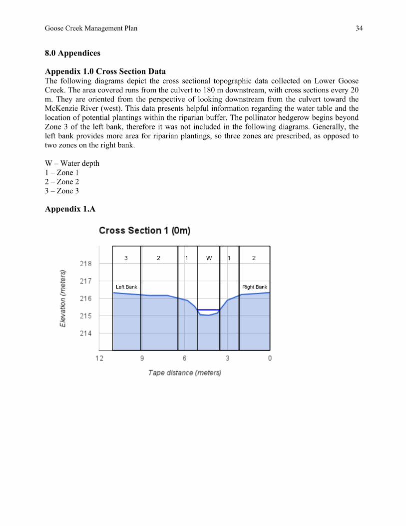
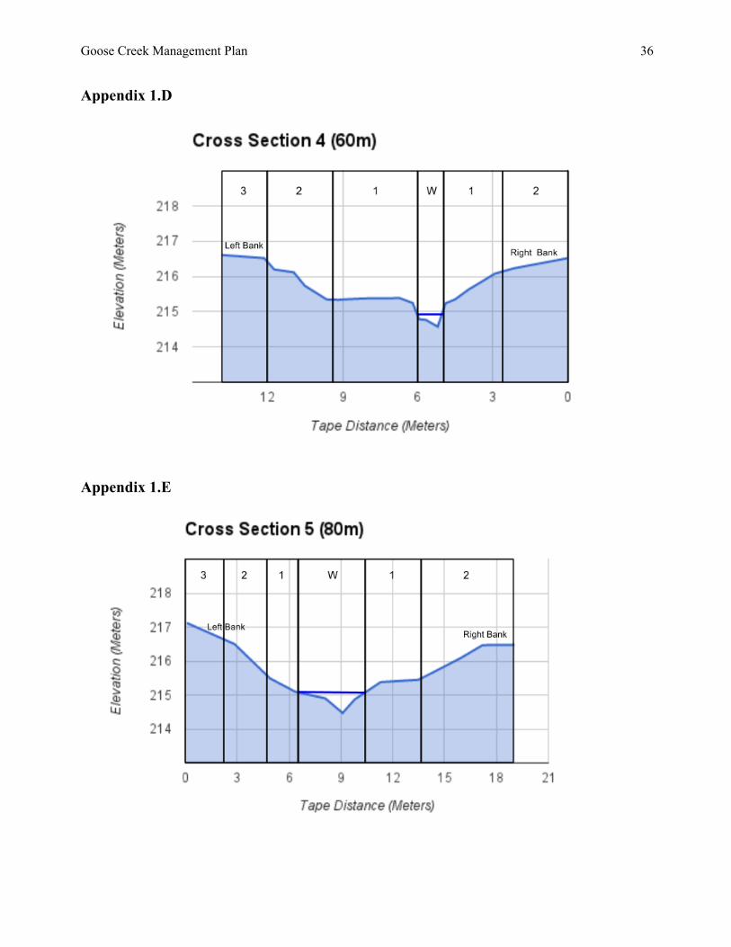
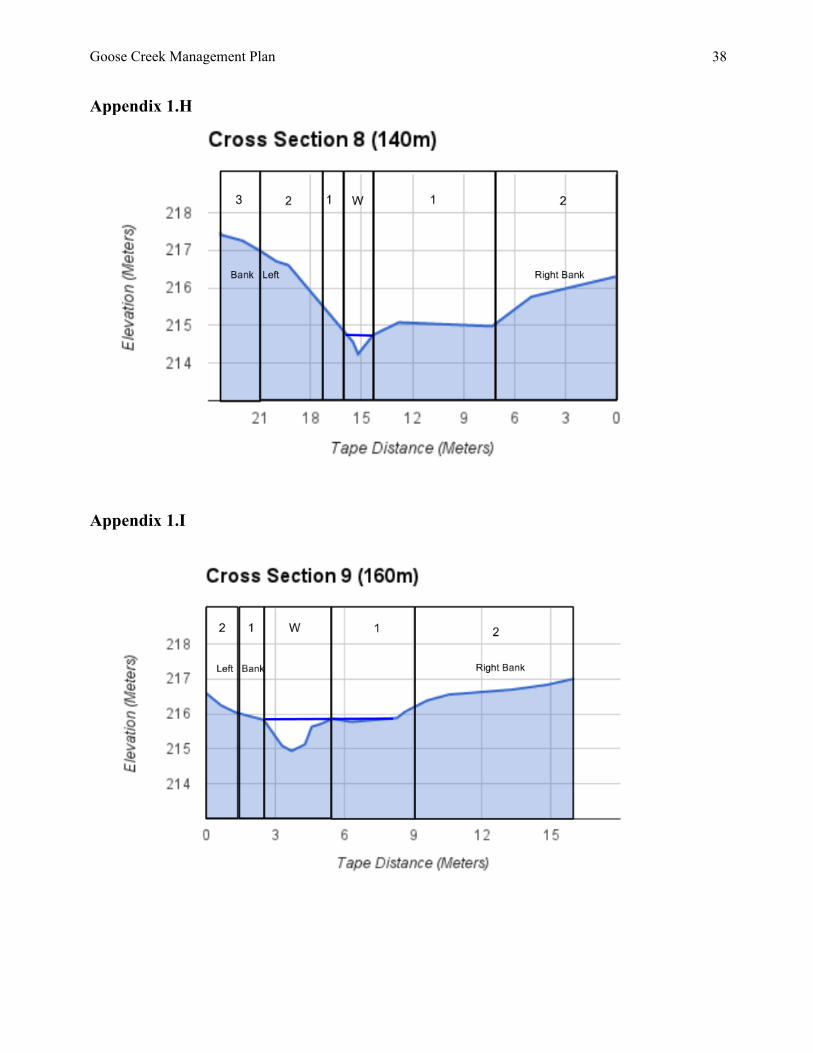
8.0 Appendices Appendix 1.0 Cross Section Data The following diagrams depict the cross sectional topographic data collected on Lower Goose Creek. The area covered runs from the culvert to 180 m downstream, with cross sections every 20 m. They are oriented from the perspective of looking downstream from the culvert toward the McKenzie River (west). This data presents helpful information regarding the water table and the location of potential plantings within the riparian buffer. The pollinator hedgerow begins beyond Zone 3 of the left bank, therefore it was not included in the following diagrams. Generally, the left bank provides more area for riparian plantings, so three zones are prescribed, as opposed to two zones on the right bank. W – Water depth 1 – Zone 1 2 – Zone 2 3 – Zone 3 Appendix 1.A
Goose Creek Management Plan
35
Appendix 1.B
Appendix 1.C
Goose Creek Management Plan
36
Appendix 1.D
Appendix 1.E
Goose Creek Management Plan
37
Appendix 1.F
Appendix 1.G
Goose Creek Management Plan
38
Appendix 1.H
Appendix 1.I
Goose Creek Management Plan
39
Appendix 1.K
Goose Creek Management Plan
40
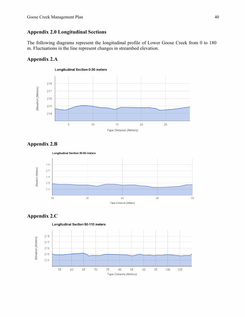
Appendix 2.0 Longitudinal Sections The following diagrams represent the longitudinal profile of Lower Goose Creek from 0 to 180 m. Fluctuations in the line represent changes in streambed elevation. Appendix 2.A
Appendix 2.B
Appendix 2.C
Goose Creek Management Plan
41
Appendix 2.D
Appendix 2.E
Goose Creek Management Plan
42
Appendix 3.0 Reference Site Plant List
Upper Goose Creek Trout Creek
Sedge (old stream bed) (Carex obnupta)
Red Alder (Alnus rubra)
Salmonberry (Rubus spectabilis)
Huckleberry (Vaccinium)
Osoberry (Oemleria cerasiformis)
Willow (Salix)
Bleeding Heart (Lamprocapnos spectabilis)
Devil’s Club (Oplopanax horridus)
Oregon Iris (Iris tenax)
Cascara Buckthorn (Rhamnus purshiana)
False Solomon Seal (Maianthemum racemosum)
Western Hemlock (Tsuga heterophylla)
Oxalis (Oxalis oregona)
White Alder (Alnus rhombifolia)
Salal (Gaultheria shallon)
Sword Fern (Polystichum munitum)
Incense Cedar (Calocedrus)
Western Red Cedar (Thuja plicata)
Vine Maple (Acer circinatum)
Maidenhair Fern (Adiantum)
Deer Fern (Blechnum spicant)
Fairy Bell (Disporum hookeri)
Goose Creek Management Plan
43
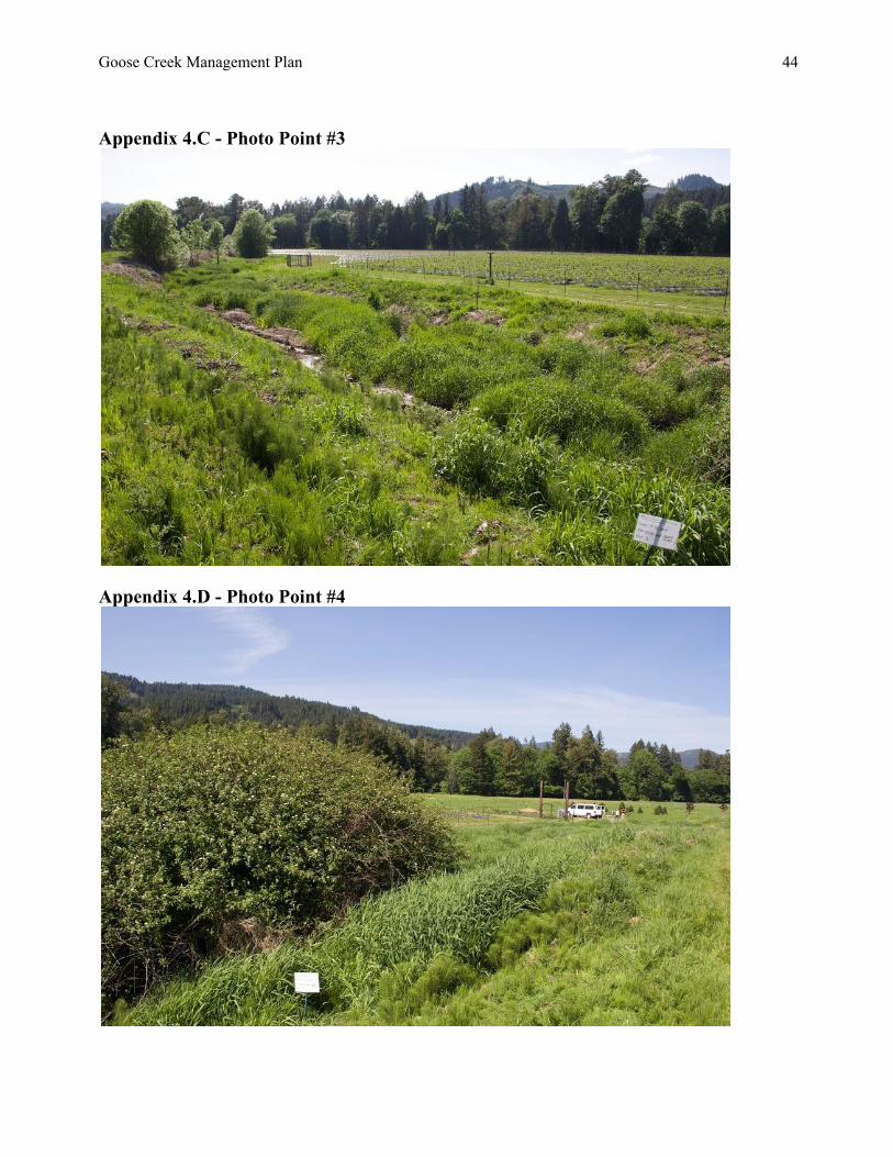
Appendix 4.0 - Baseline Photo Points of Goose Creek (re-establish photo points if needed) Appendix 4.A - Photo Point #1
Appendix 4.B - Photo Point #2
Goose Creek Management Plan
44
Appendix 4.C - Photo Point #3
Appendix 4.D - Photo Point #4
Goose Creek Management Plan
45
Appendix 4.E - Photo Point Coordinates and Other Related Geographic Information
Photo Point Geographic Data & Coordinates
Notes
#1 pp01 - pdop 1.82 4885372.66 meters North (UTM)
529780.89 meters East (UTM)
Shot #1 looks down Goose Creek (river right)
#2 pp01 - pdop 1.82 4885372.66 meters North (UTM)
529780.89 meters East (UTM)
Shot #2 looks up Goose Creek (river right)
#3 pp02 - pdop 1.66 4885355.13 meters North (UTM)
529789.12 meters East (UTM)
Shot #3 looks down Goose Creek (river left)
#4
pp02 - pdop 1.66 4885355.13 meters North (UTM)
529789.12 meters East (UTM)
Shot #4 looks up Goose Creek (river left)
Appendix 5.0 - Pollinator Hedgerow Bloom Time Chart The following chart represents pollinator hedgerow species selection based on origin and bloom time, coordinated to maximize ecosystem services by native pollinators. This provides useful information for implementing hedgerow design options during future phases of restoration on Lower Goose Creek.