Review ArticleThe Potential for Observing African Weather withGNSS Remote Sensing
Olalekan A Isioye12 Ludwig Combrinck12 Joel O Botai1 and Cilence Munghemezulu12
1Department of Geography Geoinformatics and Meteorology University of Pretoria Pretoria 0002 South Africa2Hartebeesthoek Radio Astronomy Observatory (HartRAO) PO Box 443 Krugersdorp 1740 South Africa
Correspondence should be addressed to Olalekan A Isioye u13390742tukscoza
Received 1 September 2014 Revised 19 January 2015 Accepted 22 January 2015
Academic Editor Julio Diaz
Copyright copy 2015 Olalekan A Isioye et al This is an open access article distributed under the Creative Commons AttributionLicense which permits unrestricted use distribution and reproduction in any medium provided the original work is properlycited
When compared to thewide range of atmospheric sensing techniques global navigation satellite system (GNSS) offers the advantageof operating under all weather conditions is continuous with high temporal and spatial resolution and high accuracy and haslong-term stabilityThe utilisation of GNSS ground networks of continuous stations for operational weather and climate services isalready in place in many nations in Europe Asia and America under different initiatives and organisations In Africa the situationappears to be different The focus of this paper is to assess the conditions of the existing and anticipated GNSS reference networkin the African region for meteorological applications The technical issues related to the implementation of near-real-time (NRT)GNSS meteorology are also discussed including the data and network requirements for meteorological and climate applicationsWe conclude from this study that the African GNSS network is sparse in the north and central regions of the continent with adense network in the south and fairly dense network in the west and east regions of the continent Most stations lack collocatedmeteorological sensors and other geodetic observing systems as called for by the GCOS Reference Upper Air Network (GRUAN)GNSS Precipitable Water Task Team and the World Meteorological Organization (WMO) Preliminary results of calculated zenithtropospheric delay (ZTD) from the African GNSS indicate spatial variability and diurnal dependence of ZTD To improve thedensity and geometry of the existing network countries are urged to contribute more stations to the African Geodetic ReferenceFrame (AFREF) program and a collaborative scheme between different organisations maintaining different GNSS stations on thecontinent is recommended The benefit of using spaced based GNSS radio occultation (RO) data for atmospheric sounding ishighlighted and filling of geographical gaps from the station-based observation network with GNSS RO is also proposed
1 Introduction and Background
Satellite-based remote sensing technologies are an integralpart of the work of the United Nations Framework Con-vention on Climate Change (UNFCCC) through the GlobalClimate Observing System (GCOS) The mandate of GCOSis to determine what data are needed for the monitoring ofclimate impacts To this end GCOS has identified 44 so-called Essential Climate Variables (ECVs) [1] According toGCOS progress in producing the forty-four ECVs has beenlethargic to date Nonetheless the increasing importance ofadaptation in terms of both costs and needs has heightenedthe interest in space-based operations [2]
Atmospheric water vapour is identified as one of theforty-four ECVs Atmospheric water vapour is one of
the most important components of the atmosphere since itis the means by which moisture and latent heat are trans-ported to influence weather furthermore it is a greenhousegas that plays an essential role in the global hydrologicalcycle and global climate system [3] Most meteorologicalprocesses (convection cloud formation and precipitation)are influenced by the local as well as large-scale variability inatmospheric water vapour Traditional methods of collectingdata on atmospheric water vapour do not offer the spatialand temporal resolution necessary for in-depth studies ofweather and climate [4] A better understanding of climateand weather patterns requires data sets that are more com-prehensive
Global navigation satellite systems (GNSS) through aconcept referred to as ldquoGNSS meteorologyrdquo are a contender
Hindawi Publishing CorporationAdvances in MeteorologyVolume 2015 Article ID 723071 16 pageshttpdxdoiorg1011552015723071
2 Advances in Meteorology
for providing the water vapour knowledge that atmosphericscientists have been seeking GNSS receiversantennas do notrequire continual calibration as some sensors do formeasure-ment drifts or biases although pressure sensors collocated atGNSS sites occasionally require calibration for instrumentdrift Also large numbers of GNSS measurements can bemade temporally and spatially in all weather conditionsDue to the coverage and potential for near-real-time datatransmission that GNSS water vapour estimates offer GNSScould be used to determine the distribution of water vapourover a region of interest and thus help in the identification ofpotential severe weather activity [3 5 6]
The term GNSS meteorology relates to the utilizationof the GNSS radio signals to deliver information about thestate of the troposphere This can be achieved from a satelliteplatform (GNSS radio occultation meteorology) [7 8] andground permanent stations (ground-based GNSS meteorol-ogy) [9 10] Continuous observations from GNSS receiversprovide an excellent tool for studying the earthrsquos atmosphereGNSS meteorology has transitioned from research intonational and regional networks The collaboration betweenthe geodetic and meteorological communities has con-tributed to themeteorological communityrsquos understanding ofthe GNSS representation of water vapour These and otherefforts have resulted in projects and collaboration betweenGCOS and the International GNSS Service ((IGS) [11ndash13])focussed on the operational use of GNSS water vapourestimations [14]
The new technology of GNSS atmospheric remote sens-ing has several advantages over the conventional watervapour observing system including global coverage reliableand stable results high measurement accuracy all weatheroperability and radio frequencies that can penetrate cloudsand dusts [15] In addition since the majority of nationalgeodetic institutions and scientific organisations install GNSSreceivers in the different regions of the world with densenetworks in order to do positioning mapping monitortectonics and so forth through collaboration with thosedata for zenith total delay (ZTD) estimation for meteorologycan be obtained at a low or no cost GNSS meteorologyenables precipitable water vapour (PWV) to be inferredwith the same accuracy as conventional meteorological mea-surements such as radiosondes water vapour radiometer(WVR) and microwave profiler (MWP) measurements toabout 1-2mm PWV accuracy [16] Comparative and val-idation results of GNSSZTDPWV with existing numericweather prediction (NWP) models such as the EuropeanCentre for Medium Weather Forecast (ECMWF) and theNational Centre for Environmental Prediction (NCEP) arepromising as seen from the works of for example Chen etal [17] Kishore et al [18] and Koulali et al [19] Also Tekeet al [20] van Malderen et al [21] and Bock et al [22]have all reported the performance of GNSS against othergeodetic techniques (namely very long baseline interferom-etry (VLBI) Doppler Orbitography and RadiopositioningIntegrated by Satellite (DORIS) and sun photometers fromAerosol Robotic Network (AERONET)) in the estimation oftroposphere parameters with results showing strong correla-tion among them
There have been several projects from several organi-zations on the different continents of the world to derivetropospheric zenith delay measurements from ground-basedGNSS for operational meteorological applications Examplesof such projects in Europe include the COST Action 716(European Cooperation in the Field of Scientific TechnicalExploitation of Ground-Based GPS for Numerical WeatherPredictionApplication 1998ndash2004) [23] TOUGH (TargetingOptimal Use of GPS Humidity Data in Meteorology 2003ndash2006) [24] and E-GVAP (The EUMETNET GPS WaterVapour Programme 2004) [25] E-GVAP network consistsof more than 1500 GNSS sites mainly in Europe recentlyprocessing and distribution of global GNSS data have startedsince many E-GVAP members run global NWP modelsIn Africa the AMMA (African Monsoon MultidisciplinaryAnalysis Project 1999ndash2005) [26 27] worked on PWVestimation and analysis in the African monsoon region InNorth America the SuomiNet (named to honour meteoro-logical satellite pioneer Verner Suomi) network of receiversprovides real-time estimates of water vapour for a globalnetwork of receivers from zenith water vapour measure-ments which are mostly concentrated in the United States(see [4]) Additionally UCARrsquos (University Corporation forAtmospheric Research) COSMIC (Constellation ObservingSystem for Meteorology Ionosphere and Climate) programprocesses GPS data in PBO (Plate Boundary Observatory)GPS network CocoNet (Caribbean Network) SuomiNet +NOAA (National Oceanic and Atmospheric Administra-tion) USCGUSACE (United States Coast GuardUS ArmyCorps of Engineers) DOT (Department of Transportation)and other sites to produce near-real-time (NRT) PWVestimates across North America [28]The Japanese GEONET(GPS Earth Observation Network) has the largest array ofover 1200 GPS stations in the world It was established forearthquake hazard research and mitigation scientific appli-cations of the network have been expanded to include mete-orology and ionospheric research Currently the GEONETcontributes to the assimilation of GPS precipitable watervapour data into the JMA (Japan Meteorological Agency)Mesoscale Numerical Prediction Model [29] Furthermoretwo European institutes Meteo France and UK Met Officeuse NRT ZTDs in their numerical weather predictions oper-ations today both reporting a positive impact from the use ofground-based GNSS delay data [30] Utilizing its capabilityof water vapour estimation GNSS has a potential to detectand track extreme changes in weather such as thunderstorms[29] In addition NRT GNSS water vapour monitoring fornumerical weather prediction services is active in Germanyand Austria [31]
All the foregoing discussions demonstrate that GNSSatmospheric remote sensing technology is a key methodto improve spatial and temporal sampling of water vapourobservation and that GNSS PWV should be a useful source ofhumidity information for NWP applications However thereis still no operational GNSS network for GNSS meteorologyin Africa although the application has been investigatedat the Hartebeesthoek Radio Astronomy Observatory interms of South Africa only [32] Thus as a practical issueit is important to build up a network of GNSS stations
Advances in Meteorology 3
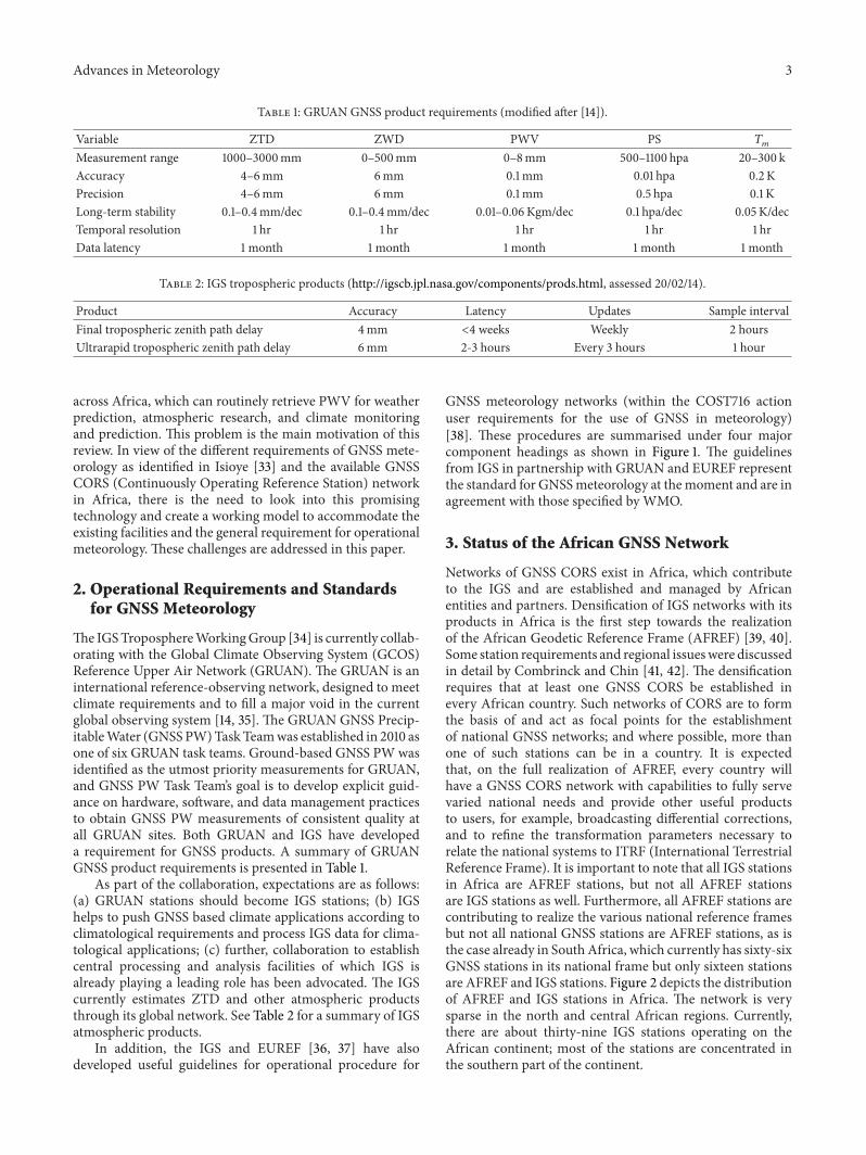
Table 1 GRUAN GNSS product requirements (modified after [14])
across Africa which can routinely retrieve PWV for weatherprediction atmospheric research and climate monitoringand prediction This problem is the main motivation of thisreview In view of the different requirements of GNSS mete-orology as identified in Isioye [33] and the available GNSSCORS (Continuously Operating Reference Station) networkin Africa there is the need to look into this promisingtechnology and create a working model to accommodate theexisting facilities and the general requirement for operationalmeteorology These challenges are addressed in this paper
2 Operational Requirements and Standardsfor GNSS Meteorology
TheIGSTroposphereWorkingGroup [34] is currently collab-orating with the Global Climate Observing System (GCOS)Reference Upper Air Network (GRUAN) The GRUAN is aninternational reference-observing network designed to meetclimate requirements and to fill a major void in the currentglobal observing system [14 35] The GRUAN GNSS Precip-itableWater (GNSSPW)TaskTeamwas established in 2010 asone of six GRUAN task teams Ground-based GNSS PWwasidentified as the utmost priority measurements for GRUANand GNSS PW Task Teamrsquos goal is to develop explicit guid-ance on hardware software and data management practicesto obtain GNSS PW measurements of consistent quality atall GRUAN sites Both GRUAN and IGS have developeda requirement for GNSS products A summary of GRUANGNSS product requirements is presented in Table 1
As part of the collaboration expectations are as follows(a) GRUAN stations should become IGS stations (b) IGShelps to push GNSS based climate applications according toclimatological requirements and process IGS data for clima-tological applications (c) further collaboration to establishcentral processing and analysis facilities of which IGS isalready playing a leading role has been advocated The IGScurrently estimates ZTD and other atmospheric productsthrough its global network See Table 2 for a summary of IGSatmospheric products
In addition the IGS and EUREF [36 37] have alsodeveloped useful guidelines for operational procedure for
GNSS meteorology networks (within the COST716 actionuser requirements for the use of GNSS in meteorology)[38] These procedures are summarised under four majorcomponent headings as shown in Figure 1 The guidelinesfrom IGS in partnership with GRUAN and EUREF representthe standard for GNSSmeteorology at themoment and are inagreement with those specified by WMO
3 Status of the African GNSS Network
Networks of GNSS CORS exist in Africa which contributeto the IGS and are established and managed by Africanentities and partners Densification of IGS networks with itsproducts in Africa is the first step towards the realizationof the African Geodetic Reference Frame (AFREF) [39 40]Some station requirements and regional issueswere discussedin detail by Combrinck and Chin [41 42] The densificationrequires that at least one GNSS CORS be established inevery African country Such networks of CORS are to formthe basis of and act as focal points for the establishmentof national GNSS networks and where possible more thanone of such stations can be in a country It is expectedthat on the full realization of AFREF every country willhave a GNSS CORS network with capabilities to fully servevaried national needs and provide other useful productsto users for example broadcasting differential correctionsand to refine the transformation parameters necessary torelate the national systems to ITRF (International TerrestrialReference Frame) It is important to note that all IGS stationsin Africa are AFREF stations but not all AFREF stationsare IGS stations as well Furthermore all AFREF stations arecontributing to realize the various national reference framesbut not all national GNSS stations are AFREF stations as isthe case already in South Africa which currently has sixty-sixGNSS stations in its national frame but only sixteen stationsare AFREF and IGS stations Figure 2 depicts the distributionof AFREF and IGS stations in Africa The network is verysparse in the north and central African regions Currentlythere are about thirty-nine IGS stations operating on theAfrican continent most of the stations are concentrated inthe southern part of the continent
4 Advances in Meteorology
adopted which represent the global standard
GNSS meteorology station requirement
km for numerical weather prediction andestimation shouldnetworktheinreceiveroneleastAt(c)km)1000approximatelybaselines(longdelayatmosphericofbe collocated with a radiosonde site for quality control (d) Latency of data collection should be smaller than 20 minutes for numerical weather prediction (assuming assimilation cycles of 3 hours) and smaller than five minutes for nowcasting (e) The network should be centred around a dense subnetwork when it exists and a number of IGS stations should be included in the network for validation with other GNSSGPS processing centres and the RINEX format should be used to exchange GPS observations
GNSS meteorology network requirement
(ultrarapid) orbits (from eg IGS) when necessary and (b) the processing time which should be such that the total latency is less than 45 minutes for numerical weather prediction and less than the repetition cycle of the product for nowcasting
GNSS meteorology processing requirement
minutes (ii) subhourly ZTDIWV estimates should be disseminated within the length of the repetition cycle and (c) the
GNSS meteorology observables
∙ The GNSS meteorology station requirement includes the station monument and hardware type the guidelines for IGS are
∙ The GNSS meteorology network requirement specifies the following (a) A network for GNSS meteorology should consist of more
∙ GNSS processing should be performed using standard software The processing should follow the following (a) use of
∙ The atmosphere observable should satisfy certain conditions such as the following (i) hourly ZTDIWV must be disseminated within 45
than one real network (eg a local network combined with IGS stations) (b) The density of the network should be 30ndash100
accuracy of the ZTD should be 10ndash15 1ndash2 for numerical weather prediction and IWV be 1ndash3 for nowcastingmmIWV
10ndash100 km for nowcasting A network should be large enough for absolute
Figure 1 Summary of requirements for GNSS meteorology from IGS GRUAN and EUREF
60∘E30
∘EARIT
Long (deg)
ABPO
GOUG
VACSRDRG
ADIS
BJCOCGGN
HNUS
MAL2
MOIU
RABT
RBAY
RCMN
Simo
Tdou
Tgev
Uldi
Wind
Yrko
ZAMB
Lpal
Meli
Abuz
Asc1
Bfo1
BjabBjna
Bjni
Bjsa
Bkfp
DamyEtadEtdd
Futy
Hukp
Ifr1
Lnda
Mas1
Maun
Mdgr
Mtnd
Mtwa
Niam
OsgfOuag
Reun
Sthl
Svct
Tana
Tanz
Tetn
Ulag
Znzb
DAKR
Dear
Ebbe
HarbHRAO
Llng
MBAR
Mfkg
NURK
Pre1Pre2
Sbok
Sey1
SUTHSutmSutv Umta
RamoFunc
Lat
(deg
)
NKLGClbr
FpnoGembUnec
IGS stationsAFREF stationsRadiosonde stationsIGS and AFREF stations with collocated met sensors
30∘N
30∘W
30∘S
0∘
0∘
N
60∘E
Figure 2 Map depicting the position of IGS and AFREF stations inAfrica
A quick check on the station availability of AFREF sta-tions from the AFREF data web page (httpwwwafrefdataorg) indicates that 81 stations are currently on the sched-uled list for daily data logging from individual contributors(countries) in Africa However only 25 countries on thecontinent are currently contributing to the IGS and AFREFThe maximum daily data archive for AFREF in the lastthree years (2011 2012 and 2013) to date (23022014) standsat 54 stations per day The reason for inconsistent datastreaming from the various stations can obviously be due
to communication problems which has to do with internetconnectivity equipment failure or in some cases electricalpower problems which is less often
The site log files and type of data archived by both theIGS and AFREF stations in Africa were inspected for thepurpose of this study to ascertain if stations are collocatedwith meteorological sensors as it is a requirement by IGS forGNSS meteorology network It was however observed thatonly a few stations in Africa have met packs collocated withthem (see Figure 2) Additionally not all the GNSS stationscollocated with weather sensors that stream meteorologicalRINEX files to the IGS as confirmed from SOPAC webdata page (httpsopacucsdedunearbySitesshtml) Fur-thermore only a few GNSS stations in Africa are collocatedwith radiosondes as required by the GRUAN PW Task Teamand IGS However there are a few GNSS stations that arewithin an appreciable distance to the radiosonde sites thismay as well be the situation for weather sensors Figure 2further illustrates the distribution of radiosonde stations inAfrica as obtained from the Integrated Global RadiosondeArchive (IGRA) Collation of meteorological parametersfrom the different weather stations for interpolation tothe GNSS site as reported in Hadas et al [43] would beunmanageable in the African context going by instrumentvariations political and administrative challenges cost andready access to data
From the foregoing the African GNSS network can beseen to have three particularities (i) sparseness going by therequirement for meteorology (ii) absence of weather sensorsand radiosondes at GNSS sites and (iii) inconsistency in datastreaming from operators due to lack of internet connec-tivity for data transmission thereby creating data gaps Thesparseness of the African network implies long interstationdistances this could also lead to a lack of constraints onthe orbit solution established by the IGS Hence the orbiterrors could be more important over Africa than in placeswith a denser IGS network These orbit errors would then
Advances in Meteorology 5
Table 3 Comparison of ZTD estimation using different orbit products (the ZTD estimates obtained using IGS final orbits were used asreference to compute the other result) (after [33])
Orbit type RMS (mm) Standard deviation (mm) Mean difference (mm) Maximum difference (mm) Minimum difference (mm)IGS rapid 0185 0180 minus0079 0870 minus1860IGS ultrarapid 1876 1832 minus0185 29435 minus19560JPL 15min 1549 1511 minus0197 9435 minus11560
limit baseline precisions on the long baselines typically foundin the African GNSS network Therefore the application ofGNSS for weather studies will be more limited in Africathis slight limitation is however not critical as the globalorbit adjustments and solutions basically avoid the problemThus the present conditions fall slightly short of internationalrequirements as discussed in the preceding section of thisreview The addition of corner cube reflectors on future andcurrent GNSS satellites will ensure Satellite Laser Ranging(SLR) calibration of the satellite orbits expansion of the SLRnetwork from the southern part of Africa is required to fullyexploit benefits that can be had
For operational weather service GNSS PWV estimatesare required to be in NRT The NRT data processinginvolves acquiring and processing of GNSS and ancillaryobservations to yield signal delay or PWV estimates withina single numerical NWP assimilation cycle In operationalweather prediction meteorological observations are typicallyassimilated every 6 hours With the new generation ofmeteorological satellite observations provided at intervals of1 hour 40 minutes the assimilation delay currently requiredby the World Meteorological Observation is approximately 2hours 15 minutes or 3 hours 20minutes at most In the case ofthe Rapid Update Cycle running operationally for Environ-mental Prediction the assimilation delay is approximately 75minutes [44] In order to ensure that one cycle of observationsis processed before the next satellite orbit is completed GNSSPWV must be calculated in NRT with a minimum loss ofaccuracy if they are to be a useable data source in NWPmodels To fulfil this objective the issue of the use of real-timeorbits is necessary and must be addressed in the context ofthe African network Preliminary investigation into the issuewas reported by Isioye [33] in an experiment that utilisedGNSS data for three days (GPS week 1578 days 1ndash3 whichcorrespond to days of years 95ndash97 2010) collected from tenIGS stations of the African GNSS network and processedwith the IGS final rapid and ultrarapid orbits and JPL 15minorbits Table 3 is adapted from Isioye [33] and summarisesresults of a comparison of the different orbit solutions
The results obtained using the IGS final orbits were takenas reference and all other results were compared to theseThese results clearly demonstrate the potential of GNSS forNRT ZTD estimation and consequently NRT PWV Furtherthis confirms that the IGS ultrarapid orbits and the JPL 15minorbits could be used for NRT GNSS water vapour estimationsince the RMS of the ZTD estimations is 19mm and 15mmrespectively It is expected that estimated PWV will be lessthan 1mm which is quite acceptable for meteorologicalapplications
4 Preliminary Results on Monitoringof GNSS ZTD Variability on the AfricanGNSS Network
41 GNSS Data Processing and Tropospheric Product Descrip-tions Twelve of the forty-four GNSS stations indicated ear-lier as IGS stations on the African continent were selected forprocessing and discussionData from the period of 2010ndash2014were analysedThe selection of the stations for this discussionwas based on the availability and continuity of data at aparticular station in relation to other stations in the networkHence the temporal connectivity weights (119879
119894) of the stations
in the network were computed Each station was assigned atemporal connectivity weight equal to
119879119894=
119873
sum
119896=1
1
119899119896
sdot 120575 (119896) (1)
where 119873 is the total number of days of interest 119899119896is the
number of data for the 119896th day and 120575(119896) = 1 if station hasdata for the 119896th day and 0 otherwise Table 4 highlights allIGS stations adopted in the networkwith associated temporalconnectivity weights for the years under review (2010ndash2014)
The GNSS data analysis has been performed with MIT(Massachusetts Institute of Technology) GAMITGLOBKsoftware package (GAMIT version 103 [45]) The softwarehas the capability to determine positional information along-side tropospheric parameters which comprises the ZTD andatmospheric gradient components
Firstly to process ZTD from GAMIT we used final (pre-cise) orbit solution for the satellites from the IGS adjustingthe orbital parameters to avoid day boundary problemsAntenna phase correction is applied following the IGS rec-ommendations [46] The coordinates of the GNSS stationswere heavily constrained to their ITRF 2008 [47] valuesInstead of using a single parameter form for the troposphericparameters we used a piecewise linear function of ZTD overthe session with the number of zenith delay parameters set atthirteen thus establishing two-hour intervals The constraintused for zenith delay was 02 metres as it is recommended toset it loose enough to encompass any error in wet delay [45]The variation is defined as parameters of a first-order GaussMarkov process and the zenith variation between points wasgiven as 010m with 100 hrs of correlation time The a prioritropospheric delay was calculated according to Saastamoinen[48] based on a standard atmosphere value from the globaltemperature pressure model (GPT 50) We used the Viennamapping function [49] and the GNSS data are used down toa cutoff elevation angle of 10∘
6 Advances in Meteorology
Table 4 GNSS sites and associated temporal weights
Station ID Country Latitude (deg) Longitude (deg) Height (m) Temporal connectivity weight (2010ndash2014)ADIS Ethiopia 90351 387663 24391540 2124104BJCO Republic of Benin 63847 24500 306000 2031985CGGN Nigeria 101231 91183 9166953 670596DAKR Senegal 147212 3425605 510000 273604HRAO South Africa minus258901 276870 14143000 2326287MBAR Uganda minus06016 307379 13376533 1307619NKLG Gabon 03539 96721 314800 2142571NURK Rwanda minus19446 300899 14850000 1818869RABT Morocco 339981 3531457 901000 2157409SUTH South Africa minus323802 208105 17997660 2275124YKRO Cote drsquoIvoire 68706 3547599 2700000 799242ZAMB Zambia minus154255 283110 1324914 982366
The calculatedZTDcomprises the hydrostatic (ZHD) andwet (ZWD) component of the delay [31] as shown in
ZTD = ZHD + ZWD (2)
The wet component of the ZTD is the foundation forestimation of water vapour content in the atmosphere Therelation betweenZWDand thewater vapour content in atmo-sphere is expressed by IWV (integrated water vapour) andPWV (precipitable water vapour) reported in for exampleBevis et al [10] and Kleijer [50] and is expressed as in
PWV = IWV120588119908
=[ZTDGNSS minus ZHD]10minus6119877
119908120588119908[1198961015840
2+ (1198963119879119898)]
= Π [ZTDGNSS minus ZHD] = Π sdot ZWD
(3)
In (3) 120588119908
is the water density 119877119908= 461525 plusmn
0003 [J kgminus1 Kminus1] is the specific gas constant forwater vapour1198961015840
2and 119896
3are refraction constants and 119879
119898is the weighted
mean water vapour temperature of the atmosphere measuredin Kelvin It is operationally required to process GNSS dataalongside meteorological parameters (temperature pressureand humidity) obtained from weather sensors collocated atthe GNSS site in the modelling of ZHD and estimationof water vapour Therefore with only 119879
119898and local surface
pressure it is possible to reduce ZTD estimates from GNSSprocessing to PWV as shown in (3)
The weighted mean water vapour temperature of theatmosphere 119879
119898of the vertical column of air above the GNSS
receiver is thus given as [51]
119879119898=
intinfin
ℎ
(119890119879) sdot 119885minus1
119908119889ℎ
intinfin
ℎ
(1198901198792) sdot 119885minus1119908119889ℎ
=
intinfin
ℎ
120588119908119889ℎ
intinfin
ℎ
(120588119908119879) 119889ℎ
(4)
In (4) 119890 is thewater vapour pressure119879 is the temperatureand 119885minus1
119889and 119885minus1
119908are the inverse compressibility factors of
dry air and water vapour respectively Thus 119879119898
can beobtained by integrating the vertical profiles of 119890 and 119879 theintegration is done between the GNSS receiver altitude ℎand infinity utilising radiosonde profiles or outputs fields of
NWP models This method is limited by the tempospatialresolution of these data products which is a barrier forGNSS meteorology and is rarely used in real-time PWVestimation Bevis et al [10] proposed a linear regressionmodel for estimating 119879
119898based on the relationship between
surface temperature and 119879119898and this is widely adopted in
many studies though its accuracy varies across the globeand thus there are many regionallocal variants of the model[52] A more recent product with NRT capability for esti-mating 119879
119898is from ECWMF operational analyses provided
by the Technical University of Vienna (information online athttpggosatmhgtuwienacatDELAYETCTMEAN)
Importantly meteorological units installed at or nearGNSS sites need to be calibrated occasionally for instrumentdrift and biases and also surface pressure observationsshould be reduced to GNSS antenna height [53] Reductionof surface pressure to GNSS antenna height is possible withthe hypsometric equation as follows [53]
In (5)119875GNSS is the pressure atGNSS antenna height (hpa)119877119889= 287 053 [J kgminus1 Kminus1] is the gas constant for dry air
119875 is the pressure at the height of the pressure sensor (hpa)Δ119867 = 119867GNSS minus 119867119878 is height difference in metres and 119879 isthe actual mean temperature of the layer between the GNSSantenna and the meteorological sensor in Kelvin
The ZHD can be calculated using empirical modelssuch as the Saastamoinen Hopfield Berman Davis Ifadisand Askne models as described in Tuka and El-Mowafy[54] The Saastamoinen model is the most used in geodeticapplications and its accuracy has been widely reported [55]The Saastamoinenmodel for zenith hydrostatic delay (ZHD)in metres is expressed as in
ZHD = 0002277 sdot 119875
1 minus 000266 cos (120601) minus 028 sdot 10minus6ℎ (6)
where 119875 is the surface pressure in mbar 120601 is latitude inradians and ℎ is the height of the surface above the ellipsoid(in metres)
Advances in Meteorology 7
The accuracy of PWV is strongly dependent on theaccuracy of ZTD values That is nearly all of the error inPWV is introduced during the ZTD estimation [10] Themajor sources of error in ZTD are GNSS antenna phasecentre offsets (PCOs) and phase centre variations (PCVs)and uncertainties inmapping functionsThe PCVs and PCOscan together yield systematic effects from 03 to 1mm andseasonal effects lt 01mm (maximum amplitude) Similarlythe mapping functions can have systematic effects of 01ndash05mm and seasonal effects of 01ndash05mm However mostof these errors are rigorously handled within precise GNSSanalysis software
The accuracy of ZHD is greatly influenced by errors insurface pressure and can be approximated by [56]
120590ZHD asymp 0002277 sdot 120590119901 (7)
Thus an error120590119901 in surface pressure of 1 hpa results in a ZHD
error 120590ZHD of 26mm Similarly the errors in convertingZWD to PWV are primarily the errors in mean atmospherictemperature (119879
119898) and are approximated by [57]
120590Πasymp1
176872sdot 120590119879119898 (8)
Finally the accuracy of PWV estimates according to thelaw of propagation of errors can be expressed as in [9]
120590PWV = radic(ZWD sdot 120590Π)2
+ (Π sdot 120590ZHD)2
+ (Π sdot 120590ZTD)2
(9)
Thus for 120590ZTD of 4ndash10mm 120590119901of 2 hpa and 120590
119879119872lt
2K the accuracy of PWV estimate ranges from about 11 to19mm This clearly indicates the level of accuracy requiredin estimating ZTD mean temperature and pressure in GNSSmeteorology
The second tropospheric parameter estimated alongsidethe ZTD from GAMIT geodetic software is the atmosphericgradient The estimation of the atmospheric gradients whichare the effect of azimuthal asymmetry in the atmosphericdelay is given as [45]
AG = Grad(N-S) sdot 119872119891 sdot cos (AZ) + Grad(E-W) sdot 119872119891 sdot sin (AZ)
(10)
where cos(AZ) and sin(AZ) are cosine and sine functionsof the Azimuth (AZ) and 119872
119891is the mapping function
for the gradients The gradient parameters Grad(N-S) and
Grad(E-W) are given to represent the difference in the North-
South and East-West delay at 10∘ elevation When usinglow elevation angle observations the azimuth asymmetryof the local troposphere gets more important and must beaccounted for Estimating horizontal tropospheric gradientsis a common way to cope with these asymmetries andthe station coordinate repeatability may be considerablyimproved by this measure as shown in Miyazaki et al [58]The convention of the GAMIT software is to resolve GNSSgradient components at 10∘ of elevation in centimetres butusing mapping functions measurement of gradients can beconverted into the zenith direction in millimetres Usuallyvalues of GAMIT gradients components do not exceed 15 cm
Figure 3 Daily variation of ZTD estimates over Africa in 2013 (days1ndash365)
In our processing the a priori constraint for the gradientswas set at 001m in the solution gradient and was thus tightlyconstrained The variations for the gradients were definedagain as parameters of a first-orderGaussMarkov process andthe gradient variations between points were given as 001mwith 100 hours of correlation time
42 GNSS ZTD Variability on the African GNSS NetworkFor the long-term trend analysis in climatic changes acontinuous record for at least thirty years is usually necessary[59] Climate requires a long time series of observations TheGNSS data from the African network cannot yet providesuch a long time series Nevertheless the four-and-half-yeartwelve times per day database of ZTD over twelve stations inthe African GNSS network available for this review providesa unique resource for providing insights into the stabilityand pattern of distribution of ZTD short-term temporalvariations (diurnal variation) of the ZTD distribution aboveAfrica
In Figure 3 the variation in the daily calculated ZTD isshown at the different sites for days 1ndash365 in the year 2013Evident from Figure 3 is the consistency in the ZTDs fromseason to season Whilst the general trend in the plot withineach monthly seasonality period is similar there is the needto adequately model the trend taking into consideration con-ditions at each site and the spatial correlation characteristicsof the ZTD values
From our archived GNSS ZTD data we examine theelevation dependence by first taking the mean of all themeasurements at a particular site and then plotting thedistribution of mean values versus site elevation as shown inFigure 4 Evidently it appears that there is strong dependenceon elevation though it is reasonable that ZTD should dependon elevation after all it is the water vapour integrated fromthe observation site to the top of the atmosphere and ifthe observation site is higher there will be less atmosphereand hence less water vapour above it Most sources of watervapour are at the earthrsquos surfaceThe dependence on elevationis found to be different than that of the major constituentsof the dry atmosphere and it falls off more quickly withelevation than would be expected from total pressure
Figure 4 Plot of GNSS ZTD against station elevation
To gain insight into the diurnal characteristics of the siteswe identified the dominant periods (or frequencies) of thetime series at each site using periodograms A periodogramfor each station based on two-hourly data from 2010ndash2014is shown in Figure 5 and also the average two-hourly dataplot over the same period is presented in Figure 6 Theperiodograms illustrate the relative importance of possiblefrequency values that might explain the oscillation patternof the calculated ZTDs An examination of the plots aspresented in Figure 5 reveals that all sites show a diurnaldependence of ZTD when averaged over a long time periodIt is also possible that a site may show a diurnal dependenceat one time of the year and not during another as a result ofseasonal changes
From the foregoing spatial and temporal variability inGNSS ZTD across Africa is identified as the different stationstend to exhibit distinct trends in GNSS ZTD variabilityThough further processing analysis and modelling of ZTDtime series for the purpose of identifying seasonalannualtrends testing for stationarity (stochastic properties) andhomogeneity of ZTD data are neededThe potential of GNSSas a tool for meteorology cannot be overemphasized as thevariability identified at the different stations can be correlatedwith other atmospheric parameters which can serve asindicators for the monitoring and predicting of the weatherat such places Furthermore GNSS meteorology offers theadvantage of ZTD time series being used inNWPmodels andalso ZTDPWVmaps used for nowcasting applications
5 Steps to Improve GNSS Meteorology withinthe African GNSS Network
The following solutions are offered in view of the peculiaritiesof the African GNSS network as identified in the precedingsection
51 Densification of GNSS Networks through CollaborativeInitiatives There are other initiatives in Africa that utilizeGNSS data apart fromAFREF to realize their objectivesThisincludes the International Space Weather Initiative (ISWI)and the Scintillation Receiver Network (SCINDA) (httpwwwfasorgsppmilitaryprogramnssrminitiativesscindahtm) which both have a strong interest in populating their
observing capability in the equatorial regions of Africa TheAMMA GPS project is primarily a meteorological projectaimed at West Africa using GPS as a supporting observingtechnique [26 27] The Africa Array currently focusingon seismology uses GPS as a positioning tool for seismicdeployment and exploration surveys (httpwwwafricaarraypsuedu) Some of the Africa Array GNSS stations arecontributing to AFREF Furthermore African MeridianB-Field Education and Research (AMBER) (httpwwwigppuclaedupublicekassieAMBERhtml) and African GPSReceivers for Equatorial Electrodynamics Studies (AGREES)(httpwwwigppuclaedupublicekassieAGREEShtml) alluse GNSS data to accomplish their objectives which are spe-cific scientific studies
Many national agencies in Africa still do not makeGNSS data available to the public or to AFREF In Ethiopiaand Malawi there is a dense GNSS network for tectonicsmonitoring SouthAfrica has a national network (TRIGNET)of 66 stations Ghana Algeria Egypt Morocco and Eritreahave national networks of GNSS stations but informationand data are not yet publicly available to AFREF In additionUNAVCO archive data for an ample number of permanentGNSS stations in Africa for different agencies and privateorganizations Figure 7 shows the position of different sta-tions in the networks discussed under this section
Collaboration in terms of data sharing and accessbetween the different initiatives and AFREF operational datacentres will go a long way towards improving the density ofthe current network to enhance meteorological applications
52Meteorological ParameterModelling fromGlobalRegionalWeather Models A few continuous GNSS stations areequipped with meteorological sensors on the African net-work as shown in Figure 2 Meteorological sensors providethe unique advantage of obtaining on-site meteorologicaldata directly at the continuous GNSS station The primarydisadvantage of GNSS meteorology packs is the lack of ver-tical temperature profiles necessary for computing the meanatmospheric temperature (119879
119898) and they often become noisy
when left uncalibrated Radiosondes offer the advantage ofproviding surface and vertical profiles of temperature butonly a few radiosondes exist close to stations within theexisting African GNSS network Radiosondes are expensiveto launch and performance is hindered under bad weathercondition However there are varieties of reanalysis modelsfrom which to obtain such data which include the following
(i) The European Centre for Medium-Range WeatherForecasts (ECMWF) 40-year reanalysis (ERA-40)from 1957 to 2002 is based on the ECMWF three-dimensional variational assimilation system andmakes use of both conventional and satellite obser-vations [60] The ERA-40 is a grid data set with aspectral resolution of 1125∘ times 1125∘ at 60 hybridvertical levels at 0000 0600 1200 and 1800 UTCdaily
(ii) The National Centers for Environmental PredictionNational Center for Atmospheric Research (NCEPNCAR) global reanalysis products (NNR-40) are
Advances in Meteorology 9
00
00
01
01
01
00 09 18 26 35
Periodogram of HRAO
Frequency
Perio
d
00
00
01
01
01
00 09 18 26 35
Periodogram of MBAR
FrequencyPe
riod
00
00
01
01
01
00 09 18 26 35
Periodogram of NKLG
Frequency
Perio
d
00
00
00
01
01
00 09 18 26 35
Periodogram of NURK
Frequency
Perio
d
00
00
01
01
01
00 09 18 26 35
Periodogram of RABT
Frequency
Perio
d00
25
50
75
100
00 09 18 26 35
Periodogram of DAKR
Frequency
Perio
d
00
20
40
60
80
00 09 18 26 35
Periodogram of CGGN
Frequency
Perio
d
00
15
30
45
60
00 09 18 26 35
Periodogram of BJCO
FrequencyPe
riod
00
00
01
01
01
00 09 18 26 35
Periodogram of ADIS
Frequency
Perio
d
00
01
01
02
02
00 09 18 26 35
Periodogram of SUTH
Frequency
Perio
d
00
00
01
01
01
00 09 18 26 35
Periodogram of YKRO
Frequency
Perio
d
00
00
01
01
01
00 09 18 26 35
Periodogram of ZAMB
Frequency
Perio
d
Figure 5 Periodogram graph of ZTD time series
10 Advances in Meteorology
24240
24260
24280
24300
24320
09 39 69 99 129
Plot of RABT
Time
21260
21285
21310
21335
21360
09 39 69 99 129
Plot of NURK
Time
26200
26235
26270
26305
26340
09 39 69 99 129
Plot of NKLG
Time
21600
21650
21700
21750
21800
09 39 69 99 129
Plot of MBAR
Time
20320
20350
20380
20410
20440
09 39 69 99 129
Plot of HRAO
Time
23980
24015
24050
24085
24120
09 39 69 99 129
Plot of DAKR
Time
23150
23200
23250
23300
23350
09 39 69 99 129
Plot of CGGN
Time
23135
23146
23158
23169
23180
09 39 69 99 129
Plot of BJCO
Time
23020
23050
23080
23110
23140
09 39 69 99 129
Plot of ADIS
Time
ZTD
ZTD
ZTD
ZTD
ZTD
ZTD
ZTD
ZTD
ZTD
21020
21045
21070
21095
21120
09 39 69 99 129
Plot of ZAMB
Time
ZTD
25180
25215
25250
25285
25320
09 39 69 99 129
Plot of YKRO
Time
ZTD
19260
19290
19320
19350
19380
09 39 69 99 129
Plot of SUTH
Time
ZTD
Figure 6 Average two-hourly ZTD plots for 2010ndash2014
available from 1948 to present The NNR-40 is againa grid data set having grid size 1875∘ times 1875∘ at 28hybrid vertical levels available at 0000 0600 1200and 1800 UTC daily [61]
(iii) The ECMWF Interim reanalysis from 1979 to presentwas only just recently released in 2011 based on
the ECMWF4D variational assimilation systems inpreparation for the reanalysis to replace ERA-40 [62]The ERA-Interim is a grid data set with a spectralresolution of 075∘ times 075∘ having 37 vertical pressurelevels The gridded data products include a largevariety of 3-hourly surface parameters describing
Figure 7 Distribution of IGS and AFREF stations and other GNSSstationsnetworks in Africa
weather as well as ocean-wave and land-surface con-ditions and 6-hourly upper-air parameters coveringthe troposphere such as temperature and relativehumidity Vertical integrals of atmospheric fluxesmonthly averages for many of the parameters andother derived fields have also been produced
The recent release of ERA-Interim provides a clear advan-tage over ERA-40 [62] Furthermore ERA-Interim does notsuffer the temporal limitations of ERA-40 thus making itcurrently the best source for surface pressure and verticaltroposphere profiles of temperature and relative humiditynecessary for GNSS meteorological calculation There is aneed to assess the applicability of these products in relation toAfrica or to develop a regional model for GNSS applications
53 Filling the Gaps with GNSS Radio Occultation (RO)GNSS radio occultation (RO) is a kind of novel methodfor indirect measurement of temperature pressure andwater vapour in the stratosphere and the troposphere Thetechnique is based on using the radio signals continuouslybroadcasted by the GNSS satellites orbiting the globe at analtitude of approximately 20000 kilometres above the surfacefrom a high precision GNSS receiver mounted on a lowearth orbiting (LEO) satellite [18] A GNSS radio occultationevent (ROE) occurs when a GNSS satellite is setting or risingbehind the earthrsquos limb as seen by a GNSS receiver aboard aLEO satellite During an ROE the transmitted signals fromthe GNSS satellite travelling to the LEO satellite are delayedbecause of the impacts of the atmosphere and ionosphere[63 64] This delay can be precisely measured and converted
to a vertical profile of bending angles and consequentlyprocessed to derive a refractivity profile by applying a seriesof transformation steps [65] The refractivity is a part ofthe electron density in the ionosphere and the temperaturepressure and water vapour in the troposphere Hence theGNSS RO technique can offer useful information about thestructure and dynamics of the ionosphere stratosphere andtroposphere
The RO technique exhibits several beneficial featuresFirst RO measurements can be obtained under all weatherconditions and are available globally Furthermore theretrieved atmospheric profiles have high agreements withatmospheric profiles provided by other methods in theupper troposphere and lower stratosphere (UTLS) regionand the data also have high vertical resolution in the sameatmospheric regions [66] Secondly its measurements areself-calibrated and have long-term stability which makes ROdata highly consistent and can be combined together withoutthe need for intercalibration [67]
Due to these features the GPS RO technique has becomea useful instrument for climate monitoring and has beenwidely applied in the subject area of the earthrsquos climate andweather For instance studies have shown the potential ofGNSS RO profiles for characterizing troposphere structuresand changes (eg [68]) and the obtained results are found tobe uniformwith other observation data recordsThe RO datahave also been employed for the study of the tropopause (eg[69]) atmospheric boundary layer (eg [70]) diurnal tides(eg [71]) the global gravity wave signatures in the uppertroposphere and stratosphere can be obtained from GNSSRO profiles (eg [72]) The RO data is also useful for severeweather prediction (eg [73]) The RO data have also showntheir usefulness in NWP systems Research indicates thatafter the ROdata are ingested in theNWP systems the qualityof the weather forecast products is improved (eg [74]) Insummation to the uses in neutral atmosphere RO data havebeen successfully applied to the subject of the ionosphere andalso space weather (eg [75])
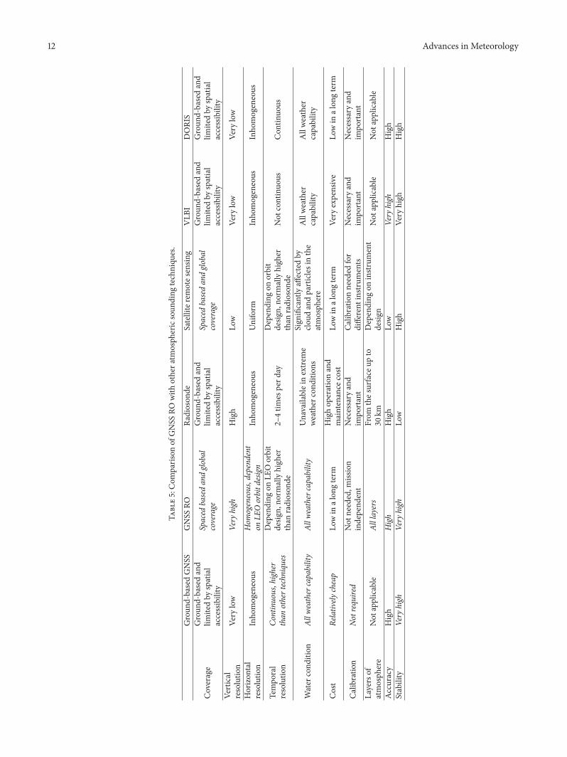
Many works have shown that the GNSS RO earth atmo-spheric observational technique can overcome the restric-tions of current observing techniques such as a poorsampling distribution the low resolution of radiosondes(from land stations ships and airplanes) and a low verticalresolution of down-looking satellites [72] Table 5 contains acomparison of the GNSS RO technique with ground-basedGNSS receivers radiosondes VLBI DORIS and remotesensing methods with regard to atmospheric observationsThe outstanding technique for each category is highlightedin italics The GNSS RO demonstrates significant advantagesover the other three techniques
From the foregoing the GNSS RO technique is seenas quite promising and stands to fill the existing gaps inatmospheric observation in Africa It has brought a newimpetus for scientists interested in Africa where traditionallythere have been very limited weather observations availableMany countries such as the USA Germany Austria theRussian Federation Finland Italy Denmark Argentina andBrazil have established experimental GNSS RO meteorol-ogy projects and launched a number of LEO experimental
12 Advances in Meteorology
Table5Com
paris
onof
GNSS
ROwith
othera
tmosph
ericsoun
ding
techniqu
es
Groun
d-basedGNSS
GNSS
RORa
dioson
deSatelliteremotes
ensin
gVLB
IDORIS
Coverage
Groun
d-basedand
limitedby
spatial
accessibility
Spaced
basedandglo
bal
coverage
Groun
d-basedand
limitedby
spatial
accessibility
Spaced
basedandglo
bal
coverage
Groun
d-basedand
limitedby
spatial
accessibility
Groun
d-basedand
limitedby
spatial
accessibility
Vertical
resolutio
nVe
rylow
Very
high
High
Low
Very
low
Very
low
Horizon
tal
resolutio
nInho
mogeneous
Hom
ogeneousdependent
onLE
Oorbitd
esign
Inho
mogeneous
Uniform
Inho
mogeneous
Inho
mogeneous
Tempo
ral
resolutio
nCo
ntinuoushigher
than
othertechn
iques
Depending
onLE
Oorbit
desig
nno
rmallyhigh
erthan
radioson
de2ndash4tim
esperd
ayDepending
onorbit
desig
nno
rmallyhigh
erthan
radioson
deNot
continuo
usCon
tinuo
us
Water
cond
ition
Allw
eathercapability
Allw
eathercapability
Unavailableinextre
me
weather
cond
ition
s
Sign
ificantlyaffectedby
cloud
andparticles
inthe
atmosph
ere
Allweather
capability
Allweather
capability
Cost
Relatively
cheap
Lowin
alon
gterm
Highop
erationand
maintenance
cost
Lowin
alon
gterm
Very
expensive
Lowin
alon
gterm
Calib
ratio
nNo
trequired
Not
neededm
ission
independ
ent
Necessary
and
impo
rtant
Calib
ratio
nneeded
for
different
instr
uments
Necessary
and
impo
rtant
Necessary
and
impo
rtant
Layersof
atmosph
ere
Not
applicable
Alllayers
From
thes
urface
upto
30km
Depending
oninstr
ument
desig
nNot
applicable
Not
applicable
Accuracy
High
High
High
Low
Very
high
High
Stability
Very
high
Very
high
Low
High
Very
high
High
Advances in Meteorology 13
satellites with GNSS RO receivers [76] New developmentsof the GNSS RO technique such as the design of GNSSreceivers and the LEO-LEO technique will offer unprece-dented opportunities to obtain a large amount of high-qualityand high-resolution observations of the earthrsquos atmosphere[77] In the near future with more GNSS RO satellitesbecoming available both the weather and climate studies inpreviously data-sparse areas will be significantly improvedThe GNSS ROmissions will provide uniform global coverageobservations and fill the geographical gaps from the station-based observation networks Furthermore the technique isldquomission calibration freerdquo and continuous quality data can beexpected over a long term from GNSS RO missions This isan important improvement for climate studies such as trendanalyses
With the era of GPS modernization and significantexpansion of other GNSS new satellites with new signalshave been developed Within the next decade about onehundred new GNSS satellites will be launched and thus newsignals will be transmitted from them These satellites willincorporate modernized GPS GLONASS systems and thenewly designed Galileo There are also some regional GNSSsuch asQZSS from Japan BeiDou fromChina and the IndianIRNSSThe next generation ROmissions (eg FORMOSAT-7COSMIC-2)will be equippedwith newGNSSRO receiverswhich are designed to receive signals from these new satellites[76] The horizontal and temporal resolution of RO profileswill be significantly improved due to the increased numberof satellites and the improved signal strength and signalspectrum The quality of the RO technique will also beimproved due to the increased number of radio frequenciesavailable for the retrieval process These new GNSS willutilize different radio frequencies and hence future GNSSRO missions will take advantage of the different signals toimprove the retrieval process for better data quality Thecontinuous and accurate measurements of the atmosphericprofiles with good spatial and temporal resolutions fromGNSS RO will be available and new opportunities for betterunderstanding of the earthrsquos atmosphere and ionosphere willfollow [78]Manymeteorological and climate related applica-tions such as numerical weather prediction analysis climatestudies and ionosphere and space weather conditions willbe passed on with the development of new generation GNSSand LEO satellite programsTherefore Africa stands to profitimmensely from these futureGNSS advancements as they donot require African funding as in the case of ground-basedGNSS receivers yet coverage will be the same over Africa aseverywhere else with minor variations in latitude
6 Concluding Remarks
The theory and practice of ground-based GNSS watervapour estimation have been systematically discussed anddemonstrated in this paper This is an attempt to analyti-cally investigate ground-based GNSS meteorology issues inAfrica Ground-basedGNSSmeteorology is a very promisingapplication which could significantly improve numericalweather and storm predictions Furthermore it is of great
benefit in climate applications The application of GNSSmeteorology has the benefit of being a more economical andefficient approach It can be unattended for a long periodof time with high reliability and with low telemetry datatransmission cost The approach also has a high temporaland spatial resolution when compared with conventionalweather balloons Notwithstanding the scientific and societalapplications of GNSS meteorology most GNSS sites andnetworks on the African continent as identified in this studydo not meet the standards required by the IGS GRUANand the WMO South Africa is performing pretty well as anumber of GNSS stations in the country have meteorologicalsensors collocated with them the compactness of the GNSSnetwork in South Africa appears to be well enough for GNSSmeteorology though more effort is still required In par-ticular the Hartebeesthoek Radio Astronomy Observatory(HartRAO) in South Africa appears to be the only supersitethat collocates other earth observation systems (seismometeraccelerometer and gravimeter) with GNSS stations (HRAO)and other space geodetic techniques that is VLBI DORISWVR and Satellite Laser Ranging (SLR) However hope isnot lost for other African countries going by the differentchallenges that are unique for the individual countries assolutions were proffered in this review Opportunities suchas the African VLBI Network (AVN) [79] can be exploitedfor synergistic collocations where GNSS and other geodeticas well as geophysical equipment can be collocated It issuggested that regionalglobal meteorological model (ieNCEPNCAR and ERA reanalysis) can be investigated fortheir accuracy on the continent and a suitable interpolationalgorithmneeds to be developed to enable interpolation fromsuch meteorological models to GNSS observation stationsowing to the fact that there are no meteorological sensorsinstalled at most GNSS sites in Africa Finally as a steptowards attaining an operational GNSS service on theAfricanGNSS network there is a need for clear policies on datasharing and collaboration among the different organisationsthat operate GNSS stations on the continent the idea ofcollaboration is to add significant extra value to these exist-ing infrastructures Other potential applications and othertechniques of GNSSmeasurements tometeorology should beexplored that is GNSS-RO
Conflict of Interests
The authors declare that there is no conflict of interestsregarding the publication of this paper
Acknowledgments
This study was supported by the University of Pretoria PhDresearch support grant to the first author The authors aregrateful to the numerous reviewers for the constructivecomments that helped to improve the paper
References
[1] P Mason ldquoA review of the 2010 update of the implemen-tation plan for the global observing system for climate in
14 Advances in Meteorology
support of the UNFCCCrdquo in Proceedings of the GCOS SteeringCommitteemdashEighteenth Session (GCOS SC rsquo10) Document 13July 2010
[2] M Alessi and C Egenhofer Space Observation Systems AnUnderused Asset in EU and Global Climate Change PolicyReport of the Centre for European Policy Studies (CEPS) 2011httpwwwcepseu
[3] S Boutiouta and A Lahcene ldquoPreliminary study of GNSSmeteorology techniques in Algeriardquo International Journal ofRemote Sensing vol 34 no 14 pp 5105ndash5118 2013
[4] RHWareDW Fulker S A Stein et al ldquoSuominet a real-timenational GPS network for atmospheric research and educationrdquoBulletin of the AmericanMeteorological Society vol 81 no 4 pp677ndash694 2000
[5] S Jin G P Feng and S Gleason ldquoRemote sensing using GNSSsignals current status and future directionsrdquo Advances in SpaceResearch vol 47 no 10 pp 1645ndash1653 2011
[6] A Karabatic R Weber and T Haiden ldquoNear real-time esti-mation of tropospheric water vapour content from groundbasedGNSS data and its potential contribution toweather now-casting in Austriardquo Advances in Space Research vol 47 no 10pp 1691ndash1703 2011
[7] R A Anthes P A Bernhardt Y Chen et al ldquoThe COSMICFormosat-3 mission early resultsrdquo Bulletin of the AmericanMeteorological Society vol 89 no 3 pp 313ndash333 2008
[8] J Wickert G Michalak T Schmidt et al ldquoGPS radiooccultation results from CHAMP GRACE and FORMOSAT-3COSMICrdquo Terrestrial Atmospheric and Oceanic Sciences vol20 no 1 pp 35ndash50 2009
[9] M Bevis S Businger T A Herring C Rocken R AAnthes and R H Ware ldquoGPS meteorology remote sensing ofatmospheric water vapor using the global positioning systemrdquoJournal of Geophysical Research vol 97 no 14 pp 15787ndash158011992
[10] M Bevis S Businger S Chiswell et al ldquoGPS meteorologymapping zenith wet delays onto precipitable waterrdquo Journal ofApplied Meteorology vol 33 no 3 pp 379ndash386 1994
[12] R Weber J Ray and J Kouba ldquoReview of IGS anal-ysis productsrdquo in Proceedings of the IGS Network Dataand Analysis Center Workshop Ottawa Canada April 2002httpigscbjplnasagovoverviewpubsottawa wshtml
[13] J M Dow R E Neilan and C Rizos ldquoThe international GNSSservice in a changing landscape of Global Navigation SatelliteSystemsrdquo Journal of Geodesy vol 83 no 3-4 pp 191ndash198 2009
[14] J Wickert K Rannat J Wang et al ldquoGRUAN GNSS precip-itable water task teamrdquo in Proceedings of the IGS WorkshopOlsztyn Poland 2012
[15] J L Awange and E W Grafarend Solving Algebraic Computa-tional Problems inGeodesy andGeoinformatics Springer BerlinGermany 2005
[16] J Bosy W Rohm A Borkowski K Kroszczynski and MFigurski ldquoIntegration and verification of meteorological obser-vations and NWP model data for the local GNSS tomographyrdquoAtmospheric Research vol 96 no 4 pp 522ndash530 2010
[17] Q Chen S Song S Heise Y-A Liou W Zhu and J ZhaoldquoAssessment of ZTD derived from ECMWFNCEP data withGPS ZTD over ChinardquoGPS Solutions vol 15 no 4 pp 415ndash4252011
[18] P Kishore M Venkat Ratnam S P Namboothiri et al ldquoGlobal(50∘S-50∘N) distribution of water vapor observed by COSMICGPS RO comparison with GPS radiosonde NCEP ERA-Interim and JRA-25 reanalysis data setsrdquo Journal of Atmosphericand SolarmdashTerrestrial Physics vol 73 no 13 pp 1849ndash18602011
[19] A Koulali D Ouazar O Bock andA Fadil ldquoStudy of seasonal-scale atmosphericwater cyclewith ground-basedGPS receiversradiosondes and NWP models over Moroccordquo AtmosphericResearch vol 104-105 pp 273ndash291 2012
[20] K Teke J Bohm T Nilsson et al ldquoMulti-technique comparisonof troposphere zenith delays and gradients during CONT08rdquoJournal of Geodesy vol 85 no 7 pp 395ndash413 2011
[21] R van Malderen H Brenot E Pottiaux et al ldquoA multi-siteintercomparison of integrated water vapour observations forclimate change analysisrdquoAtmospheric Measurement Techniquesvol 7 no 8 pp 2487ndash2512 2014
[22] O Bock P Willis M Lacarra and P Bosser ldquoAn inter-comparison of zenith tropospheric delays derived from DORISand GPS datardquo Advances in Space Research vol 46 no 12 pp1648ndash1660 2010
[23] H van der Marel ldquoCOST-716 demonstration project for thenear real-time estimation of integratedwater vapour fromGPSrdquoPhysics and Chemistry of the Earth Parts ABC vol 29 no 2-3pp 187ndash199 2004
[24] H Vedel and X-Y Huang ldquoImpact of ground based GPS dataon numerical weather predictionrdquo Journal of the MeteorologicalSociety of Japan vol 82 no 1B pp 459ndash472 2004
[25] G V Bennitt and A Jupp ldquoOperational assimilation of GPSzenith total delay observations into the met office numericalweather prediction modelsrdquoMonthly Weather Review vol 140no 8 pp 2706ndash2719 2012
[26] O Bock and M Nuret ldquoVerification of NWP model analysesand radiosonde humidity data with GPS precipitable watervapor estimates during AMMArdquo Weather and Forecasting vol24 no 4 pp 1085ndash1101 2009
[27] A Walpersdorf M-N Bouin O Bock and E DoerflingerldquoAssessment of GPS data for meteorological applications overAfrica study of error sources and analysis of positioningaccuracyrdquo Journal of Atmospheric and Solar-Terrestrial Physicsvol 69 no 12 pp 1312ndash1330 2007
[28] RWare J Braun Y S Ha et al ldquoReal timewater vapour sensingwith SUOMINETmdashtoday and tomorrowrdquo in Proceedings ofthe International GPS Meteorology Workshop Tsukuba JapanJanuary 2003
[29] H Nakamura K Koizumi and N Mannoji ldquoData assimilationof GPS precipitable water vapor into the JMA mesoscalenumerical weather prediction model and its impact on rainfallforecastsrdquo Journal of the Meteorological Society of Japan vol 82no 1 pp 441ndash452 2004
[30] S de Haan ldquoAssimilation of GNSS ZTD and radar radialvelocity for the benefit of very-short-range regional weatherforecastsrdquoQuarterly Journal of the Royal Meteorological Societyvol 139 no 677 pp 2097ndash2107 2013
[31] J Bosy J Kaplon W Rohm J Sierny and T Hadas ldquoNearreal-time estimation of water vapour in the troposphere usingground GNSS and the meteorological datardquo Annales Geophysi-cae vol 30 no 9 pp 1379ndash1391 2012
[32] A Z A Combrink W L Combrinck and H Moraal ldquoNearreal-time detection of atmospheric water vapour using theSADC GPS networkrdquo South African Journal of Science vol 100no 9-10 pp 436ndash442 2004
Advances in Meteorology 15
[33] O A Isioye ldquoTowards an operational near real time meteo-rology on the African GNSS network challenges and benefitsrdquoNigerian Journal of Scientific Research vol 9-10 pp 90ndash98 2011
[34] S H Byun and Y E Bar-Sever ldquoA new type of tropospherezenith path delay product of the international GNSS servicerdquoJournal of Geodesy vol 83 no 3-4 pp 367ndash373 2009
[35] J Wang ldquoGlobal navigation satellite system (GNSS) climateandGRUANrdquo inProceedings of the 5thGRUAN Implementation-Coordination Meeting De BiltThe Netherlands February 2013
[36] J Ihde ldquoDevelopments of the EUREF GNSS services andreference networksrdquo in Proceedings of the 3rd ICG MeetingPasadena Calif USA December 2008
[37] Y Altiner C Bruyninx J Ihde L Mervant W Sohne andG Weber ldquoDevelopment of the EUREF GNSS services andreference networksrdquo in Proceedings of the Workshop on theApplication of GNSS Chisinau Moldova May 2010
[38] S de Haan ldquoNationalregional operational procedures of GPSwater vapour networks and agreed international proceduresrdquoInstruments andObservingMethodsReportNo 92WMOTD-No1340 WMO 2006
[39] R Neilan and R Wonnacott Establishing a ContinentalReference System in Africa AFREF International Coun-cil for Science International Union of Geodesy and Geo-physicsInternational Association of Geodesy InternationalGPS ServiceInternational Earth Rotation Service and Interna-tional Society of Photogrammetry and Remote Sensing 2002
[40] R Wonnacott ldquoAFREF background and progress towards aunified reference system for Africardquo in Proceedings of the FIGWorking WeekGSDI-8 Conference Cairo Egypt April 2005httpwwwfignetpubmonthly articlesJune 2005June2005 wonnacottpdf
[41] W L Combrinck and M Chin ldquoIGS stations station andregional issuesrdquo Physics and Chemistry of the Earth vol 26 no6ndash8 pp 539ndash544 2001
[42] W L Combrinck and M Chin ldquoIGS stations station andregional issuesrdquo in Proceedings of the 1st COST Action 716Workshop lsquoTowards Operational GPS Meteorologyrsquo and the 2ndNetwork Workshop of the International GPS Service (IGS rsquo00)H-P Plag S Barlag M Caissey et al Eds Oslo Norway July2000
[43] T Hadas J Kaplon J Bosy J Sierny and KWilgan ldquoNear-real-time regional troposphere models for the GNSS precise pointpositioning techniquerdquo Measurement Science and Technologyvol 24 no 5 Article ID 055003 2013
[44] G Dick G Gendt and C Reigber ldquoFirst experience with nearreal-time water vapor estimation in a German GPS networkrdquoJournal of Atmospheric and Solar-Terrestrial Physics vol 63 no12 pp 1295ndash1304 2001
[45] T A Herring R W King and S C McClusky Introduc-tion to GAMITGLOBK Release 103 Department of EarthAtmospheric and Planetary Sciences Massachusetts Institute ofTechnology Cambridge Mass USA 2006
[46] G Gendt and R Schmid ldquoPlanned changes to IGS antennacalibrationsrdquo IGSMAIL-5189 IGS Central Bureau 2005
[47] Z Altamimi X Collilieux and L Metivier ldquoITRF2008 animproved solution of the international terrestrial referenceframerdquo Journal of Geodesy vol 85 no 8 pp 457ndash473 2011
[48] J Saastamoinen ldquoAtmospheric correction for troposphere andstratosphere in radio ranging of satellitesrdquo inTheUse of ArtificialSatellites for Geodesy S W Henriksen A Mancini and BH Chovitz Eds vol 15 of Geophysics Monograph Series pp
247ndash252 American Geophysical Union (AGU) AIAA NOAAUSATC Washington DC USA 1972
[49] J Boehm B Werl and H Schuh ldquoTroposphere mappingfunctions for GPS and very long baseline interferometry fromEuropean centre for medium-range weather forecasts opera-tional analysis datardquo Journal of Geophysical Research B SolidEarth vol 111 no 2 Article ID B02406 2006
[50] F Kleijer Troposphere modelling and filtering for precise GPSlevelling [PhD thesis] Department of Mathematical GeodesyPositioning Delft University of Technology Kluyverweg TheNetherlands 2004
[51] J L Davis T A Herring I I Shapiro A E E Rogers andG Elgered ldquoGeodesy by interferometry effects of atmosphericmodeling errors on estimates of base line lengthrdquo Radio Sciencevol 20 no 6 pp 1593ndash1607 1985
[52] L F Sapucci ldquoEvaluation of modeling water-vapor-weightedmean tropospheric temperature for GNSS-integrated watervapor estimates in Brazilrdquo Journal of Applied Meteorology andClimatology vol 53 no 3 pp 715ndash730 2014
[53] S Vey R Dietrich M Fritsche A Rulke P Steigenbergerand M Rothacher ldquoOn the homogeneity and interpretationof precipitable water time series derived from global GPSobservationsrdquo Journal of Geophysical Research D Atmospheresvol 114 no 10 Article ID D10101 2009
[54] A Tuka andA El-Mowafy ldquoPerformance evaluation of differenttroposphere delay models and mapping functionsrdquo Measure-ment vol 46 no 2 pp 928ndash937 2013
[55] J D Dodo and T O Idowu ldquoRegional assessment of the GPStropospheric delay models on the African GNSS networkrdquo inProceedings of the 3rd International Academy of AstronauticsAfrican Regional Conference (IAA rsquo09) Abuja Nigeria Novem-ber 2009
[56] Z Bai Near-real-time GPS sensing of atmospheric water vapour[PhD thesis] Faculty of Built Environment and EngineeringQueensland University of Technology Brisbane Australia2004
[57] J Wang L Zhang and A Dai ldquoGlobal estimates of water-vapor-weighted mean temperature of the atmosphere for GPSapplicationsrdquo Journal of Geophysical Research D Atmospheresvol 110 no 21 Article ID D21101 2005
[58] S Miyazaki T Iwabuchi K Heki and I Naito ldquoAn impact ofestimating tropospheric delay gradients on precise positioningin the summer using the Japanese nationwide GPS arrayrdquoJournal of Geophysical Research vol 108 no 7 article 2335 2003
[59] IPCC ldquoSummary for policymakersrdquo in Climate Change 2007The Physical Science Basis Contribution of Working Group I tothe Fourth Assessment Report of the Intergovernmental Panel onClimate Change S Solomon D Qin M Manning et al EdsCambridge University Press Cambridge UK 2007
[60] S M Uppala P W Kallberg A J Simmons et al ldquoThe ERA-40 re-analysisrdquo Quarterly Journal of the Royal MeteorologicalSociety vol 131 no 612 pp 2961ndash3012 2005
[61] E Kalnay M Kanamitsu R Kistler et al ldquoThe NCEPNCAR40-year reanalysis projectrdquo Bulletin of the AmericanMeteorolog-ical Society vol 77 no 3 pp 437ndash471 1996
[62] D P Dee S M Uppala A J Simmons et al ldquoThe ERA-Interimreanalysis configuration and performance of the data assim-ilation systemrdquo Quarterly Journal of the Royal MeteorologicalSociety vol 137 no 656 pp 553ndash597 2011
[63] Y-A Liou A G Pavelyev S-F Liu et al ldquoFORMOSAT-3COSMICGPS radio occultationmission preliminary resultsrdquo
16 Advances in Meteorology
IEEE Transactions on Geoscience and Remote Sensing vol 45no 11 pp 3813ndash3826 2007
[64] Y Li A new dynamic approach for statistical optimization ofGNSS radio occultation bending angles [PhD thesis] Schoolof Mathematical and Geospatial Sciences RMIT UniversityMelbourne Australia 2013
[65] E R Kursinski G A Hajj K R Hardy L J Romans andJ T Schofield ldquoObserving tropospheric water vapor by radiooccultation using the Global Positioning Systemrdquo GeophysicalResearch Letters vol 22 no 17 pp 2365ndash2368 1995
[66] K Zhang E FuD Silcock YWang andYKuleshov ldquoAn inves-tigation of atmospheric temperature profiles in the Australianregion using collocated GPS radio occultation and radiosondedatardquo Atmospheric Measurement Techniques vol 4 no 10 pp2087ndash2092 2011
[67] U Foelsche B Scherllin-Pirscher F Ladstadter A K Steinerand G Kirchengast ldquoRefractivity and temperature climaterecords from multiple radio occultation satellites consistentwithin 005rdquoAtmospheric Measurement Techniques vol 4 no9 pp 2007ndash2018 2011
[68] R A Anthes ldquoExploring Earthrsquos atmosphere with radio occul-tation contributions to weather climate and space weatherrdquoAtmospheric Measurement Techniques vol 4 no 6 pp 1077ndash1103 2011
[69] X Xu J Luo and K Zhang ldquoAn analysis of the structureand variation of the tropopause over China with GPS radiooccultation datardquoThe Journal of Navigation vol 64 supplement1 pp S103ndashS111 2011
[70] S Sokolovskiy Y-H Kuo C Rocken W S Schreiner D Huntand R A Anthes ldquoMonitoring the atmospheric boundary layerby GPS radio occultation signals recorded in the open-loopmoderdquo Geophysical Research Letters vol 33 no 12 Article IDL12813 2006
[71] B Pirscher U Foelsche M Borsche G Kirchengast andY-H Kuo ldquoAnalysis of migrating diurnal tides detected inFORMOSAT-3COSMIC temperature datardquo Journal of Geo-physical Research D Atmospheres vol 115 no 14 Article IDD14108 2010
[72] A de la Torre P Alexander P Llamedo T Schmidt andJ Wickert ldquoRecent advances in gravity wave analysis fromlong term global GPS radio occultation observationsrdquo in NewHorizons in Occultation Research Studies in Atmosphere andClimate A Steiner B Pirscher U Foelsche andG KirchengastEds pp 153ndash164 Springer Berlin Germany 2009
[73] L-F Hsiao D-S Chen Y-H Kuo et al ldquoApplication of WRF3DVAR to operational typhoon prediction in Taiwan impactof outer loop and partial cycling approachesrdquo Weather andForecasting vol 27 no 5 pp 1249ndash1263 2012
[74] L Cucurull and J C Derber ldquoOperational Implementation ofCOSMIC observations into NCEPrsquos global data assimilationsystemrdquo Weather and Forecasting vol 23 no 4 pp 702ndash7112008
[75] B A Carter K Zhang R Norman V V Kumar and S KumarldquoOn the occurrence of equatorial F-region irregularities duringsolarminimumusing radio occultationmeasurementsrdquo Journalof Geophysical Research A Space Physics vol 118 no 2 pp 892ndash904 2013
[76] E Fu An investigation of GNSS radio occultation atmospheresounding techniques for Australian meteorology [PhD thesis]School of Mathematical and Geospatial Sciences RMIT Uni-versity Melbourne Australia 2011
[77] E R Kursinski D Ward A Otarola et al ldquoThe activetemperature ozone and moisture microwave spectrometer(ATOMMS)rdquo in New Horizons in Occultation Research Studiesin Atmosphere and Climate A Steiner B Pirscher U Foelscheand G Kirchengast Eds pp 295ndash313 Springer Berlin Ger-many 2009
[78] R A Anthes C Rocken and Y-H Kuo ldquoApplications ofCOSMIC to meteorology and climaterdquo Terrestrial Atmosphericand Oceanic Sciences vol 11 no 1 pp 115ndash156 2000
[79] M J GaylardM F Bietenholz L Combrinck et al ldquoAnAfricanVLBI Network of radio telescopesrdquo in Proceedings of SAIP2011the 56th Annual Conference of the South African Institute ofPhysics I Basson and A E Botha Eds pp 473ndash478 Universityof South Africa Pretoria South Africa 2011
for providing the water vapour knowledge that atmosphericscientists have been seeking GNSS receiversantennas do notrequire continual calibration as some sensors do formeasure-ment drifts or biases although pressure sensors collocated atGNSS sites occasionally require calibration for instrumentdrift Also large numbers of GNSS measurements can bemade temporally and spatially in all weather conditionsDue to the coverage and potential for near-real-time datatransmission that GNSS water vapour estimates offer GNSScould be used to determine the distribution of water vapourover a region of interest and thus help in the identification ofpotential severe weather activity [3 5 6]
The term GNSS meteorology relates to the utilizationof the GNSS radio signals to deliver information about thestate of the troposphere This can be achieved from a satelliteplatform (GNSS radio occultation meteorology) [7 8] andground permanent stations (ground-based GNSS meteorol-ogy) [9 10] Continuous observations from GNSS receiversprovide an excellent tool for studying the earthrsquos atmosphereGNSS meteorology has transitioned from research intonational and regional networks The collaboration betweenthe geodetic and meteorological communities has con-tributed to themeteorological communityrsquos understanding ofthe GNSS representation of water vapour These and otherefforts have resulted in projects and collaboration betweenGCOS and the International GNSS Service ((IGS) [11ndash13])focussed on the operational use of GNSS water vapourestimations [14]
The new technology of GNSS atmospheric remote sens-ing has several advantages over the conventional watervapour observing system including global coverage reliableand stable results high measurement accuracy all weatheroperability and radio frequencies that can penetrate cloudsand dusts [15] In addition since the majority of nationalgeodetic institutions and scientific organisations install GNSSreceivers in the different regions of the world with densenetworks in order to do positioning mapping monitortectonics and so forth through collaboration with thosedata for zenith total delay (ZTD) estimation for meteorologycan be obtained at a low or no cost GNSS meteorologyenables precipitable water vapour (PWV) to be inferredwith the same accuracy as conventional meteorological mea-surements such as radiosondes water vapour radiometer(WVR) and microwave profiler (MWP) measurements toabout 1-2mm PWV accuracy [16] Comparative and val-idation results of GNSSZTDPWV with existing numericweather prediction (NWP) models such as the EuropeanCentre for Medium Weather Forecast (ECMWF) and theNational Centre for Environmental Prediction (NCEP) arepromising as seen from the works of for example Chen etal [17] Kishore et al [18] and Koulali et al [19] Also Tekeet al [20] van Malderen et al [21] and Bock et al [22]have all reported the performance of GNSS against othergeodetic techniques (namely very long baseline interferom-etry (VLBI) Doppler Orbitography and RadiopositioningIntegrated by Satellite (DORIS) and sun photometers fromAerosol Robotic Network (AERONET)) in the estimation oftroposphere parameters with results showing strong correla-tion among them
There have been several projects from several organi-zations on the different continents of the world to derivetropospheric zenith delay measurements from ground-basedGNSS for operational meteorological applications Examplesof such projects in Europe include the COST Action 716(European Cooperation in the Field of Scientific TechnicalExploitation of Ground-Based GPS for Numerical WeatherPredictionApplication 1998ndash2004) [23] TOUGH (TargetingOptimal Use of GPS Humidity Data in Meteorology 2003ndash2006) [24] and E-GVAP (The EUMETNET GPS WaterVapour Programme 2004) [25] E-GVAP network consistsof more than 1500 GNSS sites mainly in Europe recentlyprocessing and distribution of global GNSS data have startedsince many E-GVAP members run global NWP modelsIn Africa the AMMA (African Monsoon MultidisciplinaryAnalysis Project 1999ndash2005) [26 27] worked on PWVestimation and analysis in the African monsoon region InNorth America the SuomiNet (named to honour meteoro-logical satellite pioneer Verner Suomi) network of receiversprovides real-time estimates of water vapour for a globalnetwork of receivers from zenith water vapour measure-ments which are mostly concentrated in the United States(see [4]) Additionally UCARrsquos (University Corporation forAtmospheric Research) COSMIC (Constellation ObservingSystem for Meteorology Ionosphere and Climate) programprocesses GPS data in PBO (Plate Boundary Observatory)GPS network CocoNet (Caribbean Network) SuomiNet +NOAA (National Oceanic and Atmospheric Administra-tion) USCGUSACE (United States Coast GuardUS ArmyCorps of Engineers) DOT (Department of Transportation)and other sites to produce near-real-time (NRT) PWVestimates across North America [28]The Japanese GEONET(GPS Earth Observation Network) has the largest array ofover 1200 GPS stations in the world It was established forearthquake hazard research and mitigation scientific appli-cations of the network have been expanded to include mete-orology and ionospheric research Currently the GEONETcontributes to the assimilation of GPS precipitable watervapour data into the JMA (Japan Meteorological Agency)Mesoscale Numerical Prediction Model [29] Furthermoretwo European institutes Meteo France and UK Met Officeuse NRT ZTDs in their numerical weather predictions oper-ations today both reporting a positive impact from the use ofground-based GNSS delay data [30] Utilizing its capabilityof water vapour estimation GNSS has a potential to detectand track extreme changes in weather such as thunderstorms[29] In addition NRT GNSS water vapour monitoring fornumerical weather prediction services is active in Germanyand Austria [31]
All the foregoing discussions demonstrate that GNSSatmospheric remote sensing technology is a key methodto improve spatial and temporal sampling of water vapourobservation and that GNSS PWV should be a useful source ofhumidity information for NWP applications However thereis still no operational GNSS network for GNSS meteorologyin Africa although the application has been investigatedat the Hartebeesthoek Radio Astronomy Observatory interms of South Africa only [32] Thus as a practical issueit is important to build up a network of GNSS stations
Advances in Meteorology 3
Table 1 GRUAN GNSS product requirements (modified after [14])
across Africa which can routinely retrieve PWV for weatherprediction atmospheric research and climate monitoringand prediction This problem is the main motivation of thisreview In view of the different requirements of GNSS mete-orology as identified in Isioye [33] and the available GNSSCORS (Continuously Operating Reference Station) networkin Africa there is the need to look into this promisingtechnology and create a working model to accommodate theexisting facilities and the general requirement for operationalmeteorology These challenges are addressed in this paper
2 Operational Requirements and Standardsfor GNSS Meteorology
TheIGSTroposphereWorkingGroup [34] is currently collab-orating with the Global Climate Observing System (GCOS)Reference Upper Air Network (GRUAN) The GRUAN is aninternational reference-observing network designed to meetclimate requirements and to fill a major void in the currentglobal observing system [14 35] The GRUAN GNSS Precip-itableWater (GNSSPW)TaskTeamwas established in 2010 asone of six GRUAN task teams Ground-based GNSS PWwasidentified as the utmost priority measurements for GRUANand GNSS PW Task Teamrsquos goal is to develop explicit guid-ance on hardware software and data management practicesto obtain GNSS PW measurements of consistent quality atall GRUAN sites Both GRUAN and IGS have developeda requirement for GNSS products A summary of GRUANGNSS product requirements is presented in Table 1
As part of the collaboration expectations are as follows(a) GRUAN stations should become IGS stations (b) IGShelps to push GNSS based climate applications according toclimatological requirements and process IGS data for clima-tological applications (c) further collaboration to establishcentral processing and analysis facilities of which IGS isalready playing a leading role has been advocated The IGScurrently estimates ZTD and other atmospheric productsthrough its global network See Table 2 for a summary of IGSatmospheric products
In addition the IGS and EUREF [36 37] have alsodeveloped useful guidelines for operational procedure for
GNSS meteorology networks (within the COST716 actionuser requirements for the use of GNSS in meteorology)[38] These procedures are summarised under four majorcomponent headings as shown in Figure 1 The guidelinesfrom IGS in partnership with GRUAN and EUREF representthe standard for GNSSmeteorology at themoment and are inagreement with those specified by WMO
3 Status of the African GNSS Network
Networks of GNSS CORS exist in Africa which contributeto the IGS and are established and managed by Africanentities and partners Densification of IGS networks with itsproducts in Africa is the first step towards the realizationof the African Geodetic Reference Frame (AFREF) [39 40]Some station requirements and regional issueswere discussedin detail by Combrinck and Chin [41 42] The densificationrequires that at least one GNSS CORS be established inevery African country Such networks of CORS are to formthe basis of and act as focal points for the establishmentof national GNSS networks and where possible more thanone of such stations can be in a country It is expectedthat on the full realization of AFREF every country willhave a GNSS CORS network with capabilities to fully servevaried national needs and provide other useful productsto users for example broadcasting differential correctionsand to refine the transformation parameters necessary torelate the national systems to ITRF (International TerrestrialReference Frame) It is important to note that all IGS stationsin Africa are AFREF stations but not all AFREF stationsare IGS stations as well Furthermore all AFREF stations arecontributing to realize the various national reference framesbut not all national GNSS stations are AFREF stations as isthe case already in South Africa which currently has sixty-sixGNSS stations in its national frame but only sixteen stationsare AFREF and IGS stations Figure 2 depicts the distributionof AFREF and IGS stations in Africa The network is verysparse in the north and central African regions Currentlythere are about thirty-nine IGS stations operating on theAfrican continent most of the stations are concentrated inthe southern part of the continent
4 Advances in Meteorology
adopted which represent the global standard
GNSS meteorology station requirement
km for numerical weather prediction andestimation shouldnetworktheinreceiveroneleastAt(c)km)1000approximatelybaselines(longdelayatmosphericofbe collocated with a radiosonde site for quality control (d) Latency of data collection should be smaller than 20 minutes for numerical weather prediction (assuming assimilation cycles of 3 hours) and smaller than five minutes for nowcasting (e) The network should be centred around a dense subnetwork when it exists and a number of IGS stations should be included in the network for validation with other GNSSGPS processing centres and the RINEX format should be used to exchange GPS observations
GNSS meteorology network requirement
(ultrarapid) orbits (from eg IGS) when necessary and (b) the processing time which should be such that the total latency is less than 45 minutes for numerical weather prediction and less than the repetition cycle of the product for nowcasting
GNSS meteorology processing requirement
minutes (ii) subhourly ZTDIWV estimates should be disseminated within the length of the repetition cycle and (c) the
GNSS meteorology observables
∙ The GNSS meteorology station requirement includes the station monument and hardware type the guidelines for IGS are
∙ The GNSS meteorology network requirement specifies the following (a) A network for GNSS meteorology should consist of more
∙ GNSS processing should be performed using standard software The processing should follow the following (a) use of
∙ The atmosphere observable should satisfy certain conditions such as the following (i) hourly ZTDIWV must be disseminated within 45
than one real network (eg a local network combined with IGS stations) (b) The density of the network should be 30ndash100
accuracy of the ZTD should be 10ndash15 1ndash2 for numerical weather prediction and IWV be 1ndash3 for nowcastingmmIWV
10ndash100 km for nowcasting A network should be large enough for absolute
Figure 1 Summary of requirements for GNSS meteorology from IGS GRUAN and EUREF
60∘E30
∘EARIT
Long (deg)
ABPO
GOUG
VACSRDRG
ADIS
BJCOCGGN
HNUS
MAL2
MOIU
RABT
RBAY
RCMN
Simo
Tdou
Tgev
Uldi
Wind
Yrko
ZAMB
Lpal
Meli
Abuz
Asc1
Bfo1
BjabBjna
Bjni
Bjsa
Bkfp
DamyEtadEtdd
Futy
Hukp
Ifr1
Lnda
Mas1
Maun
Mdgr
Mtnd
Mtwa
Niam
OsgfOuag
Reun
Sthl
Svct
Tana
Tanz
Tetn
Ulag
Znzb
DAKR
Dear
Ebbe
HarbHRAO
Llng
MBAR
Mfkg
NURK
Pre1Pre2
Sbok
Sey1
SUTHSutmSutv Umta
RamoFunc
Lat
(deg
)
NKLGClbr
FpnoGembUnec
IGS stationsAFREF stationsRadiosonde stationsIGS and AFREF stations with collocated met sensors
30∘N
30∘W
30∘S
0∘
0∘
N
60∘E
Figure 2 Map depicting the position of IGS and AFREF stations inAfrica
A quick check on the station availability of AFREF sta-tions from the AFREF data web page (httpwwwafrefdataorg) indicates that 81 stations are currently on the sched-uled list for daily data logging from individual contributors(countries) in Africa However only 25 countries on thecontinent are currently contributing to the IGS and AFREFThe maximum daily data archive for AFREF in the lastthree years (2011 2012 and 2013) to date (23022014) standsat 54 stations per day The reason for inconsistent datastreaming from the various stations can obviously be due
to communication problems which has to do with internetconnectivity equipment failure or in some cases electricalpower problems which is less often
The site log files and type of data archived by both theIGS and AFREF stations in Africa were inspected for thepurpose of this study to ascertain if stations are collocatedwith meteorological sensors as it is a requirement by IGS forGNSS meteorology network It was however observed thatonly a few stations in Africa have met packs collocated withthem (see Figure 2) Additionally not all the GNSS stationscollocated with weather sensors that stream meteorologicalRINEX files to the IGS as confirmed from SOPAC webdata page (httpsopacucsdedunearbySitesshtml) Fur-thermore only a few GNSS stations in Africa are collocatedwith radiosondes as required by the GRUAN PW Task Teamand IGS However there are a few GNSS stations that arewithin an appreciable distance to the radiosonde sites thismay as well be the situation for weather sensors Figure 2further illustrates the distribution of radiosonde stations inAfrica as obtained from the Integrated Global RadiosondeArchive (IGRA) Collation of meteorological parametersfrom the different weather stations for interpolation tothe GNSS site as reported in Hadas et al [43] would beunmanageable in the African context going by instrumentvariations political and administrative challenges cost andready access to data
From the foregoing the African GNSS network can beseen to have three particularities (i) sparseness going by therequirement for meteorology (ii) absence of weather sensorsand radiosondes at GNSS sites and (iii) inconsistency in datastreaming from operators due to lack of internet connec-tivity for data transmission thereby creating data gaps Thesparseness of the African network implies long interstationdistances this could also lead to a lack of constraints onthe orbit solution established by the IGS Hence the orbiterrors could be more important over Africa than in placeswith a denser IGS network These orbit errors would then
Advances in Meteorology 5
Table 3 Comparison of ZTD estimation using different orbit products (the ZTD estimates obtained using IGS final orbits were used asreference to compute the other result) (after [33])
Orbit type RMS (mm) Standard deviation (mm) Mean difference (mm) Maximum difference (mm) Minimum difference (mm)IGS rapid 0185 0180 minus0079 0870 minus1860IGS ultrarapid 1876 1832 minus0185 29435 minus19560JPL 15min 1549 1511 minus0197 9435 minus11560
limit baseline precisions on the long baselines typically foundin the African GNSS network Therefore the application ofGNSS for weather studies will be more limited in Africathis slight limitation is however not critical as the globalorbit adjustments and solutions basically avoid the problemThus the present conditions fall slightly short of internationalrequirements as discussed in the preceding section of thisreview The addition of corner cube reflectors on future andcurrent GNSS satellites will ensure Satellite Laser Ranging(SLR) calibration of the satellite orbits expansion of the SLRnetwork from the southern part of Africa is required to fullyexploit benefits that can be had
For operational weather service GNSS PWV estimatesare required to be in NRT The NRT data processinginvolves acquiring and processing of GNSS and ancillaryobservations to yield signal delay or PWV estimates withina single numerical NWP assimilation cycle In operationalweather prediction meteorological observations are typicallyassimilated every 6 hours With the new generation ofmeteorological satellite observations provided at intervals of1 hour 40 minutes the assimilation delay currently requiredby the World Meteorological Observation is approximately 2hours 15 minutes or 3 hours 20minutes at most In the case ofthe Rapid Update Cycle running operationally for Environ-mental Prediction the assimilation delay is approximately 75minutes [44] In order to ensure that one cycle of observationsis processed before the next satellite orbit is completed GNSSPWV must be calculated in NRT with a minimum loss ofaccuracy if they are to be a useable data source in NWPmodels To fulfil this objective the issue of the use of real-timeorbits is necessary and must be addressed in the context ofthe African network Preliminary investigation into the issuewas reported by Isioye [33] in an experiment that utilisedGNSS data for three days (GPS week 1578 days 1ndash3 whichcorrespond to days of years 95ndash97 2010) collected from tenIGS stations of the African GNSS network and processedwith the IGS final rapid and ultrarapid orbits and JPL 15minorbits Table 3 is adapted from Isioye [33] and summarisesresults of a comparison of the different orbit solutions
The results obtained using the IGS final orbits were takenas reference and all other results were compared to theseThese results clearly demonstrate the potential of GNSS forNRT ZTD estimation and consequently NRT PWV Furtherthis confirms that the IGS ultrarapid orbits and the JPL 15minorbits could be used for NRT GNSS water vapour estimationsince the RMS of the ZTD estimations is 19mm and 15mmrespectively It is expected that estimated PWV will be lessthan 1mm which is quite acceptable for meteorologicalapplications
4 Preliminary Results on Monitoringof GNSS ZTD Variability on the AfricanGNSS Network
41 GNSS Data Processing and Tropospheric Product Descrip-tions Twelve of the forty-four GNSS stations indicated ear-lier as IGS stations on the African continent were selected forprocessing and discussionData from the period of 2010ndash2014were analysedThe selection of the stations for this discussionwas based on the availability and continuity of data at aparticular station in relation to other stations in the networkHence the temporal connectivity weights (119879
119894) of the stations
in the network were computed Each station was assigned atemporal connectivity weight equal to
119879119894=
119873
sum
119896=1
1
119899119896
sdot 120575 (119896) (1)
where 119873 is the total number of days of interest 119899119896is the
number of data for the 119896th day and 120575(119896) = 1 if station hasdata for the 119896th day and 0 otherwise Table 4 highlights allIGS stations adopted in the networkwith associated temporalconnectivity weights for the years under review (2010ndash2014)
The GNSS data analysis has been performed with MIT(Massachusetts Institute of Technology) GAMITGLOBKsoftware package (GAMIT version 103 [45]) The softwarehas the capability to determine positional information along-side tropospheric parameters which comprises the ZTD andatmospheric gradient components
Firstly to process ZTD from GAMIT we used final (pre-cise) orbit solution for the satellites from the IGS adjustingthe orbital parameters to avoid day boundary problemsAntenna phase correction is applied following the IGS rec-ommendations [46] The coordinates of the GNSS stationswere heavily constrained to their ITRF 2008 [47] valuesInstead of using a single parameter form for the troposphericparameters we used a piecewise linear function of ZTD overthe session with the number of zenith delay parameters set atthirteen thus establishing two-hour intervals The constraintused for zenith delay was 02 metres as it is recommended toset it loose enough to encompass any error in wet delay [45]The variation is defined as parameters of a first-order GaussMarkov process and the zenith variation between points wasgiven as 010m with 100 hrs of correlation time The a prioritropospheric delay was calculated according to Saastamoinen[48] based on a standard atmosphere value from the globaltemperature pressure model (GPT 50) We used the Viennamapping function [49] and the GNSS data are used down toa cutoff elevation angle of 10∘
6 Advances in Meteorology
Table 4 GNSS sites and associated temporal weights
Station ID Country Latitude (deg) Longitude (deg) Height (m) Temporal connectivity weight (2010ndash2014)ADIS Ethiopia 90351 387663 24391540 2124104BJCO Republic of Benin 63847 24500 306000 2031985CGGN Nigeria 101231 91183 9166953 670596DAKR Senegal 147212 3425605 510000 273604HRAO South Africa minus258901 276870 14143000 2326287MBAR Uganda minus06016 307379 13376533 1307619NKLG Gabon 03539 96721 314800 2142571NURK Rwanda minus19446 300899 14850000 1818869RABT Morocco 339981 3531457 901000 2157409SUTH South Africa minus323802 208105 17997660 2275124YKRO Cote drsquoIvoire 68706 3547599 2700000 799242ZAMB Zambia minus154255 283110 1324914 982366
The calculatedZTDcomprises the hydrostatic (ZHD) andwet (ZWD) component of the delay [31] as shown in
ZTD = ZHD + ZWD (2)
The wet component of the ZTD is the foundation forestimation of water vapour content in the atmosphere Therelation betweenZWDand thewater vapour content in atmo-sphere is expressed by IWV (integrated water vapour) andPWV (precipitable water vapour) reported in for exampleBevis et al [10] and Kleijer [50] and is expressed as in
PWV = IWV120588119908
=[ZTDGNSS minus ZHD]10minus6119877
119908120588119908[1198961015840
2+ (1198963119879119898)]
= Π [ZTDGNSS minus ZHD] = Π sdot ZWD
(3)
In (3) 120588119908
is the water density 119877119908= 461525 plusmn
0003 [J kgminus1 Kminus1] is the specific gas constant forwater vapour1198961015840
2and 119896
3are refraction constants and 119879
119898is the weighted
mean water vapour temperature of the atmosphere measuredin Kelvin It is operationally required to process GNSS dataalongside meteorological parameters (temperature pressureand humidity) obtained from weather sensors collocated atthe GNSS site in the modelling of ZHD and estimationof water vapour Therefore with only 119879
119898and local surface
pressure it is possible to reduce ZTD estimates from GNSSprocessing to PWV as shown in (3)
The weighted mean water vapour temperature of theatmosphere 119879
119898of the vertical column of air above the GNSS
receiver is thus given as [51]
119879119898=
intinfin
ℎ
(119890119879) sdot 119885minus1
119908119889ℎ
intinfin
ℎ
(1198901198792) sdot 119885minus1119908119889ℎ
=
intinfin
ℎ
120588119908119889ℎ
intinfin
ℎ
(120588119908119879) 119889ℎ
(4)
In (4) 119890 is thewater vapour pressure119879 is the temperatureand 119885minus1
119889and 119885minus1
119908are the inverse compressibility factors of
dry air and water vapour respectively Thus 119879119898
can beobtained by integrating the vertical profiles of 119890 and 119879 theintegration is done between the GNSS receiver altitude ℎand infinity utilising radiosonde profiles or outputs fields of
NWP models This method is limited by the tempospatialresolution of these data products which is a barrier forGNSS meteorology and is rarely used in real-time PWVestimation Bevis et al [10] proposed a linear regressionmodel for estimating 119879
119898based on the relationship between
surface temperature and 119879119898and this is widely adopted in
many studies though its accuracy varies across the globeand thus there are many regionallocal variants of the model[52] A more recent product with NRT capability for esti-mating 119879
119898is from ECWMF operational analyses provided
by the Technical University of Vienna (information online athttpggosatmhgtuwienacatDELAYETCTMEAN)
Importantly meteorological units installed at or nearGNSS sites need to be calibrated occasionally for instrumentdrift and biases and also surface pressure observationsshould be reduced to GNSS antenna height [53] Reductionof surface pressure to GNSS antenna height is possible withthe hypsometric equation as follows [53]
In (5)119875GNSS is the pressure atGNSS antenna height (hpa)119877119889= 287 053 [J kgminus1 Kminus1] is the gas constant for dry air
119875 is the pressure at the height of the pressure sensor (hpa)Δ119867 = 119867GNSS minus 119867119878 is height difference in metres and 119879 isthe actual mean temperature of the layer between the GNSSantenna and the meteorological sensor in Kelvin
The ZHD can be calculated using empirical modelssuch as the Saastamoinen Hopfield Berman Davis Ifadisand Askne models as described in Tuka and El-Mowafy[54] The Saastamoinen model is the most used in geodeticapplications and its accuracy has been widely reported [55]The Saastamoinenmodel for zenith hydrostatic delay (ZHD)in metres is expressed as in
ZHD = 0002277 sdot 119875
1 minus 000266 cos (120601) minus 028 sdot 10minus6ℎ (6)
where 119875 is the surface pressure in mbar 120601 is latitude inradians and ℎ is the height of the surface above the ellipsoid(in metres)
Advances in Meteorology 7
The accuracy of PWV is strongly dependent on theaccuracy of ZTD values That is nearly all of the error inPWV is introduced during the ZTD estimation [10] Themajor sources of error in ZTD are GNSS antenna phasecentre offsets (PCOs) and phase centre variations (PCVs)and uncertainties inmapping functionsThe PCVs and PCOscan together yield systematic effects from 03 to 1mm andseasonal effects lt 01mm (maximum amplitude) Similarlythe mapping functions can have systematic effects of 01ndash05mm and seasonal effects of 01ndash05mm However mostof these errors are rigorously handled within precise GNSSanalysis software
The accuracy of ZHD is greatly influenced by errors insurface pressure and can be approximated by [56]
120590ZHD asymp 0002277 sdot 120590119901 (7)
Thus an error120590119901 in surface pressure of 1 hpa results in a ZHD
error 120590ZHD of 26mm Similarly the errors in convertingZWD to PWV are primarily the errors in mean atmospherictemperature (119879
119898) and are approximated by [57]
120590Πasymp1
176872sdot 120590119879119898 (8)
Finally the accuracy of PWV estimates according to thelaw of propagation of errors can be expressed as in [9]
120590PWV = radic(ZWD sdot 120590Π)2
+ (Π sdot 120590ZHD)2
+ (Π sdot 120590ZTD)2
(9)
Thus for 120590ZTD of 4ndash10mm 120590119901of 2 hpa and 120590
119879119872lt
2K the accuracy of PWV estimate ranges from about 11 to19mm This clearly indicates the level of accuracy requiredin estimating ZTD mean temperature and pressure in GNSSmeteorology
The second tropospheric parameter estimated alongsidethe ZTD from GAMIT geodetic software is the atmosphericgradient The estimation of the atmospheric gradients whichare the effect of azimuthal asymmetry in the atmosphericdelay is given as [45]
AG = Grad(N-S) sdot 119872119891 sdot cos (AZ) + Grad(E-W) sdot 119872119891 sdot sin (AZ)
(10)
where cos(AZ) and sin(AZ) are cosine and sine functionsof the Azimuth (AZ) and 119872
119891is the mapping function
for the gradients The gradient parameters Grad(N-S) and
Grad(E-W) are given to represent the difference in the North-
South and East-West delay at 10∘ elevation When usinglow elevation angle observations the azimuth asymmetryof the local troposphere gets more important and must beaccounted for Estimating horizontal tropospheric gradientsis a common way to cope with these asymmetries andthe station coordinate repeatability may be considerablyimproved by this measure as shown in Miyazaki et al [58]The convention of the GAMIT software is to resolve GNSSgradient components at 10∘ of elevation in centimetres butusing mapping functions measurement of gradients can beconverted into the zenith direction in millimetres Usuallyvalues of GAMIT gradients components do not exceed 15 cm
Figure 3 Daily variation of ZTD estimates over Africa in 2013 (days1ndash365)
In our processing the a priori constraint for the gradientswas set at 001m in the solution gradient and was thus tightlyconstrained The variations for the gradients were definedagain as parameters of a first-orderGaussMarkov process andthe gradient variations between points were given as 001mwith 100 hours of correlation time
42 GNSS ZTD Variability on the African GNSS NetworkFor the long-term trend analysis in climatic changes acontinuous record for at least thirty years is usually necessary[59] Climate requires a long time series of observations TheGNSS data from the African network cannot yet providesuch a long time series Nevertheless the four-and-half-yeartwelve times per day database of ZTD over twelve stations inthe African GNSS network available for this review providesa unique resource for providing insights into the stabilityand pattern of distribution of ZTD short-term temporalvariations (diurnal variation) of the ZTD distribution aboveAfrica
In Figure 3 the variation in the daily calculated ZTD isshown at the different sites for days 1ndash365 in the year 2013Evident from Figure 3 is the consistency in the ZTDs fromseason to season Whilst the general trend in the plot withineach monthly seasonality period is similar there is the needto adequately model the trend taking into consideration con-ditions at each site and the spatial correlation characteristicsof the ZTD values
From our archived GNSS ZTD data we examine theelevation dependence by first taking the mean of all themeasurements at a particular site and then plotting thedistribution of mean values versus site elevation as shown inFigure 4 Evidently it appears that there is strong dependenceon elevation though it is reasonable that ZTD should dependon elevation after all it is the water vapour integrated fromthe observation site to the top of the atmosphere and ifthe observation site is higher there will be less atmosphereand hence less water vapour above it Most sources of watervapour are at the earthrsquos surfaceThe dependence on elevationis found to be different than that of the major constituentsof the dry atmosphere and it falls off more quickly withelevation than would be expected from total pressure
Figure 4 Plot of GNSS ZTD against station elevation
To gain insight into the diurnal characteristics of the siteswe identified the dominant periods (or frequencies) of thetime series at each site using periodograms A periodogramfor each station based on two-hourly data from 2010ndash2014is shown in Figure 5 and also the average two-hourly dataplot over the same period is presented in Figure 6 Theperiodograms illustrate the relative importance of possiblefrequency values that might explain the oscillation patternof the calculated ZTDs An examination of the plots aspresented in Figure 5 reveals that all sites show a diurnaldependence of ZTD when averaged over a long time periodIt is also possible that a site may show a diurnal dependenceat one time of the year and not during another as a result ofseasonal changes
From the foregoing spatial and temporal variability inGNSS ZTD across Africa is identified as the different stationstend to exhibit distinct trends in GNSS ZTD variabilityThough further processing analysis and modelling of ZTDtime series for the purpose of identifying seasonalannualtrends testing for stationarity (stochastic properties) andhomogeneity of ZTD data are neededThe potential of GNSSas a tool for meteorology cannot be overemphasized as thevariability identified at the different stations can be correlatedwith other atmospheric parameters which can serve asindicators for the monitoring and predicting of the weatherat such places Furthermore GNSS meteorology offers theadvantage of ZTD time series being used inNWPmodels andalso ZTDPWVmaps used for nowcasting applications
5 Steps to Improve GNSS Meteorology withinthe African GNSS Network
The following solutions are offered in view of the peculiaritiesof the African GNSS network as identified in the precedingsection
51 Densification of GNSS Networks through CollaborativeInitiatives There are other initiatives in Africa that utilizeGNSS data apart fromAFREF to realize their objectivesThisincludes the International Space Weather Initiative (ISWI)and the Scintillation Receiver Network (SCINDA) (httpwwwfasorgsppmilitaryprogramnssrminitiativesscindahtm) which both have a strong interest in populating their
observing capability in the equatorial regions of Africa TheAMMA GPS project is primarily a meteorological projectaimed at West Africa using GPS as a supporting observingtechnique [26 27] The Africa Array currently focusingon seismology uses GPS as a positioning tool for seismicdeployment and exploration surveys (httpwwwafricaarraypsuedu) Some of the Africa Array GNSS stations arecontributing to AFREF Furthermore African MeridianB-Field Education and Research (AMBER) (httpwwwigppuclaedupublicekassieAMBERhtml) and African GPSReceivers for Equatorial Electrodynamics Studies (AGREES)(httpwwwigppuclaedupublicekassieAGREEShtml) alluse GNSS data to accomplish their objectives which are spe-cific scientific studies
Many national agencies in Africa still do not makeGNSS data available to the public or to AFREF In Ethiopiaand Malawi there is a dense GNSS network for tectonicsmonitoring SouthAfrica has a national network (TRIGNET)of 66 stations Ghana Algeria Egypt Morocco and Eritreahave national networks of GNSS stations but informationand data are not yet publicly available to AFREF In additionUNAVCO archive data for an ample number of permanentGNSS stations in Africa for different agencies and privateorganizations Figure 7 shows the position of different sta-tions in the networks discussed under this section
Collaboration in terms of data sharing and accessbetween the different initiatives and AFREF operational datacentres will go a long way towards improving the density ofthe current network to enhance meteorological applications
52Meteorological ParameterModelling fromGlobalRegionalWeather Models A few continuous GNSS stations areequipped with meteorological sensors on the African net-work as shown in Figure 2 Meteorological sensors providethe unique advantage of obtaining on-site meteorologicaldata directly at the continuous GNSS station The primarydisadvantage of GNSS meteorology packs is the lack of ver-tical temperature profiles necessary for computing the meanatmospheric temperature (119879
119898) and they often become noisy
when left uncalibrated Radiosondes offer the advantage ofproviding surface and vertical profiles of temperature butonly a few radiosondes exist close to stations within theexisting African GNSS network Radiosondes are expensiveto launch and performance is hindered under bad weathercondition However there are varieties of reanalysis modelsfrom which to obtain such data which include the following
(i) The European Centre for Medium-Range WeatherForecasts (ECMWF) 40-year reanalysis (ERA-40)from 1957 to 2002 is based on the ECMWF three-dimensional variational assimilation system andmakes use of both conventional and satellite obser-vations [60] The ERA-40 is a grid data set with aspectral resolution of 1125∘ times 1125∘ at 60 hybridvertical levels at 0000 0600 1200 and 1800 UTCdaily
(ii) The National Centers for Environmental PredictionNational Center for Atmospheric Research (NCEPNCAR) global reanalysis products (NNR-40) are
Advances in Meteorology 9
00
00
01
01
01
00 09 18 26 35
Periodogram of HRAO
Frequency
Perio
d
00
00
01
01
01
00 09 18 26 35
Periodogram of MBAR
FrequencyPe
riod
00
00
01
01
01
00 09 18 26 35
Periodogram of NKLG
Frequency
Perio
d
00
00
00
01
01
00 09 18 26 35
Periodogram of NURK
Frequency
Perio
d
00
00
01
01
01
00 09 18 26 35
Periodogram of RABT
Frequency
Perio
d00
25
50
75
100
00 09 18 26 35
Periodogram of DAKR
Frequency
Perio
d
00
20
40
60
80
00 09 18 26 35
Periodogram of CGGN
Frequency
Perio
d
00
15
30
45
60
00 09 18 26 35
Periodogram of BJCO
FrequencyPe
riod
00
00
01
01
01
00 09 18 26 35
Periodogram of ADIS
Frequency
Perio
d
00
01
01
02
02
00 09 18 26 35
Periodogram of SUTH
Frequency
Perio
d
00
00
01
01
01
00 09 18 26 35
Periodogram of YKRO
Frequency
Perio
d
00
00
01
01
01
00 09 18 26 35
Periodogram of ZAMB
Frequency
Perio
d
Figure 5 Periodogram graph of ZTD time series
10 Advances in Meteorology
24240
24260
24280
24300
24320
09 39 69 99 129
Plot of RABT
Time
21260
21285
21310
21335
21360
09 39 69 99 129
Plot of NURK
Time
26200
26235
26270
26305
26340
09 39 69 99 129
Plot of NKLG
Time
21600
21650
21700
21750
21800
09 39 69 99 129
Plot of MBAR
Time
20320
20350
20380
20410
20440
09 39 69 99 129
Plot of HRAO
Time
23980
24015
24050
24085
24120
09 39 69 99 129
Plot of DAKR
Time
23150
23200
23250
23300
23350
09 39 69 99 129
Plot of CGGN
Time
23135
23146
23158
23169
23180
09 39 69 99 129
Plot of BJCO
Time
23020
23050
23080
23110
23140
09 39 69 99 129
Plot of ADIS
Time
ZTD
ZTD
ZTD
ZTD
ZTD
ZTD
ZTD
ZTD
ZTD
21020
21045
21070
21095
21120
09 39 69 99 129
Plot of ZAMB
Time
ZTD
25180
25215
25250
25285
25320
09 39 69 99 129
Plot of YKRO
Time
ZTD
19260
19290
19320
19350
19380
09 39 69 99 129
Plot of SUTH
Time
ZTD
Figure 6 Average two-hourly ZTD plots for 2010ndash2014
available from 1948 to present The NNR-40 is againa grid data set having grid size 1875∘ times 1875∘ at 28hybrid vertical levels available at 0000 0600 1200and 1800 UTC daily [61]
(iii) The ECMWF Interim reanalysis from 1979 to presentwas only just recently released in 2011 based on
the ECMWF4D variational assimilation systems inpreparation for the reanalysis to replace ERA-40 [62]The ERA-Interim is a grid data set with a spectralresolution of 075∘ times 075∘ having 37 vertical pressurelevels The gridded data products include a largevariety of 3-hourly surface parameters describing
Figure 7 Distribution of IGS and AFREF stations and other GNSSstationsnetworks in Africa
weather as well as ocean-wave and land-surface con-ditions and 6-hourly upper-air parameters coveringthe troposphere such as temperature and relativehumidity Vertical integrals of atmospheric fluxesmonthly averages for many of the parameters andother derived fields have also been produced
The recent release of ERA-Interim provides a clear advan-tage over ERA-40 [62] Furthermore ERA-Interim does notsuffer the temporal limitations of ERA-40 thus making itcurrently the best source for surface pressure and verticaltroposphere profiles of temperature and relative humiditynecessary for GNSS meteorological calculation There is aneed to assess the applicability of these products in relation toAfrica or to develop a regional model for GNSS applications
53 Filling the Gaps with GNSS Radio Occultation (RO)GNSS radio occultation (RO) is a kind of novel methodfor indirect measurement of temperature pressure andwater vapour in the stratosphere and the troposphere Thetechnique is based on using the radio signals continuouslybroadcasted by the GNSS satellites orbiting the globe at analtitude of approximately 20000 kilometres above the surfacefrom a high precision GNSS receiver mounted on a lowearth orbiting (LEO) satellite [18] A GNSS radio occultationevent (ROE) occurs when a GNSS satellite is setting or risingbehind the earthrsquos limb as seen by a GNSS receiver aboard aLEO satellite During an ROE the transmitted signals fromthe GNSS satellite travelling to the LEO satellite are delayedbecause of the impacts of the atmosphere and ionosphere[63 64] This delay can be precisely measured and converted
to a vertical profile of bending angles and consequentlyprocessed to derive a refractivity profile by applying a seriesof transformation steps [65] The refractivity is a part ofthe electron density in the ionosphere and the temperaturepressure and water vapour in the troposphere Hence theGNSS RO technique can offer useful information about thestructure and dynamics of the ionosphere stratosphere andtroposphere
The RO technique exhibits several beneficial featuresFirst RO measurements can be obtained under all weatherconditions and are available globally Furthermore theretrieved atmospheric profiles have high agreements withatmospheric profiles provided by other methods in theupper troposphere and lower stratosphere (UTLS) regionand the data also have high vertical resolution in the sameatmospheric regions [66] Secondly its measurements areself-calibrated and have long-term stability which makes ROdata highly consistent and can be combined together withoutthe need for intercalibration [67]
Due to these features the GPS RO technique has becomea useful instrument for climate monitoring and has beenwidely applied in the subject area of the earthrsquos climate andweather For instance studies have shown the potential ofGNSS RO profiles for characterizing troposphere structuresand changes (eg [68]) and the obtained results are found tobe uniformwith other observation data recordsThe RO datahave also been employed for the study of the tropopause (eg[69]) atmospheric boundary layer (eg [70]) diurnal tides(eg [71]) the global gravity wave signatures in the uppertroposphere and stratosphere can be obtained from GNSSRO profiles (eg [72]) The RO data is also useful for severeweather prediction (eg [73]) The RO data have also showntheir usefulness in NWP systems Research indicates thatafter the ROdata are ingested in theNWP systems the qualityof the weather forecast products is improved (eg [74]) Insummation to the uses in neutral atmosphere RO data havebeen successfully applied to the subject of the ionosphere andalso space weather (eg [75])
Many works have shown that the GNSS RO earth atmo-spheric observational technique can overcome the restric-tions of current observing techniques such as a poorsampling distribution the low resolution of radiosondes(from land stations ships and airplanes) and a low verticalresolution of down-looking satellites [72] Table 5 contains acomparison of the GNSS RO technique with ground-basedGNSS receivers radiosondes VLBI DORIS and remotesensing methods with regard to atmospheric observationsThe outstanding technique for each category is highlightedin italics The GNSS RO demonstrates significant advantagesover the other three techniques
From the foregoing the GNSS RO technique is seenas quite promising and stands to fill the existing gaps inatmospheric observation in Africa It has brought a newimpetus for scientists interested in Africa where traditionallythere have been very limited weather observations availableMany countries such as the USA Germany Austria theRussian Federation Finland Italy Denmark Argentina andBrazil have established experimental GNSS RO meteorol-ogy projects and launched a number of LEO experimental
12 Advances in Meteorology
Table5Com
paris
onof
GNSS
ROwith
othera
tmosph
ericsoun
ding
techniqu
es
Groun
d-basedGNSS
GNSS
RORa
dioson
deSatelliteremotes
ensin
gVLB
IDORIS
Coverage
Groun
d-basedand
limitedby
spatial
accessibility
Spaced
basedandglo
bal
coverage
Groun
d-basedand
limitedby
spatial
accessibility
Spaced
basedandglo
bal
coverage
Groun
d-basedand
limitedby
spatial
accessibility
Groun
d-basedand
limitedby
spatial
accessibility
Vertical
resolutio
nVe
rylow
Very
high
High
Low
Very
low
Very
low
Horizon
tal
resolutio
nInho
mogeneous
Hom
ogeneousdependent
onLE
Oorbitd
esign
Inho
mogeneous
Uniform
Inho
mogeneous
Inho
mogeneous
Tempo
ral
resolutio
nCo
ntinuoushigher
than
othertechn
iques
Depending
onLE
Oorbit
desig
nno
rmallyhigh
erthan
radioson
de2ndash4tim
esperd
ayDepending
onorbit
desig
nno
rmallyhigh
erthan
radioson
deNot
continuo
usCon
tinuo
us
Water
cond
ition
Allw
eathercapability
Allw
eathercapability
Unavailableinextre
me
weather
cond
ition
s
Sign
ificantlyaffectedby
cloud
andparticles
inthe
atmosph
ere
Allweather
capability
Allweather
capability
Cost
Relatively
cheap
Lowin
alon
gterm
Highop
erationand
maintenance
cost
Lowin
alon
gterm
Very
expensive
Lowin
alon
gterm
Calib
ratio
nNo
trequired
Not
neededm
ission
independ
ent
Necessary
and
impo
rtant
Calib
ratio
nneeded
for
different
instr
uments
Necessary
and
impo
rtant
Necessary
and
impo
rtant
Layersof
atmosph
ere
Not
applicable
Alllayers
From
thes
urface
upto
30km
Depending
oninstr
ument
desig
nNot
applicable
Not
applicable
Accuracy
High
High
High
Low
Very
high
High
Stability
Very
high
Very
high
Low
High
Very
high
High
Advances in Meteorology 13
satellites with GNSS RO receivers [76] New developmentsof the GNSS RO technique such as the design of GNSSreceivers and the LEO-LEO technique will offer unprece-dented opportunities to obtain a large amount of high-qualityand high-resolution observations of the earthrsquos atmosphere[77] In the near future with more GNSS RO satellitesbecoming available both the weather and climate studies inpreviously data-sparse areas will be significantly improvedThe GNSS ROmissions will provide uniform global coverageobservations and fill the geographical gaps from the station-based observation networks Furthermore the technique isldquomission calibration freerdquo and continuous quality data can beexpected over a long term from GNSS RO missions This isan important improvement for climate studies such as trendanalyses
With the era of GPS modernization and significantexpansion of other GNSS new satellites with new signalshave been developed Within the next decade about onehundred new GNSS satellites will be launched and thus newsignals will be transmitted from them These satellites willincorporate modernized GPS GLONASS systems and thenewly designed Galileo There are also some regional GNSSsuch asQZSS from Japan BeiDou fromChina and the IndianIRNSSThe next generation ROmissions (eg FORMOSAT-7COSMIC-2)will be equippedwith newGNSSRO receiverswhich are designed to receive signals from these new satellites[76] The horizontal and temporal resolution of RO profileswill be significantly improved due to the increased numberof satellites and the improved signal strength and signalspectrum The quality of the RO technique will also beimproved due to the increased number of radio frequenciesavailable for the retrieval process These new GNSS willutilize different radio frequencies and hence future GNSSRO missions will take advantage of the different signals toimprove the retrieval process for better data quality Thecontinuous and accurate measurements of the atmosphericprofiles with good spatial and temporal resolutions fromGNSS RO will be available and new opportunities for betterunderstanding of the earthrsquos atmosphere and ionosphere willfollow [78]Manymeteorological and climate related applica-tions such as numerical weather prediction analysis climatestudies and ionosphere and space weather conditions willbe passed on with the development of new generation GNSSand LEO satellite programsTherefore Africa stands to profitimmensely from these futureGNSS advancements as they donot require African funding as in the case of ground-basedGNSS receivers yet coverage will be the same over Africa aseverywhere else with minor variations in latitude
6 Concluding Remarks
The theory and practice of ground-based GNSS watervapour estimation have been systematically discussed anddemonstrated in this paper This is an attempt to analyti-cally investigate ground-based GNSS meteorology issues inAfrica Ground-basedGNSSmeteorology is a very promisingapplication which could significantly improve numericalweather and storm predictions Furthermore it is of great
benefit in climate applications The application of GNSSmeteorology has the benefit of being a more economical andefficient approach It can be unattended for a long periodof time with high reliability and with low telemetry datatransmission cost The approach also has a high temporaland spatial resolution when compared with conventionalweather balloons Notwithstanding the scientific and societalapplications of GNSS meteorology most GNSS sites andnetworks on the African continent as identified in this studydo not meet the standards required by the IGS GRUANand the WMO South Africa is performing pretty well as anumber of GNSS stations in the country have meteorologicalsensors collocated with them the compactness of the GNSSnetwork in South Africa appears to be well enough for GNSSmeteorology though more effort is still required In par-ticular the Hartebeesthoek Radio Astronomy Observatory(HartRAO) in South Africa appears to be the only supersitethat collocates other earth observation systems (seismometeraccelerometer and gravimeter) with GNSS stations (HRAO)and other space geodetic techniques that is VLBI DORISWVR and Satellite Laser Ranging (SLR) However hope isnot lost for other African countries going by the differentchallenges that are unique for the individual countries assolutions were proffered in this review Opportunities suchas the African VLBI Network (AVN) [79] can be exploitedfor synergistic collocations where GNSS and other geodeticas well as geophysical equipment can be collocated It issuggested that regionalglobal meteorological model (ieNCEPNCAR and ERA reanalysis) can be investigated fortheir accuracy on the continent and a suitable interpolationalgorithmneeds to be developed to enable interpolation fromsuch meteorological models to GNSS observation stationsowing to the fact that there are no meteorological sensorsinstalled at most GNSS sites in Africa Finally as a steptowards attaining an operational GNSS service on theAfricanGNSS network there is a need for clear policies on datasharing and collaboration among the different organisationsthat operate GNSS stations on the continent the idea ofcollaboration is to add significant extra value to these exist-ing infrastructures Other potential applications and othertechniques of GNSSmeasurements tometeorology should beexplored that is GNSS-RO
Conflict of Interests
The authors declare that there is no conflict of interestsregarding the publication of this paper
Acknowledgments
This study was supported by the University of Pretoria PhDresearch support grant to the first author The authors aregrateful to the numerous reviewers for the constructivecomments that helped to improve the paper
References
[1] P Mason ldquoA review of the 2010 update of the implemen-tation plan for the global observing system for climate in
14 Advances in Meteorology
support of the UNFCCCrdquo in Proceedings of the GCOS SteeringCommitteemdashEighteenth Session (GCOS SC rsquo10) Document 13July 2010
[2] M Alessi and C Egenhofer Space Observation Systems AnUnderused Asset in EU and Global Climate Change PolicyReport of the Centre for European Policy Studies (CEPS) 2011httpwwwcepseu
[3] S Boutiouta and A Lahcene ldquoPreliminary study of GNSSmeteorology techniques in Algeriardquo International Journal ofRemote Sensing vol 34 no 14 pp 5105ndash5118 2013
[4] RHWareDW Fulker S A Stein et al ldquoSuominet a real-timenational GPS network for atmospheric research and educationrdquoBulletin of the AmericanMeteorological Society vol 81 no 4 pp677ndash694 2000
[5] S Jin G P Feng and S Gleason ldquoRemote sensing using GNSSsignals current status and future directionsrdquo Advances in SpaceResearch vol 47 no 10 pp 1645ndash1653 2011
[6] A Karabatic R Weber and T Haiden ldquoNear real-time esti-mation of tropospheric water vapour content from groundbasedGNSS data and its potential contribution toweather now-casting in Austriardquo Advances in Space Research vol 47 no 10pp 1691ndash1703 2011
[7] R A Anthes P A Bernhardt Y Chen et al ldquoThe COSMICFormosat-3 mission early resultsrdquo Bulletin of the AmericanMeteorological Society vol 89 no 3 pp 313ndash333 2008
[8] J Wickert G Michalak T Schmidt et al ldquoGPS radiooccultation results from CHAMP GRACE and FORMOSAT-3COSMICrdquo Terrestrial Atmospheric and Oceanic Sciences vol20 no 1 pp 35ndash50 2009
[9] M Bevis S Businger T A Herring C Rocken R AAnthes and R H Ware ldquoGPS meteorology remote sensing ofatmospheric water vapor using the global positioning systemrdquoJournal of Geophysical Research vol 97 no 14 pp 15787ndash158011992
[10] M Bevis S Businger S Chiswell et al ldquoGPS meteorologymapping zenith wet delays onto precipitable waterrdquo Journal ofApplied Meteorology vol 33 no 3 pp 379ndash386 1994
[12] R Weber J Ray and J Kouba ldquoReview of IGS anal-ysis productsrdquo in Proceedings of the IGS Network Dataand Analysis Center Workshop Ottawa Canada April 2002httpigscbjplnasagovoverviewpubsottawa wshtml
[13] J M Dow R E Neilan and C Rizos ldquoThe international GNSSservice in a changing landscape of Global Navigation SatelliteSystemsrdquo Journal of Geodesy vol 83 no 3-4 pp 191ndash198 2009
[14] J Wickert K Rannat J Wang et al ldquoGRUAN GNSS precip-itable water task teamrdquo in Proceedings of the IGS WorkshopOlsztyn Poland 2012
[15] J L Awange and E W Grafarend Solving Algebraic Computa-tional Problems inGeodesy andGeoinformatics Springer BerlinGermany 2005
[16] J Bosy W Rohm A Borkowski K Kroszczynski and MFigurski ldquoIntegration and verification of meteorological obser-vations and NWP model data for the local GNSS tomographyrdquoAtmospheric Research vol 96 no 4 pp 522ndash530 2010
[17] Q Chen S Song S Heise Y-A Liou W Zhu and J ZhaoldquoAssessment of ZTD derived from ECMWFNCEP data withGPS ZTD over ChinardquoGPS Solutions vol 15 no 4 pp 415ndash4252011
[18] P Kishore M Venkat Ratnam S P Namboothiri et al ldquoGlobal(50∘S-50∘N) distribution of water vapor observed by COSMICGPS RO comparison with GPS radiosonde NCEP ERA-Interim and JRA-25 reanalysis data setsrdquo Journal of Atmosphericand SolarmdashTerrestrial Physics vol 73 no 13 pp 1849ndash18602011
[19] A Koulali D Ouazar O Bock andA Fadil ldquoStudy of seasonal-scale atmosphericwater cyclewith ground-basedGPS receiversradiosondes and NWP models over Moroccordquo AtmosphericResearch vol 104-105 pp 273ndash291 2012
[20] K Teke J Bohm T Nilsson et al ldquoMulti-technique comparisonof troposphere zenith delays and gradients during CONT08rdquoJournal of Geodesy vol 85 no 7 pp 395ndash413 2011
[21] R van Malderen H Brenot E Pottiaux et al ldquoA multi-siteintercomparison of integrated water vapour observations forclimate change analysisrdquoAtmospheric Measurement Techniquesvol 7 no 8 pp 2487ndash2512 2014
[22] O Bock P Willis M Lacarra and P Bosser ldquoAn inter-comparison of zenith tropospheric delays derived from DORISand GPS datardquo Advances in Space Research vol 46 no 12 pp1648ndash1660 2010
[23] H van der Marel ldquoCOST-716 demonstration project for thenear real-time estimation of integratedwater vapour fromGPSrdquoPhysics and Chemistry of the Earth Parts ABC vol 29 no 2-3pp 187ndash199 2004
[24] H Vedel and X-Y Huang ldquoImpact of ground based GPS dataon numerical weather predictionrdquo Journal of the MeteorologicalSociety of Japan vol 82 no 1B pp 459ndash472 2004
[25] G V Bennitt and A Jupp ldquoOperational assimilation of GPSzenith total delay observations into the met office numericalweather prediction modelsrdquoMonthly Weather Review vol 140no 8 pp 2706ndash2719 2012
[26] O Bock and M Nuret ldquoVerification of NWP model analysesand radiosonde humidity data with GPS precipitable watervapor estimates during AMMArdquo Weather and Forecasting vol24 no 4 pp 1085ndash1101 2009
[27] A Walpersdorf M-N Bouin O Bock and E DoerflingerldquoAssessment of GPS data for meteorological applications overAfrica study of error sources and analysis of positioningaccuracyrdquo Journal of Atmospheric and Solar-Terrestrial Physicsvol 69 no 12 pp 1312ndash1330 2007
[28] RWare J Braun Y S Ha et al ldquoReal timewater vapour sensingwith SUOMINETmdashtoday and tomorrowrdquo in Proceedings ofthe International GPS Meteorology Workshop Tsukuba JapanJanuary 2003
[29] H Nakamura K Koizumi and N Mannoji ldquoData assimilationof GPS precipitable water vapor into the JMA mesoscalenumerical weather prediction model and its impact on rainfallforecastsrdquo Journal of the Meteorological Society of Japan vol 82no 1 pp 441ndash452 2004
[30] S de Haan ldquoAssimilation of GNSS ZTD and radar radialvelocity for the benefit of very-short-range regional weatherforecastsrdquoQuarterly Journal of the Royal Meteorological Societyvol 139 no 677 pp 2097ndash2107 2013
[31] J Bosy J Kaplon W Rohm J Sierny and T Hadas ldquoNearreal-time estimation of water vapour in the troposphere usingground GNSS and the meteorological datardquo Annales Geophysi-cae vol 30 no 9 pp 1379ndash1391 2012
[32] A Z A Combrink W L Combrinck and H Moraal ldquoNearreal-time detection of atmospheric water vapour using theSADC GPS networkrdquo South African Journal of Science vol 100no 9-10 pp 436ndash442 2004
Advances in Meteorology 15
[33] O A Isioye ldquoTowards an operational near real time meteo-rology on the African GNSS network challenges and benefitsrdquoNigerian Journal of Scientific Research vol 9-10 pp 90ndash98 2011
[34] S H Byun and Y E Bar-Sever ldquoA new type of tropospherezenith path delay product of the international GNSS servicerdquoJournal of Geodesy vol 83 no 3-4 pp 367ndash373 2009
[35] J Wang ldquoGlobal navigation satellite system (GNSS) climateandGRUANrdquo inProceedings of the 5thGRUAN Implementation-Coordination Meeting De BiltThe Netherlands February 2013
[36] J Ihde ldquoDevelopments of the EUREF GNSS services andreference networksrdquo in Proceedings of the 3rd ICG MeetingPasadena Calif USA December 2008
[37] Y Altiner C Bruyninx J Ihde L Mervant W Sohne andG Weber ldquoDevelopment of the EUREF GNSS services andreference networksrdquo in Proceedings of the Workshop on theApplication of GNSS Chisinau Moldova May 2010
[38] S de Haan ldquoNationalregional operational procedures of GPSwater vapour networks and agreed international proceduresrdquoInstruments andObservingMethodsReportNo 92WMOTD-No1340 WMO 2006
[39] R Neilan and R Wonnacott Establishing a ContinentalReference System in Africa AFREF International Coun-cil for Science International Union of Geodesy and Geo-physicsInternational Association of Geodesy InternationalGPS ServiceInternational Earth Rotation Service and Interna-tional Society of Photogrammetry and Remote Sensing 2002
[40] R Wonnacott ldquoAFREF background and progress towards aunified reference system for Africardquo in Proceedings of the FIGWorking WeekGSDI-8 Conference Cairo Egypt April 2005httpwwwfignetpubmonthly articlesJune 2005June2005 wonnacottpdf
[41] W L Combrinck and M Chin ldquoIGS stations station andregional issuesrdquo Physics and Chemistry of the Earth vol 26 no6ndash8 pp 539ndash544 2001
[42] W L Combrinck and M Chin ldquoIGS stations station andregional issuesrdquo in Proceedings of the 1st COST Action 716Workshop lsquoTowards Operational GPS Meteorologyrsquo and the 2ndNetwork Workshop of the International GPS Service (IGS rsquo00)H-P Plag S Barlag M Caissey et al Eds Oslo Norway July2000
[43] T Hadas J Kaplon J Bosy J Sierny and KWilgan ldquoNear-real-time regional troposphere models for the GNSS precise pointpositioning techniquerdquo Measurement Science and Technologyvol 24 no 5 Article ID 055003 2013
[44] G Dick G Gendt and C Reigber ldquoFirst experience with nearreal-time water vapor estimation in a German GPS networkrdquoJournal of Atmospheric and Solar-Terrestrial Physics vol 63 no12 pp 1295ndash1304 2001
[45] T A Herring R W King and S C McClusky Introduc-tion to GAMITGLOBK Release 103 Department of EarthAtmospheric and Planetary Sciences Massachusetts Institute ofTechnology Cambridge Mass USA 2006
[46] G Gendt and R Schmid ldquoPlanned changes to IGS antennacalibrationsrdquo IGSMAIL-5189 IGS Central Bureau 2005
[47] Z Altamimi X Collilieux and L Metivier ldquoITRF2008 animproved solution of the international terrestrial referenceframerdquo Journal of Geodesy vol 85 no 8 pp 457ndash473 2011
[48] J Saastamoinen ldquoAtmospheric correction for troposphere andstratosphere in radio ranging of satellitesrdquo inTheUse of ArtificialSatellites for Geodesy S W Henriksen A Mancini and BH Chovitz Eds vol 15 of Geophysics Monograph Series pp
247ndash252 American Geophysical Union (AGU) AIAA NOAAUSATC Washington DC USA 1972
[49] J Boehm B Werl and H Schuh ldquoTroposphere mappingfunctions for GPS and very long baseline interferometry fromEuropean centre for medium-range weather forecasts opera-tional analysis datardquo Journal of Geophysical Research B SolidEarth vol 111 no 2 Article ID B02406 2006
[50] F Kleijer Troposphere modelling and filtering for precise GPSlevelling [PhD thesis] Department of Mathematical GeodesyPositioning Delft University of Technology Kluyverweg TheNetherlands 2004
[51] J L Davis T A Herring I I Shapiro A E E Rogers andG Elgered ldquoGeodesy by interferometry effects of atmosphericmodeling errors on estimates of base line lengthrdquo Radio Sciencevol 20 no 6 pp 1593ndash1607 1985
[52] L F Sapucci ldquoEvaluation of modeling water-vapor-weightedmean tropospheric temperature for GNSS-integrated watervapor estimates in Brazilrdquo Journal of Applied Meteorology andClimatology vol 53 no 3 pp 715ndash730 2014
[53] S Vey R Dietrich M Fritsche A Rulke P Steigenbergerand M Rothacher ldquoOn the homogeneity and interpretationof precipitable water time series derived from global GPSobservationsrdquo Journal of Geophysical Research D Atmospheresvol 114 no 10 Article ID D10101 2009
[54] A Tuka andA El-Mowafy ldquoPerformance evaluation of differenttroposphere delay models and mapping functionsrdquo Measure-ment vol 46 no 2 pp 928ndash937 2013
[55] J D Dodo and T O Idowu ldquoRegional assessment of the GPStropospheric delay models on the African GNSS networkrdquo inProceedings of the 3rd International Academy of AstronauticsAfrican Regional Conference (IAA rsquo09) Abuja Nigeria Novem-ber 2009
[56] Z Bai Near-real-time GPS sensing of atmospheric water vapour[PhD thesis] Faculty of Built Environment and EngineeringQueensland University of Technology Brisbane Australia2004
[57] J Wang L Zhang and A Dai ldquoGlobal estimates of water-vapor-weighted mean temperature of the atmosphere for GPSapplicationsrdquo Journal of Geophysical Research D Atmospheresvol 110 no 21 Article ID D21101 2005
[58] S Miyazaki T Iwabuchi K Heki and I Naito ldquoAn impact ofestimating tropospheric delay gradients on precise positioningin the summer using the Japanese nationwide GPS arrayrdquoJournal of Geophysical Research vol 108 no 7 article 2335 2003
[59] IPCC ldquoSummary for policymakersrdquo in Climate Change 2007The Physical Science Basis Contribution of Working Group I tothe Fourth Assessment Report of the Intergovernmental Panel onClimate Change S Solomon D Qin M Manning et al EdsCambridge University Press Cambridge UK 2007
[60] S M Uppala P W Kallberg A J Simmons et al ldquoThe ERA-40 re-analysisrdquo Quarterly Journal of the Royal MeteorologicalSociety vol 131 no 612 pp 2961ndash3012 2005
[61] E Kalnay M Kanamitsu R Kistler et al ldquoThe NCEPNCAR40-year reanalysis projectrdquo Bulletin of the AmericanMeteorolog-ical Society vol 77 no 3 pp 437ndash471 1996
[62] D P Dee S M Uppala A J Simmons et al ldquoThe ERA-Interimreanalysis configuration and performance of the data assim-ilation systemrdquo Quarterly Journal of the Royal MeteorologicalSociety vol 137 no 656 pp 553ndash597 2011
[63] Y-A Liou A G Pavelyev S-F Liu et al ldquoFORMOSAT-3COSMICGPS radio occultationmission preliminary resultsrdquo
16 Advances in Meteorology
IEEE Transactions on Geoscience and Remote Sensing vol 45no 11 pp 3813ndash3826 2007
[64] Y Li A new dynamic approach for statistical optimization ofGNSS radio occultation bending angles [PhD thesis] Schoolof Mathematical and Geospatial Sciences RMIT UniversityMelbourne Australia 2013
[65] E R Kursinski G A Hajj K R Hardy L J Romans andJ T Schofield ldquoObserving tropospheric water vapor by radiooccultation using the Global Positioning Systemrdquo GeophysicalResearch Letters vol 22 no 17 pp 2365ndash2368 1995
[66] K Zhang E FuD Silcock YWang andYKuleshov ldquoAn inves-tigation of atmospheric temperature profiles in the Australianregion using collocated GPS radio occultation and radiosondedatardquo Atmospheric Measurement Techniques vol 4 no 10 pp2087ndash2092 2011
[67] U Foelsche B Scherllin-Pirscher F Ladstadter A K Steinerand G Kirchengast ldquoRefractivity and temperature climaterecords from multiple radio occultation satellites consistentwithin 005rdquoAtmospheric Measurement Techniques vol 4 no9 pp 2007ndash2018 2011
[68] R A Anthes ldquoExploring Earthrsquos atmosphere with radio occul-tation contributions to weather climate and space weatherrdquoAtmospheric Measurement Techniques vol 4 no 6 pp 1077ndash1103 2011
[69] X Xu J Luo and K Zhang ldquoAn analysis of the structureand variation of the tropopause over China with GPS radiooccultation datardquoThe Journal of Navigation vol 64 supplement1 pp S103ndashS111 2011
[70] S Sokolovskiy Y-H Kuo C Rocken W S Schreiner D Huntand R A Anthes ldquoMonitoring the atmospheric boundary layerby GPS radio occultation signals recorded in the open-loopmoderdquo Geophysical Research Letters vol 33 no 12 Article IDL12813 2006
[71] B Pirscher U Foelsche M Borsche G Kirchengast andY-H Kuo ldquoAnalysis of migrating diurnal tides detected inFORMOSAT-3COSMIC temperature datardquo Journal of Geo-physical Research D Atmospheres vol 115 no 14 Article IDD14108 2010
[72] A de la Torre P Alexander P Llamedo T Schmidt andJ Wickert ldquoRecent advances in gravity wave analysis fromlong term global GPS radio occultation observationsrdquo in NewHorizons in Occultation Research Studies in Atmosphere andClimate A Steiner B Pirscher U Foelsche andG KirchengastEds pp 153ndash164 Springer Berlin Germany 2009
[73] L-F Hsiao D-S Chen Y-H Kuo et al ldquoApplication of WRF3DVAR to operational typhoon prediction in Taiwan impactof outer loop and partial cycling approachesrdquo Weather andForecasting vol 27 no 5 pp 1249ndash1263 2012
[74] L Cucurull and J C Derber ldquoOperational Implementation ofCOSMIC observations into NCEPrsquos global data assimilationsystemrdquo Weather and Forecasting vol 23 no 4 pp 702ndash7112008
[75] B A Carter K Zhang R Norman V V Kumar and S KumarldquoOn the occurrence of equatorial F-region irregularities duringsolarminimumusing radio occultationmeasurementsrdquo Journalof Geophysical Research A Space Physics vol 118 no 2 pp 892ndash904 2013
[76] E Fu An investigation of GNSS radio occultation atmospheresounding techniques for Australian meteorology [PhD thesis]School of Mathematical and Geospatial Sciences RMIT Uni-versity Melbourne Australia 2011
[77] E R Kursinski D Ward A Otarola et al ldquoThe activetemperature ozone and moisture microwave spectrometer(ATOMMS)rdquo in New Horizons in Occultation Research Studiesin Atmosphere and Climate A Steiner B Pirscher U Foelscheand G Kirchengast Eds pp 295ndash313 Springer Berlin Ger-many 2009
[78] R A Anthes C Rocken and Y-H Kuo ldquoApplications ofCOSMIC to meteorology and climaterdquo Terrestrial Atmosphericand Oceanic Sciences vol 11 no 1 pp 115ndash156 2000
[79] M J GaylardM F Bietenholz L Combrinck et al ldquoAnAfricanVLBI Network of radio telescopesrdquo in Proceedings of SAIP2011the 56th Annual Conference of the South African Institute ofPhysics I Basson and A E Botha Eds pp 473ndash478 Universityof South Africa Pretoria South Africa 2011