CBIPMP_Methodologies_Task1_v5_final Review of the nature and type of hazardous waste polluted sites in India Key output Final Report Task 1: Annexure 4a - Site factsheets Development of Methodologies for National Programme for Rehabilitation of Polluted Sites in India Ministry of Environment and Forests, Government of India, Delhi The World Bank, Washington, D.C.
Transcript
CBIPMP_Methodologies_Task1_v5_final
Review of the nature and type of
hazardous waste polluted sites in
India Key output Final Report Task 1: Annexure 4a - Site factsheets
Development of Methodologies for National Programme for Rehabilitation of Polluted Sites in India
Ministry of Environment and Forests, Government of India, Delhi
The World Bank, Washington, D.C.
CBIPMP_Methodologies_Task1_v5_final
Page 2 of 61
Authorisation
Title : Review of the nature and type of hazardous waste polluted sites in
India –Key output Final Report Task 1: Annexure 4a - Site factsheets
Subtitle : Development of Methodologies for National
Programme for Rehabilitation of Polluted Sites
in India
Project number : 317550
Reference number : CBIPMP_Methodologies_Task1_v4_ANNEXURE_4a_final_20130118
1 Introduction ........................................................................................... 4 1.1 General ................................................................................................. 4 1.2 Data sources ......................................................................................... 4
2 Site Factsheets ..................................................................................... 5
Introduction
CBIPMP_Methodologies_Task1_v5_final
Page 4 of 61
1 Introduction
1.1 General This report presents Annexure 4a to the Key output Final Report Task 1. In this Task the Review of the nature and type of hazardous waste polluted sites in In-dia is given as a part of the ‘Development of Methodologies for National Pro-gramme for Rehabilitation of Polluted Sites in India’. The objective of Task 1 is to review the available inventory on hazardous waste polluted sites and understand the nature of polluted sites in India. The Key out-put is the report, presenting both a thorough insight in the nature and types of all polluted sites in India and a typology of probably polluted sites in India. For these objectives in this task the available inventory on hazardous polluted sites is inventoried and analysed. The results are presented in the Key output Final Report of Task 1. This Annexure to that report includes the site factsheets, for background read-ing only. The purpose of the factsheets is an intermediate step in the under-standing of the sites in India and not to give an accurate description of all indi-vidual sites in India as such. For this purpose the reader is referred to the As-signment 1 database which will be developed for that reason specifically. 1.2 Data sources The site factsheets were drawn up on sites selected from the following site in-ventories:
List of 12 priority contaminated dump sites (CPCB, no specific reference);
List of 25 hazardous waste dump sites (CPCB , no specific reference);
Reports available on some of the sites.
Note. Not all sites from these lists were used to make a site factsheet, because the scope of the factsheets is not to give a description of all individual contami-nated sites in India as such, but to support the analysis of the different types of such sites in India. The site factsheets are presented in the next section of this Annexure report.
CBIPMP_Methodologies_Task1_v5_final
Page 5 of 61
2 Site Factsheets
Overview of Site Factsheets in this section:
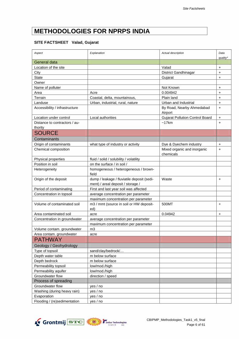
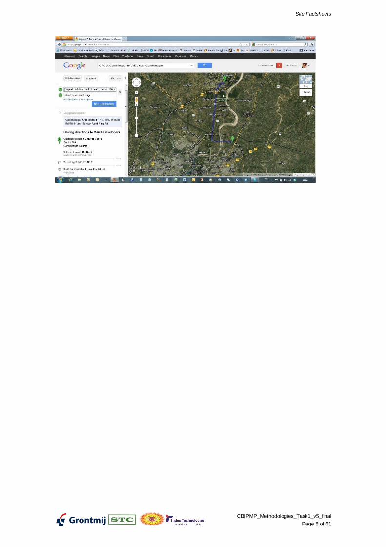
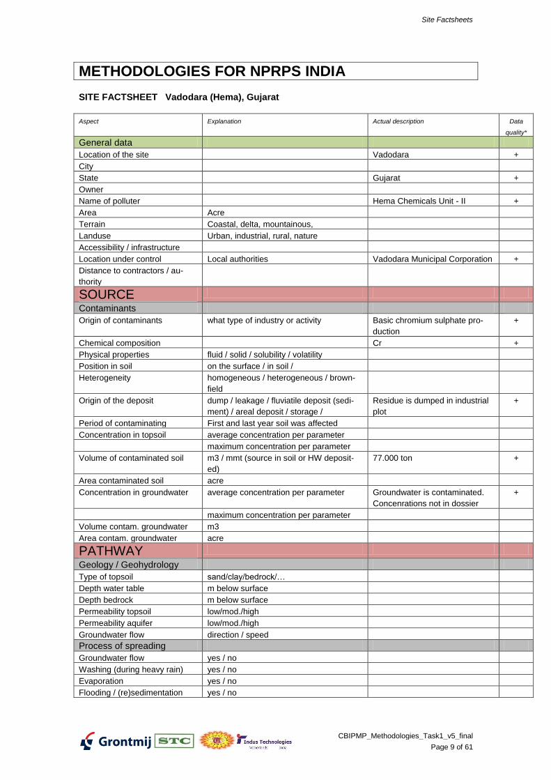
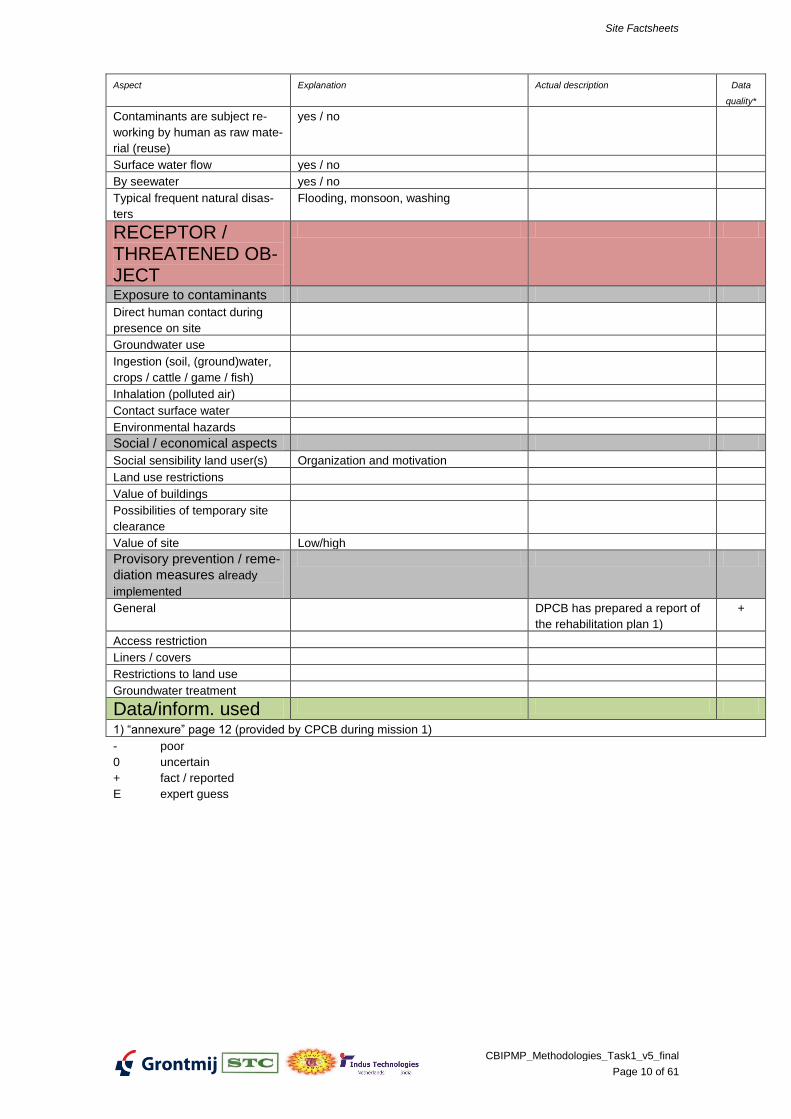
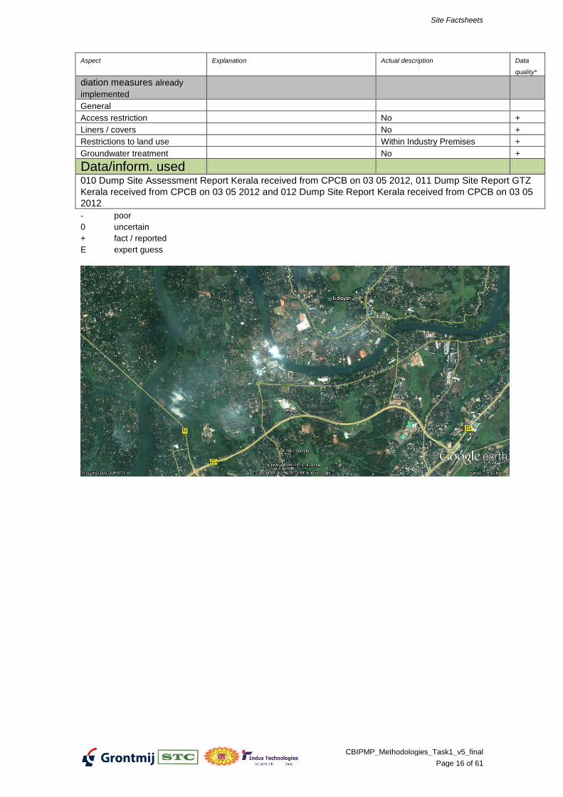
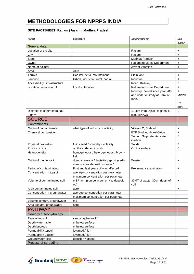
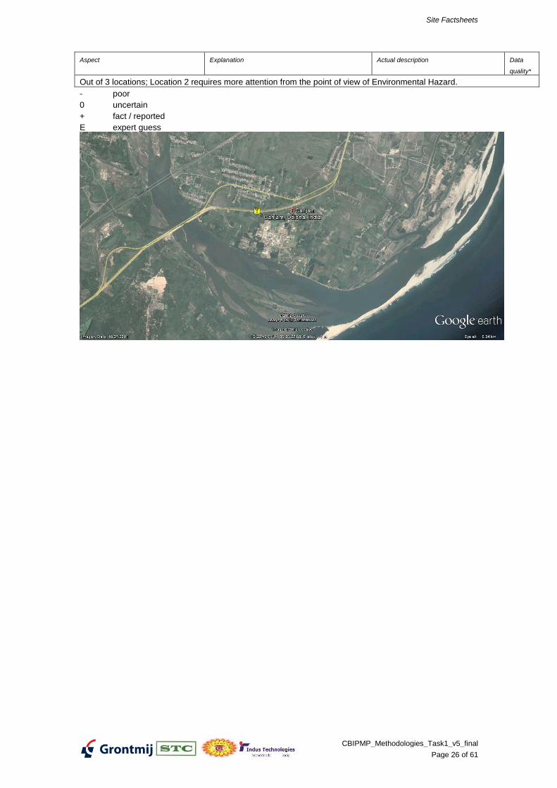
GPCB 000-002 Unknown Industries, Valad, Gujarat
GPCB 001-001 Hema-II, Vadodara. Gujarat
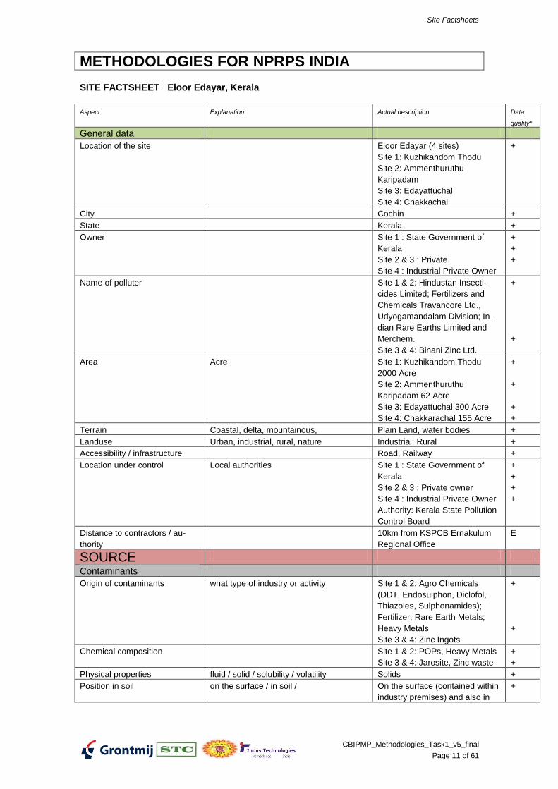
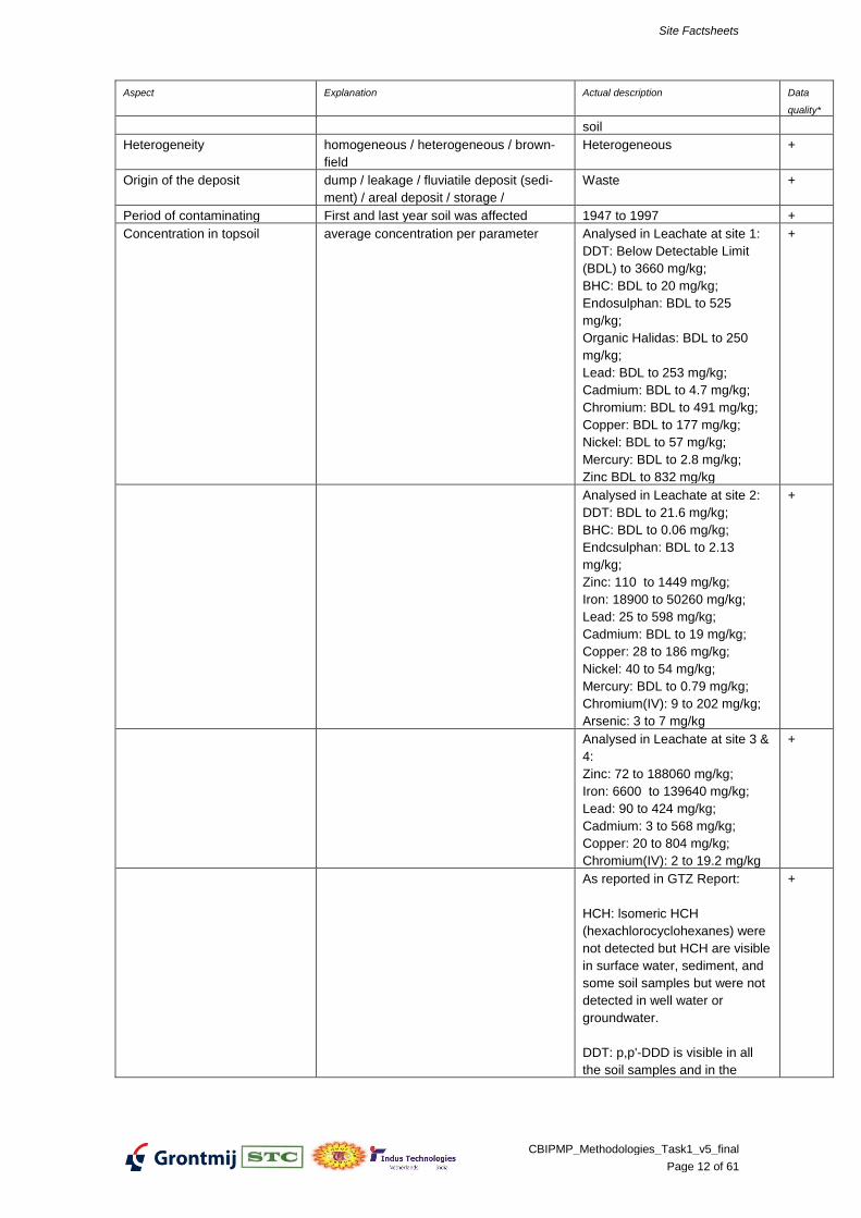
KSPCB 002-003 Hindustan Insecticides Limited, Eloor, Kerala
Origin of the deposit dump / leakage / fluviatile deposit (sedi-
ment) / areal deposit / storage /
Waste +
Period of contaminating First and last year soil was affected Preliminary examination +
Concentration in topsoil average concentration per parameter
maximum concentration per parameter
Volume of contaminated soil m3 / mmt (source in soil or HW deposit-
ed)
30MT of waste, 30cm depth of
soil
+
Area contaminated soil acre +
Concentration in groundwater average concentration per parameter
maximum concentration per parameter
Volume contam. groundwater m3
Area contam. groundwater acre
PATHWAY
Geology / Geohydrology
Type of topsoil sand/clay/bedrock/…
Depth water table m below surface
Depth bedrock m below surface
Permeability topsoil low/mod./high
Permeability aquifer low/mod./high
Groundwater flow direction / speed
Process of spreading
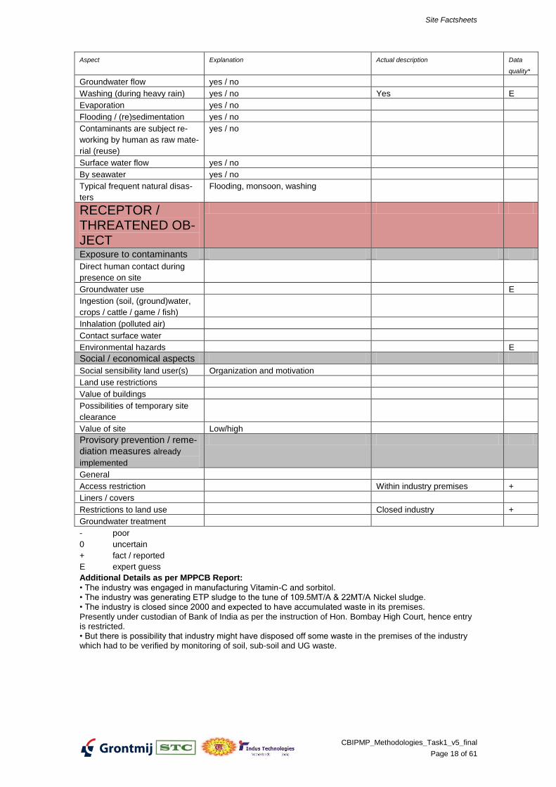
Site Factsheets
CBIPMP_Methodologies_Task1_v5_final
Page 18 of 61
Aspect Explanation Actual description Data
quality*
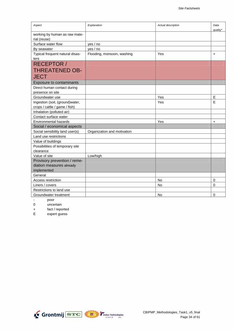
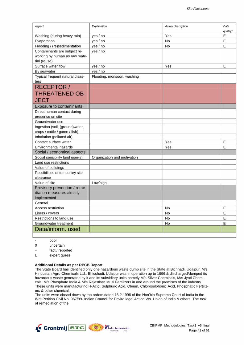
Groundwater flow yes / no
Washing (during heavy rain) yes / no Yes E
Evaporation yes / no
Flooding / (re)sedimentation yes / no
Contaminants are subject re-
working by human as raw mate-
rial (reuse)
yes / no
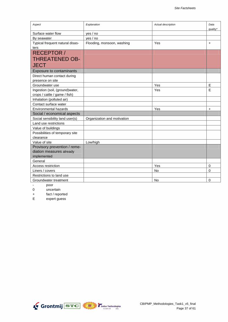
Surface water flow yes / no
By seawater yes / no
Typical frequent natural disas-
ters
Flooding, monsoon, washing
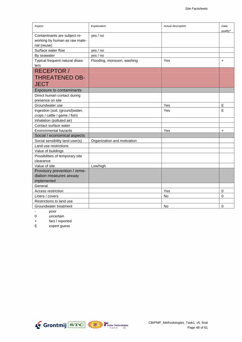
RECEPTOR / THREATENED OB-JECT
Exposure to contaminants
Direct human contact during
presence on site
Groundwater use E
Ingestion (soil, (ground)water,
crops / cattle / game / fish)
Inhalation (polluted air)
Contact surface water
Environmental hazards E
Social / economical aspects
Social sensibility land user(s) Organization and motivation
Land use restrictions
Value of buildings
Possibilities of temporary site
clearance
Value of site Low/high
Provisory prevention / reme-
diation measures already
implemented
General
Access restriction Within industry premises +
Liners / covers
Restrictions to land use Closed industry +
Groundwater treatment
- poor
0 uncertain
+ fact / reported
E expert guess
Additional Details as per MPPCB Report:
• The industry was engaged in manufacturing Vitamin-C and sorbitol. • The industry was generating ETP sludge to the tune of 109.5MT/A & 22MT/A Nickel sludge. • The industry is closed since 2000 and expected to have accumulated waste in its premises. Presently under custodian of Bank of India as per the instruction of Hon. Bombay High Court, hence entry is restricted. • But there is possibility that industry might have disposed off some waste in the premises of the industry which had to be verified by monitoring of soil, sub-soil and UG waste.
Site Factsheets
CBIPMP_Methodologies_Task1_v5_final
Page 19 of 61
Site Factsheets
CBIPMP_Methodologies_Task1_v5_final
Page 20 of 61
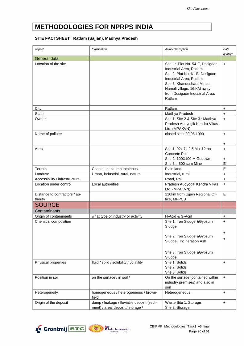
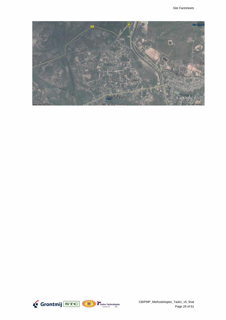
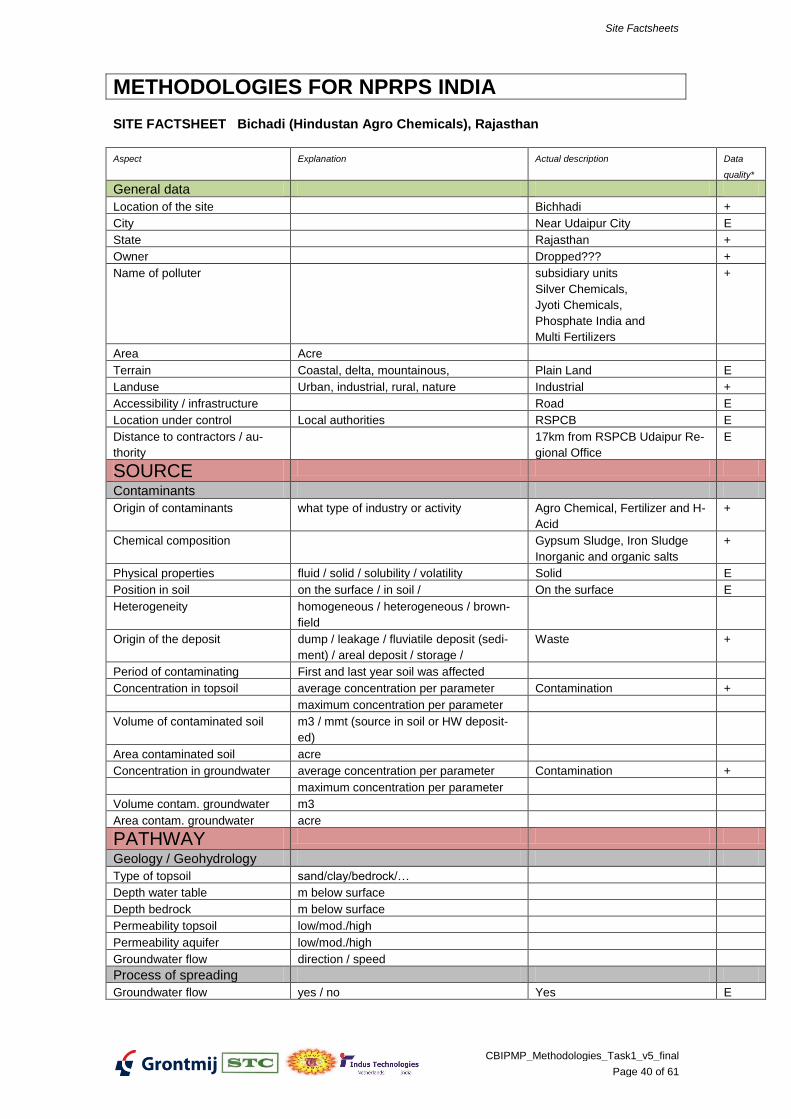
METHODOLOGIES FOR NPRPS INDIA
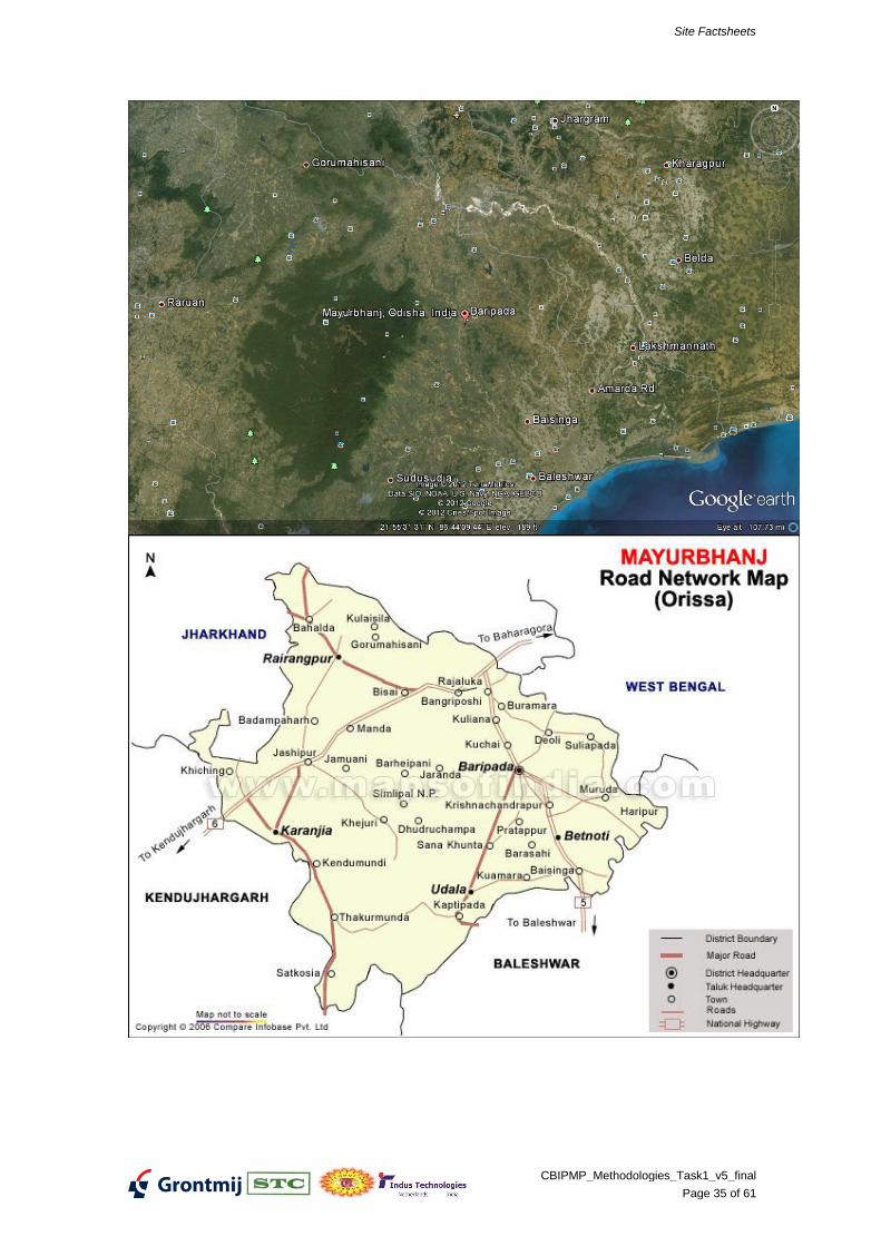
SITE FACTSHEET Ratlam (Sajjan), Madhya Pradesh
Aspect Explanation Actual description Data
quality*
General data
Location of the site Site-1: Plot No. 54-E, Dosigaon
Origin of the deposit dump / leakage / fluviatile deposit (sedi-
ment) / areal deposit / storage /
Waste Site 1: Storage
Site 2: Storage
+
Site Factsheets
CBIPMP_Methodologies_Task1_v5_final
Page 21 of 61
Aspect Explanation Actual description Data
quality*
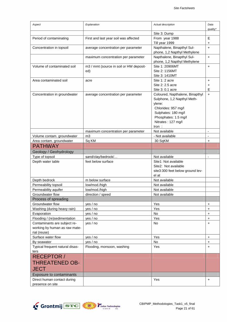
Site 3: Dump
Period of contaminating First and last year soil was affected From year 1988
Till year 1999
E
+
Concentration in topsoil average concentration per parameter Napthalene, Binapthyl Sul-
phone, 1,2 Napthyl Methylene
+
maximum concentration per parameter Napthalene, Binapthyl Sul-
phone, 1,2 Napthyl Methylene
+
Volume of contaminated soil m3 / mmt (source in soil or HW deposit-
ed)
Site 1: 20906MT
Site 2: 1156MT
Site 3: 1410MT
+
Area contaminated soil acre Site 1: 2 acre
Site 2: 2.5 acre
Site 3: 0.1 acre
+
+
E
Concentration in groundwater average concentration per parameter Coloured, Napthalene, Binapthyl
Sulphone, 1,2 Napthyl Meth-
ylene:
Chlorides: 957 mg/l
Sulphates: 180 mg/l
Phosphates: 1.5 mg/l
Nitrates : 127 mg/l
Iron :
+
maximum concentration per parameter Not available -
Volume contam. groundwater m3 - Not available -
Area contam. groundwater Sq KM 30 SqKM +
PATHWAY
Geology / Geohydrology
Type of topsoil sand/clay/bedrock/… Not available -
Depth water table feet below surface Site1: Not available
Site2: Not available
site3:300 feet below ground lev-
el at
Depth bedrock m below surface Not available
Permeability topsoil low/mod./high Not available
Permeability aquifer low/mod./high Not available
Groundwater flow direction / speed Not available
Process of spreading
Groundwater flow yes / no Yes +
Washing (during heavy rain) yes / no Yes +
Evaporation yes / no No +
Flooding / (re)sedimentation yes / no Yes +
Contaminants are subject re-
working by human as raw mate-
rial (reuse)
yes / no No +
Surface water flow yes / no Yes +
By seawater yes / no No +
Typical frequent natural disas-
ters
Flooding, monsoon, washing Yes +
RECEPTOR / THREATENED OB-JECT
Exposure to contaminants
Direct human contact during
presence on site
Yes +
Site Factsheets
CBIPMP_Methodologies_Task1_v5_final
Page 22 of 61
Aspect Explanation Actual description Data
quality*
Groundwater use Yes +
Ingestion (soil, (ground)water,
crops / cattle / game / fish)
Yes +
Inhalation (polluted air) No +
Contact surface water Yes +
Environmental hazards Yes +
Social / economical aspects
Social sensibility land user(s) Organization and motivation Health impact as skin diseases +
Land use restrictions Productivity of agricultural field
reduced
+
Value of buildings Low +
Possibilities of temporary site
clearance
Site 1 & Site 2: To Dismantle
and dispose to TSDF, Pithapur
200 km away
Site 3: To keep as is and moni-
tor
+
Value of site Low/high Low
+
Provisory prevention / reme-
diation measures already
implemented
General
Access restriction Yes +
Liners / covers No +
Restrictions to land use No +
Groundwater treatment No +
Data/inform. used
08 Dump_Site_Assessment_Madhya_Pradesh received from CPCB on 03 05 2012,011, 09 and
Dump_Site_Assessment_Madhya_Pradesh2 received from CPCB on 03 05 2012
- poor
0 uncertain
+ fact / reported
E expert guess Additional Details as per MPPCB Report:
M/s. Sajjan Chemical & Investment (P) Ltd., Ratlam was engaged in themanufacture of H-acid, G-acid and is closed since20.06.1999. • The industry was generating: 1000MT/A of Gypsum sludge, 410MT/A Iron Sludge4000MT/A of Sodium Sulphate & 1500MT/A of incinerated ash as hazardouswastes. • Some of the wastes were being disposed off in khasara No 469/1 Kandarwasa mine. The incinerated ash was stored at plot No 61B, Industrial area. • Presently all structures have been dismantled and equipments, machinery and allscrap materials have been removed from the site. • Waste debris are still lying in underground storage tanks & sheds within &near byto factory premises. • Legal action under EPA has been filed in CJM, Ratlam.
Origin of the deposit dump / leakage / fluviatile deposit (sedi-
ment) / areal deposit / storage /
Waste +
Period of contaminating First and last year soil was affected
Concentration in topsoil average concentration per parameter Contamination +
maximum concentration per parameter
Volume of contaminated soil m3 / mmt (source in soil or HW deposit-
ed)
Area contaminated soil acre
Concentration in groundwater average concentration per parameter Contamination +
maximum concentration per parameter
Volume contam. groundwater m3
Area contam. groundwater acre
PATHWAY
Geology / Geohydrology
Type of topsoil sand/clay/bedrock/…
Depth water table m below surface
Depth bedrock m below surface
Permeability topsoil low/mod./high
Permeability aquifer low/mod./high
Groundwater flow direction / speed
Process of spreading
Groundwater flow yes / no Yes E
Site Factsheets
CBIPMP_Methodologies_Task1_v5_final
Page 41 of 61
Aspect Explanation Actual description Data
quality*
Washing (during heavy rain) yes / no Yes E
Evaporation yes / no No E
Flooding / (re)sedimentation yes / no No E
Contaminants are subject re-
working by human as raw mate-
rial (reuse)
yes / no
Surface water flow yes / no Yes E
By seawater yes / no
Typical frequent natural disas-
ters
Flooding, monsoon, washing
RECEPTOR / THREATENED OB-JECT
Exposure to contaminants
Direct human contact during
presence on site
Groundwater use
Ingestion (soil, (ground)water,
crops / cattle / game / fish)
Inhalation (polluted air)
Contact surface water Yes E
Environmental hazards Yes E
Social / economical aspects
Social sensibility land user(s) Organization and motivation
Land use restrictions
Value of buildings
Possibilities of temporary site
clearance
Value of site Low/high
Provisory prevention / reme-
diation measures already
implemented
General
Access restriction No E
Liners / covers No E
Restrictions to land use No E
Groundwater treatment No E
Data/inform. used
- poor
0 uncertain
+ fact / reported
E expert guess
Additional Details as per RPCB Report:
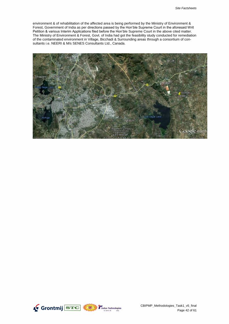
The State Board has identified only one hazardous waste dump site in the State at Bichhadi, Udaipur. M/s Hindustan Agro Chemicals Ltd., Bhicchadi, Udaipur was in operation up to 1996 & discharged/dumped its hazardous waste generated by it and its subsidiary units namely M/s Silver Chemicals, M/s Jyoti Chemi-cals, M/s Phosphate India & M/s Rajasthan Multi Fertilizers in and around the premises of the industry. These units were manufacturing H-Acid, Sulphuric Acid, Oleum, Chlorosulphonic Acid, Phosphatic Fertiliz-ers & other chemical. The units were closed down by the orders dated 13.2.1996 of the Hon’ble Supreme Court of India in the Writ Petition Civil No. 967/89- Indian Council for Enviro legal Action V/s. Union of India & others. The task of remediation of the
Site Factsheets
CBIPMP_Methodologies_Task1_v5_final
Page 42 of 61
environment & of rehabilitation of the affected area is being performed by the Ministry of Environment & Forest, Government of India as per directions passed by the Hon’ble Supreme Court in the aforesaid Writ Petition & various Interim Applications filed before the Hon’ble Supreme Court in the above cited matter. The Ministry of Environment & Forest, Govt. of India had got the feasibility study conducted for remediation of the contaminated environment in Village, Bicchadi & Surrounding areas through a consortium of con-sultants i.e. NEERI & M/s SENES Consultants Ltd., Canada.
Site Factsheets
CBIPMP_Methodologies_Task1_v5_final
Page 43 of 61
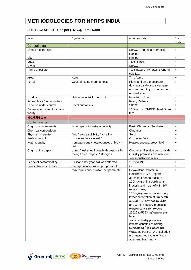
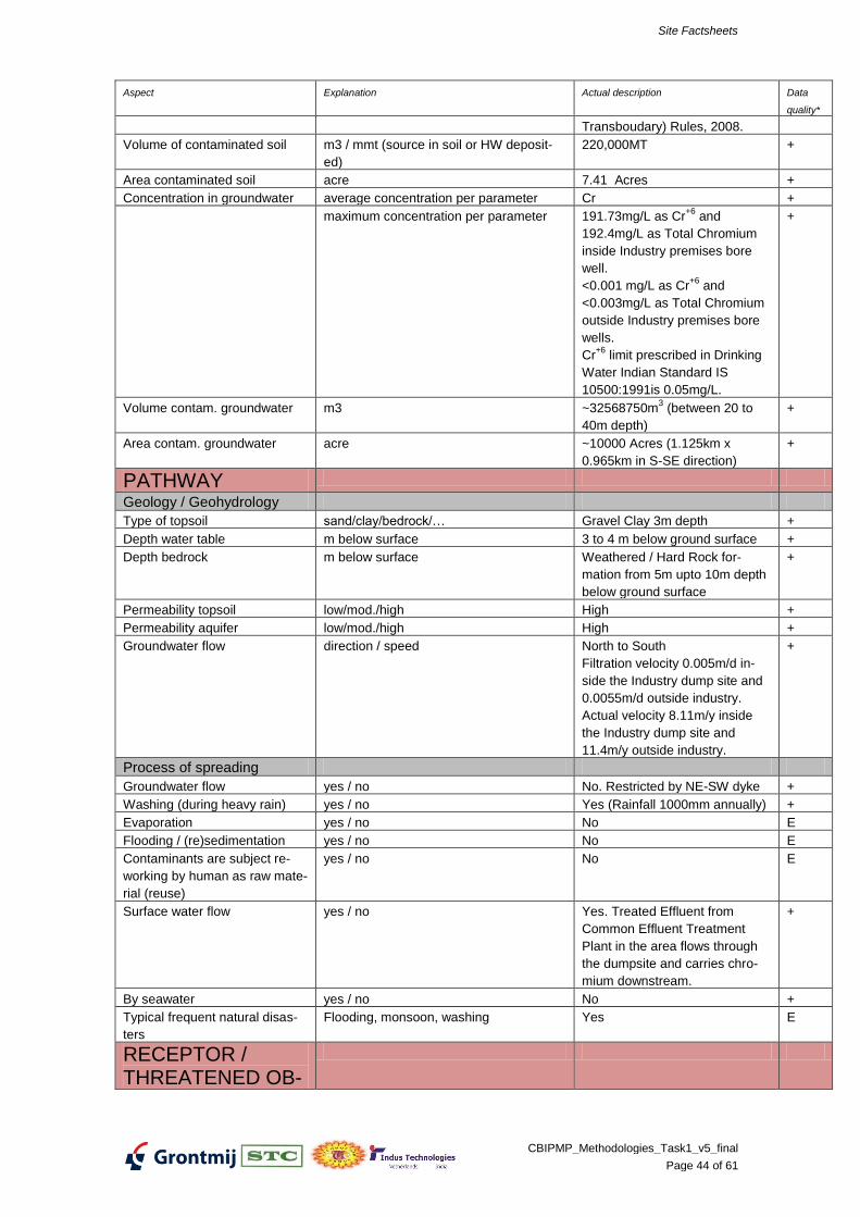
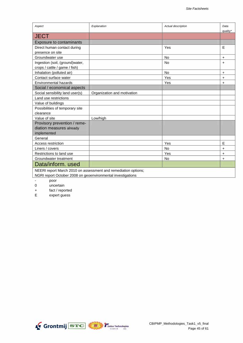
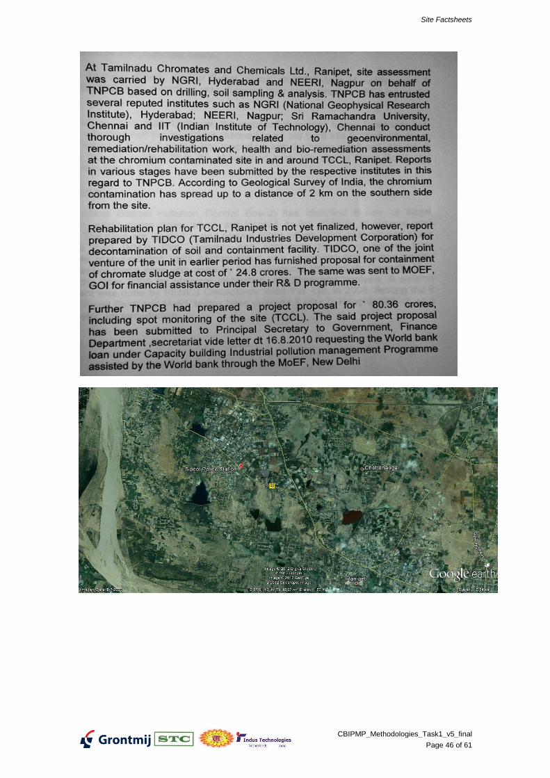
METHODOLOGIES FOR NPRPS INDIA
SITE FACTSHEET Ranipet (TNCC), Tamil Nadu
Aspect Explanation Actual description Data
quality*
General data
Location of the site SIPCOT Industrial Complex,
Ranipet
+
City Ranipet +
State Tamil Nadu +
Owner SIPCOT +
Name of polluter Tamilnadu Chromates & Chemi-
cals Ltd.
+
Area Acre 7.41 Acres +
Terrain Coastal, delta, mountainous, Plain land on the southern
Origin of the deposit dump / leakage / fluviatile deposit (sedi-
ment) / areal deposit / storage /
Leached Residue +
Period of contaminating First and last year soil was affected
Concentration in topsoil average concentration per parameter Mercury +
maximum concentration per parameter
Volume of contaminated soil m3 / mmt (source in soil or HW deposit-
ed)
3 acres of mercury contaminat-
ed soil to a depth of 1m. Apprx
5000 MT of waste(?)2250MT
+
Area contaminated soil acre Within and around industry
premises, forest
+
Concentration in groundwater average concentration per parameter Mrcury +
maximum concentration per parameter
Volume contam. groundwater m3
Area contam. groundwater acre
PATHWAY
Geology / Geohydrology
Type of topsoil sand/clay/bedrock/…
Depth water table m below surface
Depth bedrock m below surface
Permeability topsoil low/mod./high
Permeability aquifer low/mod./high
Groundwater flow direction / speed
Process of spreading
Groundwater flow yes / no Yes +
Washing (during heavy rain) yes / no Yes +
Evaporation yes / no
Flooding / (re)sedimentation yes / no
Site Factsheets
CBIPMP_Methodologies_Task1_v5_final
Page 48 of 61
Aspect Explanation Actual description Data
quality*
Contaminants are subject re-
working by human as raw mate-
rial (reuse)
yes / no
Surface water flow yes / no
By seawater yes / no
Typical frequent natural disas-
ters
Flooding, monsoon, washing Yes +
RECEPTOR / THREATENED OB-JECT
Exposure to contaminants
Direct human contact during
presence on site
Groundwater use Yes E
Ingestion (soil, (ground)water,
crops / cattle / game / fish)
Yes E
Inhalation (polluted air)
Contact surface water
Environmental hazards Yes +
Social / economical aspects
Social sensibility land user(s) Organization and motivation
Land use restrictions
Value of buildings
Possibilities of temporary site
clearance
Value of site Low/high
Provisory prevention / reme-
diation measures already
implemented
General
Access restriction Yes 0
Liners / covers No 0
Restrictions to land use
Groundwater treatment No 0
- poor
0 uncertain
+ fact / reported
E expert guess
Site Factsheets
CBIPMP_Methodologies_Task1_v5_final
Page 49 of 61
Site Factsheets
CBIPMP_Methodologies_Task1_v5_final
Page 50 of 61
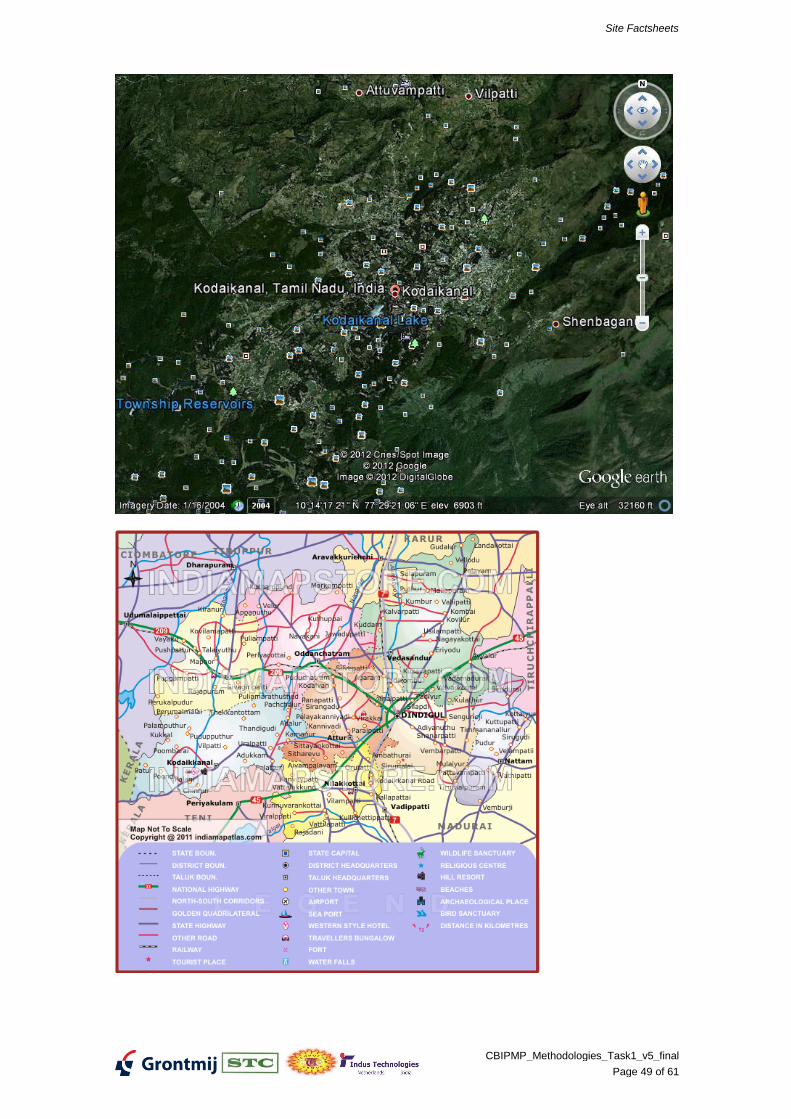
Mercury pollution
Air and water-borne mercury emissions have contaminated large areas of Kodaikanal and sur-rounding forests. A study conducted by the Department of Atomic Energy confirmed that Kodaikanal Lake has been contaminated by mercury emissions.,
[22][23]
Mercury pollution was reported in Kodaikanal which affected lakes in the area. The causes, originating from a Hindustan Lever thermometer factory nearby, were reported to be dispersal of elemental mercury to the atmosphere from improper storage and dispersal to water from sur-face effluents from the factory. Apart from tests conducted on Kodaikanal lake, moss samples collected from trees surrounding the Berijam Lake, located 20 km (12.4 mi) from the factory were also tested. This showed mercury level in the range of 0.2 µg/kg, while in Kodaikanal lake the lichen and moss levels were 7.9 µg/kg and 8.3 µg/kg, respectively. Fish samples tested from the Kodaikanal lake also showed Hg level in the range of 120 to 290 mg/kg confirming that pol-lution of the lake had taken place due to mercury emissions from the factory.
[24]
The Hindustan Unilever thermometer factory caused widespread mercury pollution through im-proper disposal of broken thermometer waste containing large quantities of mercury. The facto-ry sold much of this waste to a junkyard in Kodaikanal and also dumped large quantities in the forest behind the factory. The factory was eventually closed in 2001 after 18 years of operation. Hindustan Lever, have used considerable legal maneuvering to avoid paying compensation the ex-workers and their families, many of whom died or became physically handicapped as a result of mercury poisoning.
[25][26]
The ex-workers have joined to form the 559-strong Ex-Mercury Employees Welfare Association and in 2006 filed a Public Interest Litigation (PIL) suit in the Madras High Court. The association wants an economic rehabilitation scheme and a healthcare treatment and monitoring pro-gramme at the company's expense for everyone who ever worked in the factory. It also wants the company prosecuted. Hindustan Unilever denies that any of the health problems of the workers or their families was the result of mercury exposure in the factory. In 2010 the workers were still fighting for compensation.
[27]
June 2007 the Madras High Court constituted a five-member expert committee to decide on the mercury workers health claims. The last court hearing was in June 2008. The committee later failed to find sufficient evidence to link the current clinical condition of the factory workers to past mercury exposure in the factory.
[28]
Additional site remediation studies are being undertaken by national institutions, as desired by the Tamil Nadu pollution Control Board (TNPCB) and the Court's Scientific Experts Committee (SEC) during the project review meeting in January 2010. IIT Delhi is revalidating the risk as-sessment study and site specific clean-up standard; National Botanical Research Institute, Lucknow is studying impact on trees and preservation of trees; and Centre for Soil and Water Conservation Research and Training Institute, Ooty is studying the impact on soil and soil ero-sion. Based on the above study findings, results of remediation trials and recommendation of SEC, the TNPCB will take a final decision on the clean-up standard. Hindustan Unilever Ltd. (HUL) will commence soil remediation work at the factory site once