New School at Big River NEPA Environmental Assessment BLM Reference Number CACA-44393 BLM NEPA Control Number CA-690-EA06-17 and CEQA Initial Study Mitigated Negative Declaration Land Management Agency: United States Department of the Interior Bureau of Land Management Needles Field Office 1303 South Highway 95 Needles, CA 92363 Contact: George R. Meckfessel 760.326.7008 Project Applicant: Needles Unified School District 1900 Erin Drive Needles, CA 92363 Contact: Dave Renquest 760.326.3891 December 2006
United States Department of the Interior Bureau of Land Management
Needles Field Office 1303 South Highway 95
Needles, CA 92363 Contact: George R. Meckfessel
760.326.7008
Project Applicant:
Needles Unified School District 1900 Erin Drive
Needles, CA 92363 Contact: Dave Renquest
760.326.3891
December 2006
BLM Mission Statement
The Bureau of Land Management is responsible for the stewardship of our public lands. It is committed to manage, protect, and improve these lands in a manner to serve the needs of the American people for all times. Management is based upon the principles of multiple use and sustained yield of our nation’s resources within a framework of environmental responsibility and scientific technology. These resources include recreation, rangelands, timber, minerals, watershed, fish and wildlife, air and scenic, scientific and cultural values.
Table of Contents
New School at Big River Page i December 2006
TABLE OF CONTENTS
1.0 INTRODUCTION .......................................................................................................................................... 1-1 1.1. Project Background............................................................................................................................. 1-1 1.2. Purpose and Need .............................................................................................................................. 1-1 1.3. Project Location and Environmental Setting....................................................................................... 1-2 1.4. Relationship to NEPA Guidelines ....................................................................................................... 1-2
1.4.1. Land Use Plan Conformance................................................................................................. 1-4 1.4.2 Decisions to be Made ............................................................................................................ 1-4
1.5. Relationship to CEQA Guidelines ....................................................................................................... 1-4 1.5.1. Intended Uses of the Initial Study .......................................................................................... 1-4 1.5.2. Incorporation by Reference.................................................................................................... 1-5 1.5.3. Mitigation Monitoring.............................................................................................................. 1-6
1.6. Discretionary Actions and Regulatory Permits ................................................................................... 1-6 2.0 PROPOSED ACTION AND ALTERNATIVES ............................................................................................. 2-1
2.1. Proposed Action.................................................................................................................................. 2-1 2.1.1. Access and Proposed Roadway System............................................................................... 2-1 2.1.2. Educational Facilities ............................................................................................................. 2-1 2.1.3. Phase I - Elementary School ................................................................................................. 2-1 2.1.4. Phase II - High School ........................................................................................................... 2-3 2.1.5. Ancillary Facilities................................................................................................................... 2-5 2.1.6. Construction Activities............................................................................................................ 2-7 2.1.7. Applicant Initiated Environmental Construction Measures .................................................... 2-7
2.2. Alternatives to the Proposed Action....................................................... Error! Bookmark not defined. 2.2.1. No Action Alternative............................................................................................................ 2-12
2.3. Alternatives Considered but Eliminated ............................................................................................ 2-12 2.3.1. Extend Current Lease .......................................................................................................... 2-13 2.3.2. Construct Project on Reservation Land ............................................................................... 2-13 2.3.3. Buss Students to Arizona Alternative................................................................................... 2-13
3.0 PUBLIC SCOPING AND ISSUE IDENTIFICATION .................................................................................... 3-1 3.1. BLM Scoping....................................................................................................................................... 3-1 3.2. Critical Elements of the Human Environment ..................................................................................... 3-1 3.3. Resources Present but Not Affected................................................................................................... 3-1 3.4. Issues and Resources Present and Brought Forward for Analysis .................................................... 3-2
4.0 AFFECTED ENVIRONMENT, IMPACTS, AND MITIGATION..................................................................... 4-1 4.1. Soils and Geology ............................................................................................................................... 4-1
4.1.1. Proposed Action..................................................................................................................... 4-1 4.1.2. No Action Alternative.............................................................................................................. 4-2
4.10. Air Quality.......................................................................................................................................... 4-17 4.10.1. Proposed Action................................................................................................................... 4-17 4.10.2. No Action Alternative............................................................................................................ 4-19
4.11. Surface and Groundwater ................................................................................................................. 4-19 4.11.1. Proposed Action................................................................................................................... 4-19 4.11.2. No Action Alternative............................................................................................................ 4-22
4.12. Public Services and Utilities.............................................................................................................. 4-22 4.12.1. Proposed Action................................................................................................................... 4-22 4.12.2. No Action Alternative............................................................................................................ 4-24
4.13. Health and Safety / Hazardous Materials ......................................................................................... 4-24 4.13.1. Proposed Action................................................................................................................... 4-24 4.13.2. No Action Alternative............................................................................................................ 4-26
4.14. Cultural Resources............................................................................................................................ 4-27 4.14.1. Proposed Action................................................................................................................... 4-27 4.14.2. No Action Alternative............................................................................................................ 4-30
6.0 UNAVOIDABLE ADVERSE EFFECTS........................................................................................................ 6-1 6.1. Relationship of Short-term Uses and Long-term Productivity............................................................. 6-1 6.2. Irreversible and Irretrievable Commitments of Resources.................................................................. 6-1 6.3. Growth Inducement............................................................................................................................. 6-1
7.0 CONSULTATION AND COORDINATION ................................................................................................... 7-1 7.1. List of Preparers and Reviewers......................................................................................................... 7-1 7.2. Tribes, Agencies, Organizations, and Persons Consulted ................................................................. 7-2
Appendix H Air Quality Management District Correspondence
Appendix I Hydrology Study and SWPPP Measures
Appendix J Jurisdictional Delineation
Appendix K Southern California Edison Correspondence
Appendix L Phase I Environmental Assessment Report
Appendix M Health and Safety Plan/Spill Prevention and Emergency Response Plan
LIST OF FIGURES
Figure 1.3-1 Regional Location
Figure 1.3-2 Vicinity Map
Figure 1.3-3 Site Photographs
Figure 2.1-1 Phase I - Elementary School Site Plan
Figure 2.1-2 Phase I - Elementary School Building Elevations
Figure 2.1-3 Phase II - High School Site Plan
LIST OF TABLES
Table 1.6-1 Discretionary Actions and Regulatory Permits
Table 2.1-1 Phase I - Elementary School Project Summary
Table 2.1-2 Phase II - High School Project Summary
Table 2.1-3 Ancillary Facilities Summary
Table of Contents
New School at Big River Page iv December 2006
ACRONYMS AND ABBREVIATIONS
ACEC Area of Critical Environmental Concern AP Alquist-Priolo (earthquake zone) APN Assessor’s Parcel Number ASTM American Society for Testing and Materials BIA Bureau of Indian Affairs BLM Bureau of Land Management BMP Best Management Practice BRWC Big River Water Company CAA Clean Air Act CalFlora University of California at Berkeley Database CalOSHA California Occupational Safety and Hazard Administration Caltrans California Department of Transportation CCR California Code of Regulations CDCA California Desert Conservation Area CDE California Department of Education CDFG California Department of Fish and Game CDMG California Division of Mines and Geology CDP Census Designated Places CDWR California Division of Water Resources CEQ Council on Environmental Quality CEQA California Environmental Quality Act CERCLA Comprehensive Environmental Response Compensation and Liability Act CFR Code of Federal Regulations cfs cubic feet per second CHRIS California Historic Resources Information System CMP Coordinated Management Plan CNDDB California Natural Diversity Database CNEL Community Noise Equivalent Level CNPS California Native Plant Society Corps U.S. Army Corps of Engineers CRIT Colorado River Indian Tribes CRWQCB California Regional Water Quality Control Board CSD Community Service District dB decibel dBA A - weighted decibel DBE design basis earthquake
Table of Contents
New School at Big River Page v December 2006
District Needles Unified School District dpm diesel particulate matter DTSC Department of Toxic Substances Control EA Environmental Assessment EA/IS Environmental Assessment/Initial Study EIS Environmental Impact Statement EPA Environmental Protection Agency ESA Endangered Species Act F Fahrenheit FCR field contact representative FEIS Final Environmental Impact Statement FEMA Federal Emergency Management Agency FLPMA Federal Land Policy and Management Act FONSI Finding of No Significant Impact g gravity HCM Highway Capacity Manual HCP habitat conservation plan U.S. 95 U.S. Highway 95 IS Initial Study kV kilovolts Ldn Day-Night Average Noise Leq Equivalent Continuous Sound Level L max maximum noise levels LOS level of service L 10 noise levels exceeded 10 percent of the time MDAB Mojave Desert Air Basin MDAQMD Mojave Desert Air Quality management District MND Mitigated Negative Declaration Mph miles per hour MOU Memorandum of Understanding MSCP Multiple Species Conservation Plan msl mean sea level MSDS material safety data sheets NAHC Native American Heritage Commission NECO Northern and Eastern Colorado Desert NEPA National Environmental Policy Act NHPA National Historic Preservation Act NOC Notice of Completion NOD Notice of Determination
Table of Contents
New School at Big River Page vi December 2006
NPDES National Pollution Discharge Elimination System NPS National Park Service NRHP National Register of Historic Places NUSD Needles Unified School District OHV Off-highway vehicle OSHA Occupational Safety Health Administration Phase I Phase I Environmental Site Assessment PWG San Bernardino County Public Works Group RCRA Resource Conservation Recovery Act RMP Resource Management Plan R&PP Recreation & Public Purposes Act ROD Record of Decision ROP rate-of-progress ROW right-of-way SANBAG San Bernardino Area Council of Governments SBAIC San Bernardino Archaeological Information Center SBBM San Bernardino Baseline & Meridian SBCFD San Bernardino County Fire Department SBCSD San Bernardino County Sheriff’s Department SCAQMD South Coast Air Quality management District SCE Southern California Edison Company SE Southest SHPO State Historical Preservation Officer SR State Route SWPPP Storm Water Pollution Prevention Plan T&E threatened & endangered UBC Uniform Building Code UPRR Union Pacific Railroad USBR United States Bureau of Reclamation FWS United States Fish and Wildlife Service USGS United States Geological Survey UTM Universal Transverse Mercator VRM Visual Resource Management WDR waste discharge requirements
1.0 Introduction
New School at Big River Page 1-1 December 2006
1.0 INTRODUCTION
1.1. Project Background
The Needles Unified School District (NUSD) proposes to construct, operate and maintain a new educational facility in two phases on 65.7-acres of Bureau of Land Management (BLM) property situated immediately west of the community of Big River which is located along the Colorado River in southeastern San Bernardino County, California. The elementary school is presently proposed as Phase I and a high school is anticipated to be proposed in the future as Phase II. The project applicant has submitted an application to the BLM for a lease pursuant to the Recreation and Public Purposes (R&PP) Act for the proposed project.
1.2. Purpose and Need
The project applicant currently provides public educational services to the largest geographical area in the continental United States and serves approximately 1,190 students living in eastern San Bernardino County. The NUSD currently maintains eight schools within its attendance boundaries including facilities in Needles and Parker Dam. Parker Dam Elementary School is currently situated in a building located at the corner of California and Utah Streets near the Parker Dam. This school serves approximately 132 elementary students in grades K-8. Alternatively, high school students in grades 9-12 are bussed to Parker, Arizona. The Parker Dam School is located in a structure built by the U.S. Bureau of Reclamation (USBR) in 1950 to provide housing for construction workers building the Parker Dam. The 55 year old structure is currently leased to the project applicant under Contract No. 1-07-30-L0128, Amendment No. 2 which expires on August 12, 2007. In addition to the age of the structure, the building has exceeded its design capacity. The project applicant is also proposing to construct the New School at Big River because the existing educational facility: ▪ is situated in dilapidating structures that do not meet current uniform building codes; • is planned to be condemned by the USBR; ▪ can not be modified or expanded to accommodate increasing student population; • does not provide a learning environment that contains the amenities needed for a quality education; • is located in close proximity to the Parker Dam which has safety/security concerns; • does not meet Title 5 State of California Code of Regulations for school facility siting; • is not compatible with surrounding land uses; and ▪ is located 30 miles north of 80 percent of the students who attend the facility. Student growth within eastern San Bernardino County is predicted to increase significantly over the next decade due to the construction of new housing units, vacation rentals, and the steady number of families who relocate along the Colorado River. In order to provide for this growth, the project applicant is planning to: ▪ Construct a new elementary school (Phase I) in the southeastern portion of NUSD boundaries to replace
existing outdated educational facilities at Parker Dam; • Construct a new high school (Phase II) in the southeastern portion of NUSD boundaries and stop bussing
high school students to Arizona to attend school; • Provide facilities for a Head Start Program to assist younger students who need specialized services; and
1.0 Introduction
New School at Big River Page 1-2 December 2006
• Construct facilities made available to the public including an auditorium, playground, baseball fields,
soccer fields, and a library.
1.3. Project Location and Environmental Setting
The project site is regionally located in southeastern San Bernardino County within the Vidal Valley as shown on Figure 1.3-1. The project site is also located approximately two miles north of the Colorado River, two miles south of State Highway 62 (Aqueduct Road), six miles east of U.S. Highway 95 (Highway 95), and five miles west of Parker, Arizona. On a local scale, the project site is located immediately west and adjacent to the Colorado River Indian Tribes (CRIT) reservation at Big River as shown on Figure 1.3-2. More specifically, the site is located west of the small community of Earp, south and east of federal BLM land, and west of Osage Trail which is a street situated within Big River. Both the 65.7 acre site and the 12 acre elementary school site are located in the southeast (SE) quarter of Section 30, in Township 1 North, and Range 25 East, San Bernardino Base Line and Meridian (SBBM) on the Parker NW California U.S. Geological Survey (USGS) topographic quadrangle (1970, photo revised 1975; scale 1:24,000). The subject site is also located within the boundaries of Assessor’s Parcel Numbers (APN) 647-39-11-26, -28, -29, -30, and -38. A legal description for the project site is contained in Appendix A. The environmental setting in the vicinity of the project site is characterized as a low desert plain with several blue-line drainage features traversing the area from north to south. The soil consists of a very coarse sand loam supporting typical desert scrub vegetation including creosote bush, paloverde trees, ironwood trees, and barrel cactus. The wildlife is largely restricted to species that can co-exist in a desert near human habitation including jack rabbits, cottontails, reptiles, birds and coyotes. There are no permanent buildings or structures located on the project site however several unimproved dirt roads traverse the site as shown on Figure 1.3-3. Human encroachment is limited to small amounts of urban refuse and debris from the adjacent residential area. BLM land surrounding the project site to the north and west consist of vacant undeveloped desert land. There are several residential homes located east of the project within the unincorporated community of Big River.
1.4. Relationship to NEPA Guidelines
The proposed project is subject to the National Environmental Policy Act (NEPA) because the project is proposed on federal BLM land. Therefore, this document has been prepared in compliance with NEPA and its implementing regulations issued by the Council of Environmental Quality (40 CFR § 1500) and 40 CFR Part 1506.2(a) and (b) addressing joint documents. It also complies with the Federal Land Policy and Management Act (FLPMA), with planning guidance at 43 CFR § 1600 and in the BLM Planning Manual (1600 Series); the BLM Environmental Handbook (H-1790); Clean Water Act (Sections 401 and 404); National Historic Preservation Act (NHPA) (Section 106); American Indian Religious Freedom Act; Safe Drinking Water Act; Wild and Scenic Rivers Act; Wilderness Act; the Endangered Species Act (ESA) (Section 7); Executive Order 13007 on Sacred Sites; Executive Order 11988 on Floodplains; Executive Order 1199-0 on Wetlands and Riparian Zones; Executive Order 13045 on Protection of Children from Environmental Health and Safety Risks; and Executive Order 12898 addressing Environmental Justice. The preparation, review, and certification process for the NEPA Environmental Assessment (EA) will involve the following procedural steps:
1.0 Introduction
New School at Big River Page 1-3 December 2006
Environmental Assessment This document constitutes the EA and contains a description of the proposed action (proposed project), description of the existing environment, identification of environmental consequences (impacts), and mitigation measures. Public Notice/Public Review Prior to issuing a decision record, the BLM will prepare a public notice associated with the R&PP lease which will notify the public about the proposed project and will invite comment from the general public, agencies, organizations, and other interested parties. Public comment on the R&PP lease will be accepted in written form at the BLM Needles Field Office for 45 days. Public Review This document will be circulated to applicable federal, state, and local agencies in conjunction with the California Environmental Quality Act (CEQA) and National Environmental Policy Act (NEPA) requirements. The BLM also requires a 45 day public comment period on a “Notice of Realty Action”. Finding of No Significant Impact The primary purpose of conducting an environmental assessment is to determine whether or not a proposed action will have a significant impact on the human environment and therefore will require the preparation of an EIS. As defined in 40 CFR 1508.13, the Finding of No Significant Impact (FONSI) is a document that briefly presents the reasons why an action will not have significant effect on the human environment. The regulations further define the term “significantly” in 40 CFR 1508.27 and require that the context and intensity of impacts be considered in analyzing significance. Significance of impacts is to be considered in terms of context and intensity includes: a) Context. This means that the significance of an action must be analyzed in several contexts such as society as a whole (human, national), the affected region, the affected interests, and the locality. Significance varies with the setting of the proposed action. For instance, in the case of a site-specific action, significance would usually depend upon the effects in the locale rather than in the world as a whole. Both short-term and long-term effects are relevant”. (40 CFR 1508.27(a)) and (b) Intensity. This refers to the severity of impact. Responsible officials must bear in mind that more than one agency may make decisions about partial aspects of a major action. The following should be considered in evaluating intensity:” (40 CFR 1508.27(b)) (1) Impacts that may be both beneficial and adverse. A significant effect may exist even if the Federal agency believes that on balance the effect will be beneficial.” (40 CFR 1508.27(b)(1)); (2) The degree to which the proposed action affects public health or safety.” (40 CFR 1508.27(b)(2)); (3) Unique characteristics of the geographic area such as proximity to historic or cultural resources, park lands, prime farmlands, wetlands, wild and scenic rivers, or ecologically critical areas.” (40 CFR 1508.27(b)(3)); (4) The degree to which the effects on the quality of the human environment are likely to be highly controversial.” (40 CFR 1508.27(b)(4)); (5) The degree to which the possible effects on the human environment are highly uncertain or involve unique or unknown risks.” (40 CFR 1508.27(b)(5)); (6) The degree to which the action may establish a precedent for future actions with significant effects or represents a decision in principle about a future consideration” (40 CFR 1508.27(b)(6));
1.0 Introduction
New School at Big River Page 1-4 December 2006
(7) Whether the action is related to other actions with individually insignificant but cumulatively significant impacts. Significance exists if it is reasonable to anticipate a cumulatively significant impact on the environment. Significance cannot be avoided by terming an action temporary or by breaking it down into small component parts.” (40 CFR 1508.27(b)(7)); (8) The degree to which the action may adversely affect districts, sites, highways, structures, or objects listed or eligible for listing in the National Register of Historic Places or may cause loss or destruction of significant scientific, cultural, or historical resources” (40 CFR 1508.27(b)(8)); (9) The degree to which the action may adversely affect an endangered or threatened species or its habitat that has been determined to be critical under the Endangered Species Act of 1973” (40 CFR 1508.27(b)(9)); and (10) Whether the action threatens a violation of Federal, State, or local law or requirements imposed for the protection of the environment” (40 CFR 1508.27(b)(10)).
1.4.1. Land Use Plan Conformance
The proposed action is subject to and in conformance with the California Desert Conservation Area Plan of 1980 (as amended) in accordance with Title 43 Code of Federal Regulations 1610.5-3. The plan’s General Guidelines section provides that laws and regulations governing the issuance of permits and/or authorizations for uses of the public lands can be found in Titles 30, 36, and 43 Code of Federal Regulations.
1.4.2 Decisions to be Made
Decisions to be made at this phase of the project involve the following: BLM approval of a Recreational and Public Purposes Act lease for an educational facility area including
the construction, operation and maintenance of an elementary school.
1.5. Relationship to CEQA Guidelines
The proposed project is also subject to the requirements of California Environmental Quality Act (CEQA) because the project involves construction and operation of a public school and the project applicant is seeking financial hardship funding through the California Department of Education (CDE). The project applicant is the designated Lead Agency and has authority to approve the project. The Lead Agency also has authority to certify the CEQA Initial Study, approve the mitigation monitoring program, prepare written environmental findings, and adopt a resolution. Responsible agencies include the BLM, U.S. Army Corps of Engineers (Corps), California Department of Fish & Game (CDFG), California Regional Water Quality Control Board (CRWQCB), and CRIT. Responsible agencies have jurisdiction to issue permits related to leasing land, construction, and/or operation of the proposed project as an educational facility.
1.5.1. Intended Uses of the Initial Study
The preparation, review, and certification process for the CEQA Initial Study will involve the following procedural steps: Draft Initial Study This document constitutes the Draft CEQA environmental document and contains a description of the project, description of the environmental setting, identification of project impacts, and mitigation measures for impacts found to be significant, as well as an analysis of project alternatives. This document also contains a completed Environmental Checklist Form (Appendix B) as required by CEQA. Upon completion of the Revised Draft Initial Study, the project applicant will file a Notice of Completion (NOC) with the California State Clearinghouse to begin the public review period as outlined in Public Resources Code, Section 21161. Appendix C contains a copy of the NOC.
1.0 Introduction
New School at Big River Page 1-5 December 2006
Public Notice/Public Review Concurrent with the NOC, the project proponent and the BLM will provide public notice of the availability of the Draft Initial Study for public review, and invite comment from the general public, agencies, organizations, and other interested parties. This public notice of availability is issued to comply with the CEQA Guidelines. Section 15088.5(d) states that circulation requires consultation with other agencies for thirty (30) days. Public comment on the Draft Initial Study will be accepted both in written form and orally at a future NUSD Board Hearing in Needles. Because the BLM requires a 45 day public comment period associated with a “Notice of Realty Action”, the Draft Initial Study will be circulated for 45 days. Response to Comments/Final Initial Study Following the public review period, a Final Initial Study will be prepared. The Final Initial Study will respond to written comments received during the public review period. Certification of the Initial Study/Project Consideration The NUSD Board will review and consider all information contained in the Draft and Final Initial Study. If the NUSD Board finds that the Final Initial Study is "adequate and complete", the Board may recommend certification. The NUSD Board will take all final actions on the project and the Final Initial Study and will take into account comments made during the public review period. The rule of adequacy generally holds that the Initial Study can be certified if: 1) it shows a good faith effort at full disclosure of environmental information; and 2) it provides sufficient analysis to allow decisions to be made regarding the project in contemplation of its environmental consequences. Upon review and consideration of the Final Initial Study, the NUSD Board may take action to approve, revise, or reject the project. A decision to approve the project would be accompanied by written findings in accordance with CEQA Guidelines § 15091.
1.5.2. Incorporation by Reference
Pertinent documents related to this joint NEPA EA/CEQA Initial Study have been cited and incorporated by reference, in accordance with § 15150 of the CEQA Guidelines, as a means of reducing the redundancy and length of environmental reports. The following documents are available for review at both the BLM Needles Field Office and on the BLM web page at http://www.blm.gov/ca/needles/planning.htm and are hereby incorporated by reference into this Joint NEPA EA/CEQA Initial Study: BLM California Desert Conservation Area Plan and Final Environmental Impact Statement (FEIS), 1980. The California Desert Conservation Area (CDCA) Plan involved a 25-million acre federal planning effort in southern California designated by Congress in 1976 to promote the concepts of multiple use, sustained yield, and maintenance of environmental quality. Congress directed the BLM to prepare and implement a comprehensive, long-range plan for the management, use, development and protection of the public lands within the CDCA. Approximately 10 million acres were administered by the BLM from 1980 to 2002. BLM Northern & Eastern Colorado Desert Coordinated Management Plan and Final Environmental Impact Statement (FEIS) and amendments, 2002 The Northern & Eastern Colorado Desert Coordinated Management Plan (NECO) involved a landscape-scale, multi-agency planning effort sought to protect and conserve natural resources while simultaneously balancing human uses of the California portion of the Sonoran Desert ecosystem including areas in the vicinity of the proposed project. The planning area encompassed over five million acres and hosted 60 sensitive plant and animal species. The NECO was an amendment to the California Desert Conservation Area Plan. The Record of Decision (ROD) approving the plan was signed in December 2002.
1.0 Introduction
New School at Big River Page 1-6 December 2006
1.5.3 Mitigation Monitoring
Pursuant to § 21081.6 of the California Public Resources Code, the project applicant is required to prepare, approve, and implement a Mitigation Monitoring Program to monitor applicant initiated environmental construction measures, best management practices (BMP), and conditions of approval outlined in this EA/Initial Study. This program serves to document compliance with applicant initiated environmental construction measures, BMPs and conditions of approval required to minimize effects of the proposed project on the environment. A Mitigation Monitoring Program for the proposed project is contained in Appendix D.
1.6. Discretionary Actions and Regulatory Permits
Table 1.6-1 lists the known federal, state and local agency approvals, reviews and permitting requirements associated with the proposed project. Table 1.6-1 Discretionary Actions and Regulatory Permits
Regulatory Agency
Authorizing Action/ Permit
U. S. Bureau of Land Management
R&PP Lease Agreement (Phase I)
U.S. Army Corps of Engineers
Section 404 (of the Clean Water Act) Permit (Phase II)
Colorado River Indian Tribes
MOU to Cross Tribal Lands to Access the Project Site (Phase I)
Site Plan Approval and Financial Hardship Funding (Phase I & II)
California Regional Water Quality Control Board
Section 401 Certification (Phase I & II)
Southern California Edison Company
Environmental approval to extend utility line (Phase I)
San Bernardino County Public Works Group
Septic/Leach Field Permit and Appropriate Traffic Signage (Phase I)
1.0 Introduction
New School at Big River Page 1-7 December 2006
Figure 1.3-1 Regional Location
1.0 Introduction
New School at Big River Page 1-8 December 2006
Insert Figure 1.3-2 Vicinity Map
1.0 Introduction
New School at Big River Page 1-9 December 2006
Figure 1.3-3 Site Photographs
2.0 Proposed Action and Alternatives
New School at Big River Page 2-1 December 2006
2.0 PROPOSED ACTION AND ALTERNATIVES
Two alternatives have been developed for analysis in this joint Environmental Assessment/Initial Study (EA/Initial Study) including the Proposed Action (Proposed Project) and the No Action Alternative. The following sections describe each alternative.
2.1. Proposed Action
Under the Proposed Action, the BLM would approve and issue an R&PP lease to the project applicant to construct and operate educational facilities on 65.7 acres of federal land. The District’s current plan is to construct and operate an educational facility serving grades K-8 (Phase I) on 12 acres of land. In the future, the District plans to construct a separate high school campus (Phase II) on approximately 30 acres of contiguous land which would be subject to future independent environmental review and approval.
2.1.1. Access and Proposed Roadway System
The proposed project is located on federal BLM land in eastern San Bernardino County, California. The project is also located approximately 50 miles south of the City of Needles and 45 miles north of the City of Blythe as shown on Figure 1.3-1. The project site is also located approximately five miles west of Parker, Arizona and the Colorado River. More specifically, the project site is located immediately adjacent to Big River which is situated on CRIT reservation land as shown on Figure 1.3-2. Regional access to the project site is currently provided by U.S. Highway 95 and State Route 62 (SR-62) while Rio Linda Drive provides a local access. Within Big River, a series of residential streets provide access to the site including Rio Mesa Drive, Buckskin Drive, Bannock Trail, Osage Trail, Choctaw Drive, Cochise Road, and Klamath Trail as shown on Figure 1.3-2. Within the 65.7-acre project site, a new North Road would be built to provide access to the elementary school while a new West Road would be constructed to provide access to the future high school. This new roadway system would be built to meet San Bernardino County roadway standards with an approximate right-of-way width of 40 feet and a paved width of 26 feet. The BLM also requires berm slopes not to exceed a 30 percent slope and breaks in the berm are to be located at 300 foot intervals.
2.1.2. Educational Facilities
The project applicant is proposing to construct an elementary school and a high school facility in two construction phases. Phase I would include construction the elementary school, access road, drainage berm, water well, water storage tank, septic system, and infiltration basin while Phase II would include construction of the high school and related facilities. The elementary school would be constructed immediately after project approvals while the high school would not be constructed until enrollment projections warrant a separate facility and funding becomes available. This is anticipated to be within approximately five years. For the purposes of this environmental document, Phase II is analyzed as a reasonably Forseeable Future Project in Section 5.0 (Cumulative Projects).
2.1.3. Phase I - Elementary School (Proposed Action)
The project applicant is proposing the construction of a new elementary school on a total of 12 acres. This elementary school would serve grades K through 8 and have an enrollment capacity of approximately 390 students. The elementary school project (Phase I) represents a total of 23,989 square feet of administrative offices, classrooms, head start program, and a daycare facility. Figure 2.1-1 shows the general layout of the elementary school campus. The campus would be constructed and oriented to the north. The administrative offices (Building A), multi-purpose facility/gymnasium (Building B), and kindergarten area (Building F) would be located along the front of the school on the northerly portion of the elementary school campus. The classrooms would consist of approximately 10,080 square feet and would be located in Buildings C, D and E. The fourteen classrooms would be located on the south side of the elementary school campus. A large lunch shelter would be located in the courtyard while the cafeteria would take access off the multi-purpose facility. A smaller lunch shelter
2.0 Proposed Action and Alternatives
New School at Big River Page 2-2 December 2006
would be located in the courtyard adjacent to the kindergarten area and would provide a separate area for younger students to eat meals. The Head Start and Daycare Facility would be located on the west side of the elementary school campus in Buildings G and H. Figure 2.1-2 shows building elevations associated with the administrative offices and classroom facilities. Building heights associated with the administrative offices and academic structures would be approximately 13 feet and low profile signage would be provided along the future North Road. The proposed multi-purpose facility (gymnasium) would be approximately 28 feet high. All administrative offices, classrooms, and related facilities at the elementary school would consist of modular structures placed on concrete foundations. Exterior lighting sources for the elementary school would include low-level night-time security lighting. The majority of usage of the school site would be during daytime hours; however, occasional usage of the site would occur for nighttime events including back-to-school night. Recreational Facilities The recreational facilities associated with the elementary school project include an indoor multi-purpose facility/gymnasium (Building B); two basketball courts; one soccer field; three playground apparatus areas, and two baseball diamonds. These facilities are located on the southern portion of the 12-acre elementary school site. Head Start Program and Daycare The project applicant is also proposing to operate a Head Start Program (Building G) and a Daycare Facility (Building H) in two separate classrooms located on the western portion of the 12 acre elementary school site. The Head Start Program would have 1,440 square feet of classroom for young children who need educational assistance before entering kindergarten. The Daycare Facility would also have 1,440 square feet of classroom for children who qualify or pay for daycare services. Teachers and Staff With the completion of the project, approximately 14 teaching stations would be included in the proposed elementary school layout, the majority of the classrooms being located in Buildings D and E. In addition, approximately one administrator and five staff members would report to the campus to assist with non-teaching positions. Parking Vehicle parking for the elementary school would be located in two parking areas located on the north and west side of the elementary school campus. A total of 45 spaces are proposed as shown on Figure 2.1-1. The staff parking lot would be located on the western portion of the site while the visitor parking lot would be located on the north side of the site. Both parking lots would take access off the new North Road that would connect to Klamath Trail within Big River. The site plan also designates five handicapped parking spaces. Bussing The project applicant is proposing to transport elementary school students who live more than one mile from the proposed school. They are anticipating the use of three busses and would park them at the school when they are not in use during the evenings and on weekends. Maintenance activities associated with these busses would not occur on the project site and would most likely be occur at an off-site location in Needles. However, the proponent is required to install a device to collect oil drips when the busses are parked onsite. When the busses arrive at the elementary school campus, they would have a separate bus turnout located along the new North Road near the Kindergarten classroom in Building F.
2.0 Proposed Action and Alternatives
New School at Big River Page 2-3 December 2006
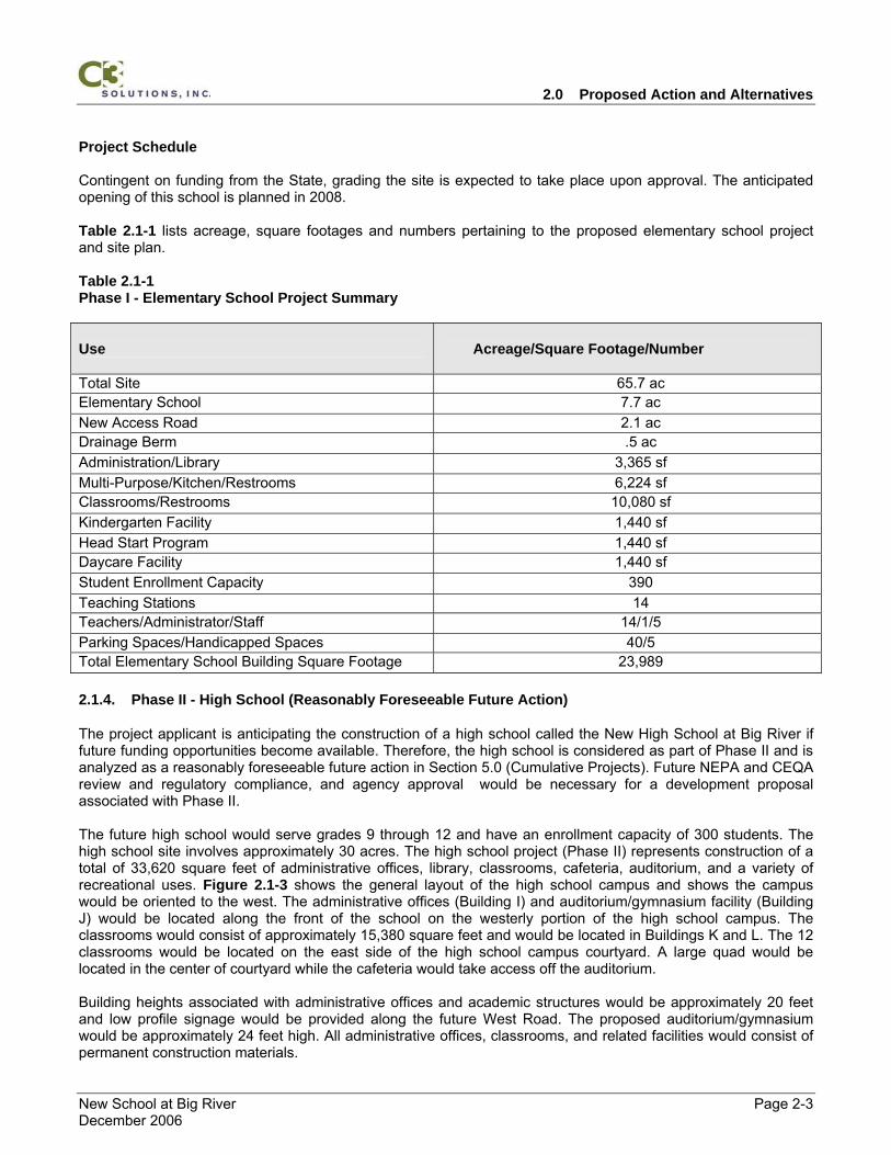
Project Schedule Contingent on funding from the State, grading the site is expected to take place upon approval. The anticipated opening of this school is planned in 2008. Table 2.1-1 lists acreage, square footages and numbers pertaining to the proposed elementary school project and site plan. Table 2.1-1 Phase I - Elementary School Project Summary Use
Acreage/Square Footage/Number
Total Site 65.7 ac Elementary School 7.7 ac New Access Road 2.1 ac Drainage Berm .5 ac Administration/Library 3,365 sf Multi-Purpose/Kitchen/Restrooms 6,224 sf Classrooms/Restrooms 10,080 sf Kindergarten Facility 1,440 sf Head Start Program 1,440 sf Daycare Facility 1,440 sf Student Enrollment Capacity 390 Teaching Stations 14 Teachers/Administrator/Staff 14/1/5 Parking Spaces/Handicapped Spaces 40/5 Total Elementary School Building Square Footage 23,989
2.1.4. Phase II - High School (Reasonably Foreseeable Future Action)
The project applicant is anticipating the construction of a high school called the New High School at Big River if future funding opportunities become available. Therefore, the high school is considered as part of Phase II and is analyzed as a reasonably foreseeable future action in Section 5.0 (Cumulative Projects). Future NEPA and CEQA review and regulatory compliance, and agency approval would be necessary for a development proposal associated with Phase II. The future high school would serve grades 9 through 12 and have an enrollment capacity of 300 students. The high school site involves approximately 30 acres. The high school project (Phase II) represents construction of a total of 33,620 square feet of administrative offices, library, classrooms, cafeteria, auditorium, and a variety of recreational uses. Figure 2.1-3 shows the general layout of the high school campus and shows the campus would be oriented to the west. The administrative offices (Building I) and auditorium/gymnasium facility (Building J) would be located along the front of the school on the westerly portion of the high school campus. The classrooms would consist of approximately 15,380 square feet and would be located in Buildings K and L. The 12 classrooms would be located on the east side of the high school campus courtyard. A large quad would be located in the center of courtyard while the cafeteria would take access off the auditorium. Building heights associated with administrative offices and academic structures would be approximately 20 feet and low profile signage would be provided along the future West Road. The proposed auditorium/gymnasium would be approximately 24 feet high. All administrative offices, classrooms, and related facilities would consist of permanent construction materials.
2.0 Proposed Action and Alternatives
New School at Big River Page 2-4 December 2006
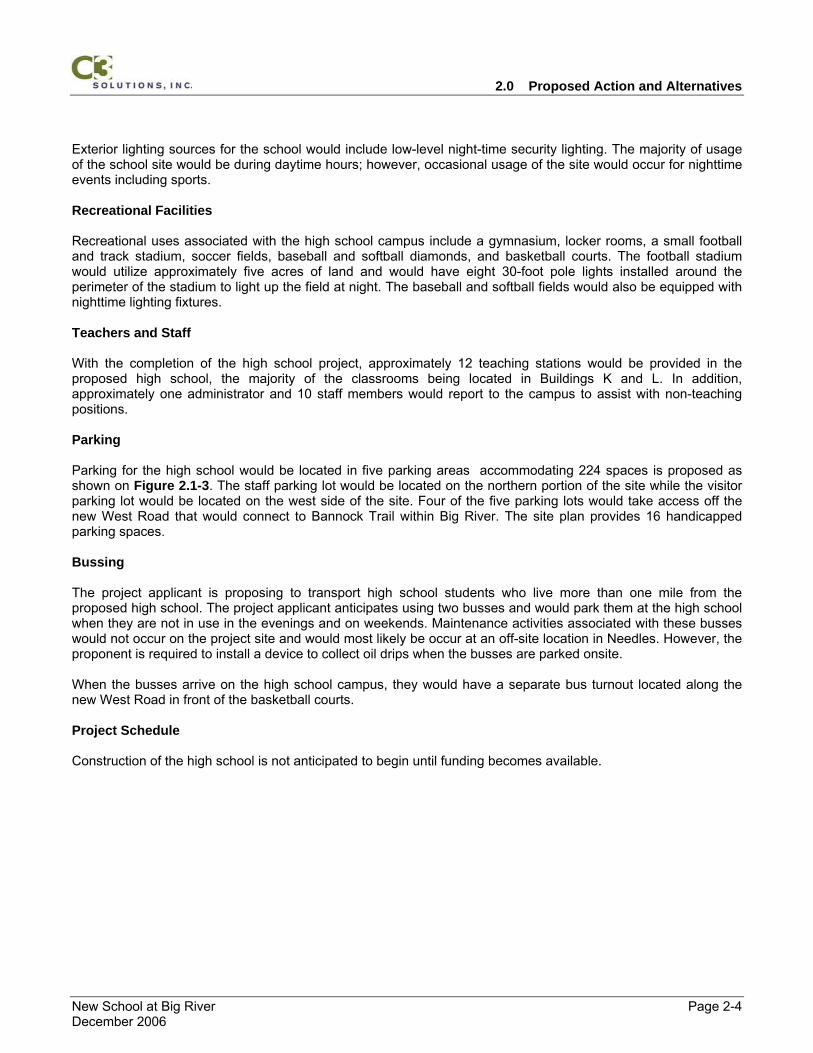
Exterior lighting sources for the school would include low-level night-time security lighting. The majority of usage of the school site would be during daytime hours; however, occasional usage of the site would occur for nighttime events including sports. Recreational Facilities Recreational uses associated with the high school campus include a gymnasium, locker rooms, a small football and track stadium, soccer fields, baseball and softball diamonds, and basketball courts. The football stadium would utilize approximately five acres of land and would have eight 30-foot pole lights installed around the perimeter of the stadium to light up the field at night. The baseball and softball fields would also be equipped with nighttime lighting fixtures. Teachers and Staff With the completion of the high school project, approximately 12 teaching stations would be provided in the proposed high school, the majority of the classrooms being located in Buildings K and L. In addition, approximately one administrator and 10 staff members would report to the campus to assist with non-teaching positions. Parking Parking for the high school would be located in five parking areas accommodating 224 spaces is proposed as shown on Figure 2.1-3. The staff parking lot would be located on the northern portion of the site while the visitor parking lot would be located on the west side of the site. Four of the five parking lots would take access off the new West Road that would connect to Bannock Trail within Big River. The site plan provides 16 handicapped parking spaces. Bussing The project applicant is proposing to transport high school students who live more than one mile from the proposed high school. The project applicant anticipates using two busses and would park them at the high school when they are not in use in the evenings and on weekends. Maintenance activities associated with these busses would not occur on the project site and would most likely be occur at an off-site location in Needles. However, the proponent is required to install a device to collect oil drips when the busses are parked onsite. When the busses arrive on the high school campus, they would have a separate bus turnout located along the new West Road in front of the basketball courts. Project Schedule Construction of the high school is not anticipated to begin until funding becomes available.
2.0 Proposed Action and Alternatives
New School at Big River Page 2-5 December 2006
Table 2.1-2 lists acreage, square footages and numbers pertaining to the proposed high school project and site plan. Table 2.1-2 Phase II - High School Project Summary
Use
Acreage/Square Footage/Number
Total Site 65.7 ac High School Site 30 ac Access Road 4.3 ac Drainage Berm .5 ac Administrative/Library 6,500 sf Auditorium/Gymnasium/Locker Rooms 11,740 sf Classrooms 15,380 sf Football Field 5 ac Other Recreational Facilities 15 ac Student Enrollment Capacity 300 Teaching Stations 12 Teachers/Administrator/Staff 12/1/10 Parking Spaces/Handicapped Spaces 208/16 Total High School Building Square Footage 33,620
2.1.5. Ancillary Facilities
In addition to the educational facilities, the project applicant would also construct several ancillary facilities to serve both the elementary and high schools. These facilities include a water well, water storage tank, a leach field, drainage diversion berms, and a drainage retention facility as shown on Figure 2.1-1. Table 2.1-3 outlines each of these facilities and the corresponding acreage or square footages. Table 2.1-3 Ancillary Facilities Summary Use
Acreage/Square Footage/Number
Total Site 65.7 ac Elementary School Site (Phase I) 7.7 ac High School Site (Phase II) 30 ac Access Road (Phase I) 2.1 ac Access Road (Phase II) 4.3 ac Water Storage Tank (Phase I) .5 ac Water Well (Phase I) .5 ac Leach Field (Phase I) .5 ac Drainage Diversion Berm (Phase I) .5 ac Drainage Diversion Berm (Phase II) .5 ac Infiltration Basin (Phase I) .2 ac Open Space 15
2.0 Proposed Action and Alternatives
New School at Big River Page 2-6 December 2006
Water Supply The water well is proposed to be constructed in a small (200 square foot) area and fenced from the public. The wellhead would be approximately four feet high and would be located immediately west of the elementary school campus along the new North Road as shown on Figure 2.1-1. Water treatment would consist of adding chlorine to meet public drinking water standards. The water treatment facility would be subject to inspection and permit issuance by San Bernardino County’s Division of Environmental Health Services. Water Storage Tank The water storage tank would consist of a 500,000-gallon metal facility and would be located on one half acre of land west of the elementary school campus as shown on Figure 2.1-1. The water tank would be approximately 20-30 feet high and painted a tan color to blend into the desert landscape. In addition, the water storage tank would be located behind a chain link fence. Sanitary and Solid Waste Disposal A one half acre leach field is proposed to accommodate sanitary sewage from both educational facilities and would be located immediately west of the elementary school campus along the new North Road (Figure 2.1-1). The leach field would be located below the water well and water storage tank and would be sized to accommodate waste from both the elementary and high school. This solid waste disposal system would require a Septic/Leach Field Permit from the San Bernardino County Public Works Group (PWG). Solid waste would be placed in outside covered waste bins and would be collected twice a week and deposited at the La Paz Landfill in Quartzsite. Electrical and Telephone Services Electrical power would be supplied to the site via the Southern California Edison Company (SCE) who is planning to install a 3.75-mile long 12-kilovolt (kV) power line from Calzona to the southwest portion of the site. This new powerline is subject to issuance of a right-of-way permit by the BLM. Appendix K contains a mapprepared by SCE pertaining to the proposed Needles New Pole Line Project. Telephone service would be provided by Verizon who currently provides residential telephone services to homes located in the Big River area. Existing overhead telephone lines are currently located along most of the residential streets in Big River and would be extended to the proposed educational facilities. Drainage Facilities There are several desert washes traversing the northern portion of the site and water is confined to these drainages only during times of intense precipitation. The applicant would construct a .5 acre berm (rock rip rap) along the north side of the proposed North access road to divert surface flows to an intake facility under the elementary school site (Phase I). The applicant would then construct a .5 acre berm (rock rip rap) along the north side of the proposed West access road to divert surface flows under the high school site (Phase II). The applicant would also regrade land on both sides of the washes to keep surface waters within the confines of the drainages. Surface waters would then be directed into its existing path which exits the project site and flows in a southerly direction. Construction of the new roadway system would require the construction of a drainage berm along the new roadway as well as installation of a culvert under the roadway to convey intermittent flows north of the site. The top of all new building pads would be constructed above the elevation of the existing desert washes in order to avoid flooding. In order to retain surface flows generated from new impervious surfaces including a parking lot, asphalt play courts, and walkways, the project applicant would construct a one acre drainage retention/infiltration basin on the southeastern portion of the site. A summary of the Stormwater Pollution and Prevention Plan
2.0 Proposed Action and Alternatives
New School at Big River Page 2-7 December 2006
(SWPPP) to address controlling construction related erosion and sedimentation is incorporated by reference as Appendix I.
2.1.6. Construction Activities
Construction Timeframes and Workforce During the 18-month construction period associated with the elementary school, it is estimated that approximately 20 construction contractors would be working at the project site on grading activities, roadway construction, building construction, electrical, plumbing, and/or landscape construction. They would work from 7 am to 6 pm Monday through Saturday and be supervised by a construction superintendent retained by the project proponent. Appendix M contains a copy of a site specific Health and Safety Plan required by the California Occupational Safety and Hazard Administration (CalOSHA) which would be enforced by the proponent’s construction superintendent. This plan outlines specific measures including injury illness prevention measures and incident reporting steps. Construction Equipment It is anticipated that clearing, grading, construction, and landscaping activities would require the use of three grade scrapers, two graders, four backhoes, two tractors, two forklifts, and several tractor/trailers that would bring construction materials to the site. In addition, the 20 construction contractors would either commute together or bring personal vehicles to the site each day. Construction equipment would remain on-site during the various construction activities. Traffic control would be accomplished by the construction superintendent providing all necessary construction signage and traffic control devices as recommended by the San Bernardino PWG. The PWG would review the site plan and would make specific recommendations to the proponent to exercise during construction activities.
2.1.7. Applicant Initiated Environmental Construction Measures
In order to minimize adverse impacts to the environment, the project applicant would be required to comply with BLM standard operating procedures for the use of public lands as required by law, regulation, and other BLM guidelines. The following environmental construction measures would be employed by the project applicant and/or the construction superintendent. Erosion and Sediment Control CM-1 The project applicant is preparing a Stormwater Pollution and Prevention Plan (SWPPP) to address
controlling construction related erosion and sedimentation and would obtain an NPDES permit from the RWQCB stipulating permissible waste discharge requirements (WDRs).
CM-2 The construction superintendent would be responsible for constructing and installing all BMP measures
outlined in the SWPPP to limit sediment movement. Flow dissipation and sediment control structures would also be constructed in appropriate locations. Small sediment areas, designed for catching runoff and storing sediment from exposed and erodible surfaces would be built prior to construction start-up where they are deemed necessary. These structures would be maintained and cleaned out as often as necessary for as long as erodible surfaces were exposed. Small hay bale dams would be placed below slopes as temporary erosion control measures.
Invasive and Noxious Weeds CM-3 To prevent the introduction or spread of noxious weeds to other areas, the construction superintendent
would power wash construction vehicles and equipment, including body and undercarriages, prior to moving the equipment on-site and beginning earthmoving activities.
2.0 Proposed Action and Alternatives
New School at Big River Page 2-8 December 2006
CM-4 The construction superintendent would use weed-free erosion control materials (i.e., straw bales) during grading and construction activities to control surface runoff.
CM-5 The construction superintendent would use a weed free grass species mix to seed the proposed
athletic field. CM-5.5 The project applicant would be responsible for implementing an invasive species monitoring program to
identify and remove any invasive species if they were revealed. Traffic and Circulation CM-6 The project applicant would contact the San Bernardino County Public Works Group (PWG) to discuss
installing the following signs W65 (School), R2(25) Speed Limit 25), and R72 (When Children are Present) in the vicinity of the proposed project.
CM-7 The project applicant would contact the San Bernardino County PWG to discuss installing the following
signs W66 (School Crossing-logo) and W66A (School Crossing-words) in the vicinity of the proposed project.
CM-8 The project applicant would contact the San Bernardino County PWG to discuss installing a W65-1
(End School Zone) or R2 (Speed Limit) signs, which notifies drivers that they are exiting into a 25 miles per hour (mph) “school zone”.
CM-9 The project applicant would contact the San Bernardino County PWG to discuss installing stop signs
(R1) at every access point where vehicles would be exiting a school site and returning to county streets. CM-10 The project applicant would contact the San Bernardino County PWG to discuss installing yellow school
crosswalks in front of both schools and at major intersections in the Big River area. CM-11 The new access roadway would be constructed to meet San Bernardino County roadway standards
with an approximate right-of-way width of 40 feet and a paved width of 26 feet. Because the proposed access road is located on BLM land, the roadway can not exceed a 30 percent berm slope and breaks in the berm need to be located at 300 foot intervals.
Surface Hydrology and Groundwater CM-12 A detailed hydrologic analysis to determine the anticipated amounts and rate of post-development
storm water runoff is incorporated by reference in Appendix I. Calculations of the amount of post-development impervious surface have been made and calculations of anticipated runoff are determined using accepted engineering methods. Considerations include slope, impervious surface, and both average and 100-year storms. Worst-case case scenario calculations are used to size onsite storm water infrastructure. Drainage systems are engineered and designed so that post development site runoff is safely conveyed offsite. Drainage systems are engineered and designed so that the rate and amount of post development site runoff leaving the site does not adversely affect offsite downstream populations or structures.
Public Health and Safety/Hazardous Materials CM-13 The project applicant would follow the Public Health and Safety Plan (Appendix M) which outlines the
storage and use of hazardous materials, the prevention of spill incidents, and emergency response procedures. The plan also describes the various chemicals to be stored and used on the project site (i.e., fertilizers, chlorine, etc.). This plan also establish procedures and methods to transport, store, and clean up a spill involving hazardous materials in compliance with state and county regulations and ordinances. In addition, the plan outlines construction measures and operational procedures to follow in the event of an emergency.
2.0 Proposed Action and Alternatives
New School at Big River Page 2-9 December 2006
The proposed project is located within the approximate 18,000 square mile Desert Training Center/California-Arizona desert maneuver area active from 1942-1944. While there are no known emissions related training activities at the proposed site, the following measures should be followed during initial construction activities. UXO Hazard Precautions CM-14 Construction personnel should be aware that ordnance (OE) and ordnance-related items may be
encountered on the project site. Personnel should be on alert for OE and OE-related scrap. The following general precautions with regards to ordnance should be observed at all times:
• Should suspected UXO be encountered, personnel should immediately evacuate the work area to an upwind location; • DO NOT touch or move any ordnance item(s) regardless of the markings or apparent condition; • DO NOT remain in a suspected ordnance/UXO area if an electrical storm is occurring or approaching. If a storm approaches during a site visit, leave the site immediately and seek shelter; • DO NOT use radios or cellular phones in the vicinity of suspect ordnance items; • DO NOT drive vehicles into a suspected OE/UXO area; and • Always assume ordnance items contain a live charge until it can be ascertained otherwise. Specific Actions to Be Taken Upon Locating Ordnance CM-15 Construction personnel should be aware of the following specific actions to take upon locating an
Ornance: • Do not be misled by markings on the ordnance item stating practice bomb or inert. Even practice bombs have explosive charges that are used to mark/spot the point of impact; or the item could be mismarked; • Do not disturb the item. Do not roll it over or scrape the item to identify the markings; • The general location of any ordnance items found during project activities should be clearly marked so it can be easily located and avoided; and • Upon locating any suspected OE/UXO item, notify the federal interagency communication center at (909) 383-5651. Occupational Safety and Health Administration CM-14 The project applicant and construction superintendent would be subject to the Occupational Safety
Health Administration (OSHA) which sets forth mandatory health and safety standards for construction sites. These standards include mandatory incident reporting, weekly tailgate meetings, and monthly safety meetings with the contractor to discuss potential health and safety issues. In addition, the construction superintendent would be responsible for verifying that all construction personnel working on the project site is a legal citizen or possesses an employment visa.
Air Quality/Fugitive Dust Control CM-15 Subject to BLM approval, the construction superintendent would apply water or a chemical wetting
agent to all excavated surfaces, dirt roads, and material stockpiles to prevent excessive amounts of dust during grading and construction activities. The pooling of water would be prevented so as to not attract desert tortoises.
CM-16 The construction superintendent would cease all earth moving or excavation activities during periods of
high winds (i.e., winds greater than 20 mph averaged over one hour). CM-17 The construction superintendent would sufficiently water or secure all material transported off-site to
prevent excessive amounts of dust.
2.0 Proposed Action and Alternatives
New School at Big River Page 2-10 December 2006
CM-18 The construction superintendent would control fugitive dust emissions by limiting all on-site construction vehicle speeds to 15 mph.
CM-19 The construction superintendent would control Ozone precursor emissions from mobile equipment by
keeping all engines in good condition and in proper tune according to manufacturer's specifications. CM-20 The construction superintendent would monitor on-site mobile equipment which should not be left idling
for periods longer than 60 seconds. Cultural Resources CM-21 If buried cultural materials are identified are during construction activities, the construction
superintendent would halt all work in that area until a qualified archaeologist can evaluate the nature and significance of the finds. Upon discovery of potential human skeletal remains, all activity in the area of discovery would cease immediately. The County Coroner would be notified immediately (within 24 hours) to make a determination as to human or nonhuman skeletal remains, and the circumstances, manner and cause of death. At the same time, the BLM would also be notified of the discovery. If the Coroner determines that the remains are Native American, the BLM and/or the proponent would contact the Native American Heritage Commission (NAHC) to identify a Most Likely Descendent. The BLM would also notify the potentially effected Tribe(s).
Biological Resources In the following biological measures, a “qualified biologist” is defined as a trained wildlife biologist who is knowledgeable concerning desert tortoise biology, tortoise mitigation techniques, tortoise habitat requirements, identification of tortoise sign, and procedures for surveying for tortoises. Evidence of such knowledge may include one or more of the following: employment as a field biologist working on desert tortoise or successful completion of a contract dealing with desert tortoise fieldwork. Attendance at the training course sponsored by the Desert Tortoise Council would be a supporting qualification. An “authorized biologist” is defined as a wildlife biologist who has been authorized to handle desert tortoises. An authorized biologist must be approved by the FWS, the DFG and the BLM. No authorized biologists will be approved for this project. CM-22 The project proponent would designate a field contact representative (FCR) who would be responsible
for overseeing compliance with protective measures for the desert tortoise and for coordination on compliance with the BLM. The FCR must be on-site during all project activities. The FCR would have authority to halt all project activities that are in violation of the measures. The FCR would have a copy of all stipulations when work is being conducted on the site. The FCR may be a crew chief or field supervisor, a project manager, any employee of the project proponent, or a contracted biologist.
CM-23 All employees of the project proponent who work on-site would participate in a tortoise education
program prior to initiation of field activities. The construction superintendent would be responsible for ensuring that the education program is developed and presented prior to conducting activities. New employees would receive formal, approved training prior to working on-site. The employee education program must be received, reviewed, and approved by the BLM at least 15 days prior to the presentation of the program. The program may consist of a class presented by a qualified biologist (BLM or contracted) or a video. The program would cover the following topics at a minimum: distribution of the desert tortoise, general behavior and ecology of the tortoise, sensitivity to human activities, legal protection, penalties for violations of State or Federal laws, reporting requirements, and project protective mitigation measures.
CM-24 No desert tortoise will be handled on the project site. The project proponent will submit the name(s) of
proposed qualified biologist(s) to the BLM for review and approval at least 30 days prior to the onset of
2.0 Proposed Action and Alternatives
New School at Big River Page 2-11 December 2006
activities. No activities will begin until a qualified biologist is approved. The submission of qualifications to the BLM will follow the Ventura U.S. Fish and Wildlife Service format found at the following web site:
CM-25 Except when absolutely required by the project and as explicitly stated in the project permit, cross-
country vehicle use by employees is prohibited during work and non-work hours. CM-26 A desert tortoise clearance survey of the project site would be performed by a qualified biologist no
more than 14 days prior to any activity involving surface disturbance within the range of the desert tortoise. If desert tortoises, burrows, or other habitat features are found within the project site, the qualified biologist must contact BLM immediately. Work on the project would not proceed until the BLM has consulted with the FWS under the auspices of Section 7(a)(2) of the ESA of 1973 as Amended.
CM-27 The project site would be enclosed within a tortoise-proof fence and an effective desert tortoise-proof
gate to exclude desert tortoises prior to initiating construction activity. The fence would be constructed under the direction of a qualified biologist. The fence would be composed of erosion control silt fencing. The silt fence would extend at least 24 inches above the ground and at least six inches folded outward and fastened to the ground to prevent desert tortoises from entering the site. The fence would be supported sufficiently to maintain its integrity and the integrity of the fencing would be checked once per week. Gate(s) would be desert tortoise proof and would remain closed except for the immediate passage of vehicles.
CM-28 After installation of the desert tortoise-proof fencing, the qualified biologist would conduct a thorough
survey for desert tortoises within the project area. The fencing would be maintained when necessary to ensure its integrity. Should any of the fencing be found to be compromised, the qualified biologist would conduct a thorough survey within the enclosed area. In the event a desert tortoise is found within the enclosure at any time, all work would stop and the FCR would contact the BLM immediately. Work on the project shall not proceed until the BLM has consulted with the FWS under the auspices of Section 7(a)(2) of the ESA of 1973 as Amended.
CM-29 The presence of desert tortoise proof fencing around the entire project site would preclude the need for
a qualified biologist on site during surface disturbing activities, but a FCR would need to be present to ensure compliance with terms and conditions.
CM-30 Upon locating individuals of a listed species that are dead or injured as a direct result of construction
activities, immediate initial notification would be made to CDFG, the Service’s Division of Law Enforcement at (310) 328-1516 and the Bureau’s Needles Field Office at (760) 326-7000. Notification would also be made to the Ventura Fish and Wildlife Office at (805) 644-1766. Written notification would be made within five calendar days and include the date, time, and location of the carcass, a photograph, cause of death, if known, and any other pertinent information. The BLM would endeavor to recover and place the remains of intact listed species with educational or research institutions holding the appropriate state and Federal permits per their instructions. If such instructions are not available or the animal’s remains are in poor condition, the information above would be noted and the carcass left in place. The BLM through an authorized biologist would make arrangements regarding proper disposition of potential museum specimens with the institution prior to implementation of the action.
CM-31 Work area boundaries and access routes will be delineated with flagging or other marking to minimize
surface disturbance associated with vehicle straying. Work area assessments will be performed by qualified biologists, and/or FCRs to ensure that construction activities are conducted within the pre-defined work area. The qualified biologist, in consultation with the project proponent, will ensure compliance with this measure.
2.0 Proposed Action and Alternatives
New School at Big River Page 2-12 December 2006
CM-32 An injured listed species would be transported to a qualified veterinarian for treatment at the expense of the project proponent. If an injured animal recovers, the appropriate field office of FWS should be contacted for final disposition of the animal.
CM-33 Except on county-maintained roads, vehicle speeds would not exceed 20 miles per hour through desert
tortoise habitat. CM-34 Workers would inspect for tortoises under a vehicle prior to moving it. If a tortoise is present, the worker
would not move his/her vehicle until the desert tortoise has moved away on its own accord. CM-35 No dogs would be allowed on the project site during construction activities. CM-36 All trash and food items would be promptly contained within closed, common raven-proof containers
and would be removed daily from the project site to reduce the attractiveness of the area to common ravens (Corvus corax) and other predators of the desert tortoise.
CM-37 Firearms are prohibited on the project site during construction activities. CM-38 Any trenches or excavations temporarily created would either be sloped at the end of each work day in
such a manner as to allow wildlife to escape, or would covered with temporary barriers such as plywood sheeting. All holes and trenches would be inspected for desert tortoise and other wildlife occupancy at the beginning and end of each work day. If holes or trenches are not being used for construction activities, they would be covered or backfilled to prevent wildlife entrapment.
Noise CM-39 The construction superintendent would comply with California State and San Bernardino County noise
ordinances. (I.e. Daytime work hours shall have noise levels not to exceed 10 dBA above background levels at the property line. Daytime work hours are considered daylight or 7:00 a.m. whichever is later and thirty minutes after dusk. Weekend work must start after 8:00 a.m.)
The following section describes alternatives to the Proposed Project. This includes the No Action Alternative.
2.1.8. No Action Alternative
Under the No Action Alternative, the BLM would not grant approval to lease federal land to build an elementary and high school in the Big River area. A new school would not be constructed at Big River and students attending elementary school would continue to attend school at Parker Dam. When the Parker Dam lease with the USBR expires, the students would have to attend elementary school in Arizona. Under the No Action Alternative, the potential impacts identified in this EA/Initial Study would not occur.
2.2. Alternatives Considered but Eliminated
The project applicant has considered several alternatives to constructing the proposed educational facilities on the project site including the following options: ▪ Extend current lease at Parker Dam Elementary School; ▪ Construct project on Reservation Land in Big River; and ▪ Buss Students to Arizona.
2.0 Proposed Action and Alternatives
New School at Big River Page 2-13 December 2006
2.2.1. Extend Current Lease
Under the Extend Current Lease Alternative, the project applicant would request USBR to extend the current lease and the potential impacts identified in this EA/Initial Study would not occur. This alternative was eliminated from further consideration because the USBR is not interested in extending the lease past 2007.
2.2.2. Construct Project on Reservation Land
Under the Construct Project on Reservation Land Alternative, the project applicant would not submit an application for an R&PP lease and the BLM would not grant approval to lease federal land to build an elementary and high school in the Big River area. Instead, the project applicant would propose to lease approximately 60-acres of tribal land within the Big River area and build the proposed project. Under the Construct Project on Reservation Land Alternative, the potential impacts identified in this EA/Initial Study would occur on tribal land immediately east of BLM land in the Big River area. This alternative was eliminated from further consideration after negotiations between the project applicant and CRIT ended without resolution.
2.2.3. Buss Students to Arizona Alternative
Under the Buss Students to Arizona Alternative, the project applicant’s current lease with the USBR to operate the Parker Dam Elementary School would terminate and the District would transport elementary school aged students to Parker, Arizona to attend school. Under the Buss Students to Arizona Alternative, the potential impacts identified in this EA/Initial Study would not occur on BLM land in the Big River area. This alternative was eliminated from further consideration because of financial constraints associated with continuing to reimburse the State of Arizona for educating students living in California. The project applicant also determined it was not in the best interests of elementary students living in California to be bussed out-of-state (Arizona) to receive a public education.
2.0 Proposed Action and Alternatives
New School at Big River Page 2-14 December 2006
Figure 2.1-1 Phase I - Elementary School Site Plan
2.0 Proposed Action and Alternatives
New School at Big River Page 2-15 December 2006
Figure 2.1-2 Phase I - Elementary School Building Elevations
2.0 Proposed Action and Alternatives
New School at Big River Page 2-16 December 2006
Figure 2.1-3 Phase II – High School Site Plan
2.0 Proposed Action and Alternatives
New School at Big River Page 2-17 December 2006
3.0 Public Scoping and Issue Identification
New School at Big River Page 3-1 December 2006
3.0 PUBLIC SCOPING AND ISSUE IDENTIFICATION
3.1. BLM Scoping
In 2003, the project applicant met with the Needles Field Office to discuss constructing an educational facility on BLM land in Big River which started an informal internal scoping process. During the same year, the project applicant also met with the CDE and other responsible agencies to discuss the proposed project. The issues and concerns discussed during internal scoping meetings with the BLM involved addressing the potential impacts to soils, hydrology, vegetation, wildlife, recreation, and visual resources. The following federal legislation, regulations, and executive orders require government-to-government consultation between federally-recognized Native American Indian Tribes and federal agencies prior to taking action that might affect Native American Tribes: ▪ American Indian Religious Freedom Act; ▪ Religious Freedom Restoration Act; ▪ Archaeological Resources Protection Act: ▪ Section 106 of the National Historic Preservation Act, as amended (16 USC Section 470); and ▪ Executive Orders 12898 and 13007. The purpose of the government-to-government consultation process is to discuss the issues and concerns of a project with local Native American Tribes before a project is approved. Information gathered from the Native Americans is typically used to develop project alternatives and mitigation measures that would abate or reduce potential affects from a project. An information gathering process to identify Native American concerns related specifically to the proposed project was initiated by the BLM in 2003 and has continued throughout the project. The BLM sent notification to the CRIT in the form of a letter before the cultural resource surveys were conducted. A second letter was sent to CRIT to discuss options associated with providing access to the project site. In 2005, CRIT signed a Memorandum of Understanding (MOU) granting access to the project applicant via two 200-foot long (80- and 60-foot wide) roadway easements across tribal lands. In addition, consultation was conducted with both the Chemehuevi and Fort Mojave Indian Tribes.
3.2. Critical Elements of the Human Environment
Based on internal scoping, it was determined that the following critical elements of the human environment were either not present or would not be affected by the Proposed Action or No Action Alternative: ▪ Areas of Critical Environmental Concern ▪ Prime or Unique Farmlands ▪ Wild and Scenic Rivers ▪ Wetland and Riparian Zones ▪ Floodplains ▪ Wilderness
3.3. Resources Not Affected
In addition to the above-referenced critical elements, it was determined during scoping that the following resources would not affected by the Proposed Action or No Action Alternative: ▪ Wild, Free-Roaming Horses and Burros ▪ Mineral Resources ▪ Livestock Grazing ▪ Socioeconomics
3.0 Public Scoping and Issue Identification
New School at Big River Page 3-2 December 2006
3.4. Issues and Resources Present and Brought Forward for Analysis
The following resources were determined to be potentially affected by the Proposed Action or the No Action Alternative and therefore, have been analyzed in detail throughout Section 4.0. ▪ Soils and Geology ▪ Recreation ▪ Land Use ▪ Vegetation and Wildlife ▪ Invasive and Noxious Weeds ▪ Traffic and Circulation ▪ Noise ▪ Air Quality ▪ Surface and Groundwater ▪ Public Services and Utilities ▪ Health and Safety/Hazardous Materials ▪ Cultural Resources ▪ Native American Religious Concerns ▪ Environmental Justice
4.0 Affected Environment, Impacts and Mitigation
New School at Big River Page 4-1 December 2006
4.0 AFFECTED ENVIRONMENT, IMPACTS, AND MITIGATION
4.1. Soils and Geology
A site specific Geologic/Seismic Site Evaluation was conducted by John R. Byerly, Inc. to satisfy the requirements of California Education Code § 17212.5. Appendix E contains a copy of the Geologic/Seismic Site Evaluation.
4.1.1. Proposed Action
4.1.1.1 Affected Environment
The project site is located in the Vidal Valley, in the Mojave Desert Geomorphic Province, south of the Whipple Mountains. The Mojave Desert Geomorphic Province is a broad triangular-shaped region of low relief interrupted by northwest trending mountain ranges structurally controlled, in part, by faulting. The Whipple Mountains are located approximately four miles north of the site. The project site is within Quaternary-aged unconsolidated to semi-consolidated alluvial deposits, much of it within alluvial fan deposit of the Whipple Mountains. The uppermost bedrock unit is mapped as Tertiary volcanic flow rocks or minor pyroclastic deposits. Topography in the vicinity of the project site is considered gently rolling toward the southeast. Elevations range between 480 and 520 feet above mean sea level (msl). Total site relief across the project site is approximately 32 feet. A south-trending desert wash traverses the eastern portion of the project while a smaller desert wash traverses the western portion of the site. Soils are primarily deep well-drained soils developed on fan pediments and on basin edges. Soils are considered coarse-grained soils, particularly gravel, gravel with fines, silty gravel, and clayey gravel. These types of soils are characterized as having low erosion susceptibility. According to the BLM, a Mineral Potential Report has been prepared for the proposed site. The Mineral Report has identified potential sand and gravel resources present on site which have potential value. Because of their potential value, sand and gravel resources will be retained in federal ownership. The proponent would be allowed the use of those resources but would not be allowed to sell or remove from the site any sand or gravel resources under the terms of the lease. Faulting There are no faults known to traverse the project site and the subject site is not located in an Alquist-Priolo (AP) earthquake fault zone. The closest AP earthquake zone is located approximately 90 miles to the west and is called the Mesquite Lake Fault. The San Andreas Fault is located approximately 92 miles southwest of the project site. The site is located in Seismic Zone 3 as defined in the California Building Code. Based on a design basis earthquake (DBE) of 7.5 on the San Andreas Fault, the greatest mean value of the peak ground acceleration expected on the project site could be 0.03 gravity (g). Liquefaction occurs when water saturated sediments, mainly sand and silt, become suspended and flow due to vibratory motions such as those induced by earthquakes. The project site does not lie within an area designated as susceptible to liquefaction. Landslides are the downslope movement of geologic materials. The stability of slopes is related to a variety of factors, including the slope's steepness, the strength of geologic materials, and characteristics of bedding planes, joints, faults, vegetation, surface water, and groundwater conditions. The site consists of relatively flat terrain and landslides do not appear to be an issue.
4.0 Affected Environment, Impacts and Mitigation
New School at Big River Page 4-2 December 2006
4.1.1.2 Significance Criteria
Pursuant to CEQA, an impact to soils and geologic resources would be considered significant if the proposed project: ▪ Exposed people or structures to major geologic hazards including landslides, slope failures, and subsidence; or ▪ Resulted in structural damage caused by seismic loading from an earthquake. Pursuant to the NEPA, consideration of significant impact on the human environment is conducted in accordance with Title 40 Code of Federal Regulations 1508.27 (specified in section 1.4). Following the public comment period, a finding regarding significant impact will be prepared in accordance with this provision.
4.1.1.3 Impacts and Mitigation
Implementation of the proposed project would result in the construction of an elementary school and related recreational facilities on approximately 12-acres of the 65.7-acre project site. Due to the project's distance from the Mesquite Lake and San Andreas Faults, there is a low possibility of ground rupture on the project site. Despite the low potential for significant ground shaking at the site, the proposed educational facilities would be designed to safely withstand the peak ground acceleration expected at the site. The proposed project would also be designed to meet current seismic safety standards for schools, as required by the Field Act. All school buildings are required to meet the Field Act structure design requirements enacted by the California State Legislature to ensure seismically safe school facilities. Compliance with these standards would reduce hazards from strong seismic ground shaking to less than significant levels and no mitigation measures are required pursuant to CEQA. The project site does not lie within an area designated as susceptible to liquefaction therefore liquefaction does not need to be considered in the design of future structures. Since the project site is relatively flat, the potential for a landslide or mudslide appears to be low. This impact is considered to be less than significant and no mitigation measures are required pursuant to CEQA.
4.1.2. No Action Alternative
Selection of the No-Action Alternative, as described in Section 2.2.1, would not result in construction of the proposed project and potential effects to soils and geological resources described in Section 4.1.1.3 would not occur.
4.2. Recreation
Recreation policies on BLM land in the vicinity of the project site are guided by the CDCA Plan (1980).
4.2.1. Proposed Action
4.2.1.1 Affected Environment
Dispersed outdoor recreation is the predominant type of recreation on BLM land in the vicinity of the project site. Primary dispersed recreational uses in the area include walking, hiking and limited off-highway vehicle (OHV) use. Recreation policies on BLM land within the vicinity of the project site are guided by the CDCA Plan (1980). According to the CDCA Plan, there are no wilderness areas, areas of critical environmental concern (ACEC), national parks/monuments, or national historic sites located on or near the project site. Private recreational uses in the vicinity of the project site are located along the Colorado River and include Big River Park which is maintained by the Big River Community Services District (CSD). Big River Park is located approximately two miles east of the project site and includes play equipment for young children, volleyball courts, a boat ramp, and a boat dock.
4.0 Affected Environment, Impacts and Mitigation
New School at Big River Page 4-3 December 2006
4.2.1.2 Significance Criteria
Pursuant to CEQA, impacts to recreation would be considered significant if the proposed project: ▪ Conflicted with an established recreational, educational, religious, or scientific use of the area; ▪ Degraded the quantity or quality of the area available for recreational opportunities; or ▪ Resulted in the loss of a unique recreational resource. Pursuant to the NEPA, consideration of significant impact on the human environment is conducted in accordance with Title 40 Code of Federal Regulations 1508.27 (specified in Section 1.4). Following the public comment period, a finding regarding significant impact will be prepared in accordance with this provision.
4.2.1.3 Impacts and Mitigation
Implementation of the proposed project would result in the construction of an elementary school and related recreational facilities on approximately 12-acres of the 65.7-acre project site. The recreational facilities associated with the elementary school campus would include an indoor multi-purpose facility/gymnasium; two basketball courts; one soccer field; three playground apparatus areas, and two baseball diamonds. The proposed project would not conflict with any established recreational, educational, religious, or scientific uses. In addition, the project would not degrade the quantity or quality of the area available for recreational opportunities. The proposed project would provide additional recreational opportunities for students attending the elementary and high schools as well as the residents of the adjacent residential community. This impact is considered to be less than significant and no mitigation measures are required pursuant to CEQA.
4.2.2. No Action Alternative
Selection of the No-Action Alternative, as described in Section 2.2.1, would not result in construction of the proposed project and potential effects to the recreational resources described in Section 4.2.1.3 would not occur.
4.3. Land Use
Land use policies on BLM land within the vicinity of the project site are guided by the CDCA Land Use Plan (1999).
4.3.1. Proposed Action
4.3.1.1 Affected Environment
The project site is located on 65.7-acres of BLM land in the southeastern part of the CDCA. The project site is also located directly adjacent to and west of tribal lands belonging to CRIT. Existing land uses in the vicinity of the project site include vacant BLM land and residential uses on tribal property. Land use policies on BLM land within the vicinity of the project site are guided by the CDCA Plan (1980 as amended). There are no private lands, state lands, military boundaries, national park boundaries, or competitive event corridors located on or in the vicinity of the project site. The land use classification for project site is designated as Class L “Limited Use” which limits motorized vehicle travel to “Approved Routes of Travel”. The CDCA Plan also states that BLM lands should be made available for community expansions and public uses. Land uses on tribal land adjacent to the project site are guided by the Big River Master Plan and Big River Enterprises (tribal organization) is responsible for managing development in Big River. Big River also includes several commercial areas, a community park, and open space corridors. There are approximately 5,000 lots that have been subdivided of which approximately 700 residential homes have been constructed within Big River. The Big River Master Plan has designated land directly adjacent to the project site for small residential homes on 20,000 square foot lots along Osage Trail. Only one residential home has been constructed on Osage Trail
4.0 Affected Environment, Impacts and Mitigation
New School at Big River Page 4-4 December 2006
adjacent to the project site. There are no existing BLM permitted land uses which conflict with the proposed action.
4.3.1.2 Significance Criteria
Pursuant to CEQA, impacts associated with land use issues would be considered significant if the proposed project: ▪ Resulted in the substantial termination or modification of a land use; ▪ Conflicted with adopted environmental plans and goals of a community where it is located; or ▪ Disrupted or divided the physical arrangement of an established community. Pursuant to the NEPA, consideration of significant impact on the human environment is conducted in accordance with Title 40 Code of Federal Regulations 1508.27 (specified in Section 1.4). Following the public comment period, a finding regarding significant impact will be prepared in accordance with this provision.
4.3.1.3 Impacts and Mitigation
Implementation of the proposed project would result in the construction of an elementary school and related recreational facilities on approximately 12-acres of the 65.7-acre project site. Public lands currently used for open space uses would be removed from use as a result of the proposed project and developed with educational and recreational uses. However, the school would be considered a public use and educational and recreational facilities would remain available to the public and residents of Big River. The proposed project would not conflict with any adopted plans and goals of a community and would not disrupt or divide the physical arrangement of the Big River Master Plan. In addition, the proposed action is in conformance with the CDCA Plan and would not require emendation to the Plan. This impact is considered to be less than significant and no mitigation measures are required pursuant to CEQA.
4.3.2. No Action Alternative
Selection of the No-Action Alternative, as described in Section 2.2.1, would not result in construction of the proposed project and potential effects to the land uses described in Section 4.3.1.3 would not occur.
4.4. Visual Resources
The BLM is entrusted with the care of public lands containing many outstanding scenic landscapes. By law, BLM is responsible for managing these public lands for multiple uses. BLM is also responsible for ensuring that the scenic values of these public lands are considered before allowing uses that may have negative visual impacts.
4.4.1. Proposed Action
4.4.1.1 Affected Environment
The proposed project is located in the eastern Colorado Desert near the Colorado River. The topography is considered relatively flat to rolling; the texture of the vegetation on the site varies from coarse to fine. Colors vary from light tans and grays of the bare ground to the yellow greens and gray greens of the creosote bushes and associated shrubs and grasses as shown on Figure 1.3-3. Traveling east along SR-62, down valley views towards the project site are of a fairly unbroken landscape. Man-made alterations visible from most vantage points along SR-62 include several OHV routes in the middle ground and electrical transmission lines in the background.
4.0 Affected Environment, Impacts and Mitigation
New School at Big River Page 4-5 December 2006
Views of the site from BLM land situated south of the project site, looking up valley are of a fairly unbroken landscape with the Whipple Mountains forming the background view. Man-made elements visible from this vantage point looking north include railroad tracks and several residential structures in the foreground and electrical transmission lines in the middle ground. The area south of the project site is considered to be a semi-developed rural landscape. Views from Modoc Trail and Osage Trail looking west at the project site are of a relatively unbroken landscape interrupted by overhead telephone lines and a man-made berm to control drainage in the area. The area east of the project site is considered to be a developed suburban landscape. Visual Resource Management (VRM) objectives and standards were not adopted in the land use management plan for the proposed project area (California Desert Conservation Area Plan, 1980). However, the proposed project area would fall under VRM Class III which states in H-8410-1; BLM Manual Handbook for Visual Resource Inventory, “The objective of this class is to partially retain the existing character of the landscape. The level of change to the characteristic landscape should be moderate. Management activities may attract attention but should not dominate the view of the casual observer. Changes should repeat the basic elements found in the predominate natural features of the characteristic landscape.”
4.4.1.2 Significance Criteria
Pursuant to CEQA, impacts to visual resources would be considered significant if the proposed project: ▪ Affected the quality of any scenic resources, or scenic resources having rare or unique values; ▪ Affected views from, or the visual setting of, designated or planned parks, wilderness areas, natural
areas, or other visually sensitive land uses; or ▪ Affected views from, or the visual setting of, travel routes; and/or views from, or the visual setting of,
established, designated, or planned recreational, educational, or scientific facilities, use areas, activities, viewpoints, or vistas.
If the proposed project results in impacts beyond the intent of the objectives identified for the VRM Class III the significance criteria may be exceeded. Pursuant to the NEPA, consideration of significant impact on the human environment is conducted in accordance with Title 40 Code of Federal Regulations 1508.27 (specified in Section 1.4). Following the public comment period, a finding regarding significant impact will be prepared in accordance with this provision.
4.4.1.3 Impacts and Mitigation
Implementation of the proposed project would result in the construction of an elementary school and related recreational facilities on approximately 12-acres of the 65.7-acre project site. The administrative offices and classrooms associated with Phase I would consist of low profile institutional style contemporary modular structures consisting of concrete, steel, and wood as shown on Figure 2.1-2. The color scheme would consist of incorporating natural colors and hues associated with the lower desert environment. Light tan and gray colors would be used on structures to imitate the bare ground while yellow green, gray green, and mint green colors would be used on structures to imitate creosote bushes and grasses. The elementary school playground would consist of large open grass fields surrounded by a landscape buffer consisting of native desert vegetation and rocks to imitate a small natural desert wash. During the grading phase and throughout construction, development from SR-62 would initially result in a “moderate” degree of contrast for the elements of form, line, color, and texture with respect to the landscape. After construction is complete, the degree of contrast would be considered “weak”.
4.0 Affected Environment, Impacts and Mitigation
New School at Big River Page 4-6 December 2006
The proposed project would not affect the quality of any major scenic resources, or scenic resources having rare or unique values. In addition, the proposed project would not affect views from, or the visual setting of, designated or planned parks, wilderness areas, natural areas, or other visually sensitive land uses. The project would be visible from travel routes associated with SR-62 and from several roadways within Big River but would not dominate the view of the casual observer. Colors associated with building materials and introduced landscape vegetation would repeat the basic elements found in the predominant natural features of the desert landscape. The project-related visual modification and contrast would be consistent with BLM management objectives for a Class III area, which allow for a moderate level of change, with activities that may attract attention but should not dominate the view of the casual observer. The project would be constructed in an area where several other man-made alterations of the landscape are visible from SR-62. The proposed project would not necessarily be likely to attract attention nor would it be a dominant fixture on the landscape. This impact is considered to be less than significant and no mitigation measures are required pursuant to CEQA.
4.4.2. No Action Alternative
Selection of the No-Action Alternative, as described in Section 2.2.1, would not result in construction of the proposed project and potential effects to the visual resources described in Section 4.3.1.3 would not occur.
4.5. Vegetation
Under the provisions of the federal Endangered Species Act of 1973, as amended (ESA) (16 United States Code [USC] Section 1531 et seq.), federal agencies are directed to conserve threatened and endangered (T&E) species and the habitats in which these species are found. Federal agencies are to ensure that actions they authorize, fund, or carry out are not likely to jeopardize the continued existence of a species that is endangered, threatened, or proposed threatened or endangered or critical habitat of such a species. The California Native Plants Act, Division 80001-80006 of the California Food and Agriculture Code, is intended to “protect California desert native plants from unlawful harvesting on both public and privately owned lands.” The Act regulates the harvesting, transport, and sale of specific species of native plants in California.
4.5.1. Proposed Action
Biological Assessment Services was responsible for conducting a biological resources records search for the project site and its immediate vicinity using CDFG’s California Natural Diversity Database (CNDDB). Two separate biological surveys of the project site and its immediate vicinity were conducted in June of 2003 and May of 2005 using transect intervals of 15 feet apart. A Biological Evaluation report was prepared in October of 2005 to summarize information from the various record searches and field surveys. Appendix F contains a copy of the Biological Evaluation for the proposed project. Web pages and publications of the FWS, BLM, and CDFG were consulted to determine if any federally listed threatened or endangered plant species have been reported in the project area. Recovery plans, records of listings, conversations, and informal meetings with local personnel of these agencies provided a comprehensive list of T&E species that might occur within the Project Area. Another primary source of information was the CDFG CNDDB, University of California at Berkeley Database (CalFlora), and the CNPS online inventory. These databases summarize species observations, including location, date, habitat, and other pertinent information as available. Using these sources and the knowledge of biologists working on this project, it was determined that no T&E plant species were identified as potentially occurring in the Project Area. A Jurisdictional Delineation was conducted on the project site by a biologist/wetland delineator at Pacific Southwest Biological Services, Inc. in December 2005. The Jurisdictional Delineation Report (July 2006) is contained in Appendix J.
4.0 Affected Environment, Impacts and Mitigation
New School at Big River Page 4-7 December 2006
4.5.1.2 Affected Environment
The 65.7-acre project site is located on a vacant parcel of land in the Mojave Desert area of eastern San Bernardino County. Vegetation communities noted on the project site include the creosote bush scrub (approximately 57 acres) and disturbed habitat (approximately 3 acres). The creosote bush scrub vegetation community occurs throughout the Mojave Desert region, and is the dominant plant community below 3,000 feet. Ccreosote bush scrub occurs on well drained soils with very low available water-holding capacity. As such, the creosote bush scrub community is generally found on slopes, alluvial fans, and in valleys. The area classified as disturbed includes dirt roads and trails traversing the site that are unvegetated and appear to be used mainly by residents in the adjacent neighborhood. Dominant species associated with the creosote bush scrub vegetation community within the project area include creosote bush (Larrea tridentata) and burro bush (Ambrosia dumosa). Other common species include Pima ratany (Krameria erecta), woolly plantain (Plantago ovata), cheesebush (Hymenoclea salsola), indigo bush (Psorothamnus fremontii), fluffgrass (Erioneuron pulchellum), desert trumpet (Eriogonum inflatum), desert senna (Senna armata), red brome (Bromus madritensis var. rubens), desert chicory (Rafinesquia neomexicana), desert dandelion (Malacothrix glabrata), fiddleneck (Amsinckia sp.), spiny-herb (Chorizanthe rigida), globe mallow (Sphaeralcea ambigua), and cat's claw (Acacia greggii). Common cacti include beavertail cactus (Opuntia basilaris), pencil cholla (Opuntia ramosissima), and silver or golden cholla (Opuntia echinocarpa). There is a system of braided channels or desert washes that traverse the project site in a northwest to southeast direction and consist of sparsely vegetated incised channels formed by periodic flooding from summer thunderstorms. These braided desert washes are characterized by the growth of Ironwood (Olyneya tesota) and Palo Verde (Cercidium floridum). Threatened and Endangered Species Web pages and publications of the FWS, BLM, and CDFG were consulted to determine if any federally listed T&E plant species have been reported in the project area. Recovery plans, records of listings, conversations, and informal meetings with local personnel of these agencies provided a comprehensive list of T&E species that might occur within the project area. Using these sources, the knowledge of professional biologists, and the results of intensive field surveys; it was determined that no T&E plant species were identified as potentially occurring in the project area. The project site is also not located in any adopted or designated habitat conservation plan (HCP) or multiple species conservation plan (MSCP) areas. Species of Special Concern Web pages and publications of the CDFG CNDDB, CalFlora, and the CNPS online inventory were consulted to determine if any state listed species of concern have been reported in the project area. These databases summarize species observations; including location, date, habitat, and other pertinent information in the area as available. Records of listings provided a list of plant species of concern that might occur in the area. Based on information and input from the FWS, BLM, and CDFG, as well as the status given by the CNPS, the following six (6) species of concern and state-listed species might occur within the project area: ▪ Saguaro (Carnegia gigantean) ▪ Glandular ditaxis (Ditaxis clarina) ▪ Arizona pholistoma (Pholistoma auritum var. arizonicum) ▪ Narrow-leaved psorothamnus (Psorothamnus fremontii var. attenuatus) ▪ Coves’ cassia (Senna covesii) ▪ Sticky germander (Teucrium glandulosum) None of these species are listed as rare or endangered in California and all species are on List 2 of the CNPS’s listings of plants that may be in need of protection in California. Appearance on List 2 indicates that the species is rare in California but more common elsewhere. Using the knowledge of professional biologists and the results of
4.0 Affected Environment, Impacts and Mitigation
New School at Big River Page 4-8 December 2006
intensive field surveys; it was determined that no plant species of concern were identified as potentially occurring in the project area.
4.5.1.2 Significance Criteria
Pursuant to CEQA, impacts to vegetation resources would be considered significant if the proposed project: ▪ Substantially affected a species of habitat afforded protection under either the ESA or state law; or
designated as having special status (Species of Concern, Sensitive Species, etc.) by an overseeing agency;
▪ Eliminated a natural plant community; or ▪ Violated Executive Order 11990 (Wetlands Protection). Pursuant to the NEPA, consideration of significant impact on the human environment is conducted in accordance with Title 40 Code of Federal Regulations 1508.27 (specified in Section 1.4). Following the public comment period, a finding regarding significant impact will be prepared in accordance with this provision.
4.5.1.3 Impacts and Mitigation
Implementation of the proposed project would result in the construction of an elementary school and related recreational facilities on approximately 12-acres of the 65.7-acre project site. Phase I would impact approximately ten acres of creosote bush scrub, three quarters of an acre of disturbed habitat, and one quarter of an acre of desert dry wash Woodland. The desert dry Woodland community situated within Phase I is non-jurisdictional and would not require regulatory compliance permits from the Corps or CDFG as stated in the Jurisdictional Report contained in Appendix J. Phase II would impact approximately 40 acres of creosote bush scrub, half an acre of disturbed habitat, and 1.59 acres of desert dry wash Woodland which are considered non-wetland waters of the U.S.. and referred to as feeder channels. Refer to Appendix J for a detailed description of the non wetland waters of the U.S. located within Phase II. Impacts to the creosote bush scrub vegetation community on the project site and disturbed habitat would be considered less than significant. Impacts to the 1.59 acres of Waters of the U.S. are considered to be less than significant after implementation of the applicant initiated environmental construction measures outlined in Section 2.1.7. Threatened and Endangered Species Implementation of the proposed project would not impact any T&E plant species because they were not identified to occur on the site during intensive field surveys. This impact is considered to be less than significant. Species of Special Concern Implementation of the proposed project would not impact any plant species of special concern because they were not identified to occur on the site during intensive field surveys. This impact is considered to be less than significant. Implementation of the project would not involve harvesting, transporting, or selling any native plants that might be impacted by project implementation. This impact is considered to be less than significant. After implementation of the applicant initiated environmental construction measures outlined in Section 2.1.7, impacts to vegetation resources would be considered to be less than significant and no mitigation measures are required.
4.0 Affected Environment, Impacts and Mitigation
New School at Big River Page 4-9 December 2006
4.5.2. No Action Alternative
Selection of the No-Action Alternative, as described in Section 2.2.1, would not result in construction of the proposed project and potential effects to vegetation resources described in Section 4.5.1.3 would not occur.
4.6. Wildlife
Under the provisions of the federal Endangered Species Act of 1973, as amended (ESA) (16 United States Code [USC] § 1531 et seq.), federal agencies are directed to conserve T&E species and the habitats in which these species are found. Federal agencies are to ensure that actions they authorize, fund, or carry out are not likely to jeopardize the continued existence of a species that is endangered, threatened, or proposed threatened or endangered or critical habitat of such a species.
4.6.1. Proposed Action
Biological Assessment Services was responsible for conducting a biological resources records search for the project site and its immediate vicinity using the CDFG CNDDB. Two separate biological surveys of the project site and its immediate vicinity were conducted in June of 2003 and May of 2005 using transect intervals of 15 feet apart. A Biological Evaluation report was prepared in October of 2005 to summarize information from the various record searches and field surveys. Appendix F contains a copy of the Biological Assessment Report for the proposed project. Web pages and publications of the FWS, BLM, and CDFG were also consulted to determine if any federally listed threatened or endangered wildlife species have been reported in the project area. Recovery plans, records of listings, conversations, and informal meetings with local personnel of these agencies provided a comprehensive list of special status species that might occur within the Project Area. These databases summarize species observations; including location, date, habitat, and other pertinent information as available.
4.6.1.1 Affected Environment
The creosote bush scrub vegetation community occurs throughout the Mojave Desert region, and is the dominant plant community below 3,000 feet. Ccreosote bush scrub occurs on well drained soils with very low available water-holding capacity. As such, the creosote bush scrub community is generally found on slopes, alluvial fans, and in valleys. Dominant wildlife species associated with the creosote bush scrub vegetation community within the project area include the Desert iguana, Side-blotched lizard, and jackrabbit. Common mammals include the coyote and pocket mouse. Common birds include House finch, Mourning dove, and California quail. Threatened and Endangered Species The list of federal T&E wildlife species reported to occur in the Project Area was compiled from lists maintained by the FWS, the BLM, and the CDFG (Appendix F). Conversations and informal meetings with local personnel of these agencies provided a comprehensive list of T&E species that might be within the Project Area. The following four (4) T&E wildlife species were identified as occurring or potentially occurring within the project area: ▪ Desert tortoise (Gopherus agassizii) ▪ Southwestern willow flycatcher (Empidonax traillii extimus) ▪ Yuma clapper rail (Rallus longipostris yumanensis) ▪ Razorback sucker (Xyrauchen texanus) Based on field investigation, review of existing information, and the implementation of conservation (mitigation) measures; the Proposed Project would have “no effect” on the following three down-listed to threatened species: ▪ Southwestern willow flycatcher (Empidonax traillii extimus)
4.0 Affected Environment, Impacts and Mitigation
New School at Big River Page 4-10 December 2006
▪ Yuma clapper rail (Rallus longipostris yumanensis) ▪ Razorback sucker (Xyrauchen texanus) Focused Survey for the Desert Tortoise On August 4, 1988 the U.S. Fish and Wildlife Service (Service) Designated the Desert Gopher Tortoise (Xerobates agassizii) as a federally listed Endangered Species on an emergency basis. At that time the tortoise was afforded full protection under the Endangered Species Act of 1973, as amended (ESA). This protection entails a federal "taking" prohibition regarding the tortoise. The term "take" means to harass, harm, pursue, hunt, shoot, wound, kill, trap, capture, collect, or to attempt to engage in any such conduct. Harm includes significant habitat modification or degradation that results in death or injury to listed species by significantly impairing behavioral patterns such as breeding, feeding, or sheltering. Harass is defined as actions that create the likelihood of injury to listed species to such extent as to significantly disrupt normal behavior patterns which include, but are not limited to, breeding, feeding, or sheltering. Activities that have a negative impact on habitat occupied by an endangered species constitute a "taking" of that species. The desert tortoise (Mojave population) was down-listed as threatened in 1990 and critical habitat was designated in 1994. Survey Methods Site surveys that focused on detection of the desert tortoise were conducted in June of 2003 and again in May of 2005 and field protocol for any Federal Action that may occur within the range of the desert tortoise was followed. The site survey was conducted by Biological Assessment Services walking required transect lines as the FWS guidelines specify a 100 percent coverage survey of the subject property, the entire site was covered in this fashion. In addition, the "Zone of Influence" around the property was surveyed. Results No evidence of live desert tortoises was discovered on the project site during the course of the two surveys. However, there were several small desert tortoise bone fragments identified to be located just outside of the zone of influence. Although not present on-site during two previous protocol surveys, construction activities could have an affect on the Desert Tortoise if it traverses the project site during construction. Species of Special Concern This section addresses potential impacts on thirteen wildlife species of concern and California-listed wildlife. An impact assessment was conducted for the species that were determined to occur, or are likely to occur, within the Project Area based on all current commonly available existing information. Flannelmouth sucker (Catostomus latipinnis) Burrowing owl (Athene cunicularia) Prairie falcon (Falco mexicanus) Western yellow-billed cuckoo (Coccyzus americanus occidentalis) Arizona Bell’s Vireo (Vireo bellii arizonae) Vermillion flycatcher (Pyrocephalus rubinus) Sonoran yellow warbler (Dendroica petechia sonorana) Yellow-breasted chat (Icteria virens) Summer tanager (Piranga rubra) Gila woodpecker (Melanerpies uropygialis) Brown-crested flycatcher (Myiarchus tyrannulus) Crissal thrasher (Toxostoma crissale) Nelson’s bighorn sheep (Ovis canadensis nelsoni)
4.0 Affected Environment, Impacts and Mitigation
New School at Big River Page 4-11 December 2006
4.6.1.2 Significance Criteria
Pursuant to CEQA, impacts to wildlife resources would be considered significant if the proposed project: ▪ Substantially disturbed critical wildlife habitat; ▪ Caused the loss of a species or habitat afforded protection under either the ESA or state law; or
designated as having special status (Species of Concern, Sensitive Species, etc.) by an overseeing agency;
▪ Caused the loss of a bird protected by the Migratory Bird Treaty Act; or ▪ Eliminated a natural plant community from the project site. Pursuant to the NEPA, consideration of significant impact on the human environment is conducted in accordance with Title 40 Code of Federal Regulations 1508.27 (specified in Section 1.4). Following the public comment period, a finding regarding significant impact will be prepared in accordance with this provision.
4.6.1.3 Impacts and Mitigation
Implementation of the proposed project would result in the construction of an elementary school and related recreational facilities on approximately 12-acres of the 65.7-acre project site. Phase I would impact approximately ten acres of creosote bush scrub, three quarters of an acre of disturbed habitat, and one quarter of an acre of desert dry wash Woodland. Impacts to the creosote bush scrub vegetation community (and the wildlife occupying this habitat) on the project site and disturbed habitat would be considered less than significant after implementation of the applicant initiated environmental construction measures outlined in Section 2.1.6. Threatened and Endangered Species Implementation of the proposed project would not impact the Desert Tortoise because of the lack of sign observed during protocol surveys; the proximity to a residential area and the resulting previous disturbance to site; and the low elevation the project site. In addition, due to the integration of desert tortoise protective measures outlined in Section 2.1.6, the proposed action will have “no effect” on desert tortoises or their habitat. Species of Special Concern Implementation of the proposed project would not impact any wildlife species of special concern because they were not identified as occurring on the site during intensive field surveys. This impact is considered to be less than significant. After implementation of the applicant initiated environmental construction measures outlined in Section 2.1.7, impacts to wildlife resources would be considered to be less than significant and no mitigation measures are required pursuant to CEQA.
4.6.2. No Action Alternative
Selection of the No-Action Alternative, as described in Section 2.2.1, would not result in construction of the proposed project and potential effects to the wildlife resources described in Section 4.6.1.3 would not occur.
4.7. Invasive and Noxious Weeds
Executive Order 13112 requires each federal agency whose actions may affect the status of invasive species to identify such actions; prevent the introduction of invasive species; detect and respond to and control populations of such species in a cost-effective and environmentally sound manner; monitor invasive species populations accurately and reliably; provide for restoration of native species and habitat conditions in ecosystems that have
4.0 Affected Environment, Impacts and Mitigation
New School at Big River Page 4-12 December 2006
been invaded; and not authorize, fund, or carry out actions that it believes are likely to cause or promote the introduction or spread of invasive weed species.
4.7.1. Proposed Action
4.7.1.1 Affected Environment
Although the project site is located directly adjacent to an existing residential neighborhood, BLM land in the vicinity is not located in or near a designated Weed Management Area. Noxious weeds and invasive species that are likely to be located closer to the Colorado River and its tributary drainages include Giant reed (Arundo donax) and Small flower tamarisk (Tamarisk parvaflora).
4.7.1.2 Significance Criteria
Pursuant to CEQA, impacts to noxious weed management would be considered significant if the proposed project: ▪ Increased the likelihood of noxious weed species being introduced into a relatively weed-free area at
moderate or high ecological risk; or ▪ Resulted in an expansion of noxious weed infestation(s) within and outside the project site into relatively
weed-free areas at moderate or high ecological risk. Pursuant to the NEPA, consideration of significant impact on the human environment is conducted in accordance with Title 40 Code of Federal Regulations 1508.27 (specified in Section 1.4). Following the public comment period, a finding regarding significant impact will be prepared in ccordance with this provision.
4.7.1.3 Impacts and Mitigation
Implementation of the proposed project would result in the construction of an elementary school and related recreational facilities on approximately 12-acres of the 65.7-acre project site. The risk for spread of invasive and noxious weeds from implementation of the proposed project is expected to be high because non-native grass seed would be applied to the playground and athletic fields. Another common method of introduction and spread includes the movement of contaminated equipment across uncontaminated lands, and spreading gravel, road fill, and topsoil contaminated with noxious weed seed in areas that were previously weed free. As previously stated in Section 2.1.7, the grading contractor and construction superintendent would power wash construction vehicles and equipment, including body and undercarriages, prior to moving the equipment on-site and beginning earthmoving activities in order to prevent the introduction or spread of noxious weeds. In addition, weed-free erosion control materials (i.e., straw bales) would be used to during grading and construction activities to control surface runoff. The project applicant would also use a low water tolerant weed free grass mix to seed the proposed playground and athletic fields. In addition, an invasive species monitoring program would be implemented to identify and remove any invasive species revealed. Finally, the project applicant is proposing to incorporate a landscape buffer consisting of native desert vegetation around all playgrounds and athletic fields to help prevent the spread of invasive and noxious weeds. After implementation of the applicant initiated environmental construction measures outlined in Section 2.1.7, impacts associated with noxious weeds would be considered to be less than significant and no mitigation measures are required pursuant to CEQA.
4.7.2. No Action Alternative
Selection of the No-Action Alternative, as described in Section 2.2.1, would not result in construction of the proposed project and potential effects from invasive and noxious weeds described in Section 4.7.1.3 would not occur.
4.0 Affected Environment, Impacts and Mitigation
New School at Big River Page 4-13 December 2006
4.8. Traffic and Circulation
The San Bernardino County Association of Governments (SANBAG) has prepared a Congestion Management Plan (CMP) for San Bernardino County. This document is the 2003 Update to the Congestion Management Program for San Bernardino County, originally adopted in 1992 and updated in 1993, 1995, 1997, 1999 and 2001. The CMP designated a Level of Service (LOS) “C” as the minimum acceptable level of operation on roadways in the county.
4.8.1. Proposed Action
The protection of the school age pedestrians is the shared responsibility of parents, school administrators, traffic officials, civic leaders, and vehicle drivers. Pedestrian safety consists of educating the pedestrian, enforcement of traffic laws, and engineering of the road system to reduce risk. Appendix G contains a copy of a Safe Routes-to-School discussion which addresses the current practices in applying standard measures to safeguard young pedestrians.
4.8.1.1 Affected Environment
The proposed project is located on 65.7-acres of BLM land in eastern San Bernardino County adjacent to Big River. All paved roadways in Big River (with the exception of SR-62) are maintained by the San Bernardino County PWG. The following is a brief description of the existing street system in the vicinity of the project site. State Route 62 is an east/west facility maintained by the California Department of Transportation (Caltrans) and provides regional access to the site. This route is currently a two-lane undivided roadway providing access to Parker, Arizona to the east and Vidal Junction to the west. According to Caltrans, there are 4,500 average daily trips (ADT) on SR-62 west of the Colorado River. Rio Mesa Drive is classified as a two-lane “collector” in the San Bernardino County Circulation Element. It is currently a two-lane undivided roadway and the posted speed limit is 45 mph. The oil based asphalt surface is approximately 26 to 40 feet wide and there are no sidewalks or improved shoulders. There are approximately 487 two-way ADTs on this roadway south of SR-62. El Paseo Street is classified as a two lane “local” roadway in the San Bernardino County Circulation Element. It is currently a two-lane roadway in the project area with a posted speed limit of 25 mph. The oil based asphalt surface is approximately 20 feet wide and there are no sidewalks or improved shoulders. Buckskin Drive is classified as a two lane “local” roadway in the San Bernardino County Circulation Element. It is currently a two-lane roadway in the project area with a posted speed limit of 25 mph. The pavement is approximately 20 feet wide and there are no sidewalks or improved shoulders. Deerpath Road is classified as a two lane “local” roadway in the San Bernardino County Circulation Element. It is currently a two-lane roadway in the project area with a posted speed limit of 25 mph. The pavement is 20 feet wide and there are no sidewalks or improved shoulders. Modoc Trail is classified as a two lane “local” roadway in the San Bernardino County Circulation Element. It is currently a two-lane roadway in the project area with a posted speed limit of 25 mph. The pavement is 20 feet wide and there are no sidewalks or improved shoulders. Klamath Trail is classified as a two lane “local” roadway in the San Bernardino County Circulation Element. It is currently a two-lane roadway in the project area with a posted speed limit of 25 mph. The pavement is 20 feet wide and there are no sidewalks or improved shoulders. Osage Trail is classified as a two lane “local” roadway in the San Bernardino County Circulation Element. It is currently a two-lane roadway in the project area with a posted speed limit of 25 mph. The pavement is in poor condition and there are no sidewalks or improved shoulders.
4.0 Affected Environment, Impacts and Mitigation
New School at Big River Page 4-14 December 2006
Bannock Trail is classified as a two lane “local” roadway in the San Bernardino County Circulation Element. It is currently a two-lane roadway in the project area with a posted speed limit of 25 mph. The pavement is in poor condition and there are no sidewalks or improved shoulders. The current technical guide to evaluate traffic operations is the 1997 Highway Capacity Manual (HCM) (Transportation Research Board Special Report 209). The HCM defines LOS as a qualitative measure which describes operational conditions within a traffic stream, generally in terms of such factors as speed and travel time, freedom to maneuver, traffic interruptions, comfort and convenience, and safety. The criteria used to evaluate LOS conditions vary based on the type of roadway and whether the traffic flow is considered interrupted or uninterrupted. The definitions of level of service for uninterrupted flow (flow unrestrained by the existence of traffic control devices) are: LOS "A" represents free flow. Individual users are virtually unaffected by the presence of others in the
traffic stream. LOS "B" is in the range of stable flow, but the presence of other users in the traffic stream begins to be
noticeable. Freedom to select desired speeds is relatively unaffected, but there is a slight decline in the freedom to maneuver.
LOS "C" is in the range of stable flow, but marks the beginning of the range of flow in which the operation
of individual users becomes significantly affected by interactions with others in the traffic stream. LOS "D" represents high-density but stable flow. Speed and freedom to maneuver are severely restricted,
and the driver experiences a generally poor level of comfort and convenience. LOS "E" represents operating conditions at or near the capacity level. All speeds are reduced to a low,
but relatively uniform value. Small increases in flow will cause breakdowns in traffic movement. LOS "F" is used to define forced or breakdown flow. This condition exists wherever the amount of traffic
approaching a point exceeds the amount which can traverse the point. Queues form behind such locations.
There are no signalized intersections located in the project area and stop signs are used to control traffic. All roadways in the vicinity of the project site are currently operating at LOS “C” or better.
4.8.1.2 Significance Criteria
Pursuant to CEQA, an impact to traffic and circulation would be considered significant if the proposed project: Caused an increase in traffic that is substantial in relation to the existing traffic load and capacity of the
street system; Exceeded either individually or cumulatively, a LOS standard established by the county congestion
management agency for designated roads and highways; Substantially increased hazards due to a design feature (e.g., sharp curves or dangerous intersections);
Resulted in inadequate emergency access;
Resulted in inadequate parking capacity; or
Conflicted with adopted policies, plans, or programs supporting alternative transportation (e.g., bus
turnouts, bicycle racks).
4.0 Affected Environment, Impacts and Mitigation
New School at Big River Page 4-15 December 2006
Pursuant to the NEPA, consideration of significant impact on the human environment is conducted in accordance with Title 40 Code of Federal Regulations 1508.27 (specified in Section 1.4). Following the public comment period, a finding regarding significant impact will be prepared in accordance with this provision.
4.8.1.3 Impacts and Mitigation
Implementation of the proposed project would result in the construction of an elementary school and related recreational facilities on approximately 12-acres of the 65.7-acre project site. The trip generation estimates have been calculated based on a maximum enrollment of 390 elementary students (Phase I). Currently, the project site is vacant and does not generate any traffic. Phase I is expected to generate approximately 300 daily trips a day (assuming maximum enrollment) with 200 trips occurring during the AM peak hour and 100 trips occurring during the PM peak hour. The proposed project would not generate a substantial amount of traffic. The project would generate short-term traffic related to parents dropping off students from 8:00 am to 9:00 am and retrieving students from 2:00 pm to 3:00 pm during the weekday. However, the project applicant offers bussing to students living more than a mile from the project which would decrease the number of vehicle trips to and from the school. The Safe-Routes-to-School discussion in Appendix G outlines current practices in applying standard measures to safeguard young pedestrians. Such protective measures include safe walking routes, signs, markings, and adult crossing guards. The master site plan shown on Figure 2.1.3 shows that proper access points, sufficient drop-off zones, bus turnarounds, and adequate on-site parking have been incorporated into the proposed project. After implementation of the applicant initiated environmental construction measures outlined in Section 2.1.7, impacts associated with traffic and circulation would be considered to be less than significant and no mitigation measures are required pursuant to CEQA.
4.8.2. No Action Alternative
Selection of the No-Action Alternative, as described in Section 2.2.1, would not result in construction of the proposed project and potential effects from traffic and circulation as described in Section 4.8.1.3 would not occur.
4.9. Noise
The San Bernardino County Noise Element outlines noise criteria and standards for evaluating auditory impacts while the San Bernardino County Sheriff’s Department is responsible for enforcing regulations to control excessive noise.
4.9.1. Proposed Action
The San Bernardino County Noise Element, places the level of significance standard for residential noise at 60 community noise equivalent level (CNEL) and institutional noise at 65 CNEL.
4.9.1.1 Affected Environment
Sound is mechanical energy transmitted by pressure waves in a compressible medium such as air. Noise is generally defined as unwanted sound. Sound is characterized by various parameters which describe the rate of oscillation of sound waves, the distance between successive troughs or crests, the speed of propagation, and the pressure level or energy content of a given sound wave. In particular, the sound pressure level has become the most common descriptor used to characterize the loudness of an ambient sound level. The unit of sound pressure ratioed to the faintest sound detectable by a keen human ear is called a decibel (dB). Because sound or noise can vary in intensity by over one million times within the range of human hearing, a logarithmic loudness scale similar to the Richter Scale used for earthquake intensity is used to keep sound intensity numbers at a convenient and manageable level. Since the human ear is not equally sensitive to all sound frequencies within the entire spectrum, noise levels at maximum human sensitivity are factored more heavily into sound descriptions in a process called "A-weighting" written as dB(A). Any further reference to decibels written as "dB" should be understood to be A-weighted.
4.0 Affected Environment, Impacts and Mitigation
New School at Big River Page 4-16 December 2006
Noise exposure standards have been developed by the State of California. For educational facilities, the "normally compatible" noise level is up to 65 dB CNEL. These levels generally apply to usable outdoor space such as assembly or recreation areas. An exterior exposure of 65 dB CNEL also allows a desirable interior level of 45 dB CNEL to be attained with no other noise control measure other than closing windows and doors. In an air conditioned classroom with fixed-sash and upgraded windows, exterior noise levels of 75 dB or more could be accommodated without adversely affecting the classroom learning environment. The 65 dB CNEL criterion is therefore applicable almost exclusively to outdoor assembly locations. Schools are considered "sensitive receivers" due to possible noise interference with instructional programs. Schools can also be noise generators. On-campus noise sources may thus be limited as to intensity, duration or other characteristics in terms of possibly impacting residential communities surrounding the campus. Existing noise levels throughout the Big River area derive almost exclusively from vehicular sources on the local roadways in the area.
4.9.1.2 Significance Criteria
Pursuant to CEQA, impacts from noise would be considered significant if the proposed project: ▪ Violated an existing noise standard; or ▪ Substantially worsened an already excessive noise environment. Pursuant to the NEPA, consideration of significant impact on the human environment is conducted in accordance with Title 40 Code of Federal Regulations 1508.27 (specified in Section 1.4). Following the public comment period, a finding regarding significant impact will be prepared in accordance with this provision.
4.9.1.3 Impacts and Mitigation
Construction Noise Implementation of the proposed project would result in the construction of an elementary school and related recreational facilities on approximately 12-acres of the 65.7-acre project site. There are two homes constructed on residential properties in the vicinity of Phase I. One home is located on the west side of Osage Trail approximately 500 feet from the project boundary while the second home is located on the north side of Cochise Road approximately 700 feet from the project site. Implementation of the proposed project (Phase I) would generate short-term noise associated with construction equipment and activities. Exterior construction noise levels are estimated to possibly reach 87 dBA but would only occur directly adjacent to the construction locations and not along the perimeter of the project site. In addition, this noise would only occur during the construction phase of the project. Although there would at times be high intermittent construction noise in the project area during project construction activities, construction of the project would not appreciably affect the two existing residential properties east of the project site because of the variation in existing topography and the distances involved. After implementation of the applicant initiated environmental construction measures outlined in Section 2.1.7, impacts associated with noise would be considered to be less than significant and no mitigation measures are required pursuant to CEQA. Vehicular Noise Implementation of the proposed project would generate an increase in daily traffic trips and therefore, would increase traffic noise along access roads leading to the project site. Project-related, off-site traffic noise would increase but would not substantially alter the existing noise environment in Big River. This impact is considered to be less than significant.
4.0 Affected Environment, Impacts and Mitigation
New School at Big River Page 4-17 December 2006
Operational Noise Implementation of the proposed project would generate noise associated with students using the playground at recess, school bells, announcements on the public address system, and athletic events however this noise is expected to be below the 65 dB CNEL threshold considered normally acceptable for adjacent land uses. On-site noise exposure from traffic noise at any usable outdoor space would be well below the 65 dB CNEL threshold considered normally acceptable for school uses. Classroom interior noise will be at an acceptable level with the use of central air conditioning and the option to close windows and doors. Impacts associated with noise affecting the proposed project would be considered to be less than significant and no mitigation measures are required.
4.9.2. No Action Alternative
Selection of the No-Action Alternative, as described in Section 2.2.1, would not result in construction of the proposed project and potential effects associated with noise as described in Section 4.9.1.3 would not occur.
4.10. Air Quality
4.10.1. Proposed Action
Pursuant to Public Resource Code § 21151.8 and Education Code § 17213, the project applicant is required to contact the appropriate air quality management district to determine if businesses emitting hazardous emissions or handling hazardous or acutely hazardous materials, substances, or waste are located within one quarter mile of a proposed educational facility. Appendix H includes a letter to the Mojave Desert Air Quality Management District (MDAQMD) and their response to permitted and non permitted facilities. The MDAQMD letter documents that the Riverland Resort currently stores and dispenses gasoline for motor powered boats on the Colorado River and is required to use a Phase I vapor recovery system on their nozzles. It should be noted that this business is located approximately two miles away from the project site.
4.10.1.1 Affected Environment
The project site is located in the extreme southeastern portion of the Mojave Desert Air Basin (MDAB). The climate in the Mojave Desert is characterized by high temperatures, high evaporation rates, and extreme variability in the amount, intensity, and spatial distribution of precipitation. Arid conditions and sparse vegetation serve to enhance wind as a major factor in local climates. Humidity is generally very low, usually 15 to 30 percent. Summers are typically hot and dry; winters are cool and dry. Compared to the Sonoran Desert to the south, summers in the Mojave Desert are cooler and winters are moister. The Mojave Desert is drier, however, than most Sonoran desert areas in Arizona, especially those that receive summer monsoonal or thunderstorm activity. Evapotranspiration exceeds precipitation most of the year and only falls below the precipitation curve for a few months during the winter, allowing for soil storage of water. Descending dry air of the semi-permanent subtropical high-pressure cell situated along the Pacific coast fundamentally influences the climate of the Mojave Desert. Early in winter, the high-pressure cell is disrupted and displaced southward. This allows some storms generated over the Gulf of Alaska to reach southern California. Orographic uplift of moist polar Pacific air across the Coast Ranges and the Sierra Nevada produces periods of low-intensity precipitation between November and March. Freezing temperatures may occur and some winter precipitation falls as snow (especially in the higher elevations of the eastern Mojave Desert), although lower elevations usually only experience snow flurries. When the high-pressure system is reestablished in the spring, it deflects storm tracks to the north. The region is generally dry between April and June. Summer precipitation is convective and results primarily from the influx of moist, unstable air from the Gulf of California and the Gulf of Mexico. Summer conditions feature high temperature, large daily temperature fluctuations, and low humidity.
4.0 Affected Environment, Impacts and Mitigation
New School at Big River Page 4-18 December 2006
The climate of the study area is characterized by strong seasonal winds and extreme fluctuations of daily temperatures between night and day. The average maximum temperature in the vicinity of Earp, California is 86.1 degrees F and the average minimum temperature is 60.6 degrees F. The average precipitation is 4.52 inches (as rain; snow is exceptionally rare). Existing levels of ambient air quality in the lower Mojave Desert area are documented from measurements made by the MDAQMD air monitoring station located in Twentynine Palms. This data suggests that baseline air quality levels in the study are only occasionally unhealthful, but that such violations of clean air standards usually affect only those people most sensitive to air pollution exposure. In 2004, the ozone never exceeded the federal one-hour standard but the more stringent state one-hour ozone standard was exceeded seven times that year. Particulate standards, for both small diameter PM-10, and ultra-fine diameter PM-2.5, were not exceeded.
4.10.1.2 Significance Criteria
Pursuant to CEQA, impacts related to air quality would be considered significant if the proposed project: ▪ Did not conform with applicable air quality plans; ▪ Violated ambient air quality standards; ▪ Contributed substantially to an existing or projected air quality violation; ▪ Exposed sensitive receptors to substantial pollutant concentrations; or ▪ Created odors that affected a substantial number of people. Pursuant to the NEPA, consideration of significant impact on the human environment is conducted in accordance with Title 40 Code of Federal Regulations 1508.27 (specified in Section 1.4). Following the public comment period, a finding regarding significant impact will be prepared in accordance with this provision.
4.10.1.3 Impacts and Mitigation
Implementation of the proposed project would result in the construction of an elementary school and related recreational facilities on approximately 12-acres of the 65.7-acre project site. Implementation of the proposed project would require site preparation (grading) to accommodate utilities and flat surfaces for building pads and athletic fields. During this period, on-site stationary construction equipment and vehicles would generate emissions. In addition, fugitive dust would be generated by grading activities. Construction emissions for new developments are primarily associated with grading and earthwork. For educational uses such as the proposed project, the threshold identified in the SCAQMD Screening Table is a ground floor area of 66,000 square feet. In comparison, the elementary school would have a ground floor square footage of 23,989. The square footage for the elementary school project remains below this threshold significance. Construction emissions would be short-term in nature and would be limited only to the time period when construction activity is taking place. Therefore, construction emissions would not add to long-term air quality degradation. Operational emissions would be generated by both stationary and mobile sources as a result of normal day-to-day activity on the project site after occupation. Stationary emissions would be generated by the consumption of natural gas for space heating devices and from electric power generation sources. Mobile emissions would be generated by motor vehicles traveling to and from the site. SCAQMD’s CEQA Air Quality Handbook Screening Table for operation indicates that educational uses that exceed 150,000 square feet are considered to have the potential to significantly affect air quality and further analysis is suggested. Given the elementary school is
4.0 Affected Environment, Impacts and Mitigation
New School at Big River Page 4-19 December 2006
approximately 23,000 square feet, operational-related emissions would be considered less than significant based on the screening level criteria developed by SCAQMD. As such, the project would not contribute towards the violation of state or federal standards, and impacts from daily air emissions of the project would be considered to be less than significant. As previously stated in Section 2.1.7, the construction superintendent would apply water or a chemical wetting agent to all excavated surfaces, dirt roads, and material stockpiles to prevent excessive amounts of dust during grading and construction activities. The construction superintendent would terminate all earth moving or excavation activities during periods of high winds. The construction superintendent would also water and secure all materials transported off-site to prevent excessive amounts of dust. On-site construction vehicle speeds would be limited to 15 mph and engines maintained according to manufacturer's specifications. After implementation of the applicant initiated environmental construction measures outlined in Section 2.1.7, air quality impacts would be considered to be less than significant and no mitigation measures are required pursuant to CEQA.
4.10.2. No Action Alternative
Selection of the No-Action Alternative, as described in Section 2.2.1, would not result in construction of the proposed project and potential effects to air quality as described in Section 4.10.1.3 would not occur.
4.11. Surface and Groundwater
A Hydrology Study was prepared by RHA Engineering, Inc. in March 2006 to identify surface hydrology in the vicinity of the project site. A Jurisdictional Delineation was conducted by Pacific Southwest Biological Services, Inc. in December 2005 to identify jurisdictional waters in the vicinity of the project site. A copy of the Hydrology Study is contained in Appendix I while the Jurisdictional Delineation is contained in Appendix J.
4.11.1. Proposed Action
Pursuant to the Clean Water Act (CWA), the proposed project falls within the jurisdiction of the U.S. Army Corps of Engineers (Corps), Colorado River Regional Water Quality Control Board (RWQCB), California Department of Fish and Game (CDFG) and the California Division of Water Resources (CDWR). Each of these is discussed below. U. S. Army Corps of Engineers Under Section 404 of the Clean Water Act (33 USC, Part 1344) the United States Army Corps of Engineers (Corps) regulates discharges to jurisdictional waters of the United States. Two of the drainages traversing the project site are “intermittent blueline streams” and are classified as “Other Waters of the United States,” and as such are under the jurisdiction of the Corps. Pursuant to consultation with the Corps, the proposed project (Phase I) will not affect the drainages and will not require a permit from the Corps. The project applicant has prepared a Jurisdictional Delineation confirming that no permit requirements exist for Phase I development because there are no impacts to Waters of the U.S. California Regional Water Quality Control Board The Colorado River Basin RWQCB, Region 7, enforces water quality thresholds and standards set forth in the Basin Plan through the project permitting process. The U.S. Environmental Protection Agency (EPA) requires a stormwater discharge permit under the National Pollution Discharge Elimination System (NPDES) program which is enforced in California by the RWQCBs. A Nationwide #39 Permit would be required if impacts to Waters of the United States are less than 0.5 acres and an Individual Permit would be necessary if impacts to these waters are equal to or greater than 0.5 acres.
4.0 Affected Environment, Impacts and Mitigation
New School at Big River Page 4-20 December 2006
The RWQCB also issues water quality certification permits under Section 401 of the CWA. The Corps permitting requirement entails securing a 401 Water Quality Certification, or waiver, from the RWQCB. Because a Section 404 permit is not required, a Section 401 permit is not necessary. California Department of Fish and Game The CDFG regulates activities in rivers, streams, and lakes pursuant to Sections 1600-1607 of the Fish and Game Code. These sections discuss the process by which an individual, government agency, or public utility must notify the CDFG prior to any activity that would "substantially divert or obstruct the natural flow or substantially change the bed, channel or bank of any river, stream or lake..." Pursuant to consultation with the CDFG, the project applicant will compensate for Phase I related impacts to braided channels at a ratio of 2:1. The compensation will be submitted to the BLM. With the aforementioned compensation to BLM, CDFG will issue a letter that a streambed alteration agreement is not required. California Department of Water Resources The California Department of Water Resources (CDWR) is responsible for maintaining records associated with drilling water wells and monitoring the quantity and quality of water extracted for domestic purposes. The proposed project would require the project applicant to drill a well to extract water for domestic purposes. The project applicant will contact the state and county prior to drilling a well for domestic purposes.
4.11.1.1 Affected Environment
Regional Surface Water The project site is located in a hydrographic basin containing 12.7 square miles below the Whipple Mountains in eastern San Bernardino County. The southern flank of these mountains is a functional part of the greater watershed for the Colorado River. This area is in the jurisdiction of the Colorado River Basin RWQCB and surface water traversing the project site eventually enters into the Colorado River several miles to the south. There is minimal elevation change on the project site. Elevation ranges from approximately 490 above msl in the drainage features to approximately 530 feet msl near the northwestern project boundary. Local Surface Hydrology Based on surface topography, there are two unnamed desert washes (channels) traversing the project site in a northwest to southeast direction. The easterly channel (Subarea B-11) has been determined to generate a 10-year runoff of approximately 3,160 cfs and a 100-year runoff of approximately 6,308 cfs after infrequent seasonal rain events. The westerly channel (Subarea A-27) has been determined to generate a 10-year runoff of approximately 6,845 cfs and a 100-year runoff of approximately 12,400 cfs. The 10- and 100-year storm runoffs were determined using the Rational Method of hydrologic calculations and calculations were prepared using CivilCADD/CivilDesign Software Version 6.4. The Hydrology Study control data (i.e. 10-year and 100-year 24 hour precipitation, slope intensity duration curve, and hydrologic soils map) were obtained from hydrographic maps maintained by the San Bernardino County PWG. Drainage immediately southeast of the project site is captured in an existing drainage easement maintained by the CRIT. The drainage easement consists of a 10 foot high earthen berm which was constructed to contain seasonal surface flows and direct them under a UPRR underpass located approximately 2,000 feet south of the project site. Jurisdictional Waters of the United States The drainage system on the project site was examined and the two desert washes traversing the site are classified as intermittent blue-line stream beds. There are approximately 1.59 acres of “Non-Wetland Waters” (Phase II) situated within and adjacent to the boundaries of the subject site and are under the jurisdiction of the
4.0 Affected Environment, Impacts and Mitigation
New School at Big River Page 4-21 December 2006
Corps and CDFG. The eastern feeder channel is approximately 1,400 linear feet in length (0.87 acres) while the western feeder channel is approximately 1,925 linear feet in length (0.72 acres). Groundwater The project site is located within the Vidal Valley groundwater basin (CDWR 2004) and groundwater in this basin flows southeast toward the Colorado River. Primary recharge in this basin occurs from runoff from surrounding mountain ranges (Whipple Mountains) that percolates through unconsolidated deposits at the edges of the valley floor. Underflow from the Vidal Valley groundwater basin to the west is also a likely source of additional recharge. The depth to groundwater in the vicinity of the project site is approximately 100 feet. No wells are located within or directly adjacent to the project site however, according to CDWR (2005), the closest wells are located along the Colorado River to the east. One of these wells, identified with State Well Number 01N25E24B002S, was reported to have a depth to water of 63.6 feet below ground surface due to its proximity to the Colorado River.
4.11.1.2 Significance Criteria
Pursuant to CEQA, impacts related to floodplains and groundwater would be considered significant if the proposed project: ▪ Violates any water quality standards or waste discharge requirements; ▪ Substantially depletes groundwater supplies or interfere substantially with groundwater recharge such
that there would be a net deficit in aquifer volume or a lowering of the local groundwater table level (i.e., the production rate of pre-existing nearby wells would drop to a level which would not support existing land uses or planned uses for which permits have been granted);
▪ Substantially alters the existing drainage pattern of the site or area, including through the alteration of the
course of a stream or river, in a manner which would result in substantial erosion or siltation on- or off-site;
▪ Substantially alters the existing drainage pattern of the site or area, including through the alteration of the
course of a stream or river, or substantially increase the rate or amount of surface runoff in a manner which would result in flooding on- or off-site;
▪ Creates or contributes runoff water which would exceed the capacity of existing or planned stormwater
drainage systems or provide substantial additional sources of polluted runoff; ▪ Substantially degrades water quality; or ▪ Places housing within a 100-year floodplain, as mapped on a federal Flood Hazard Boundary or Flood
Insurance Rate Map or other flood hazard delineation map. Pursuant to the NEPA, consideration of significant impact on the human environment is conducted in accordance with Title 40 Code of Federal Regulations 1508.27 (specified in Section 1.4). Following the public comment period, a finding regarding significant impact will be prepared in accordance with this provision.
4.11.1.3 Impacts and Mitigation
Implementation of the proposed project would result in the construction of an elementary school and related recreational facilities on approximately 12-acres of the 65.7-acre project site. Cut and fill activities would be required for development of the proposed project and the potential exists for site erosion and sedimentation impacts on down-gradient streams. In addition, site grading activities would leave project soils susceptible to erosion until they are stabilized by construction of the proposed improvements.
4.0 Affected Environment, Impacts and Mitigation
New School at Big River Page 4-22 December 2006
Development of buildings, sidewalks, driveways, parking lots and an access road would introduce new impervious surfaces which would increase the rate and amount of water runoff. During final project design, the amount of impervious surface would be calculated and all drainage facilities would be engineered and designed so that post-development site runoff is conveyed to predevelopment surface water conveyance features. This would include development of a retention basin utilizing absorbent filters on the intake side of the system. Filters would also be maintained in a maximum serviceable condition and inspected and replaced as needed. The project applicant would also use low phosphate fertilizers applied in minimal amounts. The project applicant is responsible for preparing a Storm Water Pollution Prevention Plan (SWPPP) for Phase I which would include BMPs for crossing desert washes to minimize effects to seasonal surface waters. The project applicant proposes to develop the elementary school (Phase I) on the eastern portion of the site and would not disturb any acreage classified as non-wetland waters of the U.S. After implementation of the applicant initiated environmental construction measures outlined in Section 2.1.7, hydrological impacts would be considered to be less than significant and no mitigation measures are required pursuant to CEQA.
4.11.2. No Action Alternative
Selection of the No-Action Alternative, as described in Section 2.2.1, would not result in construction of the proposed project and potential effects to floodplains and groundwater as described in Section 4.11.1.3 would not occur.
4.12. Public Services and Utilities
4.12.1. Proposed Action
4.12.1.1. Affected Environment
Emergency Services The San Bernardino County Fire Department (SBCFD) provides fire protection services in the vicinity of the project site from Station #17 located on Capistrano Way in Big River. This station is equipped with one fire engine, one brush patrol, and one water tender and there are typically two fire fighters on duty 24-hours a day. According to Fire Fighter Yvonne Anchors, response times to the project site are approximately 4 to 5 minutes. The SBCFD maintains mutual aid agreements with the Parker and Buckskin Fire Departments. The San Bernardino County Sheriff’s Department (SBCSD) provides police protection in the Big River area from a substation located in Parker Dam. There is typically one sheriff’s deputy on patrol 24-hours a day. According to Deputy John Romero, response times to the project site vary depending on the location of the law enforcement officer on patrol. The SBCSD maintains mutual aid agreements with the Parker Police Department, La Paz County Sheriff’s Department, and the CRIT Police. River Medical Ambulance Service currently provides ground transportation for medical emergencies in the vicinity of the project site. River Medical Ambulance currently maintains several ambulances operating from the City of Parker. Response times to the project site are approximately 10 to 15 minutes. Health Care Major medical services in the vicinity of the project site are provided by La Paz Regional Hospital which serves eastern San Bernardino County, California and western La Paz County, Arizona. La Paz Regional Hospital, located in Parker Arizona, has an active medical staff of seven doctors and has 39 acute patient beds. According to Diane Krebs, Administrative Assistant at La Paz Regional Hospital, patients with life threatening injuries are flown by Tri-City Care Flight (rotor) or Native Air (fixed wing) to Phoenix for medical care. Additional medical services are provided by Indian Health Services which typically provides medical services to Native Americans.
4.0 Affected Environment, Impacts and Mitigation
New School at Big River Page 4-23 December 2006
This facility is located in Parker and has several active doctors and 10 emergency beds. Native Americans with life threatening injuries are transported to La Paz Regional Hospital. The facilities, equipment, and staff at each of the public and private establishments mentioned above are adequate to serve the existing population in the area and as the community grows, these establishments have indicated that they would keep up with current demands. Public Education Needles Unified School District provides public educational services to students residing in both incorporated and unincorporated areas of eastern San Bernardino County. As outlined in Section 1.2 (Purpose and Need), the existing elementary school in Parker Dam is operating above capacity and all high school students in this area are transported by buss to a high school in Parker, Arizona. Domestic Water With the exception of the Big River Development, surrounding developments rely on individual wells for domestic water. Wastewater Treatment All residents, businesses, and other establishments located in Big River rely on private septic systems to dispose of domestic sewage. Solid Waste Disposal Solid waste generated in Big River is collected by the CRIT Solid Waste and transported to the La Paz County Landfill in Quartzsite. Residents in outlying areas typically haul their household trash to collection bins located in various areas. According to Charles Leach, Facilities Manager at the landfill, the 130-acre facility is considered a Class III municipal landfill and has the capacity to serve the area for the next 80 years without modifications. Electricity and Natural Gas Electricity is currently provided by the Southern California Edison (SCE) Company which maintains a series of low voltage aerial power lines throughout Big River. SCE also maintains a series of low voltage power lines south of the project site. Most residents, businesses, and establishments in Big River use propane tanks to heat their homes and businesses. Appendix K includes correspondence from SCE addressing their abilities to extend an existing power line to the southern portion of the project site. Telephone and Internet Verizon currently provides telephone and Internet services to establishments in Big River. There are also other private companies that provide wireless telephone and Internet services in the area.
4.12.1.2 Significance Criteria
Pursuant to CEQA, impacts related to public services and utilities would be considered significant if the proposed project: ▪ Resulted in a substantial alteration to existing governmental services to maintain acceptable service levels; or ▪ Resulted in adverse physical impacts to capacity that would lead to construction of new public utilities.
4.0 Affected Environment, Impacts and Mitigation
New School at Big River Page 4-24 December 2006
Pursuant to the NEPA, consideration of significant impact on the human environment is conducted in accordance with Title 40 Code of Federal Regulations 1508.27 (specified in Section 1.4). Following the public comment period, a finding regarding significant impact will be prepared in accordance with this provision.
4.12.1.3 Impacts and Mitigation
Implementation of the proposed project would result in the construction of an elementary school and related recreational facilities on approximately 12-acres of the 65.7-acre project site. Implementation of the proposed project would require the services of several public agencies and private utilities including fire, police, medical care, solid waste disposal, power, and telephone services. All public service agencies and private utility providers mentioned in Section 4.12.1.3 were contacted and stated they were able to serve existing and future demands including the proposed project. This impact is considered to be less than significant and no mitigation measures are required pursuant to CEQA.
4.12.2. No Action Alternative
Selection of the No-Action Alternative, as described in Section 2.2.1, would not result in construction of the proposed project and the potential demands on public services and utilities as described in Section 4.12.1.3 would not occur.
4.13. Health and Safety / Hazardous Materials
This section assesses public health and safety (Title 40 CFR 1508.27 (b) (2)) relating to construction, operation and maintenance of the proposed project. This section also assesses potential health and safety issues associated with a water pipeline failure, high-pressure natural gas pipeline explosion, electromagnetic radiation, an airport, and a wildland fire. In addition, this section identifies if potential hazardous materials have ever been present on-site.
4.13.1. Proposed Action
The Planning Center performed a Phase I Environmental Site Assessment (Phase I) for the project site in conformance with scope and limitations of the American Society for Testing and Materials (ASTM) E 1527-00 Standard Practices and following the California EPA DTSC guidelines for preparing Phase I evaluations for proposed school sites. The goal was to identify if recognized environmental conditions (RECs) are present on the project site or if conditions surrounding the site constituted a threat to the public. The Phase I Report in Appendix L has revealed no evidence of recognized environmental conditions on or surrounding the project site.
4.13.1.1 Affected Environment
A Phase I Environmental Site Assessment was prepared to evaluate site history, existing observable conditions, current site use, and current and former uses of surrounding properties to identify if public health and safety issues exist. After conducting a visual survey of the site and reviewing aerial photographs, historic topographical maps, agency records, and various databases; it was determined that there are no high-pressure natural gas pipelines, fuel transmission lines, high voltage power lines, or railroad tracks located within 1,500 feet of the project site. It was also determined that prior usage of the site did not involve agriculture, mining, or illegal drug manufacturing. Hazardous Materials Hazardous materials are routinely transported on highways and roadways and all hazardous substances are required to be transported by commercial carriers or vendors in accordance with the requirements of 49 CFR. Title 49 CFR requires that all shipments of hazardous substances be properly identified and placarded. Shipping papers must be accessible and include information describing the substance, immediate health hazards, fire and explosion risks, immediate precautions, fire-fighting information, procedures for handling leaks or spills, first aid measures, and emergency response telephone numbers. Carriers are also required to be licensed and subject to
4.0 Affected Environment, Impacts and Mitigation
New School at Big River Page 4-25 December 2006
inspection as required by the State of California. Permits licenses, and certificates are the responsibility of the carrier. Asbestos According to the California Division of Mines and Geology (CDMG), no naturally occurring serpentine rock or rock formations that may contain a significant quantity of asbestos are located in the vicinity of the project site. Public Safety The project site is not located within two miles of a public airport or a private airstrip. However, the project site is located within the 18,000 square mile Desert Training Center/ California - Arizona Desert Maneuver Area, used from 1942 through 1944 for military servicemen training and weapons testing. While the project site is not located in or near documented camps or firing ranges, unexploded ordnance associated with this training area may be encountered in the area. Wildland Fire The project site is located in an area that is vulnerable to wildland fires.
4.13.1.2 Threshold Significance
Pursuant to CEQA, an impact associated with health and safety is considered significant if the proposed project: Created a significant hazard to the public or the environment by routine transport, use, or disposal of
hazardous materials or from a foreseeable upset and accident conditions; Would be located within one-quarter mile of an existing or proposed project generating emissions
and/or handling hazardous or acutely hazardous materials, substances, or waste; Would be located on a site listed to have handled hazardous materials pursuant to Government Code §
65962.5; Would be located within two miles from a public airport or private airstrip or situated in an airport land
use plan; Impaired/interfered with adopted emergency response plans or an emergency evacuation plan; or
Exposed people to hazards associated with a wildland fire.
Pursuant to the NEPA, consideration of significant impact on the human environment is conducted in accordance with Title 40 Code of Federal Regulations 1508.27 (specified in Section 1.4). Following the public comment period, a finding regarding significant impact will be prepared in accordance with this provision.
4.13.1.3 Impacts and Mitigation
Hazardous Materials Construction activities associated with implementation of the proposed project would involve the potential risk of releasing hazardous substances such as gasoline, oil, solvents, paints, and other hazardous chemical agents. Potentially hazardous materials associated with normal school operational and maintenance activities include using fertilizers on the athletic fields and adding chlorine to the domestic water system. However, the amount of fertilizers would be limited and standard OSHA safety precautions and measures would be employed during construction activities associated with the athletic fields. The amount of chlorine supplies associated with the potable water system would also be limited and standard OSHA safety measures would be required.
4.0 Affected Environment, Impacts and Mitigation
New School at Big River Page 4-26 December 2006
Over the life of the project, the probability of minor spills of materials such as oils and lubricants would be low because the busses are not proposed to be maintained at an off-site location. However, the busses would be parked on the project site and therefore could release minor amounts of oils and lubricants. Minor spills of this nature would be localized, contained, and appropriately cleaned up and disposed of at an authorized facility. The project applicant would also be required to maintain necessary spill containment and clean up equipment on-site and personnel would be trained to respond quickly. Implementation of the applicant initiated environmental construction measures outlined in Section 2.1.7 would reduce public safety impacts to levels less than significant. Pursuant to Public Resource Code § 21151.8 and Education Code § 17213, a letter from the Mojave Desert AQMD (Appendix H) revealed there are no records of properties located within one-quarter mile of the project site that are known to emit hazardous emissions or handle hazardous or acutely hazardous materials, substances, or waste. A visual survey of the project site and surrounding area also confirmed this finding. This impact is considered to be less than significant and no mitigation measures are required pursuant to CEQA. Public Safety Pursuant to § 15154 of the State CEQA Guidelines and § 17215 of the Education Code, it was determined the project site was not located within two miles of a public airport or private airstrip and that proposed educational facilities would not be subjected to adverse public safety and noise issues associated with airports and airplanes. Construction, operation, and maintenance related public safety issues are considered to be less than significant and no mitigation measures are required pursuant to CEQA. Wildland Fire Implementation of the proposed project would not interfere with using existing adopted emergency response or evacuation plans. Both the elementary and high school would be required to prepare an emergency evacuation plan and execute emergency drills on a regular basis. In the event of a wildland fire, earthquake, or other emergencies requiring evacuation of the area; the playground and athletic fields would function as emergency meeting areas for students and staff at the school. School busses would then be used to transport students and staff off-site. The BLM CDCA Plan indicates the project site is located in a high fire hazard area. Construction of the proposed educational facilities would reduce the potential for a fire to occur on-site. Converting a vacant site to developed structures and an irrigated playground would further reduce the risk of wildfires on-site. The proposed administration buildings and classrooms would also be constructed to meet the Uniform Building Code (UBC) and additional requirements established by the Division of the State Architect and the State Fire Marshal. In addition, the potable water system would be designed with capacity to help extinguish a fire. After implementation of the applicant initiated environmental construction measures outlined in Section 2.1.7, impacts associated with health and safety/hazardous materials would be considered to be less than significant and no mitigation measures are required pursuant to CEQA.
4.13.2. No Action Alternative
Selection of the No-Action Alternative, as described in Section 2.2.1, would not result in construction of the proposed project and potential effects associated with health and safety/hazardous materials as described in Section 4.13.1.3 would not occur.
4.0 Affected Environment, Impacts and Mitigation
New School at Big River Page 4-27 December 2006
4.14. Cultural Resources
The National Historic Preservation Act (NHPA) of 1966, as amended (16 USC 470-470a-6: as amended to 1992), is the cornerstone of the federal government’s policy on historic preservation. It expresses a general government policy of supporting and encouraging the preservation of cultural resources for present and future generations in the United States by directing federal agencies to assume responsibility for considering these resources in their activities. The American Indian Religious Freedom Act of 1978 affirms United States policy that federal agencies shall assure that their policies and procedures protect and preserve the rights of American Indians to affirm, express, and exercise traditional religious, including access to sites; use and possession of sacred objects; and freedom of worship through ceremonials and traditional rites. The law requires a review of policies by federal agencies when it was passed. However, it contains no enforcement provisions or sanctions for policies or procedures that do not comply with the overall policy. Executive Order 13007 adds an element of enforcement to the policy set forth by the American Indian Religious Freedom Act in 1978 and requires federal agencies to provide reasonable notice of proposed actions that might “restrict future access to or ceremonial use of, or adversely affect the physical integrity of, sacred sites.” Tribes must also inform agencies of the existence of such sites.
4.14.1. Proposed Action
Tetra Tech, Inc. was responsible for conducting a cultural resources records search for the project site and its immediate vicinity (including a one-mile query radius) at the San Bernardino Archaeological Information Center (SBAIC). A query was also sent to the California Native American Heritage Commission (NAHC) to determine whether any sacred sites or localities were located on or near the project site. A survey report was prepared in May of 2005 to summarize information from the various record searches, information queries, and field inventories.
4.14.1.1 Affected Environment
Ethnohistorical Setting The project site is located within territory traditionally used by the Chemehuevi people who belong to the Southern Numic branch of the Uto-Aztecan linguistic family. The Mojave are Yuman speakers who occupied areas of the Mojave and Colorado Deserts west of the Colorado River. They practiced riverine (floodplain) horticulture as an adaptation to the low desert environment. East of the Mojave Sink, the Chemehuevi exploited uplands rich in pinyon pine, mountain sheep, deer and small game. At lower altitudes, resources such as juniper berries, grass seeds, jackrabbit and cottontail, yucca, mesquite and screw bean groves and small game were exploited. Residence and political organization was organized patrilineally. Interment was the common form of burial practice among the Chemehuevi. Southern Paiute residential structures were typically conical or subconical, though caves were exploited at higher elevations. Chemehuevi pottery was manufactured through the paddle and anvil method using a stone temper, and painted. Mojave Indians were also agriculturalists and settled on the floodplain and the low terraces of the Colorado River. Mohave Indians occupied semi-permanent family ‘rancherias’. Houses varied from semi-subterranean houses built with Cottonwood log frames and thatched roofs, to small summer shelters. Like the Chemehuevi, the Mojave were organized patrilineally, though the clans had no territorial association or ritual functions. Mojave Indians cultivated maize, beans, pumpkins, gourds, sunflowers, tobacco, watermelons, cantaloupes, wheat and barley. Wild plants exploited by the Mohave include chia and tansy mustard. Grasses and seeds were processed with rectangular metates; mesquite pods were processed with stone pestles in wooden mortars. The Mojave Indians were also known for their militaristic behavior; warriors were socially valued individuals, and for long expeditions across the desert, even as far as the coast, where they traded in shells with other Indian groups. Mohave Indians are known for their physical appearance; tall, large-boned individuals who frequently used face paint in war and
4.0 Affected Environment, Impacts and Mitigation
New School at Big River Page 4-28 December 2006
ritual events. Distinctive shapes and ornate decoration characterized Mohave pottery; baskets were less ornate than Mojave pottery. Encompassing more than 270 thousand acres, the Colorado River Indian Reservation was created by an act of Congress in 1865 for the Mojave and Chemehuevi. In 1945, Hopi and Navajo Indians were also relocated to the reservation by the Bureau of Indian Affairs (BIA). Today these four nations co-exist within this reservation land as Colorado River Indian Tribes (CRIT). Historical Setting In 1604, Onate made contact with the Mojave Indians at the confluence of the Bill Williams River and the Colorado River. Then in 1776, Francisco Garces traversed the area. Numerous railroad surveys traversed the region in the 1850’s. Steamboat traffic on the Colorado River was determined to be feasibly by Ives in 1858. The U.S. Army established itself in the region by the early 1860’s The Santa Fe Railroad was constructed across the Colorado River in this area in 1883, followed by the emergence of settlements around the nucleus of stations, whistle-stops and water-stations. Earp was the location of an early signal station, a trading station, and a ferry stop on the Colorado River. The area was settled in the first decade of the twentieth century. Records Search The cultural resources records search indicated that previous surveys had not been conducted within the boundaries of the project site. One area-specific survey report and five general area overview cultural resource reports are available regarding surveys conducted within one-mile of the proposed project. No prehistoric archaeological sites or historic era properties are known within the boundaries of the subject site. However, the records check revealed that one prehistoric archaeological site, one historic archaeological site, one possible historic structure/archaeological property location, and one California Historic Landmark occur within a one-mile radius of the proposed project area. Field Survey The Class III intensive archaeological field inventory did not detect the presence of any prehistoric or historic-era (i.e., older than 50 years) artifacts, features, or sites within the 65.7-acre study area. The project site was also found to be devoid of historic-era artifacts such as historic cans, bottles, tools, nails, and domestic items. In general, the rocks observed on the project site were not of the types that would lend themselves to aboriginal tool making. Local rocks include hornfels, gneisses, limestone, marbles, dolomites, shales, and sandstones. Native American Religious Values No concerns were registered by Native Americans or the NAHC regarding sites and localities known to be important and significant to local Indian groups. Such properties might include religious sites, vision quest sites, rock art sites, or traditional resources procurement areas.
4.14.1.2 Threshold Significance
Historic properties," as defined by the Advisory Council on Historic Preservation (the body charged with implementing the National Historic Preservation Act of 1966 [as amended]) include any "…prehistoric or historic district, site, building, structure, or object included in, or eligible for inclusion in, the National Register of Historic Places maintained by the Secretary of the Interior" Title 36 Code of Federal Regulations (36 CFR) §800.16(1). Sites are evaluated against four criteria to determine eligibility for inclusion in NRHP (36 CFR 60.4a-d). ‘The quality of significance in American history, architecture, archeology, engineering, and culture is present in
4.0 Affected Environment, Impacts and Mitigation
New School at Big River Page 4-29 December 2006
districts, sites, buildings, structures, and objects that possess integrity, design, setting, materials, workmanship, feeling, and association and That are associated with events that have made a significant contributions to the broad patterns of our
history; That are associated with the lives of persons significant in our past;
That embody the distinctive of a type, period, or method of construction, or that represent the work of a
master, or that possess high artistic values, or that represent a significant and distinguishable entity whose components may lack individual distinction; or
That yielded, or may be likely to yield, information important in prehistory or history’.
An impact to a sacred site is considered significant if the proposed project:
Restricted access to such sites;
Impeded the exercise of ceremonies at such sites;
Affected the physical integrity of such sites; or
Impacted a distinct Native American cultural practice.
An impact to a historic/archaeological resource is considered significant if the proposed project: Adversely effected historic/archaeological resource values listed on, or have eligible for listing, on the
NRHP. Pursuant to the NEPA, consideration of significant impact on the human environment is conducted in accordance with Title 40 Code of Federal Regulations 1508.27 (specified in Section 1.4). Following the public comment period, a finding regarding significant impact will be prepared in accordance with this provision.
4.14.1.3 Impacts and Mitigation
The project site has undergone an intense examination of cultural resources and no historic properties were located. A cultural resource records search indicated that there were no properties within one mile of the project site that are listed on, or that have been determined eligible for listing on the NRHP. The query directed to the NAHC failed to reveal the presence or close proximity of sensitive sites or resources. A Class III intensive archaeological field inventory of the project site detected no historic properties, features, or artifacts. In addition, no cultural properties or resources significant to Native Americans were identified. As previously stated in Section 2.1.7, if previously unidentified or buried cultural materials are identified are during construction activities, the project applicant would be responsible for halting or diverting construction activities in that area until the BLM can evaluate the nature and significance of the finds and a written Notice to Proceed is received from the BLM. Upon discovery of potential human skeletal remains, all activity in the area of discovery will cease immediately. The protocol for the inadvertent discovery of human remains is found in State Health and Safety Code Division, Part 1, Chapter 2, Section 7050.5 and Public Resource Code 5097.98. Other applicable state and federal laws are the Archaeological Resources Protection Act (ARPA), the American Indian Religious Freedom Act (AIRFA), and the Native American Graves Protection & Repatriation Act (NAGPRA). The County Coroner is to be notified immediately (within 24 hours) to make a determination as to human or nonhuman skeletal remains, and the circumstances, manner and cause of death. At the same time, the BLM shall be notified of the discovery. If the Coroner determines that the remains are Native American, the BLM and/or the project applicant will contact the
4.0 Affected Environment, Impacts and Mitigation
New School at Big River Page 4-30 December 2006
Native American Heritage Commission to identify a Most Likely Descendent. The BLM will also notify the potentially effected Tribes. After implementation of the applicant initiated environmental construction measures outlined in Section 2.1.6, impacts to cultural resources would be considered to be less than significant and no mitigation measures are required pursuant to CEQA.
4.14.2. No Action Alternative
Selection of the No-Action Alternative, as described in Section 2.2.1, would not result in construction of the proposed project and potential effects to cultural resources as described in Section 4.14.1.3 would not occur.
4.15. Environmental Justice
Executive Order 12898 (Environmental Justice) requires federal agencies to identify and address disproportionately high and adverse human health or environmental effects on minority and low-income communities while Executive Order 13045 (Protection of Children from Environmental Health Risks and Safety Risks) requires that federal agencies identify and address the environmental health risks and safety risks that may disproportionately affect children.
4.15.1. Proposed Action
Socioeconomic data were obtained from the 2000 U.S. Census. The study area for environmental justice effects includes the 65.7-acre project site which is located on federal BLM land, as well as the Big River Census designated places (CDP) which encompasses approximately 14 square miles of tribal land in California belonging to the Colorado River Indian Reservation.
4.15.1.1 Affected Environment
According to the 2000 U.S. Census, there were 1,266 people residing in the Big River CDP. Approximately 84 percent of the people were White, nine percent were Hispanic, two percent were either American Indian or Alaska Native, two percent were either Black or African American, and two percent were of other races. The 2000 U.S. Census also reported that there were 1,196 housing units in the CDP; 54 percent of the units were occupied on a full-time basis, 32 percent of the units were occupied on a seasonal or recreational basis, and 45 percent of the units were vacant. Eighty percent of the households in occupied units were considered owners while 20 percent of the households were renters. The median household income in the study area was $23,488.00 and four percent of the households were reported as receiving public assistance income.
4.15.1.2 Threshold Significance
An impact associated with environmental justice is considered significant if the proposed project: Impacts a minority and/or low-income population;
Impacts distinct Native American cultural practices; or
Has a disproportionately high or adverse human health or environmental effects on minority communities.
Pursuant to the NEPA, consideration of significant impact on the human environment is conducted in accordance with Title 40 Code of Federal Regulations 1508.27 (specified in Section 1.4). Following the public comment period, a finding regarding significant impact will be prepared in accordance with this provision.
4.0 Affected Environment, Impacts and Mitigation
New School at Big River Page 4-31 December 2006
4.15.1.3 Impacts and Mitigation
Implementation of the proposed project would allow construction of an elementary school, recreational facilities, a daycare facility, and a public head start program for younger students who quality for specialized educational services. The new elementary school would be constructed to provide space for 390 students of which approximately 132 students currently attend Parker Dam Elementary School. The public educational facilities proposed on the project site would be available to elementary and high school students regardless of nationality and/or household income levels. Since the proposed action does not include residential or commercial uses, the proposed project would not induce substantial population growth in the area. Indirectly, the new educational facilities might attract a few new residents and teachers to the area, but the project has been proposed to satisfy existing and future needs of projected growth within the area. Because the project is proposed on vacant BLM land, the proposed action would not displace any businesses or residents in Big River. Initial analysis concluded that the potential effects of the proposed project would not be expected to disproportionately affect any particular population, including children. Although the project site is located directly adjacent to tribal lands, the Big River area does not have an unusually high minority or low-income population. The project site has undergone an intense examination of cultural resources and no historic properties were located. A cultural resource records search indicated that there were no properties within one mile of the project site that are listed on, or that have been determined eligible for listing on the NRHP. The query directed to the NAHC failed to reveal the presence or close proximity of sensitive sites or resources. A Class III intensive archaeological field inventory of the project site detected no historic properties, features, or artifacts. In addition, no cultural properties or resources significant to Native Americans were identified. Short-term environmental effects including construction noise and air quality emissions from construction equipment would affect the area’s population equally, without regard to nationality or income level. This impact is considered to be less than significant and no mitigation measures are required pursuant to CEQA.
4.15.2. No Action Alternative
Selection of the No-Action Alternative, as described in Section 2.2.1, would not result in construction of the proposed project and potential effects to environmental justice as described in Section 4.15.1.3 would not occur.
5.0 Cumulative Impacts and Findings
New School at Big River Page 5-1 December 2006
5.0 CUMULATIVE IMPACTS AND FINDINGS
The CEQ regulations implementing NEPA require that the cumulative impacts of a Proposed Action be assessed (40 CFR Parts 1500-1508). A cumulative impact is an “impact on the environment which results from the incremental impact of the action when added to other past, present, and reasonably foreseeable future actions” (40 CFR § 1508.7). Cumulative impacts can result from individually minor but collectively significant actions taking place over a period of time (40 CFR § 1508.7). The area from which potential cumulative projects were drawn includes BLM land in the vicinity of the proposed project and 14 square miles in the Big River area. With the exception of off-road recreational vehicle use, there is no evidence of past or present activities occurring on the project site. The reasonably foreseeable time frame for this cumulative analysis is approximately 15 years. The majority of the effects from the proposed project would be limited to construction activities which would last approximately 18 months while other effects (traffic and noise) would occur throughout operation of the educational facilities.
5.1. Foreseeable Future Projects
Coordination with the BLM and CRIT was conducted to identify planned future projects within the cumulative impact area in the vicinity of the proposed project. With the exception of Phase II, the BLM does not anticipate any other foreseeable future actions on federal land in the vicinity of the proposed project. The only future projects that are planned within the cumulative area include Phase II and residential development within Big River. According to the 2000 U.S. Census, residential development in this area has occurred at a rate of less than one percent annually. Based on this information, it is assumed that 10 additional residential homes would be constructed in Big River in the foreseeable future
5.2. Cumulative Impacts
The following analyzed resources and human communities of concern are not approaching conditions where additional stresses associated with the proposed action will have consequential cumulative effects. Soils and Geology The proposed project in conjunction with past, present, and reasonably foreseeable future actions (Phase II and approximately 10 residential homes) would potentially disturb approximately 100 acres of soils in the cumulative area by grading and construction activities. Both project related and cumulative impacts to soils and geology are considered to be less than significant. Recreational Use The proposed project in conjunction with past, present, and reasonably foreseeable future actions (Phase II and approximately 10 residential homes) would potentially disturb approximately 100 acres of vacant land in the cumulative area by introducing new land uses. Both project related and cumulative impacts to recreational use are considered to be less than significant. Land Use Implementation of the proposed project would directly disturb approximately 12 acres of vacant public land by the introduction of a new land use. Because the CDCA Plan states that certain BLM lands should be made available for community expansions and public uses, potential direct and indirect impacts associated with land use are considered to be less than significant. The proposed project in conjunction with past, present, and reasonably foreseeable future actions (Phase II and approximately 10 residential homes) would potentially disturb approximately 100 acres of land in the cumulative area by introducing new land uses. Since the proposed project is consistent with area plans, land use impacts would be considered to be less than significant. Visual Resources
5.0 Cumulative Impacts and Findings
New School at Big River Page 5-2 December 2006
The proposed project in conjunction with past, present, and reasonably foreseeable future actions (Phase II and approximately 10 residential homes) would introduce new structures on the landscape. Proposed structures would consist of low profile buildings and color schemes would consist of incorporating natural colors and hues associated with the lower desert. Both project related and cumulative impacts to visual resources are considered to be less than significant. Vegetation The proposed project in conjunction with past, present, and reasonably foreseeable future actions (Phase II and approximately 10 residential homes) would impact approximately 40 acres of Creosote bush scrub and approximately 1.59 acres of desert dry woodland community and are considered to be less than significant after implementation of the environmental construction measures outlined in Section 2.1.7. Wildlife The proposed project in conjunction with past, present, and reasonably foreseeable future actions (Phase II and approximately 10 residential homes) would impact approximately 40 acres of Creosote bush scrub and approximately 1.59 acres of desert dry woodland community and are considered to be less than significant after implementation of the environmental construction measures outlined in Section 2.1.7. Invasive and Noxious Weeds Implementation of the proposed project in conjunction with past, present, and reasonably foreseeable future actions (Phase II and approximately 10 residential homes) would have the potential to create impacts associated with invasive and noxious weeds. Both project related and cumulative impacts to invasive and noxious weeds are considered to be less than significant. Traffic and Circulation The proposed project in conjunction with past, present, and reasonably foreseeable future actions (Phase II and approximately 10 residential homes) would have the potential to generate traffic. Both project related and cumulative impacts associated with traffic and circulation are considered to be less than significant. Noise The proposed project in conjunction with past, present, and reasonably foreseeable future actions (Phase II and approximately 10 residential homes) would generate both short-term construction and long-term operational noise in the cumulative impact area. Both project related and cumulative impacts associated with noise are considered to be less than significant. Air Quality The proposed project in conjunction with past, present, and reasonably foreseeable future actions (Phase II and approximately 10 residential homes) would generate both short-term construction and long-term operational air emissions. Both project related and cumulative impacts associated with air quality are considered to be less than significant. Surface and Groundwater The proposed project in conjunction with past, present, and reasonably foreseeable future actions (Phase II and approximately 10 residential homes) would have the potential to impact existing desert washes in the cumulative impact area. Both project related and cumulative impacts to surface and groundwater are considered to be less than significant with implementation of the environmental construction measures outlined in Section 2.1.7.
5.0 Cumulative Impacts and Findings
New School at Big River Page 5-3 December 2006
Public Services and Utilities The proposed project in conjunction with past, present, and reasonably foreseeable future actions (Phase II and approximately 10 residential homes) would not create impacts to existing public services and utility providers. This issue is considered to be less than significant in the cumulative impact area. Health and Safety / Hazardous Materials The proposed project in conjunction with past, present, and reasonably foreseeable future actions (Phase II and approximately 10 residential homes) would not create impacts associated with health and safety or from hazardous materials. This issue is considered to be less than significant in the cumulative area. Cultural Resources The proposed project in conjunction with past, present, and reasonably foreseeable future actions (Phase II and approximately 10 residential homes) would have the potential to impact unknown cultural resources. Applicant initiated environmental construction measures would be implemented to reduce potential impacts to these resources. Implementation of the measures in Section 2.1.7 would reduce potential issues to cultural resources to less than significant levels. Environmental Justice The proposed project in conjunction with past, present, and reasonably foreseeable future actions (Phase II and approximately 10 residential homes) would not create impacts associated with environmental justice. This issue is considered to be less than significant in the cumulative impact area.
5.3. Mandatory Findings of Significance
Impacts generated or created by the proposed project and cumulative projects would be mitigated to less than significant levels through environmental construction measures and BMPs identified in Section 2.1.7 as required by CEQA.
6.0 Unavoidable Adverse Effects
New School at Big River Page 6-1 December 2006
6.0 UNAVOIDABLE ADVERSE EFFECTS
6.1. Relationship of Short-term Uses and Long-term Productivity
CEQA requires evaluation of adverse impacts which could not be avoided should Phase I of the proposed project be implemented. Implementation of the proposed project would result in the construction of an elementary school (Phase I) and related recreational facilities on 65.7-acres of vacant BLM land. Public lands currently used for open space uses would be removed from use as a result of the proposed project and developed with educational and recreational uses. However, the school would be considered a public use and educational and recreational facilities would remain available to the public and residents of Big River. Impacts generated or created by the proposed project are mitigated to less than significant levels through the applicant initiated environmental construction measures and BMPs identified in Section 2.1.7.
6.2. Irreversible and Irretrievable Commitments of Resources
Implementation of the proposed project would cause the conversion of currently vacant land to allow for development of educational and recreational uses which may be considered a permanent commitment of the site. The proposed project also involves the consumption of resources, including the energy required for building and operating the project. Energy would be expanded in the form of diesel fuel, gasoline, lubricants for equipment and vehicles, and electricity for power. The commitment of materials during construction operations also includes water for dust control.
6.3. Growth Inducement
CEQA requires that any growth-inducing effects of a proposed project be identified. CEQA Guidelines § 15126.2(d) explains growth-inducing impacts as development that would directly or indirectly foster population growth or construction of additional housing in the surrounding environment. The project applicant has identified the need for the proposed project to provide sufficient facilities to accommodate the existing elementary and high school student population as well as any increases in growth in the community. The proposed project is intended to accommodate existing growth and would not directly or indirectly induce growth within the community or the surrounding area.
7.0 Consultation and Coordination
New School at Big River Page 7-1 December 2006
7.0 CONSULTATION AND COORDINATION
The following agencies and organizations having jurisdiction and/or specific interest within the project area were contacted to discuss the proposed project, existing environmental data, permitting requirements, and potential future projects.
7.1. List of Preparers and Reviewers
Technical Consultants C3Solutions, Inc. (Environmental Documentation) Colleen Henderson, Principal Lisa Padon, Assistant Planner WLC Architects, Inc. (Architecture) George Wiens, Architect - WLC Architects, Inc. Biological Assessment Services (Vegetation, Wildlife, and T&E Species) Ty Garrison, Biologist Mike Wear, Biologist and Desert Tortoise Specialist Tetra Tech, Inc. (Cultural Resources and Native American Traditional Values) Fred Budinger, Archaeologist The Planning Center (Public Safety and Hazardous Materials) Denise Clendening, PhD, Senior Investigator John R. Byerly, Inc. (Soils, Geology and Seismic Safety) Glenn Fraser, Geologist RHA Engineering, Inc. (Civil Engineering and Hydrology) Tom Harris, P.E., President Pacific Southwest Biological Services, Inc. (Jurisdictional Delineation) R. Mitchel Beauchamp, President and Wetlands Delineator #1697 BLM Needles Field Office Planning and Environmental Coordinator (NEPA Compliance) George R. Meckfessel Lead Realty Specialist (Land Use, Recreation, Visual Resources, R&PP Lease) Richard Waggoner Kathleen O’Connell Archaeologist (Cultural Resources) John Murray Wildlife Biologist (Biological Resources) Willow Dressell Alicia Rabas Heather McKinney Karen Harvel Ecologist/Range Conservation Specialist Kimberly Allison Geologist/Hydrologist Ken Downing Hazardous Materials Specialist/Certified Industrial Hygienist Juli Smith Outdoor Recreation Specialist David Roan
7.0 Consultation and Coordination
New School at Big River Page 7-2 December 2006
Needles Unified School District District Superintendent David Renquest, Superintendent Maintenance & Operations Mike Mc Allister, Facilities Director Debra Downey, Accountant
7.2. Tribes, Agencies, Organizations, and Persons Consulted
Colorado River Indian Tribes Daniel Eddy, Jr., Chairperson Chemehuevi Indian Tribe Edward D. “Tito” Smith, Chairperson Fort Mojave Indian Tribe Nora Helton, Chairperson Bureau of Indian Affairs-Colorado River Agency Allen Anspach, Superintendent CRIT Solid Waste Denise Carter, Office Manager Big River Community Services District Teresa Musick, Administrative Assistant Big River Water Company Patsy Schwaesdall, Manager Federal Agencies US Bureau of Reclamation Doug Inman, Manager of the Parker Dam Field Division US Army Corps of Engineers Gerry Salas, Project Manager Marjorie Blaine, Project Manager State of California California Department of Transportation Jim Strate California Department of Fish and Game Canh Nguyen, Environmental Scientist County and Local Agencies Mojave Desert Air Quality Management District Barbara Weese, Air Quality Specialist Fred Wohosky, Air Quality Instrument Technician
7.0 Consultation and Coordination
New School at Big River Page 7-3 December 2006
San Bernardino County Public Works Group Travis Kottwitz, Public Works Engineer (Transportation Design) Ed Petre, Public Works Engineer (Traffic) Rubin Albritton, Engineering Technician II (Flood Control Engineering) Patrick Mead, Assistant Director of Planning (Transportation) Jacob Babico, Traffic Division Chief (Transportation) Ted Golondzinger, Assistant Director (Transportation) Steve Perry, Public Works Engineer (Transportation Program Management) Mary Lou Mermilliod, Public Works Engineer III (Water Resources) Kevin Canepa, Maintenance & Construction Supervisor II - Transportation Maintenance Yard #2 San Bernardino County Fire Department Yvonne Anchors, Fire Fighter at Station #17 San Bernardino County Sheriff’s Department John Romero, Deputy at Parker Dam Substation La Paz County Landfill Charles Leach, Manager La Paz Regional Medical Center Diane Krebs, Administrative Assistant
8.0 References
New School at Big River Page 8-2 December 2006
8.0 REFERENCES
American Society for Testing and Materials. April 2000. Practice for ESAs: Phase I Assessments Process (ASTM Standard E 1527-00).
Army Corps of Engineers, 2001. Final Summary Report: Guidelines for Jurisdictional Determination for Waters of
the United States in the Arid Southwest. U.S. Army Corps of Engineers, South Pacific Division. Big River Water Company. 2004. Consumer Confidence Report for Public Water System #0600224. Bishop, Charles C. 1963. Needles Sheet, Geological Map of California, Olaf P. Jenkins Edition, third printing
1977. California Division of Mines and Geology, Sacramento CA Bureau of Land Management (BLM). 2005. Cultural Resources Publications, BLM California Desert District. BLM. 1982. Guide to Social Assessments. BLM.1963. National Environmental Policy Act (NEPA) of 1969. BLM. 1986. Visual Resource Contrast Rating Handbook: H-8431-1. BLM. 1986. Visual Resource Inventory Handbook: H-8410-1. Burchfiel, B.C. and G.A. Davis. 1981. Mojave Desert and Environs: In the Geotectonic Development of California,
pp. 217-252. Buwalda, J.P. 1914. Pleistocene Beds at Manix in the Eastern Mojave Desert Region. University of California,
Department of Geology, Bulletin 7(24):443-464. Buwalda, J.P. and C.F. Richter. 1948. Movement on the Manix (California) Fault on April 10, 1947 (abstract).
Geological Society of America Bulletin 59:1367. California Office of Planning and Research 1980. Guidelines for Implementation of the California Environmental
Quality Act (CEQA). California Department of Conservation. 2004. California Division of Oil, Gas and Geothermal Resources
Reference Map Series, Sheet K. California Department of Water Resources (CDWR). 2005. California’s Groundwater, Bulletin 118, individual
basin: Calzona Valley Groundwater Basin. Website accessed on June 1, 2005 at http://www.dpla2.water.ca.gov/publications/groundwater/bulletin118/basins/pdfs_desc/7-41.pdf.
CDWR. 2005. Groundwater Module website accessed on June 1, 2005 at
http://well.water.ca.gov/gw/gw_data/hyd/Rpt_SWN_Data2_gw.asp. California Division of Mines and Geology (CDMG). 2000. “A General Location Guide for Ultramafic Rocks in
California – Areas More Likely to Contain Natural Occurring Asbestos”, Open-File Report 2000-19. California Environmental Protection Agency (EPA), Department of Toxic Substances Control (DTSC). 2001.
Phase I Environmental Site Assessment Advisory School Property Evaluations. California EPA DTSC. 2001. Interim Guidance for Evaluating Lead-Based Paint and Asbestos Containing Material
at Proposed School Sites.
8.0 References
New School at Big River Page 8-3 December 2006
Dibblee, T.W., Jr. 1961. Evidence of Strike-Slip Movement on Northwest-Trending Faults in the Mojave Desert, California. In Short Papers in the Geological and Hydrological Sciences, U.S. Geological Survey.
Dibblee, T.W., Jr. and A.M. Bassett. 1966. Geologic Map of the Newberry Quadrangle, San Bernardino County,
California. U.S. Geological Survey Miscellaneous Geologic Investigations Map I-461. Dokka, R.K. 1983. Displacement on Late Cenozoic Strike-Slip Faults of the Central Mojave Desert, Geology
11:305-308. Environmental Data Resources, Inc. 2005. Database Report, dated May 20, 2005. Elam, Noram E. September 1974. Soils Survey of Palo Verde Area, California, U.S. Department of Agriculture,
Sols Conservation Service in cooperation with the University of California, Agricultural Experiment Station.
website accessed on May 20, 2005, http://www.esri.com/hazards/index.html. Haley & Aldrich, Inc. 2003. Phase I Environmental Site Assessment, Proposed K-8 Parker Dam School, Big River,
California. Hewett, D.F. 1954. General Geology of the Mojave Desert Region, California, California Division of Mines Bulletin
170. Holland, Robert F. October 1986. Preliminary Descriptions of the Terrestrial Natural Communities of California.
California Department of Fish and Game. Jennings, C. W. 2000. Geologic Map of California: A Digital Database. Jennings, C.W. 1975. Fault Map of California with Locations of Volcanos, Thermal Springs and Thermal Wells,
California Geologic Data Map Series. Scale 1:750,000. Keaton, J.R. and R.T. Keaton. Manix Fault Zone, San Bernardino, California. California Geology 30(8):177-186. Kelly, I.T. and C.S. Fowler. 1986. In Handbook of North American Indians, Volume 11, Great Basin. Knack, Martha. 1981. A Cultural Resource Overview of the Colorado Planning Units, by Elizabeth Von Till
Warren, Robert H. Crabtree, Claude N. Warren, Martha Knack and Richard McCarty, pp. 55-82. Kroeber, W. A. 1925. Handbook of American Indians of California, Washington: Bureau of American Ethnology
Bulletin 78. McCulloh, T.L. 1965. Geologic Map of the Nebo and Yermo Quadrangles, San Bernardino County, California.
U.S. Geological Survey Open File Map OFR-65-107. Scale 1:24,000. Meisling, K.E. and R.J. Weldon. 1989. Late Cenozoic Tectonics of the Northwestern San Bernardino Mountains,
Southern California. Geological Society of America Bulletin 101:106-128. Mojave Desert Air Quality Management District (AQMD). 2005. Air Quality Data Summary for 2004 website
accessed on October 14, 2005 at http://64.227.226.15/ozonemap/aqsumm/aqsum04.htm. Norris, R.M. and Webb, R.W. 1976. Landscapes of California. Oakeshott, Gordon B. 1971. California’s Changing Landscapes.
Pacific Southwest Biological Services, Inc. 2006. Jurisdictional Delineation. Ponti, D.J. 1985. The Quaternary Alluvial Sequence of the Antelope Valley, California, Geological Society of
America Special Paper 203, pp. 79-96. Ponti, D.J., D.B. Burke, D.E. Marchand, B.F. Atwater, and E.J. Helley. 1980. Evidence for Correlation and
Climatic Control of Sequences of Late Quaternary Alluvium in California. Geological Society of America, Abstracts with Programs 12, p. 501.
San Bernardino Archaeological Information Center. 2003. Cultural Resources Records Check: June 12, 2003. San Bernardino Associated Governments. 2003. Congestion Management Program for San Bernardino County. Storie, R. Earl and Walter W. Weir. 1980. Generalized Soil Map of California, Publication 4028 (formerly Manual
6). Division of Agricultural Sciences, University of California. Tarman, D.W. and D.M. Thompson. 1988. Folding of the Barstow Formation in the Southern Calico Mountains. Transportation Research Board. 1997. Highway Capacity Manual (Special Report 209). U.S Bureau of the Census. 2001. Census 2000 Profile of Selected Economic Characteristics. USGS Topographic Map. 1975. Parker NW, California, 7.5 minute series. Woodburn, M.O. Cenozoic. 1975. Stratigraphy of the Transverse Ranges and Adjacent Areas, Southern
California. Geological Society of America Special Paper 162. Woodburn, M.O. and D.J. Golz. 1972. Stratigraphy of the Punchbowl Formation, Cajon Valley, Southern
California University Publications in Geological Sciences, vol. 92.