Operational Fire Danger Rating System in Indonesia International Workshop on “Inventory, Modelling and Climate Impacts of Greenhouse Gas Emission (GHG’s) and Aerosols in the Asian Region Tsukuba, Japan 26-28 June 2013 Israr Albar 13 , I Nengah Surati Jaya 1 , Bambang Hero Saharjo 2 1 Department of Forest Management 2 Department of Silviculture Graduate School of Bogor Agricultural University, Indonesia 3 Directorate of Forest Fire Control Ministry of Forestry, Jakarta, Indonesia
Transcript
Operational Fire Danger Rating System in Indonesia
International Workshop on “Inventory, Modelling and Climate Impacts of
Greenhouse Gas Emission (GHG’s) and Aerosols in the Asian Region
Tsukuba, Japan 26-28 June 2013
Israr Albar13, I Nengah Surati Jaya1, Bambang Hero Saharjo2
1Department of Forest Management 2Department of Silviculture
Graduate School of Bogor Agricultural University, Indonesia
3Directorate of Forest Fire Control Ministry of Forestry, Jakarta, Indonesia
Outline
• Land and Forest Fire in Indonesia
• Hotspot Monitoring/Early Detection
• Fire Danger Rating System/Early Warning System
• Fire Information Dissemination
• Fire Controlling
• Remarks
Land and Forest Fire in Indonesia
Conservation Protection Production Total
26,127,409 32,211,209 77,832,507 136,171,126
Conservation 19%
Protection 24%
Production 57%
Ministry of Forestry, 2012
Forest Area based on Function (ha)
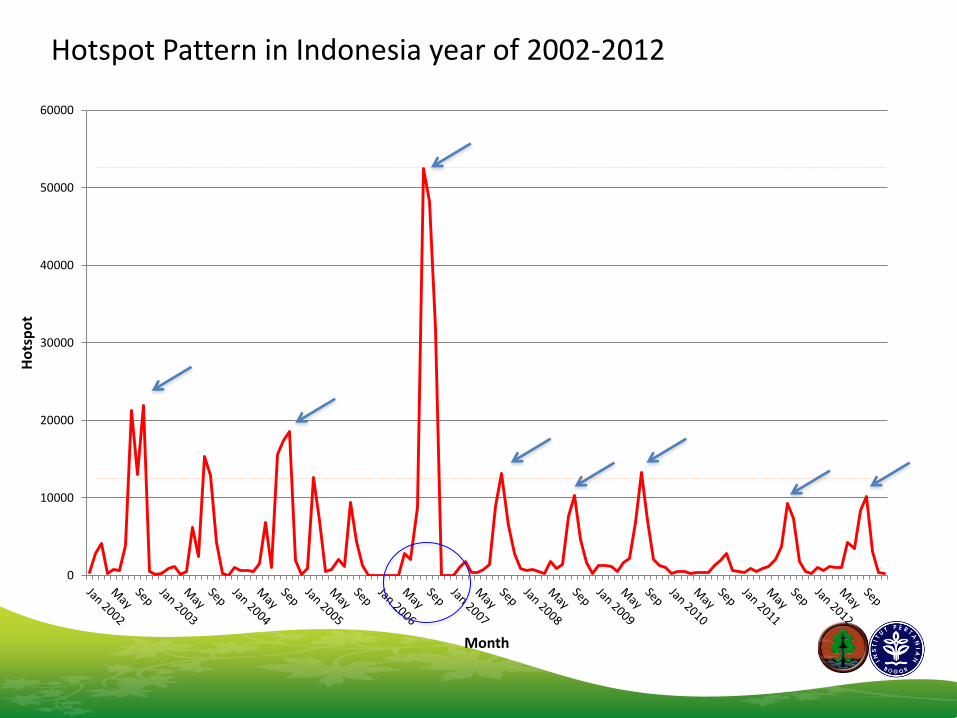
• Land and forest fires in Indonesia has become an almost repetitive annual phenomenon, especially in the long dry season with significant drought.
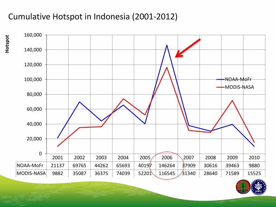
• Since 1997 until today, the indicators that have been used by MoFr in monitoring forest fires are hotspots as obtained by satellite NOAA-AVHRR (National Oceanic and Atmospheric Administration-Advanced Very High Resolution Radiometer).
• However, since 2008, hotspots monitoring are also obtained by satellite Aqua and Terra, which have instrument called MODIS (Moderate Resolution Imaging Spectroradiometer).
Loss from Land & Forest Fire in Indonesia
Year Loss (x 1,000 ha) Cost (US $ x Billion)
1982/1983 3,600 9.04
1987 66 NA
1991 500 0.17
1994 5,110 15,00
1997/1998 10 - 11,000 17,00
2006 8,000 NA
ADB, 2009; Saharjo, 2012
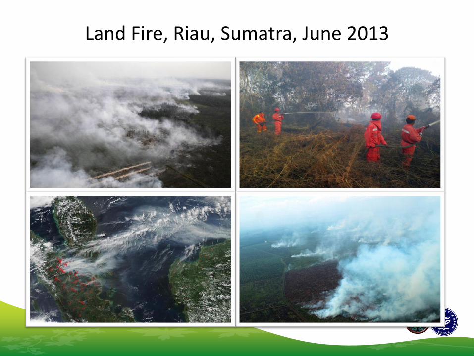
Land Fire, Riau, Sumatra, June 2013
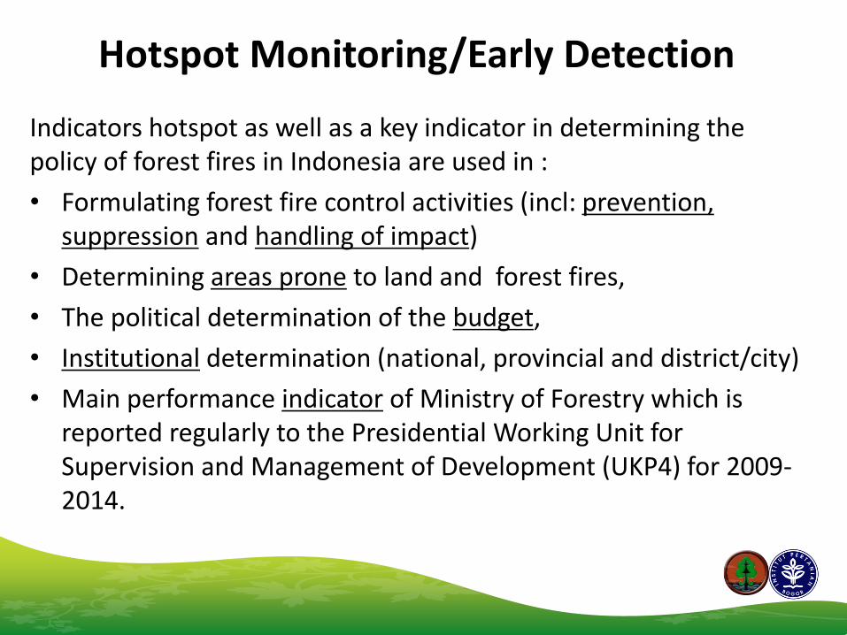
Indicators hotspot as well as a key indicator in determining the policy of forest fires in Indonesia are used in :
• Formulating forest fire control activities (incl: prevention, suppression and handling of impact)
• Determining areas prone to land and forest fires,
• The political determination of the budget,
• Institutional determination (national, provincial and district/city)
• Main performance indicator of Ministry of Forestry which is reported regularly to the Presidential Working Unit for Supervision and Management of Development (UKP4) for 2009-2014.
Hotspot Distribution in Indonesia year of 2001-2010
0
5,000
10,000
15,000
20,000
25,000
30,000
35,000
40,000
45,000
Jan Feb Mar Apr May Jun Jul Aug Sept Oct Nov Dec
2001 2002 2003 2004 2005 2006 2007 2008 2009 2010
Fire Season Month
Ho
tsp
ot
NOAA-FHS year of 2006 in Indonesia
No coverage
MODIS-FHS year of 2006 in Indonesia
FHS MODIS year of 2001 – 2010 at fire prone province
1
2
3
Fire Danger Rating/Early Warning System
• Evaluation of (meteorological) factors that influence fire danger
• A system for fire danger rating to evaluate the fire environment on regular intervals and in objective way.
• Provides information and guidelines for fire management
Concept: Satellite surveillance based on surface temperature.
Early Detection
Usage: To identify burnt area for suppression purpose.
Early Warning
Concept: 1. Daily weather data to estimate
phisycal condition (water content of fuel).
2. Fuel information – land cover 3. A correlation model of weather and
field condition. Usage:
To identify potential area to control activities.
Complementary
Low
Moderate
High
Extreme
FIRE DANGER
FDRS BASIC CONCEPT
Rain Fall
Wind Speed
Temperature
Humidity
Fuel
Weather
Fire Weather Index/FWI
Fire Behaviour
Prediction/ FBP
Fie Weather
Index
(FWI)
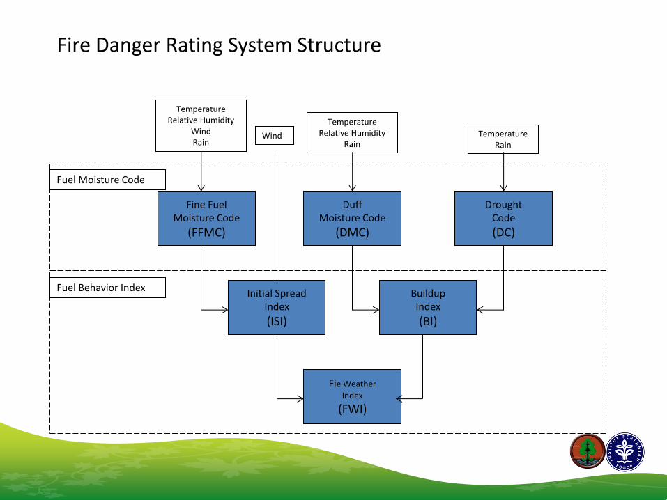
Fine Fuel Moisture Code
(FFMC)
Initial Spread Index
(ISI)
Buildup Index
(BI)
Duff Moisture Code
(DMC)
Drought Code
(DC)
Temperature Relative Humidity
Wind Rain
Wind
Temperature Relative Humidity
Rain Temperature
Rain
Fuel Moisture Code
Fuel Behavior Index
Fire Danger Rating System Structure
1999-2002
2003 2004 2005 2006 2007 2008 2011
MoU G to G (Indonesia & Canada) SEA FDRS – Indonesia Initiative (CFS, A3T, AMCG and MoFr) 1.Adaptation 2.Operational 3.Application 4.Haze Regional System
MoU 3 Agencies (A3T, AMCG and MoF) FDRS Indonesia 1. Operational 2. Capacity Building in MoFr 3. Product Dissemination
MoFr start to produce AWS and XLFWI FDR Calculation in 21 areas – 8 provinces
National Institute of Aeoronautics and Space Agency – sFMS based on RS
AMCG produce 3 days FDR Prediction
AMCG (R&D) start to develop 7 days FDR Prediction
AMCG intall and runs FDRS (Pontianak, Palangka Raya, Jambi, Palembang, Pekanbaru, Lampung) & National Smoke Trajectory
MoFr replace the AWS at 33 areas – 10 provinces
Implementation
A3T : Agency for the Assessment and Application of Technology (BPPT) AMCG : Agency for Meteorology, Climatology and Geophysics (BMKG) MoFr : Ministry of Forestry
Development
Institutions:
– Agency for Meteorology Climatology and Geophysics (BMKG)
– National Institute of Aeronautics and Space (LAPAN)
– Ministry of Forestry (MoFr)
– Agency for Assessment and Application of Technology (BPPT)
– Canadian Forest Service (CFS)
Pilot project areas:
– Riau Province
– West Kalimantan Province
Information providers: – BMKG (since February 2002) → weather station based, spatial information – LAPAN (since 2005) → satellite remote sensing-based, spatial information – Ministry of Forestry (since 2005) → Single weather station based- ExcelFWI Calculation (33 Operation areas for 10 Provinces) Users: – Ministry of Forestry – Ministry of Environment – Disaster Management Agency – ASEAN Secretariat – NGOs – Universities
FDRS Operation
National FDRS – operated by BMKG
FFMC - Indonesia
FWI - Indonesia
Provincial FDRS – operated by BMKG
FFMC – Riau, Sumatera (15 June 2013)
FWI Riau, Sumatera (15 June 2013)
3 days FDRS FFMC - 26 June 2013
FFMC - 27 June 2013
FFMC - 28 June 2013
3 days FDRS FWI - 26 June 2013
FWI - 27 June 2013
FWI - 28 June 2013
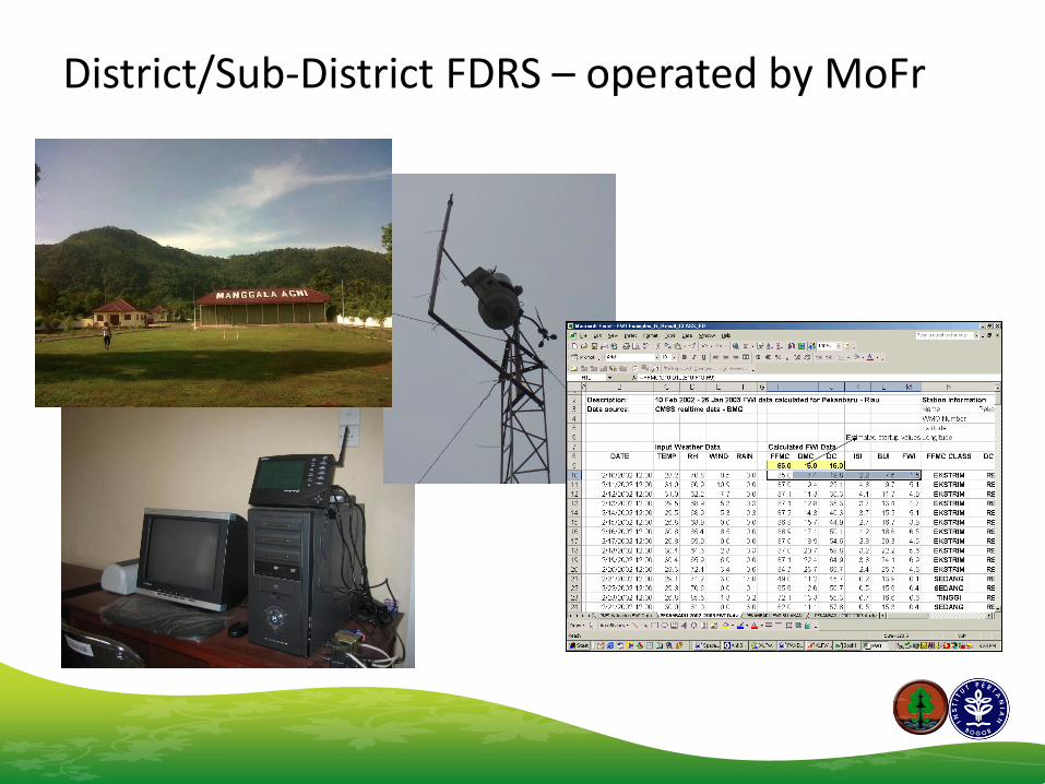
District/Sub-District FDRS – operated by MoFr
Fire Information Dissemination
Mailing list sipongi Founded Sept 4, 2001 Member as of June 2013 : 1,005 subscribers. Incl. fire fighters, policy maker district & provincial agency, ministry of environment, agriculture, internal affair, local & int’l NGOs, universities, etc.
NOAA-FHS Dissemination
www.indofire.org/www.dephut.go.id
Hotspot Monitoring MODIS-FHS Dissemination
http://indofire.landgate.wa.gov.au/indofire.asp.
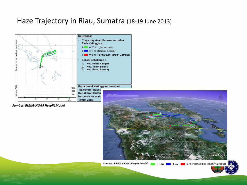
Haze Trajectory in Riau, Sumatra (18-19 June 2013)
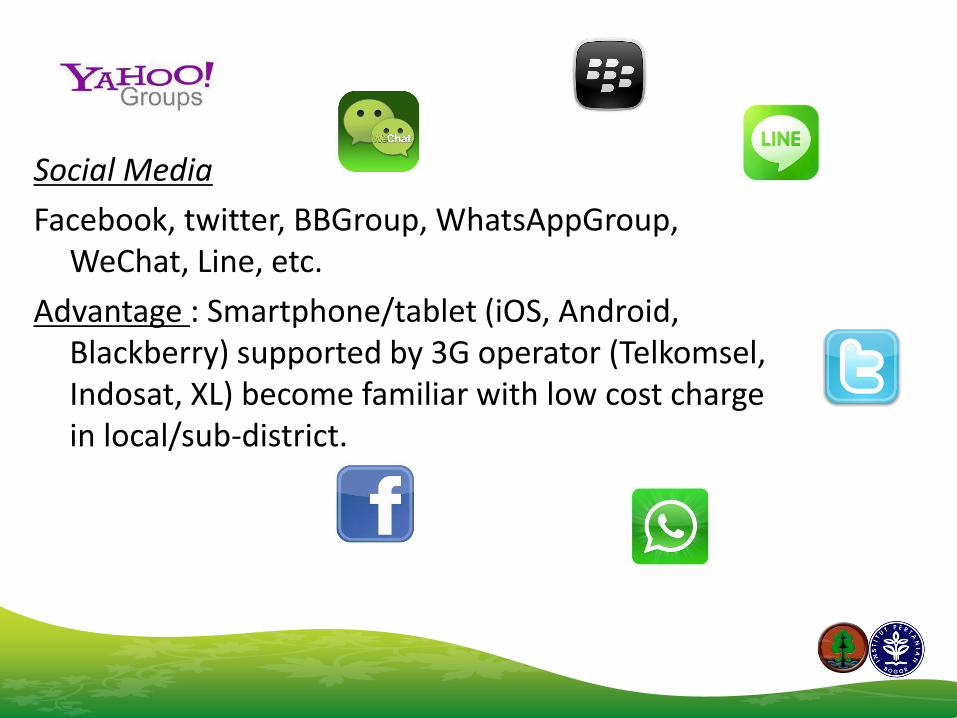
Social Media
Facebook, twitter, BBGroup, WhatsAppGroup, WeChat, Line, etc.
Advantage : Smartphone/tablet (iOS, Android, Blackberry) supported by 3G operator (Telkomsel, Indosat, XL) become familiar with low cost charge in local/sub-district.
Mailing List & Social Media
Hotspot access from Smartphone FDRS access from Tablet
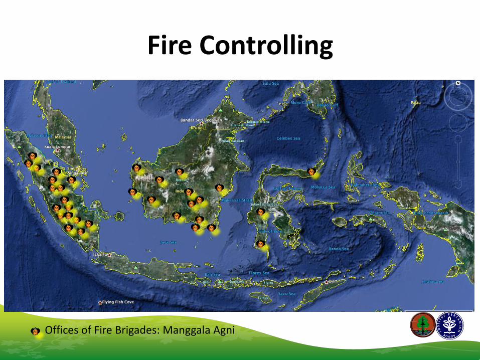
Fire Controlling
Offices of Fire Brigades: Manggala Agni
Fire Controlling
• Prevention
• Suppression
• Handling of Impact
Manggala Agni : 1.845 (as of June 2013)
Community Care Fire : 7.308 (as of June 2013)
Fire in Rengat, Riau, Feb 2013
Nozzle-stick with holes for Peat fire
Remarks
• Weather stations distributed uniformly across the fire prone area could support land/forest fire monitoring.
• Difficulty in keeping inputs for FDRS consistent → technical problems such as weather data communication, data format, weather observation instrument, AWS sensors problem, etc.