60
0 1 SAN ANTONIO RIVER SOUTH area management plan PROTECT . PROMOTE . COORDINATE

0
1
SAN ANTONIO
RIVER SOUTH area
management plan
PROTECT . PROMOTE . COORDINATE
1
Letter/resolution From:
Commissioners Court
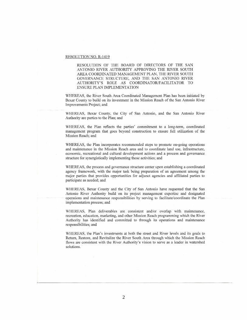
2
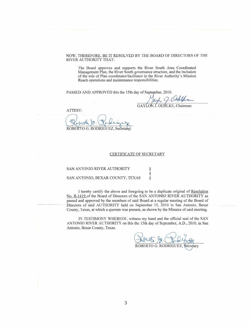
3

4

5
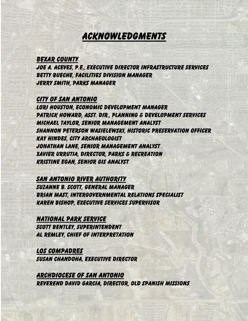
Acknowledgments
Bexar county commissioners court Nelson W. wolff, county judge Sergio “Chico” rodriguez, commissioner, precinct 1 Paul elizondo, commissioner, precinct 2 Kevin wolff, commissioner, precinct 3 Tommy adkisson, commissioner, precinct 4
City council of San antonio Julián castro, mayor
Mary alice p. cisneros, District 1 Ivy r. taylor, district 2 Jennifer v. ramos, district 3 Phillip a. cortez, district 4 David medina, jr., district 5
Ray lopez, district 6 Justin Rodriguez, district 7 w. reed Williams, district 8 elisa chan, district 9 john g. clamp, district 10
San Antonio River Authority Gaylon j. oehlke, chairman, karnes Sally Buchanan, vice chair, bexar Roberto g. rodríguez, secretary, bexar Terry e. baiamonte, treasurer, goliad a.d. “al” kollodziej, jr., Wilson hector r. morales, bexar john j. flieller, Wilson Michael w. lackey, p.e., bexar Názirite rubén pérez, bexar h.b. “trip” ruckman III, karnes adair r. Sutherland, goliad Thomas g. weaver, bexar
ii
Acknowledgments
Bexar county Joe A. Aceves, P.E., executive Director Infrastructure services Betty Bueche, facilities division Manager Jerry smith, parks manager
City of San antonio Lori Houston, economic development manager Patrick Howard, asst. dir., planning & development services Michael Taylor, senior management analyst Shannon Peterson Wasielewski, historic preservation officer Kay hindes, city archaeologist Jonathan lane, senior management analyst Xavier urrutia, director, parks & recreation Kristine Egan, Senior GIS Analyst
San Antonio River Authority Suzanne b. scott, general manager Brian Mast, intergovernmental relations specialist Karen bishop, executive services supervisor
National park service Scott Bentley, superintendent Al remley, chief of interpretation
los compadres susan chandoha, executive director
archdiocese of san Antonio reverend david Garcia, director, old Spanish missions
iii
TABLE OF CONTENTS
foreword
OVERVIEW 1. Introduction 2. river improvement History 3. RIVER SOUTH Area BoundarY Area DESCRIPTION land use Zoning demographics 4. Policy guidelines City of San antonio master plan policy Neighborhood and zoning plans Infill and reinvestment National park service criteria Interlocal agreements
The plan Vision statement Goals:
1. return Objectives: historic resources
Worldwide recognition River NpS Boundaries access 2. Restore
Objectives: natural resources and ecosystems habitat user-friendly spaces healthy, safe, sustainable infrastructure ecological management and use connections
iv
TABLE OF CONTENTS 3. revitalize
objectives: economic development Economic Diversity and job creation Business/government relationships business start-ups and growth housing and infill
tools for Commercial and residential opportunities
Recommendations and action steps process
governance structure action items and responsible parties
appendix list of illustrations
bibliography resources
v
FOREWORD
Since the 1950s Bexar County has grown, stretching its original borders and, beyond the confines of the San Antonio River, its
birthplace. During that time, efforts to manage the River during flood events and allowing for controlled flow throughout the year resulted in a complete change in its characteristics. It shifted from
gentle sloped banks to concrete channels moving water efficiently throughout the City of San Antonio.
In the meantime, the neighborhoods bordering the River turned their
backs to it, its role as the area’s historic beginnings all but forgotten. At the turn of this century, that role was reversed. In the late 1990s, the Bexar County Commissioners Court, the City of San Antonio and
the San Antonio River Authority began an unprecedented cooperative effort to restore all 13 miles of the San Antonio River to its rightful
place in history. The northern segment of River Improvements was completed in
2009. Attention was then turned to the southern segment—the Mission Reach. Not only was this part of the river dramatically altered
by channelization, it ignored the Missions—the very fact of San Antonio’s existence.
Commissioners Court unanimously moved to allocate over $207 million and staff to work with its partners and the National Park
Service to return the river to its beginnings with full scale renovations for planning, design and construction efforts to restore and revitalize the Mission Reach.
In its vision for the Mission Reach, the Court has mandated that a
Coordinated Management Plan be developed and implemented for the partners to establish operational, maintenance, security and
economic development opportunities.
vi
The Coordinated Management Plan will:
1. Protect the community’s investment in the redeveloped River.
2. Maximize the return on investment and promote economic
development.
3. Establish a coordinated framework among agencies for
essential functions.
4. Ensure seamless, integrated management of the river and
related areas.
5. Promote National Park Service boundary study and land
management plan.
The Court’s leadership in this effort ensures that the Mission Reach’s
success goes beyond construction. Its history, cultural legacy and educational and recreational opportunities signal the commitment for a long-term management program that will serve generations to
come.
The major tenets of the Court’s efforts to protect, promote and coordinate all facets of the Mission Reach project result in a concerted management program. These tenets bestow the Mission
Reach as our foundation and legacy.
vii
river south area coordinated management
plan
overview

1
river south area coordinated management plan
overview introduction The River South Area Coordinated Management Plan is the culmination of a collaborative effort among the leadership of Bexar
County Commissioners Court, the San Antonio River Authority (hereinafter ―SARA‖), the City Council of San Antonio and the National Park Service (hereinafter ―NPS‖).
With the successful and timely completion of the Museum Reach
section of the San Antonio River Improvements Project, attention was then focused on the southern portion—the Mission Reach—an 8-mile
stretch of the San Antonio River commencing downtown and moving southward to the San Antonio city limits.
Commissioners Court seized the opportunity to ensure that this phase of the River improvements would also be completed in a timely
manner. By working through its partnership with SARA, the City and the U.S. Army Corps of Engineers, Bexar County became the lead in a local funding plan. The Commissioners Court committed monies from
the Bexar County Venue/Visitor Tax and the Bexar County Flood Tax fund for the construction project including recreational and other
amenities along the River to meet the community’s full vision for the Mission Reach. This, coupled with the City’s efforts for neighborhood revitalization, and SARA’s commitment to operate and maintain the
completed River improvements, make this a true investment in San Antonio’s future.
Bexar County, and this area in particular, is grounded by its cultural
legacy. The Spanish colonial resources of San Antonio are focal points of the River South area. Through an unprecedented collaborative partnership these tangible assets of our city and nation

2
will be protected, made accessible, and commemorated in perpetuity as an inheritance for future generations. This awareness and pride in
our heritage brings the fourth partner, the National Park Service, to the table. The community is committed to increasing the boundary
of San Antonio Missions National Historical Park to that envisioned since the 1930s. A proposal has been presented to the United States Congress by local leaders to increase the boundary of the existing
park lands designated as a national park along the San Antonio River. The proposal is to establish these parcels as a comprehensive
Spanish colonial site, the largest in the world. This initiative is tightly timed for completion to meet the National Park Service centennial
anniversary in 2016 and the potential designation as World Heritage Site.
River South is a confluence of opportunities whose time has come. This Coordinated Management Plan is a program providing an outline
and schedule of activities to ensure implementation and continued success of the projects and activities for generations to come.
The natural characteristics of the San Antonio River were so amenable to domestic pursuits that Spanish Franciscans in the early
1700s settled along the banks. The characteristics of the River resulted in, and left behind, the legacy of the largest concentration of Spanish colonial missions in the United States. The River South Area
is the home of the oldest continuously functioning Spanish colonial dam and Acequia in America. The oldest priority water rights in the
State of Texas also originate from mission agricultural use within the River South Area and continue to influence land use in and around the missions.
The River has made San Antonio home to the largest collection of
authentic Spanish colonial resources in the United States. These resources impart who we are as individuals, families, a community,
and as a nation. Within the River South Area the Missions are sacred places where people experience the spirit of our cultural roots. The material evidence of a significant piece of our nation’s most
determining time, people, customs, and places can be easily found throughout the area. The River and the Spanish colonial resources
3
along its banks have meaning for every American, but are particularly significant to the people of South Texas as our own legacy.
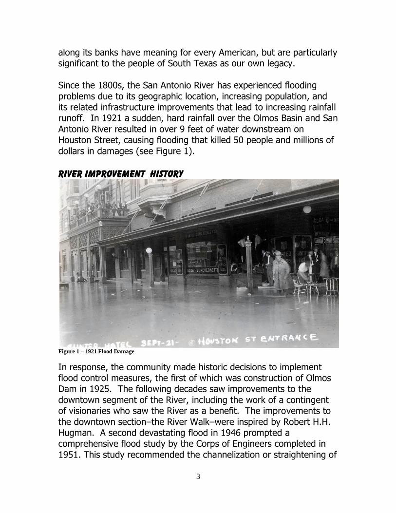
Since the 1800s, the San Antonio River has experienced flooding
problems due to its geographic location, increasing population, and its related infrastructure improvements that lead to increasing rainfall runoff. In 1921 a sudden, hard rainfall over the Olmos Basin and San
Antonio River resulted in over 9 feet of water downstream on Houston Street, causing flooding that killed 50 people and millions of
dollars in damages (see Figure 1).
River improvement History
Figure 1 – 1921 Flood Damage
In response, the community made historic decisions to implement flood control measures, the first of which was construction of Olmos Dam in 1925. The following decades saw improvements to the
downtown segment of the River, including the work of a contingent of visionaries who saw the River as a benefit. The improvements to
the downtown section–the River Walk–were inspired by Robert H.H. Hugman. A second devastating flood in 1946 prompted a comprehensive flood study by the Corps of Engineers completed in
1951. This study recommended the channelization or straightening of
4
31 miles of the River and its tributaries better known as the San Antonio Channel Improvement Project (SACIP). This project was
authorized by Congress for implementation by the Corps of Engineers in 1954.
In 1975, the National Park Service completed a suitability and feasibility study for a proposed San Antonio Missions National
Historical Park along the San Antonio River. The study found that ―the San Antonio River served as the lifestream of the mission
system.‖ The study noted that little remained of the River’s natural, untouched state since the Corps of Engineers channelization project,
and that it could never be returned to its authentic historical appearance. However, the study went on to say that the River was the ―single most important element influencing the initial location of
the missions‖ and ―the disastrous effects of channelization could be softened by a large-scale program of relandscaping.‖ In 1978, the
United States Congress created San Antonio Missions National Historical Park. The River was excluded primarily because of the significant costs associated with a larger-scale restoration project.
Since that time, SARA has agreed to serve as the local agency and
sponsor with the Corps to oversee river improvements programs. SARA has partnered with the City of San Antonio and Bexar County to plan, implement and maintain projects included in the SACIP.
Since the completion of the channelization of the River south of
downtown in the 1970s, the community has benefited from the flood protection provided by channelization, and continued to desire a solution that would maintain the flood protection, but allow for the
River to be more than just a drainage ditch. In the 1990s, improved engineering techniques allowed for the possibility for the River to be
restored to a more naturalized setting without jeopardizing flood protection. The creation of the community-based vision for
improvements to the River emerged and in 2001 the partners’ scope of work transitioned from the San Antonio Channel Improvement Project flood control focus to the broader San Antonio River
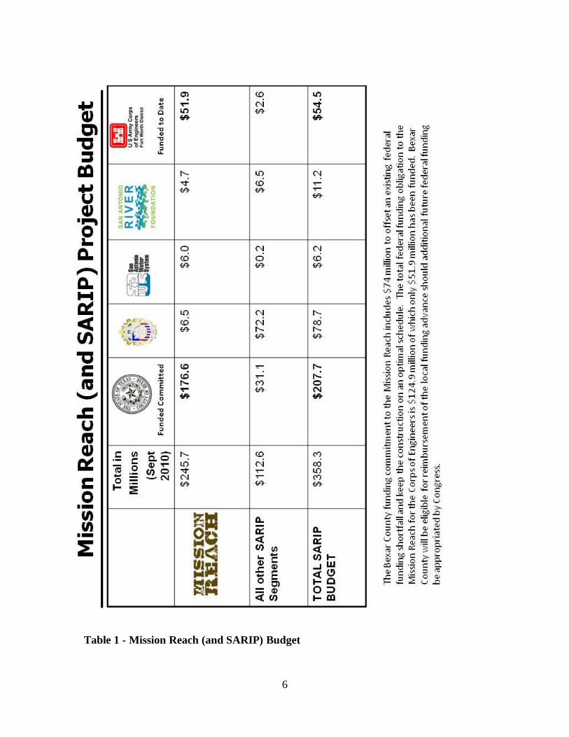
Improvements Project (SARIP). The SARIP has evolved today into a $358.3 million investment by Bexar County, the City of San Antonio,

5
the Corps of Engineers, the San Antonio River Authority and the San Antonio River Foundation in flood control, amenities, ecosystem
restoration and recreational improvements for the San Antonio River. SARA serves as project manager for all sections of SARIP and as local
sponsor with the Corps of Engineers specifically for the Mission Reach.
The northern section—Museum Reach—cost $72 million. Project contributions came from the City ($52.3million), Bexar County ($13.1
million), San Antonio Water System (SAWS; $200,000 for utility line relocation) and through private donations collected by the San
Antonio River Foundation ($6.5 million). This improvement doubled the length of the existing River Walk extending the once undeveloped section of the river north of downtown.
Ecosystem Restoration is the primary focus for improvements on the
8-mile Mission Reach segment. It will replicate the original flow of the river while maintaining flood control, reducing erosion, re-introducing native vegetation and creating an environment more
suitable for recreation and wildlife.
Also four key passages, or portals, will allow direct access to each of the Missions from the River’s edge. These ―Mission Portals‖ will provide critical links for recreation and enjoyment of both the River
and Missions.
Funding for the $245.7 million Mission Reach project is provided by Bexar County ($176.6 million), the City of San Antonio ($6.5 million) and the Corps of Engineers ($51.9 million). Bexar County has
provided $74 million to ensure optimum scheduling in advance of Corps payments. Other funds include private donations by the San
Antonio River Foundation ($4.7 million), and SAWS utility relocation funding of $6 million. The Mission Reach project is underway and
being constructed in three phases, with scheduled completion in 2013.
6
Table 1 - Mission Reach (and SARIP) Budget
7
The Mission Reach remains a federal project with the Corps responsible for reviewing and approving project design and
construction. The Corps is also responsible for determining the final reimbursement amount above the local cost share.
The 1933 Comprehensive Plan for San Antonio recommended
connecting the historic Spanish Missions. The importance of preserving the San Antonio River and linking the Missions became a
key local effort in 1953 by the San Antonio Conservation Society and Archdiocese of San Antonio. They commissioned Robert H.H. Hugman to prepare a study to beautify the historic Spanish Missions
of San Antonio. ―It was decided that this goal could be best achieved by connecting all the missions with a landscaped parkway.‖ In 1959,
a plan was presented by nationally renowned planning consultant, Sam Zisman, which proposed developing a scenic park roadway. The program was reinvigorated in 1962 with the Mission Parkway Master
Plan.
In 1964, the City of San Antonio passed a bond to begin purchasing lands for a route linking the Missions, and the National Park Service (NPS) was asked to make further studies of the proposed Mission
Parkway. The NPS submitted recommendations in ―A proposal for a parkway to memorialize the historical significance of the Missions of
San Antonio.‖ The NPS found that the Missions are: ―the noblest and most enduring visible monument of the
Spanish occupation… .‖ ―an historical resource of great and unique value.‖
―that the Spanish phase of Texas history is significant – to the
State, to the Southwest, to the Nation.‖ ―are the best surviving remains of Spanish occupation.‖
Also, it stated that the ―shortage of open space is already critical along Mission Road and round the missions. The roadsides along
portions of Mission Road can only be described as ugly… . Fortunately, the San Antonio River has been kept relatively clean. However, river channelization has essentially ruined the natural
character of the river making it nothing more than a drainage channel… .‖

8
The NPS made the following notable recommendations: ―every attempt should be made to keep the water clean and
the banks litter free.‖
―Remove the utility lines… .‖ ―The natural beauty (of the San Antonio River) has been
destroyed… but consideration should be given… to preserving the natural character of the river.‖
The NPS study recommended that a local commission create and administer the development of a Mission Parkway. It also
encouraged the City of San Antonio to ‖acquire land before the total destruction of its historic values occurred from development.‖
In 1966, the City of San Antonio issued another bond and received a grant from the Department of Housing and Urban Development
(HUD) to begin work on the Mission Parkway concept. In 1972, the San Antonio Chamber of Commerce developed a 5-year plan to complete the parkway and establish an environment for preserving
the historic Missions of San Antonio. In 1973, the City of San Antonio completed a plan titled ―The Missions of San Antonio‖ that
resulted in the City’s Historic Preservation Programs and the Missions Historic Park.
In 1978, the United States Congress created San Antonio Missions National Historical Park as four units along the Mission Parkway. In
1991, the City of San Antonio passed a ―Mission Trails‖ resolution to pursue implementing recommendations from previous studies to link
the Missions. In 1993, the City of San Antonio conducted another Planning Study to find appropriate multimodal ways to link the Missions and other features including the San Antonio River and
approved the recommendations in Ordinance No. 78775. Since 1993, over $17 million has been spent on the development of the Mission
Trails, and large areas of the connections are complete. In 2010, the City of San Antonio and Mission Trails Committee continue to work to complete the multimodal links between the Missions as the
restoration of the San Antonio River continues.
9
River south area The River South Area Coordinated Management Plan promotes
recognition of the River South Area’s historical and cultural significance, programs for neighborhood and economic revitalization,
eco-system restoration and community connectivity.
Boundary The River South area boundaries are extended beyond the City Limits to the County line. This designation incorporates the National Park
Service boundary study and plan for the Missions as presented to the Department of the Interior (see map on page 10). The planning area
urban boundaries begin at Lone Star Boulevard on the north, following south ½ block east of Roosevelt to Eads Avenue, east to ½ block east of S. Presa to Graf Road, then S. Villamain Road to the
San Antonio city limits following up ½ block west of Espada Road to Ashley Road, thence north along the fence line of Stinson Airport and
following northward along Mission Road to Terrell Road proceeding west to S. Flores, to IH10 east to King Roger and north to Lone Star
Boulevard (see map on page 11).
Area description Just south of downtown, River South is convenient to four
highways—IH 10, IH 37, Loop 410 and IH 35. It is served by several parks, a golf course and Stinson Airport. Texas A&M campus and
Palo Alto Community College are within commuting distance to residents.
The San Antonio River along this area has withstood a combination of flood control efforts by the Corps and concerted attempts to provide
River access at southernmost points near the Missions. Neighborhoods in this area are close-knit, with many homesteads
passing from generation to generation. The strong commitment to place and family is demonstrated by families working to revitalize
their generational neighborhoods and upgrade longstanding business corridors.
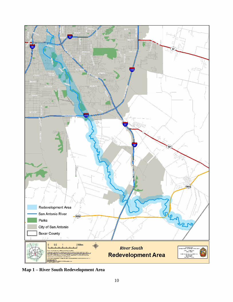
10
Map 1 – River South Redevelopment Area
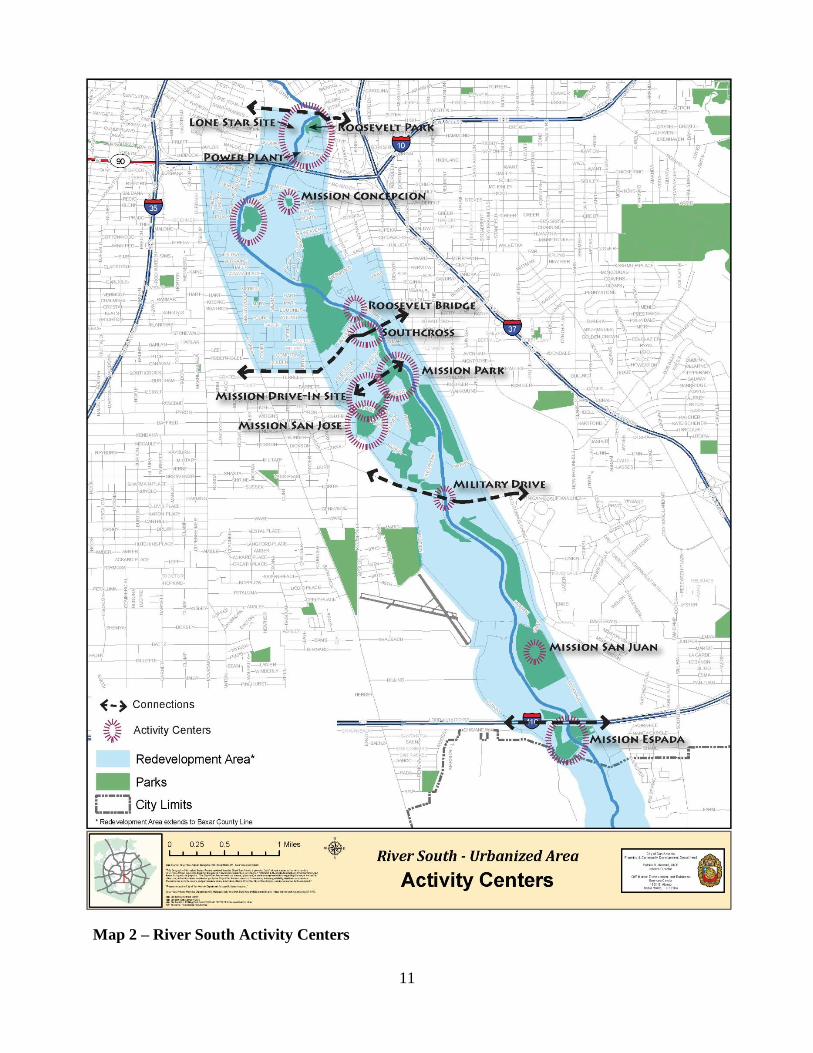
11
Map 2 – River South Activity Centers
12
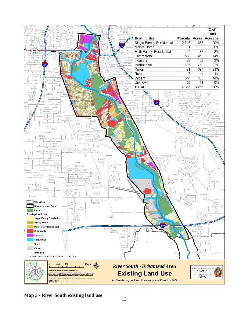
Land use
The northern section of the Plan area includes a mix of residential and commercial uses. South of Riverside Golf Course, the existing
uses are generally more commercial with vacant parcels found throughout (see map on page 13).
The parcels in the southern portion of River South are commercial or rural acreage. Much of the property is occupied by Stinson Airport or
salvage yards and contractors’ facilities.
The size of parcels increases and the density of development decreases going from north to south. The existing pattern of uses exhibits a lack of consistency, a high potential for conflict between
uses and a high percentage of vacant parcels.
ZONING Current zoning districts generally allow for a higher-intensity of commercial and industrial uses than what is allowed for proximity to
single-family residential uses and the smaller sized lots in existence. This intensity of land uses has been in effect for most of the 20th
century. Alternatively, commercial projects have changed to meet consumer tastes. Larger scale buildings and warehouse style chain
stores with a regional appeal have replaced the traditional mom and pop neighborhood stores. The larger establishments tend to locate on arterials with greater traffic capacity and attraction. In contrast,
smaller volume main roadway commercial activity includes budget motels, bars, auto repair shops and used automobile sales lots. Add
to this, noise, crime and code violations that concentrations of these activities can produce, and neighbors nearby want change.
As a result, the City has instituted a comprehensive rezoning effort. It is intended to reduce the intensity of commercial uses currently
allowed and provide for new uses appropriate to the area. Existing, legally established uses will be grandfathered and considered legally nonconforming. This will allow for a transition to less intense uses
over time and thus attract visitors and appeal to neighbors.
13
Map 3 - River South existing land use
14
Demographics River South is an older established area of San Antonio. Demographic data compiled by the City of San Antonio. Analysis
reveals challenges due to a declining population, lower educational levels, median income and higher poverty levels when compared to
overall City data. Trend analysis is also useful to track an area’s growth, stability, or decline and changes in population. This data, coupled with anticipated 2010 Census data, will provide opportunities
for River South to position itself for funding resources.
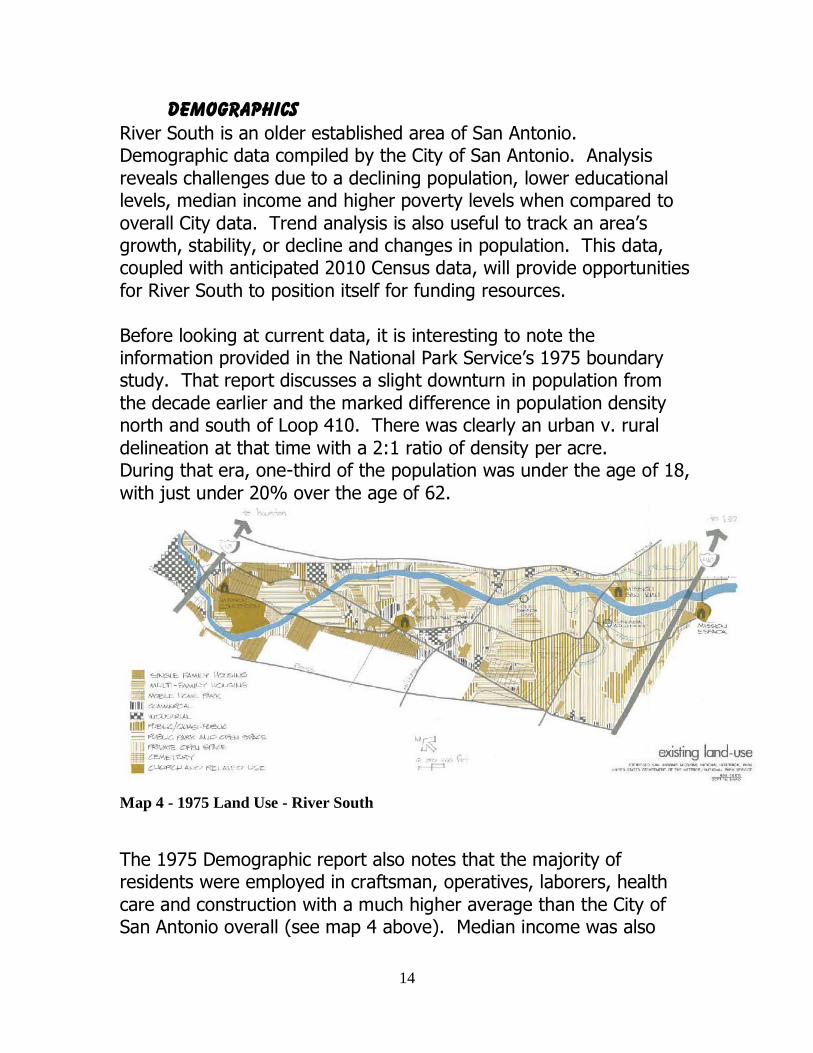
Before looking at current data, it is interesting to note the information provided in the National Park Service’s 1975 boundary study. That report discusses a slight downturn in population from
the decade earlier and the marked difference in population density north and south of Loop 410. There was clearly an urban v. rural
delineation at that time with a 2:1 ratio of density per acre. During that era, one-third of the population was under the age of 18,
with just under 20% over the age of 62.
Map 4 - 1975 Land Use - River South
The 1975 Demographic report also notes that the majority of residents were employed in craftsman, operatives, laborers, health
care and construction with a much higher average than the City of San Antonio overall (see map 4 above). Median income was also
15
lower than the San Antonio average at that time, trailing by an average of 30-45%. Another statistic telling for the area is the
amount of population below the poverty level: 30% rivaled San Antonio’s average of 17.5%.
Currently of great concern in the River South neighborhoods, as in all parts of San Antonio, is the crime rate. While the City’s Burglary
Department tracks overall San Antonio numbers at 32/1000 in River South to 37/1000 in the City, vehicle theft is slightly higher in River
South at 6.26/1000 compared to San Antonio at 5.08/1000. Robbery is 4.37/1000 in River South compared to San Antonio at 2.11/1000.
Prostitution is disproportionately higher with a 4.59/1000 rate in River South and the City reports at .31/1000. Murder is also much higher with .44/1000 occurrences in River South as opposed to
overall San Antonio numbers at .08/1000. This alone has caused many neighborhood areas to rally and work for expanded team
efforts with schools, churches, civic organizations and the City for revitalization to strengthen its viability and discourage criminal activity.
1975 housing characteristics in the area showed a slight shift from owner to rental units. The average rental units in the City is 35%,
while the River South area rated higher at 45%. Median home value was less than the City average by $3500.00.
Between 1990 and 2008 the population within this area decreased slightly (-1%) while San Antonio increased by 37%. Residents within
the corridor are 5% of the City’s total population (approximately 66,000) and density averages 4.92 persons per acre. Median age is 32.7 years, slightly younger than San Antonio’s average of 34 years.
Almost 43% of the population 25 years and older in this area has not completed high school. (The City averages 20%.) However, the gap
narrows a bit with 31.4% having a diploma compared with the City average of 28%. Trends for some college and associates degrees
are encouraging with 16% and 3.8% respectively in River South and the City data at 21% and 6.8%.
16
Of course, educational attainment ties with income potential and discretionary spending. This area earns nearly $11,000 less than the
City average--$30,630 v. $41,593. Six percent of families Citywide live below the poverty level while this area has a 5% overall level or
21.2% of total population. Housing data shows that most residential structures account for
23% of the land use. They were built during the post WWII era and have a current median value of $54,843 compared to the City of San
Antonio average of $113,988. Other major land uses in the area include parks 21%, institutional 22%, and commercial and vacant
land both at 14%. It is interesting to note that of the two eras, not much has changed.
Population shifts, income and housing data seem to indicate a stable residential area growing older and slowly taking advantage of
educational opportunities.
Policy guidelines
In 1982, the National Park Service (NPS) published a General
Management Plan (GMP) for San Antonio Missions National Historical Park (Missions). The GMP stated, ―Beyond the existing authorized
park boundary are lands which are closely associated with the purposes for which the park was established. Some of these lands, such as the Labores of San Juan and Espada, contain significant
cultural resources directly related to the missions and still retain their historical integrity. Other lands may have little historic value, but the
current or potential uses of these lands threaten the integrity of the park resources and the quality of the visitor’s experience.‖ In 1994, the NPS produced an updated Missions Land Protection Plan that
state: ―The historic resources within the San Antonio Missions National Historical Park that have survived the past 250 years need to
be properly protected lest they be lost to adverse and incompatible modern development. This can only be done through the combined efforts of the National Park Service, State and local governments, the
Archdiocese, and the public, including the local communities.‖ Little has been done by the NPS to acquire interest in the lands within the
17
current park boundary or to add park lands that are significant, but reside outside the park’s boundary despite having minor boundary
adjustment authority. To ensure the preservation and protection of the Missions, and investment being made by the citizens of Bexar
County in the Mission Reach of the San Antonio River, it is vital that the NPS acquire the culturally significant lands associated with the Missions both inside and outside the existing boundary. Acquisition
of the Mission lands will prevent further loss and ensure the protection of the river restoration efforts.
Over the years many grassroots efforts have taken hold in the
neighborhoods. Neighborhood planning and general City planning efforts for guiding positive change in specific areas have been enacted chiefly by the residents in those areas. The City of San
Antonio has been instrumental in shepherding these efforts into City Council adopted policies that direct opportunities for such initiatives.
The residents of River South have been and will continue to be active participants in seeing those changes occur in the next few years.
The City Council adopted its Master Plan policies for San Antonio in 1997. It is intended to provide a framework to guide the
development and implementation of policies to promote an equitable distribution of benefits and amenities to all its citizens. Specifically it addresses goals for ―safe, sustainable neighborhoods which offer
economic opportunities, high quality education, adequate and affordable shelter, health care and recreational amenities.‖ Also, the
Plan promotes a ―vibrant economic climate‖ and ―responsible protection of the City’s historical, cultural and natural resources.‖ Although the Plan did not specifically address geographic areas, these
principles are used over and over again in all endeavors related to San Antonio.
The South Central San Antonio Community Plan, adopted in 1999 and
updated in 2003, covers the northern portion of River South to SW Military Drive. Plan elements cover neighborhood and community development, community facilities, transportation and quality of life.
Emphasis is on infill development, housing stock and improving the quality of commercial corridors, including S. Flores and S. Presa
18
streets, Roosevelt Avenue and SW Military Drive. A chief goal for the Plan is to ―enhance and improve the Missions, parks and the San
Antonio River‖ through strategies aimed at zoning, safety, accessibility and restoration.
In 2009, the City Council adopted the Stinson Airport Vicinity Land Use Plan. The Plan area is south of Military Drive, IH 37 on the east,
Loop 410 on the south and Pleasanton Road, Gladnell Avenue and Loleta Street on the west. The Plan calls for ―additional measures to
ensure compatible land uses adjacent to the Stinson Airport.‖ The Plan is also specific regarding opportunities for neighborhoods,
economic development, and cultural and environmental resources ―to promote future sustainability.‖
The Roosevelt Corridor Reinvestment Plan, adopted in 2009, includes four registered neighborhood associations in River South—Roosevelt
Park, Riverside South, Mission San Jose and East Pyron/Symphony Lane. The goal of the Plan is to encourage reinvestment in the Roosevelt corridor. Seven strategy areas have been identified:
Leverage River improvements and Mission Drive-In redevelopment
Invest in drainage, street and sidewalk
infrastructure Phase out high intensity commercial and industrial
zoning Adopt unifying design standards for new
construction Launch community-based initiatives to improve
quality of life Link existing business and property owners with
funding sources Create investment opportunities.
These reinvestment strategies are a set of specific actions based on infrastructure priorities, short- and long-term reinvestment priorities identified by a community planning team.
19
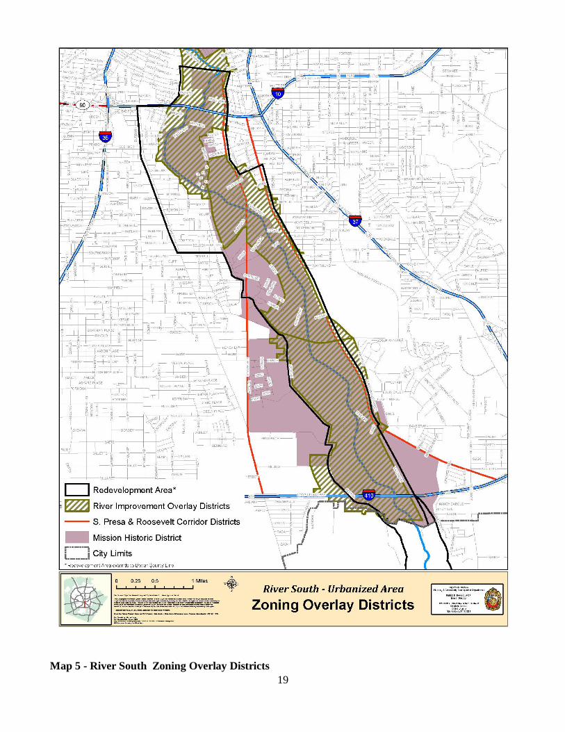
Map 5 - River South Zoning Overlay Districts
20
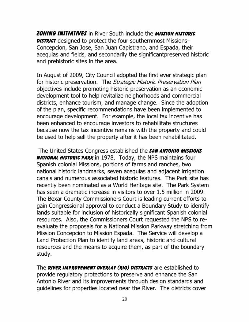
zoning initiatives in River South include the Mission Historic
District designed to protect the four southernmost Missions– Concepcion, San Jose, San Juan Capistrano, and Espada, their
acequias and fields, and secondarily the significantpreserved historic and prehistoric sites in the area.
In August of 2009, City Council adopted the first ever strategic plan for historic preservation. The Strategic Historic Preservation Plan
objectives include promoting historic preservation as an economic development tool to help revitalize neighorhoods and commercial
districts, enhance tourism, and manage change. Since the adoption of the plan, specific recommendations have been implemented to encourage development. For example, the local tax incentive has
been enhanced to encourage investors to rehabilitate structures because now the tax incentive remains with the property and could
be used to help sell the property after it has been rehabilitated.
The United States Congress established the San Antonio Missions National Historic Park in 1978. Today, the NPS maintains four Spanish colonial Missions, portions of farms and ranches, two
national historic landmarks, seven acequias and adjacent irrigation canals and numerous associated historic features. The Park site has
recently been nominated as a World Heritage site. The Park System has seen a dramatic increase in visitors to over 1.5 million in 2009. The Bexar County Commissioners Court is leading current efforts to
gain Congressional approval to conduct a Boundary Study to identify lands suitable for inclusion of historically significant Spanish colonial
resources. Also, the Commissioners Court requested the NPS to re-evaluate the proposals for a National Mission Parkway stretching from Mission Concepcion to Mission Espada. The Service will develop a
Land Protection Plan to identify land areas, historic and cultural resources and the means to acquire them, as part of the boundary
study.
The River Improvement Overlay (RIO) Districts are established to provide regulatory protections to preserve and enhance the San Antonio River and its improvements through design standards and
guidelines for properties located near the River. The districts cover
21
six geographic areas. River South lies in a portion of RIO-4 and all of RIO 5 and 6. Design objectives for these areas are to enhance the
historic elements while maintaining the residential and rural character of the specific districts. Each of these districts encourages mixed-
used developments, riverbank restoration, neighborhood services and family recreation. In 2010 a joint effort of City Council members whose districts encompass this area requested the RIO District
guidelines be reevaluated to strengthen design requirements (see map 5 on page 19).
Mission viewsheds will be studied at Council request to protect the
new corridor of the individual Missions. The South Presa Corridor is the most recent area approved by City
Council for study. On March 28, 2010, staff was assigned to undertake land use and other background studies necessary to
recommend to Council 1) a corridor overlay district along both sides of S. Presa between IH10 to the north and SE Loop 410 to the south, and 2) implement a comprehensive rezoning of the properties
generally located within those boundaries.
22
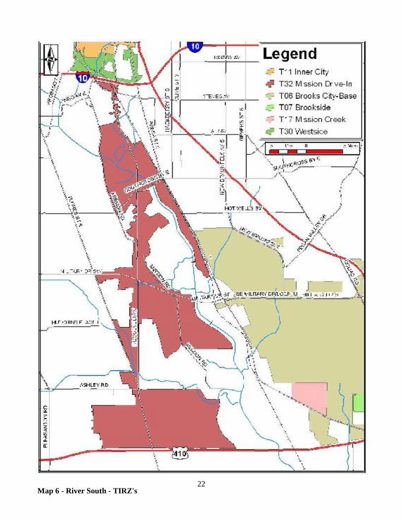
Map 6 - River South - TIRZ's
23
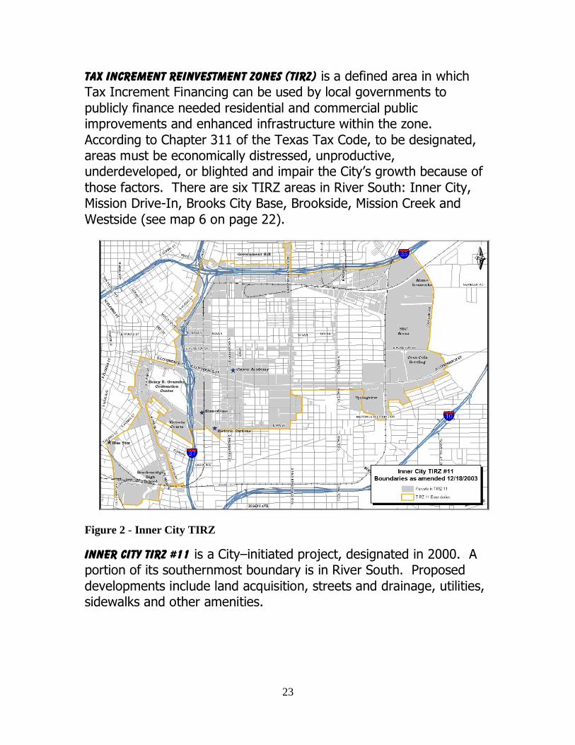
Tax Increment Reinvestment Zones (TIRZ) is a defined area in which Tax Increment Financing can be used by local governments to
publicly finance needed residential and commercial public improvements and enhanced infrastructure within the zone.
According to Chapter 311 of the Texas Tax Code, to be designated, areas must be economically distressed, unproductive, underdeveloped, or blighted and impair the City’s growth because of
those factors. There are six TIRZ areas in River South: Inner City, Mission Drive-In, Brooks City Base, Brookside, Mission Creek and
Westside (see map 6 on page 22).
Figure 2 - Inner City TIRZ
Inner City TIRZ #11 is a City–initiated project, designated in 2000. A portion of its southernmost boundary is in River South. Proposed
developments include land acquisition, streets and drainage, utilities, sidewalks and other amenities.
24
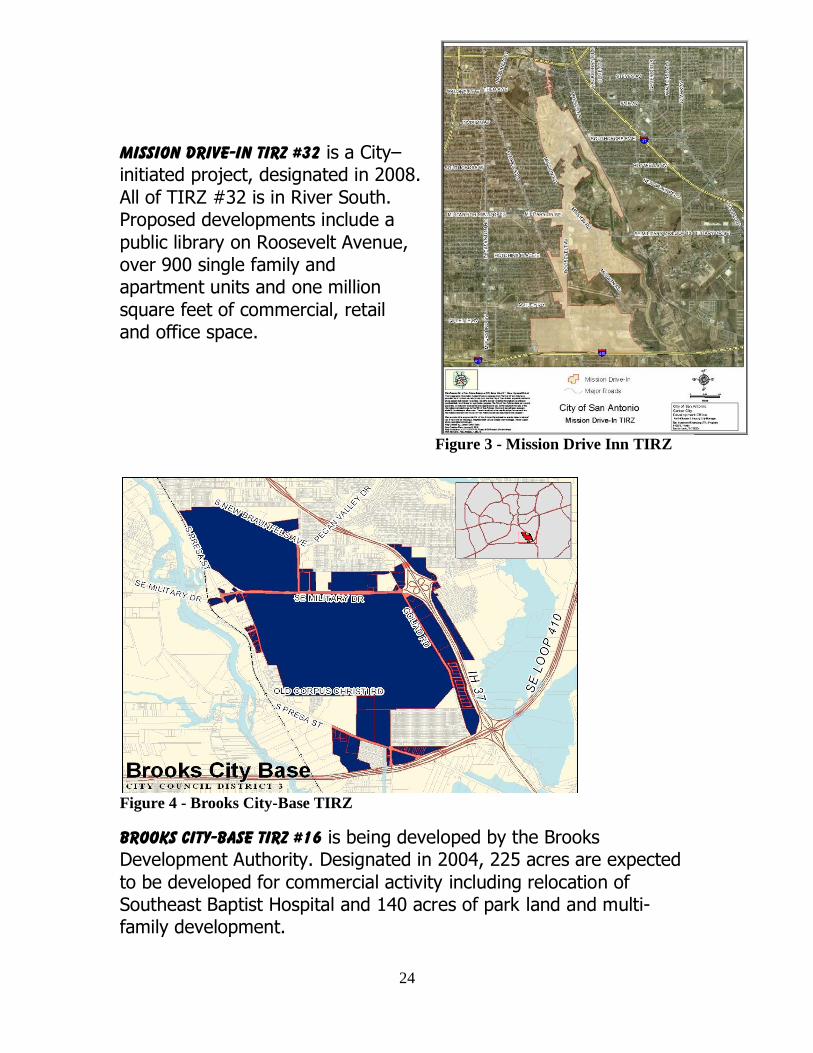
Mission Drive-In TIRZ #32 is a City– initiated project, designated in 2008.
All of TIRZ #32 is in River South. Proposed developments include a
public library on Roosevelt Avenue, over 900 single family and apartment units and one million
square feet of commercial, retail and office space.
Figure 4 - Brooks City-Base TIRZ
Brooks City-Base TIRZ #16 is being developed by the Brooks Development Authority. Designated in 2004, 225 acres are expected
to be developed for commercial activity including relocation of Southeast Baptist Hospital and 140 acres of park land and multi-family development.
Figure 3 - Mission Drive Inn TIRZ
25
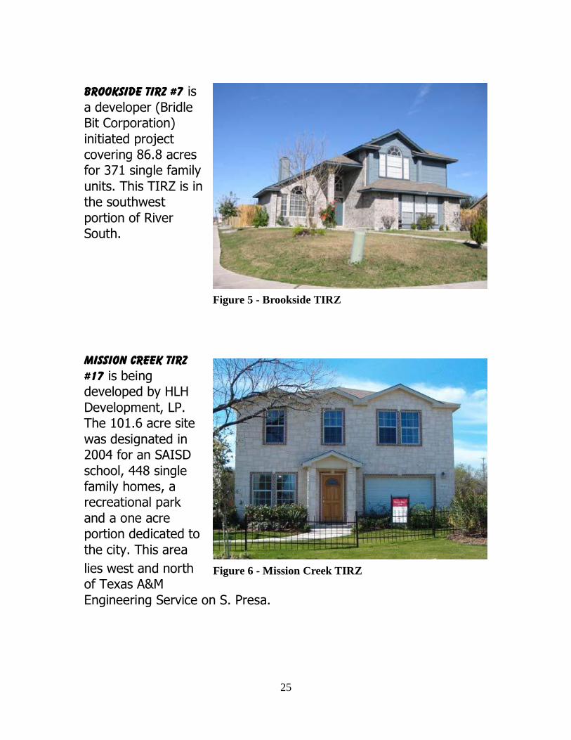
Brookside TIRZ #7 is
a developer (Bridle Bit Corporation)
initiated project covering 86.8 acres for 371 single family
units. This TIRZ is in the southwest
portion of River South.
Mission Creek TIRZ #17 is being developed by HLH
Development, LP. The 101.6 acre site
was designated in 2004 for an SAISD
school, 448 single family homes, a recreational park
and a one acre portion dedicated to
the city. This area
lies west and north of Texas A&M
Engineering Service on S. Presa.
Figure 5 - Brookside TIRZ
Figure 6 - Mission Creek TIRZ
26
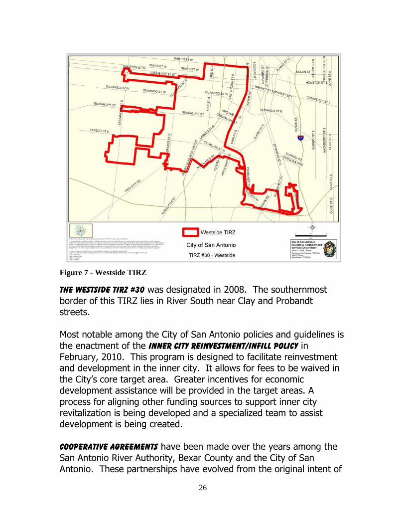
Figure 7 - Westside TIRZ
The Westside TIRZ #30 was designated in 2008. The southernmost
border of this TIRZ lies in River South near Clay and Probandt streets.
Most notable among the City of San Antonio policies and guidelines is
the enactment of the Inner City Reinvestment/Infill Policy in February, 2010. This program is designed to facilitate reinvestment and development in the inner city. It allows for fees to be waived in
the City’s core target area. Greater incentives for economic development assistance will be provided in the target areas. A
process for aligning other funding sources to support inner city revitalization is being developed and a specialized team to assist development is being created.
Cooperative Agreements have been made over the years among the
San Antonio River Authority, Bexar County and the City of San Antonio. These partnerships have evolved from the original intent of

27
the Bexar Regional Watershed Management Program (BRWMP) to address flooding issues throughout the county in a coordinated
manner. Through these agreements, projects for awareness and public education, technological improvements, and efficient use of
manpower and resources were implemented. San Antonio Missions National Historical Park (Missions) is managed
through a series of cooperative agreements with multiple agencies and organizations. Much of the land within the boundaries of the
Missions is owned by entities other than the National Park Service. The Missions currently are managed in partnership with:
Bexar County City of San Antonio (Parks, Police, Fire & Airport)
San Antonio River Authority
Archdiocese of San Antonio San Antonio Conservation Society
Los Compadres de San Antonio Missions National Historical Park
Texas Parks and Wildlife Department Bexar County Sheriff’s Department
In 2004, the BRWMP local agency partners entered into an
Interlocal Agreement to implement the San Antonio River Improvements Project (SARIP). The purpose of such an agreement is
to ―provide for one or more agencies to contract with each other for the performance of governmental functions or services for the
promotion and protection of the health and welfare of the inhabitants of this State and the mutual benefits of the parties to the agreement‖ (V.T.C.A., Government Code, Chapter 791, the Texas Interlocal
Cooperation Act). This Interlocal Agreement outlined each entity’s responsibilities for funding, permitting, design, environmental
restoration, construction, and maintenance. The Project includes the River redevelopment program from the Museum Reach southward to the Mission Reach segment. SARA serves as the SARIP project
manager and administrator. As the implementation of the SARIP has continued, the Interlocal Agreement has been amended and recently
was renamed as a Cooperative Agreement and included Bexar County's additional flood control and visitor tax funding to ensure the timely completion of the Mission Reach.
28
River south area coordinated
management plan
The plan
vision
Goals and policy objectives
29
The plan
Vision River South is an 8-mile stretch of the San Antonio River, adjacent neighborhoods and home to four of the San Antonio Missions. The
investment of time, funding and improvements at both the street and River levels is key to this area realizing its full potential as an
attractive, viable corridor. River South:
Connects to the restored Mission Reach segment of the San Antonio River
Improvements Projects.
Builds on existing neighborhoods, area history and cultural identity.
Provides incentives to facilitate reinvestment
and development in the Plan area for commercial and housing opportunities.
Creates a renewed sense of place attracting
area residents and visitors to a variety of recreational, historical, environmental and
commercial entities.
Goals and objectives The River South Coordinated Management Plan outlines three specific
goals and related policy objectives necessary for implementation. These goals relate to historic and natural resource restoration,
accessibility, recreation, safety, economic development, land use and neighborhoods.
30
Each of these goals and policy objectives provide the foundation for the Plan’s purpose to:
1. Maximize the return on investment and promote
economic development
2. Protect the community’s investment in the San
Antonio River
3. Promote the National Parks Service boundary study and land management plan
4. Establish a coordinated framework among agencies
for essential functions.
Following the Goals and Objectives section are recommendations and
action steps that will provide a long-term program for revitalization and continued participation by all partners.
Goal 1. return San Antonio’s earliest settlers immediately recognized the wealth of
natural resources necessary for establishing a thriving community. Springs, creeks, farmland, and a temperate climate all were factors
for San Antonio’s strong position as the leading city for commerce and growth well into the 20th century.
These natural resources have contributed to the City’s cultural heritage and growth. The blending of prairie land, plateau and plains
contributes to a landscape crisscrossed with streams and creeks of available clean water. Edwards Aquifer spring water has been utilized by the earliest settlers during 17,000 BC to people of current
time. Economic development and growth patterns have evolved over time. What has remained constant is the community’s proud
commitment to the past, and a growing awareness for dedicated protection of these unique attributes as a legacy as well as a key to maintaining the City’s future economic vitality and quality of life.
31
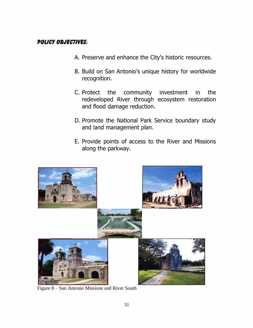
Policy objectives:
A. Preserve and enhance the City’s historic resources.
B. Build on San Antonio’s unique history for worldwide recognition.
C. Protect the community investment in the
redeveloped River through ecosystem restoration
and flood damage reduction.
D. Promote the National Park Service boundary study and land management plan.
E. Provide points of access to the River and Missions along the parkway.
Figure 8 – San Antonio Missions and River South
32
Goal 2. restore
Refocusing the community’s attention to the River South area
provides challenges to restore the ecosystem and the recognition of the roots of San Antonio’s heritage. River South links the history, the
Missions and the life-blood of the City then and now—the San Antonio River itself.
Investments in River South through the Mission Reach project provide for an ecosystem restoration project that will be a premier
environmental, recreational and educational gem. The 8–mile stretch of the San Antonio and surrounding area reaches from Lone Star Boulevard south to Mission Espada. The project will be complete in
2013 and will provide the following amenities:
Over 15 miles of trails Over 200 picnic tables and benches
Six foot bridges for pedestrian access
Four pavilions Eight street connections and four Mission portals
Planting of 100 native grasses, trees, shrubs and
wildflower species including 20,000 young trees and shrubs
These features will greatly improve the quality of life for River South
area residents as well as attract new residents and activities.
Policy objectives:
A. Restore the unique, rare and significant habitat features of the River South natural environment.
B. Create user-friendly spaces compatible with the
unique natural habitat such as trails, bikeways and
other recreational possibilities.
33
C. Plan, locate and maintain infrastructure to facilitate and maintain safe, healthy and sustainable
environments for human activity.
D. Encourage the ecological management of floodplains and promote their use as open space including greenways, wildlife habitat and pedestrian
friendly linkage corridors.
E. Provide support to the National Park Service in its development and subsequent congressional
approval for a boundary study and land protection plan for its Spanish Colonial Heritage Program to expand the current Missions National Parks
boundaries and to promote the role the restored River has in re-establishing the ecological
connections that are essential to fully interpreting the historic life and operation of the Spanish Colonial Missions.
Goal 3. revitalize Opportunities abound in River South for residential, commercial and
mixed-use projects. New developments and community improvement efforts will benefit from the programs specifically targeted for the corridor. Although this area now has locational advantages and amenities it is
hampered by existing conditions of land underutilized and pockets of neglect.
Rebuilding neighborhoods to ensure their vitality and viability are chief objectives of the Concept Plan. San Antonio acknowledges that
its growth and attraction is dependent on the quality experienced in its neighborhoods. This basic premise is a catalyst for promoting future development, economic prosperity and prudent land use.
Existing neighborhoods are protected and improved through
34
implementation and enforcement of ordinances coupled with joint community participation of residents and businesses.
Policy objectives:
A. Encourage economic diversity and job creation
which are compatible with San Antonio’s natural and cultural resources.
B. Promote a business-government relationship that addresses the needs of commercial interests to
operate in a positive and mutually beneficial environment.
C. Create an environment of entrepreneurship, productivity and innovation in River South that
promote business start-ups and business growth.
D. Preserve and revitalize existing housing and promote targeted infill for new housing neighborhood improvements.
E. Implement adopted policies, ordinances and neighborhood plans aimed at offering a diversity of housing choices and a balance of land uses
designed to retain and attract both commercial and residential opportunities.
These goals and the objectives that support them are the foundation of this management plan. The action steps that follow largely will be
implemented by the major parties of the plan – Bexar County, the City of San Antonio, and the San Antonio River Authority; by the
National Park Service, River South’s new major party; and by other agencies and entities directly related to the Plan’s initiatives, such as the Texas Department of Transportation, the San Antonio Water
System, CPS Energy, TIRZ boards, and others. Initiatives emanating from these parties and entities will be funded as part of the parties’

35
and entities’ normal course of business and may be incorporated into future cooperative agreements as described below. Thus, this Plan
does not encompass a budget for implementation.
36
River south area coordinated management plan
The plan
Recommendations
Action steps
37
Recommendations and action steps The River South Coordinated Management Plan identifies three specific goals and 15 policy objectives intended to protect, promote
and coordinate its multi-jurisdictional aspects. Each of these goals and policy objectives is tied to recommendations and subsequent
implementation requirements. They will ensure this area serves as a catalyst for becoming a place where people from all of San Antonio will enjoy the experiences created. All who come will share its legacy
as one of the earliest settlements of the nation with visitors from the Americas and beyond.
Revitalization, as a result of the efforts to return to River South and restore it to its greatest potential, should encourage diversity in
choices for housing, commerce and compatible land uses. River South will regain its sense of identity and share its treasures of
history and heritage with all who visit and those who decide to stay.
Key to implementation of the planning effort is the successful realization of two primary purposes of the Plan:
1. Establish coordinated framework among agencies for essential functions.
2. Ensure seamless, integrated management of the River and related areas.
Process
ISSUE: Establish a coordinated agency framework. TASK: Prepare an Agreement(s) among major parties with
opportunities for adjunct agencies and affiliated parties to participate as needed. These partnerships will facilitate a long-term
management program designed to:
38
1. Ensure protection of the investment through long term maintenance and operation of the River South and Mission
corridor. 2. Revitalize the surrounding areas through community
heritage-based economic development. 3. Expand the NPS’s role in the promotion and preservation of
the largest collection of Spanish colonial resources in
America. 4. Coordinate, identifying and appropriating new funding
sources where such are determined necessary. 5. Create a timeline and budget to implement action items.
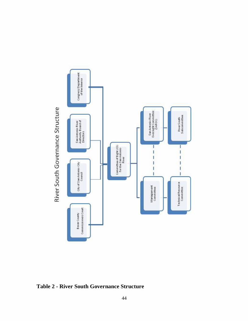
governance structure The River South Area Coordinated Management Plan contains recommendations and action steps for land use, infrastructure,
economic and cultural development action in the Mission Reach area. It also proposes a process to link these elements into a synergistic
implementation plan. That process centers upon establishing a coordinated agency framework. The primary task is preparation of an agreement among the major partners with opportunities for
adjunct agencies and affiliated parties to participate as needed.
The foundation of the Plan’s agreement incorporates a governance structure modeled after the San Antonio River Improvements Project (SARIP). It will be redefined to establish necessary program roles and
requirements to implement the Plan’s Vision for River South Redevelopment Area and the Mission Reach.
Key components of the governance structure include:
a. Committee of Eight: This committee will focus on coordinating policy issues of the participating government
agencies and will consist of the following:
Two Commissioner’s Court Appointments
Two City Council Appointments
Two SARA Board Appointments
39
Two Congressional Appointments to represent the NPS
interests
Ex officio representation by co-chairs of SAROC.
b. Management Committee: This committee, which is a modification of the SARIP’s Executive Committee, will expand its scope from managing the SARIP construction project to
maximizing the broader programmatic and operational benefits of the Mission Reach/River South project. Each agency listed
below will designate two administrative-level staff with decision-making authority to sit on the Management Committee:
Bexar County: Executive Director of Infrastructure
Services and/or designee
City of San Antonio: City Manager and/or designee
San Antonio River Authority: General Manager and/or designee
NPS: Superintendent and/or designee
c. San Antonio River Oversight Committee: This committee will
remain at 22 members and will continue to serve as an advisory committee. It will create a River South Subcommittee similar to the Park Segment Subcommittee. The River South
Subcommittee’s membership will include San Antonio River Oversight Committee (SAROC) organizations that represent
River South interests and will add non-SAROC members that represent:
Business within the River South Area
Neighborhood Plans
San Antonio River Foundation
School Districts
TIRZ Boards
Others
40
d. River South Subcommittee: This new subcommittee’s focus will be to provide reviews and advice to Bexar County, the City
of San Antonio, SARA and the National Park Service, and specifically to:
Review RIO (River Improvement Overlay), UDC, and
other City ordinances that affect the River
Oversee process by which Plan assessments and
deliverables, identified under Action Items/Responsible Parties below, are completed.
e. Technical Resource Committee: Plan implementation may require
targeted or issue-specific agreements with other governmental partners such as SAWS, CPS and TxDOT. To coordinate interagency agreements and the work emanating from them, the San Antonio
River Authority, in its capacity as Project Manager, will form a multi-agency Technical Resource Committee as a subcommittee of the
SARIP Management Committee. Agency representation will be determined by each involved government partner and may vary depending upon the matter at hand. The Technical Resource
Committee will make recommendations on policy issues and other coordination matters to the Management Committee, depending on
the topic, issues may also be presented to the ROC subcommittee for input and to the Committee of 8 for recommended action by the respective governmental bodies.
ACTION ITEMS/Responsible Parties
The recommendations and action steps below will provide a long-term program for revitalization and continued participation by all partners and will be overseen and implemented through the
governance structure described above.
Operational Agreement (Targeted Approval: January 2011)
a. Establish an intergovernmental operational partnership that builds on existing SARIP agreements between the County, City and SARA and adding the NPS for its role.
41
b. Designate SARA as the local governmental coordinating
agency, as part of its established Operation and Maintenance duties, to provide administrative and coordination support to
meet the goals and objectives of the River South Plan. c. Detail the roles and responsibilities of each of the
governmental entities (City, County, SARA and NPS) in the implementation of the River South Plan. Include provisions in
the agreement that will allow development and implementation of intergovernmental agreements, as necessary, with other
entities. Assessments and Action Plans (Targeted Completion: within 18
months of Plan approval by Bexar County Commissioners Court, the City of San Antonio, and the SARA Board of Directors)
Assess and/or develop the following:
River Maintenance Expectations and Standards
River Recreational Plan and Implementation Strategy
Security Needs Assessment
Neighborhood Needs Assessment
Infrastructure Needs Assessment
Economic Development
Educational Plan
Events Marketing Plan.
The general role, responsibilities, and timeline for Plan implementation will be identified in more detail through the
Operational Agreement and are outlined below:
i. Protection, maintenance and operation for River
South Maintenance/ecosystem and user environment—SARA
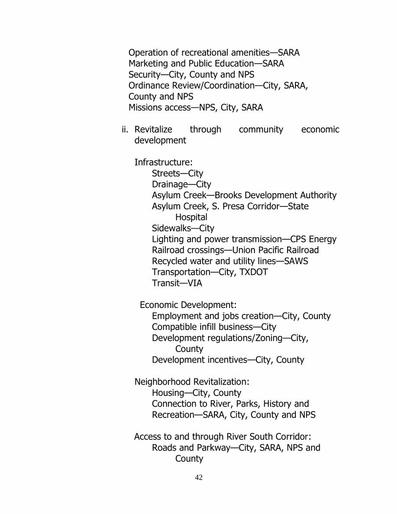
42
Operation of recreational amenities—SARA Marketing and Public Education—SARA
Security—City, County and NPS Ordinance Review/Coordination—City, SARA,
County and NPS Missions access—NPS, City, SARA
ii. Revitalize through community economic development
Infrastructure:
Streets—City Drainage—City
Asylum Creek—Brooks Development Authority
Asylum Creek, S. Presa Corridor—State Hospital
Sidewalks—City Lighting and power transmission—CPS Energy Railroad crossings—Union Pacific Railroad
Recycled water and utility lines—SAWS Transportation—City, TXDOT
Transit—VIA Economic Development:
Employment and jobs creation—City, County Compatible infill business—City
Development regulations/Zoning—City, County
Development incentives—City, County
Neighborhood Revitalization:
Housing—City, County Connection to River, Parks, History and
Recreation—SARA, City, County and NPS Access to and through River South Corridor:
Roads and Parkway—City, SARA, NPS and County
43
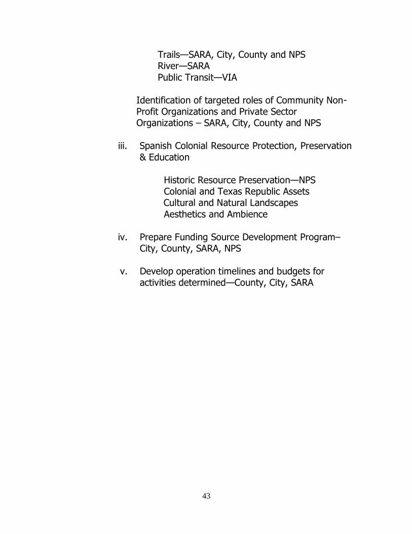
Trails—SARA, City, County and NPS River—SARA
Public Transit—VIA
Identification of targeted roles of Community Non-Profit Organizations and Private Sector Organizations – SARA, City, County and NPS
iii. Spanish Colonial Resource Protection, Preservation
& Education
Historic Resource Preservation—NPS Colonial and Texas Republic Assets
Cultural and Natural Landscapes
Aesthetics and Ambience
iv. Prepare Funding Source Development Program– City, County, SARA, NPS
v. Develop operation timelines and budgets for activities determined—County, City, SARA
44
Table 2 - River South Governance Structure
45
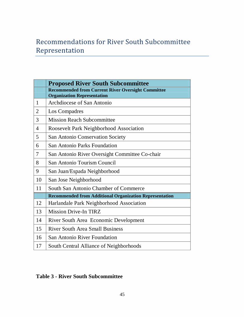
Recommendations for River South Subcommittee Representation
Table 3 - River South Subcommittee
Proposed River South Subcommittee Recommended from Current River Oversight Committee
Organization Representation
1 Archdiocese of San Antonio
2 Los Compadres
3 Mission Reach Subcommittee
4 Roosevelt Park Neighborhood Association
5 San Antonio Conservation Society
6 San Antonio Parks Foundation
7 San Antonio River Oversight Committee Co-chair
8 San Antonio Tourism Council
9 San Juan/Espada Neighborhood
10 San Jose Neighborhood
11 South San Antonio Chamber of Commerce
Recommended from Additional Organization Representation
12 Harlandale Park Neighborhood Association
13 Mission Drive-In TIRZ
14 River South Area Economic Development
15 River South Area Small Business
16 San Antonio River Foundation
17 South Central Alliance of Neighborhoods
46
Appendix – list of illustrations Figure 1 - 1921 Flood Damage ..................................................... 3
Figure 2 - Inner City TIRZ ........................................................... 23 Figure 3 – Mission Drive Inn TIRZ ................................................ 24
Figure 4 – Brooks City-Base TIRZ ................................................ 24 Figure 5 - Brookside TIRZ ........................................................... 25 Figure 6 - Mission Creek TIRZ ..................................................... 25
Figure 7 - Westside TIRZ ............................................................ 26 Figure 8 - San Antonio Missions and River South……….…………………36
Table 1 – Mission Reach (and SARIP) Project Budget…………………….6 Table 2 – River South Governance Structure……………………………….44
Table 3 – River South Subcommittee………………………………………….45
Map 1 – River South Redevelopment Area…………………………………..10 Map 2 – River South Activity Centers………………………………………….11
Map 3 – River South Existing Land Use……………………………………….13 Map 4 – 1975 Land Use – River South………………………………………..14 Map 5 – River South Zoning Overlay Districts………………………………19
Map 6 – River South – TIRZ’s…………………………………………………....22
47
Bibliography - Resources San Antonio Master Plan Policies, May 29, 1997.
San Antonio River Improvements Fact Sheet, San Antonio River Authority.
San Antonio Development Incentive Toolkit Definitions.
City of San Antonio, Historic Preservation website, Historic and Zoning Districts.
Roosevelt Corridor Reinvestment Plan, 2009.
South Central San Antonio Community Plan, August 19, 1999. Amended, October 26, 2005.
Stinson Airport Vicinity Plan, 2009.
Tax Increment Reinvestment Zone description handouts.
San Antonio River Improvement Plan Interlocal Agreement, 2006.
Strategic Historic Preservation Plan, 2009. Proposed San Antonio Missions National Historic Park: Alternatives
for Implementation, National Park Service, 1975.
48
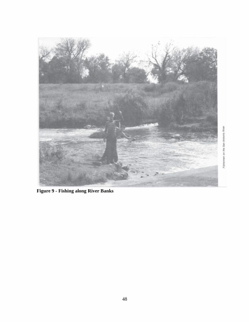
Figure 9 - Fishing along River Banks


